
(v) Apparent Onlap
An apparent onlap is an onlap observed in any randomly oriented vertical section, which may or may not be oriented parallel to depositional dip.
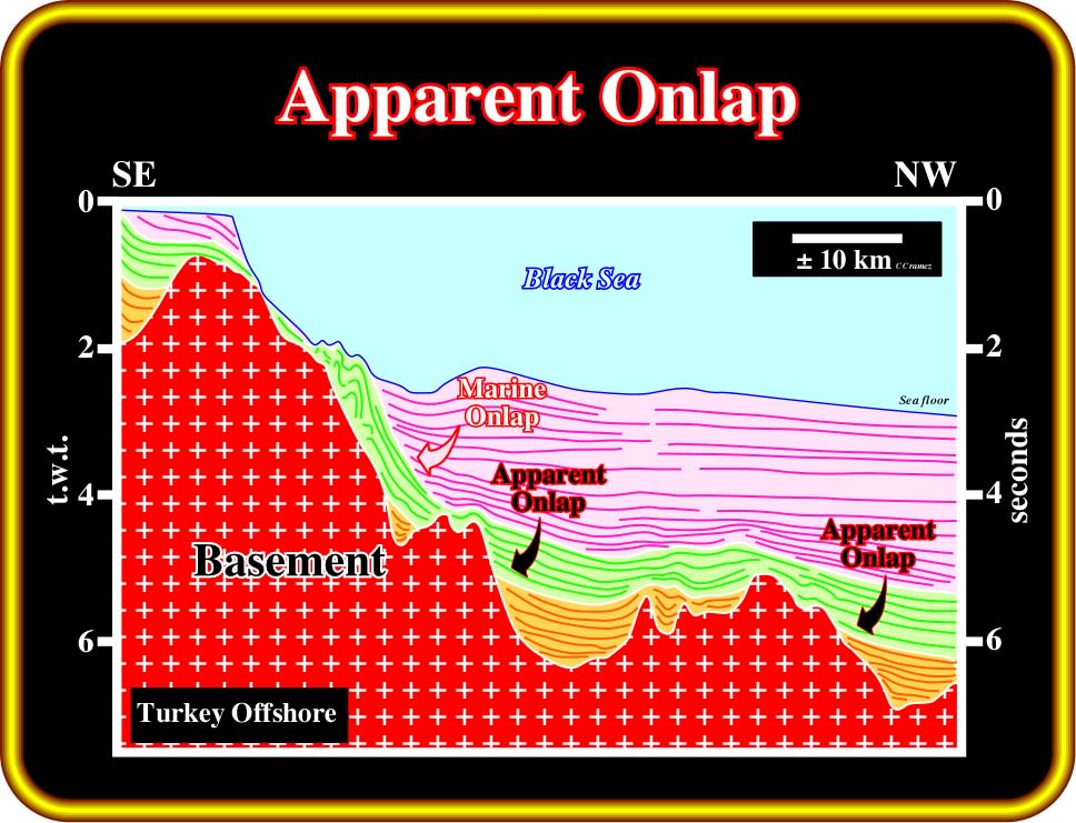
Plate 143- The onlaps in the lower most sedimentary intervals (light brown and light green) are apparent onlaps. As a matter of fact, the seismic line, in which this tentative interpretation is based, is oblique to the depositional dip of the lower intervals. Contrariwise, in relation to the depositional dip of the upper interval, the seismic profile is roughly parallel, so the associated onlaps can, in a preliminary tentative interpretation be considered as marine.
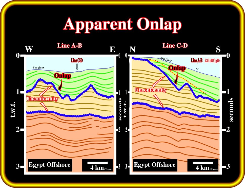
Plate 144- On line A-B, the geometrical relationships of the uppermost interval are apparent onlaps. The seismic line A-B, in which the tentative interpretation is based, is not parallel to the depositional dip of the rocks composing the concerned interval. On line C-D, which is orthogonal to the A-B line and parallel to the depositional dip of the sedimentary rocks composing the uppermost interval, it is easy to recognize that the geometrical relationships of the strata are not onlap, but downlap (see later), as illustrated in this tentative interpretation. Briefly speaking, on seismic data, the real geometrical relationships are only recognized on a seismic line parallel to the depositional dip when the sediments are undeformed. However, it must be noted, that on the seismic lines, the strike of the depositional dip can change from one seismic interval to another.
(vi) Non-marine Onlap
A non-marine onlap is an onlap observed in non-marine environment, that is to say, generally, landward of the depositional coastal break.
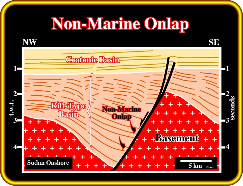
Plate 145- On this tentative interpretation of a seismic line from from Sudan onshore, the rift-type basins, as depicted above, are overlain by a quite large, but relatively thin cratonic basin. An unconformity, which locally can be tectonically enhanced (angular unconformity), separates the rift-type basin from the cratonic basin. In rift-type basins developed in non-marine environments, the onlap of the strata against the basement is non-marine. Actually, on this tentative, the onlap can even be considered as lacustrine onlap. since the internal configuration of the rift-type basin is mainly parallel than divergent toward the faults. Actually, organic rich lacustrine shales (source-rocks) were recognized by drilling (the giant Unity oil field, is located on the left end of the line). Contrariwise to the unconformity between the rift-type basins and the Atlantic-type divergent margins, which highlights the breakup of the Pangea lithosphere, the unconformity between these rift-type basins and the cratonic basin corresponds just to a change in subsidence. During the development of the rift-type basins, the subsidence was differential (lengthening and thinning of the lithosphere with a subsequent pull-up of the isotherms), while during the cratonic basin, the subsidence is induced by a thermal re-equilibrium (pull-down) of the isotherm es. In other words, between the rift-type basins and the cratonic basin, there is not breakup of the lithosphere and therefore no oceanization.
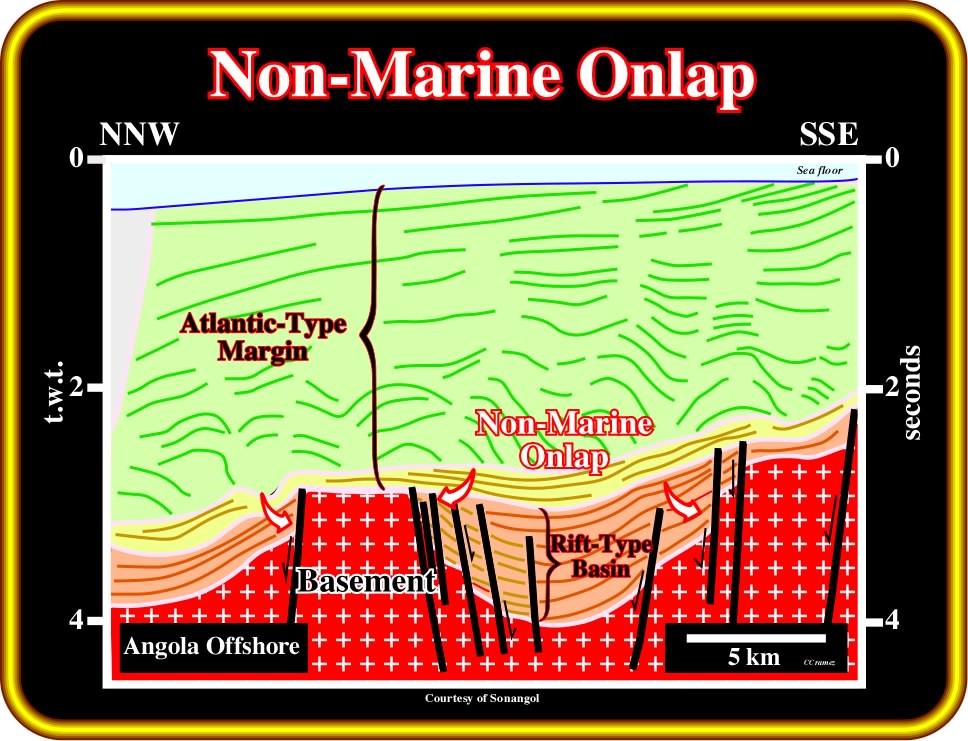
Plate 146 - In Angola offshore, the Kwanza and Congo basins are composed by the superposition of three types of sedimentary basins. On this tentative interpretation, from bottom to top, one can recognize a Paleozoic fold belt (or a granite-gneiss basement), two Upper Jurassic - Lower Cretaceous rift-type basins, which are covered by a Meso-Cenozoic Atlantic-type divergent margin. The onlapping recognized on the rift-type basins is non-marine. Rift-type basins were developed within the Pangea supercontinent, where non-marine environments were paramount, during the lengthening of the lithosphere, i.e., they predate the breakup unconformity. The salt induced tectonic disharmony, between the green interval (salt and overburden) and the yellow interval (sag basin of the American geoscientists working in Angola), does not correspond to the breakup unconformity (limit between the rift-type basin or basement with the divergent margin). Potential source-rocks can be developed in the rift-type basins (lacustrine source-rocks) or in the margin infrasalt sediments ("sag basin"). Reefal carbonate reservoirs and travertines (massive calcium carbonate resulting from deposition by springs or rivers) are often associated with buried hills or the borders of the margin infrasalt sediments.
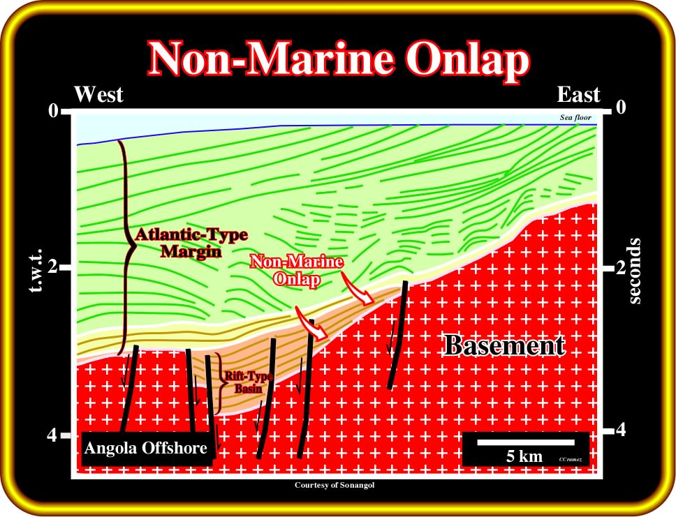
Plate 147 - On this tentative interpretation of an Angola offshore seismic line, the onlap recognized in the rift-type basin is a non-marine onlap (red arrows). The predominant depositional environment of the South Atlantic rift-type basin is non-marine. However, in certain rift-type basins, such as the North Sea, the uppermost stratigraphic levels of the rift-type basins can show a significant marine influence (Kimmeridgian shales). Again to not take the salt induced tectonic disharmony (bottom of the green interval) as the breakup unconformity, in spite of the fact that locally they can be coincident (absence of rift-type basin and margin subsalt sediments under seismic resolution).
(vii) True Onlap
When two apparent onlaps are observed on two sections intersecting at right angles, a true onlap is likely to be observed on the section parallel to the depositional dip.
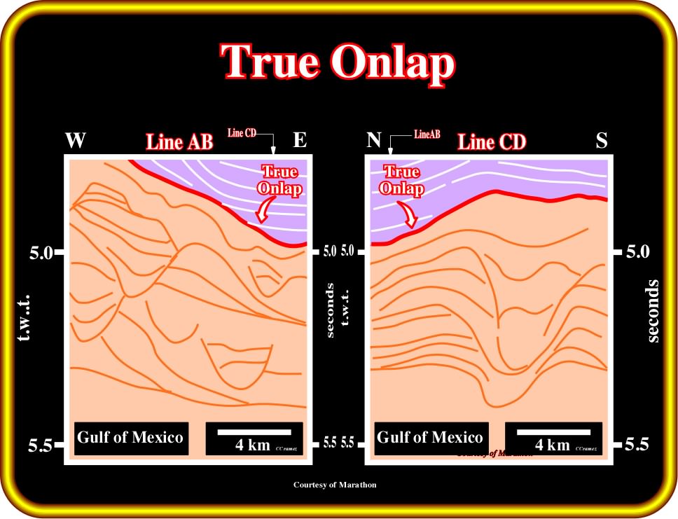
Plate 148 - On these tentative interpretations of two perpendicular seismic lines, located in the Gulf of Mexico, two apparent onlaps can be recognized. Hence, it is likely that a true onlap will be recognized on the line shot parallel to depositional dip (parallel to clastic sediment supply). These tentative illustrate deep-water environments, characterized by turbiditic channel-levee complexes, where onlap geometrical relationships are quite rare. The dominant geometrical relationships are downlap (overbank deposits). Onlap occurs mainly in the overlying intervals as picture above.
(viii) Tilted Onlap
A tilted onlap is an apparent geometrical relationship, that looks like a downlap. Generally, it is induced by tilting, compensatory subsidence and salt or shale flowage.
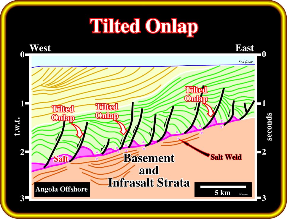
Plate 149 - On this tentative interpretation (seismic line from Angola offshore), in which lateral and vertical salt flowage are paramount, salt-induced tectonic inversions took place. The original onlap geometrical strata relationships were tilted becoming similar, in geometry, to progradational reflectors (downlap). It is important to remember that an onlap is a synsedimentary geometrical relationship, which can be more or less deformed by regional or local post-depositional tectonic regimes.
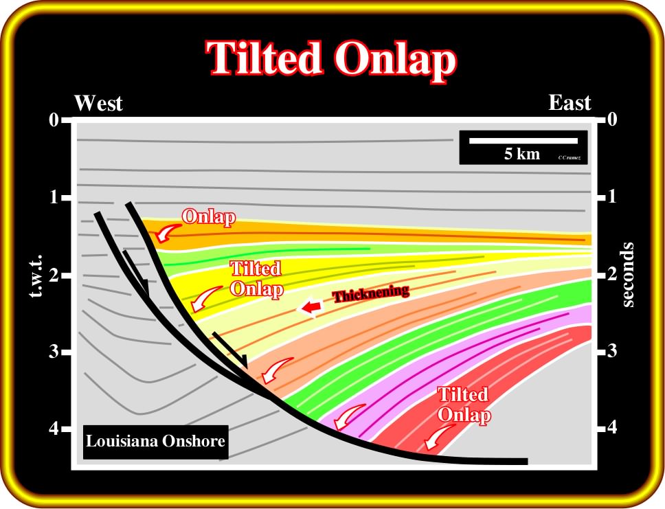
Plate 150 - On this tentative interpretation of a seismic line of the Louisiana onshore, sediments thicken landward towards the fault plane of a large growth fault (a type of normal fault that develops and continues to move during sedimentation and typically has thicker strata on the downthrown, hanging wall side of the fault than in the footwall). The original onlap geometrical relationships were progressively rotated seaward. Subsequently, the seismic surface, defined by reflection terminations against the fault plane, is not an downlap surface, but rather a surface of “tilted onlaps". Such tilted reflection terminations should not be confused with downlap. In a downlap geometrical relationship, sediments thin (converge) downdip, what it is the case here, since they are thickening toward the fault plane (differential subsidence).
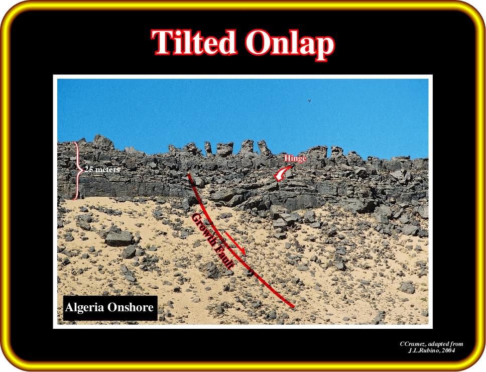
Plate 151 - On this outcrop (Algeria onshore), tilted onlaps can be recognized in association with a normal growth fault (in red). The hinge point is also easily recognized. It corresponds to a change in subsidence. Strata thicken toward the fault plane. Tilted onlaps against a fault plane have roughly the same geological meaning as a true onlap. In terms of relative sea level changes, they correspond to a relative sea level rise. In carbonate environments, the hinge points associated with growth faults are often the locus of reefal or bioherm buildups.
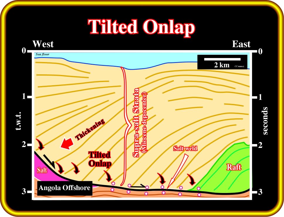
Plate 152 - On this tentative interpretation of a seismic line (Angola offshore), a synsedimentary salt flowage tilted the pristine onlap geometrical relationships. Presently, they look like progradational strata. However, as they thicken toward the fault plane, along which they glided downward, they should not be confused with progradational strata. Progradational strata thin or converge basinward, so the stratigraphic units (and the equivalent seismic interval) become condensed seaward.
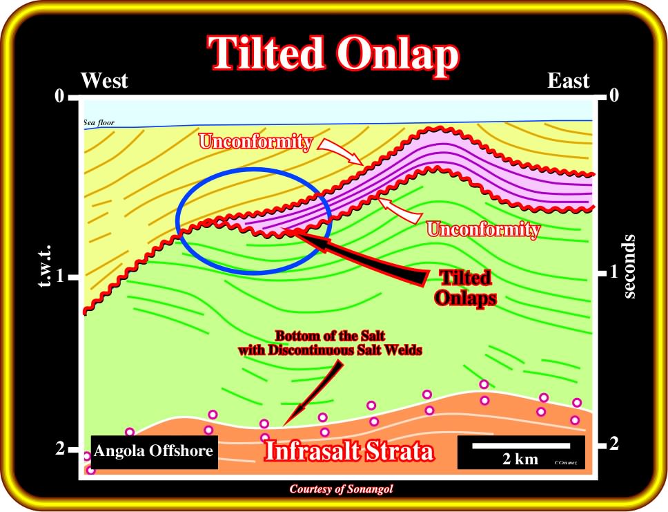
Plate 153 - As illustrated on this tentative interpretation, in salt basins, such as in Kwanza basin, halokinesis (extension induce by salt flowage) and reactivation of fracture zones (compression) can deform the original geometrical relationships between strata. Here, between two unconformities (relative sea level falls), the original onlaps (distal onlaps) were deformed. Now a days, they look like downlaps (see next). However, it seems quite evident that they correspond to an aggradational rather than a progradational unit. Note that the bottom of the salt interval is here marked by more or less discontinuous salt welds, which highlight the salt induced tectonic disharmony.
to continue press![]()
![]()