Caveat
This glossary of Sequential Stratigraphy should not be considered as an attempt to normalize the terminology of Sequential Stratigraphy. The work presented here corresponds, simply, to a compilation of definitions and concepts dispersed in the most varied publications on Sequential Stratigraphy. It is intended, primarily, to serve the young geoscientists who have followed our short courses and workshops, since all the terms defined here were all used in these classes. For each term, presented: (i) a succinct definition (with a translation in French, Portuguese, Spanish, German, Chinese, Russian and Italian which, later, will be updated, particularly the German translation) ; (ii) a tentative geological interpretaion of an auto-traces of a seismic line, a sketch or a photograph illustrating its meaning, and (iii) a commentary, sometimes with notes, clarifying certain points related to the illustration of the term.

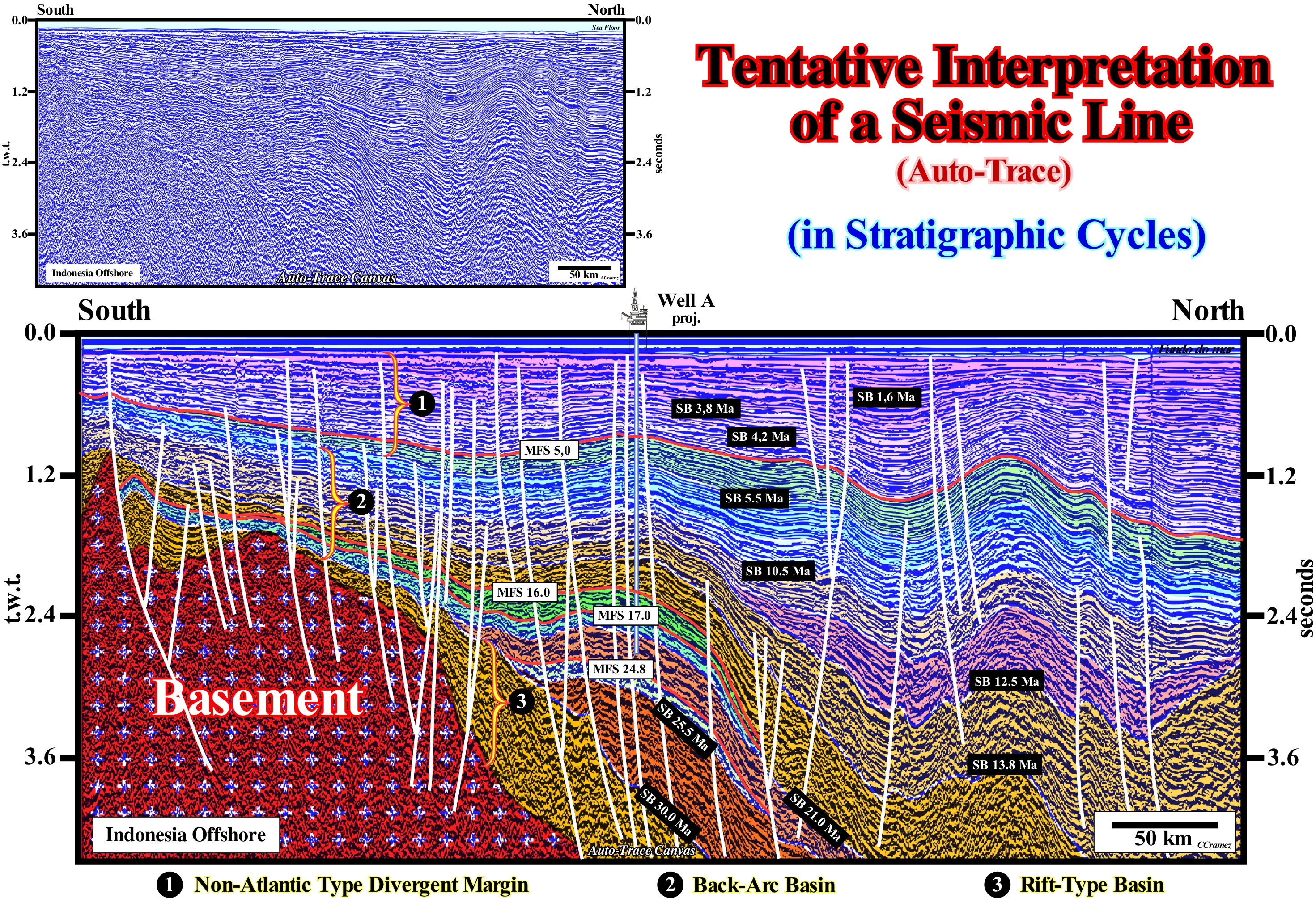
On the auto-trace of a seismic line of the Indonesian offshore, as well as, on the tentative geological interpretation (in terms of Sequential Stratigraphy), illustrated n the figure below, a geoscientist will only see what he knows a priori. In the same way, he will just understand the terms and geological concepts depicted in the legend of this tentative geological interpretation if he has a good knowledge of Sequential Stratigraphy. It is in this sense this glossary can help him.
On this tentative geological interpretation of an auto-trace Canvas, from a seismic line of the Indonesia offshore, the vertical scale, as in most seismic lines, is in time. This implies, necessarily, important modifications when the tentative interpretation is converted to depth, in particular, when there are significant lateral variations in thickness and velocity of the seismic intervals. The horizontal scale is metric. The length of the original seismic line is about 550 km. Seismic reflectors, which represent interfaces between small sedimentary intervals (10-20 meters in thickness), can be followed, in continuity, by a distance comparable to the length of Portugal. However, this is not the case in the field, where the outcrops are discontinuous and difficult to correlate (mesoscopic scale of observation). On the tentative of geological interpretation presented here, the geoscientist (not necessarily a geophysicist) who made the interpretation not only assumed that "Theory precedes Observation", but also applied the principles of "falsification" and "refutation" of the geological setting of the area. The geological setting can be summarized as follows: (i) A non-Atlantic type divergent margin, developed within the Mesozoic/Cenozoic megassuture, composed by a pre-Mesozoic basement, in which rift-type basins were developed, which were fossilized, later, by sediments of a backarc basin ; (ii) The backarc basin was covered by a non-Atlantic type divergent margin, since there is any oceanization (seafloor spreading), i.e., there is no creation of a marginal sea (South China Sea, is just well visible northward of this area). In contrast to naive tentative geological interpretations (induction and verificationism), in this case, the geoscientist after refuting several tentative interpretations, using all the available data (exploration well results, gravimetry, magnetism, etc.), chose the tentative more difficult to "falsify" as the most likely geological interpretation. Actually, there are no good or bad interpretations, but just interpretations that are easily refuted and others that are harder to refute. The sedimentary packages correspond to stratigraphic cycles, i.e., sedimentary intervals deposited during eustatic cycles. The stratigraphic cycles are delimited by unconformities (defined by onlaps and/or toplaps). Unconformities are erosional surfaces (such as: SB 5.5 Ma ; SB 10.5 Ma, etc.) induced by relative sea level falls, since eustasy (absolute or eustatic sea level changes) is the main responsible for sedimentary cyclicity (eustatic changes are much faster than tectonic changes which, in parrticular cases, can explain by just themselves the cyclicity of deposits). In Sequential Stratigraphy, sea level can be relative or absolute. Relative sea level is a local sea level referenced to any point on the Earth's surface, which can be the sea floor or the base of the sediment (top of the continental crust). Absolute (eustatic) sea level is supposed to be global and referenced to the Earth's. Absolute (eustatic) sea level is the result of the combined action of: (i) Tectono-Eustasy, which is controlled by ocean basin volume changes in association with the sea floor spreading following the breakup of supercontinents ; (ii) Glacio-Eustasy, which is controlled by ocean water volume changes as a function of ice volume (assuming the amount of water in all its forms, is constant since the Earth's formation, around 4.5 Ga) ; (iii) Geoidal-Eustasy which is controlled by the distribution of ocean water caused by variations in the terrestrial gravity field (where gravity is stronger than normal, sea level is thrown to the center of the earth) and (iv) Steric sea level rise or thermal expansion of the ocean, which is controlled by rising sea temperatures (if temperature increases, water density decreases and, for a constant mass, volume increases). Obviously, relative sea level is the result of the combined action of absolute (eustatic) sea level and tectonics (subsidence or uplift of the sea floor as a function of the predominant tectonic regime). The ages of the unconformities proposed on this tentative geological interpretation follow the ages proposed by Hardenbol et al. (1998). At the top of this tentative interpretation, where the deposition rate was, relatively, high, the sequence-cycles (induced by 3rd order eustatic cycles) are easily recognized. Also, some maximum flooding surfaces (MFS) are recognized (red solid lines): MFS 5.0 Ma ; MFS 16.0 Ma ; MFS 17.0 Ma and MFS 24.8 Ma. At the bottom and, particularly, during the onset of the Miocene and Oligocene, the seismic packages are, relatively, thin and the age difference between unconformities, which limit stratigraphic cycles, is greater than 3-5 Ma and less than 50 My. Consequently, only continental encroachment subcycles associated with 2nd order eustatic cycles are recognized. Fault planes (in white) correspond to seismic surfaces defined by reflector terminations (rarely a fault plane is underlined by a reflector, except when it is injected by salt, volcanic rocks or when it corresponds to an interface between sediments and a basement. Sequential stratigraphy is one of the best tools for hydrocarbon exploration, as the most likely reservoir-rocks onlap against the unconformities and the most likely marine source-rocks are associated with downlap surfaces that separate transgressive episodes (retrogradational geometry) from regressive episodes (progradational geometry). On the other hand, sequential stratigraphy is an excellent proxy method (measurement of parameters, which correlate with certain variables and then infer the values of these variables that cannot be measured directly) from paleoclimatology, since they allows us to easily determine absolute and relative sea level changes.

To open the glossary pressurize (click) the button below,

For reasons of confidentiality, only manual auto-traces (when the main reflectors of a seismic line are manually underlined by pencil strokes) and Canvas auto-traces (when the main reflectors of a seismic line are automatically underlined by a software) of the seismic lines used in this glossary. For the same reason, sometimes, the exact locations and orientations of the auto-traces and geological cross-sections are not indicated. The author is solely responsible for the vast majority of proposed tentative geological interpretation on which certain calibrations are speculative.
Dr. Carlos Cramez
Foreign Member of the Lisbon Academy of Sciences
Crans-Montana, Switzerland, 2019
To see the bibliographic references, please, press navigation bottom below