

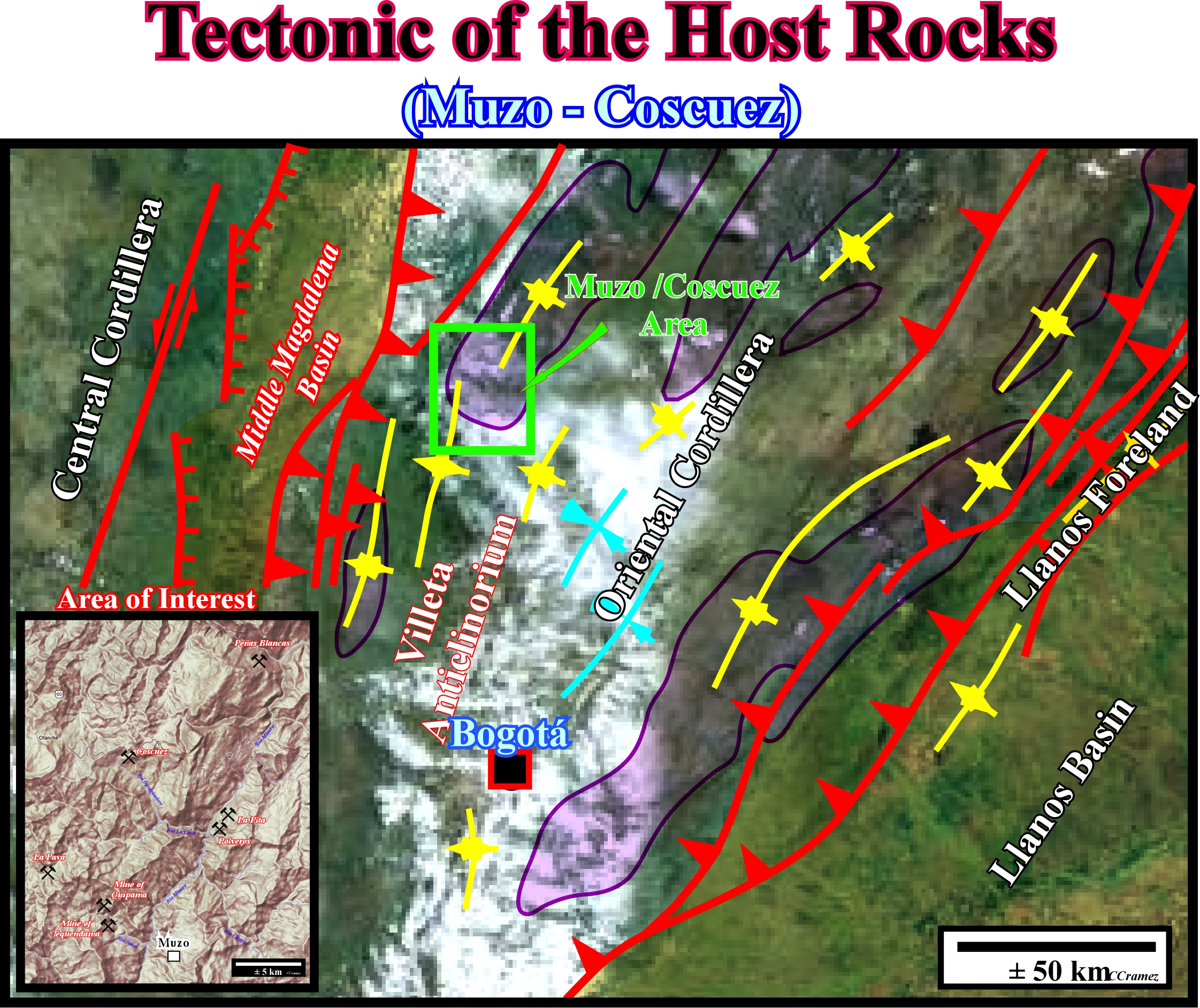
As suggested previously, the Oriental Cordillera emerald deposits are mainly controlled by the burial (subsidence) of the organic rich Lower Cretaceous argillaceous rocks (development of hydrothermal fluids particularly rich in beryllium) and by the shortening (compressional tectonic regime) of the sediments, which dictates the more likely location of the emerald deposits (generally in association with calcite veins). Subsequently, the geoscientists, in charge of the mining strategy, must make detail geologic maps (at metric scale and not kilometric as the one illustrated above) and cross-sections of the mine (see next plates) using all possible observable data (field, horizontal and vertical shafts, drifts, etc.) to increase the probability of success. In other words, the main target of the geoscientists is to master the strike of the galleries, which cut more : (i) deformed calcite veins ; (ii) emerald rich stratiform breccia, along the décollement planes and (iii) hydraulic breccia, near the small scale fault-anticline axis, as illustrated next.
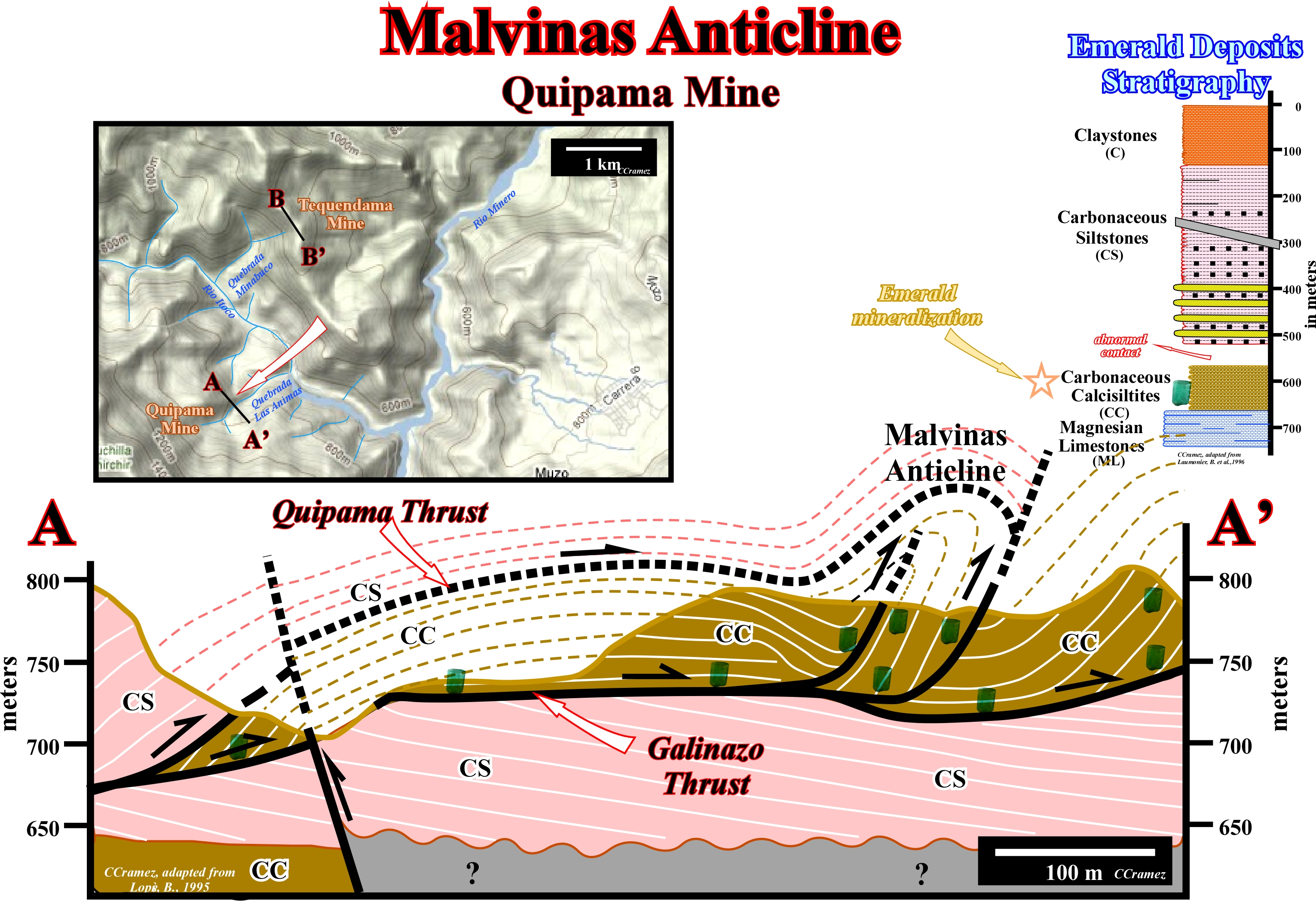
As suggested in this cross-section of the Quípama mine (Muzo), the emeralds deposits are mainly hosted in Lower Cretaceous carbonaceous calcisiltites, particularly above the décollement surfaces (thrust fault surfaces), where stratiform breccia are developed and near the anticline apexes, where hydraulic breccia are frequent in association with “strados” (extensional fractures developed in the upper part of each folded bed). In other words, all galleries dig below the Galinazo thrust fault will are a big probability to be unproductive.
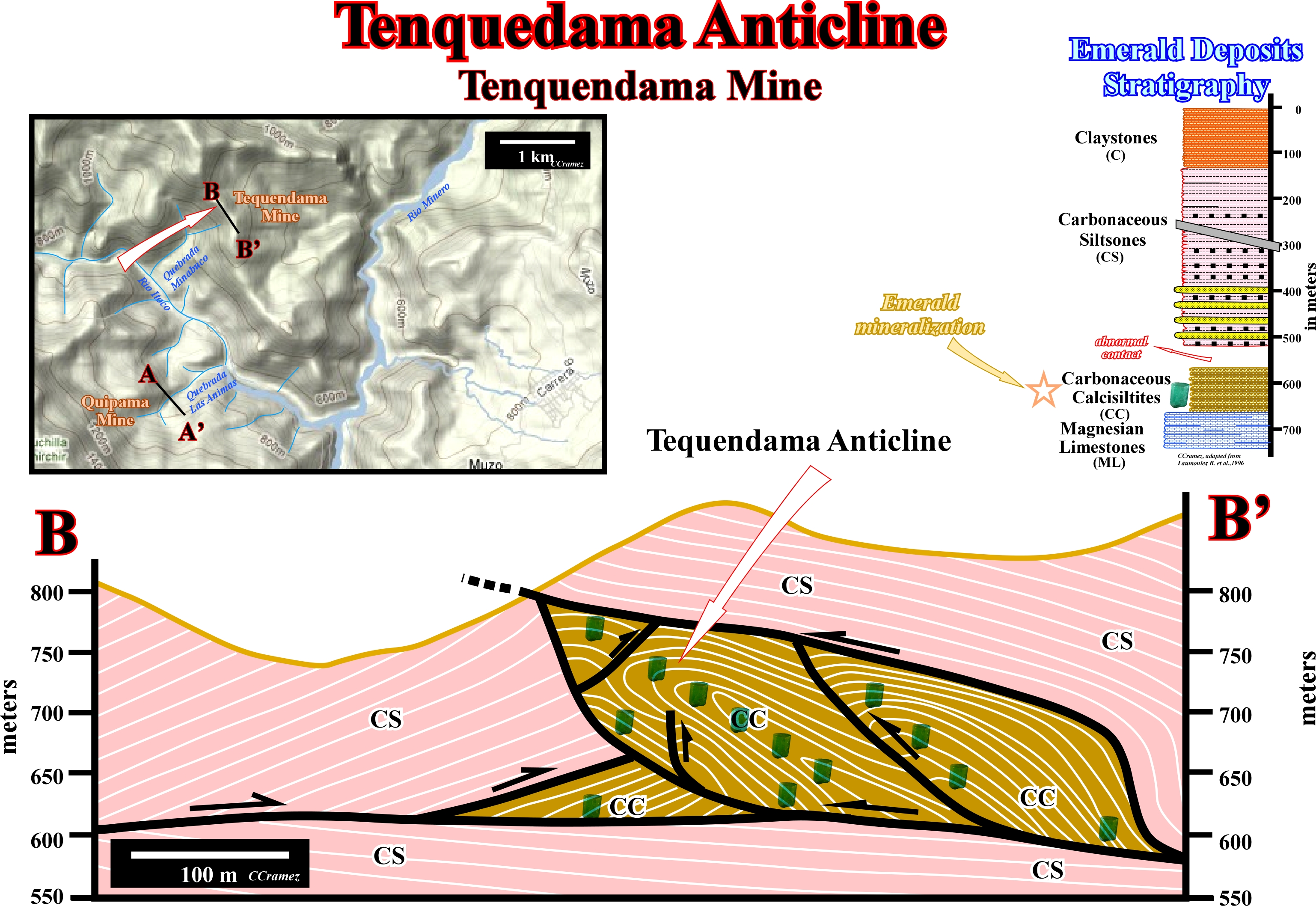
Since geoscientists get an accurate geological cross-section of potential emerald host rocks, as here the carbonaceous calcisiltites of Tenquendama mine (Muzo), the more likely location of the emerald deposits can be predicted as illustrated, that is to say, within the Lower Cretaceous calcisiltites along the thrust fault planes and in the anticline apexes of the duplex structures (imbricated thrust systems.
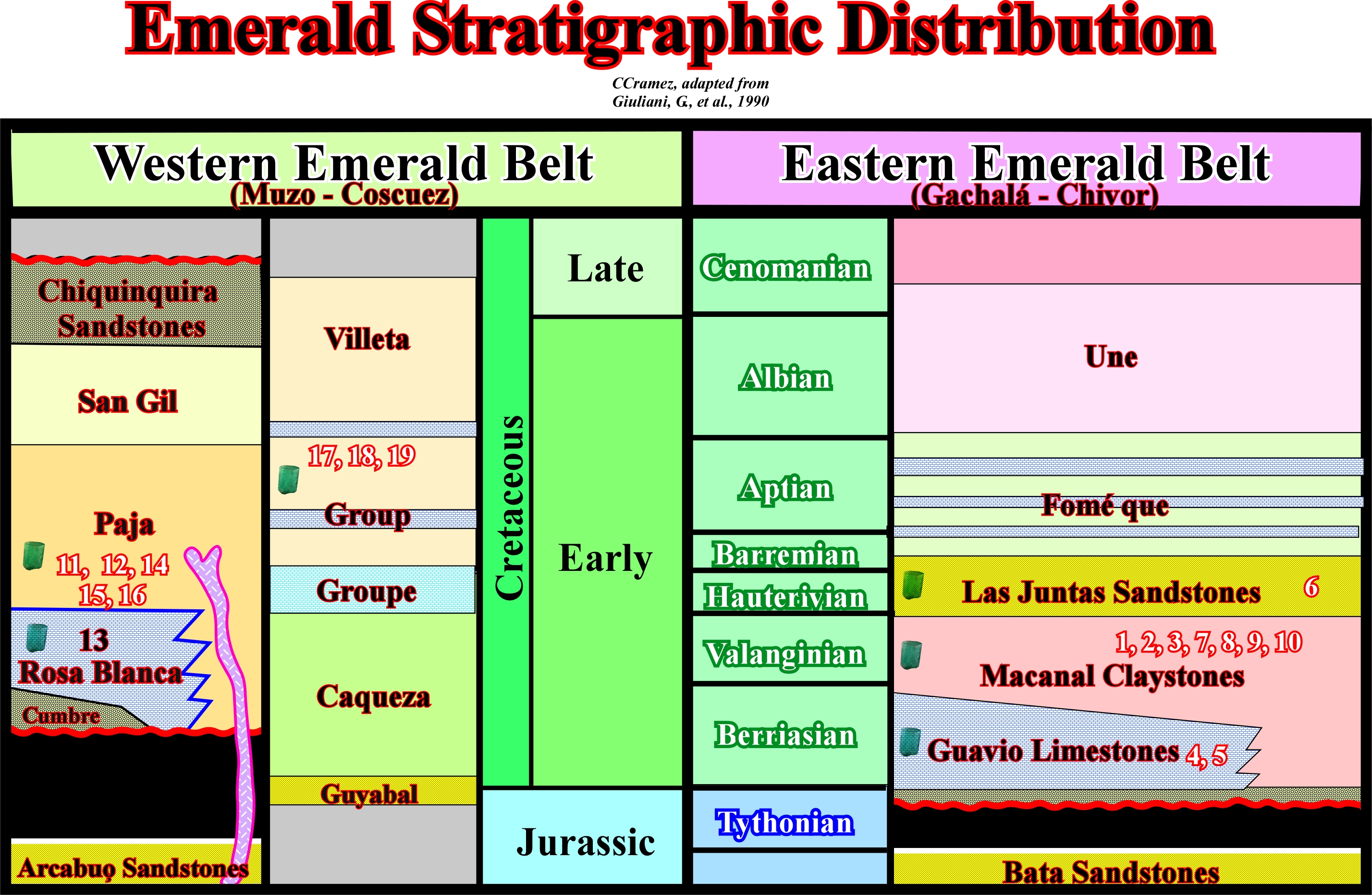
As indicated in these stratigraphic columns, typically the emerald deposits are hosted in Lower Cretaceous rocks, mainly in cjaxystones of the Macanal, Paja formations and Villeta group. However, the presence of emeralds in the sandstones de Las Juntas formation is known in Las Cruces mine (6), as well as in the Rosa Blanca Limestones (13, Peñas Blancas mine) and Guavio limestones (4, Chivor mines and 5, Buenavista mine). No emerald deposits were found in Jurassic and upper Lower Cretaceous sediments. The numbers 1-19 indicate the name of the emerald mines, where emerald deposits are or were found: 1- Achiote ; 2- Pavaranado ; 3- Guali ; 4- Chivor ; 5- Buenavista ; 6- Mundo Nuevo ; 7- La Providencia ; 8- La Vega San Juan ; 9- Las Cruces ; 10- Sagrada Familia ; 11- Muzo ; 12- Coscuez ; 13- Peñas Blancas ; 14- La Corona ; 15- La Calichona ; 16- Penjamo ; 17- El Penon ; 18- Aposentos ; 19- La Mina Glorieta.
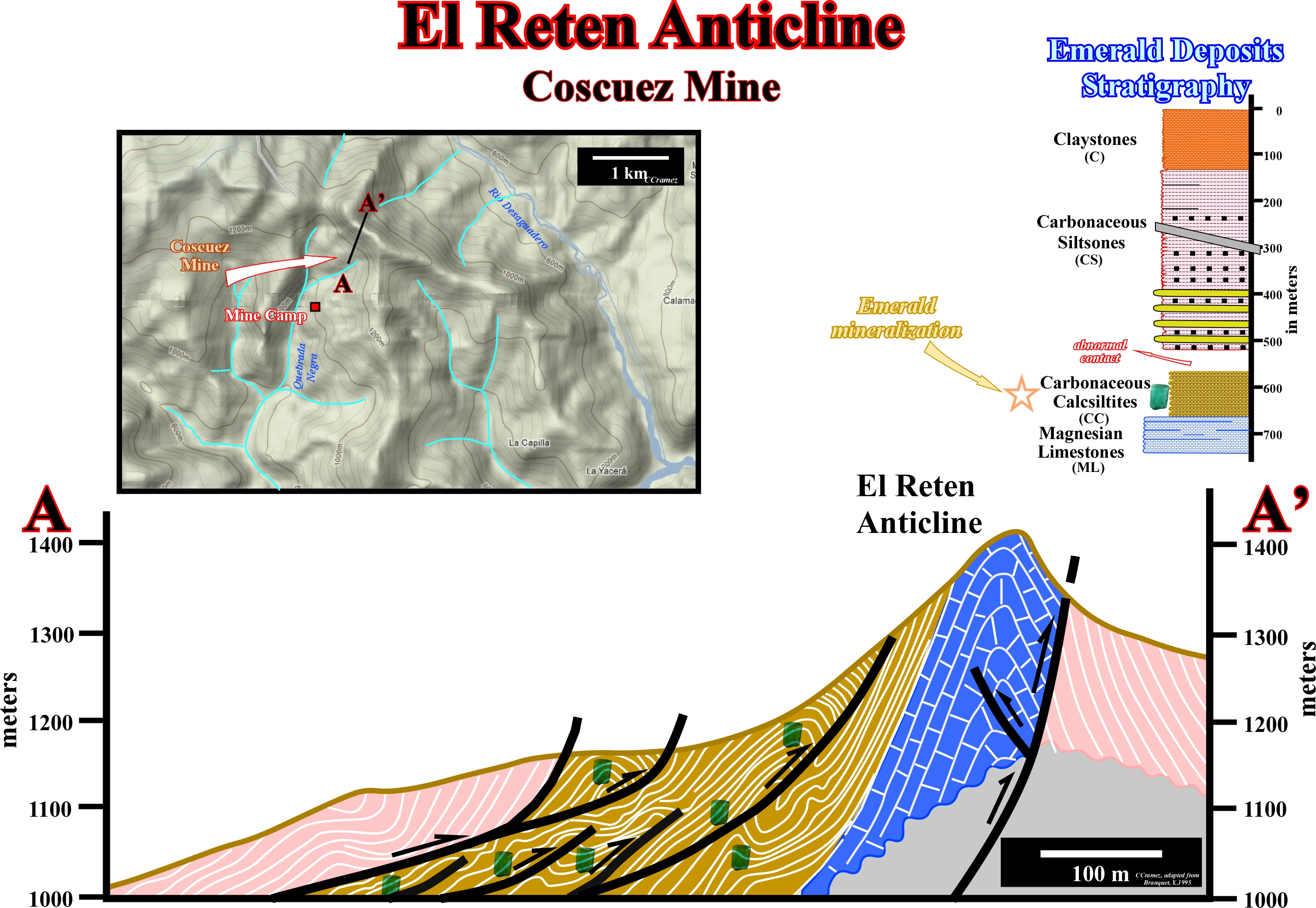
As in the mines of Itoco river, in Coscuez mine the genesis and location of the emerald mineralizations follow the same principles: precipitation from hydrothermal fluids along the thrust planes (stratiform breccia) and near of the apexes of the anticlines (hydraulic breccia) within the duplex structures. In other words, here again, the remnant emerald deposits potential is strongly dependent of the geoscientist’s tectonic (structural) interpretation of the area of mainly of the Lower Cretaceous sediments.
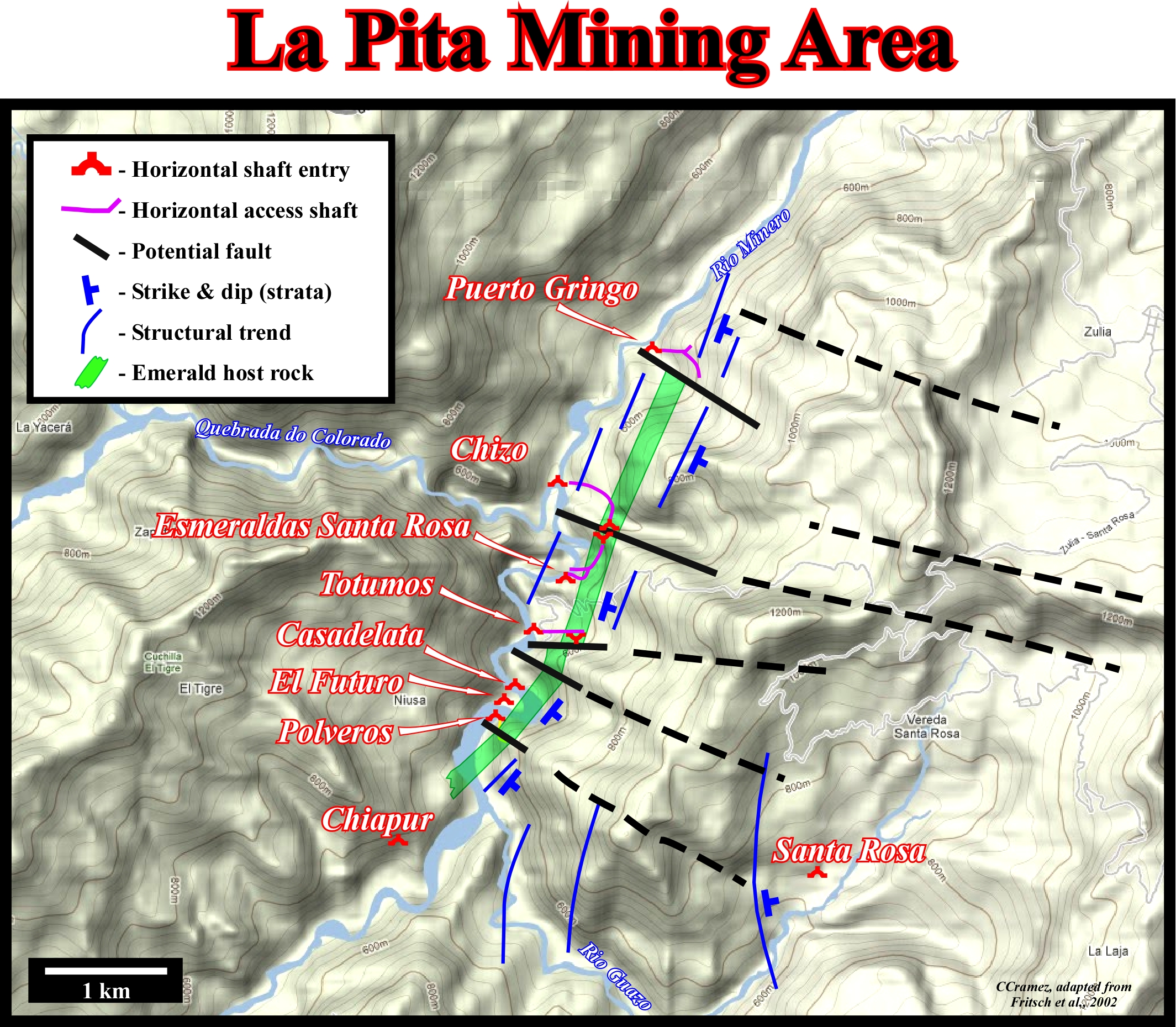
Geographically, La Pita mining area is located, midway between Muzo and Coscuez areas, on the eastern bank of the Minero river, in Maripi and Santa Rosa “veredas” (territorial division of a municipality). The emeralds have been extracted by few independent miners, which political and economic relationships are quite complexes. At the beginning of the century (2002), around 33 concessions were known (the principal are located in this plate). The name of a concession is, generally, the name of farm were the first horizontal access shaft was located. The emerald deposits of this area, along the Minero river, are similar to those of Muzo (Itoco river), in the south, and Coscuez, in the North. As in the others areas, the emeralds are located in breccia veins of calcite (with other minerals associated), which cut the Lower Cretaceous carbonaceous calsiltite (CC) interval, intercalated between magnesian limestones (ML) and carbonaceous siltstones (CS). Probably, the emerald host rock (here in green), that is to say, the Lower Cretaceous calcisiltites are highly shortened by imbricated thrust faults (duplexes) as it is the case southward (Muzo area) and northward (Coscuez area).
.jpg)
In this area, the sediments strike NNW-SSE (Minero river flows, roughly, parallel to bedding), as, globally, the Oriental Cordillera. They were strongly shortened and exhibited eastward dips as higher as 70°. The host sedimentary rocks are carbonaceous calsiltites (lutites, argillites, for other geoscientists), composed by thin crystals of argile, calcite and quartz, as well as organic matter. These claystones, rich in small crystal (microscopic to centimetric) of pyrite (calcopyrite is scarce), are cut by veins (mainly calcite, but also, parsite, pyrite, quartz, dolomite, albite muscovite, etc.) containing the emeralds. The implementation (“mise en place” in French) of the emerald deposits is, approximately, the same than in Muzo and Coscuez mines, that is to say, in association with the Andean orogeny, which took place during Late Tertiary. The shortening (tectonic inversion) of the deep parts of the Triassic-Cretaceous backarc basin created hydrothermal fluids, rich in carbonates, rare earth metals, beryl, chrome, vanadium, etc. Different episodes of calcite mineralization were recognized, what suggest different injection episodes of the hydrothermal fluids during the shortening. The first injected veins are deformed by the shortening. They were cut and displaced by younger veins. The more deformed sectors are underlined by breccia (crushed rocks composed by angular elements of carbonaceous calsiltites and calcite). They are, by far, the most rich in emeralds. At my time (1998-2002), This area was well studied by French geoscientists (ORSTOM, CRPG-CNRS, etc.), all emerald mining was, already, mainly underground. In fact, at beginning of the XXI century, in this area, more or less 5 kilometers along the Minero River, as depicted in plate 20, ten horizontal access shafts (tunnels or open building pit, i.e., horizontal and a vertical boundary that keeps groundwater and soil out of the pit) were dig. The exploitation method was, and probably still is, quite rudimentary. It can be summarized as follow: (i) On the eastern bank of the Minero River, about ten meters above the river water level, an adit (the opening of a mine tunnel or entrance of a horizontal access shaft) is chosen ; (ii) The tunnel (horizontal access shaft) is dig eastward, into the mountain, with a significant slope to allow the evacuation to the river of the water infiltrated along the fractures ; (iii) After, more or less 500 m, the tunnel reaches the emerald host rock (carbonaceous calsiltites) ; (iv) Then, drifts (galleries or levels, that is to say, horizontal workings off the tunnel) ranging between 2 - 30 m are dig, in order to detect the presence of emerald deposits ; (v) In the absence of geological and tectonic studies, the direction of the galleries is, just, dependent of the emerald production of the working face (in underground mining the common term is mine face).
.jpg)
(vi) The zones more rich are dig in all direction, while certain galleries are abandoned due to the absence of production ; (vii) Often, the directions of certain galleries (drift) are difficult to explain, since the majority of miners and owners have not geological knowledge, other than consider that the richer emerald deposits are, always, in the nearby concession, reason why a lot of galleries veer, in depth, to the adjacent concession (to avoid potential discussions and wars was born a zone of mining named Consorcio, between Prominas de Zulia and Esmeraldas Santa Rosa concessions) ; (viii) For security reasons, solid shorings, particularly in the fractured zones, are imperative (shoring is a process of supporting the walls of galleries in order to prevent collapse so that digging can proceed) ; (ix) By the same token, a controlled infiltration water is indispensable, as well as, a good ventilation, which is assured by outside turbines, which expel the air via flexible pipes as the mine face progress (the temperature can be higher than 45° C and humidity near 100% ; (x) The dig of the galleries is performed by electric jackhammer or dynamite by a group of two or three miners, which work eight hours per day (dynamite seems dangerous but, in fact, since long time there is no major accidents reported by the working teams) ; (xi) The totality of the run-of-mine (raw mined material prior to treatment of any sort) or “tout-venant (in French”) is evacuated by mine cars drawn by the miners to the entrance of the mine ; (xii) Outside, well armed guards keep an eye on the miners (men and women) responsible for the crushing the run-of-mine and sorting, using obsolete mechanic carpets (despite the expert eyes of the miners (the green emerald contrast with the black of the carbonaceous calcisiltites or with the white of the calcite), in all likelihood, a lot of small emerald end in the Minero River) ; (xiii) The recuperated emeralds are stocked in a “tula” (small bag with a locker), which is, then, transferred, under high surveillance, to a special building, where the emeralds are washed, sorted and finally, put in large safety-deposit box, waiting an equitable sharing among the many owners of the mine. I guess, that presently, the exploitation method still is, more or less, the same, that in beginning of the century, that is to say, done by a lot of people with mining experience, but just few with adequate geological knowledge, as my friend Cezar Valencia, who was a moment in charge of Totumos mine). A better understand of geology and tectonics of the emerald deposits will strongly decrease the risk of sterile drifts (galleries).
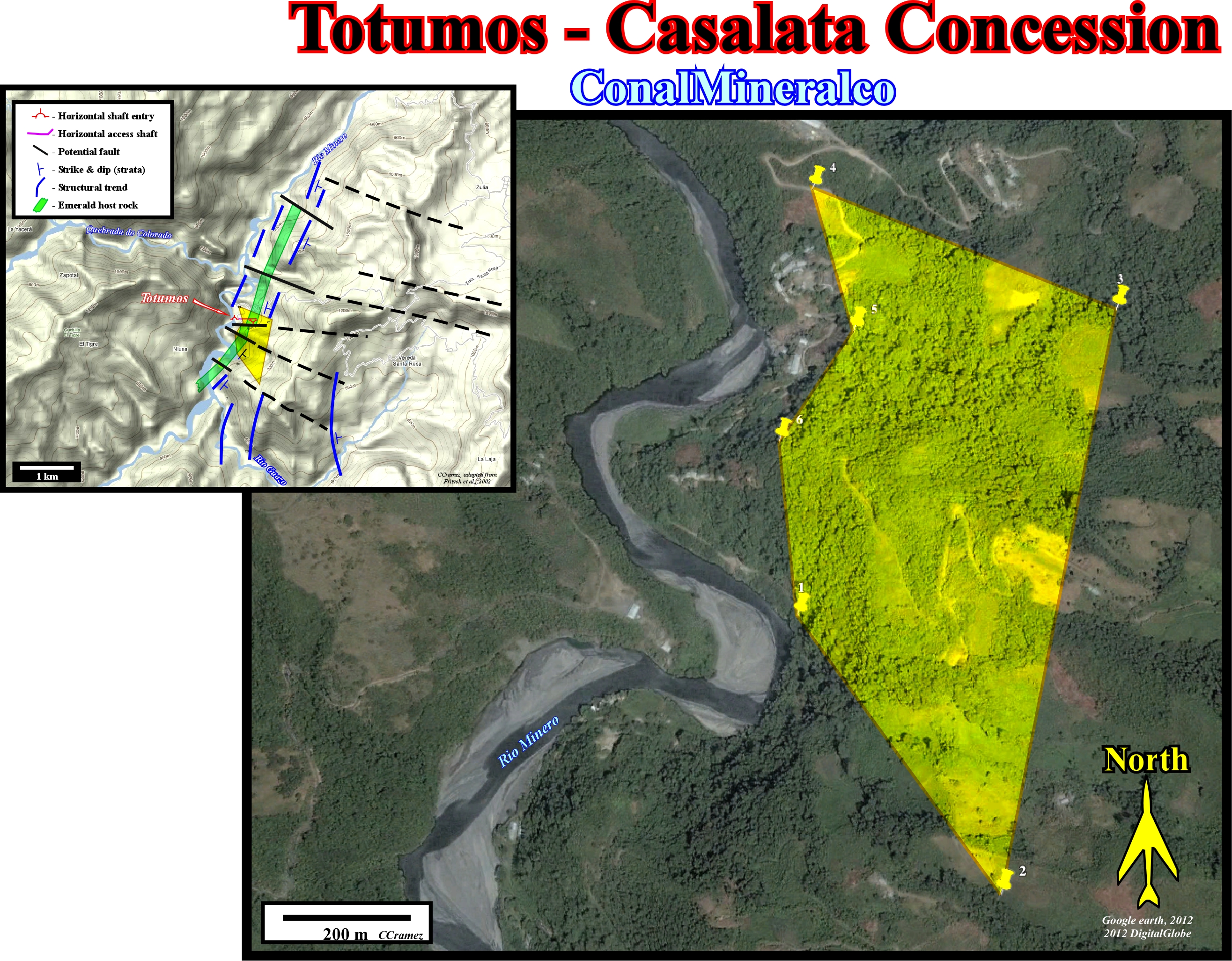
Let's take of an example the Totumos-Casalata concessions, which coordenates are : (1) 5° 35' 15, 963" - 74° 05' 21.013" ; (2) 5° 35‘ 1, 3140" - 74° 05’ 9.4855" ; (3) 5° 35’ 32, 965" - 74° 05’ 2.7737" ; (4) 5° 35’ 41, 028" - 74° 05’ 20.031" ; (5) 5° 35’ 32, 566" - 74° 05’ 17.610" ; (6) 5° 35’ 26, 055" - 74° 05’ 24.108". The Lower Cretaceous carbonaceous calcisiltites (potential emerald host rocks) outcrop near the western boundary of the concession with a eastern dip of about 70°and according to the geological sketch (left corner) seems they are affected by strike slip faults. To evaluate the remnant emerald deposits and their economical potential, before all, the following data is absolutely indispensable (see next). If does exist, it must be done as soon as possible.

In absence of a more accurate topographic map of the Totumos concession and neraby areas, the geoscientists in charge of the exploration - exploitation of the concession may use this map to make a detailed geological and structural map of all area (if it doesn’t exist), taking into account not only all field data, but all data observed along the walls of the shafts and galleries, as well. The strike and dip of the shafts and galleries must be projected in the geological map. Then, they must proposed the more likely geological cross-sections (A-A’. B- B’ and C-C’) knowing that the Lower cretaceous carbonaceous calcisiltites lie over the carbonaceous siltstones, by a décollement plane, and were shortened by an imbricated thrust system (duplexes).
Send E-mail to carloscramez@gmail.com with questions or comments about these notes .
Copyright © 2012 CCramez
Last modification: December, 2014