In the American Heritage Dictionary (2 ß College Edition), a canyon is defined as a narrow chasm with steep walls formed by running water. However, in the geological literature and particularly in the deep water exploration jargon, more or less rectilinear submarine erosional features are often called canyons. Conventionally, such a denomination implies an association with an up-dip deltaic system and particularly with an important river. In other words, the majority of geologists working in deep water environments have a tendency to explain such erosional submarine features as seaward continuations of incised valleys generated by significant relative sea level falls. In Western Africa offshore and particularly in Gabon, Congo and Angola offshore, such genetic hypothesis is not supported by seismic data. Actually, as illustrated on the plates gathered in these notes, the large majority of post-Oligocene submarine erosional features, localized in middle and upper slope, are submarine upwelling valleys (SUVs).
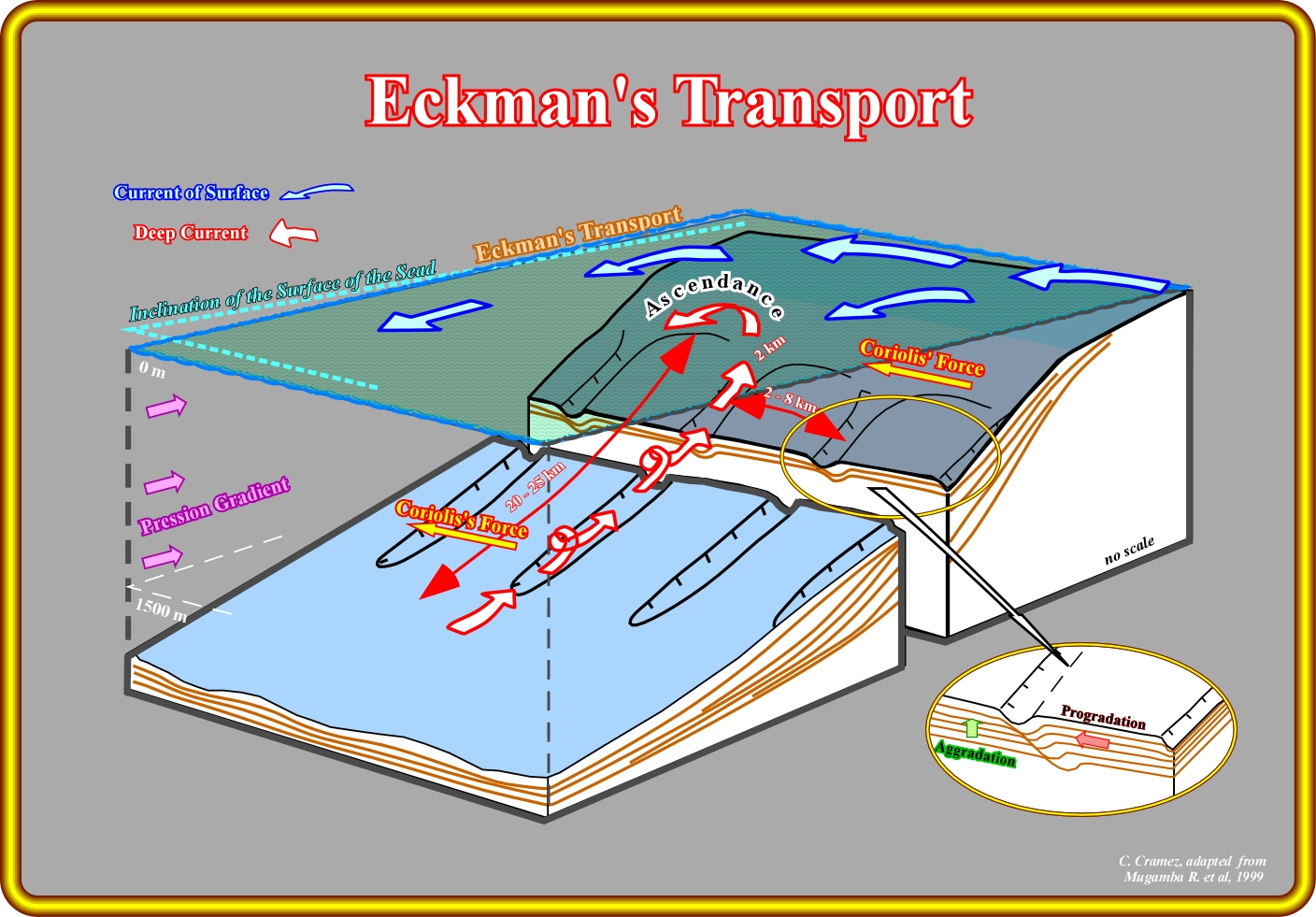
As illustrated in this plate, the combination of the wind and the Coriolis force can develop an upwelling deep current, which erodes the middle-upper part of the continental slope creating what some geoscientists call a submarine valley (SUV). Generally, at least in West Africa offshore, and particularly in Gabon offshore, such a submarine valley, in average, have a length ranging between 20-25 kilo meters and a width of more or less 2 km. The spacing between the submarine valley spacing ranging between 2 and 8 kilo meters. Obviously, due to the Coriolis force such a valleys migrate laterally (northward, in this part of the world) with time, i.e., Miocene submarine valleys are located northward of the Oligocene valleys as illustrated later. When the upwelling erosion reaches the upper section of the continental slope (more or less the shelf break), slope and shelf break failures are like, which induce turbidite currents, which composition is dependent of the predominant facies of the shelf break and upper slope.
They are created by the upwelling currents induced by Eckman transport and Coriolis deflection. In fact, as illustrated above, the bottom currents are generated by a landward pressure gradient as a result of surface current driven by the Eckman motion. With time, wind-driven surface water motion extends downward into the water column, but speed decreases and direction changes because of Coriolis deflection. The Eckman Spiral is the spiralling pattern described by changes in water direction and speed with depth. Eckman transport is the net transport of water by wind-induced motion. Net transport of the water in an Eckman spiral has a Coriolis deflection of 90° to the direction of the wind. Along coastal areas Eckman transport can induce downwelling or upwelling by driving water towards or away from the coast, respectively. Through time, the SUVs are constructed by progradation and nondeposition on the northwest edge. The filling of the SUVs takes place when erosion reaches the uppermost part of the upper slope, and originates a retrogradational sequence of catastrophic gravitational slumps of the shelf break. The filling has a backstepping geometry associated with a turbidite origin. The facies is a direct consequence of the lithology of the shelf edge sediments. It is sandprone when the depositional coastal break is sandy and located near the shelf break in order to be affect by the shelf - slope failure. The length of the bypass zone is function of the amplitude of the shelf - slope failure. Medium (Type II, in Mutti’s terminology) or large (Type I) turbidite systems can be deposited under the capping small turbidite shaly system. Medium turbidite systems are more likely, since the relatively small size of the SUVs (2-4 km by 200-400 meters) cannot induce gigantic slope-shelf failure and associated large submarine erosions (NB - Turbidite system is here considered in a systemic or holistic sense (General Theory of Systems), i.e., a turbidite system is an integrated whole which properties cannot be reduced to those of its parts).
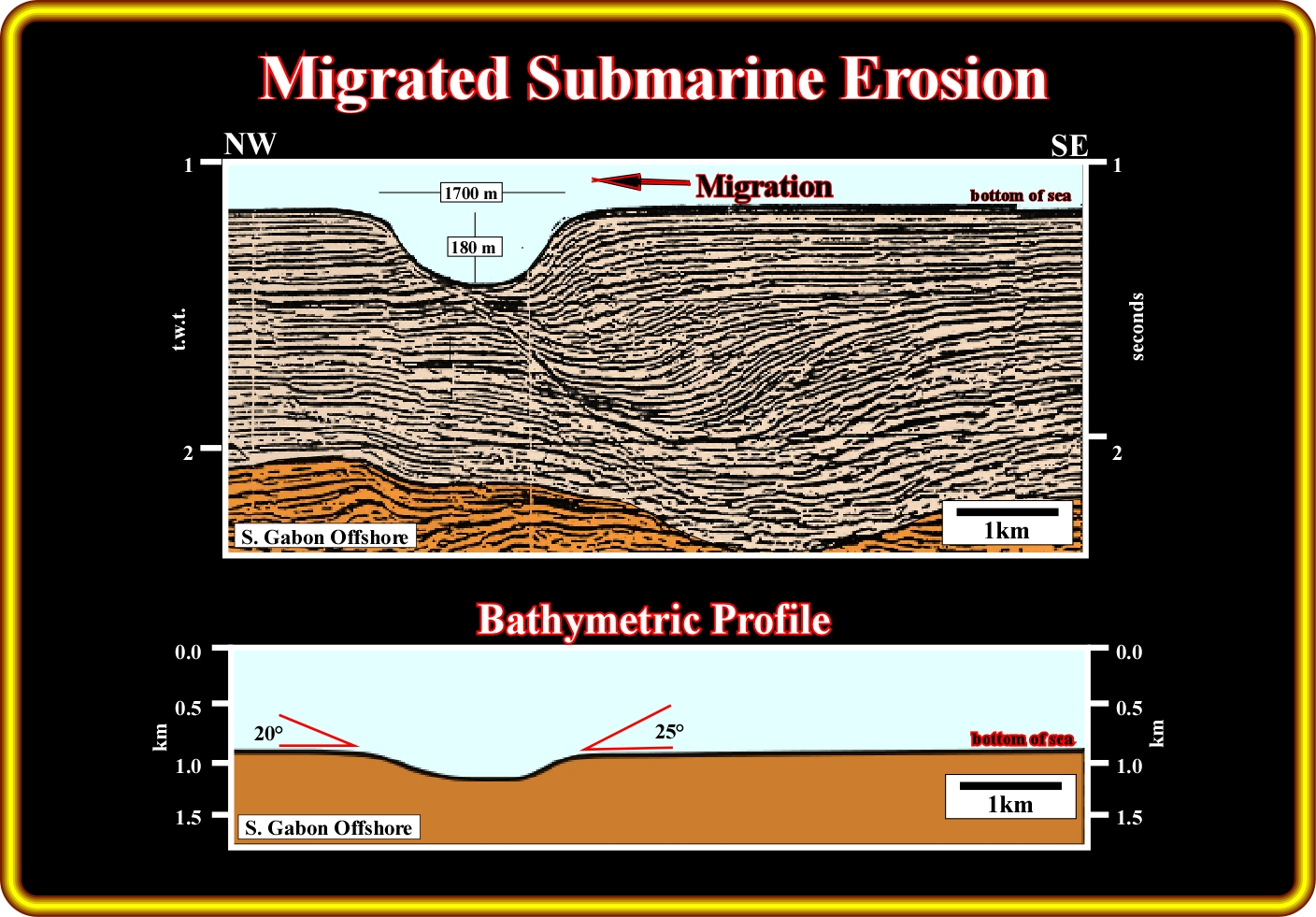
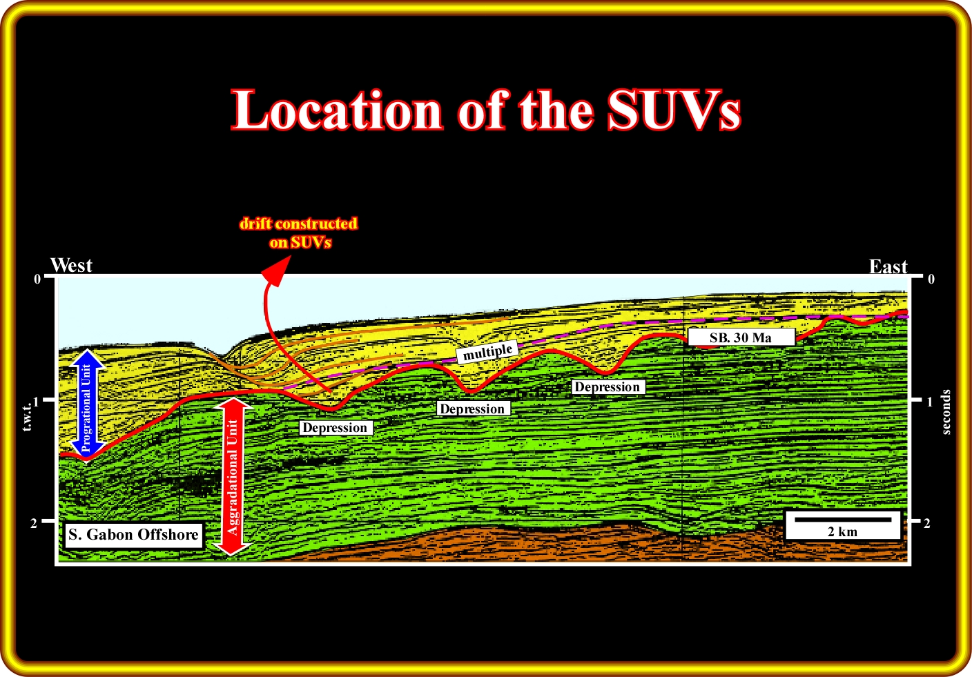
As observed on this strike seismic line, North-South migrating submarine erosion fills are expressed by aggradational and progradational deposits. The sea floor is affected by a present SUV , strongly suggests that submarine erosion is still active. At natural scale (1:1), the bathymetric profile (on bottom) shows the topography of the recent submarine valley : 1700 m in width and 180 m deep.
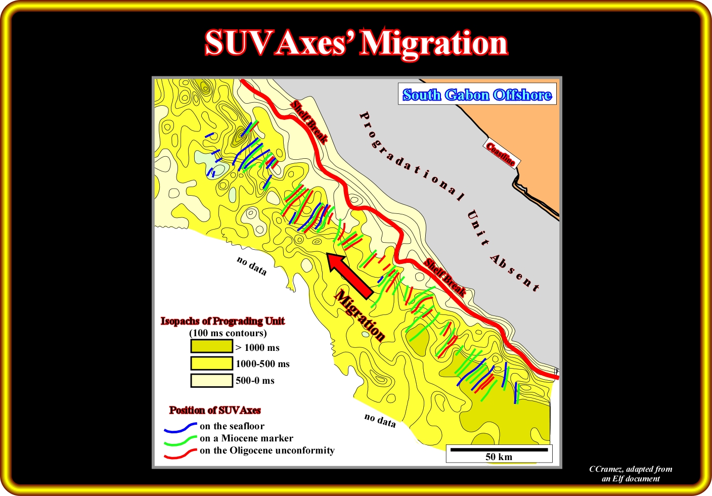
This plate illustrates the cartography of the SUV axes on three seismic markers representing three time slices superimposed on a isopach map (in meters) of the Oligocene - Recent progradational interval. The SUVs (submarine valley) are perpendicular to the shelf break. Admittedly, the submarine valley migrate northward through time due to the Coriolis deflection, which corresponds to the deflection of moving objects when they are viewed in a rotating reference frame (in a reference frame with clockwise rotation, the deflection is to the left of the motion of the object; in one with counter-clockwise rotation, the deflection is to the right). It is important to notice, that the progradational interval which is not present on the shelf has the maximum thickness in the upper-slope where the SUVs are located. On the other hand, there any deltaic depositional system on the continental platform, that is to say, landward often shelf break.
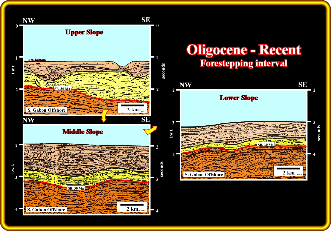
These three strike seismic lines (parallel to the continental slope) illustrate, clearly, that in Gabon offshore, the post Oligocene progradational units thins basinward ( the geometrical relationship of the reflection terminations at the bottom of the yellow interval are apparent, i.e., they are not onlaps but downlaps). Referring to the yellow seismic interval, it is easily to realize that its maximum thickness is observed in the upper slope and it thins progressively basinward to become stratigraphically condensed toward the abyssal plain. The nature of the submarine valley is turbiditic, but facies (lithology) is difficult to prognosticate.
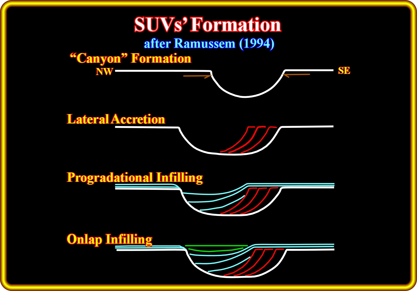
The tentative geological interpretations of the strike seismic lines, in the Gabon offshore, proposed by Ramussen (1994) suggest him the conjecture that the infilling mechanism of the submarine valleys, created by an upwelling and northward migrated erosion, is similar to the infilling of the incised valley, formed during lowstand periods, that is to say, filled during sea level rise and highstand geological periods. During the infilling of the submarine valleys, from bottom to top, he considered three major phases : (i) Lateral accretion ; (ii) Progradational infilling and (iii) Onlap infilling.
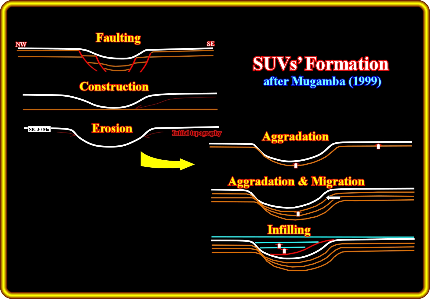
Using, more or less, the same seismic data, Mugamba (1999) propose an alternative interpretation of the submarine valley observed in the Gabon offshore. The submarine valleys are for Mugamba formed, preferably, over the areas affected by normal faulting (lengthening). In the formation and infilling of the SUVs, Mugamba considered several phases: (i) Faulting : (ii) Construction ; (iii) Erosion ; (iv) Aggradation ; (v) Aggradation and Migration and Infilling. The Mugamba hypothesis is quite similar to the one proposed previously by Ramussen (both geoscientists work or have worked in the same oil company, ELF). Mugamba associated the origin of the submarine valley just with the unconformity SB. 30 Ma, that is to say, for him, there is not SUV in the pre-Oligocene interval, which see quit likely. On the contrary, the tectonic control of the erosion (burial due normal faulting) on the Oligocene unconformity (SB 30 Ma) is highly refutable.
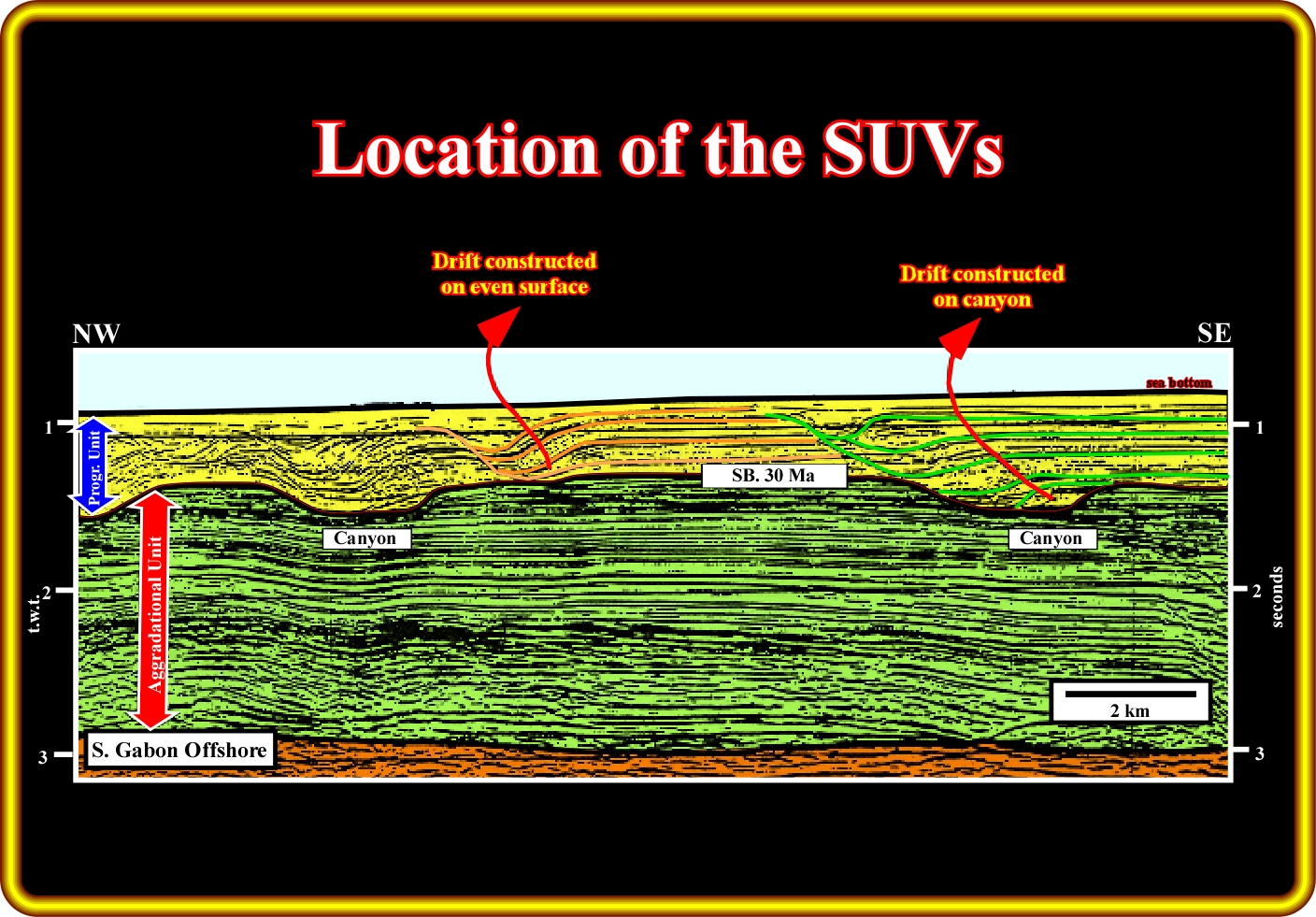
As illustrated on this geological tentative interpretation of a seismic line from the south Gabon offshore, as suggested by Mugamba, erosion initiating the formation of submarine valleys (here labelled "canyons") starts at the unconformity SB 30 Ma, which for several geoscientists is associated with an important glaciation (relative sea level fall). In fact, the northward migration of the SUVs is developed exclusively within the post-Oligocene progradational unit (yellow interval). In other words, one can say that this tentative interpretation suggest that the northward migration of the submarine valleys is mainly post-Oligocene and that they are initiated above negative topographic features on the major Oligocene unconformity (SB. 30 Ma).
As on the previous geological tentative geological interpretation, the northward drifting of the moats (SUVs) created on the unconformity SB 30 Ma is only visible within the progradational unit (coloured in yellow). In this particular case, it is obvious that the submarine valleys are initiated above bathymetric features of the major Oligocene unconformity (SB 30 Ma). On the other hand, the geometry of the SUVs et the time of their inception is maintained through the Present.
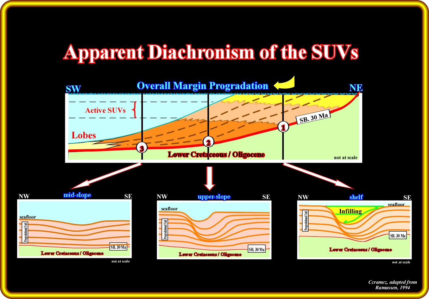
This sketch illustrates how the overall basinward progradation of the divergent margin accounts for the apparent diachronism of the SUVs. Note the active submarine valley zone. Similarly, it is important to notice the infilling of the submarine valleys in the upper slope. Such infilling, when done in highstand geological condition, is, probably, of turbiditic nature, that is to say, due to turbidite currents triggered by slope failures induced by the erosion associated with the upwelling currents or flush floods (Mutti's turbidite model). When the infilling of the submarine valleys is realised during lowstand geological conditions, i.e., when the sea level is lower than the shelf break, the turbidite currents can easier be explained by the Vail's model.
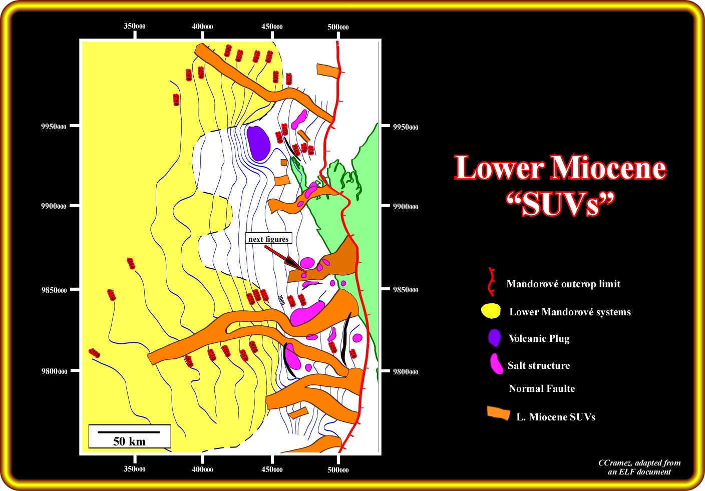
This plate illustrated a tentative cartography of a Lower Miocene submarine valleys in Southern Gabon offshore. The time contours are those of a seismic marker near the Lower Miocene unconformity. Notice the geometry of the SUVs (orientation, width and spacing) and the take into account that the submarine valleys incise Eocene and Oligocene sediments as illustrated in next plates.
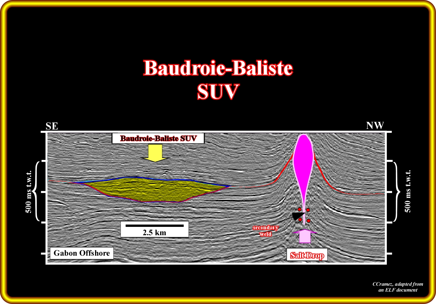
On this geological tentative interpretation seismic line of south Gabon offshore (location on the previous plate), the infilling of a Lower Miocene submarine valley, in which the Baliste and Baudroie fields are located, is easily identify southward a a salt diapir (in fact the oil fields are located between two salt structure, but just the northern one is visible on this line). The filled submarine valley is around 4 kilo meters wide and roughly 400 meters thick. The differential compaction associated with SUV fill sediments suggests a sand-prone facies.
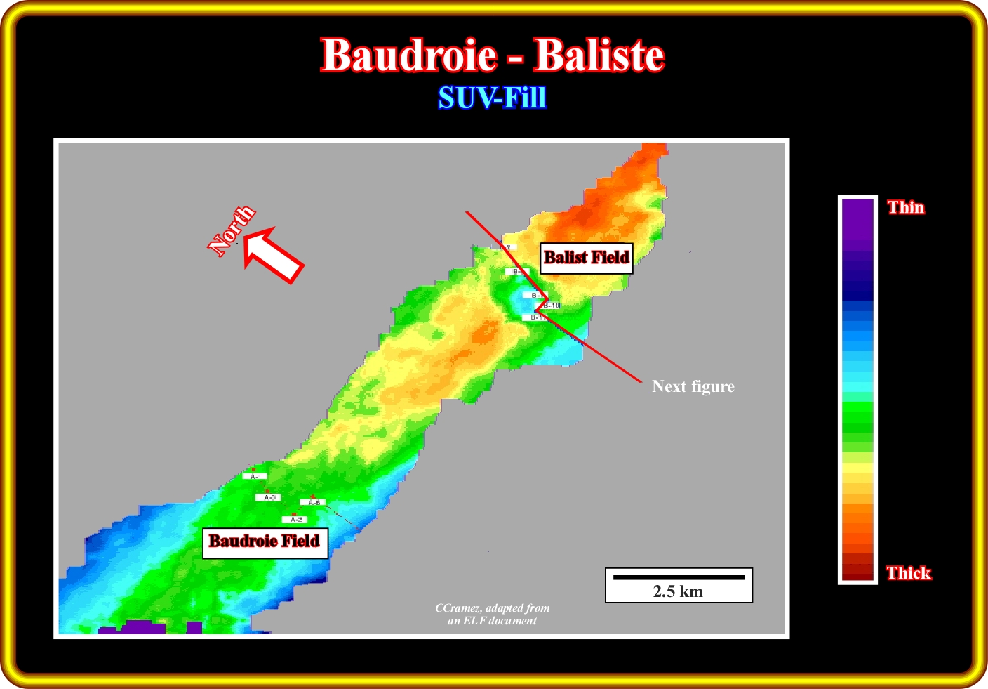
The isopach map of the Baudroie-Baliste SUV-fill shows an increasing thickness southward (Baudroie field). Such a thickness changing suggests a retrogradation or a backstepping infilling of the submarine valley, that is to say, an infilling from the bottom to top.
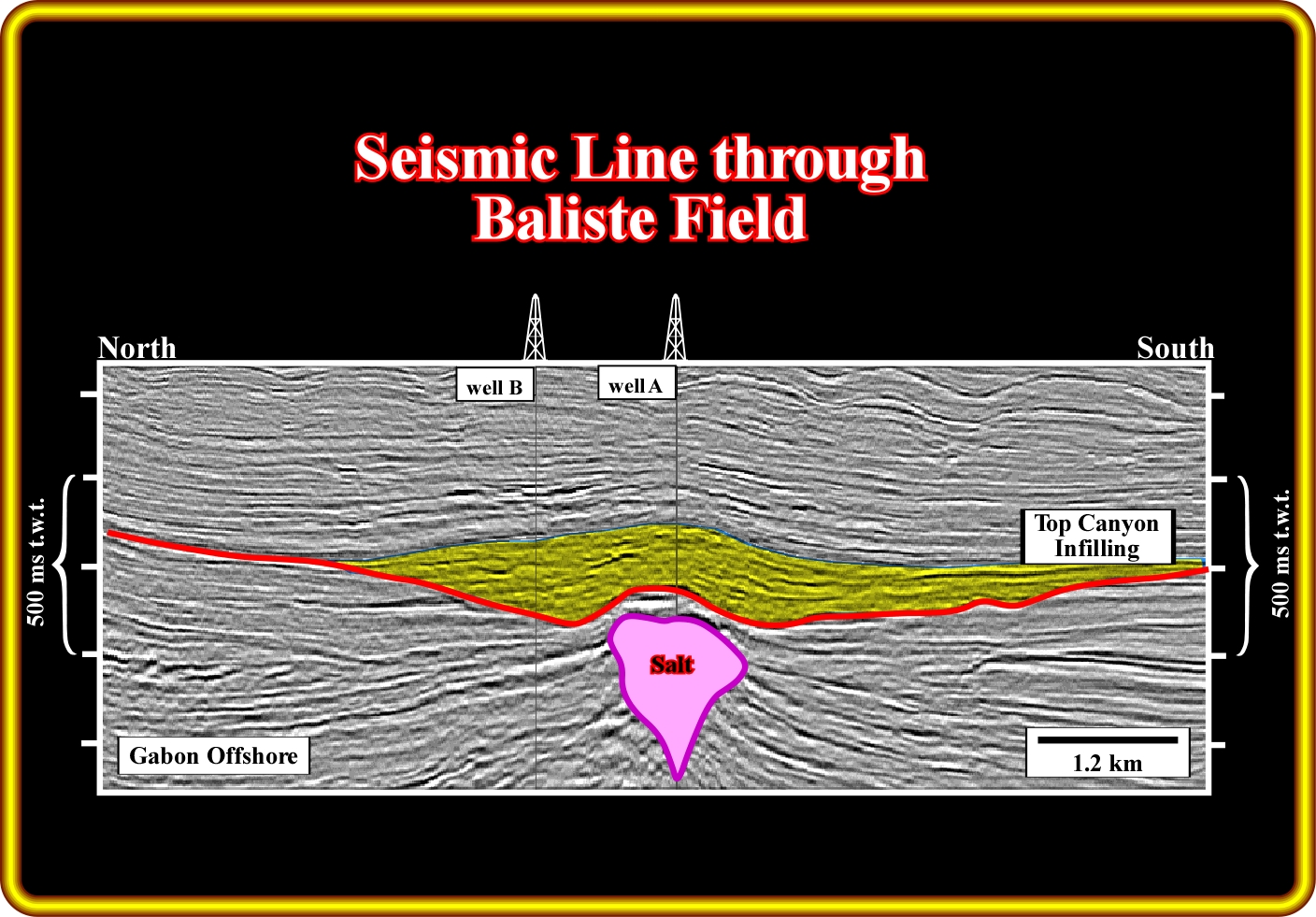
The seismic line traverses the through Baliste field. The schematic tentative interpretation suggests a tectonic inversion of the SUV-fill (here labelled canyon-fill), most likely, in association with the emplacement of the salt diapir The trapping is structural and the time of inversion is prior to the major migration phase of the hydrocarbons Notice that the causation and evolution of the submarine valley seems to be totally independent of the salt tectonics and halokinesis.
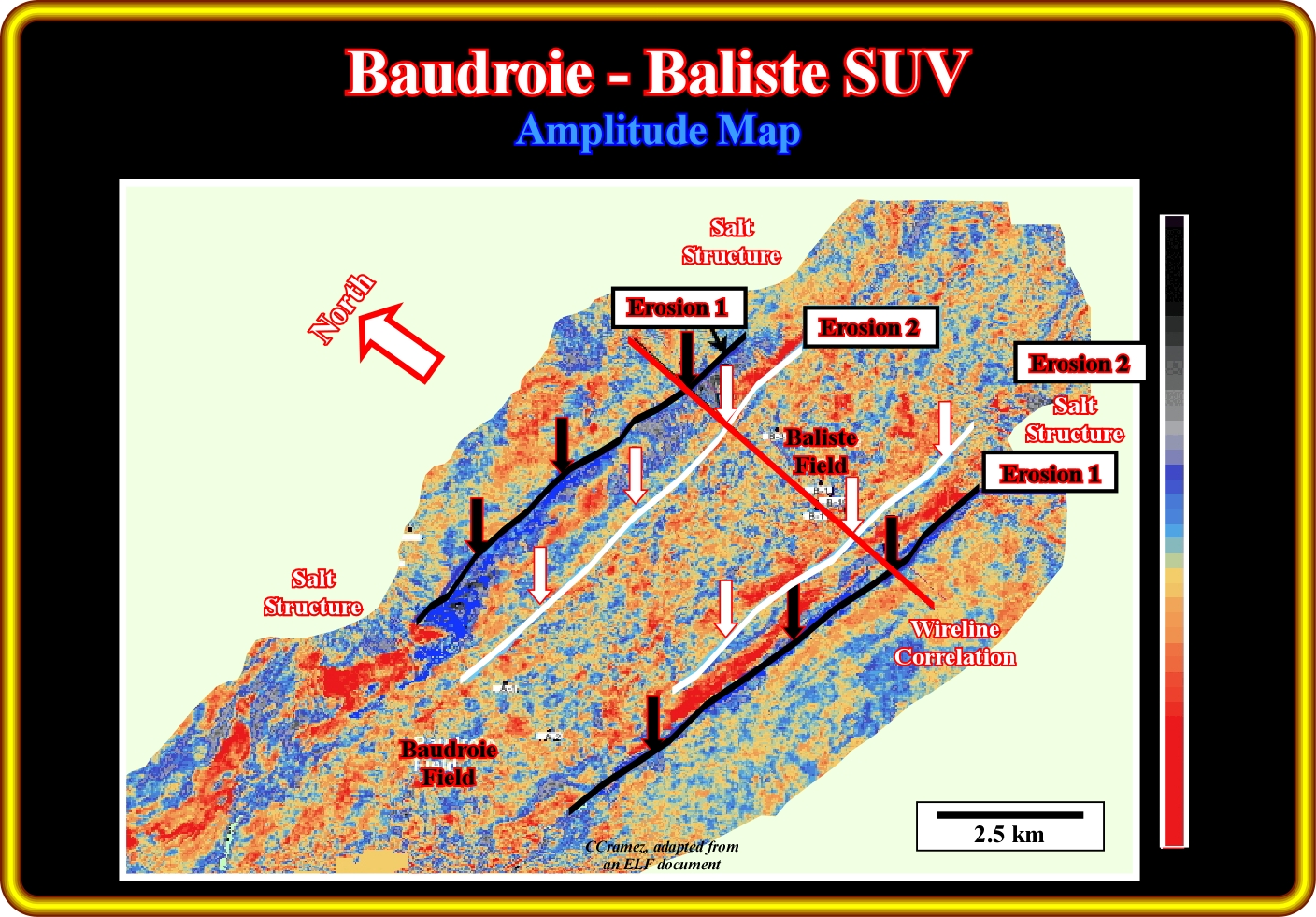
This amplitude extraction map (top SUV surface moved down 152 ms) shows lineaments trending roughly East-West. Such lineaments are interpreted as erosional belts which become progressively narrower trough time (erosion 1 older than erosion 2). Do not forget that, as suggested on the tentative geological interpretations of the seismic line illustrated on the previous plates) the salt structures postdate the infilling of the submarine valleys and so the evolution of the SUVs is not constrain by the salt tectonics and/or halokinesis.
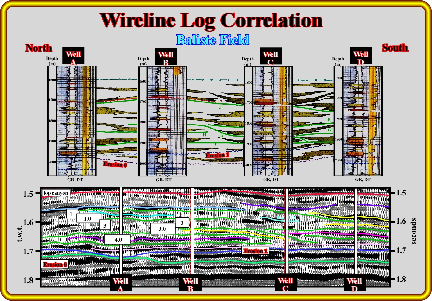
This plate illustrate the a tentative interpretation of a seismic cross-section and wireline log correlation. The sandstone bodies do not correlate each other. A random distribution pattern of the sandstone bodies is likely. The sandstone bodies, often called erroneously channels, come progressively narrower and thinner upward.
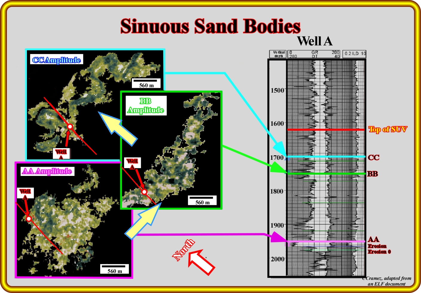
This plate illustrates a three dimensional evolution of the sand-channel elements within Baudroie-Baliste submarine valley. The high amplitude-related to sinuous sand bodies gradually develop up section. They are roughly correlative to a gradual decrease of the sand/shale ratio in the channelized sand bodies.
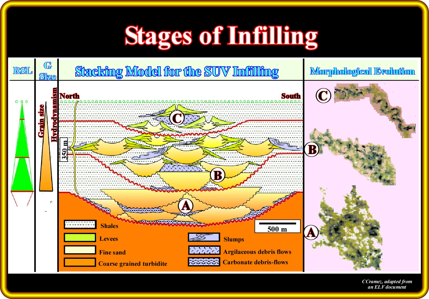
This schematic diagram shows the different infilling scales of the Baudroie-Baliste submarine valley. The stratigraphic cycles display a retrogradational trend which is correlative with a decrease in thickness as observed from wireline logs and a decrease in the sand/shale ratio. It is important to notice that more the morphology of the sand bodies has a meandriform morphology more shaly are the potential reservoirs.
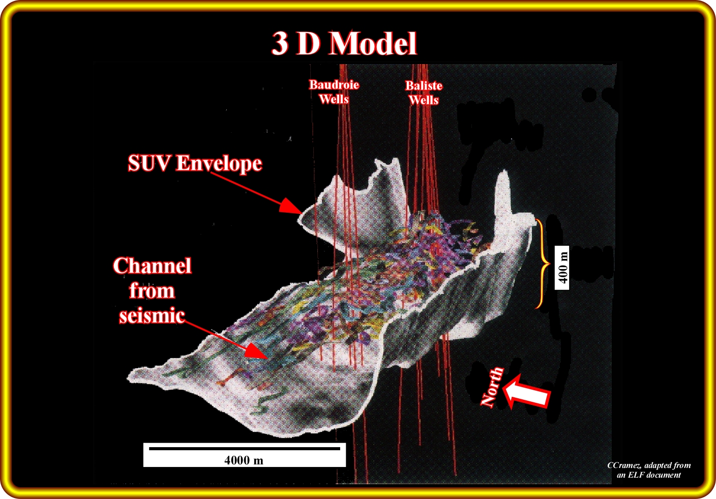
This plate illustrate a 3D model showing the distribution of sinuous turbidite sand bodies recognized within Baudroie-Baliste submarine valley, which limits are quite deformed by salt tectonic and halokinesis, which are in the part of the Southern Gabon offshore quite active.
to continue press
![]()
Send E-mail to carloscramez@gmail.com with critics, corrections or commentaries on these Turbidite Deposits notes.
Copyright © 2001CCramez
Last modification : November, 2013