
On this seismic line, geoscientists trained in the breakup of the supercontinents and, particularly, in the breakup of the southern continent of the Pangea, that is to say, the breakup of the Gondwana, recognized, easily, in the lower right par of the line, the subaerial lava flows, which are emplaced, immediately, after the breakup of the lithosphere. Above the lava flows, which dip and thickening sea, that is to say, to spreading centres, on the divergent continental margin, from the bottom to top, one can recognize : (i) The retrogradtional transgressive phase of the post-Pangea continental encroachment cycle and (ii) The progradational regressive phase. Within the progradational phase of the continental encroachment cycle two different intervals, separated by an unconformity (erosional surface , induced by a significant relative sea level fall, can be recognized. Turbidite deposits are likely on the abyssal plain in the lower part of the progradational interval, as well as in the upper part, at the bottom of the growth faults.
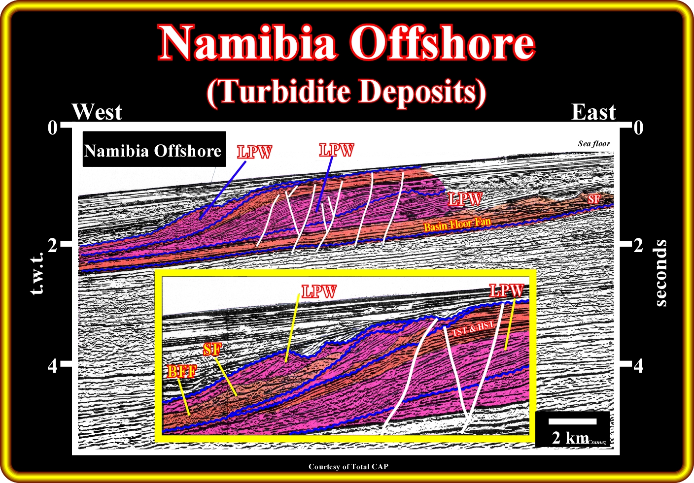
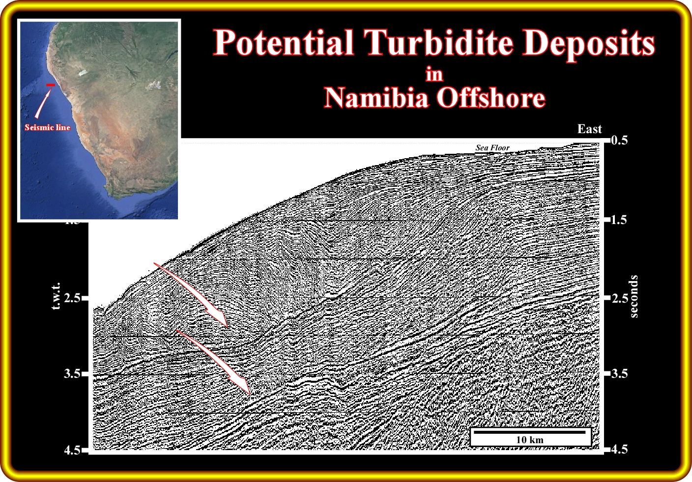
On this geological tentative interpretation of a seismic line of the Namibia offshore (located northward of the seismic line illustrated on the previous plate), basin floor fans (BBF) and slope fans (SF) are easily recognized above the unconformities bounding different incomplete sequence-cycles (the highstand systems tracts are absent or under seismic resolution). Admittedly, such a potential turbidite deposits are easily explained by the Vail's turbidite model. In fact, one can assume that at each relative sea level fall, the continental platform, i.e., the shelf, when it exists, is exhumed and eroded, as well as, the coastal plain with formation of incised valley and deposition of turbidite deposits (basin and slope fans), in the deeper part of the basin. The incised valley, which underlies the associated unconformity (erosional surface) are filled later at the time of the upper pat of the lowstand prograding wedge. Notice that at each significative sea level fall, the mouth of the rivers (and associated coastal onlaps) are shift seaward and basinward, that is to say, that the rivers' discharge takes place directly on the slope, which creates turbidite current down to slope, which are the responsible of the turbidite deposit recognized on this geological tentative interpretation.
B.1- Namibe Offshore
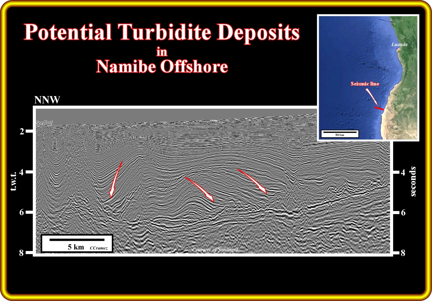
On this seismic line of the southern Angola offshore (Namibe basin), the breakup unconformity is easily recognised, in the lower right corner of the line. it (interface between rift-type basin sediments and margin infrasalt sediments) is tectonically enhanced, which creates an angular unconformity. Similarly, the salt induced tectonic disharmony, as well as the salt and associated salt structures can be picked without difficulty. Above the salt, turbidite deposits are likely in rimsynclines of the depocenters and turtle back structures. The thickening of the sediments toward the synsedimentary faults welds and the associated amplitude anomalies strongly suggest sandprone turbidite deposits. The turbidite currents are, here, better explained by the Mutti's turbidite model (slope failures, salt induced slumps, halokinesis, flush floods, etc.) since the geological conditions seem to be rather of highstand (sea level above the shelf break) than lowstand.
B.2- Benguela Offshore
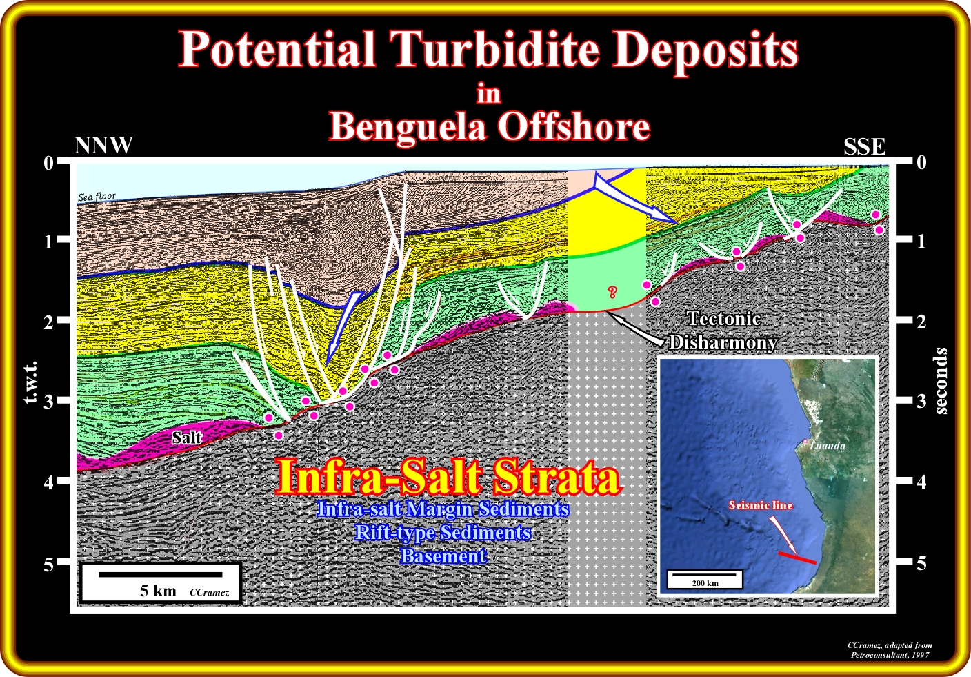
On this geological tentative interpretation of a seismic line from the southern Angola offshore (Namibe basin), above the salt induced tectonic disharmony, that is to say, above the bottom of the salt or associated primary salt welds, it is, relatively, easily to recognize the transgressive backstepping stratigraphic phase (coloured in green) of the post Pangea continental encroachment cycle, as well as the overlying regressive phase (yellow and beige). Taking into account the influence of the salt tectonics and halokinesis (tectonic vector = 0), one can say that the geometry of the transgressive phase is, mainly, retrogradational (backstepping predominates aggradation) and the facies an interbedding of limestones and shales. On the contrary, the geometry of the regressive phase, which is individualised from the transgressive phase by a major downlap surface, is progradational (upbuilding predominates outbuilding). Two different sedimentary packages (coloured in yellow and beige), separated by a significant relative sea level fall (unconformity), can be individualized within the regressive phase, in which the progradation (seaward and upward displacement) of the shelf break, which is here, more or less, coincident with the shoreline (depositional coastal break), is readily followed. These geometries suggest that during the transgressive phase, the basin has, generally, a continental platform (shelf), what means, that the shoreline was located landward of the shelf break, which is not the case during the regressive phase since, at least seismically, the shoreline is, more or less, coincident with the shelf break (the basin has no shelf). Subsequently, turbidite deposits are likely within the regressive phase in association with significant relative sea level falls (locally enhanced by the lengthening created by the salt tectonics), which displace the mouth of the rivers toward the upper continental slope triggering turbidite currents down to slope On the contrary, the probability of found Vail's turbidite deposits is quite small in the transgressive phase. If there are turbidite deposits within the transgressive phase, they will be, mainly, caused by flush floods, and they will be located on the shelf at the bottom of deltaic slopes (proximal turbidites).
B.3- Kwanza Offshore
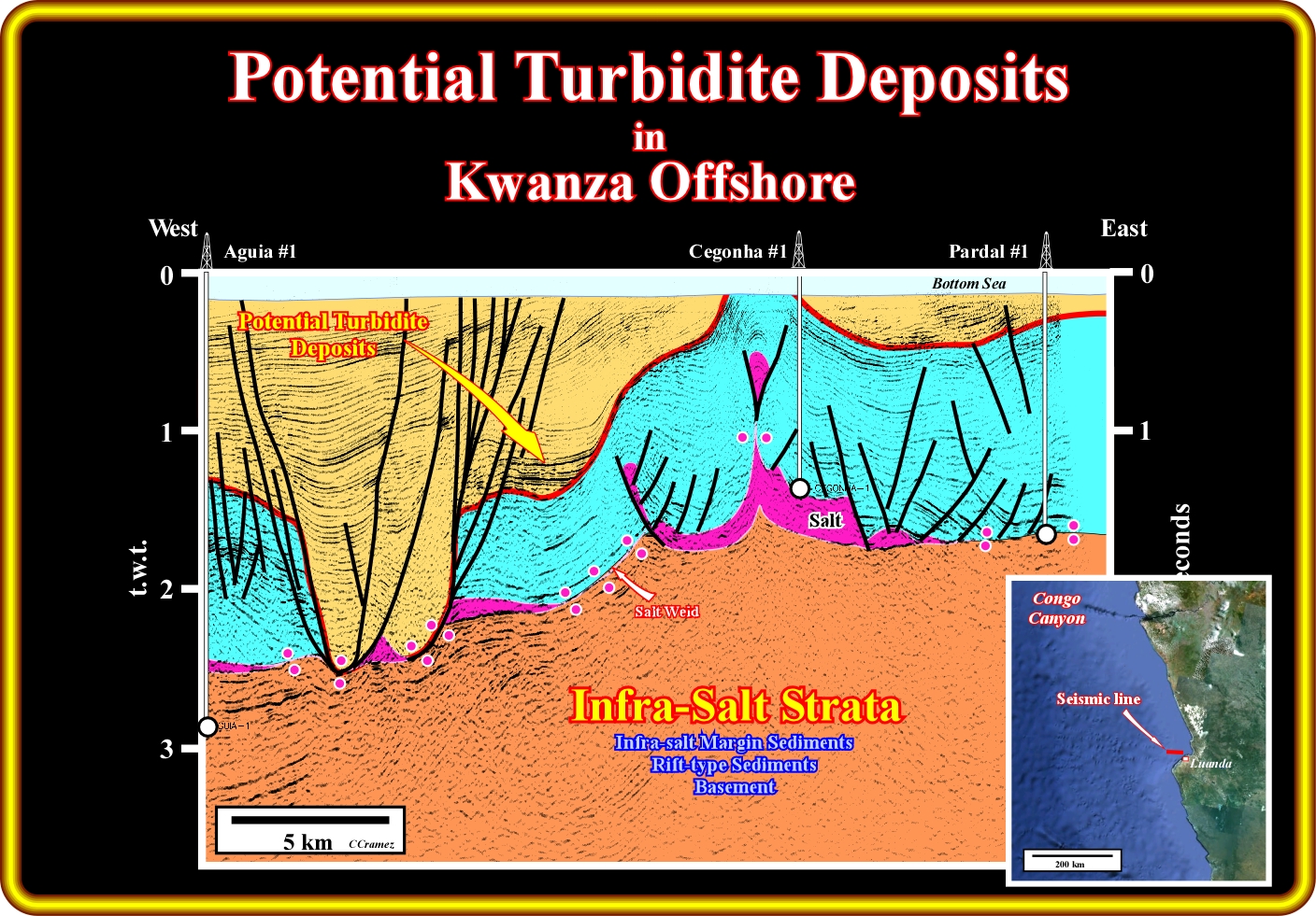
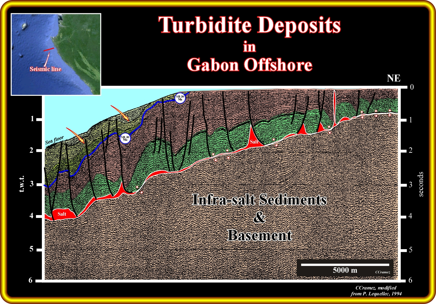
On this geological tentative interpretation of a seismic line of the Kwanza offshore, located not far from the Angola capital (Luanda), in block 6 exploration block, potential turbidite deposits (undrilled so far) are, easily recognized, onlapping the Oligocene unconformity (picked in red on this tentative interpretation). The sea level fall, which created such unconformity (SB. 30 Ma), which is recognized all along West Africa offshores, is explained by most of the geoscientists by glacio-eustasy. However, on this tentative interpretation, taking into account the geometry of the salt induced tectonic disharmony (bottom of salt) and the reflection terminations at the bottom of the sea (toplaps by truncation), the Oligocene unconformity can be easily explained as a consequence of a significant uplift of the eastern part of the basin (proximal area). In fact, such a Tertiary uplift, which is recognized regionally, developed lowstand geological conditions that, strongly, favour the deposition of turbidite deposits, mainly according to the Vail's turbidite model. It is interesting and important to notice that in Kwanza offshore (southward of the Ambriz structural arch), the facies of the Tertiary sediments are mainly shaleprone. The results of the offshore exploration wells do not show significant turbidite deposits as in Congo basin (northward of Ambriz structural arch). Actually, southward of the Congo river and Congo canyon, just and two small rivers (Kwanza and Cunene) reach the sea and they do not developed any canyon on the shelf or upper continental slope. So, why are you prognosting sandprone turbidite deposits on this geological tentative interpretation (large yellow arrow) not far from Luanda city, which is located more than 50 km northward of the present mouth of the Kwanza river ? The reason is that, the geological and morphological maps of the onshore Kwanza basin strongly suggest that, before the Tertiary uplift of eastern part of the basin, the path of the old Kwanza was, more or less, South-North and the mouth was located northward of Luanda (roughly between Cegonha and Pardal wells on this tentative interpretation), near the Sao Tiago beach (northward of the Sonangol refinery). However, after or during the Tertiary uplift of the basin, the Kwanza river, in the area of Bom Jesus, shift westward to its present position. In other words, potential sandprone turbidite deposits can be prognosticated on this tentative interpretation, seaward of the Oligocene continental break (basin without shelf), because, locally, the terrigeneous influx, at mouth of the old Kwanza river, can be appropriated.
B.4- South Congo Offshore
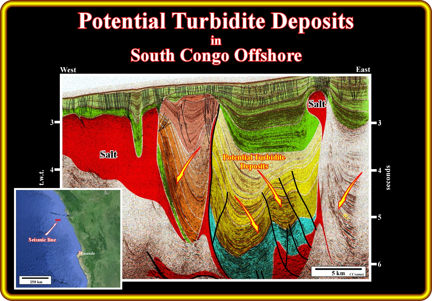
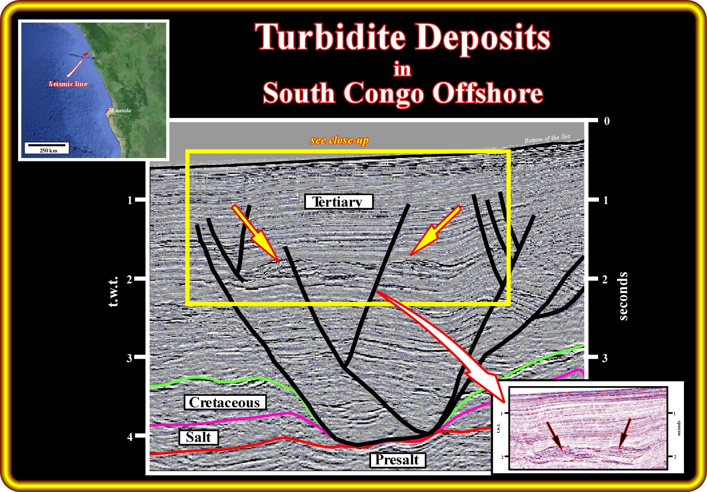
On this geological tentative interpretation of a seismic line from southern Congo basin, that is to say, located in deep water, between the Congo Canyon and the Ambriz structural arch of the basement, the most prolific known petroleum system is Cretaceous/Tertiary. In fact, the principal marine source-rocks are, mainly, the organic rich transgressive shales (Cenomanian-Turonian in age) and the main reservoir-rocks are turbidite deposits as indicated on this tentative interpretation (the carbonate reservoir-rocks of the transgressive phase of the post-Pangea continental encroachment cycle, principal resrvoir-rocks in conventional offshore, are, here, alternative reservoirs, because they are too deep and they do not have amplitude anomalies associated). These turbidite deposits can be explained by Vail and Mutti's turbidite models. However, in our opinion, the Mutti's model explain better the sinuous turbidite channel sandbodies. In fact, in the southern Congo basin, so far, the exploration wells did not put in evident any basin floor fan (Turbidite type I in Mutti's model). The majority of the oil bearing reservoirs are infillings of turbidite channels (when erosion and incision are evident) or infilling of depression between the shaleprone turbidite lateral lobes ("gully wings" of P. Vail). Admittedly, on this area, the turbidite deposits are, easily, recognized not by a conventional geological approach, but, indirectly, by the associated seismic anomalies, induced by the presence of hydrocarbons in the pores. Actually, so far, the petroleum exploration is, exclusively, based on the presence of seismic anomalies explained not only by the presence of hydrocarbons but by the high porosity of the turbidite deposits as well. On this subject, it is interesting to say that below the inversion point, were, normally, there is no more seismic anomalies (do not confound with geological and stratigraphic anomalies), the basin is immature at the exploration point of view. Notice that, in spite of the fact that the oil bearing reservoirs rocks are turbidite deposits, which by definition are deposited in low area, the large majority of the oil fields are located in structural highs (antiforms and not anticlines). This means that the low deposition areas became high structural areas by a strong and evident salt tectonic inversions and reactivation of the old fracture zones.
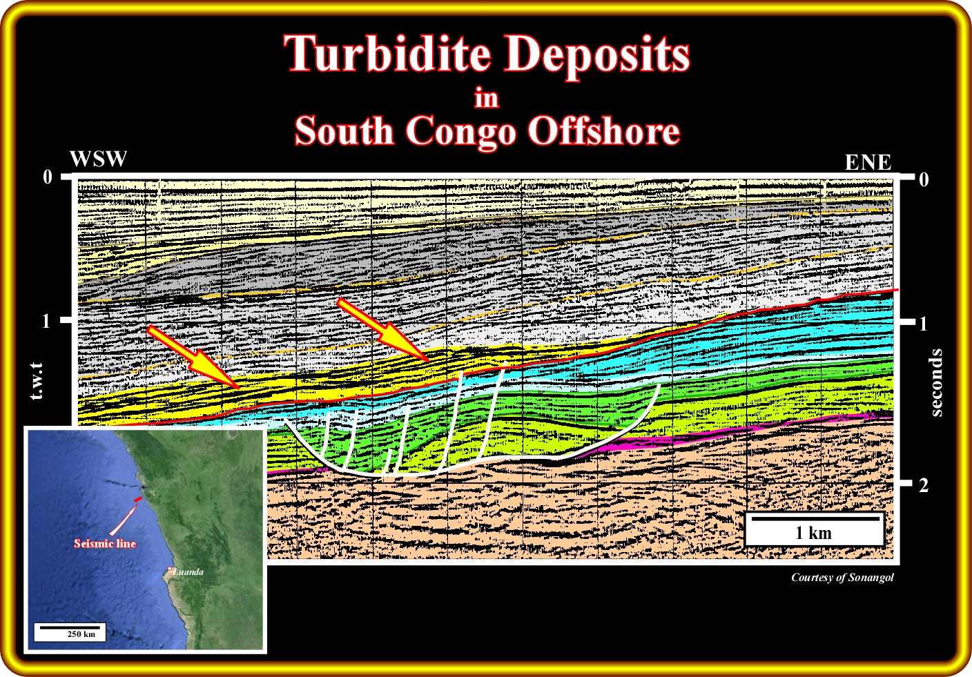
On this geological tentative interpretation of a seismic line located in the conventional south Congo offshore (block 2 or 3), evident turbidite deposits onlap the Oligocene unconformity (SB. 30 Ma). Such a feature, probably, means that the turbidite currents responsible by the depositions of these turbidites were, likely, triggered by relative sea level falls, which put the sea level below the shelf break and displaced, seaward, to the upper continental slope the shoreline and associated depositional systems. Such a displacement exhumed the old shelf, which created an erosional surface (unconformity) and a great increasing of the terrigeneous influx. In other words, the accommodation (space available for the sediments) decrease strongly and the amount of sediments increased enormously, which creates at the shoreline (now equivalent to the shelf break, sin the basin has no shelf) a critical state, way out of balance, where minor disturbances may lead to catastrophic events (turbidite currents). Within the regressive progradational interval overlying the unconformity SB. 30 Ma, i.e., overlying the sediments of the transgressive phase of the post-Pangea continental encroachment cycle, few sedimentary packages, probably, continental encroachment stratigraphic subcycles, induced by second order eustatic cycles (duration time ranging between 3-5 and 5o My), are visible. In association with limits of these different regressive packages, in association with the bounding unconformities (erosional surfaces) there are turbidite deposits, particularly, seaward of the deepwater breaks (limit continental slope-abyssal plain) of each subcycle or sequence-cycle boundary, were the depositional hiatus is the smallest (it gives the age of the unconformity).
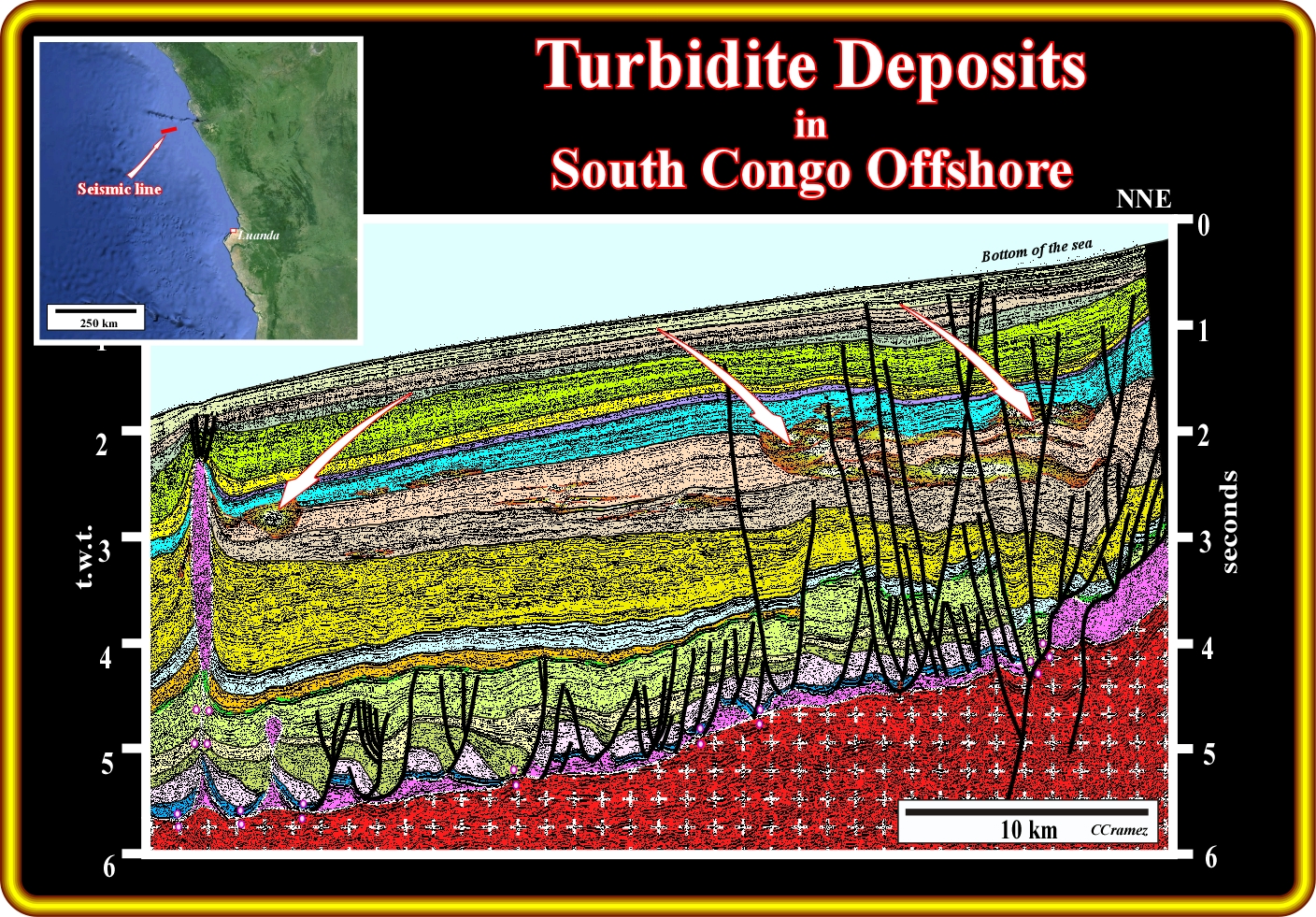
On this geological tentative interpretation of a seismic line of south Congo basin, not far from the Congo Canyon, the seismic anomalies underlie turbidite deposits mainly channel-levees complexes. There is no evidence of basin floor fans. On the contrary, few typical "gully wings" are easily recognized. All evident potential turbidite deposits are localised in the middle-upper part of the Tertiary sedimentary package (regressive phase of the post-Pangea continental encroachment cycle). In the lower part of the Tertiary, probably, below the inversion point, that is to say, where sandprone intervals, even saturated by hydrocarbons, have a higher acoustical impedance that the shaleprone intervals, there is not direct evidence of the turbidite deposits. This does not means that there is not turbidite deposits. Probably, they are there, even with hydrocarbons, but their recognition implies much more geological studies and particularly a detailed sequential stratigraphy analysis. It is interesting to point out that, in spite of the fact that Petrofina found oil bearing Tertiary turbidite in the conventional offshore of South Congo basin, at the beginning of the deepwater exploration in Congo and Kwanza offshore, any oil company was looking for turbidite reservoirs, but for the conventional limestone reservoir-rocks found under shallow water and that still a producing in blocks 2, 3, 17, etc. In fact, it must be said and re-said, that the first significant oil field oil fields as Girassol and Kuito were discovered by pure serendipity (accidentality), since the targets were avowedly the Cretaceous limestone turtle back structures. Fortunately, in a normal stratigraphic column, before reach the Cretaceous one needs to drill the Tertiary. In fact, the Cretaceous Girassol turtle back, for instance, was known, since 1966-1968, by all geoscientists working in Angola and Congo-Cabinda, since it was more than obvious in the regional Sefel seismic lines lines.
On this geological tentative interpretation of a seismic line of the Congo basin, located northward of the Congo Canyon (not too far), the more likely location of the Tertiary turbidite deposits are easily to prognosticate. In fact, above the major unconformity (erosional surface), which, probably, corresponds to the Oligocene unconformity (SB. 30 Ma), associated with a significant relative sea level fall, one can recognize the deposition of the upper regressive phase the post-Pangea continental encroachment cycle. The lower part of the regressive phase (green tones) is just recognized in the right part of the tentative interpretation, below the Oligocene unconformity and above the maximum flooding surface (MFS. 91.5 Ma), which corresponds to the interface between the dark green and the underlying light green interval. Globally, the stratigraphic regressive phase is progradational, which contrast with the retrogradational (aggradational) geometry of the transgressive phase limited between the breakup unconformity and the MFS. 91.5 Ma. In addition, to the sea level fall associated with the Oligocene unconformity, the uplift of eastern part of the continental margin (see the toplap reflection terminations at the bottom of sea) created lowstand geological conditions during which turbidite depositional systems were deposited, at the bottom of the continental slope at each relative sea level fall. These turbidite deposits not only onlap the unconformity SB. 30 Ma seared of the continental break (basin without shelf), but all other unconformities (erosional surfaces) bounding the different continental encroachment subcycles composing the regressive stratigraphic phase of the post-Pangea continental encroachment stratigraphic cycle.
On this detail of a seismic line of the southern Congo basin offshore, located slightly northward of the Congo Canyon, seismic anomalies (presence of the hydrocarbons, which strongly dimmed the acoustic impedance)enhancing stratigraphic anomalies are obvious. Such stratigraphic anomalies correspond to the infilling of the erosional features created by the passageway of the turbidite currents. Such rectilinear erosional feature, as illustrated in the next plate, were later infilled, probably in retrogradation, when the relative sea starts to rise in acceleration. Most of the geoscientists think that the rectilinear geometry corresponds to the incision created by the passage of quite dense (rich in sand material) turbidite currents towards the abyssal plain, and so it marks the geometry of the transfer zone, and that afterwards the currents are low density (rich in shaly material) they meander along the rectilinear transfer zone depositing the most part of the transport material as sinuous turbidite channel-levees complexes. Do not forget, that, one must take into account the differential compaction, by also the architectural infilling phases when trying to understand the morphology of the channel-leveed turbidite deposits. In the right lower corner of this plate, a clean close up of the seismic line (in colour) shows how discernible are the turbidite deposits, particularly when they are saturated by hydrocarbons. However, take always into account, that a 5% of hydrocarbon saturation in turbidite reservoir-rock is enough to bring forth strong seismic anomalies, which obviously cannot be interpreted as economical hydrocarbon accumulations.
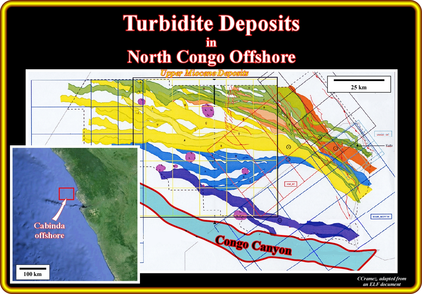
This plate illustrated the rectilinear geometry of passageway of the Upper Miocene turbidite currents, in Congo-Cabinda basin, which flow northward of the present Congo Canyon, which, by the way has, more or less, the same orientation. Such geometry suggests that the density of the original turbidite currents was quite high, i.e., rich in siliciclasts. After the downward slope passage of the turbidite currents, which incised the substratum or the already deposited turbidite sediments and transported the coastal and shallow water sediments toward the abyssal plain, where they were deposited forming basin floor fans, such a topographic anomalies were, according several geoscientists, filled up, in retrogradation, by smaller and lower density currents. In de distal parts, the deposited potential basin floor fans, since, so far, there is evidence of their actual existence, can, eventually, be eroded by submarine currents. As illustrated in the next plates (Congo offshore), the infilling of such topographic anomalies can be done by younger turbidite currents flowing along previous turbidite incisions (rectilinear channelling, when the relative sea level starts to rise in acceleration (according to the Vail's turbidite model). As we will see, the Mutti's turbidite model propose an alternative explanation of such infilling that seems to fit better with the observed seismic and subsurface data.
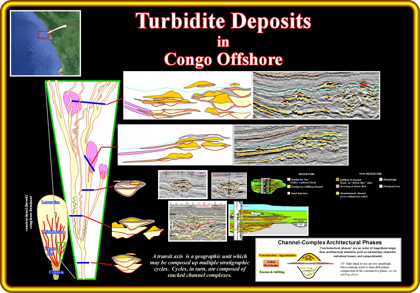
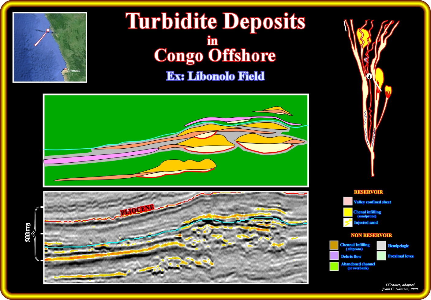
This plate shows the interpretation proposed by C. Navarre (1999) for the reservoir-rocks of several Congo offshore oil fields. As illustrated, the Mutti's turbidite model seems here to be corroborated by the observed subsurface and 3D seismic data. Several turbidite fans seem to be deposed at the mouth of canyons, which developed either in highstand or lowstand conditions. In each turbidite fan three particular areas can be individualised : (i) Lower fan ; (ii) Middle fan and (iii) Upper fan. In the upper and middle fan, the transit axes (transfer zones), along which the denser turbidite currents transport the sediments basinward to form the turbidite lobes (see the upper two seismic close-ups and respective tentative interpretations), are filled, later, in retrogradation, by relatively coarser sediments as illustrated by the lower seismic close-ups. Navarre along of the transit axis (topographic negative anomalies incised by the younger turbidite currents) distinguish three stratigraphic infilling phases : (i) Erosion and infilling ; (ii) Deposition of lobes and overbank deposits and (iii) Construction / Aggradation, which later, by differential compaction, can form the antiform structures. These infilling phases are better recognised in the next plate, which corresponds to the western most transit axis of this plate.
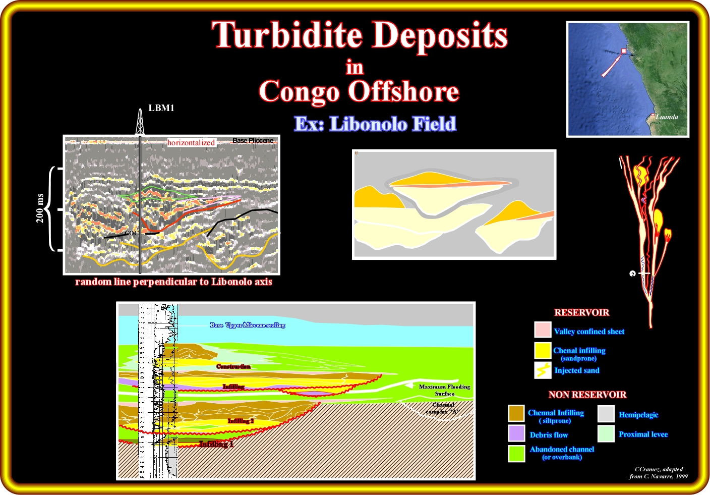
On this plate are illustrated (taken fom an Elf document, C. Navarre, 1999) in the upper part, a detail of the seismic line passing through the Libonolo fiel, as well as, its geological tentative interpretation and, in the lower part, the respective electrical logs. The more likely location of this seismic detail in the Mutti's turbidite model is schematised on the right part of the plate, i.e., in a transit axis of the upper fan. In each complete complex sandy body, from bottom to top one can recognize different sedimentary phases : (i) Erosion and infilling ; (ii) Deposition overbank deposits and lobes and (iii) The construction and aggradation. Each sandy body, which, in geological terms, is deposited instantaneously, is bounded by a correlative deepwater unconformity equivalent. On the other hand, the time hiatus between each sandy body can reach hundred or thousand years. It is interesting to notice that the chennal-leveed complexes, that is to say the "gully wings" of P. Vail are preponderant in the construction / aggradation phase.
Here (Libonolo field), the seismic detail,without scale horizontal due to confidential reasons, in which a complex sand body is easily recognised, is located near the downward end of a transit axis (see sketch on the right part of the line). In addition to the lobes, which basically are composed by hemiplegic sediments, that is to say, sediments without petrophysical characteristics (porosity and permeability) of reservoir-rocks, one can recognize sandprone sediments, in the erosion and infilling phase, which characteristics of reservoirs-rocks. Actually, in terms of potential reservoirs-rocks, one can say that, they are, generally, present in the lower phase (erosion /infilling) and, practically, absent in the construction/ aggradation phase, in which shaleprone gully wings are dominant.
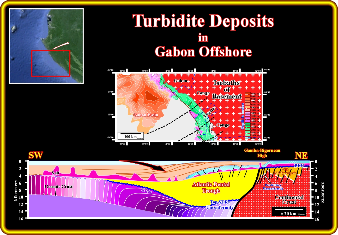
In this schematic cross-section through the Gabon offshore, one can predict turbidite deposits in the upper part of the divergent margin, particularly, in the regressive phase of the post-Pangea (or post-Gondwana, in this area) continental encroachment cycle, as indicated by the arrow. In spite of the fact that the global eustatic sea level has felt since the Cenomanian-Turonian time (first order eustatic cycle), the combination of the eustasy with tectonics (subsidence or uplift) creates relative sea level variations which originate the deposition of continental encroachment stratigraphic subcycles These subcycles are bounded by unconformities, i.e., by significant relative sea level falls, which putting the sea level under the shelf break, favour the triggering of turbidite currents and subsequent turbidite deposition, in the deeper part of the margin. Taking into account the size of the Atlantic Dental trough, in the lower part of the margin, immediately above the post breakup subaerial lava flows, which is accurately corroborated by the isopach map of the basement, turbidite deposits, probably, lacustrine can be expected between the salt induced tectonic disharmony and the top of the post break lava flows. Notice that the Atlantic Dental trough is the equivalent of the infra-salt margin depocenters of the Congo, Kwanza and Santos (Brazil) basins.
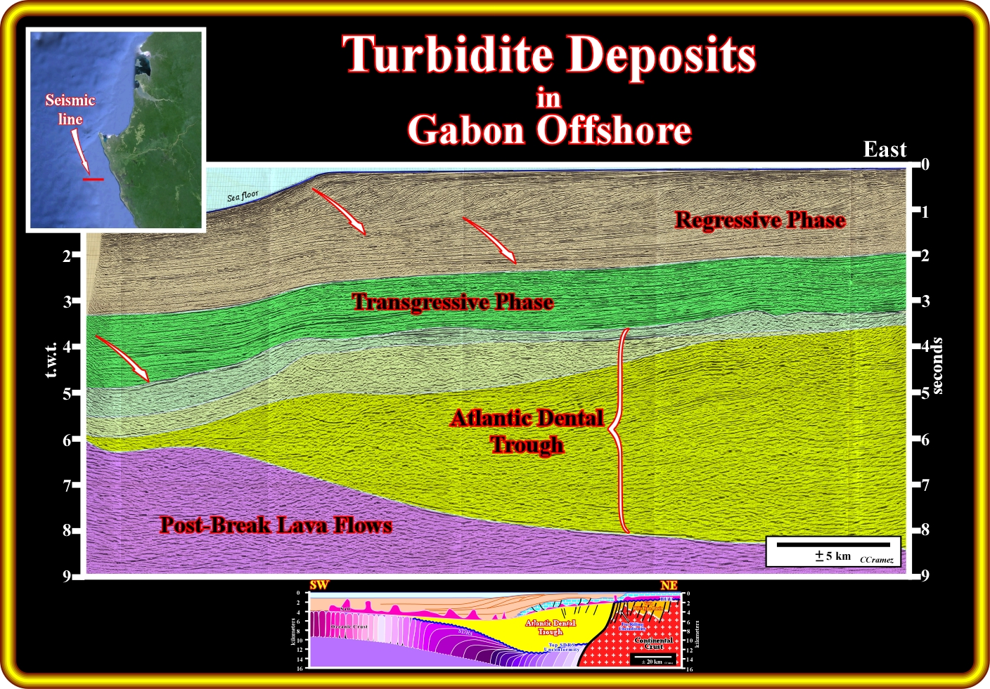
On this geological tentative interpretation of a seismic line of the Gabon offshore, mainly shot in the conventional offshore, potential turbidite deposits, located at the bottom of the transgressive and the regressive phase (seaward of the shelf break or continental break) of the post-Pangea continental encroachment cycle, in association with the unconformities bounding stratigraphic subcycles, can be alternative reservoir-rocks to the limestones buildups located at the top of the Atlantic Dental trough. Notice that the Atlantic Dental trough postdates not only the breakup unconformity, but the subaerial lava flows. It is an equivalent of the margin infrasalt depocenters recognized in Kwanza and Congo offshore, were a very good generating petroleum systems was found, particularly in Kwanza offshore (Falcão source-rocks in the offshore block 6, for instance).
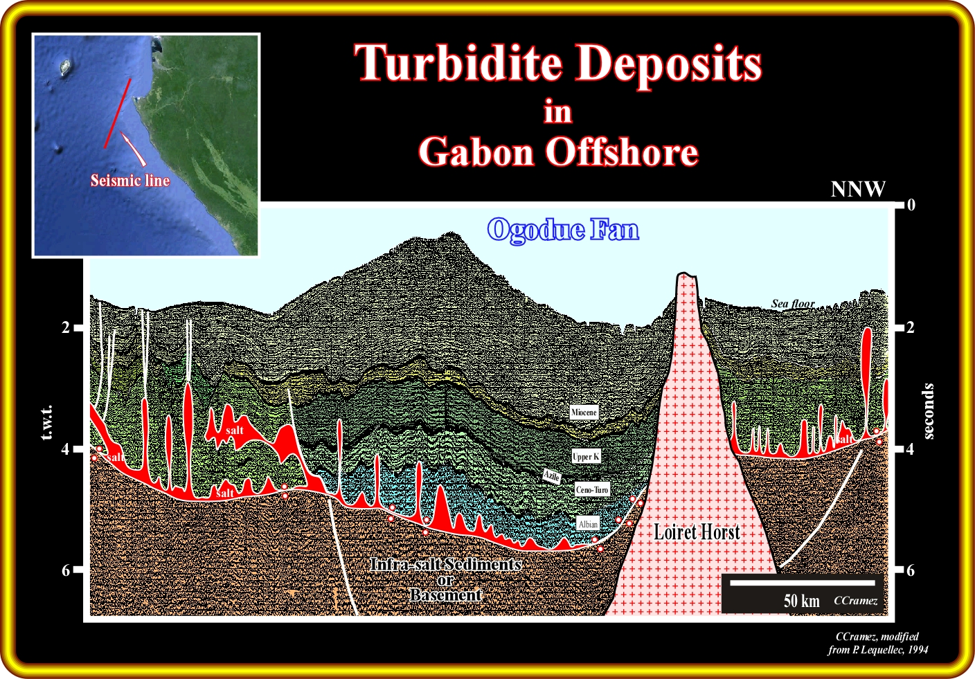
This geological tentative interpretation of a regional seismic line through the Gabon offshore strongly suggest that turbidite accumulations, deposited according to the Mutti's turbidite model are, also, likely enough. In fact, on this tentative interpretation, the deep sea Ogodue fan (or Ogowe fan) is obvious (Ogodue river is about 900 km long, reaching the South Atlantic by a a marshy delta south of Port-Gentil, after a course mainly from east to west). In spite of the fact that there is any canyon incisions evidence on the shelf (continental platform) at the mouth of the Ogodue, the arcuate geometry of the limit shelf-slope suggests that upper slope failures triggered turbidite currents down to slope favouring the formation of the deep sea fan illustrated on this tentative interpretation. Notice, as Mutti's said, very often, when the turbidite currents are induced by land mass abrupt failures, landslides and not by flush floods, the facies of the turbidite deposits is function of the lithology of the upper slope and distal shelf. In other words, if the facies of the shelf, and particularly, around the shelf break is shaly, the turbidite deposits will be shaleprone (no reservoir-rocks). On the contrary, if the facies is sandy there is relatively high probability to find sand bodies reservoirs in such a turbidite accumulations.
On this geological tentative interpretation of the seismic line of Gabon offshore, it is evident that turbidite deposits (Vail's or Mutti's turbidite model) are likely rather above the Oligocene unconformity (SB. 30 Ma) than below. Nevertheless, turbidite deposits cannot be exclude on the brown interval, that is to say, in the lower part of the regressive phase of the post-Pangea (or post-Gondwana) continental encroachment cycle, particularly at the base of the continental slope progradations (shingled turbidites) or in the distal part of the basin at each significant relative sea fall, i.e., at each unconformity bounding the continental encroachment stratigraphic subcycles. Along the unconformity SB.30 Ma, several submarines canyon formed during the associated sea level fall (glacio-eustasy). They were, later, infilled by potential turbidite sediments, easily, recognized, by their onlapping against the unconformitiy and by seismic anomalies, often, associated..
E) Guinea Equatoriale Offshore
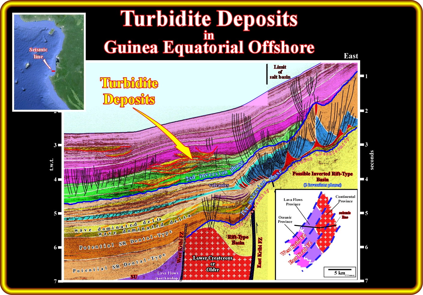
On this geological tentative interpretation of a seismic line of the Equatorial Guinea Offshore, the turbidite deposits are obvious. The major fracture zones, the crustal unities (geological provinces) and the inversions phases are indicated. Inversion phase induced by reactivation of the fracture zones are clearly visible, since the sediments were shortened and consequently uplifted, creating local complex anticline structures. The first inversion phase took place immediately after the breakup of the lithosphere. It allowed the deposition of marine source-rock intervals over the lava flow (Lower Dental potential source-rocks). Shallow water sands were deposited above the potential source-rock intervals (wavy dominated deltaic sandstones). The second inversion phase took place after the salt deposition (just quite evident on the right part of the tentative interpretation). The uplift, associated with the tectonic inversion phases, induced a gravity tectonics on the salt layer and overburden. The associated gravity structures were fossilized by onlapping of deep water sediments, particularly, turbidite deposits, which form nice morphologic by juxtaposition traps, which were tectonically enhanced by the reactivation of the fracture zones, particularly by the Kribi fracture zones.
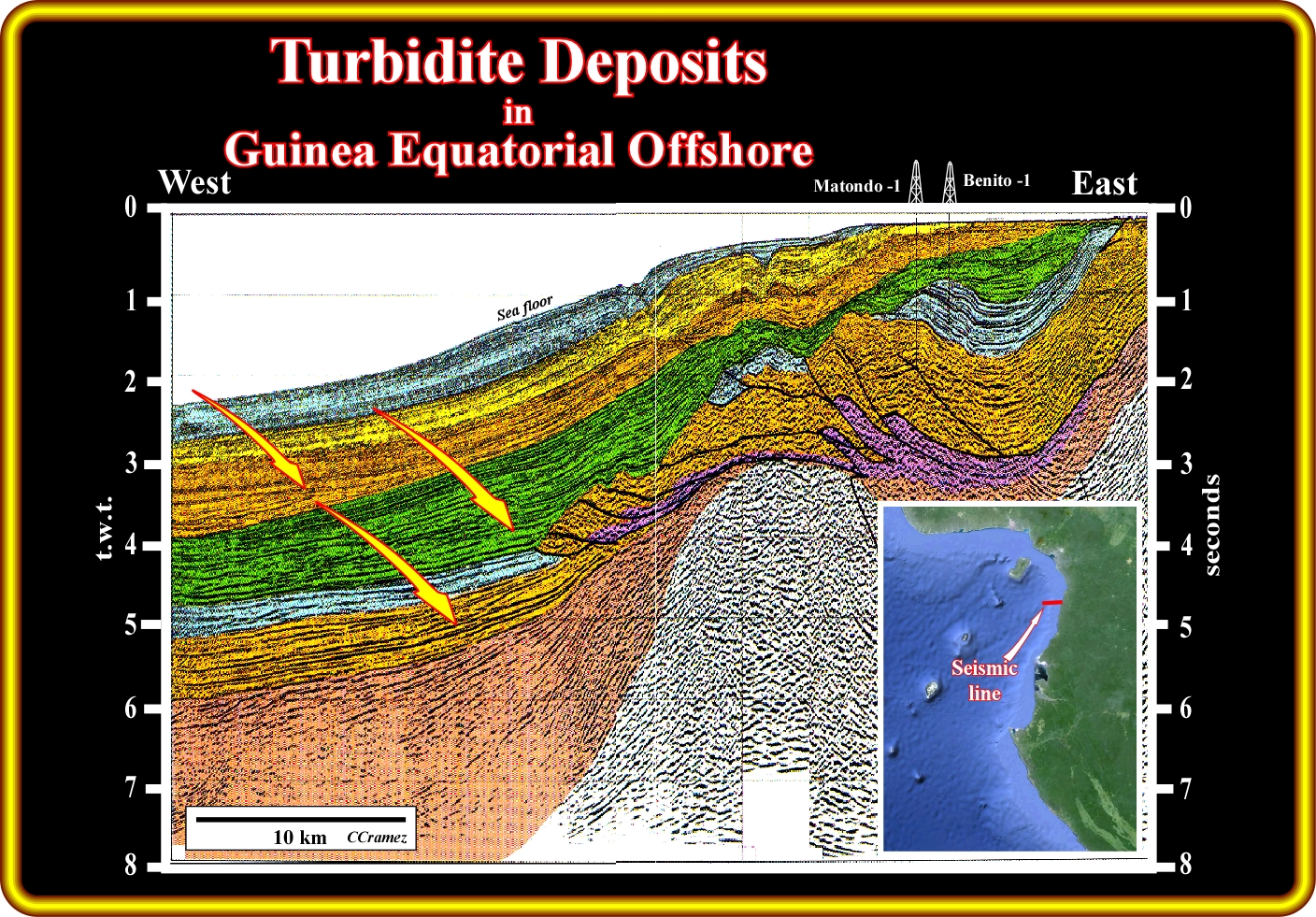
On this geological tentative interpretation of a seismic line of the Equatorial Guinea offshore, located not far from the line illustrated on the previous plate, the potential turbidite deposits are indicated by the red-yellow arrow. In association with the salt tectonics, one can say that turbidite deposits are likely within the Senonian stratigraphic interval and that they follow rather the Mutti's turbidite model, since slope failures and down slope landslides are paramount. Postdating the salt and gravity tectonics, which, practically, became inactive, Tertiary turbidite deposits are evident, but are better explained by the Vail's turbidite model, that is to say, induced by turbidite currents trigger by significant relative sea level falls, i.e., in association with the sequence boundaries (unconformities) and developed during lowstand geological conditions.
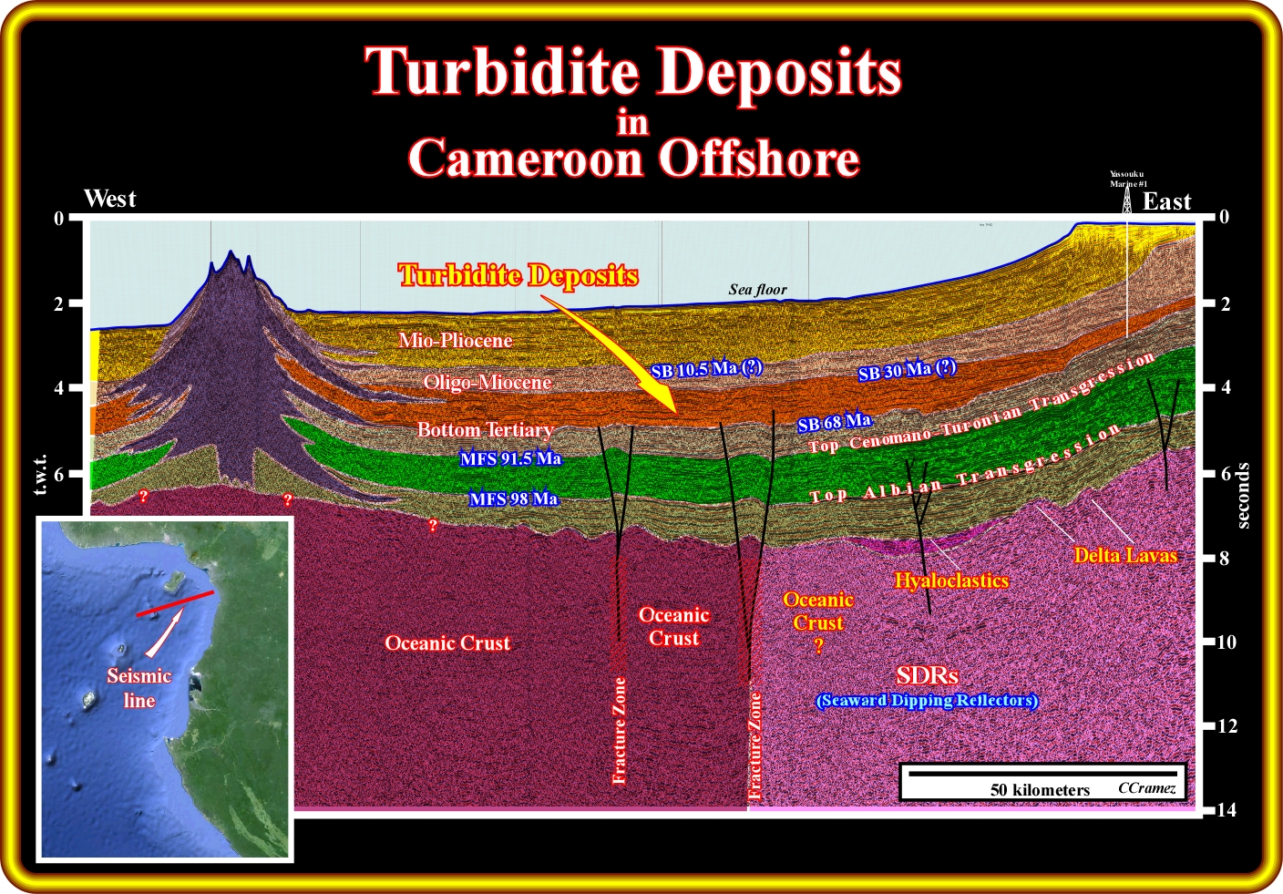
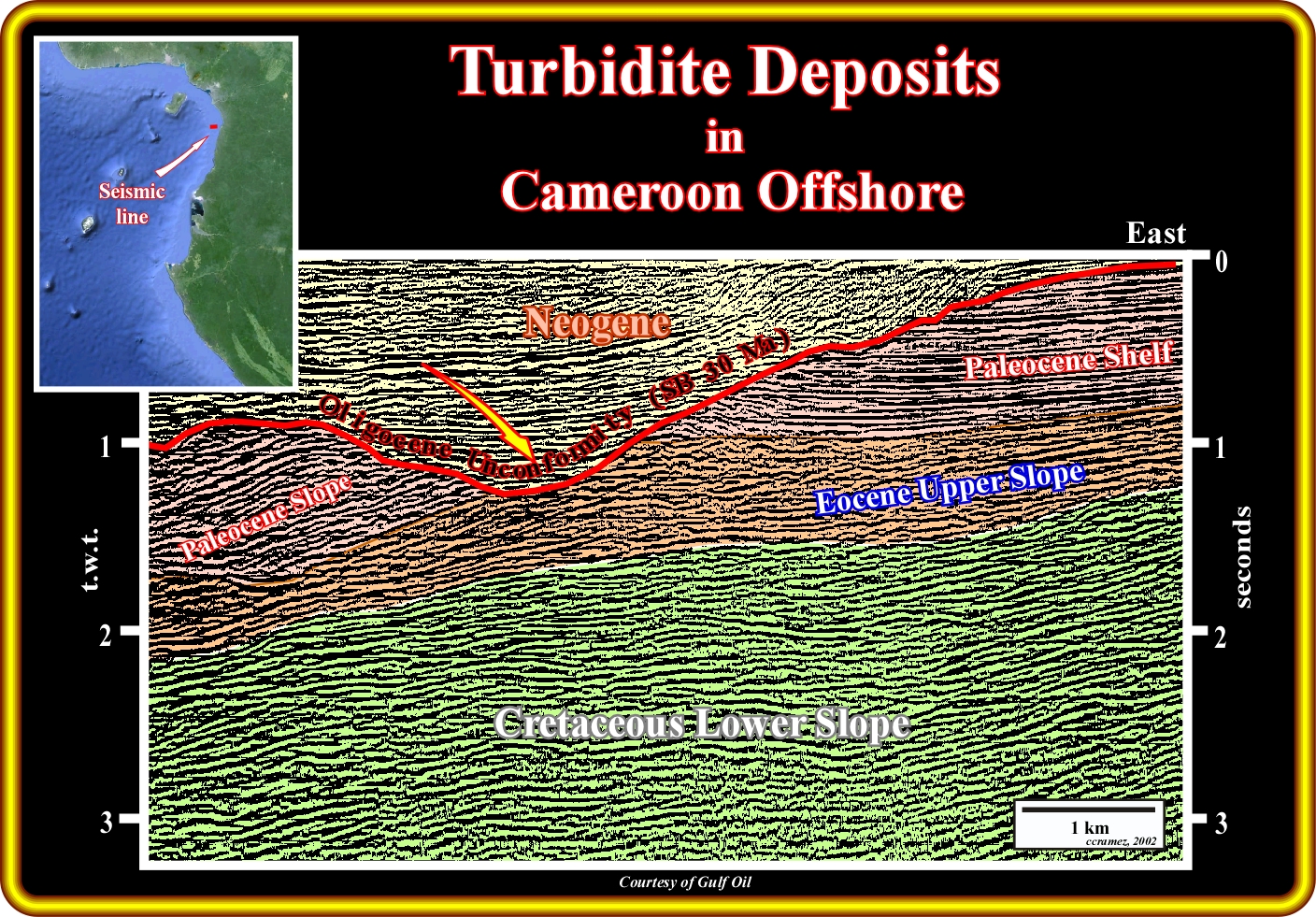
On this geological tentative interpretation of a regional seismic line of the Cameroon offshore, it is quite evident that, as in the majority of the West Africa offshore, the more likely location of the turbidite deposits is in the regressive stratigraphic phase of the post-Pangea continental encroachment cycle. Indeed, looking at this tentative interpretation, the turbidite deposition induced by relative sea level falls (Vail's turbidite model) or associated with slope-shelf break failures or flush floods of the local rivers (Mutti's turgidity model) are likely above the top Cretaceous unconformity (SB. 68 Ma) and particularly in the post Oligocene-Miocene interval, i.e., above the SB 30 Ma. A more detailed seismic data, as illustrated in next plate, suggests that slope failures can develop quite large turbidite fans.
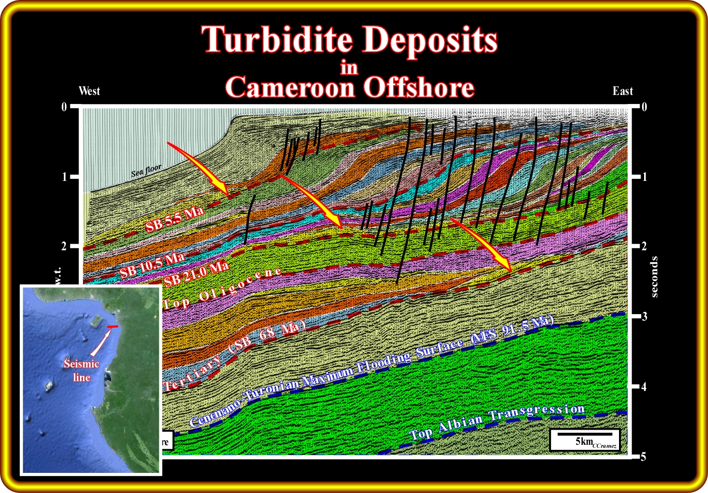
On this geological tentative interpretation, it is easy to see that in Tertiary some of the turbidites deposits can be associated with turbidite currents induced by slope-self break failures triggering large amount of sediments down to slope. In fact, important stratigraphic anomalies can be recognized in association with the unconformities SB. 21.0 Ma, SB. 10.5 Ma and SB. 5.5 Ma, which were produced by significant relative sea level falls, that is to say, sea level falls that put the sea level below the shelf break or the continental break (lowstand geological conditions). It is interesting to notice that the geometry of post-Oligocene reflectors, landward of the shelf breaks, which in this particular case correspond, more or less, to the shorelines (the basin has no shelf), is subhorizontal, which means that the eustasy is largely preponderant over the tectonics (subsidence or uplift) in the shelfal accommodation increasing (creation of space available for sediments in the shelf).
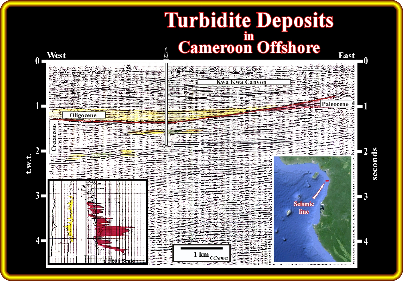
This seismic line and in its schematic geological tentative interpretation illustrate not only the turbidite deposits accumulated in the Kwa Kwa Canyon, but those deposited, in the Upper Cretaceous, below the Oligocene unconformity SB. 30 Ma as well. The relative sea level fall, which created the unconformity SB. 30 Ma, was, probably, induced by an important glacio-eustasy event. In fact, such unconformity is, easily recognized in all regional seismic of the West Africa offshore. It is interesting to notice that at the time I was working in this area ( in the 70's), the oil companies were looking for structural traps (anticline structures). So, below the Oligocene unconformity, taking into account the opposite dips, recognized within the Paleocene and Cretaceous sediments, the geoscientists proposed several four way dips prospects, which were interpreted as anticlines. Some of these prospects were drilled and oil was found. However, the big problem arise when the geoscientists try to evaluate the potential reserves of such a prospects using the results of the discovery well and a structural map of the trap. They found huge reserves. However, for reserves calculation, the only interesting structural map is the structural map made at the top of the reservoir-rock.. Fortunately, in 1975, E. Mutti in the short course that to the geoscientists of CFP, i.e., Compagnie Francaise des Pétroles, which is today TOTAL SA, on turbidite deposits and its implications in hydrocarbon exploration, showed how naive geoscientists (unknowing the turbidite stratigraphic models) took the turbidite channel-leveed complexes as antiform structures, particularly in West Africa offshore. In fact, in this offshore, every time that a second exploratory well was drilled on the opposite flank of the "anticline" ("gully wings") the results were either disappointed either not correlable with those of the discovery well.
On this geological tentative interpretation of a seismic line in Cameroon offshore, the deposition of the channel-leveed complexes, readily recognized by their geometry similar to that of gully-wings, is easily explained by the Vail's turbidite model. In fact, when a significant relative sea level fall puts the sea level below the shelf break, the mouth of the river, as well as, the coastal onlaps are displaced seaward and basinward. Subsequently, the river discharge the transported sediments directly on the upper continental slope (since the basin has no shelf) triggering turbidite currents down to slope. The turbidite currents arriving to the bottom of the continental slope and abyssal plain decelerate lose competence and capacity. The coarser transported sediments deposited forming two lateral lobes, since the velocity of the current is higher in the central part of the current. The smaller particles are transported further before being deposited in distal areas reached by the turbidite currents. If a next turbidite current takes the same trajectory, it will guide or canalised by the area of non-deposition (transfer zone) between the lateral lobes already deposited. and if the height of the currents is big enough overbank deposits will be developed above the previous lobes. Such an overbank deposition enhanced the depression (non-deposition area) between the lateral lobes, which favour the canalisation of the next turbidite currents. This turbidite deposition mechanism gives the well known "gully wings" geometry, well illustrated on this tentative interpretation. Later on, the depression between the lateral lobes (notice that there is no significant erosion), is filled in retrogradation by turbidite sediments or by of pelagic sediments falling through the water column.
On this geological tentative interpretation of a seismic line of the Cameroon offshore, turbidite deposits are infilling the submarine canyon created by the relative sea level fall which induced by the Oligocene unconformity (SB. 30 Ma). It is interesting to notice that the submarine erosion strongly eroded the successive Paleocene shelf breaks. In fact, landward of the submarine canyon, the Paleocene shelves are obvious, while seaward the Paleocene sediments correspond to slope sediments. Notice that the turbidite deposits filling the submarine canyon are fossilized by Neogene turbidite abyssal plain deposits, probably, shingled turbidites, since they are located at the base of the slope progradations. Indeed, aggradation (upbuilding), that is to say, infiling is necessary to allow progradation ("aggradate ut progradamus"). In addition to the Neogene turbidite deposits, Cretaceous turbidite deposits are easily recognized by the typical geometry of the chennal-leveed turbidites ("gully wings") that can be considered as part of a large slope fan, using the terminology of P. Vail (turbidites type III of Mutti).
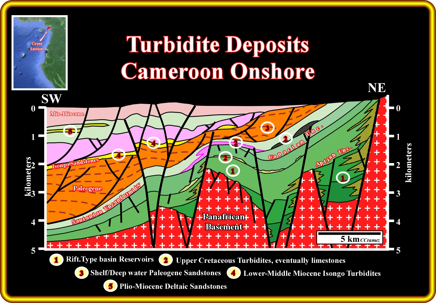
On this sketch are summarized the more likely reservoir-rocks that can be find in Cameroon onshore and offshore : (i) Lacustrine or non-marine sandstone can be found in the rift-type basin, which predate the breakup unconformity, i.e., located below the divergent margin ; (ii) Upper Cretaceous turbidites, eventually, limestones, above the structural highs (or less subsident areas) ; (iii) Shelf / Deep water Paleogene sandstones ; (iv) Lower-Middle Miocene Isongo turbidites and (v) Plio-Miocene deltaic sandstones. The Isongo turbidite deposits are quite interested in the area shortened by the reactivation of the fracture zones since they can form structural traps, i.e., four way dips structures (see next plate).
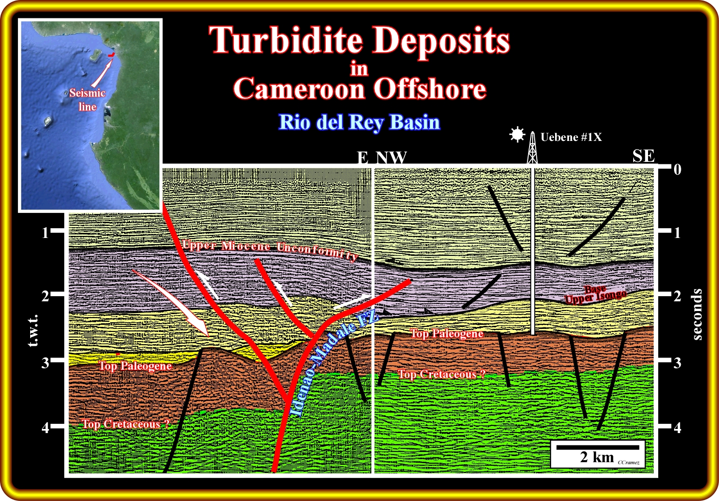
In Rio del Rey basin (northern Cameroon offshore), the Lower-Middle Miocene Isongo turbidite deposits were often shortened by a compressional tectonic regime created by the reactivation of old fracture zones as Idenao-Madale, here illustrated, creating interesting mixed traps (partially structural and partially morphological by juataposition). On this subject, it is imporant do not forget that a trap is defined by the structural map of the top of the the reservoir-rock. Subsequently, when the potential reservoir-rocks are turbidite sandstones, that is to say, confined sandy bodies enclosed in shaly sediments, it is very difficult to make a coherent map of the potential reservoirs, with few exploration wells, allowing an acceptable reserves calculation. Geoscientists use often the extend of the associated seismic anomalies but the surprises are, often, quite dramatic. Please, do not forget that the exploration-production results suggest that when the reservoir-rock is associted to turbidite deposits the ultimate recoverable reserves are much smaller that the initial reserves (before development).
to continue press
![]()
Send E-mail to carloscramez@gmail.com with critics, corrections or commentaries on these Turbidite Deposits notes.
Copyright © 2001CCramez
Last modification : November, 2013