
I) Turbidite Deposits and HC Exploration
In the past 25 years, reservoirs related to gravity flows, in deep marine environments, have aroused increasing interest in oil and gas exploration. Economical hydrocarbon accumulations associated with such reservoirs, generically called turbidites, have been found in tens of sedimentary basins around the world .
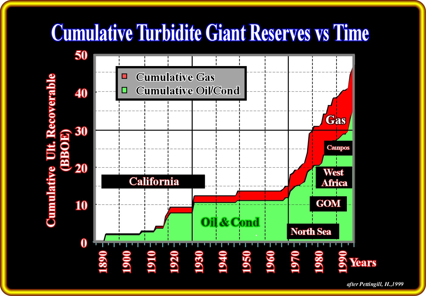
Since 1980, the contribution of turbidite deposits to worldwide petroleum reserves has been very significant. The period of rapid increase started in the North Sea. Later, with the advent of deep water drilling technology, several major oil and gas fields were discovered in South Atlantic margins, particularly in Angola and Brazil (Campos and Santos) offshores, in which the main reservoir-rocks are deep-water turbidites, either basin floor or slope fans (in Vail's terminology).
During the first quarter of the 20th century, hydrocarbon discoveries in turbidite sandstone reservoirs were restricted to California basins. With the advent of deep offshore exploration, large oil and gas fields were found in North Sea, between 1970 and 1990. Major discoveries in the deep-water of the Gulf of Mexico have occurred from 1979 to the present day. Since 1990, offshore and, particularly, deep offshore exploration in West Africa (Congo, Angola, Gabon, and Nigeria) and Brazil (Campos and Santos basins) has discovered large hydrocarbon reserves found in turbidite sandstone reservoirs. The majority of these reservoirs-rocks are, mainly, associated with slope fans (channel-levees complexes). Typical basin floor fan, if present, are too distal, under quite important water depth, particularly in West Africa offshores. In the other hand, the high sand-shale ratio, it is much more difficult to have morphological traps (no structural traps) in basin floor fans than in slope fans.
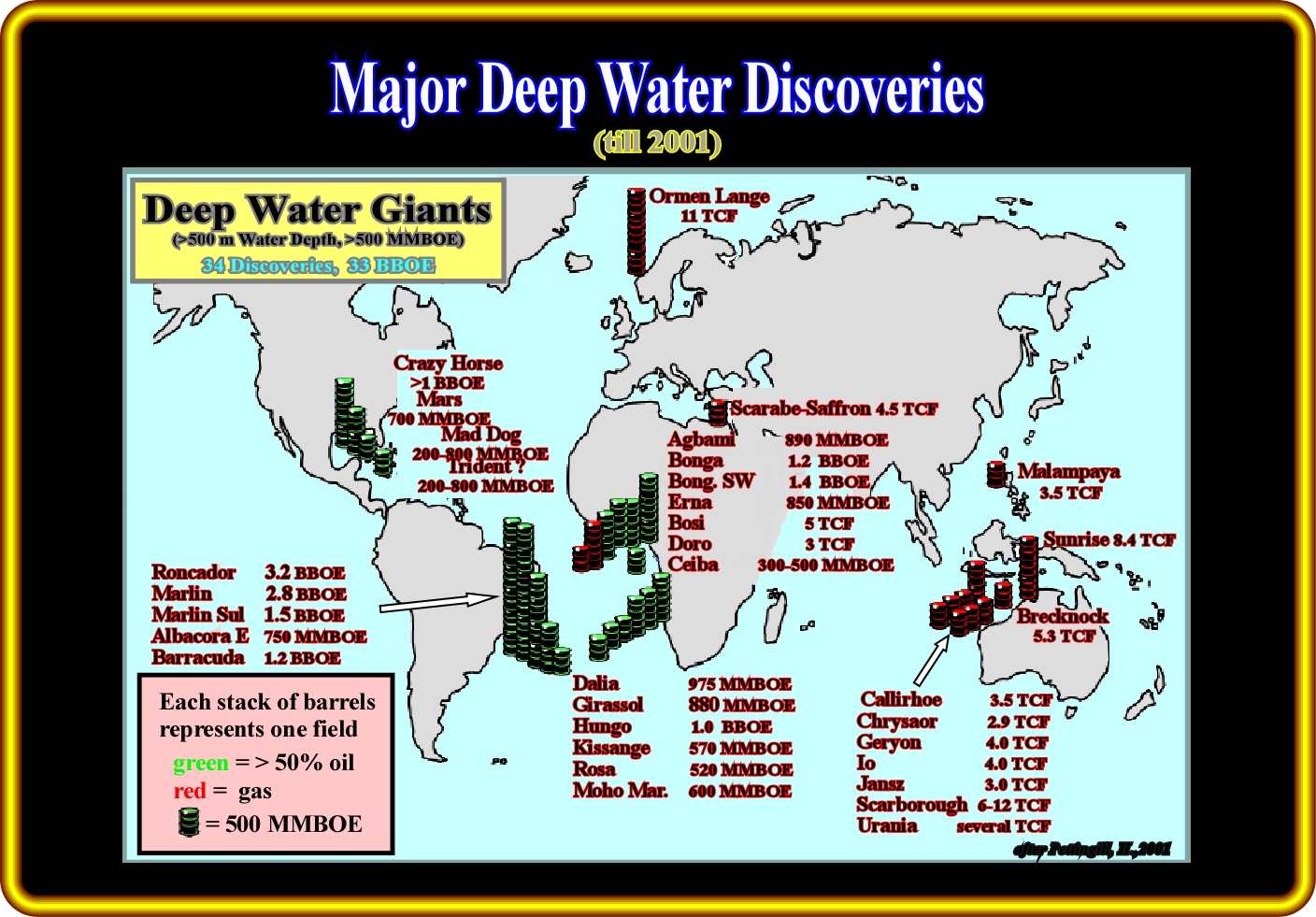
In this plate, each stack of barrels represents deepwater hydrocarbon discoveries in water depths greater than 500 meters and exceeding 500 MMBOE recoverable. They (34 discoveries) have roughly 33 BBOE of reserves. Those made in South America and Gulf of Mexico are oil discoveries. In West Africa, they are either oil or gas discoveries. In Europe, Asia and Australia they are predominantly gas discoveries. To these discoveries, it is important to add those made recently, particularly in Angola offshore, which have significant reserves. The amount of reserves shown here must be used carefully, as reserve are, often, influenced by politics. In fact, as J. Lahererre say announcing reserves is a politic act. For all barrel of oil equivalents (BOE), the conversion factor employed is 6000 cu. ft. gas = 1 barrel oil or condensate.
So far, the most active deep-water exploration frontiers and associated resources (not all of discovered hydrocarbons have been proven to be economic, and therefore can not be classified as reserves) are located along the post-Pangea Atlantic-type continental divergent margins and very often down-dip from productive Tertiary delta systems, such as Niger, Congo, and Mississippi. The generating petroleum sub-system (potential source-rocks) are typically located either in rift-type basins (mainly lacustrine source-rocks) or in the transgressive (backstepping) or regressive (forestepping) phases of the post-Pangea continental encroachment stratigraphic cycle (mainly marine source-rocks). In West Africa offshores, for instance, there are several potential generating petroleum-subsystems :
A) The organic-rich lacustrine shales (and limestones) deposited in rift-type basins. The source-rocks are oil-prone with a type I organic matter ;
B) The organic rich lacustrine shales deposited in the infra salt margin depocenters (Sag basin of the American geoscientists) ;
C) The transgressive marine sediments associated with post-Pangea maximum flooding surface (Cenomanian-Turonian in age). Their organic matter is type II. They can generate oil or gas. Their burial is determinant.
D) Low TOC (Total Organic Carbon) Tertiary deep-water sediments. Their organic matter is type III and dispersive. These source rocks are fundamentally gas-prone, nevertheless, in favourable conditions, condensate and small amounts of oil are associated.
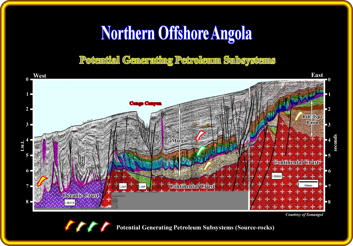
On this geological tentative interpretation of a regional seismic line from northern Angola offshore, the vertical superposition of different sedimentary basins is obvious. Using the Bally's basin classification (Bally, 1980, 1985), from bottom to top, it is easy to recognize : (i) An old fold-belt, often considered as the basement ; (ii) Several Upper Jurassic-Lower Cretaceous rift-type basins and (iii) a Meso-Cenozoic Atlantic-type continental divergent margin. On the other hand, it is important to notice in this tentative interpretation : (i) The deposition of subaerial lava flows (SDRs) above the basement and distal rift-type basins, emplaced immediately after the break-up of the lithosphere and (ii) The presence, in the lower part of the margin, of a thick salt interval. As in all continental divergent margins, the Western Africa margin is composed by a backstepping or transgressive phase at the bottom and, at the top, by a forestepping or regressive phase. The limit between these two sedimentary phases is marked by a major downlap surface (MFS 91.5 Ma, in Vail's terminology, i.e., the maximum flooding surface with the age 91.5 million years ago) . Four potential source-rock intervals have been distinguished as having generated hydrocarbons : (A) In the large rift-type basins, similar to the one visible on the right part of the line, lacustrine potential source-rocks rich in type I organic matter ; (B) In the infra salt margin sediments, organic rich lacustrine source ; (C) In the lower part of the margin, at the top of the transgressive phase and in association with the major downlap surface (MFS 91.5 Ma), potential marine source-rocks rich in type II organic matter and (D) In the regressive phase, within the deep-water sediments of the Cenozoic depocenters, potential source-rocks intervals characterized by type III dispersible organic matter.
In Gulf of Mexico, the predominant generating petroleum system is associated with the major downlap surface of the post-Pangea continental encroachment stratigraphic cycle, i.e., with Cenomanian - Turonian sediments (La Luna equivalents) :
- The organic matter is marine and type II. The maturation of the organic matter determines the generation of oil or gas.
- Due to the presence of autochthonous and allochthonous salt, the knowledge of the burial and thermal flux make the prediction of the maturation zones of the potential source-rocks challenging.
- The geometry of the salt and the source rocks is also quite important. The salt being an excellent heat conductor can retard, or prevent, the maturation of the organic matter when it overlies the source-rocks, or increase the maturation when it underlies them.
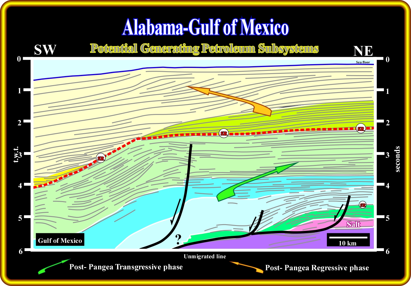
On this geological tentative interpretation of a regional seismic line located between the Alabama offshore and the eastern part of Gulf of Mexico, the boundary between the two major sedimentary phases of the post Pangea continental encroachment stratigraphic cycle (Duval et al., 1993), that is to say, the downlap MFS 91.5 Ma is easily recognized by the geometrical relationships between the reflectors. On the lower part of the line, a tectonic disharmony, at the bottom of the Jurassic salt, separates the substratum (subaerial lava flows, SDRs), from the Mesozoic Mediterranean -type basin (Bally, 1980). In this Mesozoic basin, which roughly corresponds to a Pannonian basin with oceanization, a carbonate interval (Smackover formation) deposited above the salt layer is considered as a potential source-rock interval (in the Alabama offshore). However, the most important potential marine source-rock interval corresponds to the organic rich sediments deposited in association with the major Meso-Cenozoic downlap surface, i.e., MFS 91.5 Ma. Obviously, in the eastern part of the line (landward of the old Cenomanian-Turonian shelf break), the organic matter of the marine potential source rocks is immature. However, seaward, as the burial increases, it becomes mature. Below the MFS 91.5 Ma (underlined in red on this interpretation), the geometry of the reflectors strongly suggests a passage from shelf sediments (on the right) to slope sediments (on the left). The limit between these coeval sedimentary environments is the shelf break ,which often is enhanced by reefal developments.
In NW Australia, the more likely potential generating petroleum subsystem, is mainly gas-prone :
- It is related either with the Kimmeridgian downlap surface or with the forestepping Tertiary sediment ;
- The organic matter of Kimmeridgian shales is marine and type II ; it can generate gas or oil depending on burial. The organic matter of progradational Tertiary sediments is type III disperse (gas-prone) ;
- Organic matter type III disperse can generate economical gas accumulations only when the thickness of the source-rock is important and the migration paths, predominantly, vertical and convergent to a large trap.
So far, in deep-water exploration, the global exploration average success rate is around 30%, what is a very high success rate. The highest success rate is 45% for West Africa. Undeniably, the principal success factor are the seismic DHI’s (Direct Hydrocarbon Indicators). Their identification allows geoscientists to predict reservoir-rocks and hydrocarbons almost without any knowledge of the geological and petroleum settings of a basin. Such practice has strongly favoured the reductionism (Cartesian) or fragmented exploration approach, still used by a lot of oil companies in deep-water. Unfortunately, as it has been said, often, when geoscientists reduce an integrated whole (petroleum system) to its fundamental constituents (reservoir-rocks, amplitude anomalies, traps, etc.) and then they try to explain all phenomena (the system) with regard to these elements, the result is always the same : they never understand the coordinating activities of system ; the "whole" is much more than the sum of the "parts".
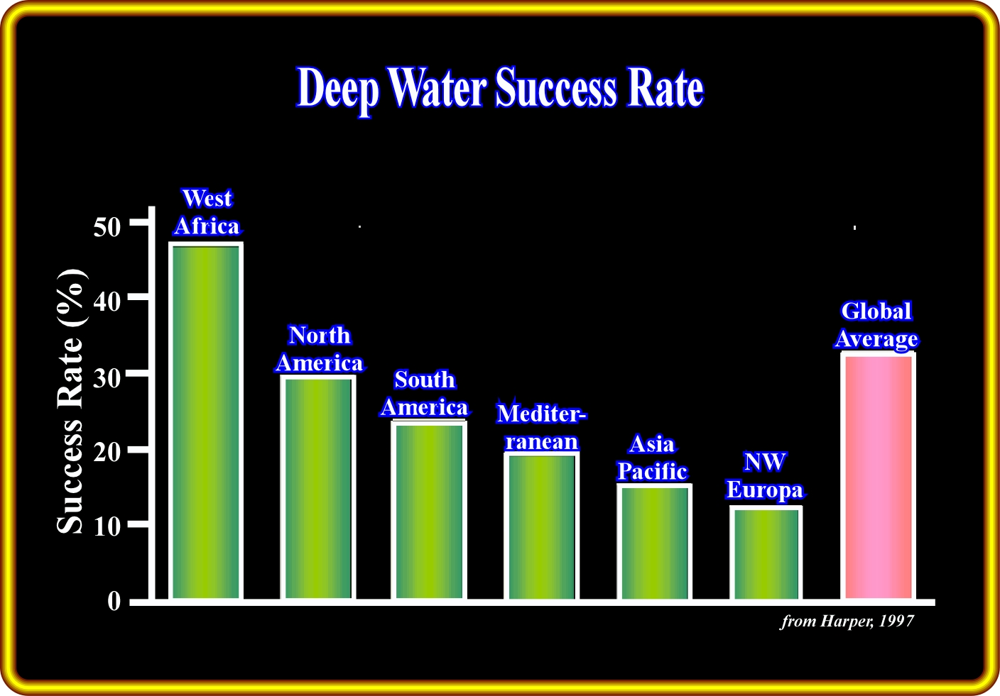
So far, in deep-water environments, exploration success rate has been quite high, mainly in West Africa (40%). In Gulf of Mexico, it is around 30% and in Brazil roughly 25%. The global average exploration success rate is approximately 30 %, which apparently indicates that deep-water exploration is facile. However, not all discovered hydrocarbons have been proven to be economic. In addition, it is important to notice that an isolated 200 MMBBOE discovered in West Africa may be classified as resources (may be noneconomic), while in GOM, it will be considered as reserves, i.e., economical. On the other hand, it is important to point out that the easy deep-water exploration targets, particular in Western Africa, have been tested first. In fact, in Angola offshore, for instance, the exploration of the relinquished area of certain block, is not going to be so easy as previously, since the more evident amplitude anomalies have already been drilled. In the same token, the exploration in the relinquished areas, will be much more difficult and, probably, the success rate is going to plunge abruptly. So far, in certain blocks, exploration was just mapping and drilling the larger and more evident amplitude anomalies. At my time, some executives used to say "even a taxi drive can find oil in Angola offshore". I hope they can be able to find oil on the new relinquished areas, in which the potential prospects are not only below the inversion point (no amplitude anomalies) but in a subsalt geological context as well.
In spite of the large number of announced discoveries, the consequences of the used Cartesian exploration approach are already quite evident. Many drilled amplitude anomalies (USA $30 to 50 M per well) are not associated with hydrocarbons but with : a) Condensed stratigraphic sections ; b) Facies change ; c) Fault planes ; d) Volcanic glass ; e) Downlap surfaces ; f) Opal horizons ; g) Cherts ; h) Pelagic limestones ; i) BSR (Bottom Simulated Reflectors ; j) Diagenetic lines, etc.
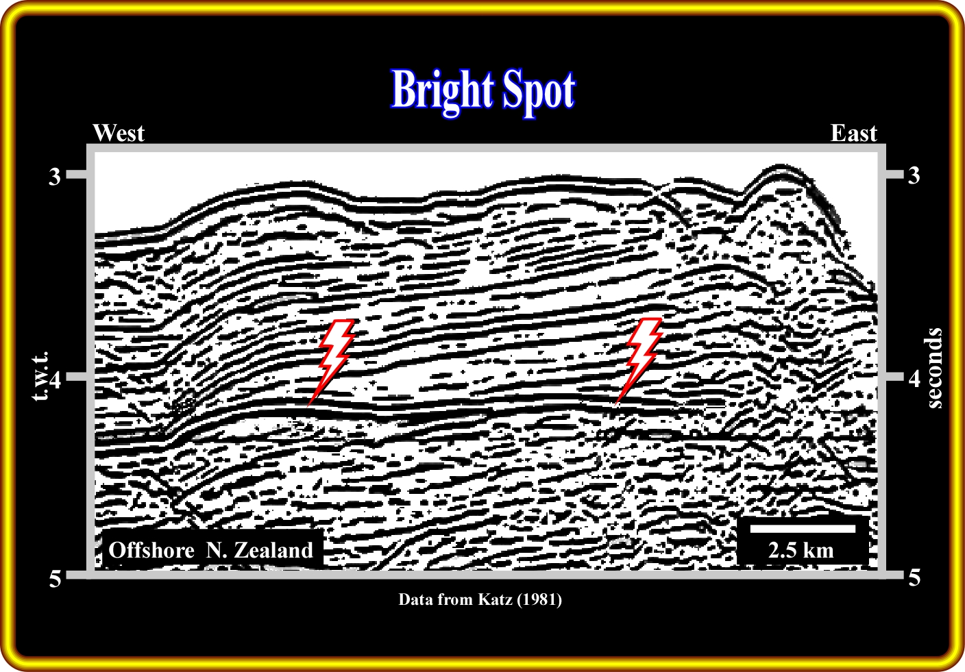
Not all bright spots correspond to the presence of hydrocarbon in the reservoir-rocks, particularly when they are in turbidite deposits. As illustrated on this seismic line, the bottom simulating reflector (BSR) may appear as a bright spot which cross-cuts bedding-related reflectors. In fact, the lower limit of hydrate-cemented sediment is quite often concordant with bathymetry, because the velocity contrast between the gas-hydrate-cemented sediments and underlying non-cemented sediment is large enough to generate a non-chronostratigraphic (diachronic) seismic reflector. Don't forget that the high porosity of the Tertiary turbidite sediments, which burial is relatively small, strongly favour the presence of seismic anomalies even in reservoir-rocks saturated by oil. On the other hand, below a certain depth (inversion point), the hydrocarbon induced seismic anomalies disappear, since the acoustical impedance of the shales (sealing-rocks of turbidite morphological traps) becomes higher that that of the sands (reservoir-rocks).
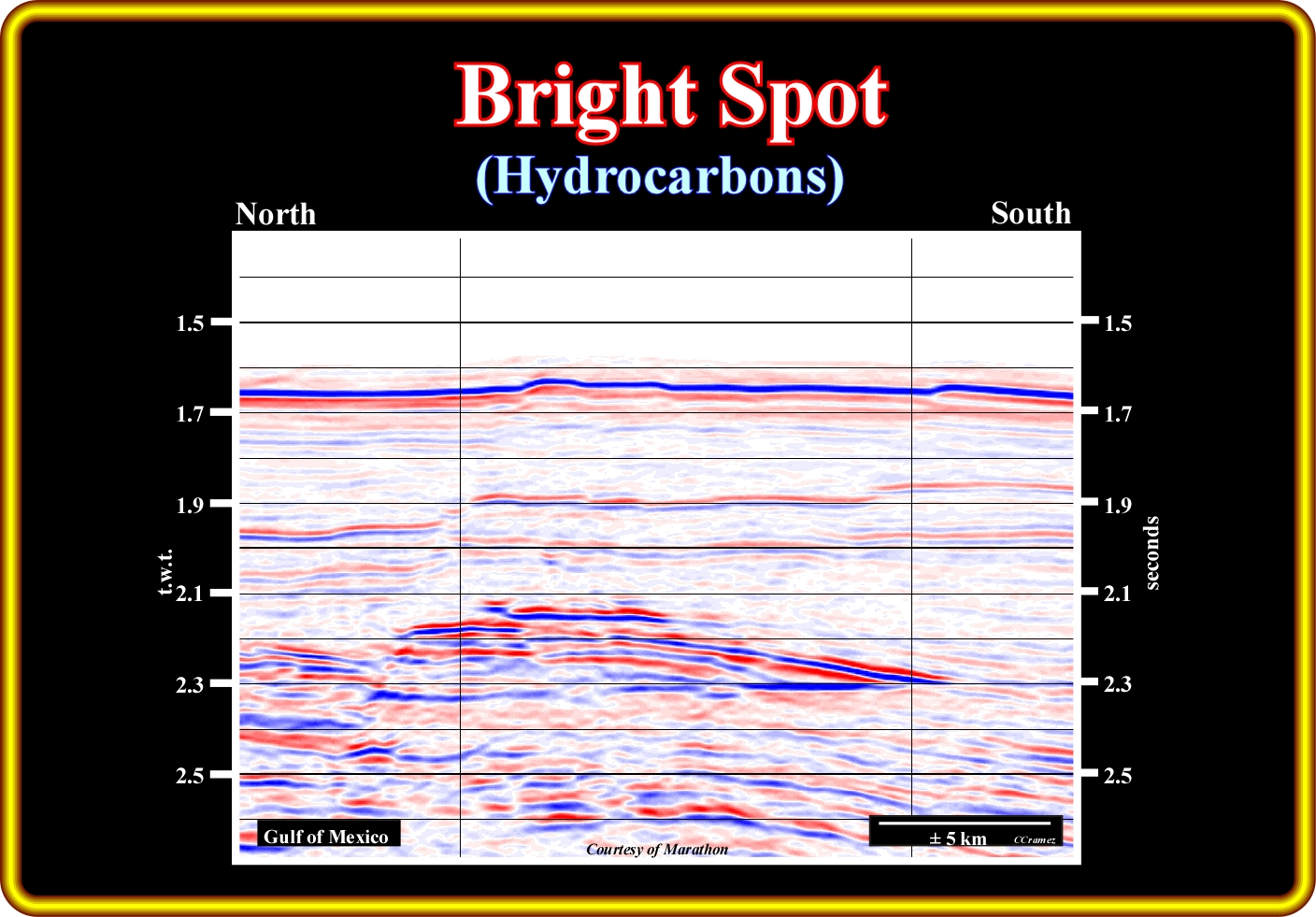
On this detail of a regional seismic line of the Gulf of Mexico (USA), the interface between oil and water (oil-water plane contact), that is to say, the interface between oil-satured turbidite sandstones and water saturated turbidite sandstones is underline by a more or less subhorizontal diachronic seismic marker (roughly at 2.3 seconds, t.w.t.). With such hydrocarbon evidence, certain oil companies concentrated the exploration just in the drilling of this kind of anomalies without understand the genesis, geometry and characteristic of the turbidite deposits, which are, by far, at such small burial (above the acoustical inversion point), the main potential reservoir-rocks and the more common morphological traps. However, one cannot forget, that 5% of oil or gas saturation in a turbidite reservoir-rock is big enough to induce a strong seismic anomaly. In other words, the presence a strong seismic anomaly, with a well marked oil-water plane contact, is not a guarantee of existence of an economical field.
In deep water, even above the inversion point, where the amplitude anomalies are normally located, a reductionist exploration approach is not appropriate. Amplitude anomalies are necessary but not fundamental. The identification and mapping of the stratigraphic and morphological traps, the reservoir architecture prediction, the cartography of the sealing-rocks and maturation zones, as well as the migration paths, etc., are paramount.
So far, in deep water exploration, the reductionist approach has been very successful and it is responsible of new exploration cycles that characterize all offshore petroleum basins. In fact, in almost each petroleum basin, it is possible to recognize several exploration cycles associated with new geological knowledge and new technologies. In Campos basin, for instance, three exploration cycles can be recognized : (1) The first, between 1974 and 1983 ; (2) The second, between 1983 and 1992 and (3) The third, since 1993.
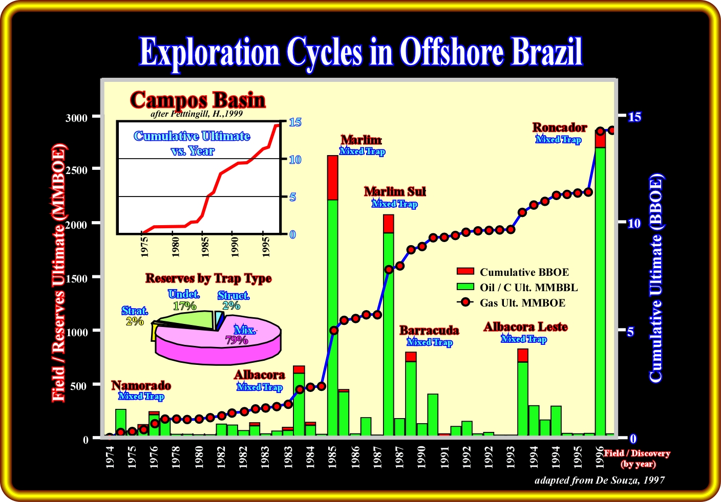
This figure illustrates the cumulative reserves of 46 discoveries from Cretaceous turbidite reservoirs in the Campos basin. The main graphic shows individual fields and discoveries in chronological order (histogram bars, left y-axis) and cumulative ultimate recoverable reserves for the basin (right x-axis). The cumulative curve is re-scaled in time in the upper left inset. The pie chart shows the percentage of the reserves for each trap type. In this basin, the cyclicity of the exploration results is quite evident. Three peaks of discovered reserves are easily recognized. Each cycle seems to correspond to a technological improvement in petroleum exploration.
The first cycle underlines the conventional shallow water exploration. The second cycle marks the advent of new drilling technologies, which allowed to test the large deep-water turtleback structures, such as Albacora, Marlin and Barracuda. The last cycle is mainly due to new geophysical technology, particular seismic DHI’s and subsalt imaging.
The tremendous progress in finding hydrocarbons realized by the geoscientists in deep-water exploration did not significantly contribute to widening their basic exploration philosophy. The Cartesian paradigm (reductionism or fragmentation of exploration) often dominates exploration and particularly in deep-water exploration. In fact, as amplitude anomalies and large structural or morphological traps become less common, to continue to find significant reserves or resources, a new paradigm will be necessary with concepts transcending the Cartesian vision of Geology. It is possible that a systemic or holistic vision furnish the conceptual setting of a new exploration.
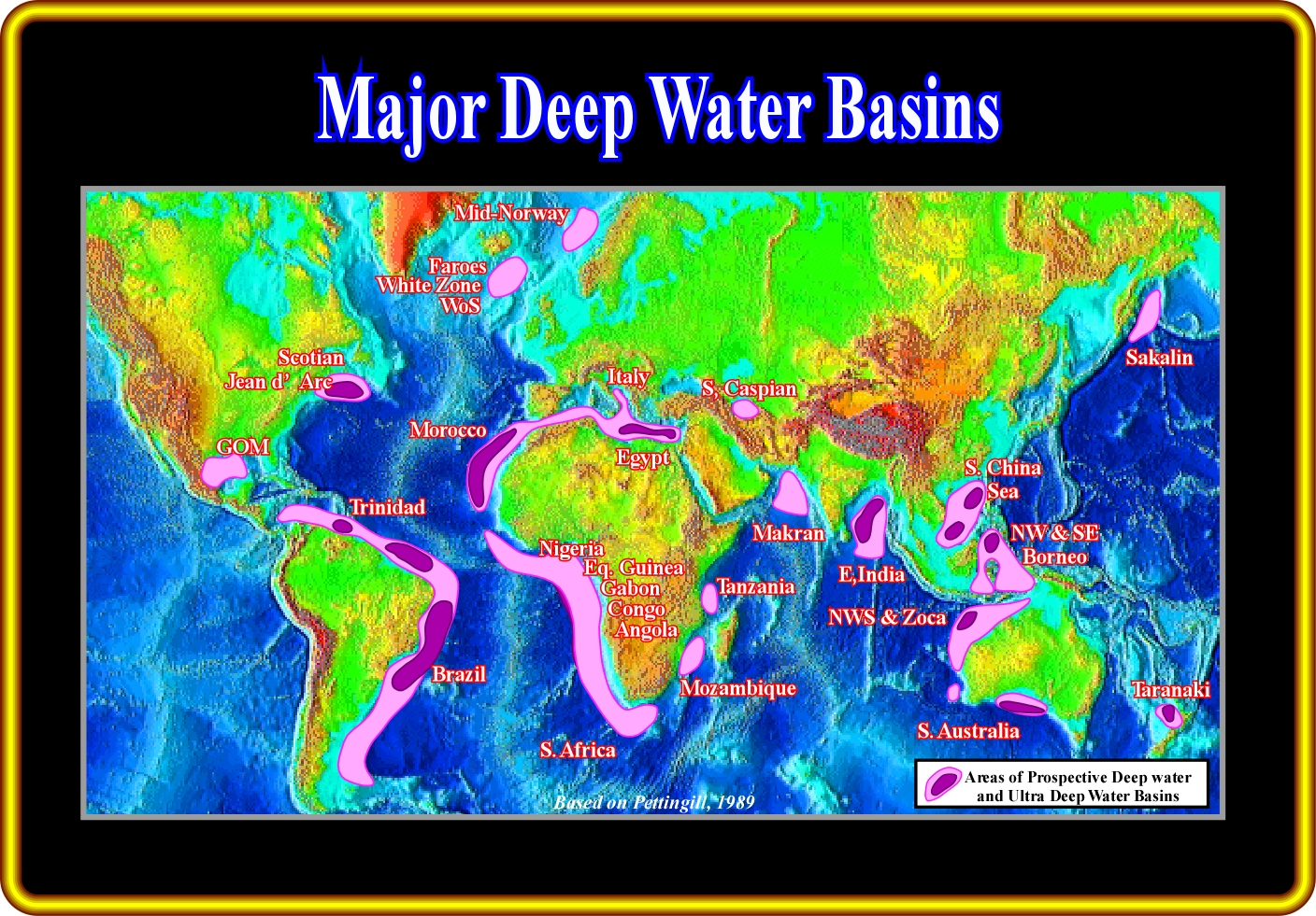
In deep water (>500 meters), the recoverable resources announced in Brazil, West Africa, GOM and NW Australia (see before) include producing reserves, i.e. those in development and technically recoverable resources for which development has not been sanctioned. All these resources are in Atlantic-type divergent margins. However, the resources found in Mid-Norway (Ormen Lange) 11 TCF & 34 MMBC, Egypt (Scarab-Saffron) 4.5 TCF and Philippines (Malampaya) 3.5 TCF, strongly suggest that other types of sedimentary basins can also be highly prospective. This seems particularly true for non-Atlantic type divergent margins. In addition, as illustrated above, other deep water basins as Jean d’Arc, Sakhalin, South Caspian, Taranaki, etc., and ultra deep basins must be taken into account. In spite of all these discoveries, in terms of global petroleum consumption, it must be said that the deep water exploration has been quite disappointing. Actually, it cannot substantially delay the peak of oil. Let's take a simple example. Assuming that the remaining reserves of Angola offshore are 10 Gbl (10 000 000 000 bls), they correspond just to four (4) months of the world oil consumption (85 Mbld, in 2001).
In such an exploration approach, the passage from the objects to the relations will have important implication. The relations should be used as base of all definition. Geological features, as a turbidite deposit, for instance, should not be defined by what it is, in itself, but by the relations with other objects.
N.B.- The fragmentation or reduction of exploration should not be confused with the act of division of an area of knowledge into particular fields of specialization or with the abstraction of specific problems for study. These divisions may be perfectly legitimate and, in fact, they are essential features in the exploration. Rather as the term indicates, to fragment means “to back up or to smash”. Fragmentation in exploration arises when an attempt is made to impose divisions in an arbitrary fashion without any refer for wider context, even to the point of ignoring essential connections to the rest of the basin or adjacent basins.
All hydrocarbon discoveries in turbidite reservoirs and particularly the discoveries of the giants oil fields in deep offshore of Atlantic margins in the last two decades, with the resultant large availability of seismic, wells and reservoir data, have occasioned a proliferation of geological turbidite models, as well as, a sophisticated terminology, which very often contrast the models issued from the outcrops and the marine geological studies.
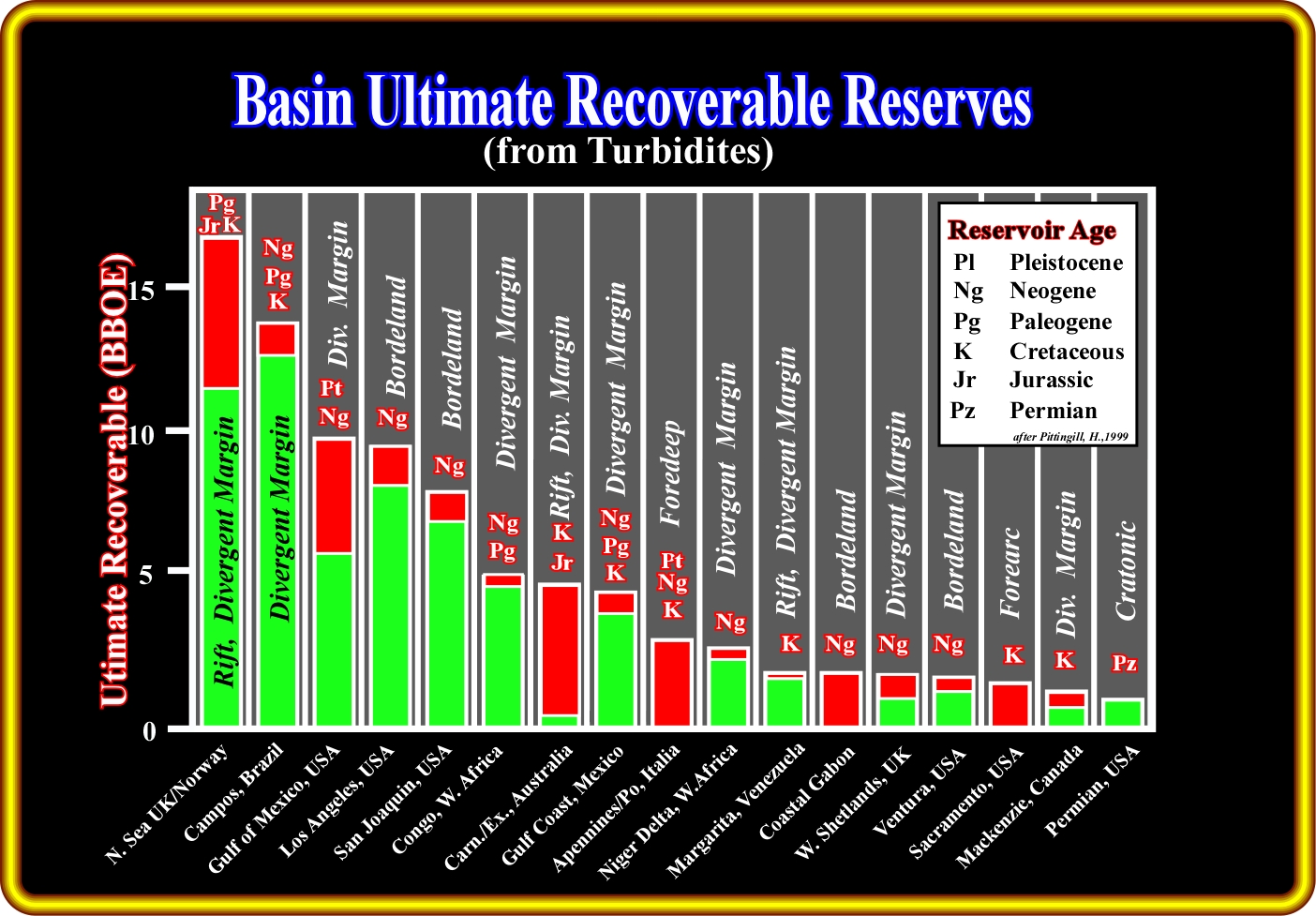
This plate illustrates the more likely total Ultimate Reserves, for 17 basins, exceeding 1 BBOE ultimate recoverable from turbidite reservoirs. The basin types, mainly from the Bally's classification (1980), are listed along with the age of the reservoirs. The green colour represents oil, and the red gas. Outside of the continental divergent margins (Atlantic or non-Atlantic type), the reserves are quite small. However, several conjectures can be advanced to explain such a feature : (i) The absence of source-rocks and (ii) The absence sealing-rocks. In fact, when the potential reservoirs are turbidites, the potential traps are mainly non-structural; they are morphological and, therefore, the sealing-rocks, lateral and vertical become paramount. In fact, without a rock-sealing, a potential reservoir-rock has no closure and so there is no trapping.
to continue press
![]()