Universidade Fernando Pessoa
Porto, Portugal
I- Ground Rules
In Geology, and particularly in Petroleum Exploration, ground rules concerning volume preservation during deformation have been used for a very long-time. Such basic rules allow explorationists to test cross-sections and geological interpretations of seismic profiles. However, it must be noticed that the testability of a cross-section or geological interpretation of seismic line increases, or decreases, with its informative content, therefore, with its improbability (in the sense of the calculus of probability). In other words, the “better” or “preferable” tentative solution will be correct more often than the more improbable one. In fact, on this subject, K. Popper (1971) introduced the idea of corroboration, or degree of corroboration, with the aim of showing clearly that every probabilistic theory of preference is absurd. Indeed, at a certain time (t), the degree of corroboration of a geological hypothesis is the report evaluating the way it stood up to critical tests. Corroboration is an evaluating report of past performance: it says nothing whatever about future performance, or reliability of the hypothesis.
Due to the incompressibility of rocks (pressure solution, see below), we have to observe the preservation of volume between non-deformed and deformed stages. In cross-sections, as in fig. 9, or in seismic lines, as in fig. 10, when the folding is concentric and the profiles perpendicular to
2, volume preservation means preservation of area, or length, particularly in competent sedimentary intervals.
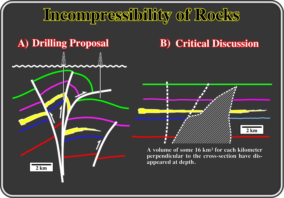
Fig. 9- These two sketches illustrate a real exploration example. The sketch on the left (A), taken from the drilling proposal, is the interpretation of the seismic line, in which the interpreter proposed two exploration wells. The seismic line is perpendicular to the structural trends, which are mainly associated with cylindrical folds and thrust faults. The tectonic regime responsible of the shortening was characterized by an
The tentative interpretation, proposed for the seismic line illustrated on fig. 10, corresponds roughly to the example depicted on fig. 9. It shows how often seismic interpreters forgot the volume preservation law.
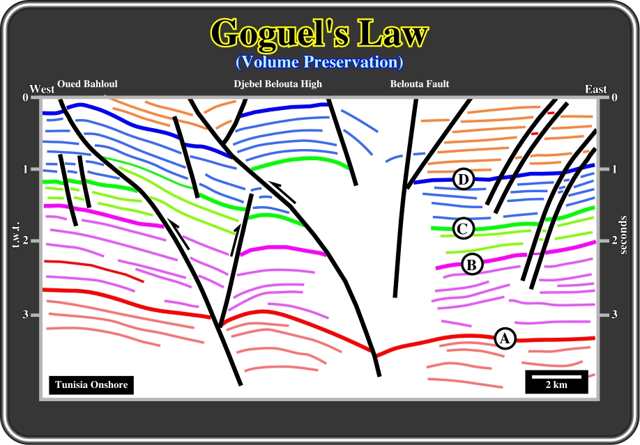
Fig. 10- This picking of the chiefly seismic reflectors comes from a seismic line, in which there is not significant lateral displacements. The proposed picking clearly pionts out the interpreter forgot that during deformation the volume of sediments must be keep more or less constant (porosity reduction and stylolite formation taken into account). Such interpretation does not resist a simple geometrical critical test. Indeed, the shortening of the seismic markers is not coherent. The green marker (C), for instance, is much more shortened that the red marker (A). Therefore, so some kind of detachment plane, or tectonic disharmony, must be present. In fact, the geometric relationships between the seismic markers can only be explained by a tectonic inversion, in which the old normal faults were reactivated by a compressional tectonic regime, or by a tectonic disharmony characterizing a “stockwerk tectonics” (see later).
Theoretically, one must to be capable of restoring every structural interpretation to its original state, without violating the rule of volume preservation. However, there are several common exceptions: (i) Dissolution, (ii) Erosion, (iii) Salt basins, etc.
In areas or basins where styolitization (carbonate sediments) or dissolution (salt basins) is important, Goguel's law is approximate. It can be used to test tentative solutions but quite carefully, since styolitization and dissolution can remove significant amounts of sediments (see figures below).
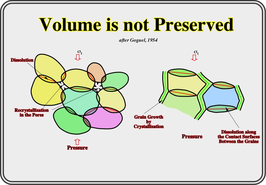
Fig. 11- Deformations in limestone often results in significant dissolution along the most loaded joints and recrystallization either in the pores (left) or, along the least loaded joints (right), if there are no more pores. Mineral solubility depends on the mechanical stress, t°, P and T. The loss of volume by dissolution can be quite important (20-30%) and so can strongly affect the validity of Goguel’s law.
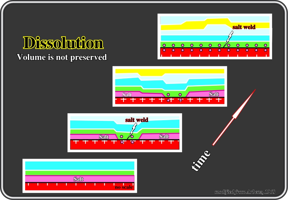
Fig. 12- These sketches illustrate the structural effects of salt dissolution. These kind of structures were discovered and studied a long-time ago, during the exploration of Devonian sediments in the Williston Basin. They were explained by Shell's explorationists (Arbenz, 1968) as follows: “These structures are created by selective salt solution of Devonian evaporites in the subsurface with compensatory sedimentation. In its simplest form the mechanism of origin consists of the selective leaching of a part of the salt horizon with concurrent subsidence of the roof into the created space. Because of compensatory sedimentation, the sediments over the initially withdrawn are become thicker until all salt has been removed at that place. During the next phase, the remainder of the salt is removed and the formerly infilled portion (because it is thicker) then becomes a positive, thus creating an anticline structure sandwiched between non deformed overlying and underlying sediments”. Summing up: In salt basins, such as the South Atlantic margins: when testing the validity of their tentative solutions, explorationists should not forget that salt can be dissolved. The observed compensatory subsidence, and its associated sedimentary depocenters, is not always induced by salt flowage. They can be the end result of salt dissolution.
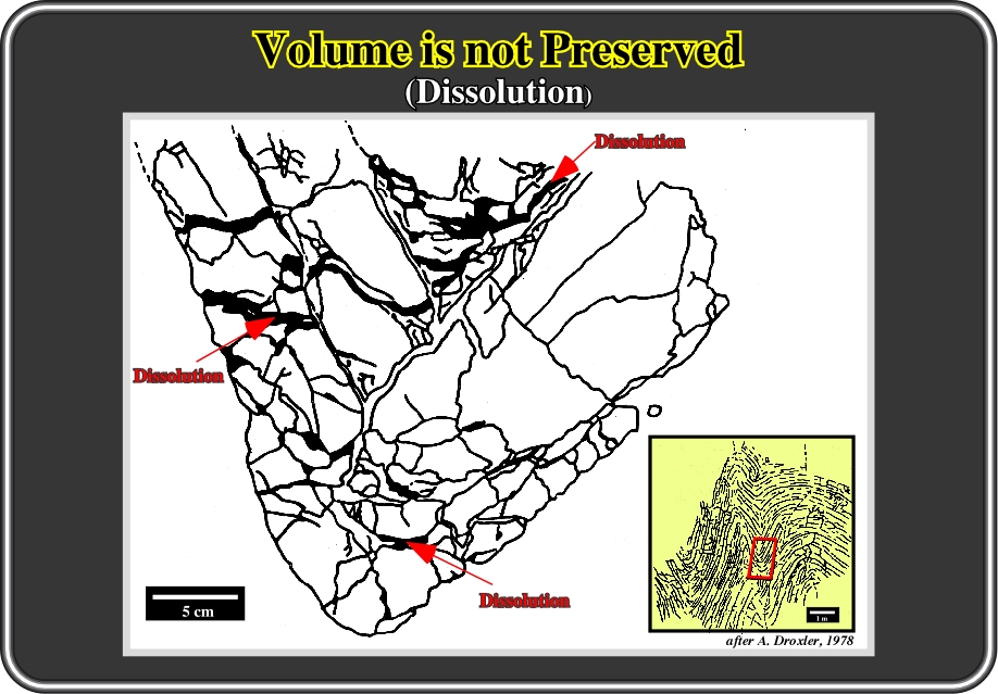
Fig. 13- Similarly, in a basin where carbonate sediments are predominant, carbonate dissolution in sediments must be taken into account in volume restorations. In fact, in certain cases, it can be higher than 30% of the total volume. In the Jura Mountains, for instance, carbonate dissolution is highly significant, as illustrated in the above photograph of a typical microscopic Jura anticline structure. In this particularly example taken from Droxler (1978), the area in black represents areas of dissolution. Notice that at mesoscopic scale (continuous outcrop), the structure looks perfectly concentric without dissolution loss. However, at smaller scales dissolution is obvious not only in pores but joints as well. So, in predominant carbonate facies, geologists, when testing tentative solutions using Goguel's law, must take into account the amount of material lost by dissolution.
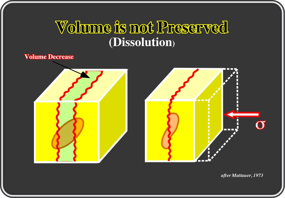
Fig. 14- The volume of carbonate material lost by styolitization, as depicted in this figure, can be considerable. Quite frequently, differential movement under pressure is accompanied by dissolution and formation (diagenetically) of styolites. So, in carbonate, and more rarely in sandstones and quartzites, geologists can roughly calculate the rock volume lost by stylolization, which appears as an early phenomenon during deformation. However, as the direction of stylolites is parallel of
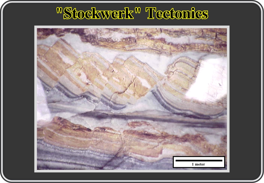
Fig. 15- Restoration tests of cross-sections, or depth seismic interpretations (scale 1:1), must take into account that different deformation stages that can exist in sediments at all scales (macroscopic, mesoscopic and microscopic). This figure illustrates, at small scale, the concept of "Stockwerk Tectonics" proposed by Wegmann (1956, 57) and its implications in volume problems. Indeed, it is easy see that the middle layers were strongly lengthened, while the others are almost undeformed. Therefore, in this case particularly, volume problems must take into account such tectonic disharmonies. Recently (2001), interpreters in Maracaibo Lake 3D seismic studies, using mainly seiscrop interpretations, recognized how important the “Stockwerk tectonics” is in the understanding of petroleum systems and remnant hydrocarbon potential. Wegmann (1956) introduced the concept of "Stockwerk Tectonics" for the different styles of tectonic deformation in the crust and the substratum. The knowledge of geodynamic processes of great dimensions (continental drift, great transcurrent fault systems, mid-ocean rises rift-systems, etc.,) lead to the postulation that the causative mass displacements of the geo- and megatectonic processes occur near surface as at great depths (probably in the outer and inner mantle). For the mechanical explanation of the structural features of the earth’s surface, distinction should be made between components of movement due to disturbances of the gravitational equilibrium at various structural levels of the crust and mantle. The relative importance of these impulsive forces of the tectonic deformations, displacements, and rotations of the crustal elements should indeed, be judged according to the concept of “Stockwerk Tectonics” in lato sensu. Summing up: when "Stockwerk tectonics", that is to say, tectonic by layers ("tectonique par étages" in French) is present in an area, volume problems must be solved, or used as critical test, within each realm of deformation defined between successive tectonic disharmonies. Notice that a tectonic disharmony, quite often, does not correspond to an unconformity (erosional surface) but rather to a disconformity
In areas where erosion removed sediments during or after deformation, it is evident that Goguel's law must be carefully used, either to suggest tentative solutions, or to test them. In fact, in a compressional tectonic regime (1 horizontal), sediments are shortened and so uplifted. Therefore, significant erosion takes place with development of an erosional surface (eustatic unconformity), which can become an angular unconformity when tectonically enhanced. In generally, on seismic lines, the seismic reflectors do not underline eustatic unconformities. They are underlined by seismic surfaces, that is to say, surfaces defined by reflections terminations such as toplap (below) and onlap (above). The sediments removed by erosion along these unconformities must necessarily be taken into account when restoring or testing the viability of the proposed tentative solutions.
In predominant extensional tectonic regimes (1 vertical), such as Atlantic-type divergent margins, sediments are lengthened, and so, usually they sink (subsidence). The unconformities bounding the sedimentary packages are mainly eustatic. They are created by relative sea level falls. The cyclicity of the relative sea level falls is controlled by eustacy, while their amplitude is mainly due to subsidence (tectonics). Therefore, there is no significant erosion between the sedimentary intervals separated by a relative sea level fall. Subsequently, such unconformities, by far the most frequent on the ground, cannot be easily recognized by the geometry of the underlying and overlying sediments, since the sedimentary packages often have a parallel internal configuration. Eustatic unconformities are by and large identified by the detection of coeval incised valleys frequently localized near the depositional coastal break. In fact, during a relative sea level fall, the costal onlaps are displaced downward, and basinward, inducing a disruption of rivers' equilibrium profiles. So, the rivers are obliged to cut into the ground, creating incised valleys in order to get a new equilibrium profile, which become incised valley fills during the following relative sea level rise.
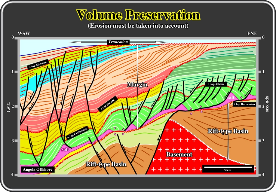
Fig. 16- On this interpretation, it is evident that some ground rules of restoring cross-sections must be used carefully. Indeed, the amount of sediment removed by erosion must be carefully calculated. In fact, the regional SW Africa uplift, created by Tristan and Gough hot spots, induced a significant relative sea level fall that resulted in a lot of sediments being removed by erosion during and after this deformation (see truncation at sea bottom). Likewise, the global Oligocene lowstand, induced most likely by glacio-eustacy, eroded a lot of Paleogene sediments (uppermost green intervals). Similar Oligocene erosional features are recognized not only along the entire Atlantic offshore but worldwide as well. In addition to erosion, lateral thickness variations within post salt-sediments (margin), compensatory subsidence and halokinesis (salt tectonics) must also be taken into account when testing tentative solutions.
Under certain conditions, large amounts of sediments can be removed by aerial or submarine erosion. Aerial erosion is often associated with extensional uplift induced by volcanic plumes, while submarine erosion is often associated with periods of lowstand induced by glaciations. Both hypotheses are illustrated on the seismic lines of the North Angola offshore (Fig. 16), in which the volume of removed sediments must be taken into account when restoring or testing the validity of tentative seismic interpretations.
In areas where salt (halokinesis) or shale tectonics (shalokinesis) has occurred the volume of the sediments is not preserved due to erosion, compensatory subsidence or dissolution. Indeed, when mobile layers, such salt or under-compacted shales are present in a basin, erosion and compensatory subsidence, induced by lateral or vertical flowage, must be taken into account when restoring or testing tentative structural and stratigraphic interpretations (Fig. 17).
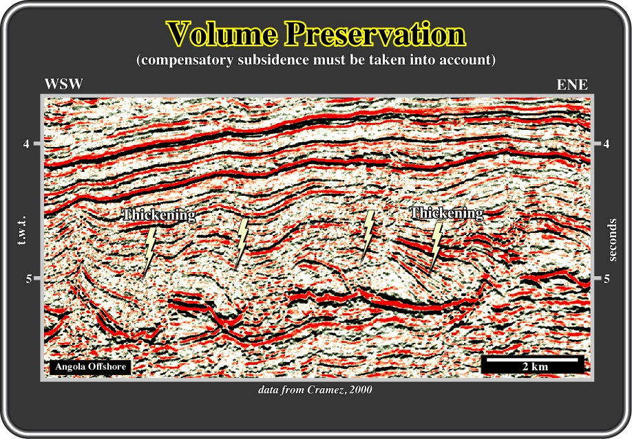
Fig. 17- Goguel’s law cannot be used to test tentative geological solutions where salt flowage creates compensatory sedimentation and strong lateral thickness variations. Indeed, the sedimentary intervals contemporaneous of halokinesis (salt tectonics) show divergent internal configurations and strong lateral time thickness variations. Restorations are possible but difficult to perform, since lateral salt flowage must be taken into account. When 3D seismic data is available, modern software programs, such as Locace, can, at least partially, solve such tricky situations. Summing up: When performing tentative solutions in salt basins (halokinesis + extension), geologists must know, a priori, the basic principles in salt tectonics and they must take into account, when criticizing their tentative solutions, that intervals synchronous with salt movement thicken strongly toward the faults and salt welds created by compensatory subsidence.
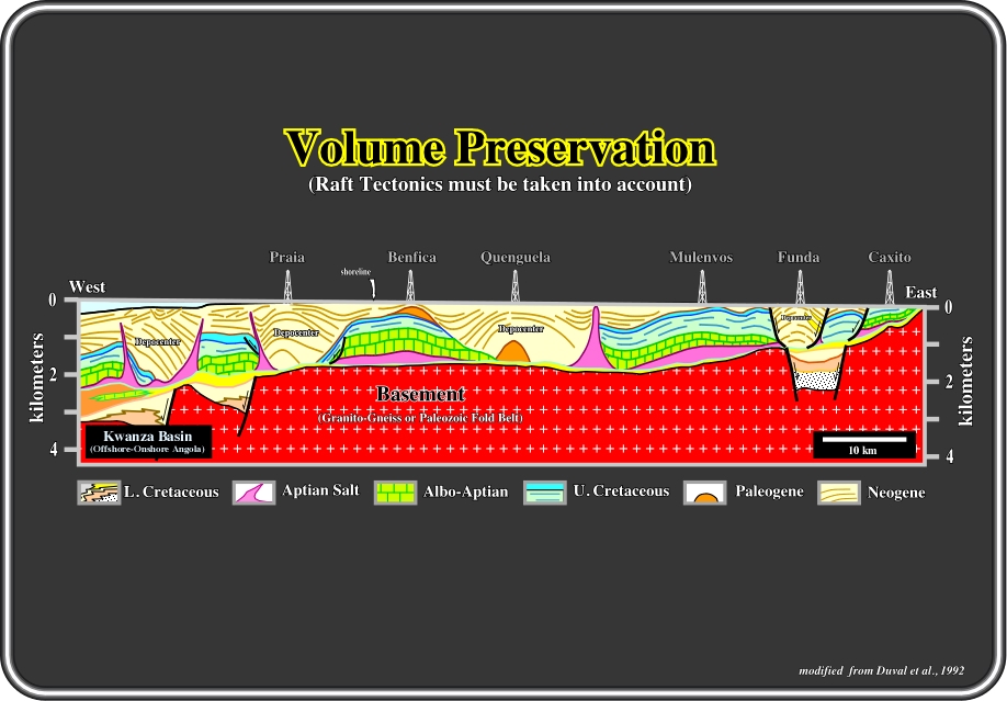
Fig. 18- When testing and restoring cross-sections in salt basins, as is the case in the Kwanza basin (Onshore Angola), raft tectonics must be taken into account. Indeed, as depicted above, there are areas with anomalous stratigraphy (depocenters), which alternate with areas showing a normal stratigraphy (rafts or prerafts). However, palinspastic restorations at end Cretaceous (green interval) are rather simple, since rafting seems to start at Paleogene time. Notice that is this basin, as well as in the U.S. Gulf Coast basin, the majority of the structures can be locally explained soley by salt flowage (
to continue press
![]()
Send E-mail to ccramez@compuserve.com or cramez@ufp.pt with questions or comments about this short-course.
Copyright © 2000 CCramez
Last modification:
Agosto 27, 2006