Universidade Fernando Pessoa
Porto, Portugal

Salt Tectonics Short Course
10- Extension and Rafting(cont.)
10.8- Translation Extensional Structures
Extensional structures, created when the overburden slides (translation) over a single stepped detachment surface (top salt), were described previously (see fig. 202 to 206) using the geological model proposed by AGL. For more complex detachment surfaces, the AGL’s hypotheses can be summarized as follows:
A) Single Buried Step (fig. 285)
Previously was said:
- If the sedimentation rate is insufficient to cover the bathymetric escarpment, each unit will onlap above the step.
-Onlaps are translated basinward after deposition, producing a landward-dipping package of apparent downlaping strata.
-The distance from a given onlap to the step records the amount of translation since the deposition of that unit.
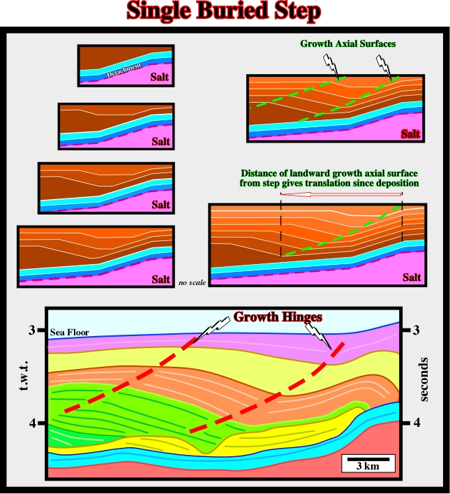
Fig. 283- Geological mechanism proposed by AGL to explain the geometry of the overburden in certain areas of the offshore Angola, particularly around the fracture zones, which have been recognized for a long time (see fig. 284 and 285).
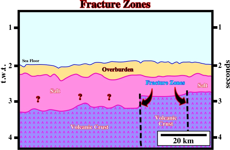
Fig. 284- On this old seismic line (Seffel 5, 1968), two fracture zones are easily recognized by the vertical displacement of the substratum (probably volcanic crust). Above the substratum two seismic intervals can be identified. The upper corresponds to the overburden (yellow). The lower seems to correspond to the Aptian evaporitic layer (pink). Northward of fracture zones, the thickness of the salt is questionable. More recent seismic lines suggest (i) the presence of autochthonous and allochthonous and (ii) extensional structures induced by translation of the overburden over the fracture zones (fig. 285).
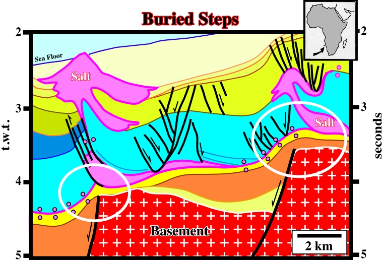
Fig. 285- Two fracture zones, associated with the reactivation of the normal-faults bordering the rift-type basins, create two buried steps at the level of the tectonic disharmony. Therefore, when the overburden glided seaward, apparent downlap surfaces were created in association with the synkinematic layers. The growth hinges of the synsedimentary extensional structures are well visible, at least in the blue interval on the central part of the line (see fig. 283 and 285).
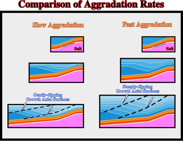
Fig.286- If the sedimentation rate is high enough to cover the bathymetric escarpment above the step, each stratigraphic unit will form a depocenter seaward of the step. As older depocenters are translated basinward, younger depocenters form at the step. Continued translation produces a shingled series of landward-dipping sediment thicks, bounded by two growth axial surfaces. The distance between the step and the intersection of a horizon with the landward growth axial surface records the translation since the deposition of that horizon. For a given translation rate, faster sedimentation produces steeper growth axial surfaces.
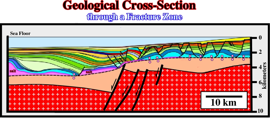
Fig. 287- On this regional cross-section of the southern offshore Kwanza, proposed by BHP’s geologists in 1998, an apparent downlap surface, above the prekinematic layers of the overburden, is recognized seaward of a major step. It correspond either to the reactivation of an old normal fault bordering a rift-type basin or to the reactivation of a fracture zone. The apparent downlap surface is the consequence of the translation of the overburden over the buried step at the top of the prekinematic layer. The reactivation took place immediately after the deposition of the prekinematic interval. The seaward translation of the synkinematic layers creates enough space to allow a significant landward thickening. This mechanism is, at large scale, similar to that responsible for back-raft and fore-raft structures (see fig. 288).
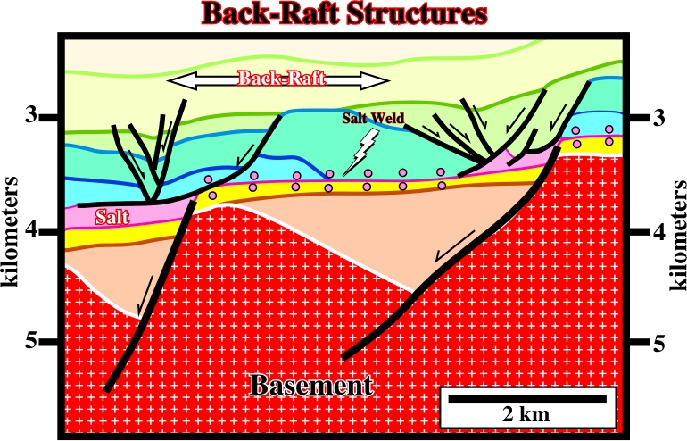
Fig. 288- A major back-raft structure is developed seaward of the eastern step of sub-salt strata (in yellow). The top of the sub-salt strata, which in the central part of the line corresponds to a fault weld) shows two sharp steps, which match two basement highs. They seem to correspond to the reactivation of the normal-faults bordering the rift-type basins. The reactivation took place after the deposition of the isopachous dark blue interval. Then, the overburden glided seaward (prekinematic interval included) with progressive deposition of the synkinematic layers. Due to the translation, the original onlaps of the synkinematic layers progressively became apparent downlaps upon the fault weld. The mechanism of the back-raft structures is the same of the large translation extensional structures. Only the scale and the age of the translation are different.
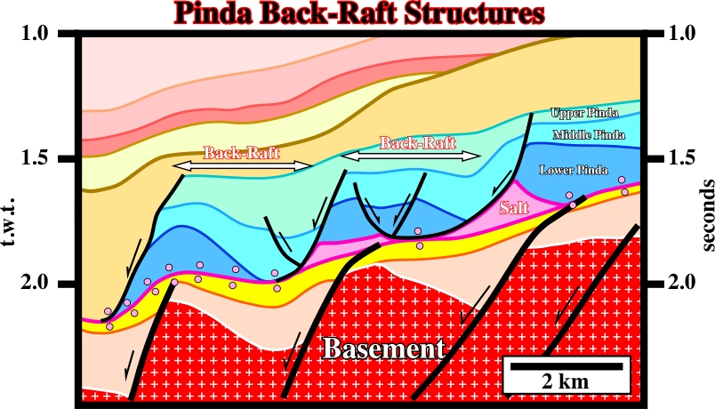
Fig. 289- In block 2 of offshore Angola, back-raft structures are quit frequent. Their geometry, the apparent downlap surface and the associated sub-salt strata steps are characteristic of the translation of the Pinda formation over the salt or faults welds. As illustrated in next figures, more complex overburden geometry can occur by combination of translation, buried steps and diapirs.
B) Single Emergent Step with Salt Diapir (fig. 290 and 291)
Certain seismic lines from offshore Angola (fig. 290) can be easily interpreted assuming the gliding of cover (salt layer + overburden) over a single step with the interference of a salt diapir.
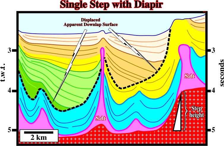
Fig. 290- The step, at the bottom of the salt, is evidence, as well as, the apparent downlap surface, which is offset by the central diapir. Taking into account that the salt was displaced down-dip, by translation, at a given time, the central diapir was above the step, as illustrated in the AGL’s model (fig. 291).
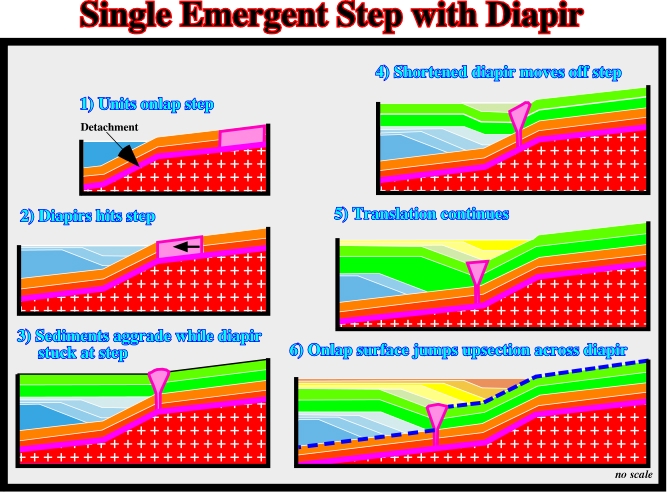
Fig. 291- When a diapir reaches the step, it begins to shorten laterally. Translation is absorbed by diapir contraction. The units basinward of the step do not move until the diapir has finished shortening. Diapir narrowing elevates its roof, which may lead to erosion and salt extrusion. Sediments landward of the step are commonly ponded behind the elevated diapir roof. The apparent downlap surface jumps up-section across the diapir. The jump in age measures how long the diapir remained at the step.
C) Two Emergent Steps
On the seismic lines of the deepwater of Angola, very often, one can observe two or more steps at the bottom of the salt. The associated geometry of the cover can be readily recognized when knowing the following geological models (fig. 292). Again, one can say: Theory precedes Observation.
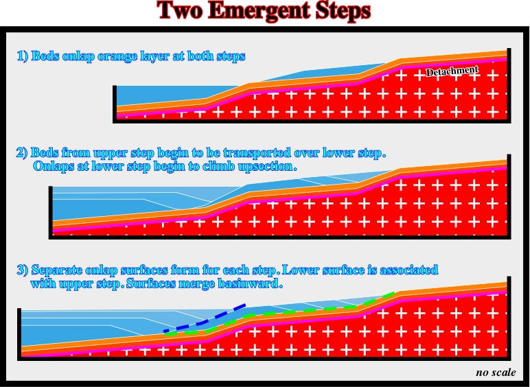
Fig. 292- Two steps will create twin apparent downlap provinces if sedimentation rates are not high enough to bury the scarps. Time-equivalent apparent downlaps are separated by the step spacing, which constitutes, a powerful tool for correlation. Apparent downlap associated with the lower (basinward) step climb up-section over units deposited at the upper (landward) step as they are translated basinward.
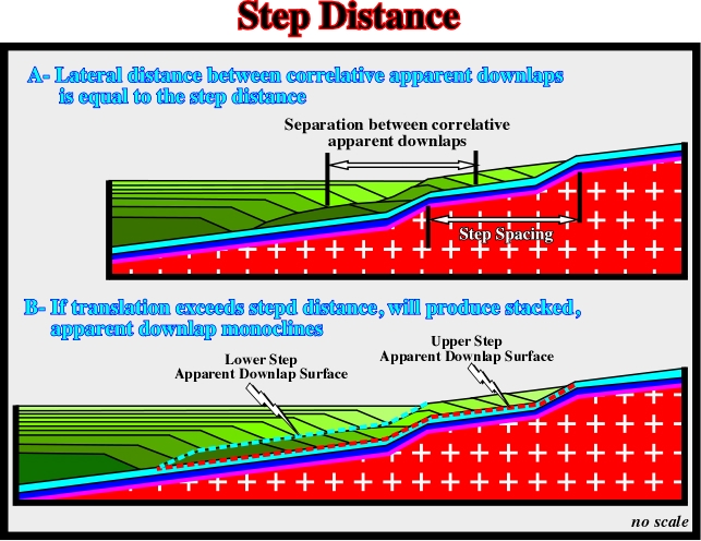
Fig. 293- If translation exceeds step spacing, stacked, landward-dipping, apparent downlap monoclines result. This geometry is thought to be diagnostic of stepped detachment systems.
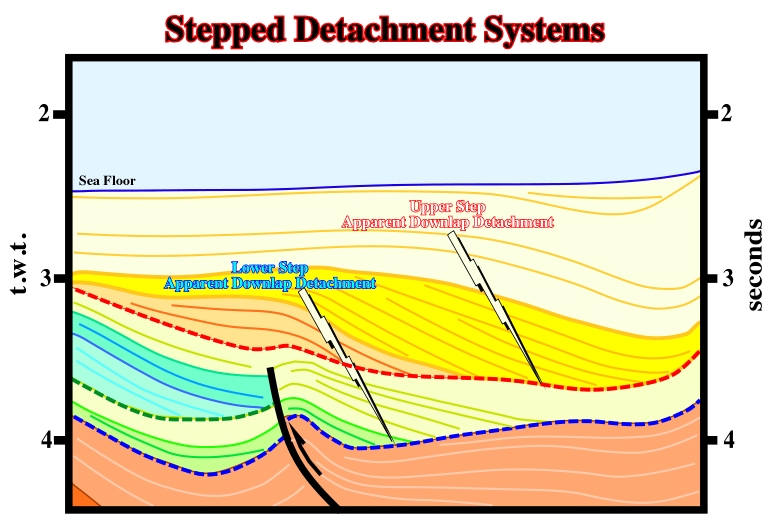
Fig. 294- On this line (see fig. 295), the stacking of different apparent downlap surfaces strongly suggest, at least, two emergent steps. The simplicity of geometry of the chronostratigraphic lines is local masked by the inference of salt diapir as pictured in next figures.
D) Two Emergent Steps with Salt Diapir
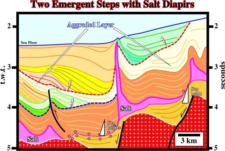
Fig. 295- This seismic line (see detail fig. 294) shows two apparent downlap surfaces induced by two steps of the base of salt, which underlie the reactivation of the normal faults bordering rift-type basins. An aggraded layer (light yellow) deposited when the diapir was at the upper steps separates the apparent downlap surfaces, as sketch in fig. 296.
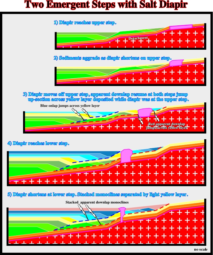
Fig. 295- Whenever a diapir is shortening at a step, sediments aggrade seaward of the step. When translation resumes and the diapir move off the step, all apparent downlap surfaces jump up-section across the aggraded layer. An aggraded layer will thus separate stacked apparent downlap monoclines.
The important of stepped detachments in seismic interpretation can be summarized as follows:
a) If detailed age control is not available, stepped detachments can be used to: (i) measure total translation, (ii) establish correlations between steps and across diapirs.
b) If detailed age control is available, stepped detachments can be used to: (i) determine translation history, establishing position of migration windows relative to sub-salt maturation kitchens, (ii) calculate translation rates, (iii) estimate length of time that systems stalled with a diapir shortening on a step, (iv) compute original diapir widths.
Summing up:
Translation across a stepped detachment system creates diagnostic stratal patterns. Not all-stratigraphic variation in a salt-involved detachment is salt controlled. In multi-step systems, these stratal patterns can be a valuable correlation tool. A wide variety of geometries are possible, depending on sedimentation rate, translation rate, number of steps, and position of salt structures. Interpretation of stepped detachment systems allows estimation of translation past a fixed point - a powerful constraint on regional restorations.
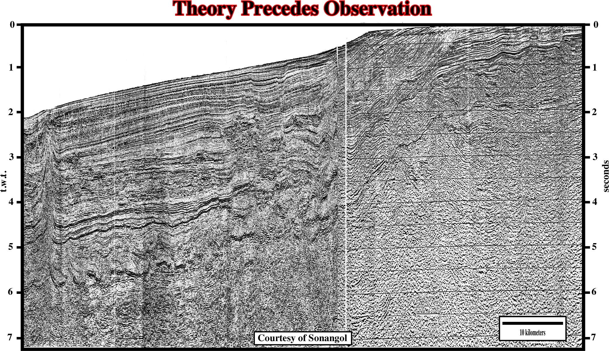
Fig. 296- Taking into account the hypotheses advanced previously, on this composite line of the northern offshore Angola (South Congo basin), it is easy to recognize: (i) a Late Tertiary uplift, particularly in the conventional offshore, (ii) the tectonic disharmony (bottom of the salt or salt weld), (iii) pre-raft and raft structures, (iv) Tertiary depocenters, (v) Fracture zones, (vi) buried steps at the bottom of the salt layer, and apparent downlap surfaces created by translation. Try to localize the more significant apparent downlap surfaces and you will realize that, at least, one is inverted due to the uplift.
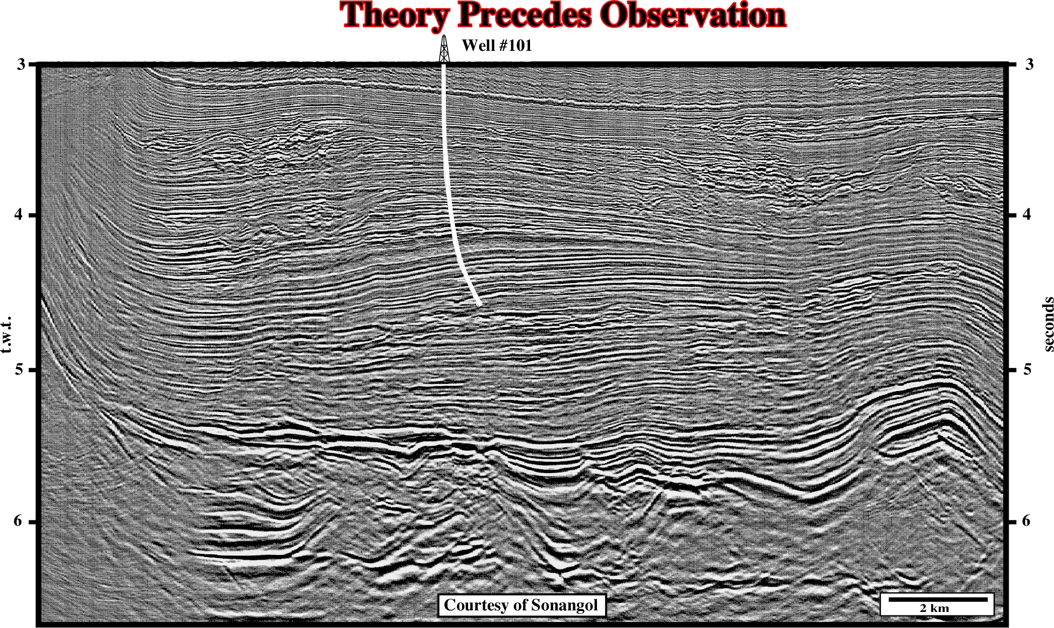
Fig. 297- As the philosophers of sciences said “seismic interpreters can only recognize on a seismic line what they know, indeed all observations are theory impregnated”, we guess, on this line, you can recognize two major apparent downlap surfaces and an aggraded interval. Try to locate them and propose the more likely geological explanation (see fig. 294 and 295).
10.9- Rafting and Petroleum Systems
The understanding of rafting and translation, and particularly the limit between the pre-raft and raft domains, has a landmark impact on the comprehension of petroleum systems. On this subject, the northern conventional offshore (northward of the structural high of Ambriz) is a quite interesting example. Indeed, the relationships between the rafting domains and the hydrocarbons parameters, in this area, can be depicted as illustrated in fig. 298.
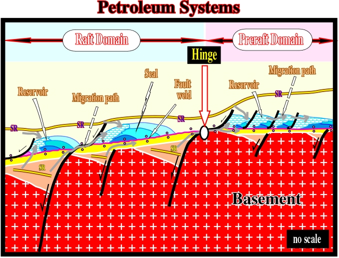
Fig. 298- This sketch illustrates the hypothesis proposed by Total’s explorationists to explain the potential petroleum systems, in the northern offshore Angola. In pre-raft domain, they considered the highest structural areas as potential reservoirs, and in the raft domain. Where translation (extension) is paramount, they considered fore-raft structures as potential reservoirs and back-raft structures as potential seals.
Landward of the Atlantic hinge, which separates the pre-raft from the raft domain, the organic matter of the potential source rocks deposited within the rift-type basins, is immature.
a) Actually, even taking into account the general uplift of the proximal offshore and onshore, the organic matter of the potential source rocks has not been buried enough to reach the oil window.
b) In such a geological conditions, the hydrocarbons must have migrated from the rift-type basins located seaward of the Atlantic hinge.
Seaward, on the raft domain, the main petroleum system is Barremian / Albian:
a) The generating petroleum subsystem is composed of lacustrine shales deposited in the rift-type basins (Barremian).
b) The reservoir / entrapment petroleum subsystem is composed by the high-energy Albian limestones, which initially were in a structural high position. After salt flowage and extension, salt induced tectonic inversions put them in a low structural position overlying relic rollers or immediately above the tectonic disharmony.
c- The migration of the generated hydrocarbons is vertical, along the fault planes and then, horizontal, along the basal reservoirs of the margin.
The hydrocarbon parameters have been summarized as illustrated in fig. 299.
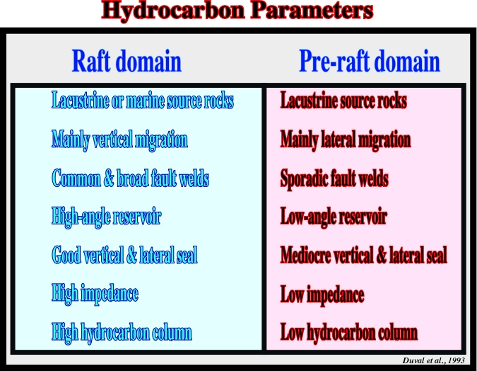
Fig. 299- The characteristics of the main hydrocarbon parameters of the northern conventional offshore of Angola have been hypothesized since the 80’s, predominantly by Total’s explorationists. At the present time, taking into account the deep-water exploration, the sketch of the petroleum systems may be adapted, as illustrated as below (fig. 300).
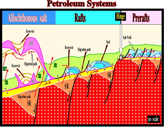
Fig. 300- In deep-water, the presence of allochthonous salt layers strongly change the targets of hydrocarbon exploration. The best reservoirs are Tertiary turbidite sandstones and the trapping mechanism can also be associated with allochthonous salt as is the case in deepwater of Gulf of Mexico (see next chapter).
to continue press next
next

Send E-mails to ccramez@compuserve.com or cramez@ufp.pt with questions or comments about these notes.
Copyright © 2001 CCramez
Last modification:
Março 19, 2006