
Porto, Portugal
Contents:

11.1-  GOM Regional Cross-Sections
         11.1.1- Deep-water Cross-Section
         11.1.2- Dip Cross-Section through Mississippi Delta
         11.1.3- Strike Cross-Section through Mississippi Delta
11.2- Allochthonous Salt with and without Extension
11.3- Hydrocarbon Parameters in GOM Deep-water
11.1- GOM Regional Cross-Sections
In spite of the fact that the presence of allochthonous salt in Gulf of Mexico was suspect since long time, until the 70’s, the large majority of the seismic interpreters proposed always a domal morphology for the evaporitic interval as illustrated in fig. 301.
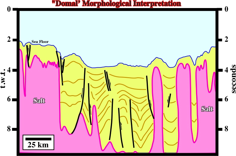
Fig. 301- Before the 80’s, similar erroneous interpretations, as above, were more than frequent in the Gulf of Mexico. Exploration was concentrated in the upper sedimentary layers of the conventional offshore.
However, in beginning of the 80’s, under the influence of the explorationists having work in South Atlantic margins and in onshore Alabama, interpretation changed a lot (fig. 302).
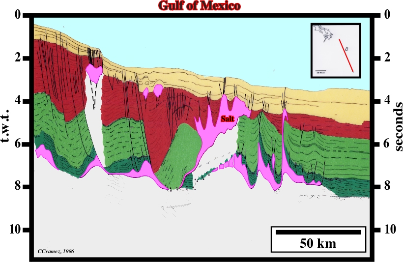
Fig. 302- End 80’s, rafting, translation, allochthonous salt sheets, salt expulsion basins (see later) and turbidite depositional systems became key a priori hypotheses in seismic interpretation (see fig. 303).
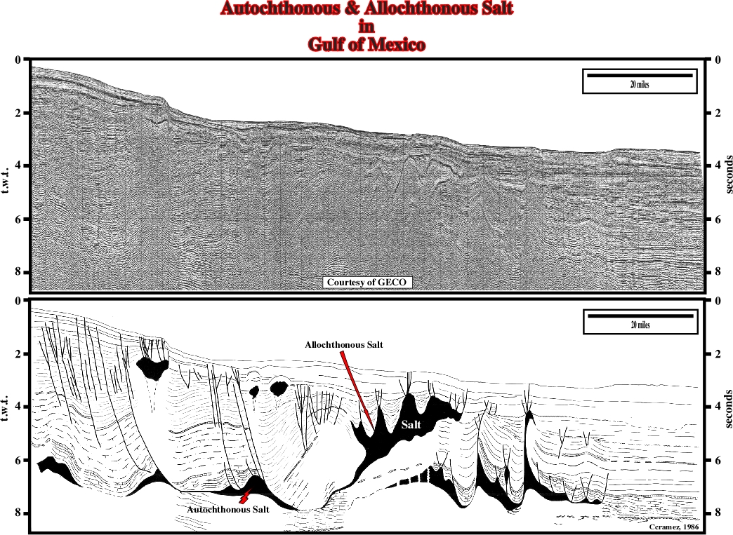
Fig. 303- The originals of the previous fig. 302 are illustrated here. On the top the un-interpreted line and on the bottom how it was interpreted in 1986. Indeed, in association with the allochthonous salt layer, raft structures, salt rollers, faults welds and diapirs are easily recognized, while in the allochthonous salt layer mini-basins are paramount. Apparent downlap surfaces are associated rafting as better illustrated in next figure (fig. 304).
Fig. 303- On this seismic line it seems that the seaward translation of the cover contributes to the development of the allochthonous salt. Indeed, the depocenter deposited in the down-thrown block of the growth fault seems to force the autochthonous salt to flow basinward and upward to form quite important salt sheet. At present time, the autochthonous salt is reduced to a relic roller, in the up-thrown block of the growth fault, and to a mound below the end of eastern end of the allochthonous salt.
The following geological cross-sections through the Gulf of Mexico illustrate different geometries of the allochthonous Louan salt and their relationships with the autochthonous layers.
On the time cross-section illustrated below (fig. 304), which is just the interpretation of a composite seismic profile between the Florida platform and the recent basin floor fan of the Mississippi, it is readily to recognize:
a) The changes in water depth induce an important pull-down southward of the Florida escarpment, which should not be interpreted entirely as a fault displacement.
b) On the Florida Platform:
b.1- There is not allochthonous salt.
b.2- The autochthonous salt is continuous and there is no evidence of salt welding.
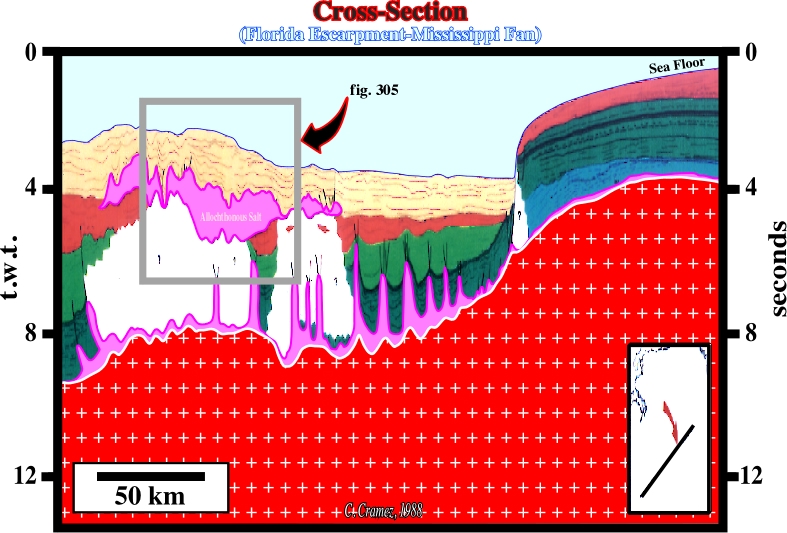
Fig. 304- Autochthonous and allochthonous salt layers are quite evident. Below the allochthonous salt, the interpretation is sometimes speculative. Both salt layers induce a strong tectonic disharmonies, that is to say, above and below the salt layers, the sedimentary deformation is quite different as illustrated in fig. 305 for the allochthonous layer.
b.3- The salt is very thin.
b.4- The salt movements are restricted to a mound stage.
c) Southward of the Florida escarpment, one can say:
c.1- There is autochthonous and allochthonous salt.
c.2- The autochthonous salt is more or less continuous. There is no strong evidence of salt welding, except near the toe of the Florida escarpment.
c.3- Mounds and domes are frequently associated with stretching faults on the top of the domes.
c.4- Reverse fault domes on the southeast of the line.
c.5- Below the Mississippi basin floor fan, a huge reactivated salt nappe is easily recognized.
c.6- Several depocenters are overlying the allochthonous salt.
c.7- There are at least two tertiary salt welds associated with the salt nappe.
c.8- Below the allochthonous salt, the interpretation is speculative. The salt interval absorbs the energy of the seismic waves and the below it the line is almost reflection free.
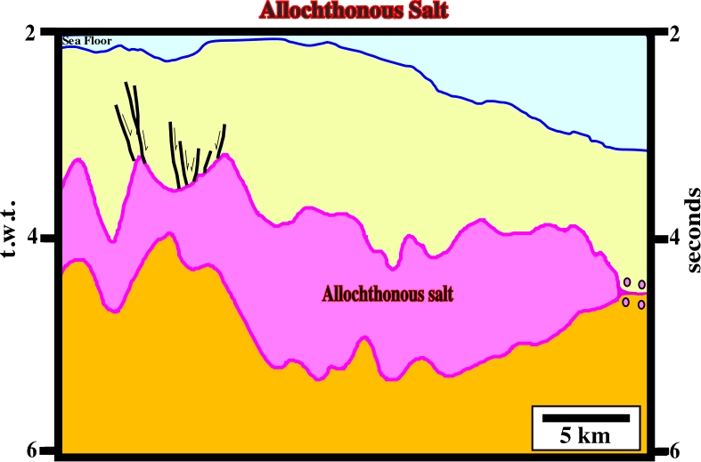
d) On the close-up illustrated in fig. 305, the following feature can be noticed:
d.1- The bottom of the salt nappe is undulating and difficult to follow.
d.2- The top of the allochthonous salt has been reactivated (flowage and probably compression).
d.3- The sedimentary interval immediately above the salt nappe is isopachous, at least in the northeastern section. This interval dates the emplacement of the salt nappe.
d.4- The emplacement of the salt nappe took place under a relatively thin cover, which corresponds roughly to the thickness of the isopachous interval.
d.5- The salt nappe was reactivated with development of several young depocenters and salt welds, as the one visible on the NE part of the close-up.
d.6- Finally, notice that when interpreting seismic data with allochthonous salt, explorationists must take into account that:
- A seismic line is a time profile,
- The seismic waves travel through salt at around 5500 m/s,
- Very often, the bottom of the allochthonous salt is difficult to follow,
- The strong reflector, often interpreted as the bottom of the salt, is rather associated with under-compacted shales or shear zones, as indicated by several wildcats and suggests by certain seismic lines (fig. 306).
This geological cross-section (fig. 307), as the one illustrated in fig. 304, is in depth and it corresponds to the interpretation of a composite regional seismic profile. The majority of the sedimentary packages of the Gulf Coast, as well as the main halokinetic and salt tectonic features are depicted.
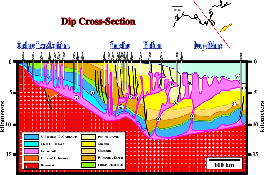
Indeed, it is easily to recognize:
1- The limit “platform / slope” at the Middle Cretaceous.
2- The sedimentary interval with generating hydrocarbon potential, which, roughly, corresponds to the peak transgression of the post-Pangea continental encroachment stratigraphic cycle (Cenomanian-Turonian).
3- The autochthonous salt.
4- The salt ramps, between the autochthonous and the allochthonous salt layers.
5- The 1st generation of allochthonous salt.
6- Salt and fault welds associated with the allochthonous salt.
7- The 2nd generation of allochthonous salt (it is interesting to notice on this cross-section there are several generations of allochthonous salt, that is to say, a salt nappe can be developed from a previous one, which works as a 2nd order mother salt layer).
8- The salt expulsion basins upon salt nappes (salt expulsion basins or « mini basins »as labeled by some American explorationists will be studied in the next chapter).
9- The Sigsbee escarpment.
10- The Mississippi deep sea fan.
11- The Perdido fold belt.
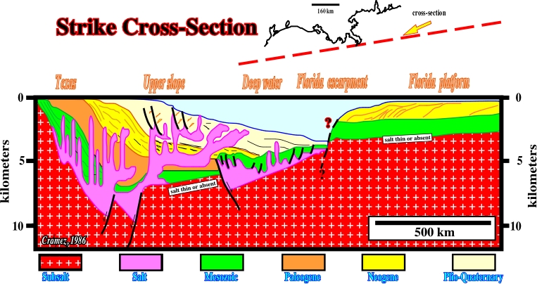
Fig. 308- Geologically speaking, the Gulf Coast, between the Florida platform and the onshore Texas, corresponds to a Mesozoic Mediterranean-type basin (the oceanization of the Gulf of Mexico is no more a speculative hypothesis, but a likely one) overlain by Neogene Atlantic type divergent margin. The two graben-like structures filled by salt are speculative. They correspond to an old geological hypothesis that so far has not been verified and corroborated either. Certain geophysical data seems refute it.
On the Florida platform, the Louan salt is thin and often absent. On the contrary, seaward, the salt thickness is important (quite exaggerated on the cross-section). The salt deformation can be recognized under different structural configurations.
-All stages of diapirism are present on the autochthonous salt:
(i) Mound stage
(ii) Dome stage
(iii) Post-dome stage- Two generations of allochthonous salt with the associated depocenters.
- Compressional structures are locally developed.
11.2- Allochthonous Salt with and without Extension
Conventionally, in Gulf Coast and particularly in Gulf of Mexico, diapirism and allochthonous salt structures have been explained mainly by extension. However, in his PhD thesis S. Wu (1993) clearly demonstrated that all stages of diapirism and the development of salt nappes could happen in absence of significant lateral extension. The next sketch (fig. 309) illustrates, in six steps, the conventional hypothesis.
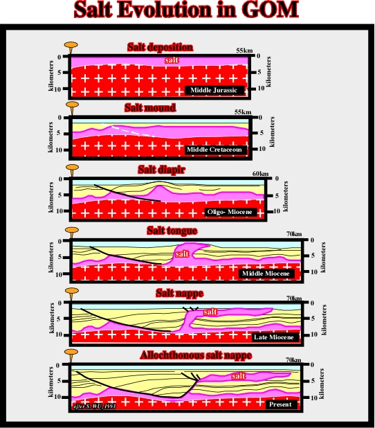
Fig. 309- Geologists who think that extension is a primordial, if not, a sine qua non factor for development of salt nappes in Gulf of Mexico propose evolutions similar to the one illustrated above.
a) The first step was the salt deposition during the Middle Jurassic.
On the proximal parts of the basins, the salt was deposited upon a sedimentary or metamorphic substratum. On the contrary, on the central part of the basin, due to oceanization, the salt was deposited directly above the volcanic crust (SDRs or oceanic crust). The hydrothermal origin of the brines of the potash salt was likely.
b) During the Middle Cretaceous, the salt started to flow creating salt mounds.
c) Mild extension and continuation of salt flowage created salt domes during the Oligocene -Miocene.
d) Due to a regional extension, during the Middle Miocene, salt domes became salt tongues.
e) Contraction of the stems of the salt nappes compensated the extension induced by the growth faults and obliged the salt to flow seaward creating huge salt nappes (Late Miocene).
f) At present time, the majority of the stems of the salt tongues are welds and the allochthonous salt nappes are disconnected of the mother salt layers.
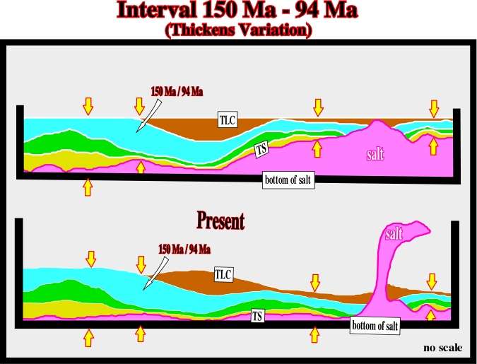
According to this evolution, the development of allochthonous salt is made with significant extension, which contrasts with Wu’s hypothesis, in which extension is insignificant. Wu’s hypothesis seems to be corroborated by the thickness of the interval 150 Ma – 94 Ma, as illustrated in fig. 310.
The evolution proposed by Wu (1993) is depicted in fig. 311 and 312. It can be summarized as follows:
A) Salt deposition took place around 150.5 Ma (150.5 Ma means million years ago, while 150.5 My means a geological interval with a time duration of 150. 5 million years (either Paleozoic or Meso-Cenozoic)) , during Middle Jurassic.
B) Continuous sedimentary loading during Jurassic and Cretaceous displaced laterally the salt creating salt mounds.
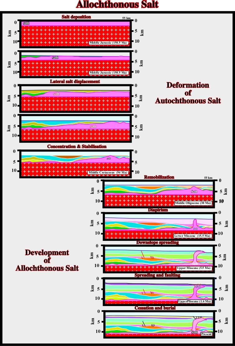
C) In the Middle Cretaceous, the salt reached concentration and stabilization with the formation of large salt mounds with associated welds.
D From Cretaceous to Middle Oligocene, the geological conditions were starved. The sedimentation rate was very low. Salt movements were almost nonexistent.
E) During Miocene, deposition started again.
F) Sedimentary loading remobilize the salt.
G) Diapirism reached dome and post-dome stages.
H) In the Upper Miocene, the salt reached the surface (or near surface) and started to flow down-slope creating large allochthonous salt nappes.
I) Spreading and faulting, particularly on the uppermost structures of the allochthonous salt, took place during Upper Pliocene.
L) Finally, at present time, there is cessation of the salt movement and burial.
It is interesting to notice that, as in Angola (remember the explanation of the Quenguela structure), in the GOM, two geological schools were developed. One took extension as main factor. The other took halokinesis (loading) as the main mechanism. Indeed, outside of the whole regional geological stetting, one can explain all types of salt structures either by halokinesis (insignificant lateral extension) or by salt tectonics (significant lateral extension). Contrariwise, when the whole regional geological setting is taking into account, either in offshore Angola or In Gulf of Mexico, the fold belts found in the distal part of the margins require some kind of extension up-dip to create the shortening in deep and ultra-deep offshore. Therefore, it seems reasonable to think extension and halokinesis are normally associated (salt tectonics) in salt margins, but, in certain areas, halokinesis can be preponderant, while, in others areas, the extension is more evident.
11.3- HC Parameters in GOM Deep-Water
Before going to the next chapter, where salt expulsion basins will be review, it is interesting to show the impact of the allochthonous salt in deep-water petroleum systems. The more likely hydrocarbon parameters, in the GOM deep-water, are depicted on fig. 312.
Source Rocks
The more likely potential source rocks are associated with the major downlap surface of the post-Pangea continental encroachment stratigraphic cycle (MFS 91.5 Ma). Such a downlap surface limits the transgressive phase (backstepping, aggradation) from the regression (forestepping, progradation) phase of the stratigraphic cycle (fig. 313). Alternative potential source rocks are possible, but not proven. Their organic matter is often immature, particularly within the young salt expulsion basins (see later).
Reservoir Rocks
Reservoirs rocks can be present in all stratigraphic intervals. They are particularly good and frequent within the depocenters associated with allochthonous salt reactivations. Mesozoic carbonates are generally to deep to be considered as main target. In addition, at such depths, their petrophysical characteristics are mediocre.
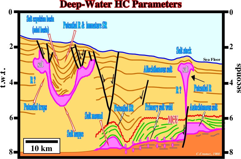
Traps
The traps are non-structural. They are mainly morphological (associated with slope fans or deep sea fans) or morphological by juxtaposition associated with autochthonous or allochthonous salt.
Migration
Migration paths and migration time must be clearly understood. The age of the trap must predate or be coeval of the migration time. On the other hand, a potential reservoir with a good trapping mechanism, for instance in a salt expulsion basin, can only be interesting, at the exploration standpoint, when the generated hydrocarbons can arrive there. Thereof, the presence of a window on the allochthonous salt allowing the migration of the hydrocarbons toward the potential reservoir is a sine qua non condition.
Retention
A glance at the sea floor, where HC seepages are quite abundant, is sufficient to show how the study of this parameter is important. A lot of dry or non-economical wells are due to a lack of retention.
to continue press
next
![]()
Send E-mails to ccramez@compuserve.com or cramez@ufp.pt with questions or comments about these notes.
Copyright © 2001 CCramez
Last modification:
Março 19, 2006