
Porto, Portugal
Introduction
Salt Tectonics (fig. 1) has been defined as any tectonic deformation of a sedimentary package involving salt, or other evaporites, as a mobile substratum or mobile layer. In this sense, salt tectonics is not a synonym of Halokinesis, which labels a sedimentary deformation powered entirely by gravity, that is to say, by buoyancy, in absence of significant tectonic stress (![]() t).
t).
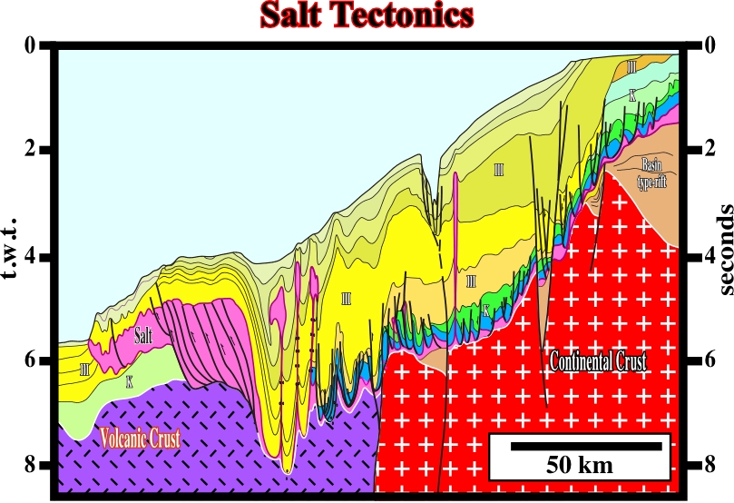
Fig. 1- This composite time profile of the Northern Offshore Angola (South Congo Basin) illustrates what we intend to convey by salt tectonics. The Atlantic-type margin, in which an evaporitic layer (Loeme Salt) was deposited, has undergone different tectonic regimes. The regional tectonic regime was extensional and characterized by a maximum effective stress (
1) vertical, a medium effective stress (
A stratigraphic column, in which a salt layer (or an evaporitic layer) is inter-bedded with other rocks, can be deformed in different ways. The deformation depends on whether the basement is involved in the deformation and upon the effective stresses ellipsoid, that is to say, the tectonic regime, which can change spatially and temporally (see plate I). A salt layer can be lengthened, or shortened, or both. It depends upon the geological history of the area (fig. 2). In addition, in absence of an important tectonic stress (![]() t), the salt layer can flow by itself following the basic principles of halokinesis. When the basement is involved, the salt is deformed along with the other rocks, which they are lengthened, when
t), the salt layer can flow by itself following the basic principles of halokinesis. When the basement is involved, the salt is deformed along with the other rocks, which they are lengthened, when ![]() 1 is vertical and shortened when
1 is vertical and shortened when ![]() 1 is horizontal.
1 is horizontal.
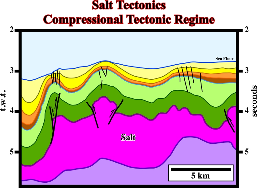
Fig. 2- This seismic line, shot on an offshore deep water, illustrates that a salt layer, independent of its thickness and its previous history (autochthonous or allochthonous), can be lengthened or shortened as any other rock following the basic principles of tectonics. In this particular example, taking into account that the profile is in time and not in depth, it is highly probable that the sub-salt rocks (probably volcanic crust) was involved in deformation. Actually, in South Atlantic Margins, and particularly in African margins, an Upper Miocene - Pliocene compressional tectonic regime, induced by ridge-push stresses, or a reactivation of the lithospheric plates, shortened the sedimentary pile as well as the volcanic crust (SDRs or oceanic crust). Notice the faults, located on the apexes of the anticlines (they do not exist on the synclines), are not normal faults. They are contemporaneous of the shortening, and so, they are associated with the same tectonic regime that created the anticline and syncline structures. In fact, they are small strike slip faults that elongate the anticline structures along their axes (
Whenever the basement is not involved in the deformation, generally, there is a tectonic disharmony between the overburden and the sub-salt strata:
- The overburden is either shortened or lengthened, while the sub-salt strata are undeformed or slightly deformed.
- Locally, in the absence of significant tectonic stresses, halokinesis extends the overburden.
In absence of significant tectonic stress (![]() t = 0), that is to say, in a tectonic regime characterized by
t = 0), that is to say, in a tectonic regime characterized by ![]() 1 vertical and t
1 vertical and t ![]() 2 =
2 =![]() 3 (fig. 3), salt can flow laterally and vertical creating a compensatory subsidence, which gives accommodation for the overburden sedimentation. Such a local and differential accommodation induces significant lateral thickness variations in the synkinematic layers of the overburden, which are one of the main characteristics of the halokinesis, as illustrated by Quenguela depocenter (fig. 4). Salt and other evaporites result from extensive or total evaporation of the solvent of saline solution. However, it is important to realize that the origin of the brine can be quite different. In fact, the halite mineralogy is non-diagnostic of the brine source.
3 (fig. 3), salt can flow laterally and vertical creating a compensatory subsidence, which gives accommodation for the overburden sedimentation. Such a local and differential accommodation induces significant lateral thickness variations in the synkinematic layers of the overburden, which are one of the main characteristics of the halokinesis, as illustrated by Quenguela depocenter (fig. 4). Salt and other evaporites result from extensive or total evaporation of the solvent of saline solution. However, it is important to realize that the origin of the brine can be quite different. In fact, the halite mineralogy is non-diagnostic of the brine source.
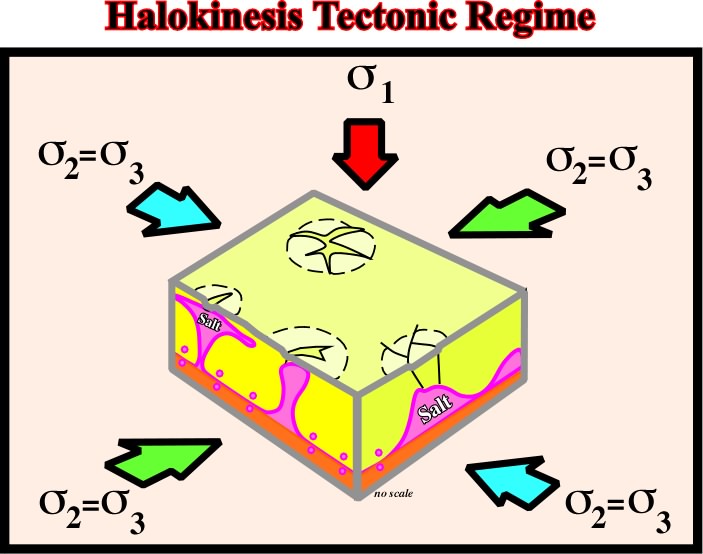
Fig. 3- The tectonic regime favoring halokinesis is characterized by an effective stress ellipsoid with
The most suitable host is basalt, hydrothermally altered to spilite greenstones. Actually, (i) Chloritization absorbs Mg from the brine; (ii) Albitization releases abundant Ca into the brine, which combines with any S04 present to precipitate at surface and (iii) Brine lakes remain enriched in Ca. Others host rocks for hydrothermal alteration are also possible: a) Arkose containing plagioclase; b) Redbeds containing Ca-Smectites; c) Limestones.
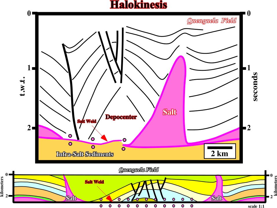
Fig. 4- In the 50’s, in the onshore Angola, Petrangol’s geologists, using the geological cross-sections made in the beginning of the 20th century by the field geologists of the Synclair, initiated a petroleum exploration campaign. After shooting several key seismic lines and drilling few wells, Petrangol’s explorationists not only discovered economical oil accumulations, but discovered halokinesis as well. This interpretation of a composite un-migrated seismic line is quite similar to the original original interpretation used by Petrangol to drilling Quenguela #1, which became the largest field discovered in the onshore Kwanza. Later, Petrangol’s explorationists (Masson, 1972) explained the genesis of the Quenguela “Turtle-Back Structure” (cross-section under the seismic line) with a minimum stretch (
= 0) and a maximum salt reduction (SR=77%). They explained the antiform structure and the associated depocenters as the consequence of a compensatory subsidence induced by salt flowage, in absence of significant tectonic stress.
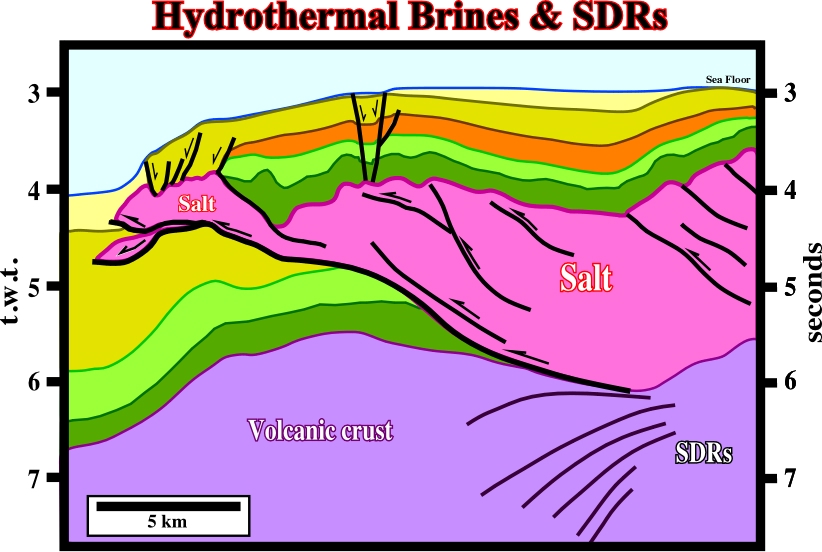
In spite of the fact KCl minerals do not prove that evaporites formed on basalt, in South Atlantic Margins, the evidence for hydrothermal brines is strong enough: (i) The vast thickness, high temperatures, and abundant plagioclase in flood basalts means that these would have formed the most prolific source of Ca for the CaCl2 (fig. 5); (ii) In South Atlantic, all known Aptian potash evaporites are formed from CaCl2 brines enriched by hydrothermal alteration. Examples: (a) The Sergipe-Alagoas basin contains carnalite and tachyhydrite 10m thick; (b) In offshore Gabon, Aptian evaporites contain carnalite-bischofite; (c) The Lower Congo basin contains carnalite-sylvite with bischofite-tachyhydrite 150 m thick; (iii) Pb-Zn-Cu mineralization was widespread during the Early to Middle Cretaceous along the South Atlantic Margins and (iv) CaCl2-rich brines are typically enriched in base metals because they contain roughly eight times more chloride than seawater.
to continue press
next
![]()
Send E-mails to ccramez@compuserve.com or cramez@ufp.pt with questions or comments about these notes.
Copyright © 2001 CCramez
Last modification:
Março 19, 2006