
Parameter: Trapping
This hydrocarbon parameter reflects the presence or absence of traps in a certain reservoir rock. Conventionally, when a geoscientist talks about a trap, he refers to the trapping of hydrocarbons in a precise reservoir-rock (several reservoir-rocks may form a multiple traps). In the majority of the cases, at the geological and oil related issues, talk about an hydrocarbon trap without specifying the reservoir-rock doesn't make any sense. This is particularly true when a geoscientist shows on a map, at the level of an enhanced unconformity (angular unconformity), a huge antiform structure and then he says the potential reservoir-rocks are underlying the unconformity. Actually, when a geoscientist proposes a trap at a certain stratigraphic level, the only map, really significant, is the structural map, in isochrons or isohypses, of this level. In other words, the structural map defining a trap must be made at the top of the reservoir-rock, which must be closed by a sealing rock (e.g., shale, salt, etc.,). Structural maps made at other stratigraphic levels (above or below the potential reservoir-rock), generally, are not too significant of the trapping.
The trapping of hydrocarbons, in economic quantities, requires two simultaneous geological conditions: (i) A reservoir rock, in which, usually, there is an isolated and low potential part (an isolated sandy body, completely, filled with hydrocarbons is an exception to this sub-criterion) and (ii) A barrier (sealing-rock or cover), which must have a, sufficiently strong, entrance pressure to be able to retain the hydrocarbons ( minimum pressure required to pass an oil or gas stream in a water-oil system through the largest pores and canaliculi of a reservoir).
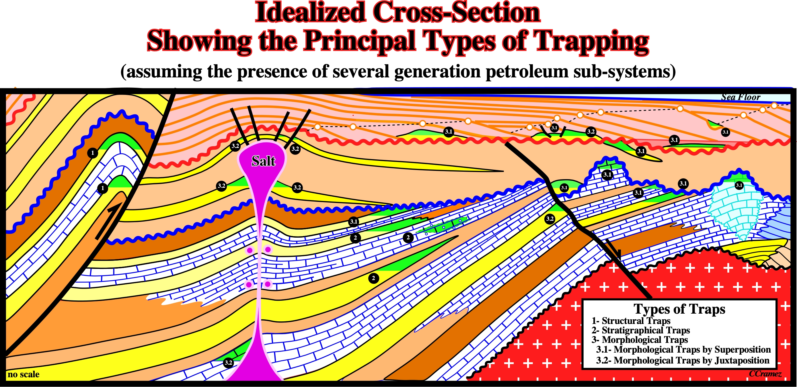
As illustrated on this sketch, in which shaly intervals are colored in brown, sandy reservoirs in yellow, limestones by hatching (horizontal and vertical hatching), salt in pink and the basement with crosses, the possible hydrocarbon accumulations (in green) can be classified in two principal trap's types: (i) Structural and (ii) Non-Structural. The non-structural traps can be (ii.1) Stratigraphic and (ii.2) Morphological. The morphological traps can be by superposition or by juxtaposition (see text).
There several trap classifications. We prefer the one where two big families are considered: (i) Structural Traps and (ii) Non-Structural Traps. Structural traps (fig. 2) constitute, from all points of view, a very special category. They and very different from non-structural traps. Their closure, i.e., the barrier that forces the flow of hydrocarbons to accumulate upstream, is very different from the other traps. This difference is very marked not only from the geometric point of view, but also from the dynamic point of view.
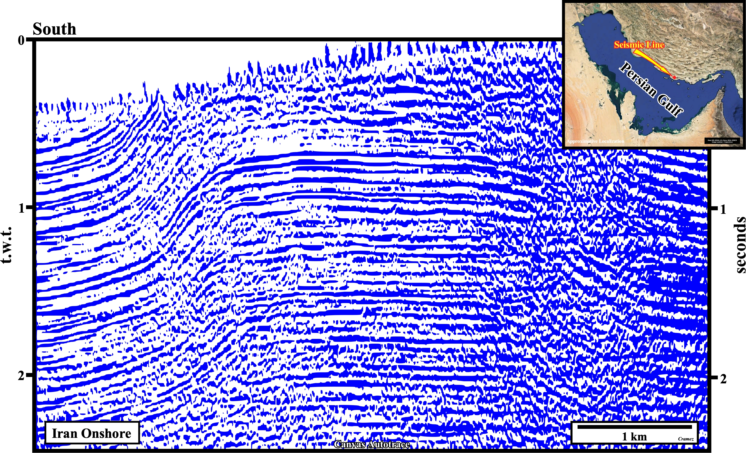
This Canvas autotrace of seismic line of onshore Iran illustrates structural traps (there are several potential reservoirs and sealing rocks in the stratigraphic column) in the anticline structure. In fact, it is quite evident the sediments were shortened and uplifted by a compressional tectonic regime with σ1, roughly, parallel to the trace of the seismic profile. The folding (concentric) was not sufficient enough to accommodate the sediments. Reverse faults formed on the flanks of the anticline. They are, easily, recognized, particularly, on the right flank. On the field, small strike slip faults allowing the lengthening of the anticline along the σ2 have been recognize by a lot of geoscientist. In spite of the fact they are under seismic resolution, they are depicted on the geological map of the area. These faults have any consequence in an eventual hydrocarbon migration. They are compressional geological features, totally, inappropriate to a hydrocarbons dis-migration.
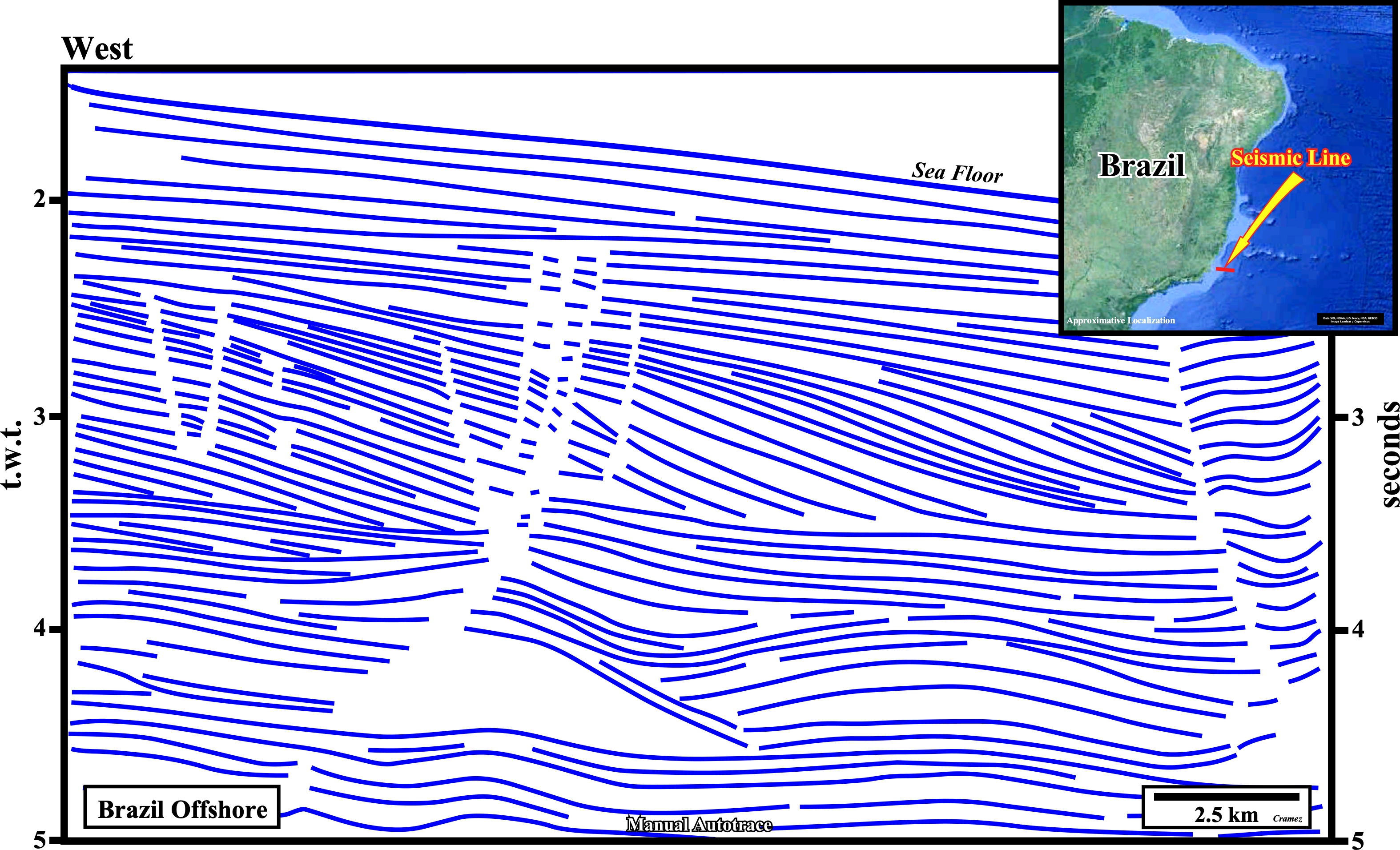
From a geometric point of view, the closure of structural traps is constituted by a chronostratigraphic surface concave towards the bottom of the layer forming the cover, which characterizes all the traps associated with anticlines (not antiforms). This definition, obviously, does not apply to traps linked to non-synchronous interfaces, such as those of top sub-aerial or submarine fans, which form very recognizable sedimentary anomalies as those of the cratonic basin of the North Sea or Brazil offshore (Campos Geographic Basin, next figure). Likewise, this definition does not apply to reef constructions, such as those from the Upper Oligocene-Lower Miocene of Indonesia / Malaysia, easily recognized on seismic lines (see Indonesia offshore autotrace) in which the associated trapping corresponds to a particular type of non-structural trap called geomorphological.
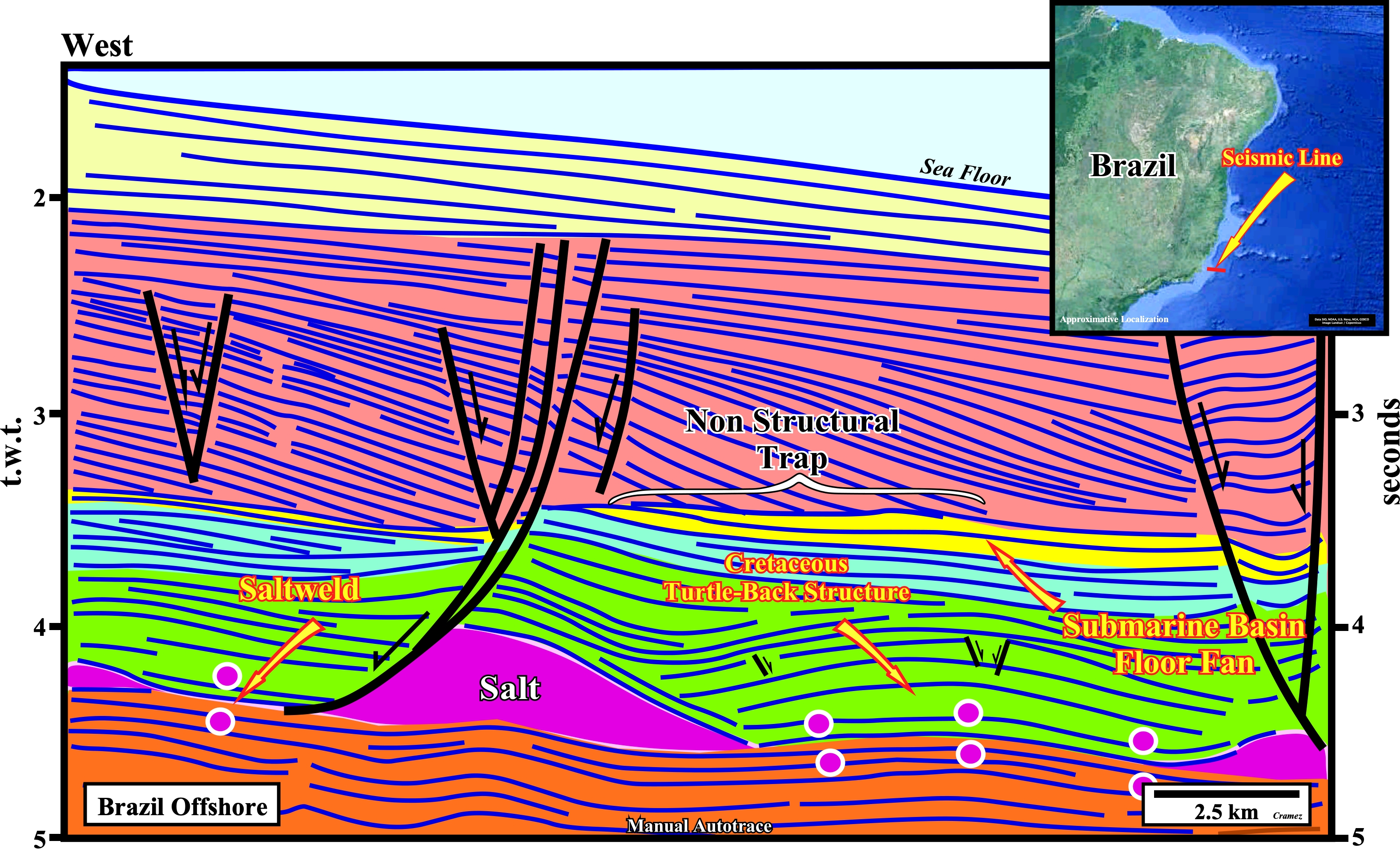
On this manual autotrace of a seismic line of the Campos geographic basin (Brazil offshore) is illustrated the well known non-structural trap (morphological trap by superposition) of Marlin oil field. The reservoir rock interval (colored in yellow on the tentative geological interpretation of the autotrace) is sealed by the deepwater shales of a progradational interval, i.e., by a major downlap surface and it lies, by onlapping, on an unconformity created by a significant relative sea level fall. It is interesting to notice such a morphological trap is located at the vertical of a Cretaceous turtle-back structure (extensional structure, i.e., an antiform and not an anticline), which was, before the discovery of Marlin field, the conventional petroleum target in Campos geographic basin. My regretted friend Celso Ponte of Petrobras told me : "You know Carlos, we were targeting the Cretaceous limestone of the salt induced turtle-back and we found Tertiary sandstones full of oil, God is Brazilian". At the seismic standpoint, the fault picking, as depicted on the manual autotrace, correspond to interruptions or discontinuities of the chronostratigraphic lines (time lines) rather than seismic reflections.
From a dynamic point of view, the difference between the closing of structural traps and that of other traps is even more marked. In non-structural traps, the barrier hindering the migration of hydrocarbons is, most often, the passage from a porous and permeable facies to a finer-grained sediment presenting a pore pressure or an entrance pressure greater than the pushing exerted by the fluids from the outside. In the event that the capillary pressure is sufficient to force the water-hydrocarbon interface through the pores of the upstream sediments, these sediments no longer form a barrier to the migration of hydrocarbons. The capillary pressure is the difference between the oil pressure and water pressure and the magnitude of the capillary pressure at which the water-hydrocarbon interface enters the barrier is called the inlet pressure or barrier displacement pressure.
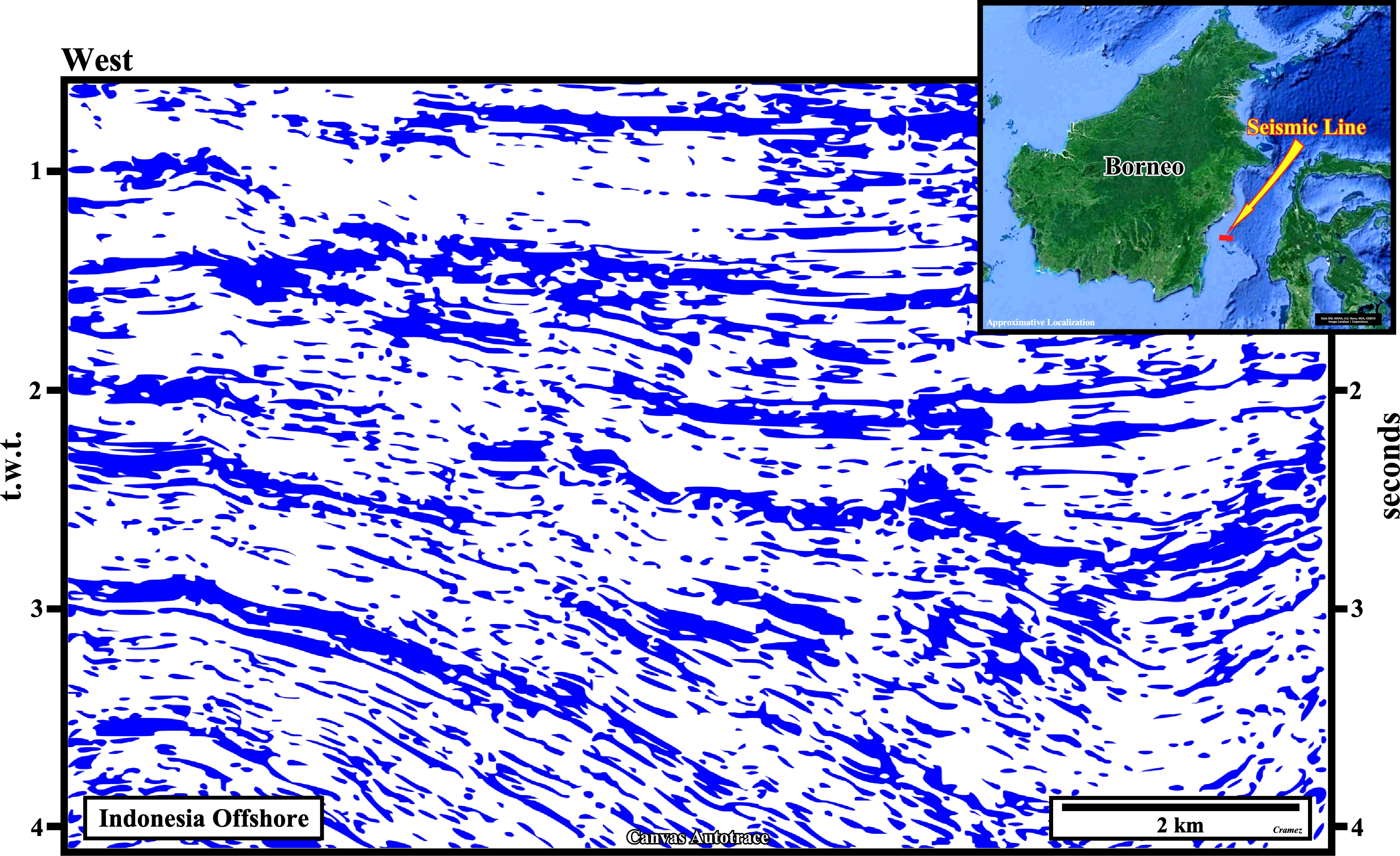
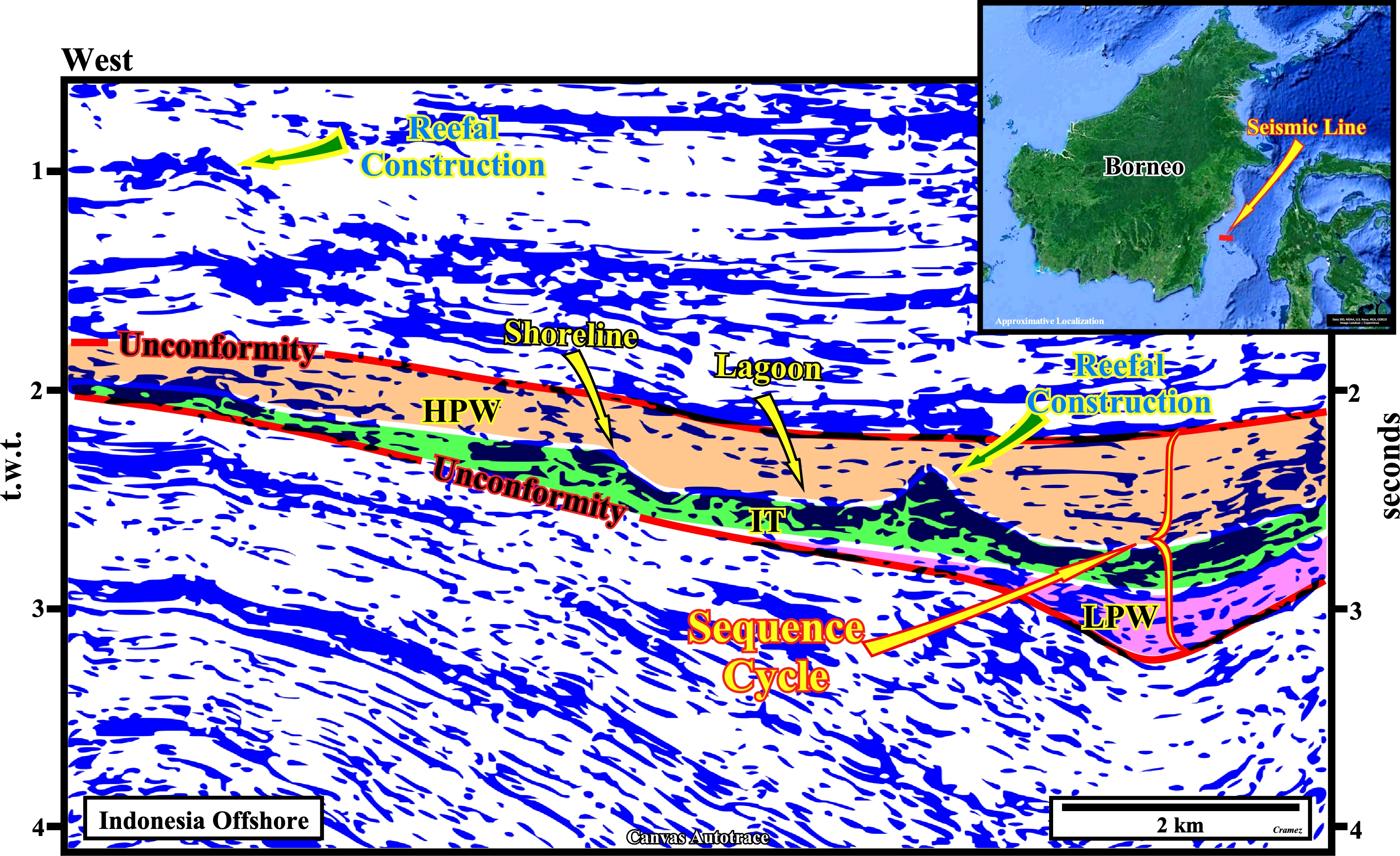
Morphological traps by juxtaposition are evident on this Canvas autotrace of a seismic line of the South Makassar offshore (East Offshore of Kalimantan, Indonesia). Reefal constructions are quite, easy, to recognize. On the tentative interpretation we have picked a sequence-cycle (stratigraphic interval bounded by unconformities which difference in age in less than 5-3.5 My). On this area, the sequence cycle is incomplete. Just the lowstand prograding wedge (LPW, colored in pink), the transgressive interval (IT, colored in green) and the highstand prograding wedge (HPW, colored in light brown) are visible. The interface between the IT and the HPW corresponds to a downlap surface, which hiatus increases seaward, i.e., eastward. The transgressive interval (TI) was induced by a relative sea level rise, which created a shelf above the LPW and the lower sequence boundary unconformity. The shelf break is underlined by a reefal construction, which buildup balanced the successive marine ingressions (relative sea level para-cycles). The reefal limestones are the reservoir-rock of such a non-structural trap (morphological by superposition and juxtaposition). They were later sealed by the progradational marine shales of the highstand prograding wedge (HPW).
In structural traps, the flow of hydrocarbons is perpendicular to the sedimentary layers, while in other traps, it is parallel. Structural traps, by their geometry, are very easy to identify and their closures are quite effective: (i) If the first layer above the reservoir rock does not present a displacement pressure strong enough to trap the hydrocarbons, there is always, in this type of trap, the possibility that an upper stratigraphic levels present a higher pressure capable of making a trapping ; (ii) In some cases, we can differentiate between main coverage and induced coverage. High pressure levels can exert an indirect action on the underlying cover formations, however, these only act as induced covers when they are topped by a high pressure layer which functions as the primary cover.
Contrariwise to structural traps, in the case of non-stratigraphic traps, the mapping of the sealing rock is more important than the mapping of the reservoir rock. It is important to insist, as Downey M. W. (1980) did longtime ago, that a "trap against fault" of the American geoscientists is a misnomer. It is not a structural trap, but a morphological trap by juxtaposition (see next autotrace). A fault, which is just a mental construction of geoscientists, is never a trap. What traps, most often, are: (i) The sediments located on the other side of the fault in juxtaposition with the potential reservoir rock, or (ii) The gouge zone shaly sediments, when a gouge zone is present. However, the capillary pressure of displacement of the sediments juxtaposed to the reservoir rock must be greater than pressure of the reservoir.
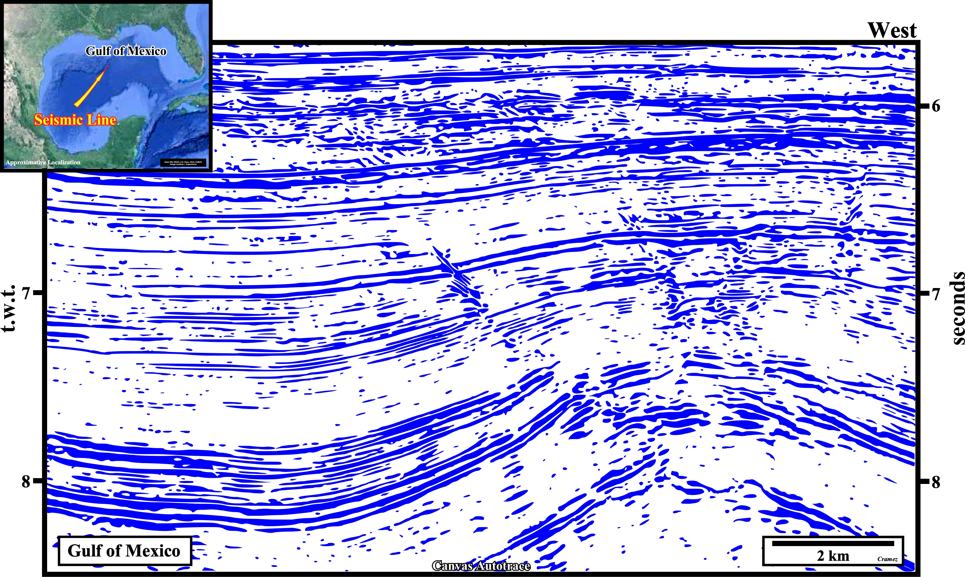
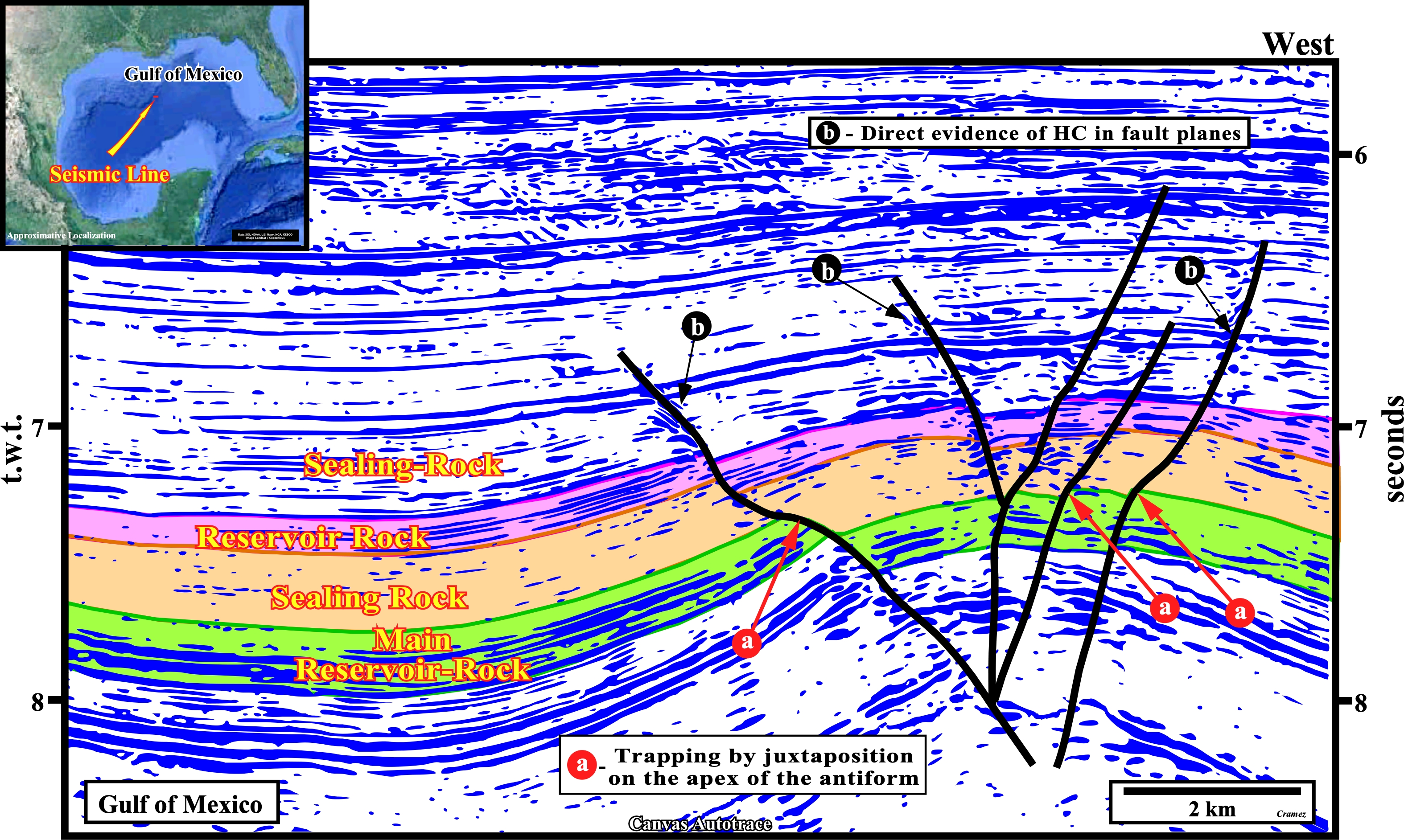
Morphological traps by juxtaposition ("Fault Traps" of certain American geoscientists) are, utterly, visible on this Canvas autotrace of Gulf of Mexico seismic line, adjacent to the Sigsbee escarpment, and in its tentative geological interpretation. The geometry of the fault planes allow to predict, in the foot-walls, reservoir and sealing rock intervals. Actually, due to the different compactability of the reservoir and sealing rock intervals, the dip of the fault plane (or fault zone) is lower in front of foot-wall highly compactable sealing rocks (e.g., shales) and higher, i.e., more vertical, in front of less compactable reservoir rocks (e.g., sandstone or limestones). Consequently, an accurate picking of the fault planes allows to highlight the more important morphological traps by juxtaposition, i.e., those with an higher interval of sealing rocks in juxtaposition to the potential reservoir rock. A probably direct evidence of hydrocarbon is perceived along the fault planes.
Non structural traps are more difficult to recognize than structural traps: (i) They are, often, very subtle and their identification on seismic lines is most often difficult ; (ii) Their closure is, essentially, associated with the displacement pressure of the stratigraphic levels or fractures extending the reservoir rock. A single thin layer more detrital with a lower inlet pressure is sufficient to allow the oil or gas to migrate ; (iii) The cover, under certain pressures and temperatures, is effective for certain fluids and not for others (the result is a delicate and complex interplay of hydrocarbon inputs and outputs) ; (iv) A trap is filled, insofar as it is fed upstream, at a rate, substantially, equal to that of its losses downstream ; (v) The migration of hydrocarbons, whether primary (expulsion of hydrocarbons from kerogen and source-rock) or secondary (transfer of hydrocarbons to areas with lower pressure and temperature), follows the direction of decreasing pressure gradients. The hydrocarbons accumulate, preferably, in the lower potential zones, i.e., in fractured zones and reservoirs.
Traps located in the more subsiding parts of a sedimentary basin are more likely to be full than those located in stable or raised areas. Account must be taken of aquifers and hydrodynamics. They play a very important role in the effectiveness of closures. Their influence is particularly real for closures of non-structural traps, because the hydrodynamic gradient is parallel to the layers or to the faults, that is to say, parallel to the preferential hydrocarbon leak directions. In evaluating a trap, it is important, and often decisive, to know whether there is hydrodynamics and whether it is in the direction of the flow of oil. The consequences are not the same: (i) In young sedimentary basins undergoing subsidence, such as the cratonic basin of the North Sea, or Atlantic-type divergent margins, the majority of the sedimentary intervals is still in the process of compaction. The highest hydraulic potentials are found in the central and deep parts where the hydrodynamic gradients are, mainly, centrifugal (ascendants). In basins associated with the Meso-Cenozoic megasuture, such as episutural basins of SE Asia or South America (backarc basins) or perisutural basins (foredeeps), which are, globally, in compression, structural deformations uplift and short the sediments. These deformations are, in general, more marked along the old normal faults bordering the tops of the substratum and near the margins. The deep parts of these basins, with very high hydraulic potential, are, often, inverted as a result of shortening, and become, structurally, high regions. Thereby, the hydrodynamic gradients are most, often, centripetal (descendants).
Certain geoscientists taking into account the predominance of the geological factor responsible for the hydrocarbon isolation within the reservoir rock or in a sector with lower potential, consider three categories of traps : (a) Structural ; (b) Non-Structural and (c) Hydrodynamic.
![]()
![]()
Send E-mails to carloscramez@gmail.com or to carlos.cramez@bluewin.ch with comments and suggestions to improve this atlas.
Copyright © 2001 CCramez
Last update:
2022
![]()