.jpg)
Offshore du Gabon
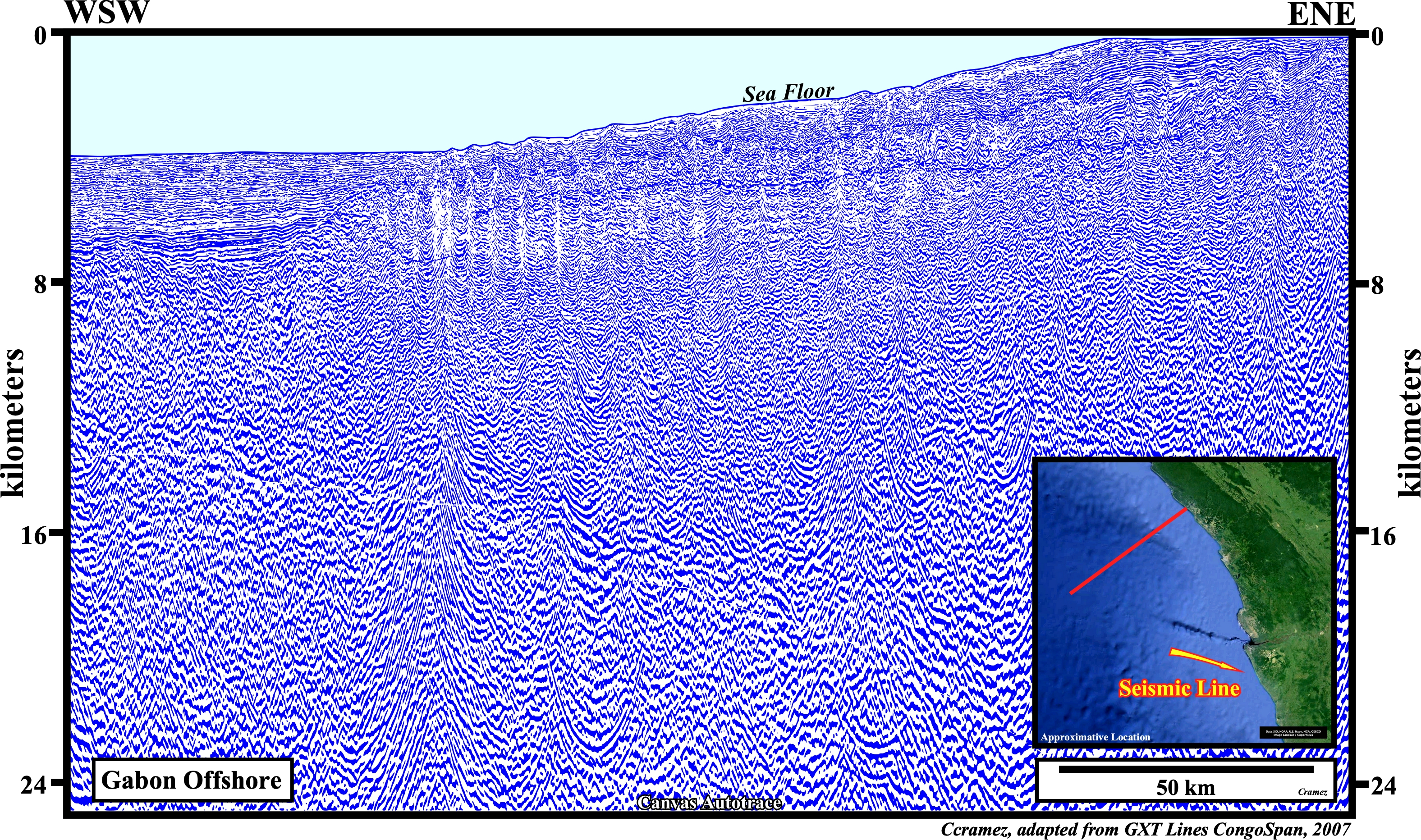
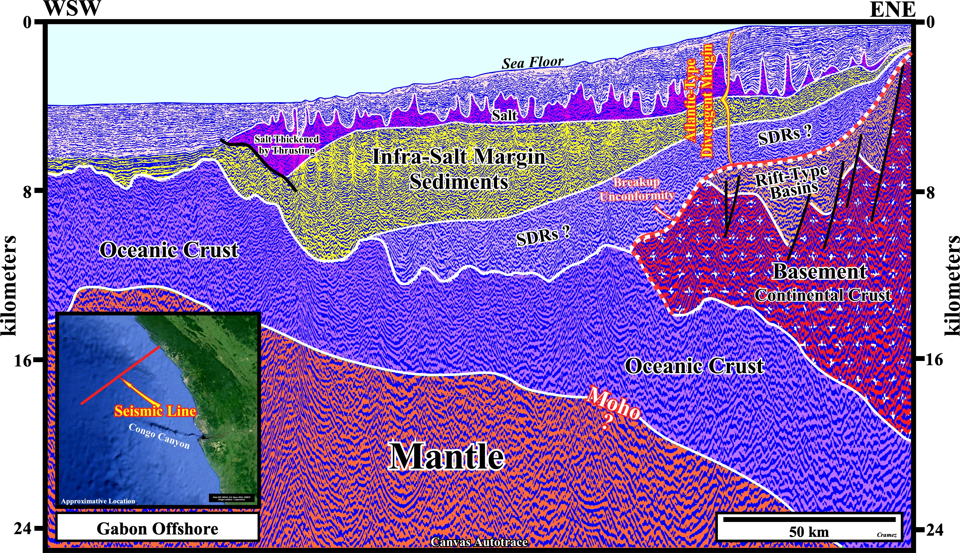
As for depth regional seismic lines of the the Congo and Angola offshores, we had not access to the original time section from which the depth seismic line of this Canvas autotrace is supposed to be developed. The same comments made for the regional depth lines of Angola and Congo can be employed to the depth version illustrated here. As in any tentative geological interpretation of a seismic line, the geological knowledge of the area precedes the observance (on a seismic line, a geoscientist sees only what he knows or what he expected to see). The proposed tentative geological interpretation is based in the Atlantic opening model put forward in the introduction of this atlas (Classification). So, as depicted above the mantle, the crust is easily recognized. On the right part of the autotrace the continental crust is recognized by its lengthening (normal faulting), which induced the formation of rift-type basins (half grabens) filled by non marine sediments, often, lacustrine. The breakup of the thin and highly intruded (mantle material) Gondwana continental crust is abrupt. The breakup unconformity underlines the end of the lengthening of the Gondwana lithosphere and so caps the rift-type sediments. Immediately after the breakup, the formed margins are accreted by lava-flows (SDRs) since the expansion centers are sub-aerial (volcanic sector of the Atantic-type divergent margin). They thin toward the continent and they are, progressively, tilted seaward due to the weight of the younger lava-flows. Non-marine sediments and evaporites are deposited above the lava flows, before the expansion centers (generally volcanoes) became submerged, starting the deposition of the post-Pangea continental encroachment stratigraphic cycle (clastic sector of the Atlantic margin). Since the expansion centers became under the water, the mantle material arriving at sea floor, via sheeted dykes, is frozen, i.e., cannot flow and forms the oceanic crust. Locally, significant lacustrine infra-salt depocenters can developed, as it is the case in the area where the seismic line of this autotrace was shot. Above the salt, transgressive retrogradational sediments form the transgressive phase of the stratigraphic cycle, which are fossilized by the regressive forestepping sediments of the regressive phase. The western limit of the Aptian salt basin is enhanced by a salt thickening by thrusting and a buckle folding of the overburden in association with the development of a allochthonous salt nappe, which probably more evident on the next autotrace.
In this tentative geological interpretation, the western limit of the salt basin is, easily, recognized not only by the presence of the salt thickened by thrusting, but the small salt nappe as well. Similarly, the end of the folded overburden above the thickened salt by thrusting emphasizes, roughly, the western limit of the salt basin, which put in evidence the volume problem created, near the ending of the salt due to by the seaward gliding of the salt. Below the salt interval the seismic quality does not allow a coherent geological interpretation. Even the upper limit of the oceanic crust is speculative.
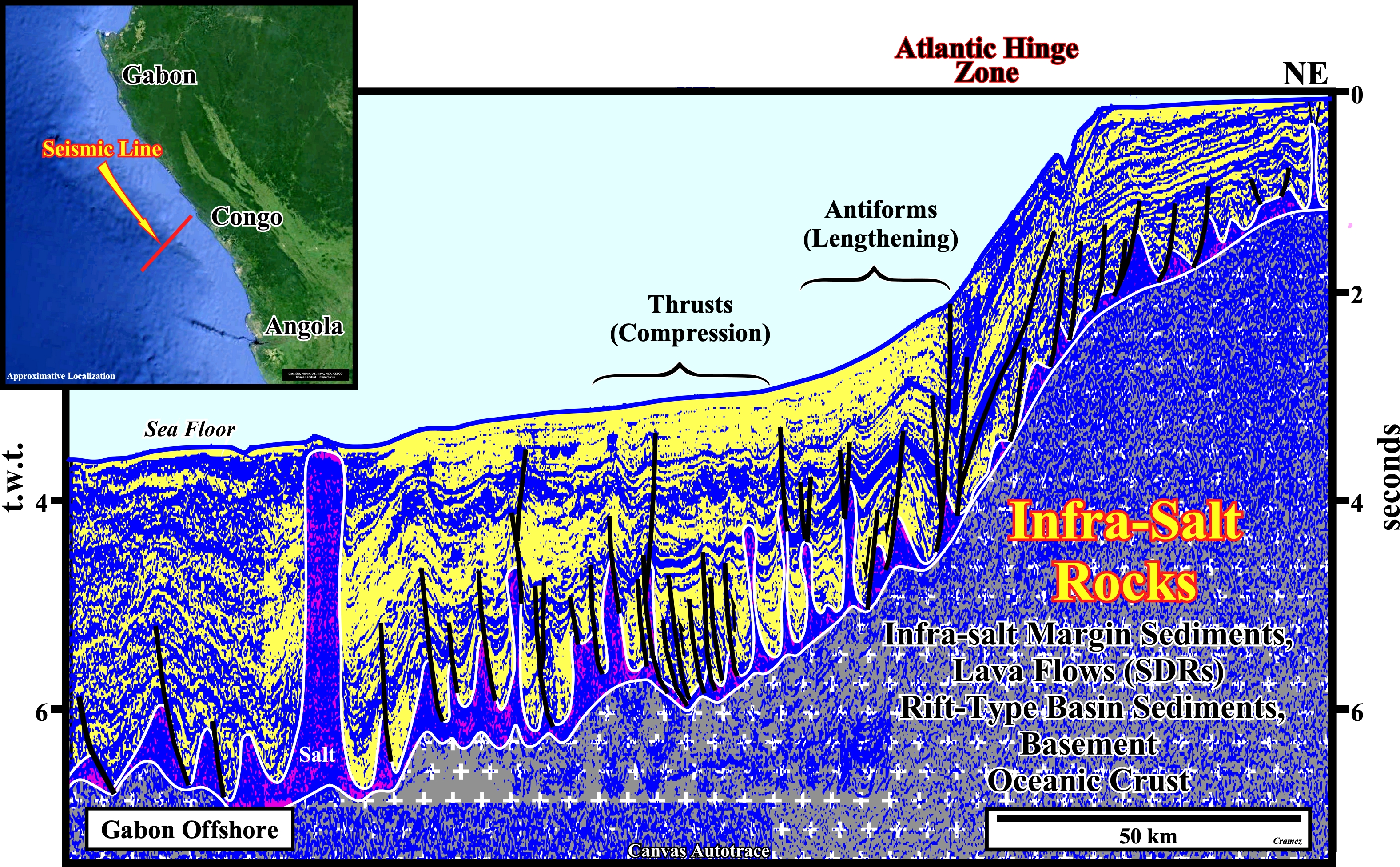
In despite of the seismic pitfall created the abrupt change in water-depth (seismic waves travel slower in the water than in a sedimentary column), the morphology of the of the salt induced tectonic disharmony (bottom of the salt + salt welds) is, easily, recognized on this tentative geological interpretation of a Canvas autotrace of the Gabon offshore. Such a morphology induced an extensional tectonic regime (lengthening of the sediments), in the conventional offshore and continental slope, and a compressional tectonic regime (shortening of the sediments) associated with an halokinetic regime in the abyssal plain. The compressional tectonic regime seems to be developed as a counterbalance of the gravitational up-dip extensional regime.
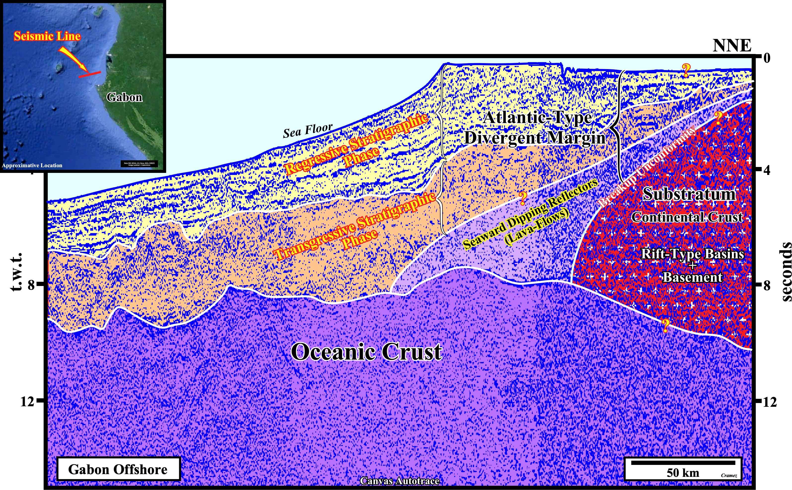
On this tentative interpretation, as well as in all tentative geological interpretations of offshore seismic lines with an sharp shelf break, i.e., with an abrupt change in water depth, it is necessary to take into account the seismic pitfall introduced by such a change. In fact, all seismic reflectors below water column of the continental slope are pulled down since the seismic waves travel slower in the water than in neighboring sediments. Thus, the deep reflectors, as for instance, the interface between the oceanic crust and the sediments of the margin is, in the central and left part of the autotrace, almost horizontal if not dipping continentward. That said, the seismic intervals considered on this tentative interpretation are those, that theoretically, geoscientists must look for before going to a detailed interpretation. It should not be forget geological seismic interpretation progresses from general to particular and not the opposite. Picking detail geometrical relationships between the seismic reflectors can even be exciting and fun, but unfortunately we learn from generalities and not details (P. Bak, 1996). From the continent seaward, above the oceanic crust four major geological unities can be recognized: (i) Basement, which corresponds to the lengthened Gondwana continental crust, in which rift-type basins are developed and filled, generally, by non-marine sediments ; (ii) The post breakup sub-aerial volcanic crust, which corresponds, mainly, to lava-flows thinning continentward and dipping seaward due to the submersion of the expansion centers (volcanoes), which cause the onset of the oceanic crust ; (iii) The clastic sector of the Atlantic-type divergent margin or margin strictly speaking (lava-flows excluded), deposited in association with the post-Pangea 1st order eustatic cycle, in which the transgressive and regressive phases are, easily, recognized by their retrogradational and progradational geometries.

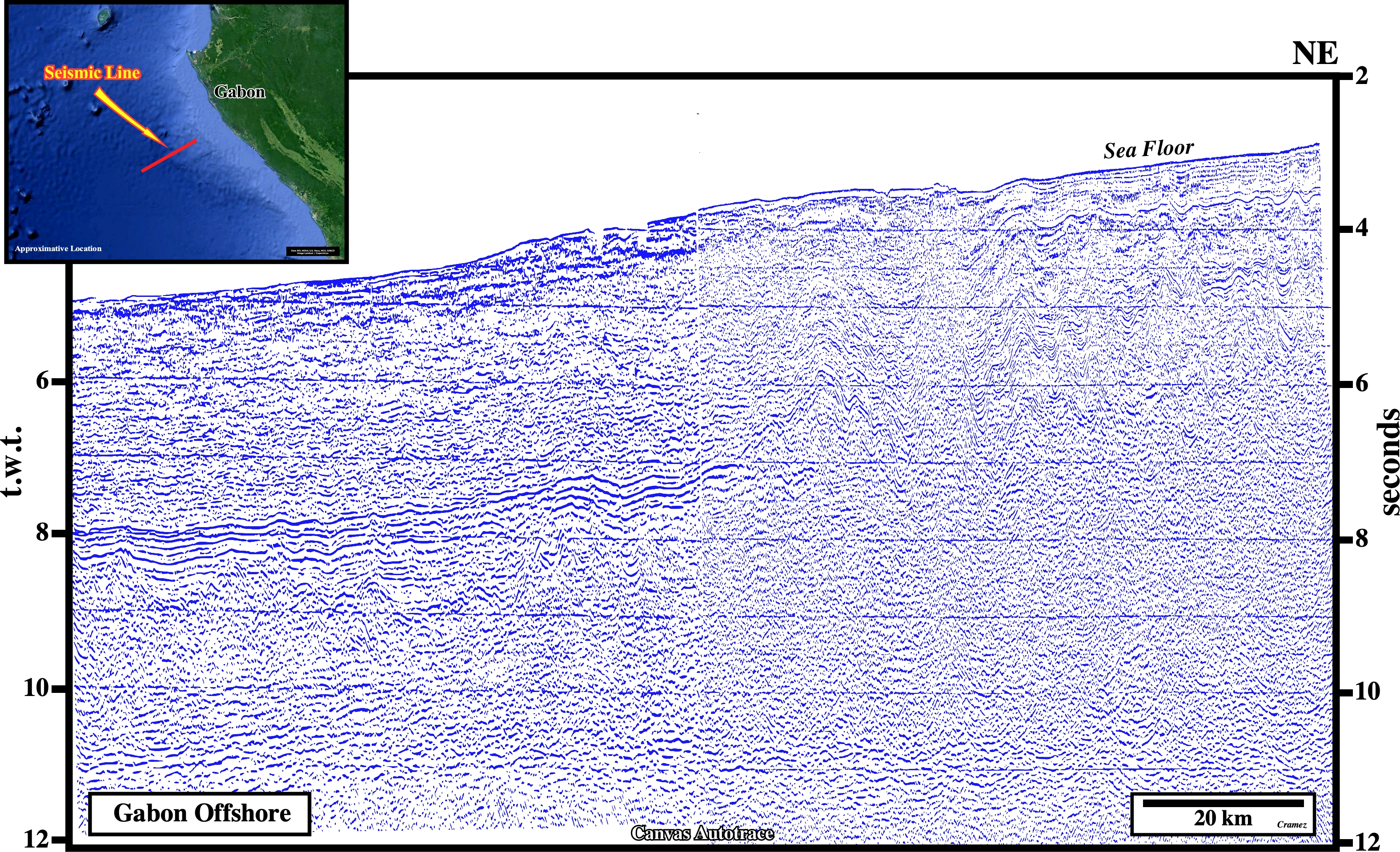
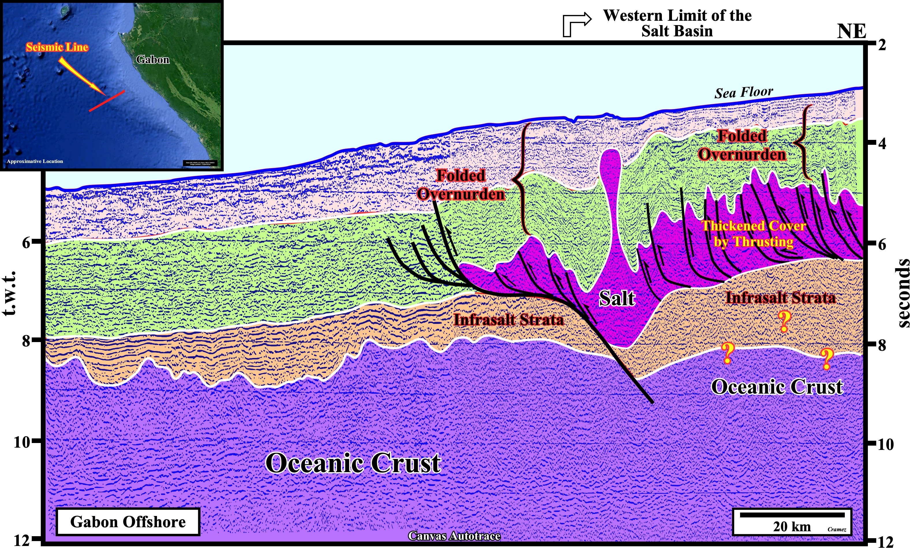
This geological cross-section, based on a composite seismic line, illustrates the Ogodue submarine basin floor fan complex and the underwater extrusive (Loiret Bank) associated with a transcurrent system including a strike-slip fault zone ("Fang") running parallel to the Cameroon line and rooted on an old suture zone (G. Cornen et al., 1993). The picking of the salt and salt welds was quite easy and the presence of two levels of allochthonous salt is obvious. The development of the Ogodue submarine basin floor fan complex is associated with the absolute sea level fall that induced the post-Pangea regressive stratigraphic phase.

![]()
![]()
Send E-mails to carlos.cramez@bluewin.ch with comments and suggestions to improve this atlas.
Copyright © 2001 CCramez
Last update:
2022
![]()