
Brazil Offshore
North Pelotas Geographic Basin (offshore)
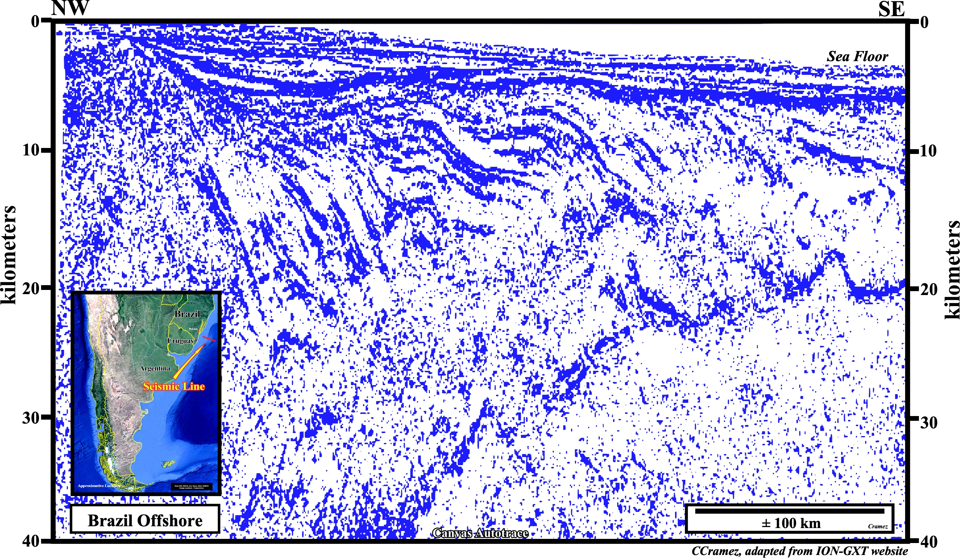
On this Canvas autotrace of a regional seismic line of the northern offshore of the Pelotas geographic basin, several SDRs wedges and the Moho, i.e., the Mohorovicic discontinuity (acceleration of velocity of the seismic waves), which is the boundary between the Earth's crust (lower density material) and the mantle (higher density material), are recognized, easily. The interval between the SDRs and the Moho is difficult to interpret on this autotrace. However, other regional seismic lines allow interesting tentative geological interpretations as the on illustrated below, which NW sector correspond exactly to this Canvas autotrace.
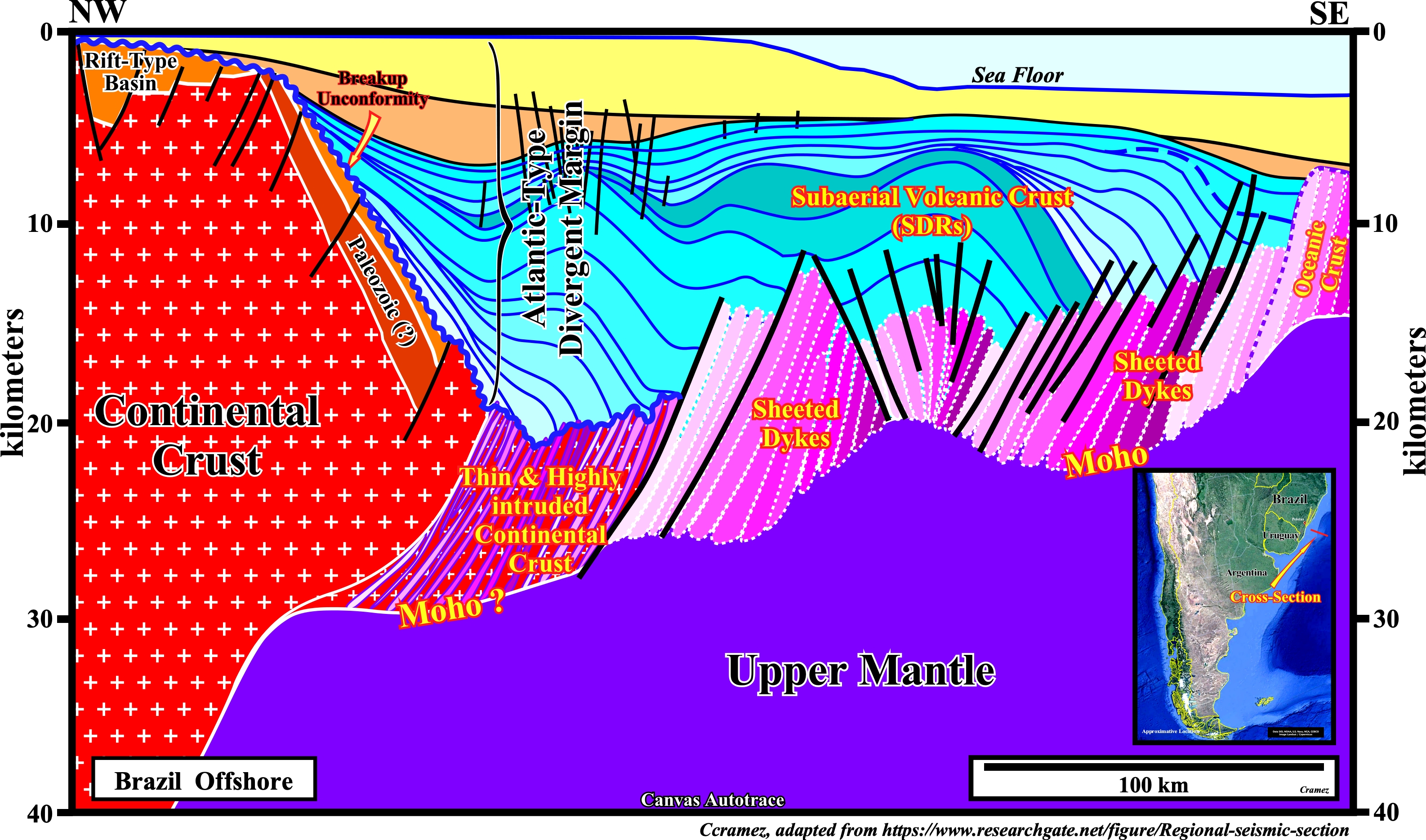
On this tentative geological interpretation of regional seismic line of the Brazil offshore (Pelotas geographic basin), the lengthened Gondwana continental crust, with the associated, rift-type basins and the thinned and highly intruded continental crust, which predate the breakup unconformity, are located on the left part of the tentative interpretation. The interval between the upper mantle and base of the Atlantic-type divergent margin is composed by a thick complex volcanic crust. However, in this volcanic crust, it is possible to individualize : (i) Sub-aerial volcanic crust, represented by several SDRs wedges (lava flows) effused out of outcrops of sheeted dykes toward the recent detached continent (South America), (ii) Underlying sheet dykes complex and (iii) Oceanic crust, which corresponds, practically, to immerse sheeted dykes, i.e., not covered by lava-flows, but by pillow lava, since the mantle material cannot flow under water.
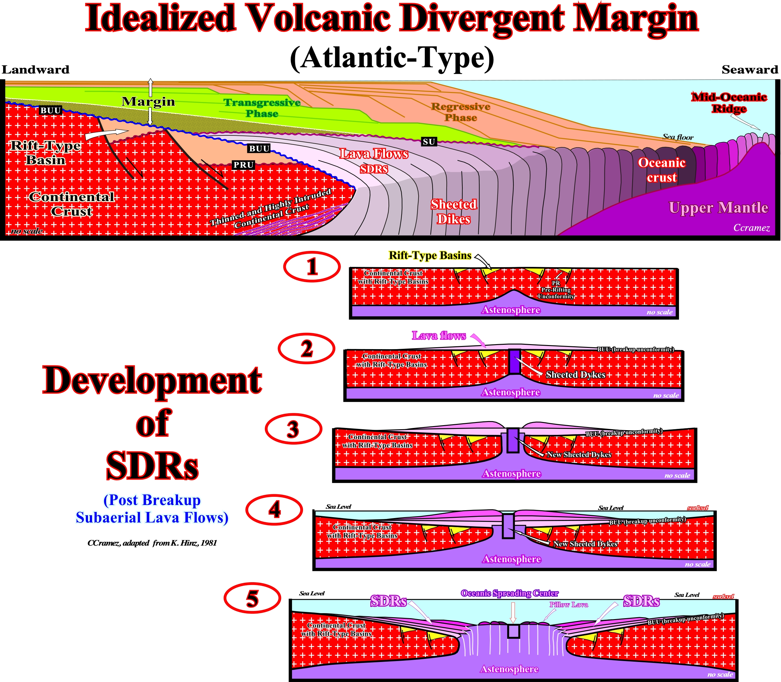
In this idealized Atlantic-type divergent continental margin, we recognize: (i) Thinned and highly intruded continental crust, i.e., the zone where the breakdown of the continental crust take place, when the mantle material becomes predominant ; (ii) The pre-rifting unconformity (PRU) and rift-type basins developed during the lengthening of the continental crust, which foreshadow the breakup ; (iii) The breakup unconformity (BUU) ; (iv) The SDRs, that is to say, the sub-aerial volcanic crust, developed when the sheeted dykes outcrop, which disappear when the sheeted dykes become covered completely by sea-water ; (v) The upper mantle covered by the oceanic, which upper part, is formed, mainly, by sheeted dykes and pillow lava (volcanic material cannot flow under water) and (vi) The Atlantic-type divergent margin, which can fossilize either the continental crust, rift-type basin sediments (breakup unconformity), or the oceanic crust (SDRs form the volcanic sector of the Atlantic-type divergent margin), is composed by a transgression phase, characterized by a retrogradation geometry, and a regressive phase, characterized by a progradational geometry with a major downlap surface between the two phases. In the lower part of this plate is illustrated how the SDRs are probably formed: (1) Lengthening and thinning of the Gondwana continental crust with formation of pre-rifting unconformity and rift-type basins filled, generally, by non-marine sediments, with a small uprising of the continental crust ; (2) Breakup of the continental crust by injection of mantle material in the thinnest zone with outcropping of sheeted dykes and associated sub aerial lava-flows ; (3) Injection of new sheeted dykes and stacking of new lava-flows which cause a slightly outward sinking of the breakup unconformity ; (4) The progressive sinking of the breakup unconformity caused, mainly, by the weight of the successive lava-flows ends to plunge the spreading centers (sheeted dykes) under water ; (v) With the sheeted dykes covered by water, as the lava arriving to the sea floor cannot flow it forms pillow lava, (oceanic crust) in a continuum spreading movement accompanied by a progressive seaward subsidence of the breakup unconformity.
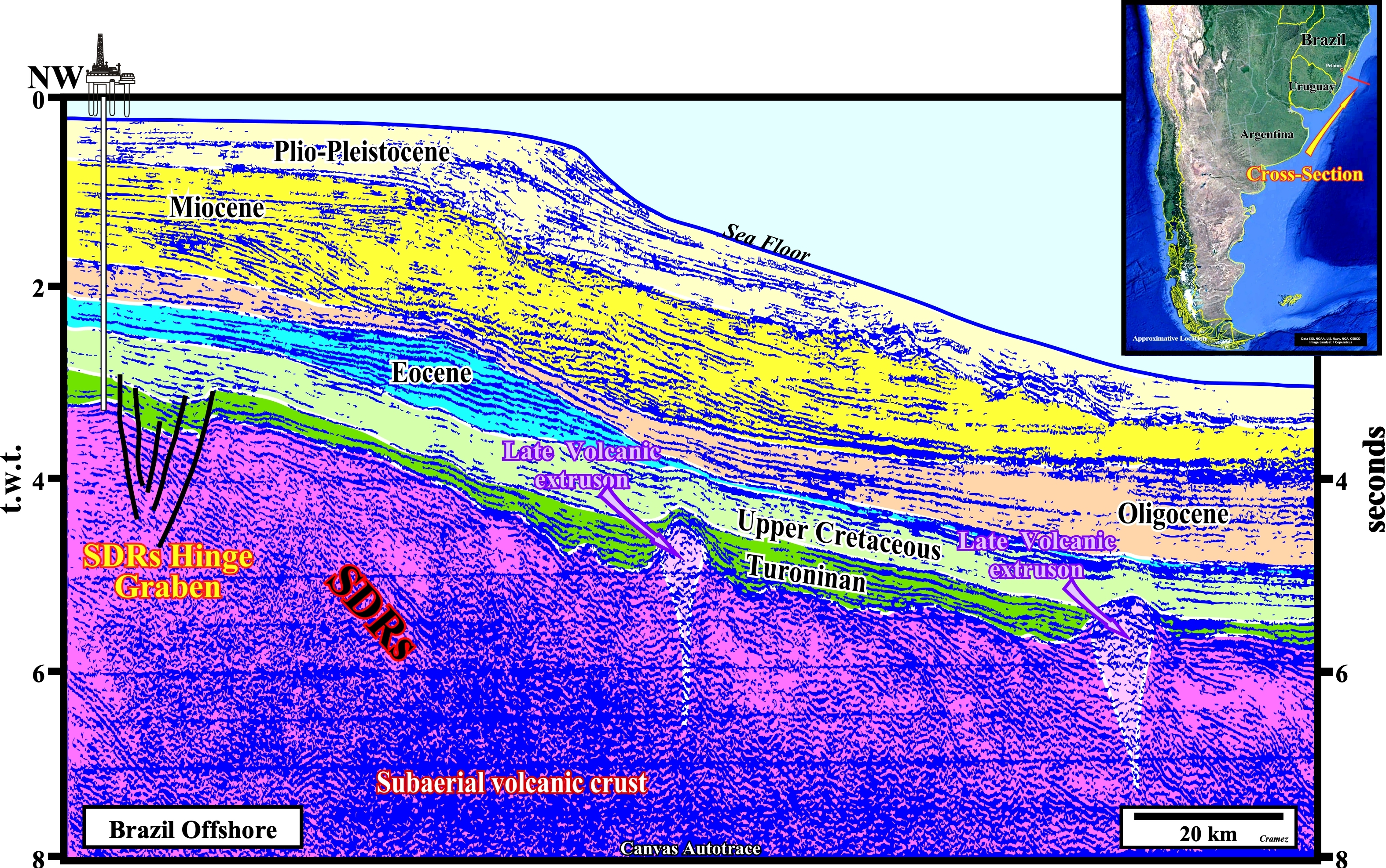
This tentative geological interpretation illustrated two important feature that must be take into account. The first is that the sub-aerial volcanic crust, i.e., the SDRs, which form the volcanic sectors of the Atlantic-type divergent margin, can be deformed by late volcanic extrusions as well as the basal sediments of the margin. The second is the presence of extensional structures, generally, grabens or half-grabens between the SDRs wedges or associated to tectonic hinges. Such structures should not be taken as rift-type basins, which origin is connected with the lengthening of the continental crust of supercontinents (Pangea or Rodhinia) and not to the seaward tilting of the the lava-flows, which postdate the breakup pf the lithosphere.

![]()
![]()
Send E-mails to carlos.cramez@bluewin.ch with comments and suggestions to improve this atlas.
Copyright © 2001 CCramez
Last update:
2022
![]()