
North Bengal Offshore
Upper Upper Fan
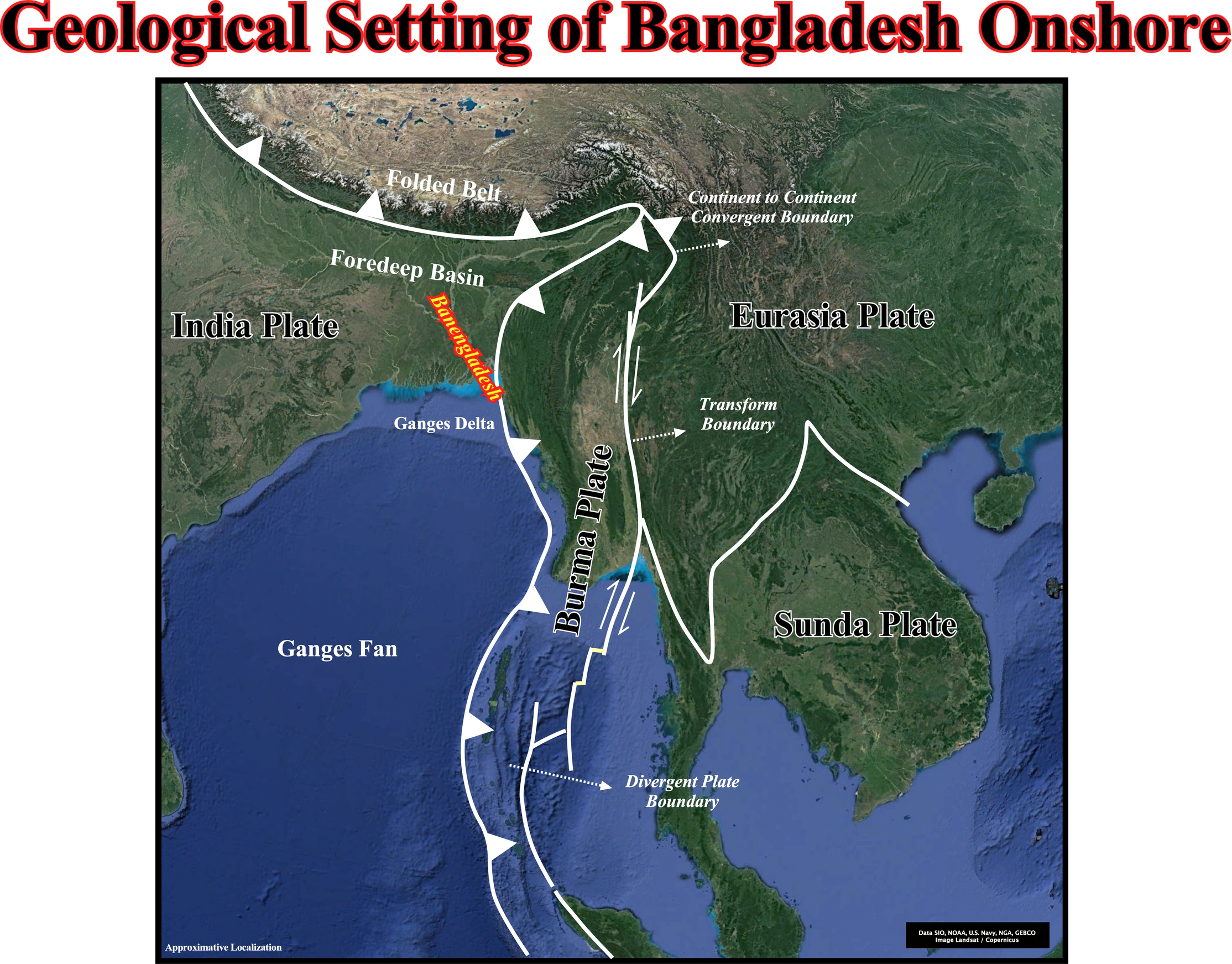
The Cachemire onshore corresponds to a foredeep basin developed in association with the fold belt of the Himalayas (bounded by a Type-A or Ampferer subduction zone), while the offshore corresponds to the Ganges delta (Bengal geographic basin) and to the Ganges fan. The eastern limit of the offshore is, mainly, marked by a Type-B subduction zone (Benioff zone). The geological cross-sections illustrated below shows the geological setting of the area.
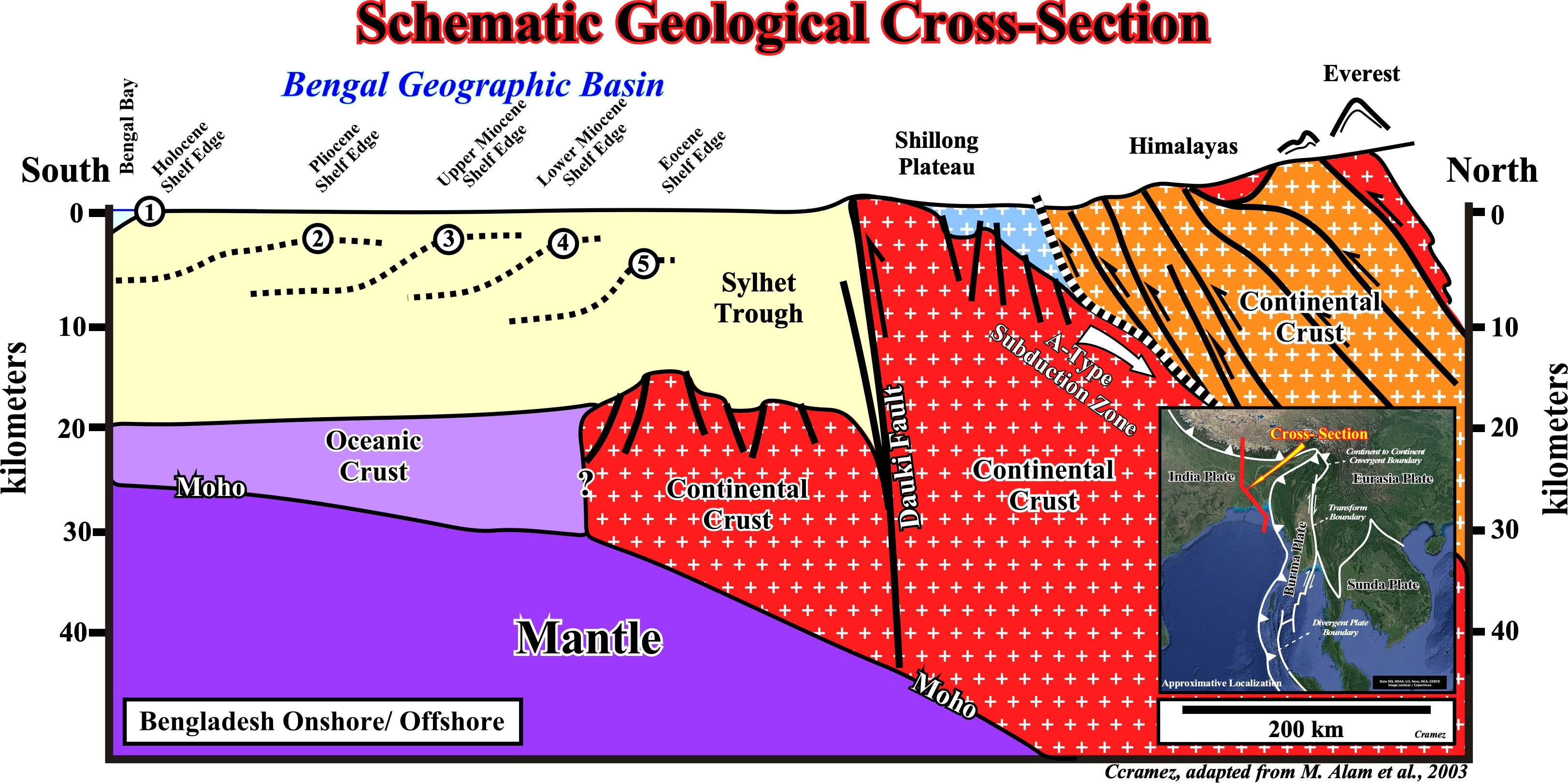
Geological speaking the Bengal geographic basin corresponds to a flexure of the basement rocks under pressure of the sediments laid down since the Cretaceous time. Three major tectonic units are often considered on this area : (i) Stable Shelf ; (ii) Central Deep Basin and (iii) Chittagong–Tripura Fold Belt. Located near a tectonic triple junction (where the boundaries of the Indian, Burma and Eurasia plates meet), the geological history is strongly affect by the plate tectonics. Following With the breakup of Gondwana small supercontinent (Jurassic / Cretaceous) and the northward movement of the Indian Plate, the basement start down-warping in the Early Cretaceous and sedimentation took place on the stable shelf and deep basin. Since then sedimentation has been continuous for most of the basin. The subsidence of this geographic basin can be attributed to: (a) Differential adjustments of the crust ; (b) Collision with the various elements of south Asia and (c) Uplift of the eastern Himalayas and the Indo-Burman Ranges. Movements along several well-established faults were initiated following the breakup of Gondwanaland and during down-warping in the Cretaceous (Alam M. et al., 2003). The stable shelf became under a carbonate regime with influence of the Eocene marine ingression, where as the deep basinal area was dominated by deep-water sedimentation (see next plates and Page 14). M. Alam (2003), assumed that by Middle Miocene, with continuing collision events between the plates and uplift in the Himalayas and Indo-Burman Ranges, a huge influx of clastic sediments came into the basin from the northeast and east. Throughout the Miocene, the depositional settings continued to vary from deep marine in the basin to shallow and coastal marine in the marginal parts of the basin. From Pliocene onwards, large amounts of sediment were filling the Bengal Basin from the west and northwest and major delta building processes continued to develop the present-day delta morphology. The present basin configuration with the Ganges–Brahmaputra delta system on the north and the Bengal Deep Sea Fan (see Page 14) on the south was established during the later part of Pliocene and Pleistocene; and delta progradation since then has been strongly affected by orogeny in the eastern Himalayas (Alam M. et al., 2003). On this cross section, the Dauki fault marks the southern margins of Shillong Plateau. The steep escarpment indicates vertical displacement along the Dauki Fault Zone where the Bangladesh plains subside. Though the Dauki Fault Zone is shown as a single fault line it correspnds ito a set of en-echelon faults trending in different directions, making the fault scraps zigzag rather than a straight line. Spread between the block faulted Paleogene sediments of the northern foreland shelf and the block faulted piedmont deposits of Plio-Pleistocene age of the Garo hills, the Dauki Fault is a structural unit of considerable regional importance, which seems to be the responsible dor the seismicity of the NE Bengal geographic basin.
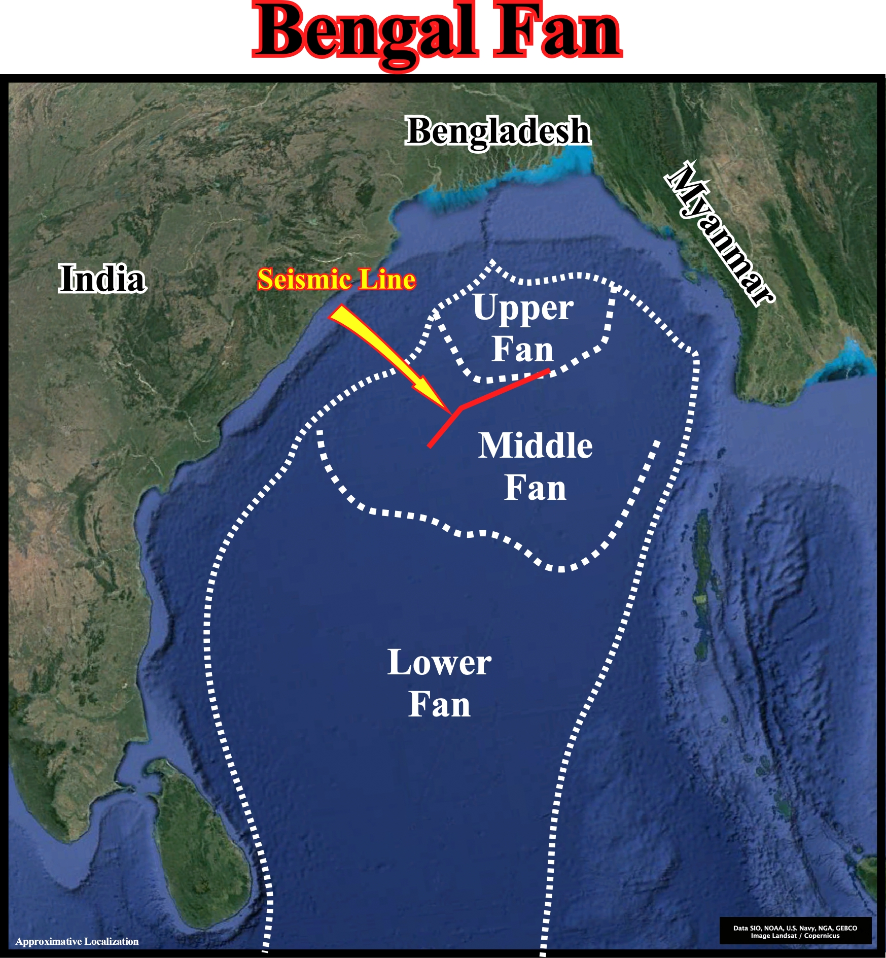
This plate illustrates the approximative extension of the upper, middle and lower parts of the submarine Bengal fan, which is locate between the eastern India offshore (formed by a stacking of rift-type basins and an Atlantic-type divergent margin) and the B-type subduction zone that forms the western limit of the Burma lithospheric plate. The upper, middle and lower fan are roughly delimited, as well the location of the next Canvas autotrace, which recognizes, mainly, the middle Bengal fan.
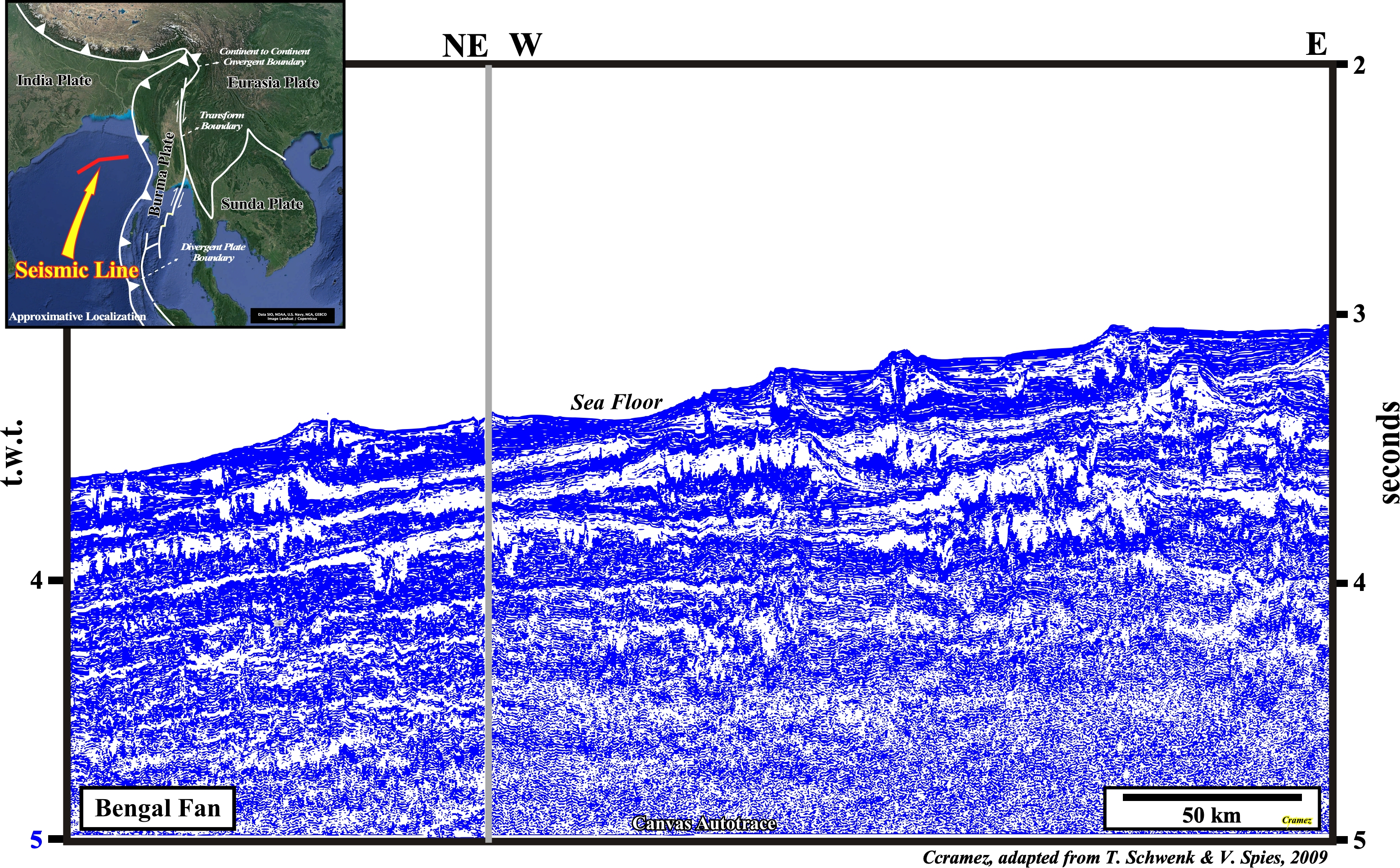
This Canvas autotrace of a seismic line shot on middle Bengal fan shows, in the upper part, a complex stacking of submarine slope fans, in which, according to the P. Vail's turbidite model (see next plate), different depositional systems can be recognized ; (i) Canyon Fill or Slump Blocks ; (ii) Over-bank Deposits ; (iii) Distal Over-bank Mudstones ; (iv) Channel Fill Sands ; (v) Apron shales ; (vi) Abandonment shales and (vii) Basin Floor Thin Bedded Turbidites. In the Emiliano Mutti's model, the middle Bengal fan corresponds, roughly, to a stacking of medium turbidite systems (Mutti's Type II ), in which the more sandy systems (sand/shale ratio > 80 % of sand) are deposited at the base of the slope and their extension is, relatively, small, between 10 to 15 km (they change, laterally, into thin-bedded-turbidites, i.e., to medium-small turbidite systems. The sand systems with a sand/shale ratio between 80-50% are deposited, mainly, on the abyssal plain and their extension reaches several tens of kilometers (medium-large turbidite systems) and the thickness of individual strata, often amalgamated, ranges between 1-5 meters.
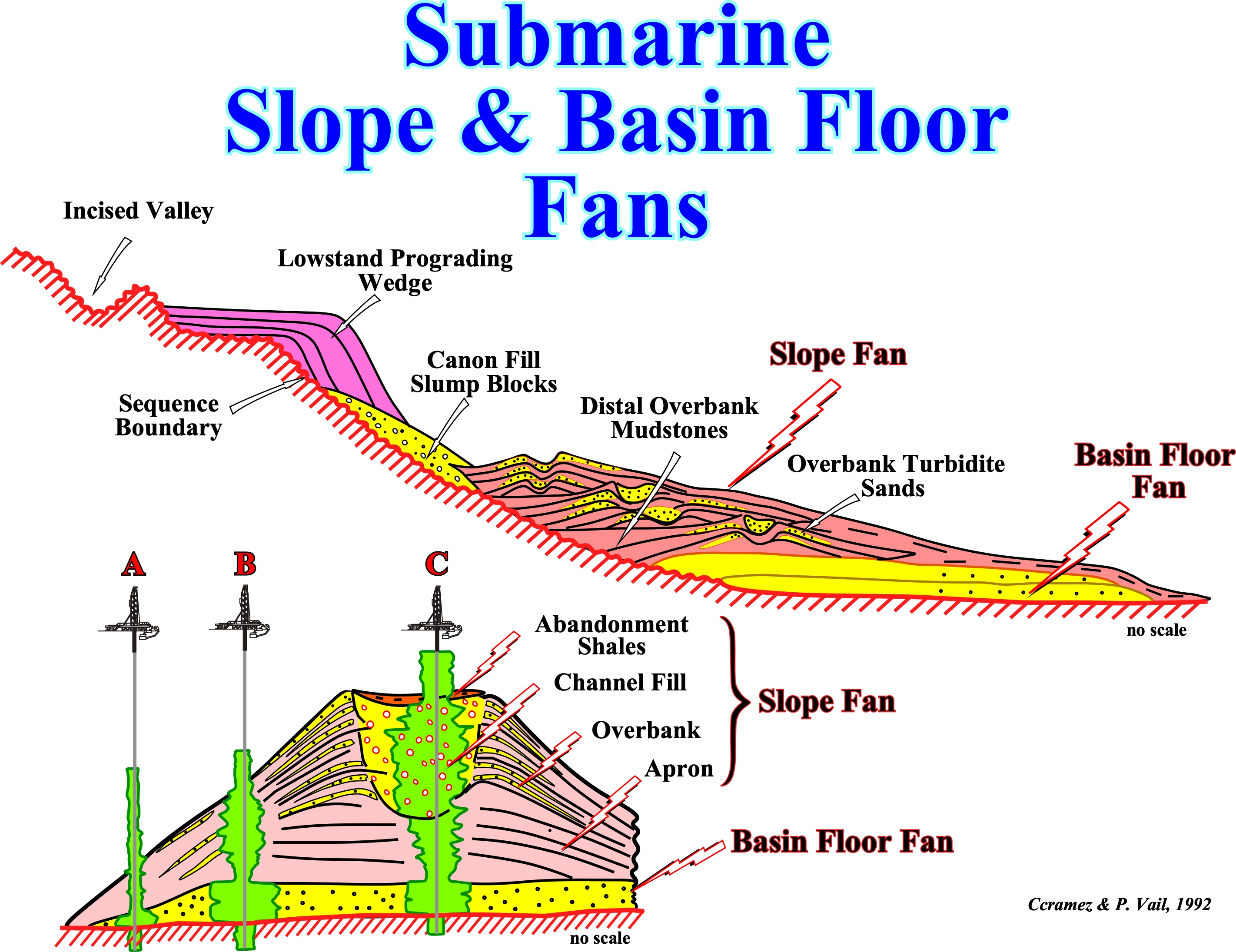
In sequential stratigraphy, the above P. Vail's submarine turbidite model summarizes the main characteristics of a lowstand systems tract (LST) and particularly those of a slope fan, in which the channel levee complexes are paramount. The slope fan time is a period of major headward erosion and bank collapse of the submarine canyons. Actually, basin subsidence begins to create a very slow sea level rise relative to the basin margin, as the rate of eustatic sea level fall slows and approaches zero at the lowest part of the eustatic cycle. The seismic expression of a submarine slope fan varies widely : a) Externally, the fan appears as a broad thick apron of sediments with the thickest and crestal position opposite the source supply/ a submarine canyon and b) Internally, the recognizable seismic facies patterns include slumped deposits from delta and from adjacent flanks, the typical “gull wing” pattern of submarine channels and a discontinuous pattern associated with over-bank sands near the crest of the slope fan. Submarine channel sands make excellent exploration targets, particularly, if they are identifiable seismically due to gas saturation. Over-bank sands are thin and, often, below the resolution of the conventional logging tools, but their porosity and permeability may be startling high. Over-bank sands are, apparently, created when the supply to a submarine channel exceeds the transport capacity of that conduit and sands well up over the levee and are widely spread in a thin sheet over the slope fan apron. Over-bank sands appear to trap against the levee facies or channel fill shales (clay-plug). In thick accumulations over-bank sands may form a very large stratigraphic trap composed of many thin sands.
![]()
![]()
Send E-mails to carlos.cramez@bluewin.ch with comments and suggestions to improve this atlas.
Copyright © 2001 CCramez
Last update:
2022![]()
