
New Zeland Offshore
Taranaki Geographic Basin
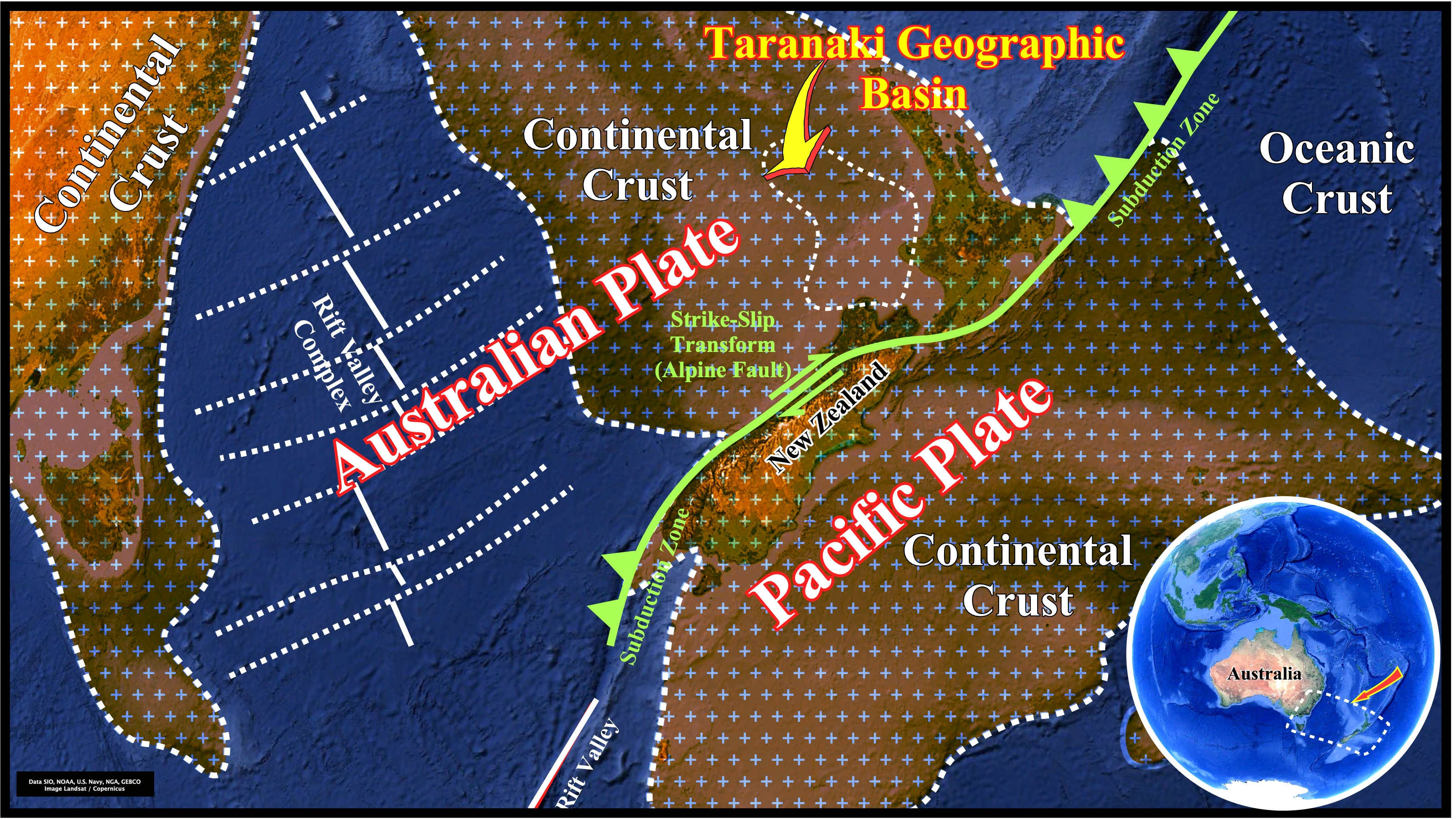
The geological regional context of this area is summarized on Page 26. The Taranaki Geographic Basin is a Late Cretaceous rift-type basin developed on the West Coast of New Zealand, during the lengthening of the Gondwana lithosphere in association with the extensional tectonic regime responsible of the Gondwana breakup (Emerald depression, i.e., a rift valley complex). After the breakup of the lithosphere the area became a divergent margin mainly during the Paleocene/Eocene. Later, the area underwent a forearc and intra-arc development due to the subduction of the Pacific Plate under the Australian Plate. In fact, after the breakup of the Gondwana lithosphere, the Taranaki geographic basin corresponds to a Cenozoic Atlantic-type divergent continental margin, in which important strike slip movement developed a Californian basin (Taranaki graben) in the northern part during the Mio-Pliocene time.
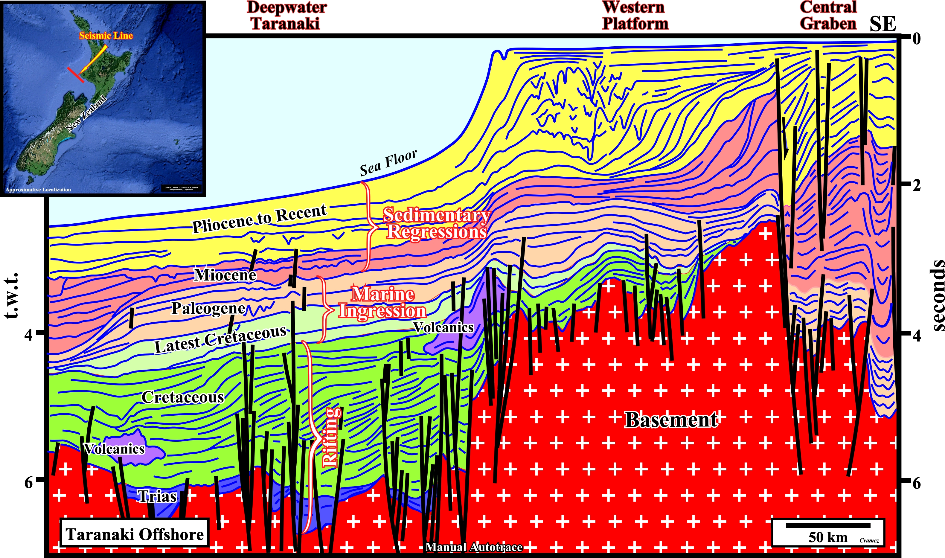
On this tentative geological interpretation (take into account the seismic pitfall induced by the abrupt change in water depth) we can speculate the following The stratigraphic signature : (i) Rifting in the Late Cretaceous prior to the opening of Tasman Sea ; (ii) General aggradation associated with the marine ingression coming from northwest during the latest Cretaceous, which ended at the Early Miocene (24 Ma) with deposition of pelagic limestones (Corden limestones or Tikorangi limestones) ; (iii) General overall progradation during Lower and Middle Miocene (24.8 to 10.5 Ma) with a marine ingression and progressive smaller sedimentary regressions (transgressions, during the Middle to Late Miocene with strong volcanic activity followed by a strong progradation with a northward shift of the depocenters filling up the Taranaki graben (see next plate). Mainly, during the Miocene and in association with the important strike slip faults, locally the Atlantic-type divergent margin becomes a Californian-Type basin (episutural basins associated with strike-slip movements). Take note that we follow Ceasare Emiliani (1992) for who transgressions or sedimentary transgressions (and not transgression) is set of increasingly important marine ingressions and associated increasingly small sedimentary regressions, that collectively create a retrogradation morphology. Similarly, regressions or sedimentary regressions (and nor regression) is a set of increasingly small marine ingressions (relative sea level rises) and associated increasingly important sedimentary regressions, that collectively create a progradational morphology.
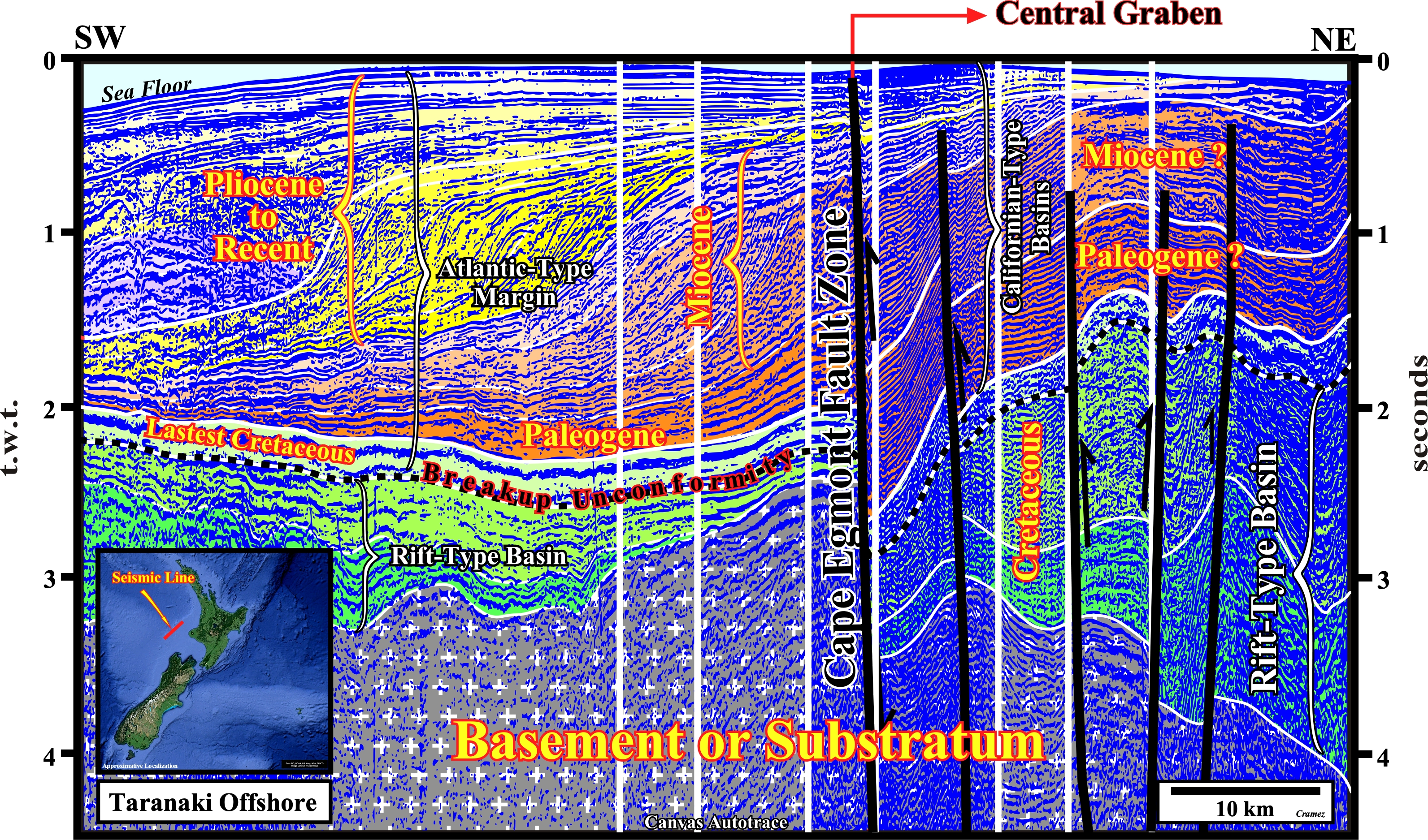
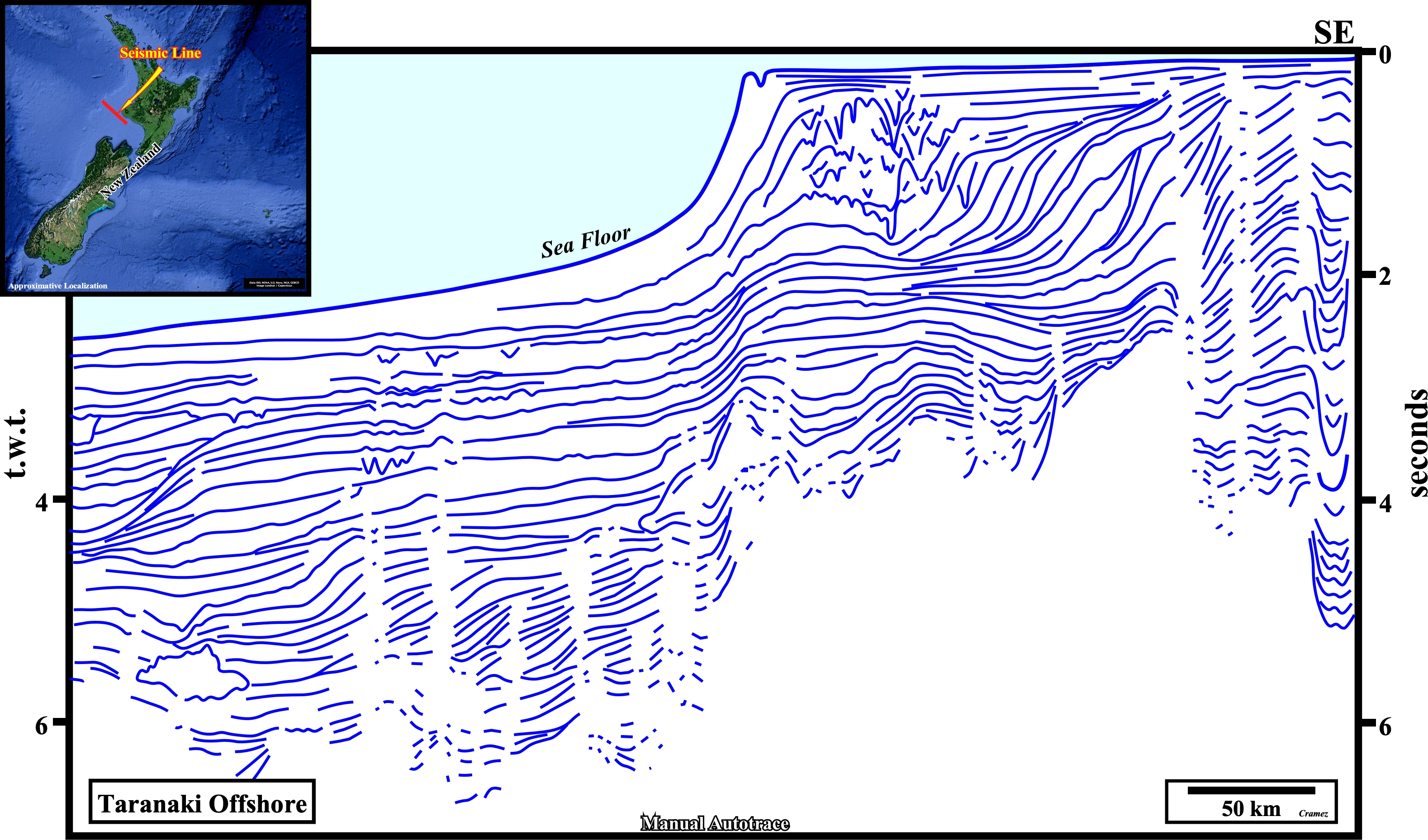
On this speculative tentative geological interpretation of a Canvas autotrace of a composite seismic line of the NW New Zealand offshore, crossing, obliquely, the Cape Egmont fault zone, the Central graben (certain geoscientists call it Taranaki graben), is quite well illustrated eastward of the fault zone. However, the correlation between the seismic intervals on each side of the faulted zone is questionable and must be, severely, criticized, i.e., tested. Westward of the Cape Egmont fault zone, the seismic quality is quite good, and so, it is easy to recognize above the basement (or the substratum) : (i) A Cretaceous rift-type basin ; (ii) The breakup unconformity, probable Upper Cretaceous in age) ; (iii) An Atlantic-type divergent margin, in which the retrogradational transgressive stratigraphic phase is represented Late Cretaceous marine sediments, and the forestepping or regressive stratigraphic phase by sediments ranging from Paleogene to Recent. Eastward of the the Cape Egmont fault zone, the seismic quality is mediocre. Nevertheless, a rift-type basin, the breakup unconformity, as well as, the transgressive stratigraphic phase of the Atlantic-type margin can be identified without major difficulty. Above the transgressive phase, taking into account the prevalence of the strike-slip faulting, a local Californian-type basin developed.
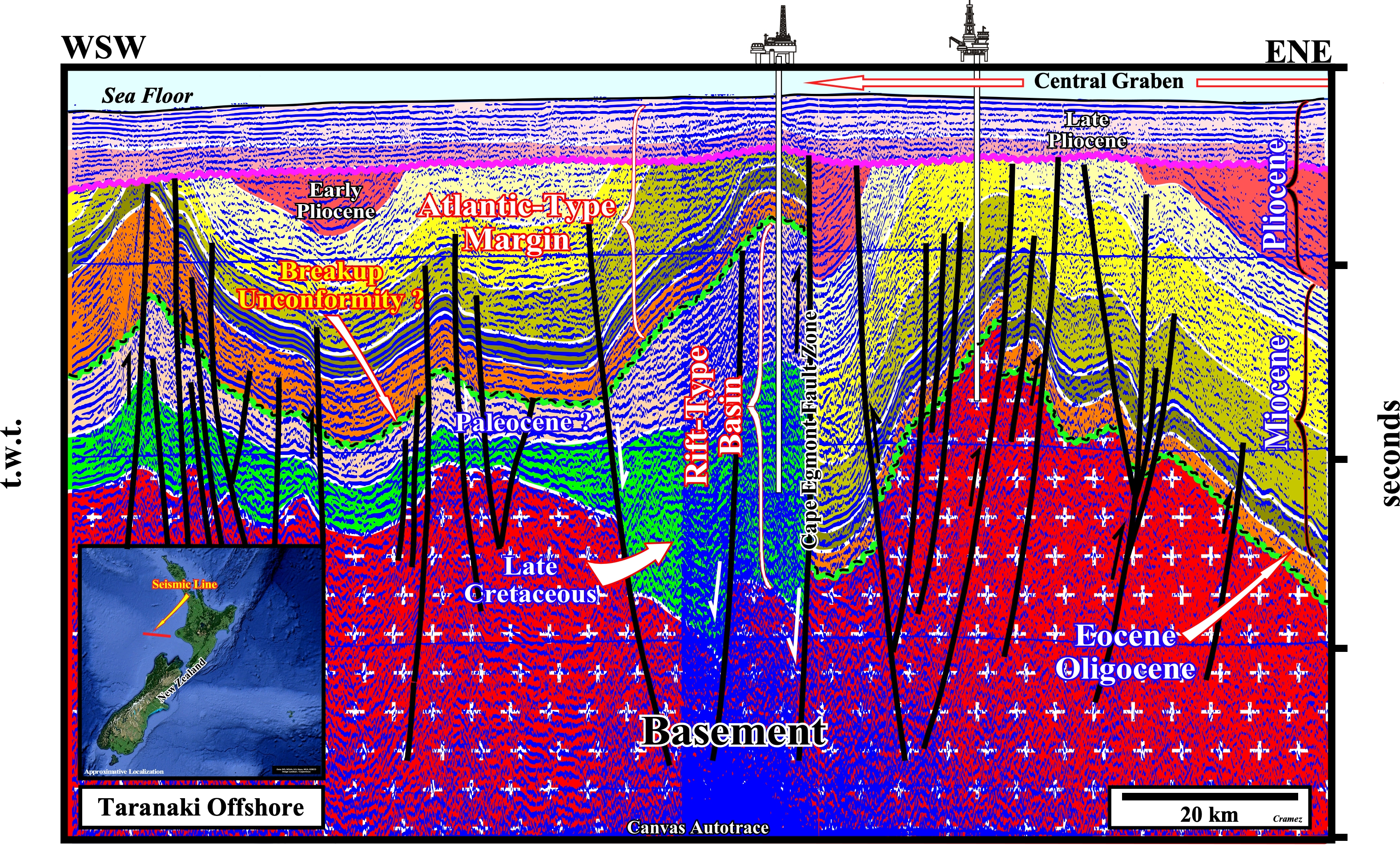
In spite of the fact the basement, the rift-type basins and the Atlantic-type margin are, easily, recognized. However, locally, during the Miocene-Pliocene time, the influence of the strike-slip faults and associated deposits, strongly, suggest to considered, in Taranaki geographic basin, sedimentary Californian-type, i.e., episutural basins associated with strike-slip faults (A. Bally & S. Snelson, 1980), as it is the case in the Central Graben (also called Taranaki graben), which is confined between the Cape Egmont fault and the Taranaki fault (in the onshore).

![]()
![]()
Send E-mails to carlos.cramez@bluewin.ch with comments and suggestions to improve this atlas.
Copyright © 2001 CCramez
Last update:
2022![]()