

09) Absolute & Relative Sea Level
Few geoscientists know the difference between absolute and relative sea level. In addition, generally, they do not have any idea how sea level changes are measured, but they use them to explain the cyclicity of sedimentary deposits.
The dramatic sea level rise announced by the media and politicians, is, for the people, in general, the most known and dangerous consequence of climate changes. However, talk about sea level changes without specifying the reference surface does not make sense. Saying that sea level will rise 4 cm, until the end of the century without telling what sea level is taking into account is a lie by omission (Al Gore in his book “An Inconvenient Truth “ says: “6 meters” !!).
The sea level is, always, changing due to geography, gravity, temperature, ocean currents tides, tectonics, etc. A sea level measure is, always, made in relation to a specific reference surface : (i) Topograpgic surface ; (ii) Geoid , (iii) Elipsoid, etc.
(i) Topographic Surface, is the visible Earth’s surface ;
(ii) Geoid, is the equipotential surface of the Earth’s gravitational field that would coincide, exactly, with the “Mean Sea Level” of the Earth’s oceans, if they were in equilibrium, at rest and extending across the continents ;
(iii) Ellipsoid, is a three-dimensional geometric figure that resembles a sphere, but whose equatorial axis (a) is, slightly, longer than its polar axis (b). Many ellipsoids have been defined in the world and used as approximations. Local ellipsoids are established to fit the Geoid (mean sea level) well over an area of local interest. A global ellipsoid approximates the Geoid as a mean Earth Ellipsoid. the WGS-84 ellipsoid, with semi-axes a = 6 378 137.0 m and b = 6, that is, often used as Reference Ellipsoid is close to the “mean sea level”.
Consequently, different types of sea level can be proposed, function of the reference surface taken by the observer. Thus, as illustrated in figure below, he can measure:
a) The Absolute Sea Level ;
b) The Relative Sea Level ;
c) The Sea Surface Height ;
d) The Mean Sea Level, etc.
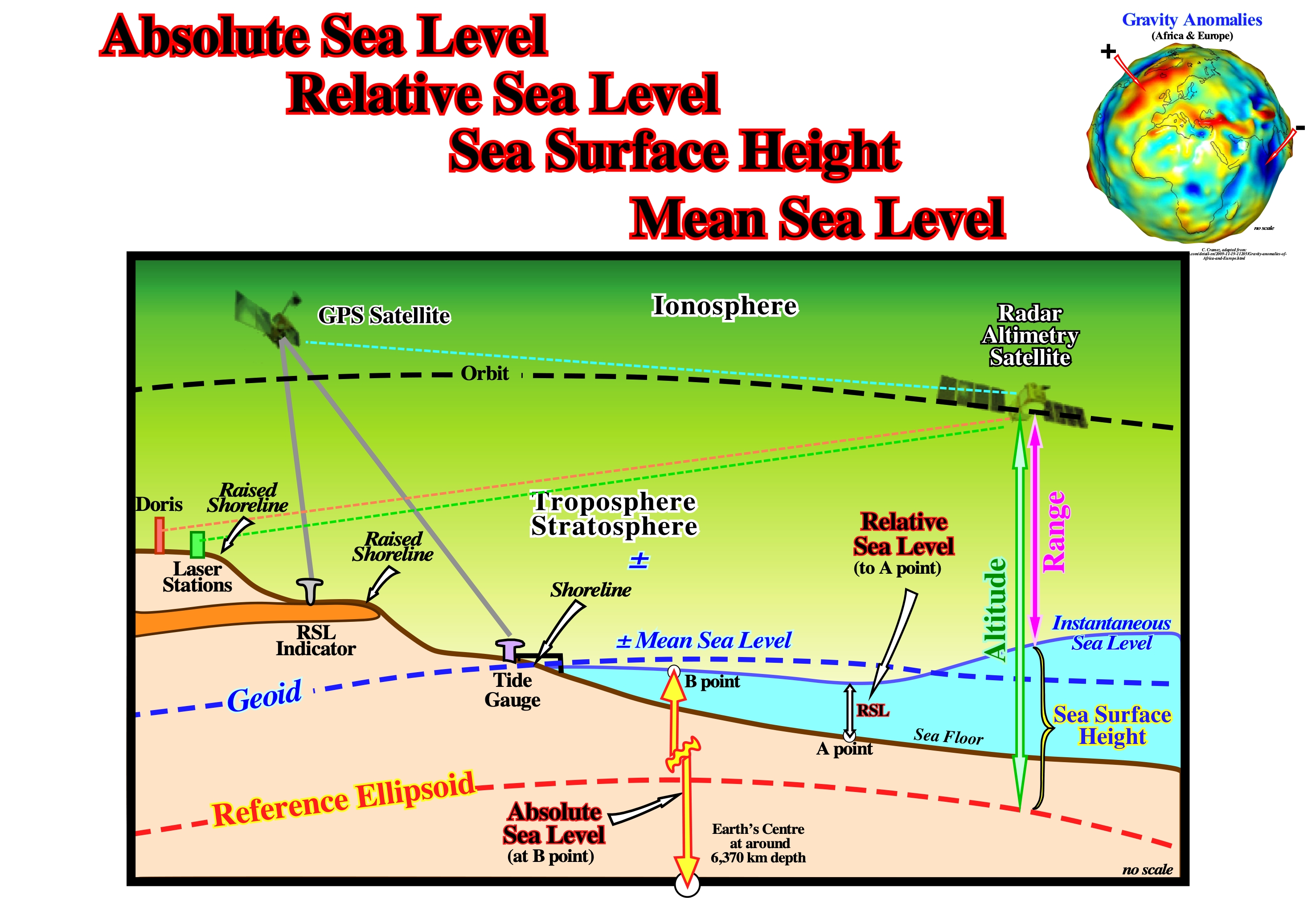
Figure 036- GPS receivers use the reference ellipsoid to calculate elevation. The elevation reading from the GPS receiver is not the vertical distance from true sea level, but rather the distance from the reference ellipsoid. A GPS receiver gives latitude, longitude and elevation. To calculate the elevation, the following informations are required (i) The location of at least four satellites in space ; (ii) The current time ; (iii) The reference ellipsoidal shape of the sea level for the entire Earth. There are many different reference ellipsoids, but all GPS receivers use the same one, and it is called the WGS-84 Reference Ellipsoid. However, according to the Einstein' relativity theories, the GPS measures must be corrected (GPS is based on the very precise measurement of the signal travel time between the Earth and satellites in orbit which travel at high speed, and they are further from the Earth's gravity field than we are ; their time is therefore not the same as on the ground, since it runs a little faster). Due to currents, variations in air pressure, temperature, etc., the Mean Sea Level (MSL) does not coincide with the geoid, not even as a long-term average. Function of location (persistent over time), the separation, between the Mean Sea Level and geoid, is referred as the geodetic topography. It varies, globally, on a scale of ± 2 m. It is this stationary sea surface that is called geodetic sea level (it corresponds to a set of digital values of the highest geoid points in relation to a reference ellipsoid). Nevertheless, the geoid is the best representation the MSL. The sea level is wavy and mimics the topography of the sea floor. Its undulations are very small and can just be measured by altimetric radars from satellites. The GOCE mission measured the gravity gradients and proposed a global model of the Earth’s gravity field and the geoid. Everything depends on the knowledge of the Earth’s gravity field, which defines the horizontal. It is a function of several factors (mountain ranges, oceanic trenches, etc), which make Earth’s surface very uneven. In addition, as Earth’s materials have different densities and are not uniformly distributed, the force of gravity varies from one place to the other at the Earth’s surface.
As illustrated in figure below, there are, basically, two different manners to measure the changes of sea level, by maregraphs and by radar altimetry.
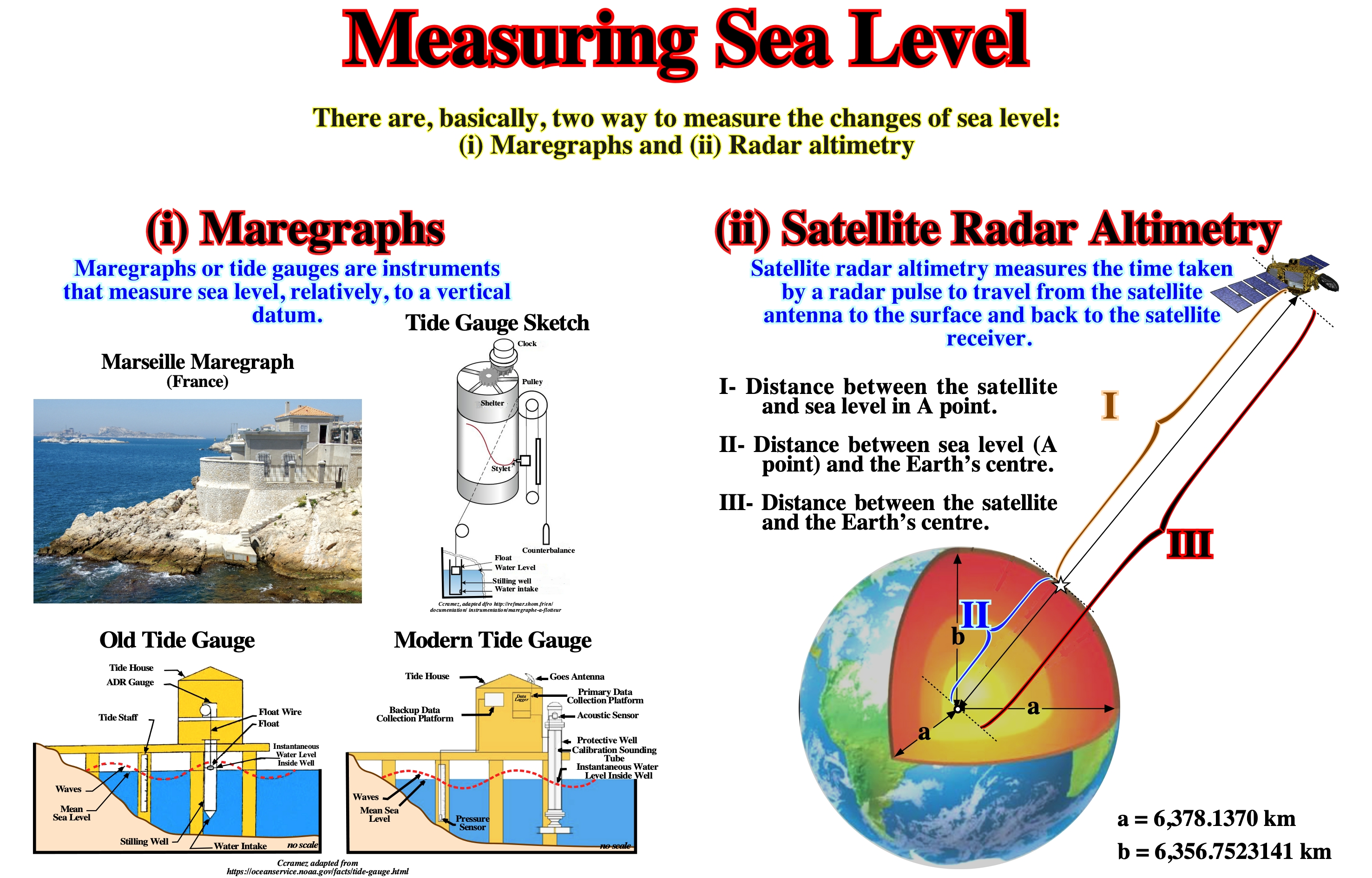
Figure 037- Float gauges were the first self-recording tide gauges and even today are still in widespread use despite technological developments. The float is located in a stilling well, usually, topped with a shelter containing the chart recorder, to protect against the weather. These instruments are, generally, reliable and relatively unsophisticated. If high accuracy is not required, highly skilled personnel are not needed to maintain and use them. Satellites, as for instance Jason-3, can measure the distance from themselves to the sea level within an error of about three centimeters (I). In addition, they have instruments allowing to measure the distance from them to the Earth’s center (III). By subtracting the first distance (between the satellite and sea level) from the second distance (between the satellite and Earth’s center), geoscientists can calculate the distance from the sea level to Earth’s center (II). In about 10 days, they measures the sea level height (distance between an instantaneous sea level and the reference ellipsoid) over the entire Earth, allowing to find the mean sea level for the whole planet. After several years of measuring, it is possible to determine how much and how quickly sea level changed.
From the above mentioned sea level types, the Absolute and Relative Sea Levels are, by far the most used on geology and particularly on tentative geological interpretation of the seismic lines.
A) Absolute Sea Level
The absolute (eustatic) sea level is referenced to a fixed point, which is, generally, the Earth's center. It rises or falls, mainly, function of the:
(i) Tectono-Eustasy, that is controlled by the volume variations of the ocean basins in association with oceanic expansion (seafloor spreading) following the breakup of the supercontinents ;
(ii) Glacio-Eustasy, that is controlled by the variations of water volume of the oceans as a function of the amount of ice (assuming the amount of water, in all its forms, is constant since the Earth's, around 4.5 Ga) ;
(iii) Geoidal-Eustasy, that is controlled by the distribution of ocean water caused by variations in the Earth's gravity field (where gravity is stronger than normal, sea level is thrown to the center of the Earth) and
(iv) Steric Sea Level Rise or Thermal Expansion of the Oceans, that is the volume increasing of the oceans with the temperature, i.e., if the temperature increases, the density of the water decreases and, for a constant mass, the volume increases.
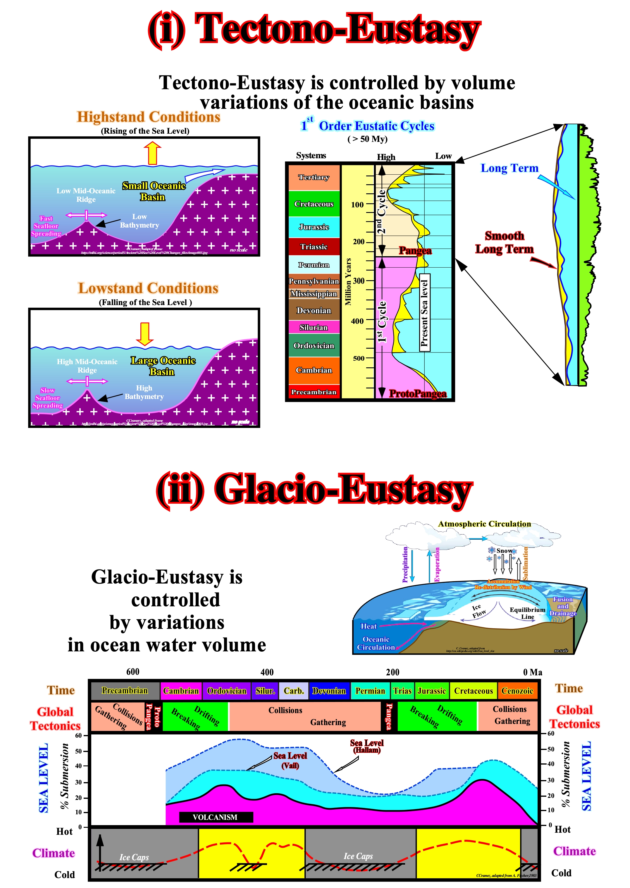
Figure 038- The Paleozoic eustatic maximum, with the sea level 200-250 meters higher than at present-time, occurred at about 500 Ma. The dispersion of Paleozoic continents was maximum. The Mesozoic / Cenozoic eustatic maximum, with sea level 150/200 meters higher than today, occurred about 91.5 Ma, when the dispersion of the post-Pangea continents was maximum. As the continents began to approach each other to finally form a new supercontinent, the level of the absolute (eustatic) sea level fell. It reached a minimum height at the formation time of the of the new supercontinent. Assuming the amount of water (in all its forms) is constant since the Earth formation (± 4.5 Ga), it is evident that at time of supercontinents, the volume of the ocean basins is larger (less oceanic ridges) and the absolute sea level lower. On the contrary, when the volume of the ocean basins is small (abundance of ocean ridges), i.e., when the continents, created by the break-up of a supercontinent, are far apart, the absolute sea level is higher. Tectono-Eustasy and Glacio-Eustasy are eustatic changes, which are, sometimes, erroneously, considered global and uniform. During glaciations, the absolute sea level falls. Contrariwise, during the thaw (deglaciations) the absolute sea level rises. The eustatic level rose about 120 meters during the millennium that followed the end of the last glacial age (more or less, 21,000 years ago) and it has stabilized between 3 and 2 ka. A particular attention has to be given to ice caps or ice sheets (ice masses covering respectively less than or greater than 50,000 km2 of a continent) and ice shelves or ice seas (thick, but floating, ice that has been discharged, as illustrated in this figure, or formed, directly, on the surface of the sea). The melting of the former implies a rise of absolute sea level, while the melting of the latter does not. The absolute sea level falls. The ice is less dense than the water. The maximum extent of the ice caps and ice-seas (Northern and Southern hemispheres) during the last ice age was reached, approximately, at about the same time and more or less at are 19 ka. Glacio-Eustasy is, sometimes, considered globally and uniform. However, they can neither be global nor uniform, since any cause of sea level also affects the terrestrial geoid. There is no eustatic curve valid globally.
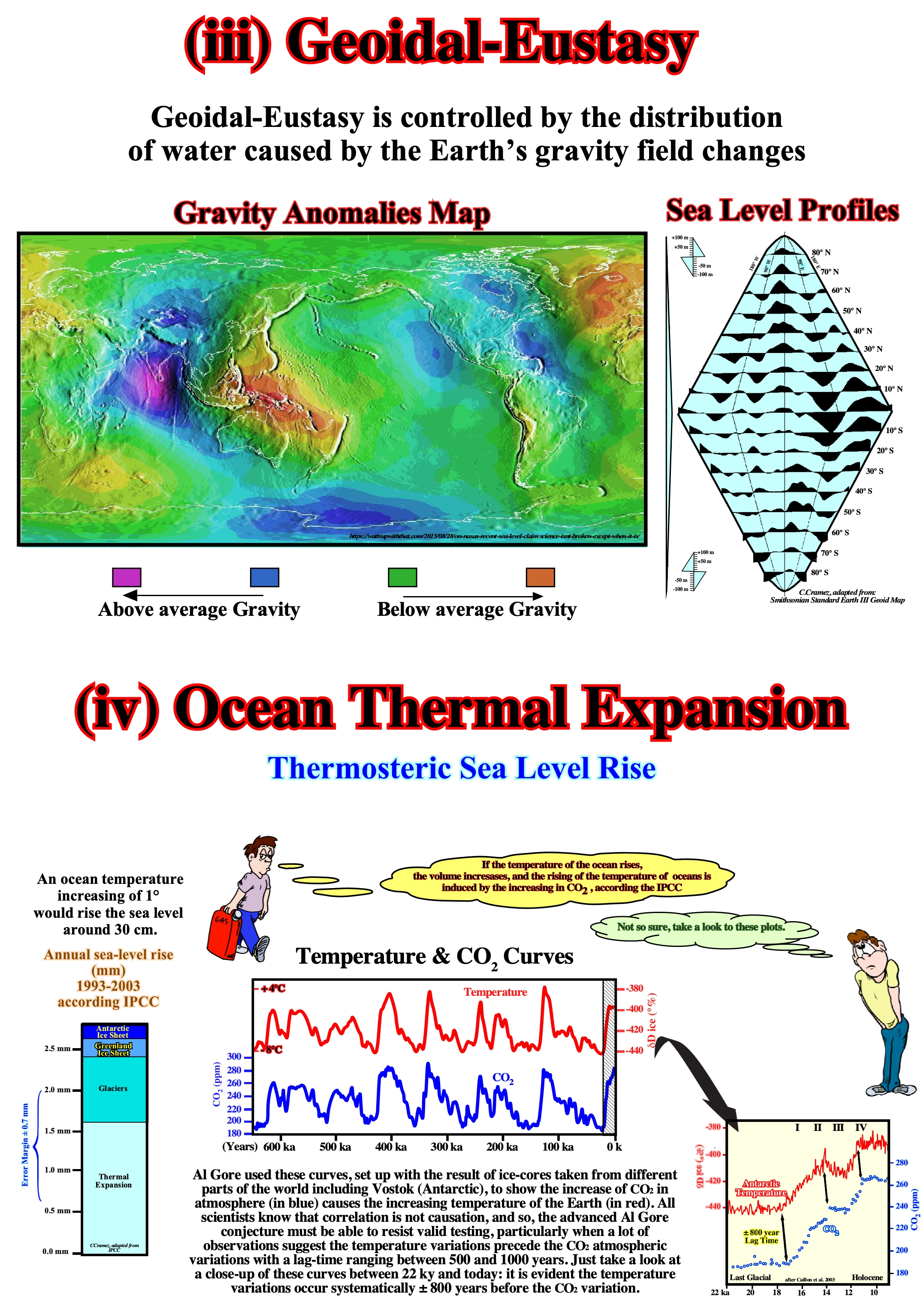
Figure 039- As illustrated on these profiles (Smithsonian Standard Earth Geoid Map III) and on the map of gravity anomalies, absolute sea level shows important irregularities with very high and low values. That means the sea level, contrary to a very accepted idea, is not flat. The amplitude of the undulations is exaggerated by a factor of 100,000 with respect to the Earth's radius. The high values (where sea level is higher) correspond to Earth's areas where gravity is below normal. By the same token, when the values of gravity are higher, absolute sea level is lower. This results from the fact that the Earth’s material is not distributed, neither uniformly nor in layers, perfectly, concentric. If this were so, the geoid (the equipotential surface that would give the average surface of the oceans, if they were in equilibrium, without movement and continue under the continents) it would coincide with the Earth’s surface. Between the areas where absolute sea level is high, such as near New Guinea and the areas where it is lower than normal, such as in the Seychelles, there is a difference of about 180 meters. If the temperature of the oceans increases, the density of water decreases and, for a constant mass, the volume increases, is what geoscientists call thermal expansion of the oceans or steric sea rise, i.e., function of the spacial arrangement of atoms. The whole problem is to know whether it is the increase of CO2 in the atmosphere that increases the temperature of the oceans or if it is the increase in the temperature of the oceans that releases CO2 into the atmosphere. The ability of water to maintain a certain amount of dissolved CO2 is a function of its temperature. The lower the water temperature the more dissolved CO2 it supports. At high latitudes, the surface water is icy and allows the dissolution of high concentrations of atmospheric CO2. When the surface of the sea freezes, the salt is kept out of the freezing process and dissolves in the water, immediately, under the sea of ice. Ice-cold and salty, with much dissolved atmospheric CO2, the water becomes more dense, sinks and flows along the continental slope of the polar platforms, invading the deeper regions of the ocean basins.
Glacio-Eustasy and Tectono-Eustasy are eustatic variations that are, sometimes considered, globally, and uniform. However, for many geoscientists, they can be neither global nor uniform, since any cause of sea level affects, also, the terrestrial geoid. If this is true, no eustatic curve is valid globally. During the thawing of the ice caps, in response to the charge of water added to the ocean basins, sea level will be depressed and in response to the removed charge, the continent will be raised. The redistribution of material within the Earth is affected by overload and will further force ocean surface variations (induced by gravity anomalies) and thus further water redistributions will be necessary to try to equalize gravitational potential. This continuous gravitational retroactive processes between ice caps, oceans and continent, are the process that determines, ultimately, the relative sea level signatures that are observed everywhere the continent and the ocean meet. Only Glacio-Eustasy changes are both important (> 10 m) and rapid (<1 My).
B) Relative Sea Level
The relative sea level is the sea level referenced to any point on the land surface whether it be the top of the continental crust (base of sediments) or the sea floor. It is the result of the combined action of the absolute or eustatic sea level, supposed to be global and referenced to the Earth's center and tectonics (subsidence or uplift of the sea floor).
In a certain area, at certain geological time, subsidence and uplift are, directly, related with the tectonic regime. Assuming a constant rate of the absolute sea level rise, one can say:
1) During extensional tectonic regimes, which are characterized by a maximum vertical effective stress (σ1), sediments are lengthened :
(i) This lengthening induces subsidence ;
(ii) Subsidence gives a relative sea level rise, which increases the space available for sediments (accommodation) ;
(iii) A relative sea level rise induces sedimentation.
2) During compressional tectonic regimes, which are characterized by a maximum horizontal effective stress (σ1), sediments are shortened :
(i) Shortening generates uplift, which creates a relative sea level fall that decreases the accommodation (space available for sediments) ;
(ii) A relative sea level fall (RSLF) induces erosion.
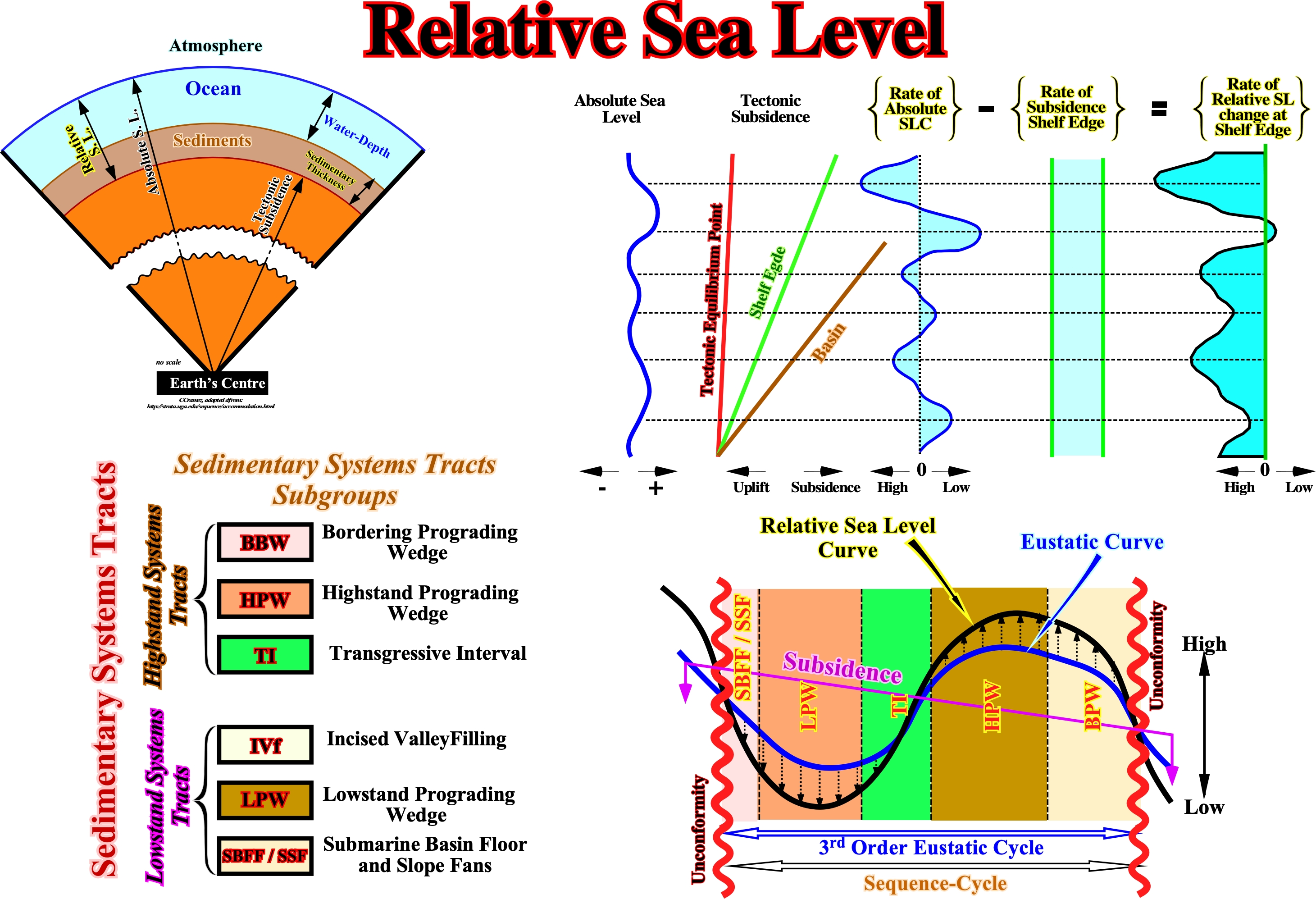
Figure 040- When tectonics is combined with eustatic changes (absolute sea level changes), the final accommodation, i.e., the space available for sediments, is the sum of the space induced by tectonics and by eustasy24: a) During an eustatic sea level rise (increasing of accommodation), the amount of water depth created by subsidence is added to that created by the eustatic rise ; b) During a eustatic sea level fall (decreasing of accommodation), the amount of space created by subsidence must be subtracted from that created by the eustatic sea level fall ; c) In the case of uplift (compressional tectonic regimes), the reduction of accommodation is increased by the reduction created by an eustatic sea level fall (ESLF) and decreased by the accommodation created by an eustatic sea level rise (ESLR).
24Since 1977, the definition of Eustasy more difficult to falsify is: Vertical Sea Level Changes, regardless their Causes (Alex Mörner)
The curve of the relative sea level is the result of a combined of the absolute or eustatic sea level curve (absolute sea level is supposed to be global and referenced to the Earth's center) and tectonics (subsidence of the sea floor, when the prevailing tectonic regime is extensional or uplift, when it is compressional).
As shown in this figure 040, the relative sea level curve is a sinusoidal wave, in which each eustatic cycle is bounded between two consecutive downward inflection points. In mathematics, a sinusoidal curve represents, graphically, the sine function and also the function itself, that is, the relative sea level change. When the function is increasing and concave, at each point, the 1st derivative and the 2nd derivative (derived from the derivative) are positive. Do note forget that a derivative is a rate. The speed of a car is the rate between the distance it has traveled and the time it took to travel that distance, as well as, the acceleration of a a car is the rate between the speed variation and the time of that variation, i.e., a rate of a rate (2nd derivative).
When the function (relative sea level curve) is increasing and convex the 1st derivative is positive, but the 2nd derivative is negative, i.e., since the function grows but less rapidly, the derivative of the derivative changes signal. When the function (relative sea level curve) is decreasing and concave the 1st derivative is negative, but the 2nd is positive. Finally, when the function is decreasing and convex the 1st and 2nd derivatives are negative.
The limits of the 1st and 2nd order eustatic cycles are limited by the points where the rate of relative sea level fall is maximum (points where the 1st derivative of the curve is maximum, i.e., where the slope of the function is maximum). As shown above (figure 036a), within sequence-cycle (stratigraphic cycle induced by a 3rd order eustatic cycle, which is characterized by a time-duration between 0.5 and 3-5 My) two groups of sedimentary systems tracts (lateral association of contemporaneous and genetically linked depositional systems composed by stratigraphic paracycle or sequence-paracycle) are deposited. The lower sedimentary systems tracts group is the (i) Lowstand Systems Tracts Group (LSTG) and the upper one is the (ii) Highstand Systems Tracts Group (LSTG).
The lowstand systems tracts group (LSTG) is composed of three subgroups which, from the bottom up, are:
(a) Submarine Basin Floor Fans (SBFF), characterized by a general planar geometry ;
(b) Submarine slope fans (SSF), generally, characterized by a wavy geometry ("Gull Wings") ;
(c) Lowstand prograding wedge (LPW), characterized by a progradational geometry.
The highstand systems tracts group (LSTG) group is composed of two subgroups:
(a) Transgressive interval (TI), characterized by a global retrogradational geometry and
(b) Highstand prograding wedge (HPW), characterized by a prograding geometry.
In a curve of relative sea level change, the unconformities correspond to the points where the rate of the relative sea level fall is maximum. During the period of relative sea level fall, submarine basin floor fans (SBFF) and submarine slope fans (SSF) are deposited25. The first ones deposit when the rate relative sea level fall is the strongest, while the second are deposited when the rate relative sea level fall begins to slow down. The lowstand prograding wedge (LPW) deposits when the rate of relative sea level fall is in deceleration and even when it begins to rise.
25 The deposition of the sedimentary particles is not coeval with the relative sea level rise increments, but with the stability periods of the relative sea level that follow each eustatic paracycle (marine ingression). During a relative sea level rise (marine ingression), the shoreline is displaced landward at same time that a ravinement surface (washout surface) is, often, developed on the sea floor, but there is no deposition. During the period of stability of the relative sea level that follows each marine ingressions, the shoreline, progressively, is displaced seaward as the sedimentary particles deposit by progradations creating what geoscientists call a stratigraphic paracycle-sequence, i.e. small sedimentary regression.
The transgressive interval (TI) of the highstand systems tracts group is deposited when the relative sea level rise is in acceleration, whereas the highstand prograding wedge (HPW) is deposited when the relative sea rise is in deceleration and, even, when it starts to falls. The bordering prograding wedge (BBW) is deposited during slow relative sea level falls, which did not put the sea level lower than the basin edge.
At present, however, most geoscientists prefer to speak of forced regressions (seaward displacement of the shoreline within a sequence-cycle, when the relative sea level falls, and when the position of the upper limit of the sequence-cycle is difficult to locate). The bordering prograding wedge fell into disuse. Upstream of the continental edge, to have deposition the relative sea level has to rise, since the space available for the sediments (accommodation) must increase. Just the submarine fans (SBFF and SSF) and, particularly, the submarine basin floor fans (SBFF) are deposited during significant relative sea level falls, when the platform and the top of the continental slope are exhumed.
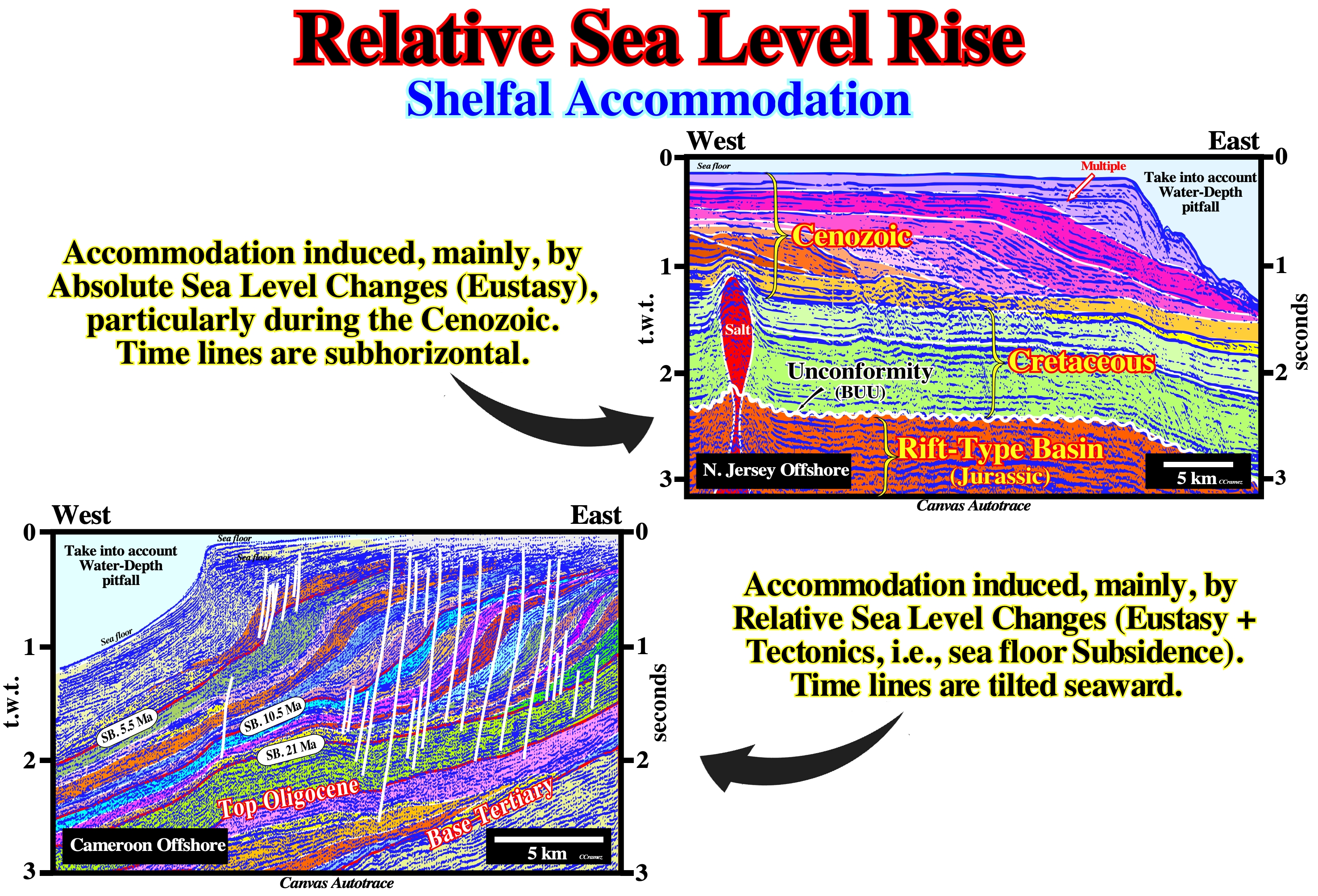
Figure 041- Accommodation is the space available for the sedimentary particles to deposit, i.e, to have sedimentation the space available must increase or, in others terms, the relative sea level (combined action of the absolute sea level and tectonics) must increase. Depositional surfaces are chronostratigraphic lines, that have a sigmoid geometry, in which three sectors can be individualized: (i) Upper subhorizontal ; (ii) Middle seaward dipping and (iii) Lower subhorizontal. When on seismic lines, the lower subhorizontal sector has a, more or less, horizontal behavior (as on the autotrace of the New Jersey seismic line), obviously, eustasy (absolute sea level changes) is the preponderant factor of shelfal accommodation. When the lower subhorizontal sector of the depositional surface dips seaward, as it is the case in Cameroon offshore, tectonics, i.e., the increasing seaward tilting of the sea floor (subsidence) is the main responsible for the creation of accommodation. Generally, the cyclicity observed in sedimentary series, is due to the absolute sea level changes. Tectonics is, mainly, chargeable for the amount of the accommodation created.