

10) Marine Ingressions & Sedimentary Regressions
"When the sea level rise, we get a transgression and when the sea level falls we have a regression" [sic] is a false statement. A sedimentary transgression does not exist in Geology. A set of increasingly smaller sedimentary regressions can be, eventually, interpreted as the consequence of marine ingressions (transgressions).
A large number of geoscientists took the habit of using the term transgression to designate the continentward displacement of coastal deposits in spite of the fact, that coastal deposits do not have a reverse gear, like a car, to move mainland.
An invasion of the continent by sea is what geoscientists call marine ingression, i.e., a relative sea level rise26, eustatic paracycle or marine transgression. A gradual stepwise invasion of the continent by the sea is composed by a vertical stacking of relative sea level rises in acceleration, e.g., a rise of 3 m, followed by a rise of 5m, 8 m, 10 meters, etc., with stability periods of relative sea level falls between them (no relative sea level falls).
26 It is fundamental not to confuse the relative sea level with absolute (eustatic) sea level. The first is a local sea level, referenced to any fixed point on the Earth's surface, which can be the base of the sediments (top of continental crust) or the sea floor. The second is the sea level, supposed to be global, referenced to the Earth's center. The relative sea level is the result of the combined action of absolute (eustatic) sea level and tectonics (subsidence or uplift of the sea floor). The absolute sea level is the result of the combination of: i) Tectono-Eustasy that is controlled by the volume variation of the ocean basins in association with oceanic expansion following the rupture of the supercontinents ; (ii) Glacio-Eustasy, which is controlled by the variation of water volume of the oceans as a function of the amount of ice (assuming that the amount of water in all its forms is constant since the formation of the Earth (around 4.5 Ga) ; (iii) Geoidal-Eustasy which is controlled by the distribution of ocean water caused by variations in the Earth's gravity field (where gravity is stronger than normal, sea level is thrown to the center of the Earth) and (iv) Steric rise of sea level or thermal expansion of the oceans (if the temperature increases, the density of the water decreases, and for a constant mass, the volume increases). During a given geological time, the combination of the eustatic curve (curve absolute sea level changes) and the tectonic (subsidence, when the predominant tectonic regime is in extensional or uplift, when the predominant tectonic regime is of compressional) gives the curve of the relative sea level change rate.
The term transgression to designate a continentward displacement of the coastal deposits is inappropriate, since, in isolation, all the sequence-paracycles, deposit during the stability periods of the relative sea level between the eustatic paracycles, prograde seaward. My old teachers used to said:
" The sea transgresses, but the sediments regress "
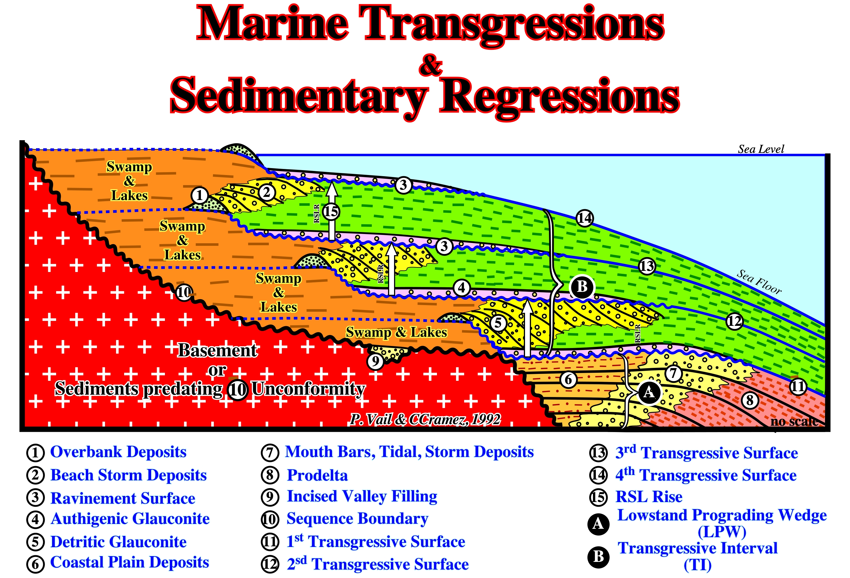
Figure 042- On this geological model, above the lower sequence-cycle boundary (10), which corresponds to the unconformity (10), i.e., to an erosional surface, are represented the uppermost part of the of the lowstand systems tracts group (LSTG), represented here by sequence-paracycles of lowstand prograding wedge (LPW) and an incised valley fill (Ivf) and the lower member of the highstand systems tracts group (HSTG), i.e., the transgressive interval (TI). The first marine ingressions (11) displaced the depositional coastal break (more or less the shoreline on seismic lines) landward creating at sea floor a ravinement surface, i.e., a quite insignificant erosional surface and a small shelf. The during the stability period of the relative sea level rise, sedimentation resumes and the shoreline is displaced seaward as prograding sequence-paracycles are deposited (outbuilding predominates upbuilding). Since the second marine ingression takes place (12) due a relative sea level rise in acceleration, again the shoreline is displaced landward with formation of a new ravinement surface. Since the relative sea level reach a new stability period, again deposition resumes displacing seaward the shoreline. However, as generally the terrrigeneous influx decreases, since the extension of the shelf increases, the shoreline does not reach the position it has previously (before the last ingression). A new relative sea level rise in acceleration, i.e., more important than the previous one, occurs displacing the shoreline farther landward until relative sea level reaches a stability period. Then the deposition resumes displacing, again, the shoreline seaward, etc. etc.. Theses geological events (increasingly important marine ingressions an associated increasingly smaller sedimentary regressions) repeat until the rise of the relative sea level is decelerated (beginning of the highstand prograding wedge, HPW).
Transgressions (not a transgression) as Cesare Emiliani (1992) stipulated, is a set of increasingly important marine ingressions and associated increasingly small sedimentary regressions, that collectively create a retrogradational morphology.
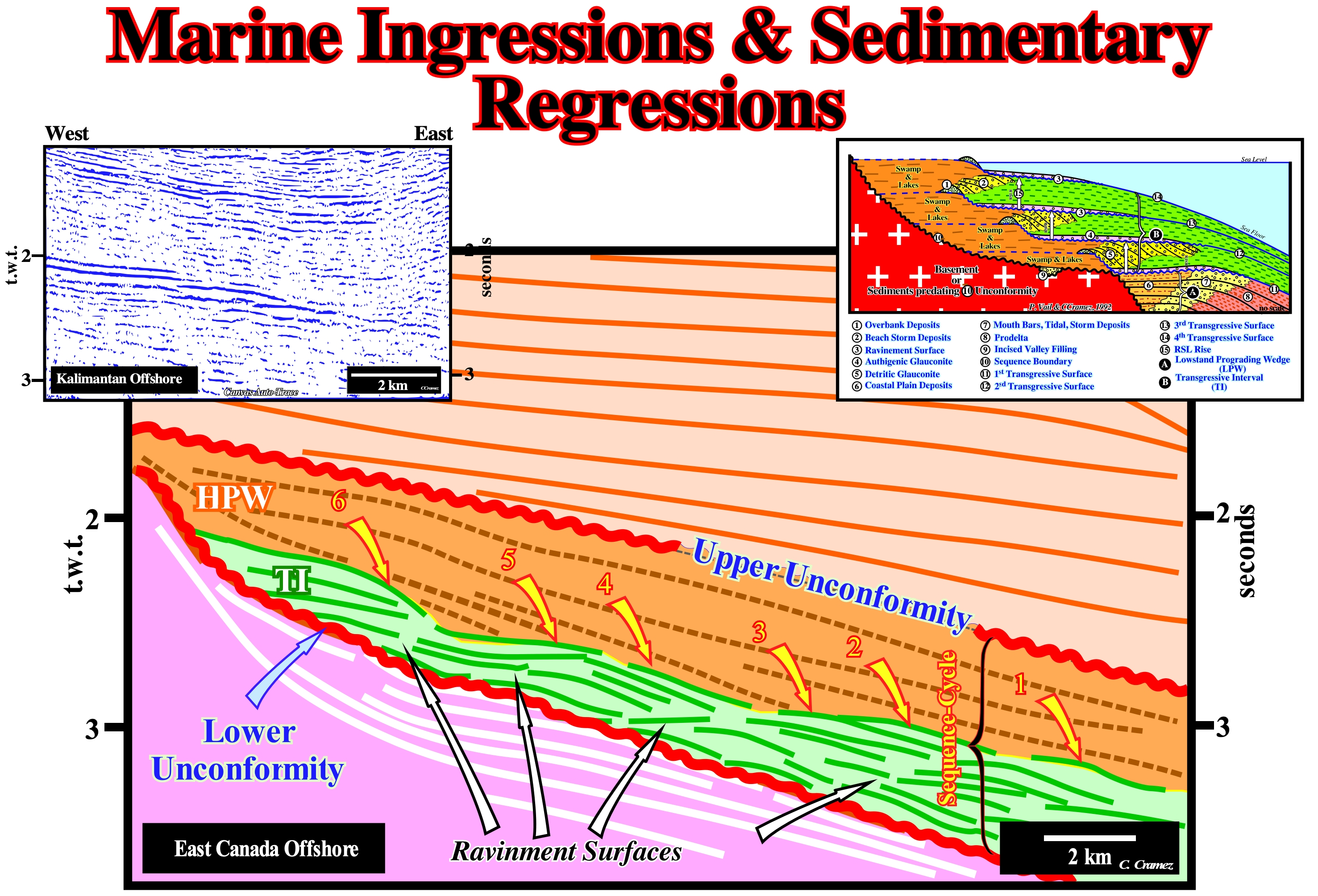
Figure 043- On this tentative geological interpretation of a Labrador Sea seismic line, within a sequence-cycle, induced by a 3 rd order eustatic cycle, whose time-duration varies between 0.5 My and 3.5 My, the transgressive interval (TI), which certain geoscientists call, inappropriately, transgressive systems tract is, easily, recognized between the lower unconformity of the sequence-cycle and the highstand prograding wedge (HPW). The reflectors of the underlying sequence-cycle are represented by thick, white traces, while those of the transgressive interval (TI) are colored in green. The reflectors of the transgressive interval (TI) rest by coastal onlaps against the reflectors of the underlying sequence-cycle emphasizing an unconformity (erosional surface). Within the transgressive interval, the presence of four ravinement surfaces is observed and, between them, the reflectors progradate seaward. The transgressive interval, in its entirety, corresponds to the transgressions of C. Emilia (1992), i.e., to a set of increasingly important marine ingressions (relative sea level rises) and increasingly smaller sedimentary regressions, which, creates, globally, a retrogradational geometry. The relative sea level is a local sea level, referenced at any point on the Earth's surface, which can be the sea floor or the base of the sediments (top of the continental crust) and which is the result of the combined action of the tectonics (subsidence or uplift of the sea floor) and the absolute (eustatic) sea level, which is supposed to be global and referenced to the Earth' center of the Earth. As can be seen on this tentative interpretation, as well as in the geological model, since the first relative sea level rise, which floods the preexisting topography, the shoreline (more or less the depositional coastal break of the depositional surface) is displaced landward (marine ingression), creating on the deposited sediments, a ravinement surface. At the same time, a water-depth is created (development of the shelf within the sequence-cycle) and available space for the sediments (accommodation). During the stability period of relative sea level, which follows the marine ingression, the transported sedimentary particles, gradually, deposit in progradational sedimentary packages (sequence-paracycle) moving the shoreline, progressively, seaward, but without reaching its previous position. A shelf is thus initiated, between the continental edge and the new shoreline. A more important marine ingression than the previous one, again, shifts landward the depositional coastal break of the depositional surface, creating a new ravinement surface and increasing, again, the space available for the sediments. At the same time, lowstand geological conditions with a low sedimentation rate, are developed in the distal part of the platform (near the continental edge). More sediments will be deposit during the new stability period, in progradational packages, but, as before, the shoreline does not reach the extreme position it had before this relative sea level rise. New marine ingression, even more important, etc., etc. This geological history is repeated several times, until, finally, the new marine ingression is smaller than the previous one, i.e., until a relative sea level rise is deceleration, what starts the deposition of the highstand prograding wedge (HPW), during the stability period of relative sea level, as the shoreline begins to move, progressively, seaward diminishing the extension of the continental platform (shelf). It is important not to forget that a marine ingression27 reduces the Earth's albedo (ratio of reflected light energy to incident light energy), since the sea surface absorbs more solar radiation than the Earth's surface. Thus, probably, the temperature gradient between low and high latitudes is reduced during large marine ingressions. Some of this reduction is attributed to the increase of the CO2 content in the atmosphere, increased volcanic activity along the mid-ocean ridges, and increased organic productivity. On the contrary, a marine ingression contributes to the deposition of fossil-rich marine sediments on the continent, which means that sedimentary regressions interrupt the marine sedimentation on the continent, at same time, as erosion reduces the sedimentary deposits, previously, settle down, which implies that the continuity of marine records in a given region of the continent, rarely, exceeds a few tens of millions of years. Thus a Phanerozoic continuous record can, just, be reconstructed correlating and joining different stratigraphic sections.
27 During the Phanerozoic geological time, the sea level oscillated more than 600 meters (C. Emiliani, 1992).