

13) Downlap Surfaces & Marine Source Rocks
Potential marine source-rock, can be localize, in the field or on seismic lines. They lie along the interfaces between retrogradational and progradational intervals.
Ulmisheck and Klemme (1991) showed the majority of the oil and gas reserves, in the world, were generated by particular organic-rich stratigraphic interval. Taking into account the hydrocarbons lost during the Hercynian Orogeny, around 60% of the world’s hydrocarbon reserves come from Upper Jurassic (25%) and Aptian / Turonian (29%) organic-rich intervals (figure 051).
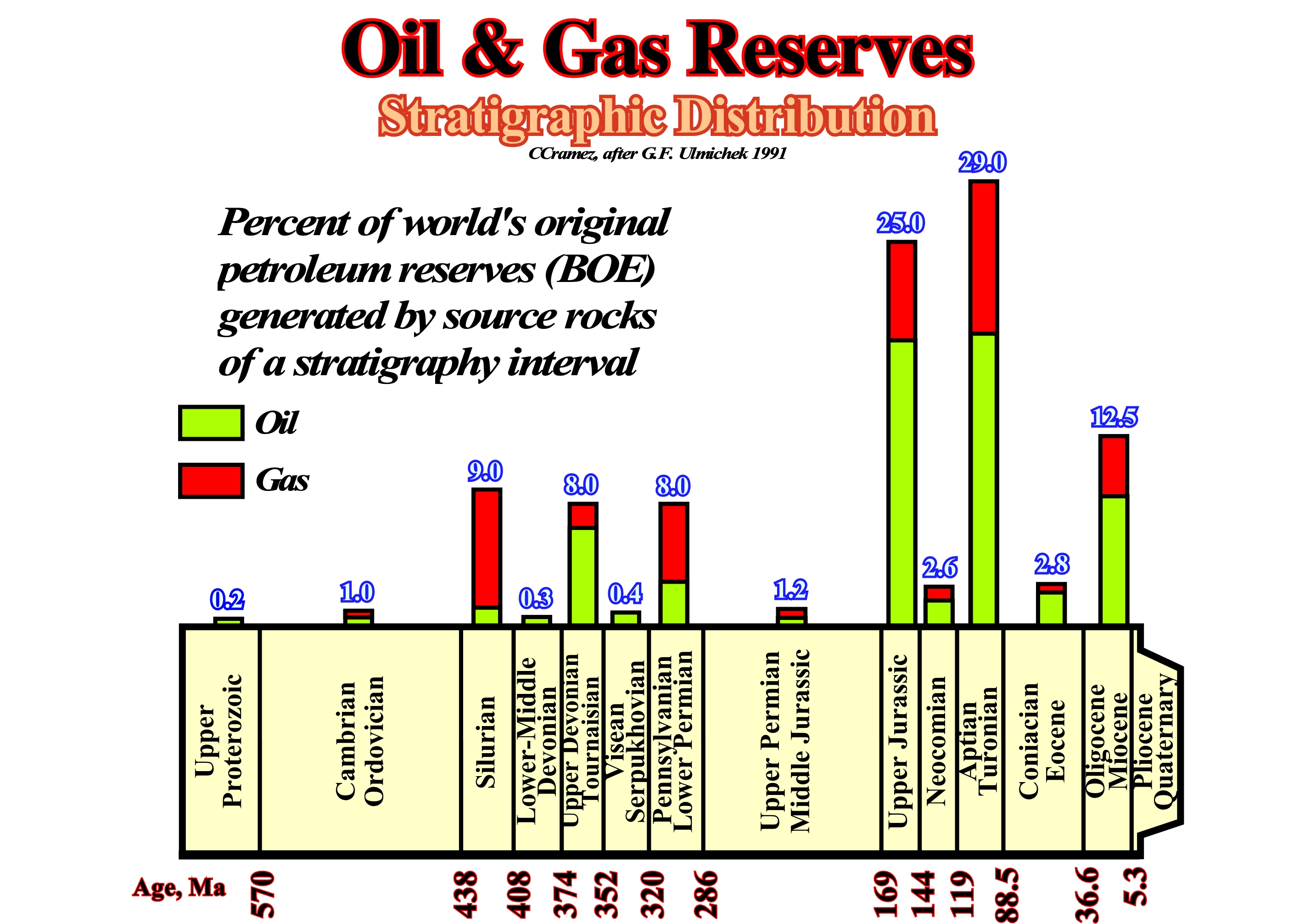
Figure 051- In this cross-plot, the green color represents the oil reserves. The gas reserves are represented in red. The numbers on the bottom of the diagram indicate the geological age in million years. The numbers above each column represent the percentage of world's original petroleum reserves (BOE) generated by source-rocks of a stratigraphic interval. As there is any reason to suppose that the pre-Pangea source-rocks are not so good as the post-Pangea source-rocks, geoscientists assumed that a lot of hydrocarbon was lost during the Hercynian orogeny. Taking into account the oil and gas reserves known in the world, the Paleozoic source-rock intervals generated, roughly, 30%. The Upper Jurassic and Aptian-Turonian source-rocks generated around 60% of the world's original hydrocarbon reserves. Around 10% of the hydrocarbon reserves seem to be associated with Upper Tertiary source rocks, mainly, lacustrine.
Assuming the amount of hydrocarbons lost during the Hercynian Orogeny affected in the same way all Paleozoic potential source-rocks, the Ulmichek's diagram (figure 051) indicates that most of the world reserves were generated during periods of high sea level,i.e., during the Cambrian / Silurian and Jurassic / Cretaceous transgressions. Such a statement is particularly true for the post-Pangea stratigraphic interval, where the Upper Jurassic and Middle Cretaceous marine source-rocks produced around 60% of the world's reserves. The values for the Paleozoic source-rocks are too affected by the erosion during the Hercynian orogeny to be meaningful.
To understand how potential source-rocks can be recognized on seismic data it is useful to review some of the geological features of continental encroachment stratigraphic cycles and subcycles :
- There are two major continental encroachment cycles in the Phanerozoic ;
- The continental encroachment cycles (figure 052) are associated with 1st order eustatic cycles28 created by the changes in ocean basin volume induced during the breakup of the proto-Pangea and Pangea supercontinents and subsequent gathering of the individualized continents ;
28The older 1st order eustatic cycle started in the late Precambrian, around 600 million years ago and ended in the Permian with the formation of the Supercontinent Pangea. The younger started at end Permian and continues today. Each of these eustatic cycles have a corresponding stratigraphic cycle. The older eustatic cycle corresponds to the Pre-Pangea or Paleozoic Continental Encroachment Stratigraphic Cycle, whereas the younger 1storder eustatic cycle corresponds the Post-Pangea, or Mesozoic / Cenozoic Continental Encroachment Cycle
- The older cycle started in the uppermost Proterozoic time and extended to the end of Permian ;
- The Proterozoic was a time of slow encroachment with regression, whereas Cambrian time was a period of extensive encroachment with transgression ;- An eustatic high was reached during the Ordovician / Silurian time and from Silurian to Permian time there was a gradual restriction of the marine domain.
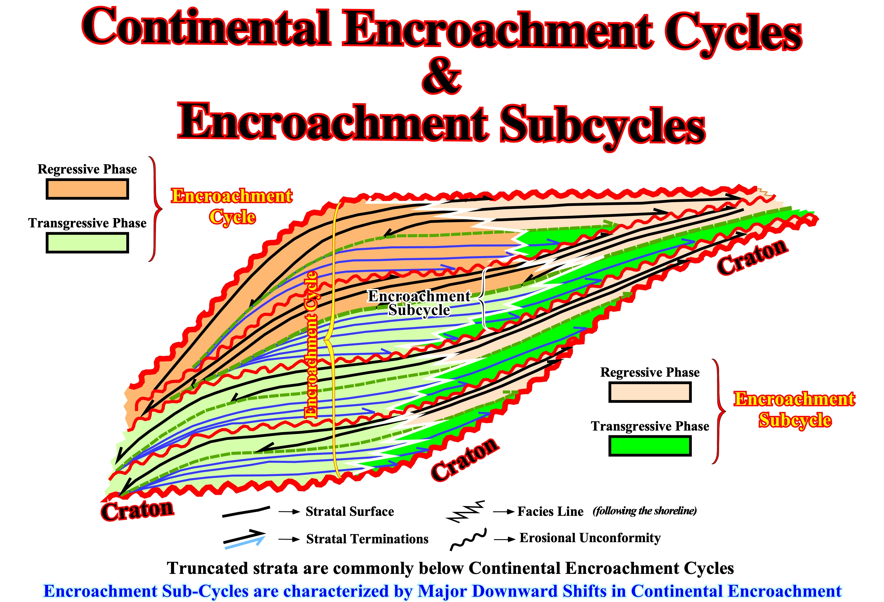
Figure 052 - Continental encroachment subcycles form a continental encroachment cycle. They have the same characteristics but different hierarchies. The transgressive phase of a continental encroachment cycle or subcycle has a backstepping geometry. Contrariwise, the regressive phase has a progradational or forestepping geometry. When the absolute sea level rises, the depositional coastal break is individualized from the shelf break and is displaced landward during the marine ingression. Such a landward displacement of the shoreline creates a continental platform which widens and deepens as long as the sea level continues to rise in acceleration.
- The younger cycle started in the Triassic and extents to the Present time ;
- Triassic Period was a time of slow encroachment of sediments onto the craton, while the Jurassic and the Early Cretaceous Periods were times of extensive encroachment ;
- Early Turonian time is believed to have been the time of maximum eustatic high, while Late Cretaceous and Cenozoic time were characterized by a gradual restriction of sediments to the continental margins and basinal areas ;
- The maximum marine transgression within the continental encroachment cycles occurred at the Ordovician / Silurian boundary in the older cycle and nearly Cenomanian / Turonian time on the younger cycle ;
- Each continental encroachment cycle shows a smooth long-term landward displacement of the shoreline followed by a seaward displacement ;
- Sedimentary packages deposited during the landward shoreline displacement show mainly parallel and retrogradational geometry and make up what is termed the transgressive phase ;
- Sedimentary packages deposited during the seaward displacement of the shoreline have mainly forestepping progradational geometries and comprise what is termed the regressive phase ;
- The transgressive phase thickens landward to a maximum and then pinches out against the craton ;
- The regressive phase reaches maximum thickness seaward and becomes condensed in the more distal parts of the basin ;
- The surface between the transgressive and regressive phases is marked by a downlap surface, which represents the eustatic high and a period of starved sedimentation ;
- The boundaries between the transgressive and regressive phases of the Phanerozoic stratigraphic cycles correspond to the Cenomanian-Turonian and the Cambrian - Ordovician maximum eustatic highs, which are marked, on seismic lines, by major downlap surfaces and maximum encroachment of the coastal onlaps (figure 053).
- On regional seismic lines, both of these geological features correspond to interfaces between retrogradational and progradational geometries of the seismic markers.
The above geological conditions combined with coeval upwelling currents and anoxic environments are favorable for the development and preservation of major source rocks. Recognizing the major downlap surfaces of the continental encroachment cycles, geoscientists can located the more likely marine source-rocks, as illustrated in figure 051.
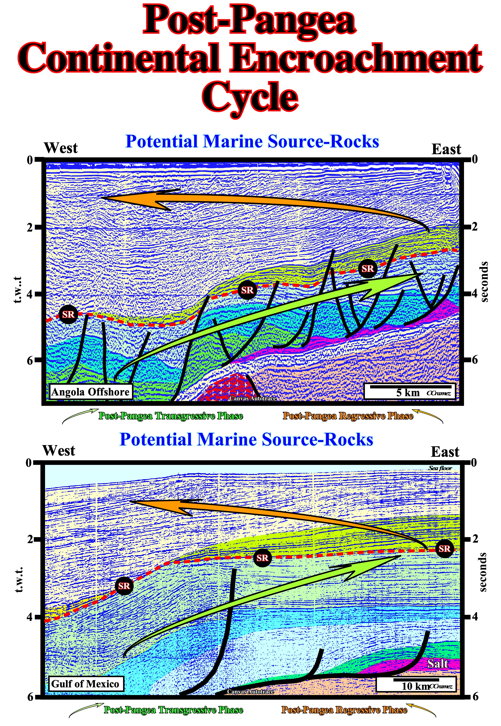
Figure 053- On the left is illustrated a tentative geological interpretation of a Canvas autotrace of seismic line of Angola offshore. A vertical stacking of two sedimentary basins is recognized: (i) At the bottom, landward of a buried hill a rift-type basin, colored in brown and (ii) Above the breakup unconformity, the continental margin. In spite of intensive salt flow (the salt is colored in violet), the transgressive or retrogradational phase is, easily, recognized below the Cenomanian / Turonian downlap surface. This phase is, here, underlined by the green arrow pointing landward, indicating that the depositional coastal break was displaced landward as absolute sea level rose. The regressive or progradational phase is also, easily, recognized by the foresetting geometry of the seismic markers above the major downlap surface. The major marine source-rocks on this margin are concentrated between the two phases, along the Cenomanian / Turonian downlap surface, underlined here in red. The associated marine potential source-rocks have not generated hydrocarbons because they have not been buried deep enough for their organic matter reach maturation. Actually, on this area, the generating petroleum sub-system is composed of the lacustrine source rocks deposited in the rift-type basin and in the margin below the salt layer. Below, is a tentative geological interpretation of a seismic line from the Gulf of Mexico, where the post-Pangea continental encroachment cycle corresponds to the superposition of a Pannonian basin and a divergent continental margin. As in the Angola line, the transgressive and regressive phases of this stratigraphic cycle are, easily, recognized by the retrogradational and progradational geometries. The interface between these phases is the Cenomanian-Turonian downlap surface (MFS 91.5 Ma) , with which potential marine source rocks are associated.
During a continental encroachment cycle, onlapping against the cratons does not always shows continuous landward and upward movement (positive aggradation). Occasionally, the onlapping shows major shifts seaward and downward (negative aggradation). During these large downward shifts of the coastal onlaps, the coastal plain and the upper slope are exposed, due to major eustatic sea level falls, and a pronounced erosional surface is formed, creating unconformities.
As a continental encroachment cycle, a continental encroachment subcycle is defined as being between two consecutive downward shifts of onlap (i.e., two significant erosional unconformities within a continental encroachment cycle). Each subcycle is developed in association with a 2nd order eustatic cycle (time duration between 3-5 My and 50 My). Inside each encroachment subcycle, the most significant downlap surface separates a retrogradational subphase from an overlying progradational subphase (figure 052). Basinward, the extent of this downlap surface varies from one subcycle to another and depends on the construction of each subcycle. The major downlap surface of the continental encroachment cycle coincides with the downlap surface of only one of the subcycles. Downlap surfaces of the rest of sub-cycles are therefore considered to be secondary downlap surfaces, as illustrated in figure 054.
In petroleum basins around the world, tentative geological interpretations using stratigraphic cycles and geochemical studies show a correlation between the marine source-rocks and the downlap surfaces of the continental encroachment cycles and subcycles.
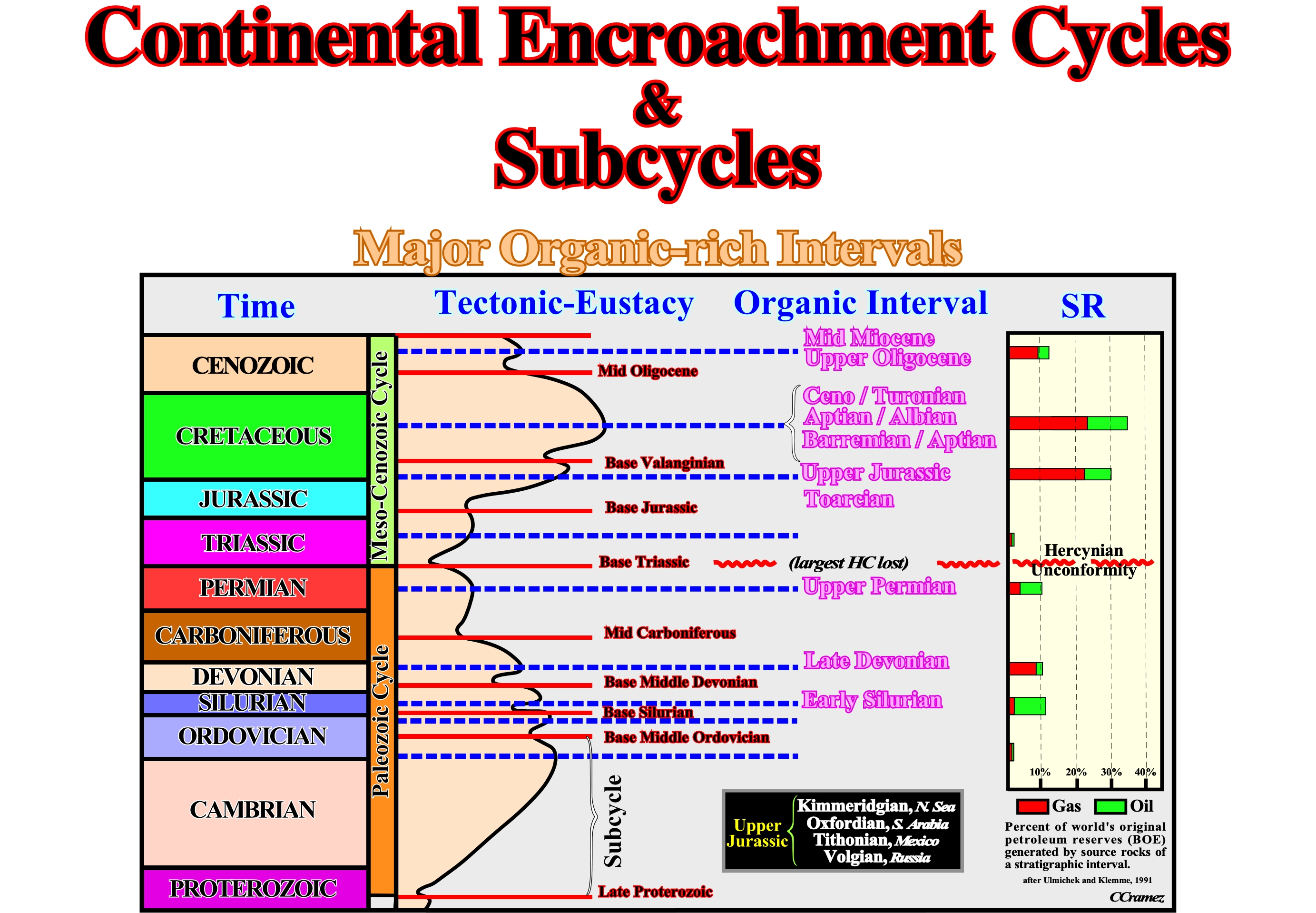
Figure 054 - The major organic-rich intervals in the Phanerozoic are associated with downlap surfaces of the continental encroachments subcycles. The correlation with the percentage of the world’s original petroleum reserves generated by source-rocks of stratigraphic intervals proposed by Ulmisheck and Klemme (1990), is quite good despite hydrocarbon loss during the aggregation of the supercontinent Pangea. The highest percentage is associated with the major downlap surface of the continental encroachment cycles (Ordovician / Silurian and Middle-Upper Cretaceous). In the Upper Jurassic, Kimmeridgian source-rocks are found in North Sea, while Oxfordian source-rocks exist in South Arabia. Similarly, in Mexico the main source rocks are associated with organic-rich Tithonian source-rocks.
During The Phanerozoic, two major downlap surfaces : (a) Cambrian / Ordovician and (b) Early Late Cretaceous, are associated with the major organic-rich marine source-rocks, respectively, in the proto-Pangea and Pangea continental encroachment cycles. Secondary downlap surfaces within the encroachment subcycles are associated with the rest of the important marine source-rocks. From bottom to top, the age of the potential marine-source rocks can be summarized as follows :
(1) Early Silurian, within the continental encroachment subcycle bounded by the Base Middle Ordovician and Base Silurian unconformities ;
(2) Late Devonian, within the continental encroachment subcycle bounded by the Base Silurian and Base Middle Devonian unconformities ;
(3) Upper Permian, within the continental encroachment subcycle bounded by the Mid-Carboniferous and Base Triassic unconformities ;
(4) Toarcian - Upper Jurassic, within the continental encroachment subcycle bounded by the Base Jurassic and Base Valanginian unconformities ;
(5) Barremian - Aptian / Aptian-Albian / Cenomanian - Turonian, within the continental encroachment subcycle bounded by Base Valanginian and Mid Oligocene unconformities ;
(6) Upper Oligocene - Mid Miocene, within the continental encroachment subcycle bounded by the mid Oligocene and today.
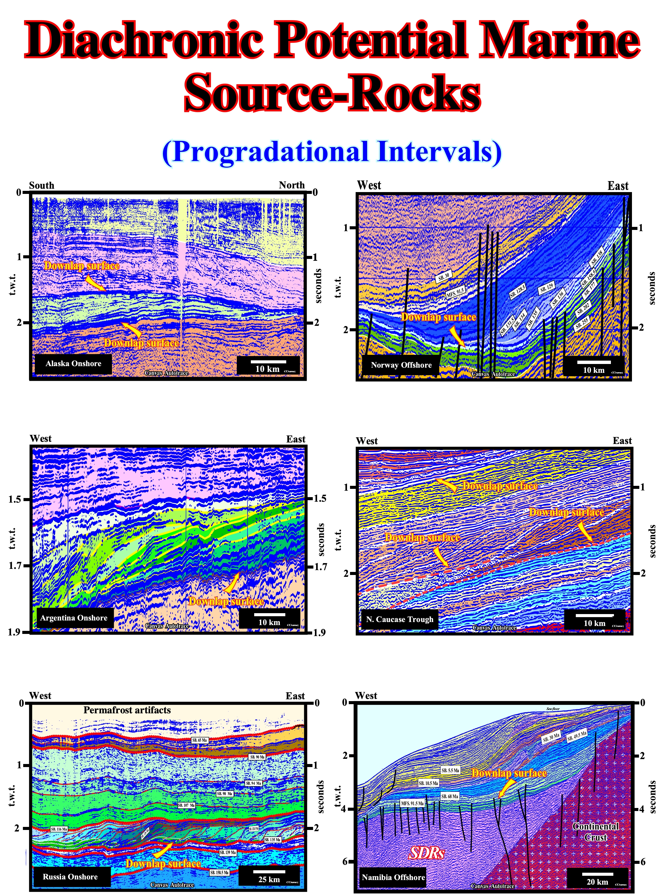
Figure 055- In this figure are illustrated source-rocks associated with relative shallow marine (60-300 meters water-depth) progradational intervals. In Alaska onshore, the marine potential source-rocks associated with the lower downlap surface are deposited in the continental margin basin, while those associated with upper downlap surface are in the foredeep basin. In Norway offshore, the source-rocks associated with the downlap surface belong, probably, to the top of the North Sea rift-type basin (Kimmeridgian shales). In Argentina onshore (Neuquén geographic basin), the diachronic source-rocks associated with the illustrated downlap surface (Vaca Muerta source-rocks) were deposited in the upper phase of the backarc basin. In the North Caucus trough, the lower downlap surface emphasis the source rocks of the margin basin (probably the equivalent of the Tithonian / Early Berriasian Bazhenov shales), while the upper downlap surface can underline the equivalent of the organic-rich Oligocene / Miocene source-rocks (Maykop formation). The tentative geological interpretation of the Russia onshore seismic line (West Siberia), illustrates the progradational interval characterizing the organic-rich Bazhenov shales, which have been called the world’s largest oil source-rocks (take into account the undulations induced by permafrost lateral changes). The downlap surface, illustrated in the Namibia offshore, limits the transgressive and regressive phases of the post-Pangea continental encroachment cycle. It emphasizes the stratigraphic location of the main marine source-rocks, particularly in Angola and Brazil offshore, deposited above the salt interval. Obviously, in the Namibia offshore, the organic matter of these source rocks is immature.
Summarizing: For the conventional marine source-rocks, the recognition and mapping of continental encroachment cycles and subcycles, strongly, enhance the probability of locating the main petroleum generating subsystems, without which all the other necessary requisites for a play (i.e., reservoir-rocks, traps, seal, etc.) become irrelevant. The focus is therefore on 1st order and 2nd order stratigraphic cycles (identification of encroachment cycles and subcycles, using the geometrical relationships, recognition and mapping of major downlap surfaces). Whereas seismic stratigraphy is, generally, more focused on finding reservoirs, such methodology contributes, also, to identifying regional seals, which is of course another major issue, and new exploration areas with poor stratigraphic control. This approach may become critical for the long-term strategy of an industry faced with an ever-increasing maturity of established petroleum provinces.
In a lot of petroleum systems, around the world, as it the case in some Argentina petroleum basins, the generating petroleum sub-system is formed by non marine source-rocks, particularly, lacustrine and epeiric source-rocks. A quickly review on these source rocks will be welcome (figure 055).
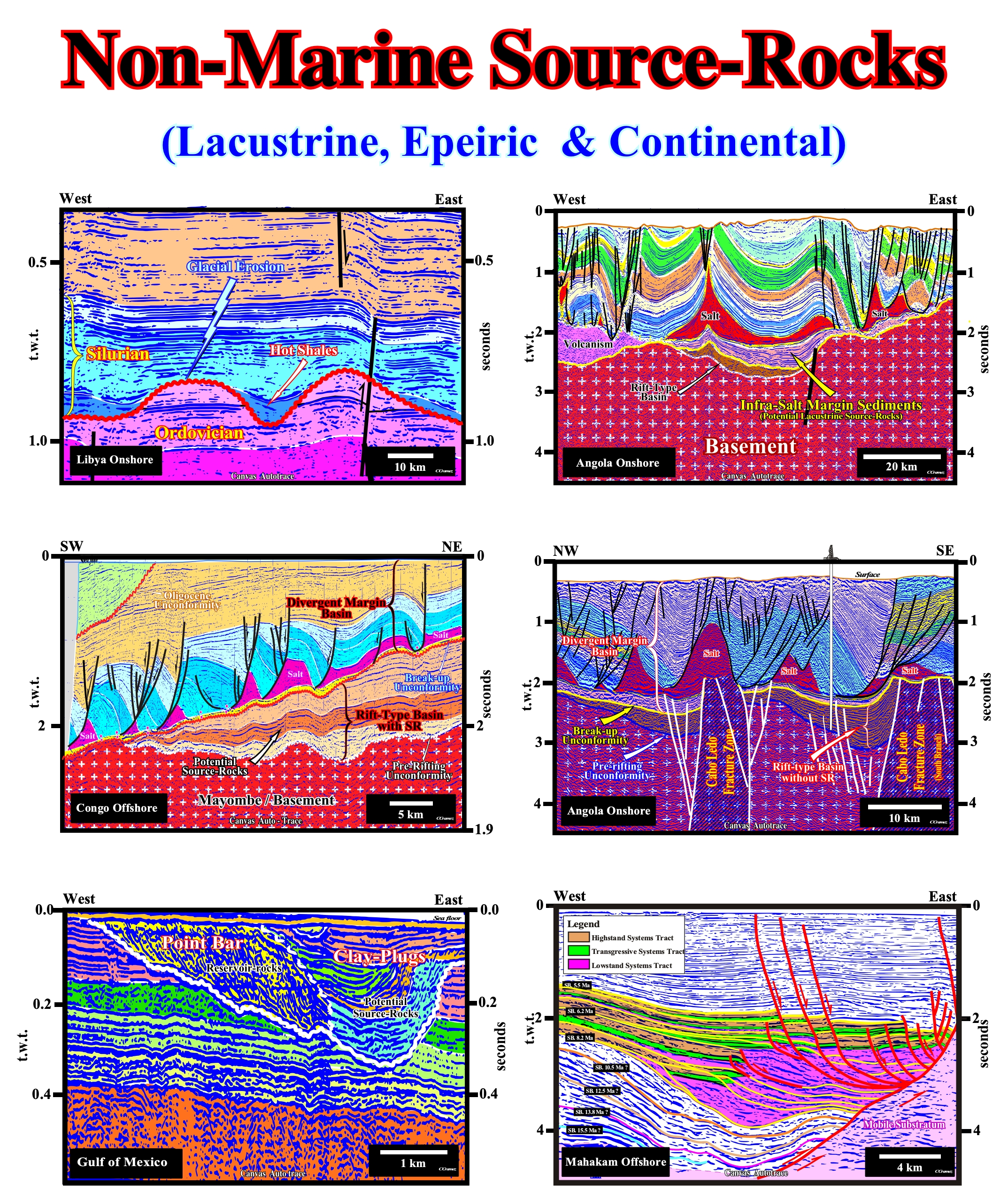
Figure 056- On this figure are illustrated tentative geological interpretation of Canvas autotraces of seismic lines, in which non-marine potential source rocks, i.e., lacustrine, epeiric or continental source-rocks were corroborated by drilling, as in Libya, Angola, Congo, Indonesia, etc., or highly probable as in the Gulf of Mexico seismic line of the. As described in the text, the Silurian “Hot Shale” are, basically, epeiric source-rocks, since they were deposited in an inland extension of the sea, which flooded the Ordovician glacial valleys. In Angola onshore, the infrasalt margin source-rocks are lacustrine. They were deposited in large lakes developed after the breakup of the lithosphere, immediately, after the deposition of the subaerial lava flows. On the Congo offshore seismic line, the source-rocks were deposited in the rift-type basins, which predate the breakup of the Gondwana. They are lacustrine source-rocks and they correspond, roughly, to the source-rocks of the Bucomazi formation. In the Mahakam offshore, the source-rocks are continental. They correspond to the coal layers deposited in the deltaic plain, i.e., deposited landward of the depositional coastal break. The seismic line of the Gulf of Mexico illustrates the infilling of a meander, in which the potential reservoirs-rocks correspond to the sandstones of the point bars, which clearly, migrate eastward, and the speculative potential source-rocks are associated to the clay-plugs (obvious, the burial is insufficient to mature the organic matter). The clay plugs correspond to the aggradational infilling of oxbow lakes, in which the organic matter can be preserved by anoxic conditions, which are quite frequent in such depositional systems. The stacking of several clay-plugs, strongly suggest, that the river after the abandonment of its bed took several times the original path. Each clay-plug can be taken as an abandonment period of the river creating an oxbow lake. The presence of reservoir and source-rocks alongside one another, favor non-structural traps.
(i) The Silurian “Hot shales” of the Murzuk basin in Libya (figure 055) are an excellent example of the epeiric source-rocks. The Late Ordovician Glaciation, which is seen in a lot of places, as Morocco, Libya, Algeria, Wyoming, Bolivia, Peru, Argentina29 etc. Such a glaciation and particular the Late Ashgillian not only is the leading cause of the Ordovician / Silurian extinction event, but the responsible for the glacial topography that characterized the end Ordovician.
29 This concepts can be used in Chaco-Parana Argentina (Paleozoic), which, so far, was seismically explored by an old, noised and sparse 2D seismic coverage. Potential Late Ordovician and Early Silurian post glacial source-rocks are likely (if not over-mature), as well as Early Permian post-glacial coaly and bituminous shales. Late Carboniferous interglacial deposits (channel stacking) as potential reservoirs are likely. However, as the strong Early Hercynian unconformity eroded the Silurian / Devonian sequences sub-crop maps are require to approach the hydrocarbon parameters as illustrated later.
In fact, all around of the Late Ashgillian ice cap (figure 056), the glaciers carved deep glacial valleys. Later, just before the great flooding of the continent by the Silurian sea (Silurian ingression), that is to say, still during lowstand geological conditions, the incised glacial valleys were flooded creating anoxic depositional environment, which were filled, progressively filled, by organic-rich shales (“hot shales”), which are coeval of the sediments of the upper lowstand prograding wedge (lowstand systems tract). With the flooding of glacial Ordovician sediments, following the Silurian relative sea level rise, the shoreline was displaced continent-ward, far away from the shelf break, creating a large continental platform seaward of the Ordovician continental slope. Then, due to the deposition of thick Silurian progradational interval, the extension of the platform was, progressively, reduced till the shoreline became, more or less, coincident with the old Ordovician shelf break, which became the new Silurian continental break. Since, that time, the basin has no shelf and the continental slope was, progressively, accreted by slope Silurian sediments.
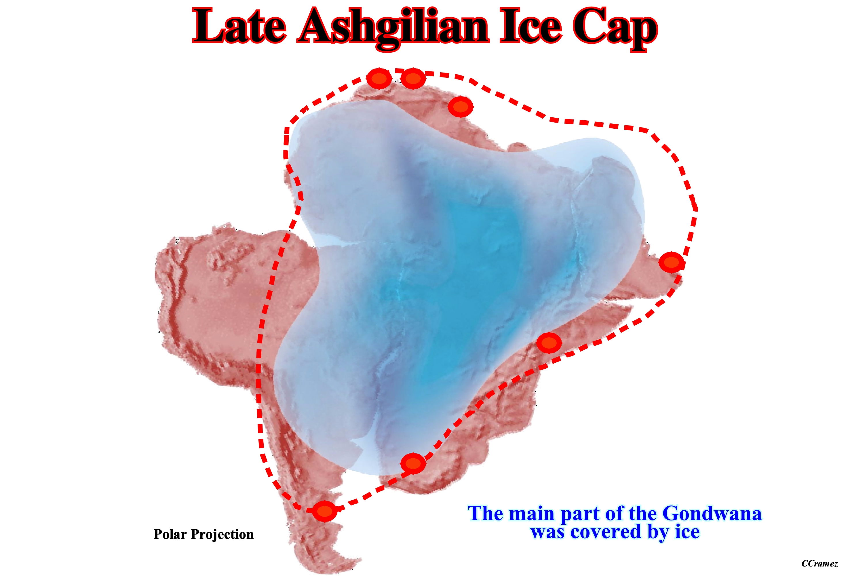
Figure 057- This figure illustrates the extent of the Late Ashgillian ice cap, that covered the majority of the Gondwana. At that time, the northern part of Argentina was covered by ice and the glaciers flowing southwestern carved deep valleys as it was the case in Algeria and Morocco. Later, such a valleys were flood by the Silurian sea creating conditions for deposition of organic-rich shales that when buried enough form potential source-rocks.
(ii) In the geographic Kwanza basin (Angola), after the breakup of the Gondwana lithosphere and immediately after the deposition of the subaerial lava flows, large lakes or epeiric sea (inland seas are shallow seas that cover central areas of continents during periods of high sea level at the onset of marine transgression ; presently, as continents stand high and eustatic sea level is low, there are few epeiric seas, being the larger the Caspian Sea) where developed at the onset of the Cretaceous transgression.
Such a depositional environments, particularly the larger ones, were filled, partially, by organic-rich sediments (organic matter type I), which form today, in onshore and offshore Angola (southward of the Ambriz structural arch), the more likely infrasalt potential generating petroleum sub-system (figure 055). In fact, in this area, the majority of the rift-type basins, formed before the break-up of the Gondwana lithosphere, have no hydrocarbon potential. They are halfgrabens too small with a typical divergent internal configuration and filled up by lateral terrigeneous influx. The more likely generating petroleum sub-system is formed by the margin infra-salt potential lacustrine or shallow water source-rocks, which are quite similar to those developed in western South Atlantic margins that generated almost all of the hydrocarbons of the recent petroleum discoveries in deep-water Santos offshore. Unfortunately, such a margin infrasalt depocenters seem not to be present southward of Santos offshore. They are not present in the geographic Pelotas basin (Brazil and Uruguay offshore). On the other hand, the regional seismic lines of Argentina offshore corroborate the absence of such a lower margin depocenters.
(iii) In the Congo onshore and offshore, as well as, in the Cabinda onshore and offshore (Cabinda also spelled Kabinda, formerly Portuguese Congo, known locally as Tchiowa, is an enclave and province of Angola, separated from the rest of Angola by a narrow strip of territory belonging to the Democratic Republic of the Congo, which bounds the province on the South and the East.), the rift-type basins, developed before the break-up of the lithosphere, were filled, partially, by organic-rich lacustrine sediments, which form, probably, the most important generating petroleum subsystems.
Contrariwise to the rift-type basins of the geographic Kwanza basin, the Congo rift-type basins have large dimensions and parallel internal configurations. Certain geoscientists advanced the conjecture that the development of potential lacustrine source-rocks in the rift-type basins imply a divergent internal configuration of the sedimentary infilling. Actually, the development of organic-rich lacustrine shales requires the formation of a lake in the rift type basin, that is to say, the creation of a water column. Such a water column is likely, when the rate of lengthening (extension) is not balanced by the terrigeneous influx. When the rate of extension is balanced by the terrigeneous influx, the water depth is, practically, zero. The infilling sand-prone sediments thick toward the bordering fault, where the differential subsidence is higher. In figure 055 (tentative geological interpretations in the middle of the figure) illustrated two rift-type basins with different internal configurations. The one, located in Congo offshore, which has a parallel internal configuration is rich in lacustrine source-rocks (Bucomazi organic interval colored in brown), while the one located in the Kwanza onshore has a divergent internal configuration is, almost, totally filled by sandstones, as corroborated by the exploration wells drilled in the area.
(iv) Potential non-marine source rocks are, likely, in oxbow lakes, even when the abandonment of stream bed (the channel bottom of a stream, river or creek, which confines of the normal water flow. The lateral confines or channel margins, during all but flood stages are the stream banks or river banks) is intermittent, as seems to have been the case in the meander illustrated in figure 055 (Gulf of Mexico seismic line). In fact, clay plugs, rich in organic matter, are not only found in modern meanders belts but in ancient meanders belts as well.
Such a potential source-rocks seem to generate hydrocarbons enough to feed small economical accumulation, particularly, in onshore structural mature petroleum basins as it seems to be the case of onshore Argentina basins. The geographic Cuyo Basin (Triassic) seems to be a good candidate. Indeed, after more than 70 years of structural exploration new no-structural traps are likely. Potential reservoirs-rocks (mainly point bars) of the Carninan Potrerillos formation can be feed by local source-rocks deposited in the nearby oxbow lakes (abandoned meanders) and paleo-valley of the Norian Cacheuta formation).
(v) The Mahakam delta building of complex, illustrated by the tentative geological interpretation shown in figure 056 (Mahakam offshore, in southeast Kalimantan, Indonesia) is a good example to illustrate that non marine source-rocks with organic matter type III can be predicted on seismic data.
Geologically speaking, this Mahakam offshore is a back-arc basin developed within the Mesozoic / Cenozoic megasuture. The illustrated tentative geological interpretation was performed in sequence-cycles, which were deposited during eustatic cycles of 3rd order lasting between 0.5 and 3-5 million years. The widespread fore-stepping geometry of the sequence-cycles indicates an overall regressive pattern with a general seaward displacement of the depositional coastal break. Every time the relative sea level rose, the seaward shift of the shoreline was interrupted by a landward shift (some of them are under seismic resolution). However, the amplitude of the landward displacements decreased upward which means that overall the shoreline is regressive. The calibration of several tentative geological interpretations using sliding averages of exploration wells indicates that the encroachment of transgressive intervals decrease upward, but also the time displacement of the limits between the different sedimentary environments, i.e., alluvial plain, delta plain, delta front and upper slope. The combination of the sliding averages with the chronostratigraphic lines given by the seismic reflectors shows an important Upper Miocene depocenter on the delta plain and the presence of abundant coal beds on the delta plain and organic marine shales on the delta front. The source-rocks for the hydrocarbons of all Mahakam gas and oil fields are these coals and these delta-front marine organic shales (the Middle-Upper Miocene delta plain and delta front depocenters are so thick that the potential source rocks are within the oil window landward). However, most hydrocarbons were generated by the coals and not by the delta-front marine organic shales. The Total Organic Content (TOC) and the Hydrogen Index (HI) are very significant. The productivity of the delta-front organic shales is 30-40 kg of hydrocarbons per tonne, whereas that of the coals is around 200 kg per tonne. The productivity of the slope shales is around 2 kg per tonne.
In conclusion : The best way of finding type III non-marine source rocks, and particularly coal, is to look for thick delta-plain depocenters on progradational regressive intervals.