

Foreword :
"All geological observation are theory laden"
After several geological expertises in the proved and speculative petroleum systems (Magoon's terminology) in South Atlantic geographic basins, particularly, in Angola and Argentina, I found out the majority of the geoscientists, working in petroleum exploration, propose naive tentative geological interpretations of the seismic lines and electrical logs, using, often, questionable geological models. Several of them use the “Tabula Rasa” interpretation approach assuming, erroneously, the conjecture that observation precedes theory 1. Often, they shot seismic grids, particularly 3D, to try to understand geological and petroleum problems and not to test a priori geological ideas or conjectures. They forget that all geological observation is theory laden. In addition, they try, always, to verify their inductive interpretations and not to refute them. Criticism, as growth of knowledge, is totally ignored. Therefore, their interpretations are, often, quite controversial and even completely wrong.
1On this subject, it important do not forget that:
A) In the inductive approach, geoscientists start by making observations. Then, they invoke hypotheses. Their hypotheses can never be completed verified by posterior observations, since observations are, necessarily, limited: you can’t keep throwing rocks at windows forever in order to conclude that throwing a rock at a window it breaks, i.e., the experimental method is “finistic” (M. Macrone, 1994). They try, rarely to refute their hypotheses. The swan metaphor of K. Popper is, highly, significant. In a slightly modified form, it can be expressed as follows: It is not because a geoscientist saw, in Copacabana beach, 1332 girls in bikini, that he has the right to say that, in Copacabana beach, all girls wear bikini (induced hypothesis). Just one dressing a bathing costume is enough to refute the induced hypothesis, even if he spends few days to find her.
B) In the rationalist or hypothetic-deductive approach, geoscientists try to solve problems by trial and error. When they have a problem, they advance an a priori hypotheses. Then, they try to refute the advanced hypotheses by observations.
These two scientific approaches are very different:
(i) In the inductive approach, a geoscientist can do all kind of jobs. He just needs to observe. Observations precede theory. However, if he does not know what is a delta or a deep sea fan, for instance, he can spend hours, weeks, even months looking at a 3D seismic data, shot in a deltaic area, without understanding what he is looking at and that he, eventually, has mapped. The same is true for geoscientists, that by challenge or by unconsciousness, accept tasks for which they have not been trained. Moreover, as the continuation of an inductive reasoning is the verification of the induced hypothesis, geoscientists makes, rarely, progress. In reality, it is quite difficult for a geoscientist to progress seeking to demonstrate that he is, always, right.
(ii) In the hypothetic-deductive approach, a geoscientist can only do the job for which he was trained. Observations are entirely dependent on the theory adopted by the observer. Theory precedes observation. For rationalists, as Sir K. Popper used to say, all observations are theory-impregnated, but, also, there is no pure, disinterested, theory free from observation.
Such philosophic critical thinking, strongly, contrasts with the inductive thinking of Francis Bacon, who was worried about the fact that theories may prejudice observations. This led him to advise scientists that they should avoid prejudice by purifying their minds of all theories. Similar concepts are still held in several major oil companies. I saw exploration managers, who hid the location and scales of the seismic lines before give them to the geoscientists in charge of the geological interpretation, not alleging confidentiality reasons, but "I want him to be honest and not to impose his ideas on the interpretation" (sic). However a seismic line without location and scales is just uninterpretable.
I belong to the geological community that thinks the deductive approach gives the better results in petroleum exploration. I think knowledge of Geology began with observations, but it not derives from observations. Like empiricists, I agree that there are no innate geological ideas, but I do not believe that all geological knowledge derives from observations. Geoscientists using the inductive approach argue, often, that geological knowledge is conform to observations, but as Kant showed long time ago, I prefer by far to change the order of the words and to say that all geological observations conform to the observer's geological knowledge.
A lot of geoscientists seem to have forgotten why they use seismic lines to make stratigraphic and tectonic interpretations. As a small reminder one can say, in the sixties, geoscientists working in oil companies thought the seismic reflectors, visible on seismic lines (unmigrated lines at that time), were associated with acoustic impedance contrasts created by the lithology (facies) of the sedimentary intervals. However, when Exxon explored the Portuguese Guinea offshore (now Guinea Bissau), they drilled three exploration wells based on the interpretation of the seismic lines. The first well found the top of the reservoir-rocks above an unconformity with Paleozoic rocks beneath. Before the second well, located, structurally, in a higher structural position, Exxon geoscientists predicted the reservoirs-rocks (delta front sandstones) should be found higher than in the first well. In reality, they were found further below. A similar discrepancy was obtained with the third exploration well. Given the negative exploration and geological results compared to expectations, Exxon geoscientists reinterpreted and calibrated the seismic lines. To everyone surprise, they concluded the seismic reflection associated with the top the reservoir-rocks found in the first well was two reflections above the top of the sandstones found in the second and even higher in the third exploration well. As the correlations between seismic and well data resist to all refutation tests, the micropaleontological studies, strongly, suggested:
"Seismic reflectors followed time-lines (chronostratigraphic lines) and not facies-lines (lithology), as was, formerly, admitted".
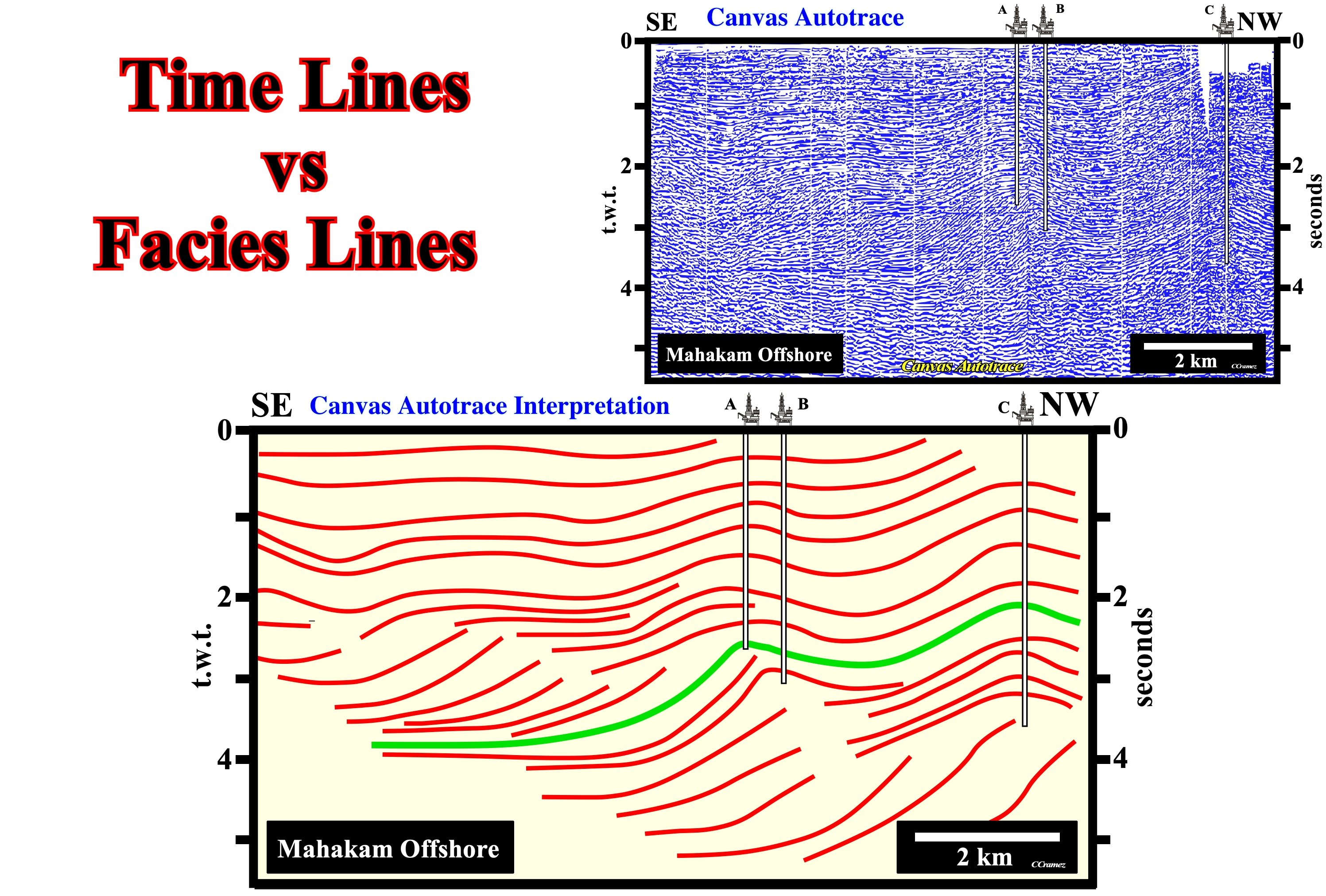
Figure 001 - In theory, seismic reflectors underline significant acoustic impedance contrasts between sedimentary intervals with different lithologies. In the sixties, geoscientists of oil companies using seismic reflection data in oil exploration, the reflectors, as illustrated on this modern Canvas autotrace of seismic line were interpreted as facies-lines. At that time, the seismic lines (unmigrated) were quite different of the modern lines than any geoscientist, with a minimum of geological knowledge, can interpret easily. Obviously, this was not the case at that time. The geological interpretation of seismic lines was made by geophysicists without or little geological knowledge. Each reflector corresponded to an interface between different lithologies (shale-sandstone, sandstone-limestone, etc.). The Canvas autotrace of a Mahakam offshore seismic line simulates the Exxon seismic line shot during the petroleum exploration of Portuguese Guinea offshore in which the exploration wells have been located (see text). On the Canvas autotrace interpretation, the seismic reflectors are underlined by color pencil lines. The A well exploration (first drilled well) recognized a limestone interval at the level of the green horizon. The same limestone level should be found in B and C wells, when the drill bit reached the green marker. It was with these ideas that Exxon’s geoscientists expected recognize and follow, on Guinea-Bissau offshore seismic lines, the prograding delta front (reservoir-rocks), since the acoustic impedance of sandstones is much higher than that of the prodelta clays or delta plain silts. However, as said in the text, after three exploration wells, Exxon’s geoscientists, after calibrated and testing their proposed geological interpretation the seismic lines, concluded that the seismic reflectors follow time-lines (chronostratigraphic surfaces) and not facies-lines (lithological changes).
Thus, for the first time, geoscientists recognized: (i) Correlations between seismic reflectors and electrical logs follow the real physical surfaces (bedding), which cut the time-lines of the rock units and (ii) Seismic reflections do not follow the limits of geological formations (facies), where the acoustic impedance contrasts occur, but the patterns of stratification i.e., the real physical surfaces of rocks. The reaction of Exxon geoscientist was immediate:
“As seismic reflectors follow chronostratigraphic sedimentary packages and not lithological packages, one can use the seismic lines to perform stratigraphic studies”
Thus was born the Seismic Stratigraphy, which geoscientists defined, later, as a predictable succession of stratigraphic units, as continental encroachment cycles, continental encroachment subcycles, sequence-cycles and sequence-paracycles (depositional systems tracts), defined on the basis of the internal geometry of, more or less, thick seismic intervals and seismic surfaces (defined by the reflector's terminations) deposited in response to shelfal accommodation changes (fluctuations of the space available for sediments on the continental platform).
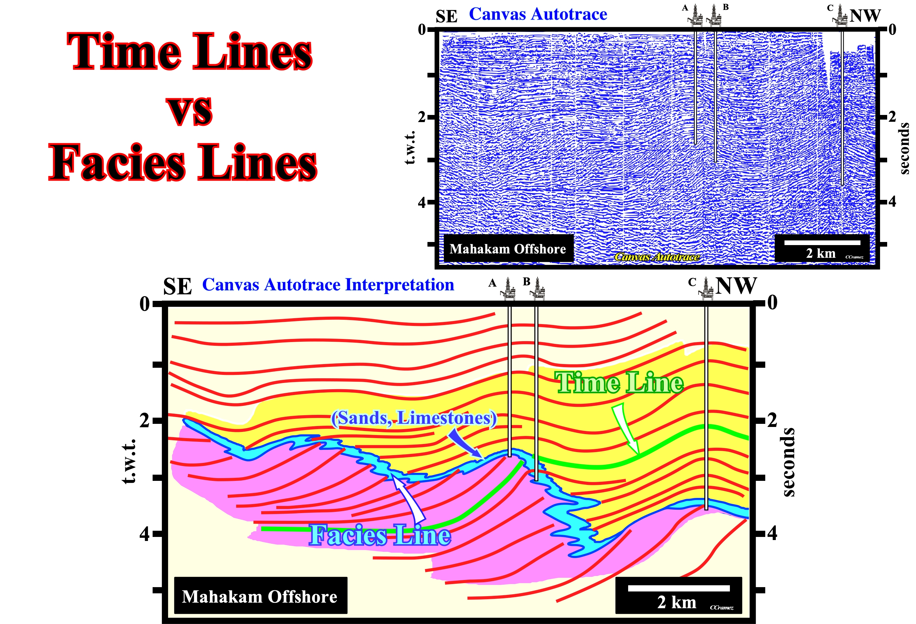
Figure 002 - This tentative geological interpretation of a Canvas autotrace of a Mahakam offshore the seismic line, based on the patterns of the seismic packages and calibrated by the results of the exploration wells drilled in the area, corroborates the conjecture that seismic reflectors follow time-lines (chronostratigraphic surfaces) and not facies-lines (lithological surfaces). On this tentative interpretation is, relatively, easy to follow the successive depositional coastal breaks (more or less the shoreline) of the chronostratigraphic lines, which in this particular case (seismically speaking the basin has no shelf), coincide, roughly, with the continental breaks. It can be said, (i) near of the depositional coast breaks, delta front sandstones and bioherms (ancient organic reef of mound-like form built by a variety of marine invertebrates, including corals, echinoderms, gastropods, mollusks, and others) were deposited, while (ii) delta plain sediments were deposited, landward of the depositional coastal breaks. Seaward of depositional coastal breaks, in the delta slope, which, here, forms the upper part of the continental slope, claystones were deposited. Taking into account the lithology (facies), the acoustic impedance contrast associated with the blue interval (facies line) should correspond, on the seismic line, to a strong reflector. However, as can be seen on the Canvas autotrace there is no reflector associated with such seismic impedance contrast. The reflectors correspond to chronostratigraphic lines that cut the facies lines.
All this allow geoscientists to stress that, generally, lithological predictions and, particularly, predictions of the most likely reservoir-rocks cannot be made by a simple glance at seismic lines (see chapter 17). They require an exhaustive methodological approach, i.e., a sequential stratigraphic interpretation of seismic lines, that certain geoscientists call Seismostratigraphy, and not a naive inductive picking of the high amplitude reflections. Lithostratigraphy, as defined in the field and, particularly, on the base of geological formations, is not appropriate to be apply in the geological interpretation of the seismic lines. The reflectors follow chronostratigraphic lines.
On these notes, we will summarize the main misunderstandings and seismic pitfalls2 (interpretation traps) that obscure the recognition of the petroleum systems 3, that can easily be avoid, particularly, in evaluation of the remnant petroleum potential.
2Pitfalls can be induced by (i) Changes in interval velocity ; (ii) Geometry of the reflector ; (iii) Recording and (iv) Playback (software programs carrying out tasks from retrieving time series of seismic data). Regional interval velocity changes seldom give trouble. On the contrary, abrupt change in velocity due to an equally abrupt structural change can be disastrous consequence, when not recognized: (a) Reverse faults create pull-ups ; (b) Normal faults create pull-downs ; (c) Reefs induce underlying pull-ups ; (d) Surface or seafloor irregularities with their coincidental subsurface reversals, etc. The depth section can be used to avoid these pitfalls, providing that it is not in itself a pitfall.
3A petroleum system describes the genetic relationship between a pod of active source-rock and the resulting oil and gas accumulations. The petroleum system has a stratigraphic, geographic and temporal extent. Its name combines the names of the source-rock and the major reservoir-rock and also expresses a level of certainty: known (.), hypothetical (?), or speculative (!).