

1) Geographic and Sedimentary Basins
Geoscientists forget to use the geological context on tentative geological interpretations of the seismic lines, locating them in relation to geographic or administrative basins and not to sedimentary basins defined in a specific basin classification.
Contrarily to a sedimentary basin, a geographic basin has no geological meaning. A geographic basin is a pure administrative division of an onshore or offshore, in which sedimentary basins were deposited over time. The Kwanza geographic basin, for instance, is just the area, in the Angola onshore (crossed by the Kwanza river), where a stacking of different sedimentary basins (Paleozoic folded belt, Late Jurassic / Early Cretaceous rift-type basins and a Meso-Cenozoic divergent continental margin) were deposited. The use of geographic basins, such as Lusitanian Basin, Paris Basin, Neuquén Basin, Congo basin, etc., can be, easily, replaced by the temporal and spatial sedimentary basins of the Bally and Snelson's classification composing them. The Bally and Snelson's classification (1980) of the sedimentary basins is adopted on these notes.
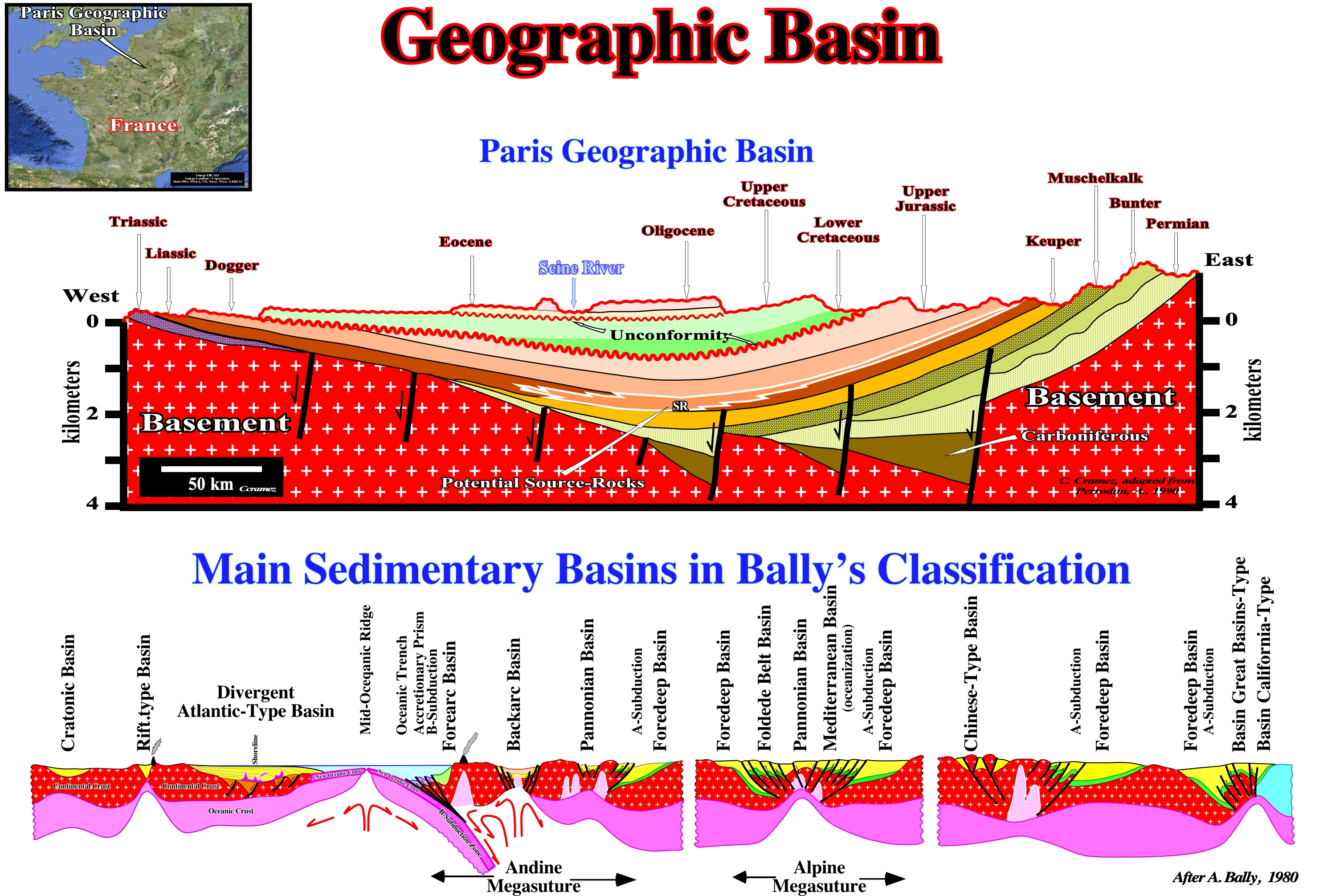
Figure 003- In the vast majority of cases, what many geoscientists call a structural basin is a large geological object formed by the deformation of previously subhorizontal strata. Synclines are considered as structural basins , since the term basin is used in its very broad sens: concave valley, wide and circular, surrounded by higher ground, to the center of which run and converge water-courses. Such a definition is morphologically. It implies the basin is posterior to the sediments forming it :before deforming the sediments it is necessary to deposit them. In geology, this does not seem to be very correct. T he term sedimentary basin designates the place where the sediments are deposited and not the place where and how they were deformed. The geological section, illustrated on this figure, shows, roughly, the structural and stratigraphical configuration of what is, often, termed the "Paris Basin". However, taking into account the definition of a sedimentary basin (a low ground crust area, with a variable geometry, circular to linear, usually of tectonic origin, in which sediments are deposited thickening to the deepest and central part, characterized by an higher subsidence), it is evident that the above geological section, strongly, suggests the "Paris Basin" is a deformed stacking of continental platforms (uplifted at East and West) and not a sedimentary basin. It is this type of structures that certain geoscientists call structural basin. Such a designation just makes sense when the deformation postdates with the deposition. On the contrary, a sedimentary basin, is a structure in extension (lengthening) with a synform geometry, more or less, circular, in which the layers dive and thicken, slightly, toward the center. On the above cross-section, with the exception of Carboniferous halfgrabens (lengthening structures, induced by a differential subsidence and formed by more or less parallel normal faults dipping in the same direction), which are the rift-type basins over which a Mesozoic divergent margin was deposited, the thickness of the stratigraphic intervals is, practically, constant (although there are several tectonically enhanced unconformities, i.e., several angular unconformities). The sediments dip towards the center of the structure but they do not thicken (regionally erosion is, certainly, not very important). That means the synform geometry is posterior to the deposition and the sediments were, probably, deposited in a platform environment or in an abyssal plain, since the internal configuration of the sedimentary intervals is parallel (subhorizontal at the depositional time). Several observations refute the second hypothesis (abyssal plain environment). The generating petroleum subsystem (Lias source-rocks) is located, mainly, in the Central and East area of the section. According some geoscientists, the evolution of the organic matter of these potential source-rocks is dependent on the erosion associated with the Late Cretaceous and Tertiary unconformities, that is to say, with the burial of the source-rocks. This implies that before the erosion, which produced the unconformities, the organic matter of the source-rocks had already reached maturation. Until today, it seems such hypothesis, has never been tested. The geometric relations observed on the seismic lines, which are, roughly, summarized on this geological cross-section suggest more a refutation than a corroboration of such hypothesis. Similarly, when a geoscientist speaks of the Neuquén Basin (Argentina onshore ) or the Kwanza Basin (Angola onshore and offshore), he is not talking about sedimentary basins, but geographic basins that, in generally, correspond, in geological terms to the spatial and temporal stacking of different types of basins of the Bally and Snelson's classification of the sedimentary basins, that we review below.
A sedimentary basin is a low land area of the Earth's crust, of variable geometry, with a circular to linear form, usually, of tectonic origin and in which sediments are deposited thicken to the deepest and central part, which has an higher subsidence. A sedimentary basin is a structure in extension with synform geometry (a syncline is a compressive structure), more or less, circular, in which the layers dip and thicken, slightly, to the center.
In Sequential Stratigraphy, the term basin refers, always, to the depositional area of a stratigraphic cycle, whether a continental encroachment cycle or a sequence-cycle. At a sequence-cycle hierarchical level, a basin has no shelf during the deposition of the lowstand systems tracts group (LSTG), which, from bottom to top, is, when complete, formed by submarine basin floor fan (SBFF), submarine slope fan (SSF), lowstand prograding wedge (LPW). Similarly, the basin has no shelf during the deposition of the 2nd stage of development of the highstand prograding wedge (HPW), i.e., when the shoreline (roughly, the depositional coastal break), is cooccurring with shelf break and continental break. The basin has a shelf (continental platform) during the deposition of the transgressive interval (TI) and during the 1st stage of development of the highstand prograding wedge (HPW), which are subgroups of the highstand systems tracts group (HSTG). Geographical names of the basins, such as Lusitanian Basin, Paris Basin, Neuquén Basin, etc., are to be avoided. They correspond just to the temporal and spatial stacking of different types of sedimentary basins of the classification of Bally and Snelson (1980).
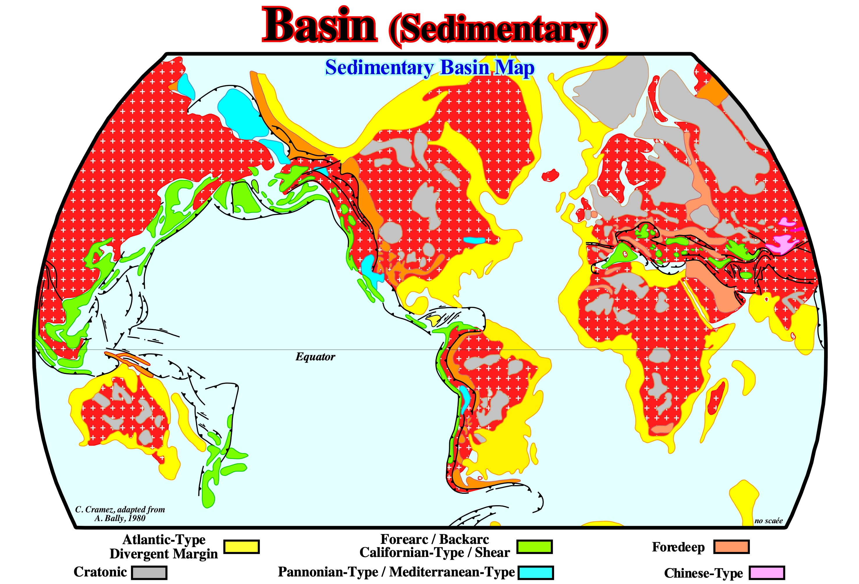
Figure 004- This map illustrates the distribution of the different types of Mesozoic / Cenozoic sedimentary basins recognized in the classification of Bally and Snelson (1980). This basin classification is, mainly, based on the subsidence realm. It does not take into account sedimentary basins less than 1,000 meters thick, and abyssal plains of the oceans, certain marginal seas, volcanic plateaus, etc., are excluded. Two main types of sedimentary basins are put forward: (i) Basins not associated with the formation of the Mesozoic / Cenozoic megasuture4 and (ii) Basins associated with the formation of Mesozoic / Cenozoic megasuture. In the former, there are three main classes: (a) Cratonic Basins, which developed in the Paleozoic continental crust and which were, generally, created by a regional thermal subsidence ; (b) Rift-type Basins, which were created in the Paleozoic continental crust by a differential subsidence, when the lithosphere was, locally, lengthened and (c) Divergent Atlantic-type Margins developed above the rift-type basins in association with a thermal subsidence, since the lithosphere of the Pangea supercontinent fractured. As rift-type basins are, usually, covered either by a cratonic basin or a divergent margin, they are not visible on the map illustrated in this figure. In the sedimentary basins associated with the formation of the Mesozoic / Cenozoic megasuture, there are two large families: (1) Perisutural Basins, which developed at the periphery of the megasuture, in association with a B-type (Benioff) or A-type (Ampferer) subduction zones, such as foredeep (foreland) or forearc basins and (2) Episutural Basins, which developed within the megasuture such as the backarc, Mediterranean and Pannonian basins. The extension behind the volcanic arc can be very important and create an oceanization, i.e., a breakup the lithosphere with formation of a marginal sea (new oceanic crust), in which a divergent non-Atlantic type margin develops. The fundamental difference between an Atlantic type and a non-Atlantic type divergent margin is the former develops in a tectonic setting, globally, compressive (shortening), i.e., it is located within the megasuture, while the latter is formed in an extensive context (lengthening), outside the megasuture. This classification can, of course, be used for the Paleozoic basins by replacing the Pangea supercontinent by the Protopangeia (Rodhinia) supercontinent and the Mesozoic / Cenozoic megasuture by the Paleozoic megasuture. On the other hand, taking into account the geological time, a given area may correspond to a stacking of different sedimentary basins. Thus, the Angola offshore, for instance, corresponds from the bottom to top, to the stacking of: (i) A Paleozoic fold belt, more or less, flattened or a Precambrian basement ; (ii) Late Jurassic / Early Cretaceous rift-type basins and (iii) A divergent Atlantic type margin deposited since the Early Cretaceous, in which two tectonic sedimentary phases can be recognized: a) A Transgressive Phase with a retrogradational geometry covered by a b) Regressive Phase with a well marked progradational geometry. This classification, like all other classification of the sedimentary basins, does not predict the volume of hydrocarbons generated and preserved in the different sedimentary basin families. However, it allows and to a certain extent it obliges, geoscientists in charge of the petroleum exploration to make geological observations based and controlled by the plate tectonics theory, which is the basis of all progress in geology and petroleum exploration. In fact, it allows a better evaluation of the different petroleum parameters (source-rock, reservoir-rock, trapping, migration and retention), which form the potential petroleum systems, by quickly highlight the key parameters, which, from a petroleum standpoint, can "kill"a basin or a prospect.
4A megasuture is a mobile region of the Earth (folded and faulted mountain belts) that testifies to the complexity of the accretion and deformation phases undergone by the geological bodies in the regions where the compressive tectonic regimens are predominant. The term megasuture was first used by A. Bally in 1975. Although the compressive tectonic regimes associated with the subduction zones are predominant in the formation of a megasuture, extensional regimes and the formation of sedimentary basins play, also, an important role.
2) Classsification of the Sedimentary Basins
Using the classification of Bally & Snelson (1980), geoscientists know, in advance, what they must look for on seismic lines, because it gives the geological context suggesting the main geological events and critical hydrocarbon parameters.
Bally and Snelson (1980), using the realms of subsidence, proposed a classification for the sedimentary basins (figure 005). Such a classification allows a good understanding of the different potential petroleum systems present in the sedimentary basins. The mechanism of the subsidence and eustatic changes (vertical sea level changes regardless their causes, Mörner, A., 1977) in time and space. Sedimentary depositional depocenters as, for instance, in the geographic Neuquén or Colorado basins (located, respectively, in Argentina onshore and offshore) correspond often, to a vertical stacking of different sedimentary basins with characteristic shelfal accommodations and petroleum parameters.
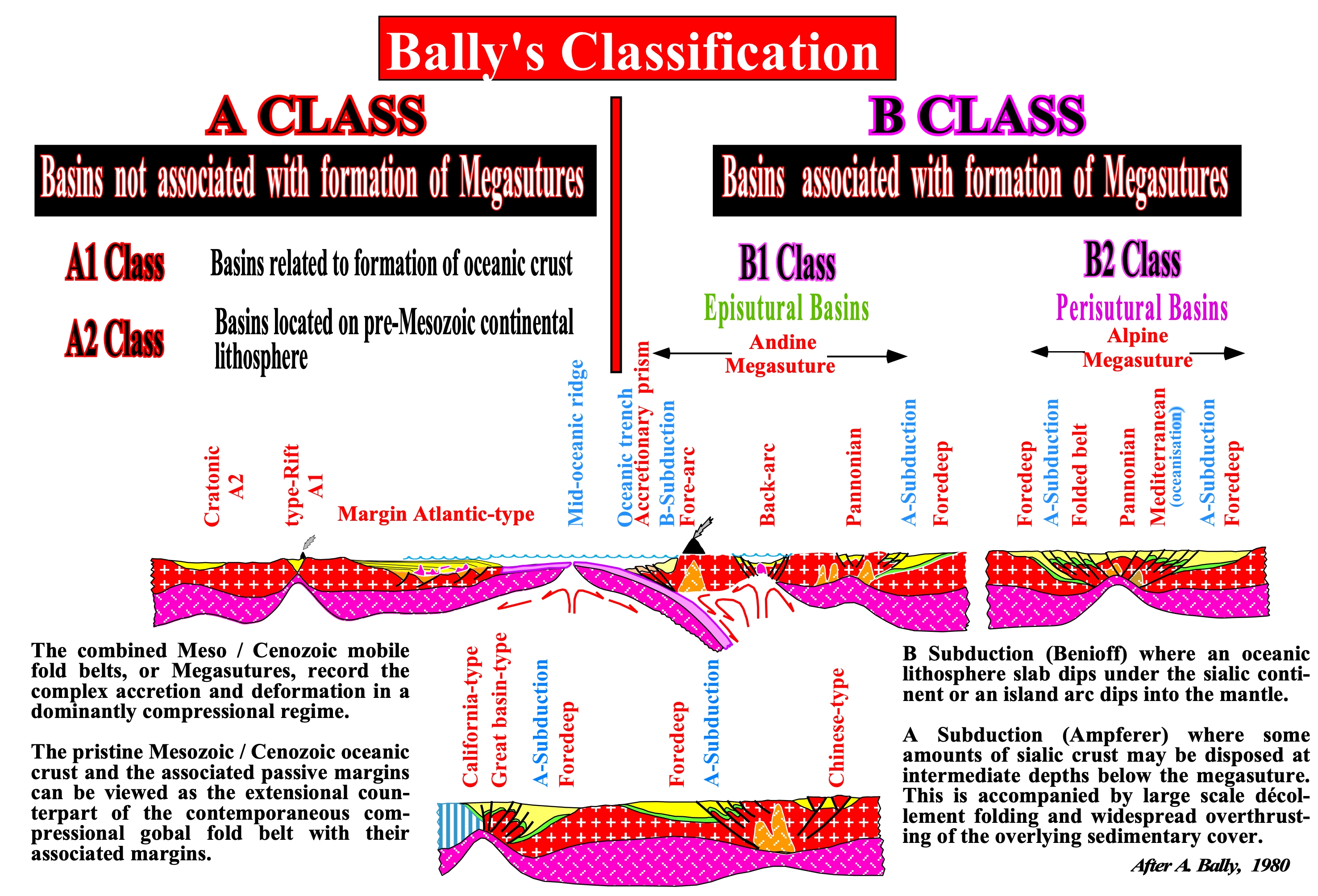
Figure 005- In this classification, there are two main groups of sedimentary basins : (i) Basins not associated with the formation of mega-sutures (A Class), in which extensional tectonic regimes (lengthening) are predominant and (ii) Basins associated with the formations of mega-sutures (B Class), in which compressional tectonic regimes (shortening) are predominant. The basins of A class are be related with the formation of the oceanic crust, as it is the case of rift-type basins and overlying divergent margin or just located on a continental lithospheric infrastructure, as cratonic basins. Rift-type basins are, mainly, characterized by a differential subsidence, responsible of their halfgraben geometry. The divergent margins (Atlantic or non-Atlantic) are characterized by a seaward increasing of the thermal subsidence responsible by their oblique fusiform geometry. Cratonic basins are, mainly, characterized by a thermal subsidence responsible for their characteristic sag geometry. The basins of B class can be episutural, i.e., located inside of the megasuture or perisutural, located around the megasuture. Episutural basins, as forearc and backarc basins are associated with B-type subduction (Benioff) zones. Perisutural basins, as foredeep basins, are associated with A-type subduction zones as in the Alpine and Andean areas. Backarc basins are formed by two sub-basins (often called phases). The lower one, developed during the lengthening of the lithosphere of the overriding tectonic plate of a B-type subduction zone, is quite similar to a rift-type basin, since the subsidence responsible of the majority of the accommodation (space available for the sediments) is differential (halfgraben geometry). The upper sub-basin or upper phase, created by thermal subsidence, looks like a cratonic basin. Most of the space available for the sediments is, mainly, creating by sagging (tectonics). Eustasy is just responsible of the cyclicity of the sedimentary intervals. Potential source-rocks can be found in both sub-basins. Potential lacustrine source-rocks are, often, found in the lower sub-basin (rifting phase), particularly, when the accommodation (space available) created by lengthening is not, completely, filled by terrigeneous influx, which implies the formation of a water column, i.e., a lake. Such a geological condition implies a parallel infilling, which is, easily, recognized on the seismic lines by a parallel internal configuration of the lacustrine intervals. In the upper sub-basin (sag or cratonic phase), the potential source-rocks are marine and associated with the lower-middle segments of deltaic progradation, i.e., associated with downlap surfaces (generally, secondary). Foredeep basins are associated with A-type subduction zones (Ampferer). They are created by a flexural subsidence induced by the loading of successive thrust-faults of the fold belt, which, with time, becomes the principal provenance (place of origin) of the terrigeneous influx. In these basins, potential source and reservoir-rocks are likely in association with progradational shelfal intervals (platform). Potential turbiditic intervals, onlapping against the basal unconformity of the foredeep basin, are also possible, particularly, in the onset of the flexural subsidence. In Argentina onshore, the backarc basins are Triassic / Jurassic in age and covered by foredeep basin sediments since the Early Cretaceous time. Jurassic / Lower Cretaceous rift-types basins, developed during the lengthening of the Pangea lithosphere (before the breakup of the Pangea, which is the most important geological event in South Atlantic), are present in coastal and offshore areas. Thick subaerial lava flows where deposited, immediately, after the breakup of the Pangea, above the distal rift-type basins (near the breakup zone) and below the clastic margin sediments. Most of the geoscientists incorporated such subaerial lava flows in the divergent margin, reason why they call it volcanic margin.
The accommodation mechanism, i.e., the creation of space for sedimentation is by a combination of the subsidence and eustasy. The amount of accommodation (amount of space) changes from basin to basin, what has important implications not only in the reservoir and source-rocks distribution, but in the development of non-structural traps as well. As illustrated in figure 006, on the seismic lines, the stacking of the different types of sedimentary basins of the Bally’s classification, composing the stratigraphic column, is quite easy to recognize. Such a recognition is much more helpful for the identification and study of the potential petroleum systems that the meaninglessness basin partitioning using local geological formations, which is utilized, quite often, by naive inductive geoscientists.
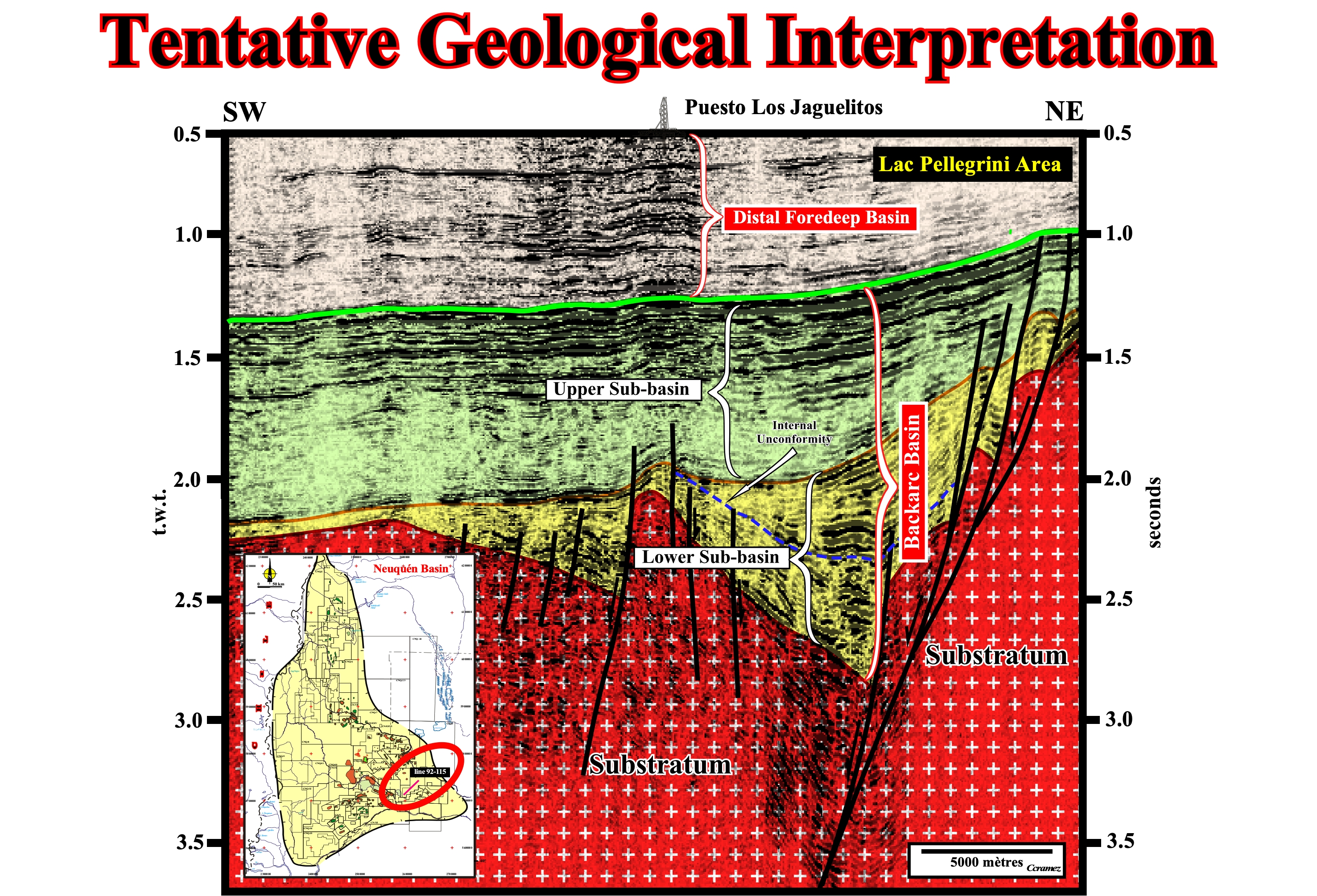
Figure 006- On this tentative geological interpretation of a seismic line of the Neuquén geographic basin (see location on the map located on the lower left corner of the figure), from the bottom to the top, a geoscientist knowing, a priori, the geology of the area and the Bally’s basin classification, can easily recognized : (i) The Paleozoic lithosphere (actually, southward of a line from Cordoba to Buenos Aires, the infrastructure of the Mesozoic / Cenozoic sediments is the Paleozoic megasuture and not the Precambrian Megasuture, as it the case northward) ; (ii) The lower sub-basin (rifting phase) of the backarc basin, in which an important unconformity is suggested by onlapping seismic surface defined by the reflection terminations ; (iii) The upper sub-basin of the backarc basin (sag or cratonic phase) and (iv) The distal part of the foredeep basin (eastern section). The geometry and internal configuration of the lower sub-basin of the backarc basin, strongly, suggests a differential subsidence and volcano-clastic infilling below of the onlap seismic surface (unconformity) and lacustrine sediments above (potential lacustrine source rocks). The internal configuration of the upper sub-basin of the backarc (sag or cratonic phase) suggests a thermal subsidence and sediments deposited in a shallow marine environment (platform sediments) some of which exhibit a clear progradational geometry suggesting the possibility of presence, side by side, of potential reservoir and source-rocks quite favorable to the development of non-structural traps. The presence of foredeep sediments in this area contributes, mainly, to the maturation of the organic matter of the potential source-rocks of the backarc basin.
The Bally’s classification as all other basin classifications, does not permit to predict the volume of hydrocarbons generated and preserved in the different families of sedimentary basins. Nevertheless, it allows and, to a certain extent, it forces geoscientists to make geological observations controlled by Plate Tectonics, which is the basis of any progress in oil exploration.
The use of this basin classification in combination with a sequential stratigraphic interpretation of the seismic lines, has immediate results on the evaluation of the remnant petroleum potential of geographic depositional depocenters, particularly when the structural petroleum exploration is mature or over-mature, as it is the case of all Argentine backarc basins. Such a combination enables a better assessment of different petroleum parameters and the recognition of potential non-structural traps (stratigraphic and morphological by juxtaposition traps), as well as, it, quickly, highlights the key petroleum parameters (those who can, alone, kill, at petroleum standpoint, a basin or prospect).
Geoscientists must try, for each type of sedimentary basin considered in a given depositional area, to characterize, in regional terms, the various petroleum parameters and emphasizing those looking most important:
(i) Source-rock (presence and maturation) ;
(ii) Reservoir-rock (presence and characteristics) ;
(iii) Trapping ;
(iv) Migration ;
(v) Retention.
Assuming, the presence of source-rocks (organic matter mature) in a sedimentary basin associated with a megasuture, for instance, in a conventional structural exploration, the principal petroleum parameter, i.e., the killer parameter, is the migration (age and type). The basin being located in a tectonic realm, globally, compressive, sooner or later, the sediments will be shortened including the preexisting extensional structures. Therefore, for this type of basin, the knowledge of the age of the migration of hydrocarbons in relation to the age tectonic shortening is the key petroleum parameter, since the migration of the hydrocarbons must postdate the potential traps.
When the structural petroleum exploration is mature or overmature, i.e., when the large majority of the structural traps (four way dip structures) have been tested (drilled), it does not means that there is no more petroleum to discovery. It does just mean, geoscientists must adopt another exploration approach, mainly, based on detailed sequential stratigraphic interpretations (P. Vail) and/or genetic stratigraphic interpretations (W. E. Galloway) of the different realms of subsidence, i.e., of the different Bally’s sedimentary basins (another reason to adopt it).

Figure 007- On this tentative geological interpretation of a seismic line of the central part of the geographic Neuquén basin (passing through the Chiuido ≠1 well location), the geoscientist who did the tentative interpretation not only recognized above of the substratum, the two types of sedimentary basins composed the geographic depocenter, but also propose a sequential interpretation, in terms of continental encroachment subcycles. Using the results of the well Canadon A. Salada X-1, the geoscientist recognized, easily, the non sense of a seismic calibration in terms of geological formations, mainly in the Quintuco and Vaca Muerta formations. In fact, the Upper Quintuco lies above the basal unconformity of the foredeep basin, i.e., it belongs to the foredeep, while the Lower Quintuco belongs to the upper sub-basin (sag or cratonic phase) of the backarc basin. By the same token, it is quite evident that the Vaca Muerta formation (major source-rock interval in the area) correspond just to the lower segment of the progradations of the Upper Jurassic, easily, recognized on seismic data. Therefore, the Vaca Muerta formation does not correspond to a chronostratigraphic interval but to a lateral stacking of diachronic intervals rich in organic matter. A simple glance to the seismic data, strongly, suggest several others lateral diachronic interval not only in the Upper sub-basin of the backarc basin, but in the foredeep basin as well. The basal unconformity of the foredeep basin is quite well visible on this seismic line. As all other unconformities, it corresponds to an erosional surface. In the proximal area, i.e., near the fold belt, the onlapping of foredeep deep marine sediments against the tilted backarc sediments characterize this unconformity. In the distal area, it is, mainly, characterized by the toplapping of the shallow water sediments of the backarc (toplaps are the consequence of the outward migration of the bulge anomaly). In the distal area, the progradation of the foredeep sediments, preserving the erosional surface is not very evident (the angle of the slope is too small). Noticed that very often, in certain lines of this area, immediately, overlying this unconformity, there is a complex downlap surface marking the distal terminations of the progradation of the foredeep sediments.
As in the Neuquén area, the large majority of the structural traps (four way dips structures, in which the map of the top of reservoir and map of the sealing-rocks are interchangeable) have been already tested, the remnant petroleum potential is associated with non-structural traps (stratigraphic, morphological and morphological by juxtaposition traps), particularly, when a non negligible component hydrodynamic is present. To target these non-structural traps, the cartography of the limits of the different basins and sub-basins, particularly, on the seismic lines, is the first step of the remnant exploration. Such cartography is, often, difficult for junior geoscientists. However, taking into account that they correspond to genetic changes of the subsidence (lengthening, thermal contraction and flexural), they can be recognized indirectly.
A priori, one can say:
a) When the subsidence is due to lengthening (halfgraben or rift-type basins), the sedimentary fill is mainly non-marine and, at seismic scale, it is, mainly, aggradational. The progradation of a deltaic depositional system is, probably, the more simple geological mechanism of infilling. However, on conventional seismic data, the breaks of the depositional surfaces associated with the deltaic progradation are, often, under the seismic resolution.
b) In a backarc basin (thermal contraction), the sedimentary infilling is mainly aggradational. The internal configuration is aggradational rather than progradational. The progradation of deltaic depositional systems is, probably, the more simple geological mechanism of infilling. However, on conventional seismic data, the depositional sedimentary breaks associated with the deltaic progradation are just evident when the basin has no shelf, i.e., when the delta slopes lie on the top of the continental slope.c) When the subsidence is flexural, there is formation of sedimentary wedges, often, call sedimentary prisms. Their progradation depending on tectonic loading. Just in the proximal and deep areas of the foredeep basins, i.e. in the turbiditic realms, the geometry is aggradational. On seismic data, the lower limit of the foredeep basins, i.e., at the onset of the flexural subsidence, is, often, underlain by a major downlap surface, which is seen as distal reflection terminations as the successive sedimentary wedges prograde away from the fold belt.
Summing up : When using seismic data, geographic basins, as Neuquén, St. Jorge basins or Kwanza basins (Angola onshore and offshore), must be subdivided, in time and space, into sedimentary basins according the genetic changes of the subsidence (differential, thermal, thermal contraction, flexural, etc.). Please do not subdivide them using unappropriated geographic or meaninglessness terms (as rift, post-rift, synrift, sag, etc.), as well as, using geological formations as Vaca Muerta, Quintuco, etc.