

3.1) Deltaic & Continental Slopes
Every time a geoscientist shows you a delta slope on a seismic line, there is a high probability that he is showing a continental slope. The large majority of delta slopes are under seismic resolution.
A delta slope is, generally, defined landward of the shelf break, in the platform, under a water depth lesser than 200 meters. A continental slope is defined between the continental break (more or less, coincident with the depositional coastal break and shelf break, in lowstand geological conditions) and the beginning of the ocean basin at depths higher than 200 meters. Taking as reference modern deltas (Niger, Rhone, Rhine and Mississippi), the length of delta plain (a) and delta slope (b), as wells as, the delta slope height (c) and height of the delta (4) and are quite significant, particularly, the last two, as illustrated in figure 012.
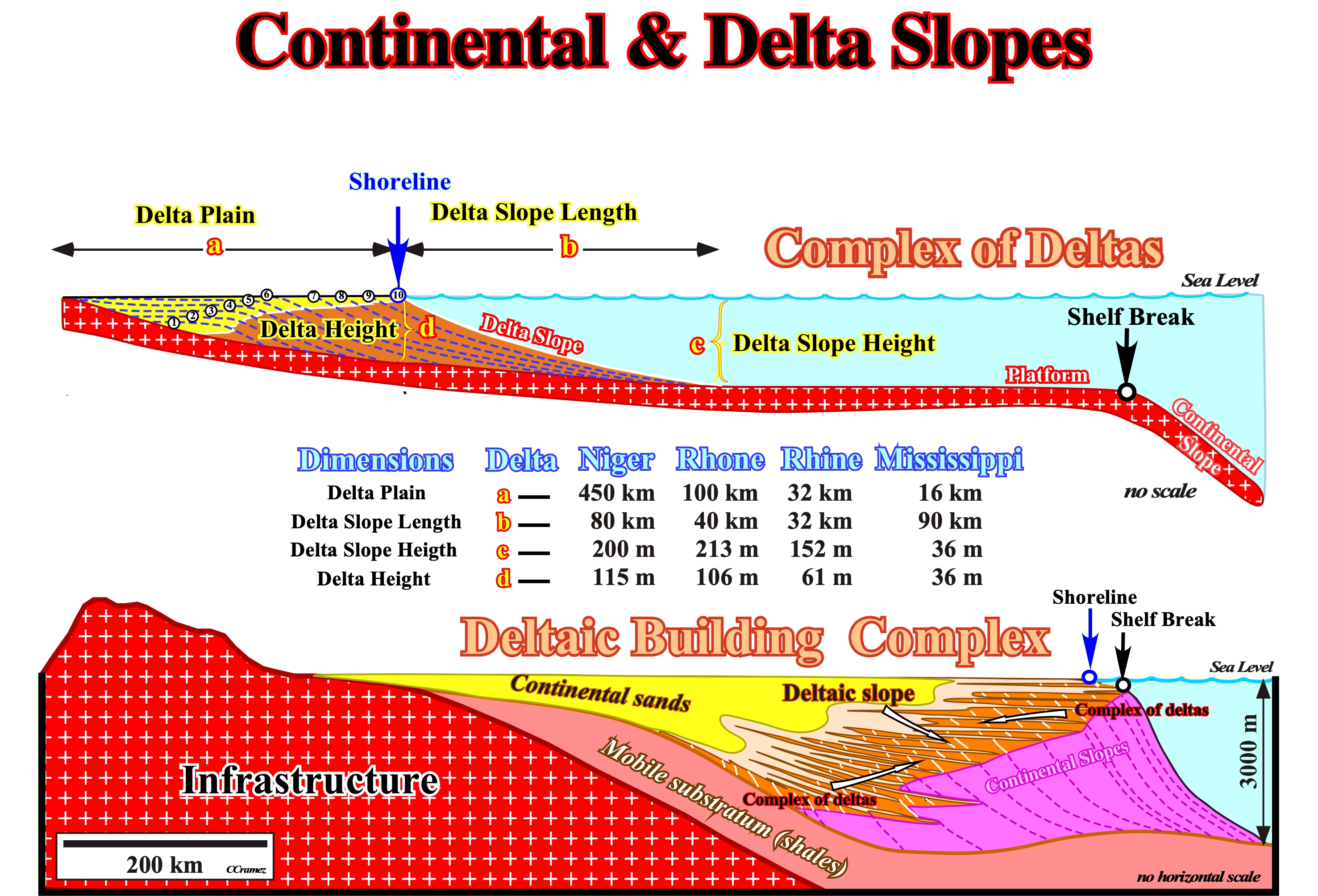
Figure 012- The height of a delta, rarely, exceeds 100 meters. The thickness of a deltaic building complex (vertical stacking of complexes of deltas, i.e., lateral accretions of deltas) can be higher than 3,000 meters. Otherwise stated, the height of a delta progradation, rarely, exceeds the seismic resolution, while the height of a continental slope progradation is, largely, above the seismic resolution. In highstand geological conditions, delta progradations, which can be oblique (no upbuilding, just outbuilding) or sigmoidal (upbuilding and outbuilding), are landward of the shelf break (summit of the continental slope which is, here, roughly, coincident with the edge of the basin). In lowstand geological conditions, delta progradations are seaward of the edge of the basin (the basin has no shelf). As illustrated in the upper sketch, when a sedimentary basin has a shelf, i.e, when the basin has continental platform (water depth between 0 and 200 meters), as it happens, always, during the transgressive interval of a stratigraphic sequence-cycle, the shoreline is landward of the shelf break. A condensed stratigraphic section, deposited during starved geological conditions, can be present between the bottom of the prodelta (bottom of the delta slope) and the shelf break. In such geological conditions, delta slopes are landward and completely, disconnected (landward) of the continental slopes, which is not the case when the shoreline is, more or less, coincident with the shelf break ( basin without shelf). Within a sequence-cycle, since the onset of highstand prograding wedge, progressively, the extension of the platform diminishes as the shoreline comes near the shelf break. In a deltaic building complex (vertical stacking of complexes of deltas), as illustrated in the lower geological sketch, one can say, globally and, particularly on the seismic lines (resolution around 30-50 meters), the basin has no self, since the shoreline is, practically, coincident with the shelf break (here, also, functioning a basin edge). Under these conditions, quite often, delta slopes are connected with the uppermost part of the continental slope. However, in detail and, particularly, at natural scale (scale 1:1), it is easy to see (deduct) that at each relative sea level rise, a shelf is created and is, rapidly, filled by the progradation of delta systems till the next relative sea level rise. In reality, between each stratigraphic sequence paracycle composing a sequence-cycle there is any relative sea level fall, but a stability period of the relative sea level, during which the shoreline progrades seaward deposing delta systems. Shortly, when a geoscientist recognizes on a seismic line lowstand geological conditions (no shelf) he can never be sure of the absence of shelf deposits (deltaic systems for instance). They can be present, but their thickness is under the seismic resolution.
On seismic lines, delta slopes are, often, under the seismic resolution. Continental slopes are, largely, above it. However, in absence of scale, due to self-similarity of these geological features their differentiation can be a difficult task and impossible very often. Since longtime, I realized that when a geoscientist in charge of the geological interpretation of the seismic data speaks about delta progradations, quite often, he refers to continental slope progradations. If you do not belief me, try to falsify my conjecture making a test. In the canteen of your company canteen, when you take a meal with your colleagues (also geoscientists) ask them : "What is the height of a delta? You will be surprise with the answers. Then, if you are not satisfied, ask them if a delta is deposited during highstand or lowstand geological conditions (sea level above or below the basin edge) or if a delta is deposited when the relative sea level fall or rise. After listening them, see if you can refute or corroborate my conjecture.
The next Canvas autotrace of a seismic line shot in onshore Texas (figure 013) illustrates the outbuilding of the Late Cretaceous Woodbine complex of deltas. The deltas forming this complex are destructive delta systems of progradational channel-mouth bar. Woodbine delta systems are characterized b: (i) Poor development of constructional sequences ; (ii) Formation of embayments and associated strandplains ; (iii) Well developed coastal barriers proximal to areas of maximum discharge ; (iv) Relatively thin prodelta facies and (v) High sand mud ratio with poor muddy delta plain aggradational deposits. These deltas are not classified as marine influenced. They are part of one type of wave-dominated delta. Note that a strandplain is a broad belt of sand along a shoreline with a surface exhibiting well-defined parallel or semi-parallel sand ridges separated by shallow swales. A strandplain differs from a barrier island. It lacks either lagoons or tidal marsh that separate a barrier island from the shoreline to which the strandplain is directly attached. Also, the tidal channels and inlets, which cut through barrier islands, are absent. Strandplains are, typically, created by the redistribution of coarse sediment on either side of a river mouth, by waves and longshore currents. Thus, they are part of one type of wave-dominated delta.
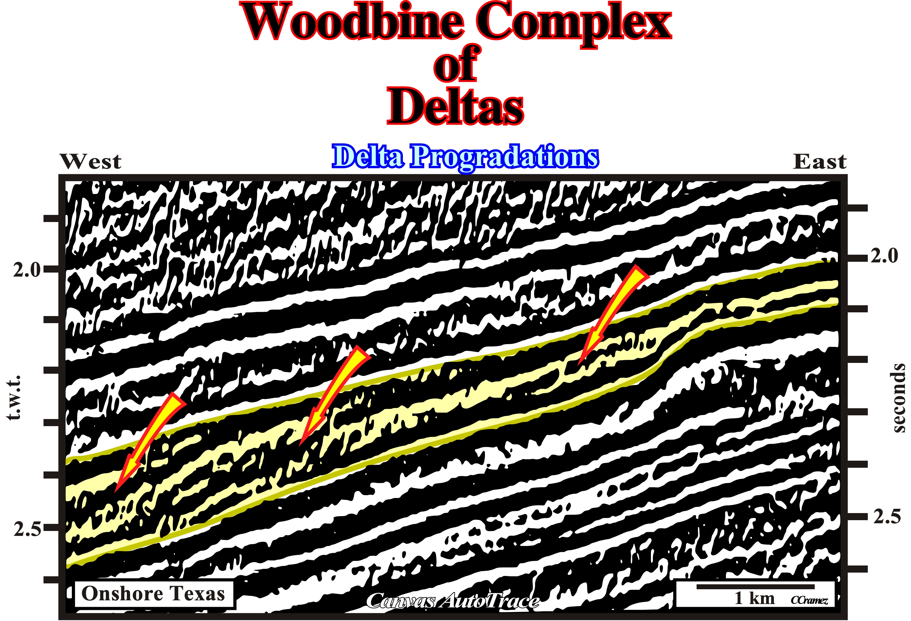
Figure 013- Woodbine's oblique delta progradations are, easily, recognized on this Canvas autotrace. They are located within a seismic interval bounded by two unconformities induced by two relative sea level falls which created two erosional surface. In sequence stratigraphy, such seismic interval (colored in yellow), probably, corresponds to a sequence-cycle (if the difference in age of the two unconformities ranges between 0.5 and 3-5 million years). Its maximal thickness (at least on this line) is around 200 milliseconds (double time), what exclude a continental slope interpretation for the internal reflectors responsible for the internal oblique configuration. Such a realistic sequence-cycle is formed by a lateral accretion of stratigraphic sequence-paracycles (depositional systems tracts), composed by a lateral linkage of depositional systems. The oblique internal configuration is given by the lateral accretion of sequence-paracycles. At this scale, such a configuration, characterized by an important outbuilding and a small or null upbuilding of the shoreline is, often, associated to a lateral accretion of deltas (complex of deltas). Each delta, i.e., each oblique progradation (time line) corresponds to a depositional systems tract formed, generally, by three different depositional systems (prodelta, delta front and delta plain). Each depositional system is characterized by a typical facies (lithology) and fauna. Taking into account this figure and figure 012, we can say : (i) Each progradation is a delta ; (ii) Each delta, emphasized by a progradation (here oblique) is, generally composed by three coeval and genetically related depositional systems ; (iii) Each depositional system is characterized by a lithology and an associated fauna ; (iv) A lateral accretion of deltas form a complex of deltas and (iv) A vertical stacking of complexes of deltas form a deltaic building complex.
Theoretically, delta depositional systems are, relatively, complex. However, three main environments may summarize them:
(i) Prodelta (bottomset) ;
(ii) Delta front (foreset) and
(iii) Delta plain (topset).
- The prodelta consists of muddy facies with varying amounts of marine fossils and intermittent fine sands as the prodelta environment grades into the delta front. The prodelta is a coarsening upwards lithological succession of muddy lithology grading into sandier lithology of the delta front. The prodelta front muds tend to grade into interbedded, flat laminated sands. The facies of the prodelta environment, greatly, depends upon the processes influencing sediment transport, deposition and reworking.
- The delta front has the most abundant sedimentation and progrades out over the prodelta muds. The delta front is a slope of offlapping clinoforms that grades, gradually, into the sandier facies of the delta plain. The delta front can be more strongly influenced by fluvial sedimentation than the prodelta environment. The delta front sands, silts and muds occur overlying the mudstones of the prodelta and consist of flat to wavy laminated coarsening upward sands interbedded with silts and muds. Delta progradation can lead to delta plain lithologies overlying the delta front sands. However, the delta front sands can be eroded by progradation of the channel over the mouth bar.
- The delta plain is the emergent portion of the delta system where sedimentation occurs in distributary channels, levees, splays, lagoons, tidal flats and marshes. The delta plain consists of sands, silts and clays with organic matter, coal or peat, occurring in marsh environments. Fossils of terrestrial vertebrates (dinosaurs, reptiles and mammals) occur, often, in the delta plain. The delta plain is largely controlled by river and tidal processes.
As said previously, continental slopes are characterized by large and tall progradations, easily, recognized on seismic lines, as illustrated on the next tentative geological interpretation (figure 014). Their geometry is, generally, sigmoidal with significant upbuilding and outbuilding between successive progradations deposited during decelerated relative sea level rise.
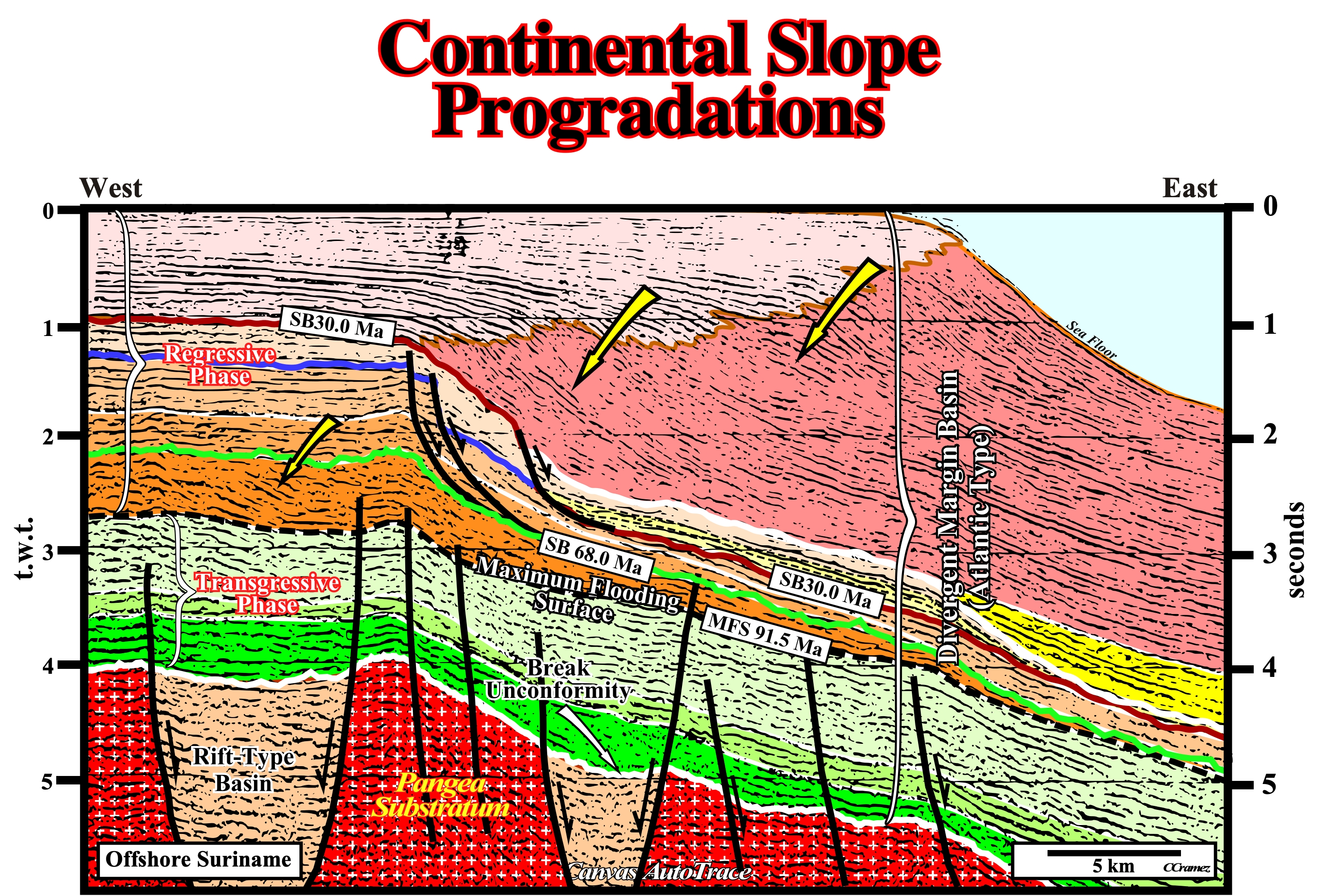
Figure 014- On this tentative geological interpretation of a Suriname offshore seismic line, continental slopes are quite well represented in the regressive phase of the post-Pangea continental encroachment stratigraphic cycle. This stratigraphic phase, deposited during the 1st order eustatic cycle, has a progradational geometry. The transgressive phase (here represented by the seismic interval colored in green tones), seismically speaking, has an aggradational geometry. Whereas the aggradational transgressive phase is deposited during the rising of the absolute (eustatic) sea level rising (not relative sea level), the progradational regressive phase is deposited during the absolute sea level falling. A maximum flooding surface (MFS 91.5 Ma) separates these stratigraphic phases. The continental slope progradations are paramount after the Oligocene unconformity (SB. 30.0 Ma). The relative sea level fall associated with this unconformity seems to be induced by the formation of the Antarctica ice sheet, which covers about 98% of the Antarctica continent and is the largest single mass of ice on Earth. After the Oligocene unconformity, the basin seems to have no shelf, i.e., the shoreline was, more or less, coincident with the continental break. However, as previously pointed out, transgressive episodes with a relative shallow continental platform, are likely, but their thickness is under resolution.
In a relative sea level cycle, the rising of the relative sea level starts in acceleration (e.g., 2, 5, 9, 15, meters, etc.) till the inflexion point. The 1st derivative of the relative sea level curve is positive. Then, it continues to rise, but in deceleration (e.g., 20, 18, 14, 9, 3, 0 meters) till it starts to fall. Between the inflexion point and the point where the relative sea level starts to fall, the 1st derivative of the curve is negative. Excluding the turbidite deposits, which are accumulated during relative sea level falls, all the other marine depositional systems, particularly, those deposited on the shelf require a relative sea level rise, or in other words, an increasing of the accommodation (space available for the sediments).
When a geoscientist says during a sea level rise, the shoreline is displaced landward and during a sea level fall, it is displaces seaward, he must know that such a statement is just valid during 1st order eustatic cycles, in which the absolute sea level changes are created, mainly, by the volume variation of the oceanic basin, induced by the breakup of the supercontinents and subsequent agglutination (Wilson’s cycle). When the shoreline is displaced landward, certain geoscientists speak of transgression and when it is displaced seaward they speak of regression.
Other geoscientists, as Cesar Emiliani use the term marine ingression to express an advance of the sea to cover a broad area :
“The Middle and Late Jurassic saw the widening of the South Atlantic rift and the creation and widening of a rift-type basins between western Gondwana (South America - Africa) and eastern Gondwana (Madagascar - Seychelles - India - Australia - Antartica). As result, a significant ingression took place” [sic]
When a geoscientist takes the depositional coastal break as reference, he, generally, speaks in transgression6 (retrogradation of the shoreline and associated coastal deposits) and regression (progradation of the shoreline and associated coastal deposits). When he takes the sea level as reference, he speaks in marine ingression (when the sea advances) and marine regression (when the sea retreats).
6As all terrigeneous influx comes from the continent. In reality, there are not transgressive depositional events. A sedimentary transgression is just the name that geoscientists give to a succession of sedimentary regressions each time smaller. Such a succession, globally, gives the impression of a retrogradation of the shoreline. In fact, a relative sea level rise displaces the shoreline (roughly, the depositional coastal break) landward. After such a displacement, the relative sea level becomes, more or less, constant (stability period). Then, the shoreline is, progressively, displaced seaward as deposition re-starts. However, it never reach the position that it had before the sea level rise (the terrigeneous influx is not big enough). A new relative sea level rise takes place. It displaces, again, the shoreline landward and, again, during the stability period of the relative sea level, deposition takes place, displacing, progressively, the shoreline seaward, but without reaching its previous position before the relative sea level rise. A new relative sea level rise takes place and all geologic events will be repeated until a relative sea fall place the sea level below the basin edge and a new stratigraphic cycle starts.
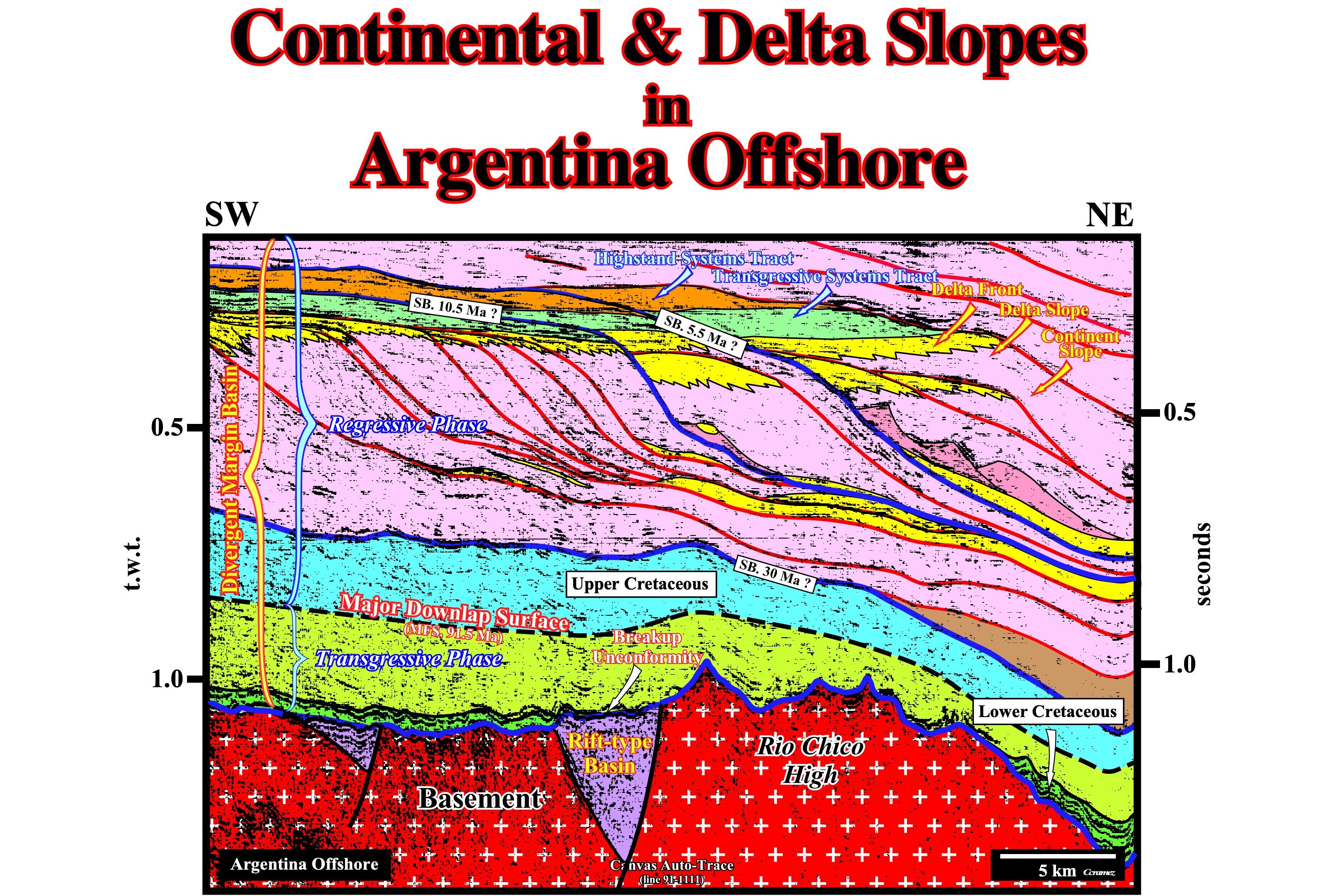
Figure 015- On this tentative geological interpretation of an Argentina offshore seismic line, continental slopes are obvious in the upper part of the regressive phase of the post-Pangea continental encroachment stratigraphic cycle. In spite of the fact that the amplitude and, particularly, the height of the progradations is not excessively high, it exceeds the delta slope standards. However, as suggested by the tentative interpretation, the progradations were developed during a lowstand geological situation, i.e, in basins without platform (no-shelf). Turbidite depositional systems are, easily, recognized along and on the bottom of the continental slope (submarine slope fans and submarine basin floor fans). In such geological conditions, the shoreline (roughly, the depositional coastal break) coincides, more or less, with the basin edge. Subsequently, delta plains, delta fronts and delta slopes (prodeltas) are located on the top of the continental slope as illustrated above. Some of the delta plains are covered by transgressive interval and others by highstand prograding wedges (often under the seismic resolution).
Within a sequence-cycle (deposited during a 3rd order eustatic cycle characterized by a time duration ranging between 0.5 My and 3-5 My), when the relative sea level rises in deceleration, highstand systems tracts are deposited with continental slope relatively small at the beginning (when the shoreline still is far away of the shelf break, since the basin has a shelf). Progressively, the continental slopes become more important till the basin has no more shelf. At this moment, at least seismically speaking, the shoreline (roughly the depositional coastal break) is close to the basin edge (continental break). Afterwards, the progradation of the shoreline, among others factors, depends on the angle of stability of the continental slope. If the critical angle is reached, slumps of the continental break (there is no more shelf, so one cannot speak of shelf-break) can induce turbidite deposits in order to decrease the slope angle to allow, again, progradation of the shoreline.
In certain continental margins, upwelling currents induced by the Eckman’s transportation (horizontal movement of surface water layers of the ocean by the action of the friction of the surface wind), erode, partially, the continental slope destabilizing the continental break. The wind blowing over the ocean moves the surface layer, but the Coriolis force deflects the movement to the right in the northern hemisphere and clockwise in the southern hemisphere. This deviation spreads downwardly the viscosity and gives a mean of transporting material out of the axis of the surface winds.
3.2) Delta Slopes in Argentina Geographic Basins
A delta height, rarely, exceeds 100 m. A delta slope height, rarely, exceeds, 250 m. The length of a delta slope can reach more than 100 km. In appropriated geological settings, delta slopes are just visible on seismic lines with an important vertical exaggeration.
Two examples of delta slopes were taken from (i) Malvinas geographic basin (figure o16) basin and Neuquén geographic basin (figure 017 and 18), located, respectively, in Argentina offshore and onshore.
a) Delta Slopes in Malvinas Geographic Basin
The geological setting of the geographic North Malvinas Geographic Basin can be abridge as follows:
1 - During the Late Paleozoic, the deposition of the "Gondwana sequence" was characterized by a very low magmatic activity and a strong sedimentary shortening (orogeny Pan Africa-Brazilian). The predominant structural alignments have a NNW-SSE trend.
2 - Since Triassic, the preponderant tectonic regimes were in extension (lengthening) and the magmatic activity quite intense. Such a changing presaged the onset of the breakup of southern continent of the Pangea supercontinent, i.e., of the Gondwana. During this geological period, the lithosphere was stretched perpendicularly to striking of the Paleozoic structural trends.
3 - In response to this stretching, halfgrabens and grabens striking 150-160° N were formed. They were filled, in large part, by volcano-clastic. The amount of volcanic material decreases upward.
4 - During the Jurassic, what is today the western and southern margins of South America, were surrounded by an imposing volcanic-arc behind which backarc basins developed. The volcanic-arc and the backarc sedimentary basins were induced by the subduction of the Panthalassa oceanic crust. The majority of these basins strike NNW-SSE. This trend suggests the extension of the continental crust, behind the volcanic-arc was made by reactivation of old normal faults bordering the Jurassic-Triassic rift-type basins.
5 - Afterwards, about 25 million years (Late Jurassic) before the separation of South America and Africa by the emplacement of the volcanic crust (sub-aerial and oceanic), a new stretch of lithosphere took place. Such lengthening was marked the fault system allowing the formation of geographic basins of Orange, Salado, Pelotas, Walvis, Santos, etc. Another area associated with this stretching, is underlined by the geographic basins of Rawson, Western Colorado, Macachin, Laboulade, North Malvinas, etc, (several geoscientists believe that these basins were largely controlled by the fault zones of Rio de La Plata and Agulhas - Malvinas).
6 - At the beginning of the Cretaceous, before the onset of seafloor spreading between South America and Africa, a significant lengthening and fracturing of the crust took place along the Atlantic margin of Argentina, Uruguay and SE of Brazil. Fracturing was, particularly, important along the alignments of Agulhas / Malvinas and Rio Grande / Walvis. The associated rift-type basins, although striking, locally, perpendicular to the open of the Atlantic, are direct indicators of the continental separation.
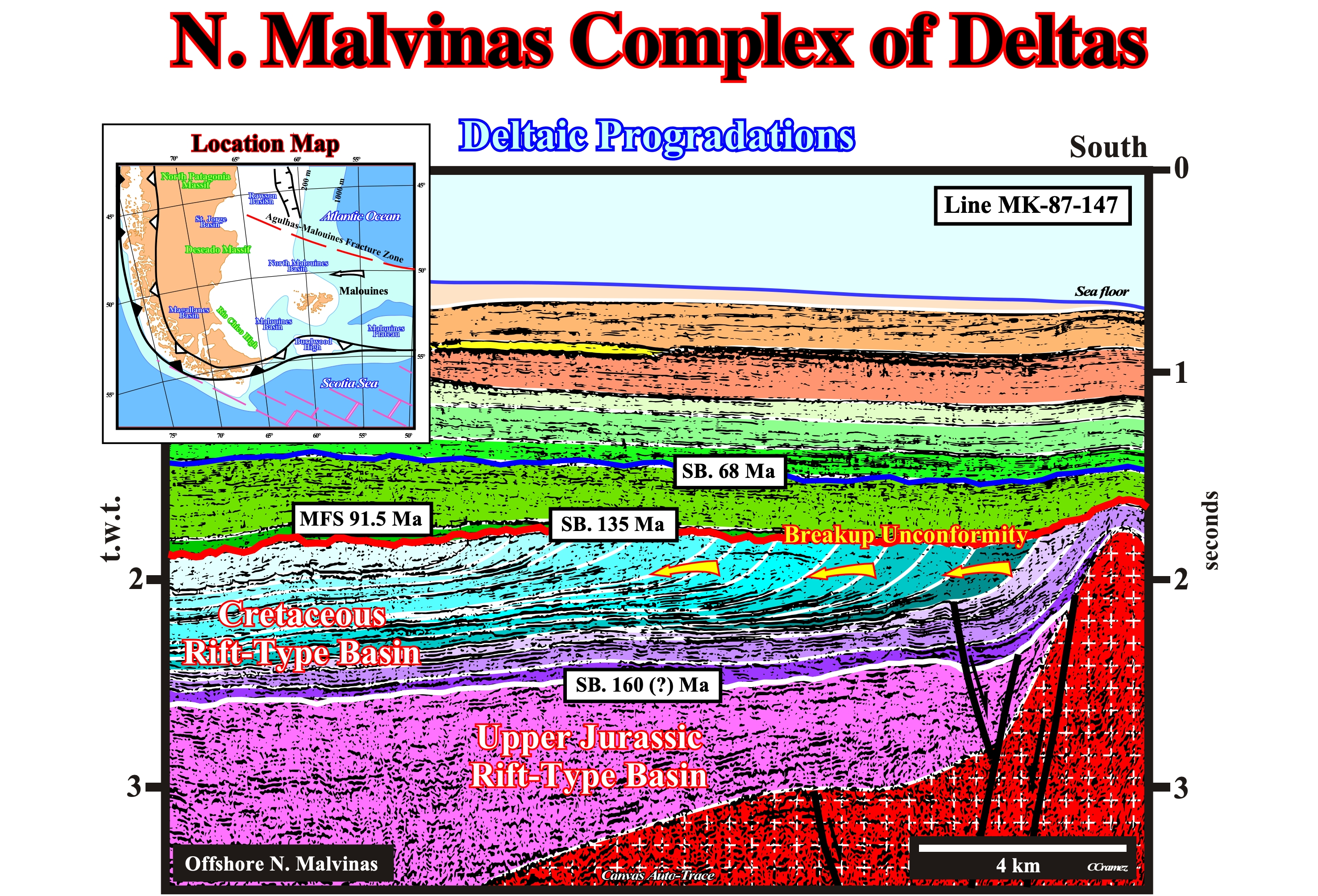
Figure 016- This tentative geological interpretation is speculative. We could not tested it by the results of exploration wells. The geological calibration is, mainly, based on the overall geological setting. Significant changes are possible. Despite all this, it seems that, from the bottom to top, the following geological intervals can be recognized : (i) A Paleozoic basement ; (ii) A rift-type basin, with two phases, separated by an unconformity (SB. 160 Ma ?), the lower phase is, probably, of age Late Jurassic, while the upper one is Early Cretaceous ; (ii) The breakup unconformity, here tectonically enhanced (angular unconformity), associated with the breakup of continental crust ; (iv) A Mesozoic / Cenozoic divergent margin, in which is possible to distinguish the transgressive phase of the continental encroachment cycle (limited at the top by the Early Turonian downlap surface (MFS 91.5 Ma) and the regressive phase that is, mainly, composed by sediments of Late Cretaceous and Tertiary. A well developed complex of deltas is visible in the Cretaceous rift-type basin (in a such geological context, the probability of find, obvious continental slopes in the rift-type is quite small). The erosional surface associated with breakup unconformity (SB. 135 Ma) seems to have, partially, eroded the topset of the delta systems. Bottomsets (bottom of the prodelta) are well developed and vertically stacked. Potential petroleum systems are, probably, associated with this complex of deltas. The generating petroleum subsystem can be associated with the organic-rich prodelta shales, while the reservoir-entrapment subsystem with the delta front sandstones. The more likely trapping mechanism is stratigraphic or morphological by juxtaposition, in which potential reservoir-rocks are juxtaposed to sealing-rock (Cenomanian-Turonian marine transgressive shales associated with the major downlap surface MFS. 91.5 Ma).
The progradations visible within the Cretaceous rift-type basin (figure 016) are, clearly, associated with delta systems. Their dimensions, and particularly the height of the inclined segment, are not those of a continental slope. They lie within 200-300 milliseconds (two way time). The recognition on the seismic lines of such a delta progradations and the complexes of deltas, especially, are fundamental to a good evaluation the remnant petroleum potential.
Potential source-rocks can be found in prodelta and delta plain (e.g., oxbow shales). Potential reservoir-rocks can be found in the delta front and delta plain (e,g., point bar sandstone). In other words, the potential generating petroleum subsystem and the reservoir-rocks being side by side, favors the development of non-structural traps, which are the key of new petroleum discovery, particularly, in petroleum mature basins at the structural standpoint.
b) Delta Slopes in Neuquén Geographic Basin
Before regarding the tentative geological interpretation of a seismic lines shot in Neuquén geographic basin, it is quite important for a geoscientist to know the geological setting to understand what he must look for (Theory precedes Observation) and, particularly, where the complexes of deltas are more likely. The evaluation of remnant petroleum potential of the geographic Neuquén basin, passes, above all, by the understanding of the evolution, in time and space, of tectonic regimes and subsidence that have affected the area, particularly, after the break-up of the Gondwana, i.e., since the Permian-Triassic time.
1) Above the Paleozoic megasuture (which petroleum potential must be also evaluated), during the Triassic / Jurassic, in association with an extensional tectonic regime, a backarc basin was developed, since the Berriasian-Valanginian, overcome by a foredeep basin.
2) The lower sub-basin (rifting phase) of the backarc basin, induced by a differential subsidence, look like rift-type basin. Its age is Triassic - Early Jurassic. It is, easily, recognized on the seismic lines. It does not have a significant petroleum potential, even if certain geoscientists, seem to have recognized, locally, thin intervals of lacustrine shales within the volcano-clastic sediments.
3) The upper sub-basin (sag or cratonic phase) of the backarc basin is associated to a regional thermal subsidence. The origin of this subsidence seems to be associated to a rebalancing of the isotherms.
4) This subsidence induced a regional marine transgression whose acme is reached near the end of Portlandian (Lower Quintuco formation). At the base of this marine ingression (Middle Jurassic), the sediments have a progradational geometry (Cuyano and Los Molles formations). However, towards the top (Upper Jurassic), their geometry is retrogradational.
5) The sediments thick toward the basin edges (e.g., Vaca Muerta and Lower Quintuco sediments). In the central part, where the geological conditions of low sedimentation rate are predominant. Just condensed stratigraphic sections were deposited. These condensed stratigraphic sections were deposited under an important water depth that can reach, locally, more than 600-800 meters.
6) During the sag or cratonic phase of the backarc basin, the extensional tectonic regimes, eustasy and terrigeneous influx (coming from the east, i.e. from the Paleozoic megasuture) were predominant. They control the stratigraphic signature and they are responsible for the deposition of the Kimmeridgian sandy reservoir-rocks (Tordillo formation) and of the source-rocks of the Vaca Muerta formation (mainly Portlandian), which generated most of the hydrocarbons found so far.
7) The western edge of the backarc basin, i.e., the eastern flank of the volcanic-arc should not be very far from the current location of first thrust structures. Some exploration wells (Bridas) seem to have recognized, in this area, thick alluvial deposits, coming from the West, synchronous of the sandstones of the Tordillo formation, were deposited, directly, into the deep water bodies (Neptunian sands or delta fans).
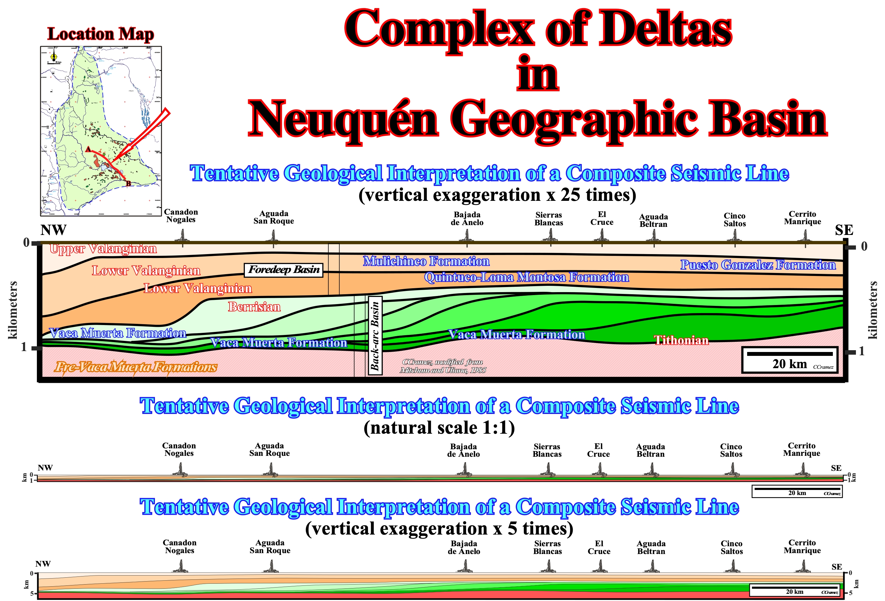
Figure 017 - The uppermost cross-section corresponds to a tentative geological interpretation of a composite seismic line of the Neuquén geographic basin. The progradations are, mainly, sigmoidal (upbuilding and outbuilding). Their heights exclude the possibility of continental slopes. They fall within the heights range of the delta slopes. A Late Jurassic - Early Cretaceous complex of deltas is advanced. The age of the deltas composing the complex of deltas range from Tithonian (150.7 - 144.2 Ma) to Berrisian (144.2 - 137.0 Ma). Two relative sea level falls (or two lateral shifts of the depocenter : pendulum effect) can be recognized during the westward progradation of the deltas. These relative sea level falls displaced, seaward, the shoreline and associated coastal deposits. The deposition of proximal turbidites and the development of potential stratigraphic traps is possible, downdip of the such unconformities. This complex of delta seems to end or at least change drastically, with the onset of the flexural subsidence, i.e., at the beginning of the foredeep basin at Late Berrisian - Early Valanginian. As illustrated, it is obvious that a calibration of the tentative interpretation in terms of geological formations, as Vaca Muerta or Quintuco, has not stratigraphic sense. On the other hand, note that the original composite seismic line is 20 x exaggerated vertically. In fact, when illustrated at the natural scale (1:1), the progradations of the complex of deltas are not at all visible. With a vertical exaggeration of 5 times (lower tentative interpretation), which correspond, more or less, to the vertical exaggeration of the conventional seismic lines, the delta progradations are, barely, visible. Actually, geoscientists working in this area should work with seismic lines at different scales. Highly vertical exaggerated seismic lines to recognize detailed geological features and slightly exaggerated to not lost perspective.
8) From the Berriasian (Upper Quintuco formation), catastrophically7, geological conditions, i.e., the tectonic regimes, the subsidence, the terrigeneous influx, the eustasy, the depositional systems, etc., changed abruptly due to the emplacement of a foredeep basin (see figure 017) :
7According to Gretener P. (1967), in the geological evolution of a sedimentary basin, a geological episodic event is characterised by a period which exceeds, rarely, 1/100 of the total time considered. In other words, when we graphically expresses an episodic geological event (change versus time), it is only the thickness of the pencil. Thus, in the backarc basin of Neuquén, an event with a duration of 3-5 x 10⁶ years, as a sequence-cycle, is, geologically, instantaneous.
(i) From the end of Portlandian, compressional tectonic regimes become preponderant and shortened the sediments. This shortening was, mainly, done by the reactivation, in reverse movement, of old normal faults, formed during the rifting phase of the backarc basin (tectonic inversions).
(ii) These tectonic inversions are evident near the Paleozoic craton. On the contrary, in the western area, near the volcanic arc, although reknowable, they are masked by the successive shortening, which during the Cretaceous and Cenozoic have, progressively, transformed part of the foredeep basins in a folded-belt.
(iii) The overloading produced by thrusts associated with the tectonic inversions induced a flexural subsidence, underlines the beginning of the foredeep basin. Changing of the thermal subsidence, which characterized the sag or cratonic phase of the backarc basin, into a flexural subsidence, which characterizes the foredeep basin, is marked by a significant unconformity, clearly visible on all regional seismic lines.
(iv) The sedimentary shortening cause the uplift of the western part of the backarc basin and the formation of a mountain range and a folded-belt, which become the main sources of terrigeneous influx during the foredeep, i.e., since the Berriasian-Valangian. In the East, the Paleozoic megasuture was already quite eroded and its contribution, as source of terrigeneous influx, was limited to foreland river mouths. Actually, all the sedimentary interval of the foredeep basin thick towards the Cordillera and pitchout, in the foreland by downlapping indicating the majority of the terrigeneous influx comes from the West.
(v) During the foredeep basin, the terrigeneous influx, although continuous, is characterized by tectonic convulsions easily recognized by a typical stratigraphic signature that sequential stratigraphy does not explain suitably. In fact, the frequency of the tectonic upheavals, i.e., the rate of sedimentary uplifts is greater than the rate of eustatic changes.
(vi) The stratigraphic signature and the cyclicity of the deposits are more controlled by tectonics than eustasy. On the other hand, the successive uplifts and subsequent periods of denudation change very quickly the drainage surfaces and the amount of terrigeneous influx that the sequential stratigraphy are considered constant over longer periods.
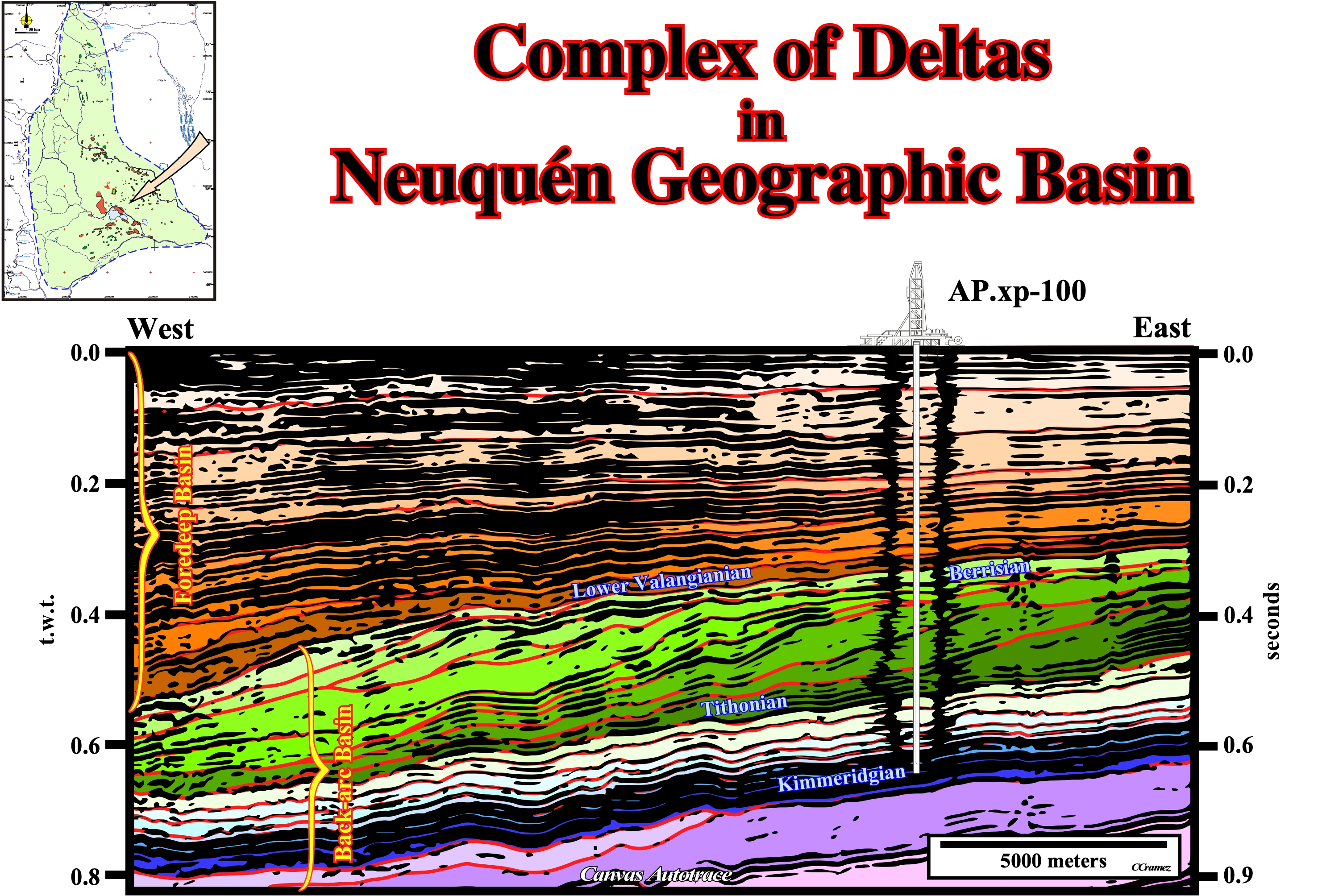
Figure 018- On this tentative geological interpretation of a vertically exaggerated (around 20 times) seismic line (just the Canvas autotrace is here illustrated) from the Neuquén geographic basin, the Late Jurassic - Early Cretaceous complex of deltas is easy recognized. Several negative aggradations (relative sea level falls) can be inferred from the geometric relationships between the seismic reflectors. The upper boundary of the complex of deltas (lateral accretion of deltaic systems) seems to correspond to the basal unconformity of the foredeep basin, i.e., with the onset of the flexural subsidence. In the foredeep basin, complexes of deltas are, also, possible, as for instance during the Valanginian (Tordillo formation), but the mechanism of creation of space for the sediments (accommodation), as well as, the provenance of the terrigeneous influx seems quite different of that of the backarc basin.
(vii) In such a geological conditions, the depositional systems of the Neuquén foredeep basin do not correspond, just as they should be, to those proposed in the P. Vail sedimentary model (1977 and 1991). The progradational and retrogradational geometries, the stratigraphy, the predominance of terrigeneous influx from the Cordillera, etc., are, probably, better explained by erosion cycles of short duration (E. Mutti, 1996), i.e., by a succession of uplift-denudation similar to that proposed at the end of last century by W. M. Davies (1899).
(viii) The sedimentological model that seems explain better the lithology encountered on observational data (field geology, drilling and seismic lines l floods alternating with the deltas fans (not confined floods) and river deltas (confined floods).
The tectonic-sedimentary evolution proposed, particular, the depositional model of the foredeep basin, i.e., since the Portlandian, is, so far, corroborated by observational data (available to us). The sedimentary figures type HCS (Hummocky Cross-stratification), invoked to refute the importance of the river-floods, are not, according to some sedimentologists (Southard, 1990, Allen and Underhill 1989, Arnott and Southard, 1990, E. Mutti et al. 1996), diagnostic of a process or sedimentary environment.