.jpg)
Gambia Offshore
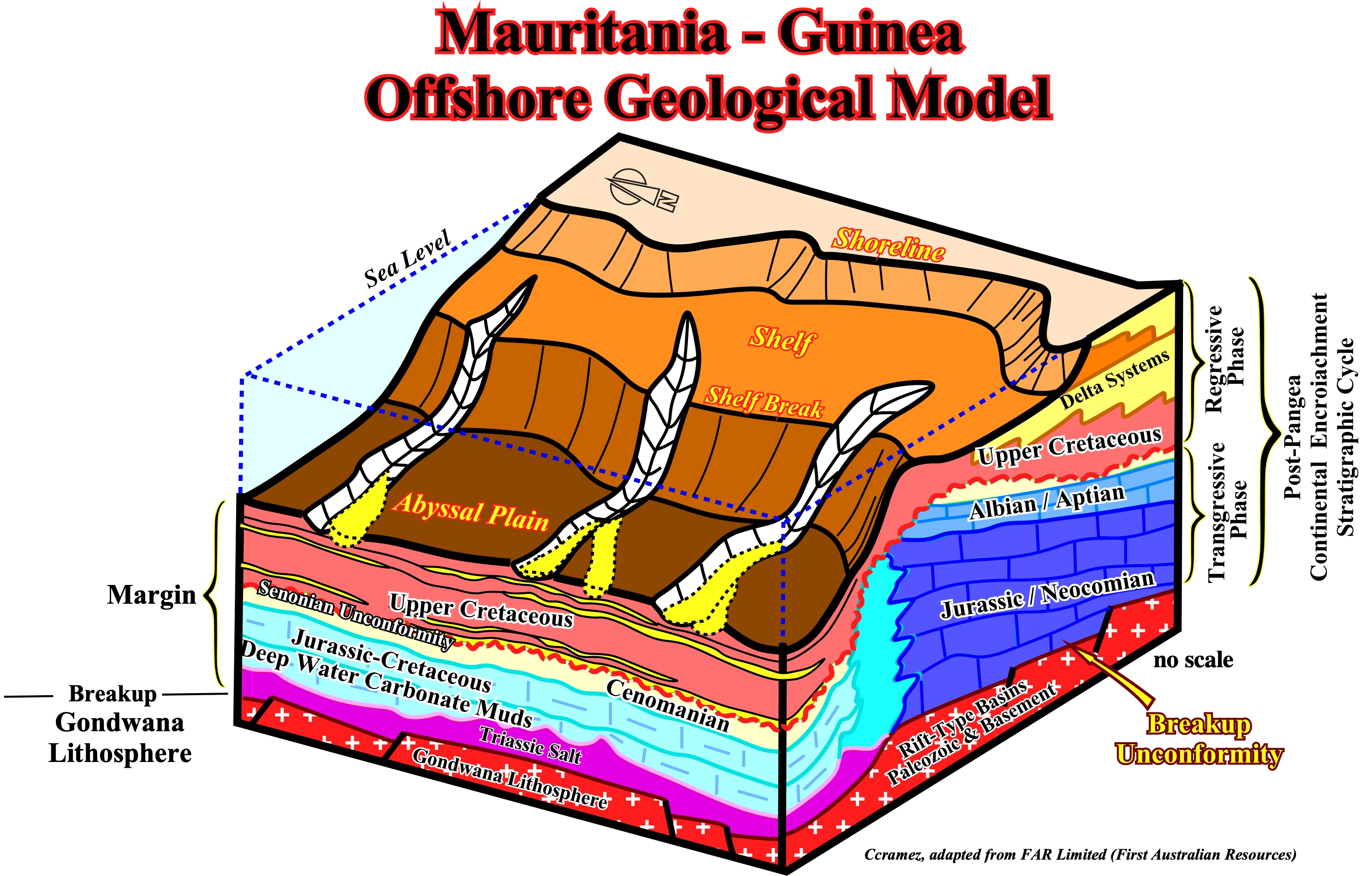
As said previously (Page 53A), his block diagram illustrates the geological configuration of the post Pangea continental encroachment stratigraphic cycle in the Mauritania-Guinea offshore. Above the breakup unconformity, which is the upper boundary of the pre-rifting and rift-type basin rocks, a Triassic salt layer was deposited in a confined shallow water depocenter, apparently, from potash enriched brines due to the spilitization of sub-aerial volcanism (lava-flows, i.e., SDRs). Then, due to absolute sea level rise induced by the volume reduction of the oceanic basins created by the emplacement of the oceanic ridge, carbonate sediments of the transgressive retrogradational phase were deposited. During this stratigraphic phase, the shoreline was, progressively, displaced landward, while the successive shelf breaks were, more or less, stacked in a still-stand position (strong upbuilding) creating an abrupt deep water geological setting, i.e., an abrupt change between the shelf and the abyssal plain environments with a quite steep continental slope. Since the absolute sea level started to fall, due to the volume reduction of the oceanic basins induced by the subduction of the oceanic crust along the subduction zones and the continental collision, i.e., during the regressive phase of the post-Pangea continental encroachment stratigraphic cycle, submarine basin and slope fans deposited in the deeper parts of the basin. Potential turbidite depositional systems may form excellent entrapment-migration petroleum sub-systems, which can be feed by potential deep-water source-rocks intervals.
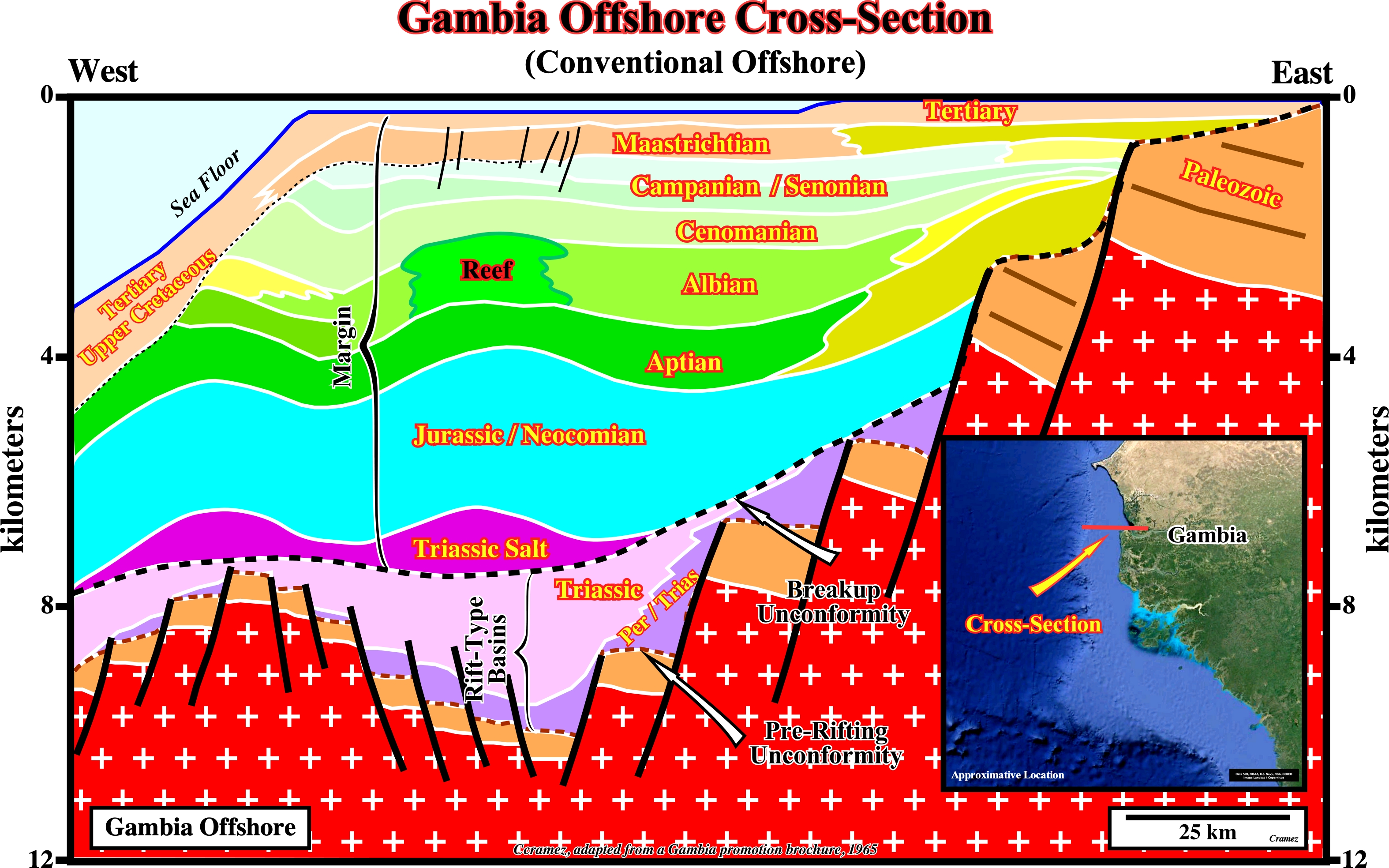
As depicted on this geological cross-section of Gambia geographic basins, the geology of Gambia conventional offshore is very similar to that of the Guinea Bissau and Senegal offshores (see Page 23 & 23A). This seems to be true also to the deep offshore (see next plate), since an abrupt deepwater geological setting was always present since the beginning of a Atlantic-type divergent margin, which developed above typical Permo-Triassic and Triassic rift-type basins. This basins, which predate the breakup unconformity, developed in a lengthened Gondwana lithosphere formed, mainly, by a Precambrian basement with a Paleozoic infrastructure. The Triassic salt layer postdates the break unconformity. It seems the salt was deposited in small ponds of an epicontinental sea (proto-ocean phase of some geoscientists) that later coalesce. On the other hand, its chemical composition, strongly, suggest the brine was enriched in potash by spilitization of the volcanic material, probably, lava-flows that pour or ooze from an erupting expansion centers (SDRs) immediately after the breakup of the Gondwana lithosphere (see below).
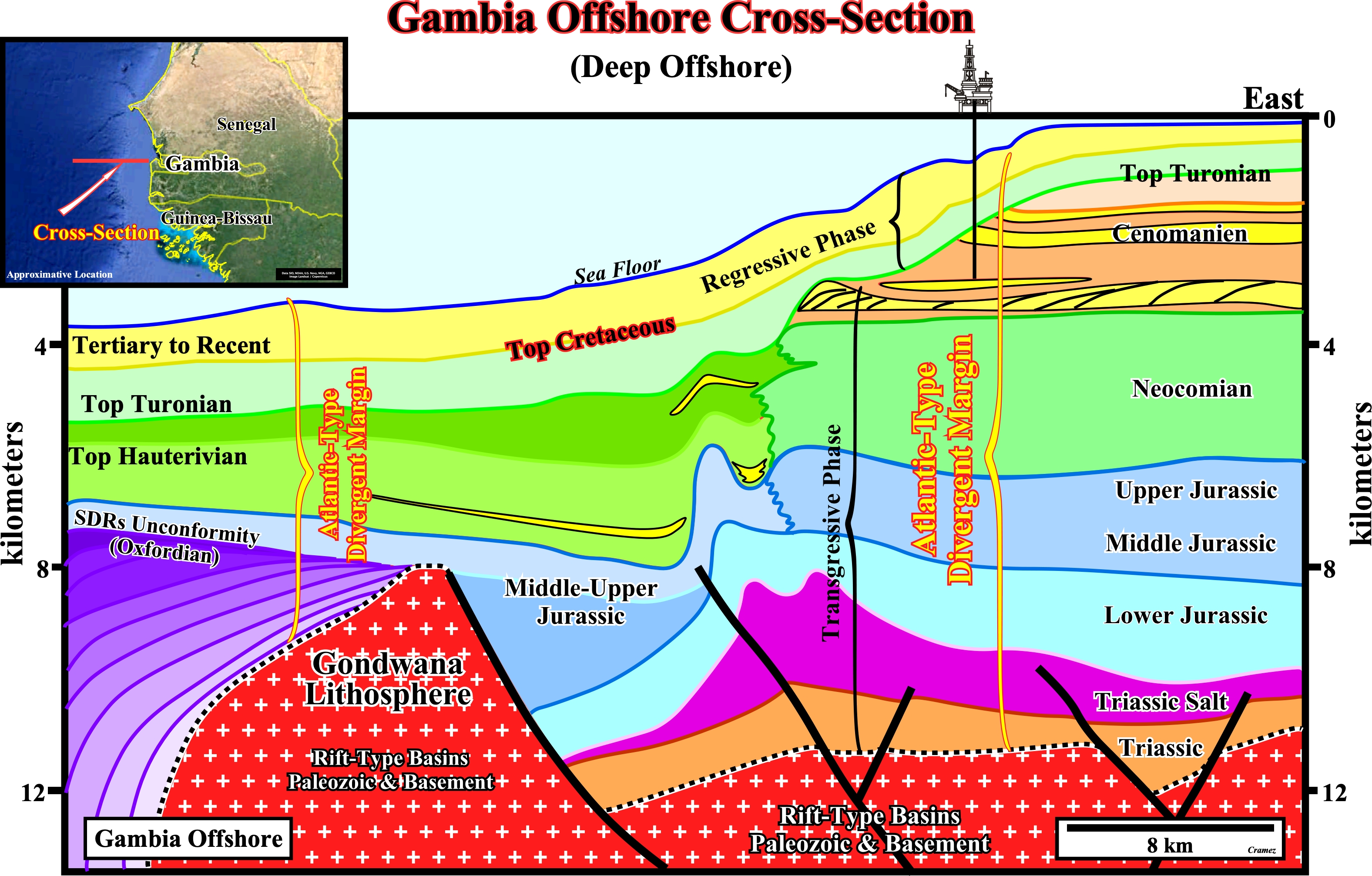
First of all take note that this cross-section is in depth. It is based on the tentative interpretation of a depth version of a seismic line, i.e., the pitfall induced by the water depth in a time version has been corrected. In other words, you can see the majority of the geological interfaces dip landward and not seaward as it is the case in a time version. That said, obviously, the more likely location of the turbidite deposits, found in Senegal offshore, is seaward of the last Jurassic shelf break, often, highlighted by reefal construction and seaward of the sucessive retrogradational Cretaceous shelf break and shelf failures, which, locally, can be underlined by salt induced normal faulting. In regressive phase of continental encroachment stratigraphic cycle, i.e, in the uppermost Cretaceous intervals (post Turonian) and Tertiary, turbidite systems seem to be, mainly, associated with significant relative sea level falls (Peter Vail model) that put the sea level below the shelf break (lowstand geological conditions). However, the presence of submarine basin floor and slope fans deposited according the Emiliano Mutti model (in highstand geological conditions) cannot be excluded.
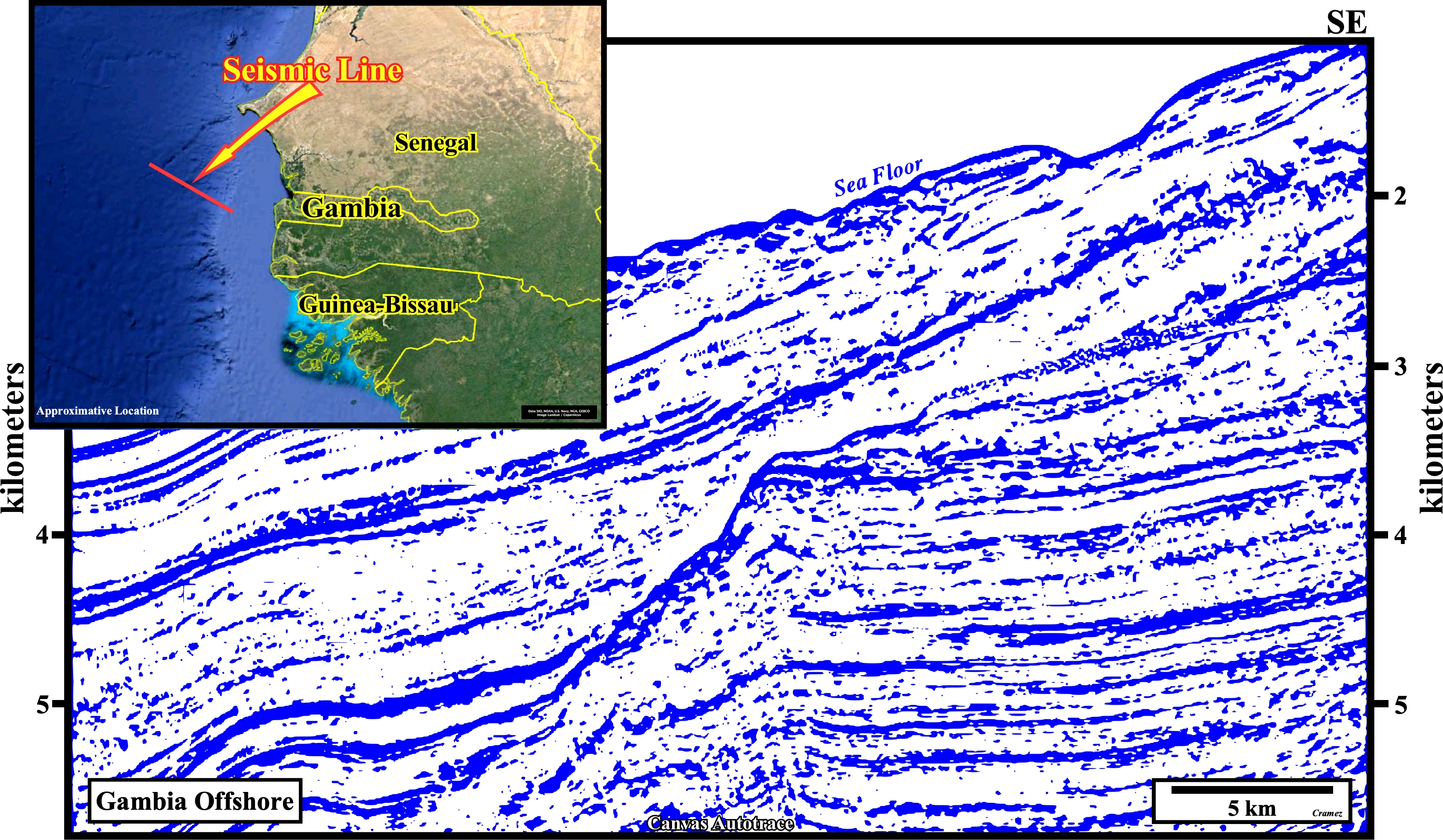
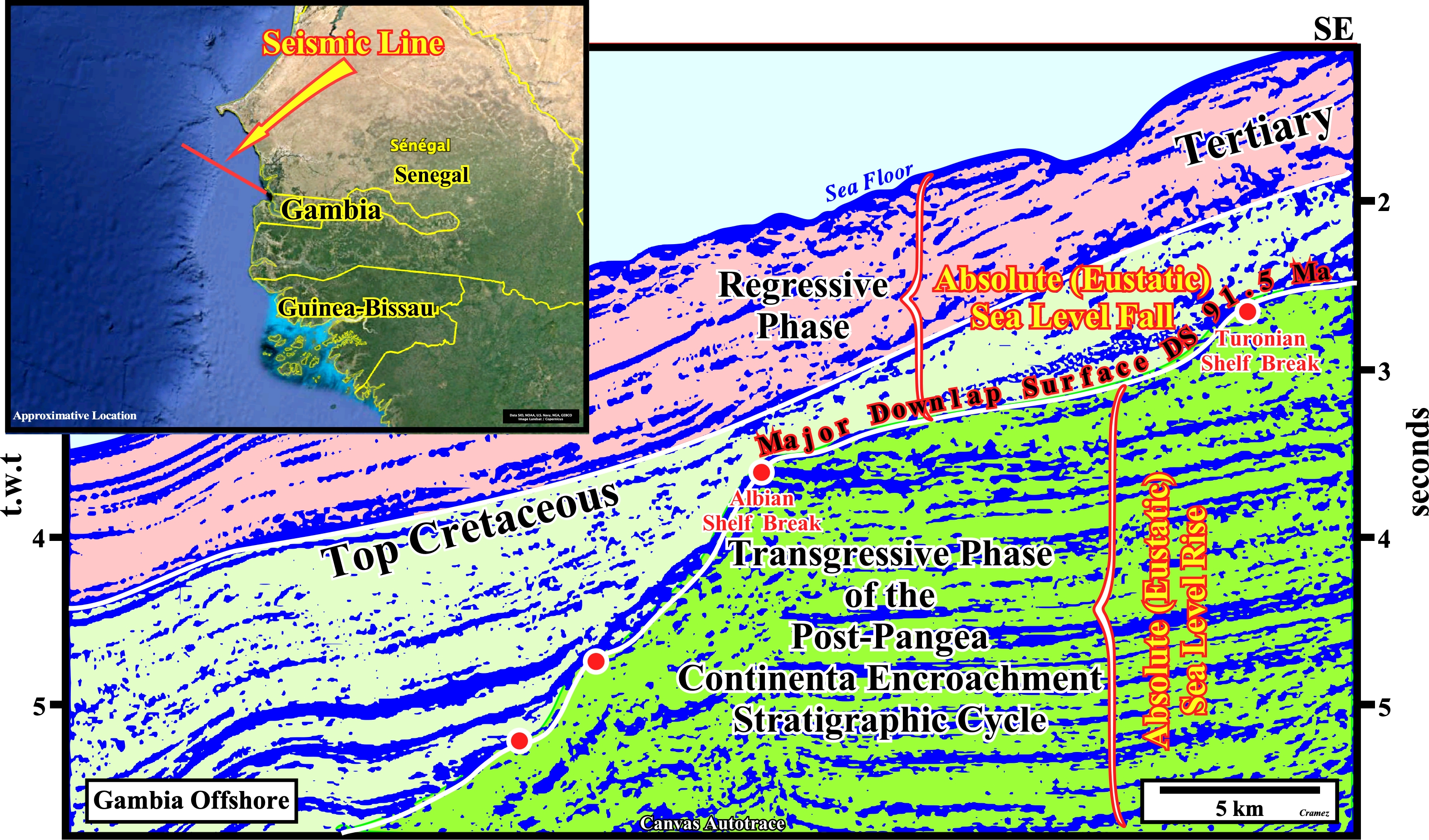
On this Canvas autotrace of a seismic line of Gambia offshore, the limit between the transgressive and regressive phases of the post-Pangea continental encroachment stratigraphic cycle, induced by the 1st order post-Pangea eustatic cycle, is clearly, visible. It corresponds to a major downlap surface (DS. 91,5 Ma) along which the successive shelf-breaks show a striking backstepping with condensed stratigraphic sections seaward (potential marine source-rocks). The transgressive phase has a retrogradational geometry, while the regressive phase has a forestepping or progradational geometry. During the transgressive phase, the basin, seismically speaking; has always a shelf (the distance between the shoreline and the shelf-break and the water depth increases, progressively, upward)- Contrariwise, during regressive phase, the basin, seismically speaking, generally, has no shelf. Highstand geological conditions (sea level higher than the basin edge, which in a sequence-cycle corresponds, more or less, to the outer limit of the coastal plain) are, always, present in the transgressive phase. Lowstand geological conditions, characterized by a sea level lower that the basin edge, are frequent during the regressive phase favoring the deposition of turbidite systems, in which potential entrapment-migration petroleum sub-systems can be found.
![]()
![]()
Send E-mails to carlos.cramez@bluewin.ch with comments and suggestions to improve this atlas.
Copyright © 2001 CCramez
Last update:
2022
![]()