Colombia Offshore
North & NE Santa Marta Offshore
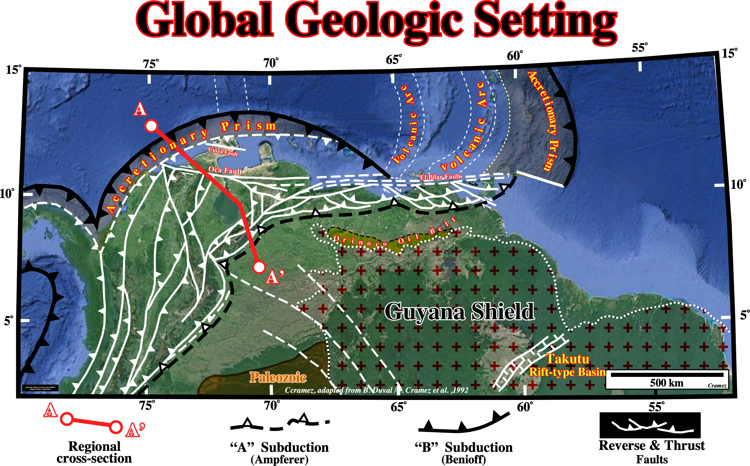
This tectonic sketch is a tentative representation of the global geological setting of the South America lithospheric plate, in which two subduction zones are paramount. The northern subduction zone is a B-Type subduction (Benioff type), since the descending plate is oceanic (B-type subductions are underlined by an: (i) Oceanic trench ; (ii) Alignment of volcanoes and (iii) Deformation of the crust, which often causes the formation of mountains). The southern subduction zone is A-type subduction zone (Ampferer type), since the descending plate is continental (A-type subduction are underlined by a foreland basin). Thus, we can say the northern and northeastern Santa Mata offshore , located on the northern part of the A-A' geological cross-section (see next plate), is associated with a B-Type subduction zone, which is responsible, in the overriding lithospheric plate (South America plate) for the development of a volcanic arc and an accretionary forearc basin.
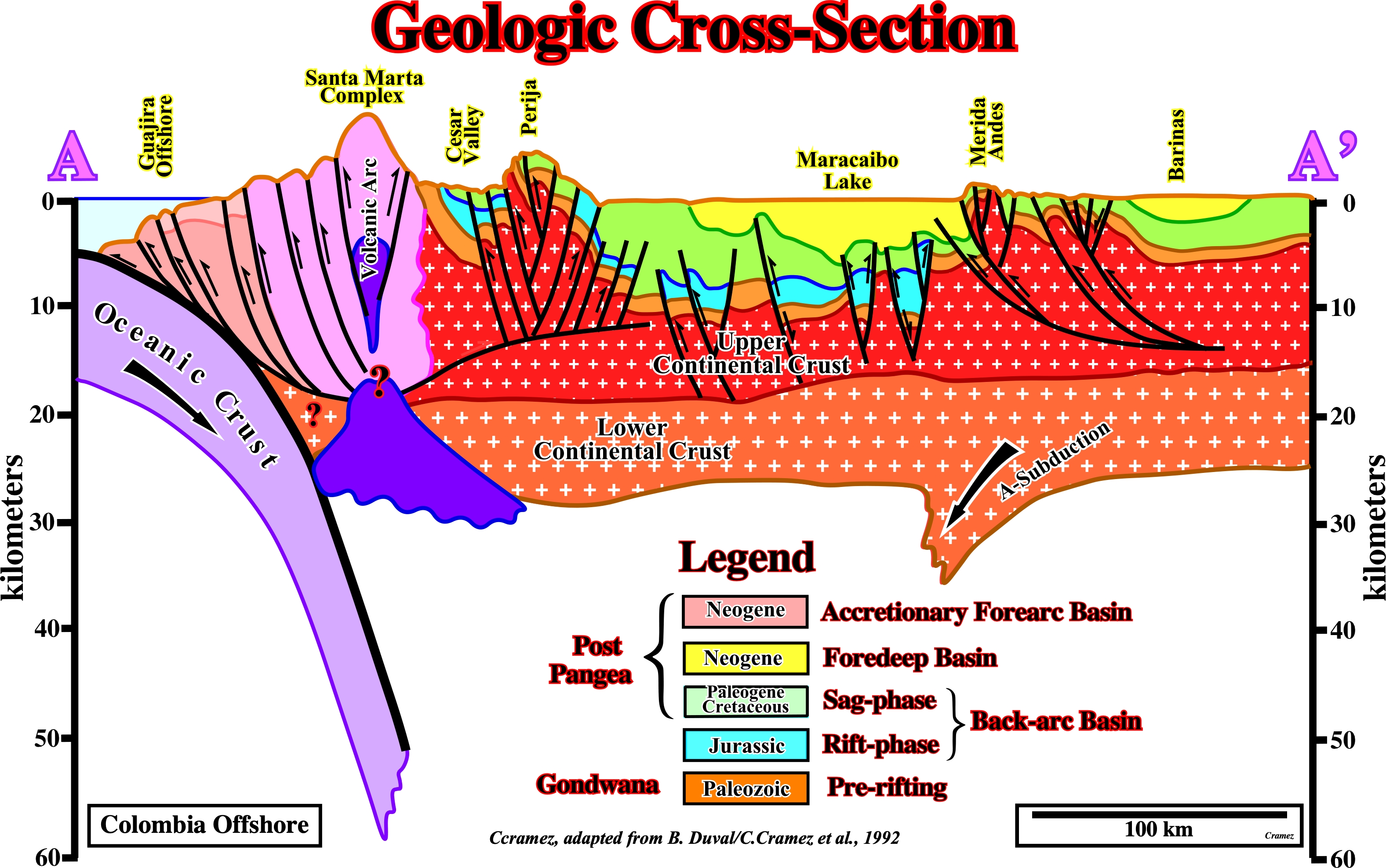
This geological cross-section between the Santa Marta offshore and the Barinas state (location on the previous plate), not only depict the geological setting of the Guajira geographic basin, but the Merida Andes as well. The Guajira offshore is associated with a B-subduction and it corresponds to an accretionary wedge and its associated forearc basin. The Merida Andes and the Barinas foreland basin area associated with a A-subduction. In the A-type subduction zone, since both plates are of the same nature and density, there is, practically, no consummation of lithospheric material, but rather accretion (if it is not compensated by erosion). This means that the descending plate does not penetrate the asthenosphere. On the contrary, in the Benioff or B-type subduction zones, as the descending lithospheric plate is oceanic in nature, and overriding plate is continental, the descending plate, denser, enters the asthenosphere where it is consumed. For these reasons, many geoscientists consider that the true subduction zones are just the B-type, since they counterbalance the creation of oceanic crust in the mid-ocean ridges. Assuming this geological cross-section depicts the geological context of the Colombia northern coastal area, on the seismic lines geoscientist must look for a B-Type subduction zone on the descending lithospheric plate and for an accretionary wedge and a forearc basin in the overriding plate.
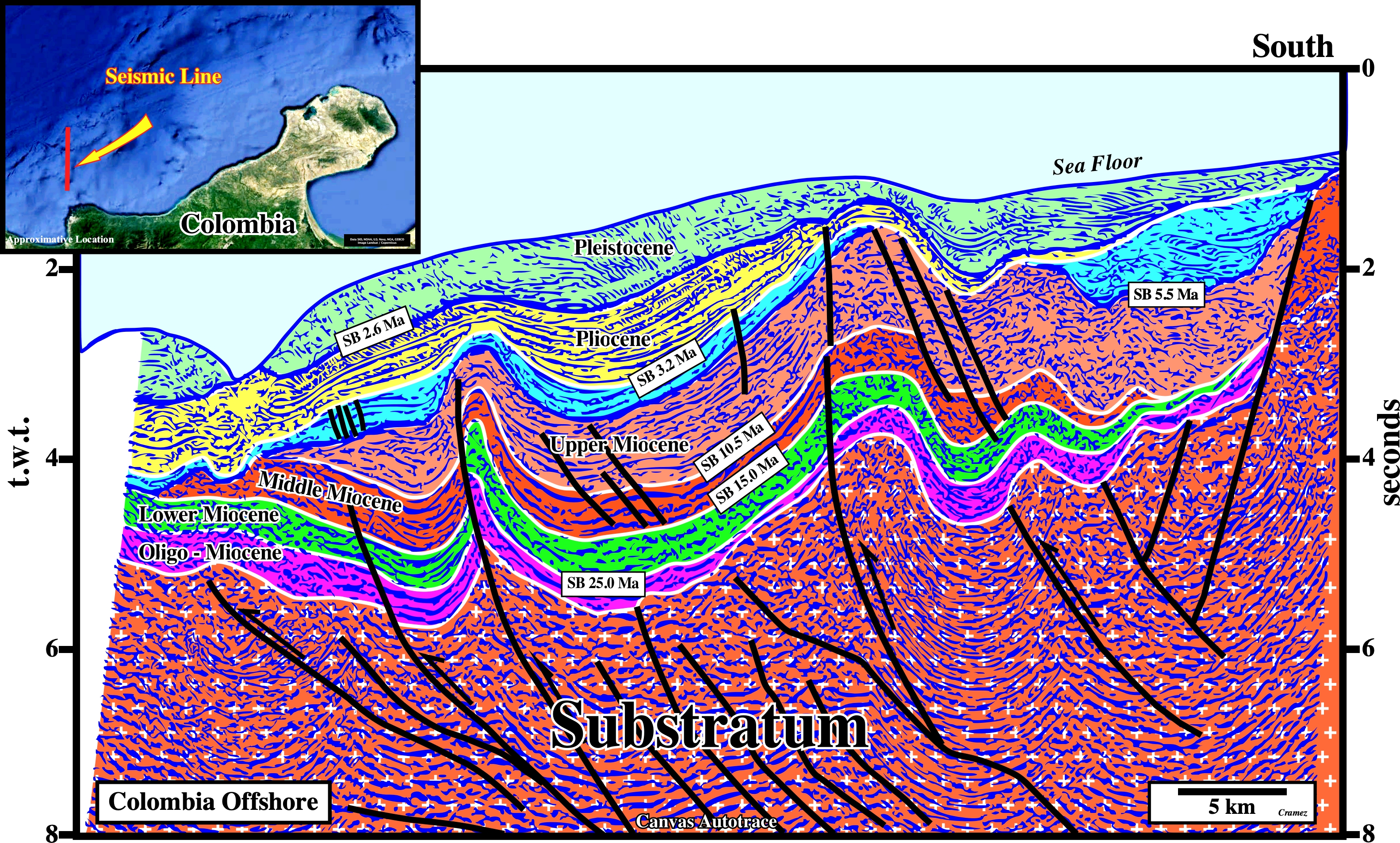
This tentative geological interpretation of the Canvas autotrace of a Santa Marta offshore seismic line located, slightly NW of the Santa Marta volcanic arc (see the cross-section of the previous plate), illustrates the stratigraphy above the substratum, which corresponds, mainly, to the Gondwana continental crust, that is to say, the stratigraphy of the upper part of the accretionary prism. In fact, for certain geoscientists the substratum and in certain cases even the oceanic crust can belong to the accretionary prism as illustrated on Sinu Offshore (see Page19). The shortening of the accretionary prism sediments is quite typical as corroborated in the next uninterpreted Canvas autotraces.

A preponderant compressional tectonic regime (σ1 horizontal, striking, roughly, perpendicularly to the shoreline, which, generally, parallels the B-subduction zone, σ2 horizontal and perpendicular to σ1 and σ3 vertical) is the mainly responsible of the shortened geological structures (anticlines and thrusts faults recognized on this Canvas autotrace, which affect sediments till the sea floor. Locally, the uppermost sediments seem not be affected by such a tectonic regime because the presence of bottom simulating reflectors (BSR) that, partially, mask the shortening of the sediments. However in certain cases, it can be observed the BSR cuts the chronostratigraphic reflectors which define the geological structures as can be see in next autotrace.
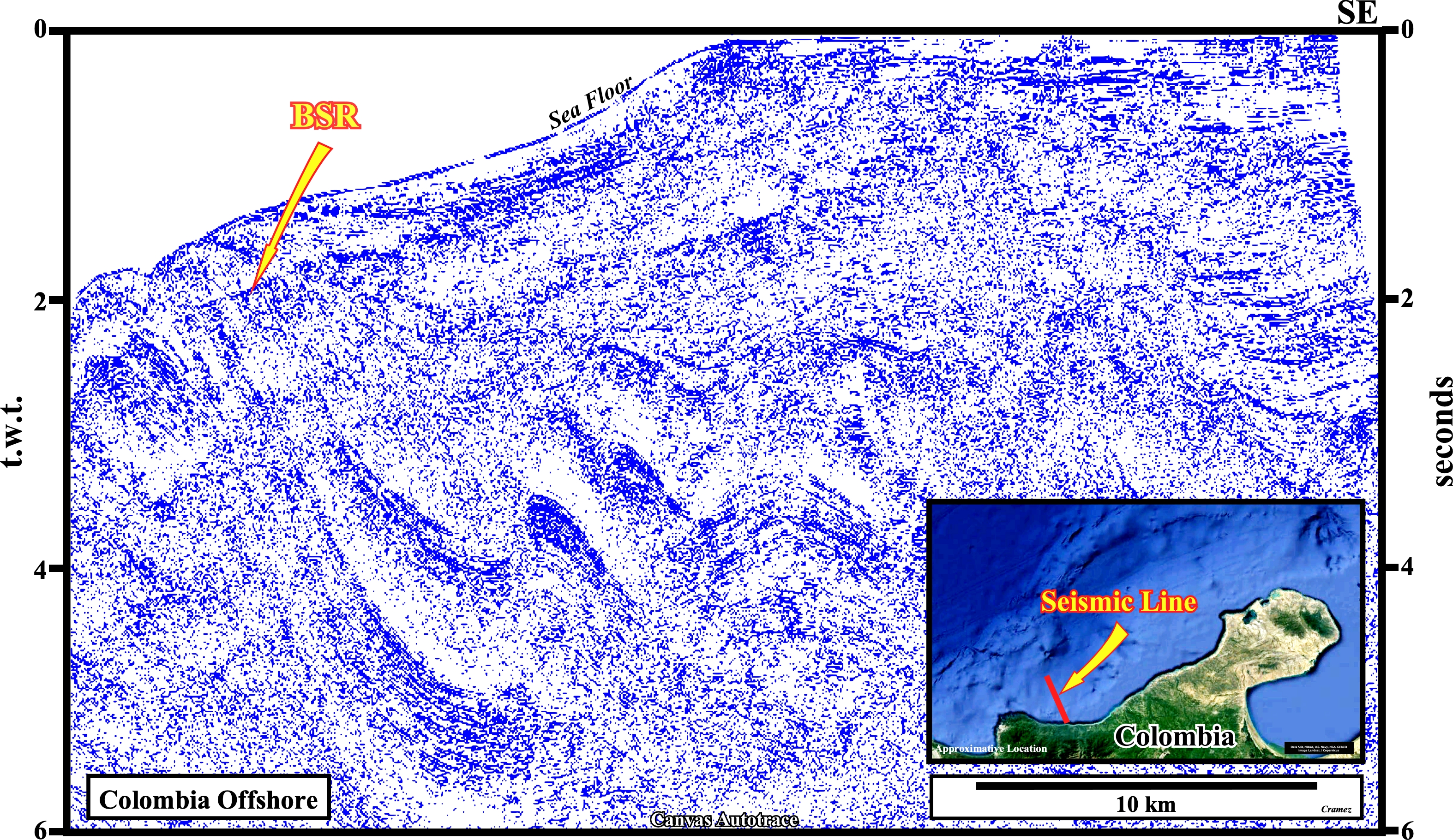
A BSR (bottom simulating reflector) is, easily, recognized on this Canvas autotrace of a seismic line from from Colombia offshore. The gas hydrate stability zone (GHSZ) occurs in oceanic sediments over the first few hundred meters below sea floor. In this zone, any methane from organic material, including any seepage from below, is converted into solid hydrate, and is locked in place in the sediments. The origin of the methane is poorly understood, with even its biogenic origin being challenged. There are three main areas of gas hydrate occurrences : (i) The regions of continuous onshore permafrost ; (ii) The regions of sub-sea permafrost within the arctic shelves and (iii) The oceanic regions of the outer continental margin. The first and the third regions are, currently, characterized by fairly stable conditions. Due to gas hydrate stability zone dynamics, changes in the concentration of greenhouse gases can be initiated more likely in the region of continental shelves with gas hydrates (http://www.cgc.uaf.edu/Newsletter/gg4_2/gas.html). On this subject it is interesting to summarize the composition, occurrence and economic significance of gas hydrates (Selley, R., 1998): (i) Gas hydrates are compounds of frozen water that contain gas molecule ; (ii) The ice molecules themselves are referred to as clathrates ; (iii) Physically, hydrates look similar to white, powdery snow and exhibit two types of unit structure; (iv) They occur only in very specific pressure temperature conditions ; (v) The pressure required for stability increasing logarithmically for linear thermal gradient ; (vi) They are stables at high pressures and low temperatures ; (vii) The pressure required for stability increasing logarithmically for linear thermal gradient ; (viii) Gas hydrates have been found in sediments of many oceans around the world ; (ix) They have been recognized from bright spots on seismic lines in water depths of 1000 to 2500 m (North Sea) and in water depths of 1000 to 4000 m (North Atlantic and South America offshores). Gas hydrates have been attributed to a shallow biogenic source. However, a crustal inorganic origin has been postulated, based on analysis of their carbon and helium isotope ratios: 1) It is probable that methane comes from three sources : 1a- Some may be derived from the mantle ; 1b- Some may be derived from the thermal maturation of kerogen ; 1c- Some may be derived from bacterial degradation of organic matter at shallow burial depths ; 2) The presence of gas hydrates can be suspected, but not proved from seismic data ; 3) The lower limit of hydrate-cemented sediment is often concordant with bathymetry ; 4) he velocity contrast between the gas-hydrate cemented sediment and underlying non cemented sediment is large enough to generate a detectable reflection horizon ; 5) The bottom-simulating reflector (BSR) may appear as a bright spot, which cross cuts bedding-related reflectors ; 6) he presence of gas hydrates can only be proved, however, by engineering data (they have high resistivity and acoustic velocity, coupled with low density) ; 7) Detailed studies have been carried out on 12 selected areas of known gas occurrence. These studies have revealed that these areas contain well in excess of 100.000 Tcf of gas within the hydrate cemented sediment, and more than 4.000 Tcf of gas trapped beneath the hydrate seal (Selley, 1998) ; 8) Unfortunately, gas hydrates present considerable production problems that have yet to be overcome. These problems are due, in part, to the low permeability of the reservoir and, to chemical problems concerning the release of gas from deep crustal zones ; 9) Clathrates deposits may be of indirect economic significance, however, by acting as cap rocks ; 10) Because of their low permeability, they form seals that prevent the upward movement of free gas ; 11)Some gas is produced from gas hydrates in western Siberia, where they pose some interesting engineering problems ; 12) Gas hydrates may have considerable importance in understanding climatic changes ; 13) Relative sea level falls can induce sudden release of gas may trigger mud volcanoes and pock-marks on the sea bed, pingos in permafrost, as well as large turbidite currents .

![]()
![]()
Send E-mails to carlos.cramez@bluewin.ch with comments and suggestions to improve this atlas.
Copyright © 2001 CCramez
Last update:
2022
![]()