

Water of Crystallization
Water in a crystal structure that is chemically combined but may be driven off by heat. Classically, "water of crystallization" refers to waterthat is found in the crystalline framework of a metal complex or a salt, which is not directly bonded to the metal cation.
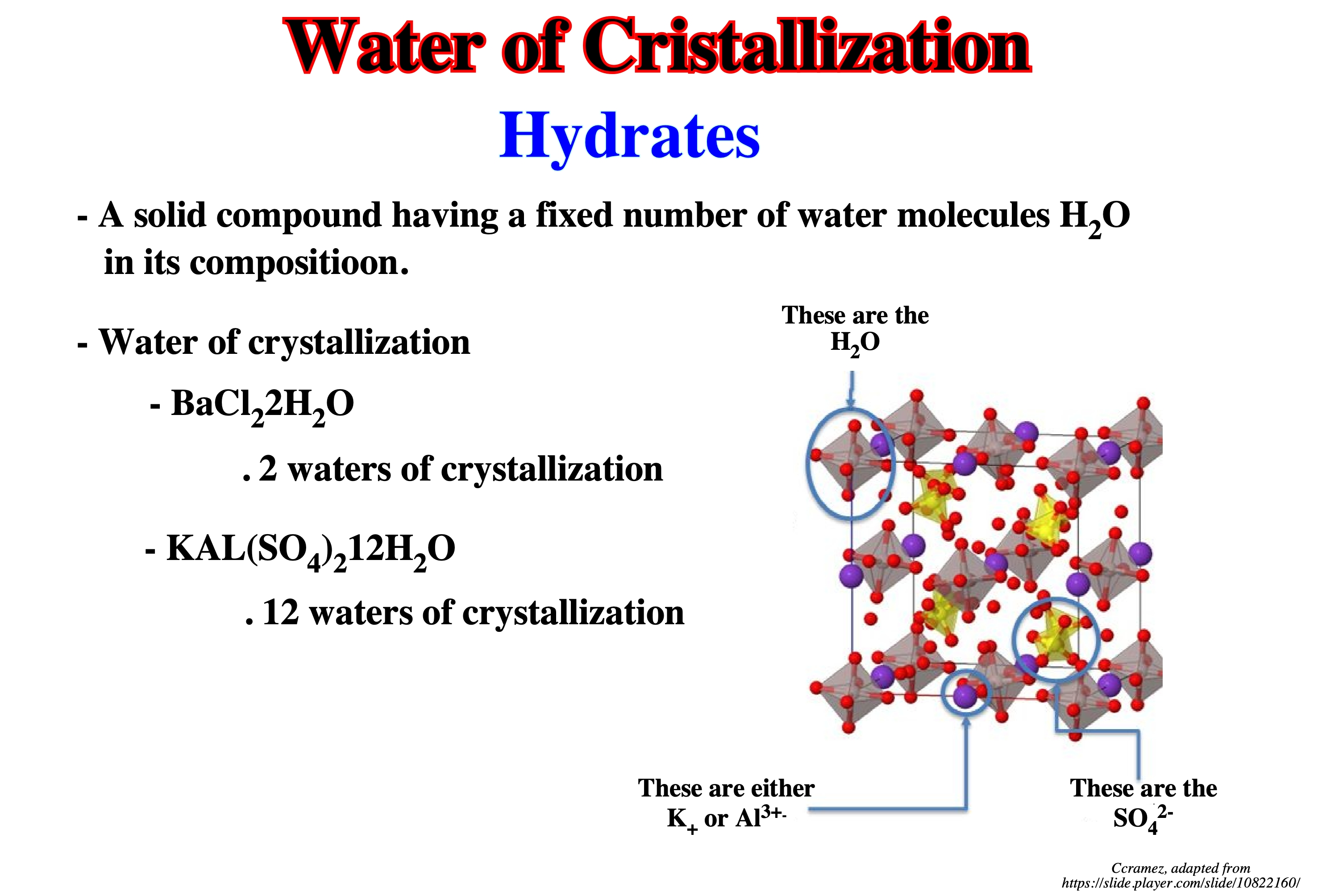
The fixed number of water molecules, which are in loose combination with one molecule of a salt, is called water of crystallization. Examples of salt containing water of crystallization are as follows: (i) Gypsum or calcium sulphate bihydrate (CaSO4 . 2H2O) ; (ii) Washing soda or sodium carbonate decahydrate (Na2CO3 . 10H2O) ; (iii) Magnesium sulphate heptahydrate (MgSO4 . 7H2O) ; (iv) Zinc sulphate heptahydrate (ZnSO4 . 7H2O ; (iv) Iron (II) sulphate heptahydrate (FeSO4 . 7H2O) ; (v) Copper (II) sulphate pentahydrate (CuSO4 . 5H2O). Salt which are able to lose the water of crystallization on their own are known as efflorescentsalt . Salt which ‘absorb’ moisture are known as deliquescent. Sodium hydroxide is deliquescent. MgCl2 is deliquescent that why table alt become soggy on a rainy day it has some MgCl2 in it .
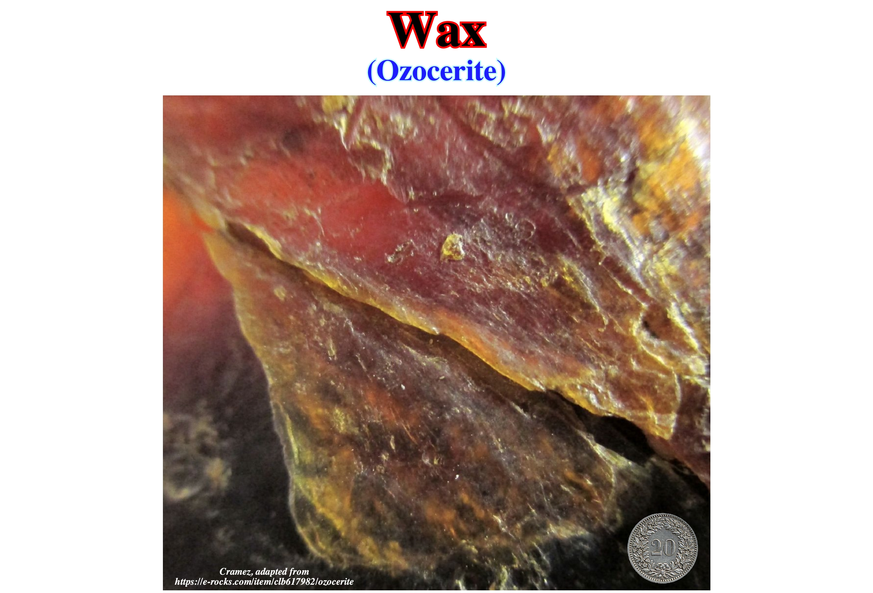
Wax
A solid, non crystalline hydrocarbon of mineral origin such as ozocerite (brown to jet black parafin wax occuring in irregular veins and solible in chloroform with a variable melting point and yielding ceresine on heating with a 20-30% solution of concentrate H2SO4 at 120º to 200º) and parafin wax, composed of the fatty acid esters of the higher hydrocarbon.
Waxes are organic compounds that characteristicall consist of long alkyl chains. Natural waxes may contain unsaturated bonds and include various functional groups such as fatty acids, primary and secondary alcohols, ketones, aldehydes and fatty acid esters, and aromatic compounds may also be present. Synthetic waxes often consist of homologous series of long-chain aliphatic hydrocarbons (alkanes or paraffins) that lack functional groups. (https://en.wikipedia.org/wiki/Wax)
Wearing
The gradual destruction of a landform or surface by friction or attrition.
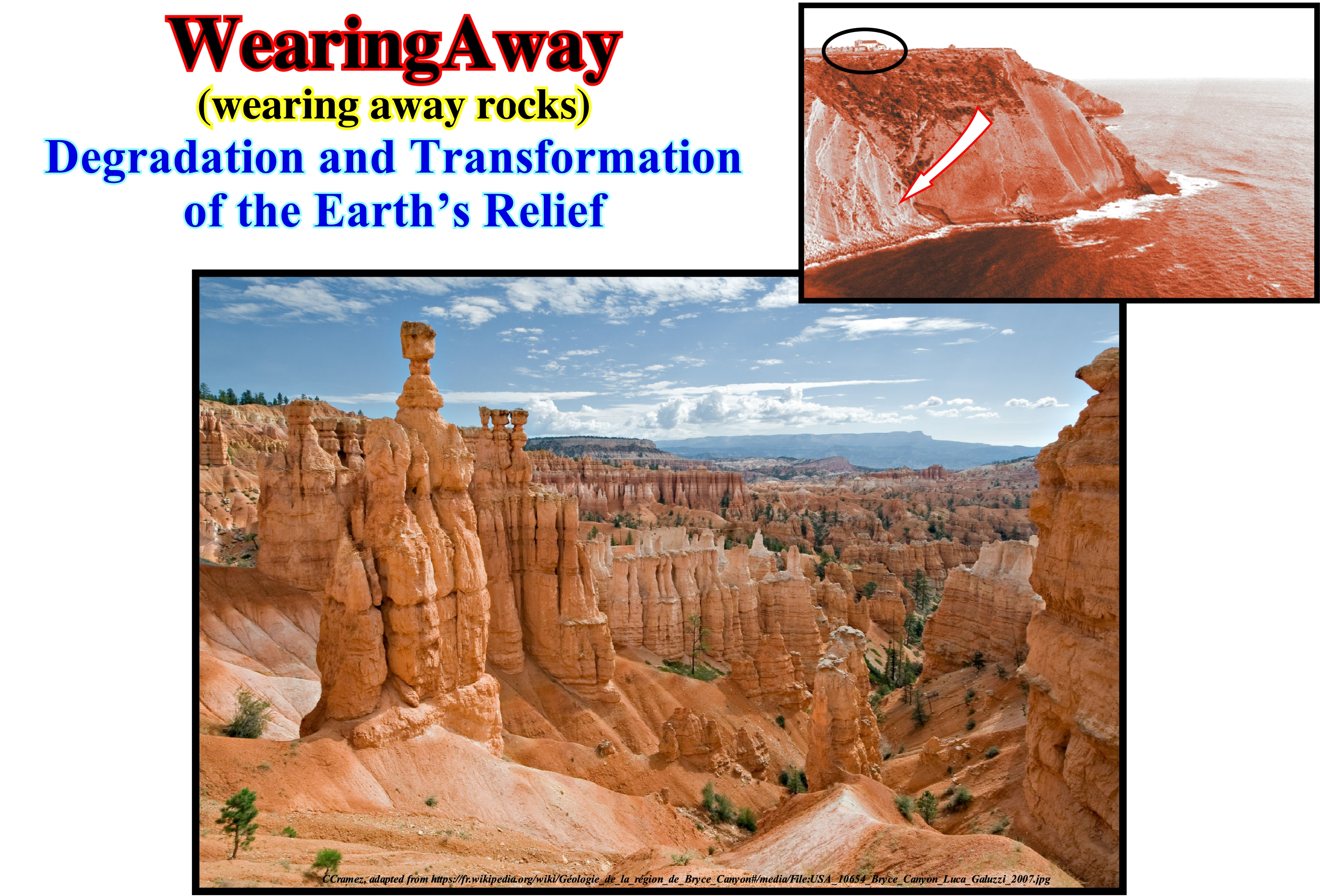
Rocks are solid bodies formed by the aggregation of mineral materials. Such bodies are formed by one or several types of minerals. All the rocks began to form in an igneous state, under high temperatures. Outside the land crust, igneous rocks are ejected through the volcanoes. The igneous material cooling, forms solid bodies of variable forms. The rocks undergo continuous processes of wear, through diverse conditions, as, weathering, storms, etc. The type of rock formed by deposition of the sedimentary particles, created by the wear agents, form the sedimentary rocks. The erosion that the original rocks (primary rocks or igneous rocks) undergo, gradually, transform them into sedimentary particles that end up being incorporated in other natural cycles (loaded by rivers, wind or rain). Over time (thousands and thousands of years), the sedimentary particles of the worn-out original rocks deposit in layers on the ground, and are pushed into the innermost parts of the Earth by the geostatic pressure (weight of the sediments). Finally, the sedimentary particles return to the environment where the rocks are in a, more or less, liquid state, melting again to restart the cycle of the rocks. Mechanical action of water and wind wears, substantially, the rocks. The movement of the waters and winds causes the accelerated wear of the rocks as it promotes their physical disintegration. These phenomena are amplified, as is the case during sandstorms in which sand, at great speed, collides with the rocks causing them to wear. Cryoclasty * is also an important process of rock wear. It is made through the infiltration of water into the cracks in the rocky massifs. When the temperature drops to negative values the water freezes and increases in volume, which exerts a great pressure on the cracks, widening them which contributes to the wear of the rocks.
(*) Fragmentation process of rocks and glaciers by the force exerted by the water that freezes inside the cracks.
Well Log
A graphic record of the measured or computed physical characteristics of the rock section encountered in a well, plotted as a continuous function of depth.
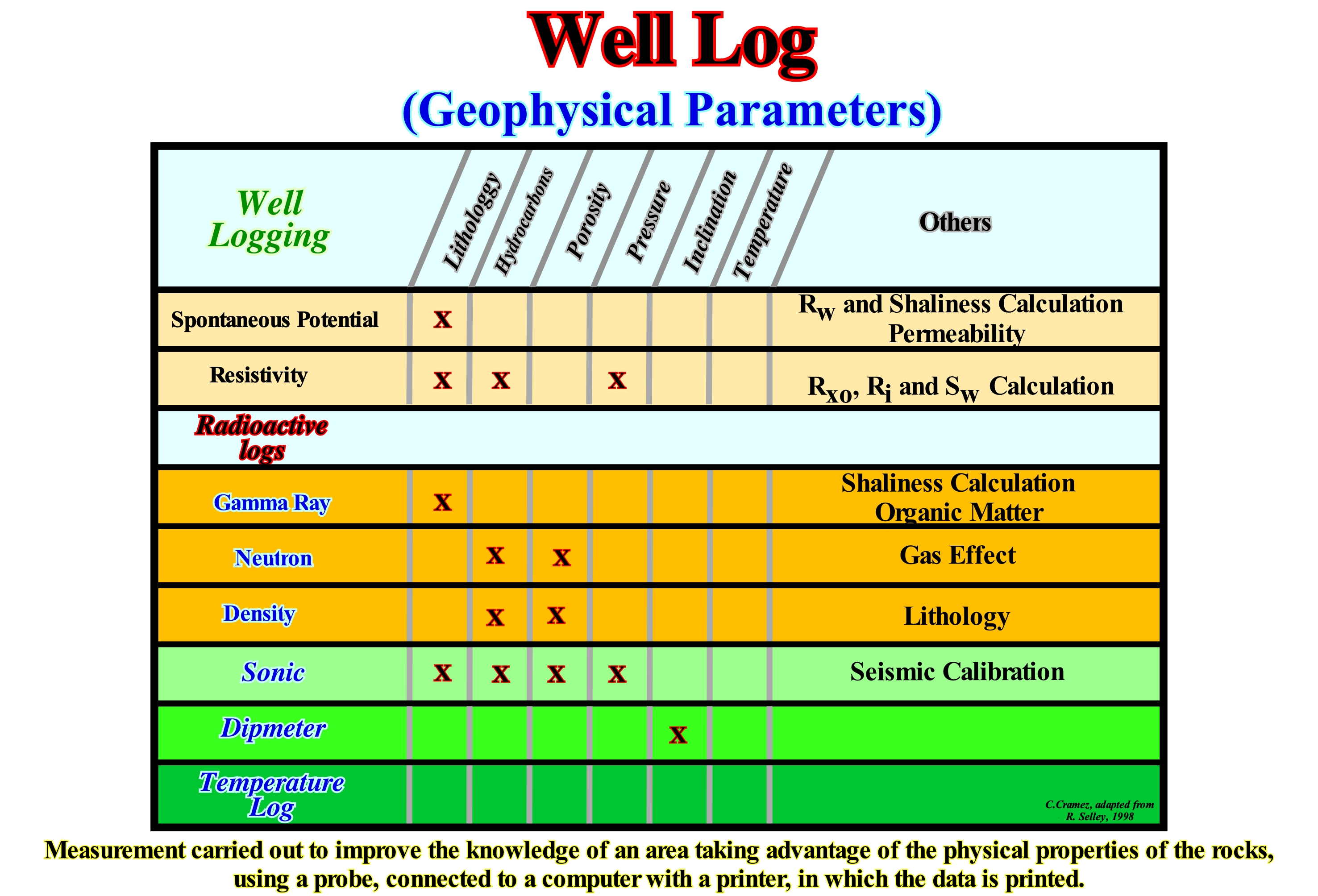
At present, most logs are interpreted automatically. They give a continuous reading of the lithology, porosity and percentages of the various fluids present in the pores. Although such logs seem very convincing, especially when presented in colour, it is preferable to always check the original data and, above all, to check them with the nonelectric logs made during the drilling. Most automatic interpretations do not take into account the presence of aberrant minerals, which can invalidate the whole process of interpretation. The presence of abundant mica reeds in a sand will be read by autolithic-logs as shales which will give wrong porosity values and the sand (potential reservoir-rocks) will be automatically interpreted as a packet of shales with no reservoir-rock quality. In my professional career, I found several errors of this type, especially those induced by the presence of glauconite. This mineral, which is very abundant in the transgressive sandstones, which are, in general, high quality potential reservoir-rocks and that, above all, can form potential stratigraphic traps (due to its retrogradational geometry), greatly influences the readings of the logs to such an extent that the sands can be mistakenly interpreted as clay intervals. The diagrams may also be used to determine lithology and the deposition environment. The spontaneous potential (SP) and gamma ray (GR) logs may indicate granulometry profiles (fining upward or coarsening upward) of the sandy intervals. The spontaneous potential logs are, locally controlled, by permeability, which increases with grain size. In this type of log, the maximum deflection to the left occurs in the most permeable intervals. The spontaneous potential, usually, registers a granulometry. The gamma ray can be used in a similar manner to indicate the clay content of the sand which, in general, increases when the particle size decreases.
World Time (Teeichi Kobayashi, 1944)
Geological time as indicated by the life range of a single cosmopolitan fossil species.
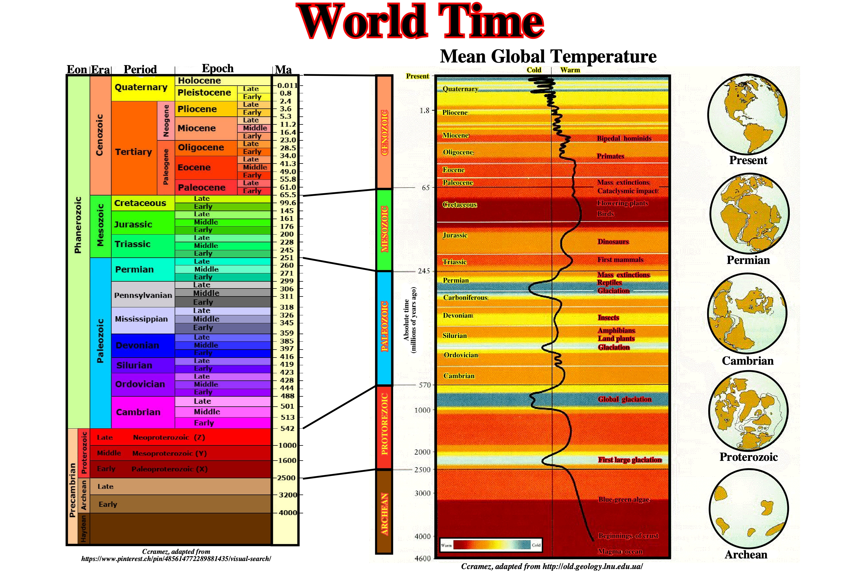
On this figure are represented the many geological divisio0ns as well as the principal geological events and the princiopla paleogeoghraphic maps.