
Oblique Inversion (Letouzey, J. et al.,1995)
Inversion associated with a strike-slip movement. Oblique inversions are associated structures with en-échellon folds and faults. Examples of oblique inversions can be found along the Saharan flexure, which separates the Atlas domain from the Saharan platform. The Atlas domain is a typical folded and uplifted inverted graben above thick salt. In addition to conventional inversion structures such as forced folds over the basement faults, a strike-slip component forms en-échellon folds in footwalls of basement folds. Fold axial traces are slightly oblique to the flexure and are crosscut by synthetic crestal tear folds. Within the Atlas domain, folds that are unrelated to basement fault inversion or diapirism trend perpendicular to the regional Tertiary compression.
Occlusion (Talbot, C. J., 1995)
Occlusion of a salt diapir can occur by roof thicker than critical thickness. Burying diapirs deeper than their critical roof thickness not only eclipses passive diapirs but also occludes them until they are incapable of piercing actively. However, until occluded salt bodies are dissolved at depth, they maintain their potential to pierce actively if their denser overburden is ever thinned by erosion or deformation.
The study of the ocean, including its physical, chemical, biological and geologic aspects. Synonym of oceanology.
The sedimentary basin bottomed by oceanic crust. The large surface of such a basin is starved. Oceanic basins are almost exclusively filled by water, i.e., they are the infrastucture of the oceans.
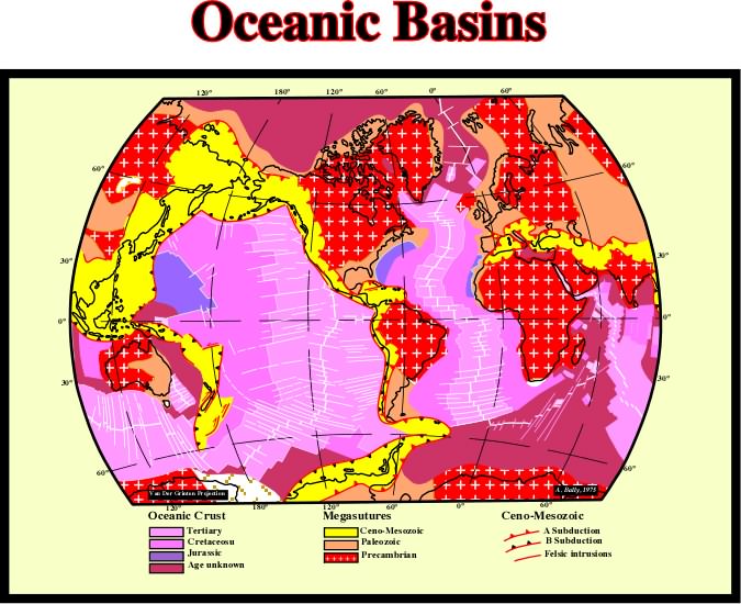
The map of the oceanic crust represent roughly that of the oceanic basins, which are at 99% filled by water. The fact that the bottom of the oceanic basins is the oceanic crust is quite important. Indeed, due to movement of the lithospheric plates, the volume of the basin changes with time. However, as the water volume, in all its forms, is assumed to be constant since the Earth's birth, every time the volume of the basin increase, the global sea level falls. Contrariwise, when the volume of the basins decreases, the global sea level rise.
Tectonic stress induced by the emplacement and topography of new oceanic crust at the level of the mid-oceanic ridges.
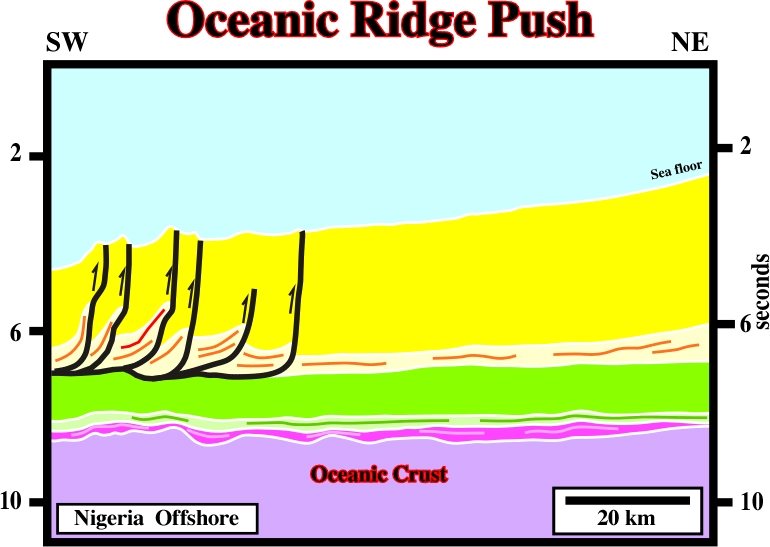
This fold-belt, located on ultra-deep offshore, in which all thrusts show a landward vergence, was probably created by a local tectonic stress created by oceanic ridge pushing. It cannot be explained as a counterpart of the up-dip extension so characteristic of West Africa offshores.
Progressive offshore regression of the up-dip terminations of the sedimentary units within a conformable sequence of rocks.
Upwelling of salt characterized by two contrasting flanks: (1) steep, discordant flank-typically a growth fault-separating salt from thick, gently dipping strata; (2) gently-dipping, concordant flank overlain by tilted, trapdoorlike interval of sediments, which are commonly erosionally truncated and which preserve prekinematic strata.
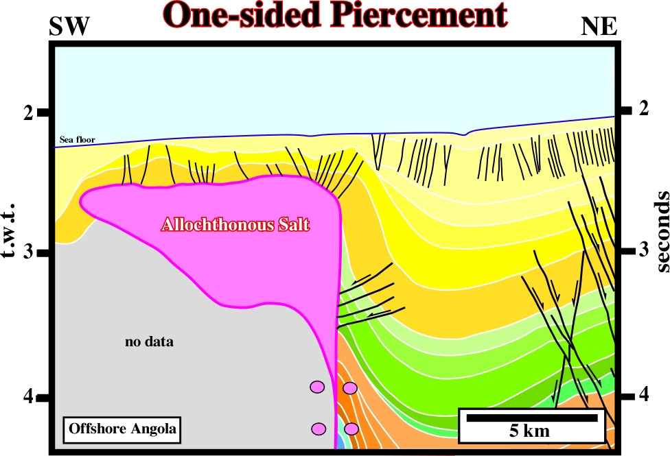
One sided piercements are frequent in deep water of West Africa in association with thrust faults created by a compressional tectonic regime induced as a counterpart of the extension regime located up-dip, that is to say in slope and upper slope environments.
A base-discordant relation in which initially (deposition time) horizontal strata terminate progressively against an initially inclined surface, or in which initially inclined strata terminate progressively up-dip against a surface of greater initial inclination.
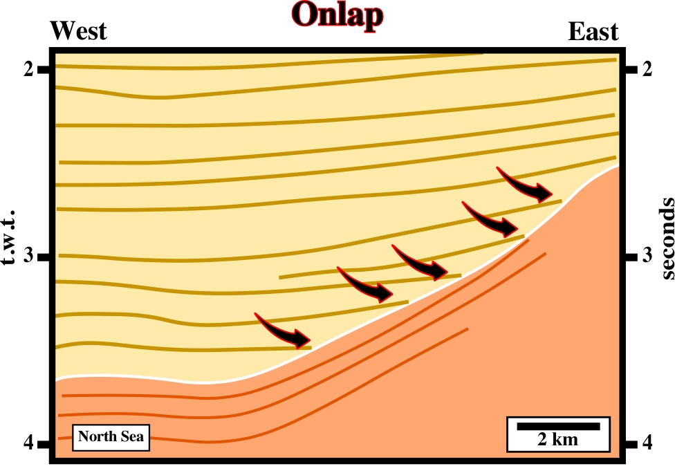
Onlap relationships can be coastal or marine. Both represent the aggradation induced by a relative sea level rise. With exception of turbidite depositional systems, deposition takes place when sedimentary accommodation increases.
Ordovician Salt Deposits (Zharkov, M. A., 1984)
The available information allows the recognition of a single Ordovician salt basin -The Canadian Arctic Archipelago Basin. The Canning Basin in Australia may also be Ordovician in age, but the stratigraphic position of the salt deposits occurring therein is still unknown.
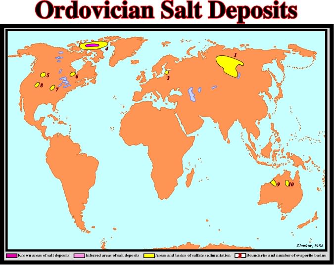
The distribution of Ordovician evaporite deposits can be summarized as follows: (1) Lena-Yenisei, (2) Severnaya Zemlya, (3) Baltic, (4) Canadian Artic Archipelago, (5) Williston, (6) Moose River, (7) South Illinois, (8) Anadarko, (9) Canning, (10) Georgina.
Parallel salt walls are now though to result from linear boundary effects rather than from extra-thick source layers, as was previously supposed. The strongest and most direct boundary effects are exerted by overburden faulting or by overburden folding and the pattern of differential loading in the overburden, especially during progradation or downslope mass flow. Other boundary effects include basement-fault offset in the base of the source layer and tilted or wedge-shaped source layers or overburdens. A salt roller is the first response of the salt to non-uniform extension of the overburden.
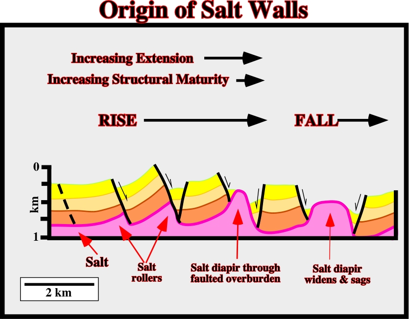
A salt roller is the first response of the salt to non-uniform extension of the overburden. A roller having a simple crest forms at the base of the footwall of a half-graben. Two roller form below a graben, one in each footwall. As extension increases, the salt diapir pierces the graben to evolve into a salt wall. With the most extreme thin-skinned extension, the overburden breaks into rafts, which can glide laterally tens of kilometers.
A linear or arcuate region that has been subjected to folding and other deformation during an orogenic cycle.
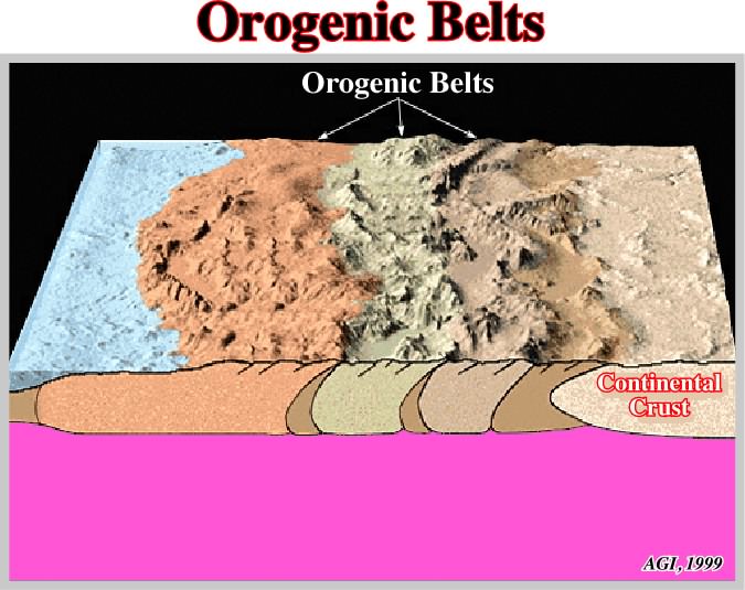
Orogenic-belts are mobile belts during their formative stages, and most of them later became mountain-belts by post-orogenic processes.
Orogenic Cycle (McNeill, L. et al., 1999)
The interval of time during which an originally mobile belt evolved into a stabilized orogenic belt passing through (i) a preorogenic phase, (ii) a orogenic phase and (iii) a postorogenic phase. The concept has been rendered obsolete by the recognition of the lithospheric plate of the Earth.
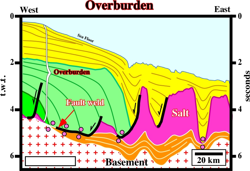
Strata younger than the salt substratum or source layer.
On this seismic line, assuming the salt layer is autochthonous, what is the more likely (above basement),the sediments overlying it form the overburden.
Part of the mass of a salt dome that projects out from the top of the dome much like the cap of a mushroom diapir.
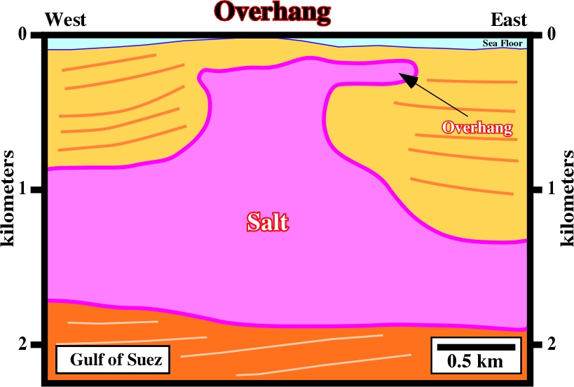
On this reprocessed seismic line, the overhang is quite evident. Below it, sub-salt prospects are likely. In salt basins with a mature petroleum exploration, a lot of significant hydrocarbon accumulations are associated with overhangs.
Exchange in position of the source layer and overburden such that the less-dense layer is eventually uppermost.
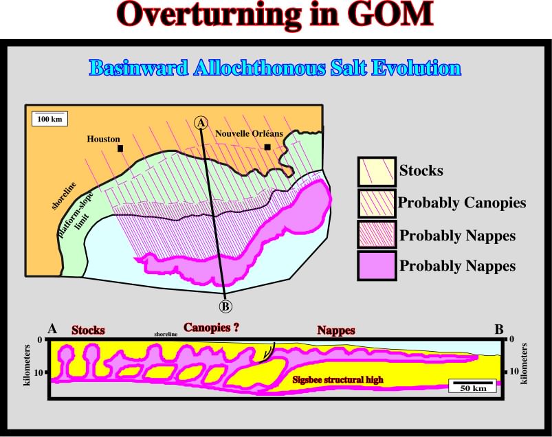
In Gulf Coast, the allochthonous salt napes are examples of overturning. Indeed, as illustrated, the Louan salt, which age is Jurassic, is quite often intercalated in Miocene sediments.