

A lithology and the associated fauna. A sedimentary facies can be defined as a mass of sedimentary rock, which can be defined, and distinguished from others, by its lithology, geometry, sedimentary structures, paleocurrent pattern and fossils As pointed out by Selley (1970), it is very important to distinguish a sedimentary environment from a sedimentary facies. One should say sand facies in a deltaic environment rather than sandstones deposited in a fluvial facies or in a turbidite facies.
Adjoining salt walls or salt stocks comprising more than one generation of diapir. The secondary peripheral sink of the mother diapir laterally merges with the primarily peripheral sink of the daughter diapir, the same relationship holds for succeeding offspring. The secondary peripheral sinks of each generation are thus imbricated. The family comprises diapirs of different ages rooted in the same source layer. This relationship contrasts with generations of salt structures distributed vertically, each generation of salt sheet providing a new source layer for the next secondary-cycle and third-cycle diapirs.
A block of the crust that has been displaced by movement on a fault. Fault block is mainly used when the dip of the fault plane is unknown, that is to say when the footwall or hangingwall cannot be recognized.
See: Basal cutoff.
The process of fracturing and displacement that produces a fault.
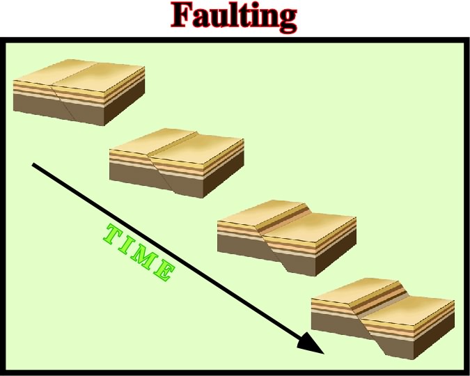
Four steps of faulting along a post-compaction normal fault are illustrated. When a fault is pre-compaction, the dip of the fault is affected by the different compaction of the stratigraphic intervals. A shale interval, for instance, is much more compactable than a sand or limestone interval.
Fault surface or fault zone joining strata originally separated by autochthonous or allochthonous salt. It is equivalent to a salt weld along which there has been significant slip or shear.
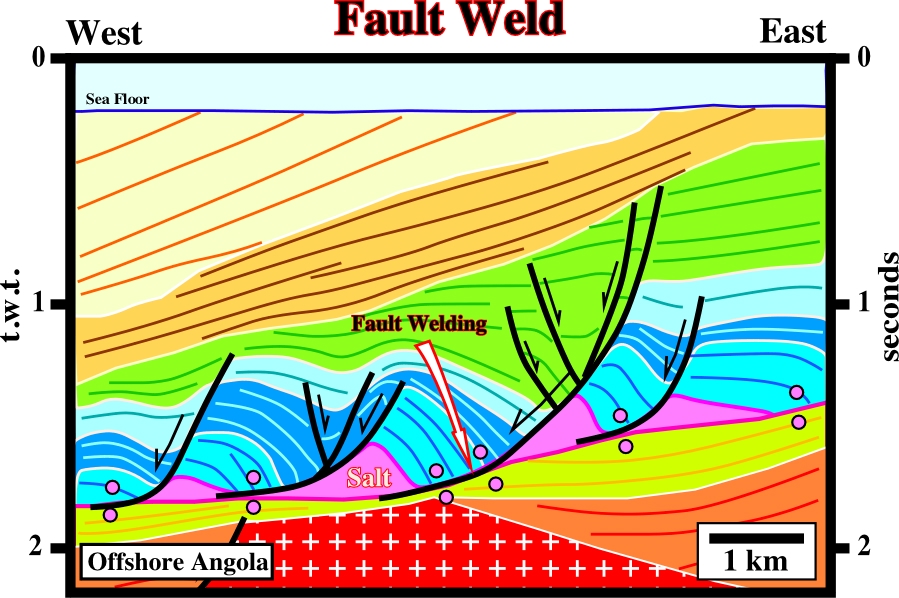
Fault welds ("cicatrices salifères" in French) were first defined in onshore and offshore Angola, from where this seismic line come from. The movement along the fault welds is generally easy to date using the internal configuration of the different sedimentary packages. In this particular example, it is quite evident, the seaward movement was initiated during the dark blue interval since the first blue interval is roughly isopach.
Counter-regional fault, which is often interpreted as a feeder of allochthonous salt structures.
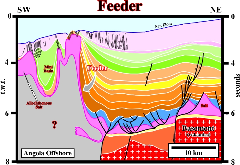
On this interpretation, the salt in the counter-regional fault, underlined by the arrow, is just a interpreter's suggestion of the connection between the allochthonous and autochthonous salt layers. In other words, it is suggested than the counter-regional faults is a feeder of the allochthonous salt structure.
A group of abundant rock-forming minerals of general formula: M{Al(Al,Si)3O8}, where M=K, Na, Ca, Ba, Rb, Sr or Fe. Feldspars are the most widespread of any mineral group and constitute 60% of the earth's crust. They occur as components of all kinds of rocks (crystalline schists, migmatites, gneisses, granites, most magmatic rocks) and as fissure minerals in clefts and druse mineral cavities.
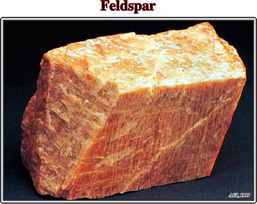
Feldspars are usually white or nearly white and clear and translucent (they have no color of their own but are frequently colored by impurities), have a hardness of 6 on the Mohs scale, frequently display twinning, exhibit monoclinic or triclinic symmetry, and possess good cleavage in two directions (intersecting at 90° as in orthoclase and at about 86° as in plagioclase). On decomposition, feldspars yield a large part of the clay of soil and also the mineral kaolinite.
A finite change in shape or volume of a body as a result of stress. The final state of finite strain can be considered as being made up of a large number of incremental or infinitesimal strains.
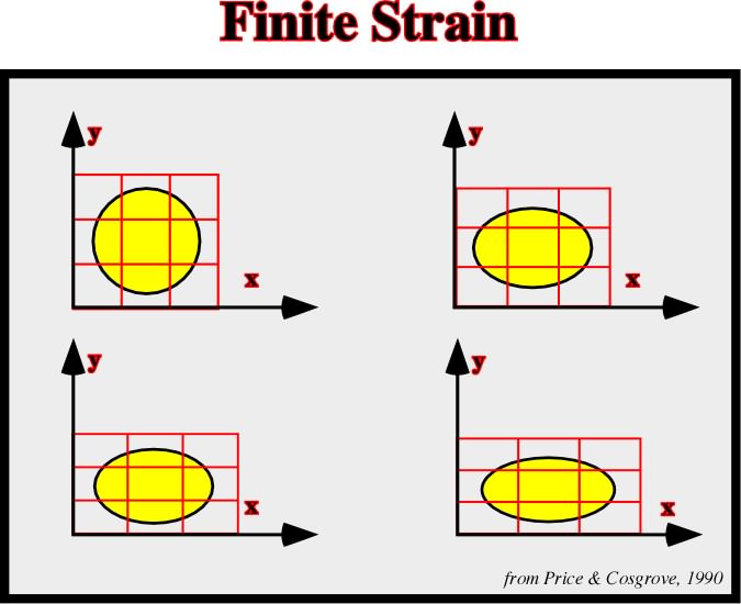
Various stage in pure shear deformation. Such deformations involve no area change. There are three principal strains: (i) longitudinal, change in length per unit length (e.g. when stretching a wire); (ii) volume, change in volume per unit volume (e.g. when a hydrostatic pressure is applied to a body); (iii) shear, angular deformation without change in volume (e.g. a rectangular block strained so that two opposite faces become parallelograms, the others not changing shape).
Cell that contains several diapirs within it and which may be as large as an entire sedimentary basin.
Detachment fold with a fish-tail geometry in an upper detachment.
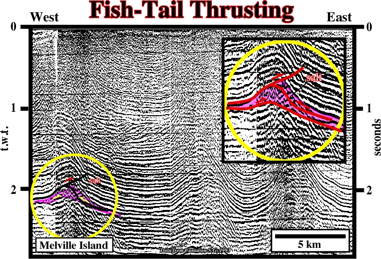
Fish-tail thrusting structures, above the salt layer, are quite frequent, in Melville Island.
Flaring Regime (in salt molding) (Talbot, C. J., 1995)
When the molding ratio (R°/A°), that is to say, flow rate of salt minus dissolution divided by aggradation rate minus compaction, ranges between 100> R°/A°>10. With such a ratios the dip of the bottom contact flares between 0.6° and about 11.5°.
A fold in which the mechanism of folding is slip along bedding planes or along surfaces of foliation. In this type of folds there is no change in thickness of individual strata and the resultant folds are parallel.
See: Glacial structures.
Flow Law For Damp Salt (Jackson, M. P. A., 1995)
Water had long been known to soften salt, but until the 1980s, experimental rock mechanics had focused on the rheology of dry salt, known to deform by dislocation creep. Recently, geologists found that damp evaporites could deform by solution-transfer creep under much lower stresses and much more rapidly than dislocation creep characteristic of dry evaporites. This explained the extraordinarily high flow rates of damp glacial salt.
Fluid Era (Jackson, M. P. A., 1995)
In the history of salt tectonics three eras can be considered: (i) Pioneering era, between 1856 and 1933, (ii) Fluid era, between 1933 and roughly 1898, and (iii) Brittle era. The fluid era was dominated by the view that salt tectonics resulted from the Rayleigh-Taylor instabilities in which a dense fluid overburden having negligible yield strength sinks into a less dense fluid salt layer, displacing it upward. Density contrasts, viscosity contrasts and dominant wavelengths were emphasized, whereas strength and faulting of the overburden were ignored.
A curve or bent of a planar structure such a rock strata, bedding planes, foliation or cleavage. A fold is usually a product of deformation, although its definition is descriptive and not genetic and may include primary structures.
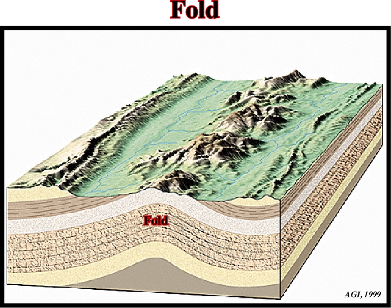
Admittedly, fold is a general term and is used in reference to extensional and compressional structures, i.e., structures created by shortening and lengthening. Actually, anticlines are fold created by shortening, while antiforms are folds created by lengthening, in other words, anticlines and antiforms cannot be formed at same time in the same place.
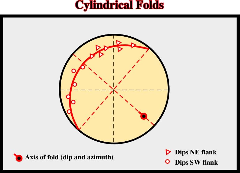
Anticlines can be cylindrical or conical. They are easily differentiated when depicted on a stereographic projection. Indeed, on a stereographic projection, the flanks of an anticline lie on a meridian and the axis of the anticline is the pole of the meridian.
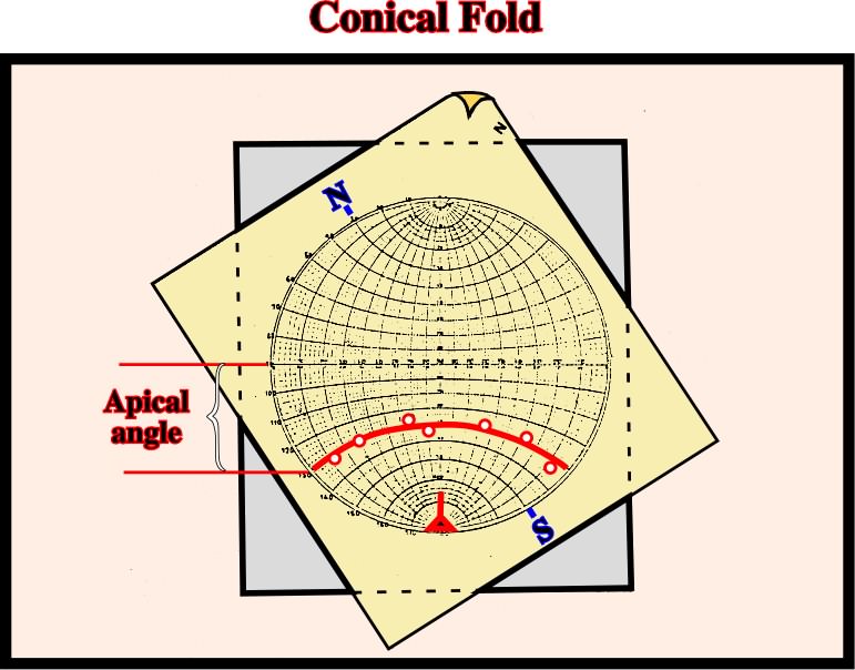
Conical anticlines, generally associated with strike slip movements, are oblique to the maximum effective stress. In a stereographic projection, their flanks lie on a parallel. The apical angle, as illustrated above, is the angle between the equatorial parallel and the the parallel where the anticline flanks lie.
The line connecting the points of flexure or maximum curvature of the bedding planes in a fold. Synonym of hinge line.
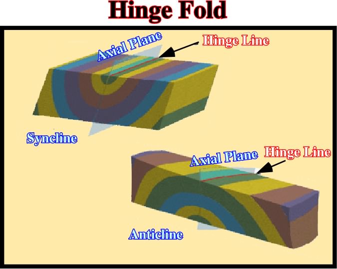
The hinge line of a fold (anticline or syncline) can be easily determined. It is given by the intersection of the axial plane, where lies the medium effective stress (
2), with the horizontal plane. The dip of the hinge line gives the inclination of the axis of the structure.
Synonym of Orogenic belt.
The underlying side of a fault, ore-body, or mine working. Also, the wall rock beneath an inclined vein or fault.
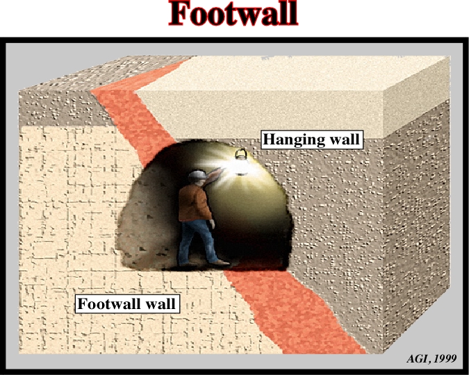
Initially, the term footwall was mainly used by the mining workers before being adopted by the American petroleum geologists. It corresponds to the up-thrown faulted block of the French geologists.
Foredeep Basin (Bally and Snelson, 1980)
Basin associated with the formation of the megasutures and located in the plunging continental lithospheric plate. Foredeep basins are often related with an Ampferer subduction zone.
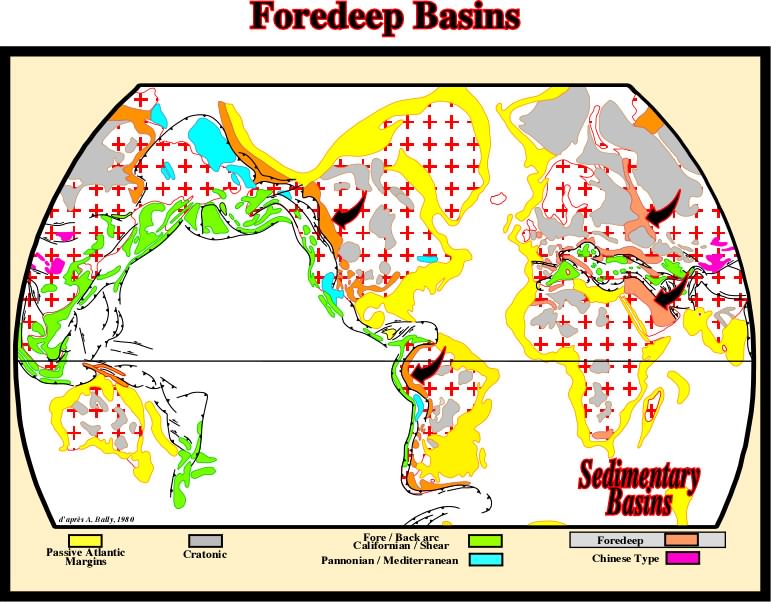
Foredeep basins are associated with the formation of the megasutures and particularly with the Ampferer, or A-type, subduction zones, where a continental lithospheric plate sink under a continental or oceanic thrusting plate.
Structures deposited above the upper compartments of major basement faults or quite close to the noses of the large tilted blocks when translation is taken into account. Fore-raft are characterized by the presence of erosional surfaces, steep dips and large salt pillows.
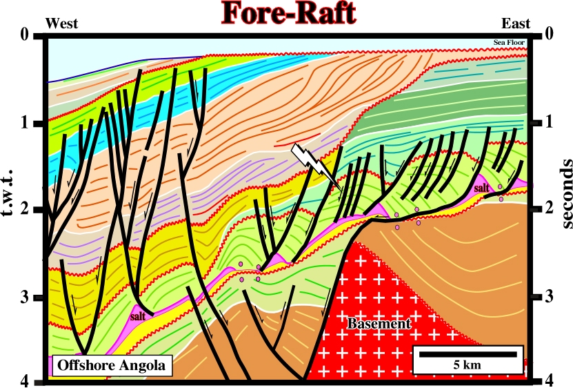
Fore-rafts structures, located in the basinward side of a raft, are slightly located down-dip of the basement (or sub-salt strata) highs. In carbonate intervals, and contrariwise to back-rafts, they are very good potential reservoirs. In the area where this line was shot, there two main generating petroleum sub-systems. A lower one, located in the rift-type basin (lacustrine shales) and an upper one, located in the overburden and associated with the Cretaceous major downlap surface (Cenomanian-Turonian).
The geometry associated with the regressive intervals, where the successive depositional coastal breaks and/or shelf breaks are progressively displaced seaward. In the onset of a regressive episode, the basin has a platform, and so, depositional coastal breaks and shelf breaks can be recognized. However, after a certain amount of forestepping, the basins has no more platform and the depositional coastal break and shelf break are coincident.
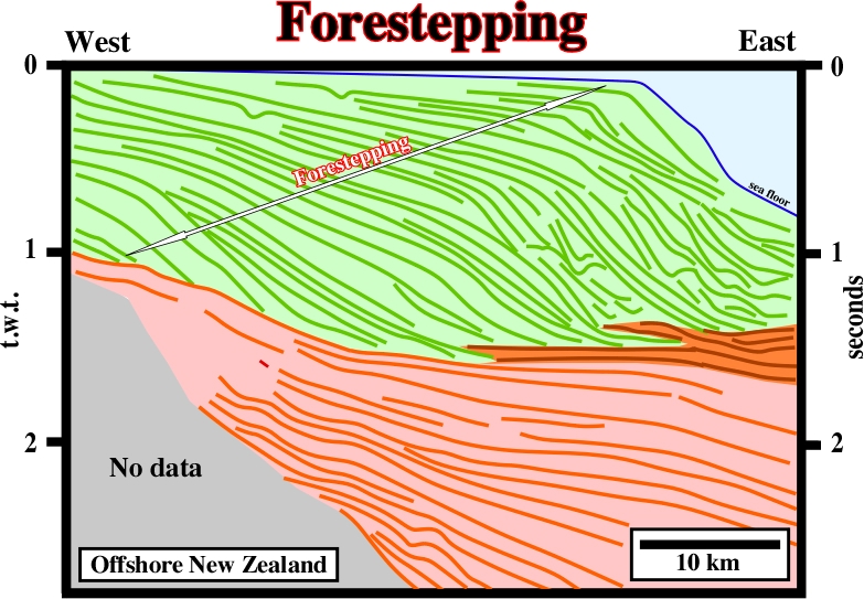
The upper sedimentary package overlying the major downlap surface is mainly composed by a succession of regressive episodes separated by minor transgressive or retrogradational episodes. Globally, one can say the geometry of shelf breaks is mainly forestepping, since they have been almost continually displaced seaward.
See: Molding and Backward molding models.
Zone of fragility of the continental crust, which can favor the breakup of the lithosphere. In offshore, and particularly in the divergent Atlantic-type margins, fracture zones are often directly, or indirectly, associated with transform faults and changes in the rate of sea floor spreading.
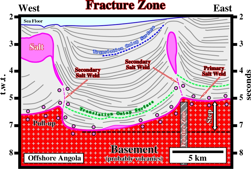
In offshore Angola, some fracture zones correspond to reactivated pre-Pangea fractures or rifting faults. The firsts strike roughly WE-SW; the others are oriented more or less North-South. The fracture zones related with pre-Pangea are well recognized on the morphology of the shoreline of Angola.
The height of the crest of a salt diapir or sheet above the surrounding sediment surface.
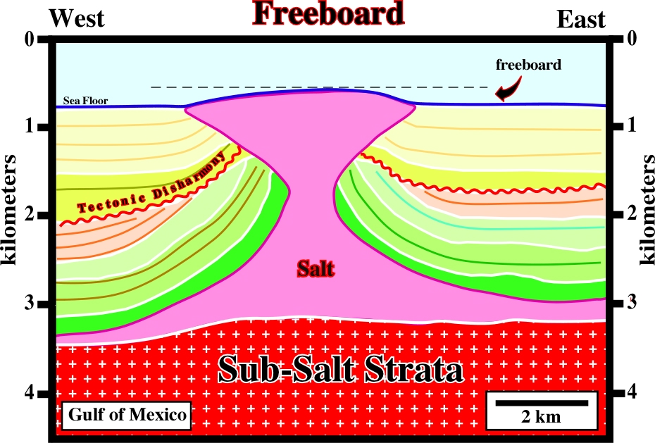
The freeboard of the Green Koll structure (Gulf of Mexico) is quite well marked on the morphology of the bottom sea. Actually, the freeboard of extrusive salt diapirs or allochthonous sheet are easily recognized on dip maps of the bottom of the sea.
Surface that perpendicularly to it the confining pressure is meaningless and along which deformation takes place. Uplift takes place perpendicularly to the free surface. The surface of the geoid can be considered as a free surface.
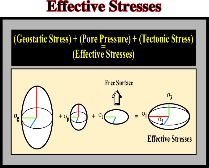
Earth's surface is the outward free surface, since perpendicular to it there is not confining pressure. The implications of such a features are well known. In areas characterized by a tectonic regime with a minimum effective stress vertical (cylindrical folds, reverse faults and thrusts), is not uncommon to see erroneous seismic interpretations with fault planes becoming subvertical in depth. Such a fault geometry (in the given tectonic regime) implies an inward free surface.
The force needed to keep one solid surface just sliding over another (kinetic or dynamic friction) or the force which has to be applied to initiate motion is slightly greater and is called static or limiting friction. The friction increases approximately in proportion to the total perpendicular force (normal reaction) between surfaces and its ratio to the normal reaction between the surfaces is called the coefficient of friction (m).