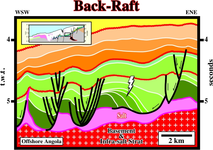

Back-Raft (Denelle, E.,, 1992)
Salt structures associated with rafts deposited above the downward compartment of the major faulted blocks, when the basement is involved in deformation.
On this seismic line, the basement is involved in the deformation. The normal faulting affecting the infra-salt sediments, which is corresponds whether to margin, valley rift-type or Paleozoic sediments, or even basement, created asymmetric anomalies on the salt layer favoring the seaward displacement of the lower supra-salt sediments.
Backstepping (Mitchum et al., 1977)
A landward displacement of the coastal depositional break within the transgressive systems tract insofar as relative sea level rise. It is a synonym retrogradation. A backstepping is a consequence of smaller and smaller regressive intervals (progradational intervals). Backstepping takes place every time the depositional coastal break of progradational unit does not reach the deposition coastal break of the previous unit. A backstepping suggest a quite fast relative sea level rise.
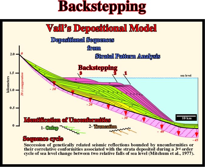
On this depositional model, in which three sequence cycles were deposited, two backsteppings are easily recognized. The first one, within the green sequence cycle, between units 11, 12, 13 and 14, and the second one, within the purple sequence cycle, between units 27, 28 and 28. The retrogradational or backstepping intervals are associated with the transgressive systems tracts, which are induced by significant relative sea level rises. A backstepping not only increases the area of the shelf but the depositional water depth as well.
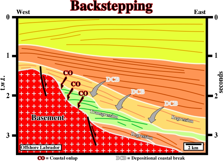
Two completely different geometries and internal configurations are recognized. The regressive interval is progradational, while the transgressive interval is retrogradational (backstepping). Within the progradational interval, successive depositional coastal breaks (DCB) are displaced seaward and the thicknesses of the intervals increase basinward. Contrariwise, within backstepping interval, the DCB are progressively displaced landward and the thicknesses of intervals increase towards the continent. The aggradation, given by the coastal onlaps (CO), is positive in transgressive intervals and, generally, negative in regressive intervals.
Backward Molding Model (Talbot, 1995)
See Molding Model.
Molding model starting by inferring histories of molding ratios, from profiles of individual diapirs, and then, by comparing the molding histories of suites of diapirs. Forward models of molding ratios that vary in both space and time hint at the potential of reading molding histories from dip of salt molded during particular intervals of space in time.
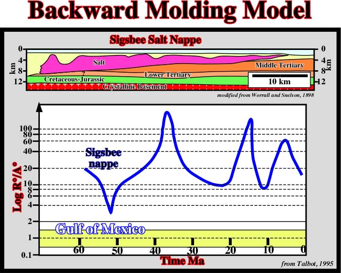
The blue curve represents the backward models the history of the molding ratio for most of the Tertiary from the flared bottom of the Sigsbee salt nappe in Gulf of Mexico, which is illustrated by cross-section above. The Louan salt is usually considered to be driven by the superincumbent continental margin that is advancing by both sedimentary progradation and gravity spreading. The bottom contact of the Sigsbee nappe ramped as steeply as 11°-14° in the Eocene, suggesting that the salt then slowed at ± 52 Ma to spread only four to five time faster down-slope than the local clastic sediments aggraded. However, even then, the lowest molding ratio for the nappe remained in the flaring regime. Since ± 56 Ma, the molding ratio of the most distal salt nappe rarely fell below R°/A° ±10. The increase in structural relief of a diapir, R, occurs at the net rate, R°, which is the rate of the vertical rise of the salt diapir minus any salt dissolution. The local net accumulation of the overburden thickness, A, occurs at rate A°; this is the rate of aggradation of the overburden minus its vertical compaction.
A geological profile constructed on the basis of field observation, and/or seismic and borehole data, in which volume problems (Goguel's law) are respected (a cross-section geometrically possible). Palinspastic sections are required to test balanced cross-sections. If a palinpastic section falsify the proposed balanced section another must be proposed, and so far. In salt basins, balanced cross-sections are difficult to propose. Indeed, as the salt can flow in any direction, Goguel's law is not adequated to test whether the cross-section is balanced or not. Geologists used palinpastic sections to estimate the displacement or orogenic contraction resulting from thrusting and associated imbrication and folding, as illustrated below.
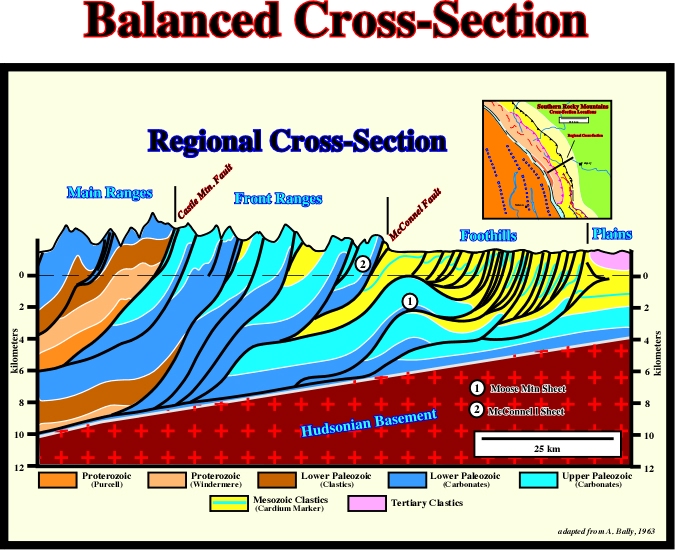
This geological cross-section, proposed by A. Bally, in 1966, is balanced (see figure below). The Paleozoic carbonate skeleton consists of a several thrust sheets. Overlying the Paleozoic carbonates there is an envelope of complex Mesozoic imbrications. Most should be considered as being sheared off the top of the lower sheet by the higher Moose Mountain sheet. Actually, the thrust displacement of the Cardium, for instance, often greatly exceeds the slip shown for the underlying frontal sheets. This implies that the Moose Mountain sheet sheared off Mesozoic beds off their carbonate substratum before the more easterly lower thrust sheet was formed.
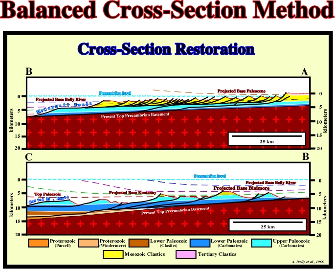
Here, each imbrication and thrust sheet is shown in its present and restored position. Offsets in the line of the section are disregarded, and for ease of construction the restoration is tied to the present basement gradient, whereas to the west a non specific datum is assumed. Note that nowhere in the structure section or in its restoration the Paleozoic section is completely missing. A. Bally (1966) assumed that no major structural units have been removed by erosion. They calculate a shortening in the order of 50%, or about 160 km for the Main Ranges.
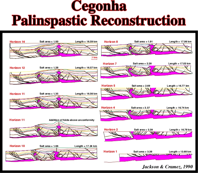
The palinspatic restoration of the Cegonha salt induced structure (conventional offshore Angola), made with Restore software, suggests the interpretation of the seismic line through Cegonha is likely. In other words, one can say the palinspatic restoration does not falsify the seismic interpretation. However, it does not prove that it is right. It just says it is geometrically possible and the volume problems were respected. Indeed, a solution is not necessarily unique. For many given set data there are generally several possible solutions.
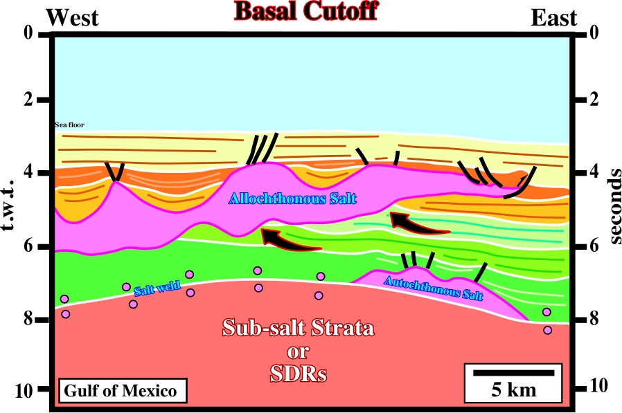
An oblique truncation of strata against the lower contact of a salt tongue. Each cutoff marks successive positions of the leading edges of a spreading tongue at successive stratigraphic times.
A relic of autochthonous salt is visible at around 8 seconds depth, as well as, a large salt weld, which underlines a tectonic disharmony. The more or less vertical steps (basal cutoffs), visible along on the bottom of the allochthonous salt, represent the periods of time during which the salt layer moved upward to an upper stratigraphic level.
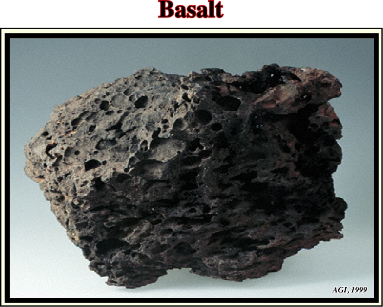
Basalt (American Geological Institute, 1999).
A general term for a dark-colored mafic igneous rock, commonly extrusive but locally intrusive (e.g. as dykes), composed chiefly of calcite plagioclase and clinopyroxene. It is the fine-grained equivalent of the gabbro.
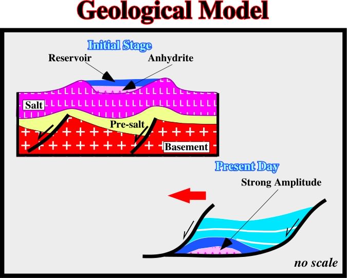
Basalt and particularly sub-aerial lava flows, hydrothermally altered to spilite greenstones, are at the origin of MgSO4-poor potash evaporites. Indeed, (i) chloritization absorbs Mg from the brine, (ii) albitization releases abundant Ca into the brine, which combines with any SO4 present to precipitate at surface, (iii) brine lakes remain enriched in Ca. The brines of Louann salt, in Gulf Coast, and Loeme salt, in West Africa, were strongly enriched in Ca by the sub-aerial volcanism (SDRs) emplaced since the breakup of the lithosphere. Both salts have similar composition to the salt deposited in association with the volcanism emplaced in the Gulf of Aden triple point (Aden ridge - East Africa rift axis - Ertaiale Red Sea rift axis) and particularly in the Assal lake.
Undifferentiated complex rocks that underlies the rocks of interest in an area. In salt tectonics, below the autochthonous salt, an infrastructure or sub-salt strata is often recognized above the basement. In petroleum geology, rocks without generating petroleum potential are often considered as basement. In many places, the rocks of the basement are igneous and metamorphic and of Precambrian age, but in some places they are Paleozoic, Mesozoic or even Cenozoic.
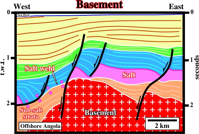
On this seismic line from the northern offshore Angola (Cabinda), the basement, mainly composed by Paleozoic sediments and locally granite-gneiss, is clearly involved in deformation. Indeed, at least two faults affect the sediments of the margin and the basement (Paleozoic fold-belt). These faults are more or less sub-vertical. They contrast with listric faults of the cover, which flatten on the top of the salt layer or on a salt weld.
Faults affecting the basement. In a salt basin, they can be predate the salt and postdate it. In both case, they have important implications. They can induce the emplacement of salt anomalies and tectonic inversions, as illustrated on the figures below.
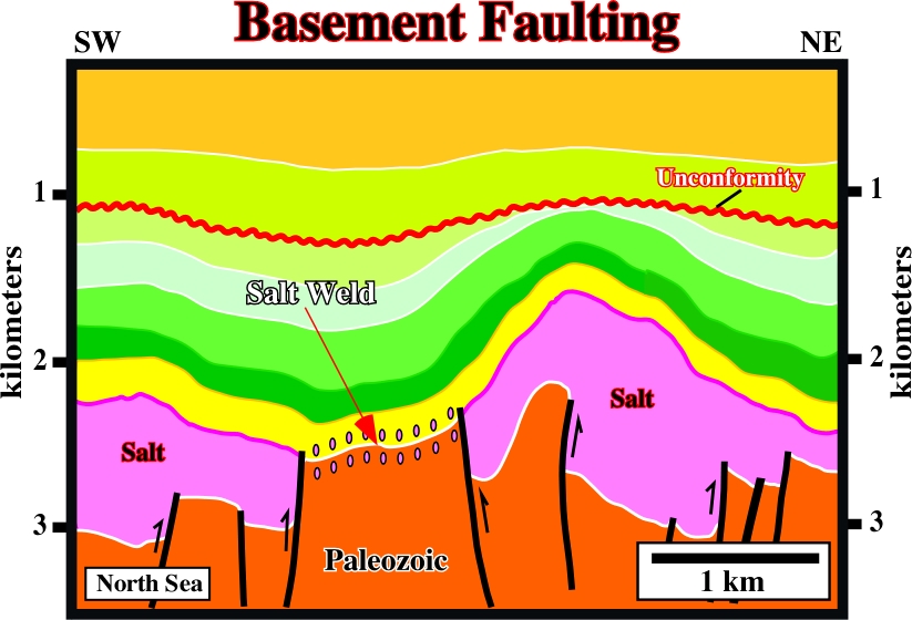
On this example, the faults affecting the basement (Paleozoic sediments) are posterior to the salt (Zechstein). They were created by a post-salt extensional tectonic regime, which took place in Cretaceous time (second green interval). During the extension the salt flowed laterally and downward filling, in the basement, the space created by the normal faults (grabens). However, a later compressional tectonic regime reactivated the original normal faults as reverse. Such reactivation created obvious tectonic inversions, in which the Cretaceous salt grabens, created during the extensional tectonic regime, became anticline structures.
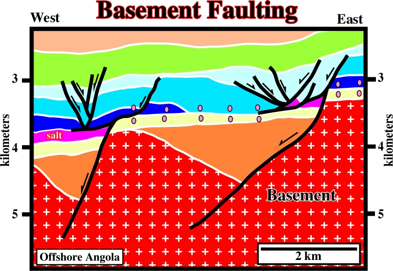
On this example, the faults, affecting the basement (granite-gneiss), are pre-salt. They were created during the rifting phase before the breakup of the lithosphere. However, after the break-up, they were slightly reactivated (the yellow margin pre-salt strata is faulted). This reactivation affected also the salt layer (in purple) creating salt anomalies. Mounds or domes were formed at the vertical of the faults (see geological model below). Later, the basinward salt flowage and salt withdrawal induced the formation of back-raft structures, which are recognized at present time on seismic lines.
This model, proposed by Total's geologists, explains the formation of the back-raft Pinda structures, in offshore Angola. There is a obvious connection between basement highs and pristine salt anomalies, which, later, induced back-raft and fore-raft structures. Due to a seaward displacement of the cover (salt and overburden), back-raft and fore-raft structures were slightly displaced down-dip of the buried hills.
Fault throws affecting the infra-salt sediments. In salt tectonics, basement steps are in fact sub-salt strata steps, which, often, are created major fracture zones associated with sea floor spreading or with rifting faults. During the seaward translation of the cover, the presence of such a fault steps, creates translation onlap surfaces (see below).
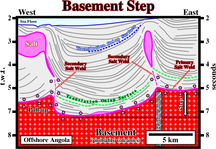
A sub-salt strata step is easily recognized picking of the bottom of the autochthonous salt, which, on this line, is almost exclusively represented by a salt weld. Such a step, probably created by a major fracture zone striking roughly perpendicularly to the line, has a height of 1.2 seconds (t.w.t.). Due to the seaward translation of the cover, two translation onlap surfaces were created, which are easily identified by their apparent geometrical relationships (apparent downlaps with a landward vergence).
Bedding Plane (McNeill, L. et al., 1999)
A plane of deposition. It often marks a change in the circumstances of deposition and may show a parting, a color difference, or both. This term is often applied to any bedding surface even when conspicuously bent or deformed by folding.
Zone between two lithospheric tectonic plates, in which the sinking plate is oceanic. Benioff subduction zones, or B-type subductions, characterize convergent margins. They are areas of great seismicity. They are associated with deep-sea trenches and they dip toward and beneath volcanic arcs, along which earthquakes foci cluster (see below).
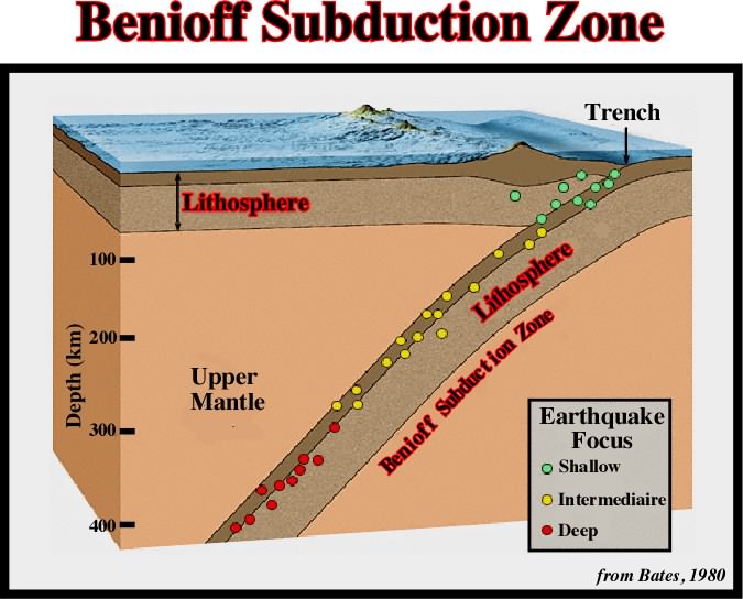
Depending on the lithology of the thrusting plate (sinking plate always oceanic) different types of convergent margins can be considered. The South America western margin (Andin margin) is a typical example of convergent margin, in which the thrusting plate is continental. As illustrated on this sketch, a volcanic arc, located on the thrusting plate, is always associated with a Benioff or B-type subduction zone.
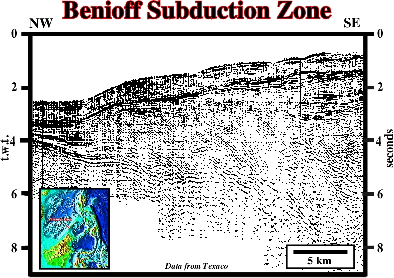
On this seismic line, from Palawan offshore (Philippines), the sinking of the oceanic plate induced a significant shortening in the thrusting plate obliging the sediments to accommodate to new volume conditions creating an accretionary prism, which in this particular example, is characterized by a great number of thrust faults.
Bentonite (Bates, R. L. and Jackson, J. A., 1980)
A soft, plastic, porous, light-colored rock composed essentially of clay minerals of the montmorrillonite (smectite) group plus colloidal silica, and produced by devitrification and accompanying chemical alteration of a glassy igneous material, usually a tuff or volcanic ash. It often contains accessory crystal grains that were originally phenocrysts in the parent rock. Its color ranges from white to light green and light blue when fresh, becoming light cream on exposure and gradually changing to yellow, red, or brown. The rock is greasy and soap-like to the touch (without gritty feeling), and commonly has the ability to absorb large quantities of water accompanied by an increase in volume about 8 times.
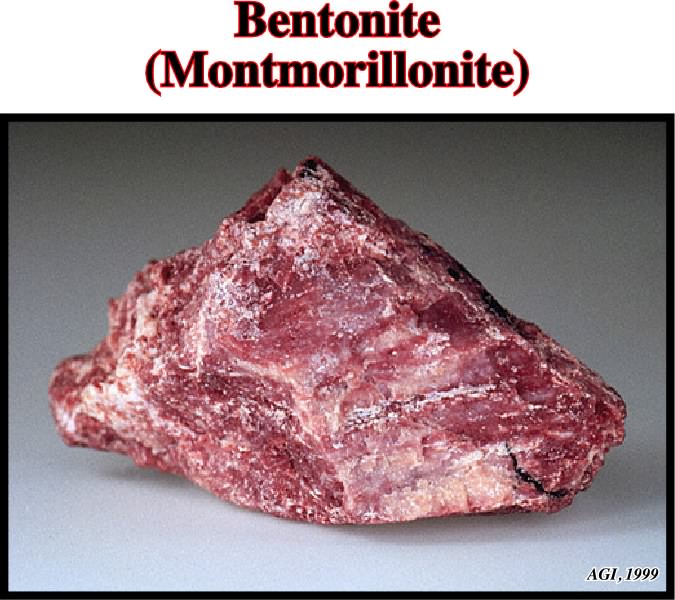
Montmorillonite is a member of the dioctahedral smectite group of minerals that has the origin of the layer charge primarily in the octahedral sheet. An ideal formula is: R0.33+(Al1.67Mg0.33)SiO4O10(OH)2.
Ellipsoid in which the two perpendicular horizontal axes are equal. At a given depth point, the geostatic pressure can be represented by a biaxial ellipsoid, with a vertical axis (
v) and two equal horizontal (
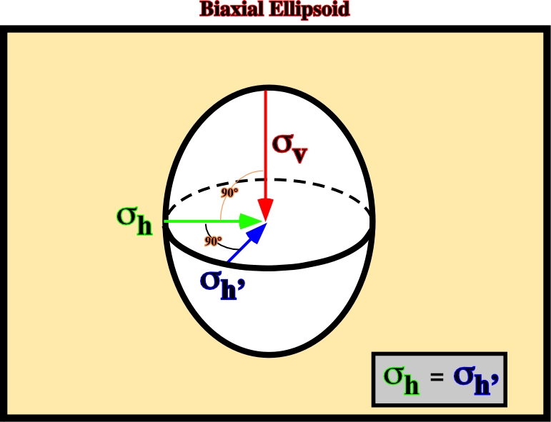
Generally, in the lithostatic (geostatic) pressure, the vertical stress is higher than the horizontal stress. In the upper levels of the continental crust, depending of the rheology of the sediments, the horizontal stress ranges between 5/10 to 8/10 of the vertical stress. However, in depth, a biaxial ellipsoid can become an uniaxial ellipsoid, in other words, the ellipsoid becomes a sphere.
A white or colorless mineral: MgCl2.6H20
A term used for pore fluids in deep sedimentary basins, stratified hot fluids in restricted basins such as the Red Sea, oil-field water, and geothermal mineralizing fluids. It denotes warm to hot highly saline waters containing Ca, Na K, Cl, and minor amounts of other elements. In oceanography, it can corresponds to seawater that, owing to evaporation or freezing, has considerably more than the average concentration of dissolved ions, i.e., a salinity of 40 or higher being the highest salinity commonly found. Similarly, this term can correspond to seawater beneath the seabed in sediments or rock fractures with a high concentration of dissolved ions due to water-rock reactions within the ocean floor.
When deformation or strain reaches less than 3-5% and the rock fractures. A brittle or rigid material when tested to failure, under conditions of triaxial compression, exhibits a relationship between principal stresses at failure, which is represented by the empirically derived linear equation:
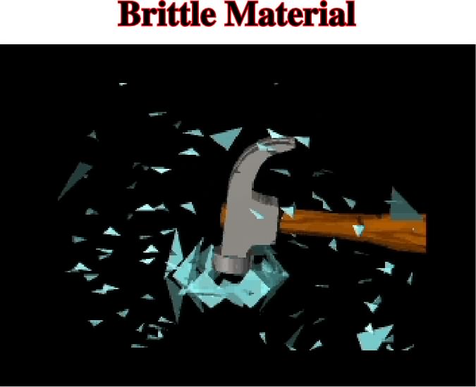
Some rock types exhibit a non-linear relationship between principal stresses at failure. In these types of tests the specimens fail in shear. Usually the specimens fail along only one shear plane. Occasionally specimens exhibit two conjugated shear planes, with opposite shear sense. The angle between them, which is often considerably less than 90°, is bisected by the axis of maximum principal stress.
Brittle Era (Jackson, M. P. A., 1995)
In the history of salt tectonics three eras can be considered: (i) Pioneering era, between 1856 and 1933, (ii) Fluid era, between 1933 and roughly 1898, and (iii) Brittle era. The brittle era became evident about 1989 is actually rooted in the 1947 discovery that a diapir stops rising if its roof becomes too thick. Such a notion was heretical in the fluid era. Stimulated by sandbox experiments and computerized reconstructions of Gulf Coast diapirs and surrounding faults, the onset of the brittle era yielded regional detachments and evacuations surfaces (salt welds and fault welds) along vanished salt allochthonous, raft tectonics, shallow spreading, and segmentation of salt sheet.
A mineral compound characterized by a fundamental structure of BO3-3. An example of a borate is boracite: Mg3B7O13
Limit of a shear zone enclosed within the diapir and contains screens or clast trains of country rock. Some boundary shear zones could result from external shear zones becoming entrained in mushroom structures.
Buckle Folds (Bates, R. L. and Jackson, J. A., 1980)
Folds that occur in response to end-loading of competent layers.
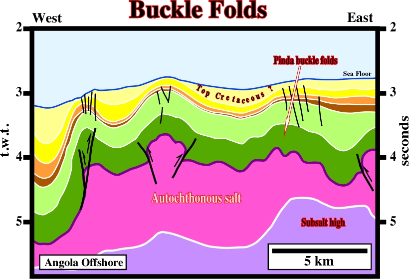
In Angola deep water, buckle folds visible within the Pinda formation (lower green seismic interval) should not be confused with the larger Upper Tertiary folds affecting the overburden.
Overhanging, swollen crestal portion of a salt diapir. Extremely broad bulbs grade into salt sheets.
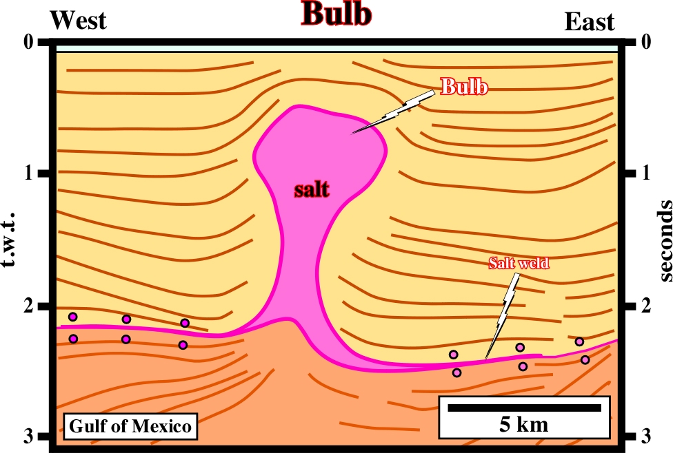
Salt flowage created two salt welds (underlined by the small circles), which mark a major tectonic disharmony, and a diapiric salt structure, in which the swollen crestal portion -the bulb- is quite evident. The internal configurations of the post-salt sediments suggest the overburden is composed by two major stratigraphic intervals; (i) a synkinematic with a divergent configuration and (ii) a postkinematic with parallel internal configuration.
Instability caused by the tendency of an overburden to sink into less dense source layer. Buoyancy is driven by lateral pressure gradients caused by structural relief in the upper surface of the salt layer. The buoyancy concept is generally linked to Rayleigh-Taylor instability, which originally applied to two viscous layers but also applies to multi-layers having other properties. In both cases, the density inversion is primary because of compositional differences.
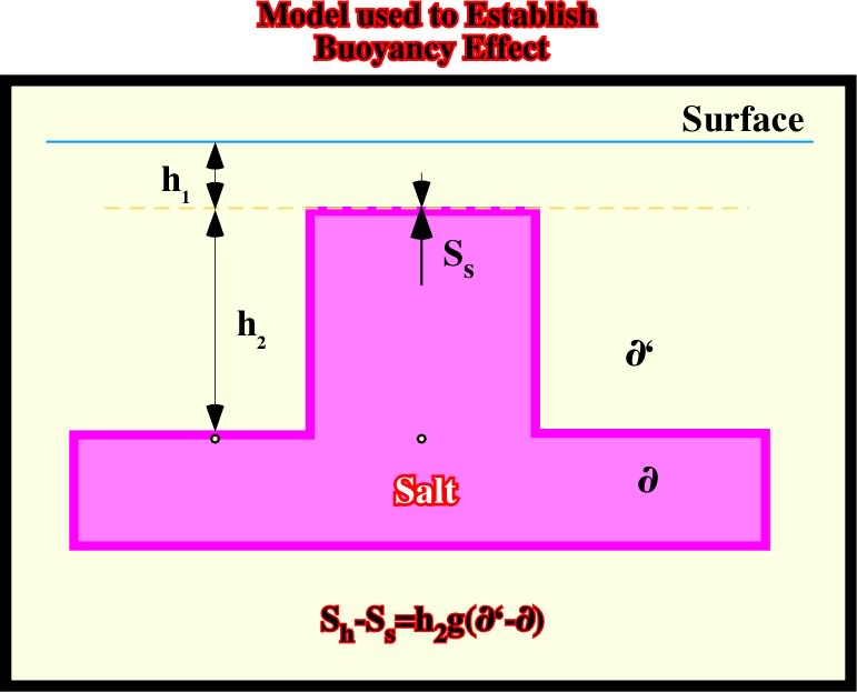
In a static situation, there is a tendency for the upward pressure in the salt column (Ss), at the interface at depth h1, to exceed the downward gravitational load (Sh) by the amount: Sh-Ss=h2g(∂‘-∂), which corresponds to the buoyancy effect.
Allochthonous salt sheets are usually emplaced as extrusive salt glaciers at the sediment-water interface, where a thin carapace of pelagic sediments prevent massif dissolution. Different model have been proposed to explain the progressive burial of the extrusive salt sheets.
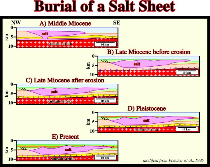
This restoration of a seismic line of the Gulf of Mexico proposed by Fletcher (1995) illustrates the burial of a salt sheet. Depth conversion was done using constant layer velocities. All blocks were restored by vertical simple shear. The effects of decompaction are not included. The positions of the three mini-basins on top of the salt sheet in the restoration were calculated using mathematical models.