
Calcite (American Geological Institute, 1999)
A common rock-forming mineral: CaCO3. It is trimorphous with aragonite and vaterite. Calcite is usually white, colorless, or pale shades of gray, yellow and blue. It has perfect rhombohedral cleavage, a vitreous luster, and a hardness of 3 on the Mohs scale and it readily effervesces in cold dilute hydrochloric acid. It is the principal constituent of limestone. Calcite also occurs crystalline in marble, loose and earthly in chalk, spongy tuffa and stalactitic in cave deposits. It is common found as gangue mineral in many ore deposits and as cementing medium in clastic sedimentary rocks.

Calcite is also a minor constituent of many igneous rocks and the chief constituent of some carbonatites. Calcite crystallizes in a variety of forms, such as nailhead spar, dogtooth spar and iceland spar.
Cambrian Salt Deposits (Zharkov, M. A., 1984)
Cambrian salt-bearing strata are known only from Asia, North America and Australia. At present, five Cambrian salt basins are distinguished: East Siberian, Iran-Pakistan, Mackenzie, Amadeus and Arckaringa.
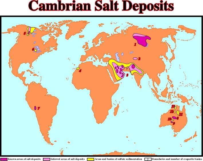
The main Cambrian evaporitic basins are: (1) East Siberia, (2) Tarim, (3) Iran-Pakistan, (4) Anti-Atlas, (5) Mackenzie, (6) Michigan, (7) Cis-Andean, (8) Amadeus, (9) Arckaringa, (10) Officer, (11) Georgina, (12) Wiso, (13) Daly River.
See Salt Canopy.
An impervious body of anhydrite and gypsum, with minor calcite and sometimes with sulphur, that overlies the salt body, or plug. It probably results from accumulation of the less soluble minerals of the salt body during leaching in the course of its ascent. A cap rock effect is a sharp positive anomaly superimposed on a broader negative, indicative of a salt dome. It is commonly produced by the dense cap rock of the dome, but very shallow salt is denser than the surrounding sediments, so cap rock is not essential in producing this effect.
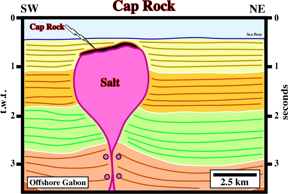
On this seismic line from the offshore Gabon, a cap rock is easily recognized, just above of the bulb of a diapiric salt structure, by an anomalous amplitude of the associated seismic marker. Such anomalous amplitude is created by the strong acoustical impedance generated by the impervious bodies of anhydrite and gypsum.
Carboniferous Salt Deposits (Zharkov, M. A., 1984)
Carboniferous salt deposits have been recognized in the following basins: Chu-Sarysu, Mid-Tien Shan, Sverdrup, Williston, Paradox, Eagle, Maritime and Saltville.
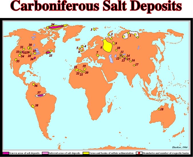
The basins with Carboniferous evaporites are: (1) North Siberia, (2) Pechora-Novaya Zemlya, (3) Spitsbergen, (4) Northumberland, (5) North Ireland, (6) Central England, (7) Dobruja, (8) East European, (9) East Uralian, (10) Teniz, (11) Chu-Sarysu, (12) Chimkent, (13) Mid-Tien Shan, (14) Tyup, (15) Aksu, (16) Achkkil, (17) Lhasa, (18) Fitzrov, (19) Radames, (20) Illizzi, (21) Ahnet, (22) Reggane, (23) Tindouf, (24) Sverdrup, (25) Maritime, (26) Saltville, (27) Michigan, (28) Illinois, (29) South Iowa, (30) Williston, (31) East Wyoming, (32) Eagle, (33) Paradox, (34) San Juan, (35) Orogrande, (36) Venezuela, (37) Amazon, (38) South Peruan.
A milk-white to reddish orthorhombic mineral: KMgCl3.6H20. It occurs as a similar residue and is a raw material of fertilizer manufacture in some European districts.
Ca-Smectite (American Geological Institute, 1999)
The accepted group name for 2/1 phyllosilicate clay minerals with layer charge between 0.2 and 0.6 per formula unit and which take polar liquids into the interlayer space causing them to swell in a direction perpendicular to the 001 surface. They have cation exchange capacity: about 110 cmolckg-1 for soil smectites, and variable interlayer spacing.
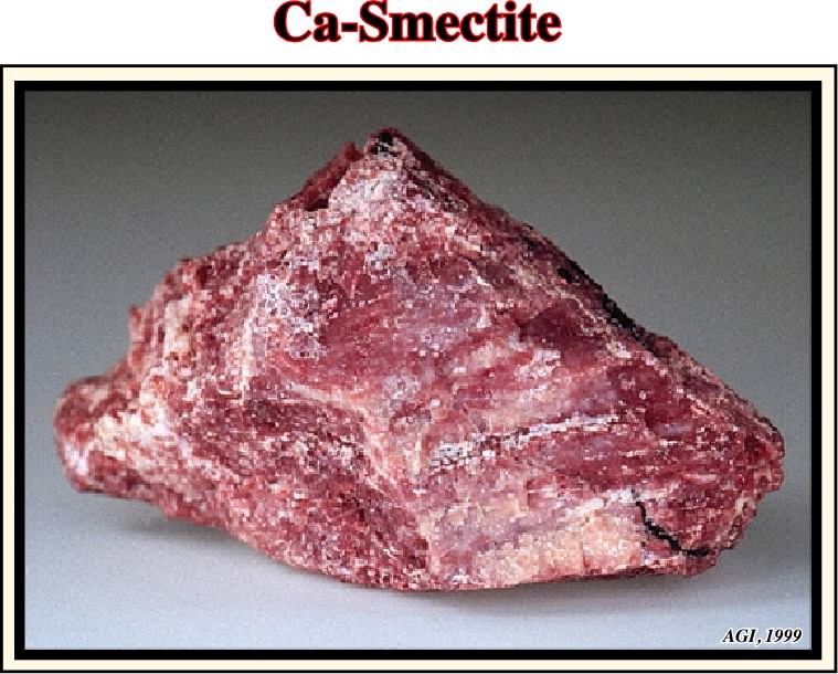
The smectite minerals are derived from the alteration of volcanic glass and from the weathering of primary silicates. They are the chief constituents of bentonites and fuller's earth and are common in soils, sedimentary rocks, and some mineral deposits.
The upper erathem of the Phanerozoic Eonothem, in the Standard Global Chronostratigraphic Scale. The Cenozoic is the time during which those rocks those rocks were formed. The Cenozoic Period extends from 65 Ma to the present.
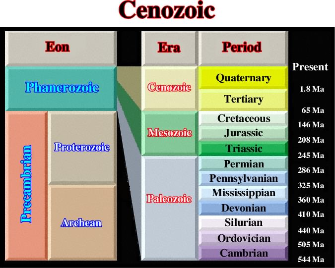
Paleontologically, the Cenozoic is characterized by the evolution and abundance of mammals, advanced mollusks and birds. Paleobotanically, angiosperms are predominant.
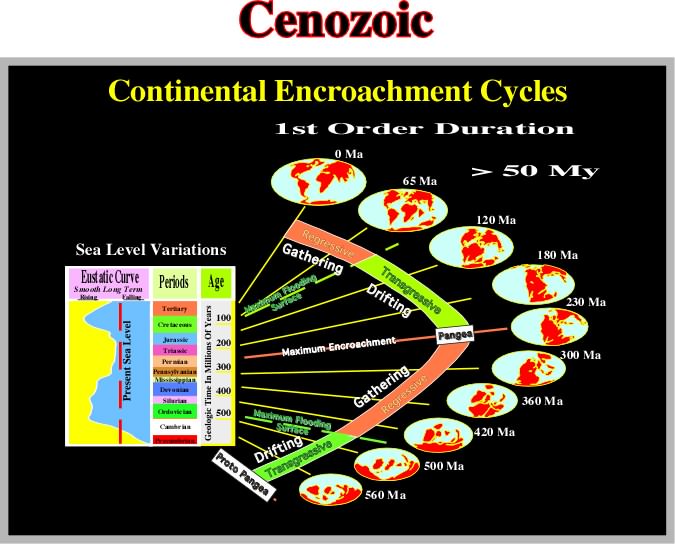
In terms of Sequence Stratigraphy terms, the Cenozoic corresponds roughly to the regressive phase of the post Pangea continental encroachment stratigraphic cycle, that is to say, the period during which the continents, individualized by the breakup of the Pangea, assembled to create a new supercontinent. Indeed, due to the collision between the continents of different lithospheric plates, the volume of the oceanic basins increased, and so, the global sea level falls. Actually, the onset of the eustatic sea falling started immediately after the Cenomanian-Turonian, around 30 million years before the beginning of the Cenozoic.
Characteristic Wavelength (dc)
Theoretical periodic spacing of the fastest mode of growth of an instability, represented by the principal eignevalue (the special value of a variable parameter for which the solution of an equation is nontrivial) of growth rate, k*m. Amplitude of the displacement at time t on the interface is:
yi (t)=yi (0) exp ( k*m qt), where:
yi is the amplitude of perturbation on layer i and
q is the scaling factor (s-1).
Chlorite (American Geological Institute, 1999)
A group of platy, monoclinic, usually greenish minerals with the general formula (R+2 R+3)6Al SiO3O10(OH)8. There are four sub-groups of this 2:1 layer clay mineral (the interlayer hydroxyl sheet is to be treated like other interlayer material), (i) trioctahedral chlorite (the most common chlorites) i.e., both the octahedral sheet sandwiched between tetrahedral sheets and the interval one are trioctahedral; (ii) dioctahedral chlorite with both octahedral sheets dioctahedral, e.g. donbassite; (iii) di/trioctahedral chlorite with the octahedral sheet in the 2:1 layer dioctahedral, but with the hydroxyl sheet trioctahedral, e.g. cookeite or sudoite; and (iv) tri/dioctahedral with the 2:1 layer trioctahedral, but with the hydroxyl sheet dioctahedral. No examples of this mineral have yet been found.
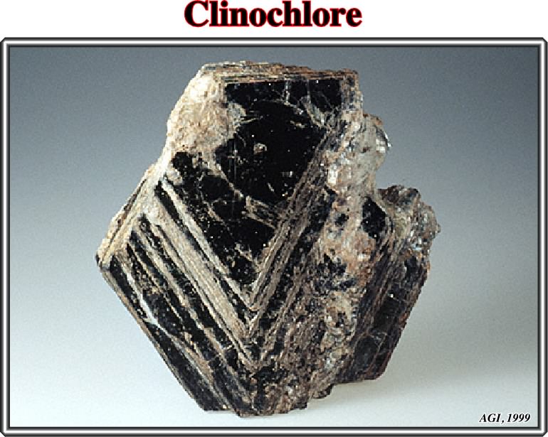
The most common chlorites, trioctahedral ones, are named according to the dominant cation/ Fe-rich is chamosite, Mg-rich is clinochlore, N-rich is nimite, and Mn-rich is pennantite.
The replacement by, conversion into, or introduction of chlorite, i.e. a group of platy, monoclinic, usually greenish minerals with the general formula: (R+2, R+3)6AlSi3O10(OH)8
Clinopyroxene (American Geological Institute, 1999)
A group name for pyroxenes crystallizing in the monoclinic system and sometimes containing considerable calcium with or without aluminum and the alkalies.

Any monoclinic mineral of pyroxene group, such as diopside, hedenbergite, clinoenstatite, acmite, pigeonite, spodumene, jadeite and omphacite belongs to the clinopyroxene group.
Synonym of salt suture, in salt tectonics.
Local subsidence induced by salt flowage or salt withdrawal. Compensatory subsidence is mainly associated with halokinesis and salt tectonics, as well as, with shalokinesis. Flowage of a salt layer induces a local increasing of the available space for sedimentation (accommodation) independently of eustacy and tectonic subsidence.
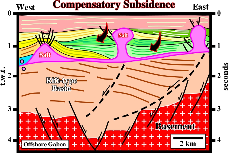
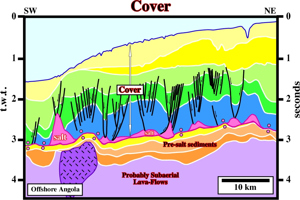
On this line, the basement (granite-gneiss + Paleozoic sediments) is overlain by rift-type basin sediments, which are overlain by a divergent margin sediments. The limit between the sediments of the rift-type basin and those deposited in the divergent margin, that is to say, the breakup unconformity (BUU), is not to evident. The margin pre-salt interval (salt in purple) is too thin; it is under seismic resolution. Apparently, the breakup unconformity seems to be at the bottom of the evaporitic layer (purple). On the other hand, as the bottom of the salt layer is roughly sub-horizontal, a tectonic subsidence cannot be invoked to explain the thickness variations of the overburden. A compensatory subsidence, created by salt flowage, is the hypothesis less falsifiable, so the more likely.
A strain induced by a compressional tectonic regime and characterized by a sedimentary shortening (folding or reverse faulting).
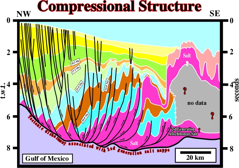
It is quite evident the compressional structures (folds and thrusts), recognized on the central part of this line, are the consequence of a local compressional tectonic regime created as a counterpart of the up-dip extensional tectonic regime responsible for the lengthening of the sediments recognized on the left part of the line. A compressional regime (
1 horizontal) induces a shortening, while an extensional regime (
Tectonic regime characterized by an horizontal oblong effective stresses ellipsoid, that isa to say, with a s1 horizontal. As illustrated below, two major compressional tectonic regimes can be individualized.
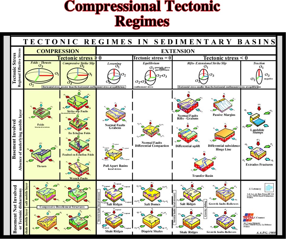
When the tectonic stress is positive (
Confining Pressure (American Geological Institute, 1999)
All equal, all-sided pressure around a specific volume of material, e.g. geostatic pressure or hydrostatic pressure. See also lateral confining pressure.
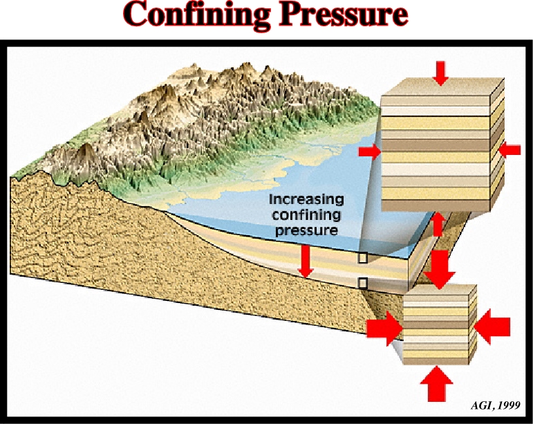
Confining pressure increases with depth. So, geostatic pressure, in depth, has a tendency to become uniaxial, as hydrostatic pressure.
A fold model that can be described geometrically by the rotation of a line about one of its ends, which is fixed. In a stereographic projection, contrariwise to cylindrical-folds, in which the dip of the flanks lie on meridians, in conical-folds, the dip of the flanks lie in a parallel. Conical-folds are associated with strike-slip movements of the basement and strike oblique to the maximum effective stress (
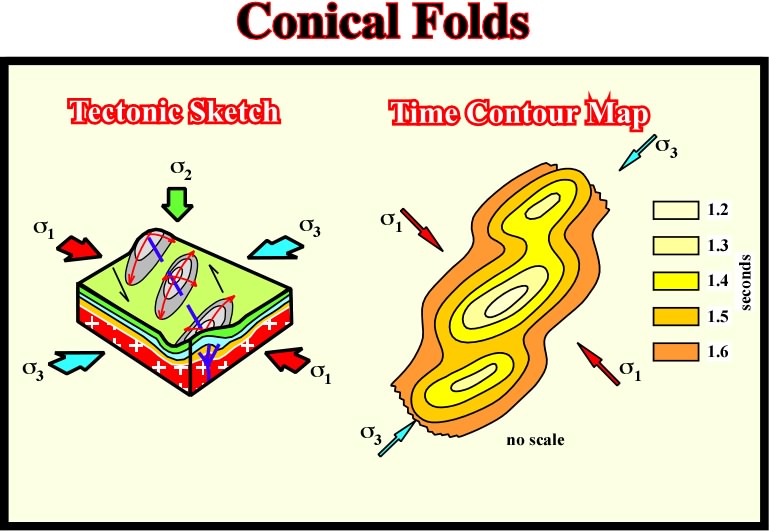
Depending on the amplitude of the strike-slip movement of the basement, the shortening of the sedimentary cover is quite different. When the displacement is relatively small (less than 5 km), the cover is shortening by en-échellon folds. When the displacement is higher than 5 km, let's say 10 km, folding is insufficient to short the sediments, therefore the en-échellon folds are faulted by reverse-faults. These faults are the surface evidence of a deep strike-slip faulted zone. When the lateral displacement is important (25 km or more), a wrench fault zone is formed, in surface, with more or less discontinuous outcrops of the basement.
A diapiric growth vertically or laterally restricted by the strength of the diapir's overburden. An example is a forceful intrusion at moderate depths, characteristic of active piercement. In contrast, unconstrained growth includes overturns of Raleigh-Taylor instability, passive piercement, shallow injection of salt sheets into weak sediments, very shallow vertical intrusion by active piercement, extrusive protuberance of diapir, and glacial flow.
A Earth's major land mass, including both dry land and continental shelves.
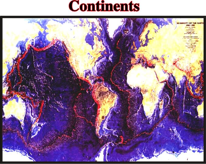
On this map (Seismicity of Earth), the continents are shown in their present location. However, as suggested by the location and morphology of high seismicity zones, it is quite evident that during the Earth's geological history, they have ben moving and their shapes have been in continual change.
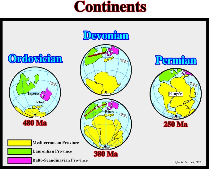
During the Middle and Upper Paleozoic, the positions and shapes of the continents changed quite a lot. This sketch illustrates the progressive gathering of the Paleozoic continents to create the Pangea Supercontinent, at the Permo-Triassic time.
Continental Lithospheric Plate
When the crust of a lithospheric plate is mainly composed by sialic rocks, that is to say, rocks rich in silica and alumina.
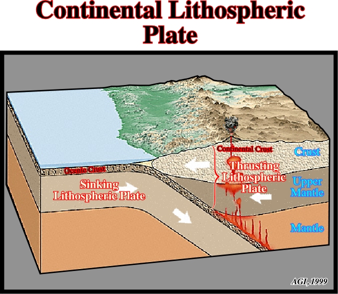
The lithosphere is composed by (i) the upper mantle and (ii) the crust. When the crust is oceanic, as the sinking plate in this example, geologists call it a lithospheric oceanic plate. When the crust is composed by sialic rocks, the lithospheric plate is called continental.
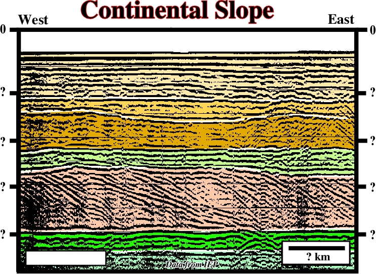
The part of the continental margin between the continental shelf break and the slope-abyssal plain break.
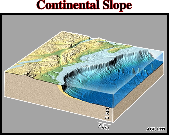
A longitudinal profile of a continental margin shows several breaks. From the continent to deep water one can recognize four majors breaks: (i) the bayline break, (ii) the depositional coastal break, (iii) the shelf break and (iv) the continental slope-abyssal plain break. Therefore, on a seismic line, to recognize the continental slope, if we do not have a complete profile, we need the geological setting and the horizontal and vertical scales (Geology is scale dependent, see below).
On this line, in which the horizontal and vertical scales were omitted, geologists are enable to interpreted the slope recognized on the lower part of the profile. Is it slope of the bayline break, a deltaic slope associated with the depositional coastal break or a continental slope associated with the shelf break? For those that often forget that a geological interpretation is scale dependent, the data illustrated above come from a georadar profile. The horizontal scale is metric (20 meters), while the vertical scale is in nanoseconds. The depth thickness of the progradational interval, is around 3-5 meters.
Roughly the shoreline. See: Shelf Break.
Sedimentary pile above the basement including both substratum and overburden.
The terms cover, basement and substratum are misleading. Indeed, in salt tectonics, basement corresponds to the infra-salt, substratum corresponds to the autochthonous salt and cover corresponds to the sedimentary pile englobing the substratum (salt) and the overburden. On this seismic line, it is quite evident that the basement, is not the real basement and the substratum (salt) is not the real substratum of the basin. Personally, as a geologist, I use these terms in their original meaning.
Failure during frictional plastic deformation follows the Mohr-Coulomb fracture criterion:
t = t0 + sn tan f = t0 + sn m
where t is the shear strength, t0 is the cohesive shear strength, tn is the normal stress, f is the angle of internal friction or slope of Mohr envelop, and m is the Coulomb coefficient.
When a growth-fault system, induced by salt evacuation, looks landward (landward vergence). Indeed, during a progradational loading, allochthonous salt can evacuated in different ways and create two quite different end-members. One with growth faults looking seaward, known, in Gulf of Mexico, as roho systems and another, with growth faults looking landward, known as counter-regional systems.
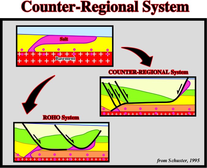
Schematic cross-section showing an allochthonous salt sheet and its ultimate evolution, following depositional loading and salt evacuation, into either of two end-member structural systems: (i) a stepped counter-regional system, consisting of a large growth fault looking landward, and (ii) a roho system, dominated by a major growth faults looking seaward.
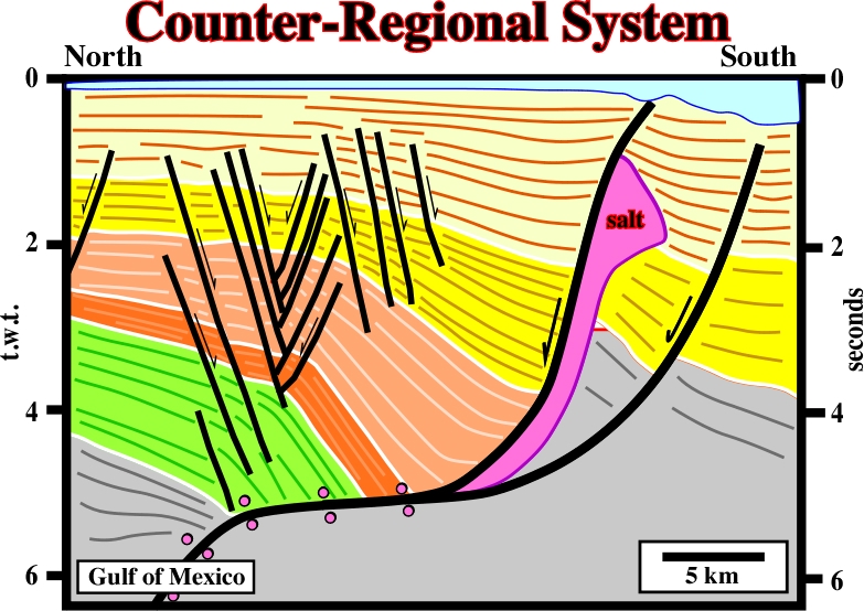
The Bourbon dome (southeast Louisiana), actually corresponds to salt intrusion in a counter-regional faulting system and quite likely it soles in an evacuated salt horizon (tertiary salt weld).
A part of the Earth's crust that has attained stability, and has been little deformed for a prolonged period. As originally defined, cratons included parts of both continents and ocean basins, but modern knowledge of the ocean basins indicates that existence of cratons there is unlikely, so the term is now restricted to continental areas of largely Precambrian age.
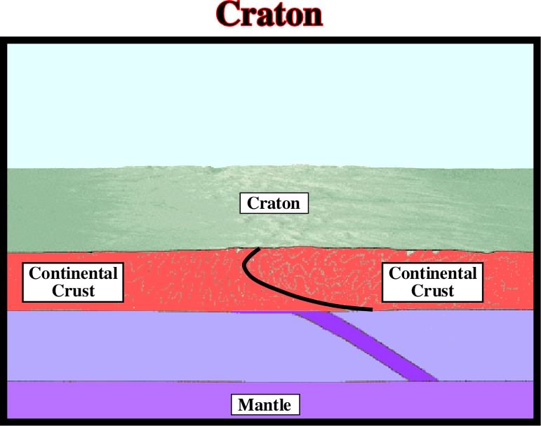
The extensive central cratons of the continents, including both shields and platforms, have been called hedreocratons. Part of the more mature Phanerozoic fold-belts have now achieved, or are approaching a cratonic condition.
The creep law for halite is an expression to quantify the steady-sate flow of halite resulting from the combined effect of solution-transfer creep (dominant at low deviatoric stress and low strain rates) and dislocation creep (dominant at high deviatoric stresses and high strain rates). The strain rate can be approximated by following composite creep law:
e¡ ={7.6 x 10⁻⁴ exp(-66,500/RT) s 4.5 } + {4.2 x 10⁻³ exp(-26,959/RT)s /Td3}
where:
e¡ is strain rate (s-1),
R is universal gas constant (8.315 JK-1 mol-1),
T is temperature (K)
d is grain size (mm; typically 1-10 but smaller in extrusions).
Fold with concentric axial trace and shallow-plunging fold hinge, originating inside the bulb of mushroom diapir.
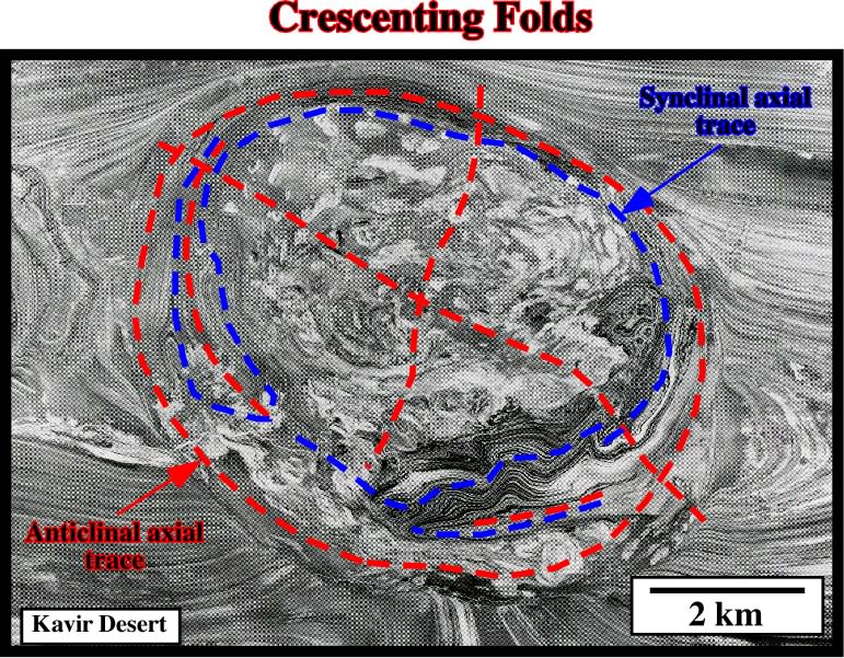
The concentric axial trace of the folds can be easily recognized in the field and aerial photographs of Kavir desert.
The taper angle of an accretionary wedge in which compressive forces at any point are balanced by frictional resistance of that part of the wedge ahead of that point.
The minimum Rayleigh number, above which thermal convection is possible.
A diapiric, cylindrical-fold with radial axial trace and steeply plunging hinge, which forms by constriction of the stem, possible incorporating sheath-folds originally formed in the source layer.
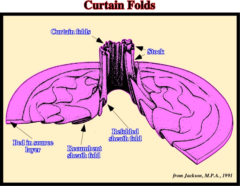
Cutaway diagram showing progressive deformation of a representative bed near the base of a salt source layer. As the bed flows toward the central stock, recumbent sheath-folds become folded and perhaps refolded above steps in the basement. The sheath-folds then rotate into the base of the salt stock, where they are refolded by steeply plunging curtain folds.
A fold generated or reproduced by moving a line with fixed orientation through space. In structural geology a cylindrical fold strikes perpendicularly to the maximum effective stress (
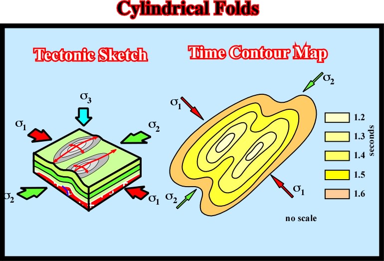
The axis of a cylindrical-fold gives the orientation in the horizontal plane of the medium effective stress (