
Synonym of effective stresses,
1,
Post Rodhinia or Pre-Pangea continental encroachment stratigraphic cycle deposited in association with the older Phanerozoic first order eustatic cycle.
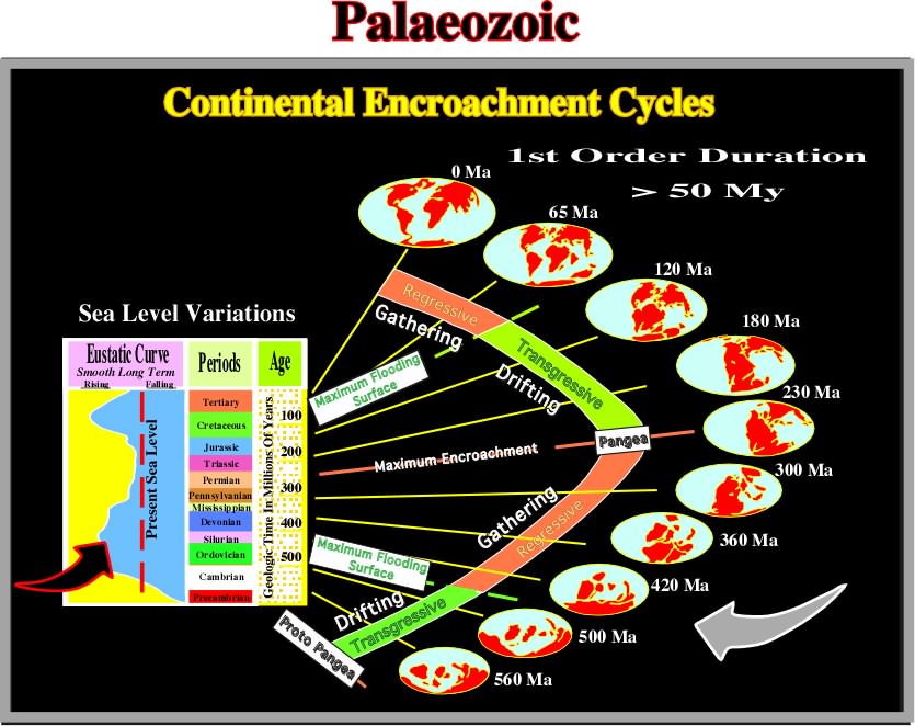
The Paleozoic is an erathem of the Standard Global Chronostratigraphic Scale, above the Precambrian and below the Mesozoic, or the time during which paleozoic rocks rocks were deposits, that is to say, from about 570 Ma to 245 Ma. In eustatic terms, one can say the Paleozoic corresponds to the post Rodhinia stratigraphic cycle deposited during the older Phanerozoic first order eustatic cycle.
Palinspastic Section (Kay, G. M., 1945)
A cross section in which the features represented have been restored as nearly as possible to their original geographic positions, before the rocks of the crust were shortened by folding, or telescope by thrusting.
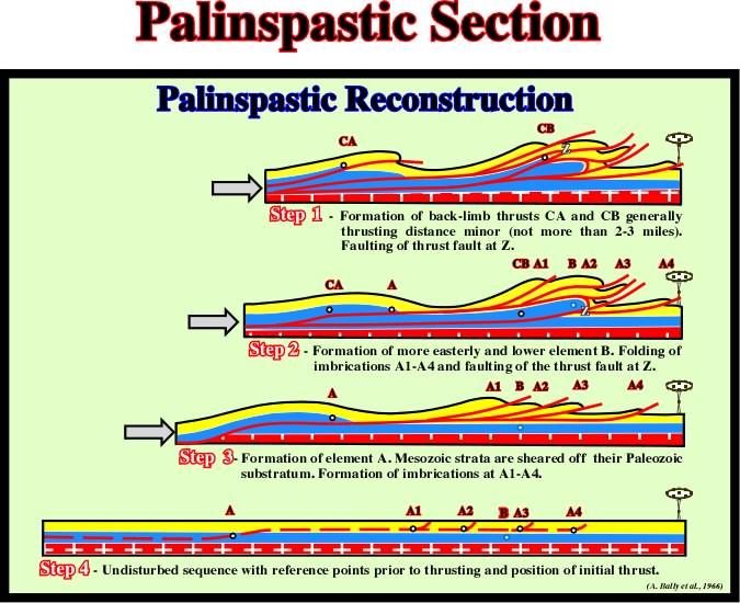
This palinspastic reconstruction proposed by Bally, in 1966, implies four main steps of deformation in the Rock Mountains. Notice, that deformation proceed from west to east, concomitant with the formation and migration of the foredeep basin.
Synonym of Downbuilding.
Passive Piercement (Jackson, M .P. A. and Talbot, C. J.,1991)
Synonym of downbuilding or passive diapirism. It is often defined as a syndepositional growth. The diapir increases relief by growing downward relative to the sedimentary surface. Its base subsides, together with the surrounding strata, as the basin fills with sediments. The diapir crest remains at or just below a thin roof that is continually thickened by sedimentation and thinned by erosion or extensional thinning. In other words, in a passive piercement the base of the diapir sinks and the crest remains shallow. In an active piercement (or upbuilding) the base of the diapir stays more or less at fixed depth, while the crest rises.
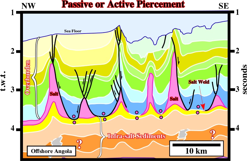
In a diapirism growth, very often, it is quite difficult to differentiate a passive (upbuilding) from an active piercement (downbuilding) as illustrated on this seismic line. Both geological mechanisms run from quite different initial situations to the same final stage. Only the regional geological knowledge of the area, allows to understand whether the observed (apparent) upbuilding was created by regional extension or by passive piercement. It must be noticed that an active piercement implies not only a reduction of the overburden, to accommodate the emplacement of the salt, but also a considerable thickness and strength of overburden must be penetrated, and displaced, by the relative weak buoyancy forces of diapirism.
Locally thickened, synkinematic strata accumulating in a rim syncline as a result of salt withdrawal. Peripheral sinks may have any shape in plan and are classified according to thickness variations within them. The mechanical significance of peripheral is now being questioned.
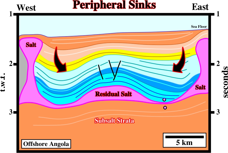
The compensatory subsidence created by the flowage of the salt created an antiform structure surrounded by two asymmetric peripheral sinks. Later, this antiform structure, known since 1968 (Seffel lines), become well known of all explorationists working in West Africa offshores. Indeed, is along this extensional structure, which does not correspond to real turtle back (there is no inward thickening of any interval), that are located several significant oil fields.
Basin associated with the formation of a megasuture, but located outside of it. Foredeep, fore-arc and Chinese-type basins are the main basins of this type.
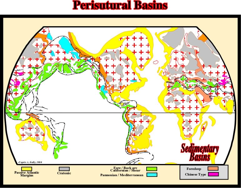
On this map only the Meso-Cenozoic perisutural basins are illustrated. To located the Paleozoic perisutural basins it is necessary to reconstruct the Paleozoic megasuture, which was completely distorted by the breakup of the Pangea and subsequent drifting of the Meso-Cenozoic continents.
During the Permian, a period of immense salt accumulation, several vast evaporitic basins, such as the European, Central European, Midcontinent and Peru-Bolivian Basins were formed. Salt deposits are also known from the following basins: Alpine, Moesian, Chu-Sarysu, Supai and North Mexican. Fourteen Permian basins with gypsum and /or anhydrite occurrences were recognized: Darvaza, Karasu-Ishsay, Dobruja, Rakhov, Mecsek, Dinarids, North Italian, Spitsbergen, East Greenland, Sverdrup, Rio Blanco Parnaiba, Arabian and Browse Basins.
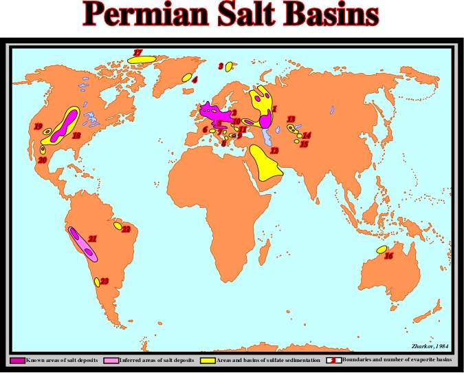
The distribution of Permian evaporites can be summarized as follows: (1) East European, (2) Central European, (3) Spitsbergen, (4) East Greeland, (5) Alpine, (6) North Italian, (7) Mecsek, (8) Dinarides, (9) Moesian, (10) Rakhov, (11) Dobruja, (12) Arabian, (13) Chu-Sarysu, (14) Karasu-Ishsay, (15) Darvaza, (16) Browse, (17) Sverdrup, (18) Midcontinent, (19) Supai, (20) North Mexican, (21) Peru-Bolivian, (22) Parnaiba, (23) Rio Blanco.
The study of the origin, migration and accumulation of oil and gas.
An enothem of the Standard Global Chronostratigraphic Scale including the rocks in which the evidence of the life is abundant. It comprises the Paleozoic, Mesozoic and Cenozoic erathems; also the time during which these rocks were formed, the Phanerozoic Eon.
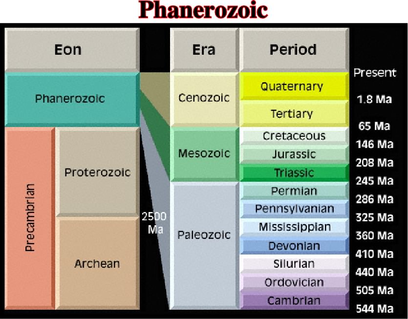
As illustrated, the Phanerozoic comprises the Paleozoic, Mesozoic and Cenozoic eras. At the eustatic standpoint, it corresponds to the two first order eustatic cycles recognized after the break-up of the Rodhinia or pre-Pangea supercontinent.
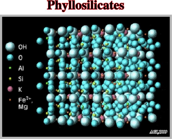
A class or structural type of silicates characterized by the sharing of three of the four oxygens in each tetrahedron with neighboring tetrahedra, to form flat sheets. The S:O ratio is 2.5.
An example of phyllosilicate is the micas that crystallize in forms apparently orthorhombic or hexagonal but really monoclinic.
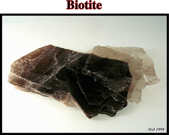
Biotite is a widely distributed and important rock-forming mineral of the mica group. It is generally black, dark brown, or dark green monoclinic and forms a constituent of crystalline rocks or a detritical constituent of sandstones and other sedimentary rocks. Biotite is useful in potassium-argon method of age determination.
See: Salt Pillow.
Pioneering Era(Jackson, M. P. A., 1995)
In the history of salt tectonics three eras can be considered: (i) Pioneering era, between 1856 and 1933, (ii) Fluid era, between 1933 and roughly 1898, and (iii) Brittle era. The pioneering era featured the search for a general hypothesis of salt diapirism, initially dominated by bizarre, erroneous notions of igneous activity, residual islands, in situ crystallization, osmotic pressures, and expansive crystallization. gradually data from oil exploration constrained speculation. The effects of buoyancy versus orogeny were debated, contact relations were characterized, salt glaciers were discovered, and the concepts of downbuilding and differential loading were proposed as diapiric mechanisms.
Plagioclase (McNeill, L. et al., 1999)
A group of triclinic feldspars of general formula: (Na,Ca)[Al(Si,Al)Si2O8]. At high temperatures it forms a complete solid-solution series from Ab Na[AlSi3O8] to An Ca[Al2Si2O8].
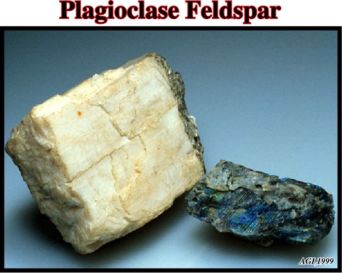
The plagioclase series is arbitrarily subdivided and named according to increasing mole fraction of the An component: albite (An 0-10), oligoclase (An 10-30), andesine (An 30-50), labradorite (An 50-70), and anorthite (An 90-100). The Al/Si ratio ranges with increasing An content from 1:3 to 1:1. Plagioclase minerals have characteristic twinning and commonly display zoning.
A flat or gently sloping underwater erosional surface extending seaward or lakeward from the shore. Synonym of shelf. In geomorphology, a platform is a general term for any level or nearly level surface, as a terrace or bench. In tectonics, the platform is the part of a continent that is covered by flat-lying or gently tilted strata, mainly sedimentary, which are underlain at varying depths by a basement of rocks that were consolidated during earlier deformations.
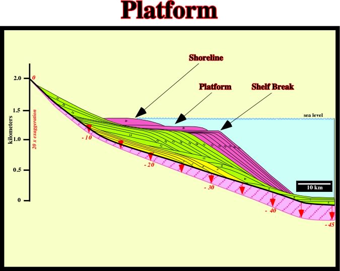
In Stratigraphy, the platform is limited between the shoreline and the shelf break. Generally, the water depth of a platform is under 200 meters. A platform is always present during regressive episodes. On the contrary, during mature regressive episodes, when the shoreline coincides with the shelf break, the basin has not platform.
See: Salt Stock.
A mineral: K2MgCA2(SO4)4.2H20. It is often brick-red owing to iron oxide.
Compressional structure developed when folding is not enough to solve volume problems. In areas where salt layers are affected by compressional tectonic regimes, when folding is not enough to shortened the overburden, additional shortening (pop-up structures) is developed in the crest of anticline structures to accommodate the sediments to new volume conditions.
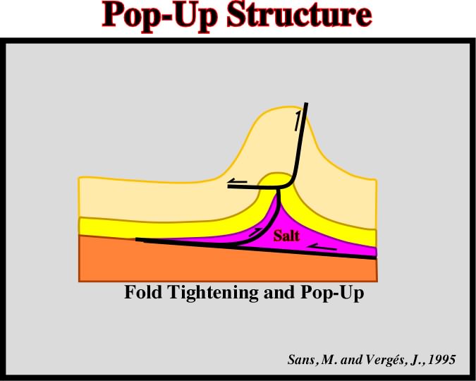
Pop-up structures associated with salt anticlines (Eocene Cardona salt) have been described in southeastern Pyrenean thrust front. The tightening of fold anticlines and blocking of thrusts promote the formation of pop-up structures in the anticline crest.
The pressure of the interstitial fluids. In geology, the fluids generally water, saturating the open pore spaces of a rock column have the same effect as immersing a rock in a water column. The pore pressure (
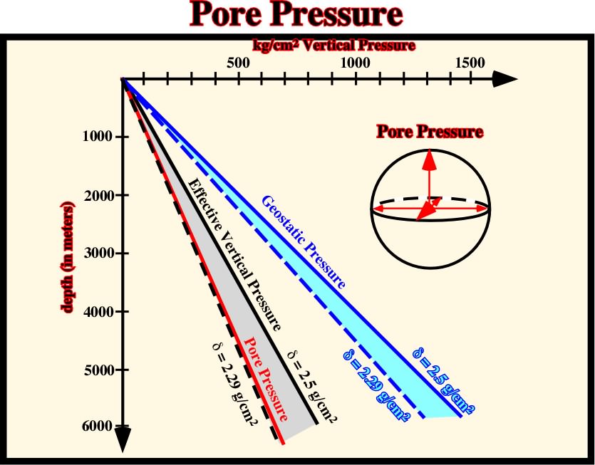
A significant increasing in pore pressure, which acts in opposite sense of the geostatic pressure, creates conditions to gravity deformations.
Stage when a salt dome becomes disconnected from the mother salt layer, thereof it cannot grow anymore.
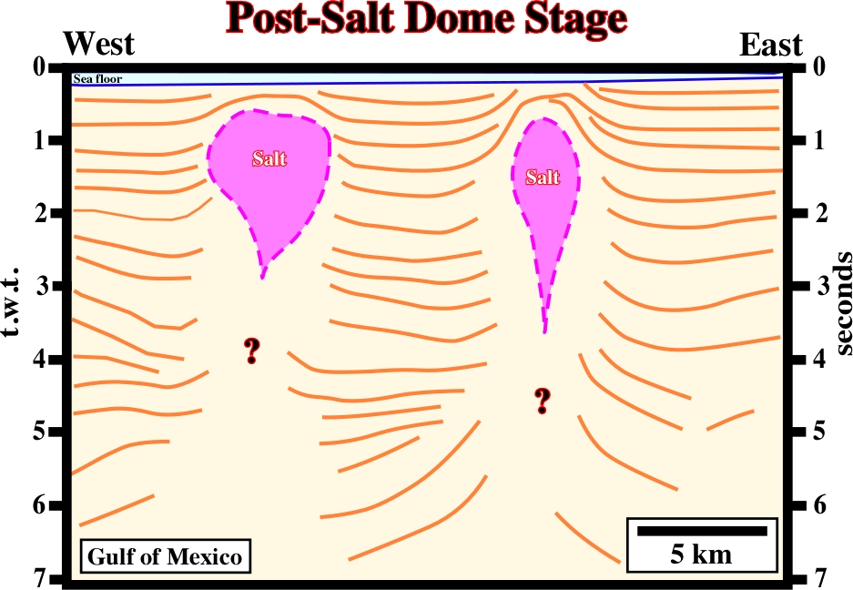
On this line, several tectonic disharmonies can be recognized. The post-dome salt structures can be associated with an allochthonous or an autochthonous salt layer. An association with the autochthonous salt seems more likely.
Strata interval overlying the synkinematic layer and recording sedimentation after salt flow or any other deformation has ceased. Basal postkinematic strata can onlap or truncate an underlying, uneven, deformed surface but show no thickness changes ascribed to local deformation.
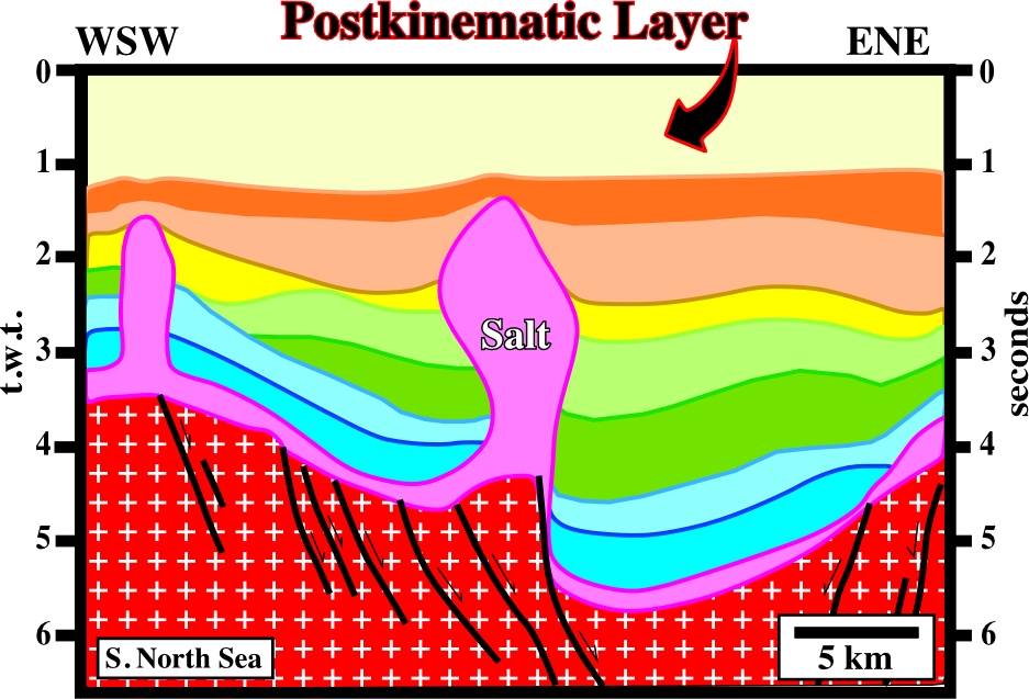
A more or less constant thickness is a major characteristic of a postkinematic layer. On this line, the progradational internal configuration slightly mask the isopachness of the postkinematic layer.
Evaporites rich in potash are much more diagnostic of brine source than are halite deposits. Potash evaporites form two groups. (i) A rare group rich in MgSO4 forms by evaporation of seawater originating from rivers. The sulfate mineral, polyhalite, kainite, and kieserite, are diagnostic. They are known in the Vendian, Late Mississippian to Permian, and Miocene to Quaternary. (ii) The second, more common, group is rich in KCl and CaCl2 poor in Mg SO4. This group cannot form by evaporation of seawater from rivers alone. The chloride minerals, sylvite, carnalite, tachyhydrite, and bischofite are diagnostic. This group formed in the Cambrian through Early Mississippian and Jurassic through Paleogene. These KCl minerals originate from brines enriched in CaCl2 by hydrothermal water rock interaction.
A unit of the Standard Global Chronostratigraphic Scale comprising all the rocks formed before the beginning of the Paleozoic Erathem.
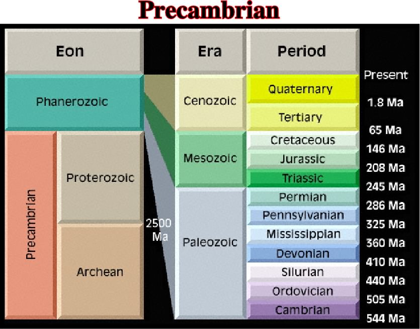
The Precambrian is also the time during which Precambrian rocks were formed. It is equivalent to about 90% of geologic time. Precambrian time has been divided according to several different schemes.
Precambrian halogenic rocks have been recognized in many areas of Eurasia, North America, Africa and Australia. Asa rule, they are represented by gypsum and anhydrite. Salt beds of more or less confirmed Precambrian age are known only from Australia in Amadeus basin. They have been suggested as occurring also in the Officer Basin.
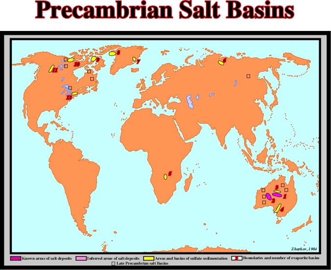
The distribution of Precambrian evaporite deposits can be summarized as follows: (1) Amadeus, (2) Officer, (3) Ngalia basin, (4) Adelaide Geosyncline, (5) Mufulira Syncline, (6) Kotuikan basin, (7)Merkebjerg Basin, (8) Thule Basin, (9) Borden Basin, (10) Amundsen Basin, (11) Mackenzie Hills, (12) NW Adirondack Mountains.
Strata interval whose initial stratigraphic thickness is constant (or no more variable than is typical for the region) above a salt structure or its adjacent rim syncline (below any synkinematic layer). The prekinematic layer records sedimentation before salt movement or any other deformation began.
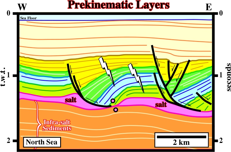
As the intervals just above the salt layer (light green and blue) are isopach, they can be considered as prekinematic, i.e., anterior to the salt flowage.
PREP method (Worrall, D.M. and Snelson, S.,1989)
Reconstruction technique to restore syndepositional faulting. This technique preserves area, accounts for decompaction and minimizes the shape change within fault blocks. The horizontal component of unfaulted bed length is preserved and footwalls are not assumed to be rigid.
An early stage of extension during which the fault block still rests on its original footwall.
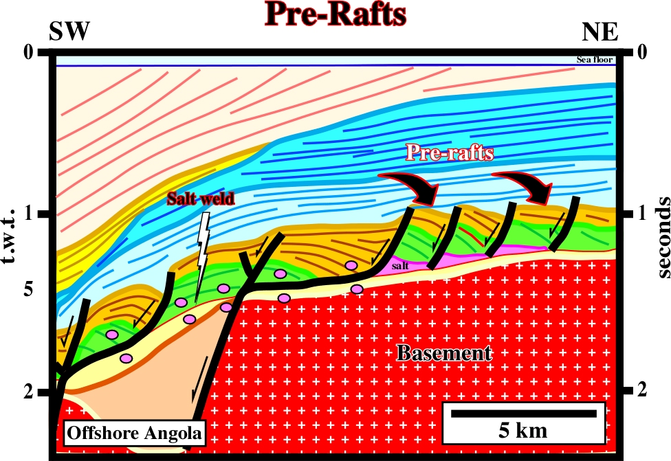
As the pre-raft structures still rest on its footwalls, the potential petroleum system in a pre-raft domain is quite different of the raft domain. The generating petroleum system is the same but the entrapment migration subsystems are quite different. On the other hand, the chances of find large accumulations in a pre-raft domain are smaller than in a raft-domain, as depicted on this interpretation.
The force exerted across a real or imaginary surface divided by the area of that surface, or the force per unit area exerted on a surface by the medium contact with it. Pressure is often as an incorrectly used short form for lithostatic or geostatic pressure.
Peripheral sink, which accumulates on the flanks of a growing salt pillow and comprises strata that thin toward the salt structure.
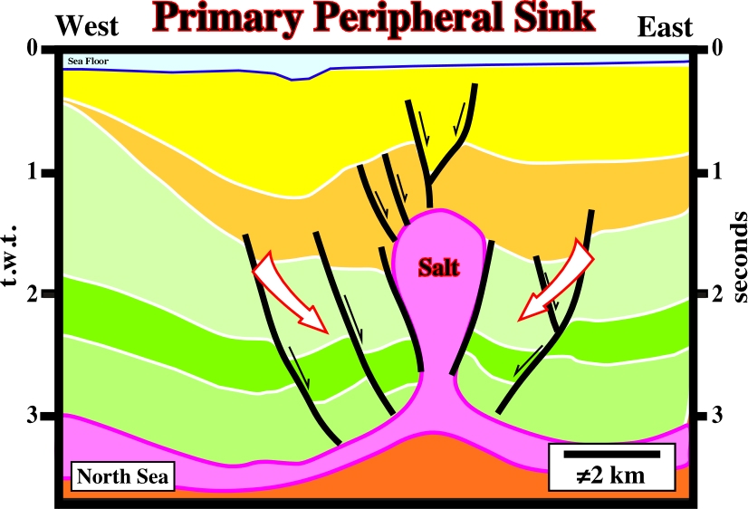
On this line the primary peripheral sinks contrast with the interval interpreted as Cretaceous chalk, which show a obvious thickening inward. Notice, that a later reactivation of the salt diapir inverted and extended the Chalk interval.
Salt weld joining strata originally separated, by gently dipping, autochthonous bedded salt.
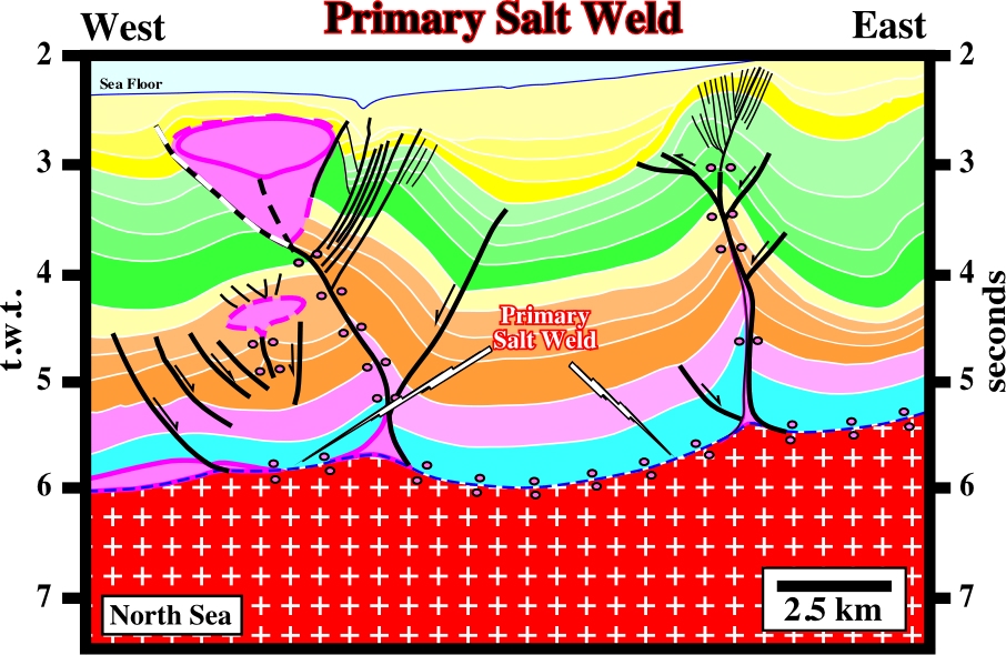
Primary salt welds are easy interpreted as induced by salt flowage when relics of the autochthonous salt layer are found laterally, as it is the case on this line.
Environment located below the effective depth of wave erosion, lying beyond the delta front and sloping gently down to the floor of the basin in to which the deltaic environment is advancing and were clastic river sediments cease to be a significant part of the deposits, in other words, the facies is mainly shaly.
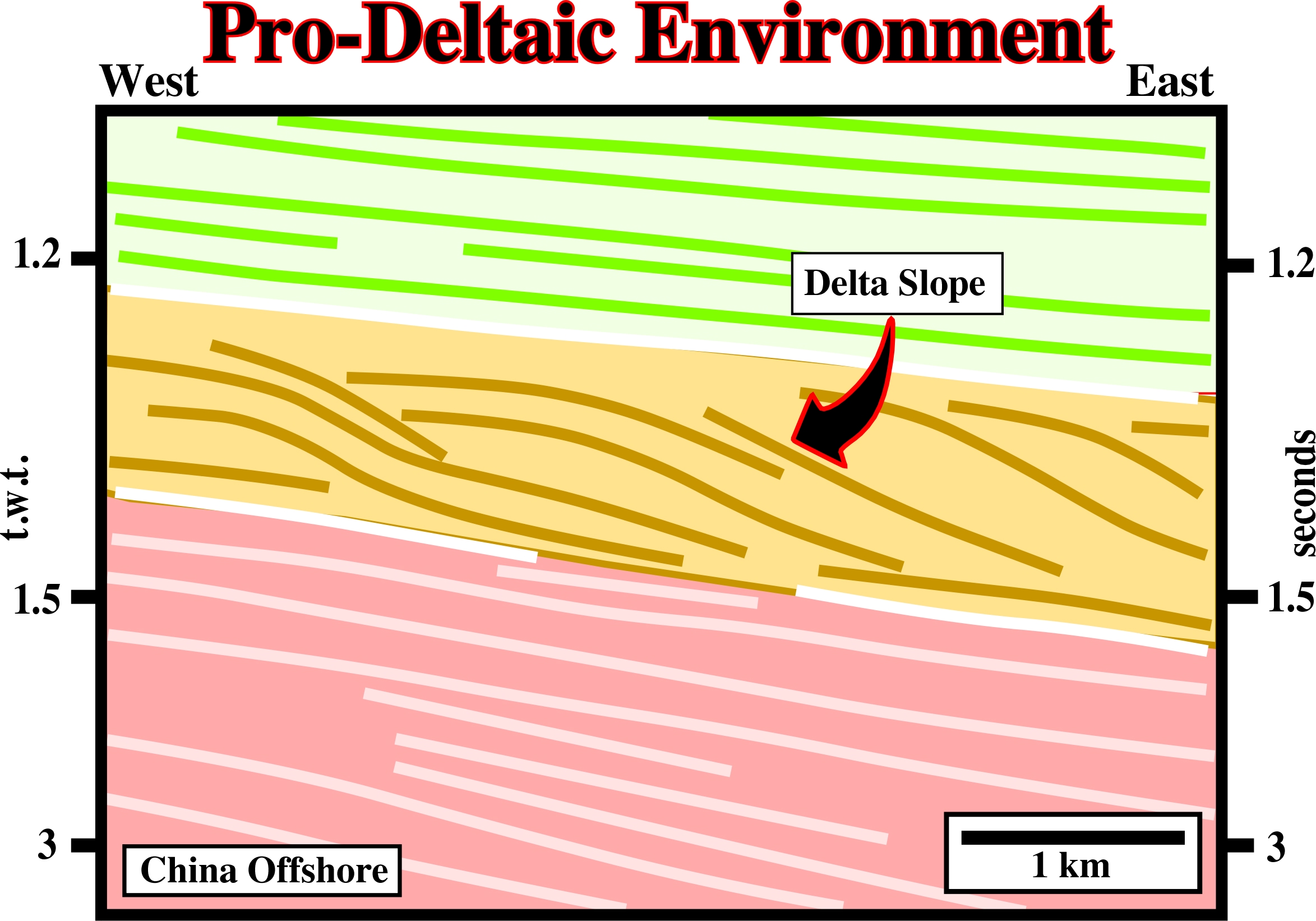
On seismic lines, prodeltaic environments correspond to the deltaic progradations, i.e., seaward or lakeward progradations of the depositional coastal break. The thickness of a prodelta is generally smaller than 50 meters.
Seaward or lakeward displacement of depositional coastal breaks, which in a mature regressive interval (basin without platform) coincide with shelf breaks.
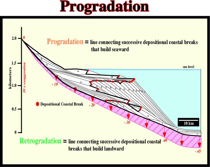
A seaward displacement of the depositional coastal break creates a forestepping geometry and characterizes a regressive episode. Contrariwise, a landward displacement, i.e., a retrogradation creates a backstepping geometry and characterizes a transgressive episodes. Both correspond to relative sea level rises. During a progradation the relative sea level rises in deceleration, while during a retrogradation the sea level rises in acceleration.
Interval with an progradational internal configuration characterized whether by sigmoidal or oblique progradations what suggest a regressive sedimentary episode.
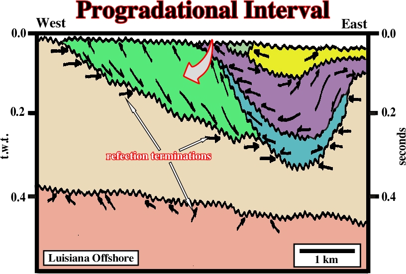
The progradational interval associated with the point-bar (arrow) contrasts with the parallel-aggradational interval of the infrastructure, as well as, with the filling geometry of clay plug interval.
Pull-Apart Diapir (Ruig, M. J., 1995)
Diapirs bounded by strike-slip faults and with a typical rhomb-shaped geometry. Pull-apart diapirs have been interpreted to have intruded pull-apart basins. They are mainly described in southern part of the Prebetic Mountains.