
Accommodation (Vail. P. et al., 1989)
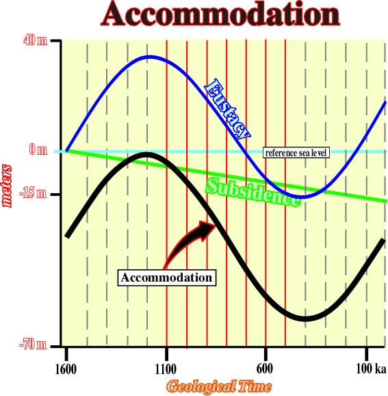
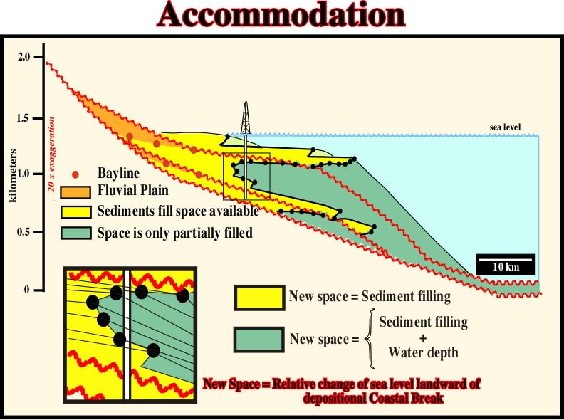
Space available for sediments between the sea floor (landward of the shelf break) and the depositional sedimentation level. Synonym of shelfal accommodation. Accommodation is function of eustacy and subsidence. Changes in accommodation are equivalent to relative sea level changes. Accommodation is required not only for progradational sedimentary packages but retrogradational as well. When accommodation increases, in acceleration, progradational deposits take place. When accommodation increases, in deceleration, retrogradational or backstepping deposits, that is to say, regressive deposits take place.
In sand-shale sedimentary intervals, landward of the shelf break, accommodation is given by the combination of the eustacy and subsidence. An accommodation increasing is required for shelfal deposits. Seaward of the shelf break, due to the magnitude of the water depth, deep water sedimentation can take place when accommodation decreases. Often, turbidite depositional systems take place in association with a decreasing of accommodation (relative sea level fall).
Landward of the shelf break, the accommodation induced by eustacy, when seal level rise, and subsidence, is completely filled by shelfal sediments (depositional water depth is near zero). Seaward of the shelf break, and in spite of the fact that deposition takes place mainly when relative sea level fall, only a very small portion of the space available for the sediments is filled by deep water sediments. Accommodation corresponds to the water depth minus the sediment filling. In salt basins, particularly when the thickness of the salt layer is significant, changes in accommodation are mainly be induced by salt flowage (compensatory subsidence).
Product of seismic velocity and bulk density of a given interval. Seismic reflections recognized on seismic profiles occur at any break of acoustical impedance.
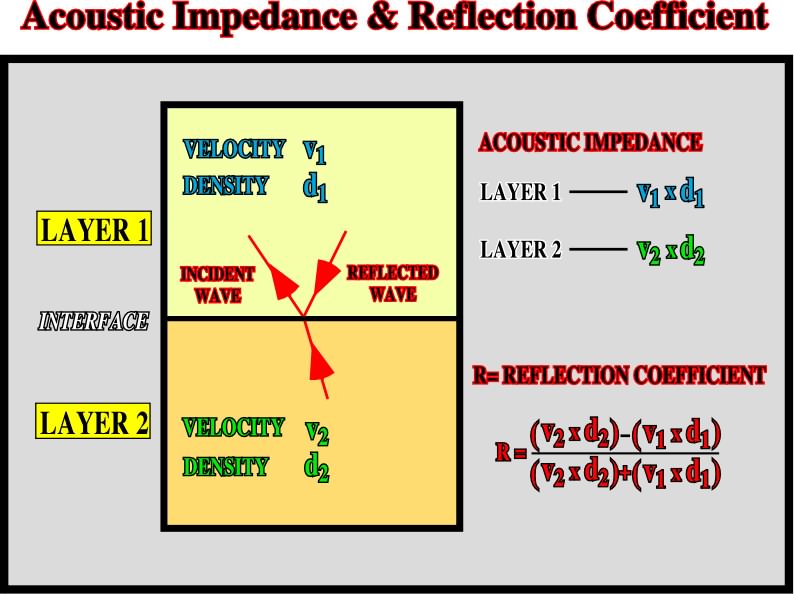
A seismic wave is modified by acoustic impedance breaks through (i) amplitude and (ii) polarity. Most of seismic reflections are associated with chronostratigraphic horizons (stratification planes). According to P. Vail such a feature is at the origin of seismic stratigraphy. When between two chronostratigraphic layers there are no acoustic impedance contrast (V1 x d1 = V2 x d2), there is no reflection associated with such an interface.
Active Piercement (Jackson, M. P. A. and Talbot, C.J.,1991)
A post-depositional diapiric growth (in the most extreme or ideal form) through prekinematic overburden. Synonym of intrusive diapirism. As a diapir increases in relief by growing upward, its base remains at constant depth below the sedimentary surface, and its crest rises toward the sedimentary surface. More commonly, diapirs grow by a combination of ideal end members of active and passive piercement, because sediments accumulate while piercement involves forceful intrusion. This is probably in relatively tall diapirs overlain by relatively thin overburden, unless the overburden is being: (i) extended, (ii) fluid or (iii) unusually weak.
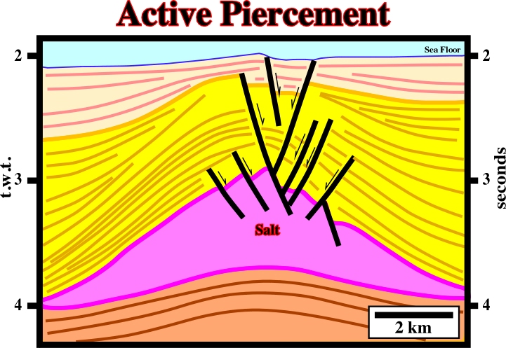
The lower part of the overburden (dark brown package) is roughly isopach. Therefore, it can be considered as prekinematic, that is to say, anterior to salt flowage. On the contrary, the upper intervals, (yellow and light yellow) have divergent internal configurations. They are synkinematic. The salt structure had an active piercement during the lower isopach interval and a passive piercement during the upper overburden intervals.
Albite (R. L. Bates and J. A. Jackson, 1980) (McNeill L. et al., 1999)
A colorless or milky-white triclinic mineral of the feldspar group: Na(AlSi3O8). It is a variety of plagioclase with composition ranging from Ab100AN0 to Ab90AN10. It is also an alkali feldspar, representing the triclinic modification of sodium feldspar. Albite occurs in all group of rocks, forming a common constituent of granite and of various acid-to-intermediate igneous rocks.
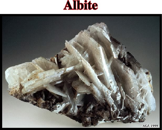
Albite is widely distributed in low-temperature metamorphic rocks (greenschists facies) and is regularly deposited from hydrothermal solutions in cavities and veins. Albite crystals frequently exhibit polysynthetic twinning, predominantly after the albite law.
Albitization (R. L. Bates and J. A. Jackson, 1980)
Introduction of, or replacement by, albite, usually replacing a more calcic plagioclase.
A secondary sedimentary structure produced by overgrowth, accumulation or addition upon a preexisting nucleus. Accretionary wedges are always found in association with salt flowage in allochthonous structures, such salt sheet, salt lacolith, etc.
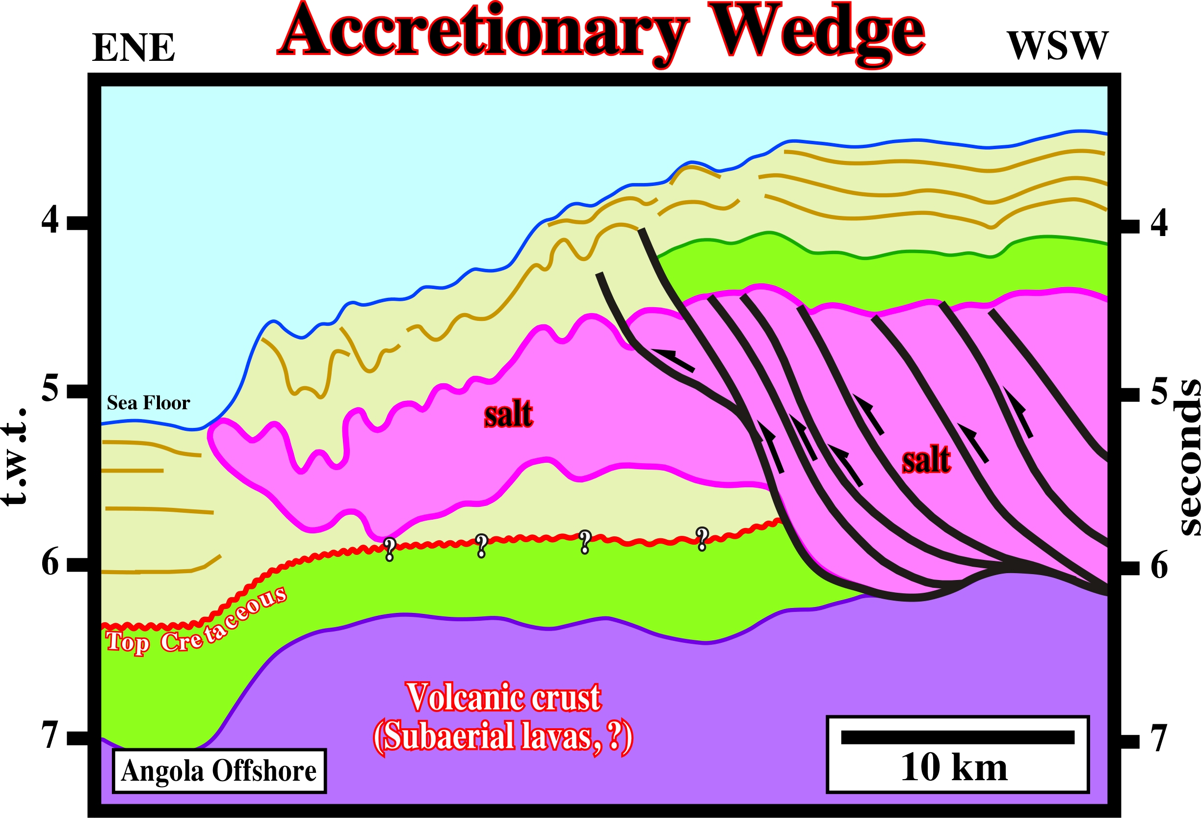
The Angola escarpment, in the deep offshore, illustrated above, as well as the Sigsbee escarpment, in Gulf of Mexico, are accretionary wedges of allochthonous salt napes. Indeed, the seaward and upward flowage of allochthonous salt are responsible for sea bottom morphology. Seaward of the Angola escarpment, the sediments are undisturbed strongly contrasting with the folded geometry of the sediments lying above the salt nappe.
Vertical component of coastal onlapping, i.e., the upbuiding between consecutive onlaps. In salt tectonic, salt aggradation of an allochthonous salt tongue, for instance, can be measured by basal cutoffs.
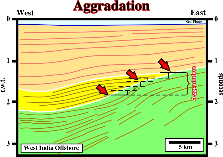
The vertical component between two consecutive onlaps gives the sedimentary aggradation, which, landward of the depositional coastal break corresponds to the associated relative sea level rise, since depositional water depth is near zero. Generally aggradation is positive. A positive aggradation is always recognized in transgressive and regressive intervals. However, in a transgressive interval, it progressively increases, while in a regressive interval, it progressively decreases. A negative aggradation corresponds to a relative sea level fall, which induces an unconformity when the relative sea level fall below the shelf break.
During a sheet lacolith injection, the aggradation rate of the allochthonous salt can be easily determined by basal cutoffs, which strongly suggest aggradation rate is hundred times smaller than injection rate.
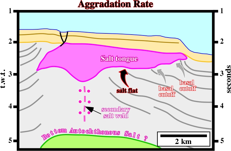
On this line, the aggradation rate, given by the basal cutoffs, is much smaller than injection rate given by the salt flats. The original diapir stem became a secondary weld. It progressively closed as strata, to its left, moved rightward along a deeper primary salt weld.
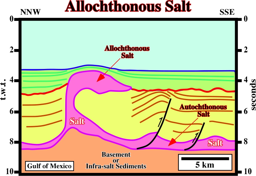
Salt layer overlying part of its overburden, a sheet like salt body tectonically emplaced at stratigraphic levels overlying the autochthonous salt layer. It lies within stratigraphically younger strata.
On this line from deepwater of the Gulf of Mexico, it is easy to see the difference between allochthonous and autochthonous salt. Autochthonous salt is in its original stratigraphic position while allochthonous salt is not. In this particular line, both salt layers communicate by a vertical salt structure.
Collision zone in which continental crust of a lithospheric plate sinks under continental crust of another tectonic plate. Synonym of A-type subduction zone. Ampferer, an Austrian geologist, when balancing Alpine geologic cross-sections, noticed a significant lacking of substratum. Subsequently, he assumed the substratum sunk till great depths under the fold belt. The geological mechanism in an Ampferer subduction zone is completely different of the one in a Benioff subduction zone (B-type subduction zone).
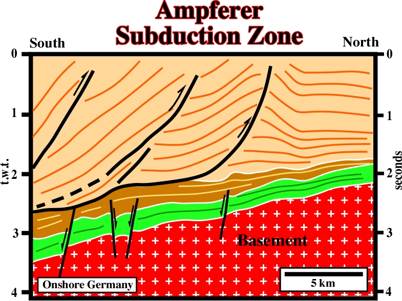
On this line, Mesozoic sediments sunk under Tertiary sediments creating an Ampferer subduction zone and a geological collision. The decoupling surface which underlying the tectonic disharmony, marks the closure of a sea. Indeed, initially, before the collision, the sedimentary packages, separated by the tectonic disharmony, belonged to different lithospheric plates.
See Salt Anticline.
Elongated up-welling of salt with concordant overburden. Salt antiform is often erroneously taken as synonym of salt anticline. Anticline is a genetic term to describe a compressional structure. Antiform is a non-genetic term to describe a bell-shaped geometry. All anticlines are antiforms, but not all antiforms are anticlines.
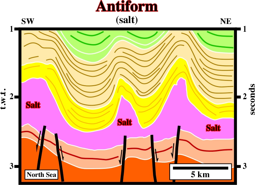
These salt structures, with a bell-shaped geometry, are extensional. They were developed under an extensional tectonic regime characterized by a vertical maximum effective stress. Under such a regime, which took place longtime after the salt deposition, the salt flowed upward forcing the overburden to lengthen. Later, the cover (overburden + salt) was slightly shortened by a compressional tectonic regime.
Anhydrite (McNeill L. et all, 1999)
A mineral consisting of anhydrous calcium sulfate: CaSO4. It represents gypsum without its water of crystallization and it alters readily to gypsum, from which it differs in crystal form (anhydrite is orthorhombic) and in being harder and slight less soluble.
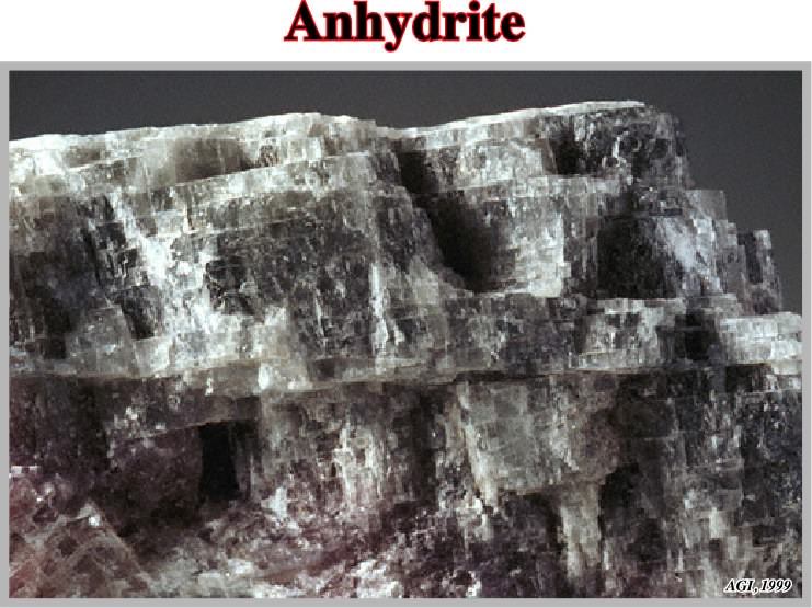
Anhydrite usually occurs in white or slightly colored, granular to compact masses, forming large beds or seams in sedimentary rocks or associated with gypsum and halite in evaporites.
Apparent Diapirism (Arbenz, J. K., 1968)
Apparent upward movement. When a diapir arrives on surface, if it is connected with the mother layer, it growths as sedimentation progresses. Geometrically, apparent diapirism does not deform the synchronous sediments (synkinematic). Prekinematic sediments show significant deformation.
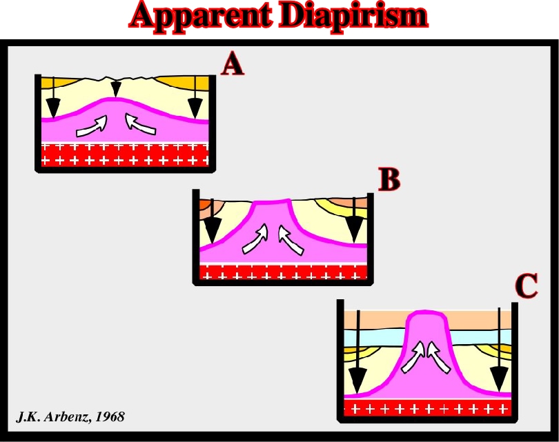
When a salt diapir, connected with the mother source rock, arrives on surface, which is the case in this model, the salt growths upward as sedimentation takes place giving a false impression of diapirism, that Arbenz called apparent diapirism.
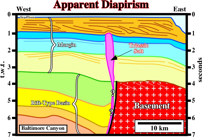
On this line of the North Atlantic Continental Margin (Offshore New Jersey), the upward movement of the Triassic salt (deposited in a rift-type basin) suggests an apparent diapirism during the Cretaceous (bleu intervals). The salt seems to have arrived at surface (bottom of the sea) at the end of Upper Jurassic. This period is emphasized by a local enhanced unconformity (bottom of the bleu interval). The enhancement of the unconformity (interface yellow-bleu) is due to the salt movement and to the emplacement of a volcanic intrusion. As the Cretaceous sediments are not disturbed by apparent diapirism, it is logical to hypothesize they are synchronous with salt movement. The Tertiary sediments, characterized by a progradational geometry, show a slightly deformation at the bottom of the orange interval. Such a deformation can be due whether to differential compaction or a late reactivation of the salt.
Apparent Mound (Jackson and Cramez, 1989)
A salt driven inverted structures, in which the high structural points become low structural points. As illustrated in the sketch below, the interdomal synformes become apparent mounds by complete salt reduction. In fact, due to total withdrawal of the salt domes, the pristine depocenters become an apparent mounds.
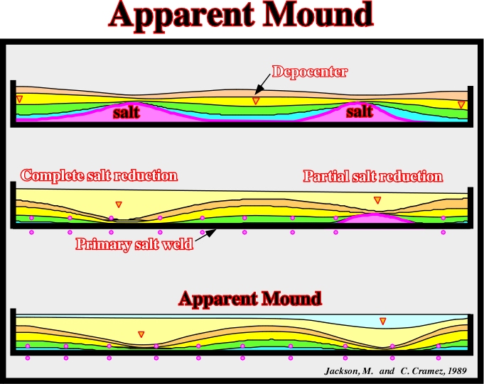
During the first phase, the migration of the salt toward the salt anomalies induce depocenter between them, which become small domes. As the salt flows away and the salt domes withdrawal, new depocenters took place where compensatory subsidence was higher, that is to say, where the salt was thicker. Finally, due to total salt reduction, a primary salt weld was formed and the older depocenters become inverted producing apparent depositional mounds.
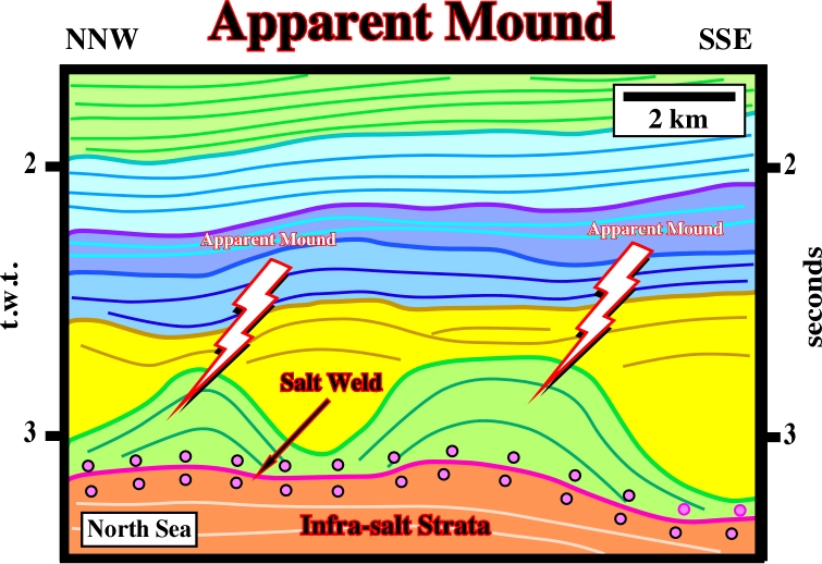
On this seismic line, the green antiforms are apparent mounds. Indeed, initially, their geometry was that of interdomal depocenters developed between salt structures (domes or walls). Later, due to the withdrawal of the salt structures, their geometry became inverted at the same time the yellow depocenters were deposited. At the bottom of the overburden, a salt weld is quite obvious, since the tectonic disharmony, between the overburden and the sub-salt strata, is rather evident.
Apparent Offlap(Jackson and Cramez, 1989)
Change of the original (depositional) reflection terminations of the chronostratigraphic lines (bedding planes or seismic reflectors) by salt reduction. Apparent downlap geometrical relationships are illustrated on the figure below.
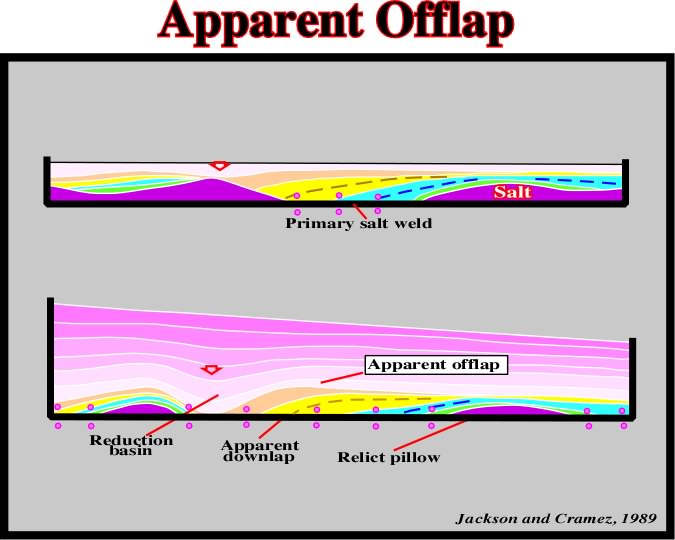
A progressive salt flowage of autochthonous salt induced a primary salt weld, and so, the original onlap chronostratigraphic terminations change into apparent downlap (or apparent offlap) terminations. On seismic lines, the recognition of apparent offlap and the associated salt weld surface are crucial to the understand of the geological evolution.
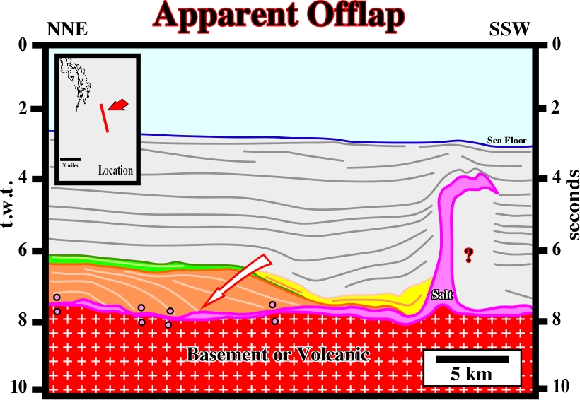
The apparent offlaps recognized in lower part of this seismic line (Gulf of Mexico) were erroneously interpreted as progradations of the Cretaceous shelf. Indeed, in Geology, and particularly in Sequence Stratigraphy, offlap is a progressive seaward regression of the up-dip terminations of the sedimentary units within a conformable interval of rocks. The retrogradational (backstepping or regressive) interval overlying the apparent offlaps correspond to the organic rich Upper Cretaceous interval which is the most likely generating petroleum subsystem in the Gulf of Mexico.
Apparent Turtle Back Structure
Back-rafts are apparent turtle back structures. In apparent turtle back structures, the main mechanism is a seaward gliding of the overburden over a salt substratum. The mechanism in turtle back structures is mainly an inversion induced by salt reduction. In an apparent turtle back there is just an interval thickening against the gliding surface, while in a turtle back structure, there are two divergent intervals. The older is thickening inward, while the younger is thickening outward.
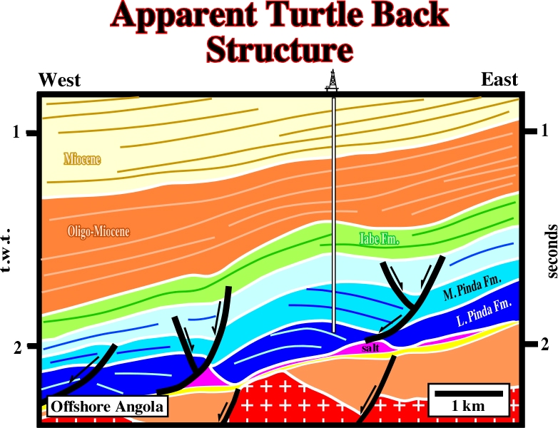
The seaward gliding of the overburden over a salt structure induced by a structural high of the sub-salt strata (sometimes of the basement) creates a mound-like structure with apparent offlaps looking landward. These structures are often erroneously considered as a turtle back structures.
Aquifer (McNeill L. et all, 1999)
A body of rock that contains sufficient saturated permeable material to conduct ground water and to yield significant quantities of water to wells and springs. An aquifer test is a test involving the withdrawal of measured quantities of water from, or addition of water to, a well and the measurement of resulting change in head in the aquifer both during and after the period of discharge or addition.
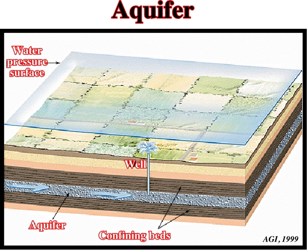
In salt basins, as in North Sea, aquifers can play an important role since the salt layer can be completely dissolved (see dissolution) Similarly, in hydrocarbon basins, the aquifer's movement (hydrodynamism) can favor, or destroy, the trapping of hydrocarbons.
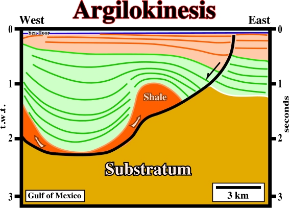
A form of shale tectonics, in which the shales, generally undercompated, flow by gravity, that is to say, by release of gravity potential energy alone, in absence of significant tectonic stress. Synonym of shalokinesis. Argilokinesis is particularly frequent, and quite important, in association with deltaic and prodeltaic environments, as in Gulf of Mexico and Gulf of Guinea.
This rollover structure was developed in the footwal of a growth fault created over a shaly mobile substratum on the western flank of a shale dome. The fault plane of the growth fault is underlined by a strong negative reflector induced by the impedance contrast between the synkinematic sediments and the undercompated shales.
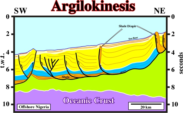
In Gulf of Guinea, argilokinesis is paramount. It creates antiform structures (extension) and anticlines (compression) as well. This area is a realm of listric faults. Indeed, the up-dip extension created by gravity gliding, is, down-dip, compensated by local compressional structures as illustrated on this seismic line. The reverse faults with an eastward vergence located in southwestern end of the line belong to a different faulting system. They are associated to a compressional tectonic regime created by oceanic ridge push.
Arkose (McNeill L. et all, 1999)
A feldspar-rich sandstone, commonly coarse-grained and pink or reddish, that is typically composed of angular or sub-angular grains that may be either poorly or moderately well sorted. It is usually derived from rapid disintegration of granite or granitic rocks, and often closely resembles granite as the Triassic arkoses of Eastern United States.
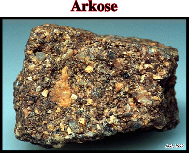
In petroleum geology, arkoses are considered as a potential reservoirs, since, very often, their feldspars can be dissolved out by the action of a percolating liquid.
Synonym of one-sided piercement.
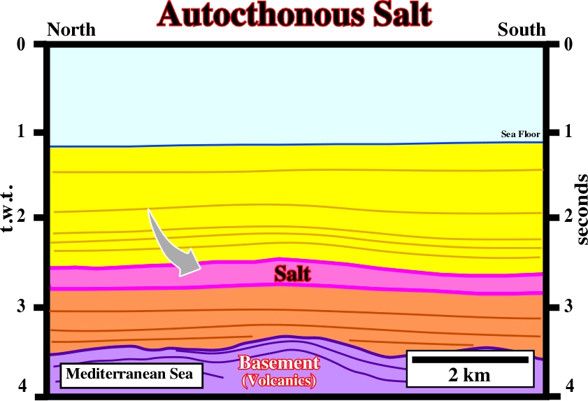
A salt body resting in the original strata or surface on which it accumulated by evaporation. One can say autochthonous salt is in its stratigraphic position.
The salt layer visible on this seismic line (Messinian salt) is an autochthonous salt layer. It is in its real stratigraphic position.