

A plutonic rock with Q between 0 and 5, P/(A+P) greater than 90, and plagioclase more calcic than An50.

A gabbro is the approximate coarse-grained equivalent of basalt. Apatite and magnetite or ilmenite are common accessory minerals. Gabbro grades into monzonite with increasing alkali-feldspar content.
The figure of the Earth considered as a sea-level surface extended continuously through the continent. It is a theoretically continuous surface that is perpendicular at every point to the direction of gravity. The geoid is the equipotential surface of the Earth's gravity field.
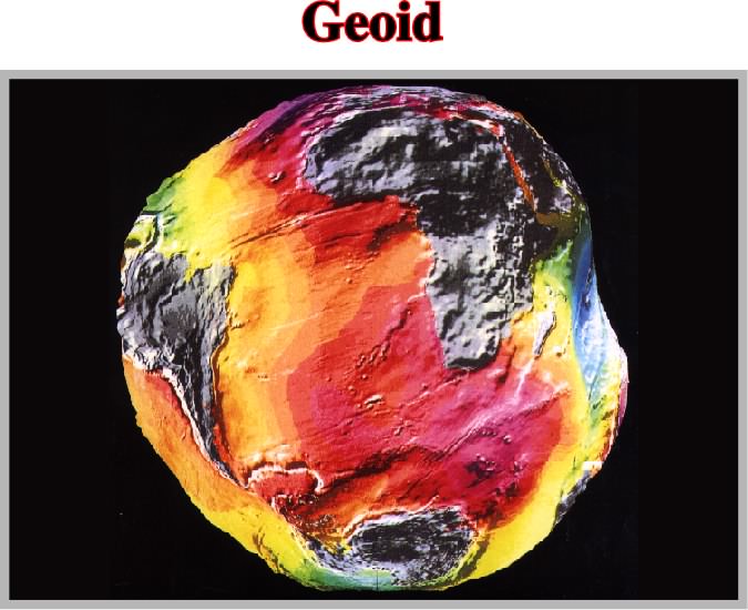
Sea level profiles show strong irregularities. Sea level is not flat. Large humps and depressions, related with gravity changes which in fact control them, are quite evident. Between the highest, near New Guinea, and the lowest, near Maldives, there is a difference of 180 m. In addition, the present geoid configuration is, of course, not stable. Eustatic sea level changes must take into account local sea level variation induced by gravity anomalies. The ocean level, i.e. the geological eustatic level assumed to be parallel to the Earth's ellipsoid, but via gravity irregularities, changed to the rough and uneven geodetic sea level, or equipotential surface of the geoid.
Geologic Map (McNeill, L. et al., 1999)
A map on which is recorded geological information, such as the distribution, nature and age relationships of rock units and the occurrence of structural features (folds, faults, joints), mineral deposits and fossil localities.
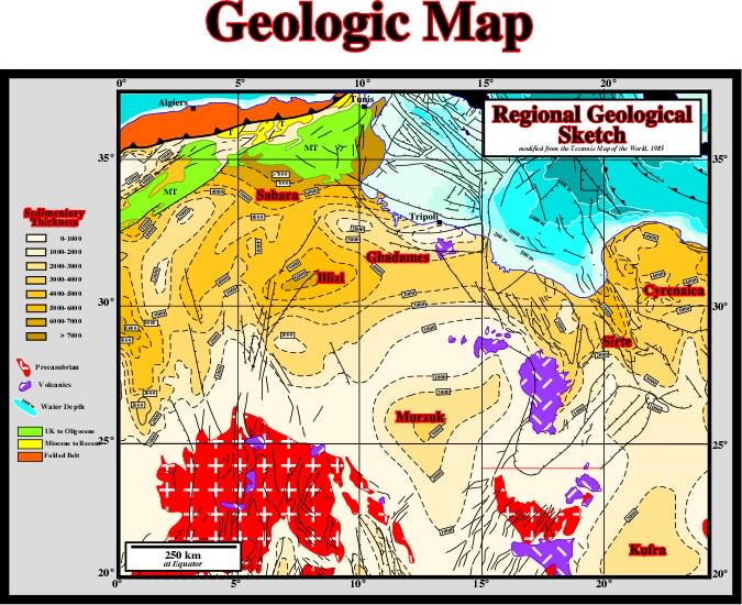
A geologic map indicates geologic structure by means of formational outcrop patterns, by conventional symbols giving the direction and amount of dip at certain points or by structure contours lines.
See: Ma.
The weight of a column of beds. At a given depth, the geostatic stress or geostatic pressure (
g) is given by a biaxial ellipsoid, with:
The geostatic stress ellipsoid varies with depth. The state of stress tends to become hydrostatic at great depth.
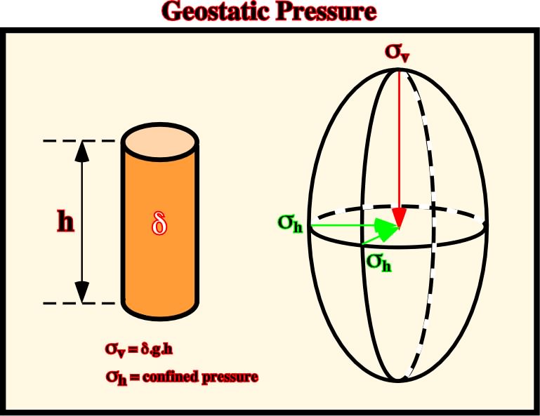
One of the consequence of the increasing, in depth, of the geostatic or lithostatic pressure is that its ellipsoid tends to become uniaxial, therefore, theoretically speaking, it is evident that the dip of the fault planes of normal and reverse faults becomes smaller in depth, i.e., fault planes flat in depth.
Glacial Flow (Jackson, M. P. A. and Talbot, C. J.,1991)
Flowing downdip from an exposed structure and spreading beneath air or water as in a glacier.
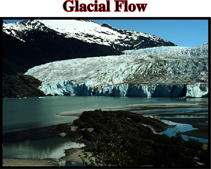
A glacier can be defined as a large mass of ice formed, at least in part, on land by compaction and recrystallization of snow, moving slowly by creep down-slope or outward in all direction due to the stress of its own weight, and surviving from year to year. Namakiers, that is to say, salt glaciers flow down-slope in a similar way.
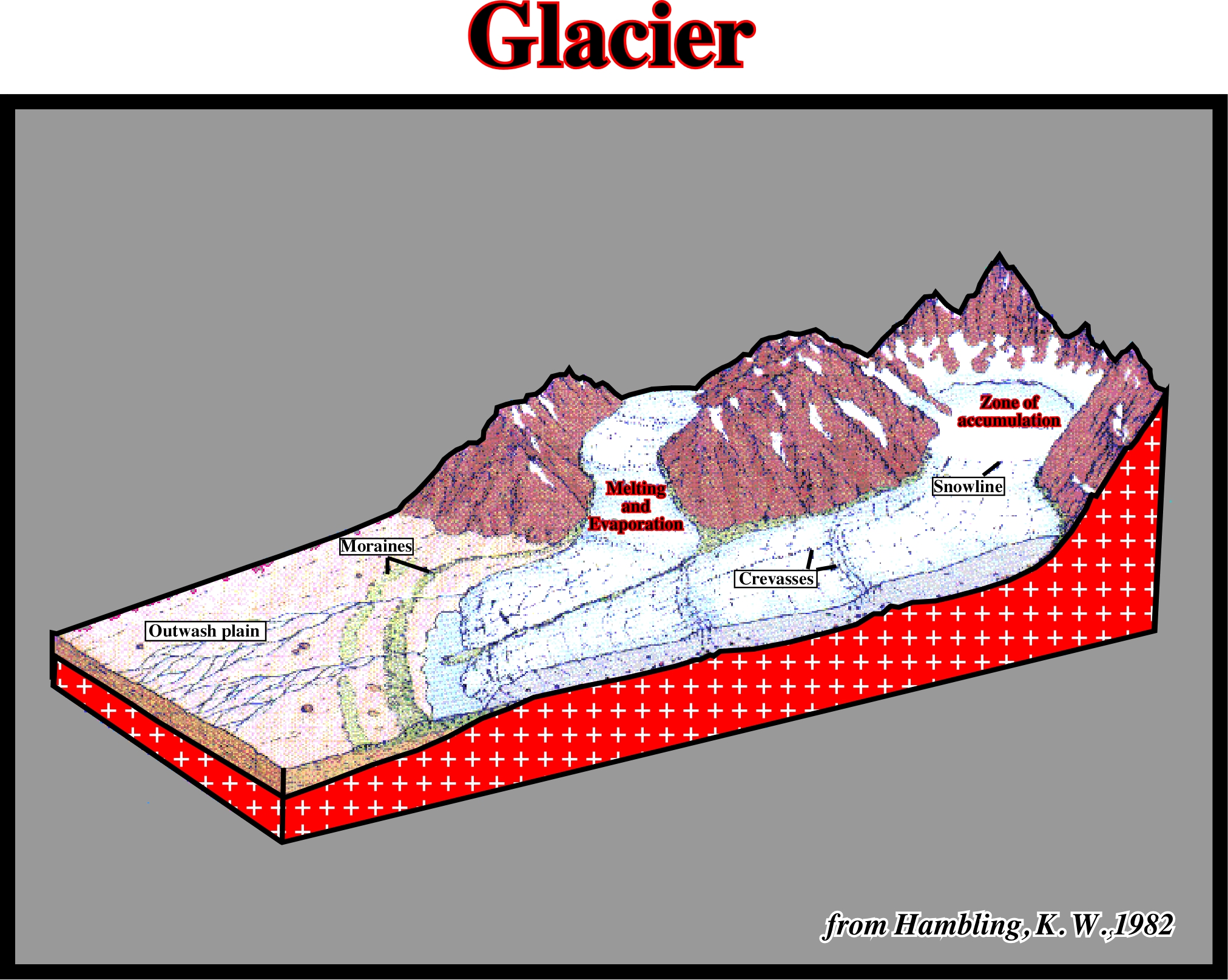
In the upper part of a glacier, three zones can be distinguished: (a) accumulation, (b) melting and (c) evaporation. In the lower part, different king of ice structures can be recognized: (i) snowlines, (ii) crevasses, (iii) moraines and (iv) the outwash plain.
Glacial Structures (Jackson, M. P. A. and Talbot, C. J.,1991)
Structures, which are not unique to salt glaciers, that provide an unrivalled display of progressive strain in salt (see below).
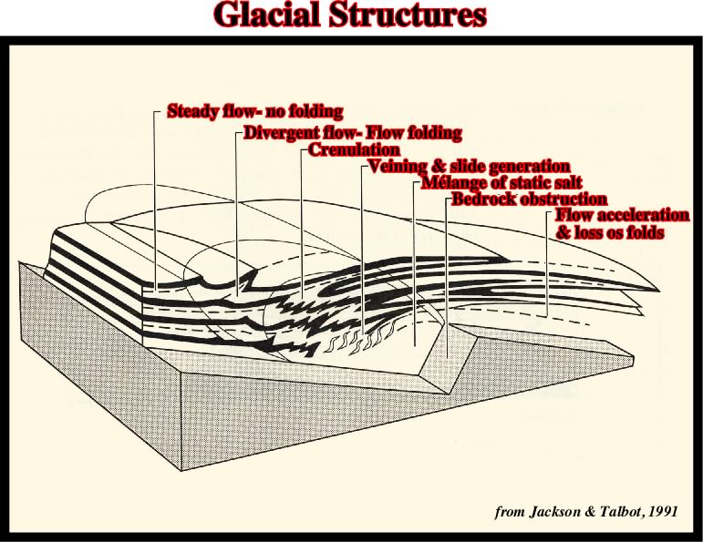
Block diagram showing schematic development of folds, sheath-folds, as slides (sheared-out limbs) in glacial salt flowing from left to right across a bedrock step. Where flow decelerates upstream of step, streamlines (dashed lines) diverge and deflect layering in the salt to form flow-folds on left. Flow then accelerates above the step and the streamlines converged, thereby tightening and elongating folds into sheath-folds (large recumbent folds on the right).
See: Salt glacier or Namakier.
Goguel's Law (Goguel, J., 1965)
The Second Law of Thermodynamic when applied in Geology. The Goguel's law can be summarized as follows: "Throughout deformation, volume is conserved, but for that due to a loose porosity or dissolution".
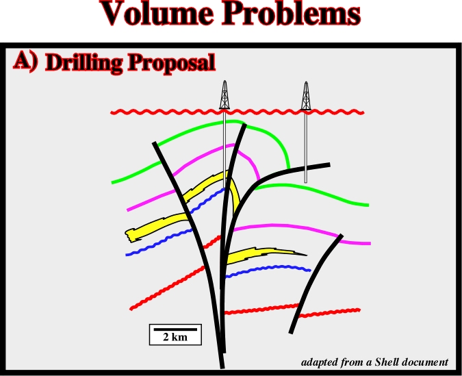
This sketch represent a geologic interpretation of a seismic line shot in an area where strike slip movements are absent. If that is so, the seismic interpreter did not respect the Goguel's law, since, in this interpretation there is a major volume problem (see below).
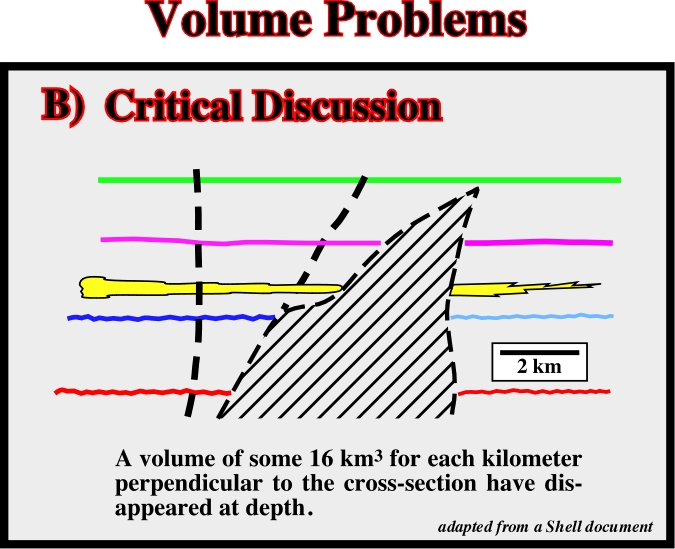
A critical discussion of the above geological interpretation clear indicates the interpreter did not respect the Goguel's law. Indeed, such a interpretation puts away a so large volume of sediments that the interpretation becomes unlikely.
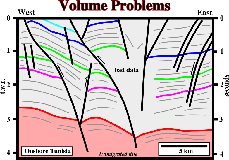
It is quite obvious that this seismic interpretation (the line comes from an area in which there is not strike-slip displacement) does not respect the Goguel's law. Indeed, if you assess the shortenings of the red and green horizons, we immediately realize than a detachment surface between them is unavoidable.
An elongate trough or basin, bounded on both sides by high-angle normal faults that dip toward the interior of the through.
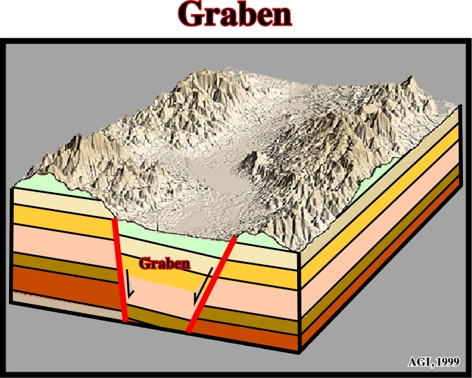
All rift-type basin are grabens, but not all grabens are rift-type basins. Generally, grabens are not symmetric. Very often, they correspond to two half-grabens of different age.
Graben Type Diapirs (Ruig, M. J., 1995)
A diapir type in Southeastern Spain. Indeed, based on their external shape and boundary faults diapirs, in Southeastern Spain, have been subdivided, for descriptive purposes, into three types: (i) graben, (ii) pull-apart and (iii) fault injection. In graben-diapirs, the boundary faults are commonly associated with small evaporites. However, larger diapiric outcrops are in the center of the grabens.
A third generation salt wall or stock flanking a daughter diapir.
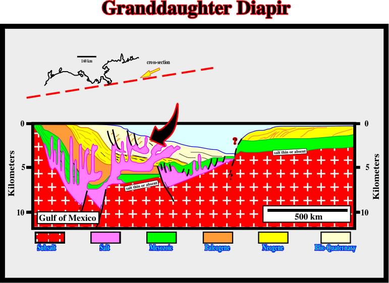
Granddaughter diapirs are known in the Gulf of Mexico. As illustrated above, they rise from secondary order allochthonous salt sheets.
A plutonic rock with Q between 20 and 60 and P/5A+P) between 10 and 65 (IUGS classification) or a plutonic rock, in which quartz constitutes 10 to 50 % of the felsic components and in which the alkali feldspar/total feldspar ratio is generally restricted to the range of 65 to 90 %.
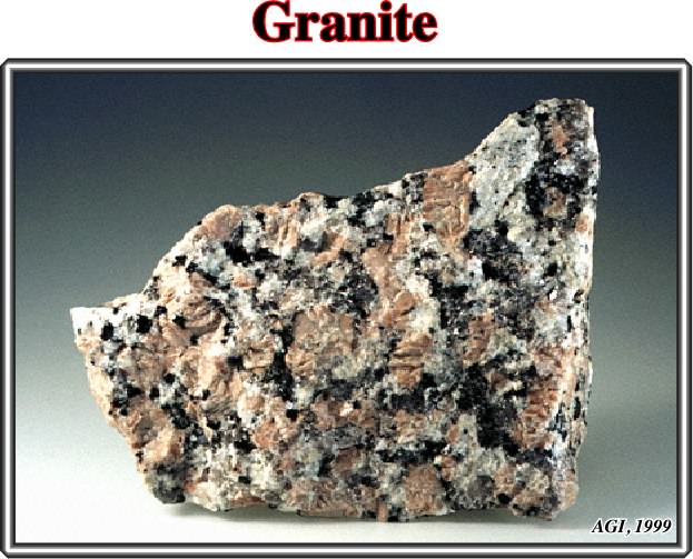
Rocks in this range of composition, indicated above, are scarce, and sentiment has been growing to expand the definition to include rocks designated as adamellite or quartz monzonite, which are abundant in the U.S. Another broadly applied definition of granite is any holocrystaline, quartz-bearing plutonic rock.
Those pertaining to or composed of granite.
An exchange in position of the source layer and overburden such that the less dense layer is eventually uppermost. The process is rarely completed in nature.
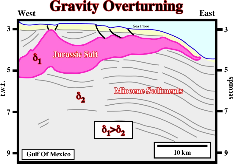
In Gulf of Mexico, the age of the salt is Jurassic. On this seismic line, stratigraphic speaking, the allochthonous salt layer is much older than surrounding sediments (Mio-Pliocene). However, as the density of the salt is constant in depth, when an allochthonous salt layer is above the inversion point, it is denser that the surrounding sediments.
Downslope sliding of an overburden sheet or block under its own weight over a weak, ductile décollement (such as salt). The base of the overburden must dip sufficiently that gravitational body force is resolved into a downslope shear stress that is large enough to overcome the shear strength of the décollement layer or the frictional strength of the décollement fault. In salt tectonics, this dip is provided by a continental slope or delta front.
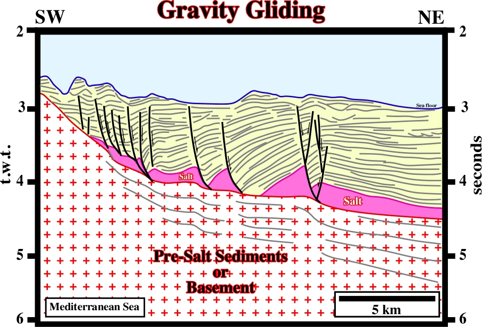
Near the pinchout of the Messinian salt layer, the overburden glided as salt evacuate basinward and the associated growth-faults, die on the top of the salt or on the salt weld.
Lateral spreading of salt (and commonly its overburden) above the level of neutral buoyancy. A dipping upper surface allows a small component of the gravitational body force to be resolved into a down-slope shear stress to drive spreading. Examples are the spread of salt glaciers or lateral injection of salt sheets.
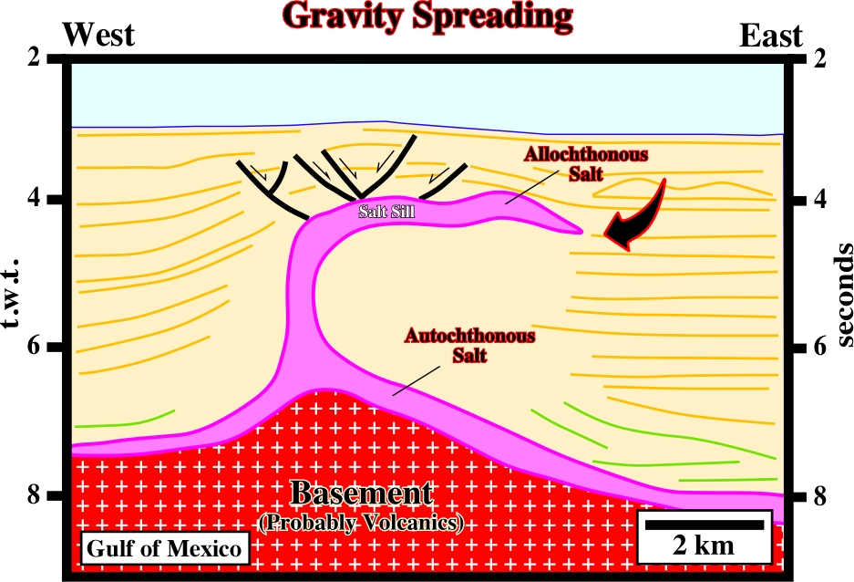
A lateral spreading of the salt is quite evident on this seismic line. The dipping upper surface of the salt creates a downslope shear stress, which partial drives the seaward spreading.
A fault in sedimentary rock that forms contemporaneously and continuously with deposition, so that the throw increases with depth and the strata of the down-thrown side are thicker than the correlative strata of the up-thrown side.
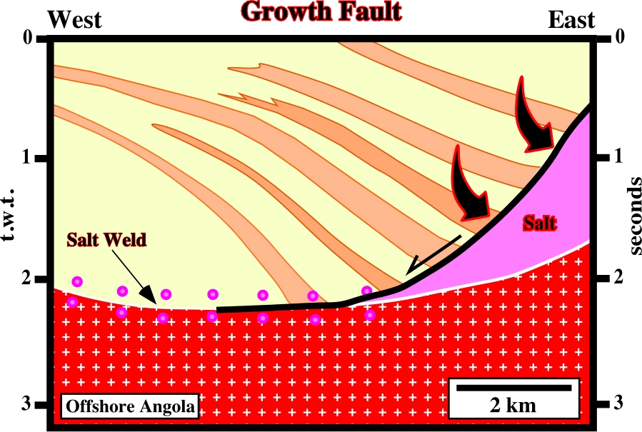
Contrariwise to the progradations of the shelf breaks in a regressive interval, which are characterized by downlap geometric relationships, in a growth-fault, induced by salt flowage, as illustrated above, the hangingwall configuration is divergent (against the fault plane) suggesting a differential subsidence. The geometric relationships of the chronostratigraphic lines of the hangingwall are apparent downlaps, that is to say, they are tilted onlaps.
Name given in Gulf of Mexico to the structural disrupted zone, directly under allochthonous salt, which works as a permeability pathway. Fluid flushing through this zone develops hyper-pressures, in the section immediately below the salt, which create big problems during drilling.
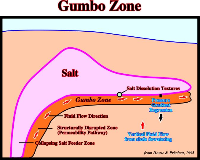
The Gumbo zone was discovered when oil companies tested the hydrocarbon potential of sub-salt prospects. They found major drilling problems at the bottom of the salt layer due to the over-pressures of the Gumbo zone. On the other hand, seismic interpreters soon realize the seismic marker associated with the bottom of the salt, was actually induced by the Gumbo zone rather than by the salt. So, when an obvious bottom of allochthonous salt is recognized on a seismic line, the chances that a Gumbo zone is present are quite high.
A widely distributed mineral consisting of aquated calcium sulfate: Ca(H2O)2(SO4). It is the commonest sulfate mineral, and is frequently associated with halite and anhydrite in evaporites, forming thick, extensive beds interstratified with limestone, shale, and clay (esp. in rocks of Permian and Triassic age).
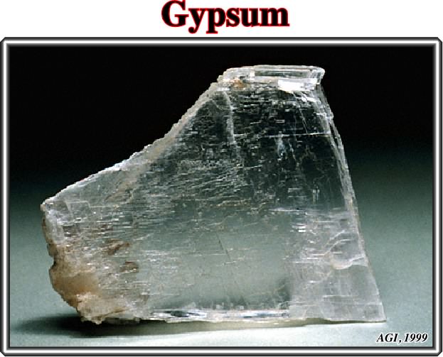
Gypsum is soft (hardness of 2 on the Mohs scale). It is white or colorless when pure, but commonly has tints of gray, red, yellow, blue or brown. It occurs massive (alabaster), fibrous (satin spar), or in monoclinic crystals (selenite). Gypsum is used chiefly as a soil amendment, as a retarder in portland cement, and in making plaster of Paris.