

See Aggradation
A compressional bell-shaped structure with a core of salt. Salt anticline structures are created by a compressional tectonic regime, thereof they are not synonym of salt antiforms, which are created by extensional tectonic regimes.
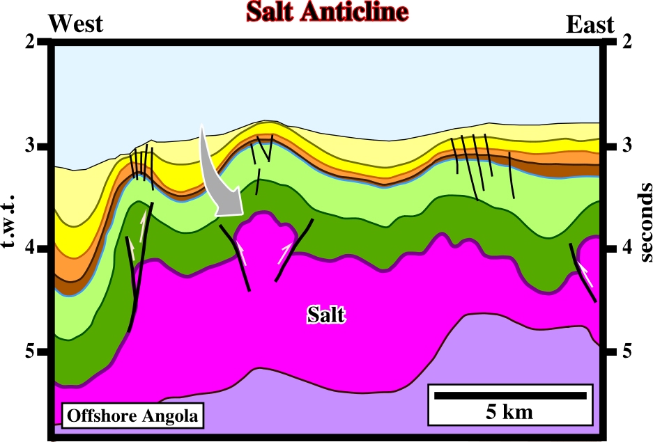
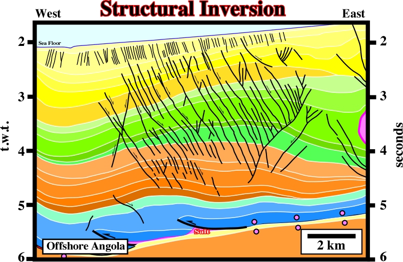
As illustrated on this seismic line, it is quite obvious the salt and overburden have been shortened (compression still is going on) by a compressional tectonic regime that some associate with ridge pushing forces. The faults in the top of the antiforms are strike-slip and not normal faults. Time slices between 3.0 and 3.2 seconds, strongly suggest that such a faults elongate the anticline axis along the s2.
See Antiform (salt).
Salt Basins (Jackson, M.P.A. and Talbot, C.J, 1991)
The map below showing the distribution of the salt structures, depicts only those parts of salt basins where deformation is large enough that salt structures are prominent on reflection seismic profiles. Areas of undeformed salt are not shown.
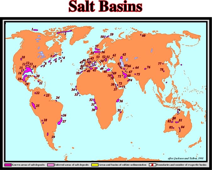
Salt provinces are categorized by amount of petroleum production according to AAPG's classification of sedimentary provinces of the world (St. John and others, 1984). (i) Giant: (2) Sverdrup, (4) Jeand'Arc, (5) Grand Banks, (10) Paradox, (11) East Texas, (12) North Louisiana, (14) Gulf Coast, (18) Salinas, (22) Zipaquira, (31) Cabinda, (32) Gabon, (47) Aquitaine, (55) Southern North Sea, (56) Northwest German, (57) Northern North Sea, (58) Tromso, (61) Dnepr-Donetz, (62) North Caspian, (64) Tadjik, (68) Zagros, (70) Suez, (71) Arabian, (72) Red Sea East, (74) Oman. (ii) Subgiant: (6) Scotian, (13) Mississippi, (16) Sabinas, (19) Petenchiapas, (23) Takutu, (25) Oriente-Ucayali, (26) Espirito Sant, (27) Campos, (30) Kwanza, (39) Essaoira, (40) Atlas, (41) Pelagian, (46) Cantabrian, (49) Ioninan, (50) South Adriatic, (51) Carpathian, (52) Transylvanian, (63) Great Kavir), (77) Bohai Bay, (79) Bonaparte, (80) Canning, (81) Amadeus. (iii) Nonproductive: (1) Chukchi, (3) Moncton, (7) Georges Bank, (8) Baltimore Canyon, (9) Carolina, (15) South Texas, (17) Sigsbee, (20) Cuban, (21) Haitian, (24) Barreirinhas, (28) Atacama, (29) Neuquen, (33) Liberia, (34) Senegal, (35) Comores, (36) West Somali, (37) Danakil, (38) Red Sea West, (42) Algerian-Alboran, (43) Balearic, (44) Ebro, (45) Jaca, (48) Levantine, (53) Ligurian, (54) Rhodanian, (59) Nordkapp, (60) Yenisey-Khatanga, (65) Tabriz, (66) Yazd-Kalut, (67) North Kerman, (69) Dead Sea, (73) Hadhramaut, (75) Salt range, (76) Qaidam, (78) Jianghan, (82) Woolnough, (83) Officer, (84) Flinders.
The lost of salt by dissolution. Goguel's law (during deformation the volume of sediments is kept roughly constant) is difficult to apply to salt layers. Actually, the salt budget suggests that dissolution take almost always place and it can reach 30% of the total salt volume. In Gulf Coast, some geologists estimate that a minimum of 6 km3 of salt was dissolved into present formation waters.
A salt protuberance induced by lateral salt flowage. A salt bulge can became a diapir. See: Downward Salt Bulge.
Composite diapiric structure formed by partial or complete coalescence of diapir bulbs or salt sheet. These coalescence bodies may or may not be connected to their source layer.
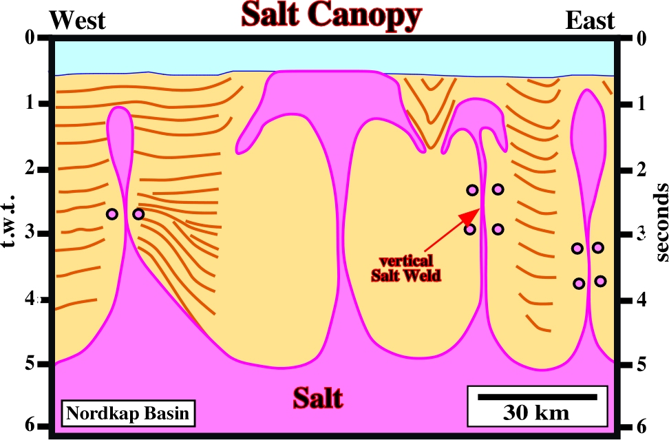
This interpretation takes into account the Rayleigh-Taylor instability. During longtime, in this area, erroneously large diapiric structures (>30 km wide) were proposed. With such large salt structures explorationists give up the area due to absence of significant traps (in depth, such structures were 3-4 times thicker than the basin itself). It is obvious that interpretations with salt canopy structures strongly change the petroleum potential, at least the trapping parameter.
Tectonic disharmony or detachment surface associated with a salt layer either autochthonous or allochthonous.
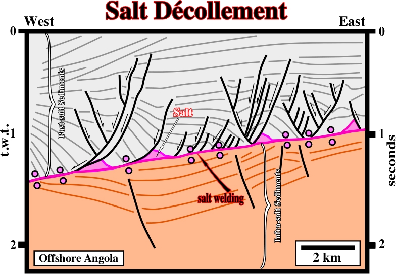
The primary salt weld recognized in the central part of the the line emphasizes the tectonic disharmony associated with the bottom of the salt layer. The overburden and sub-salt strata show quite different deformations. Salt roller are recognized on the bottom of pre-raft structures.
Imprecise term for a domal up-welling comprising a salt core, which may or may not be diapiric (i.e. discordant), and an envelope of deformed overburden. Synonym of diapir and salt diapir.
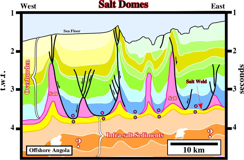
On this seismic line, the overburden is quite deformed, while the sub-salt strata is mainly undeformed. The undulations of the sub-salt strata are apparent. They are induced by lateral changes in the velocity of the overburden. Indeed, at the vertical of each salt dome, the sub-salt strata are pulled-up. The majority of the salt domes is disconnected of the mother source layer. In fact, they are separated by primary salt welds.
See: Salt décollement.
See: Dissolution and Salt budget.
Synonym of Detached salt stock.
A total flowage or withdrawal of the salt layer. In absence of significant extensional tectonic regime, a salt evacuation induces a lengthening of the the overburden. Thus, a salt evacuation of a roller induces a lengthening of the footwall sediments creating an apparent reverse-fault (a normal fault with a reverse geometry).
Salt Evacuation Surface (Diegel, F. A. et al, 1995)
Synonym of Salt weld or Salt withdrawal surface.
Synkinematic basin subsiding into relatively thick allochthonous or autochthonous salt. Salt expulsion basins may be the expression of spoke circular or may reflect merely random patterns of differential loading. Some intrasalt basins form up-dip of large salt tongues, which act as barriers to down-slope sedimentary transport.
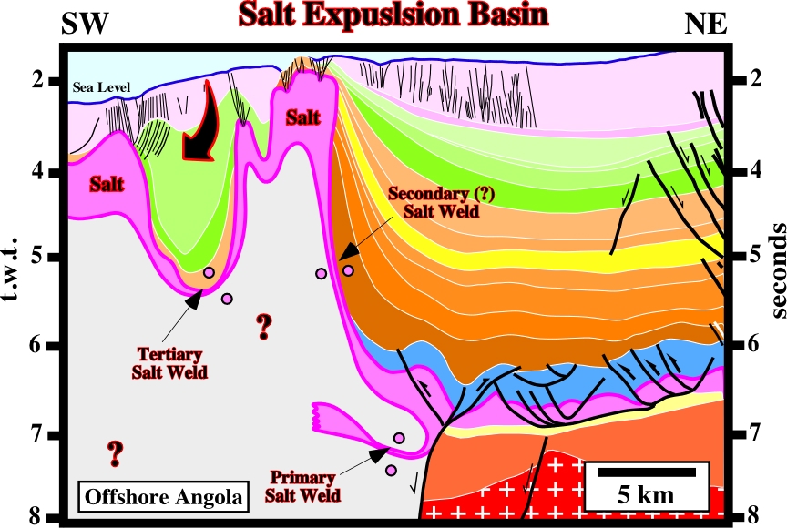
On this line, it is obvious that the mini-basin above the allochthonous salt sheet, can only be explained by a local evacuation of the salt. The ramp (or counter-regional fault) along which the autochthonous salt migrated upward is recognized in the central part of the line. Sub-salt strata and particularly two rift-type basins are recognized in the lower right corner.
General term used to express outcropping salt structures (in surface or bottom of sea). Salt extrusions can be due to erosion or piercement (with or without compression).
See: Counter-regional system.
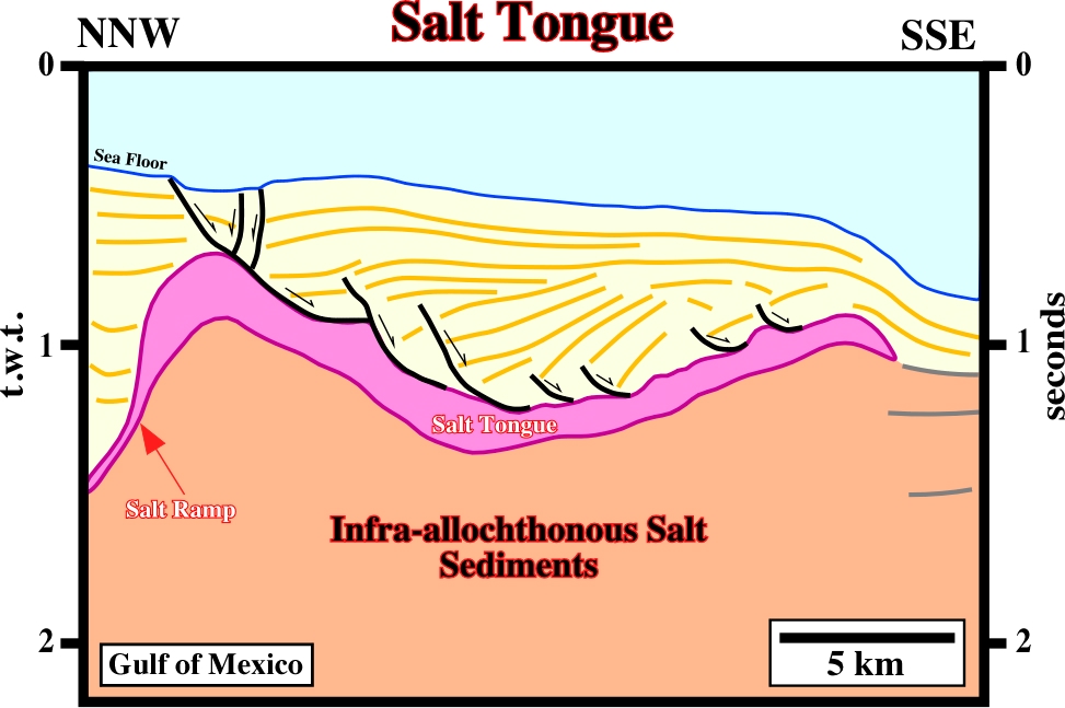
A steeply inclined and gently inclined segments, respectively, of the stair-step basal contact of a salt tongue. Can be a synonym of salt ramp. Salt flats cut up stratigraphic section in the direction of emplacement. They dip in a direction opposite to the spreading direction of a tongue during the stratigraphic time represented by strata truncated in the basal cutoff adjoining the salt ramp. Ramps form where the ration of aggradation to salt spreading is high. Conversely, flats form where this ratio is low.
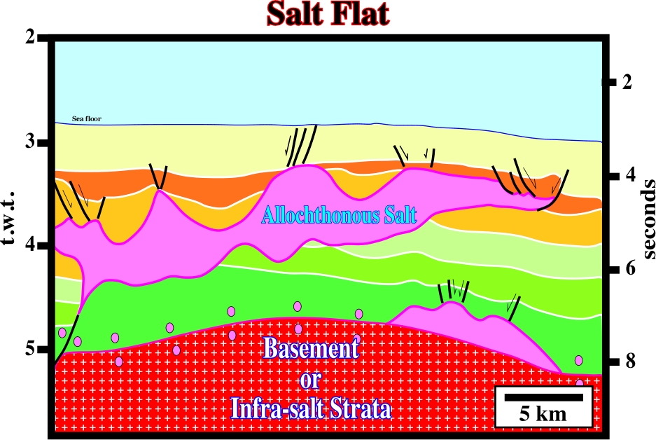
In spite of the stretched horizontal scale, the salt flats, at the bottom of the allochthonous salt sheet, are quite well recognized on this line.
Lateral or vertical displacement of a salt layer either by differential loading, density inversion or gravity.
Synonym of Salt anticline.
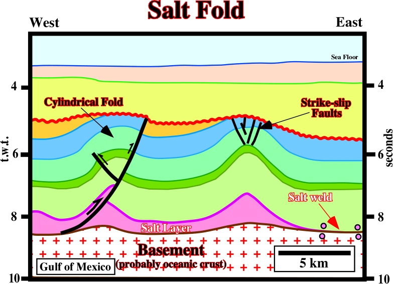
The regional geological setting of this line strongly suggests these salt structures were created by a compressional tectonic regime. The mapping of the faults on the top of the overburden structures shows that they are small strike-slip faults which elongate the axis of the anticline along the
2.
Salt Fountain (Bailey, E. B., 1931)
This expression comes from a metaphor used by Bailey: "salt diapirs are slow-motion fountains".
Sheetlike extrusion of salt issuing from an exposed diapir and spreading beneath air or water. Synonym of Namakier.
Intrusive salt sheet whose ratio of maximum width to maximum thickness is between 5 and 20. Its upper part is typically concordant, whereas its lower contact is commonly slightly discordant.
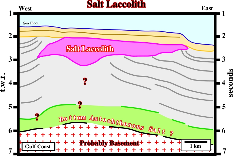
On this seismic line, a deep primary salt weld (around 6 seconds) underlines the evacuation of autochthonous salt. In the upper stratigraphic levels, allochthonous salt is quite obvious. Taking into account the dimensions of the central salt body as well as the geometry of the upper and lower contacts, it can be considered as a salt laccolith.
Lateral displacement of the salt inducing a compensatory subsidence.
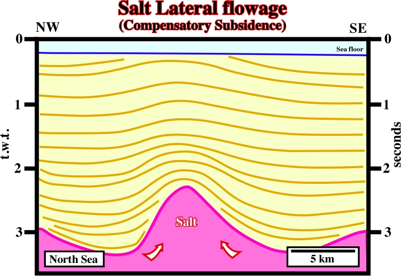
As illustrated on this seismic line, the lateral flowage of the salt is the main responsible for the creation of space available for the sediments, that is to say, it induces a compensatory subsidence. Indeed, in the lower intervals of the overburden, the thickness variations (thin above the bulge and thick above the salt synforms) can only be explain by salt flowage, in spite of the fact, that the geometry of the upper intervals of the overburden suggests a late shortening.
Synonym of salt. A salt layer can be an autochthonous or allochthonous.
Syndiapiric deposition of stiff overburden around salt diapir. Since 1933, Barton introduced the concept of downbuilding to account for salt structures that pierce clastic sediments. See: Molding Models.
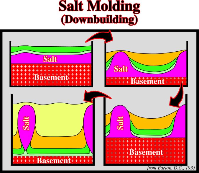
Actually, instead of a buried layer actively upthrusting toward the surface through an overburden already in place, Barton argued that cores initially tabular salt layers remained passive but emergent near the sea floor while the top of the surrounding salt was buried ever deeper by clastic sediments.
Layer supplying salt for the growth of salt structures. Synonym of mother salt.
In offshore Brazil, from where this line comes, the source salt layer, i.e., autochthonous salt overlies the potential source rocks. Contrariwise to West African salt basins, where the major marine source rocks is in the overburden, here, the potential marine source rocks never reached maturation. Indeed, as illustrated, the overburden is relatively thin. Its maximum thickness is around 3 seconds.
Salt tongue whose lower contact is a thrust fault, shear zone, or zone of inverted strata.
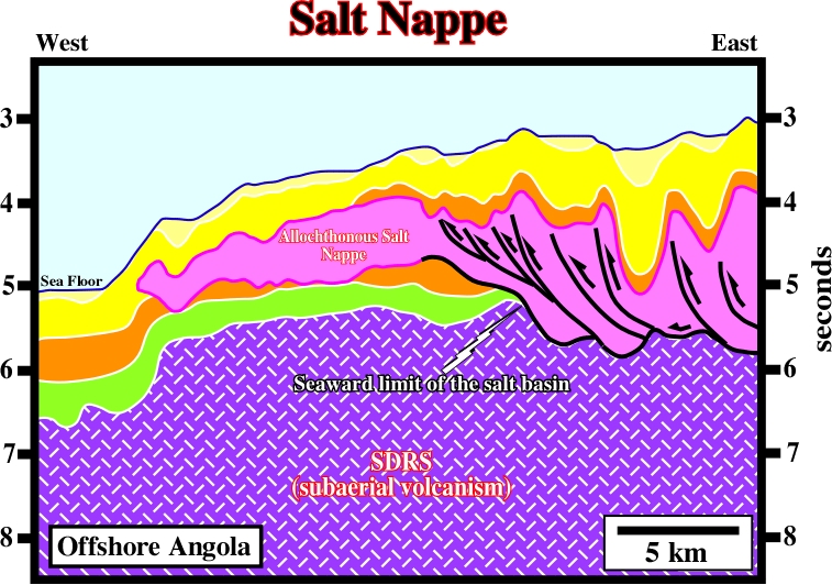
It is interesting to notice that in depth, the distal thrust fault corresponds to the seaward limit of a salt basin. Seaward, the salt is allochthonous and forms a salt nappe, which has been reactivated and shortened probably by ridge push forces. It is quite obvious that the thickness of the salt is apparent and due to thrusting. Some argued that the salt being thicker in the ultra deep offshore was the proof of an unique pristine salt basin that was later split in two. Recently, such a erroneously hypothesis has been systematically falsified.
Sub-circular up-welling of salt with concordant overburden.
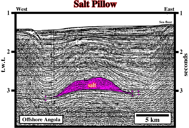
The salt pillow is completely disconnected of the mother source layer. It is limited by two primary salt welds. This antiform salt structure, recognized in 1968, on Seffel lines, became, recently, well known of all explorationists working in West Africa offshores. Indeed, major oil fields have been found around the top of the antiform. Notice the slight pull-up of the tectonic disharmony induced by the salt pillow.
Termination or end of the salt layer or when the salt narrows or thins progressively in a given direction until it disappears. The up-dip limit of a salt basin is always characterized by a graben structures in the overburden, as illustrated on the geological map of Gulf Coast.
Synonym of Salt Stock.
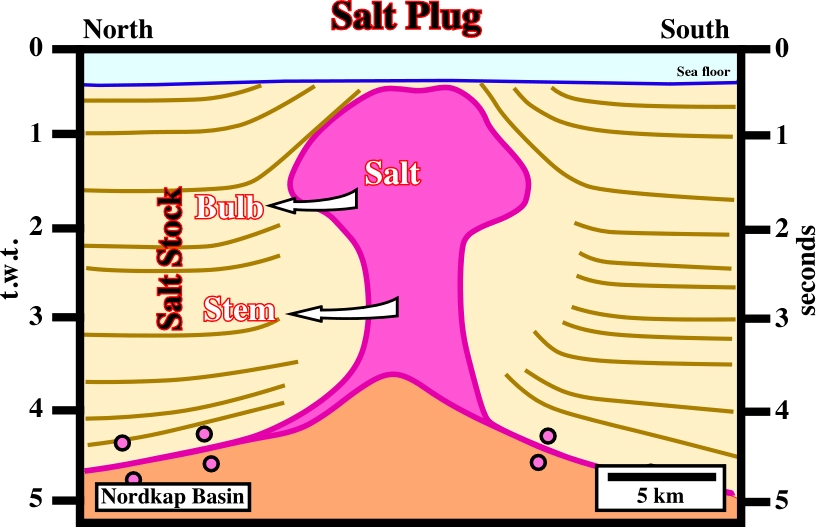
As illustrated above, one can say salt plugs are composed by a stem and a bulb. On this line, the salt stock is disconnected from the mother source layer. Two primary salt welds separate the salt stock from the mother salt layer.
A small basin, in which the brine starts to deposit salt. It is often assumed that salt basins, as the South Atlantic salt basins are, in fact the agglutination of multitudinous salt pods.
See: Feeder or Counter-regional system.
Mass transfer of salt over time, resulting in an obvious change in area of salt in cross section, by: (1) Volume loss due to dissolution, (2) Isochoric flow out of the plane of section, including smearing along décollement faults, (3) Isochoric flow within the plane of section but beyond the ends of the cross section.
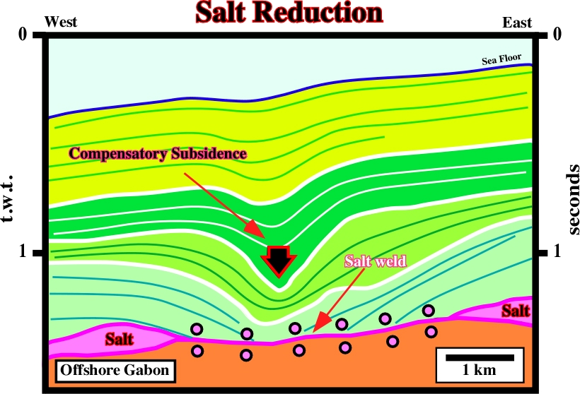
The lateral salt flowage or salt reduction, i.e, the evacuation of the salt created a primary salt weld and a local depocenters in the overburden. The salt reduction strongly increased the space available for the sediments (accommodation), which generated three local but an obvious depocenters in the synkinematic intervals of the overburden. The light blue interval seems prekinematic.
Low-amplitude, asymmetric salt structure comprising two flanks: a longer, gently dipping flank in conformable stratigraphic contact with the overburden; and a shorter, more-steeply dipping flank in normal-faulted contact with the overburden. Salt rollers are an unequivocal sign of regional thin-skinned extension perpendicular to the strike of the salt rollers.
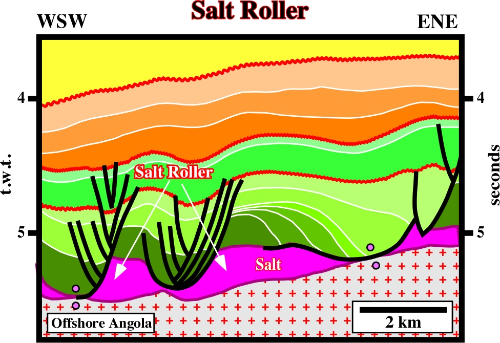
Salt rollers are characteristic of pre-raft domain, which generally are assumed to be located in upper slope or platform. This line comes from the deepwater of Angola, where salt rollers are quite obvious. Such an occurrence has important implications for the origin of the high quality calcareous reservoirs.
Allochthonous salt whose breadth is at least 5 times its maximum thickness.
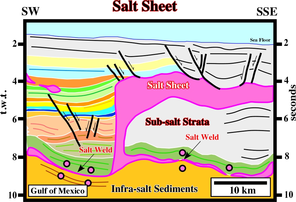
This salt sheet still is connected with the mother source layer, which is partially represent by primary salt welds. The feeder or the ramp, which later will become a counter-regional fault, is well recognized. Notice n the top of the salt sheet several Roho faults.
Intrusive salt sheet whose ratio of maximum width to maximum thickness is >20. It is typically intruded at depths of only a few hundred meters or less. Its upper contact is typically concordant, whereas its lower contact is commonly slightly discordant.
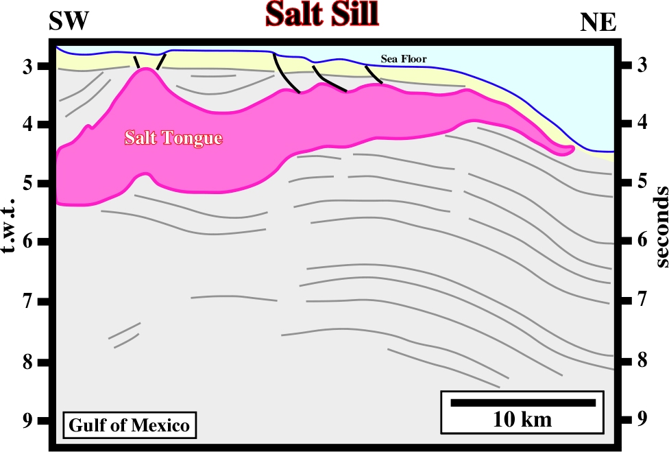
At the bottom of this salt sill (i) basal cutoffs, (ii) salt flat and (iii) salt ramps are easily recognized. However, these salt ramps should not be confused with the salt ramps synonym of feeders.
See: Basement Step.
Pluglike salt diapir with subcircular planform. Synonym of salt plug.
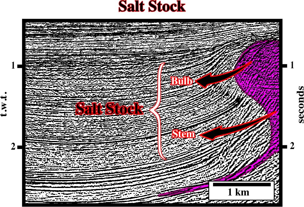
Salt stocks are formed by a stem and a bulb. They can be connected or disconnected of the mother source layer.
Salt Canopy formed by coalescence of Salt stocks.
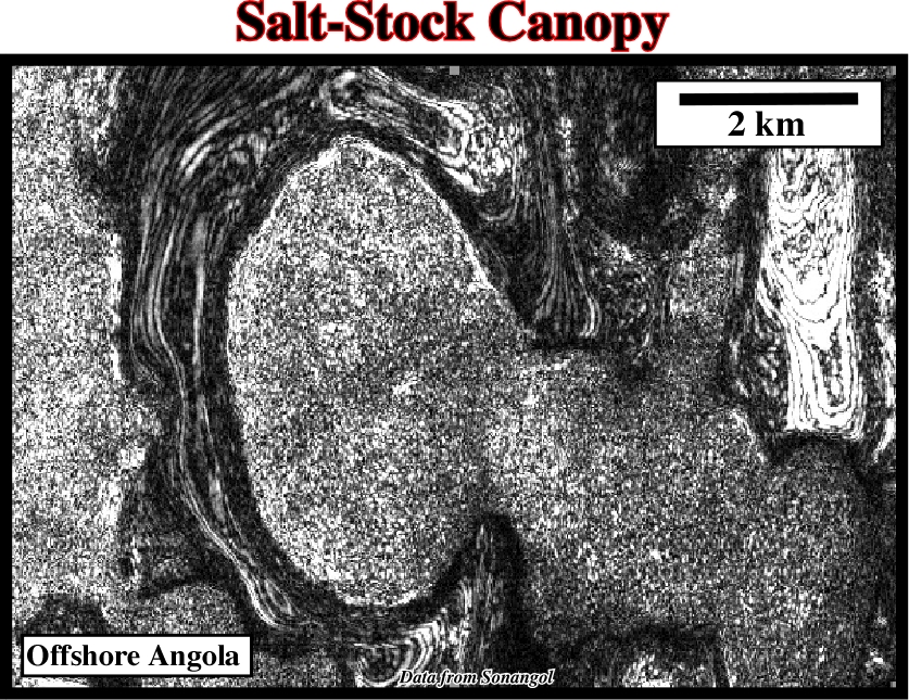
The sutures between the different salt stocks to form a salt-stock canopy still are easy recognized on this time slice, which depth is less than 0.5 second below sea floor.
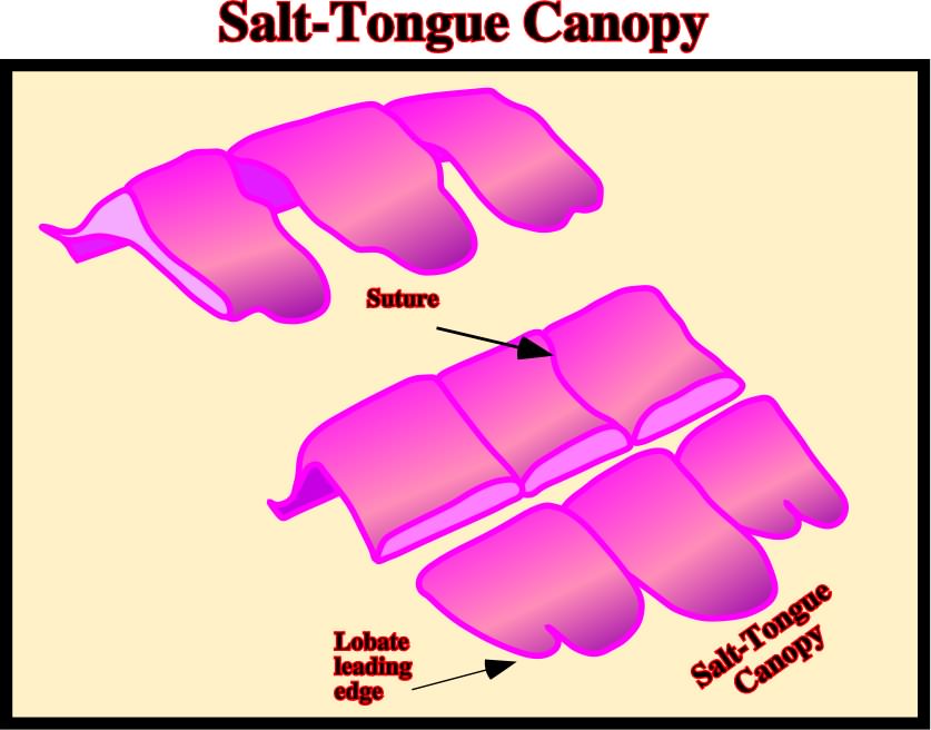
Junction between individual salt structures that have coalesced lateral to form a canopy.
Allochthonous salt sheets or salt stocks can gathered to form large salt napes or salt-stock canopies. Here, it is obvious that salt-stocks are coalescing to form a salt-stock canopy.
Generally, a synonym of Salt Pillow. However, some geologists used this term when the salt structure is induced by a compressional tectonic regime rather than salt flowage.
Any tectonic deformation involving salt, or other evaporites, as a mobile layer.
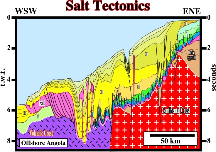
Some geologists used the Salt Tectonics when an extensional tectonic regime is active, and Halokinesis when salt deformation take place in absence of a significant tectonic stress. However, as illustrated on this regional geological cross-section, at a regional scale, i.e, at the scale of a basin, extensional and compressional tectonic regimes are always present. Locally, almost all salt structures can be explain just by halokinesis. However, at the scale of the basin, halokinesis plays a secondary if not a meaningless role.
Highly asymmetric variety of salt sheet or salt laccolith fed by a single stem. Individual salt tongues are as large as 80 km long and 7 km thick. Typically applied to wedgelike bodies with large taper angles and which do not resemble a salt sill.
Salt tongues as the one illustrated on this seismic line are quite difficult to distinguish of salt laccoliths or salt sheets.
Coalescence of salt tongues.
Salt-tongue canopies are quite difficult to recognize on seismic lines. However, they can easily to be recognized on shallow time slices knowing the above geological model. Indeed, seismic interpreters can only recognize on seismic data what they known,i.e., in seismic interpretation Theory precedes Observation.
Salt upwelling is generally referred to small vertical salt flowage initiated at shallow depths. Indeed, salt can flow under quite small overburden thickness as suggested by onlaps, truncations and lateral thickness changes against dome flanks. On the other hand, reefs are often found on dome crests.
Synonym of salt reduction.
Ellongated up-welling of diapiric (discordant) salt, commonly forming sinuous, parallel rows.
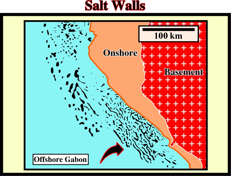
Salt walls are easily recognised on time slices or on geological maps. On this map, the salt structures (in black) are mainly elongated, particularly on the southern part, and parallel to the shoreline, which corresponds roughly to the
Coalescence of salt walls.
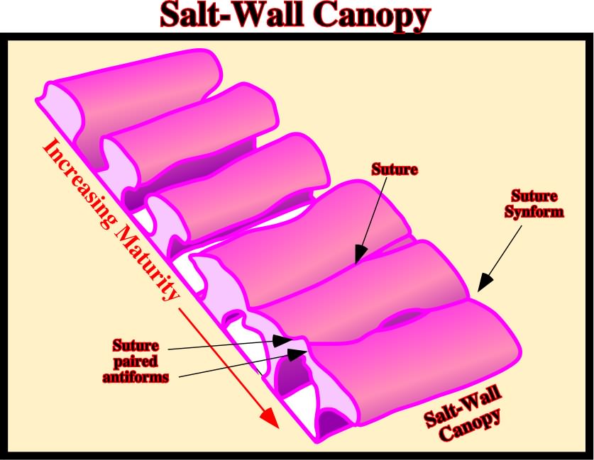
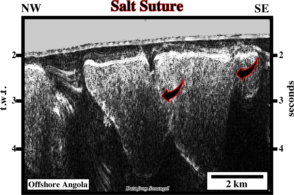
As illustrated above, with time, salt walls can coalesced and form quite large salt wall canopies. Often, time slices allow to recognize the sutures between the different salt walls or the suture synforms, which allow easily differentiate salt wall canopies from salt napes.
Surface or zone joining strata or originally separated by autochthonous or allochthonous Salt. The weld is a negative salt structure resulting from the complete or nearly complete removal of intervening salt. The weld can consist of brecciated, insoluble residue containing halite pseudomorphs or of salt too thin to be resolved in reflection-seismic data. The weld is usually but not always marked by a structural discordance. Another distinctive feature of welds is a structural inversion above them.
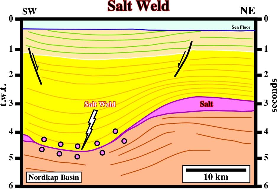
On this line, the salt weld is quite obvious. The salt mother layer is recognized in both sides of the salt weld. The depocenter located above the salt weld can only be explained by compensatory subsidence, that is to say, by withdrawal of the salt.
Synonym of salt antiform.
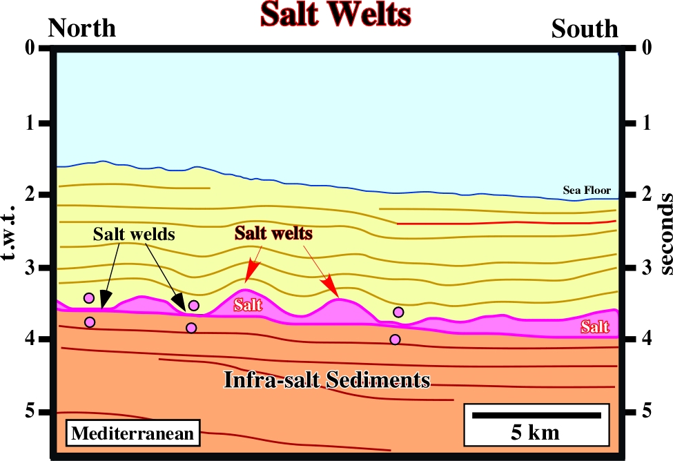
Salt welts are not synonym of salt anticlines. They are extensional salt structures, generally, created by salt flowage. Sometimes they correspond to salt upwellings, as illustrated on this line. The internal configuration of the lowermost interval of the overburden is divergent toward the synforms, what suggests that it is a synkinematic layer. The salt started to flow at quite shallow depth.
Salt Wing (Diegel, F. A. et al, 1995)
A smaller salt sheet (allochthonous salt) with a subhorizontal top and base and with a demonstrable base.
Mass transfer of salt over time without obvious change in salt area in cross-section. Examples are the migration of salt from the flanks of a salt pillow into its core as it evolves into diapir or the flow of salt along a salt wall into local culminations that evolve into salt stocks. In a certain sense salt withdrawal can be considered a salt reduction.
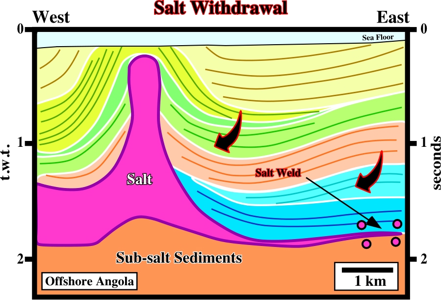
The geometrical relationships between the overburden reflectors and the top of the salt, as well as the thickness changes are mainly induced by salt withdrawal, what creates a significant differential compensatory subsidence. The geometry, and the internal configuration, of the light green seismic interval (outcropping just above the salt structure) indicates that the salt diapir was reactivated not longtime ago.
Salt Withdrawal Fault System (Diegel, F. A. et al, 1995)
Synonym of Roho system.
Salt Withdrawal Surface (Diegel, F. A. et al, 1995)
Synonym of Salt weld.
Sandstone (McNeill, L. et al., 1999)
A medium-grained clastic sedimentary rock composed of abundant rounded or angular fragments of sand size with or without a fine-grained matrix (silt or clay) and more or less firmly united by a cementing material (commonly silica, ironoxide, or calcium carbonate).
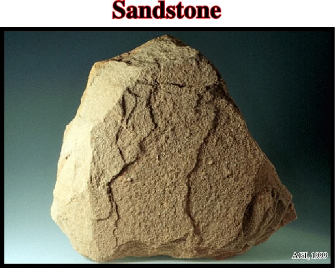
A sandstone is the consolidated equivalent of sand, intermediate in texture between conglomerate and shale. The sand particles are predominantly quartz and the term sandstone when used without qualification, indicates a rock containing about 85-90% quartz. The rock varies in color, may be deposited by water or wind and may contain numerous primary features (sedimentary structures and fossils).
Term used to express, on the seismic lines, the subaerial volcanism emplaced immediately after the breakup of the lithosphere. SDRs are deposit when the spreading centers are subaerial. Synonym of Seaward Dipping Reflectors.
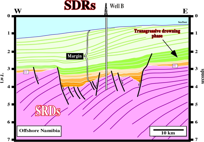
Subaerial volcanism have been found in the South Atlantic margins. The well B found more than 500 meters of lava flows. It is interesting to notice that the dip of the lavas flows increases seaward as new lavas are deposited. This subaerial volcanism was conventional interpreted as hydrocarbon bearing rift-type basin sediments. Unfortunately, the results of exploratory wells refute such an interpretation, and so the hydrocarbon potential.
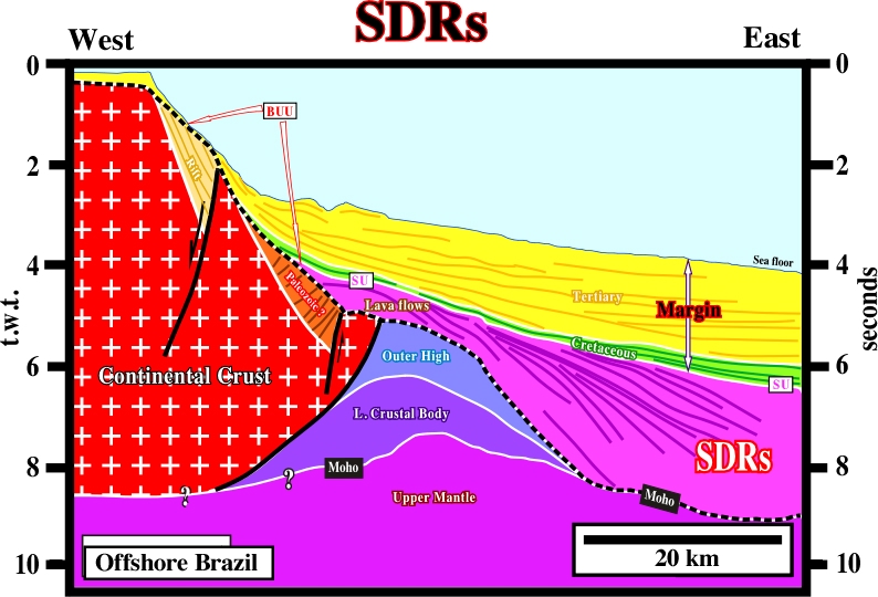
On this seismic line from Jacuipé basin, it is obvious that the subaerial volcanism is post-breakup (BUU is the breakup unconformity) and so its cannot be confused with rift-type basin sediments, which, by definition, are pre-breakup. The sediments of the rift-type basins dip (time of deposition) landward, while the SDRs dip seaward.
A theory that the oceanic crusts is increasing in area by upwelling of magma along the mid-ocean ridges and by a moving-away of the new material at rates of one to ten centimeters per year. This movement provides the source of dynamic thrust in the hypothesis of plate tectonics.
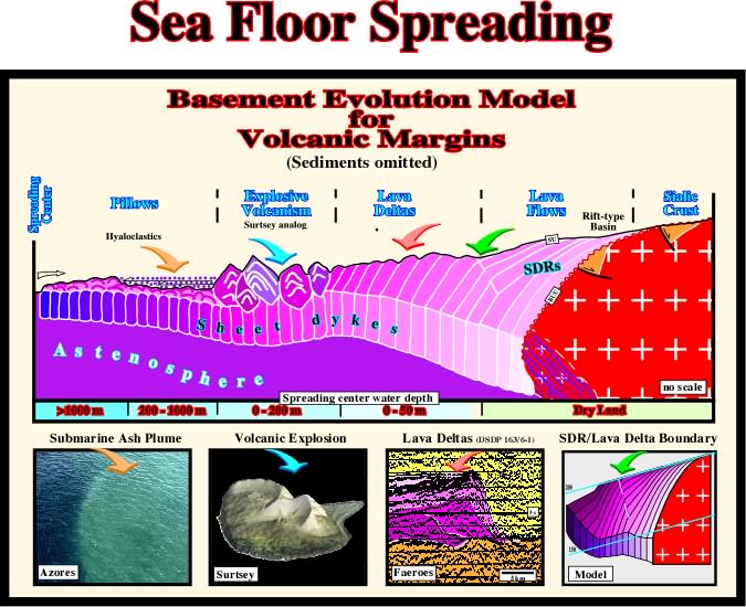
On this model proposed to the opening of the Gulf of Mexico, two major phase of oceanic expansion are taken into account, (i) the subaerial expansion with deposition of lava flows and (ii) the oceanic crust, which is mainly composed by sheeted dykes. Between the oceanic crust and the lava flows, an area of explosive volcanism and lava deltas can often be recognized.
Diapirs rising by reactivation of allocthonous Salt.
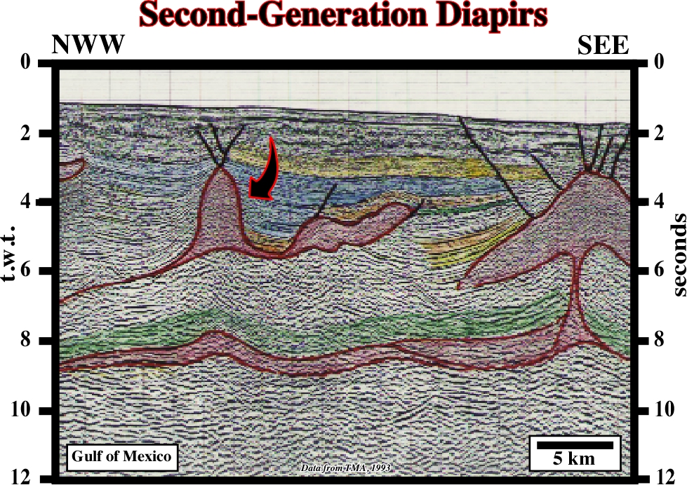
On this seismic, where the autochthonous and allochthonous salt layers are easily recognize, second order diapirs are individualized.
Salt sheet rising from allochthonous salt.
Cell on the scale of a single diapir. The center of the cell is the diapir in which the streamlines rise, whereas its lateral margins are defined by the outer limits of the sinking streamlines.
Peripheral sink, which accumulates around a diapir withdrawing salt from its precursor pillow and contains strata that thicken toward the salt diapir.
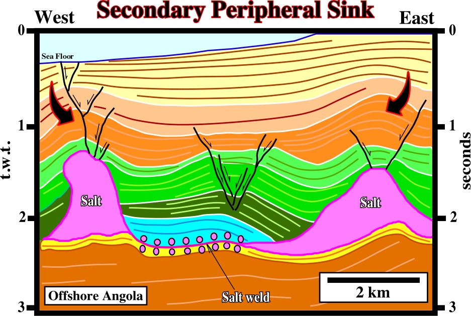
Secondary peripheral sinks are often associated with tectonic inversions whether due to a reactivation of the diapir or late regional compression.
Salt weld joining strata originally separated by steep-sided salt diapirs (salt walls or salt stocks).
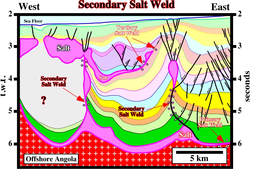
Secondary salt welds have often a vertical geometry, or undated when late regional compressions take place. A primary and a tertiary salt welds are also easily recognized.
Rocks resulting from the consolidation of loose sediment that has accumulated in layers.

Sedimentary rocks are clastic rocks (such as conglomerates or tillites) consisting of mechanically formed fragments of older rock transported from its source and deposited in water or from air or ice. They can also be formed by precipitation from solution (rock salt). Sedimentary rocks can also consist of remains or secretions of plants and animals.
Sedimentation (McNeill, L. et al., 1999)
The act or process of forming or accumulating sediment in layers, including such processes as the separation of rock particles from the material from which sediment is derived, the transportation of these particles to the site of deposition, the actual deposition or setting of the particles, the chemical and other (diagenetic) changes occurring in the sediment and the ultimate consolidation of the sediments into solid rock. In marine environments deposition takes place when the space available for sediments increases. However, turbidite deposition takes place during relative sea level falls, that is to say, when accommodation decreases. Indeed, seaward of the shelf break, the water depth is so big than there is always space available for sedimentation, even during important relative sea falls.
The amount of sediments accumulated in an aquatic environment over a given period of time, usually expressed as thickness of accumulation per unit time. Attention must be done to the completeness and preservation of the stratigraphic intervals.
Synonym of Bedding plane.
Subtle surfaces defined by reflection terminations. Onlap surfaces and downlap surfaces are examples of seismic surfaces.
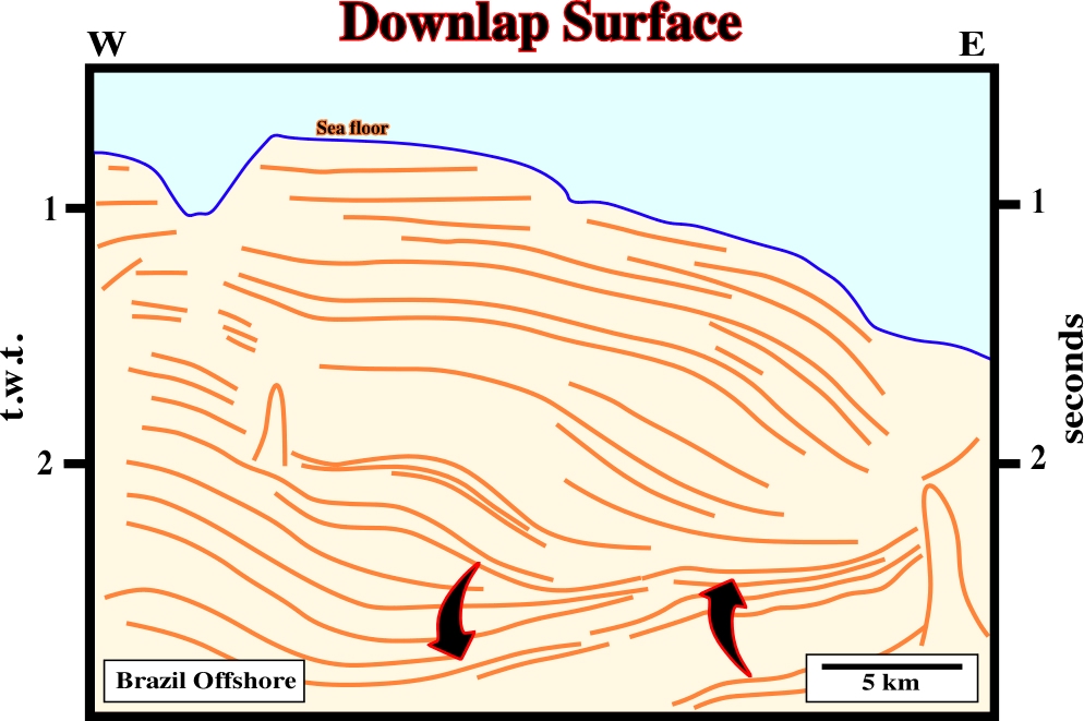
On this seismic line a major seismic downlap surface is obvious at the bottom of the progradations of the uppermost sedimentary package. This surface emphasizes the limit between a transgressive and regressive episode, in other words between the Middle and Upper Cretaceous sediments.
Term expressing deformation taking place under a combination of shalokinesis with a tectonic regime, whether compressional or extensional.
Synonym of Argilokinesis.
Band of highly deformed rock separating two rock masses that have sheared past each other. A brittle shear zone is marked by faults, whereas a ductile shear zone contains a continuous zone of high ductile strain. Three types of shear zone associated with salt diapirs have been recognized:
(i) external,(ii) boundary and
(iii) internal.
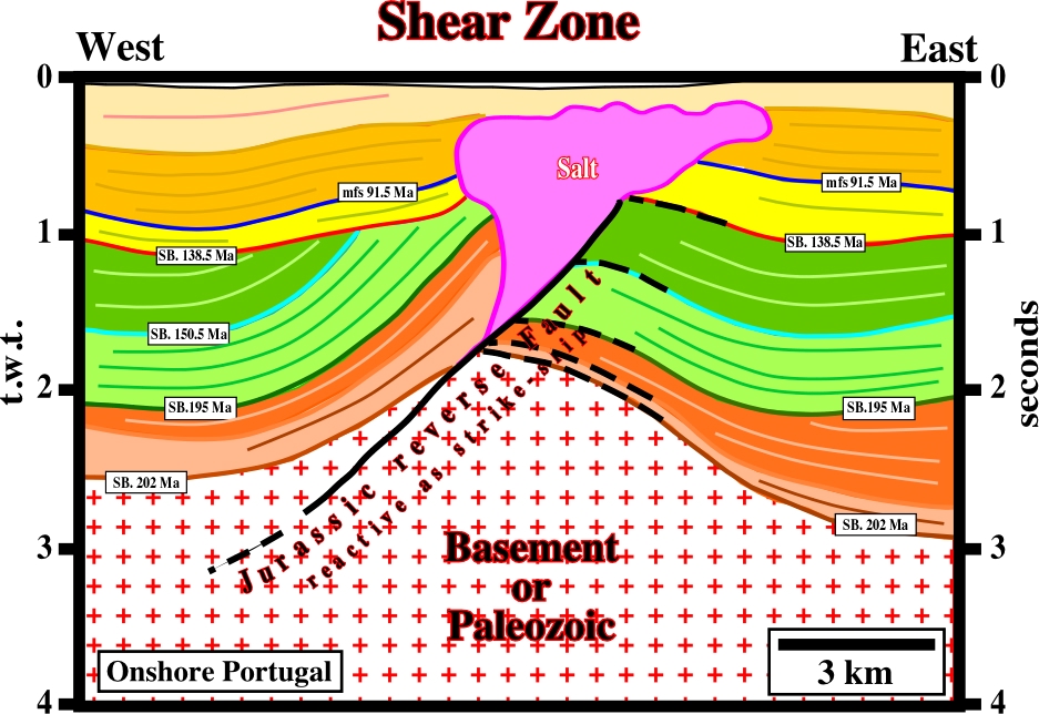
Shear zones and particularly fault zones are often feeders of salt extrusion as illustrated on this seismic line. Actually, on this area, some of these fault,s more or less injected by salt, are seismically actives and have been the source of major earthquakes.
See: Glacial structures.
Vertical thickening of a laterally injected salt laccolith or sill.
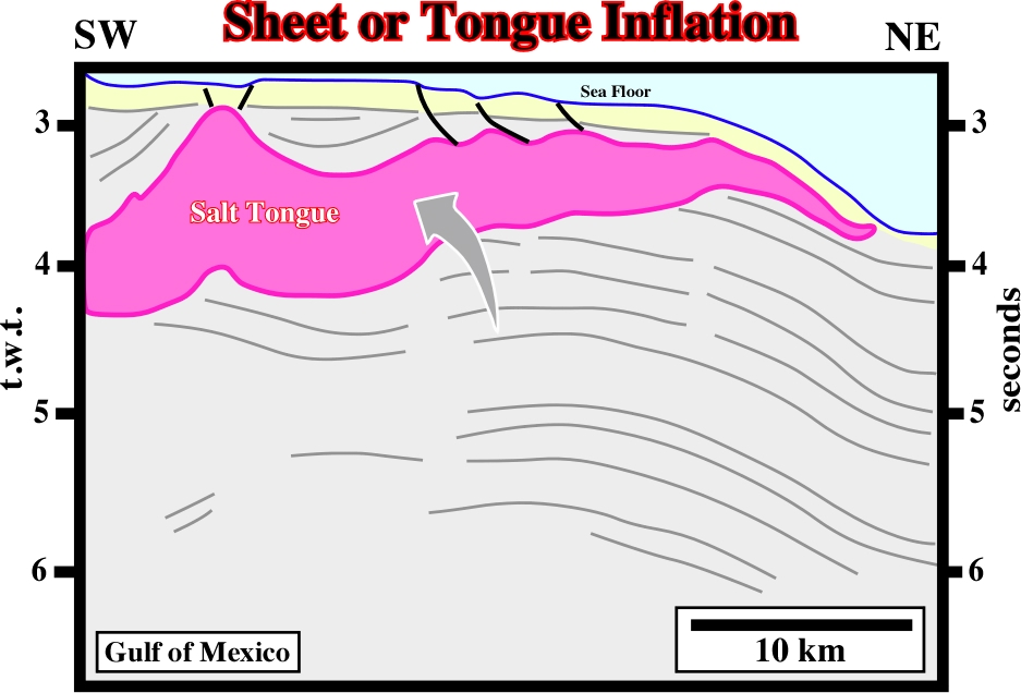
In the Gulf Coast, as illustrated above, the majority of the allochthonous salt structure have been inflated mainly due to differential loading.
Process in which salt laccoliths and salt sills are emplaced as thin sheets between overburden strata a few hundred meters or less below the sediments. Injection is driven by gravity spreading through weak, unconsolidated, mud-rich, less dense overburden under low confining pressures. Synonym of sheet spreading.
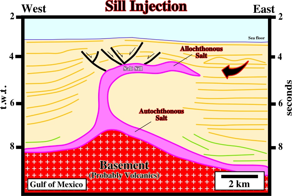
On this line, it is quite evident that the allochthonous salt structure was created by salt injection under relative thin sedimentary cover (thinner than presently).
Partitioning of a salt sheet into separated salt structures during reactivation by subsidence of intrasalt basins or by growth faulting.
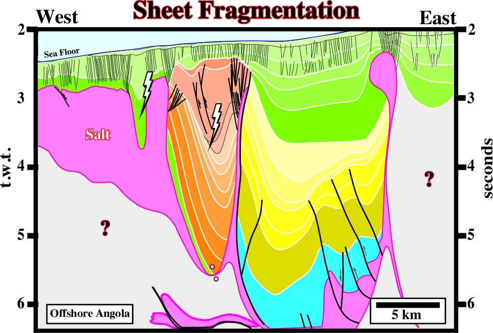
As illustrated on this seismic line, the original salt sheet is splitting up by a progressive westward development of salt expulsion basins. The counter-regional faults, in the central part of the line, is the ramp or the feeder of the salt sheet.
Synonym of Sheet injection.
Part of the offshore that is between the shoreline and the continental slope. Synonym of platform or continental shelf.
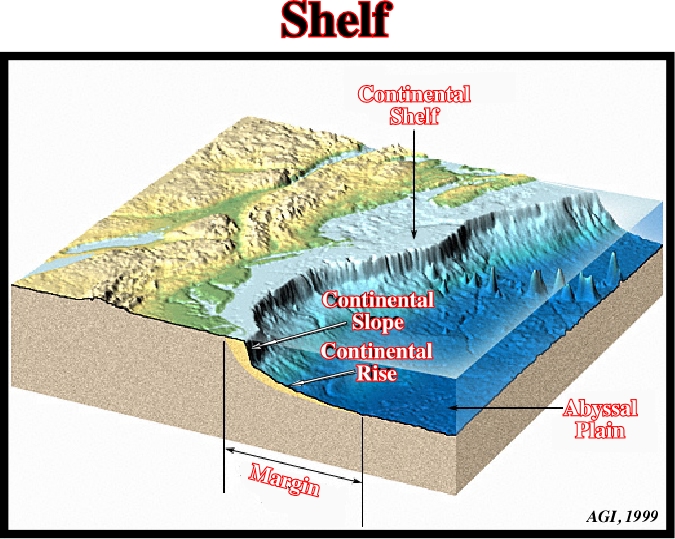
Notice that during certain geological periods of the evolution of a basin, the shelf, in which the water depth ranges between 0 and 200 meters, can disappear. Indeed, the area of a shelf is maximum at the peak of a transgression and it becomes almost nil during the last phase of regressive episode.
The limit between the shelf and the continental slope (in a transgressive setting). However, in a mature regressive setting (when the basin has no shelf), the shelf break becomes the depositional coastal break, so, the shelf break is roughly the shoreline.
The water depth of the platform, that is to say, the space available for the sediments. When there is a relative sea level rises (eustasy + subsidence), shelfal accommodation increases, and so, there is deposition. Deposition is equal to shelf accommodation increasing minus water depth deposition. When the relative sea level falls, the shelf accommodation decreases, and so, there is not deposition. If the relative sea level falls below the shelf break, the shelf is exposed, erosion takes place and un conformity is formed with deposition of turbidites in the deepest part of the basin.
Sediments deposited under a water-depth ranging between 0 and 200 meters. Synonym of platform or shallow water-depth deposits.
A large area of exposed basement rocks in a craton, commonly with a very gently convex surface, surrounded by sediment-covered tectonic platforms, as the Canadian Shield or Baltic Shield. The rocks of virtually all shields areas are Precambrian.
The bathymetric expression of salt flows that have overridden the abyssal plain of the Gulf of Mexico tens of kilometers since the Paleogene.
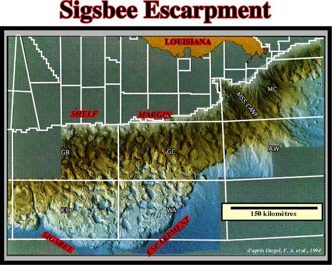
As illustrated on this map of bottom of the sea, the Sigsbee Escarpment is by far the more characteristic bathymetric feature in Gulf of Mexico. Salt expulsion basins, as well as, sutures of allochthonous salt structures can easily be predicted.
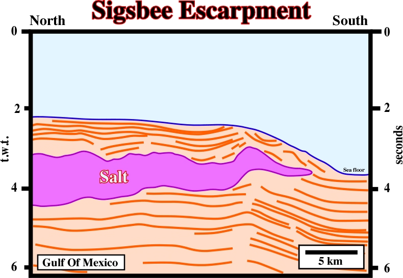
Seismic expression of the Sigsbee Escarpment. The main driving mechanism of such bathymetric features is well illustrated on this profile.
See: Salt sill.
Late Silurian age is widely accepted as the period of considerable salt accumulation. This is based chiefly on information concerning Michigan-Appallachian basin, where thick salt sequences are widespread in North America. Three salt-producing silurian evaporite basins, namely the Dniester-Prut, Lena-Yenisei and Carnavon basins can be outlined.
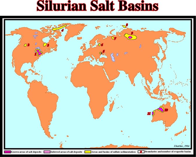
The distribution of Silurian evaporite basins can be summarized as follows: (1) Michigan-Appalachian, (2) Williston, (3) Moose River, (4) Canadian Archipelago, (5) Dnister-Prut, (6) Baltic, (7) Pechora, (8) Severnaya Zemlya, (9) Lena-Yenisei, (10) Canning, (11) Carnavon.
Downward-facing synformal anticline fringing the bulb of a mushroom diapir and made up of deformed evaporites that envelop the stem of the diapir.
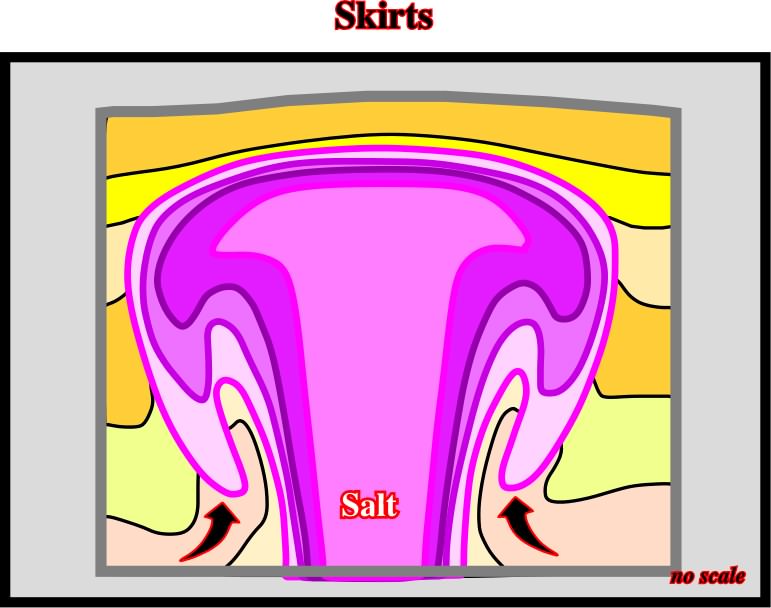
Skirts are difficult to recognize on seismic lines, but relatively easier on time slices at appropriated depth (see mushroom diapir)
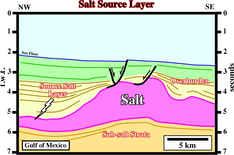
Layer supplying salt for the growth of salt structures. Source layer is often taken as a synonym of mother source layer.
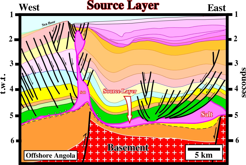
In offshore Angola, as well as in onshore, the salt source layer is the Aptian salt which, stratigraphically speaking, it was deposited above the Cretaceous basal sandstones (yellow, Cuvo and Chela formation) of the divergent margin and below the Albian limestones (green, Binga and Pinda formations). In Angola-Gabon and Brazil, the source layers are different. Indeed, and contrariwise to an erroneous hypothesis, still followed by some geologists, these Aptian salt basins were always individualized by subaerial and oceanic spreading center.
Space Available for Sedimentation
Roughly speaking, the water-depth. Synonym of accommodation. Sedimentation takes place every time that there is an increasing of the space available, i.e., a relative sea level rise.
Altered basalt, characteristically amygdaloidal or vesicular, in which the feldspar has been albitised.
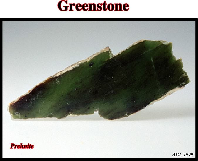
Typically, it is accompanied by chlorite, calcite, epidote, chalcedony, prehnite, or other low-temperature hydrous crystallisation products characteristic of a greenstone.
Steep-sided mass of salt within larger salt body that moves or has moved faster or slower than neighboring spines from which it is separated by boundary shear zones or internal shear zones.
Approximately Newtonian flow occurring in slightly damp salt under typically geologic conditions of low strain and low deviatoric stress under confining pressure. Dynamic recrystallisation occurs when grain boundaries migrate: grains having high internal strain energy dissolve, liberating ions that diffuse across a thin film of brine and precipitate on a neighbouring grain having low internal strain energy.
A second-order cellular pattern of the Rayleigh-Taylor instability similar to that of the most vigorous mode of thermal convention. The pattern is best developed where viscosity contrasts are small. It comprises (i) downwelling, circular basins and radiating keels of overburden fluid and (ii) upwelling, circular domes and radiating ridges of buoyant fluid.
Salt structure,, and particularly diapirs can be squeezed by compressional tectonic regimes as illustrated on the seismic line below.
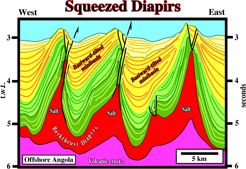
Ridge push forces seem to be responsible of the shortening of the cover in deep water, where salt diapirs have been squeezed and backthrusted, as well as the mini-basins between them. The geometrical relationships between the seismic reflectors (seismic surfaces) and the morphology of the seafloor strongly suggest that shortening still is going on.
Comparatively slender part of a salt diapir below the bulb.
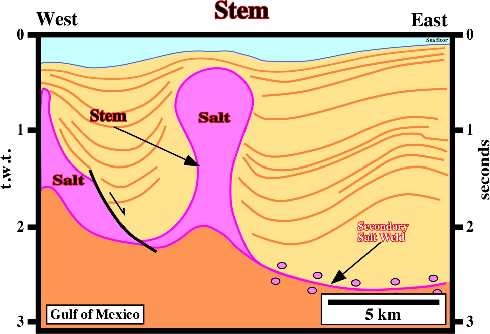
On this seismic line, the stem is relatively narrow, in circumference, in proportion to the height of the diapir, which seems completely disconnected of the mother source layer. Indeed, two primary salt welds can be recognized around the diapir.
Stepped Counter Regional System
Synonym of Roho system.
A perspective, conformal, azimuthal map projection in which meridians and parallels are projected onto a tangent plane, with the point of projection on the surface of the sphere diametrically opposite to the point of tangency of the projection plane. Any point of the tangency may be selected (at a pole, on the equator, or a point in between). It is the only azimuthal projection that is conformal.
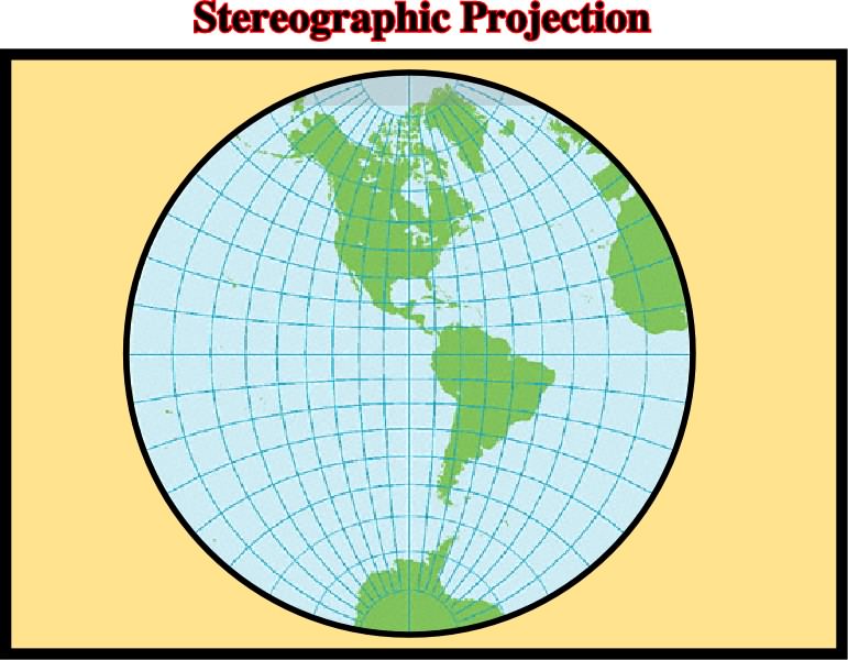
Stereographic projections are much used for maps of a hemisphere and are useful in showing geophysical relations (such as patterns of island arcs, mountain arcs, and their associated earthquake epicenters. By the same token, they are used in tectonics and optical mineralogy; they are made on equatorial plane (passing through the center of the sphere) with the point of projection at the south pole.
Plural of stratum, i.e., a tabular or sheetlike body or a bed, or a layer of sedimentary rock, visually separable from other layers above and below.
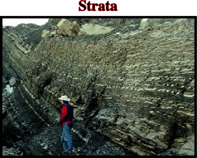
Strata has been defined as the stratigraphic unit that may be composed of a number of beds, as a layer greater than 1 cm in thickness and constituting a part of a bed, and as a general term that includes both bed and lamination.
Stratigraphic cycle induced by a eustatic cycle. Each hierarchical eustatic cycle induces a correlative stratigraphic cycle. Four types of stratigraphic cycles are usually recognized in association with the different orders of eustatic cycles: A) Continental encroachment cycles, B) Continental encroachment sub-cycles, C) Sequence cycles, and D) Parasequence cycles.
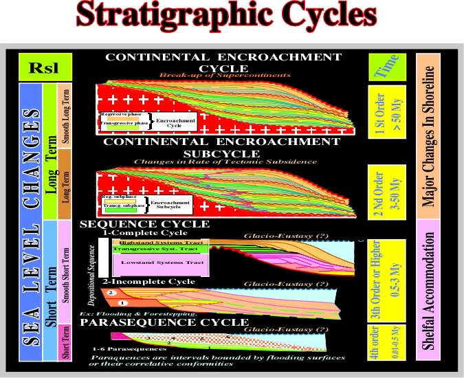
(A) Continental Encroachment Cycles are associated with 1st order eustatic cycles. They are characterized by a succession of coastal onlap against the cratons. They fossilize the unconformity created by the aggregation of Supercontinents. (B) Continental encroachment sub-cycles are associated with 2sd order eustatic cycles. They are characterized by unconformities induced by major basinward shifts of coastal onlap.The basinward shifts interrupt the continuity of continental encroachment associated with breakup of Supercontinents. (C) Sequence cycles are associated with 3rd order eustatic cycles. They are bounded by unconformities induced by changes in water depth, i.e. accommodation in the margins of basins. Sequence cycles are bounded by regional onlap surfaces. Systems tracts, i.e. by linkage of contemporaneous depositional systems compose sequence cycles. (D) Parasequence cycles are associated with 4th eustatic cycle or higher.They are bounded by two consecutive flooding surfaces.
The overall change in length per time that can be estimated (length change is vertical in most salt structures, but horizontal for salt sheets, including glaciers.
Laminar flow lines for which the tangent at any point is the local, instantaneous, velocity vector of flow. Decreasing spacing of streamlines indicates increasing velocities of flow and vice versa.
The force per unit area, acting on any surface within it, and variously expressed as pound or tons per square inch, or dynes or kilograms per square centimeter; also, by extension, the external pressure which creates the interval force. The stress at any point is mathematically defined by nine values: three to specify the normal components and six to specify the shear components, relative to three mutually perpendicular reference axes.
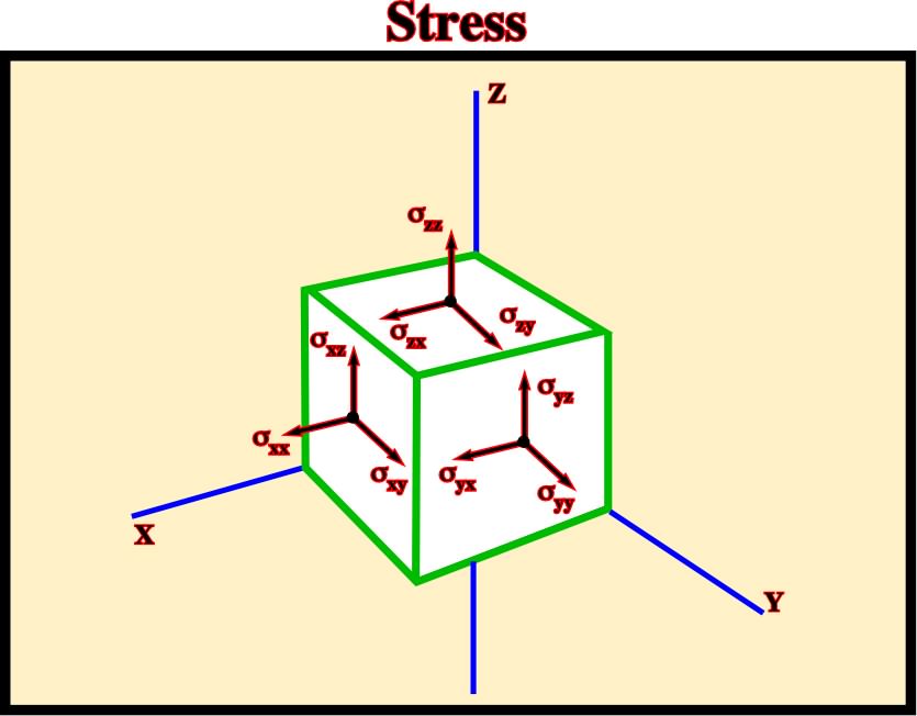
Stress is a tensor of second rank. The forces area thought to act on every one of the infinitesimal elements of area with different orientation, which can be imagined at one point. Only such forces are considered which are locally in equilibrium with equal and opposite forces: tensor is symmetrical.
Normal faults associated with diapiric structures in order to extend the overlying sediments to respect the Goguel's law (volume problem). Stretching faults are often used as a synonym of radial faults.
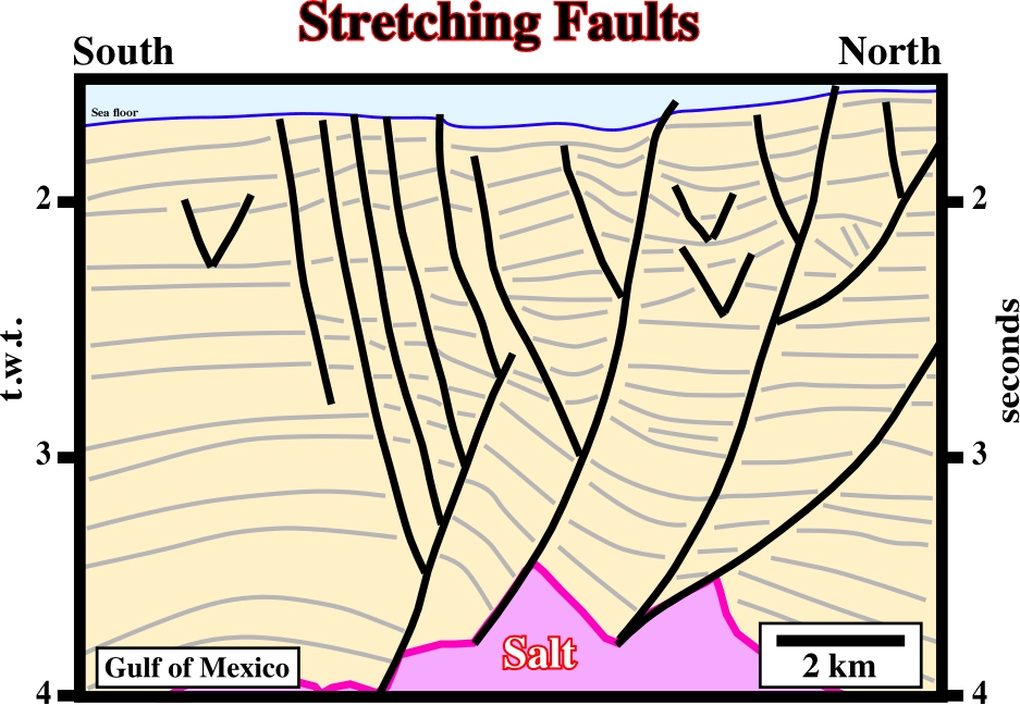
Stretching faults strike in all directions. They are induced by local extension tectonic regimes, in which
Movement parallel to the strike of a fault.

A strike-slip movement can take place in normal, reverse or strike-slip faults. The picture above represents a strike slip movement component of normal or reverse fault, since the fault plane has a no vertical dip. Some geologists should not forget that a strike slip faults have vertical or almost vertical dips. A strike slip movement is not a mechanism to lengthen (normal faulting) or shorten (reverse faulting and folding) the sediments.
Reversal of vertical motion recorded by stratigraphic thickening or thinning of synkinematic strata.
Tectonic inversions, as the one illustrated on this seismic line, imply lengthening of the upper sedimentary layers. Therefore, normal faulting is always associated with. The presence or absence of normal faults, near the apex of domal structures, can be used to differentiate inversions from anticlines.
When a salt dome is not outcropping but covered by a relative thin and permeable sedimentary interval, the roof of the dome can be washed.
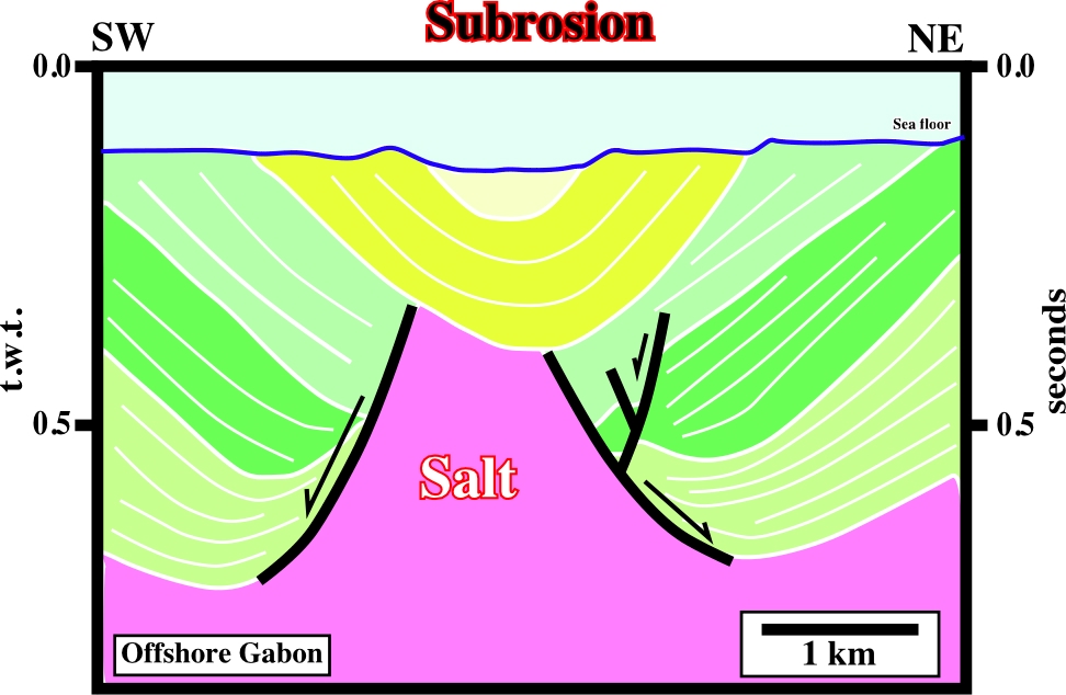
The depocenter above the salt dome can be explained as a consequence of a salt collapse following the subsurface erosion due to salt dissolution.
Sedimentary package underlying a salt layer or a salt weld.
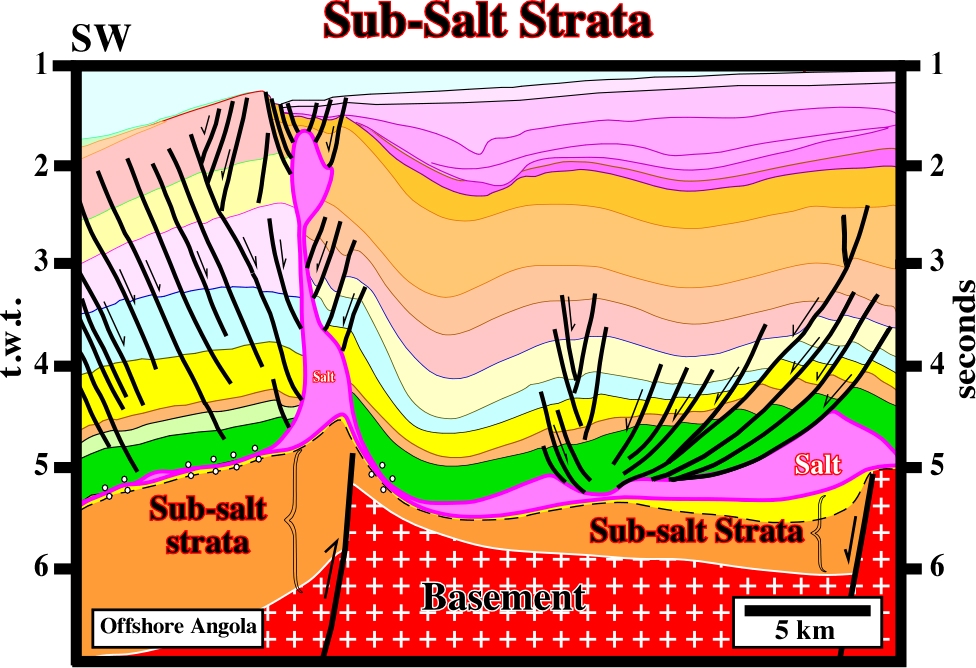
On this seismic line, sub-salt strata is composed by the basal Cretaceous sandstone of the margin (in yellow) and rift-type basin sediments (in brown). The infrastructure of the sub-salt strata is the Precambrian basement.
Subsidence (McNeill, L. et al., 1999)
A sudden sinking or gradual downward settling of the Earth's surface with little or no horizontal motion; The movement is not restricted in rate, magnitude, or area involved. Subsidence may be caused by natural geologic processes, such solution (karsts phenomena), thawing, compaction, slow crustal warping, or withdrawal of fluid lava from beneath a solid crust. See: Compensatory subsidence.
An underlying layer. In salt tectonics, substratum refers to the ductile layer below a brittle overburden and above the sub-salt strata or basement. Substratum is a term more general than source layer. The substratum may or may not give rise to up-welling structures.
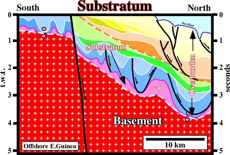
Generally, in a continental divergent margin, the substratum is formed by infra-salt margin sediments, which overly either a rift-type basin sediments, a Paleozoic fold belt or a Precambrian basement. On this particular example ,in which the infra-salt margin sediments are under seismic resolution, the substratum of the salt is a Precambrian basement.
A white or colorless isometric mineral: KCl. It is the principal ore mineral of potassium compounds. Sylvite occurs in beds as a saline residue with halite and other evaporites. It has a sharper taste than of halite.
Conteporaneous of the sedimentation.
Foldlike geometry whose limbs close downward. Conventionally a synform is not the consequence of a shortening as it is the case for a syncline. See:Antiform.
Strata interval, typically overlying the prekinematic layer, showing local stratigraphic thickening (above structures such as withdrawal basins that subside faster tan their surroundings) or thinning (above relatively rising structures). Changes in thickness can also be recorded by onlap or truncation at all levels of the synkinematic layer.
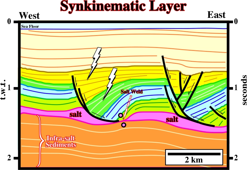
The synkinematic layers, as those illustrated above, thickening toward the growth-faults. They record sedimentation during salt flow or during any other type of deformation. The light green and blue intervals are prekinematic, which are roughly isopach.