
Rodhinia...........................................................................................................................................................................................................................................Rodhínia
Rodínia / Rodínia / Rodhinia (Superkontinent) / Rodinia超级大陆 / Родиния (гипотетический суперконтинент) / Rodhinia (supercontinente) /
Supercontinent that formed about 750 million years ago, at the end the Proterozoic, when the whole continental crust was more or less agglutinated, in the middle of a great ocean, forming one or a few lithospheric plates. Also called Protopangea. This supercontinent was formed by internal, folded mountain belts, very old with little volcanism and by peripheral belts, more recent and with strong volcanic activity.
See: « Continental Collision»
&
« Pangea »
&
« Supercontinent »
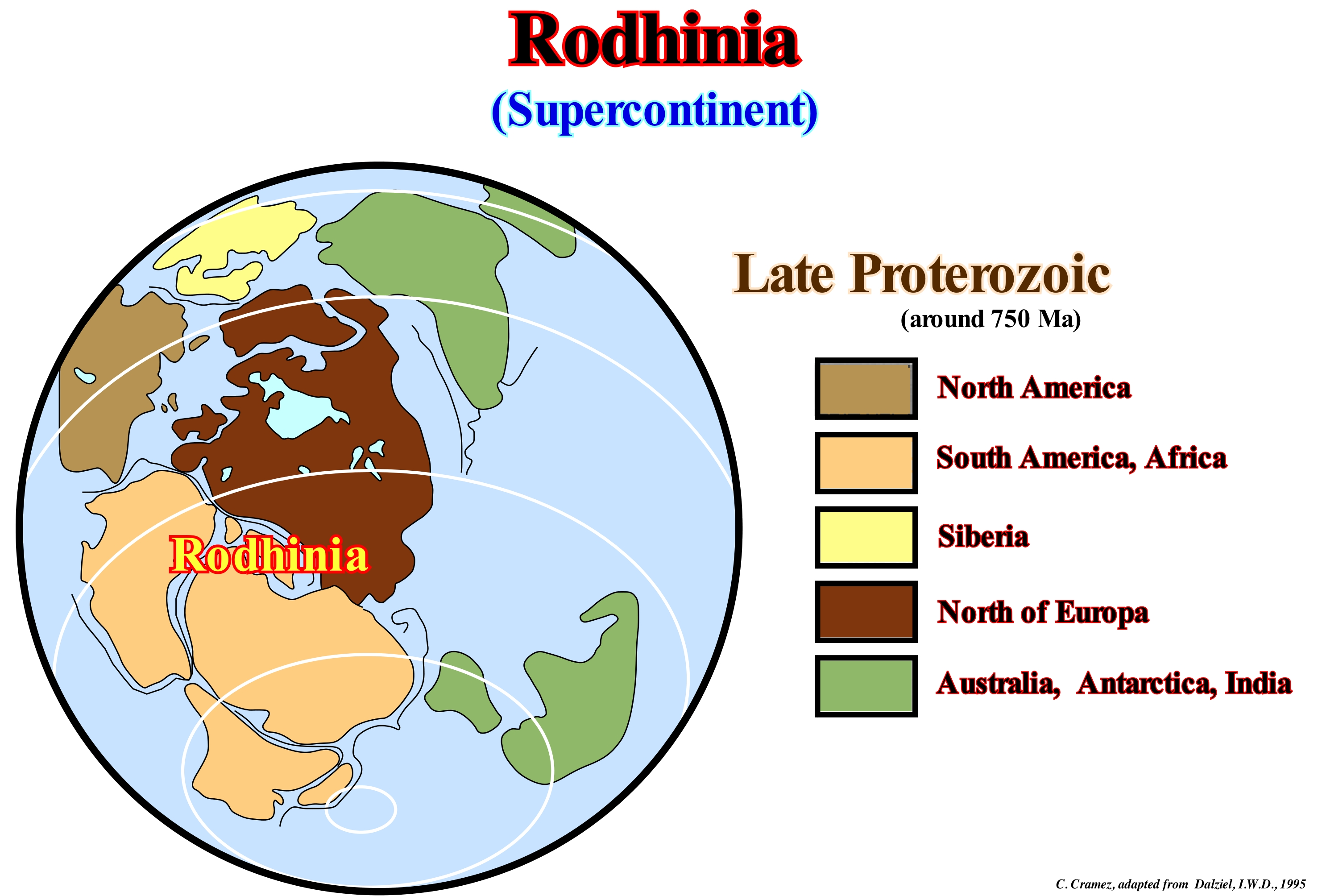
The term supercontinent is, generally, associated with the supercontinent Pangea, which is formed by the Gondwana small supercontinent (to the south) and the Laurasia small supercontinent (to the north). The list of supercontinents is quite extensive: (i) Vaalbara Supercontinent, which existed around 3.8 Ga ; (ii) ; Ur Supercontinent , which existed around 3.0 Ga ; (iii) Kenorland Supercontinent, which existed for around 2.7 Ga ; (iv) Nena Supercontinent, which existed around 1.8 Ga ; (v) Columbia Supercontinent ,which existed around 1.8 Ga ; (vi) Atlantic Supercontinent, which existed around 1.8 Ga ; (vii) Protopangea or Rodhinia Supercontinent, which existed around 1.1 Ga ; (viii) Pannotia Supercontinent , which existed around 0.6 Ga ; (ix) Euramerican Supercontinent, which existed around 0.4 Ga ; (x) Pangea Supercontinent , which existed around 0.3 Ga. The Gondwana small supercontinent , which existed around 0.2 Ga, was formed by the following continents: 1) Antarctica ; 2) Africa ; 3) Madagascar ; 4) Seychelles ; 5) India ; 6) Australia ; 7) New Guinea ; 8) New Zealand and 9) New Caledonia. The Protopangea supercontinent is considered, by certain geoscientists, as the seventh continent, also called Rodhinia (that in Russian means mother Earth), seems to have existed (according to the Plate Tectonics reconstitutions), approximately, between 1,100 and 750 Ma. Many geoscientists think the Rodhinia formed from the Ur supercontinent, that was surrounded by the Mirovia ocean and fractured in eight (8) continents (it seems that the breakup originated not only the Cryogenian glacial period* that after moving away from each other gathered to form, in a first phase the Pan supercontinent and then the Pangea supercontinent. The paleogeographic reconstructions derived from plate tectonics suggest that in the geological past, and particularly at the beginning of the Proterozoic (between about 2,500 Ma and 541 Ma), there existed a supercontinent*, since the geoscientists noticed the existence of mountain chains of that age in almost all the continents: (i) The mountains created by the orogeny of Greenville in North America ; (ii) The Ural Mountains formed during the Uralic orogeny and (iii) The mountains induced by the Dalslandian orogeny (Gothic or Swedish-Norwegian) in Europe. In contrast, to the Pangea supercontinent , which was the last supercontinent, which formed around 300 Ma, little is known about the configuration and geodynamic history of Rodhinia. There are two hypotheses on this supercontinent, that is, on the Protopangeia supercontinent, Rodhinia or Precambrian, as certain geoscientists call it: (a) SWEAT hypothesis, which admits that in the Proterozoic, more or less between 1,100 Ma and 590 Ma, Australia coalesced with the northern part of North America and (ii) AUSWUS hypothesis, which is illustrated in this figure, and in which Australia is linked to the south-western part of North America. In this last hypothesis (AUSWUS), Tasmania marks the eastern boundary of the Proterozoic platform of Australia and the line 87Sr/86Sr = 0.706 marks the western boundary of the Proterozoic of the Laurentian continent. In this hypothesis, the continents would have shifted around an Euler pole located at 51.46° N and 106.70 ° E, with an angle of rotation of 114.33 °. Note that in a three-dimensional space, the displacement of a rigid body (like lithosphere plates) is equivalent to a rotation about a fixed axis, called the Euler pole. When a supercontinent forms, it blocks the flow of heat from the interior of the Earth causing a warming of the asthenosphere and sometimes the appearance of seismic phenomena in the lithosphere such as the formation of volcanoes, magma rises and the separation of two different supercontinent fragments, which leads to its disintegration. The process leading to the reform of a new supercontinent is still subject to debate.
(*) Second period of the Neoproterozoic, between 720 Ma and 635 Ma, which preceded the Ediacaran, which is the last period of the Precambrian, during which a global glacial phenomenon known as the Snowball Earth, but also the rapid evolution of life in the Ediacarian and the Cambrian.
(**) When the Earth's surface is constituted by a minimum number of lithospheric plates and all or almost all of the continental mass is bound together and surrounded by a great ocean.
Rolling...............................................................................................................................................................................................Transport par roulement
Transporte por rolamento / Transporte por rodamiento / Transport-Umsatz / 运输周转量 / Вращающееся перемещение / Trasporto fatturato /
When the loose material, i.e., the sediments roll along the substrate of the bed of a stream whether it is liquid or gaseous.
See: « Charge »
&
« Flux (flow) »
&
« Traction (sediments) »
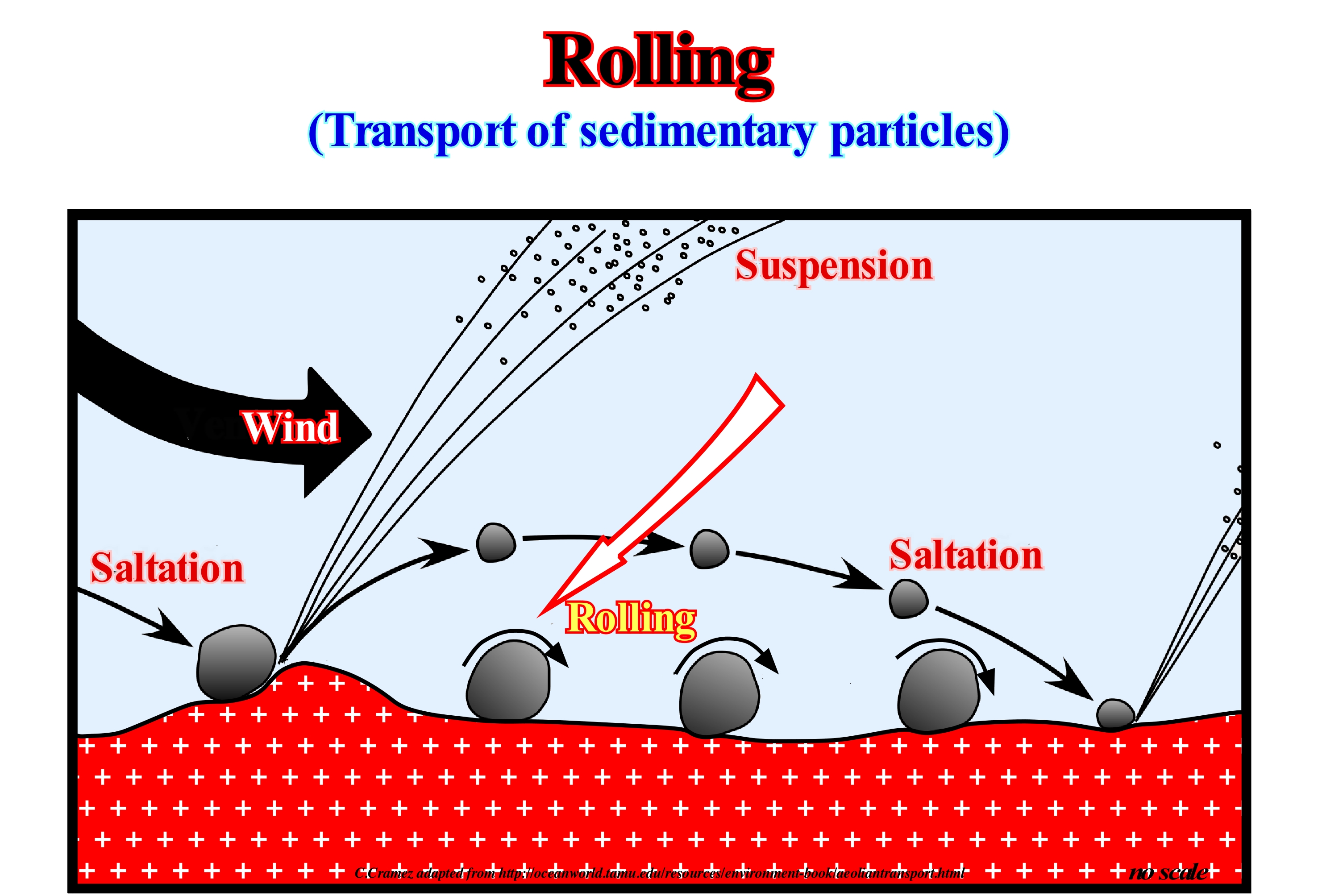
As shown in this figure, the sedimentary particles (detritus) carried by a water-course can be transported along the bed as bed loading either by sliding or rolling grain, in suspension or by saltation. Some sedimentary particles can, also be transported by flotation, at the top of the current near the surface. Rolling occurs when fairly large or elongated fragments are set in motion. The rolling will be favoured if a large grain moves on a relatively flat surface of smaller grains. There will be a much greater possibility for a grain to stop, if it is surrounded by or resting on grains of similar size to itself. All modes of transport of the base load (rolling, saltation, sliding and suspension) can coexist to a greater or lesser degree. They are, usually, associated with the development of different configurations on the surface of the sedimentary particles. These layer surface configurations, typically, occur as repetitive patterns at various scales. When fully developed, they reflect a balance between the current strength and the grain size of the sedimentary particle. A mixture of sedimentary particles and water, under suitable conditions, is capable of moving, under the action of gravity, as the mass flows. When a fluid flows at a small speed, the loose material it contains is displaced by rolling or dragging in the direction of the flow, i.e., that the particles are always in contact with the material-fluid interface. When the velocity of the fluid (water or wind) is greater, the lifting and momentum exerted by the fluid on the particles is sufficient for some of them to move away from the fluid-material interface and into the flow. Mass flows include a wide variety of processes, which are, theoretically, distinguished as distinct mechanisms in which sedimentary particles are supported within the flows. Flows that have a flow limit are considered as debris flows, of which the mud flows have a cohesion limit, while a grain flow has a friction limit. The fluid phase between particles is, usually, water, but in some flows it may be air.
Rossby's Theory.............................................................................................................................................................................Théorie de Rossby
Teoria de Rossby / Teoría de Rossby / Theorie der Rossby / 对Rossby波理论 / Теория Россби / Teoria di Rossby /
Air currents around the Earth, which do not have a circular trajectory, form waves (Rossby's waves) that follow a winding path that extends southward (north hemisphere) towards the tropics, due to the variation of the Coriolis effect with latitude.
See: « Coriolis Effect »
&
« Latitude »
&
« Atmosphere »
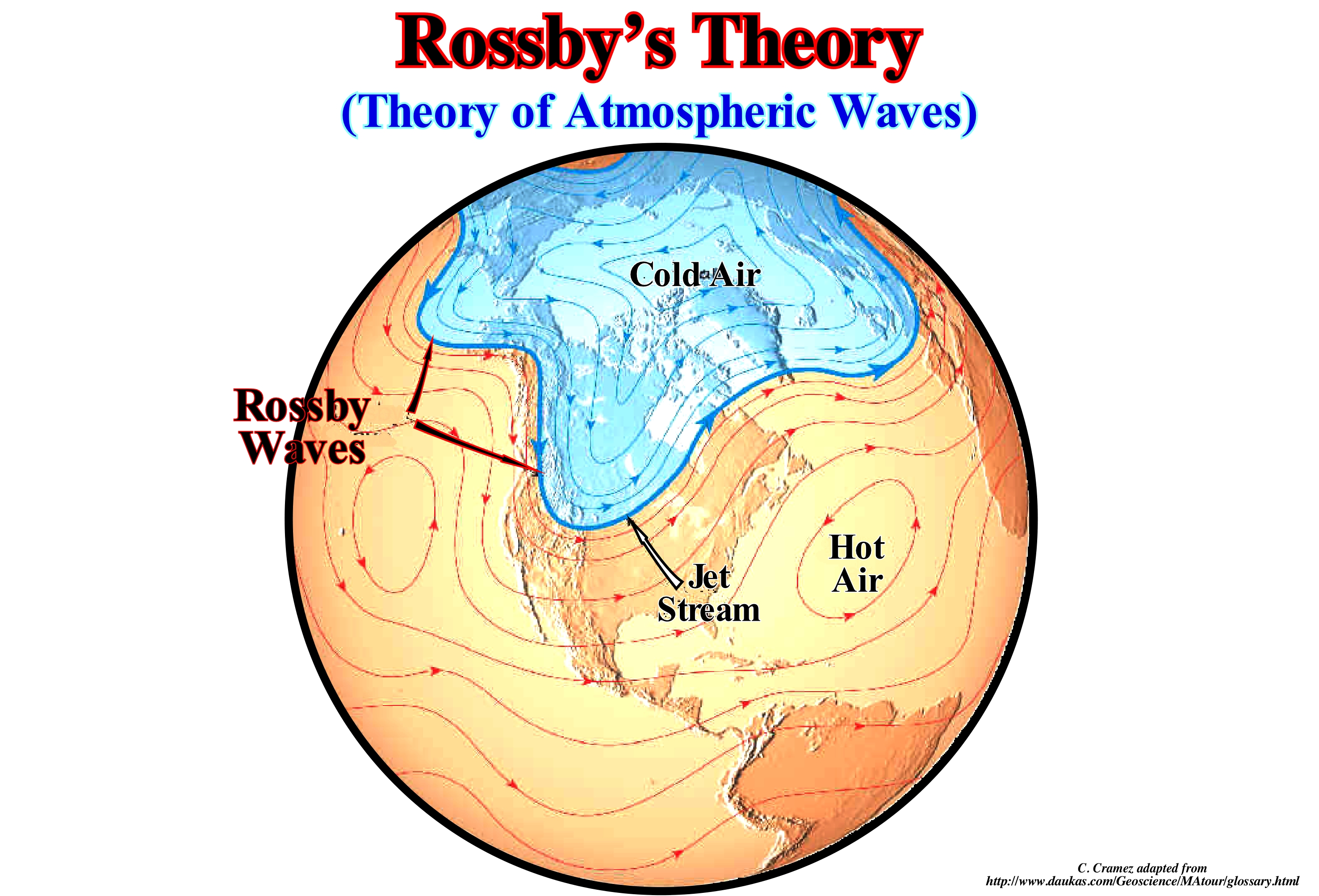
As illustrated in this figure, Rossby waves or planetary waves are giant meanders of fluid currents of planetary proportions. In planetary atmospheres, Rossby waves form due to the variation of the Coriolis effect with latitude. These waves were, initially, identified in the Earth's atmosphere in 1939 by Rossby, who explained their movement. Rossby waves are a subset of inertial waves. The special feature of Rossby wave identification is its velocity phase (the speed of the wave ridges) that always has a westward motion. However, the wave group velocity (associated with the energy flow) can be in either direction. Shorter waves, generally, have a group speed to the east, while longer waves have a group speed to the west. The terms "barotropic Rossby waves" and "baroclinic*" are used to distinguish their vertical structure. Barotropic Rossby waves do not vary in their vertical structure and have the fastest propagation speeds. On the other hand, baroclinic Rossby waves have a slower speed, with speeds of only a few centimeters per second or less. Rossby waves in the Earth's atmosphere are meanders of the large-scale jet stream. When a meander stands out, cold or hot air masses are isolated to form cyclones and anticyclones, which are responsible for the daily pattern of time in the middle latitudes. Rossby waves propagate from right to left (East to West) with a translation speed proportional to the wavelength (typically 3,000 km). However due to the general movement of the jet stream from west to east in the upper troposphere and mid latitudes, the small waves associated with baroclinic disturbances (cold fronts and extratropical cyclones) move from west to west. This, since the average speed of the west current is generally higher than the translation speed of the Rossby wave in the opposite direction.
(*) In meteorology a baroclinic atmosphere is one for which the density depends on both the temperature and the pressure. It contrasts this with a barotropic atmosphere, for which the density depends only on the pressure. In atmospheric terms, the barotropic zones of the Earth are, generally, found in the central latitudes, or tropics whereas the baroclinic areas are generally found in the mid-latitude/polar regions (https://en.wikipedia.org/wiki/Baroclinity)
Rudite...............................................................................................................................................................................................................................................................Rudite
Rudito / Rudito / Rudit / 铜焊 / Рудит (груmeteбая осадочная порода) / Rudite /
Detrital sedimentary rock whose elements that compose it have a diameter of more than 2 millimeters. The term rudite is mainly used in the classification of the detrital limestones, equivalent to the conglomerates or calcareous breccias. Some geoscientists consider that the terms conglomerate and rudite are synonyms and designate an epiclastic rock with more than 30% of rounded particles larger than 2 mm.
See: « Granulometry »
&
« Limestone »
&
« Deposition (carbonates) »
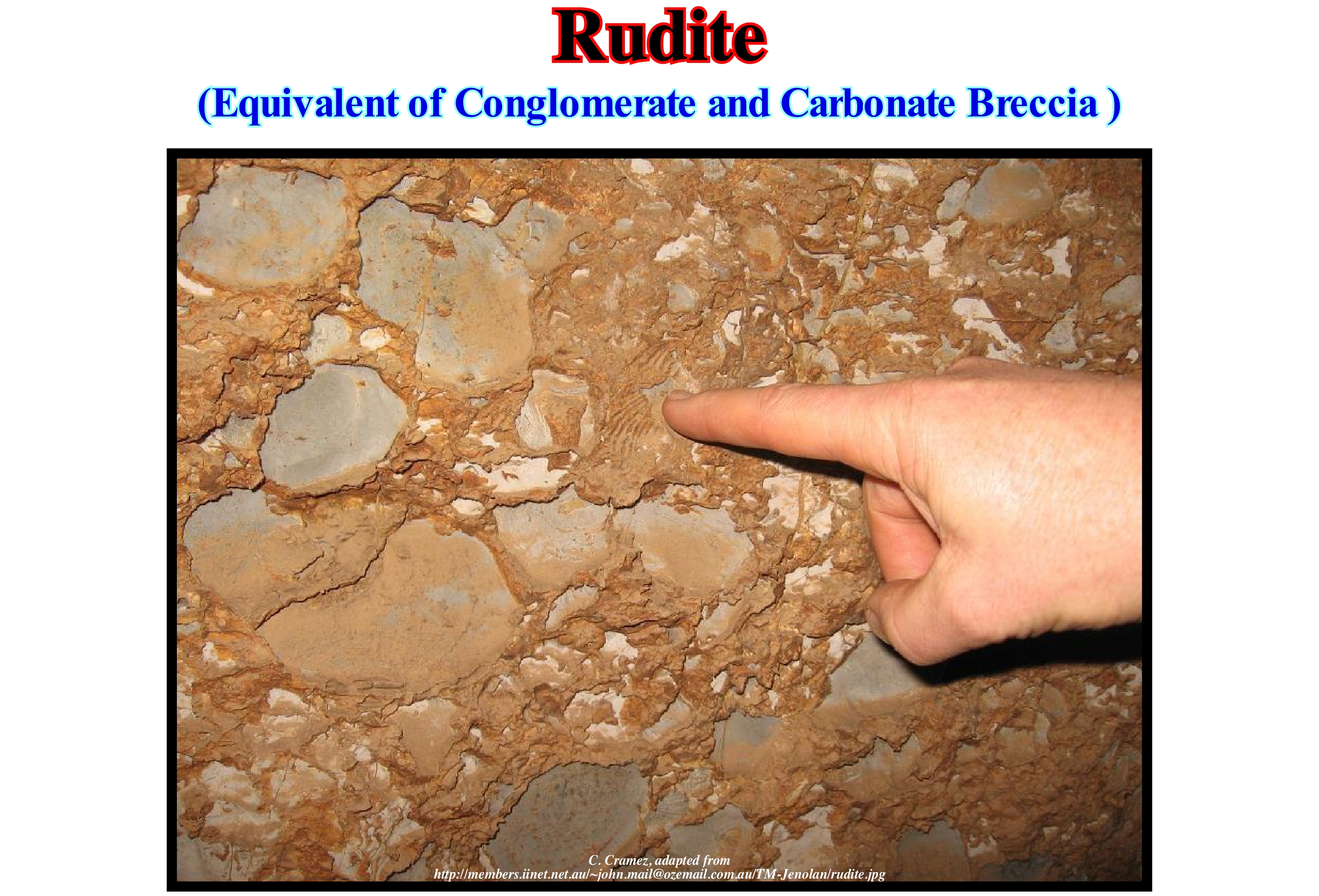
The term rudite is, often, used in the classification of detrital limestones, equivalent to the terms calcareous conglomerate or calcareous breccia. The rudites are, mainly, formed by the erosion of rocks or by the turbidite re-deposition of pebbles or, already, consolidated rocks. Certain rudites contain rounded components and thus belong to the family of conglomerates (rock consisting of rounded clasts in a, finely, granular hue that cement them), while others are composed of angular components and therefore belong to the family of breccias (rock composed of fragments of minerals or rocks cemented by a fine granulation matrix). The interstices between the coarse grains are filled by a siliciclastic or carbonate matrix. Many rudites appear as massive or granular rocks with a spaced foliation and an irregular and thin cleavage. In classification of clastic sedimentary rocks, based on the grain size proposed by Pettijohn, in which the Greek terms are, usually, used for metamorphic rocks and the Latin terms for non-metamorphosed rocks. the term rudite (Latin origin), commonly, referred to as gravel is the non-metamorphic equivalent of the term psephite (Greek origin). A clast is a particle or grain and epiclastic rocks are rocks composed of (non-volcanic) particles of all sizes (from clay to pebble), while pyroclastic rocks are composed of eruptive volcanic rock particles. The term clay may have two meanings: (i) Mineral and (ii) Granulometry. Thus, many geoscientists, to avoid genetic inference, use the following terms: A) Size clay / lutite, clayey, argilaceous ; B) Size sand / sandstone, sandy ; C) Larger size than sand / rudite.

