
Geothermal Gradient......................................................................................................................................Gradient géothermique
Gradiente geotérmico/ Gradiente geotérmico / Geothermische Tiefenstufe / 地温梯度 / Геотермический градиент / Gradiente geotermico /
Rate of increase of temperature per unit of depth on Earth. The geothermal gradient, which varies from place to place, is, generally, calculated from the temperature measurements at the bottom of a no casing exploration well (oil exploration). In order for the temperature measurement to be accurate, it is fundamental that the drilling mud reaches, in surface, the ambient temperature, i.e., that it cools down, which for practical and economic reasons is impossible (the price per day of a ground drilling rig can reach several hundred thousand dollars and, in offshore, it can easily exceed several dozen million dollars).
See : « Thermal Flux »
&
« Earth »
&
« Temperature Log »
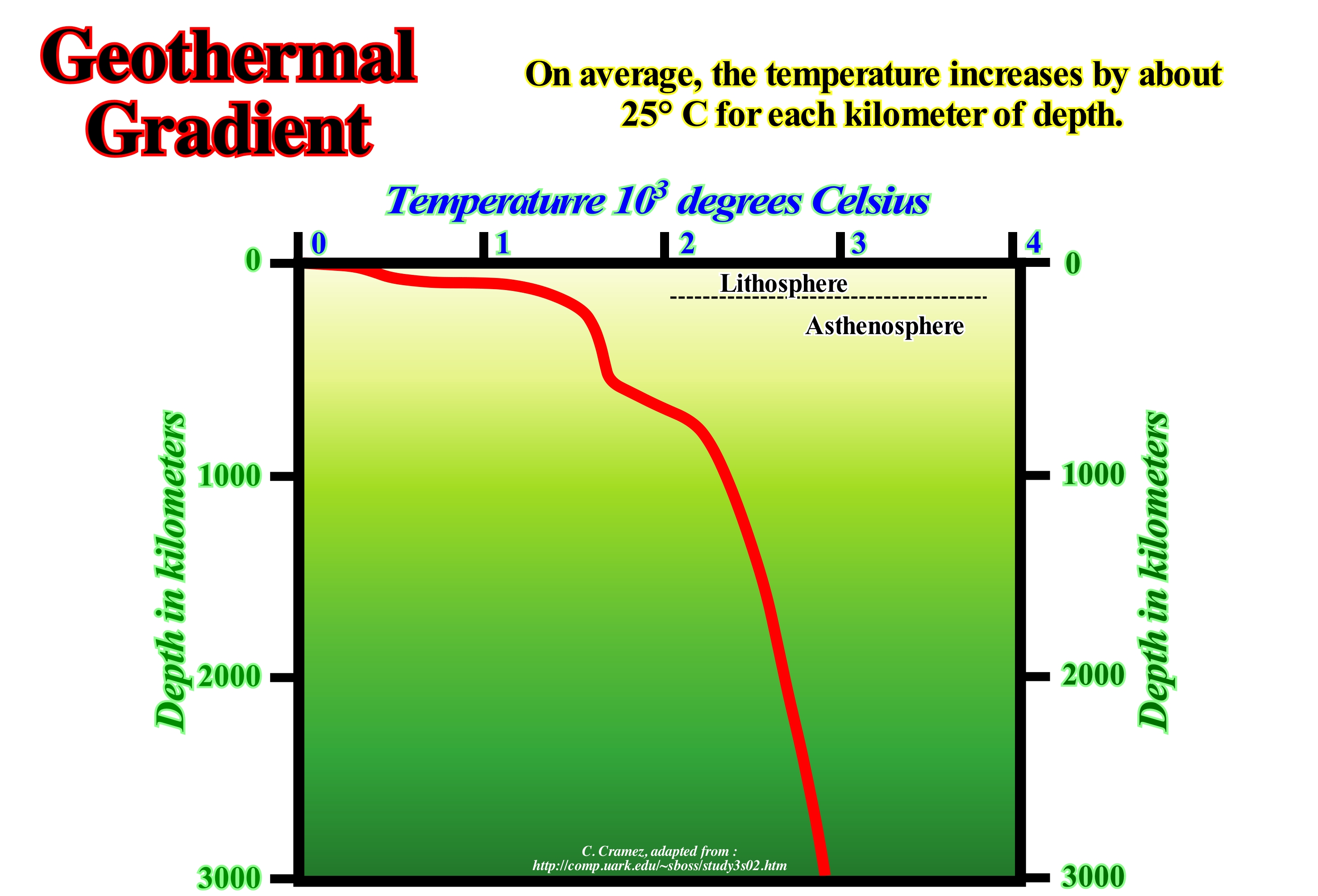
As illustrated in this diagram, the temperature increases as you descend into the Earth's centre. This increase is seen by miners working in gold and diamond mines in South Africa, where, even with air conditioning, the temperature of the galleries is almost unbearable. It is this temperature increase with the depth, that is called geothermal gradient. Although it varies from place to place, on average it is around 30° C per kilometre to about 100 km deep. In this diagram, the red curve underlines the geothermal gradient, that is, the temperature change per kilometre. The geothermal gradient is important to a depth of about 100 km. From, more or less, 100 km of depth, it is only about 1° C per kilometre. Do not forget the pressure inside the Earth increases rapidly with depth. It is the combination of the effects of heat and pressure that originates metamorphic rocks (a rock resulting from the transformation of a pre-existing rock, that is, a protolith, which may be an older sedimentary, igneous or metamorphic rock). Among the areas with a strong geothermal gradient we can mention the mid-oceanic ridge, volcanic arcs, etc. On the contrary, the main areas with a low geothermal gradient are the subduction zones, mainly the B-type subduction zones (Benioff), along which a cold and dense oceanic crust dips under a continental crust. The continental areas remote from the tectonically active zones have an average geothermal gradient. Knowledge of the geothermal degree and thermal flow of a given area is important for the maturation of organic matter of the source-rocks.
Geothermometer............................................................................................................................................................................Géothermomètre
Geotermómetro / Geotermómetro / Geologische Thermometer / 地质温度计 / Геологический термометр / Termometro geologico /
Mineral, rock or property that allows to determine, approximately, the maximum burial of a sedimentary interval. The combination of illite crystallinity (clayey mineral, KAl2(SiAl)4O10(OH)2nH2O, intermediate structure between moscovite and montmorillonite) and reflectance of vitrinite (one of the major constituents of coals and many sedimentary kerogens) may be used as a geothermometer. Geothermometers are very useful in oil exploration.
See : « Metargillite »
Gilbert Delta..............................................................................................................................................................................................Delta type-Gilbert
Delta typo-Gilbert / Delta tipo Gilbert / Gilbert Typ Delta / 吉尔伯特型三角洲 / Дельта Гильбертова типа / Delta tipo-Gilbert /
A progradational geological body formed by alluvial sediments of glacial origin or not, deposited directly in the sea (or in a lake), when the shoreline (equivalent, more or less, to the depositional coastal break) is located near the bay-line (limit, upstream, of the coastal prism of Posamentier and Vail). Certain geoscientists call these deposits Delta or Fan Alluvial.
See: « Delta »
&
« Alluvial Delta »
&
« Bottomset Bed (of a delta) »
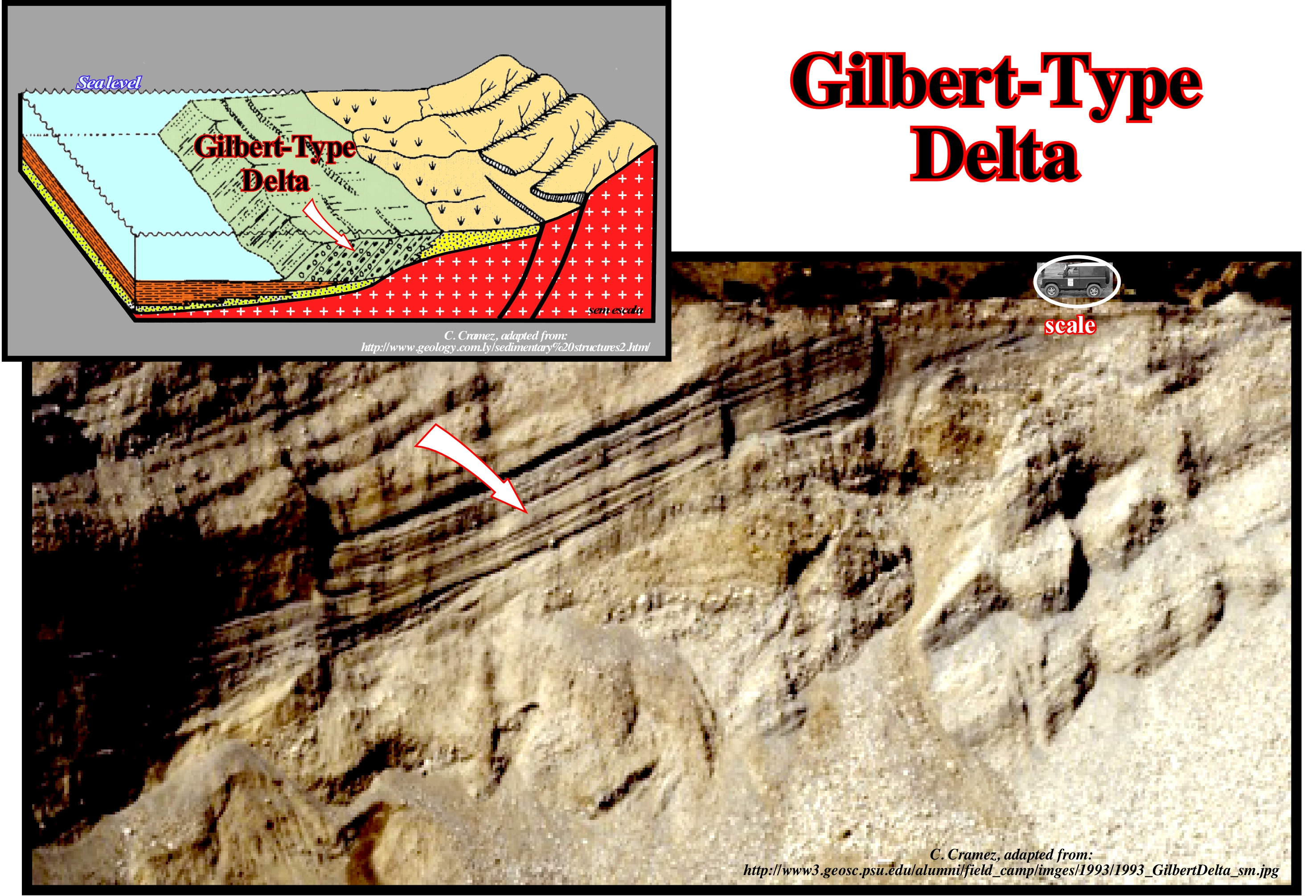
The Main (USA) glacial deltas, both marine and lacustrine, are the most characteristic Gilbert-type deltas. They were first described in the late 19th century by G. K. Gilbert of the US Geological Survey. These deltas are composed of very coarse material and exhibit very steeply progradations, practically, without top and bottom beds (delta topsets and bottomsets), as illustrated in this figure. However, in many Gilbert deltas described in the literature, they are, like any other type of delta, constituted by the three typical stratigraphic components, although often they are, poorly, marked and, sometimes, barely visible: (i) Upper sub-horizontal beds (topsets); (ii) Seaward dipping beds (foresets) and (iii) Lower sub-horizontal layers (bottomsets). The upper sub-horizontal beds, which can be, highly, reworked by waves, are composed of coarse sand and gravel with planar and cross-bedding stratification stratification. The seaward dipping beds (foresets), which may have slopes greater than 20/30°, are formed by coarse sediments, with very frequent landslides and other structures associated with detritical flows. The lower sub-horizontal layers (bottomsets) are composed of fine sediments, with structures generated, typically, by turbidite currents, such as turboglyphs*. Turboglyphs or stream marks are dug in shaly sediments and filled by the sedimentary particles of the overlying layer. The concavity of the flutes indicates the top of the layer. The elongation of the turboglyphs gives the direction of flow and the conical end points the direction, downstream, of the flow. The high dip of foresets and granulometry allow to individualise the Gilbert deltas from the muddy deltas, such as the Mississippi or Yukon deltas. The dip of Mississippi delta building foresets (do not confuse delta and delta building) is very small. In a conventional seismic line, the Mississippi delta foresets can not, practically, be recognized. Its thickness and dip are, almost always, under the seismic line resolution. Often, when a geoscientist, in charge of the interpretation of seismic lines, says that in a given line, he recognized delta foresets (sloping or frontal layers), the most likely, he is interpreting a continental slope as a prodelta (foresets). In other words, he is confusing a delta with a delta building or with a Gilbert-type delta. In a Gilbert-type delta, the progradation (foreset beds), i.e., the progradations can show a 100-200 milliseconds (double time ) between the coeval toplap and the downlaps. The thickness of a typical delta, and particularly, of a delta dominated by the river terrigeneous influx, almost never exceeds 30/60 m. On the contrary, the thickness of a delta building, which corresponds to a stacking of deltas, can reach a thickness of several kilometres. Taking into account the dominant forces in the formation process, Galloway classified the deltas into three main types: (i) Deltas dominated by river terrigeneous influx; (ii) Deltas dominated by sea waves activity and (iii) Deltas dominated by tidal activity and tidal currents. River-dominated deltas are cut off and have many distributaries with marshes, bays or tidal flats in the inter-distributary regions. They occur when the river current and sediment transport are strong and other effects, such as rework by waves or tides, are smaller. These deltas tend to form large delta lobes in the sea, which may have one or few the distributary channels and have a natural marginal dikes (levees) exposed above sea level. Due to their resemblance to a bird's paws, they are, often, referred in geological literature as a "bird foot deltas", as is the case the delta in the Mississippi River Delta Building. When much of the floodplain between the distributary channels is exposed above sea level, the delta displays lobed form. Deltas dominated by the waves are more regular, exhibiting curved and arched shapes with frequent beach ridges, as in the deltas of the Nile delta building, where the breaking of the waves causes a mixture of fresh and salt water. Consequently, the flow loses its energy and deposits all its charge along the coast. Tidal dominated deltas occur in areas with high tides or with high speed tidal currents. Such deltas resemble, often, to bay estuaries filled with many elongated islands parallel to the main tidal current. i.e., perpendicularly to the shoreline, as in the Brahmaputra Delta Building or in the Mahakam Delta building (Kalimantan offshore). The deltas of the Mississippi Delta Building and Yukon Delta Building are typical river dominated deltas deltas (dominated by the terrigeneous influx carried by the rivers). The deltas in the Senegal Delta Building and the San Francisco Delta Building are dominated mainly by sea wave activities, while the deltas of Fly Delta Building are dominated by the tides and tidal currents.
(*) Marks formed by the erosive action of the flow of a stream. They correspond to an asymmetric depression that deepens on the side from which the current comes. They are often associated with turbidity currents, as well as, marine and lake storm currents.
Glacial Cap.........................................................................................................................................................................................................Calotte glaciaire
Calota glaciária / Calota glaciária / Eiskappe / 冰川帽 / Ледниковая шапка / Calotta glaciale /
Mass of ice covering less than 50,000 km2 of land surface (usually covering a mountainous region). A mass of ice covering more than 50,000 km2 is an ice sheet. Unlike an ice sea (floating ice, which when melted contributes to an absolute or eustatic sea level fall, since the ice is less dense than water), the melting, totally or partially, of a glacial ice cap induces an absolute sea level rise. The glacial sheet of Antarctica, which began to melt about 19,000 years ago, has contributed, significantly, to the eustatic rise of the sea level during the Holocene (the edge of this ice sheet is, at present-time currently, about 450 kilometres from the starting initial edge).
See « Glacio-Eustasy »
Glacial Cirque.............................................................................................................................................................................................Cirque glaciaire
Circo glaciário / Circo glaciar / Gletscherkar / 冰川冰斗 / Ледниковый цирк / Circo glaciale /
Glacier semi-circular upstream of a valley, or semi-circular cavity, with abrupt walls, produced in the rocks by the action of the ice of a glacier.
See: « Firn »
&
« Glacier »
&
« Glacio-Eustasy »
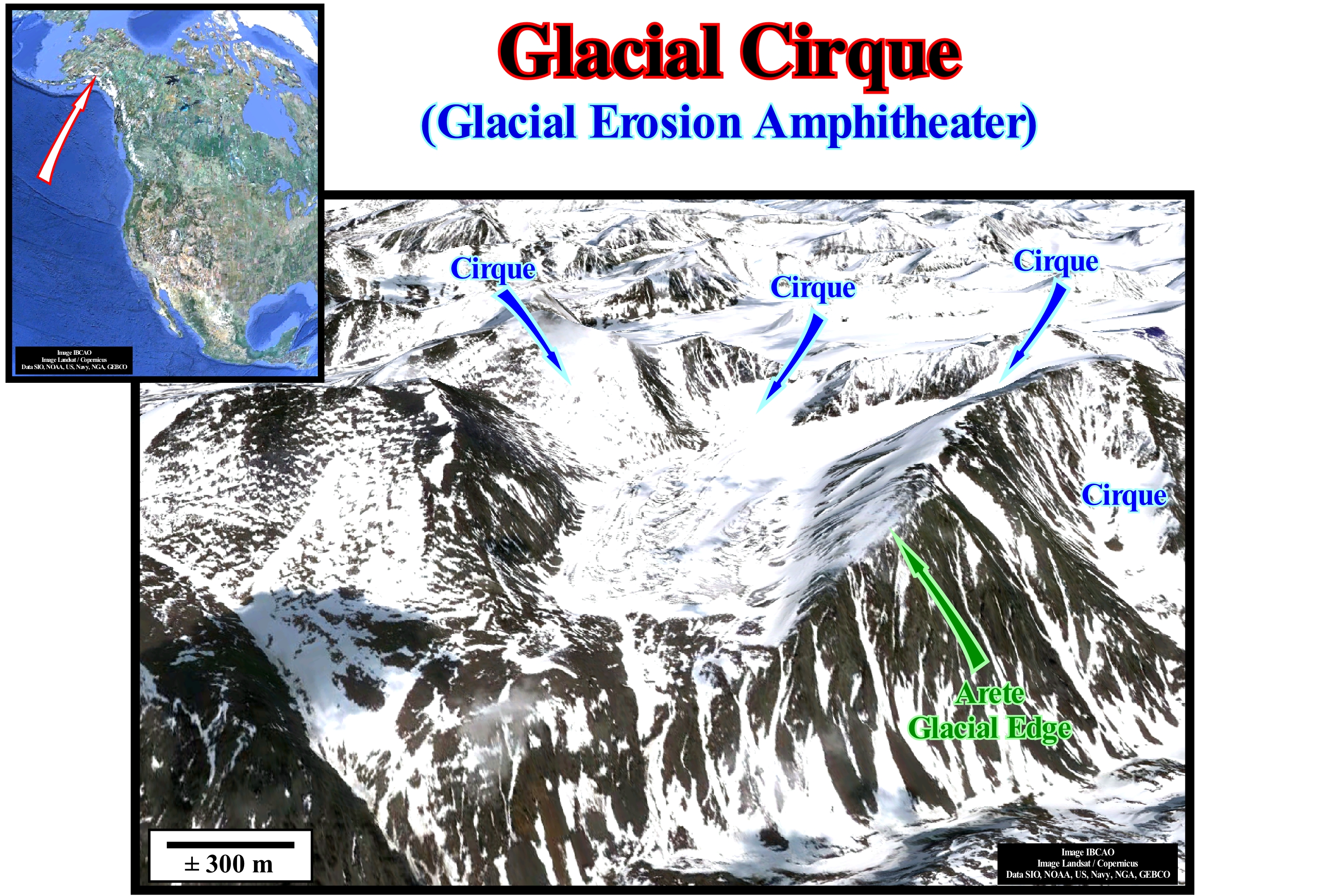
A glacier is a thick ice that has formed onshore for hundreds or thousands of years by the accumulation, compaction, and recrystallization of snow. There are several types of glaciers. In the Alps, for example, there are three distinct types: (i) Glacial Cirques deposited in semicircular basins on the edges of a mountain and, usually, upstream of a valley ; (ii) Glacial Valleys that flow along pre-existing valleys ; and (ii) Glacial Caps that form on top of mountains. A glacial cirque, usually, forms upstream (at the head) of a glacial valley. As in the upper parts of the cliffs, the wind blows very strong, it displaces the snow to the deepest part where it accumulates converting the deposition basin into a glacial cirque. Several cirques can form at the same time around the same mountain. It may happen, for instance, that two glaciers, located on the opposite flanks of a mountain, erode the upper parts of the cliffs and form a sharp rocky ridge called the glacial ridge or arete. Two cirques and a glacial ridges are very noticeable in this photograph (Fairweather Mountains, SE Alaska). Glaciers model the landscape through two well-known geological processes: (a) Abrasion and (b) Removal. Abrasion occurs when the fragments of a rock carried by the glacier scrape the rocks of the substrate as the glacier advances. The pulling occurs at the base and in front of a glacier as it raises and pulls the rocks out of the substrate and incorporates them into its mass. Not only does snow accumulate in the glacial cirque, but if it is very abundant and does not melt during the summer, it will become, after several years, on ice, which will flow downstream (glacial valley) under the action of its weight. This scenario is very likely to happen in the next few years (contrary to what proponents of anthropogenic global warming say, since we have enter the solar cycle # 24, which is a cycle of weak activity and therefore would have prevented few cosmic rays from reaching the Earth's atmosphere, which will imply a cold climate for the next 11-13 years.
Glacial-Control Theory (Atoll).........................................................................Théorie du contrôle glaciaire (Atoll)
Teoria do controlo glaciar / Teoría de control glaciar (atóis) / Glacial Regelungstechnik (Atoll) / 冰川控制理论(环礁)/ Теория ледникового контроля / Teoria del controllo Glacial /
Theory, proposed by Daly, that suggests glaciations are the main responsible of the fringed reefs. According to this theory, the series of events leading to fringed reef formation, on a more or less flat surface, begins with the small fringed reefs formed during glacial epochs. The cold waters prevent the growth of the reefs and the relative sea level fall, induced by the formation of glaciers, emerges a part of the reefs, which is eroded by the wave action. After the end of the glacial era, relative sea level rise, due to ice melting. the reefs began to grow, again, on a more or less flat surface.
See: « Bioherm »
&
« Deposition (carbonates) »
&
« Glacio-Eustasy »
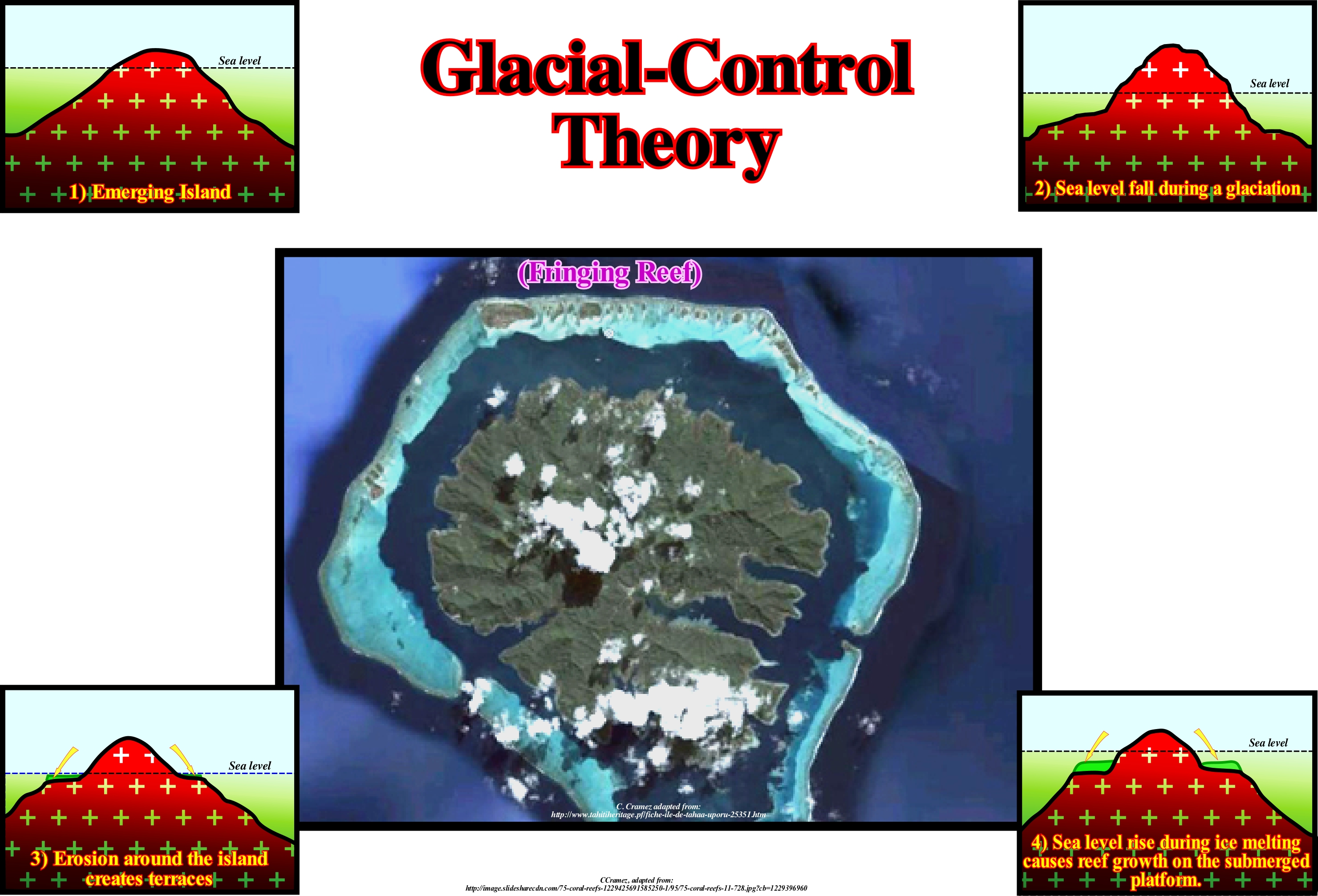
Function of the shape, size and distance of the mainland (continent or islands), many geoscientists consider reefs can be classified into: (i) Fringing or fringed reefs; (ii) Barrier Reefs; (iii) Atolls. The fringing reefs occur close to the continents or the islands. Barrier reefs have a linear or semicircular geometry and are separated from the continent by channels. Atolls are ring-shaped, at the centre of which a salt-water lagoon forms. To explain the formation of fringing reefs, as illustrated in this figure, there are several theories. However, those that best withstand refutation tests are those of Darwin (Subsidence Theory) and R. Daly (Glacial-Control Theory). According to Darwin's subsidence theory, fringing reefs form on the edge of the volcanic islands, which when they sink form barrier reefs. Subsidence may be caused by oceanic expansion (sea floor spreading) or by the weight of the volcanic island. Subsidence can cause a total submersion of the island (relative sea level rise *), leaving a circular reef (atoll) around a sea-water lagoon. This theory was not refuted by the research well drilled on the Eniwetok Island (atoll of the Marshall Islands in the Pacific), which recognized the upper part of an ancient volcano around 1,200 m deep. Daly's theory suggests the absolute (eustatic) sea level cycles (not the subsidence of the islands), as the keys to understanding the formation of corals. For Daly, the formation of the reefs is, more or less, linked to the hot periods. During the glaciations the reefs die. They are largely eroded by of the absolute (eustatic) sea level fall induced by the formation of glacial caps. Sea level falls during the ice ages. A large amount of water is turned into ice caps and glaciers. However, since the ice begins to melt, the absolute (eustatic) sea level rises. The reef exposure to the increasing sea waves energy, during the the sea level falls, erodes the islands. However, later, when the eustatic sea level rises, the coral reborn on the submerged insular platforms. It can be said, glacio-eustasy is the basis of Daly's theory. Other theories suggest reefs and atolls formation is wholly associated with relative sea level rises, i.e, irrespective of glacio-eustasy. Experimental drilling-wells in the Funafuti atoll provide evidence in support of Daly's hypothesis. In the ice age, all platforms were reduced to sea level by marine erosion. The depths of these platforms and that of lagoons with barrier reefs as well as the depths coral atolls were almost the same. Studies have shown, the depths of platforms and lagoons are the same everywhere. Finally, waves and sea currents could easily cut off the islands and convert them into low platforms (shelves). The major merit of this hypothesis is that it does not need crustal subsidence, as it is the case of the Darwin's hypothesis. However, it does not explain how so long and wide platforms can be formed just by marine erosion. One of such large platforms is the Nazareth Platform (a limestone bank that the Portuguese navigators called "Saia de Malha", which seems to be the largest submerged bank in the world and part of the vast Mascarenhas submarine plateau). It is 350 km long, 100 km width with a height, everywhere, of 600 metres. Similarly, Daly could not explain the existence of coral colonies at depths greater than 100 meters. He had to admit local subsidence to explain the presence of coral colonies in some deeper areas. Daly also calculated the absolute (eustatic) sea level fall during the ice age was around 80 meters. All theories describing the formation of most reefs and are, in certain respects, more or less, correct. However, none of them is, entirely, satisfactory. None explains in a coherent way the formation of all the reefs. It seems Daly was one of the first proponents of the continental drift theory of Alfred Wegener and Arthur Holmes (https://en.wikipedia.org/wiki/ Reginald_Aldworth_Daly). On this subject, Daly summarized his ideas in the book "Our Mobile Earth" published in 1926. In the cover of the book, he put a small image of Galileo: "E pur si move". Indeed, Daly's theory on continental displacement was based, partly, on the idea that after the Moon was ejected from the Earth (hypothesis that was fashionable in the early twentieth century), continental movement was an inevitable part of rebalancing the planet. He also suggested continental material accruing near oceans eventually slips, and forces continents to creep along.
(*) The relative sea level is a local sea level, referenced at any fixed point on the Earth's surface, whether the base of the sediments (top of the continental crust) or the sea floor, while the absolute (eustatic) sea level is the supposed global sea level, referenced to the Earth's centre. The relative sea level is the result of the combined action of absolute sea level and tectonics (subsidence or uplift of the sea floor. Indeed^ for many geoscientists the absolute sea level can not be neither global nor uniform, since any cause of sea level affects, also, the terrestrial geoid. If this is true, no eustatic curve is valid globally. During the melting of the ice caps, in response to the load of water added to the ocean basins, the absolute sea level will be depressed, and in response to the removed charge (where the ice caps melted), the continent will be lifted. The redistribution of the material inside the Earth is affected by the overload and it will enhance the variations of the surface of the ocean (induced by gravity anomalies) and thus further redistributions of water will be required to attempt to equalize gravitational potential. This continuous retroactive gravitational process between the ice caps, oceans and the mainland is the process that, at the end, determines the signature of rabsolute sea level, which is observed everywhere the continent and the ocean meet.
Glacial Crack (Crevasse)........................................................................................................................................................................Crevasse (Glacier)
Fenda (fissura glaciar) / Fisura (grieta glaciar) / Gletscherspalte / 冰隙 / Ледниковая расщелина / Crepaccio /
A more or less vertical crack in a glacier or snowfield (firn) caused by forces resulting from the differential motion of the ice on a rough surface. The fissures can develop under snow bridges and some of them can be more than 100 m deep. In geomorphology, this term is also used to describe wide ruptures in river banks, channel or natural or artificial levees.
See: « Glacier »
&
« Moraine »
&
« Ablation »
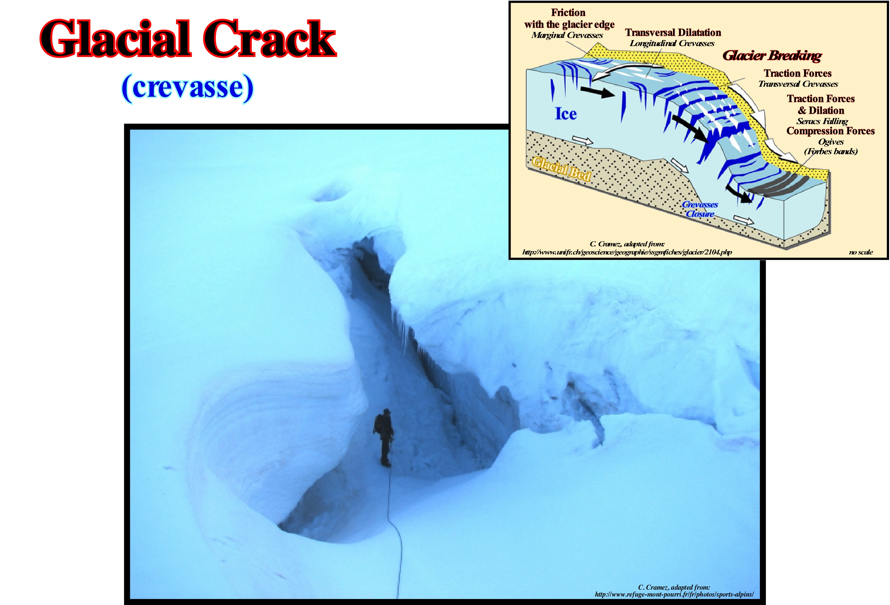
As illustrated in this photograph a glacial crack, glacial fissure or glacial crevasse is a, more or less, vertical fracture on a glacier. The depth of a glacial fissure is very variable and can, sometimes, exceed 100 meters. There are four types of glacial fissures or crevasses: (i) Transversal Crevasses ; (ii) Marginal Crevasses ; (iii) Longitudinal Crevasses and (iv) Detachment Crevasse or "Bergschrund. Transversal crevasses form in the extension or enlargement zone (where the glacier accelerates its downward movement). They are perpendicular to the direction of glacier movement (in general, are open cracks). Marginal crevasses are diagonally oriented, from the glacier end upwards, since the speed of the glacier is higher in the central part than in the margins. Longitudinal crevasses form parallel to the movement of the glacier, where the width of the glacier is expanding. Detachment crevasse or "bergschrund" separate the moving part of the glacier from the stagnant part and which can be prolonged to the rocky substratum (depth sometimes exceeding 100 m). In a glacial cirque*, the detachment crevasses ("Bergschrund") is located behind the glacier and is parallel to the rocky wall. This type of fissure appears to be induced by the rotational movement of the glacier. In winter, the "bergschrund "are filled by snow avalanches coming from the top of the mountain. In summer, due to the melting of the snow, the *bergschrunds" remain open and can be very dangerous for the climbers. Any glacial crevasses can be covered by a snow bridge and thus not fully filled. Using a snow-covered crevasse to pass from one side to the other can have serious consequences. In fact, it is quite difficult to predict whether or not a crevasses is filled. It is the interaction of the efforts on the surface of the glacier that determines, in part, the distribution, orientation, density and extent of propagation of the crevasses.
(*) Depression in the form of an amphitheatre produced by glacial erosion on the walls of the mountains or at the beginning of the valleys. It corresponds to the area of accumulation or feeding of the glacier where the mass of compressed snow moves sliding and, in this way, forms, by abrasion, a circular or semi-circular rocky concavity. When the glacier melts, circus glacier can be occupied by one or several glacial lagoons. (https://es.wikipedia.org/wiki/Circo_glaciar)
Glacial Thickening (Glacial advance).........................................................................................Épaississement (Avance d'un glacier)
Espesamento glaciário / Espesamiento (avanço glaciar) / Verdickung (vor einem Gletscher) / 增厚(提前冰川) / Утолщение (ледник) / Ispessimento (avanzare di un ghiacciaio) /
Increasing of the glacier mass, when accumulation is greater than ablation. A glacier is like a stream of water, it exists only as long as there is flow. If accumulation is greater than ablation, the glacier thickens continuing to flow downward. If the ablation is superior to the accumulation, it continues to flow downward, but thinning.
See: « Glacio-Eustasy »
&
« Glacio-Isostasy »
&
« Milankovitch's Cycle »
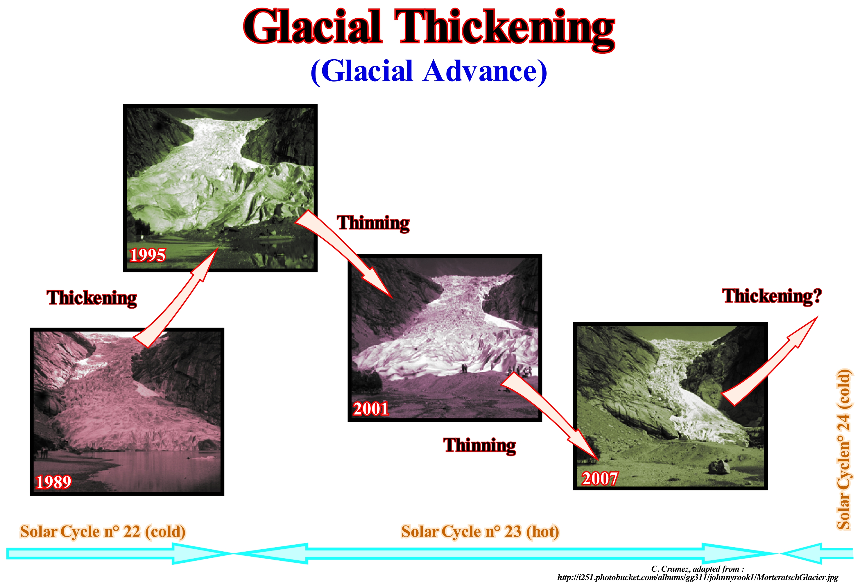
Certain geoscientists, but above all, the new ecologists, i.e., the "watermelons" (green on the outside and red on the inside) as they are known in certain western countries, speak of the advance and retreat of the glaciers. A glacier, by definition, can only move downward, since it is a current of ice. This means a glacier can never retreat (walk backwards). A glacier is just and simply a stream of ice. By definition, a glacier moves downhill and never uphill. Thus, it is more correct to say (as Ceasare Emiliani did in 1992) that a glacier thickens or that its volume increases, when accumulation is greater than ablation and and that it thins (decreases in thickness) when ablation is greater than accumulation. Often, thinning and thickening have nothing to do with the extent of the glacier. There are glaciers that have decreased in extent, but whose volume has increased. This is exactly what happens in certain regions of Antarctica. Geoscientist know, by this is no the case of a lot of people, the West Antarctica offshore is affected by a hot marine current, which, of course, melts part of the ice cap. Obvious, this has nothing to do with global warming and, especially with the so-called anthropogenic global warming*. The mass balance of a glacier, i.e., the difference between accumulation and ablation (melting and sublimation) is crucial for its survival. Climate changes can cause temperature changes as well as snowfall, causing changes in mass balance. A glacier with a persistent negative mass balance is in imbalance and slim. A glacier with a persistent positive mass balance is in imbalance, and increases in volume to restore balance. At present-time, there are some glaciers that thicken. However, the growth rates are small which may suggest they are not too far from equilibrium (**). As illustrated in this figure, it is very likely that the thickening and thinning of glaciers is, largely, but not only associated with solar cycles or Schwabe's (***). These solar magnetic activity cycles correspond to the almost periodic 11 year change in the Sun's activity, including changes in the levels of solar radiation and ejection of solar material, as well as changes in the number of sunspots, explosions and other manifestations. In this example, during the solar cycle 22, which was a cold cycle, the vast majority of glaciers increased in thickness and the lateral extent of many of them increased. However, during the solar cycle 23 (1996/2008 ?) most of the glaciers diminished in thickness and their lateral extension decreased. With solar cycle 24, which seems to have started in 2009, the lateral extent and volume of many glaciers is, likely, to increase. The increasing in solar activity acts, directly, on Earth (small increase in radiation, small heating effect and increased evaporation). Such an increase suppresses the penetration of cosmic rays into the Earth's atmosphere, thereby reducing condensation nuclei available in the low clouds. This increases the sky clarity and the radiation received, as well as, the already dominant greenhouse effect of water vapour. The inverse effect of a more quiescent Sun reduces direct solar heating, allows cosmic rays to penetrate (facilitates the formation of low clouds), which increases the reflection of reduced solar radiation, reducing sky brightness and evaporation, which simultaneously, reduces the availability of the most important greenhouse gas, water vapour, through condensation and precipitation.
(*) Increasing in average air temperature close to the Earth's surface and oceans since the mid-twentieth century and its projected continuation, which implies or suggests that prior to the 20th century, the Earth's surface temperature was stable. Such a conjecture does not seem to be true, in spite of the fact that certain alarmist ecologists argue the hot periods (i) Nomadic, (ii) Roman and (iii) Dark Ages occurred just in the Northern Hemisphere, and so they do not can be considered as global. The conjecture that global warming exists soon after the industrial revolution, mainly due to human activity, has become a dogma for ecologists. At present-time, no one with a minimum of geological knowledge speaks of "global warming". The vast majority of people have discovered climate changes have existed since Earth formation Earth around 4.5 Ga.
(**) The thinning of a glacier results from the loss of the lower part of the glacier. The highest part of the glacier is colder. The melting of the lower part of the glacier reduces, significantly, the total ablation, and thus increases mass balance, establishing an equilibrium. However, if the mass balance of a large part of the glacier accumulation zone is negative, it is in imbalance with the climate and will melt if the climate does not become colder or if the precipitation of ice does not increase. (https://fr.wikipedia.org/wiki/ Recul_des_glaciers_depuis_1850)
(***) Cycles showing the activity of the Sun at intervals of approximately 11 years. The Sun is, and will always be, a laboratory for obtaining "in situ" the data necessary for the elaboration of the theories necessary to understand the processes, phenomena and their causes, which occur in all bodies from the Solar System in the direction of the Universe, including the Earth. The Earth geomagnetic activity index can be an important indicator of the detection and prediction of the solar cycles. The index combines IHV geomagnetic activity with prominences, solar flares and coronal mass ejection. These phenomena are associated with the other component, i.e., the rate of ionization of the Earth's atmosphere caused by solar wind speed changes.
Glacial Thinning......................................................................................................................................................Amincissement glaciaire
Adelgaçamento glaciário / Adelgazamiento glaciar / Glazial Ausdünnung / 冰川变薄 / Ледниковое истончение / Assottigliamento del ghiaccio /
There is glacier thinning when, on a glacier, ablation is superior to accumulation. Glacier thinning corresponds to what many geoscientists mistakenly call retreat* of a glacier. A glacier is an ice flow. It exists, just, as the ice flows (accumulation compensates for ablation). When ablation is superior to accumulation, a glacier or ice cap (large glacier but less than 50,000 km2 otherwise called inlandsis or ice sheet) does not shrink. It continues to flow, but thinning.
See: « Glacier »
&
« Glaciation »
&
« Milankovitch's Cycle »
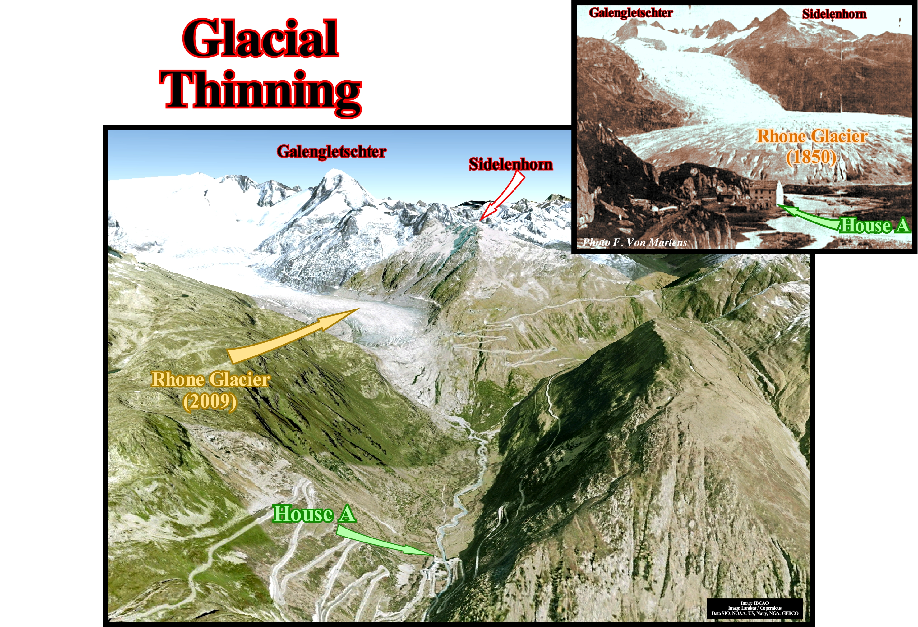
Today, almost daily, it has been said in the media that glaciers, ice seas and ice caps recede due to anthropogenic global warming **, i.e., due to the increase in global (average) temperature caused by the addition of the content of carbon dioxide (CO2) in the atmosphere caused by man, especially after 1990 ***. As illustrated in this figure, the extent of the Rhone glacier in 1850 and in 2009 is not the same. This has led a number of people, more or less, responsible, to speak of glacier retreating to better dramatize climate changes, eventually, induced by man. However, no one in this very catholic region (the canton of Valais in Switzerland, where the author of this thesaurus lives), forgot that in the 1950's missas (Christian ceremony) were frequent to ask God to prevent the progression of the glacier, otherwise a lot of the Valais' villages would be destroyed. In 1850 (photograph in the upper right corner), the front of the glacier almost reached house A, which in 2009 (central photography), is almost 2-3 kilometers downdip of the glacier front. Many geoscientists consider the terms glacial advance and retreat to be abusive (particularly the term retreat). In reality, a glacier is an ice flow. It exists just, as long as, there is flow, i.e., as long as, the accumulation compensates the ablation. If the ablation is greater than the accumulation, the glacier does not shrink, it continues to flow downhill, but it thins. What counts is not the extent downhill of glacier, but the amount of ice the glacier contains. The amount of ice can increase (accumulation higher than ablation) without the extension of the glacier increases. In the same way, the term thinning means the total volume of ice has decreased (ablation lower than accumulation), even if the downdip extension of the glacier has increased, as is the case with certain alpine glaciers
(*) Although this term is much used in the media today, unlike a car, that has a reverse and therefore can retreat, a glacier has no reverse, and therefore can not retreat. A glacier can just flow downhill, by gravitational flow. Even when a glacier does not advance further, it exhibits evidence of flow in the recent past.
(**) The term global warming is not listen any more in the majority of TV programs, as well as in the speeches of the "alarmist" ecologists. At present, they talk on climate changes, which means an important advance of their geological knowledge.
(***) The overall average temperature is generally calculated in a 5° x 5° mesh. However, most of the time, a large number of cells are missing. On the other hand, a credible global temperature requires representative averages, which are difficult to obtain having in mind that the quality and density of the measuring stations is uneven. All graphs that show average global temperatures are conjectural or subjected to tests. This is also true for the reference point which is, almost, always the average global temperature between 1961 and 1990. This reference choice is not innocent. Many measuring stations in the cold areas have become non-operational after fall of the USSR in 1990, which obviously induced a sudden and sharp rise in global average temperature.
Glaciation...................................................................................................................................................................................................................................Glaciation
Glaciação / Glaciación / Eiszeitalter, Kaltzeit / 冰河時期 / Ледниковая эпоха (мерзлота) / Era glaciale /
Modification of the Earth's surface by the action of glaciers. Glacial periods can be, partially, documented by the study of isotopic oxygen analyses, since ocean temperatures and the amount of ice on the continents have a strong influence on the oxygen isotopes ratio (O16 and O18) of the sea-water . From the Paleozoic, six major epochs were recognized in which glaciations appeared and disappeared: (i) Proterozoic (more or less 2.7 Ga); (ii) Proterozoic (plus or minus 2.2 Ga); (iii) Precambrian (700-600 Ma); (iv) Ordovician (500-400 Ma); (v) Late Carboniferous (290 Ma) and (vi) Plio-Pleistocene (3-2 Ma).
See: « Glacier »
&
« Milankovitch's Cycle »
&
« Astronomic Theory of Paleoclimate »
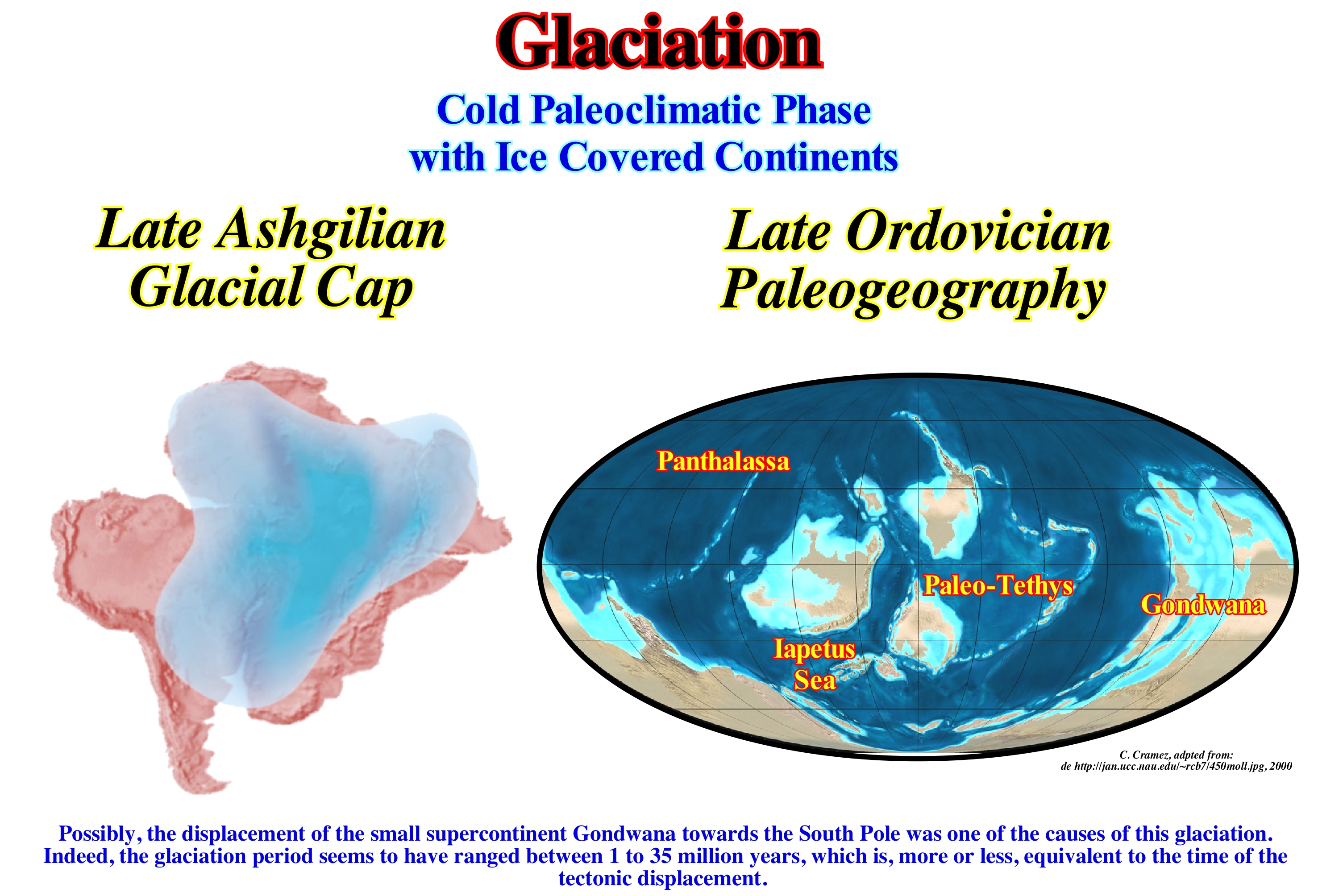
The probable extent of glaciation during the Late Ordovician is illustrated in the left map of this figure. The geometry and extent of the ice cap during Late Ashgilian allows a prediction of the most likely position of the South Pole at that time (the poles did not change, which changed was the position of the continents). In the map shown in the right part of the figure, it is illustrated, according to Scotese, the paleogeography of the Late Ordovician, during which the great majority of the glacial deposits were deposited. The Proterozoic glaciations occurred between 2 and 3 Ga. The "moutonnee" rocks with glacial slickensides and deposits associated with glacial environments of this time are mainly found in Eastern Canada. The second glacial age occurred during the Precambrian, about 0.6-0.7 Ga. It affected mainly Australia, South Africa, China, Europe and North America. After a long period (about 200 My) with higher temperatures and no glaciers, a new glacial age began at the end of the Ordovician. A new period of relatively soft temperatures (more or less 150 My) occurred before the Late Carboniferous glacial epoch (last 290 Ma). This glacial epoch was, relatively, short (between 20-30 My). It was, in part, induced by the Pangea agglutination. Glaciations occurred in Antarctica, South America, Africa, Arabia, India and Australia. After a period of about 270 My mild climate, the last glacial epoch occurred in Plio / Pleistocene (2-3 Ma). Take in mind that it takes about 50-100 ky to have a glaciation and only 10 ky to destroy it. The melting of the ice does not require the heating of the whole ocean but only of its surface.
Glacier..........................................................................................................................................................................................................................................................Glacier
Glaciar / Glaciar / Gletscher / 冰河 / Ледник / Ghiacciaio /
A mass of ice formed by the recrystallization of the snow that flows downdip or which has flowed, sometimes, in the past. Glaciers are not to be confused with glacierets (or "glacierettes", AGI, 1999), which are small volumes of ice sometimes found in the slopes or in the mountain s cirques, as is often the case, for instance, in Sierra Nevada (California).
See: « Glaciation »
&
« Milankovitch's Cycle »
&
« Astronomic Theory of Paleoclimate »
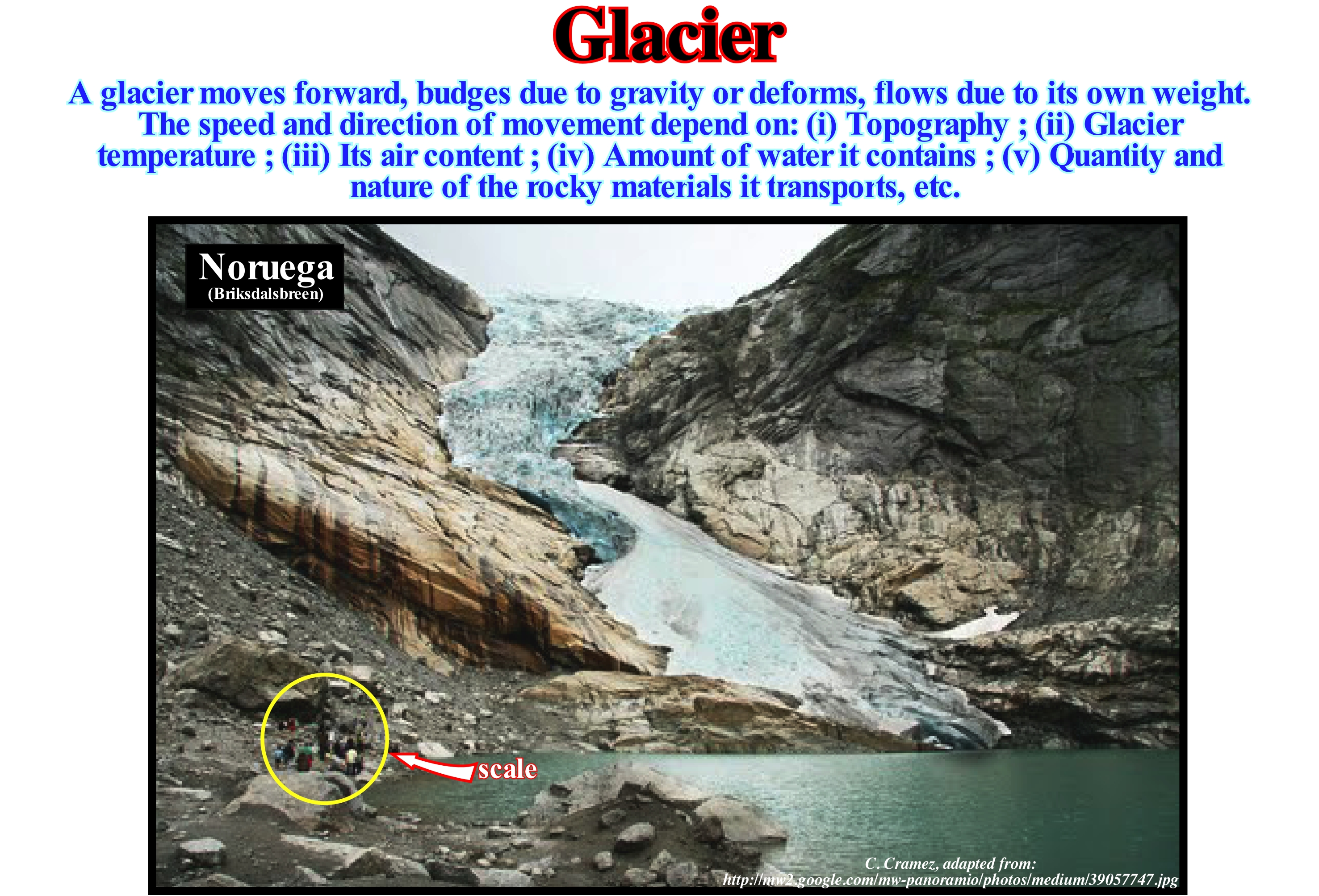
The term glacier includes small mountain glaciers as well as continental ice sheets and icebergs (mountains of ice), which are fed by ice formed on the continent. A glacier flows downstream due to the force of gravity (meters per day or year). Many glaciers are becoming smaller and smaller (extension and volume). The thickening and thinning of glaciers is a consequence of climate change. Nevertheless, in recent years, certain personalities have advanced the hypothesis that glacier thinning is the result of global warming (a rise in temperature verified, statistically, in terrestrial measures since 1990), which they think are of anthropogenic origin. We prefer the terms thinning and thickening to the terms retreat and advancement. A glacier is an ice current and a current always advances. In this photograph, the contrast between the colours induced by the diagenesis of the supra-crustal rocks, which form the rocky substrate of the Briksdalsbreen glacier valley, underlines a thinning of the glacier. From about 4,500 years ago, Pliocene-Pleistocene glaciers always thinned during hot periods: (i) Pre-dynasty of Ancient Egypt ; (ii) Ancient Egypt (intermediate period) ; (iii) Roman Empire ; (iv) Middle Ages (until the end of the fall of Constantinople, 153 A.D.) and (v) During the 19th, 20th and early 21st centuries. However, glaciers thickened, significantly, during the intermediate cold seasons: (a) Nomadic Life ; (b) Greek Empire ; (c) Dark Ages ; (d) Little Glacial Age and (e) Twentieth Century (explosion of the Pinatubo volcano). These variations have nothing to do with anthropogenic global warming. Some ecologists have already started talking about climate changes and in a few years they will tell us that humanity has nothing to do with climate changes, which all geoscientists have known for many years (do not confuse climate changes and climate).
Glacio-Eustasy..............................................................................................................................................................................................Glacio-eustasie
Glacioeustasia / Glacioeustasia / Glacioeustasy / Glacioeustasy(地质学) / Глациоэвстазия (образование ледников) / Glacio-eustatismo /
Eustatism induced by climatic changes, i.e., created by the glaciation/deglaciation cycles. Eustatism created by the variations of the cryosphere (part of the Earth's surface that is permanently frozen). In glacio-eustasy, the adjustment of the lithosphere, in response to the loading and unloading induced by the addition and removal of the ice from the ice caps, has to be taken into account. Glacio-eustasy tries to explain the global variations in sea level, especially, during the Quaternary, as a consequence of the variation of the volume of the ice on the continents and oceans, and suggests that to a glacial period corresponds a marine regression and that to an inter-glacial period correspond to a marine ingression.
See: « Eustasy »
&
« Isostatic Rebound »
&
« Eustatism »
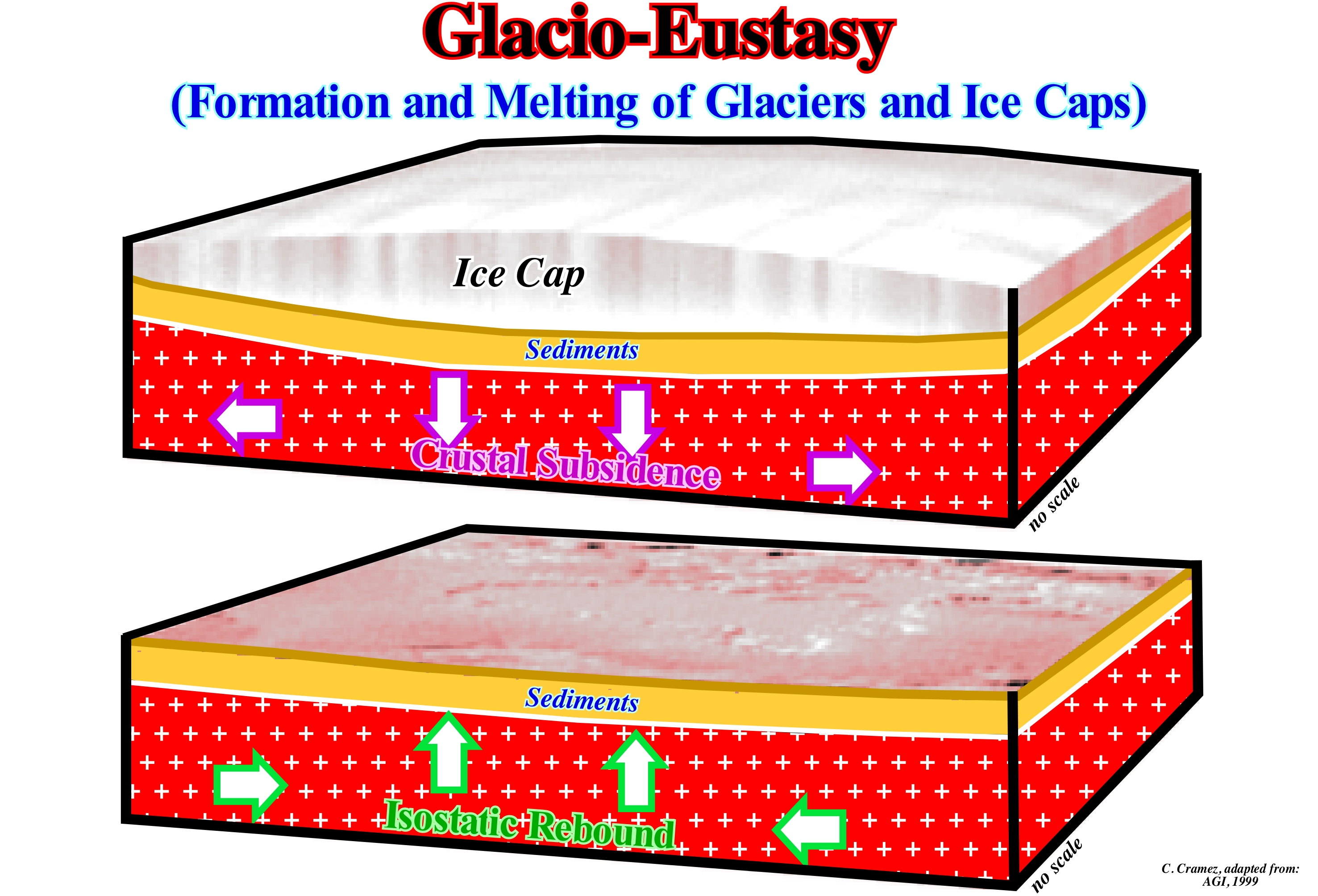
Glacio-Eustasy, which is controlled by variations in the volume of ocean water, is a major cause of absolute (eustatic) sea level variations. The other causes of eustatic sea level change are: (i) Tectono-Eustasy, which is controlled by changes in ocean basin volume ; (ii) Geoidal-Eustasy, which is controlled by the distribution of ocean water caused by gravity field variations and (iv) Steric sea level rise or thermal expansion of the oceans. Glacio-Eustasy and Tectono-Eustasy are eustatic variations, which are, sometimes, considered globally uniform. However, for many geoscientists, they can not be neither global nor uniform. Any cause of sea level also affects the terrestrial geoid. If this is true, no eustatic curve is valid globally. During the melting ice caps, in response to the load of water added to the ocean basins, the sea level will be depressed, and in response to the removed charge (where the ice caps have melted), the continent will be lifted. Redistribution of material within the Earth is affected by overload. It will further constrain the ocean surface variations (induced by gravity anomalies) and so further water redistributions will be required to attempt to equalize gravitational potential. This continuous retroactive gravitational process between the ice caps, oceans and the mainland is the process that, in the end, determines the signature of the absolute sea level, which is observed everywhere the continent and the ocean meet. Only glacial changes are at the same time important (over 10 m) and fast (lasting less than 1 m). During a glaciation, the weight of the ice cap (3-4 km thick) sinks the lithosphere. When the ice melts, the Earth's surface slowly rises again to reach the equilibrium position. The mechanism of crustal subsidence is very similar to that of a block of wood that is placed inside a viscous liquid. When the block is released, it will seek to find a position of equilibrium, which is, mainly, determined by its density. The rate at which this equilibrium is reached is controlled by the viscosity of the liquid. What happens to the block of wood happens to the lithosphere. A thick layer of ice forces the lithosphere to plunge into the asthenosphere. Since the pressure caused by the ice disappears a position of equilibrium is, slowly, restored, since the asthenosphere is very viscous. It takes about 15,000 years for the Earth's surface to regain its original attitude and re-establish the conditions necessary for another glaciation. As the amount of water in all its forms is considered constant since the Earth formation (around 4.5 Ga). During a glaciation, the absolute (eustatic) sea level, i.e., the supposed global sea level, referenced to a fixed point, which is, usually, the Earth centre) falls. During a deglaciation (de-icing epoch), the absolute sea level rises. This was, exactly, what happened during the Pliocene/Pleistocene. The absolute sea level began to fall about 120 meters, creating lowstand geological conditions (sea level lower than the basin edge). Then, it rose, more or less, the same creating highstand geological conditions (sea level higher than the basin edge). However, it must be remembered that much more time is needed to deposit ice on the continent than to melt it. The heat exchange between the ice caps, ice seas and the ocean cools the water surface. The water becoming colder and denser sinks being replaced by warmer water from the bottom. This means that the formation of ice shelves (ice seas that are not to be confused with glacial ice caps) requires cooling of the whole water column, which is not the case during deglaciation which spread in surface a layer of water little salted. The isostatic rebalancing associated with glacio-eustasy should be taken into account to understand sea level changes. It is important not to forget that in areas where the uplift (crustal rebound) was important, the sediments were tilted (by lengthening) in a significant way. In the North Sea (Norway offshore), for instance, the crustal uplift (crustal rebound for certain geoscientists) in response to the melting of the ice, is, currently, around 1,500 meters, which has important implications in the petroleum systems exploration. It implies either a hydrocarbon dismigration* (total or partial destruction of traps that could have been saturated with hydrocarbons) or an hydrocarbon re-migration**.
(*) Also called Tertiary migration, i.e., a migration to the surface, either from a reservoir-rock or from the source-rock.
(**) A re-migration is a migration from one reservoir position through an intervening section into another reservoir position in the same or a different reservoir.
Glacio-Isostasy...........................................................................................................................................................................................Glacio-isostasie
Glacioisostasia / Glacio-isostasia / Glazialisostasie / 冰河地壳均衡 / Глациоизостазия / Glacio-isostasia /
Hypothesis assuming the weight of the ice caps and ice sheets causes a sinking of the continents and that their uplift due to the defrost maintains the isostatic equilibrium (the process of weight compensation of a less dense body and a denser body) which can be exemplified by the height of an iceberg: the greater the height of an iceberg above sea level deeper is its bottom (underwater).
See: « Isostasy »
Glacis (Continental rise).........................................................................................................................................................................Glacis Continental
Sopé continental / Sopé continental / Kontinentale Aufstieg / 大陆隆 / Нижняя часть континентального склона / Ascesa continentale /
Part of the continental margin located between the continental slope and the abyssal plain. The glacis slopes to the abyssal plain with dips ranging from 1:40 to 1: 2,000. It generally has a very flat topography, although locally it may be affected by submarine canyons induced by ocean currents. For some geoscientists, the continental glacis is synonymous of the Lower Continental Slope.
See: « Abyssal Plain »
&
« Continental Platform (shelf) ”
&
« Continental Slope "
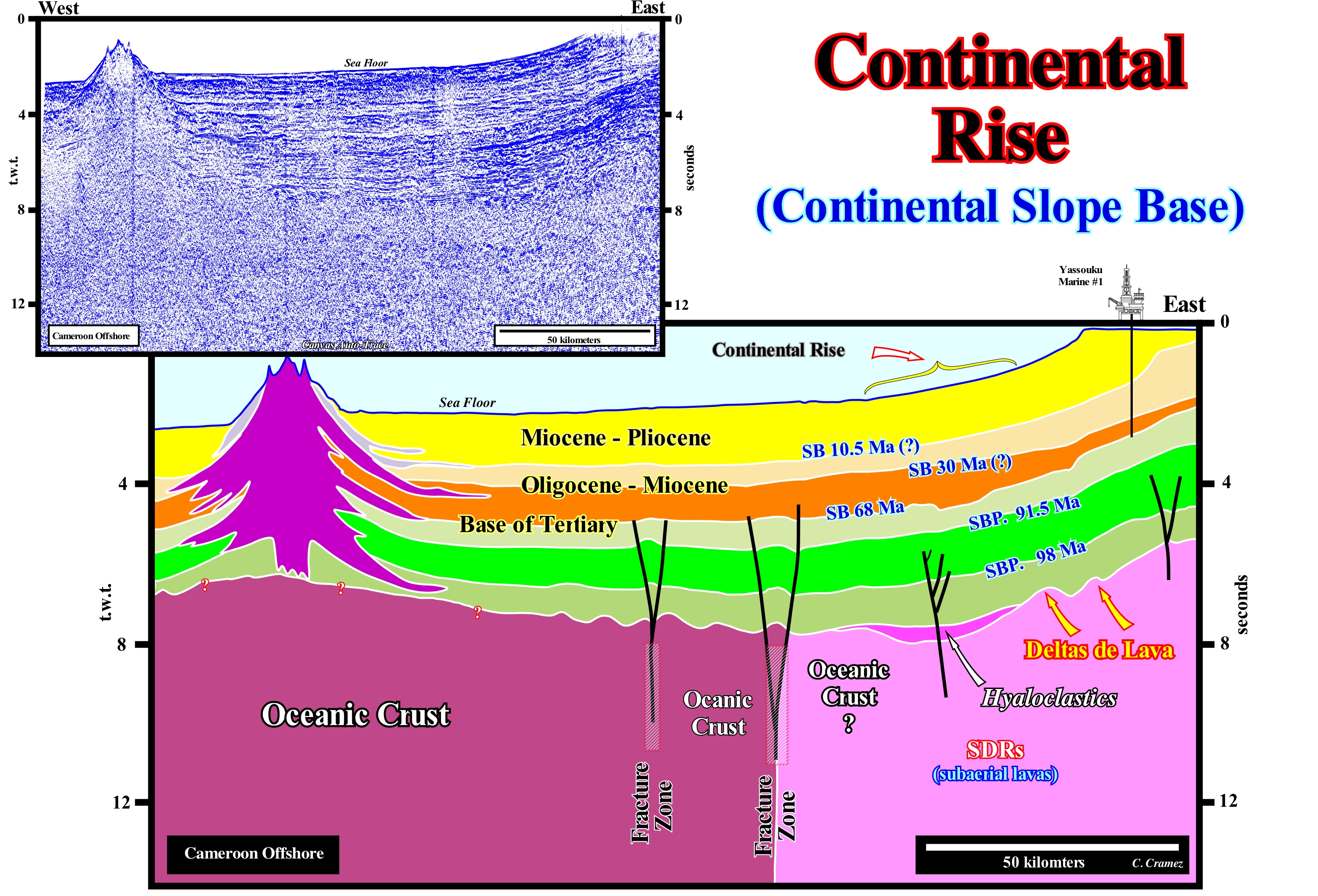
Cameroon offshore corresponds to the stacking of several basins of the classification of the sedimentary basins of Bally and Snelson (1980). In a regional seismic line, as illustrated in this figure by the tentative geological interpretation of a Canvas auto-trace of a seismic line of this offshore, it is easy to recognize, from bottom to top, the following basins: (i) Basement, i.e., generally, constituted, in the part proximal of the offshore, by a Paleozoic flattened mountain belt ; (ii) Early Jurassic/Cretaceous-Jurassic rift-type basins, which lengthened the lithosphere of the small supercontinent Gondwana before its break-up and (iii) A Mesozoic/Cenozoic Atlantic-type divergent margin. On this tentative interpretation, the present-time the glacis (continental rise) is quite well visible. The glacis corresponds to the zone near the lower break of the continental slope, i.e., more or less, the passage of the continental slope to the abyssal plain. As you can see, its dip is, relatively, small, but largely higher than that of the abyssal plain (keep in mind the scales of this auto-trace, which is greatly vertical exaggerated). It is in the glacis that the turbidite currents which transport the sediments to the abyssal plain, begin to decelerate to deposit the sediments either in the form of submarine basin floor fans (SBFF) or as submarine slope fans (SSF ). On this tentative,e it is interesting to note: (i) The absence of rift-type basins (they are located upstream of this seismic line, in the continental crust) ; (ii) The sub-aerial volcanic crust post-dates to the break-up of the lithosphere (break-up of the Gondwana small supercontinent), i.e., it is posterior to the rift-type basins developed in the continental crust by lengthening ; (iii) The boundary between the sub-aerial volcanic crust and the oceanic crust corresponds here to a fracture zone (extensional strike slip fault) ; (iv) In the distal part of this offshore, the divergent continental margin (Atlantic type) rests, directly, on the volcanic crust, which is sub-aerial, when formed by lava flows and oceanic, when formed by pillow lavas covering sheeted dykes ; (v) During the transgressive phase of the post-Pangea* continental encroachment stratigraphic sub-cycle, limited between the volcanic crust and 91.5 Ma downlap surface (Cenomanian/Turonian), two transgressive intervals are, relatively, well recognized ; (vi) The first interval was deposited during the Albian and is bounded (at the top) SBP. 98 Ma downlap surface ; (vii) The second interval was deposited during the Cenomanian/Turonian and is limited (at the top) by the 91.5 Ma downlap surface, which emphasizes the maximum of the marine ingression created by the absolute or relative sea level (**) rise following the post-Gondwana oceanic spreading ; (viii) The potential marine source-rocks of this offshore are associated with these downlap surfaces ; (ix) the richest in organic sediments seems to be Cenomanian/Turonian (SBP 91.5 Ma) downlap surface ; (x) An important volcanic apparatus has, recently (geologically), emerged from the sea floor about 200 km from the coastline, probably, in association with a major fracture zone.
(*) The hierarchy of stratigraphic cycles is a function of order. The time-duration of eustatic cycles, which create the space available for sedimentation, is as follows: (i) Continental Encroachment Stratigraphic Cycles , induced by first-order eustatic cycles, whose time-duration is greater than 50 My ; (ii) Continental Encroachment Stratigraphic Sub-cycles, induced by 2nd order eustatic cycles (time-duration between 50 and 3-5 My) and (iii) Sequence-Cycles, induced by 3rd order eustatic cycles, whose time-duration is between 0.5 and 3 -5 My. In 1st order eustatic cycles, the variations of the level of the absolute (eustatic) sea level are preponderant. In 2ndorder eustatic cycles, variations in absolute (eustatic) sea level may or may not be preponderate depending on the geological conditions. In 3rd order eustatic cycles, relative sea level changes (local sea level, referenced to any fixed point on the Earth' surface and which is the result of the combined action of absolute sea level and tectonics).
(**) The absolute sea level is the result of the combination of : i) Tectono-Eustasy that is controlled by the volume variation of the ocean basins in association with oceanic expansion following the rupture of the supercontinents ; (ii) Glacio-Eustasy, which is controlled by the volume of water in the oceans as a function of the amount of ice (assuming that the amount of water in all its forms is constant since the Earth formation, around 4.5 Ga); (iii) Geoidal-Eustasy which is controlled by the distribution of ocean water caused by variations in the Earth's gravity field (where gravity is stronger than normal, sea level is thrown to the centre of the Earth) and (iv) Steric rise of the sea level or thermal dilatation of the oceans (if the temperature increases, the density of the water decreases and, for a constant mass, the volume increases).
Glauconite...............................................................................................................................................................................................................................Glauconite
Glauconite / Glauconita / Glaukonit / 海绿石 / Глауконит / Glauconite /
Phyllosilicate (silicate characterized by sharing three of the four oxygens in each tetrahedron with the neighboring tetrahedra) of the group of micas. It has an olive green or dark green colour (so it is often confused with chlorite), crystallizes with a monoclinic system geometry, has a hardness 2 (Mohs' scale) and a density between 2.4 and 2.9.
See: « Stratigraphy Sequential »
&
« Paleobatimetry »
&
« Transgressive Interval »
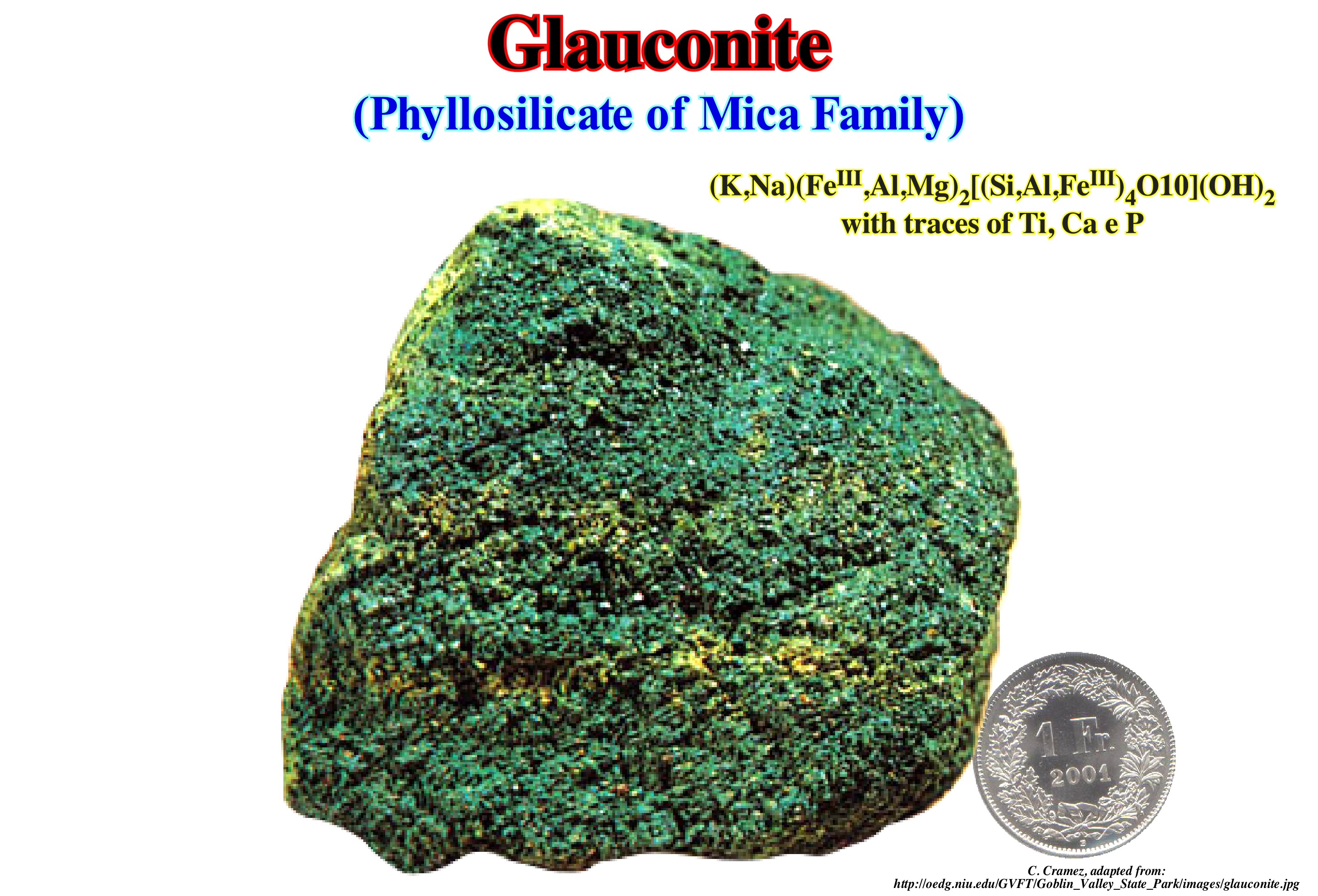
Glauconite is considered as a mineral characteristic of a continental shelf with a small sedimentation rate and appears in conjunction with the organic matter of the fecal balls that fill the holes of the Glossifungites*. Glauconite can be formed by diagenetic alteration of certain sedimentary deposits, from biotite or in relation to the decomposition of organic matter. It is, mainly, formed in reducing environments, either near the coast or in the open-sea or even in fresh-water. Glauconite is, often, inter-stratified with smectites (dioctahedral or trioctahedral clay minerals). It oxidises when exposed to air. In sequential stratigraphy, the importance of glauconite is due to the fact that it is, often, found in the sediments of transgressive systems tracts, particularly, in association with downlap surfaces. During drilling of an exploration well, the association of glauconite and coal debris suggests turbidite deposits, i.e, platform sediments, quickly, transported to the deep-parts of the basin by turbidite currents. The presence of authigenic glauconite debris and the absence of coal debris suggests platform deposits. On the other hand, the presence of coal debris and the absence of glauconite debris suggests non-marine deposits. In this photograph, glauconite is associated with a transgressive limestone. Sediments rich in glauconite have ages ranging from Precambrian to Present. They are deposited, almost always, above the transgressive surfaces. Glauconite rich sandstones are called green sandstones. They are frequent in the Cretaceous sediments of the United Kingdom, Argentina, United States, etc.. They are, sometimes, good reservoir rocks.
(*) Set of vertical, U-shaped or finely branched bio-perforations occurring in sediments of weak water depth more or less consistent but not lithified.
Glendonite.............................................................................................................................................................................................................................Glendonite
Glendonite / Glendonita / Glendonite (Mineral) / Glendonite(矿产) / Глендонит / Glendonite (minerale) /
A variety of calcite, which above 8° C dehydrates quickly to become calcite. Glendonite (pseudomorph after ikaite) indicates that seawater (shallow) was close to zero.
See: « Calcite »
&
« Limestone »
&
« Glaciation »
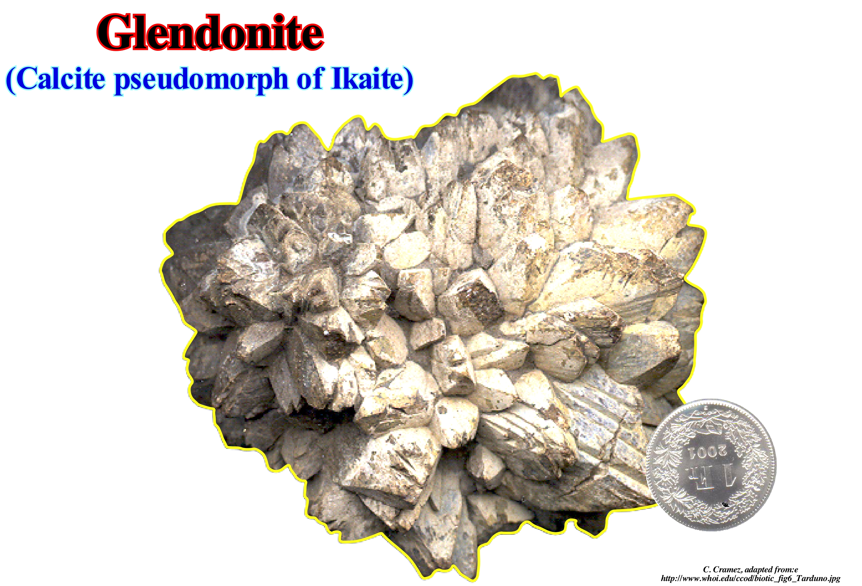
Glendonite (from Glendon, Australia) is a unique and distinctive form of calcite (CaCO3). Glendonites begin as crystalline masses of ikaite, a hydrated calcium carbonate mineral (CaCO3 6H2O). The ikaite is formed only in water near freezing (± 0°/7° C), high alkalinity and in organic rich sediments in water-sediment interface. At warmer temperatures, ikaite is not stable. It loses its water content. It converts to calcite (anhydrous calcium carbonate). During ikaite-calcite conversion, the original crystalline structure of ikaite can be maintained. Masses of calcite containing ikaite crystals are called glendonites. Glendonite is not a mineral, but a pseudomorph of calcite, after the ikaite. The presence of glendonite in a succession of rocks is considered as evidence of the presence of glaciers in the geological past (ikaite forms at low temperatures). Many ancient successions known to have been deposited in glacial environments have glendonite, as, for example, in the Permian of Australia. During the Paleozoic, the Gondwana small supercontinent (of which Australia was part) suffered several ice ages (from the Mississippi to the Permian). Thickening and thinning of the ice sheets during the Late Paleozoic of the Gondwana are underlined in North America under the form of cyclothems (cyclic sediment packages, indicating numerous short duration transgressive-regressive events). The vast majority of glendonite samples come from the banks of the Olenitsa River, in the Republic of Karelia, Kola Peninsula, in Russia. The colour of glendonite is very variable. It depends heavily on the inclusions of mud, when, during a heating of the water, calcite replaces the ikaite. Glendonite it appears from Proterozoic to today. I is a good paleoclimate and paleoceanographic indicator. It is found: (i) On the high latitude platform ; (ii) Deep Seas ; (iii) Alkaline lakes and (iv) In icy environments.
Global (Geological event)...........................................................................................................................................................Global (Événement géologique)
Global/ Global (evento geológico) / Globalen / 全球 / Глобальный / Globale /
Event that is on a global scale or that applies to the entire Earth's surface. Synonym with Planetarium (geology).
See: « Stratigraphy Sequential »
&
« Correlation »
&
« Unconformity »
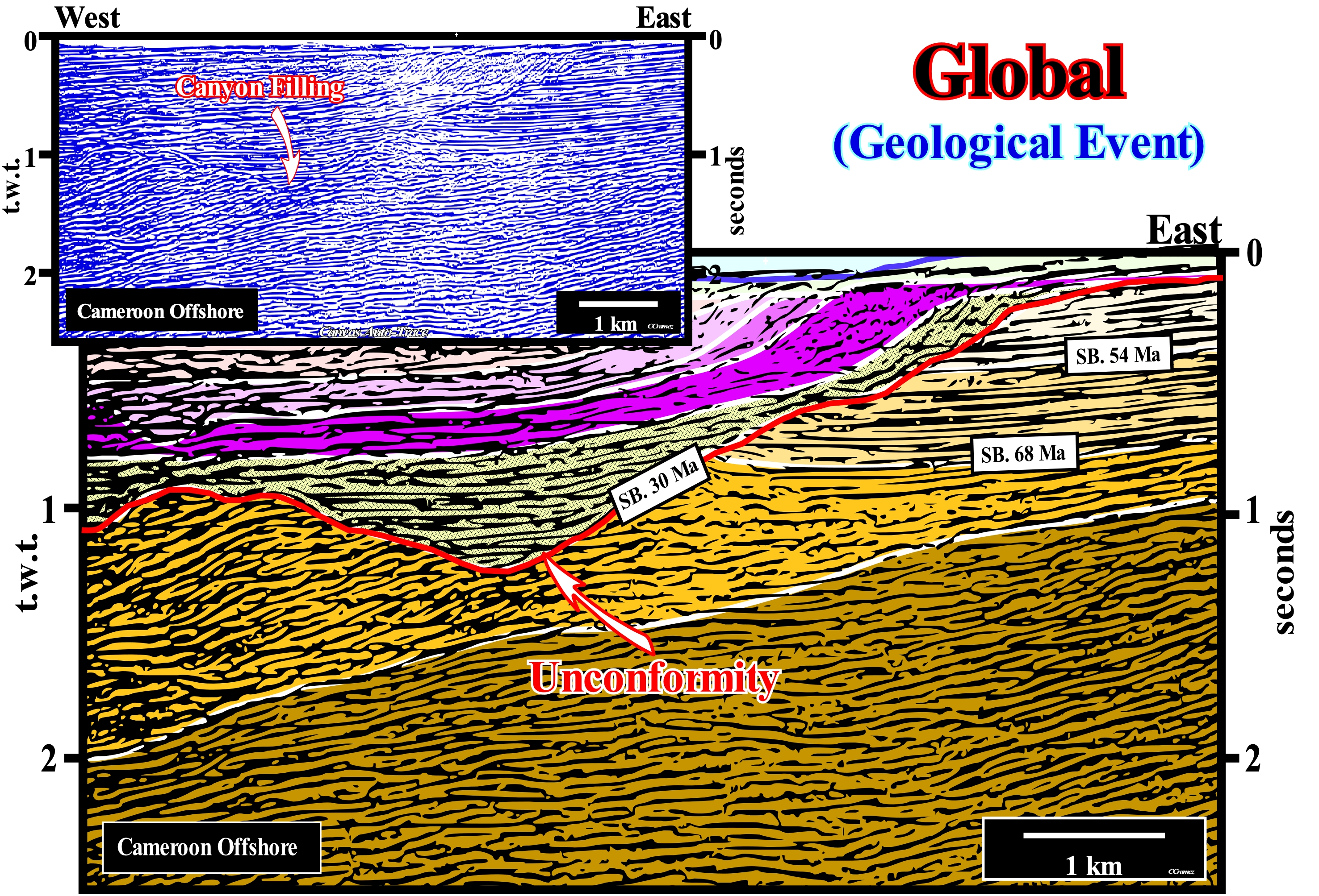
In sequential stratigraphy, the event associated with SB. 30 Ma unconformity (erosional surface dating 30 million years ago) is, probably, the most difficult global event to refute. In this context, the term refute implies, necessarily, a hypothesis. In Geology, as in any other sciences (excepting Mathematics) there are no certainties, all are hypotheses. Since a hypothesis is refuted several times, it is replaced by a more robust one, which will, probably, also be refuted later. In other words, a hypothesis is not good because it is, often, verified, but rather because it is difficult to falsify or refute. It is the refutation criterion and not the verification criterion (truth does not exist in Science) that determines the robustness of a hypothesis. The hypothesis that SB. 30 Ma unconformity, which is very conspicuous on this tentative geological interpretation of a Canvas auto-trace of a detail of a Cameroon offshore seismic line (uninterpreted auto-trace in the upper left corner of the figure), occurred in all parts of the world is corroborated by all the regional seismic lines shot across the world. At my knowledge, such conjecture has not yet been refuted. I never be able to refute the presence of a significant submarine erosion (SB. 30 Ma) between the Paleocene and Oligocene sediments, as illustrated on this tentative interpretation. This seems is true not only for Atlantic and non-Atlantic divergent margins but convergent margins as well. However, it is very possible that in the future someone will show the opposite. This unconformity which, locally, can be tectonically enhanced, corresponds to a significant absolute (eustatic) sea level* fall and not to relative sea level** fall, which changed, drastically, the geological conditions from highstand to lowstand (sea level lower than the basin edge). As can be seen on this tentative interpretation, the highstand conditions were, preponderant, during the Paleocene. During the Middle Oligocene, the geological conditions were lowstand. Before SB. 30 Ma unconformity, which is here underlined by the filling of a submarine canyon, the sea level was, almost always, higher than the basin edge. Above the unconformity and during Early Oligocene, the sea level was lower than the basin edge. This explains, in part, the great development of turbidite depositional systems, which fossilize a large part of the submarine canyon induced by a significant absolute sea level fall, as is the case, in almost all West and East Africa offshores, as wells as, in South America offshores. The significant absolute sea level fall, which induced SB. 30 Ma unconformity, which is considered by most geoscientists as a global geological event, appears to have been the result of the formation of the Antarctica ice cap (over the continent) and Antarctic ice sea (ice platform). The formation of this ice cap began, more or less, in the Oligocene (including the ice sea), but its maximum extension (***) was reached, more or less, at 19 ka (Holocene). Then, the ice began to melt. At present-time, the retrogradation of the Antarctic ice shelf is around 450 km, which means that it retrograded, on average, 24 meters per year.
(*) Referenced to a fixed point which is generally the Earth's centre.
(**) Local sea level, referenced to any point on the Earth's surface, whether the sea floor or the base of the sediments (top of the continental crust). It is the result of the combined action of absolute sea level and tectonics (subsidence or uplift of the sea floor).
(***) The maximum extent of ice caps and ice seas in the Northern and Southern hemispheres was reached during the last ice age. The maximum expansion was reached, approximately, at the same time, more or less, 19,000 years ago. Then the ice began to melt. The simultaneous melting was, probably, caused by changes in the circulation of Atlantic Ocean deep-waters, which carried warmer water to the Antarctic continental margin. The 450 km retrogradation of the Antarctic ice cap and sea ice contributed, heavily, to the post-glaciation absolute (eustatic) sea level rise (± 130 meters). The contribution of the ice seas is nil, since the water is denser than ice.
Global Change.................................................................................................................................................................................Changement global
Mudança Global / Cambio global / Globaler Wandel / 全球变化 / Глобальные изменения / Cambiamento globale /
Change that affects or involves all or most of the Earth's surface, such as eustatic sea level changes, climate change, changes in carbon concentration, etc.
See: « Global (geological event) »
&
« Glacio-Eustasy »
&
« Astronomical Cycle »
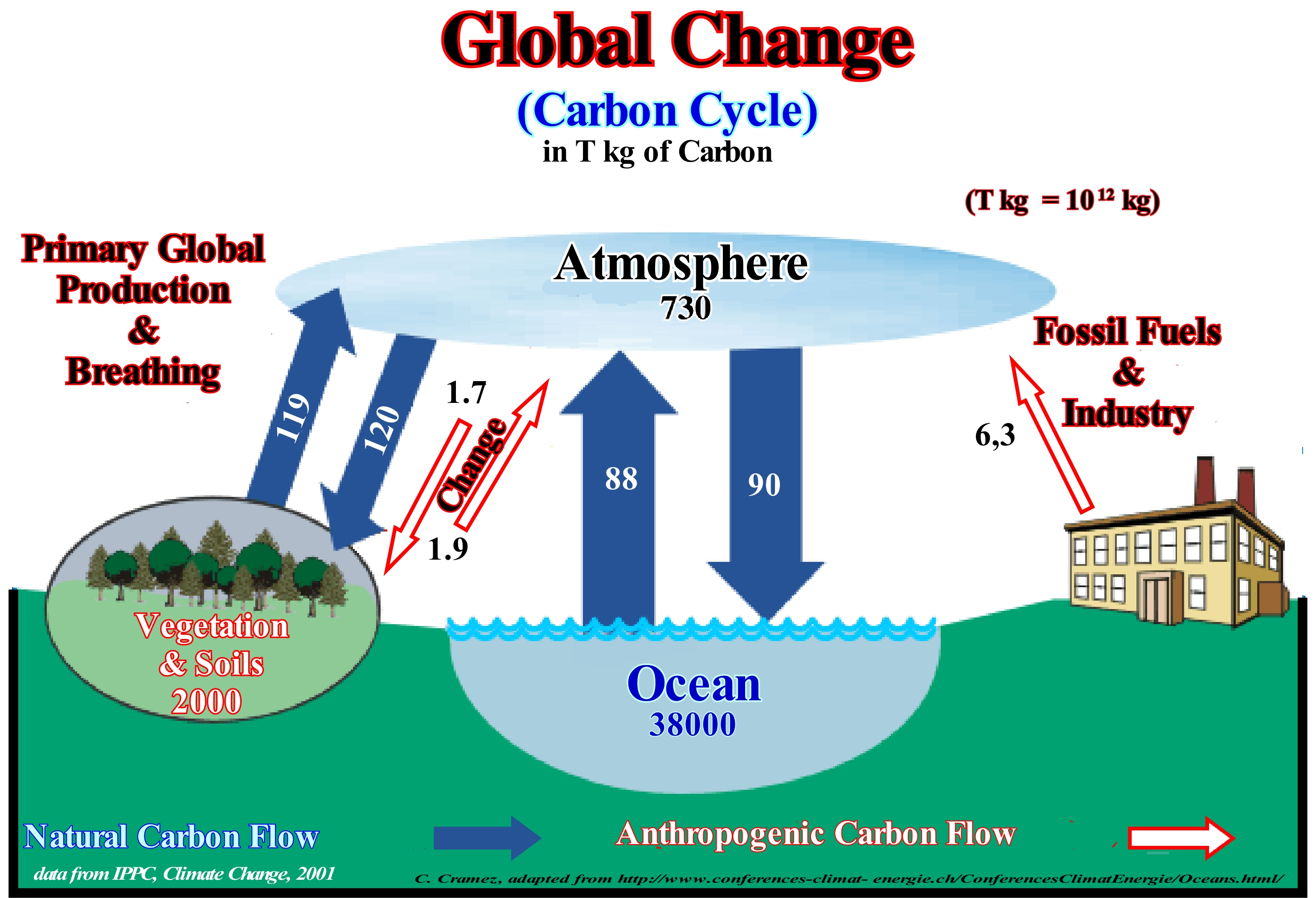
One of the global changes that is very fashionable is that of CO2. The concentrations of CO2 in the atmosphere are, of course, regulated by numerous processes that form the carbon cycle. By the photosynthesis the carbon is withdrawn from theCO2 of the environment to form organic matter: 6CO2 + 6H2O + energy (sunlight) →C6H12O6 + 6O2 (photosynthesis), which is oxidized by cellular respiration injecting CO2 into the environment: C6H12O6 (organic matter ) + C6H12O6 + 6O2+ energy (respiration). The movement (flow) of carbon between the atmosphere, land and oceans is dominated by natural processes, such as photosynthesis of plants. While these natural processes can absorb some of the 6,1x10⁹ t (tonnes) of anthropogenic CO2 emissions produced every year (measured in terms of equivalent carbon), about 3,2 x 10⁹ t are added every year to the atmosphere. The imbalance between emissions and absorption results in a continuous increase in the greenhouse gas content in the atmosphere. Given the natural variability of Earth's climate, it is difficult to determine the importance of the change that humans cause. In computer-based models (purgamentum init, exit purgamentum), increasing concentrations of greenhouse gases produce an increase in temperature, which in turn produces climate change. Certain geoscientists even suggest that the climate has warmed up in the last century and that human activity is the most important factor. However, some geoscientists have found a significant difference (about 800 years) between the peaks of the average Earth's temperature and the peaks of CO2 in the atmosphere, with the first to precede the second. This suggests that it is, probably, the increase in temperature of the oceans water, that induces the increase of the amount of CO2 of the atmosphere and not the opposite. If the temperature of the oceans increases, the density of water decreases and, for a constant mass, the volume increases. This is what geoscientists call thermal expansion of the oceans or steric sea level rise (function of the space arrangement of atoms). On the other hand, as the solubility of atmospheric CO2 decreases with water temperature (the lower the water temperature the more dissolved CO2 it supports) an increase in the temperature of the oceans releases CO2 into the atmosphere. In the high latitudes, the water of the ocean surface freezes and its temperature, under the sea ice is very low, which allows the dissolution of much atmospheric CO2 (the salt that does not participate in the process of freezing water and dissolves in the water, immediately, under the sea of ice increased its salinity). Cold, salty water with much dissolved atmospheric CO2, being much denser, sinks and flows along the continental slope of the polar platforms, invading the deeper regions of the ocean basins. The upwelling is done mainly by vertical mixing throughout the ocean (a period of time between 1,000 and 1,500 has been advanced for a water molecule to make the complete circuit*) Compare the following numbers (data from- http://www.pensee-unique.fr/theses.html & Paririe et Duarte, 2007): (i) The atmosphere contains more or less 750 GtC ; (ii) The surface of the oceans contains more or less 1,000 GtC ; (iii) The vegetation, soils, and wastes contains about 2,200 GtC ; (iv) The oceans (interior) have more or less 38,000 GtC, which gives a total of about 42,000 GtC. On the other hand, every year: a) The surface of oceans and the atmosphere exchange ± 90 GtC/year ; b) On ground vegetation and the atmosphere exchange ± 60 GtC/year ; c) Plankton and the surface of ocean exchange ± 50 GtC/year ; d) The shallow and deep water of the oceans exchange ± 100 GtC/year, which gives a total of about 300 GtC per year. In addition, each year they are injected into the atmosphere: (1) Man inject in atmosphere ±3 GtC/year, of the ± 5-7 GtC/year produced by fossil fuel combustion ; (2) Between the ground and the atmosphere ± 2 GtC/year are exchanged by changing land-use ; (3) The breathing of all humanity would release in the atmosphere ± 0.3 GtC/year ; (4)- Domestic animals release ±0.75 GtC/year ; (5) Human and animal waste release ± 0,5 GtC/year, which gives a total of ± 3 GtC. For an economic growth of 3% per year, which many economists advance so that unemployment does not increase (Okun's Law, which proposes an inverse relationship between unemployment and gross domestic product), are introduced into the atmosphere, ± 0.009 GtC are added every year, i.e., PEANUTS**. It is important to distinguish economic growth from economic development. While the former refers to GDP (gross domestic product), economic development is a concept that involves other aspects related to the well-being of a nation. It is probably best that economic growth grow, to be less poor and less unemployed, than to decline, as a number of ecologists suggest.
(*) Thermohaline circulation is referred to as the global ocean circulation induced by the differences in the density of ocean waters created by variations in temperature and / or salinity, excess evaporation on precipitation or ice formation (increase of salinity in the surrounding waters).
(**) On this subject, it is interesting remember what certain geoscientists say (C. Gerondeau & Rémy Prud'Homme in their declaration (Climate: No one can do anything! Let's stop the waste of our money, May 2019): The most widespread opinion wants that reducing its emissions of CO2 humanity can significantly influence the temperature of the globe and act on the climate. This opinion is unfounded because the orders of magnitude do not allow it. Even if annual global anthropogenic emissions were halved by 2050 as requested by the IPPC, the considerable amount of CO2 present in the atmosphere at that time would be very little affected as global emissions increase just 1/200 per year, of which 1/2,000 for the European Union, and 1/20,000 for France ». Indeed, presently the CO2 concentration in the atmosphere is around 410 ppm (parts per million), which seems very low, but corresponds to a considerable overall mass of 3,200 x 109 tonnes (the correlation factor between ppm and billions of tonnes is 7,8), On the other hand, anthropogenic CO2 emissions per year are about 33 x 109 tonnes from which more than half are absorbed by the vegetation and ocean. So an annual increase of 16 x 109 tonnes of CO2 corresponds to 1/200 of the 3,200 x 109 tonnes already present in the atmosphere.
Global Cycle Chart (Eustasy)........................................................................................................................Diagramme eustatique
Diagrama eustático / Diagrama eustático / Globale eustatischen chart / 全球海平面图 / Эвстатическая диаграмма / Curve delle oscillazioni eustatiche (livello del mare) /
Diagram that shows the simultaneity of relative sea level changes in sedimentary basins, more or less, distant from each other.
See: " Eustatic Cycle "
&
" Stratigraphic Cycle "
&
" Relative Sea Level Change "
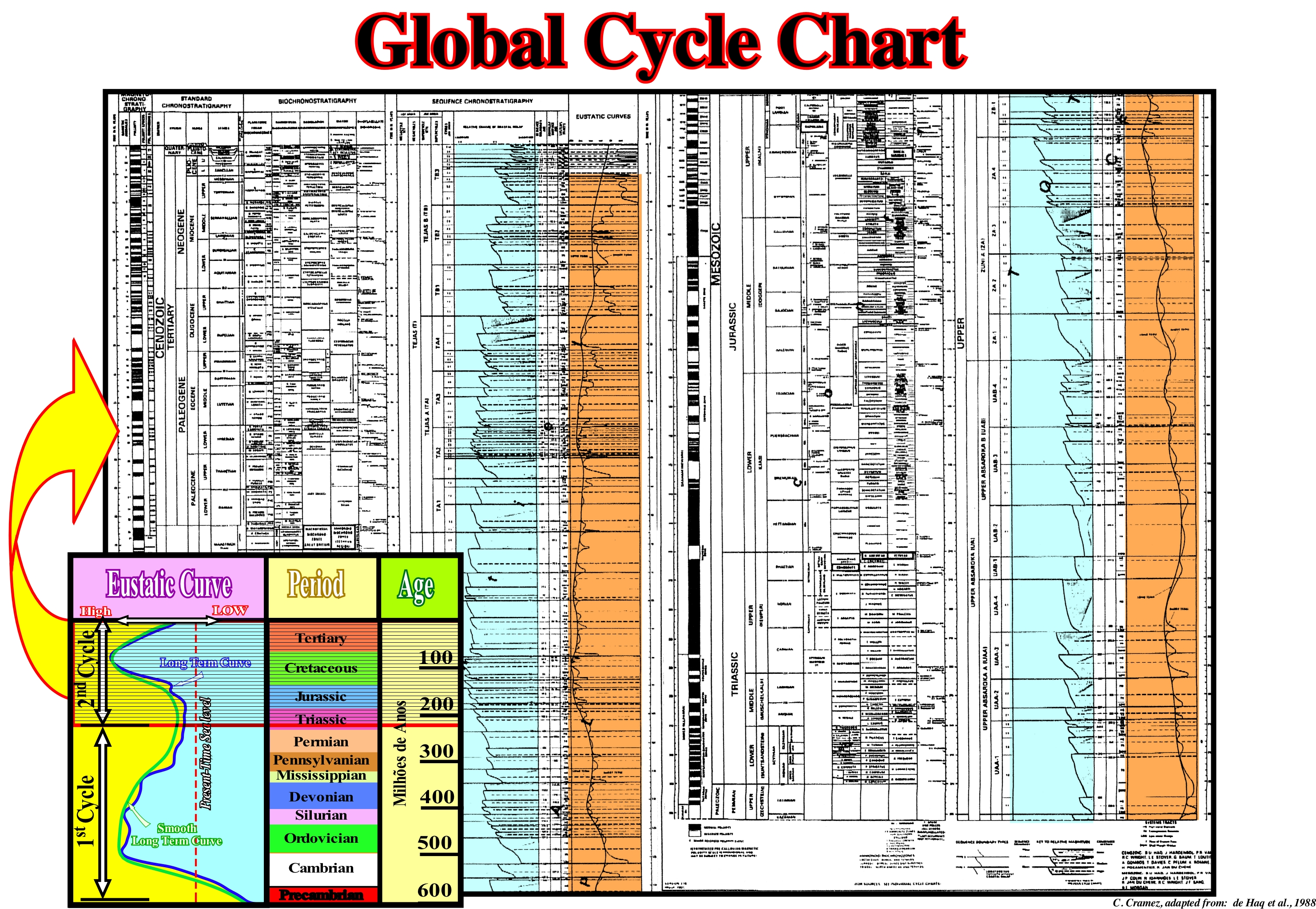
Like all scientific conjectures, over time, the original curve of the relative sea-level changes variations proposed in 1977 by EPR's geoscientists (Exxon's Exploration Production Research), which incorporated a large number of data from seismic, oilfields and research wells, was, of course, criticized in successive publications. However, over time, it has been greatly improved, becoming, increasingly, difficult to refute. The criticism advanced by certain geoscientists who require Exxon to published the seismic data (largely confidential data) is no longer valid. The basic idea of the Exxon geoscientists is that in sedimentary deposits, eustasy, that is to say, absolute (eustatic) sea level changes, is responsible for the cyclicity of sedimentary deposits. Absolute or eustatic sea level is supposed to be the global sea level, referenced to the Earth's centre, is preponderant in relation to tectonic changes (subsidence or uplift of the sea floor), The first consequence of such conjectures is that during a cycle of the relative sea level changes** curve (called, abusively, eustatic cycle***), a stratigraphic-cycle is deposited. It can be a sequence-cycle (induced by a 3rd order eustatic cycle), a continental encroachment sub-cycle (induce by a 2nd order eustatic cycle or a continental encroachment cycle (induced by a 1sat order eustatic cycle). Exxon's geoscientists admitted, also, the existence of a series of global correlations of eustatic cycles and that all stratigraphic data (field, seismic and subsurface) may be interpreted according to this concept. However, certain geoscientists, such as Miall (1977), in the absence of documentation published by Exxon, continued not to accept such a conjecture altogether. Others, such as Robin, Guillocheau & Gaulier (1998), considered the quantification of the eustatic and tectonic factors controlling the sedimentary records as one of the fundamental questions of the dynamics of the sedimentary basins. They proposed two methods allowing: (i) Calculate the accommodation, that is to say, the available space available for the sediments, at the scale of a basin and (ii) Distinguish between local accommodation (10-100 km of wavelength) and accommodation at the basin scale. In fact, it seems a local signal is most often of tectonic origin, whereas a signal at the scale of a basin, generally, has an eustatic and tectonic origin. The calculation of accommodation requires: (a) A sequential analysis not of seismic lines, but also of electrical logs ; (b) Biostratigraphic analysis of the borehole samples ; (c) Non-compacted lithologies ; (d) Determination of the depositional paleo-water-depth and paleolatitude****. The depositional water-depth is, practically, zero upstream of the depositional coastal break of the depositional surface (more or less the shoreline). That means that all the available space for the sediments is filled,.Seaward of the depositional coastal break, the water depth increases and just a part of the accommodation (available space for sediments) is filled. At present, four main eustatic cycles are considered: (i) 1st order eustatic cycles with a time-duration greater than 50 Ma, which are induced by the break-up of the supercontinents ; (ii) 2nd order eustatic cycles, whose time-duration varies between 3-5 Ma and 50 Ma, which are induced by changes in the tectonic subsidence rate ; (iii) 3rd order eustatic cycles, whose duration varies between 0.5 Ma and 3-5 Ma, which are induced mainly by glacio-eustasy ; (iv) 4th order or higher eustatic cycles, whose time-duration ranges from 0.1 to 0.5 Ma. Each of these eustatic cycles induces a particular stratigraphic cycle. Thus, in association with a 1st order eustatic cycle a continental encroachment cycle is deposited. In association with a 2nd order eustatic cycle a continental encroachment sub-cycle is deposited. In conjunction with a 3rd order eustatic cycle a sequence-cycle is deposited. High frequency stratigraphic cycles are deposited in association with 4th order or higher eustatic cycles. Some geoscientists consider 4th order eustatic cycles have a time-duration between 0.5 and 0.08 My and 5th order eustatic cycles have a time-duration of between 0.08 and 0.03 My and 6th order eustatic cycles have a time-duration of between 0.03 and 0.02 My.
(*) For many geoscientists, absolute sea level can not be neither global nor uniform. In fact, any cause of sea level affects, also, the terrestrial geoid. If this is true, no eustatic curve is valid globally. During the melting of the ice caps, in response to the load of water added to the ocean basins, the absolute (eustatic) sea level will be depressed, and in response to the removed charge (where the ice caps melted), the continent will be lifted. The redistribution of the material inside the Earth is affected by the overload and it will enhance the variations of the surface of the ocean (induced by gravity anomalies) and thus further redistributions of water will be required to attempt to equalize gravitational potential. This continuous retroactive gravitational process between the ice caps, oceans and the mainland is the process that, at the end, determines the signature of relative sea level, which is observed everywhere the continent and the ocean meet.
(**) Sea level, local, and referenced to any point on the Earth's surface, which may be the sea floor or the base of the sediments sediments. It is the result of the combined action of absolute (eustatic) sea level and tectonics (subsidence or uplift).
(***) In sequential stratigraphy, the vast majority of geoscientists use the term eustatic in a global sense, which is not the case for eustatic cycles. They are defined by relative sea level falls determined from the curve of the relative sea level changes and not from the absolute or eustatic sea level curl.
(****)The paleolatitude is the previous latitude of a given geological formation, at a given geological time, often, specifically, the time of deposition of the different sedimentary intervals.
Global Unconformity........................................................................................................................................Discordance planétaire
Discordância Global / Discordancia planetaria / Globale Diskordanz / 全球不整合 / Глобальное несогласие / Discordanza globale /
Unconformity induced by a relative sea level fall that is observed in all parts of the Earth. Apparently, for many geoscientists, this type of unconformity seems to be associated only with the volume variations of the ocean basin and not with glacio-eustasy.
See: « Global (geological event) »
&
« Unconformity »
&
« Minor Unconformity »
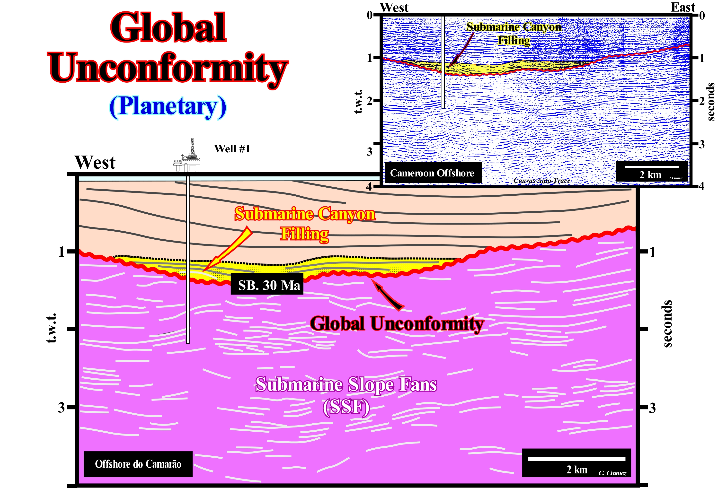
As indicated by several geoscientists, the genesis and interpretation of sedimentation breaks at a global scale remains controversial. Recently, Svetlana et al., 2008, compiled all data on the unconformities between the Jurassic and Cretaceous, in a number of regions, with different tectonic and sedimentary styles. They concluded that the correlation between the Jurassic/Cretaceous unconformity and the eustatic curve proposed by the EPR Exxon's ("Exploration Production Research") geoscientists is not clear. They think the definition of a global unconformity require before all a clarification of the curve eustatic*. Like a large majority of the geoscientists who work or who worked in the oil companies, I think that there are certain unconformities that can be considered as global. They are, practically, recognized in all the sedimentary basins. One of these unconformities is, perfectly, illustrated in this tentative geological interpretation of a Canvas auto-trace of a detail of a conventional Cameroon offshore seismic line. Indeed, in this tentative interpretation it, it is easy to see a significant relative sea level fall between the deep Cretaceous (submarine slope fans) and the Middle/Late Oligocene deposits. The unconformity is characterized by toplaps by truncation of the underlying sediments and by onlaps of the overlying sediments. For many geoscientists, the relative sea level fall of this unconformity is associated with the formation of the Antarctic ice cap, about 30 Ma (Oligocene) whose maximum extent was reached during the last glacial age about 19 ka. As until today no one has been able to falsify the conjecture admits by the great majority of geoscientists that the amount of water, in all forms forms is constant since the Earth's formation (around 4.5 Ga), it is evident that the formation of Antarctic glacier cap was accompanied by a significant absolute (eustatic) sea level fall (global sea level, referenced to a fixed point, which may be the Earth's centre). The amplitude of the relative sea level fall can be, approximated, by the absolute sea level rise induced by the thaw, which being more recent is easier to determine. The maximum extent of ice caps and ice seas (north and south hemispheres) during the last ice age is now well known. The maximum of the expansion was reached, approximately, at the same time, more or less, there were 19 ka. The ice began to melt. Simultaneous melting was, probably, caused by a absolute sea level rise and changes in the circulation of deep waters in the Atlantic Ocean, which transported warmer water to the Antarctic continental margin. The retrogradation of the Antarctic ice cap, which is currently about 450 km (plus or minus 24 m per year), has, heavily, contributed to the post-glaciation 130 meters absolute sea level rise. It can be said absolute sea level rise, induced by the initiation of the Antarctic ice cap, caused an important erosional surface, which is recognized not only in Atlantic-type divergent margins, but also in the non-Atlantic margins (formed in association with megasutures formation). With this unconformity, turbidite deposits are associated in deep parts of the sedimentary basins, which make possible to state that its most probable age is about 30 Ma. The age of an unconformity is given by age of the minimum hiatus between the deposits of the stratigraphic cycles, which the unconformity individualizes. The age of the pelagic layers of the submarine basin floor fans of the basin gives, roughly, age of the unconformity.
(*) Glacio-Eustasy and Tectono-Eustasy are eustatic changes, which are sometimes considered, globally, uniform. However, for many geoscientists, they can neither be global nor uniform. Any cause of sea level affects, also, the Earth geoid. If this is true, no eustatic curve is valid globally. During the melting of the ice caps, in response to the load of water added to the ocean basins, the sea level will be depressed. Similarly, in response to the removed charge (where ice caps melted), the continent will be uplift. Redistribution of material within the Earth is affected by overload and will further strain ocean surface changes (induced by gravity anomalies). So, more water redistributions will be required to attempt to equalize the gravitational potential. This continuous retroactive gravitational process between ice caps, ice seas, glaciers, oceans, and the mainland is the process that, ultimately, determines the signature of the relative sea level, which is observed everywhere the continent and the ocean meet. Only the glacio-eustatic changes are both important (> 10 m) and fast (<1 m).
(**) Sea level, local, referenced to any point on the Earth's surface, which may be the sea floor or the base of the sediments and which is the result of the combined absolute or eustatic sea level, which is the global sea level, referenced to the Earth's centre and tectonics.
Global Warming.................................................................................................................................................................Réchauffement global
Aquecimento global / Recalentamiento Global / Globale Erwärmung / 全球变暖 / Глобальное потепление / Riscaldamento Globale /
Conjecture that the climate will heat up due to the increase in the atmosphere of man-made greenhouse gases.
See : « Natural Greenhouse Effect »
&
« Non-Natural Greenhouse Effect »
&
« Milankovitch's Cycle »
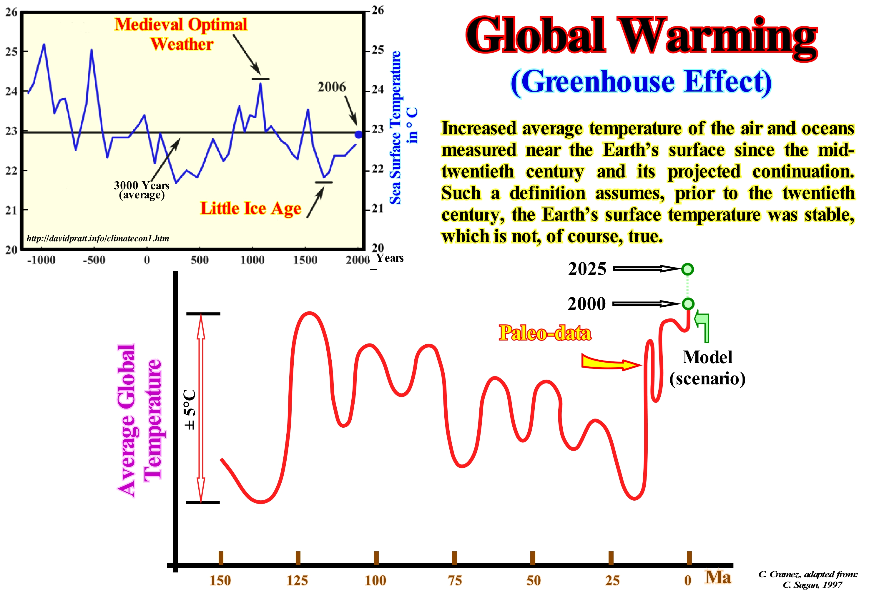
To avoid confusion on this subject it is quite important to take into account the duration and the magnitude of the climatic variations. Several geoscientists proposed the following hierarchization : (i) Pulsations (ii) Oscillations ; (iii) Fluctuations and (iv) Mutations. The pulsation last a few years or a few decades and which are perfectly reversible (e.g., series of years of raining or drought). The oscillations last from a few centuries to a few millennia, but are reversible (e.g., the Little Ice Age). The fluctuations, are spread out over tens, hundreds of thousands of years and have mark cyclic character (e.g., the evolution of the Quaternary). The mutationst last millions, tens or hundreds of millions of years and they have a irreversible character (e.g., irreversible upheavals of the Earth’s surface). On the other hand, using sea level or temperature averages, the measures must cover a long period to have certain meaning. Thus, the World Meteorological Organization (WMO) recommends that an average must cover a period of 30 years: from there one can speak of « normal ». As shown in this figure, the Earth global temperature varied between the glacial* and inter-glacial periods **. The range of variations between cold (glacial) and hot (inter-glacial) periods is about 5° C. The amplitude of the glacial and interglacial ages is, roughly, the same. The development of a glaciation is much slower than a deglaciation (melting epoch). About 50-100 ky are needed to develop a glacial age and just 15 ky to destroy it. Seven major glacial episodes occurred during the last 700 ka. The last important glacial age (***) occurred about 18 ka ago. At the end of this glaciation, the Earth average global temperature, calculated from fossil data, suggests an abnormally rapid rise, as can be seen in the lower diagram of this figure. From the year 2000 (end of the red solid line of the diagram), the advanced hypotheses (dashed line in green) are, extremely, pessimistic. Taking into account only: (i) The use of fossil fuels (combining fossil carbon with air oxygen and synthesizing CO2, which is a greenhouse gas) ; (ii) The destruction of forests (trees absorb CO2 into wood) and (iii) The respiration of living beings, about 7 billion (7 Giga = 7 x 10⁹) tons of CO2 are introduced into the atmosphere, every yea . However, the influence of CO2 on the Earth average global temperature is refuted by various types of observations. Likewise, the pessimism of certain official institutions seems very exaggerated. Stabilizing the climate is wanting to oppose natural climate change. It is like wanting to oppose the movement of tectonic plates, which provoke earthquakes and volcanic eruptions. Any geoscientist doubts climate changes. They have existed since the Earth's formation (around 4.5 Ga). What is evident today is that catastrophism over mineral resources and economic growth is politically incorrect, whereas climate catastrophism is very well viewed by the media and certain political men. The danger is the confusion of registers between it is and we must. The expert has a knowledge of is (Facts), but it does not give him the power of determining what must be or ought (legal norms). Otherwise, we’ll committed this naturalistic paralogism (« realistic fallacy ») denounced, already, by the English philosophy David Hume (1711 - 1776), i.e., one would slip from a speech declining on the mode of "it is" to a speech based on the affirmation "it is necessary or we need to ». Some geoscientists think and say, openly, that it is not the rise of CO2, which is putting Earth at great risk, but the failure of political and religious systems to evolve as, rapidly, as science.
(*) Or ice age corresponds to a geological period, more or less, long of low temperature characterized by the formation of ice caps, ice seas and glaciers, during which periods occur in very cold weather that certain geoscientists call glaciations.
(**) Geological time interval between two consecutive ice ages, with a higher average temperature, for at least several thousand years.
(***) Like all glaciations, the last ice age was interrupted by intervals in which there is less ice or even without ice. Generally, a glaciation is a time of great stress for life. All the environments change in a very drastic and abrupt way. The absolute (eustatic) sea level falls. Ice covers continental areas at high latitudes with significant thickness (2-3 km). The lakes extent increases (contracting as the amount of ice decreases). Tropical environments become less important towards the equator. Wind patterns and circulation in the oceans change, etc. The response of the biosphere to a glaciation is: (i) Migration ; (ii) Fragmentation of the population into small groups ; (iii) Increased isolation, etc., favouring an acceleration evolution (C. Emiliani, 1995).
Globigerina.......................................................................................................................................................................................................................Globigérine
Globigerina / Globigerina / Globigerina (Foraminiferen) / Globigerina(有孔虫) / Планктонная корненожка / Globigerina (foraminiferi) /
One of the organisms that form the group of globigerinas, which is one of the most common groups of foraminifera found in marine plankton. Globigerinas produce a hyaline limestone shell and are known since the Jurassic.
See: « Foraminifera »
&
« Jurassic »
&
« Paleontology »
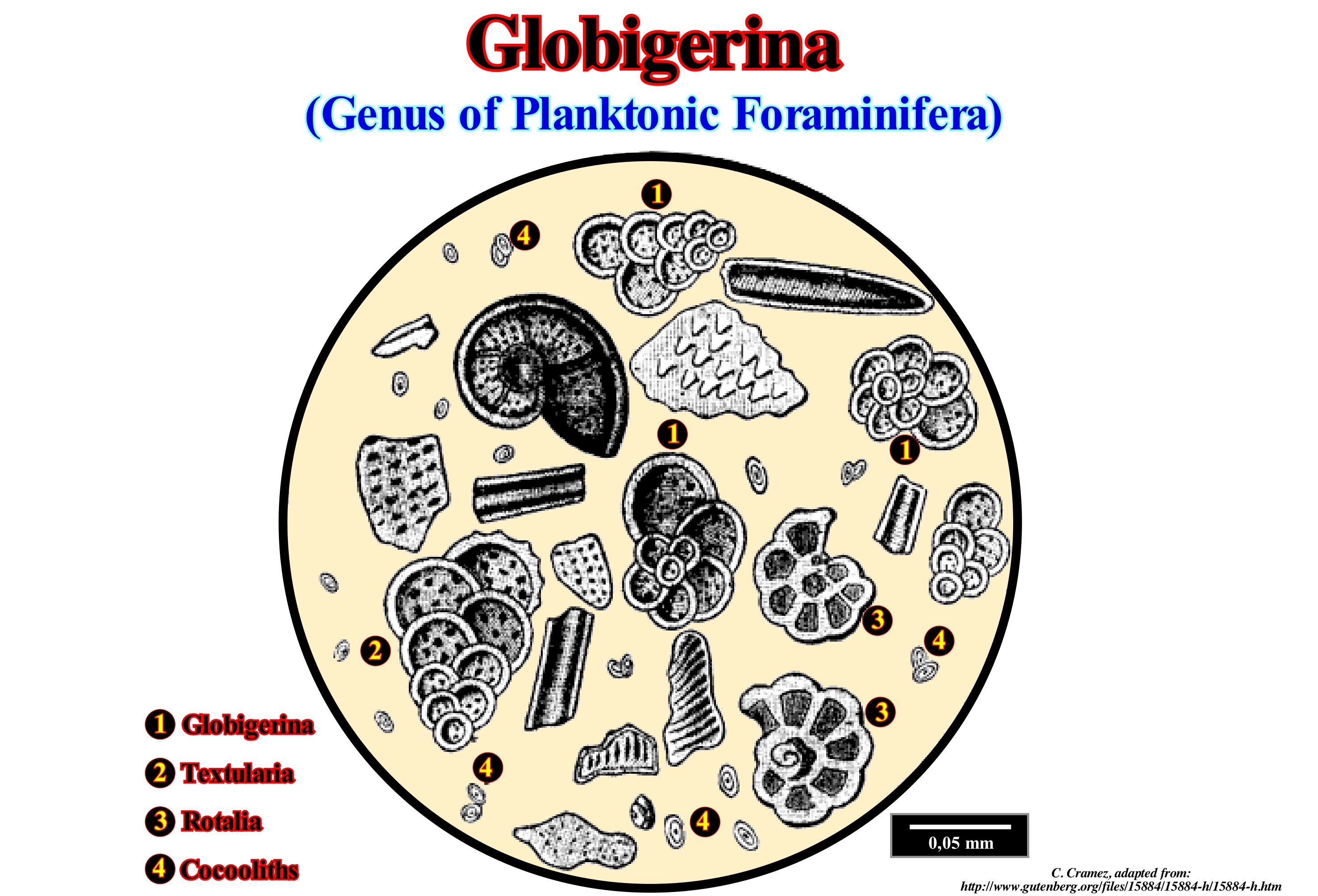
Globigerinas are a genus of marine protozoa, i.e., an unicellular marine organisms. The structure of globigerinas resembles that of amoeba. They have a very compartmentalized shell of calcium carbonate covered with thorns. The shell contains pores through which pseudopods project. Pseudopodis are extensions of the cytoplasm that globigerinas use for locomotion and food collection. The main food of globigerinas is plankton. Globigerinas live in large numbers near or to the surface of the sea. When they die, their shells slowly accumulate at the bottom of the sea, forming layers of fine mud, which geoscientists call globigerinas ooze. This mud solidifies slowly in chalk, which is a finely grained form of limestone. The chalk cliffs of England and France, and many limestone peaks in North America, are largely made up of globigerinas muds. Globigerinas belong to the foraminifera group (considered an order by some biologists and a phylum by others). Some geoscientists admit the shells of globigerinas, and particularly bulloid globigerinas, are becoming smaller and smaller. They explain such a fact, as the result of slow acidification of ocean waters, especially near Antarctica. The reason for this increased acidity is the increase in the carbon dioxide (CO2) content in the atmosphere. The evolution of these shells would be proof that climate change are making life at sea harder for shell builders. Certain geoscientists think modern bulloid globigerinas do not build shells as large as their ancestors formed a century ago. For them, modern shells are about 35% smaller than in the recent past (averaging 17.4 μg, compared to 26.8 μg before industrialization). However, they all know that in the past there have been changes in the carbonate chemistry at the surface of the ocean associated with the glacial cycles, and that these changes were of a magnitude similar to those observed today, which they consider anthropogenic.
Goguel's Law...........................................................................................................................................................................................................Loi de Goguel
Lei de Goguel / Ley de Goguel / Goguel-Gesetz / Goguel的法律 / Закон Гогеля / Legge di Goguel /
During deformation, the volume of the sediment remains more or less constant. This hypothesis, although very old, took a very important place in geology with the works of Goguel (1954), who introduced the second principle of thermodynamics in geology and in particular in tectonics. This conjecture is approximate. It does not take into account the volume reduction induced by the decrease in porosity at depth and by dissolution phenomena, which may in some cases reach about 30% of the total volume. Before Goguel, in 1933, Lindgreen introduced the same conjecture in mining geology suggesting during the formation of an ore, by substitution, there is no change in volume or shape of the rock (law of equal volumes).
See: « Geological Principle »
&
« Palinspatic Section »
&
« Geological Section »
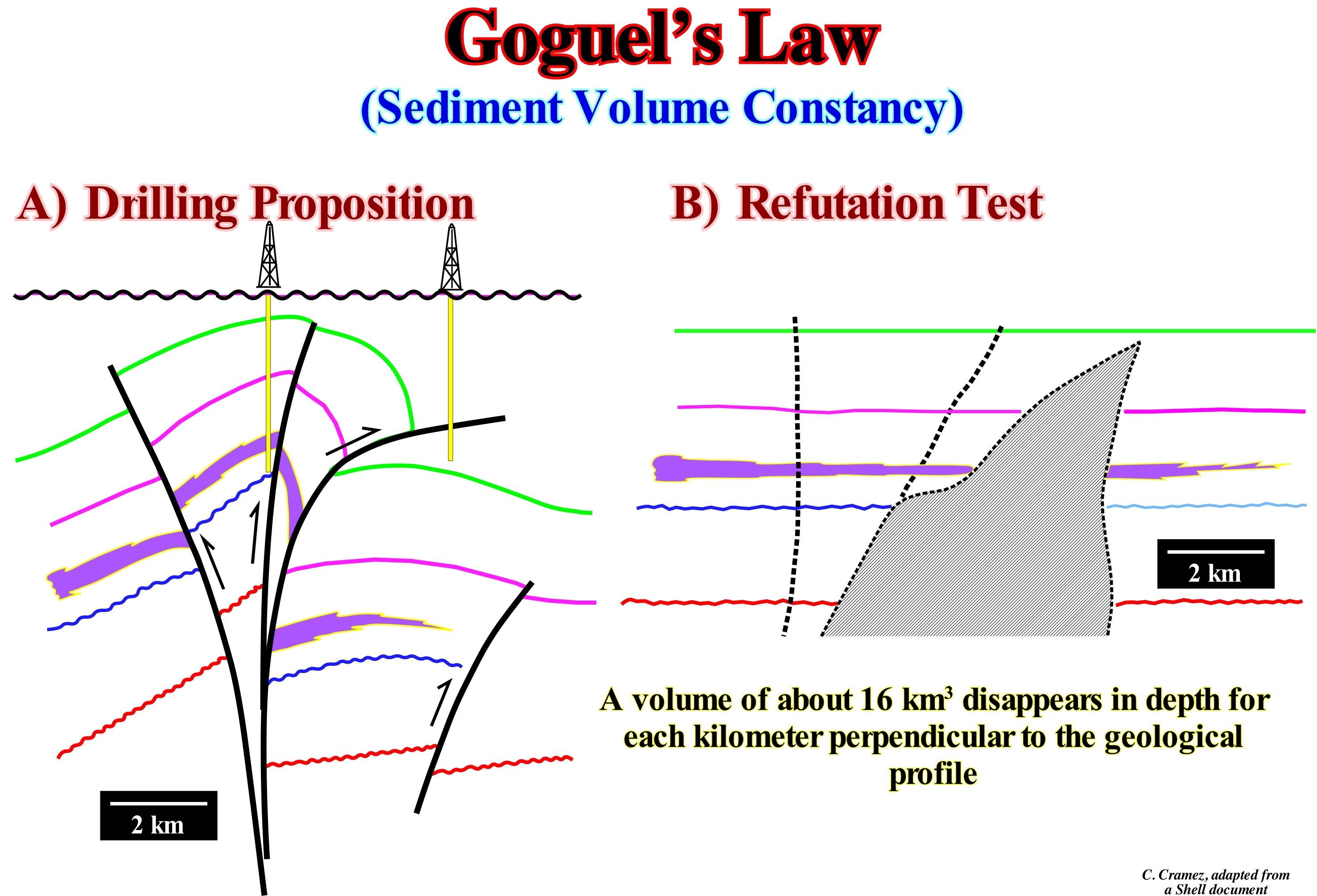
The sketch on the left represents a tentative geological interpretation of seismic line shot in an area where there are no lateral tectonic movements. The tectonic regime of this area is characterized by an ellipsoid of the effective stresses (sum of the geostatic pressure σg, hydrostatic pressure or pore pressure σp and the tectonic vector σt) with the main axis (σ1) horizontal and the smallest axis (σ3) vertical . This means the structures shortening the sediments are, mainly, cylindrical anticlines and reverse faults (absence of strike slip faults). If this is true, then the proposed tentative interpretation is wrong. The interpreter did not respect Goguel's law, which says during deformation, taking into account the compaction and the dissolution, the volume of sediment remains, more or less, constant. As emphasized by the refutation test (sketch on the right part of this figure), such tentative interpretation implies, during the shortening of the sediments, the vanishing of about 16 km3 of sediments per kilometre perpendicular to the seismic line. If the upper horizon (coloured in green) is horizontalized, a space is created between the other horizons, which increases with depth, which means that horizons have not been shortened in the same way. On the other hand, nature has a horror of emptiness. Thus, this tentative interpretation is very unlikely. It does not respect one of the basic principles of geology. Do not forget that there are neither good nor bad geological interpretations of seismic lines, but just tentative interpretations that resist better than others to refutation tests. Adopting the scientific approach followed by the vast majority of geoscientists (there are still some verificationists*), since this tentative geological interpretation is refuted, another tentative must be proposed better respecting Goguel's law. Then the new tentative interpretation must be subjected to a new refutation test and so on. In geology, as in any other science, the most likely tentative interpretation (there are no true interpretations) is the one that best withstands falsification (or refutation) tests. It is clear that Goguel's law is not exact. The loss of rock volume by compaction and by dissolution can be quite significant. Dissolution of certain minerals may be important. In limestone rocks, the dissolution can reach about 35% of the total rock volume. Errors like the one illustrated in this figure were very frequent a few years ago when the "flower structures" of Exxon's geoscientists were in vogue. At present-time, practically, all geoscientists know that a flower structure is, in most cases, a reactivation, in compression, of an older extensional structure. In the geological interpretation of the seismic lines, in addition to the law of Goguel, other geological laws must always be used: (a) Steno's law, which says the sedimentary layers are deposited in relation to time, i.e., the oldest in the bottom and most recent at the top (this law is fundamental to the interpretation of Earth's history ; it indicates the relative age of the layers and fossils they contain) ; (b) Walther's law says in continuity of sedimentation, a lateral succession of systems of deposition is also vertically that is, if laterally, seaward, is the sequence a, b, c, vertically, and from the bottom up, there will be c, b, a ; (c) law or Original Horizontality Law says sedimentary layers are deposited horizontally ; (d) Original Lateral Continuity Law according which the sedimentary layers settle in lateral continuity thinning down to zero or end by downlaps or onlaps against the edges of the original sectors of deposition ; (e) Intrusion Law says the relative age between two igneous rocks, or between an igneous rock and a sedimentary rock, can be deduced by the geometrical relations between them: "An intrusive igneous rock is younger than the one it penetrates " ; (f) Ochkam's Law says plurality should not be invoked without necessity ("Pluritas non est ponenda sine necessitate"), etc., etc.
(*) A verificationist is the term used in opposition to falsificationist. If the latter looks for observation data to try to refute, and replace the initial hypothesis (if failure to refute the initial hypothesis is reinforced), a verificationist attempts to add observation data to corroborate the initial hypothesis, which is inductively consolidated. The concepts of falsificationism and verificationism are part of the problem of inductivism, which is due to the fact that nothing can be said of universal from the data of observation. According to K. Popper, the true scientific attitude, which contrasts with the dogmatic attitude of seeking to verify its own theories, is the critical attitude, which does not seek evidence to prove its hypothesis, but seeks to make criticisms that may refute the initial hypothesis.
Goguel's Principle......................................................................................................................................................................................Principe de Goguel
.Princípio de Goguel / Principio de Goguel / Prinzip Goguel / Goguel原则 / Принцип Гогеля / Principio di Goguel /
During deformation, the volume of the sediment remains more or less constant. This principle, although very old, took a very important place in geology with the works of Goguel (1954), who introduced the second principle of thermodynamics in Geology and in particular in Tectonics. The Goguel's principle is, relatively, approximate. It does not take into account the volume reduction induced by the decrease in porosity with depth and dissolution phenomena, which in some exceptional cases may reach 30% of the total volume. In 1933, Lindgreen introduced the same principle in mining geology, suggesting that during the formation of a replacement ore, there is no change in volume or shape of the rock (law of equal volumes).
See: « Corrasion »
&
« Geological Principle »
&
« Plate Tectonics Theory »

This principle, although very old, took a very important place in geology with the works of Goguel (1954), which introduced the first principle of thermodynamics (energy can not be created or destroyed, but just transformed from one species to another) in geology and, in particular, in tectonics. The Goguel principle is, relatively, approximate. It does not take into account the volume reduction induced by the decrease in porosity with depth and the dissolution phenomena (stylolization *), which can, exceptionally, reach 30-40 % of total volume. The tentative geological interpretation of a Canvas auto-trace of a detail of a Tunisia onshore seismic line, shot in an area where there are no significant strike slip faults, proposed in this figure is, completely, refuted by the Goguel principle. In such a tentative, a large amount of sediment disappear during deformation. The violet, red, green and blue seismic reflectors are shortened in different amounts. This suggests the fault picking which, probably, wrong. The lower seismic horizons (red and violet) are much shortened than the upper ones (green and blue). Most likely, the dip of the fault planes of the two major is not correct. The fault planes become more or less horizontal around 2 seconds depth (t.w.t.). Such fault plane flattening allows, in large part, explain the different shortenings (presence of a detachment plane, more or less horizontal). Besides this principle, in Geology there are many other principles or hypotheses, among which we can mention: (i) Composition Principle says: a rock represented by fragments in another rock is older than the rock that contains them ; (ii) Carbonated Bucket Principle says: the growth architecture of a fringed carbonate platform resembles the geometry of a bucket or inverted cone trunk ; (iii) Original Horizontality Principle states: sedimentary layers deposit horizontally (not totally true) ; (iv) Intersection Principle says: recent dikes (veins) displace older dikes ; (v) Intrusion Principle says: an intrusive igneous rock is younger than the rock it penetrates ; (vi) Superposition or Stacking Principle says: in a slightly deformed sedimentary series, the oldest layers are at the base and the most recent above ; (vii) Ochkam's Principle says: plurality should not be invoked without necessity ; (viii) Original Lateral Continuity Principle states: the sedimentary layers are deposited in lateral continuity ; (ix) Walther's Principle says: in conforming strata, vertically succeeding facies occur laterally in adjacent environments ; (x) Dextrogyre Principle says: if a reference system rotates clockwise the deflection (Coriolis effect) is to the left of the object, in the direction of motion ; (xi) Uniformitarianism Principle says: geological changes are due, mainly, to the same continuous processes and changes that are observed today ; (xii) Fossil Succession Principle says: the distribution of fossils in rocks is not unpredictable, it follows a definite vertical sequence ; (xiii) Catastrophic Principle says: changes occurring in Earth were due to the occurrence of major natural catastrophes ; (xiii) Continental Drifting Principle says: continental masses have a small density and, therefore, floated on the dense masses of ocean, moving and changing the surface of the planet ; (xiv) Neocatastrophism Principle admits Uniformitarianism as the main guide, but does not exclude that occasional catastrophic phenomena may have contributed to eventual changes in the Earth's surface, i.e., Neo-catastrophism associates catastrophic and Uniformitarianism ideas to explain certain phenomena such as the extinction of dinosaurs, etc.
(*) Formation of irregular contacts similar welds, which the geoscientists call stylolites, produced by the dissolution under pressure of a rock under deep burial conditions. Stylolization is most, often, found in limestone rocks. I can be, readily, recognized by the concentration of insoluble clayey residues along the surface of stylolites. Up to 40% of the original thickness of a limestone interval can be dissolved by the stylolization.
Glossifungite............................................................................................................................................................................................................Glossifungite
Glossifungito / Glosifungito / Glossifungita (ichnofacies) / Glossifungite(遗迹相) / Глоссифунгит / Glossifungite (ichnofacies) /
A set of bioperforations (vertical, U-shaped or finely branched) occurring in more or less consistent, but not lithified, sediments, either in sandstones, carbonate marls or siltstones, in the shallow water coastal zone and in particular in the intra-tidal area. The surfaces on which Glossifungites occur are formed during: (i) A regression of the sea; (ii) A drop in sea level or (iii) After an initial transgressive phase which ends with a period of lowstand.
See: « Benthos »
&
« Marine Regression »
&
« Relative Sea level Fall »
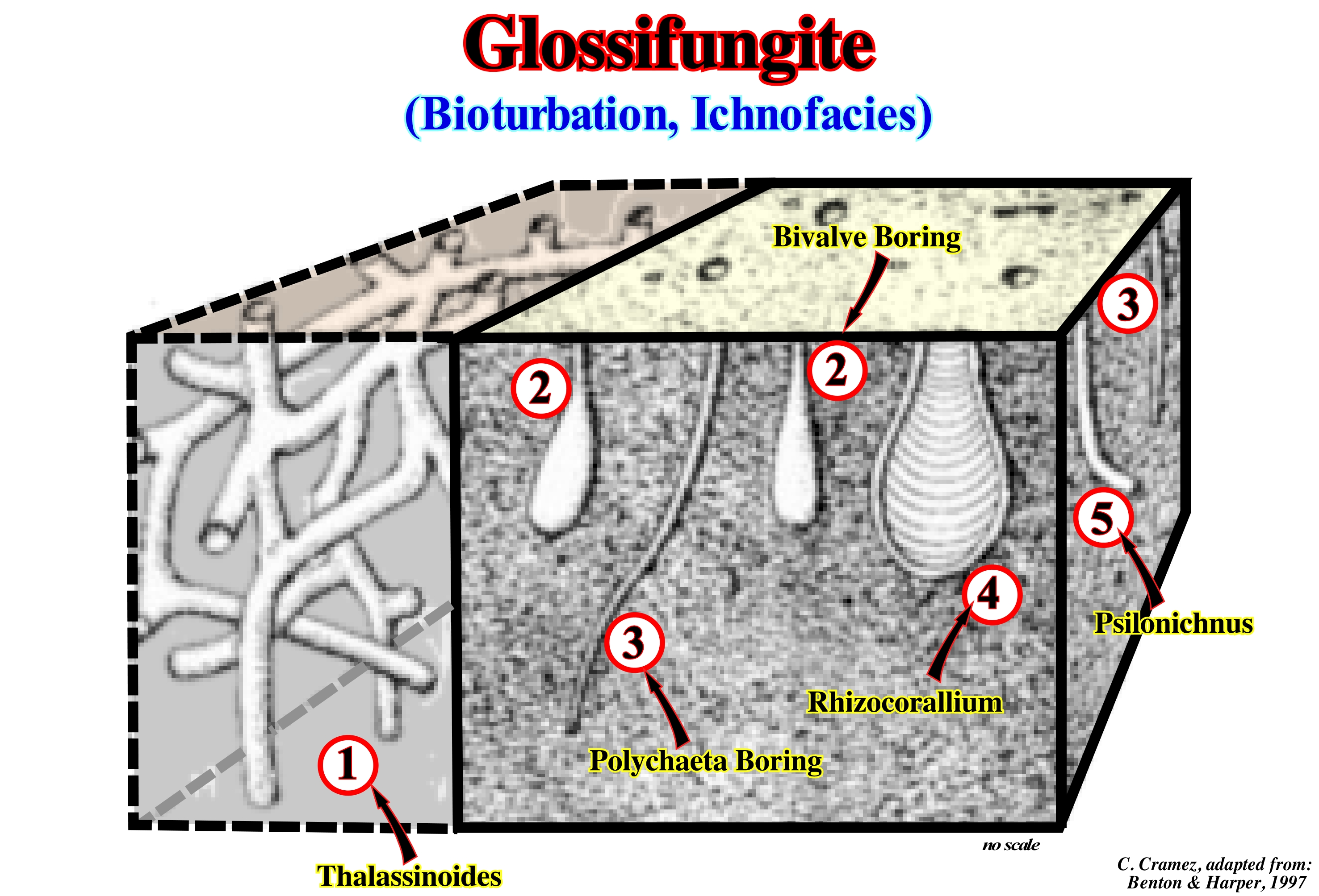
The main types of glossifungites were summarized by Benton and Harper (1997) as illustrated in this figure: (i) Thalassinoides ; (ii) Bivalve Borings (molluscs with two-part and symmetrical shells along the axis and joint) ; (iii) Polychaeta Borings (marine annelids) ; (iv) Rhizocorallium and (v) Psilonichnus. Thalassinoides are tunnels with many branches dug by small crustaceans with a diameter ranging between 2 and 5 cm and oriented, more or less, parallel to the bedding planes. Thalassinoides are very abundant from the Jurassic. Rhizocorallium are sloping and long but, relatively, narrow tunnels dipping between 10° and 15° with respect to the bedding planes. Rhizocorallium are, probably, carved out by nematodes (unsegmented, cylindrical, elongated, tapeworms that taper at the ends) to look for food. The Psilonichnus are, more or less, vertical tunnels exhibiting, often, an inverted Y-shaped branching. They are interpreted to have been the residences of certain arthropods (invertebrate animals, which have articulated appendages, segmented bodies and rigid skeletons), such as the porcelain crab. In the field and especially in the basins where the sediments were shortened, i.e., more or less deformed by a compressional tectonic regime, the Glossifungites are a good geopectal criterion (in the field, a geoscientist can infer the original top of a stratum). Their orientation allows one to determine if the layers where they lie are in the original depositional position or if they were inverted by a compressional tectonic regime.
Glyptolith.................................................................................................................................................................................................................................Glyptolithe
Gliptólito / Gliptolito / Glyptolith (Erosion) / Glyptolith(侵蚀) / Источенный ветром камень / Glyptolithe (erosione) /
Term proposed by Woodworth to designate blocks of a rock carved by the wind (wind ablation). Glyptogenesis is the sculpture of the Earth's surface by erosion. Synonym with Ventifact.
See: « Erosion »
&
« Desert »
&
« Sedimentary Environment »
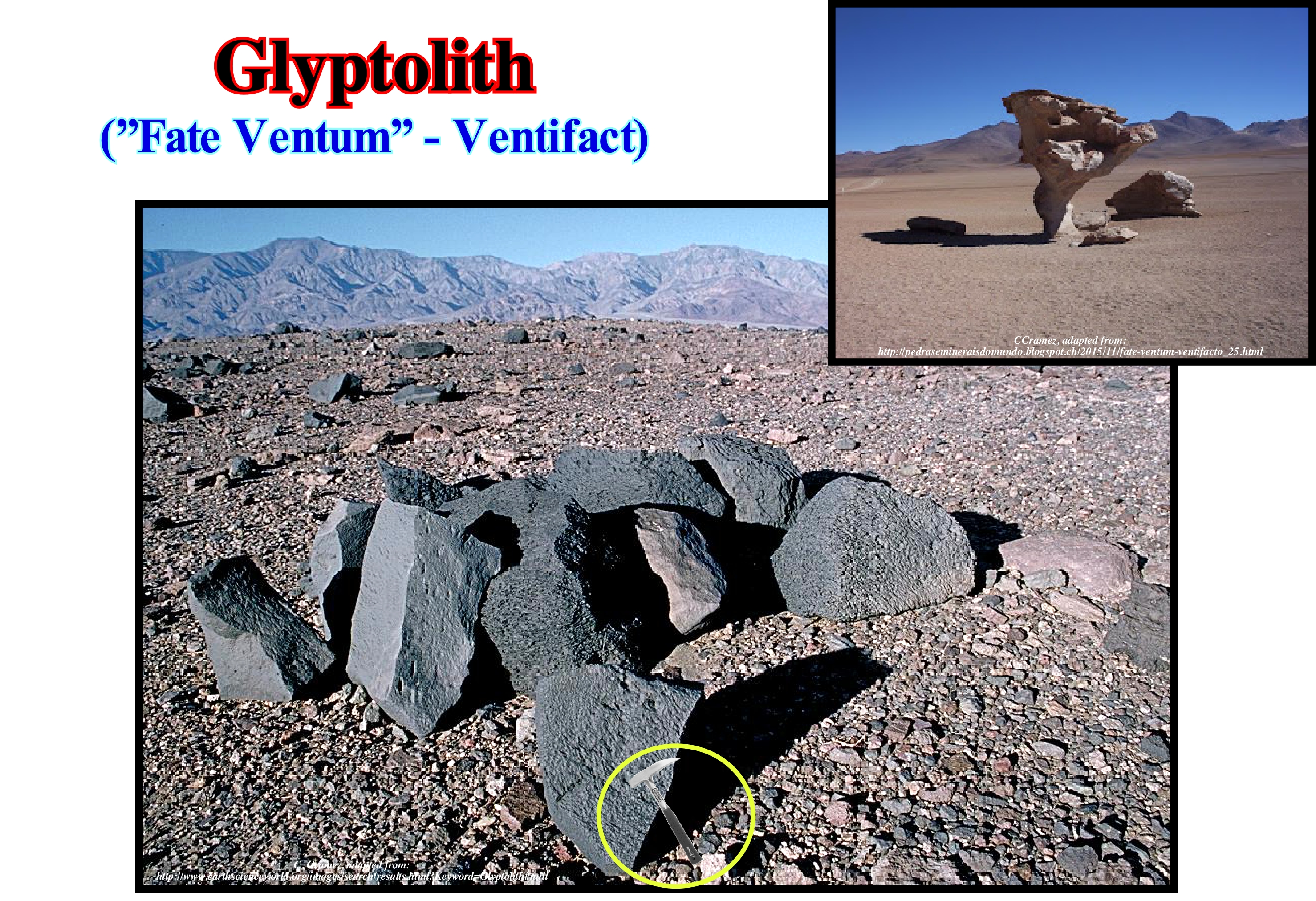
According to https://link.springer.com/referenceworkentry/10.1007%2F978-1-4020-3995-9_617, a wind‐abraded pebble or boulder, a glyptolith or ventifact is distinctly faceted on one or more sides and is used by geologists as a diagnostic marker of an ancient climatic condition when powerful winds drove silt or sand as abrasive agents. They are often associated with soil surfaces in periglacial landscapes. The term “ventifact” was first introducedin 1911 by Evans, J.W. (Dreikanter, Geol. Mag., 8: 334–335)to replace a confusing array of German terms such as “windkanter” and “dreikanter” (3‐sided), and even “glyptolith” (for sculpted rock). The entry for “Ventifact” receives no less than eight citations in the Encyclopedia of Geomorphology*. A review and bibliography was provided by Bryan** and experimental forms were demonstrated by Schoewe (***). Contemporary examples were observed in the deserts of southern Iraq (Sugden****). general, most geoscientists now recognize that Glyptogenesis is the formation of a relief after its destruction by erosive agents. A glyptolith may be considered in a broader sense than Woolworth admired, as a block resulting from glyptogenesis. Examples sedimentation and glyptogenesis cycles were recently studied in NW of Portugal (region of Minho) by Caetano Alves and Pereira (2000), who summarized the main sedimentation and glyptogenesis episodes of the Cenozoic in the following way: "The oldest traces of Cenozoic sedimentation are related to exorheic drainage networks and occur in the dependence of these valleys. It is assumed that this filling has occurred in the Placencian. They were ravaged by the first episode of Quaternary glyptogenesis (Middle Ante-Pleistocene). Three more cycles of quaternary glyptogenesis/sedimentation were identified, responsible for the incised enhanced of the river of this area. The trigged regressive erosion led to the capture of the Man River to the Cávado river and, also, by capture, the deviation from the mouth of the river Neiva to the current position These captures allowed the conservation of Alvarães deposits. The sedimentary composition of the last cycle clogging is different from the previous ones; includes some alterable and / or lesser altered rock particles and minerals, higher illite content and inter-stratified. This last excavation of the river valleys occurred during the last glacial period. There were also other episodes of smaller amplitude, which modelled levels embedded in the larger cycles, originated mainly by climatic oscillations; the evidence of tectonic movements was observed only in the Minho River valley. Evidently, most of the incised valleys identified by these authors underscore disagreements that limit the stratigraphic cycles associated with high-frequency eustatic cycles (100 and 500 My) induced by Plio/Pleistocene glacio-eustasy, responsible for the alternation of geological conditions of high and low level of the sea.
(*) Fairbridge, R.W., 1968. The Encyclopedia of Geomorphology. New York: Van Nostrand Reinhold, 1295 pp.
(**) Bryan, K., 1931. Wind worn stones or ventifacts: a discussion and bibliography. Rept. Comm. Sedimentation, 1929–1930. Natl Res. Council Cir., 98: 29–50.
(***) Schoewe, W.H., 1932. Experiments on the formation of wind‐faceted pebbles. Am. J. Sci., 24: 111–134.
(****) Sugden, W., 1964. Origin of faceted pebbles in some Recent desert sediments of southern Iraq. Sedimentology, 3: 65–74.
Gondwana................................................................................................................................................................................................................................Gondwana
Gondwana / Gondwana / Gondwana / 冈瓦那大陆 / Гондвана / Gondwana /
Small supercontinent south of Pangea at the end of the Permian. The term Gondwana means "Land of the Gonds" (people of the Indian sub-continent), that is to says the term "Gondwanaland", found in many books and publications, is a tautology.
See : « Supercontinent »
&
« A-Type Subduction (Ampferer) »
&
« Rodhinia »
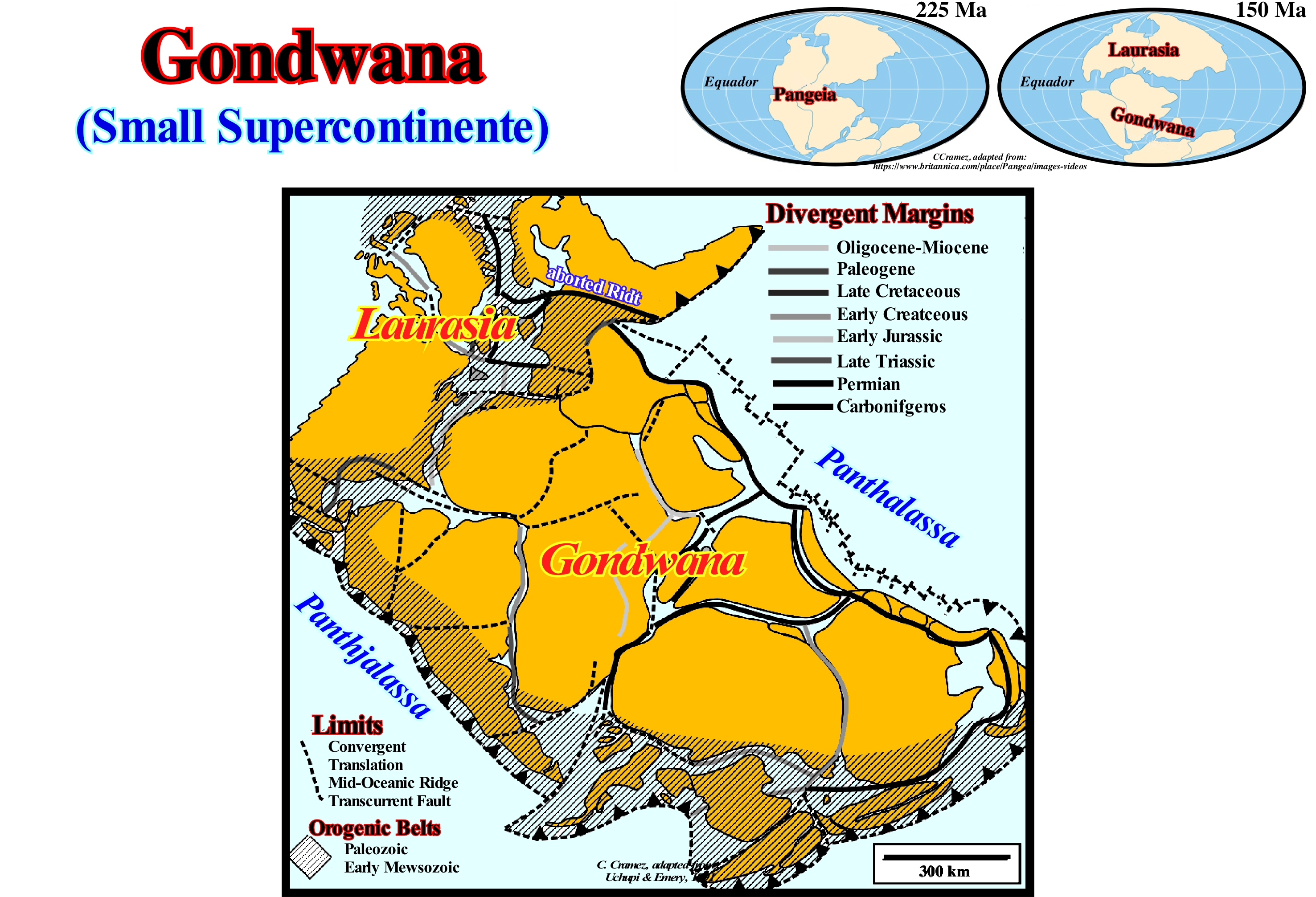
In this paleogeographic sketch at the beginning of the Triassic, when the whole continental mass was surrounded by a single ocean, called Panthalassa, which in Greek means "all seas together", shows the distribution and the most probable ages of major fracture zones (rift-type basins) along which the supercontinent Pangea* broke. Two large crustal fragments are evident: (i) The small supercontinent Laurasia, located in the northern part of the supercontinent Pangea and (ii) The small supercontinent Gondwana, in the South. Each of these continental fragments fractured into several continents separating from each other by ocean expansion or sea floor spreading (new oceanic crust formation along mid oceanic dorsal ridges). In the borders of the continents divergent continental margins formed. They fossilize the rift-type basins, created during the rifting phase which preceded the break-up of the supercontinent lithosphere. When the supercontinent Pangea (junction of two Greek terms "pan", which means together and "Geia" or Gaia which is the Earth Goddess) formed, the Panthalassa sea level was very low. The volume of the oceanic basins was very large, since the number of lithospheric plates was very small, as well as, the volume of the oceanic mountains (assuming the amount of water, in all its forms, has been constant since 4.5 Ga, i.e., since Earth's formation). The continents individualized by the break-up of the small supercontinents Gondwana and Laurasia began to disperse and move away from each other. The volume of the ocean basins has decreased due to the formation of the oceanic ridges, i.e. the volume of the oceanic mountains and the amount of oceanic crust increased. The volume decreasing of the oceanic basins caused a rise of the absolute (eustatic) sea level, The continents were flooded with formation of continental shelves on which transgressive sedimentary intervals, characterized by a retrogradational geometry, deposited. The deposition occurred during the stability periods of the relative sea level following the marine ingression increments. The absolute (eustatic) sea level is global and referenced to the Earth's centre. It is the result of the combination of: (i) Tectono-Eustasy that is controlled by the volume variation of the oceanic basins, in association with oceanic expansion following the break-up of the supercontinents ; (ii) Glacio-Eustasy, which is controlled by the variation of ocean water volume as a function of the amount of ice ; (iii) Geoidal-Eustasy, which is controlled by the distribution of ocean water caused by variations in the Earth gravity field and (iv) Thermal dilation of the oceans or Steric sea level rise. In 1992, Cesare Emiliani ** gave the name "transgressions" to the set of increasingly important marine ingressions and associated increasingly smaller sedimentary regressions that, collectively, create an overall retrogradational geometry. At the level of a sequence-cycle, this means not only the clastic sediments come from the continent but, also, the deposition of progradational sediments, forming transgressive intervals (sequence-paracycles) during the stability period of the relative sea level (***), follow each of the relative sea level rises (in acceleration). Between, the successive increments of a marine ingression, there is any relative sea level fall. Otherwise, the marine ingression increments would be eustatic cycles and not eustatic paracycles. Although on the seismic data the progradational geometry (sedimentary regression) of the sequence-paracycles is, sometimes, difficult to recognize (due to the seismic resolution), it is evident in the drilling cores of such intervals. According to E.C. Emiliani, the major global marine transgressions are: A) Middle Miocene (13 Ma), the absolute sea level rise ± 135 metres ; B) Late Cretaceous (70-90 Ma), the absolute sea level rise ± 350 metres ; C) Early Ordovician (480-505 Ma),the absolute sea level rise ± 350 meters. The main absolute sea level falls occurred in the Pleistocene (0-3 Ma), during which the absolute sea level fall ± 120 m, Late Oligocene (30 Ma), during which the absolute sea level fall ± 200 m and Early Jurassic (190 Ma) with an eustatic sea level fall of about 165 meters.
(*) In Earth's history, geoscientists consider: (i) Supercontinents such as Rodhinia (Proto-Pangea) and Pangea ; (ii) Small supercontinents, such as Laurasia and Gondwana, and (iii) Continents such as Baltica, Laurentia, Siberia, etc. Certain geoscientists besides this old land mass consider, also, in a speculative way, future mass of land such as: Amasia (possible, future supercontinent that could be formed by the merger of Asia and North America), Neo-Pangea or Ultime Pangea (is a possible future supercontinent configuration that could occur within the next 250 million years).
(**) Cesare Emiliani, 1992- Planet Earth, Cosmology, Geology, and the Evolution of Life and Environment, Cambridge University Press. ISBN 0-521-40123-2-
(***) Relative sea level is the main responsible for the marine ingressions at the hierarchical level of the sequence-cycles. A the level of the continental encroachment cycles and sub-cycles the main responsible of marine ingressions is the absolute or eustatic sea level.
Gondwanaland.............................................................................................................................................................................Terre de Gondwana
Terra de Gondwana / Tierra de Gondwana / Gondwanaland / 冈瓦纳大陆 / Гондвана / Terra di Gondwana /
Tautology to designate the small southern supercontinent of Pangea, which existed between about 500 and 200 Ma (Paleozoic and early Mesozoic). Gondwana means "Land of Gonds" (people of central India). Gondwana included not only most of the continents that are now found in the Southern Hemisphere, such as Antarctica, South America, Africa, Madagascar, Australia-New Guinea and New Zealand, but also Arabia and India that are now in the hemisphere North.
See : « Supercontinent »
&
« Continental Collision »
&
« Pangea »
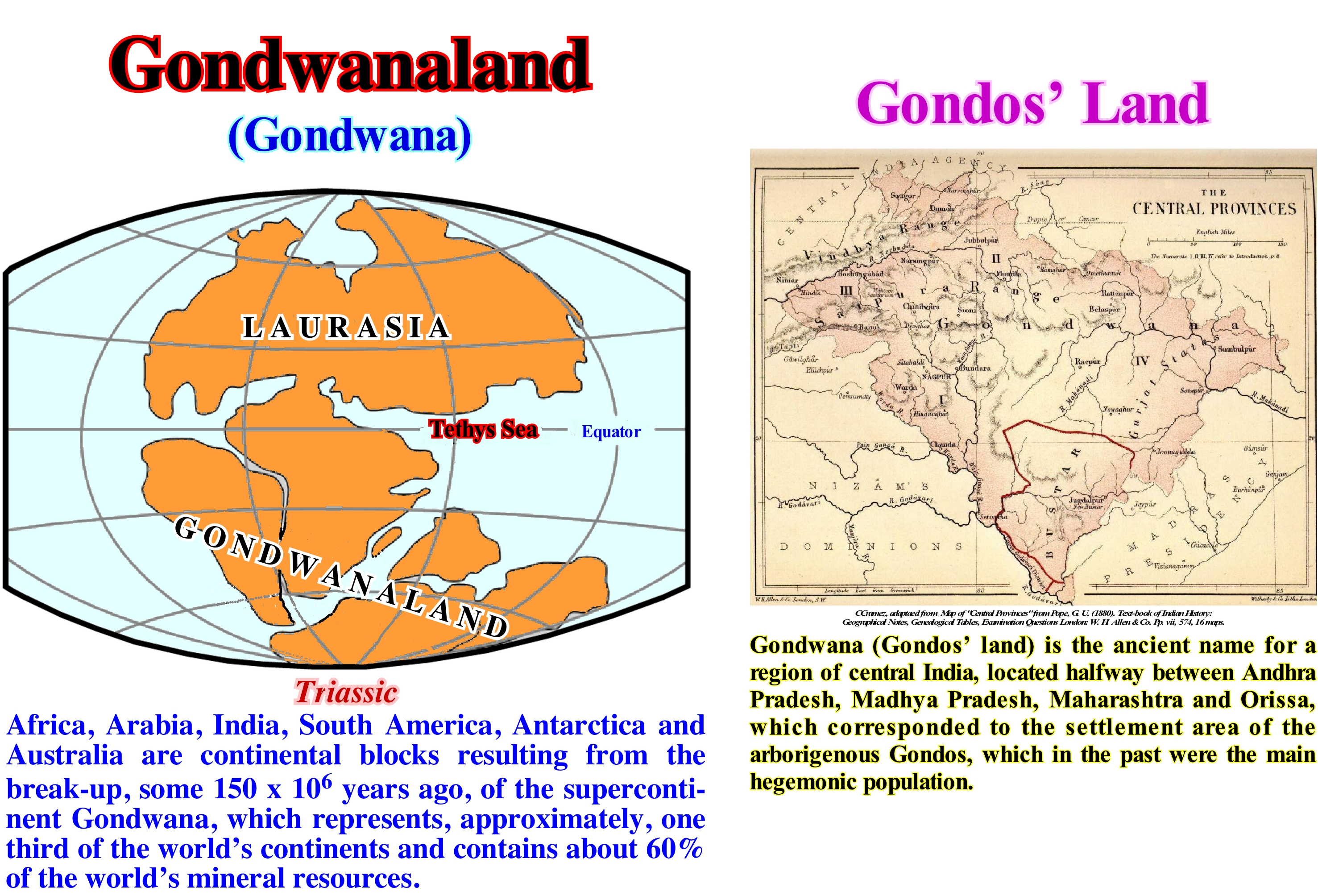
In the Permian / Triassic, almost all of the emerging land was clustered into a supercontinent (almost the same as a continent, except that they are the same present-time continents that millions of years ago, when they had otherwise, were more or less agglutinated), which geoscientists called Pangea supercontinent, which in Greek means "the whole earth." The continental mass of the Pangea supercontinent, rich in uranium, thorium and potassium, functioned as a warm cover that prevented the internal Earth heat from dissipating. The accumulation of this heat created an intumescence (thermal anomaly) in the central part of the Pangea, which, locally, lengthened by normal faulting. Such a lengthening thinned the lithosphere, facilitating the injection of material from the Earth sublithospheric mantle*. The injection, progressively, fractured the lithosphere initiating a sub-aerial expansion between the individualized blocks or continents. Fractures propagated along the axes of intumescence separating North America from North Africa about 180 million years ago, and from Europe about 150 Ma. As illustrated in this figure, it can be said, at first, the Pangea fractured into two large continental masses: (i) The small Laurasia supercontinent, which formed the northern continental mass and (ii) The small Gondwana supercontinent, which formed the southern continental mass. The small Gondwana supercontinent included what is now called Antarctica, which was, more or less, linked to South America, Africa, India and Australia. In turn, these two large continental masses (Laurasia and Gondwana) continued to fracture into small continents that moved away from each other by oceanic expansion (sea floor spreading) until they occupied the temporary positions they have today. The term Gondwana was proposed by the geoscientist Eduard Suess (1883). He took it from a region of India, where the fossil plant Glossopteris was found. Suess knowing this plant had been found not only in India but in South America, South Africa, Australia and Antarctica as well, suggested, that in the geological past, all these areas were clustered together in a large continental mass, which he called Gondwana. Gondwana was a very hot and dry continent with intense rainy seasons, where the first ferns and conifers appeared. However, as early as, 1858, the geographer Antonio Sneider-Pellegrini had illustrated, on two maps, the hypothesis that the American and African continents were in the geological past together before separating later. At the beginning of the twentieth century, Alfred Wegener advanced the hypothesis that a large continent, which he called Pangea, existed before it fractured, at the beginning of the Mesozoic, and that the individual fragments of the continent separated from each other, or less, to the Present. In this hypothesis, which the geoscientists called the continental drift, Wegener admitted the Pangea supercontinent began to break around 225/200 million years ago. Pangea has fragmented, more or less, in the continents that we know today. Wegener's hypothesis was based, primarily, on the fact that, for him, South America and Africa have complementary coastlines, which had already been advanced three centuries earlier by Abraham Ortelius (1585). The Gondwana small supercontinent fractured during the Jurassic, about 160 million years ago, when an mid oceanic ridge formed between Africa and India. Around 125 Ma, India was individualized and then New Zealand (80 Ma). At the beginning of the Cenozoic, the Australian block and New Guinea separated, gradually, moving northward, that turning on itself, allowed the connection with the longer Gondwana. India collided with Asia, around 45 Ma forming the Himalayas. At the same time, southern Australia (now Tasmania) separated from the Antarctic allowing the formation of ocean currents between them, producing a colder and drier climate.
(*) The internal Earth's structure can be described from the petrographic and rheological point of view. From the petrographic point of view, the Earth can be divided into three concentric envelopes: (i) Crust, which may be continental or volcanic (sub-air and oceanic) ; (ii) Mantle, whose upper limit is underscored by Mohorovičić discontinuity (4-70 km); can be divided into upper mantle (up to isothermal 1350 ° C) and sublithospheric mantle, which comprises a part of the upper and lower mantle whose base is located about 2,900 km deep and (iii) Core, which is composed of mainly by iron and nickel and that can be divided into a solid internal part and a liquid external one. From a rheological point of view, the Earth is divided into four large zones: (a) Lithosphere, which is the rigid outer layer and which has a thickness between 80 and 150 km, whose lower limit corresponds roughly to the low zone velocity of seismic waves (vp and SVG) ; the lithosphere is formed by the crust and mantle above the isothermal 1,350° C ; (b) Asthenosphere, which corresponds to the upper mantle, is a less rigid layer than the lithosphere and can deform by flow; the lower boundary of the asthenosphere is poorly marked but appears to be no more than 350 km depth ; (c) Mesosphere, which corresponds to the lower part of the upper mantle (below ± 350 km ± mantle) and the lower mantle, has its base more or less 2,900 km deep and (iv) Core, which is limited between about 2,900 km depth and the Earth's centre (± 6,370 km depth). The outer part of the core is liquid and the inner part is solid.
Gorge (Topography)...............................................................................................................................................................................................Gorge (Topographie)
Garganta / Garganta (topografia) / Schlucht (Tal eingelöst) / 峡谷(谷兑现) / Ущелье (узкий проход) / Gola, Gorge (valle incassato) /
Deep and narrow valley along which a permanent or intermittent river flows. A gorge is, sometimes, referred to as river canyon or river narrow pass.
See: « River »
&
« Alluvial »
&
« Cave »
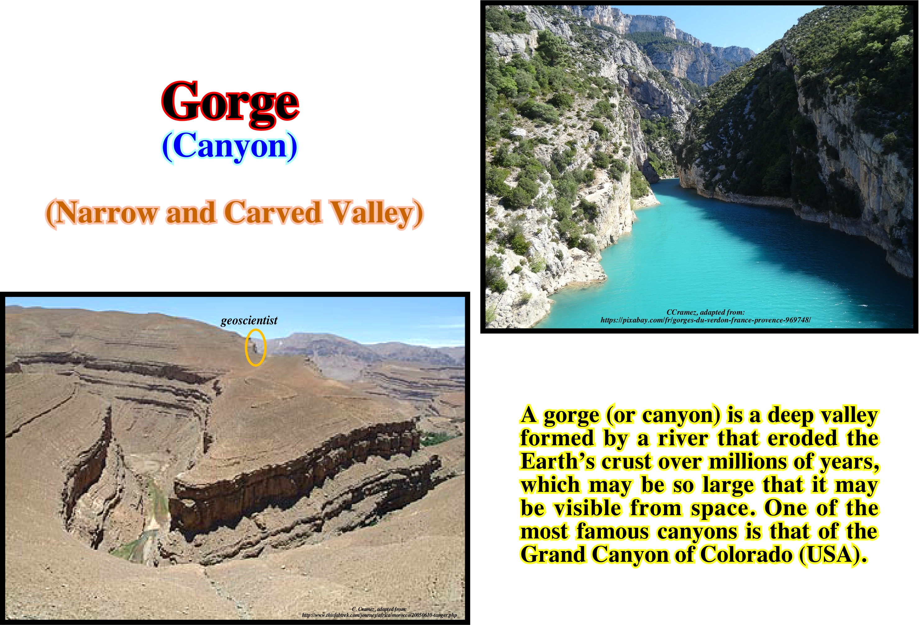
As illustrated in the lower photograph (Morocco), a river gorge (canyon or pass) is a deep valley with, more or less, abrupt walls dug in the rocks by a river, along which the meander valleys are predominant. Almost all the gorges are formed by a long process of erosion, by a river, of a region with a, more or less, flat topography. In this example, it is easy to see (by the dip of strata) that originally the terrain corresponded to a slightly inclined plateau. In general, most strata are resistant to erosion. More the walls of a gorge are vertical (in this example the walls of the gorge are less inclined where the strata are less resistant). Gorges are much more frequent in arid regions than in wetlands. It arid areas, rocks and soils decomposition and direct contact with the atmosphere (weathering) are more important than in non-arid regions. Weathering can occur in situ (without any movement). It should not be confused with erosion (transport, generally, downhill of sedimentary particles, rocks, soils by erosional agents). Erosion involves movement of rocks and minerals by erosion agents such as water, ice, wind and gravity. Although both processes, i.e., erosion and weathering can act at the same time. In terms of sequential stratigraphy, many gorges correspond to incised valleys which emphasize, in the upper continental slope and upstream of the basin edge and particularly upstream of the shoreline, the boundaries between the stratigraphic cycles (unconformities). When a significant relative sea level fall puts the sea level lower than the basin edge (unconformity type-I ), the shoreline moves downstream and exposes to the erosional agents to the former continental shelf (if it exists) and the upper limit of the continental slope. In this way, the provisional equilibrium profile of the rivers is broken. The rivers are forced to incised their beds, creating deep gorges so that a new provisional equilibrium profile can be approached.
Gradation (Soil).................................................................................................................................................................................................................................Gradation (Sol)
Gradação/ Gradación (solo) / Gradation (Boden) / 定级(土) / Градация (почвы) / Gradazione (suolo) /
Classification of soil with a granulated texture on the basis of the size of the different particles contained in the soil.
See: « Soil »
&
« Granulometry »
&
« Sediment »
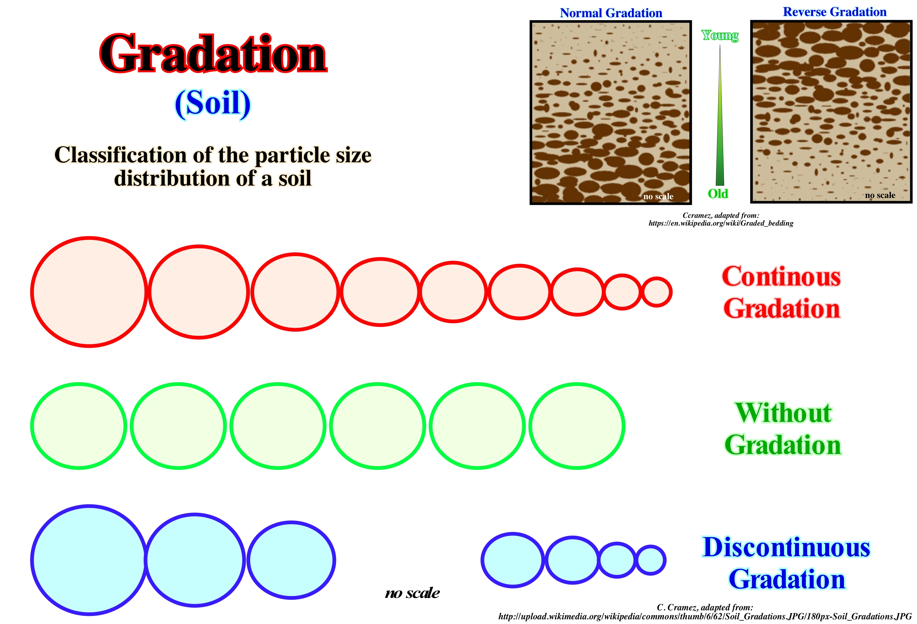
The gradation of the soil is the classification of a granular soil, on the basis of the different sizes of particles that it contains. The gradation of a soil is an important aspect in the geotechnics and an indicator of other engineering properties, such as compression, shear strength and hydraulic conductivity, etc. Poorly graduated soil will have better drainage than well-graded soil. Soils of grainy texture, mainly gravel or sand, are divided in: (i) Well graded and (ii) Poor graded. A well graded soil contains particles within a wide range of sizes and has a good representation of all sizes from n° 4 (4.75 mm) to n° 200 (75 μm) sieves. A well-graded gravel is classified as WG, while a well-graded sand is classified as WS. As illustrated in this figure, poorly graded soils are divided into: (i) With continuous gradation ; (ii) No gradation and (iii) With discontinuous gradation. The fine soils, silts and clays are classified according to the limits of Atterberg. A poorly graded soil is a soil that does not have a good representation of all particle sizes from sieve # 4 to sieve # 200. Poorly graded gravel is classified as PG ("Poor Gravel"), while poorly graded sand is classified as PS (" Poor Sand"). Poorly graded soils are more susceptible to liquefaction than well-graded soils. The soil grading process is in accordance with either the "Unified Soil Classification System". The steps of grading a soil are: (i) Data collection; (ii) Calculation of uniformity and curvature coefficients and (iii) Classification of soils on the basis of the gradation criteria of the classification system adopted. Soil gradation is determined by analysing the results of a granulometric analysis (sieves), or a hygrometric analysis (settling or sedimentation time of fine granulation soil samples in a viscous fluid).
Graded Bedding...............................................................................................................................................Stratification granoclassée
Estratificação granocalibrada / Estratificación graduada / Graded Schichtung / 递变层理 / Ритмическая слоистость / Stratificazione graduata /
A type of stratification in which each layer exhibits a gradual and progressive change in particle size. Typically, the coarser material deposits at the base of the layer and the thinnest at the top. This type of stratification is generally formed when the velocity of the current transporting the sedimentary particles decreases progressively, for instance, in a turbidity (or turbiditic) current.
See: « Turbidite »
&
« Stratification (sediments) »
&
« Granulometry »
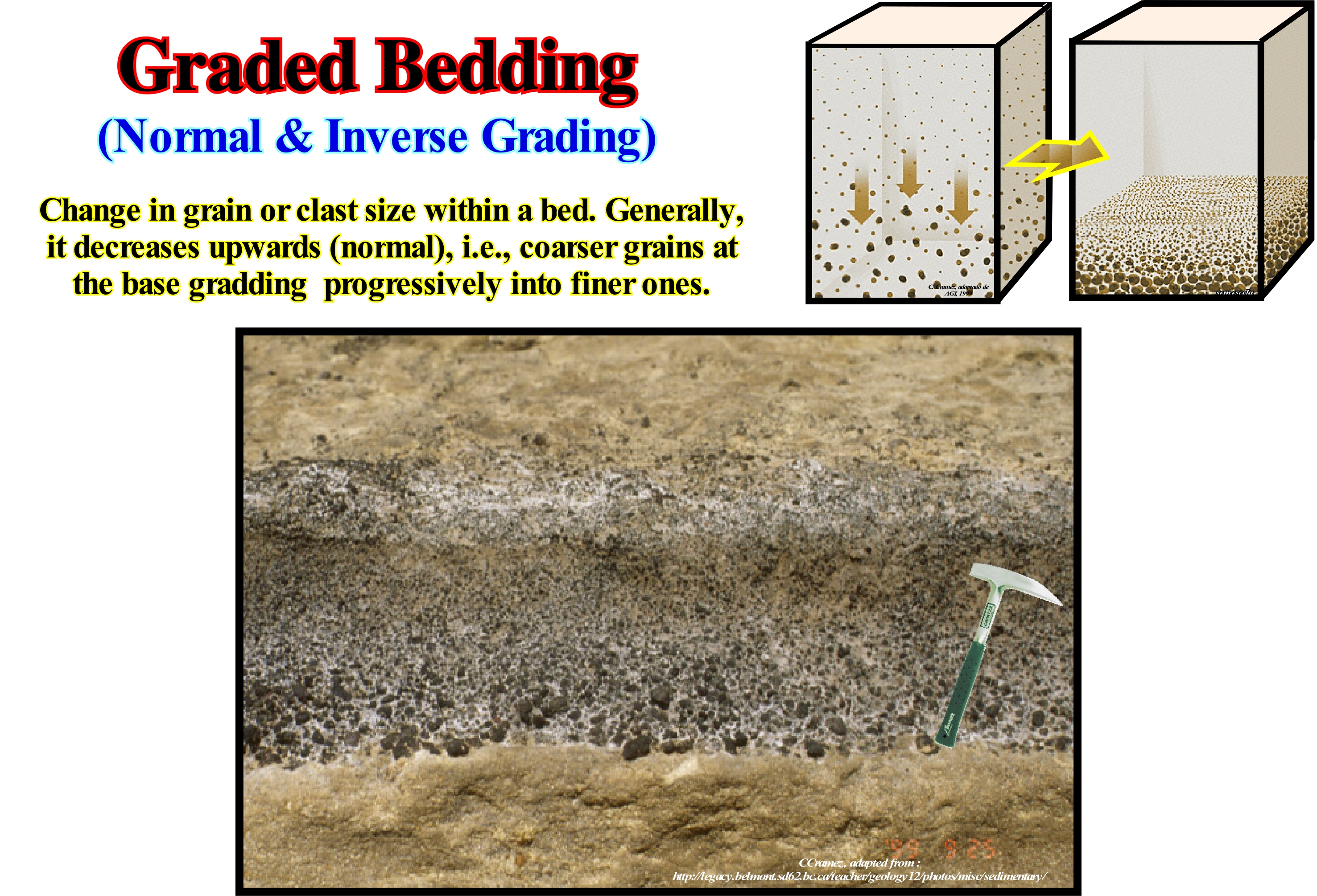
Sandstone layers have, often, a graded bedding as shown in this figure (right). This type of bedding indicates the base and top of the layers, particularly in the areas where the layers have been shortened, i.e., when the rocks have been deformed by folding or reverse faulting. Often, the position of the sedimentary beds is reversed. It is in these cases, that the presence of a graded bedding is very useful to the geoscientists. It allows to verify if the layers are or not, in their original position. If the coarsest sedimentary particles or clasts are at the top of a beds and the thinnest at the base, the beds are inverted. A graded bedding is, usually, explained by the discharge of a certain amount of sedimentary particles, of various types, into a relatively calm water body (lake or sea). This happens when, for instance, a stream enters a lake, but also when a part of the continental slope slides into the deeper parts of the basin or even when a tsunami invades a beach or lagoon. When the velocity of the water currents begins to decrease, the coarsest clasts are the first to be deposited (Stokes's law*, which is valid only when the density of the transported materials is identical), followed by the smaller particles, as the current velocity is increasingly weaker and water cleaner. The typical example of this type of stratification is produced by turbidity currents. Each bed, deposited almost instantaneously (within a few hours), can be subdivided into several intervals. The first interval is normal graded (coarser clasts at bottom which grade upward into progressively finer ones). It represents depositional environments with a decreasing transport energy as time passes. Each turbidite bed is fossilized by a pelagic layer deposited during tens or thousands of years. A cross bedding suggests a high energy depositional environment, although other factors may be active.
(*) Law giving the friction force of a fluid to a sphere moving in the fluid. If the Reynolds number is less than 0.1 (creeping flow) and if the sphere is sufficiently far from any obstacle or side-wall (consider a wall at least ten times the radius of the sphere), then the force which is exercised on a sphere of radius r is: F=-6πμrv, where μ is the dynamic viscosity of the fluid (in Pa/s).
Graded Profile (Equilibrium profile)...........................................................................................................Profil d'équilibre (Fleuve)
Perfil de equilíbrio (rio) / Perfil de equilíbrio (río) / Gleichgewicht Profil (Fluss) / 平衡剖面(河)/ Профиль равновесия (река) / Profilo di equilibrio (fiume) /
Longitudinal profile of a water-couse carrying the available sedimentary particles. Generally, a provisional equilibrium profile has a parabolic geometry (concave upward), i.e., it is almost horizontal near the mouth of the water-course, but rises, progressively, toward the spring. According to certain geoscientists, the point of equilibrium is taken in relation to the bayline (Posamentier and Vail), whereas for others (Miall) it must be taken in relation to the shoreline.
See: « Bayline »
&
« Shoreline »
&
« Equilibrium Point »
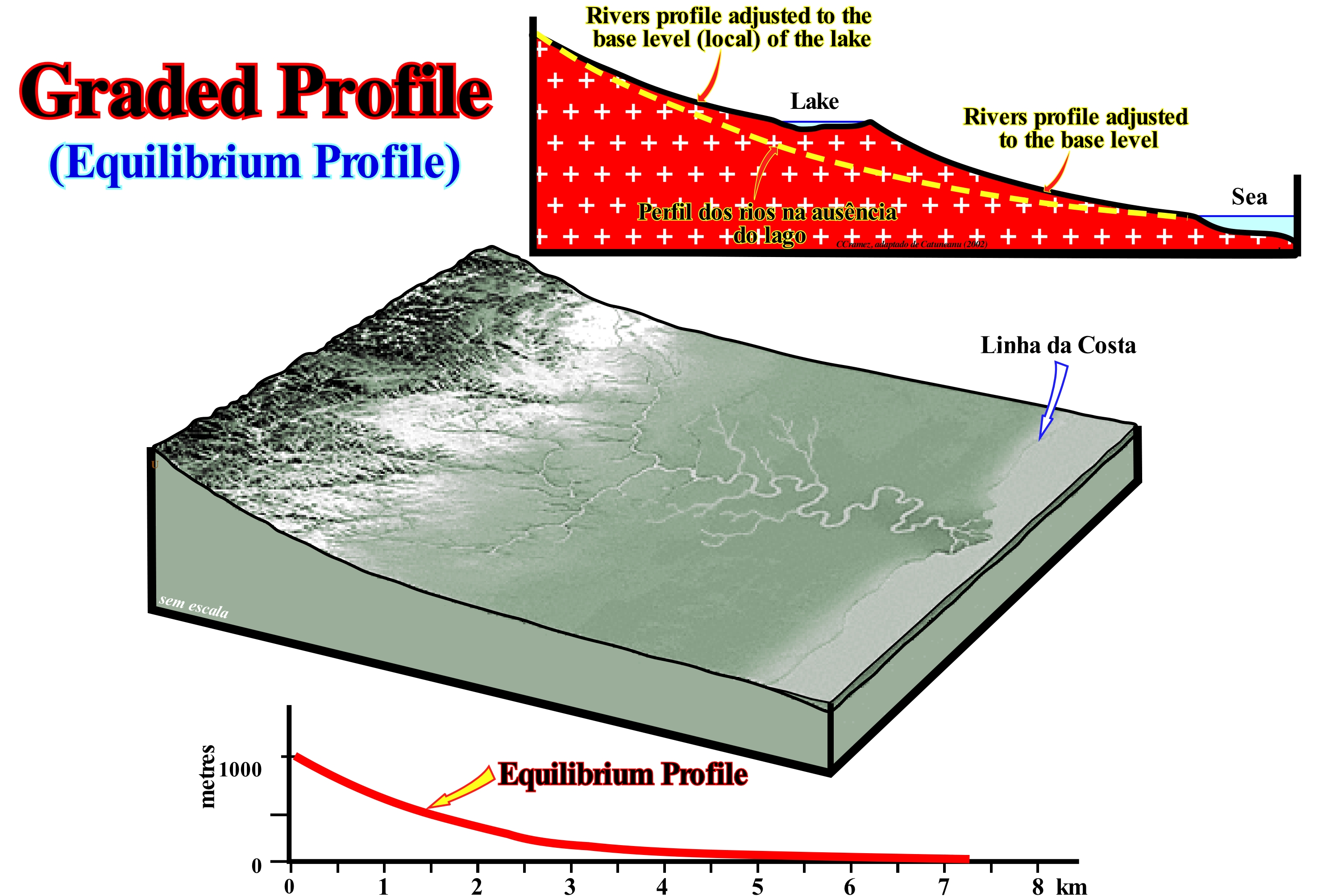
in the 17th century, Italian engineers were, probably, the first to consider the concept of equilibrium profile of a river: (i) Water currents modify the shape of the river beds, either by erosion or by deposition, in such a way that, finally, there is an equilibrium between the amount of energy transmitted (force) and the mechanical force that tends to oppose motion (resistance) ; (ii) The dip of the water currents varies according to the bed resistance and in inverse ratio of the flow (*) of the current ; (iii) Water tends to give the bed a concave upward profile. If at any point of the river longitudinal profile, the river has an equilibrium slope (the water current does not deposit and it does not dig more along its entire width). In other words, the river is in a provisional equilibrium, which means that it has along its course a slope just sufficient to evacuate the load and overcome internal frictions. However, this profile is not definitive. The river continues to deepen (there is erosion upstream, since materials are supplied). Overall, the basin is eroded and the charge becomes weaker. It may be imagined, an ideal moment in which the inclination of the stream is just sufficient for the flow of the stream (all particles transport having disappeared). Under these conditions, the current would reach its ideal or definitive equilibrium profile. However, such a profile is never achieved. Posamentier and Vail (1988) think when a current finds a water-body, almost immobile, as its speed decreases almost instantaneously, there is deposition (particularly, deltaic deposition). They consider that in the provisional equilibrium profile of the water course there is an obvious slope break, which they called bayline, which separates alluvial deposits (deposits without influence of relative sea level changes) and coastal plain deposits settle down under the influence of relative sea level changes. The bayline concept of the Posamentier and Vail was based on the following conjectures: (a) The coastal plain is formed by processes of seafloor progradations, rather than by exhumation ; (b) The sediments that accumulate on the coastal plain during seaward progradation of the shoreline are part of what they called coastal wedge (coastal prism), which includes fluvial and shallow-water deposits ; (c) The coastal prism is wedge-shaped and extends continentward by onlapping on the preexisting topography ; (d) The upstream boundary of the coastal wedge is the bay-line, which may move updip when the shoreline progradation (outbuilding) is accompanied by aggradation (upbuilding or vertical deposition) ; (e) The bayline is the boundary between the alluvial and coastal plains ; (f) Upstream of the bayline, relative sea level changes have, practically, no influence on depositional systems. Certain geoscientists consider that the basic idea of Posamentier and Vail, i.e., the deltaic deposition occurs when a water-course encounters an almost immobile water body, which controls its provisional equilibrium profile, is not quite correct. For them, it is not the bayline but the position of the water course that controls the provisional equilibrium profile mouth of the stream. In other words, for them, the head or apex of the deltas is not at the bayline but at water course mouths. So, when speaking of the provisional equilibrium profile of a river, geoscientists must say whether the profile is in relation to the bayline (Vail position) or to the shoreline (Miall position). In any case, as shown in this figure, the presence of lakes significantly deforms (locally) the provisional equilibrium profile of a water course. In a given area, in the absence of lakes, the provisional equilibrium profile of water courses, as well as the base-line level, is lower than when lakes area present in the considered area. The depositional baseline level may be given tin relation to the relative sea level, in the case of water courses that flow there or in relation to lakes or closed seas. Titicaca Lake, which is roughly at 3,800 m in altitude, is the base level of most of the Bolivian plateau water courses. Similarly, Tanganyika Lake, which is at an altitude of about 700 m, is the base level of most of the water courses of the surrounding. Within a sequence-cycle, the base level, which determines the equilibrium profile of the water courses, changes with relative sea level changes. During a marine ingression (relative sea level rise), the base level rises increasing the depositional area. During a sedimentary regression (relative sea level rise in deceleration), the area subject to erosion increases which creates a strong terrigeneous influx.
(*) The flow rate or runoff of a river is the quantity of water, expressed in cubic meters per second elapsed (m3/s) at a given point in its course. If the point of the water course is not specified, the number indicates the flow at the mouth or at the confluence with another river. The rate of flow or runoff varies during the year, depending on the contributions of rain or melted ice as well as evaporation. The normal flow changes during the year constitute the hydrological regime of the river.
Grain-Size (Sorting)...........................................................................................................................................................................Granomorphologie
Granomorfologia / Granomorfología / Granomorphologie (Teilchen), Sortierung / 排序, Granomorphologie(颗粒)/ Сортировка (размер зёрен) / Grani morfologia, Ordinamento /
In geology, the granulometry corresponds to the average size (diameter) of an individual grain of a sediment (deposited rocky debris resulting from erosion) or lithic particles, which make up a clastic rock. In metallurgy, grain size is the mean grain size of a metal designated as the mean diameter or the number of grains per unit area or volume. In the graphic arts, the grain size is the average size of the silver halogen grain of a photosensitive material. Granulometry, in geology, is synonymous of Grain-Size.
See: « Granulometry »
&
« Erratic Block »
&
« Clay »
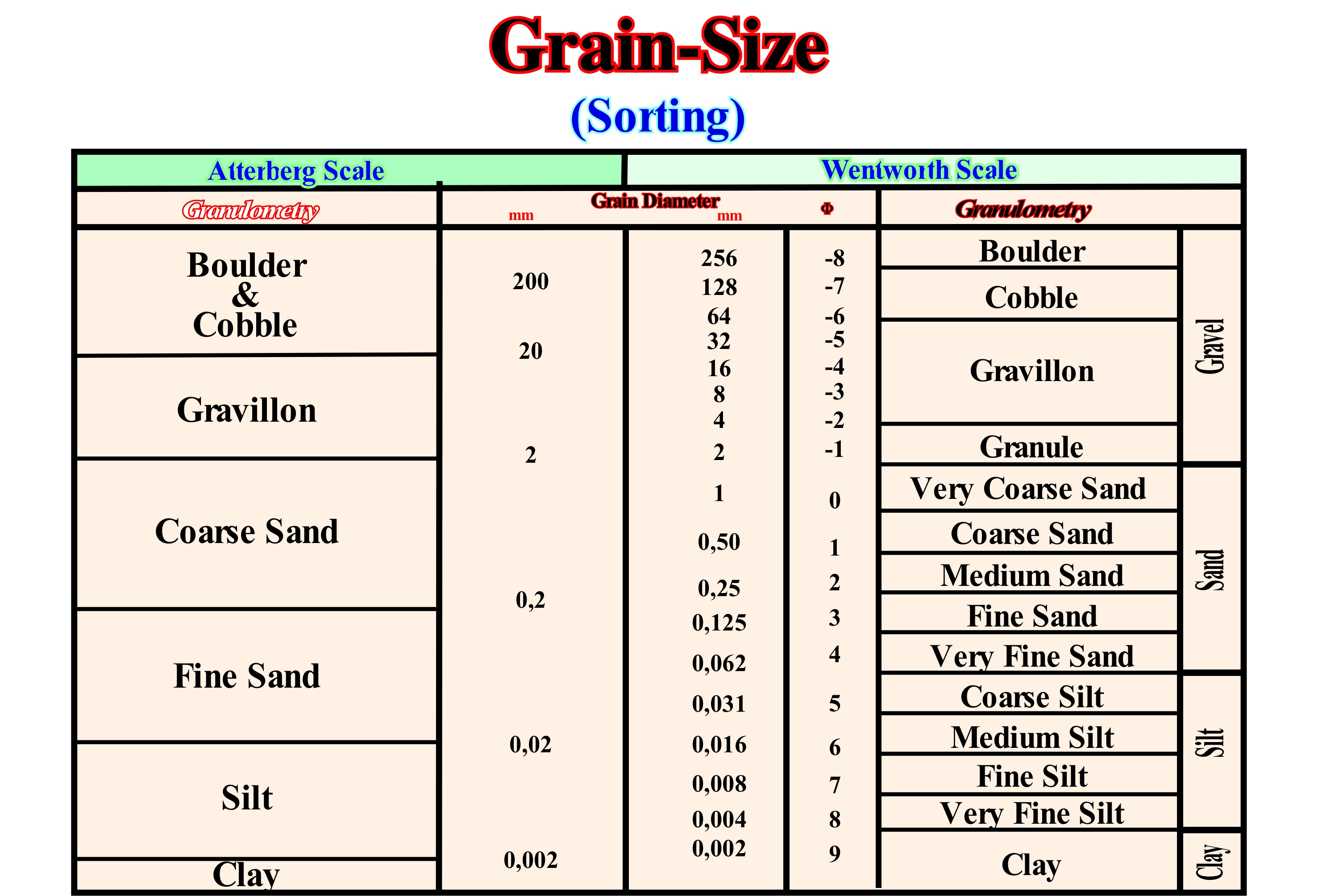
Grain size defines a series of classes whose names vary with authors, as well as the boundaries between different classes. The most widely used granulometric classifications are those of Atterberg, which is, widely, used in soil texture and mechanical analysis, and Wentworth, which is most, widely, used in the study of sediments. The divisions on the Atterberg scale are: (i) Boulder/Cobble (diameter between 20 and 200 mm) ; (ii) Gravillon (diameter between 2 and 20 mm) ; (iii) Coarse Sand (diameter between 2 and 0.2 mm) ; (iv) Fine Sand (diameter 0.2 to 0.02 mm) ; (v) Silt (diameter between 0.02 and 0.002 mm) and (vi) Clay (diameter <0.002 mm). In the Wentworth scale there are four main divisions: (a) Gravel (diameter greater than 2 mm) ; (b) Sand (diameter between 2 and 0.062 mm) ; (c) Silt (diameter between 0.062 and 0.003 mm) and (d) Clay (diameter <0.001 mm). In the Wentworth scale, the silt is divided into: (1) Coarse Silt ; (2) Medium Silt ; (3) Fine Silt and (4) Very Fine Silt. In the same way, the sand is divided into: (I) Very Coarse Sand ; (II) Coarse Sand ; (III) Medium Sand ; (IV) Fine Sand and (V) Very Fine Sand. Four sub-divisions are also considered in the Gravel : (A) Boulder (diameter > 200 mm) ; (B) Cobble (diameter between 200 and 50 mm) ; (C) Gravillon (diameter between 50 and 4 mm) and (D) Granule (diameter between 4 and 2 mm). To avoid confusion, as long as particle size is used in a given work, it is always preferable to outline the scale and terminology adopted, as illustrated in this figure. Certain geoscientists, systematically, confuse the name of the sedimentary particles with re name of the rocks formed by them: clay is the name of the sedimentary particles that the form a claystone, as well as, silt (particle) and siltite (rock).
Grainstone........................................................................................................................................................Calcaire granulaire, Grainstone
Grainstone/ Grainstone / Grainstone / 粒状灰岩/ Grainstone / Grainstone /
Granular carbonate sedimentary rock without micrite. The spaces between the grains are filled with crystalline cement.
See: « Limestone »
&
« Calcarenite »
&
« Carbonate Sedimentation (principles) »
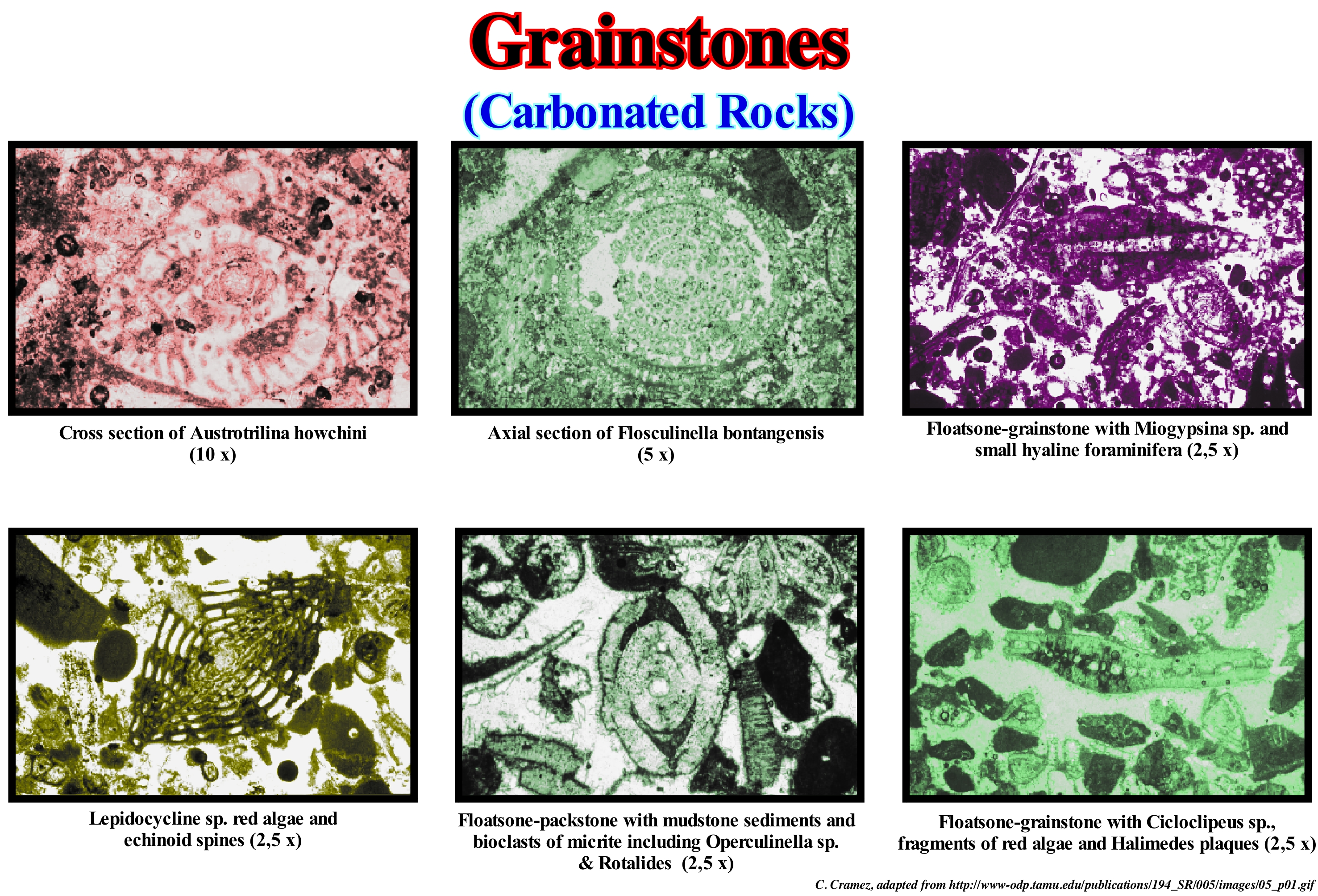
In the study of carbonate rocks, it is important to differentiate the grains, the matrix, the cement and evaluate, more or less, the porosity. In a thin section of a limestone one must always differentiate: (i) The grains, that is, the particles that make up the rock ; (ii) The matrix, i.e., the mud that penetrated between the grains during deposition ; (iii) The cement, i.e., calcite or aragonite which precipitated between the grains after deposition and (iv) The porosity, which may be filled with water, air or hydrocarbons and which may be emphasized by a colourant which is added to the resin used to make the thin sections. Most of the cements are made of sparite (large calcite crystals, generally larger than 50 μm). The matrix is the micro-crystalline mud existing at the time of deposition. It is this micro-crystalline mud (micrite), which after deposition and during the diagenesis can recrystallize (neomorphism) with substantial increase in the size of the crystals. In general, in thin sections, the cement is light and the matrix is dark. There are different types of cement: (a) Equigranular Sparite (all crystals have the same size) ; (b) Laminar Sparite that forms an isopach fringe on the edge of the cavities ; (d) Fibrous Sparite, also on isopic fringes, and (e) Drusic Sparite (the first crystals are small, then it increases in size over time towards the centre of the cavity). In the classification of the limestones of Embry & Klovan (derived from the Dunham classification) they distinguish two great families. The first, where limestones have less than 10% of elements larger than 2 mm, include:(1) Mudstones (<10% of corpuscles), (2) Wackstones (> 10%), (3) Packstones (contiguous corpuscles + matrix), (4) Grainstones (contiguous corpuscles + cement) and (5) Crystalline limestone. In the second family, where rocks have more than 10% of elements larger than 2 mm, are distinguished : (6) Framestones (described as an autochthonous limestone having "in situ massive fossils which constructed a rigid three-dimensional framework during deposition), (7) Bindstones (contain in situ, tabular or lamellar fossils which encrusted and bound sediment during deposition ; the matrix, not the in situ fossils, forms the supporting framework of the rock, and the fossils may form as little as 15 percent of the constituents of the rock), 8) Bafflestones (describe sediments that formed where organic baffling resulted in a flow reduction and a consequent deposition of the suspended material) ; (9) Rudstones (grain supported) and (10) Floatstones (matrix supported).
Granite........................................................................................................................................................................................................................................................Granite
Granito / Granito / Granit / 花崗岩 / Гранит / Granito /
An igneous rock (formed by the solidification of a magma) of granular texture (medium to coarse) and sometimes with crystals of significant size (phenocrysts), which, easily, detach themselves from the rock matrix. Quartz constitutes 10-50% of the felsic components (rich in light minerals such as silica, oxygen, sodium and potassium) and alkali feldspars (between albite and orthoclase). Feldspars, whose formula is xAl(1-2)Si(3-2)O8, in which x may be sodium and/or potassium, potassium and/or calcium) are the predominant elements (65 and 90%). The colour of the granites is very varied since it depends on the chemical and mineralogical composition.
See: « Crust »
&
« Craton »
&
« Erratic Block »
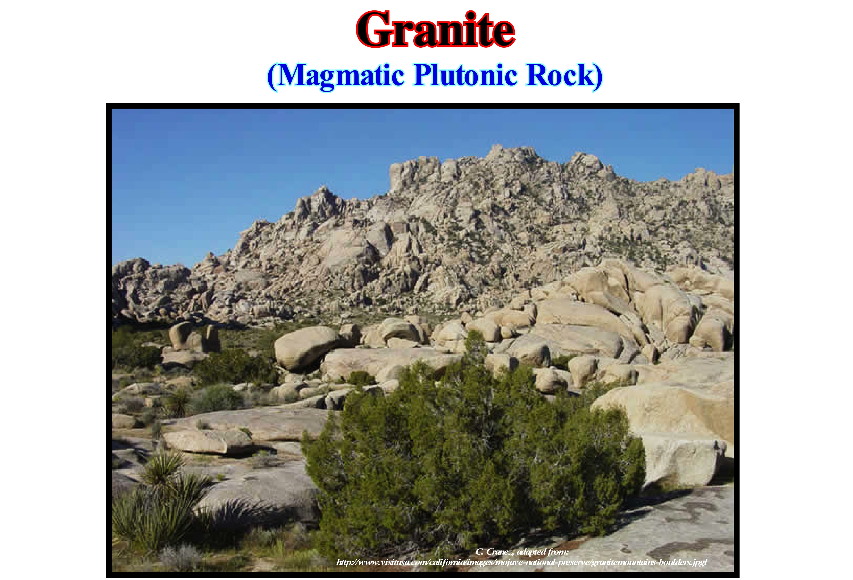
The outcrops of granite tend to create a morphology in, more or less, acute peaks, as illustrated in this figure ("Mother Natures" on Granite Mountain Trail, Washington, USA) or, more or less, rounded ridges. In certain cases, granites occur in depressions, often circular, surrounded by a belt, more or less, continuous of rugged topography, formed by hornfels (German, meaning "hornstone"), i.e., metamorphic rocks of fine texture consisting of equidimensional grains, without any preferential orientation. These hornfels which are extremely hard, compact, resist erosion much more than granite. They formed by heating the surrounding areas of a granite intrusion, i.e, when the hot, plastic granitic magma ascends and crosses the pre-existing rocks. These magmas, from which the granites are formed, can have very diverse origins. Many of the granitic intrusions are located within the continental crust at depths, generally, more than 1.5 kilometers and in some cases (thick continental crust of a convergent continental margin), they can be more than 50 km deep. As the origin of granite is still very controversial, the classifications of granites are, of course, very varied. Without exaggeration, it can be said practically every school of petrology has its own classification scheme. Granite or granitic rocks, sometimes, form, locally, the substrate of oil basins and, in certain cases, when leached they may even be considered as potential reservoir-rocks.
Granular Flow.....................................................................................................................................................................Débit ou Flux granular
Escoamento granular, Fluxo granular / Flujo granular / Körniger Durchfluss / 颗粒流 / Гранулированный поток / Flusso granulare /
When the dispersion of the materials and the maintenance of these in suspension is promoted by the collision between the particles.
See: « Turbiitic Current »
Granular Flux........................................................................................................................................................................Écoulement granulaire
Fluxo granular / Flujo granular / Granulär Fluss / 颗粒流量, 颗粒流 / Гранулированный поток / Flusso granulare /
Flow of a granular medium caused by the surface drag of a fluid in which the greatest mass flow does not always occur on the surface of the granular layer and in this case the grains move as a block of particles.
See: « Debris Flow »
&
« Turbulent Flow »
&
« Mud Flow »
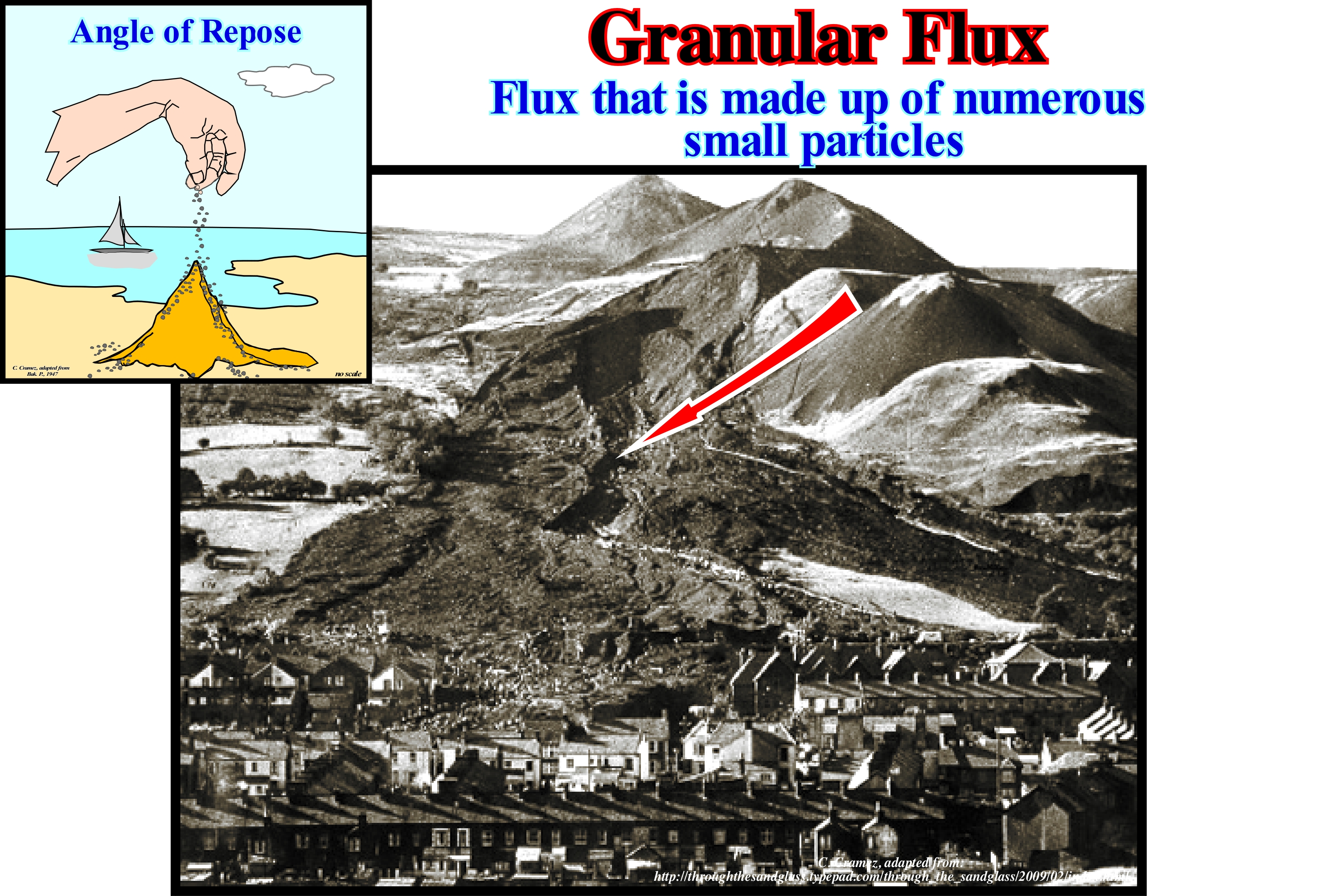
In places where granular materials, such as mining products or cereals, are stored (in silos or stacks of aggregates), the angle of repose and its sensitivity to any variation need to be carefully studied once that it produces granular flows. A break in the slope of a pile of sand can cause tragedies on the beach and gold mining (in alluvial deposits), not to mention the gold placers (concentration of metallic minerals and heavy minerals accumulated by the action of river currents, wind, glaciers or marine, although river deposits are the most frequent) as in Long Island. The inability to adequately manage the gigantic accumulations of the remains of the coal mines in Wales resulted in Aberfan's horrific tragedy in 1966, when a granular outflow of one of these artificial mountains killed 144 people, including 116 children in a school, which was, completely, buried. The angle of repose seems to have been well understood by several animals, notably by the ant-lion, which is, sometimes, referred to as the sand dragon. The ant-lion is the larval stage of a large family of insects, Myrmeleontidae, whose adults are quite attractive four-winged creatures. But the larval phase - and they can remain larvae for several years - are terrible predators. About 2,000 species occur around the world, popularly known in the US as "doodlebugs". Their traces in the sand resemble scribbles on paper. The ant-lion uses the angle of repose, very effectively, to feed. She digs into the sand, against the angle of repose, a well and bury herself in the background, her jaws loaded with venom ready to kill any visitor. If a visitor falls into the pit, he will struggle in vain to escape against the angle of repose of the sides of the pit, since lion ant casts sand against the slope, which creates granular runoff that hinders the visitor's escape the well.
Granule....................................................................................................................................................................................................................................................Granule
Areaãso (grânulo) / Gránulo / Körchen / 复合了(沉积颗粒) / Зерно, гранула / Granule /
Sedimentary particle or just a mobile particle with a diameter between 1 and 2 mm.
See: « Granulometry »
&
« Sand »
&
« Pebble »
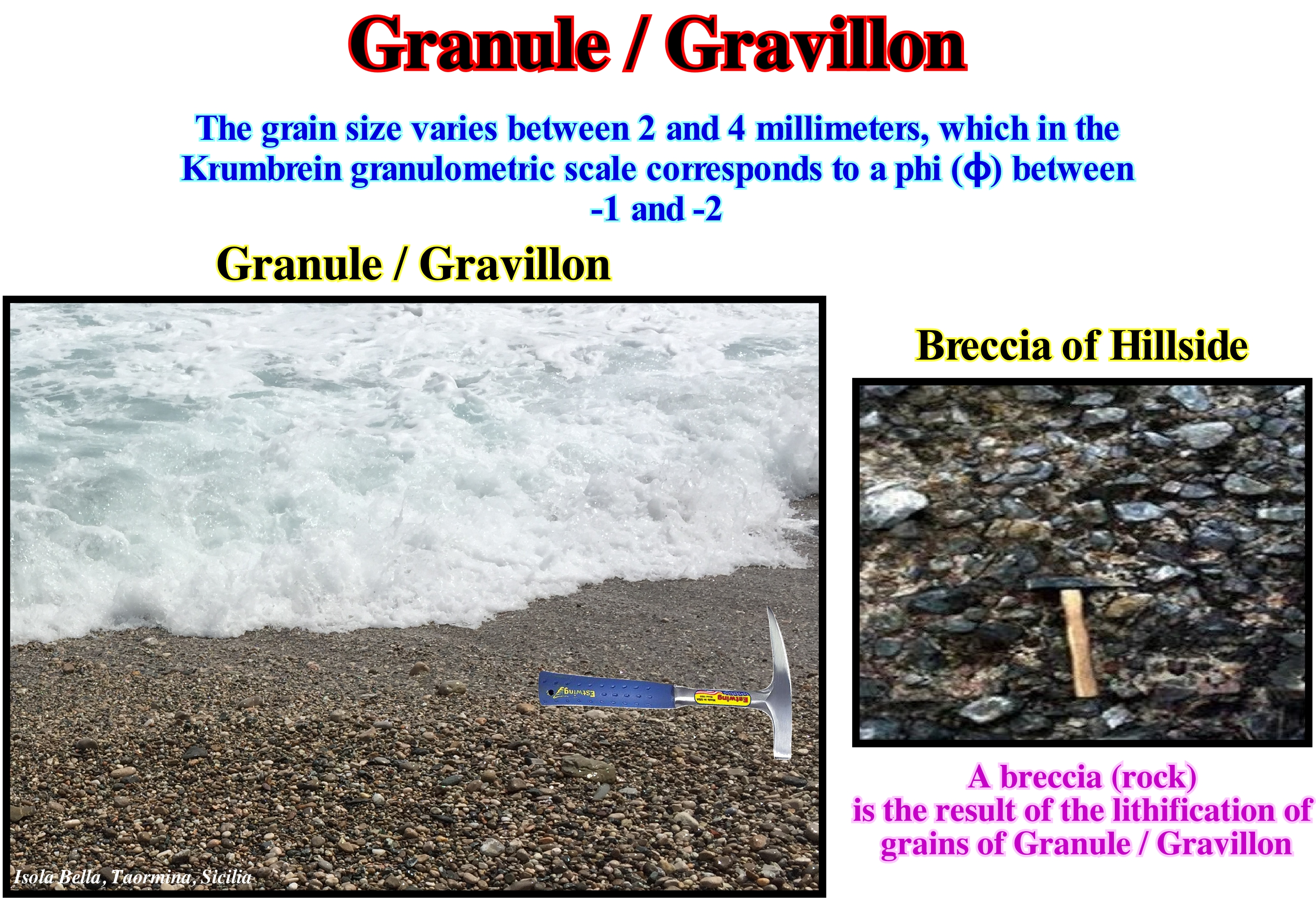
In this figure, the clastic sediments have dimensions such that, in the Wentworth scale, they allow them to be included, for instance, in gravillon (coarse) or granule (fine) granulometric pattern. The scales to define the size of the grains of the sedimentary rocks are graduated scales, that is to say, they were created imposing arbitrary sub-divisions in a natural continuum. The size of a particle, also called grain size, refers to the diameter of individual grains of the sediment, or the lithic particles of clastic rocks, but may also be applied to other granular materials. The size of a particle is different from the crystalline size, which is the size of a single crystal within a particle or grain. A single grain may be composed of several crystals and a granular material may range from very small colloidal particles, clay, silt, sand, and granules to boulders. The terminology of dimensionometry- most familiar to geoscientists is the Wentworth scale, which includes four major subdivisions: (i) Gravel ; (ii) Sand ; (iii) Silt and (iv) Clay, but which have numerous subdivisions. Due to the fact that in nature the grain size scale is very large, a logarithmic scale* is much more practical than a linear scale, as, for example, the Uden / Wentworth scale: (a) Boulders, diameter greater than 256 mm and φ = -8 (φ = - -log2 of grain diameter in millimetres) ; (ii) Cobblers, diameter greater than 64 mm and φ = -6 ; (iii) Gravillons, diameter greater than 4 mm and φ = -1 ; (iv) Granules, diameter greater than 2 mm and φ = -1 ; (v) Very Coarse Sand, diameter greater than 1 mm and φ = 0 ; (vi) Coarse Sand, diameter greater than 1/2 mm and φ = 1 ; (vii) Medium Sand, diameter greater than 1/4 mm and φ = 2 ; (viii) Fine Sand, diameter greater than 1/8 mm and φ = 3 ; (ix) Very Fine Sand, diameter greater than 1/16 mm and φ = 4; (x) Silt, diameter greater than 1/256 mm and φ = 8 et (xi) Clay, diameter greater than 1/256 mm and φ <8. The psi (φ) scale proposed by Krumbein is determined by equation: φ = -log2 (grain size in mm). D = D02 − φ, where D = particle diameter, D0 = reference diameter, equal to 1mm and φ = phi scale). The grain size variation, granulometry, which certain geoscientists call calibration, can be easily computed in a grain distribution diagram.
(*) The logarithm is an exponent that we give to a reference number, called base, to express a certain number. For example 2 is the logarithm of 100 in base 10, since 102 is equal to 100. When the number 10 is used as the base, the exponent is a common logarithm. Natural logarithms use the number 2,718 ...., i.e. 'e', as the basis. logn is an abbreviation of log2n, that is, the real number x such that 2x = n (the correct notation is log2n, not log2n or log2".
Granulometry..................................................................................................................................................................................................Granulométrie
Granulometria / Granulometría / Granulibildung / 粒径 / Гранулометрия / Granulometria /
In geology, the granulometry corresponds to the average size (diameter) of an individual grain of a sediment (deposited rocky debris resulting from erosion) or lithic particles, which make up a clastic rock. In metallurgy, grain size is the mean grain size of a metal designated as the mean diameter or the number of grains per unit area or volume. In the graphic arts, grain size is the average size of the silver halide grain of a photo-sensitive material. In geology, granulometry is synonymous of Sorting (grain-size).
See : « Grain-Size »
&
« Erratic Block »
&
« Clay »
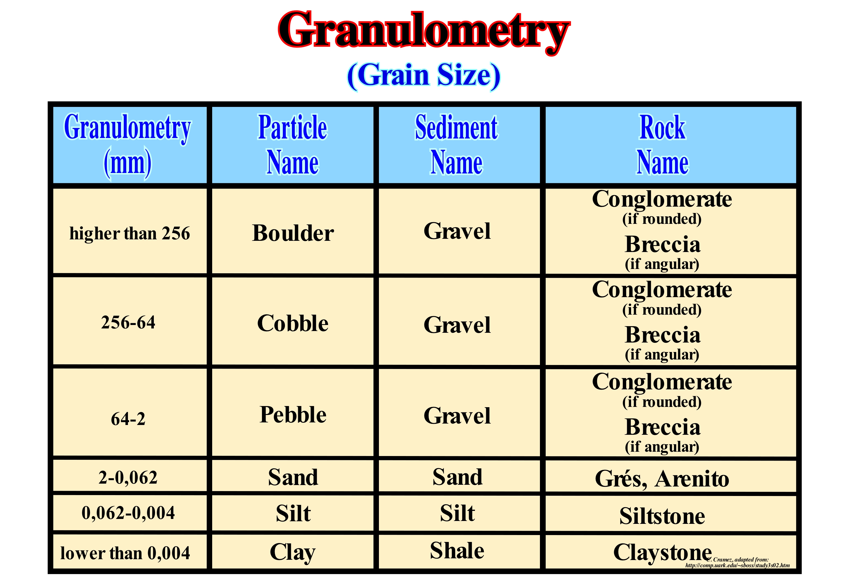
The scales used to define grain size in sediments and sedimentary rocks are scales by category, i.e., they impose arbitrary divisions on a natural continuum. The most widely used terminology is certainly the proposal in the Wentworth classification, which includes four main classes: (i) Gravel ; (ii) Sand ; (iii) Silt and (iv) Mud, with its numerous sub-divisions. As the grain size limits found in nature is very large, a logarithmic scale (scale that uses the logarithm of a physical quantity instead of the quantity itself), such as that of Udden-Wentworth, which is more practical than a scale linear. The phi (Φ) scale proposed by Krumbein is computed by the equation Φ = - log2 (grain size in mm). Grain size limits on siliciclastic rock are commonly known as calibration, calibration, or sorting. Calibration can be computed from a grain size distribution histogram. Most of the time, the calibration is estimated by comparing the grains with a visual reference chart. Calibration is one of the parameters used to determine the maturation of the texture (calibration and roundness of the grains, which implies an important transport). A rock that is, textually, mature has well calibrated and round grains. Classical sediments are differentiated or evolved from mother rocks by processes (such as erosion and transport), which act over a long period of time. As the sediments are subject to change processes, the easily alterable material, such as, for example, shales are decomposed leaving as much more stable minerals as, for example, the quartz. The degrees of mineralogical maturation can be determined by the types of grains present. For example, if a rock contains no feldspars, which are more easily altered than the clays: (i) The rock contains no feldspars since their formation or (ii) The rock consists of lithic sediments which have undergone a great weathering and / or transport, which destroyed unstable feldspar grains.
Graptolite.................................................................................................................................................................................................................................................Graptolite
Graptolite / Graptolita / Graptolithen / 笔石纲 / Граптолит / Graptolithina /
Fossil of animals that lived in colonies, mainly in the Late Cambrian and that were extinguished in the Early Carboniferous (Mississippian). The graptolites had a great distribution throughout the world. The preservation, quantity and changes through the geological time of graptolites allow these fossils to be used to date the strata in most of the Earth's Paleozoic sedimentary basins. Graptolites are, also, used to determine the waterdepth deposition and temperature.
See: « Fossil »
&
« Index Fossil »
&
« Cambrian »
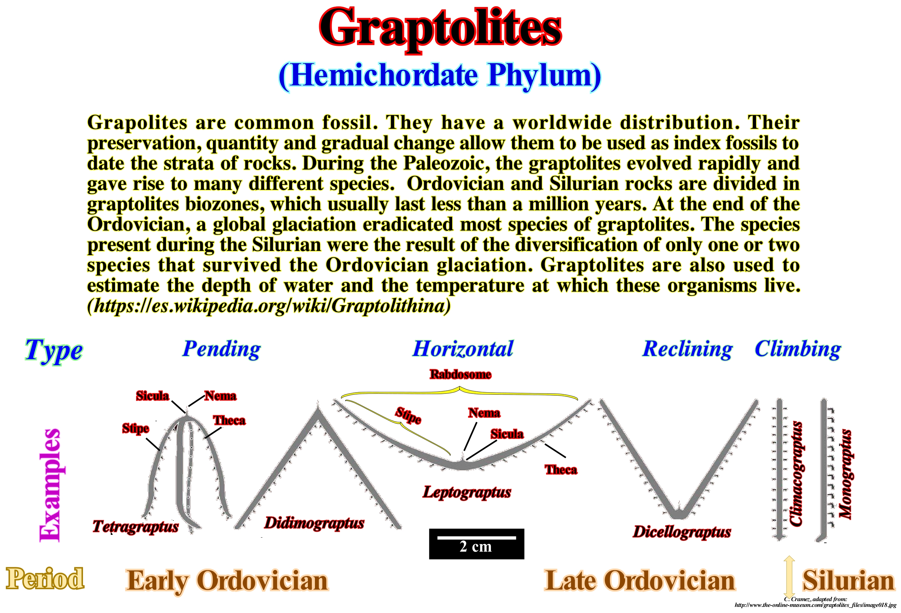
Graptolites were colonial organisms of the class Graptolithina of the phylum Hemichordata, that inhabited the Paleozoic seas. The group emerged in the Late Cambrian. It was extinguished in the Early Carboniferous (more or less, between 523 Ma and 330 Ma). A colony of graptolites consisted of a colonial skeleton - the rhabdosome- composed of several capsules called theca that housed the individual organisms. The thecas were composed of collagen (a protein of fundamental importance in the constitution of the extracellular matrix of connective tissue or gelatin) and joined together through the structure supporting nema. The rhabdosome of graptolites may have one or more stips, or branches, and are classified by paleontologists according to the geometric relationship between stips and nema. Due to the proteinic nature of the colonial skeleton, graptolite fossils are abundant only in sedimentary rocks deposited in calm and anoxic environments, such as, for example, shales and black limestone rich in organic matter. The collagen of the thecas should be destroyed in more oxidized or turbulent sedimentary environments. The dendroid graptolites formed colonies of simple rhabdosome that lived fixed to the bottom of the sea. In the initial Ordovician, these sessile forms gave rise to graptoloides (that have less branches) planktonic. The graptoloids extinguished earlier than the dendroids in the Early Devonian. The Graptolithine class is divided into six orders: (i) Dendroidea - (Early Cambrian / Early Carboniferous) ; (ii) Tubeoid - (Early Ordovician / Silurian) ; (iii) Camaroidea - (Ordovician) ; (iv) Crustoidea - (Ordovician) ; (v) Stolonoidea - (Ordovician); (vi) Graptoloidea - (Early Ordovician - Early Devonian).
Gravel (Granulometry).....................................................................................................................................................................................................................Grève
Balastro / Grava / Schotter / 砾石 / Гравий (крупнозернистый песок) / Ghiaia /
General term to designate a mobile rock in which the diameter of the grains that constitute it, varies between 2 and 75 mm. Synonymous with gravel, although certain geoscientists, restrict the term gravel to granulometries between 2 and 4 mm, using the term "Pebble" when the diameter varies between 4 and 75 millimeters.
See: « Granulometry »
&
« Sand »
&
« Arenite »
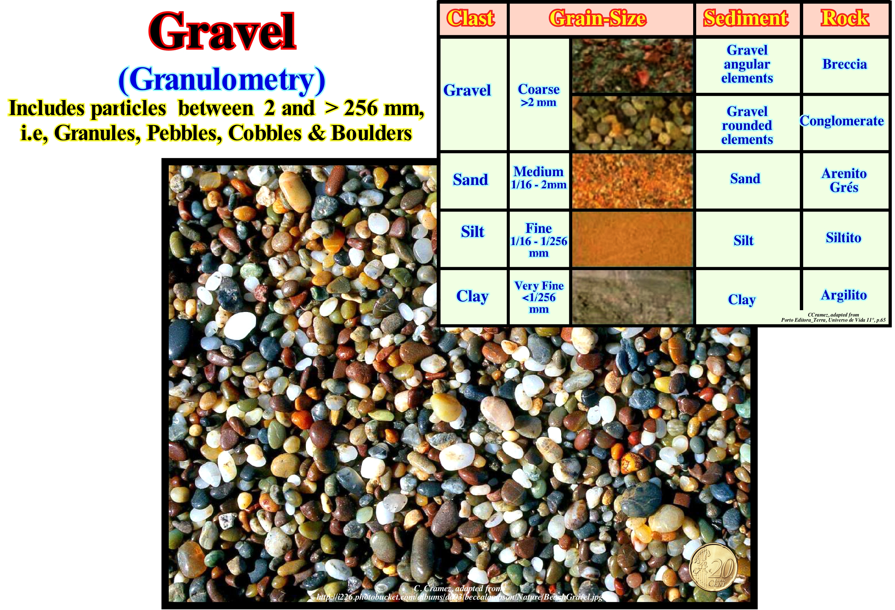
In geology, gravel is a particle but can be also a mobile sediment composed of clastic grains, more or less, calibrated with a diameter varying between certain limits (2 - 75 millimetres). When the gravel is lithified the rock is a breccia or a conglomerate. In current language, is often used as synonym of ballast, which is a mixture of gravel, sand and crushed stone that is used to construct the substrate of the railway lines,. Most of the important gravel deposits form as a result of the atmospheric alteration and erosion of the rocks. The action of rivers and sea waves tends to pile up the gravel, which, often, by compacting and cementing gives rise to conglomerates (the sediments are so large that the pressure is insufficient to maintain them, which requires cement). In Geotechnics many types of gravel can be recognized: (i) Bank Gravel, when gravel is mixed with sand and clay ; (ii) Terraced Gravel, when a level of gravel exists on either side of a valley above the present base level of the current, indicating that previously the base level was higher ; (iii) Bottom Gravel, generally round and polished, that was dredged or excavated from the bed of a current ; (iv) Artificial Gravel, is gravel produced mechanically and can be artificially calibrated by filtration; (v) Artificial Limestone Gravel, is the artificial gravel produced from calcareous rocks, which are crushed and calibrated by filtration; (vi) Fine Gravel, is the gravel in which the particle diameter varies between 1 and 2 mm; (vii) Residual Gravel, is the gravel in which the fine particles were removed; (viii) Precious Gravel, gravel with a high content of precious metals; (ix) Piedmont Gravel, coarse gravel carried by mountain streams and deposited in Piedmont ; (x) Plateau Gravel, is gravel deposited on a plateau or in a region above the height at which a terrain gravel is generally found; (xi) River Gravel, is the gravel deposited in or near the rivers.
Gravity Anomaly.............................................................................................................................................................Anomalie de la gravité
Anomalia da gravidade / Anomalía de gravedad / Schwerkraft-Anomalie / 重力异常 / Гравитационная аномалия / Anomalia gravità /
When the gravity is greater or smaller than its normal value, which is, approximately, 9.81 m/s2. Gravity is one of the four fundamental forces (electromagnetic force, weak nuclear force, strong nuclear force and gravity) the least known and which, for the time being, does not link well with quantum mechanics. It leads, for example, to the violation of the conservation of probabilities, i.e., it creates probabilities greater than one hundred percent. Gravity corresponds to the terrestrial gravitational potential (physical quantity whose value at each point in the field is given by the work done by the unit of mass in the displacement of a small quantity of that quantity from an infinite distance up to that point). The lateral anomalies of gravity are induced by an anomalous distribution of the density of the materials forming the Earth. The large scale gravity anomalies are,, easily obtained thanks to the two GRACE satellites (Gravity Recovery and Climate Experiment), which allowed to determine the terrestrial geoid (surface defined by a constant gravitational potential). In sequential stratigraphy, it is important not to forget that the shape of the geoid resembles that of the mean sea level *.
See: « Geoid »
&
« Eustasy »
&
« Geodesic Sea Level »
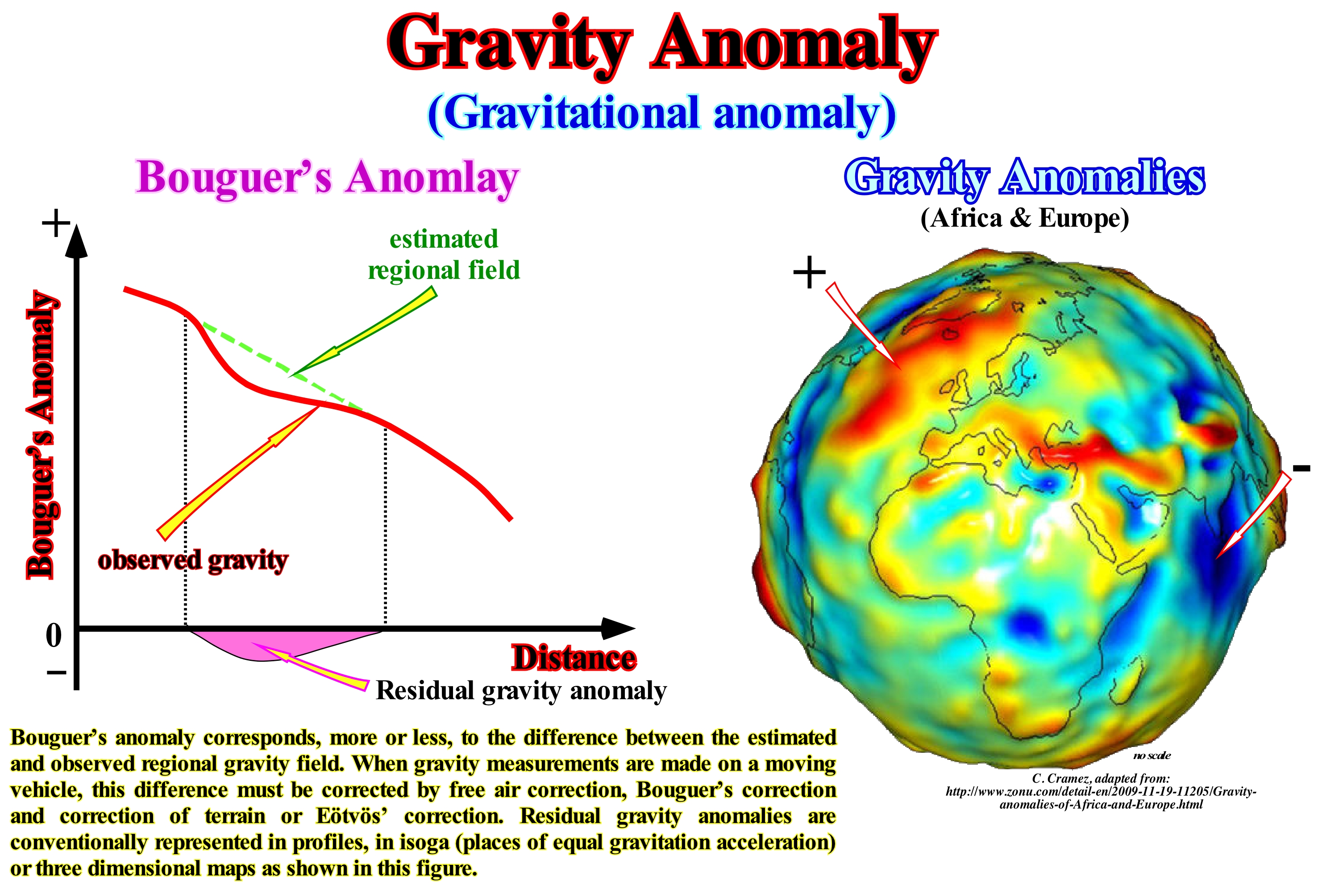
Let us first remember the theory of relativity was developed due to the fact that Newton's theory of gravity was constructed on the basis of a very strange conjecture: "The effect of gravity between two bodies, expressed by the mutual force of attraction, was supposed to propagate instantly in space". That is to say, if one of the bodies were to change shape, the other must be, immediately, informed, even if the distance between them were several thousand light-years. Obviously, this is in blatant contradiction with Einstein's theory of relativity that says nothing can propagate instantaneously. Thus, it has been suggested that gravity can not be a true force but, probably, a local manifestation of the curvature of space. In this way, the movement of the Earth around the Sun is not the result of an instantaneous action of Newton's force, but determined by the massive presence of the Sun: "The curvature of space tells matter how to move and matter tells the geometry of space as if deformed "***. Taking this into account, and to avoid embarrassing questions, we do like physics, which admits that its laws do not vary with time, although it does transform them if new facts falsify such a priori. Put another way, using Newton's theory we can say: (i) On Earth, matter is not distributed evenly or in concentric layers ; (ii) The value of gravity changes from one place to another in relation to its mean value of 9.81 m/s2, which explains the irregularity of the absolute (eustatic) sea level profiles (sea level referenced to the Earth's centre ), deduced from gravity anomalies. Indeed, as can be deduced from the spherical representation shown in this figure, the absolute (eustatic) sea level is not flat. In relation to the Earth's centre, the Presenter-time Earth's gravitational field differs from a uniform gravitational field with a flat Earth's surface. Not only is the current configuration of the geoid (gravity equipotential surface near middle sea level), is not stable. At the Earth's surface the orientation of the gravity field changes as well as the factors controlling it through geological time. In fact, there are great elevations and depressions of the middle sea level. Between areas where the absolute sea level is highest (near New Guinea, for instance) and the lowest (near the Maldives islands, for instance), there are about 180 meters of difference. Theoretically, this means that a boat sailing between these two areas, along an equipotential gravity surface, would not consume energy. In the Earth's morphology, illustrated in this figure, the amplitude of the high points of the sea is exaggerated of a factor 1000,000 in relation to the Earth's radius. As the configuration of the current geoid is not stable, it must be taken into account when proposing global stratigraphic correlations. The morphology of the geoid suggests that two regions, even little separated from each other, may have different sea level geological conditions. A relative sea level rise, that is, a marine ingression, on the west coast of the African continent, can create highstand geological conditions (relative sea level higher than the basin edge), while the same relative sea level rise on the east coast may not be sufficient to put the relative sea level above the basin edge. The sea surface is an equipotential surface. When a certain amount of water is added, such as when the glacial ice melt, the equipotential equilibrium is broken. The added water moves in such a way that the equilibrium is restored. This allows a better understanding of absolute (eustatic) sea level changes (global changes of absolute sea level caused by changes in the volume of ocean water or by volume changes of the oceanic basins referenced to the Earth's centre). Before considering an unconformity as global (induced by a significant absolute sea level fall, occurring in all parts of the Earth), one has to test such a conjecture with all available data (seismic lines, micropaleontology, field data, etc.). Even if such a conjecture is not refuted, it should be considered as a simple hypothesis of work and not a certainty, since it can never be verified.
(*) The ocean surface is, itself, an equipotential surface. The middle sea level is not the same anywhere on the globe. This is due to the fact that local mass anomalies under the ocean deform, in their vicinity, the sea surface. Because the Earth is neither a perfect sphere nor a perfect oblate spheroid, the surface of the oceans is used as an reference equipotential, because ocean water follows a constant potential surface. Put another way, if for some reason the gravitational balance is broken, the ocean water flows in order to restore potential equilibrium.
(**) Theory that describes the physics of motion in the absence of gravitational fields. The notion of variation of the laws of physics with regard to observers is what gave the theory its name. The qualification of special or restricted means that it applies only to systems in which gravitational fields are not taken into account. A generalization of this theory is the General Theory of Relativity, also published by Einstein in 1915, which includes gravitational fields. The motion Newton's laws apply only to referentials of inertial coordinates (systems with constant velocities). Strictly speaking, Newton’s laws of motion are valid only in a coordinate system at rest with respect to the “fixed” stars. Such a system is known as a Newtonian, or inertial reference, frame. The laws are also valid in any set of rigid axes moving with constant velocity and without rotation relative to the inertial frame ; this concept is known as the principle of Newtonian or Galilean relativity.
(***) Étienne Klein, 2009- Les tactiques de Chronos, Flammarion. ISBN: 978-2-0812-2305-9
Gravity Transportation....................................................................................................................................Transport gravitaire
Transporte Gravitacional / Transporte gravitacional / Gravity Transport / 重力运输 / Перемещение под действием собственной массы / Trasporto di gravità /
One of several types of sediment transport, in which sedimentary particle flow by gravity is preponderant.
See: « Debris Flow »
Graywacke............................................................................................................................................................................................................................Grauwacke
Grauvaque / Grauvaca / Grauwacke / 砂岩 / Граувакка / Grovacca /
Impure sandstone composed of fragments of rocks and quartz grains with small amounts of iron-magnesium minerals. This term was, virtually, excluded from the geological nomenclature, once, that canbe used to designate completely different rocks.
See : « Turbidite »
&
« Submarine Basin Floor Fan »
&
« Quartz »
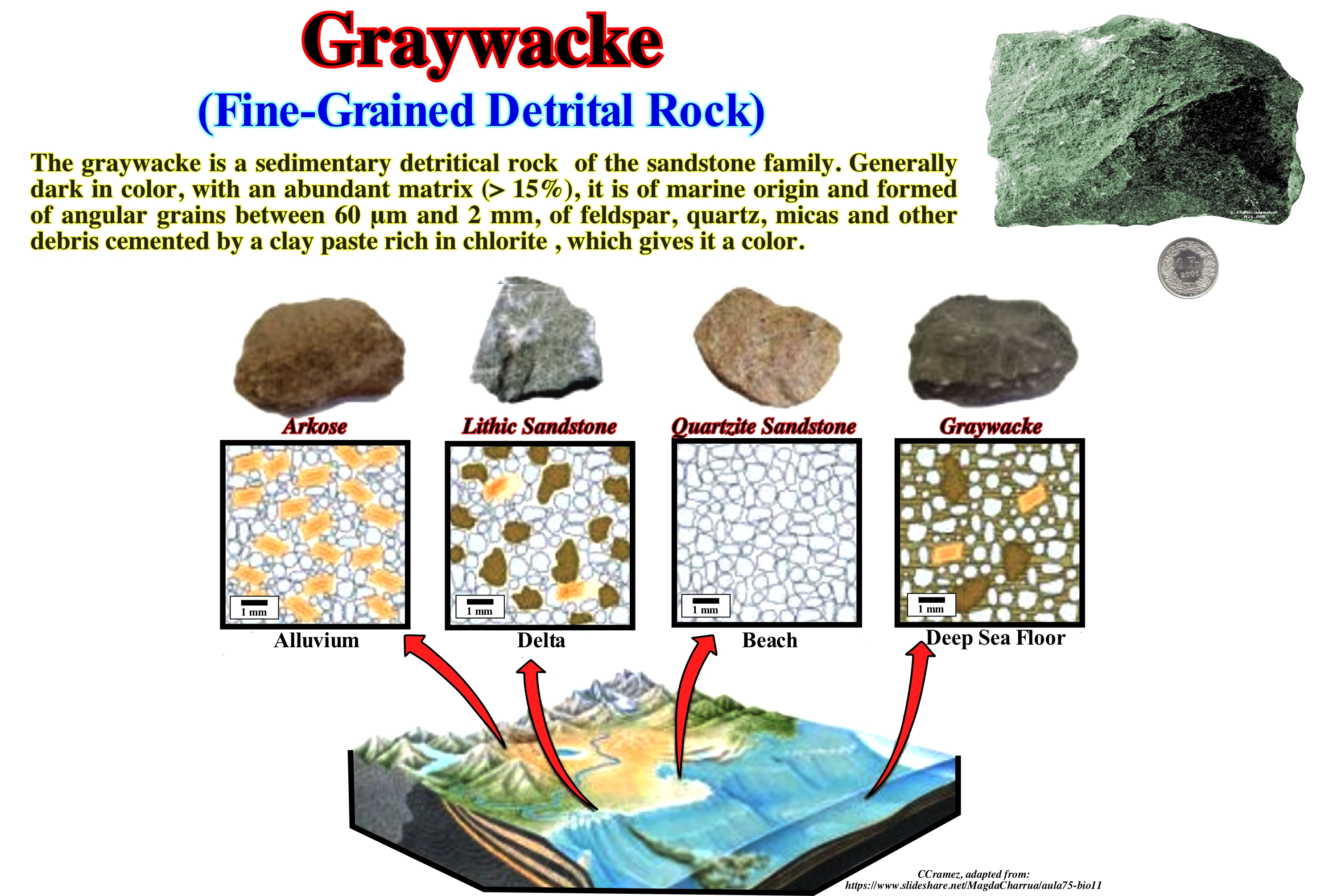
Etymologically, the term graywacke was the name that the German miners from the Harz Mountains (central Germany, Saxony) used to refer to rocks without ore veins. These rocks were described as Paleozoic sandstones from grey to dark green, very hardened and rich in fragments of other rocks and with a compact clayey matrix. To the geoscientists of the time, these sandstones suggested very rapid erosion, transport, deposition and burial, probably in association with the formation of mountain ranges. It was Pettijohn (1957) who first realized that the grade of the German miners was, probably, a rock of a turbiditic nature. This hypothesis was not easy to admit before the advent of sequential stratigraphy and the understanding of the mechanism of deposition of turbidity currents (simultaneous sedimentation of gravel, sand and mud). Most geoscientists now believe the formation of Harz mountain rocks is associated with submarine avalanches induced by relative sea level falls or caused by failures of the basin edge that have created important turbidite currents. Paleographically, the graywackes are found in the ocean bottom or continental slope and always in association with deep pelagic shales. Of course, prior to the advent of plate tectonics and sequential stratigraphy, all rocks that had a petrography similar to the rocks of the Harz Mountains were designated as graywackes, even if the geological and depositional context were different. It is for this reason that not all rocks classified as graywacke, before the 1980s, were deposited in submarine fans, either submarine basin floor fans or submarine slope fans. This means that the petrographic description of a rock, whether it is sedimentary, metamorphic or igneous, without taking into account the geological setting (tectonic and depositional), is, largely, insufficient to classify a rock in order to it correlate it with other rocks.
Green Blue Alga (Cyanobacteria).....................................................................................................................................Algue bleu-verte
Alga azul verde / Alga verde-azul / Green-Blaualgen / 蓝绿色藻类 / Сине-зелёные водоросли (цианобактерии) / Alga verde - azzurro /
Aquatic and photosynthetic bacteria, i.e., it lives in water and can produce its own food. Because blue-green algae are bacteria, they are, relatively, small and, usually, unicellular, although they can grow in colonies that can be seen with the naked eye. Cyanobacteria are known (by their fossils) since ± 3.5 Ga. Cyanobacteria are one of the largest and most important groups of bacteria present on Earth.
See: « Algae »
&
« Photosynthesis »
&
« Plankton »
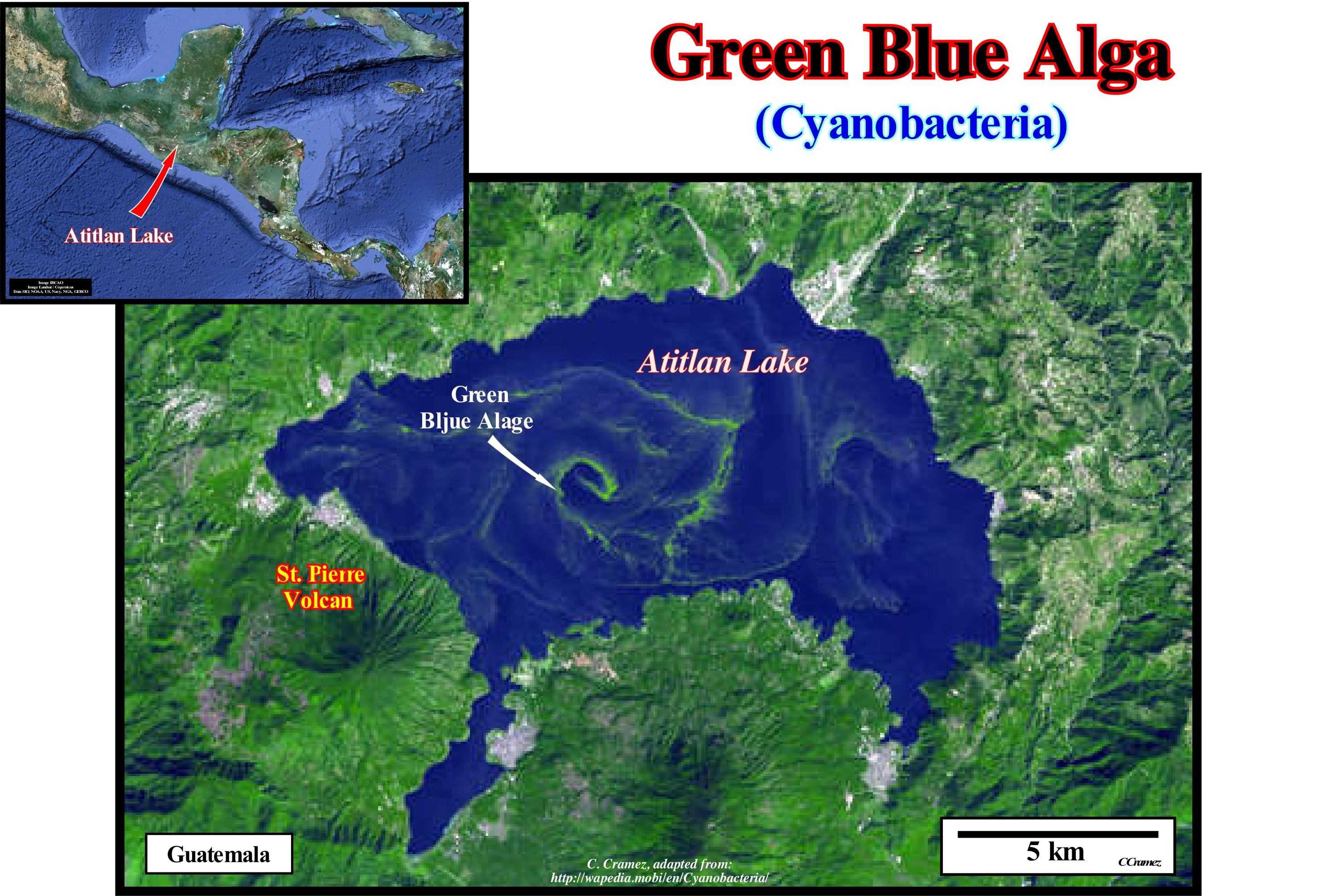
The green blue algae or cyanobacteria, as certain geoscientists call them, belong to a phylum of bacteria that gets their energy by photosynthesis (conversion of carbon dioxide into organic components from sunlight energy). The cyanobacteria, which were the first forms of life on Earth, between 3.3 and 1.5 Ga, were developed in dome-shaped structures called stromatolites consisting of alternating levels of organic and inorganic matter. Structures of this type can be observed on several coastlines, particularly, in the Bahamas and Australia. Many geoscientists consider cyanobacteria, which perform photosynthesis, were responsible not only for the reddish colouring of the Earth's surface, but for the first major biotic crisis as well. They admit the oxygen released by the cyanobacteria was fixed by the iron of the rocks. Probably, they gave a reddish coloration to the pristine terrestrial surface. After a certain moment, the oxidation of the rocks, allowed the accumulation of oxygen in the atmosphere and in the oceans, what, certainly, triggered a major biotic crisis. As its name suggests, the colour of these algae is blue*. These algae, which are an important component of the marine nitrogen cycle. They are primary producers in many areas of the ocean. Notwithstanding, they can also be found in environments in others that marine, as illustrated in this photograph. Cyanobacteria can be found in fresh-water environments, hyper-saline lakes and in arid environments, where they are the main components of the biological crusts of soils. Stromatolites (accretional structures, formed in shallow water by the storage and cementation of sedimentary grains by micro-organisms microfilms) of cyanobacteria are found in very ancient geological formations that certain geoscientists consider to be prior to 3.5 Ga. Cyanobacteria can be dangerous. They are toxic to man and other animals. They can create death zones. Indeed, as these bacteria multiply, they form a thick carpet (like the one visible in this photograph), blocking sunlight, preventing, partially or totally, the photosynthesis. On the other hand, they can consume most of the oxygen in the water creating a dead or depleted zone where other plants and animals can not survive. Such a development of cyanobacteria, also, affects themselves. Just the top of the cyanobacteria carpet receives sufficient light. The lower levels of cyanobacteria die releasing toxins ** into the water, which causes significant problems for man and other animals, as is the case in Atilan Lake in Guatemala.
(*) They look blue because red, orange and yellow (long wave-length light) are absorbed more strongly by them than is blue (short wave-length light). So when white light from the sun illuminate them, it is mostly the blue that gets returned. It is for the same reason the ocean-water or the sky are blue.
(**) Toxins may be small molecules, peptides or proteins capable of causing diseases when they come into contact or are absorbed by tissues of the human body, interacting with biological macromolecules, such as enzymes or cellular receptors. The severity of toxins varies greatly from a brief and small effect (as in the case of a bee sting) to a deadly effect (as in botulinum toxin). https://en.wikipedia.org/wiki/Toxina.
Green Revolution.................................................................................................................................................................................Révolution vert
Revolução verde / Revolución verde / Grüne Revolution / 绿色革命 / Зелёная революция / Rivoluzione verde /
A population increases exponentially (exponential growth), while food production increases arithmetically. People always run the risk of not having enough food. Since 1950, food production has, dramatically, increased due to the introduction of new fertilizers and seeds into agriculture.
See: « Murphy's Law »
&
« Law of Sigmoid Growth (carbonates) »
&
« Theory of Evolution »

The green revolution refers to the invention and dissemination of new seeds and agricultural practices that allowed a vast increase in agricultural production in less developed countries during the 1960s and 1970s. It is a broad-based program designed to increase agricultural production in the world through genetic improvement of seeds, intensive use of industrial inputs, mechanization and reduction of management costs. The model is based on the intensive use of genetically improved seeds (particularly hybrid seeds), industrial inputs (fertilizers and agrochemicals), mechanization and lower management costs. The green revolution is also credited with the extensive use of technology in planting, irrigation and harvesting as well as production management. If in a critical way the "Green Revolution" provided through these '"innovative packages" the environmental and cultural degradation of the traditional farmers, on the other hand, it was just with it that it was possible to feed the more than 6 billion people on Earth. This cycle of innovations began with the post-war technological advances, although the term green revolution just emerged in the 1970s. Since then, researchers in industrialized countries have promised, through a set of techniques, agricultural productivity and solving the hunger problem in underdeveloped countries. But, contradictorily, besides not solving the problem of hunger, it increased land ownership concentration, dependence on modified seeds and altered, significantly, the culture of smallholders. In contrast to the increase in productivity generated by the Green Revolution, it was observed in the underdeveloped countries the increase of landowner structure, since the small farmers could not finance the necessary expenses to accompany the Revolution (http://en.wikipedia.org/ wiki / Green Revolution).
Greenhouse Gas.......................................................................................................................................................................Gaz à effect de serre
Gás com efeito de estufa / Gas de efecto invernadero / Treibhausgas / 温室气体 / Парниковые газы / Gas serra /
Gas not transparent to infrared rays. Water vapour, methane, carbon dioxide, ozone, nitrogen oxides and chlorofluorocarbons are the main greenhouse gases. These gases are not transparent to the infrared rays, i.e, they do not allow them to pass to the extra atmospheric space, which, naturally, produces a heating of the atmosphere and the terrestrial surface. Certain geocientists advanced the hypothesis that without the greenhouse effect, the temperature of the Earth's surface would be about -18° C*.
See: « Methane »
&
« Global Warming »
&
« Natural Greenhouse Effect »
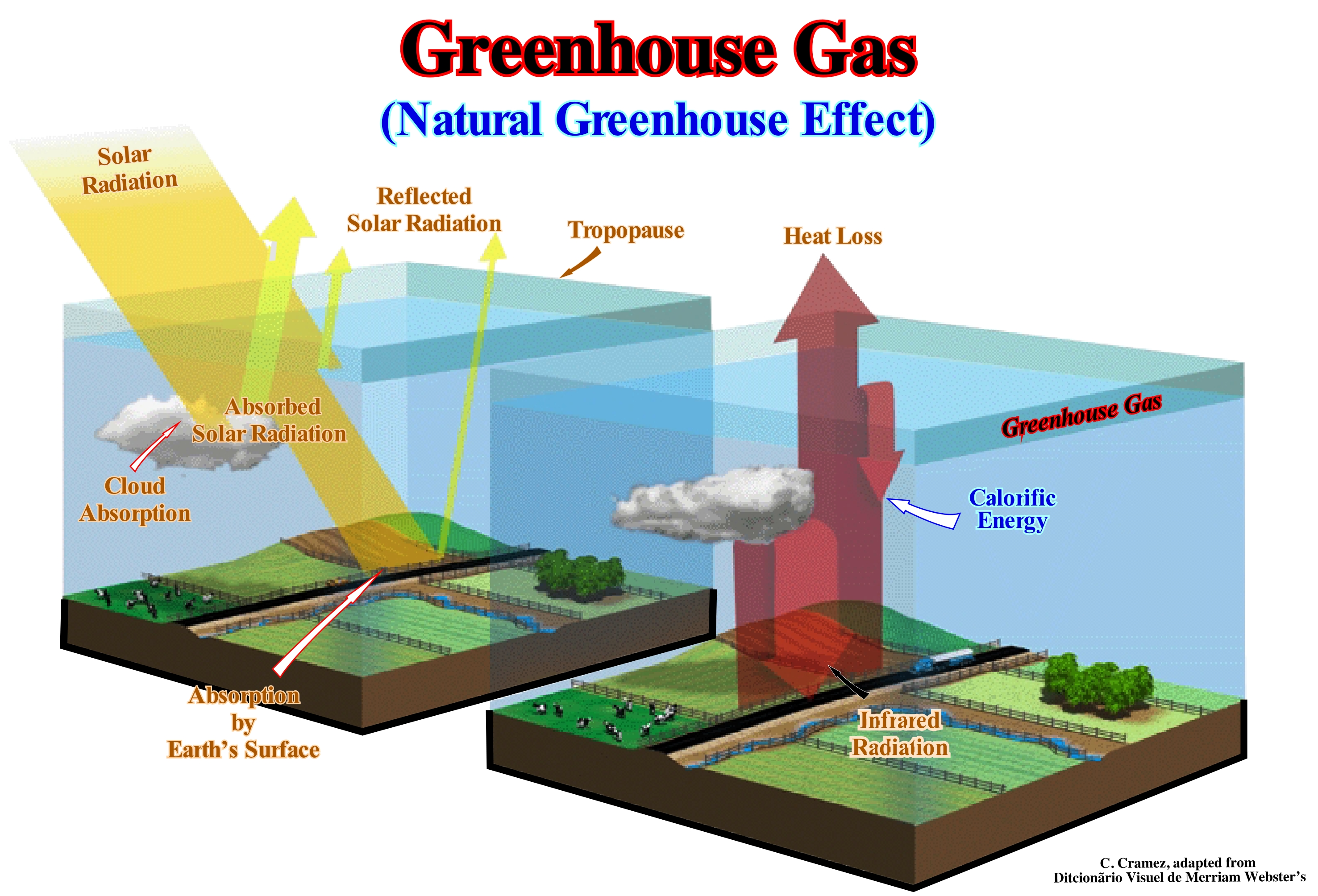
A part of the solar radiation is absorbed by the clouds or reflected by the Earth's surface. Only a small fraction is absorbed by the Earth. The rising temperature of the Earth's surface induced by the absorption of the solar radiation causes a radiation of infrared rays to the atmosphere and a loss of heat, that is dissipated in the space. The presence of greenhouse gases in the atmosphere prevents some of the infrared rays from leaving the atmosphere, which contributes to their heating. This system, which is natural, seems to have been altered by the production of greenhouse gases produced by man. It is very often heard the atmosphere acts as the greenhouse of a garden heating the Earth in the same way as a greenhouse is heated by the impermeability of the glass walls. The reasoning is as follows: (i) Like glass, the gases in the atmosphere let in the light and prevent the heat from escaping ; (ii) This natural warming is called the greenhouse effect ; (iii) Greenhouse gases (CO2, CH2, NO and others) are transparent to certain wave-lengths of the sun's rays and allow them to enter the atmosphere and reach the Earth ; (iv) Clouds, glaciers and other particles reflect about 30% of the solar radiation, but the oceans and continent absorb the rest, that returns to space as infrared radiation ; (v) Greenhouse gases and clouds prevent part of the infrared radiation from escaping, thereby blocking the heat near the Earth's surface by heating the lower atmosphere. However, many geoscientists consider that all this as mere conjecture based on a false comparison. For them, the atmosphere does not function as a garden greenhouse (half closed), in which it is the convection of air in a closed system that heats the greenhouse.
(*) The calculation of the average temperature of the Earth and planets, outside their atmosphere can done with the following data (A. Foucault, 2016, Climatologie, Cours et Paléoclimatologie. Cours et Exercices corrigés, ISBN 978-2-10-75460-1) : R= radius of the planet ; d= distance from the planet to the Sun in astronomic units UA (for the Earth d=1) ; F= Solar constant for the Earth (power of radiation received from the Sun outside the terrestrial atmosphere per square meter, or 1.361 Wm-2. For any planet, this power, which decreases as the square of the distance to the Sun will be F/d2) ; A= Albedo (proportion of radiation returned to space without modification: 0.31 for Earth) ; Pi= power received by the planet ; Pr= power returned to the space by the planet ; σ = Stephan’s constant 5.67 x 10⁻⁸ W.m-2.K-4 ; T= temperature of the planet (in Kelvins). We will get: Pi=ᴨR2F/d2 x(1-A) (solar radiation is intercepted by a disc of radius equal to that of the planet), and Pr=4ᴨR2σT4 (the radiation returned by the Earth according to Stefan's law is done by its spherical surface). In the state of thermal equilibrium, the energy returned is equal to the energy received and Pi = Pr, i.e.,: ᴨR2F/d2 x (1-A) = 4ᴨR2σT4 from which we draw: T4 = F / 4σd2 x (1-A) and : T = 278,33 (1-A)1/4 /√d for the Earth: T = 255 K or -18 ° C (temperature of the Earth seen from space, out of the atmosphere)
Groove (Undercut, notch)..........................................................................................................................................................Encoche submersible
Sapa submersa / Socavamiento submergido / Unterwasser unterbieten / 水下削弱 / Подводная выемка / Intaglio subacqueo /
Notch under the cornice of surf,below the level of nipe tide. Unlike the undercutting at the cliff base, that is formed above the average level of the sea, the submerged groove is, usually, under water.
See: « Karstification »
&
« Erosion »
&
« Cliff »
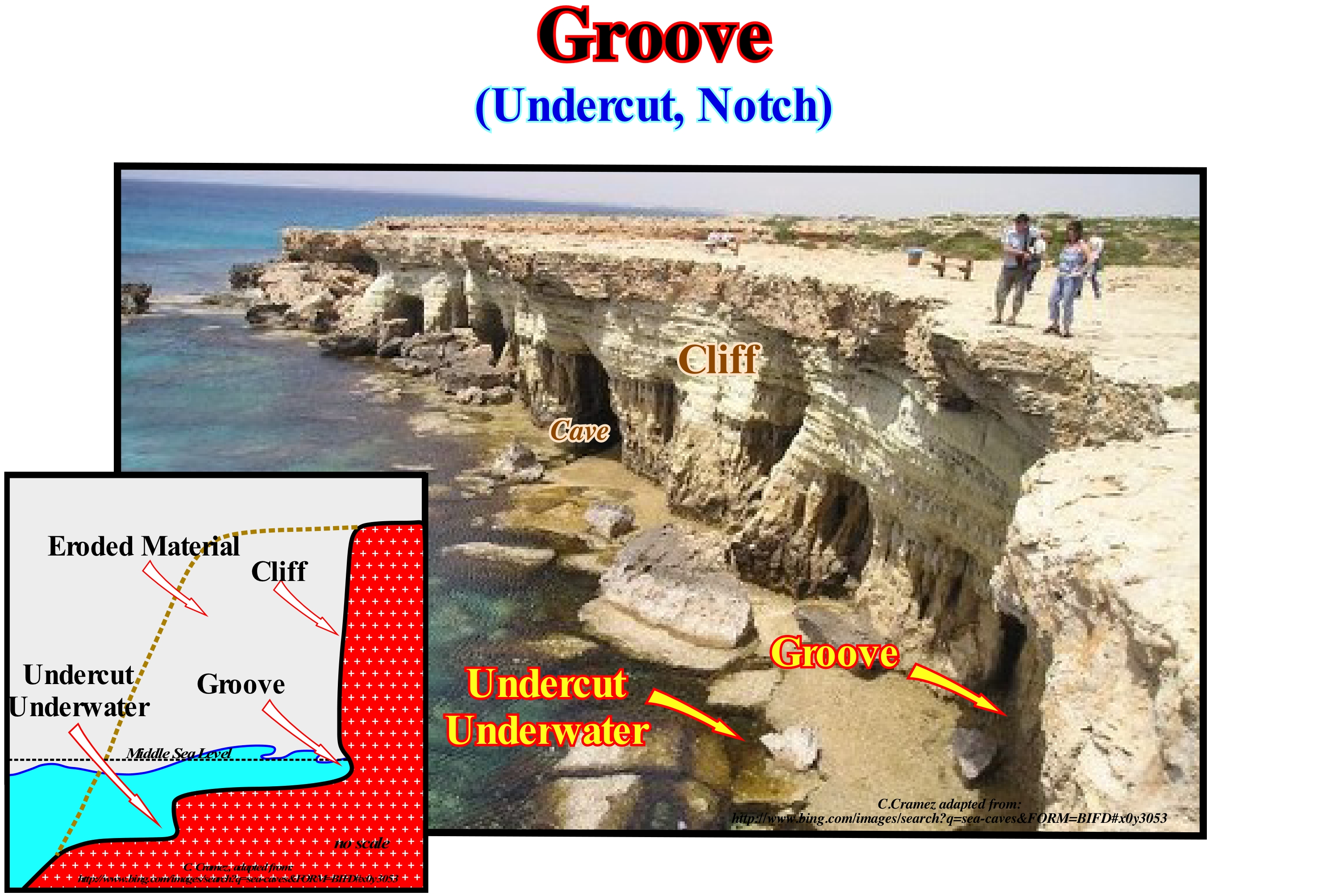
The source of energy for coastal erosion and sedimentary transport is the action of sea-waves. A wave has potential energy due to its position above the wave trough and the kinetic energy caused by the movement of water within the wave. Wave energy is generated by the friction effect of winds blowing on the surface of the ocean. The greater the wind speed and the greater is the fetch (the extent of the surface of the ocean on which the wind blows and the waves travel) the larger will be the waves and, therefore, the more energy they have. In areas where sea depth is greater than the wave-length of waves, wave motion does not reach the sea floor. Since the depth of the sea is less than half the wave-length of the waves, the height of the waves increases very quickly and the wave-length decreases strongly. In this way, the waves when they approach the coast become sharper and, finally, they break. When they break down, their potential energy is converted into kinetic energy, which gives a lot of energy for the wave to do the erosion work along the coastline. It is this energy that is responsible for the sap work that produces the coastline morphology illustrated in this figure. Of course, the rate at which the coastline is eroded depends on the hardness of the rocks and the degree to which the coast is exposed to the direct action of the wave attack. They begin by forming important groove attacking mainly the fragile zones of the rocks (fracture, fissures, etc.), which, in time, become caves. These, in turn, over time, widen and form arcs such as those illustrated above. Eventually, the arch collapses forming marine walkways (narrow passages between the cliffs, which sometimes allow one to go from one beach to another by blocking path). A new arch may eventually develop on the remaining land tip. This evolution of the groove, in caves, from caves in arches and arches in marine walkways is easily recognized on the Portuguese south coast.
Ground Moraine..................................................................................................................................................................................Moraine de fond
Moreia de fundo / Morena de fondo / Grundmoräne / 地面的冰碛 / Поддонная морёна / Morena di fondo /
Moraine deposited on the floor of the glacier valley. The ground moraine has no obvious characteristics. It is located where the glacier meets the underlying rock. It can be leached by infraglacial currents and isolated when the glacier melts.
See: « Moraine »
&
« Glacier »
&
« Erratic Block »
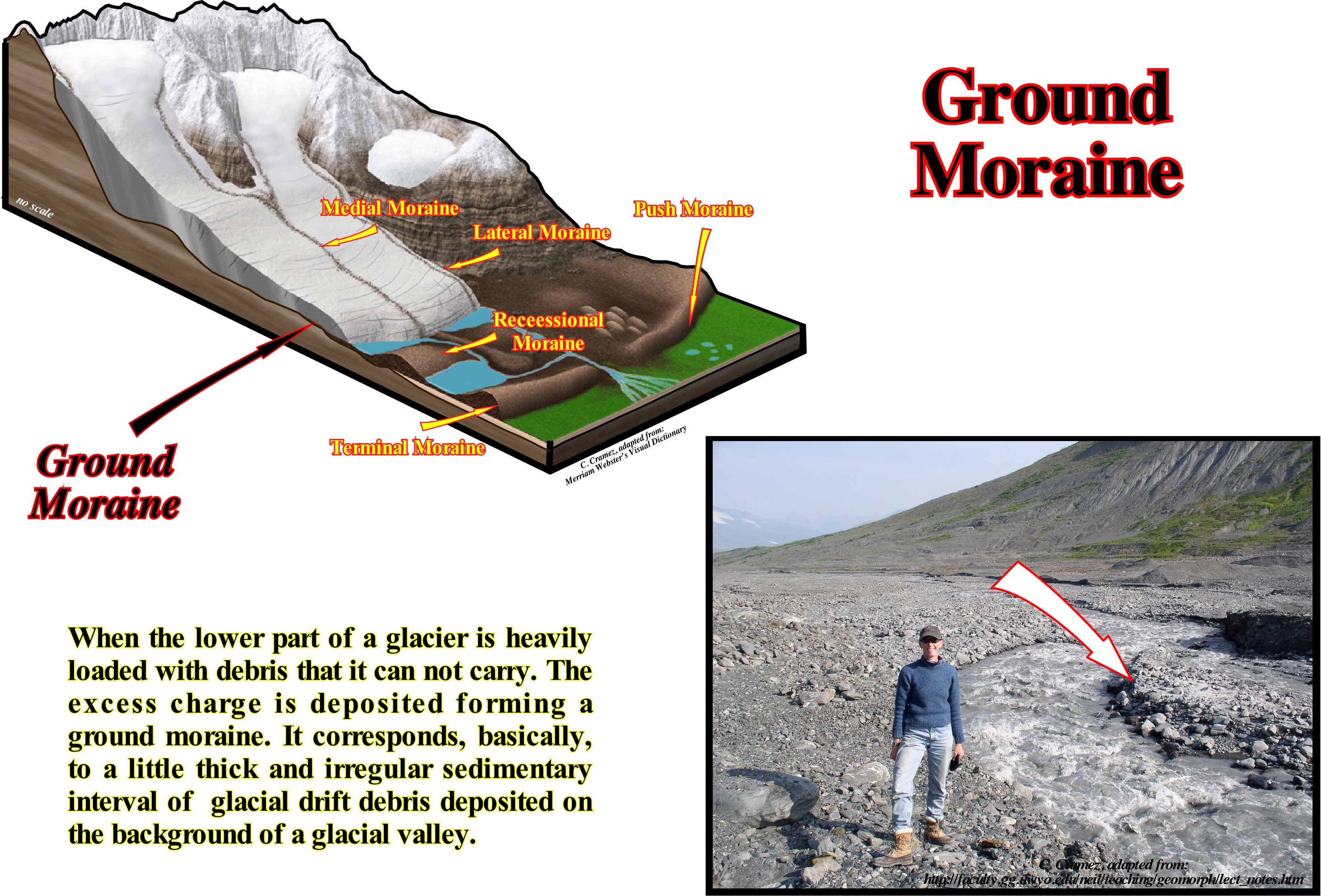
All of the rock remains shown in the foreground of the photograph constitute the ground moraine that was exposed as the Grinnell glacier thinned (Glacier National Park in the State of Montana, USA). This material was, previously, under the glacier, that can be guessed at the top left of the photograph. In general, it can be said the ground moraine are till deposits (un-worked and non-layered sediments deposited directly by or under a glacier and not reactivated by the glacier melting waters) with topography irregular forming either small hills or plains. These moraine accumulate under the ice not only when the glacier thickens but when it thins as well. In alpine glaciers, most of the time, the ground moraine are deposited between the two lateral moraines. This type of accumulation under the ice, when the glacier is active, can be presented, fundamentally, in two forms that characterize different landscapes: (i) Succession of drumlins* and (ii) Ground plain moraines. The first is characterized by whale-shaped hills, which vary in size (length from a few tens to hundreds of meters, width on average about one third of the length and height between 5 and 40 meters). The drumlins appear in groups, called drumlins fields, where swampy depressions form between ovoid hills. Drumlins are nothing more than local thickening of the bottom moraines, that the glacier modelled according to certain forms in function of its own dynamics. In the plain ground bottom moraines, accumulation is not done in packets, more or less localized, as it is the case of drumlins, but in a uniform way. The thickness of a plain bottom moraine is never very thick (a few meters on average, 20 or 30 meters if several moraines overlap). For certain geoscientists, they serve to attenuate the pre-glacial topography. In addition to the ground moraines, there are also: (i) Lateral moraines; (ii) Medial Moraines ; (iii) Frontal Moraines ; (iv) Recessional moraines ; (v) Push moraines and (vi) Terminal moraines.
(*) More or less profiled hill, largely composed of till and with the smoothest end oriented in the direction the glacier movement.
Grounded Ice Shelf.........................................................................................................................................................Plate-forme de glace
Plataforma de Gelo / Plataforma de hielo / Schelfeis / 冰架 / Шельфовый ледник / Piattaforma di ghiaccio /
Thick, floating mass of ice that forms where a glacier or ice sheet flows to a coastline unloading on the surface of the ocean. Grounded ice shelves are only found off the coast of Antarctica, Greenland and Canada.
See: « Inlandsis »
Growth Fault Setting...........................................................................................................................Contexte de bassin (Faille de croissance)
Contexto de Bacia (falha de crescimento) / Contexto de cuenca (falla de crecimiento) / Becken Kontext (Wachstum Störung) / 流域范围内(生长断层) / Внешнее окружение конседиментационного разлома / Contesto di bacino (faglie dirette listriche con crescita) /
When the boundary between the coastal plain and the continental slope is marked by a growth fault, which by definition is contemporaneous with sedimentation. As is the relative movement of the faulted blocks (footwall and hangingwall), that creates the greater part of the available space for the sediments (accommodation), the thickness of the different sedimentary packages (submarine basin floor fans, slope fans and lowstand prograding wedge) deposited on the hangingwall increases towards the fault plane.
See: « Basin (sedimentary) »
&
« Sequence-Cycle »
&
« Systems Tract »
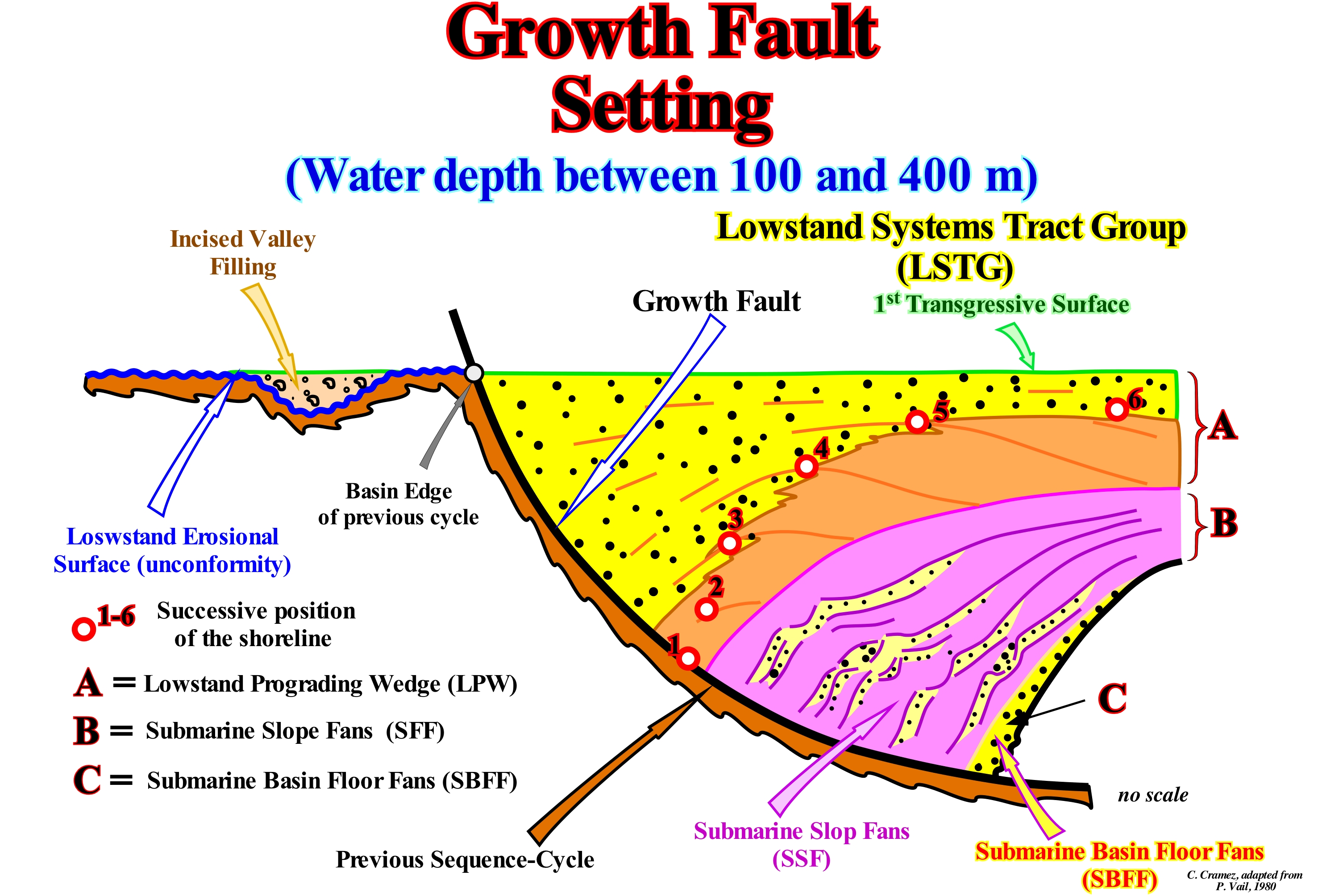
When the relative sea level*, i.e., when the local sea level, referenced to the base of the sediments (top of the continental crust) or to the sea floor, is lower than the basin edge, that is, under lowstand geological conditions, the shoreline, which is, more or less, coincident with the depositional coastal break of the depositional surface (especially in the seismic lines), overlaps, practically, the continental edge (upper limit of the continental slope). Under such conditions, within a sequence-cycle, in a growth fault basin setting, the sea level is always lower than the basin edge (the last basin edge of the preceding sequence-cycle, as shown in this figure). The last basin edge of the preceding sequence-cycle is emphasized by a growth fault. This edge and growth fault remain, more or less, in the same position during the deposition of the lowstand systems tracts group of the considered sequence-cycle (sequence-cycle having as the lower limit an unconformity underlined by the fault plane of the growth fault induced by a relative sea level fall). In depth, the fault plane of the growth fault horizontalizes, quickly, as a function of the curvature of the fault trace (more the fault trace, on the ground surface, is curved higher the plane plane is flattened in depth). On the other hand, in a normal growth fault, which is contemporaneous with sedimentation, the relative motion along the fault plane creates a differential subsidence increasing toward the fault plane. This means the available space for the sediments (accommodation) increases towards the fault plane. That is why the sedimentary intervals deposited in the hanging-wall increase in thickness toward the fault plane. In other words, the lowstand systems tracts sub-groups : (i) Submarine Basin Floor Fans (SBFF) ; (ii) Submarine Slope Fans (SSF) and (iii) Lowstand Prograding Wedge (LPW), deposited in the hanging wall of the growth fault thicken against the fault plane (towards the continent). As indicated in this sketch, landward of the basin edge, which in this conditions coincides, more or less, with the shoreline (the basin has no shelf), the incised valleys, formed during the relative sea level fall, which created the unconformity limiting the two sequence-cycles, are filled by coarse sediments deposited at the same time as the sediments deposited in the upper part of the lowstand prograding wedge (LPW). Submarine basin floor fans (SBFF) and submarine slope fans (SSF) are deposited during relative sea level fall (probably also induced by formation and movement of the growth fault). The prograding wedges (HPW and LPW) are deposited when the relative sea level begins to rise. The relative sea level is a local sea level referenced to the sea floor or to the base of the sediments (top of the continental crust). It is the result of the combined action of tectonics (subsidence or uplift of the sea floor) and absolute (eustatic) sea level, which is supposed to be global and reference to the Earth's centre. In the hanging-wall of the growth fault, the evolution of the shoreline (more or less, the depositional coastal break of the deposition surface), during the deposition of the lowstand prograding wedge (LPW), can be, easily, predicted, by the cartography of the toplaps (by no-deposition), as illustrated in this geological sketch. Since growth fault ceases to be active, a relative sea level rise creates a transgressive surface that is the result of a marine ingression in acceleration (more important that the previous marine ingression). As a consequence of the marine ingression, the shoreline is moved continentward creating, in the pre-existing topography, a ravinment surface and the formation of a shelf as the continental edge becomes the new basin edge. Under these conditions, the relative sea level is higher than the basin edge and the geological conditions become highstand. The sedimentation resumes during the stability period of relative sea level, that occurs after the marine ingression. Gradually, the shoreline is displaced seaward, but without reaching the position it had before the first marine ingression in acceleration, i.e., the position of the shoreline at the end of the lowstand prograding wedge (LPW) of the considered sequence-cycle, in spite of the fact that the shoreline is, globally, shifted continentward (retrogradation).
(*) The relative sea level is the result of the combination of absolute (eustatic) sea level (referenced to the Earth's centre) and tectonics (subsidence or uplift of the sea floor).
Growth Fault Setting (Example)...............................................................Contexte de bassin (Faille de croissance, exemple)
Contexto de Bacia (falha de crescimento) / Contexto de cuenca (falla de crecimiento, ejemplo) / Becken Kontext (Wachstum Störung) / 流域范围内(生长断层) / Внешнее окружение конседиментационного разлома (пример) / Contesto di bacino (faglie dirette listriche con crescita) /
When the boundary between the coastal plain and the continental slope is marked by a growth fault, which by definition is contemporaneous with sedimentation. As is the relative movement of the faulted blocks (footwall and hangingwall) that creates the greater part of the available space for the sediments (accommodation), the thickness of the different sedimentary packages (submarine basin floor fans, slope fans and lowstand prograding wedge) deposited on the hangingwall increases towards the fault plane.
See: « Growth Fault Setting »
&
« Sequence-Cycle »
&
« Systems Tract »
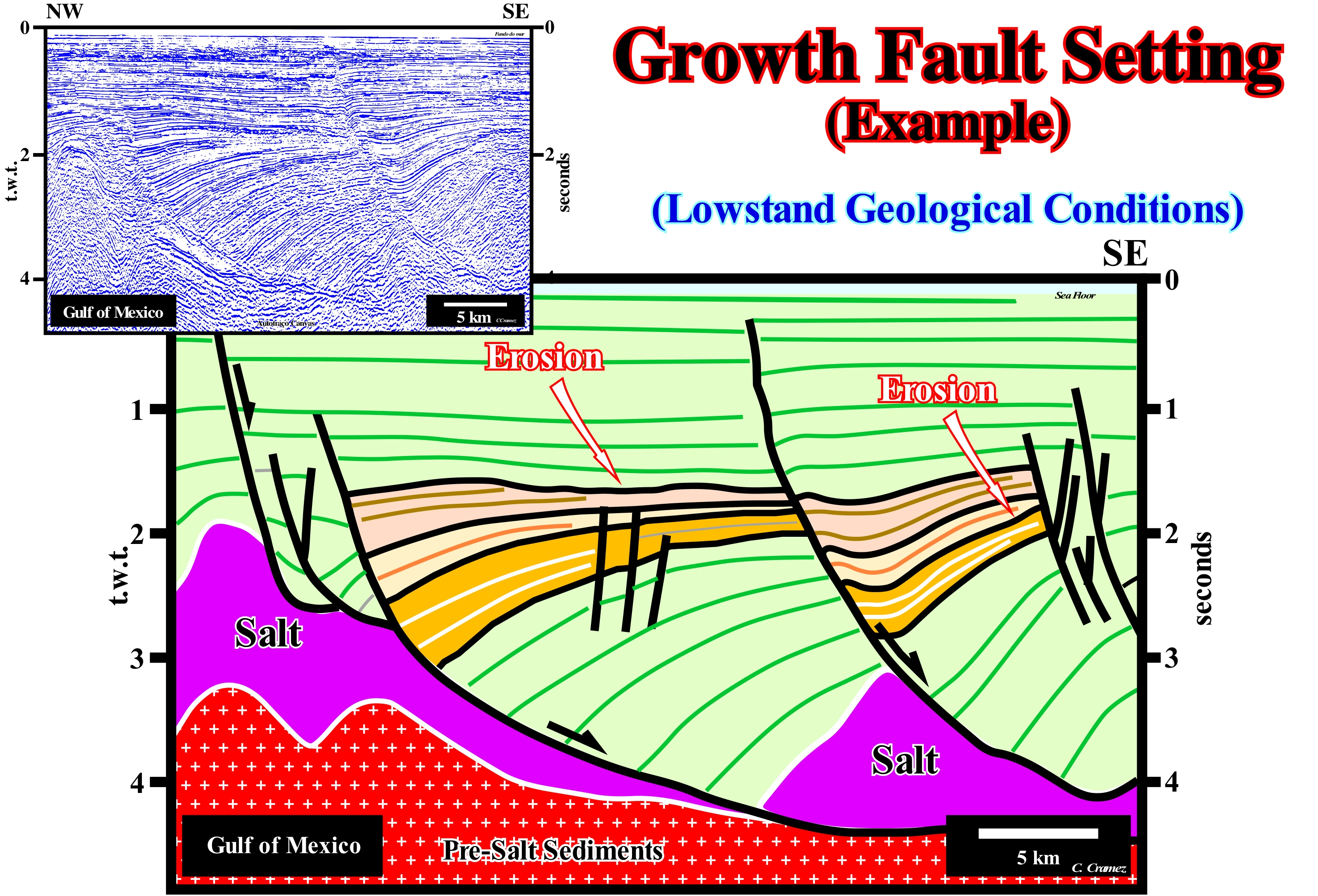
This morphological context is very frequent in the sedimentary basins where shalokinesis (clay induced tectonics) or halokinesis (salt induced tectonics) are active. Often, in these basins, normal growth faults occurs (the relative movement of faulted blocks is contemporaneous with sedimentation) in association with the formation of clay or salt domes. On this tentative of geological interpretation of a Canvas auto-trace of seismic line of the Gulf of Mexico, the relationships between growth faults (genesis and evolution) and salt structures are evident. The creation of available space for the sediments (shelfal accommodation) on the hanging-wall faulted blocks is due, mainly, to the compensatory subsidence produced by lateral flow (flow) of the salt, although the cyclicity of the sedimentary intervals is controlled by eustasy. On this tentative interpretation, the three considered intervals, in addition to the salt interval, correspond, probably, to sequence-cycles. Lowstand systems tracts groups (LSTG) are developed in the hanging-wall faulted blocks, where they thicken and dip towards the fault plane. In the distal part of the foot-wall faulted blocks, where the sedimentary deposits are little thick, lowstand systems tracts sub-groups are very reduced and, sometimes, even absent. In a finer tentative interpretation, it is noted that all members of the lowstand systems tracts group, i.e., the submarine basin floor fans (SBFF), the submarine slope fans (SSF) and the lowstand prograding wedge (LPW), thicken, in a significant way, toward the fault plane by tilted onlaps, where the facies (lithology) is coarser and more sandy (possibility of rocks-reservoir).
Guide Fossil..................................................................................................................................................................................................................Fossile index
Fóssil guia / Fósil guía / Leitfossil / 指準化石 / Руководящие ископаемые / Fossile guida /
Fossil that identifies and dates a layer on which it is, typically, found. A guide fossil must have a wide spatial distribution, even global, being restricted to a short stratigraphic range and of short duration. These fossils help geologists to date other fossils found in the same sedimentary layer. When one finds a fossil of an unknown age near a fossil of a known age, it can be assumed that the two species cohabited at the same time. Synonym with Index Fossil.
See: « Relative Age »
&
« Index Fossil »
&
« Geologic Time »
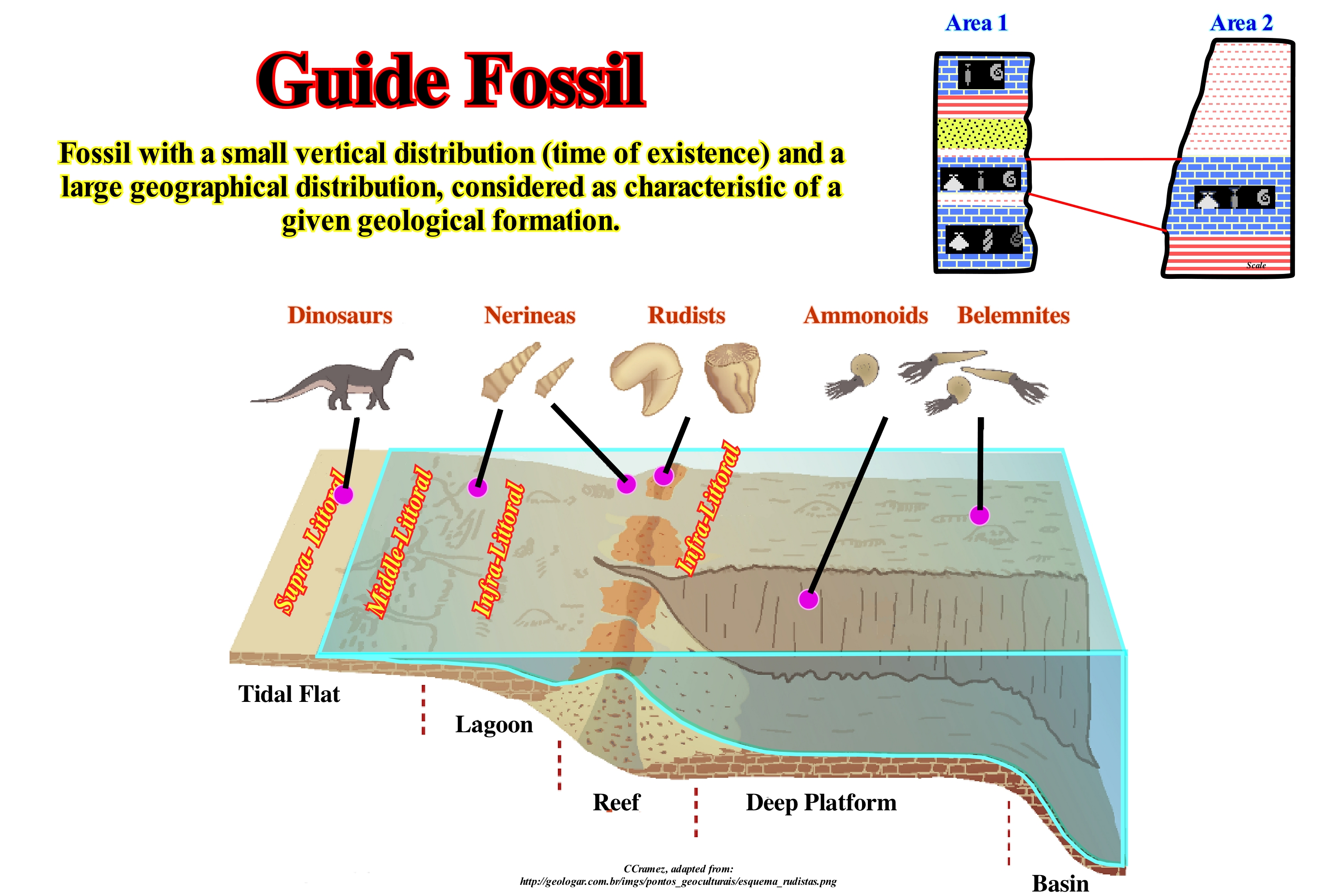
As illustrated in this sketch, guide fossils allow to make correlations between different regions, to perfect the stratigraphic column and to determine the relative age of the rocks. In this example, the three guide or index fossils of the carbonate interval in the middle of the stratigraphic column of region 1, allow to determine the age of the carbonate interval of region 2. The combined use of several guide fossils allows better results. Theoretically, a guide fossil must have the following characteristics: (i) Easy to identify ; (ii) Frequent ; (iii) Present in a relatively small geological time interval and (iv) Large areal distribution. Before the advent of sequential stratigraphy, the quest for fossils was, fundamentally, empirical. I still remember one of my teachers, to tell us that fossils were, preferably, in the shale intervals, which is partly true, but there are thousands of clayey intervals without fossils. Later, one of his young assistants went further, but he did not know why: "Fossils are most likely to be found in shales dipping slightly and covered by shales with higher dipping". Sequential stratigraphy, strongly, suggests the abundance of fossils, as the organic matter content, is, mainly, significant in the sedimentary intervals associated with downlap surfaces, as between the transgressive interval and the highstand prograding wedge of a stratigraphic-cycle. In fact, the deposition hiatus, water-depth, sedimentation rate and oxygen depletion between the transgressive interval (TI) and the highstand prograding wedge (HPW) are favourable to the development and preservation of organic matter and thus an eventual presence of fossils.
Gulf...............................................................................................................................................................................................................................................................................Golfe
Golfo / Golfo / Busen, Golf / 海湾 / Залив / Golfo /
Large recess of the coastline, arched and larger than a bay, i.e., with an area exceeding 500 km2.
See: « Bay »
&
« Shoreline »
&
« Estuary »
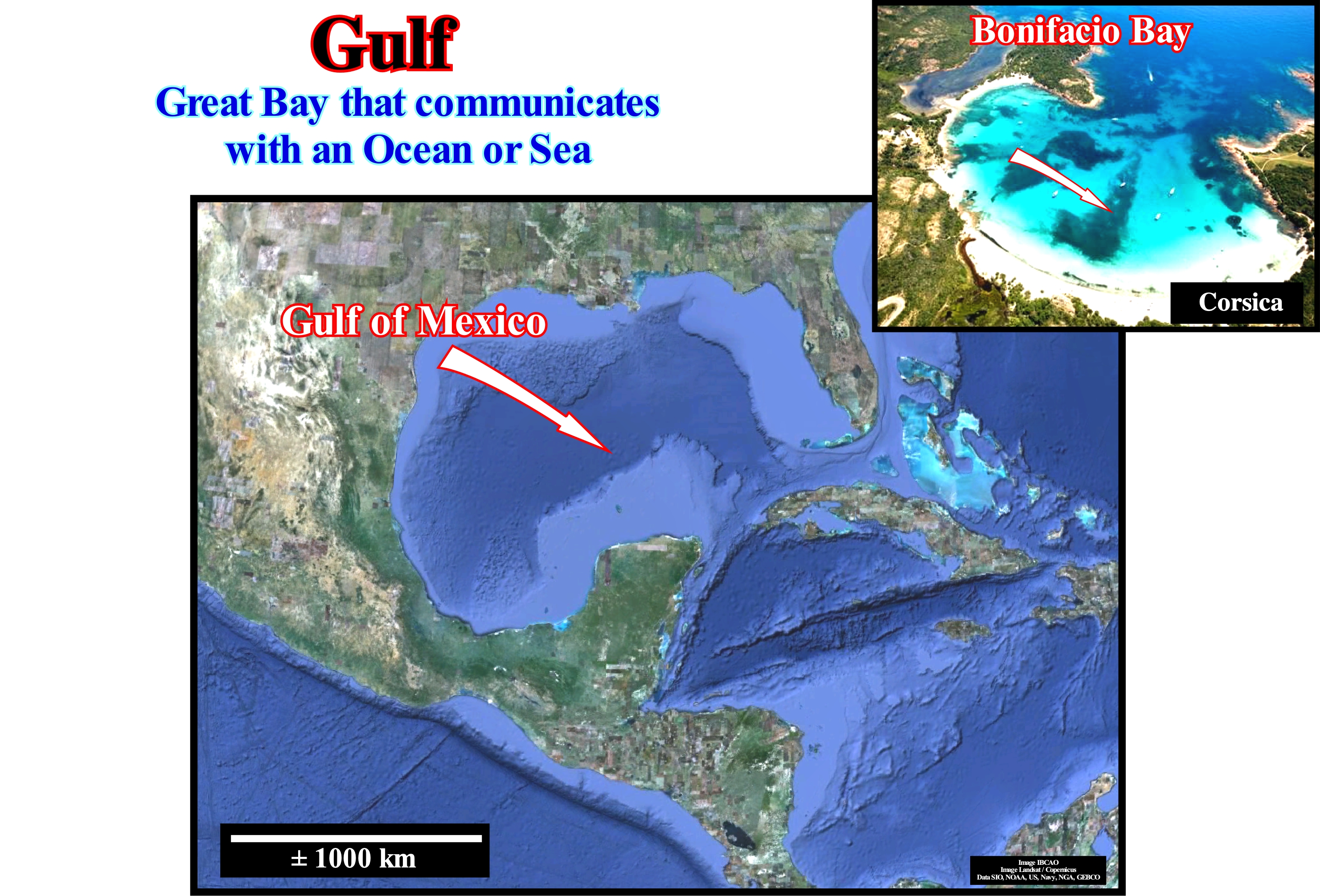
In terms of sequential stratigraphy, the Gulf of Mexico, illustrated in this figure, corresponds more to a marginal sea than to a gulf itself. In the Gulf of Mexico, the water column reaches more than 3,000 meters and a part of the substrate of this gulf corresponds, even, to the oceanic crust. Seismic data, strongly, suggest the presence of SDR, i.e., sub-aerial lavas (sub-aerial volcanic crust) and pillow lavas over volcanic dikes, that is, oceanic crust. This means Gulf of Mexico region, in the past, has undergone an extension (lengthening), sufficiently, important to break-up the lithosphere allowing oceanization. In other words, the lengthening of the Appalachian folded belt allowed the formation of a Mediterranean-type basin on which a divergent Atlantic-type margin was deposited during the Cenozoic. On the other hand, as can be seen in this figure, the mouths of the rivers occur in the gulf, downstream of the bay-line. The differentiation between the bay-line and the mouth of the water-courses is very important. For certain geoscientists the delta deposits occur at the bayline and for others at the mouth of the rivers. For most geoscientists, there is deposition when a significant water-course encounters a permanent water-body and the flow velocity of the stream decreases abruptly. However, for certain geoscientists, such an encounter occurs at the mouth of the currents, upstream of the apex of the delta, and not at the bayline. This would explain why the distributaries of the Mississippi River progradated (seaward) around 3 kilometers during the last century and deposited mouth bars as the flow entered the Gulf of Mexico, where the stream competence decreased abruptly. Such a fact is just possible when the waters gradually progradate to that point. This would be the reason why the distal area of the Mississippi is subject to heavy flooding, whereas crevasses-splay occur throughout the delta plain.
Gulfstream.........................................................................................................................................................................................................Courant du Golfe
Corrente do Golfo / Corriente del Golfo / Golfstrom / 墨西哥灣暖流 / Гольфстрим / Corrente del Golfo /
Ocean current that begins between Florida and Bahamas and dilutes in the Atlantic Ocean to the longitude of Greenland. Across Florida, it is an authentic river, with a width between 80 and 150 km and a depth between 800 and 1,200 m. It moves at a speed of ± 2 m/s and its limits are visible to the naked eye. It moves, parallel to the coast, till the Cape Hatteras, and then to east, forming meanders, which separate, gradually, from the main stream forming swirls with a life span of a few days or weeks. These whirlwinds are the main mechanism of loosening and dilution of the current.
See: « Stream »
&
« Coriolis Effect »
&
« Ekman Transportation »
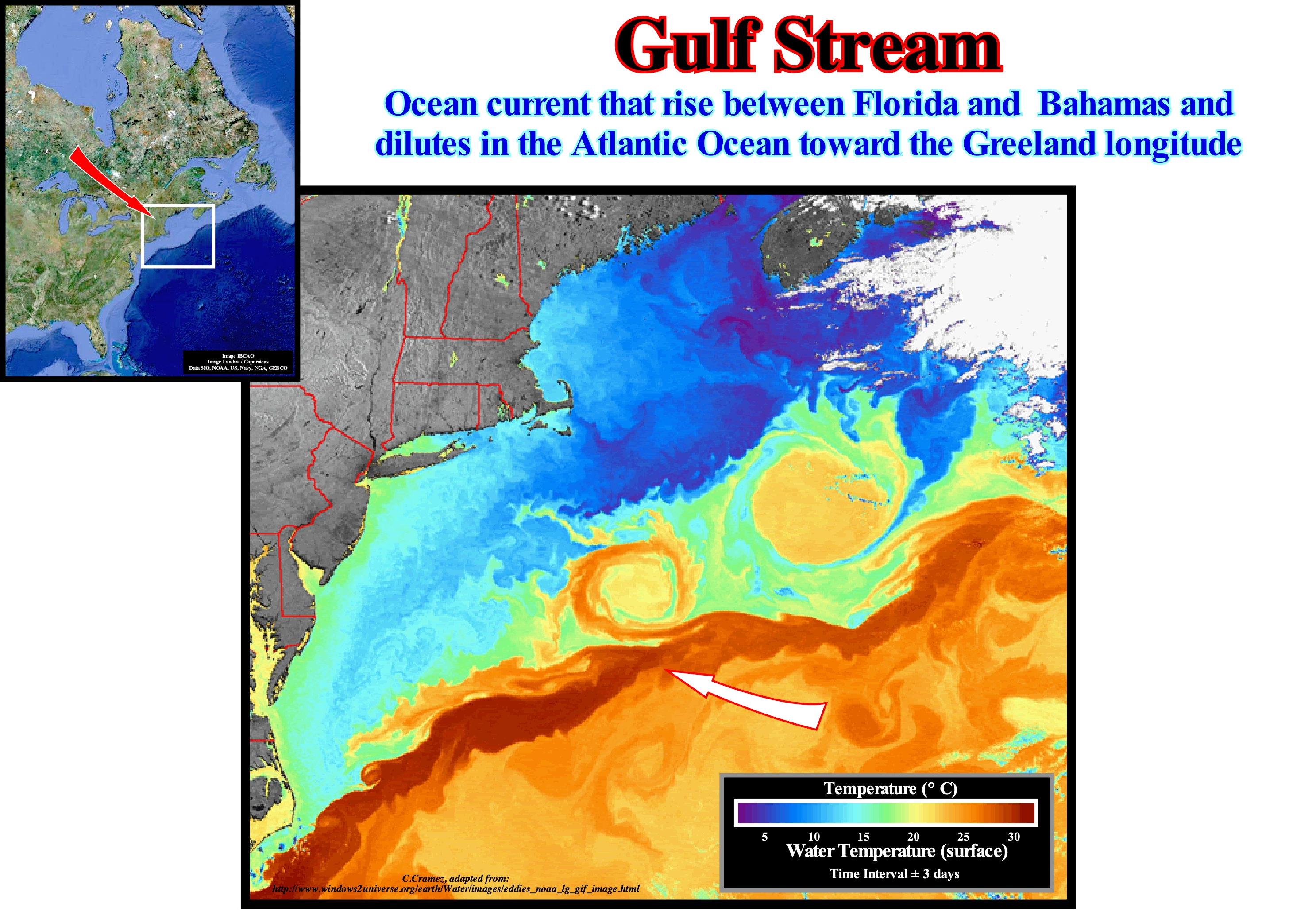
Although the Gulf Stream is a warm surface ocean current running along the US East Coast, from the Gulf of Mexico to the north-eastern Atlantic Ocean, it can, also, be considered a density current. As it flows into the Norwegian Sea, it cools and, progressively, its salinity increases. In the northern part of the Atlantic, some of its meanders are, progressively, released of the main current to forming swirls that can last for several weeks. When the water from the Gulf Stream reaches the Norwegian Sea, it cools down. As it was already, relatively, dense due to its strong salinity, such a cooling further increases its density that is, largely, sufficient to transform it in a downwelling current. It plunges to the deepest parts of the ocean basin. A the level of the high latitudes of the North Atlantic (Norway, Greenland and Labrador Sea), the salty and cooled waters plunge to a depth between 1 and 3 km and descend southward, forming the North Atlantic deep-water. The rise of these waters is done, mainly, by a vertical mixture throughout the ocean. It is estimated that a water molecule spends about 1,000-1,500 years doing this whole circuit. There are also regions of dense water formation in the Antarctic Ocean, at levels of the Ross Sea and Weddell*. In fact, it is difficult to separate the circulation created just by the density gradients from the other sources of movement of the water-bodies, such as wind and tides. In order to study this large-scale circulation, geoscientists prefer a more definite concept, namely the Meridional Overturning Circulation (MOC)**. Obviously, the current of the Gulf influences much the climate. It, significantly, warms the northern part of Europe. Without the Gulf Stream, Northern Europe would be much colder. A simple comparison between the winter temperatures of European and Canadian cities, located at about the same latitude, is quite significant. In Madrid, which is at latitude 50° N, the average temperature in January is 5° C. In Edmonton, Canada, which is at latitude 53° N in January, the average temperature is -15° C. With regard to the origin of the Gulf Stream, it can be said : (1) The Canarian Current, which originates near the Sagres promontory (Portugal), flows southward along the African coast ; 2) Northward of the Cape Verde Archipelago, it becomes the North Equatorial Current or SE Trade Winds, which crosses the Atlantic parallel to the Equator (south of the Sargasso Sea) ; 3) This current interacts with the NE coast of South America and is divided into two branches: one flows south of the Caribbean Sea and the other (called Antilles Currents) flows to the north and east of the Antilles ; 4) It is from the junction of these two branches, north of the Florida Straits that Gulf Stream is formed. Many years before the expedition of Juan Ponce de Leon, in 1512, and even before the voyage of Christopher Columbus (1492), the Gulf Stream was, already, well known by the Portuguese navigators (1416-1434). They departed, usually, from Lisbon to the African coast without great difficulty following the Canarian Current. However, to return to Portugal, they had to go around the Sargasso Sea. They moved away from the African coast to the west, taking advantage of the Northern Equatorial Current (located south of the Sargasso Sea). Then, they navigated to north of the Sargasso Sea, reaching a current that took them to the Azores, i.e., the Gulf Stream. With this technique the Portuguese navigators continued to execute a series of increasingly wide turns fixing the current conventional sea routes: 1 - Mine Tour (present Ghana) ; 2 - Azores Tour ; 3 - Sargasso Sea Tour (http: // afmata-tropicalia.blogspot.ch/2012/09/ discovered-by-portuguese-ate-se.html). The Sargasso Sea is an elongated region in the middle of the North Atlantic, about 1,100 km wide and 3,200 km long extending from about 70° to 40° W, and from 25° N to 35° N, surrounded by ocean currents. To the west, it is bordered by the Gulf Stream. To the north, it is surrounded by the North Atlantic Current. To the East, it is limited by the Canary Current and to the south it is surrounded by the North Atlantic Equatorial Current.
(*) Michèle Fieux, L'océan planétaire, ENSTA, 2010 (ISBN 978-2-7225-0915-3)
(**) Carl Wunsch, 2002- What Is the Thermohaline Circulation? , Science, vol. 298, 8 novembre 2002, p. 1179–1181.
Gull Wings (Turbidites).........................................................................................................................................................................Ailes de mouette
Asas de Gaivota / Alas de gaviota / Gull Flügel / 海鸥的翅膀 / В форме крыла чайки / Ali di gabbiano /
Term used, often, by geoscientists working in the oil industry to designate the wave-shaped configuration (as the wings of seagull in flight) of the overbank turbiditic deposits (levees) associated with the submarine slope fan (SSF).
See: « Submarine Slope Fan »
&
« Lowstand Systems Tract »
&
« Systems Tract »
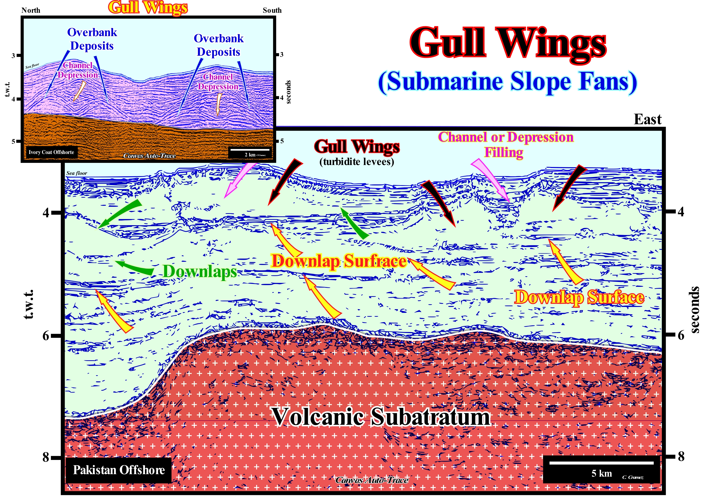
The Pakistan offshore corresponds to the stacking of several basins of the classification of the sedimentary basins of Bally and Snelson (1980), which from the bottom up are: (i) Basement, that sometimes may, locally, be a more or less flattened Paleozoic mountain folded belt ; (ii) Rift-type basins formed during the lengthening of the lithosphere of the Gondwana small supercontinent, before it break-up and (iii) An Atlantic-type divergent margin. As illustrated on this preliminary tentative geological interpretation of a Canvas auto-trace of a detail of a transverse seismic line (more or less perpendicular to the direction of the terrigeneous influx) of this offshore, submarine slope fans (SSF), probably, associated to the Indus delta building, form enormous "gull wings" structures. Large depressions, channels (when the base is erosive) and natural turbiditic marginal dykes complexes are, perfectly, visible. It is unlikely that this thick interval of submarine slope fans is just associated with relative sea level falls, i.e., it cannot be fully explained by P. Vail's model. In this particular case, the geological model, proposed by E. Mutti, for fluviodeltaic systems explains better this thick turbidite interval, probably, in association with catastrophic and recurrent floods of the Indus river. Due to the predominant shaly lithology and the, relatively, recent age of these overbanking deposits, seismic reflections are rare. The reflection terminations associated with the overbanking deposits, i.e., the turbiditic natural marginal dikes (levees), define downlap surfaces with opposite vergences. These progradations with opposing vergences (polarities) suggest local rather than regional, directions of sedimentary transportation. They suggest local sedimentary influx, more or less, perpendicular to the regional terrigeneous influx, which is roughly parallel to the turbidite currents. When the height of a turbiditic current (dense, sediment-laden underwater stream, which flows rapidly downstream into adjacent waters having a lower density) is higher than the depression along which it flows, the current overbanks. In the more typical case of ocean turbidite currents, sediment-laden waters on sloping ground flow downward because they have not only a higher density than adjacent waters but also a thickness greater than the channel height or depression height (between the lobes), along which the current flows. The current overflows in opposite directions creates local terrigeneous influxes, practically, perpendicular to the direction of the main current. Later, within the associated eustatic cycle, the relative sea level begins to rise, the depressions between the lobes or channels (when the turbidity currents have dug a channel) through which turbidity currents have passed, are filled, in retrogradation, by sediments of turbidite nature, but relatively coarser. When the facies of filling sediment is sandy, the depressions or channels fills exhibit (after compaction*) a biconvex geometry (due to differential compaction). Otherwise, when a shaly lithology is predominant, the geometry of the fillings is concave, at the top and convex at the bottom. It is important not to forget in the submarine slope fans the sedimentary intervals that compose them are not coeval. The central part of the gull wings, i.e., the sedimentary fills of the old depressions or of turbiditic channels postdates, always, ^ to the overbanking deposits (do not confuse channel, i.e., the area without deposition along which the current flows, with its filling which is a sedimentary interval).
(*) Phenomenon after deposition, generally, manifested by a local decrease in thickness, of a certain sedimentary interval during burial under the overlying sedimentary intervals. Differential compaction is frequent in sedimentary intervals that develop, in certain areas, different porosities or facies with different susceptibilities to compaction,. Similarly it occurs in intervals deposited on uneven substrates, such as on a reef construction or close to a a growth fault, etc. An interval with lateral facies (lithology) variations, for example, sandstones passing laterally to shales or shales passing laterally to limestone, will naturally suffer the effects of differential compaction during burial. The porosity of the rocks of a sediment interval that experienced differential compaction can vary considerably from one area to another.
GUT (theory)....................................................................................................................................................................................................................................GUT (Théorie)
GUT (teoria) / GUT (teoria) / GUT (Theorien) / 肠(理论) / ТВО (теория великого объединения) / GUT (teorie) /
Physical theory trying to describe the four fundamental forces of nature (electromagnetic, strong and weak nuclear, and gravitacioanal) as different manifestations of a single force. Synonym of Great Unified Theory. Even though none of the attempts at unification has been confirmed experimentally, they are, entirely, plausible. In addition, they seem to be able to explain a characteristic of the Universe that would otherwise be very difficult to explain, that is to say, the fact that the Universe contains little or no antimatter.
See: « Early Universe »
&
« Matter and Antimatter »
&
« Big Bang (theory) »
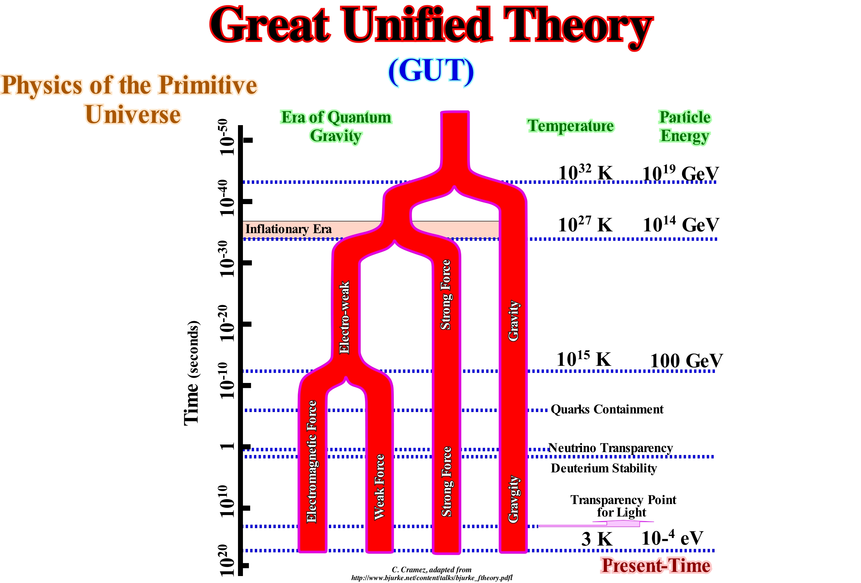
In general the term GUT refers to any of the various models of particle physics, in which at the scales of the high energies, the three forces, that is, the electromagnetic forces, weak force and strong force, emerge in a single characterized interaction by a greater symmetry and a single constant instead of of three independent. The physics of most large unification models can not be directly discovered in particle accelerators because the new particles they predict have masses on the so-called GUT scale with orders of magnitude below the Planck scale*, far beyond the reach of man-made collision experiences. Instead, information about large unification is obtained by indirect observations, such as proton decay or neutrino properties. The unification of gravity with the other three interactions (electromagnetic, weak and strong) form, what many authors call TOE ("Theory Of Everything"), this is the theory of everything and not GUT. However as illustrated in this figure, for other authors the GUT comes into account with gravity. Note that in this scheme, the inflationary period would have lasted no longer than 10-35 to 10-32 seconds and would have been produced in the first instants of the Universe. Inflation would have been gigantic, the Universe would have expanded fantastically, about 1050 times. During this inflation, the diameter of the ball where the Universe was contained would have doubled every 10-34 seconds producing an amazing energy that was released in an intense flow of particles and antiparticle, beginning the process of expansion that continues today. Astrophysicists assume the Universe would have, at the end of the period of expansion, at the moment when matter was created, the size of an apple, and that was born from a corpuscle a trillion trillions times (1018) smaller than the nucleus of a atom.
(*) The Planck scale sets the universe’s minimum limit, beyond which the laws of physics break. The Planck scale was invented as a set of universal units, so it was a shock when those limits also turned out to be the limits where the known laws of physics applied. For example, a distance smaller than the Planck length just does not make sense—the physics breaks down. Let’s consider the unit of Planck length for a moment. The proton is about 100 million trillion times larger than the Planck length. To put this into perspective, if we scaled the proton up to the size of the observable Universe, the Planck length would be a mere trip from Tokyo to Chicago. The 14-hour flight may seem long to you, but to the Universe, it would go completely unnoticed. (https://www.symmetrymagazine.org/article/the-planck-scale)
Gut (Narrow).................................................................................................................................................................................................................................................Goulet
Golada / Pequeño estrecho / Enge / 窄 / Узкий проход / Stretto /
Tight passage between two water-bodies, such as between the islands or shallows, or the depression that connects a lagoon to the sea, in general, with very strong currents.
See: « Channel »
&
« Laguna »
&
« Stream»
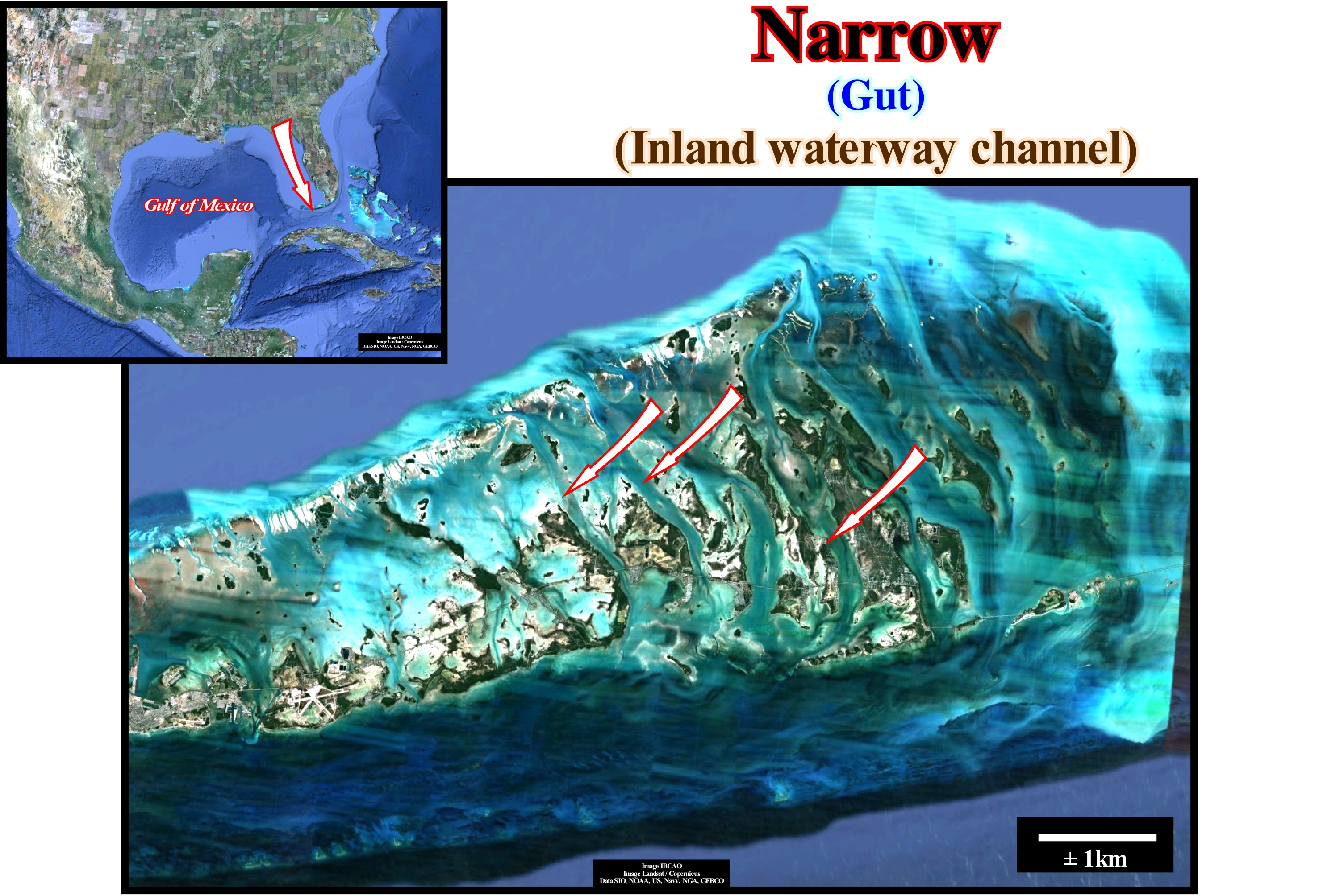
Many geoscientists consider a gut as a synonym for a channel : "In this context, gut, is the navigation channel, at the ends of the sandbanks of a bar, passable by small boats" (http://letratura.blogspot.com/2009/05/lexico-golada.html). We prefer to consider a gut a depression between two water-bodies that, under certain conditions and at certain times, allows the water to flow from one body to another. In the short term, function of the tidals, the bottom of a gut can be, totally, exhumed, which very rarely happens with a river channel. On the other hand, a gut exists even when the islands or the shoals are covered of water, i.e., when the two water-bodies unite. On the other hand, a channel can be: (i) Totally natural as the channel of a river or any other water stream ; (ii) Fully artificial, as an irrigation channel ; (iii) Partially artificial, such as channels linking existing water bodies, such as the Suez Channel and (iv) Mixed with artificial portions and channelled rivers, as for instance the channel from Nantes to Brest (France). In geology and especially in sequential stratigraphy, the term channel, which serves as the conduit for the water and particles that it carries and is defined by the wet section that allows the flow, is very confusing. Many geoscientists call the channel not only the stream bed, but also its filling. This is especially frequent on the tentative geological interpretation of seismic lines or electrical logs, on which many geoscientists recognize, for example, shaly channels or sandy channels, which is a huge error of language, since there is confusion between the bed of the old current and the sediments that fill it. In geology, a clay channel is a channel that has been incised in clayey sediments and not the filling of an old carved channel. An incised valley is developed during a relative sea level fall, while its filling, by clayey sediments, is done in association with a relative rise of sea level rise. A similar language error is very common in deep turbidite environments. Many of the so-called turbidite channels are, actually, late fillings of the depressions between the turbidite lobes.
Guttenberg Discontinuity..................................................................................................Discontinuité de Guttenberg
Descontinuidade de Guttenberg / Discontinuidad de Guttenberg / Gutenberg - Diskontinuität / 古登堡界面 / Граница Гутенберга / Discontinuità di Gutenberg /
Discontinuity between the mantle and core of the Earth. This discontinuity is underlined by a significant decrease in the velocity of the P seismic waves and by the total disappearance of the S seismic waves, which suggests that the outer part of the terrestrial core is, probably, in liquid state.
See: « Earth »
&
« Sial »
&
« Moho Discontinuity »
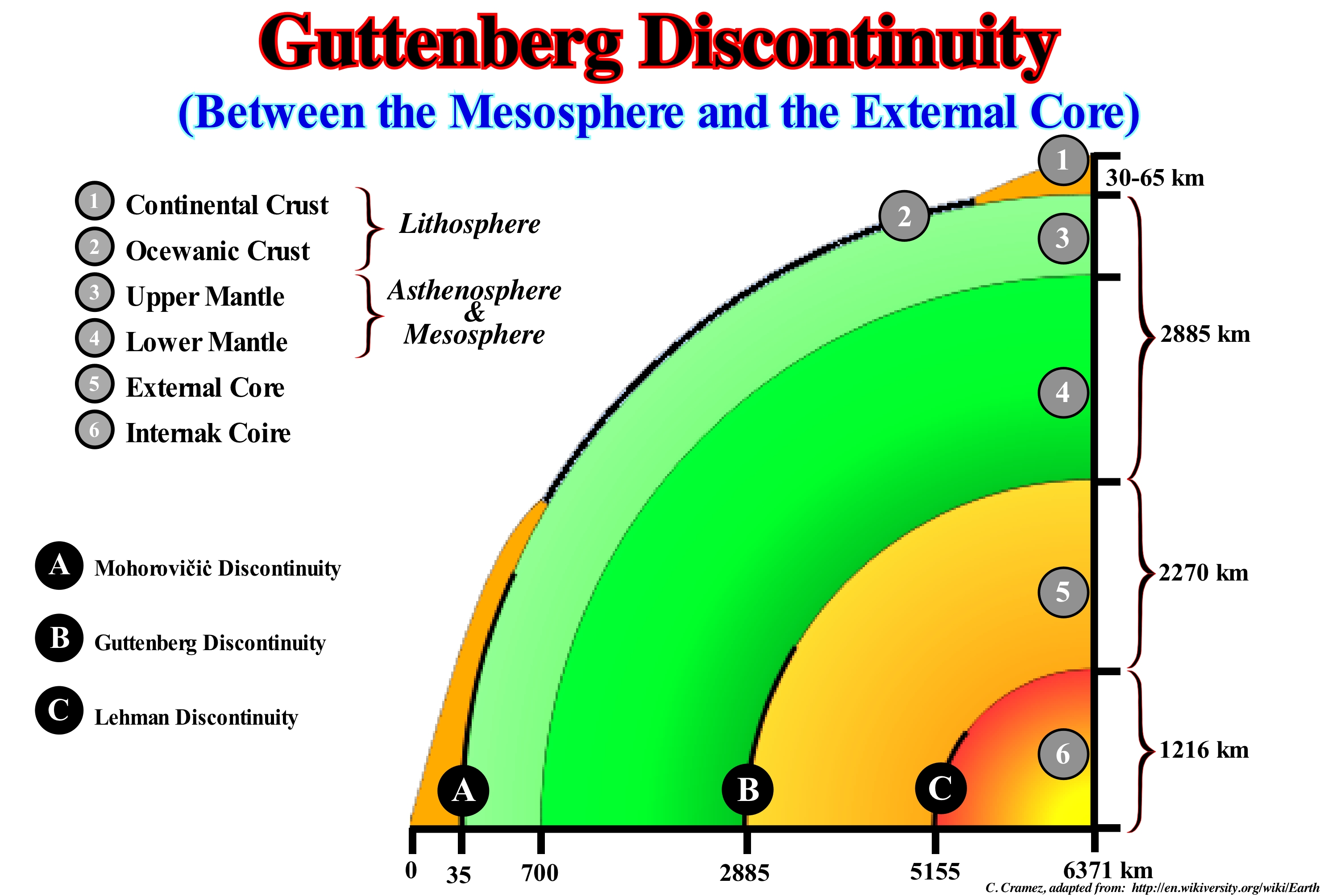
Gutenberg's discontinuity occurs within the Earth's interior at a depth of approximately 2,900 kilometers beneath the surface, where there is an abrupt change in the behaviour of seismic waves traveling through Earth, which can be generated by earthquakes or by explosions. At this depth, the primary seismic waves (P waves) slow down, while the secondary seismic waves (S waves) disappears completely. S waves can not be transmitted through liquids. Geoscientists think the interval above Gutenberg's discontinuity is solid, while the interval below it is liquid. This change marks the boundary between two layers of the Earth's interior, known as the lower mantle (which is considered solid) and the outer core (considered to be fused). The liquid section of the outer core is thought to be hotter than the overlying core of about 700° C. It is also denser, probably, due to a higher percentage of iron. This boundary between the core and mantle, which was individualized by the variation of seismic waves at this depth, is referred, often, as the core-mantle boundary or CMB. This limit or Guttenberg discontinuity corresponds to a narrow zone with corrugations that can be reach 5-8 km wide. The undulations are affected by convection currents of the overlying mantle, which may, eventually, be the driving force of movement of the lithospheric plates in plate tectonics. These undulations at the core-mantle boundary are also affected by the swirls and underlying currents, within the outer core, of the iron-rich fluids responsible for Earth's magnetic field. The boundary between the core and mantle does not remain constant. As the heat from the Earth's interior slowly dissipates, the liquid core solidifies as it shrinks, gradually, within the Earth causing a deep displacement of the mantle-core boundary within the Earth's core.
Guyot (Abyssal guyot).............................................................................................................................................................................................Mesa abyssale
Mesa abissal / Mesa abisal / Guyot / 海底平頂山 / Подводная гора с плоской вершиной / Guyot (rilievo sottomarino di origine vulcanica) /
Volcano or submarine volcanic flow, which rose from the ocean floor, with a, relatively flat, morphology.
See: « Mesa »
&
« Volcan »
&
« Abyssal Plain »
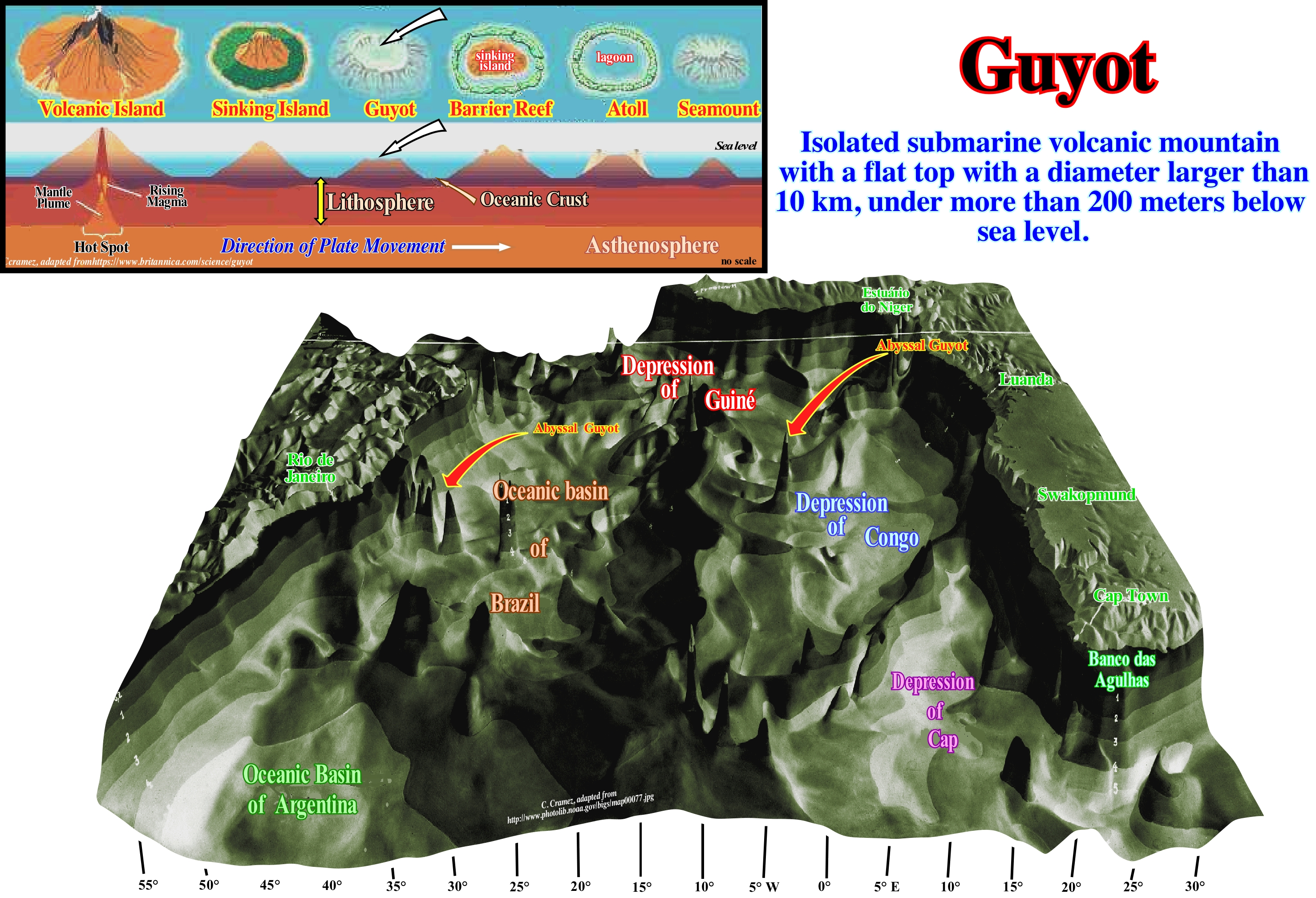
Contrariwise to a "mesa"*, which, in sedimentology, is a structure resulting from the differential erosion of a stable platform, where resistant horizons to erosive agents alternate with less resistance, an abyssal guyot is an intrusive volcanic structure whose top is, more or less, flat. In this model of the equatorial Atlantic Ocean sea floor, made by the German expedition of the Meteoro, between 1925 and 1929, several abyssal guyots are proposed, in particular, between the Brazilian and Argentinian abyssal basins. It is important to differentiate the submarine mounts (seamounts) from the abyssal guyots, sometimes, called, also, submarine plateaus. A seamount is a mountain that rises from the ocean floor, but does not reach the sea surface (a submarine hill never forms an island). Typically, seamounts are extinct volcanoes that form very rapidly and rise, generally, from the ocean floor between 1,000 and 4,000 meters. The abyssal guyots are, in general, small volcanic provinces, i.e., small volcanic plateaus. The Kerguelen volcanic plateau, located in the Indian Ocean, can be considered as a large abyssal guyot. It is, approximately, 3,000 km from the SW Australian and is about three times the size of Japan. This guyot or small abyssal plateau extends for more than 2,200 km in NO-SE direction, under a very important water-depth. Abyssal guyots correspond to hot spots (a location on the Earth's surface that has undergone active volcanism over a relatively long geological period). Thus Kerguelen's guyot, with the small abyssal guyots of the South Atlantic Ocean, are associated with the Gondwana break-up that occurred at about 130 Ma. As lithospheric plates, with their continents and oceanic floor, pass over a hot spot, the volcanoes associated with it, lay on the oceanic or continental crust a large amount of volcanic material forming both plateaus and abyssal guyot. The plate tectonics paradigm is, by far, the best explanation for most abyssal guyots.
(*) Mesa is the term for tableland, i.e., an elevated area of land with a flat top and sides that are usually steep cliffs. It may also be called a table hill, table-topped hill or table mountain. It is larger than a butte, which it otherwise resembles closely.

