
Calcarenite..........................................................................................................................................................................................................................Calcarenite
Calcoarenito / Calcarenita / Kalkarenit, Calcoarenite /灰岩 / Известняк с зернами кальцита / Calcarenite /
Carbonated sedimentary rock formed by the percolation of water through a mixture of fragments of limestone shells and quartziferous sand. The percolation induces that the limestone dissolved in the water precipitates cementing the whole set.
See: « Limestone »
&
« Cementation »
&
« Deposition (carbonates) »
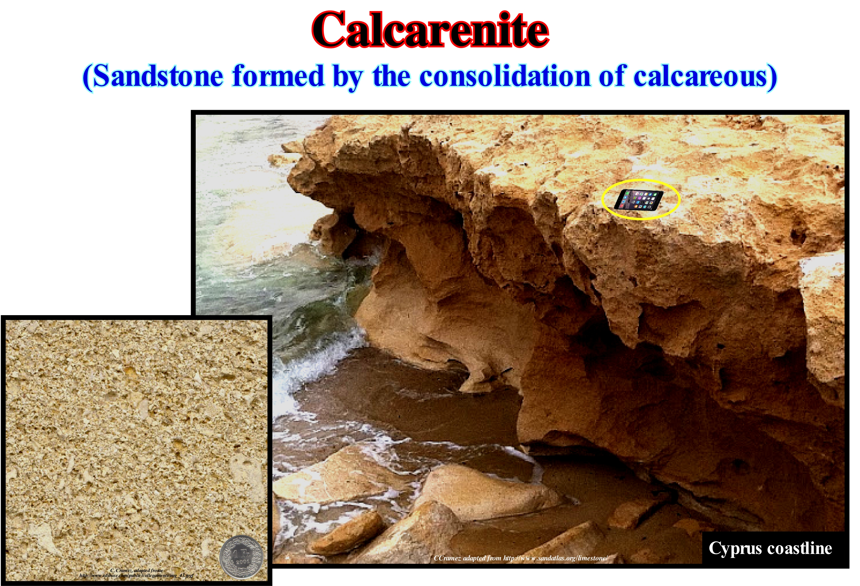
Calcarenites are sandstones formed by consolidation of calcareous sands. Calcarenites are formed, mainly, in the coastal areas of tropical regions in association with dune massifs formed by sands resulting from coral reefs erosion. Dunes develop in areas where sand (calcareous) is abundant and not set by vegetation. The sand is eroded and carried by wind (deflation), close to the ground and by saltation *, to accumulate when the wind competence decreases (wind protected slope). A dune can travel by erosion of the slope exposed to the wind and accumulation in the opposite slope. It is the diagenesis, which encompasses all the chemical and mechanical processes that affect a deposit after its formation, which transforms the calcareous sand into a calcarenite. In this type of transformation two stages are distinguished: (i) Burial and Compaction of the Grains, which are mineral debris, resulting from the disintegration of other rocks or organic debris, i.e., plant or animal remains; this process occurs gradually as other sediments come to cover the deposit to put, gradually, it several tens, hundreds or even thousands of meters deep and (ii) Grain Cementation. Cementation is a simple chemical process in which water, which circulates between the grains, becomes saturated in certain minerals and precipitates them in the pores between the grains, eventually, consolidating the sand particles. A calcarenite is identified not only by the effervescence produced on contact with hydrochloric acid (HCl), but also by its roughness. In general, the colour of a calcarenite is rosy or gray. A calcarenite belongs to the calcilutite family (limestone mud grey to yellowish and consolidated). Calcirudite corresponds to remains of coarse, cemented and consolidated organisms. Chalk is a white limestone formed by the accumulation of skeletons of unicellular organisms coccoliths. Indian bead limestone is an accumulation of crinoid debris (a variety of echinoderms). Travertine is a limestone formed in the emerging sources rich in dissolved CO3Ca.
(*) A specific type of particle transport by fluids (wind or water) occurring when loose materials are removed from a bed and carried by the fluid, before being transported back to the surface.
Calcareous Tuff.....................................................................................................................................................................................................Tuf Calcaire
Tufo calcário / Toba calcárea / Kalktuff / 钙质凝灰岩 / Известковый туф / Tufo calcareo /
Porous and friable limestone deposits, formed outside the exit points of the waters of a karst spring, by calcareous incrustation of several supports, mostly vegetable (International Union of Speleology, 1973). Sometimes synonymous with Travertine.
See: « Limestone »
&
« Deposition (carbonates) »
&
« Polyp »
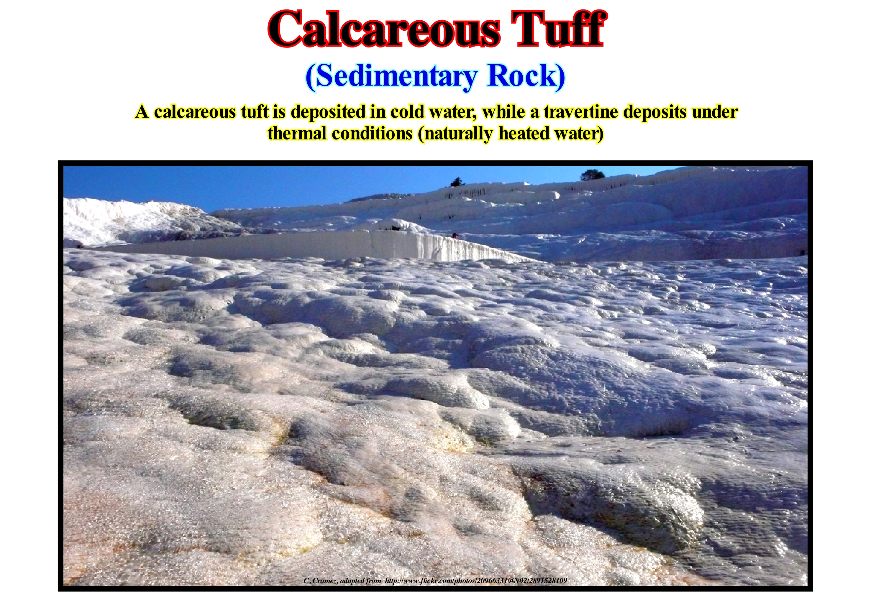
Calcareous tuffs and travertines are, widely, used as building material. The Romans exploited calcareous tuff deposits for construction. Among other buildings, for example, they built the Coliseum, the largest building in the world built mostly with calcareous tuff. Other famous buildings built, largely, with calcareous tuffs are the Basilica of Sacré-Coeur in Paris and Shell-Haus in Berlin. Travertine is one of several natural stones that are used for paving of patios and garden paths. Sometimes, it is known as travertine limestone or travertine marble, which are the same stone, although the term travertine is properly regarded as a type of limestone, and not of a marble. Travertine is characterized by the presence of holes in its surface. Although these holes or depressions occur. naturally, they suggest signs of significant wear over a relatively long time. Basically, travertine is formed from hot, supersaturated and heated geothermal alkaline waters with a high content of CO2. In the emergence zones, the water releases CO2 and the carbonate decreases with increasing pH, calcium carbonate precipitation occurs. Supersaturation (state of a solution containing more of the dissolved material than could be dissolved by the solvent under normal conditions) can be enhanced by several factors that reduce the percentage of CO2, such as air-water interactions in water-falls or photosynthesis. Calcite and aragonite are found in travertines of the hot springs. Aragonite is, preferably, precipitated when temperatures are warm, while calcite dominates when temperatures are cooler. Travertine forms from deposits of calcium in the vegetation (such as mosses, algae), in the emergence of certain sources or streams with small waterfalls, where the carbonate precipitates, due to the turbulence of the water. The vegetation then sprouts up into a new context, and the process begins again, cyclically.
Calcite..............................................................................................................................................................................................................................................................Calcite
Calcite / Calcita / Calcit / 方解石 / Кальцит (известковый шпат) / Calcite /
Very common mineral of the sedimentary rocks, whose chemical formula is CaCO3. Calcite (rhombohedral) is trimorphic as aragonite (orthorhombic) and vaterite (hexagonal). It is, usually, white or colourless, but may also be light grey, yellow or blue. It produces an effervescence when immersed in hydrochloric acid. It is the main constituent of limestones. It occurs in crystalline forms in marbles and, in less crystalline forms, in sandstones, tuffs and stalactites. It is often found in faulted areas.
See:« Limestone »
&
« Stalactite »
&
« Fault »
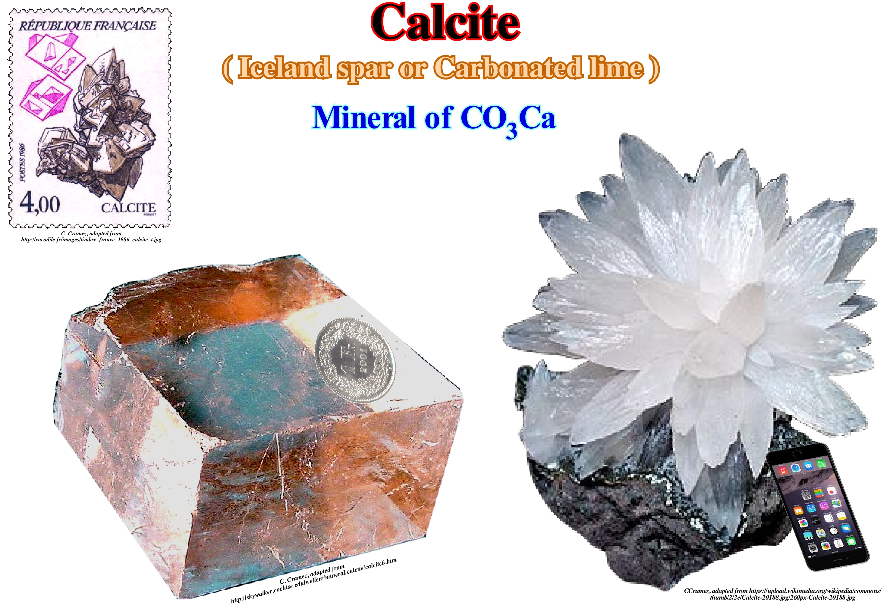
The term calcite comes from the Greek "chalix" meaning lime. Calcite (CO3Ca), which can form in varied geological environments, is one of the most common minerals on Earth's surface. It accounts for about 4% of the total weight of the continental crust. Calcite is a secondary mineral of igneous rocks, but it is the main component of carbonates and can crystallize in various forms. Calcite forms a large part of sedimentary rocks, in the form of oolites, organic remains of limestones, or as the cement of many sandstones and shales. It is also a very important component of the igneous rocks called carbonatites (of mineralogical composition similar to limestones and marbles and that install in the middle of igneous alkaline and volcanic complexes) and form the majority of hydrothermal dykes. Many rocks are composed of more than 99% calcite. The characteristic property of calcite is the reaction to acids. When drops of acid (even cold) are put into it, it releases CO2 (carbon dioxide). Thus, for example, geoscientists identify a limestone cement from a sandstone. Other carbonates such as dolomite and siderite, which are formed primarily from calcite, do not react as, easily, as calcite. Like many corals, algae and diatoms, etc., have a shell made mainly of calcite, they capture CO2 from ocean water to form calcium carbonate, which helps, certainly, to reduce the amount of free CO2, thus decreasing greenhouse effect* if it exists. For the vast majority of geoscientists, carbon dioxide is not, and has never been the main cause of the Earth's surface temperature increases, as many alarmists say. On the contrary, in certain cases, it is the increasing in temperature, especially sea-water, which is responsible for the increase of CO2 in the atmosphere.
(*) From the total energy radiated by the sun, only about 47% (161 W/m2) finally reaches the Earth's surface, where it is stored for a certain time before being restored through the atmosphere. There are three forms of restitution: (i) Radioactive (42% of 161 W/m2 or ± 20% of the initial solar radiation) ; (ii) Sensible heat (5%) and (iii) Latent heat (22%). In the radioactive restitution, the substrate emits an infrared radiation, due to its average temperature of 15° C. This radiation has difficulty crossing the atmosphere since water vapour and greenhouse gases form a barrier that tends to return the radiation to the Earth's surface (without such a barrier, which is called the greenhouse effect, the average temperature at sea level would be -18 ° C or 33 ° C less than it is at present). In sensitive heat recovery, the substrate yields part of the energy by simple contact with the atmosphere (conduction). In latent heat restitution, the transfer takes place by evaporation (energy consuming) and condensation (releasing energy).
Calcrete...................................................................................................................................................................................................................................................Calcrète
Calcrete / Calcreta / Calcret (Caliche) / 钙质结砾岩(硝酸钠), 砂砾层 / Кальцикрит (нитронатрит) / Calcrete (caliche) /
Level or hardened layer of a soil formed in calcareous terrain due to climate changes in arid or semi-arid regions. The calcite dissolved in groundwater (under certain conditions) is precipitated when water evaporates. Rainwater saturated in CO2 acts as an acid and dissolves the calcite, which is then deposited on the surface of the particles that compose the soil. When the spaces between the grains of the soil are filled by calcite an impermeable crust (calcrete) is formed.
See: « Soil »
&
« Incrusting Water »
&
« Calcite »
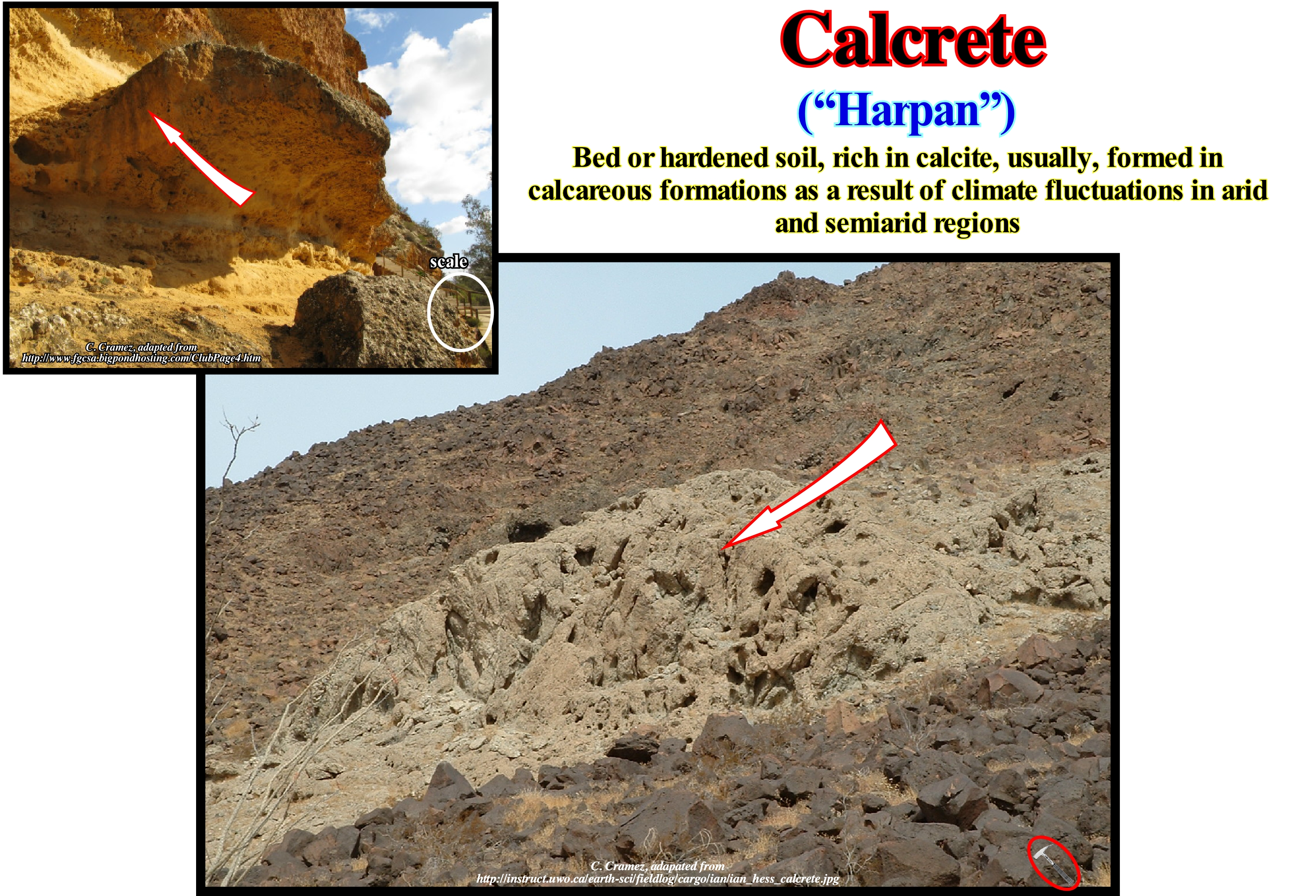
Calcrete is also called "caliche", which means lime in Spanish, "hardpan", "kankar" (India) or even hard crust, which corresponds to a deposit of hardened calcium carbonate, which cements other materials, such as, gravel, sand, silt and clay. This type of deposit occurs in almost every part of the world, particularly, in arid or semi-arid regions, as for instance, in central and western Australia, Kalahari and Sonoran deserts, as well as, in the high plateaus of the western United States of North America. The calcrete is, generally, light in colour, but depending on the impurities its colour may vary from white to red/brown. The calcrete, generally, is found at the terrestrial surface or near this surface, although it can, also, be found in deep undergrounds. As illustrated in these photographs, calcrete horizons can have very varied thicknesses (centimeters to meters) and several levels may exist in the same place. Calcrete is, usually, formed when the minerals of the upper part of the soil (horizon A*) are leached and accumulate at the level of the underlying soil (horizon B) at depths ranging from 1 to 3 meters. As stated above, calcrete consists of carbonates in semi-arid regions, whereas in arid regions, less soluble minerals form calcrete horizons after all carbonates have been leached out of the soil. The deposited calcium carbonate, first, forms grains, that then form small groups, which, over time, form a, more or less, visible horizon, which finally forms a thick, competent layer. As a calcrete horizon, gradually, forms, its lower boundary becomes deeper, and may even reach the rocky substratum.
(*) In a vertical profile of a soil, in addition to the consolidated rock, four horizons are generally noted: (i) O ; (ii) A, which has two subdivisions: A1 and A2 ; (iii) B and (iv) C. The O horizon is mainly composed of deposits of dead organic matter. The A1 horizon is a humus-rich layer, consisting of partially decomposed organic material mixed with mineral soil. The A2 horizon is a area of intense leaching of soil minerals. The B horizon contains little organic material, whose chemical composition resembles that of the underlying rock (clay minerals and iron and aluminum oxides are leached out of the A2 horizon and eventually deposited in this horizon). The C horizon consists mainly of slightly modified material from the consolidated rock). Depleted eluvial horizons (E horizon of many geoscientists) in clayey particles are generally under the horizon A.
Caldera (Crater).............................................................................................................................................................................................................................Caldeira
Caldeira / Caldera / Caldera, Krater / 弹坑 / Кальдера (кратер взрыва) / Cratere, Caldera /
Elliptic or circular volcanic depression formed after the emptying of a magma chamber in a volcanic eruption. Its diameter is much greater than the cracks (ring faults*) that, sometimes, the crater contains, regardless the inclination of the walls or the shape of the floor.
See: « Vulcanism »
&
«SDR (reflector dipping seaward) »
&
« Crust »
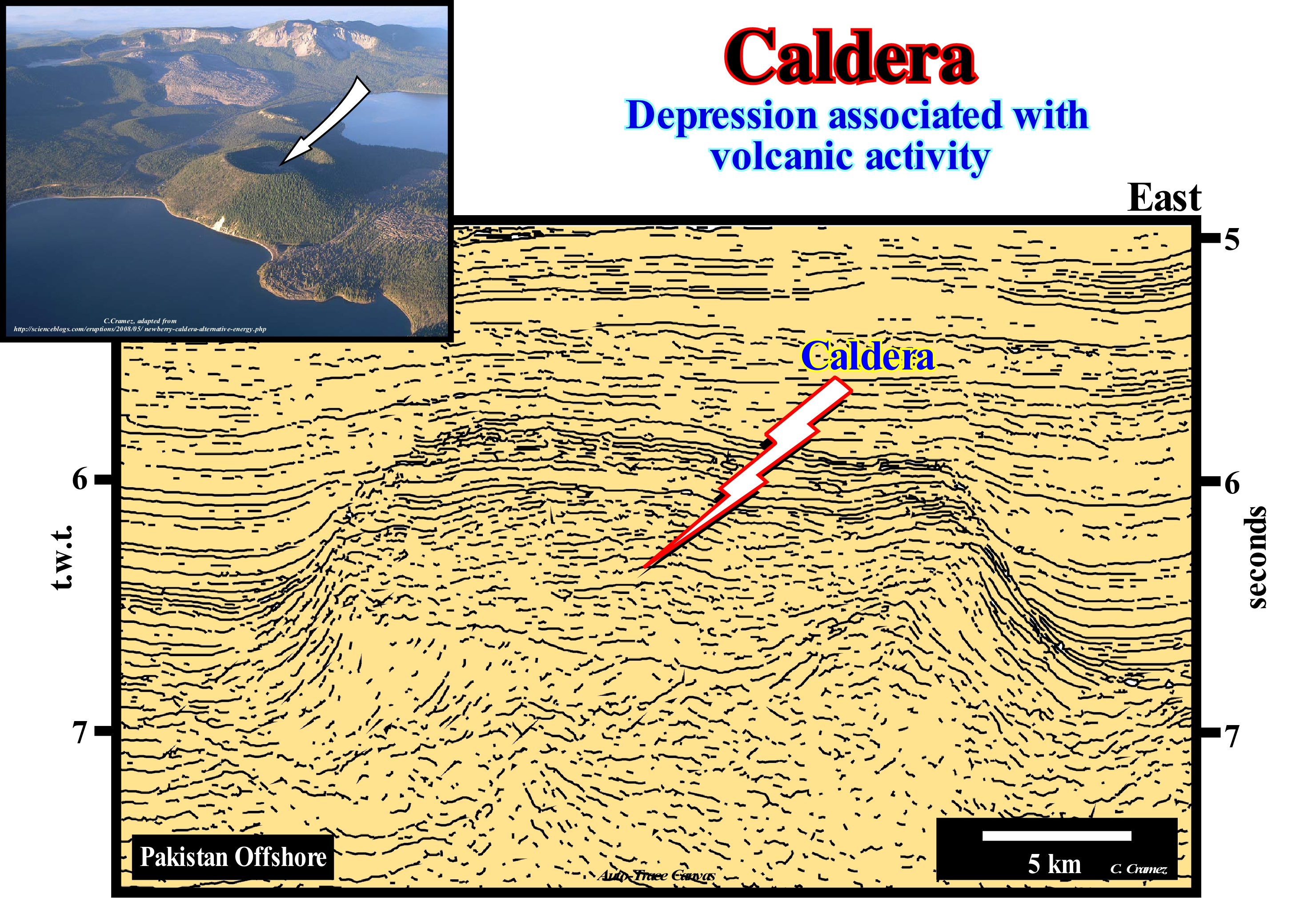
This structure can be interpreted as a caldera that has been filled by volcanic material in association with a subaerial expansion centre. The seismic reflectors represented on this Canvas auto-trace of seismic line of the Pakistan offshore (do not confuse a Canvas auto-trace with the original seismic line) suggest that in the deep-waters of Pakistan offshore (divergent continental margin), the substrate of the submarine slope fans, associated with the Bramaputra and Ganges rivers, is constituted by subaerial volcanic rocks. This hypothesis was corroborated by explorations wells, which also corroborated the geological model of the formation of the Atlantic-type divergent margins proposed by Total SA (2000) geoscientists, which can be summarized as follows: (i) Since a supercontinent is formed by agglutination of several continents, in its interior, thermal anomalies develop causing the lengthening of the lithosphere (mainly of continental crust) ; (ii) Such a lengthening produces "half-grabens" structures, since sediments can only be lengthened by normal faults ; (iii) Lengthening, cause or effect, induces a thinning of the lithosphere ; (iv) As the lithosphere becomes thin it is strongly injected by volcanic dikes ; (v) From a certain rate of stretching, the thickness of the lithosphere is, substantially, reduced (10-20 km) and thus it can no longer be enlarged by normal faults ; (vi) The lithosphere breaks-up in two major lithospheric plates (continental breakup) along irregular fissures, since the intrusive volcanic material becomes preponderant in relation to the initial crustal material ; (vii) From this moment on, the volcanic material when it reaches the surface flows from the expansion centres in opposite directions on the continental crust of the plates (subaerial lavas) ; (viii) The continuation of this process obliges the expansion centrer (volcanoes) to sink, which induces the formation of oceanic crusts (pillow lavas), once volcanic material can not flow in under water ; (ix) Deposition of the sedimentary prisms forming the Atlantic-type divergent continental margin, as oceanic sea-floor spreading progress producing an absolute or eustatic sea level rise**.
(*) Ring fault, which are developed around the edge of the chamber, serve as feeders for fault intrusions which (ring dikes). Secondary volcanic vents may form above the ring fracture. As the magma chamber empties, the centre of the volcano within the ring fracture begins to collapse. The collapse may occur as the result of a single cataclysmic eruption, or it may occur in stages as the result of a series of eruptions. /https://en.wikipedia.org /wiki/Caldera)
(**) The sea level can be absolute (eustatic), when referenced to the Earth's centre or relative (local), when referenced to any point on the Earth's surface, which may be the top of the continental crust (sediment base) or the sea-floor. A relative sea level rise can not be confused with an absolute sea level rise, as the relative sea level is the result of the combined action of absolute ( eustatic) sea level with tectonics (uplift or subsidence of the sea-floor).
Calving..........................................................................................................................................................................................................Glacio-Fracturation
Glaciofracturação / Glaciofracturación / Eis Kalben / 冰产犊 / Отламывание льда / Distacco del ghiaccio /
Individualization of ice blocks by fracturing, either in an iceberg or in the front of a glacier. Calving represents the main form of ablation of a glacial system. The dimensions of ice blocks created by calving can exceed 40 meters in height, as is the case, for example, in the Blomstrand glacier on Spitzberg Island.
See: « Glacier »
&
« Isostatic Rebound »
&
« Ablation »
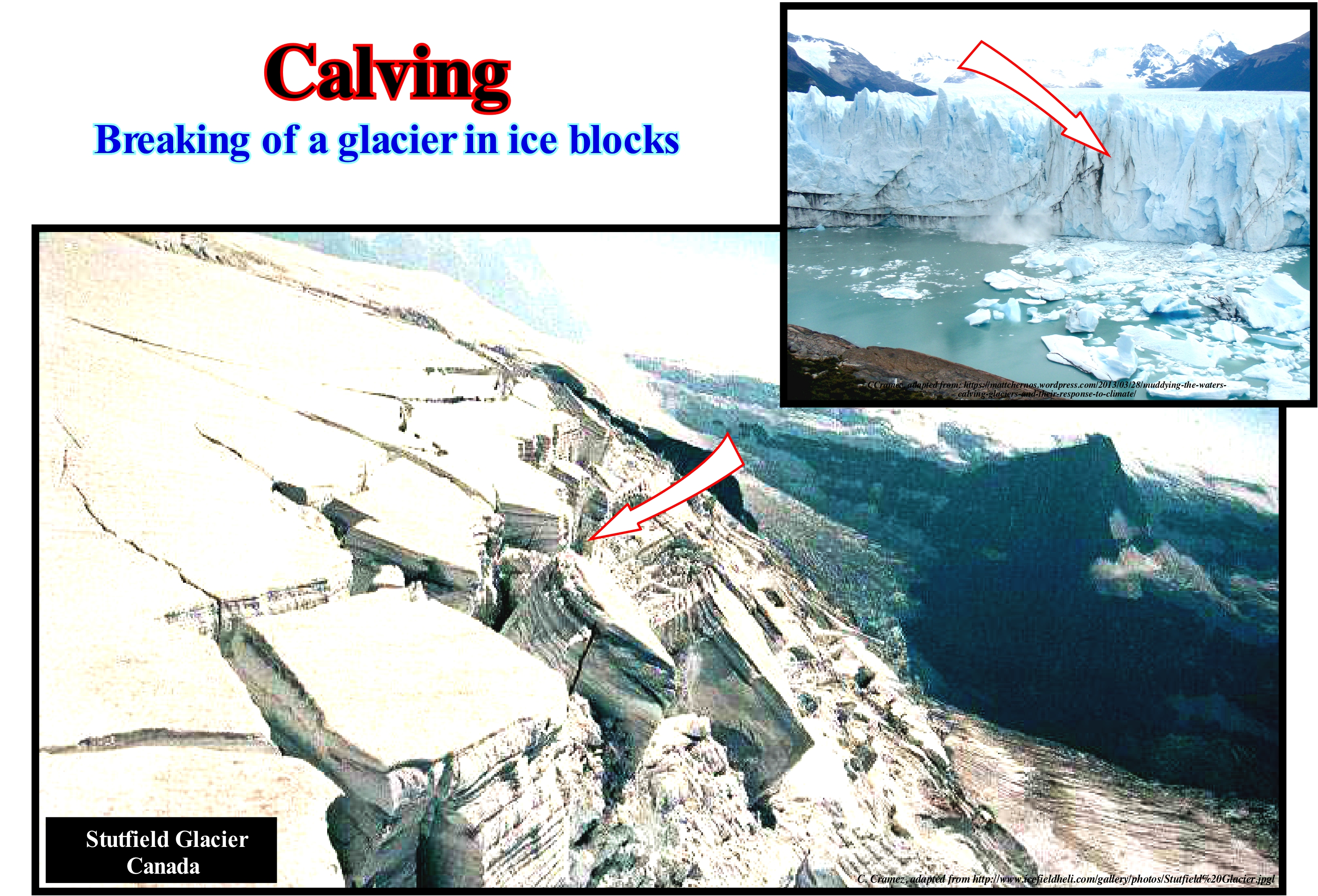
The large photograph illustrates an example of calving in front of the Stutfield Glacier (Canada). Within the fissures there is formation of serac (chaotic and unstable mass of ice, often formed by intersecting crevasses on a glacier). This glacier is suspended. The falling of individualised ice blocks individualized by calving into the glacial valley, which is much lower (lower right corner of the photograph), is an important source of ice feed for the main glacier. The small photograph illustrates the Perito Mere-no Glacier* in southern Patagonia, in which its spectacular ice chunks crumble off the glacier multiple times a day became a tourist attraction. In a glacier, in addition to the cracks induced by calving, illustrated in this photograph, there are four more types of main glacial crevasses** (synonym of glacial cracks) : (a) Transversal Crevasses ; (b) Marginal Crevasses; (c) Longitudinal Crevasses; (d) Detachment Crevasses. The detachment crevasses can be of two species: (i) Those that separate the part of the glacier that is in motion of the part that is stagnated and (ii) Those located in the glacial cirques, that limit the behind part of a glacier, the wall rocky from ice. Transversal crevasses are the most common. They are perpendicular to the glacier's direction of movement and, in general, they are opened. Marginal crevasses start at the edge of the glacier, once the speed of the glacier is higher in the central part than in the margins and they extend up-dip. Longitudinal crevasses form parallel to the movement of the glacier as the glacier's width begins to expand. All of these crevasses can be covered by a snow bridge and not necessarily filled by snow, which means that using a snow bridge to move from one ice block to another can be very dangerous (it is very difficult to know whether a crevasse is fully filled or not). Calving (or glacio-fracturation) is, also, very important in the formation of icebergs. When a glacier flows into the sea it is pressurized by the uneven underlying ground and cracks itself. From the moment it enters the sea he breaks through the fractures forming icebergs. If a glacier or a current of ice is still intact when it reaches the sea, it does not breakup, the sea waves erode the bottom until the support becomes unstable.
(*) The Perito Mereno glacier is a 250 km2 ice formation with a 30 km in length and a total ice depth of 170 metres. The terminus is 5 km wide, with an average height of 74 m above the surface of the water of Argentino Lake. The glacier is thickening (advancing), but the reason remains debated by geoscientists. It belongs to the Southern Patagonian Ice field, which forms the world's third largest reserve of fresh water.
(**) A glacial crevasse is a deep crack, or fracture, found in an ice sheet or glacier, as opposed to a crevice that forms in rock. Crevasses form as a result of the movement and resulting stress associated with the shear stress generated when two semi-rigid pieces above a plastic substrate have different rates of movement. The resulting intensity of the shear stress causes a breakage along the faces. (https://en. wikipedia.org/wiki/Crevasse)
Cambrian......................................................................................................................................................................................................................................Cambrien
Câmbrico / Cámbrico / Kambrischen / 寒武纪 / Кембрийский / Cambriano /
Geological period during which the first animal groups appeared in the fossil record. This event is often referred to as the "Cambrian Explosion" because of the relatively short time for the appearance of such a wide diversity of animal forms. Some years ago, it was thought that the rocks of the Cambrian contained the earliest and the oldest animal fossils. At present, it is known that fossils are already found in Vendian sediments (Proterozoic).
See: « Geological Time »
&
« Paleozoic »
&
« Chronostratigraphy »

The Cambrian Period is part of the Paleozoic Era* and is limited between the Ordovician and the Vendian (Pre-Cambrian, Proterozoic). The Cambrian lasted about 58 My. It started at about 590 Ma and ended at about 505 Ma (according to Harland et al., 1982). The continents of the Cambrian resulted from the break-up of an ancient supercontinent called Proto-Pangea (Rodhinia or Pannotia, for certain geoscientists). The largest small supercontinent was, undoubtedly, the Gondwana which, progressively, began to drift southward. Continents such as Laurentia, Baltica and Siberia remained always independent. During this geological period (not to be confused with period of time), the rate of oceanic expansion (sea-floor spreading) was very large and the oceans became predominant but, relatively, shallow. The largest ocean was Panthalassa**. It covered most of the southern hemisphere. In the northern hemisphere, Proto-Tethys, Iapetus Sea and Khanty (ocean between Baltica and Siberia, north of the Panthalassa and NE of Proto-Tethys) continued to expand until the end of the period. During the Cambrian, the climate was much warmer than during the Precambrian, in which the glacial periods were very common. Many geoscientists think that during the Cambrian there was no ice at the poles. The ages (sub-divisions) of the Cambrian have not yet been definitively established. In North America (Laurentia during Cambrian) however, certain geoscientists have proposed the following ages (top to bottom): (i) Sunwapatanian ; (ii) Steptoanian ; (iii) Marjumanian ; (iv) Delamaranian ; (v) Dieranian ; (vi) Montezumanian and (vii) a last unnamed subdivision between 543 and 520 Ma (millions of years). The upper six ages range from 520 to 505 Ma, each having an average duration of 5 to 6 Ma.
(*) The Paleozoic Era, which ran from about 542 Ma to 251 Ma. It was a time of great change on Earth. It began with the breakup of supercontinent Proto-Pangea and the formation of two small supercontinents composed by several continents, in which plants became widespread as well as the first vertebrate animals.
(**) Panthalassa, also known as the Panthalassic Ocean or Panthalassan Ocean, was the super-ocean that surrounded the supercontinent Pangea. It is also referred to as the Paleo-Pacific or Proto-Pacific because the Pacific Ocean developed from its centre in the Mesozoic to the present.
Canary Current.......................................................................................................................................................................Courant des Canaries
Corrente das Canárias / Corriente de las Canarias / Canary Current / 加那利洋流 / Канарское течение / Corrente di Canarie /
Wind-driven surface current that forms part of the North Atlantic oceanic gyre (large system of circulating ocean current, caused by the Coriolis effect, particularly those involved with large wind movement. It flows south-west toward Senegal, where it diverts westward to join the North Atlantic Equatorial Current.
See: « Ocean Current »
Canyon Fill....................................................................................................................................................................................Remplissage de Canyon
Preenchimento de canhão / Relleno de cañón / Befüllen der Schlucht / 峡谷填充 / Заполнение ущелья / Riempimento di canyon /
The sedimentary filling of a canyon. It differs from the filling of a turbidite submarine channel by the evidence of a significant erosion and from the filling of river channel by its complexity and dimensions. The filling of a canyon can have different geometries, which vary, almost always, with the filling episodes. However, an overall divergent internal geometry, with onlapping, is by far the most frequent.
See: « Reflection Configuration »
&
« Lowstand »
&
« Relative Sea Level Change »
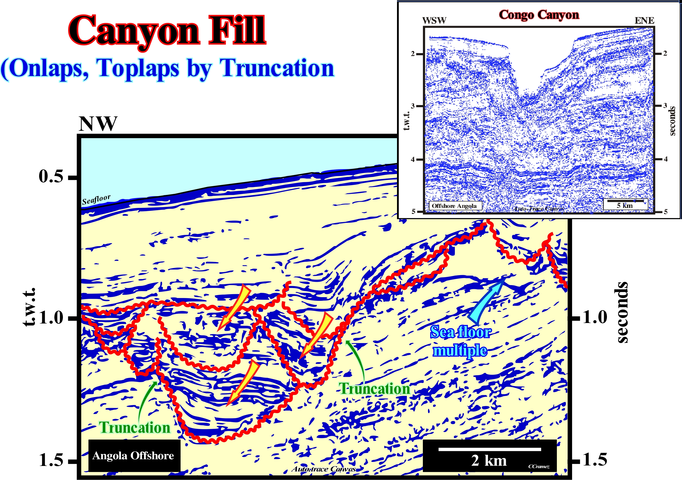
What most geoscientists call, on the field or on a seismic line, a canyon is, often, the filling of an old canyon along which a water-course flowed. A submarine canyon, as certain geoscientists say, is a cliff-shaped valley (carved more or less, vertically), located on the continental slope or even on the abyssal plain, which may or may not be later, partially or totally, filled by sediments. Thus it is preferable to say a certain canyon fill, not a canyon, has a parallel or progradational internal configuration. On this figure are illustrated canyon fills and a submarine canyon in Angola offshore. The submarine canyon is the present Congo canyon, while the canyons fills correspond to the fill of old Congo canyons. The current Congo canyon, begins on the shelf, in the middle of the Congo estuary, with a water-depth of about 20 meters. After crossing the continental shelf for about 85 km, the Congo canyon reaches the continental edge. Then, it extends down slope to finish at the end of a 280 km route. At its deepest point, the walls, more than 100 meters high, define the typical V-shaped geometry of the canyon that reaches 15 km wide. At the base of the slope, it enters the Congo submarine floor fan, where it extends for more than 200 km. Upstream of the Congo canyon there is the Congo River delta building. This suggests that the Congo canyon formed, at least initially, in association with a relative sea level fall, which displaced the mouth of the Congo River seaward and downward. However, the uplift of the continent and the proximal part of the offshore during the Late Tertiary should have, significantly, contributed to the evolution and the successive incisions visible on this tentative interpretation. Northward of the Congo River, and, particularly, in the offshore Gabon, there are canyon fillings, in the lower and middle continental slope, that migrate, laterally, in space and time. Upstream of these canyon fillings there are any delta or fluvial depositional system (certain geoscientists associate the erosive action to upwelling submarine currents). On the tentative geologically interpretation of a Canvas auto-trace of a detail of an offshore seismic line from Angola, a significant relative sea level fall* created a significant erosional surface (unconformity). The sea level became lower than the basin edge. A new sequence-cyle started with the deposition of the lowstand systems tracts group, that initiates the deposition (the basin edge is the last basin edge in the preceding sequence-cycle). Such a relative sea level fall exhumed the old shelf, raising (relatively) the coastal wedge of P. Vail and Posamentier, which includes fluvial and shallow-water deposits and is limited between the bay-line and the shoreline. A sub-aerial erosion slowly wear away the shelf's rocks and the top of the exhumed continental slope, creating an erosional surface. It this unconformity, that corresponds to the deeper incision illustrated on this tentative interpretation. The streams were forced to incised the beds to rebalance their provisional equilibrium profiles, which were broken by the relative sea level fall, causing the displacement of their mouths downstream. Due to the incision of the streams, incised valleys were formed (valleys resulting from the erosion of the underlying beds by river channels moving seaward following the relative sea level fall) and submarine canyons. Later, the submarine canyons were filled when the relative sea level began to rise in acceleration. The increments of the relative sea level rise were, increasingly, important during the deposition of the upper part of the lowstand prograding wedge (LPW), whose lower limit is the unconformity. It was, probably, in this way that the filling of the submarine canyon illustrated on this auto-trace took place. The filling is complex and was done in several steps. This suggests a pendulum effect from the main canyons. The different incisions were fossilized by onlaps, which are, also, observed on perpendicular seismic lines. The internal configuration of the fills is, slightly, divergent towards the centre of the synforms, which, here, are non-tectonic structures formed by compaction. More or less, over this canyon filling is the current Congo canyon, which begins on the continent, in the middle of the Congo.
(*) Local sea level referenced to any point on the Earth' surface, which can be the sea-floor or the base of the sediments and which is the result of the combined action of the absolute (eustatic) sea level and tectonics (subsidence or uplift of the sea-floor). Uplift of the sea-floor occurs when sediments are shortened. A shortening of the sediments displaces the coastal onlaps downward (negative aggradation) and seaward (negative encroachment) creating an unconformity (sequence-cycle boundary).
Cap-Rock (Sealing-rock).............................................................................................................................................................Roche de couverture
Rocha-de-cobertura / Roca de cobertura / Abdichtung Rock / 封岩 / Перекрывающая горная порода / Roccia di chiusura /
Rock that does not leave, or hinders, fluids and, especially, hydrocarbons moving through it. Cap-rocks are, also, denominated sealing-rocks, particularly, by the geocientists working in petroleum companies. The main sealing-rocks are shaly rocks and evaporites, particularly salt.
See: « Oil Pool »
&
« Source-Rock »
&
« Reservoir-Rock »
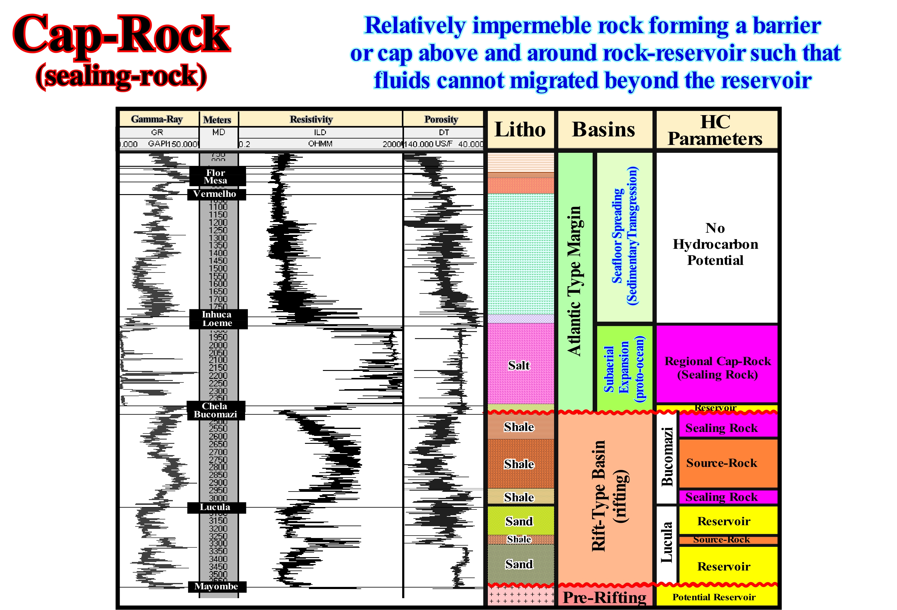
In a structural trap*, the presence of a reservoir-rock is required, in the pores from which the oil or gas accumulates, but it is also necessary the presence of a sealing-rock (cap-rock) that must close or prevent the hydrocarbons to escapes vertical and laterally from the rock-reservoir. If the presence of a cap-rock is required in a structural trap to hold the hydrocarbons, in a non-structural trap, i.e., in stratigraphic (lapout), morphological (reef) or morphological by juxtaposition (faulted blocks) traps, it is, obviously, also indispensable, since are sealing-rock who forms the traps. In a morphological by juxtaposition trap, for example, the trap exists only when the relative movement of the faulted blocks, along the fault plane, juxtaposes to rock-reservoir, in the opposite faulted block, a sealing-rock. In this figure, using the electrical logs of an exploration well drilled in the Cabinda onshore (Angola), it is summarized the lithology, the stacking sedimentary basins and the main petroleum parameters. The source-rock (lacustrine clay rich in organic matter), which generated the hydrocarbons, were deposited in rift-type basins. The reservoir-rocks, where hydrocarbons are, sometimes, accumulated, were mainly deposited in the lower part of rift-type basin (Lucula formation). The sealing-rocks are the clay of the Bucomazi formation (upper part of rift-type basin) and the evaporitic interval of the divergent margin. Knowing that, practically, all traps in this area are not structural, but rather morphological by juxtaposition, the identification and mapping of the intervals with the characteristics of sealing-rocks is crucial. Most of explorations wells that tested a non-structural trap, are dry. The trapping does not exist because of lack of sealing. In fact, it is the sealing-rock that forms the trap. In other words, the mapping of the sealing-rocks here is, practically, as much or more important than the mapping of the reservoir-rock.
(*) A structural trap is associated with anticline structures, i.e., associated with the shortening (uplift) of sediments. In a structural trap, all potential reservoir-rocks has a four way dip closure. The closure of the potential sealing-rocks is parallel to the closure of the reservoir-rocks, subsequently the mapping of the sealing-rocks is not imperative. A well drilled in the apex of a structural trap test all potential reservoir-rocks in good conditions, which is not the case of a non-structural traps.
Capacity (Stream)....................................................................................................................................................................................Capacité (Water-current)
Capacidade (de uma corrente) / Capacidad / Kapazität / 流容量 / Мощность потока / Capacità /
Possibility of a water-stream or wind to carry debris. Capacity is, usually, given by the amount of debris measured, at one point, per time unit. The term capacity may have other meanings: (i) The possibility of a soil containing water ; (ii) The productivity of a pump, well or reservoir, etc. The capacity of water-course is, also, dependent on the granulometry of the debris.
See: « River »
&
« Incised Valley »
&
« Base Flow »
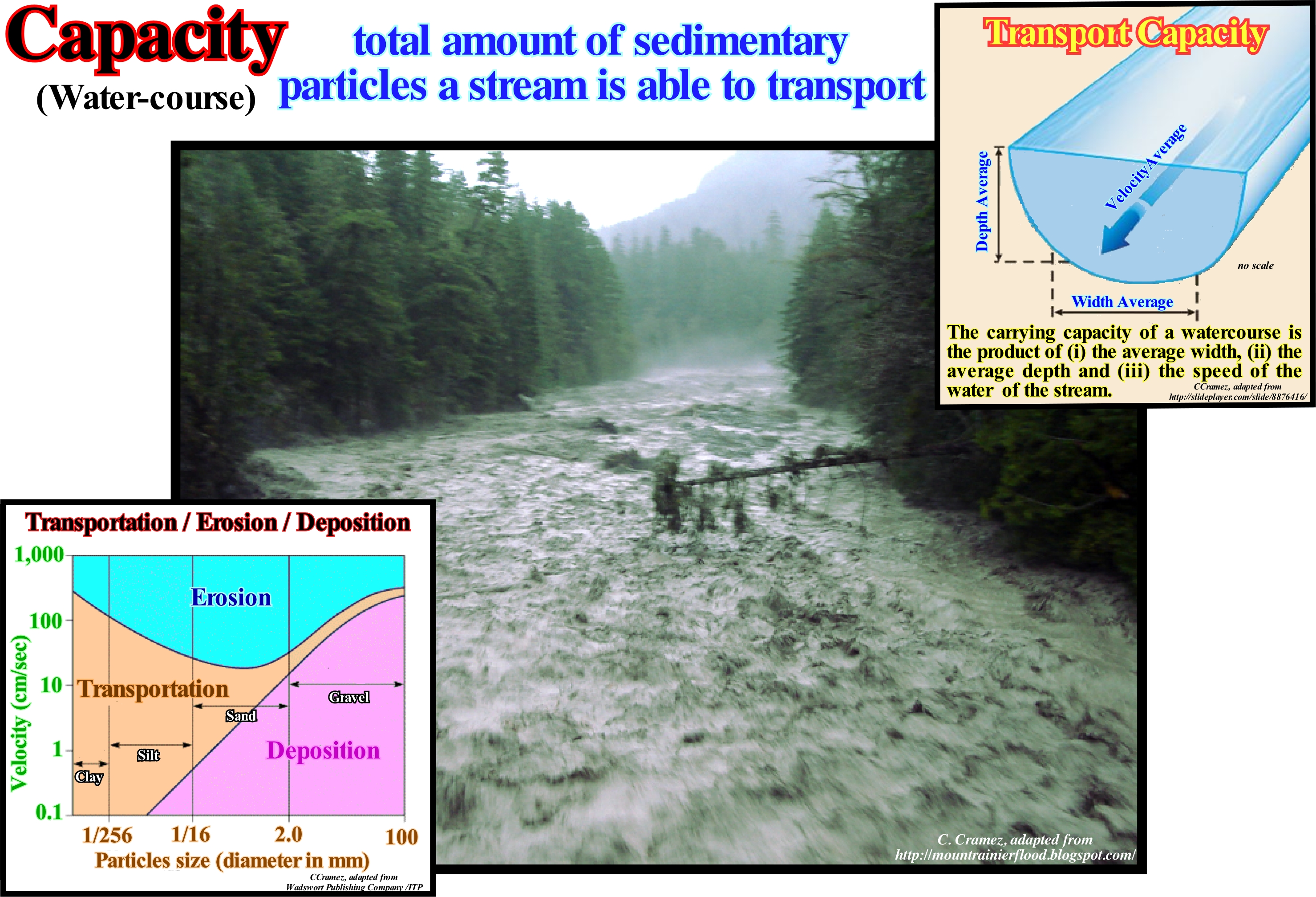
The capacity of a water-course corresponds, practically, to the current gradient, i.e., to the rate of change of the slope of the current per unit distance (cm or m per km). Sedimentary particles can be carried by a stream in three different ways: (i) Trailing; (ii) Dissolution and (iii) Suspension. In the first case, the sediments (gravel, pebbles, silt, sand, etc.) move in the bed of the stream. They can move either by traction (discontinuous rolling) or by saltation (jumping). The saltation, which is frequent in the coarser particles, facilitates the dislodging of other particles from the stream's bed. The particles are carried in suspension for short distances. When they fall back into the bed, they dislodge, eventually, the particles deposited in the bed. Dissolution transport is invisible. The material is carried in the form of ions. All streams carry a, more or less, significant amount of dissolved material resulting from chemical erosion of minerals or contamination by mineralized groundwater. It is by dissolution that the finer sediments are transported. The suspension transport includes all fine sediments which can not be transported by dissolution and which are too fine to remain in the bed of the stream. The normal flow of a stream preserves, easily, in suspension fine particles as lime, clay and silt. The material carried in suspension results from hydraulic erosion at the edges and bed of the current. Quantitatively, the material carried by suspension represents the vast majority of material that a water-course carries. A current is all water-course that channels a flow. Its middle line, where the two sides of the valley intersect is the thalweg. The more inclined is the thalweg (*) the greater the current capacity.
(*) Continuous and deep line along a valley where flows a water-course. In geomorphology, the thalweg is the continuous line that follows the points of greatest inclination or maximum slope. In a topographical map, the thalweg is, always, perpendicular to the contours lines. It encompasses the line connecting the lowest points along a valley or the bed of a stream.
Capsizing Current (Wind).........................................................................................................Courant de capsizing (Par le vent)
Corrente de Mergulho (vento) / Corriente de vuelco, Corriente de zozobra / Capsizing Strömung (Kentern) / 倾覆电流 / Штормовое течение / Corrente di rovesciamento /
Current induced by strong winds on the surface water-bodies of the sea, propelling them towards the bottom.
See: « Stream »
&
« Downwelling Current »
&
« Salinity Current »
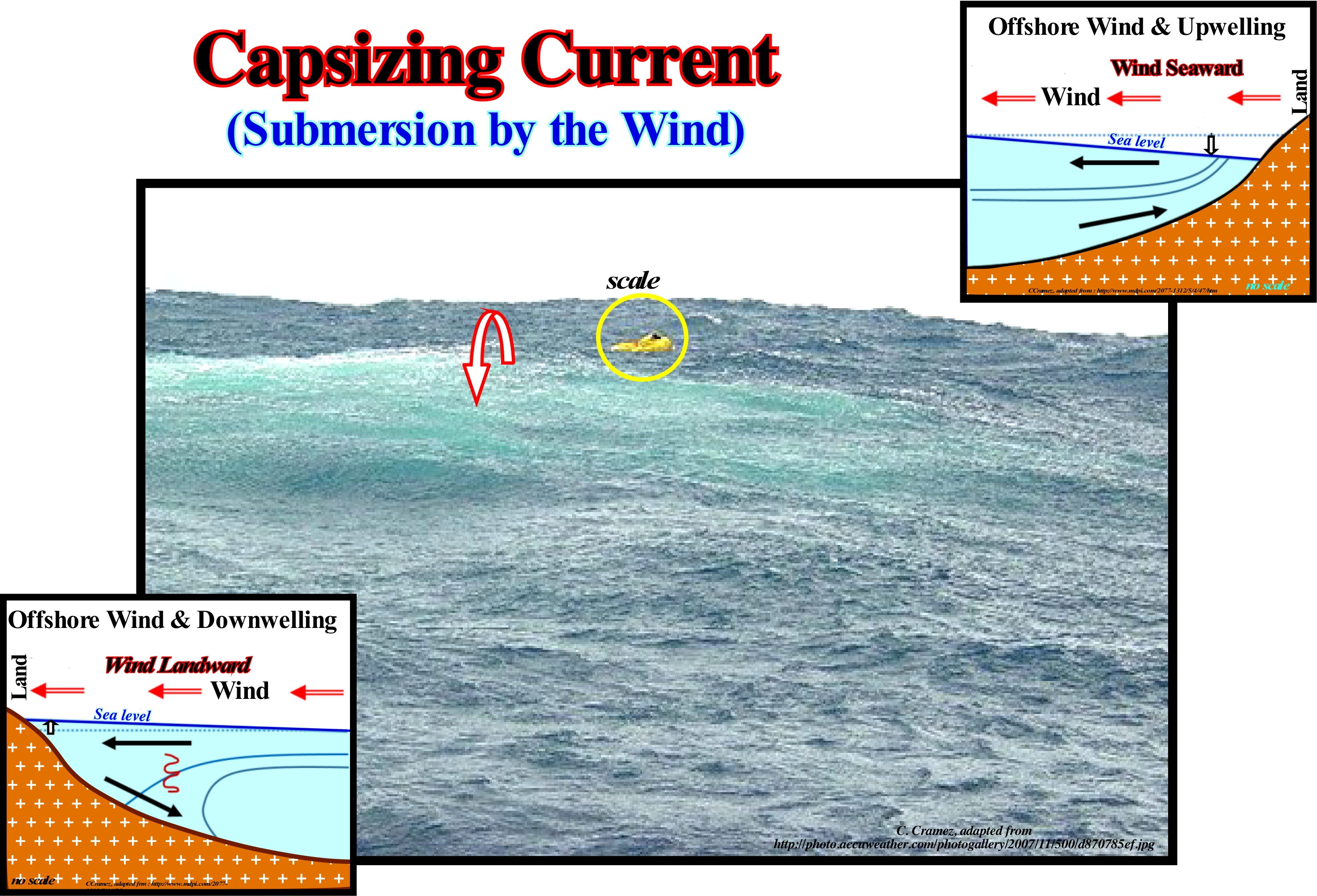
The ocean is not a still water-body. There is constant motion in the ocean in the form of a global ocean conveyor belt. This motion is caused by a combination of thermohaline currents (thermo = temperature; haline = salinity) in the deep ocean and wind-driven currents on the surface. Cold, salty water is dense and sinks to the bottom of the ocean while warm water is less dense and remains on the surface. In the ocean there are several main types of currents: (I) Surface Currents, which are pushed by the winds, which due to the Coriolis effect (caused by the rotation of the Earth), around the equator, blow slightly to the Westward ; these currents form enormous circular motions in the oceanic basins (Atlantic, Pacific and Indian), one to the north and one to the south of the equator with an anti-clockwise movement in the south and clockwise in the north; when the winds are very strong, as shown in this figure, a water-course can drive into depth forming what is called a dive stream ; (ii) Cold and Hot Currents, which form the Great Ocean Conveyor Belt* ; the cold water from the poles moves towards the equator, especially along the western side of the continents, while the hot currents flow towards the poles, mainly along the eastern sides of the continents ; the most important ocean currents are: (a) North Equatorial Currents ; (b) South Equatorial Current ; (c) Equatorial Counter-Current ; (d) Gulf Stream (Atlantic) ; (e) Canary Current (Europe) ; (f) Kuroshio current (Japan, China) ; (g) California Current (USA) ; (h) South Indian Current (Indian Ocean); (i) Benguela Current (Africa) and (j) Antarctic Circumpolar Current. The thermal parameter of the water is very different from the other substances, which they contract when cooled and dilate when heated. This also happens with water, but only until it begins to freeze. Then it begins to expand, even when it cools. The moment it freezes, the water turns to ice, which is less dense than liquid water. Ice floats on water instead of sinking**. If this were not the case there would be no life on Earth. If water from the oceans and lakes froze from bottom to top instead of from top to bottom, the deep ecologies would not exist and the icy mass would be eternal. Top-down freezing limits the freezing of the water and allows rapid thawing.
(*) The ocean conveyor gets its “start” in the Norwegian Sea, where warm water from the Gulf Stream heats the atmosphere in the cold northern latitudes. This loss of heat to the atmosphere makes the water cooler and denser, causing it to sink to the bottom of the ocean. As more warm water is transported north, the cooler water sinks and moves south to make room for the incoming warm water. This cold bottom water flows south of the equator all the way down to Antarctica. Eventually, the cold bottom waters returns to the surface through mixing and wind-driven upwelling, continuing the conveyor belt that encircles the globe. (https://oceanservice .noaa.gov/facts/conveyor.html).
(**) When am ice sea sea disappears by melting, locally, the sea level fall (contrary to what certain ecologists think) before, later on, equilibrate.
Carbon.......................................................................................................................................................................................................................................................Carbone
Carbono / Carbono / Kohlenstoff / 碳 / Углерод / Carbonio /
Chemical element with the atomic number 6 and the symbol "C". It is a non-metallic element, of the group 14 and period 2 in Mendeleev's periodic table. Carbon has several allotropic forms of which the best known are: (i) Graphite ; (ii) Diamond and (iii) Amorphous Carbon.
See: « Methane »
&
« Coal »
&
« Hydrocarbon »
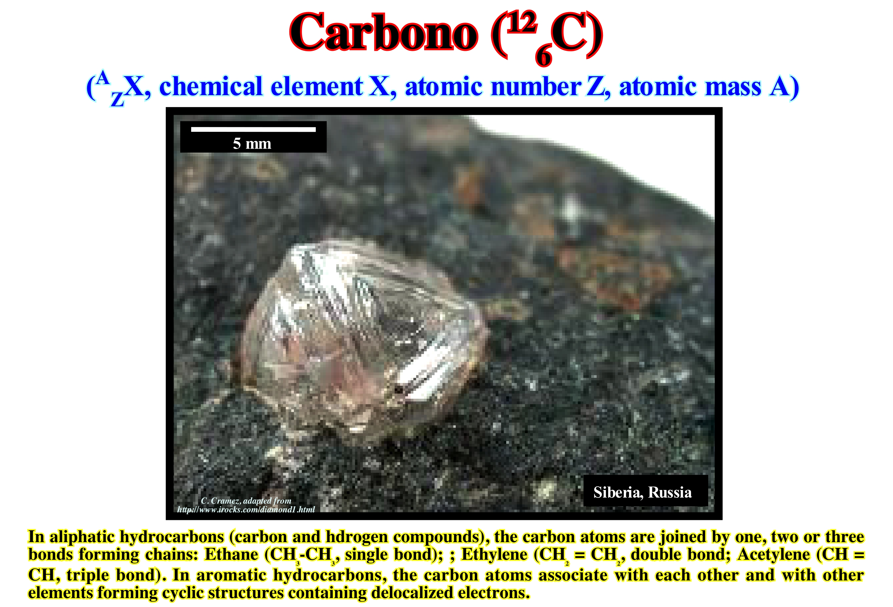
Carbon was formed by nucleosynthesis (*) inside the stars. Indeed, since a star exhausts its reserves of hydrogen, the radiation decreases and no longer withstand gravity. The star shrinks. Its density increases and the temperature rises to a hundred million degrees. The helium nuclei, the product of the combustion of hydrogen, are grouped together to form a carbon 12 nucleus. As the mass of a carbon nucleus is slightly less than the mass of three helium nuclei, the difference is transformed into radiation, which increases, sufficiently, to balance the gravity again. The diamond shown in this image is about 1.5 carats (one carat exactly 200 mg) and is embedded in an eclogite (metamorphic, granular rock of very dense basaltic composition that can withstand very large pressures) of the Udachnaya mine in Siberia. Diamond, which is an allotropic of carbon**, is the hardest natural material known. Its hardness combined with its high dispersive power of light makes it very useful not only in industry but also in jewellery. All forms of carbon are very stable. Carbon requires a high temperature to react with other elements, even with oxygen. The degree of carbon oxidation most common in inorganic components is +4, while it is +2 in carbon monoxide (CO). The main sources of inorganic carbon are limestone, dolomites and carbon dioxide (CO2). Important amounts of carbon also appear in deposits of coal, peat, oil and methane hydrates. Carbon forms many more compounds (a material made up of more than one chemical element) than any other element. To date, more than 10 million compounds have been described, which corresponds, theoretically, to a small fraction of the possible combinations under normal temperature and pressure conditions. In terms of mass, carbon is the fourth most abundant element in the Universe, after hydrogen, helium, and oxygen. He is present in all forms of life. In the human body, in terms of mass, it is the second most important element (about 18%) after oxygen. This cornucopia, together with the diversity of organic components and the ability of it to form polymers at normal temperatures on Earth, makes it the basic chemical element of all known forms of life. There are three natural isotopes of carbon. 12C and 13C are stable, while 14C is radioactive. The 14C is formed in the upper levels of the troposphere and stratosphere, at altitudes between 9 and 15 km, by a reaction that is induced by the cosmic rays.
(*) Formation of nuclei of atoms by nuclear reactions in either the Big Bang (responsible primary nucleosynthesis of light elements such as hydrogen and helium) or in the centre of the stars (manufacture of elements heavier than helium but lighter than iron) or in supernovae (where heavier elements are made than iron).
(**) List of the main allotropes of carbon: (i) Diamond ; (ii) Graphite ; (iii) Londsdaleite ; (iv) C60 Buckminsterfullerene ; (v) C540, Fullerite ; (vi) C70 ; (vii) Amorphous carbon and (viii) single-walled carbon nanotube (https://en.wikipedia.org/wiki/Allotropes_of_carbon)
Carbonate (Limestone).....................................................................................................................................................................................................Calcaire
Calcário / Calcáreo / Kalkstein / 石灰石 / Известняк / Calcare /
Sediment or sedimentary rock formed by accumulation of carbonated minerals precipitated organically or inorganically.
See: « Calcite »
&
« Reef »
&
« Organic Production (carbonates) »
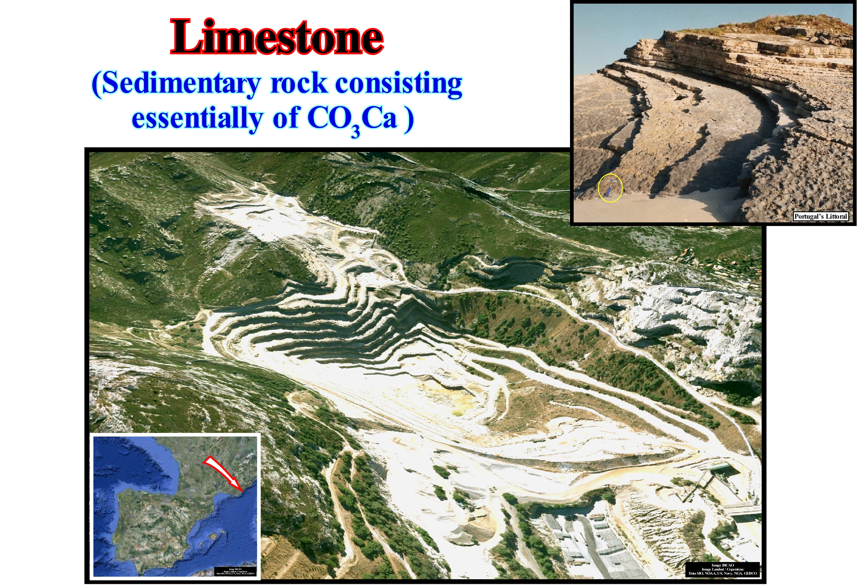
In general, limestones, as can be seen in this photograph, are very compact rocks, well stratified and subject to intense chemical erosion, since they are, essentially, carbonated minerals. Limestones may contain a certain amount of silica (as a chert, for example), as well as clay, silt and sand, either in disseminations, nodules or fine intercalations. Marine organisms are the main source of limestone calcite. These organisms secrete shells that deposit on the sea-floor in the form of mud or in conglomerates on coral reefs. Calcite can also be deposited from super-saturated meteoric waters, as in stalagmites and stalactites. Calcite can form in oolites (oolitic limestone), which is very easily recognized by its granular appearance. Limestones, which make up about 10% of the total volume of sedimentary rocks, can form in marine, lacustrine or evaporitic environments (saliferous). As limestones are, partly, soluble, in acid solutions, when they appear, they create very varied erosion morphologies. Although limestones are, widely, used in construction and sculpture (especially the marbles resulting from the metamorphism of limestones), they are also used: (i) Manufacture of lime ; (ii) Manufacture of cement ; (iii) Conditioning agricultural land ; (iv) Paving roads ; (v) As rock-reservoir, in particular in petroleum industry ; (vi) Desulphurisations ; (vii) Manufacture of glass ; (viii) Manufacture of paper, plastics and inks; (ix) Toothpaste; (x) Avoiding methane explosions, especially in coal mines ; (xi) Food as a source of calcium. Although limestones can be deposited in almost all sedimentary systems tracts, which make up a sequence-cycle, they are, particularly, frequent in transgressive interval, in association with relative sea level rises in acceleration, during which the sedimentary basin has a significant continental shelf. It can be said limestones are sedimentary rocks formed of calcite from evaporation in lake, sea and marine environments with shells. There are many different types of limestone formed through a variety of processes. Limestone can be precipitated from water (non-clastic, chemical or inorganic limestone), secreted by marine organisms, such as algae and coral (biochemical limestone), or formed from the shells of dead sea creatures (bioclastic limestone). Some limestones form from the cementation of sand and/or mud by calcite (clastic limestone), and these have, often, the appearance of sandstone or mudstone (https://flexiblelearning.auckland.ac.nz/rocks_minerals/rocks/limestone.html).
Carbonate Building..................................................................................................................................Accumulation carbonatée
Edifício carbonatado / Acumulación de carbonato / Carbonate Aufbau deltaischen Gebäude / 碳酸盐的沉积 / карбонат наращивание / Accumulo di Carbonate/Non-genetic term for any carbonated body which differs from the lateral equivalents and overlying sediments, is thicker than the lateral equivalents and is morphologically higher than sediments around, even during sedimentation.
See: « Carbonate Build-up »
Carbonate Build-up (Structure, construction)........................................................Accummulation carbonatée
Acumulação carbonatada / Acumulación carbonática / Karbonate Aufbau / 碳酸鹽建隆 / Карбонатная залежь / Accumulazione carbonato /
A non-generic term for any anomalous carbonate geological body that differs and is thicker than the lateral equivalents and overlying sediments. Morphologically, an anomalous carbonate accumulation is, almost always, higher than the sedimentation base level.
See: « Reef »
&
« Coral »
&
« Deposition (carbonates) »
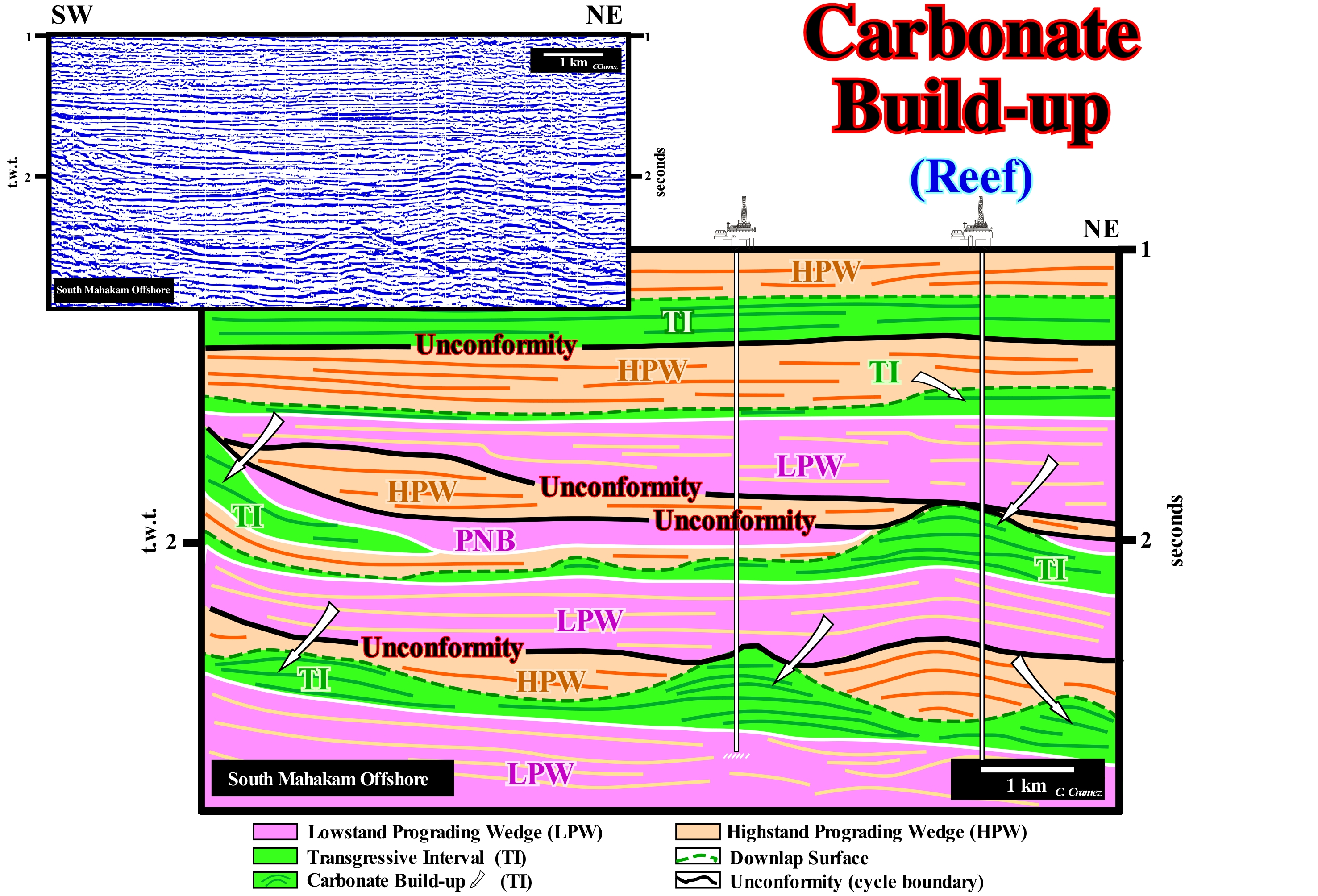
When the climate and sedimentary particles are appropriate, carbonate constructions are quite frequents in the transgressive interval (TI) of sequence-cycles, in particular, when the rate of relative sea level rise (in acceleration) compensates, more or less, the rate of construction of the carbonate bodies, which keeps the water-depth, more or less, constant within the photic zone. The East Borneo offshore, where the seismic line of this Canvas auto-trace was shot, corresponds, geologically, to a non-Atlantic Divergent Margin, developed over a Back-Arc Basin, in which two tectonic phases can be recognized: (i) Lengthening Phase (rifting), at the base, which is characterized by a differential subsidence and (ii) Sinking Phase (sag), at the top, which is characterized by a thermal subsidence. In the sequence-cycles that constitute the sinking or thermal phase, carbonate constructions* are frequent. This tentative of interpretation is proposed in sequence-cycles, induced by 3rd order eustatic cycles, which have a time-duration between 0.5 and 3-5 My. The boundaries between the sequence-cycles, as among all other stratigraphic cycles (continental encroachment cycles, continental encroachment sub-cycles, sequence-cycles and high-frequency cycles) are unconformities, i.e., erosional surfaces created by relative sea level falls resulting from the combined effects of eustasy (absolute sea level) and tectonics (subsidence or uplift of the seafloor). In the proximal part of this offshore, where the seismic line of this auto-trace was taken, just the transgressive intervals (TI) and the highstand prograding wedges (HPW), as well as the lowstand prograding wedges (LPW), were deposited within the sequence-cycles. The other sub-groups of the lowstand systems tracts group (LSTG), i.e., the submarine basin floor fans (SBFF) and the submarine slope fans (SSF) are visible just eastward of this region in the deepest part of the sequence-cycles. On this tentative of interpretation, the great majority of carbonate build-ups developed within the transgressive intervals (TI) of the sequence-cycles, corresponding to sedimentary transgressions, i.e., to a set of increasingly important marine ingressions (relative sea-level rises in acceleration) and increasingly smaller sedimentary regressions. Since the relative sea level rose (in acceleration) and flooded the preexisting topography (coastal plain of the underlying lowstand prograding wedge coloured in violet on this tentative interpretation), a continental platform (shelf) was formed that increased, progressively, as relative sea level rises. Between the relative sea level rises increments, which correspond to eustatic paracycles, there are no relative sea level falls, but a stability period of the relative sea level. Sedimentation occurs, mainly, during the stability periods of the relative sea level between eustatic paracycles, although, certain reef constructions may grow during marine ingressions. In certain parts of the shelf, especially, near the basin edge, the rate relative sea level rise was such that it allowed the construction of carbonates, since the water-depth remained, more or less, constant. Certain geoscientists consider the carbonate constructions of the transgressive interval as keep-up carbonates, once they deposit during continuous and slow relative sea level rise, so that the available space for the sediments created by the joint action of eustasy and tectonics (subsidence or uplift of the sea-floor), is completely filled by the newly formed carbonate material. The deposition of keep-up carbonates compensates the relative sea level rise. This type of transgressive carbonate constructions (keep-up carbonates) contrasts with catch-up carbonates of the highstand prograding wedge (HPW), in which the progradations are, particularly, characteristic because the carbonate is spilled into the slope or basin, once its production exceeds the rate or creation of available space (accommodation). The stability of the water-depth is a "sine qua non" condition for that the catch-up carbonate organic structures continue to grow during the 1st stage of development of the highstand prograding wedge (when the shoreline is still upstream of the continental edge, that is, while the basin still has a shelf). If the water-depth exceeds the depth of the photic zone the carbonate production ceases.
(*) Circumscribed bodies of carbonate with a topographic relief above the equivalent lateral sediments which are usually thinner, and different from the surrounding and overlying deposits. The reefs are carbonate constructions that can maintain their growth in the surf wave zone. The resistance to reef waves, which varies from one environment to another, depends on: (i) Inorganic cementation of the spar (variety of calcite) in an underwater or subaerial environment ; (ii) The organic construction of rigid skeletal structures or not ; (iii) Sediment binding by algal mats ; (iv) Presence of rooted organisms, etc. Carbonate constructions can be classified on the basis of the composition of their constituents and the type of coating of the skeletal constituents when these constituents are dominant.
Carbonate Compensation Depth......................................Profondeur de compensation (Carbonates)
Profundidade de compensação / Profundidad de compensación (carbonatos) / Carbonate Entschädigung Tiefe / 补偿深度 / Компенсационная глубина (карбонаты) / Profondità di compensazione (carbonati) /
Water-depth below which the calcium carbonate, produced in the ocean, is dissolved, completely. Water-depth below which there is no deposition of calcium carbonate.
See: « Carbonate Sedimentation »
&
« Stratification (Water) »
&
« Depositional Model (carbonates)»

Under the carbonate compensation depth (CCD), the rate of calcium carbonate (calcite and aragonite) input and dissolution rate are compensated, i.e., that no calcium carbonate is deposited. Calcium carbonate is, practically, insoluble in the superficial levels of sea-water. The plankton shells falling into deep-water are, practically, intact until they reach the lysocline (a term used in geology to indicate the sea-water depth from which the rate of dissolution of calcite increases dramatically). When they reach the carbonate compensation depth, all of the calcium carbonate dissolves. Plankton and limestone sediment are only found in a waterdepth above the compensation depth. If the sea-floor is above the compensation depth of the calcium carbonate (CCD acronym for carbonate compensation depth), the sediments of the sea-floor may be limestone sediments. If the sea-floor is lower than the carbonate compensation depth, all limestones are dissolved before reaching the sea-floor. The solubility of calcium carbonate depends on the temperature, pressure, chemical composition of the water and the amount of carbon dioxide (CO2) dissolved in the water. Calcium carbonate dissolves more easily at low temperature and high pressures. The sketch illustrated in this figure shows that the morphology of the ocean floor and the mid-oceanic ridge control, partially, the nature of the sediments deposited there. When the oceanic crust is above the carbonate compensation depth (CCD), most of the deposited sediments are organic in nature (organic ooze). When the oceanic crust reaches greater depths, only terrestrial detrital sediments settle on the sea-floor (fine levels of abyssal clays). As the oceanic crust cools, it becomes heavier and sinks more. This subsidence combined with eustasy (variations of absolute or eustatic sea level, which is supposed to be global and referenced to the Earth's centre) changes the amount of available space for the sediments, which allows the deposition of the sedimentary wedges on the margins of the ocean basins, which are posterior to the rife-type basins formed and filled before the break-up of lithosphere of the associated supercontinent. A Mesozoic/Cenozoic sedimentary prism corresponds to the post-Pangea continental encroachment stratigraphic cycle, which was deposited in association with second order Phanerozoic eustatic cycle. Such an eustatic cycle lasts over 50 million years. It Is induced by the volume variations of the ocean basins created by dispersion (seafloor spreading) and agglutination of the continents (formation of a supercontinent). The amount of water under all its forms is assumed to be constant since the Earth's formation (around 4.5 Ga). On this subject http://www.ebah.com.br/content/ABAAAANHMAJ/a-analise-sedimentar-conhecimentos-dos-sistemas-marinhos? part=5, said: (i) There is a constant exchange of CO2 between the atmosphere and the hydrosphere ; (ii) In regions rich in phytoplankton (wetlands) the excess CO2 is released into the atmosphere, while in arid zones CO2 is removed from the atmosphere by oceanic waters ; (iii) Globally, and mainly due to biological activity, CO2 is removed from the ocean in the form of carbonates, which are incorporated into the marine sediments ; (iv) The vertical zoning of carbonated pelagic sedimentation was observed for the first time during the Challenger expedition (1872 to 1876) ; (v) The solubility of CaCO3 increases with increasing pressure (increasing depth) and decreasing temperature and salinity ; (vii) Ocean water is, progressively, less saturated in carbonates as the depth increases ; (viii) At depths of 2,000 to 4,000 meters the water is unsaturated ; (ix) In the shallow part of the ocean, the saturation isolines (line of constant value on a map or chart) are directly related to the hydro-chemical conditions and have, in general, winding tracing, which softens as the depth increases ; (x) In the Atlantic, the 100% saturation isolate is located at depths of the order of 4,000m (in the Pacific it is only 2,000m), becoming progressively shallow to north and south ; (xi) Outside the carbonated sedimentation zone, i.e., north and south of 60 ° latitude, the 100% saturation in calcite reaches the surface ; (xii) The differences between the oceans, with regard to carbonate sedimentation (and consequent dissolution of the particles), are related to characteristics of the circulation (xiii) In the northern hemisphere, where continents make circulation more complex, these differences are greater, being very small in the so-called austral ocean, where disturbances in circulation by the continental masses are minimal.
(*) Plankton is composed of uni or pluricellular organisms, mostly microscopic, that float with little capacity for locomotion in the oceans and seas, on the surface of brackish waters, sweet or lakes. Some invertebrates, jellyfish and krill are examples of macroscopic plankton.
Carbonate Facies Belt*.........................................................................................................................Ceinture carbonatée (Milieu)
Ambiente de cintura carbonatada / Faja Carbonática / Karbonat-Fazies Gürtel / 碳酸岩相带 / Зона карбонатных фаций / Cintura carbonato (ambiente) /
Each of the natural environments of carbonate deposition in a shallow-water carbonate platform, regardless time and geological context. In the Wilson's model (1975) for carbonated platforms, improved by several geoscientists, are, practically, all the sedimentary environments that can be observed in a carbonate belt: (i) Basin ; (ii) Open Sea Shelf ; (iii) Deep Shelf Margin ; (iv) Fore-slopelope ; (v) Organic Build-ups; (vi) Winnowed Edge Sands; (vii) Shelf Lagoon with Open Circulation ; (vii) Restricted Circulation Shelf and Tida-Flats ; (ix) Evaporites on Sabkhas Salinas.
See: « Depositional Environment »
&
« Deposition (carbonates) »
&
« Carbonate Sedimentation (principles) »
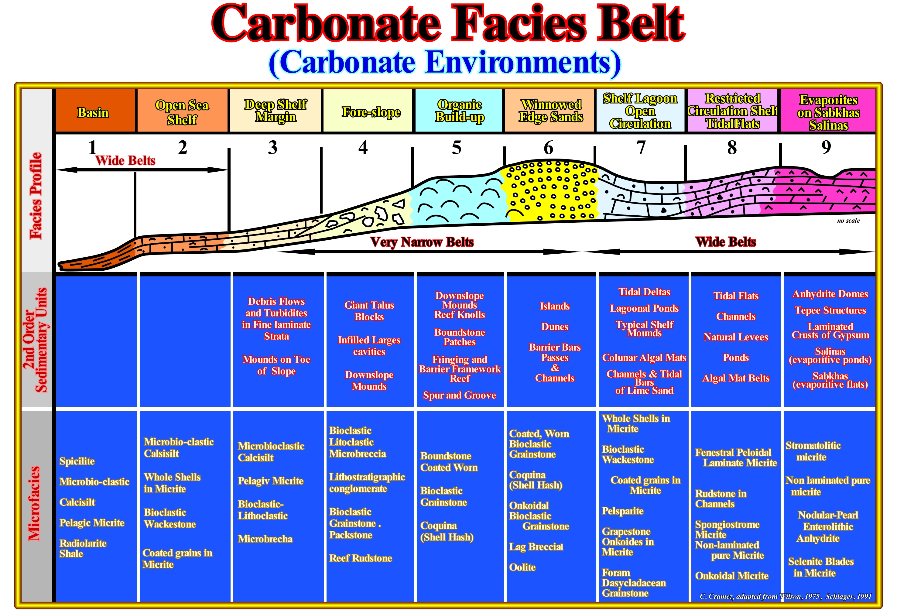
In this sketch, taken from Schlager (1991), are summarized the main environments found in a carbonated waist: (i) Basin ; (ii) Open Sea Shelf ; (iii) Deep Shelf Margin ; (iv) Foreslope; (v) Organic Build-up ; (vi) Winnowed Edge Sand ; (vii) Shelf Lagoon Open Circulation ; (viii) Restricted Circulation Shelf Tidal-Flats ; (ix) Evaporites on Sabkhas Salinas. The basin (1) and the open sea shelf (2) form wide belts, as well as the shelf lagoon open circulation open circulation (7), the restricted circulation shelf and tidal plain (8) and evaporites on sabkhas Salinas ( 9). The deep shelf margin (3), the Foreslope (4), the organic build-up (5) and the winnowed edge sands (6) form very narrow belts. The microfacies and sedimentary bodies of each environment are indicated. In open sea shelf, the main sedimentary bodies are mainly slope blocks, embankment fillings and slope mounds, while the main microfacies are bioclasts, lithoclasts, micro-breccias, lithoclastic conglomerates, "grainstones" (in the Dunham classification, grainstones are carbonate sedimentary rocks formed by grains that do not contain micrite, the spaces between the grains are filled with cement) and bioclastic "packstones" (limestone rock formed by bioclastic grains with a micrite matrix), ruditic reefs, etc. In the same way in the lagoon environment with open circulation, the main sedimentary bodies are: (i) Tidal deltas; (ii) Lagoons; (iii) Platform mounds; (iv) Algae mats on columns; (v) Fillings of channels and tidal bars by carbonated sands, etc. In this environment, the most common microfacies are: micrites with shells, bioclastic wackestones (matrix supported limestone rocks containing more than 10% allochemicals in a micrite matrix, carbonate sludge), micrites with coated grains, pelsparite containing less than 25% of intraclasts and ooliths, with a volume ratio between pellets**, and fossils greater than 3 to 1, and with calcite-sparite cement more abundant than the micritic matrix), micrites with conchoidal grapestone (a set of sand-sized grains such as oolites or peloids, held together by rapid cementation soon after deposition and often found as intraclasts within limestones), foraminifera, dasclinic grainstones, i.e., with Dasycladaceae (algae unicellular greens whose stem is protected by a limestone), etc. This model does not say anything about the differentiation of carbonate belt environments induced by wind direction. Sedimentary environments develop asymmetries in response to the dominant wind direction. The windward (on the side where the wind blows) and leeward (opposite the wind blowing) platform have different morphologies and facies (lithologies and associated fauna), which are sometimes well marked on the seismic lines of good quality. In the study of carbonate platforms it is necessary to always take into account that: (i) Carbonates are mainly of organic origin ; (ii) Carbonates build structures resistant to the action of waves, and (iii) Carbonates undergo major diagenetic changes. It is for this reason that Schlager (1991) says: (a) Carbonated sediments are not made, they are "born," meaning that carbonates are the result of an organic activity in a marine environment where sunlight and nutrients are available ; (b) The platforms construct auras that are resistant to the erosive action of waves and lands that are resistant to landslides; (c) The auras of the carbonated platforms are constructed by an organic structure with a very rapid karstification (process in which rainwater laden in carbon dioxide attacks calcareous rock, mainly composed of calcite, leading to the formation of a karst) and the flanks are stabilized by the karstification of the seabed; (d) The mineralogy changes after the deposition, once, that the shallow water carbonates are formed mainly by aragonite (polymorph stable at high temperature and pressure of calcium carbonate, with traces of strontium, lead and zinc, whose crystalline crystalline carbonate with a disordered structure in which the metal ions occur in the same crystallographic layers and not in the same crystallographic layers. alternating layers, such as in dolomite), which after deposition stabilize in calcite or turn into dolomite.
(*) Here, the term Facies is used in the American meaning of sedimentary environment rather than in its original sense of lithology.
(**) Pellets are natural products formed by a mixture of salt water and organic or inorganic materials resulting from biological and / or geological processes.
Carbonate Function (Organic production)..........................................................Courbe de production (Carbonates)
Curva de produção (carbonatos) / Curva de producción (carbonatos) / Produktion Kurve (Carbonate) / 生产曲线(碳酸盐岩) / Кривая производительности / Curva di produzione (carbonati) /
Production of carbonates as a function of water-depth. The penetration of sunlight (intensity) into an aquatic environment (sea or lake) decreases exponentially, when the water column increases. The organic matter production curve, in a carbonated basin, can be correlated with the intensity of sunlight by a hyperbolic function. The carbonate production curve has a peak in the zone of light saturation, near sea level, where light is not a limiting factor of production. The peak production is followed, in depth, by a rapid decrease in production.
See: « Accommodation »
&
« Photic Zone »
&
« Depositional Model (carbonates)»
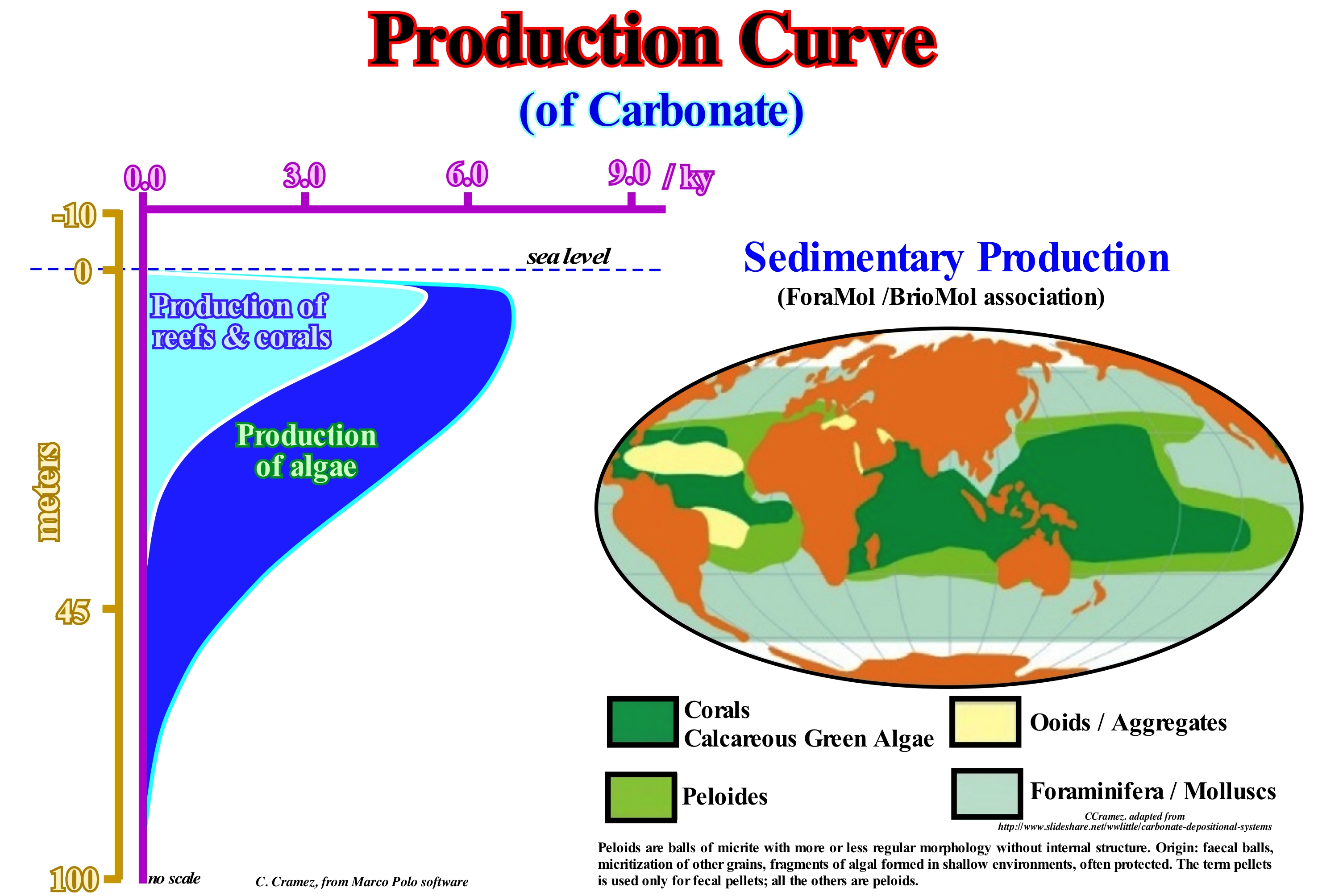
Limestones, in general, are sedimentary rocks formed by calcite (calcium carbonate). In fossiliferous limestone, the origin of carbonate comes from the fossils of carapaces and skeletons of living limestone organisms. In other limestones, calcium carbonate comes from chemical precipitation. Coral reefs, shells of molluscs, calcareous algae, echinoderms, bryozoans (small colonial invertebrates, very common in the sea, but also occurring in freshwater, which form intricate colonies, belong to the Ectoprocta phylum, a result of the division of the old phylum Bryozoa), foraminifera (they have a teak or shell, which may contain one or more chambers connected by a small aperture called foramen) and protozoa are the main responsible for deposits from organisms synthesizing the carbonate dissolved in aqueous medium. These deposits are generated in shallow marine environments, warm, calm and transparent waters. The organisms die and their shells and calcareous structures are deposited in the bottom of the sea. The CaCO3 production of coral reefs can be divided into three categories: (i) Potential production ; (ii) Gross production and (iii) Net production. The first, i.e., the potential production is the amount of CaCO3 produced per unit area of the reef surface covered by an organism or colony of organisms. Most limestone phyla have potential yields near 104 (g CaCO3/m2) / year. Some values can reach up to 105 (g/m2)/year. The second, the gross production, is the amount of CaCO3 produced by the reef community per unit area of the seabed. Associations of hypothetical reefs have crude yields ranging from 4 x 10² to 6 x 10⁴ (mg CaCO3/m2)/year. Environments consisting of combinations of these associations can produce between 3 x 10³ and 6 x 10⁴ (g CaCO3 / m2)/year. The crude production of whole reef systems is, apparently, close to 104 (g CaCO3/m2)/year. Net production is the amount of CaCO3 retained by the reef system, which is largely a function of sea level variations. Currently, net production is about 103 (g CaCO3/m2) / year. The faster rates of relative sea level rise several thousand years ago were, probably, accompanied by higher net (and gross) production - up to more than 2 x 10⁴ (g CaCO3/m2) / year - or by drowning of reefs. As shown in this figure, the carbonate production curve depends on the water-depth. The production of organic matter is maximum between 3 and 10 meters of water-depth and ends between 40 and 50 meters. The production curve is a function of light penetration of the Sun light. It can be said that from the lower limit of the euphotic or photic zone (water column of an ocean or lake where there is sufficient light for photosynthesis), there is no more production. The entire population of organisms responds to the law of sigmoid growth (when the growth rate of a mathematical function is proportional to the value of the function). A population always responds to the formation of available space. At the beginning, the rate** of available space formation exceeds the rate of population growth. Then it is the rate of growth that exceeds the rate of space formation. Finally, the rate of growth is controlled by the rate of spatial formation. Recall that the euphotic zone corresponds to the water (sea or lake) layer that receives sufficient sunlight to allow photosynthesis, which is the formation of sugars in the chloroplasts of plants from the combination of water absorbed by the roots and carbon dioxide of the air with the help of sunlight. Although variable (function of water turbidity), the photic zone is rarely more than 50 meters. The Sun is the ultimate source of energy. Each day 1.5 x 10²² kJ reaches the Earth, of which 1% is absorbed by the photosynthetic organisms and transformed into chemical energy by the known reaction: 6CO2 + 6H2O → C6H12O6 + 6O2, where solar energy is used to foment the transformation of dioxide of carbon (CO2) and water (H2O) in oxygen (O2) and glucose (C6H12O2 sugar). This means that around 1011 tonnes of CO2 are fixed globally each year. Oxygen, which is nothing other than a residue of photosynthesis, is evacuated by plants and enters the atmosphere. The sugars thus formed are stored in the form of starch, which later serves as food for the animals. It can be said that photosynthesis is nothing more than the transformation of solar energy into chemical energy.
(*) Keith E. Chave et al., (1972 ) - Carbonate production by coral reefs. Marine Geology, Vol 12, issue 2, February 1972, Pages 123-140
(**) A rate is a ratio of two quantities. It is a coefficient that expresses the relation between a quantity and the frequency of a phenomenon. In this way, the rate allows to express the presence of a situation that can not be measured or calculated directly. (http://conceito.de/taxa)
Carbonate Platform..........................................................................................................................................Plate-forme Carbonatée
Plataforma Carbonatada / Plataforma carbonática / Karbonatplattform / 碳酸盐台地 / Карбонатная платформа / Piattaforma carbonatica /
Sedimentary body with one determined the topography composed of autochthonous limestone deposits. As the growth of a carbonate platform is induced by sessile organisms (skeletons build the reefs) or by organisms (usually microbes) producing carbonate precipitation through their metabolism, they develop only in regions where there are constructive organisms.
See: « Rimmed Carbonate Platform »
&
« Drowned Shelf »
&
« Transgressive Interval »
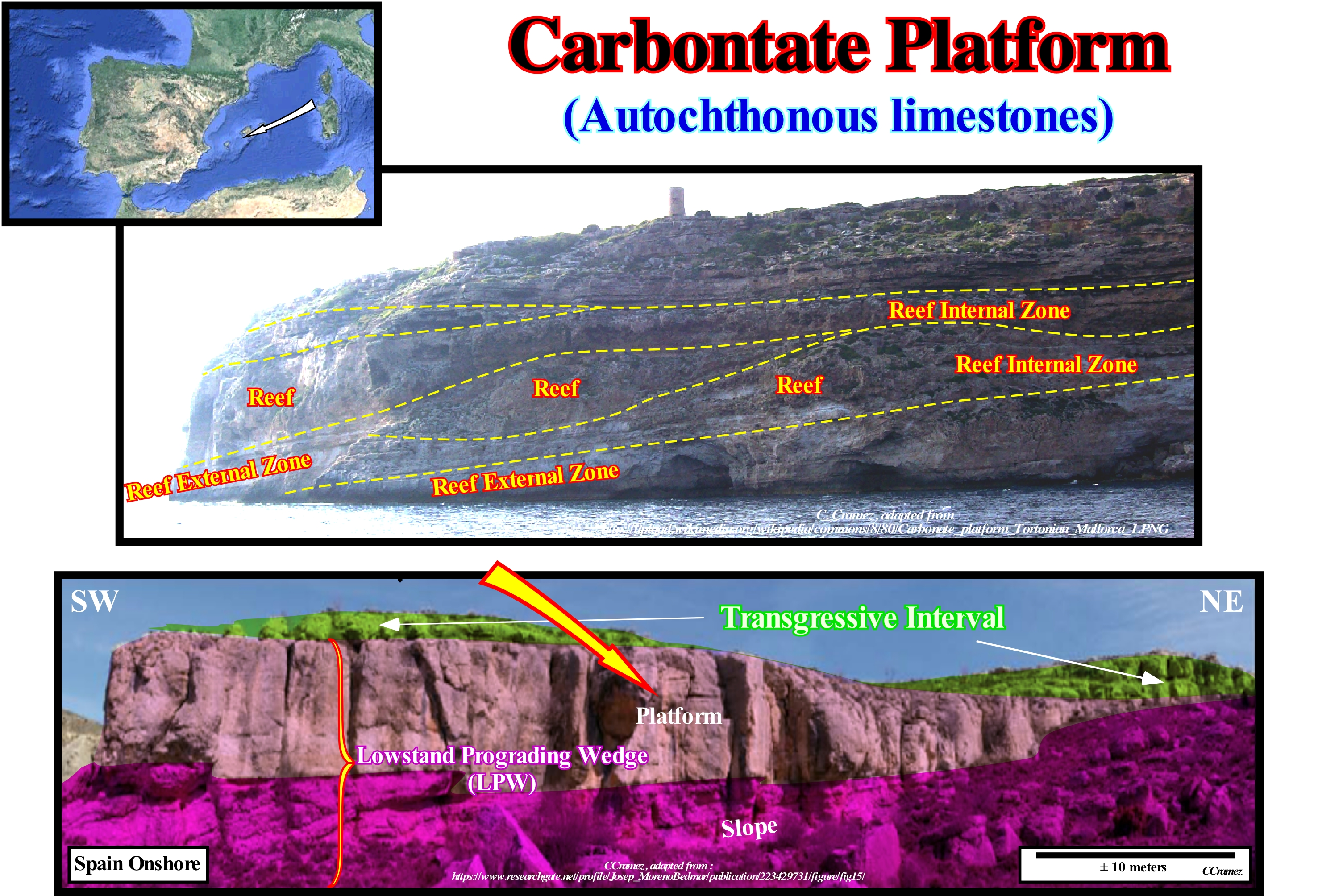
The mineralogical composition of the carbonated platforms can be calcitic or aragonitic. Sea-water is saturated with carbonate, so under certain conditions the precipitation of CaCO3 is possible. As carbonate precipitation is favoured by a high temperature and low pressure, three types of carbonate precipitation are possible: (i) Bio-controlled; (ii) Biotically induced and (iii) Abiotic. Carbonate precipitation is, biotically, controlled when organisms (such as corals) are present and use the carbonate dissolved in sea-water to build their calcite or aragonite skeletons and to develop rigid reef structures. It was, certainly, what happened in the construction of the reefs illustrated in this figure (island of Majorca). Bio-controlled precipitation occurs outside the cells of organisms and thus the carbonate is not, directly, produced by organisms but precipitates because of their metabolism. Abiotic carbonate precipitation involves little or no biological influence. Certain geoscientists consider different types of calcareous accumulations: (i) Calcareous or carbonate platforms (shelves), which correspond to large sedimentary bodies formed by the accumulation of carbonate sediments, in general, in a relatively subsurface region with a more or less flat top and steep sides with a thickness that can reach several kilometers and an extent that sometimes exceeds hundreds of square kilometers ; (ii) Limestones, stricto sensu, which are connected to the continental areas, which are sources of terrigeneous matter, organic matter and nutrients ; (iii) Epicratonic calcareous platforms (shelves), i.e., large craters covered by shallow water with carbonate deposition (there are no modern analogues) ; (iv) Calcareous banks that are insulated platforms and surrounded by deep water without source of terrigeneous. Most geoscientists consider five categories of carbonate platforms: A) Rimmed Platforms , which are characterized by the presence of reefs or limestone sands of shallow (carbonated sandbank covered by shallow sea-water) on the edge of the platform and clay sands in the lagoon or open shelf (this type of platform forms in calm waters and its extension varies between 10 and 100 km) ; B) Ramp Platforms, in which the shoreline carbonated sands pass, at the base of the ramp, to clay sands and deep water mud (in this type of platform the reefs are rare and the width of the ramp can reach 100 km) ; C) Epeirial (or Epiric) Platforms, which are characterized by the presence of tidal surfaces and protected lagoons (the width of an epeiric platform can reach 10,000 km) ; D) Isolated Platforms, in which the facies (lithologies) are very controlled by the orientation of the dominant winds (these platforms have reefs and sandy bodies, such as the rimmed platform, in the windward margin, i.e., facing the side where the wind blows, but in the leeward margin, in the direction where the wind blows, the sediments are more muddy (an isolated platform can reach 100 km wide) ; E) Dead or Drowned Platforms, when they are under the photic zone (where there is not enough light for photosynthesis, i.e., use of carbon dioxide, CO2, and water to obtain glucose through the energy of sunlight). The platforms connected to the continent are divided into two large families: (1) Ramp Type and (2) Top-Flatened Type. In ramp type platforms two subtypes can be considered: (1.1) Monoclinal and (1.2) Distal Steepened. In top-flattened platforms there are also two subtypes: (2.1) Nonrimmed and (2.2) Rimmed. It is in the subtype (rimmed platform) that the designation of abrupt carbonated platform is more frequent. The absence of a barrier, such as that on the rimmed platform, is the result of a high energy that creates complex coastal lithologies with a high rate of sedimentary transport. Although barrier reefs are absent, reefs pinnacles and reef mounds can be found on non-rimmed platforms. Modern rimmed platforms are found mainly on the tropical coast of the Arabian Gulf, Shark's Bay (Western Australia) and Yucatan (eastern part).
Carbonate Ramp.........................................................................................................................................................................Rampe carbonatée
Rampa carbonatada / Rampa carbonática / Karbonatrampe / 碳酸盐缓坡 / Карбонатная платформа / Rampa di carbonato /
Type of carbonate platform constructed of loose carbonate sediments, without reef constructions and without marked slope break (shelf edge). The carbonate ramp contrasts with abrupt and rimmed platforms.
See: « Bucket Principle, Bucket »
&
« Deposition (carbonates) »
&
« Rimmed Carbonate Platform »
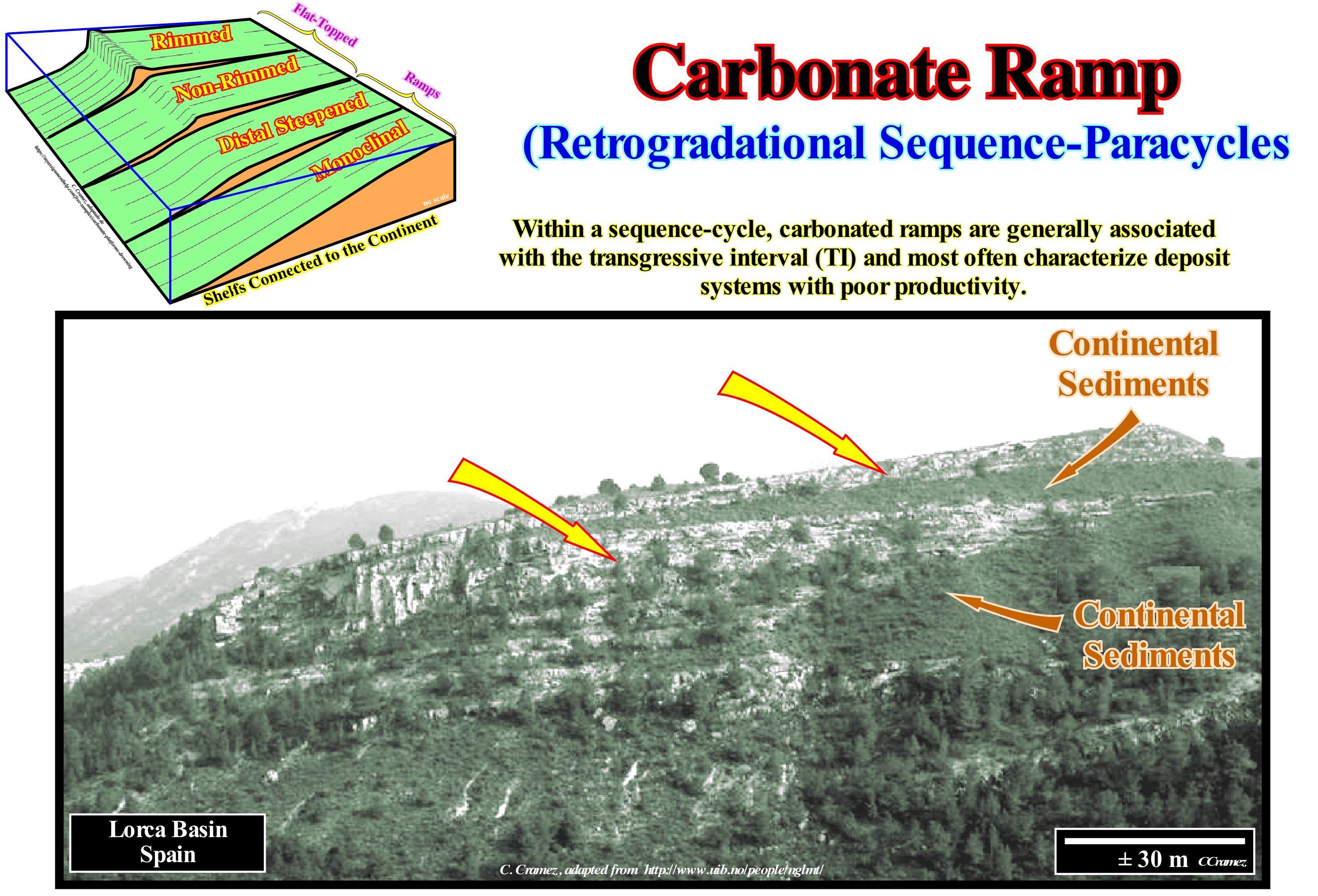
Carbonated ramps are the type of carbonated platforms (shelves) that more contrast with the rimmed platforms. When a geoscientist speaks of platform or shelf, in general, he is referring to the continental shelf, which is the slightly sloping surface of the sea-floor, limited between a water-depth from 0 to 200 m, which is not the case for a carbonated platform. Theoretically, in normal geological conditions, the water-depth of a limestone platform can not exceed the depth of the photic zone, since without the energy of the sunlight there cannot have formation of carbonate in situ. Thus, to avoid misunderstandings, it is important to know if the term platform is being applied to a sedimentary context where the clastics are predominant or to a carbonated context. Most of the geoscientists consider five types of carbonated platforms: (i) Rimmed Platforms or Shelves, that are characterized by the presence of reefs or shoal in the edge of the platform (these platforms are developed in calm waters and their width can vary between 10 and 100 km) ; (ii) Carbonated Ramps, as shown in this figure and in which the shoreline carbonated sands pass, at the base of the ramp, into clay sands and deep-water muds (carbonated ramps, where reefs are little present, can reach a width of about 100 km) ; (iii) Epeirial (or Epiric) Platforms, which are characterized by the presence of tidal surfaces and protected lagoons (the width of these platforms can reach 10,000 km) ; (iv) Isolated Platforms, which are characterized by the fact that the facies are controlled by the orientation of the dominant winds (as in rimmed platforms, reefs and sandy bodies are located in the windward margin, which receives the wind, whereas in the leeward margin, which lets the wind pass, the sediments are more muddy (an isolated platform can reach 100 km wide) ; (v) Dead or Drowned Platforms, when they are below the photic zone. Carbonated platforms are successions of rocks formed in shallow water that include rimmed platforms, ramps and reef constructions. The most well known carbonate platform geometry is associated with tropical manufacturing processes, where carbonate platforms can be subdivided into three main sedimentary environments: A) Reef, which is the part of the carbonate platform created in situ by sessile organisms ; B) Internal Lagoon (part of the platform behind the reef, which is characterized by shallow and calm waters with sediments composed of fragments of reefs and hard parts of organisms or sediments terrigeneous when the reef is epicontinental) and C) Slope which connects the reef to the basin and acts as a sink for the excess carbonate sediment, although most of the sediment produced in the lagoon and the reef is transported by various processes and accumulated on the slope. The platforms connected to the continent are divided into two large families: (A) Ramp Type and (B) Top-Flatened Type. In ramp type two sub-types can be considered: (A.1) Monoclinal and (A.2) Distal Steepened. In the Top-Flatened there are also two sub-types: (B.1) Nonrimmed Platforms and (B.2) Rimmed platforms. It is in the rimmed sub-type platform that the designation of abrupt carbonated platform is more frequent. In a carbonated ramp as illustrated in this figure, the original slope is less than 1° and the basin edge is difficult to individualize since there is, practically, any slope break along the deposition surface. Certain geoscientists divide the carbonate ramps into homoclinal (steady slope) and abrupt (break in distal part). Differentiation is problematic unless there are slope base deposits. Other geoscientists use the depth of wave action (in calm and agitated sea) to subdivide the ramps. The lithology of the carbonated ramps reflects the energy variations that are a function of the variations of the water-depth.
Carbonate Sand Shoal..................................................................................................................................Sable carbonaté (Haut fond)
Areia Carbonatada (de baixio) / Arena carbonática (de banco) / Karbonat-Sand (Tiefland) / 碳酸盐砂(低地) / Карбонатный песок / Sabbia Carbonatica (bassopiano) /
Accumulation of carbonated sand occuring, generally, downstream of the banks and carbonated platforms. Shallow carbonated sands can also form (less frequently) on inner platforms and topographically elevated areas of the deeper environments. The carbonate soal-sands can pass sideways (relatively small distance) to other calcareous facies.
See: « Rimmed Carbonate Platform »
&
« Platform Reef »
&
« Reef Mound »
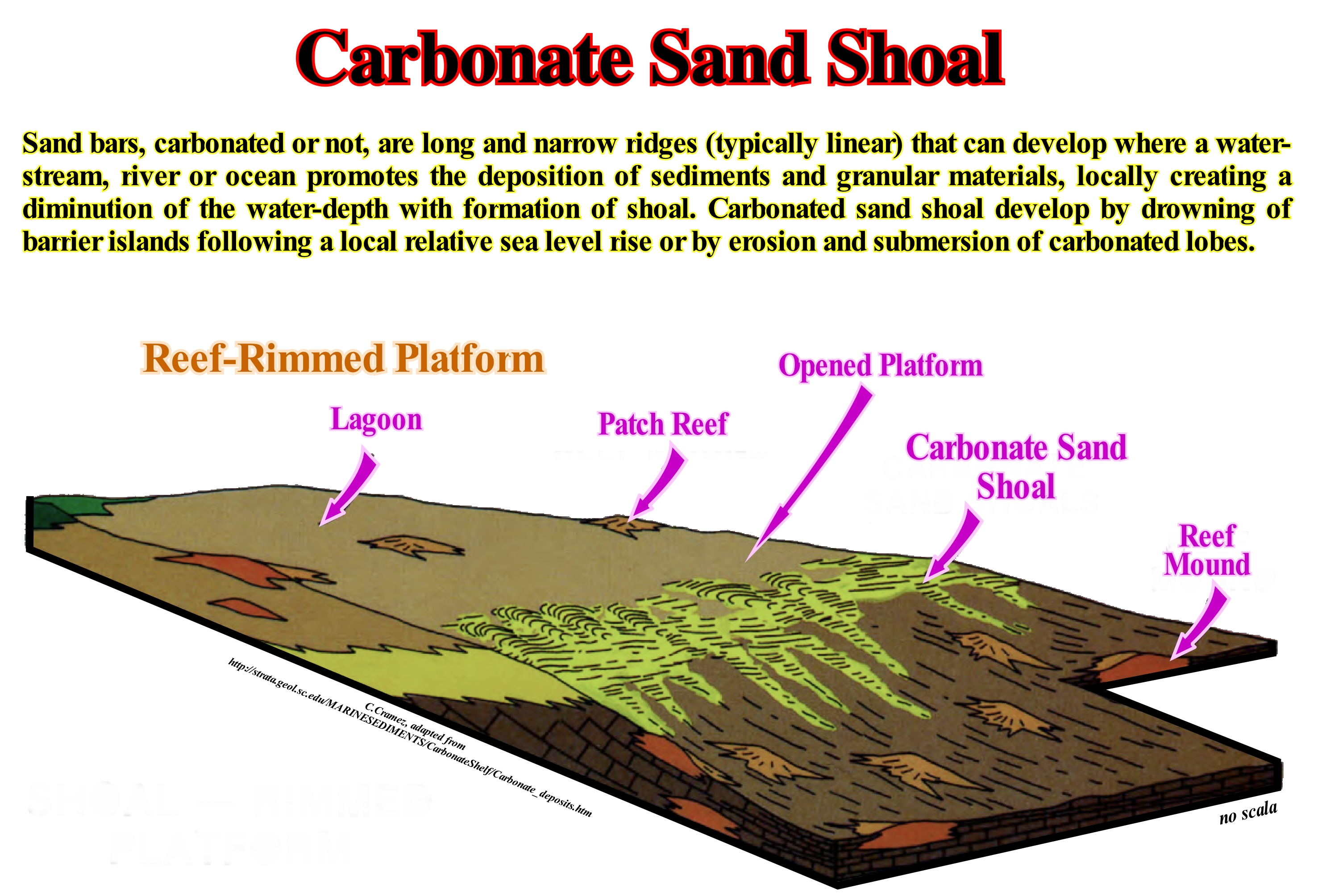
There are five categories of carbonated platforms: (i) Rimmed Platform or Rimmed Shelf characterized by the presence of reefs or calcareous sand shoal at the edge of the platform (as illustrated in this figure) and clay sands in the lagoon or open platform (formed in calm waters ) ; (ii) Carbonated Ramp Platform, where the carbonated sands of the shoreline pass at the base of the ramp to clay sands and deep water muds (reefs are rare) ; (iii) Epeiric (or epiric) platform, characterized by the presence of tidal surfaces and protected lagoons ; (iv) Isolated Platform, where the facies are very controlled by the orientation of the prevailing winds (reefs and sandy bodies in the windward margin*, while in the leeward margin, the sediments are more muddy) ; (v) Dead or Drowned Platform (located below the photic zone). As illustrated in this sketch, it is in the rimmed and open platforms, characterized by a water-depth of not more than 10 m, that the carbonated sand shoals** are frequent. In fact, the development of these carbonate sedimentary bodies requires that the sediments have a certain granulometry and the presence of geological agents to remove the larger sediments. Such conditions are, generally, found in areas of strong carbonate production, when the rupture (or break) of the platform coincides, more or less, with the depth wave action or tidal currents. In other words, for shallow limestone shoals to form during a transgressive process, for example, increases in relative sea level rises (accelerating rises) must be such that the depth wave action can remove the coarser sediments, which means that, under calm sea conditions, the water depth should not exceed 10 meters.
(*) Windward is the direction from which the wind blows, while leeward is the direction where the wind blows. Thus, in an elongated reef in the N-S direction, if the dominant wind blows from West to East, the western margin of the reef is the windward margin, while the eastern margin is the leeward margin.
(**) Shoal is a natural submerged ridge, bank, or bar that consists of, or is covered by, sand or other unconsolidated material, and rises from the bed of a body of water to near the surface.
Carbonate Sedimentation (Principles)............................................Sédimentation carbonatée (Principes)
Sedimentação de carbonatos / Sedimentación de carbonatos (principios) / Carbonatsedimentation (Grundsätze) / 碳酸盐岩沉积(原则) / Карбонатонакопление (принцип) / Sedimentazione di carbonato (principi) /
Three basic rules are to be considered in the deposition of carbonates: (i) Carbonates are mainly of organic origin ; (ii) Carbonates build structures that resist waves and (iii) Carbonates undergo major diagenetic changes because the original minerals are metastable.
See: « Bioherm »
&
« Deposition (Carbonates) »
&
« Relative Sea Level Change »
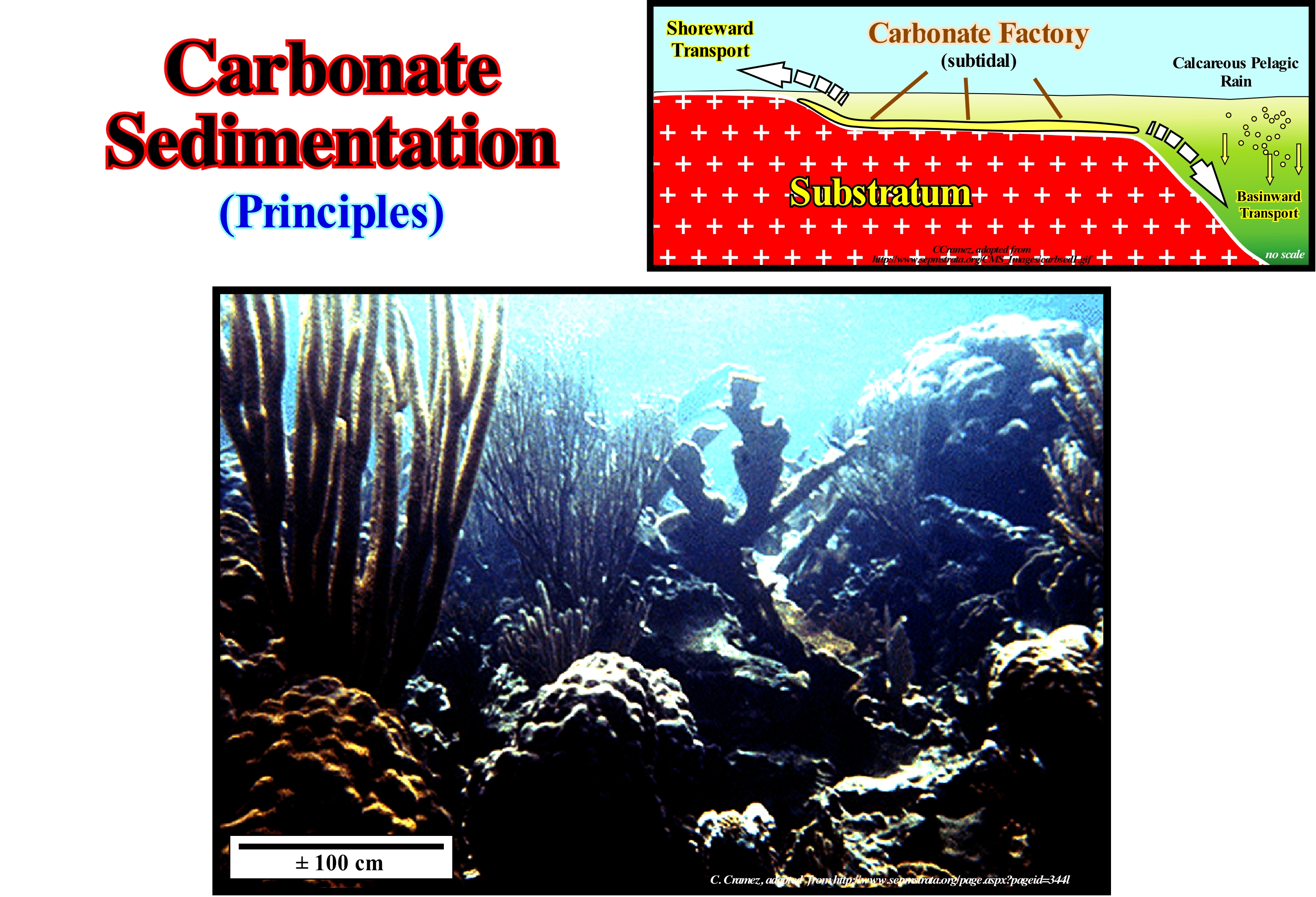
The precipitation of carbonates under the action of the reducing sulfate bacteria begins with a fall in pH (measure of the acidity or basicity of a solution), which is followed by a rise. The precipitation of calcium depends to a large extent on the intensity of the breathing process. All living things need energy to live and that energy is obtained from food. Our body gets energy from food by the process of cellular respiration, performed in the mitochondria, with the participation of the oxygen gas obtained in the environment. Glucose is a major fuel used by living cells in respiration. Observe what happens in our cells: Glucose + oxygen ----> carbonic gas + water + energy. It is this kind of phenomenon that occurs without stopping inside living cells, releasing the energy that guarantees the activity of our organs through the work of cells. Breathing can be understood in two ways: (i) The mechanism by which the chemical energy contained in food is extracted in the mitochondria and used to keep the organism in activities, this mechanism is cellular respiration and (ii) Processes of exchange of the organism with the external environment that allows the obtaining of oxygen gas and the elimination of the carbonic gas. (http: // www.sobiologia.com.br/conteudos/Corpo/Respiracao.php). Most marine carbonates are secreted by organisms, animals and plants. In organic waste, which remains after the dissolution of carbonates, certain geoscientists call "web" the fraction that is constituted by the bacteria and substrate the fraction that comes from macro-organisms. Most carbonated rocks form in warm waters and are often associated with bioherms. Fairbridge (1955) proposed a classification for the sedimentation of organogenic carbonates: A) In continental shelf (between 0 and 200 meters but, exceptionally, up to 900 meters of water) ; the conditions favour the deposit of limestone, in warm countries, between 10° and 30 ° C ; are the lightest, nutrient rich areas that are, particularly, conducive to life and photosynthesis (the process by which plants synthesize organic compounds from the presence of light, CO2 and water, in which the sun is the primary source power) ; in the platform there are bioherms (lenticular limestones, thick, without stratification, built by building organisms such as corals, coralline algae that remain in a life position), biostromes (tabular structural of limestone, built by certain organisms, such as rudists and ostreides, constituting one or more inter-stratified layers in a given sequence) and clastic carbonate deposits such as ooliths*, pelagosites (calcareous incrustations of a variety of calcite that presents as a dark coating on the dolomite, probably due to a reaction to seawater) deposited in a sea saturated with limestone ; B) In bathyal and abyssal regions (continental slope and seafloor): b.1) Under a water-depth greater than 200 meters, but less than the carbonate compensation depth, i.e., below which the calcium carbonate rate is under the depth of solvation** so that nothing of it is preserved, more or less, at about 5,000 meters ; b.2) Under a hot climate, there are calcareous sediments (Globigerinas ooze, Pteropods (small size gastropod molluscs, which have lamellae extensions around the head and which use them for swimming), Coccoliths and Rabdoliths (coccoliths with nearby discs joined by a cylindrical portion projected outwardly in a rod or trumpet shape) ; b.3) In open basins, with mixtures of water capable of renewing oxygen ; b.4) In closed and poorly ventilated basins there are anaerobic fermentations and sulphides are produced ; b.5) In the cold regions, the microplankton creates siliceous muds (with respect to the dimensions the planktonic organisms can be classified into 6 distinct groups: 1) Ultraplankton, <5 μm; 2) Nanoplankton, 5/60 cm; 3) Microplankton, 60/500 μm; 4) Mesoplankton, 0.5 / 1mm; 5) Macro-plankton, 1/10 mm; Megaplankton, > 10 mm) ; e) Chalks (amorphous calcium carbonate) belong to an intermediate category, since they are pelagic sediments similar to those of Globigerinas, but deposited in the deep parts of the continental shelf.
(*)Rounded grains of sand size, between 0.25 to 2.00 mm, formed by inorganic precipitation of calcium carbonate in agitated water and with little deposition of clastic material, limestone aeolianites (coastal limestones composed of carbonate sediments of marine biogenic origin of shallow water, formed in coastal dunes by the wind, and later lithiated).
(**) Phenomenon that occurs when an ionic or polar compound dissolves in a polar substance, without forming a new substance ; the solute molecules are surrounded by the solvent.
Carbonate Sequential Stratigraphy..................................Stratigraphie Séquentielle (Carbonates)
Estratigrafia sequencial (carbonatos) / Estratigrafía secuencial (carbonatos) / Sequenzstratigraphie (Carbonate) / 连续的地层(碳酸盐) / Последовательная стратиграфия (карбонаты) / Stratigrafia sequenziale (carbonati) /
Stratigraphic analysis in carbonate sedimentary sets limited by unconformities and/or equivalent correlative deep-water paraconformities. Four main variables control these sets: (i) Subsidence ; (ii) Eustasy ; (iii) Carbonate Production Curve ; (iv) Climate. In carbonate sequence stratigraphy, the parameter sediment supply (terrigeneous influx) of thr siliciclastics sequence stratigraphy is replaced by a carbonate production curve.
See: « Stratigraphy »
&
« Deposition (Carbonates) »
&
« Organic Production (carbonates) »
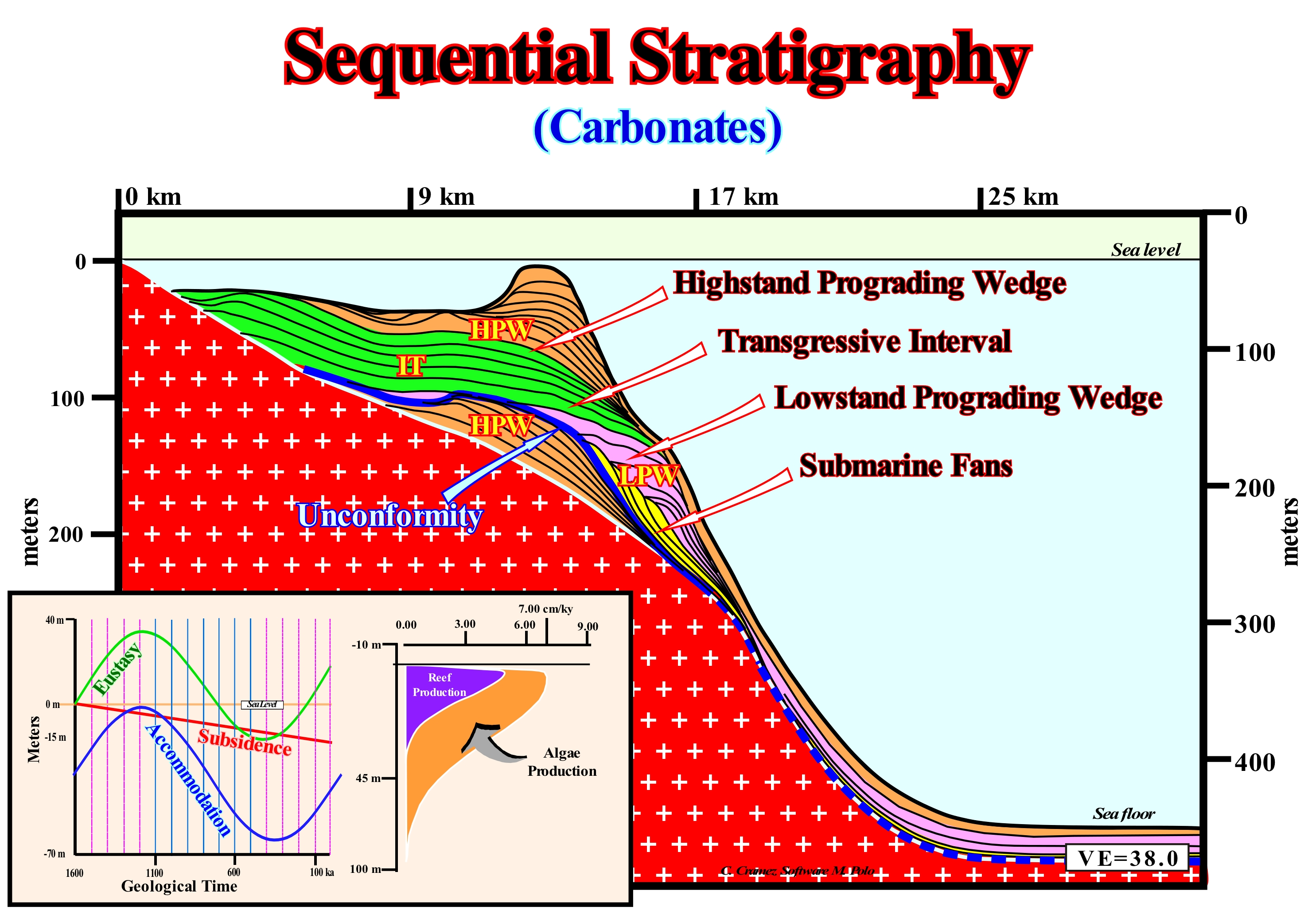
In sedimentary rocks, the sedimentary particles comprise them are, basically, of two types: (i) Clastics and (ii) Precipitates (derived from fresh-water or from the sea). The clastics are formed by the disintegration of pre-existing rocks, which may be igneous, metamorphic or sedimentary. The precipitates are formed by biogenic or inorganic precipitations of marine or fresh-water solutions. Although carbonate rocks (formed by precipitation) have some similarities with clastic rocks, there are differences in the sequential stratigraphy of these two types of sediments. Both respond to changes in the baseline level and are affected by unconformities, i.e., erosional surfaces induced by significant relative sea level falls. If the relative sea level fall* do not expose the deposited rocks to the erosive agents, they are not eroded, at least a sub-aerial erosion. The great differences in the sequential stratigraphy of these two types of rocks are that: (i) The carbonate accumulation is, practically, in situ, whereas the clasts are transported to the deposition site and (ii) The rate of carbonate production (precipitate) is, intimately, bound to photosynthesis** and thus it is dependent on the depth to the air/water interface, which allows the use of carbonate facies and associated structures to estimate the sea level position. This dependence is illustrated, in this figure, by the production curve of reefs (violet) and algae (orange). As precipitates often have a biochemical origin, they are, strongly, influenced by the chemistry of the water from which they precipitate. The characteristics of a carbonate sediment may change depending on the configuration of the lithospheric plates, the deposition environment of the paleoclimate and palaeography (isolated or in communication with the open sea). This means the carbonates can be used as indicators of the deposition context. The analysis of carbonate facies in conjunction with sequential stratigraphy is an excellent method of interpretation of seismic lines and geological sections, as well as lithological predictions. As in clastic rocks, on the basis of unconformities, the carbonate intervals can be subdivided into: (i) Continental encroachments cycles ; (ii) Continental encroachment sub-cycles ; (iii) Sequence-cycles, and (iv) Sequence-paracycles. In the same way, as shown in this figure, within a complete sequence-cycle, we can recognize the two groups systems tracts: A) Highstand Systems Tracts Group (HSTG) within which two subgroups can be identified: a) Transgressive Interval (TI), which is the lower subgroup and b) Highstand Prograding Wedge (HPW), which is the lower sub-group and B) Lowstand Systems Tracts Group (LSTG), within which the following sub-groups can be identified : a) Lowstand Prograding Wedge (LPW) ; d) Submarine Slope Fan (SSF) and e) Submarine Basin Floor Fan (SBFF). In this mathematical model (Marco Polo software): (i) The vertical exaggeration is very important ; (ii) Each line corresponds to a chronostratigraphic surface ; (iii) The time interval between two successive chronostratigraphic lines is 100 ky ; (iv) The accommodation curve and the carbonate production curve (in cm/ky) are shown in the lower left corner of this figure ; (v) The thickness between two consecutive chronostratigraphic lines is not constant, it emphasizes carbonate production ; (vi) There is no deposit above sea level ; (vii) The maximum productivity of carbonate is between 3 and 10 meters of water-depth. In relation to a mathematical model for clastics, in which, only, the curve of carbonate production is replaced by a terrigeneous influx, the sequence-cycles geometry is somewhat different. The submarine fans are much less developed and a reef construction can occur in highstand prograding wedges. The endings of the chronostratigraphic lines (lapouts ) are the same, implying that in both models two sequence-cycles are recognized, once the curve of relative sea level changes is the same. In this example, the oldest sequence-cycle is incomplete. It is represented just by the highstand prograding wedge (HPW). The upper sequence-cycle is complete.
(*) Relative sea level is the result of the combined action of absolute (eustatic) sea level and tectonics (subsidence of the sea floor, when the sediments are lengthened or uplift when the sediments shortened, although in certain cases, when there is diapirism, sediments can be lengthened). he relative sea level is referred to any point on the Earth's surface, which can be the sea-floor or the base of the sediments (top of continental crust). The absolute (eustatic) sea level is supposed to be global and is referenced to the Earth’s centre. The absolute sea level is dependent of : (i) Tectono-Eustasy, which is controlled by the volume variation of the ocean basins in association with the seafloor spreading, following the break-up of a supercontinents ; (ii) Glacio-Eustasy, which is controlled by the ocean water volume variation, depending on the amount of ice (assuming that the amount of water, in all its forms, is constant since the Earth's formation about 4.5 Ga) ; (iii) Geoidal-Eustasy, which is controlled by the distribution of ocean water caused by variations of the Earth's gravity field, and (iv) Thermal expansion of the oceans or steric sea level rise.
(**) Physical-chemical process, at the cellular level, performed by living beings with chlorophyll using carbon dioxide (CO2) and water (OH2) to obtain glucose (C6H12O6) through the energy of sunlight.
Carboniferous (Geological period)................................................................................................................................................Carbonifère
Carbonífero / Carbónico, Carbonífero / Karbon / 石炭纪 / Каменноугольный (карбон) / Carbonifero /
Period of the Paleozoic Era between 286 and 360 Ma (Harland et al., 1982). Synonym of Carboniferous (with coal).
See: « Paleozoic »
&
« Geological Time »
&
« Geological Period »
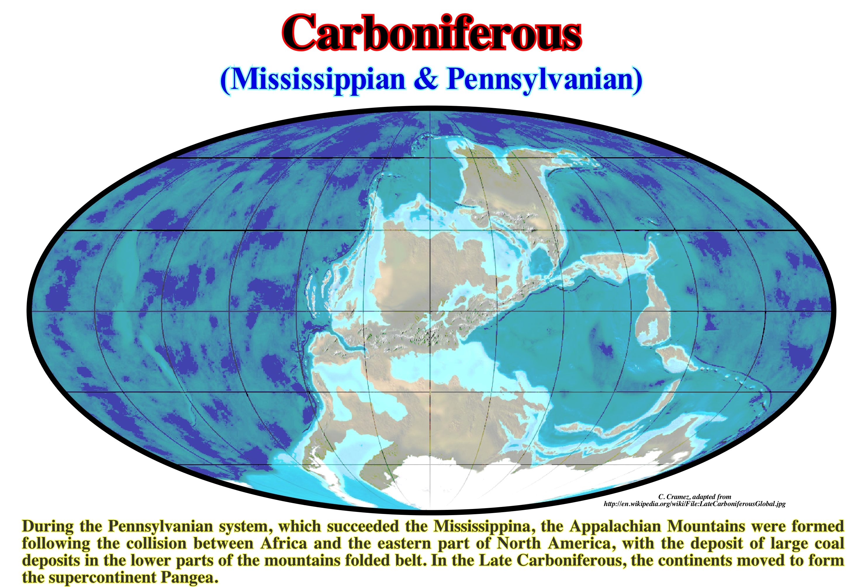
The term Carboniferous was proposed in 1822 by Conybeare, W. and W. Phillips, due to the presence, in all parts of the world, of many layers of coal. In 1807, J. Farey (1791-1851) proposed for the rocks of this period the name "Coal Measures". It was the first Geological System (rocks) to be proposed to the scientific community. In continental Europe and England, this system was sub-divided into Upper Carboniferous and Lower Carboniferous. In 1986, American geoscientists (Alexander Winchell) proposed the name of Mississippi for the Lower Carboniferous and later, in 1891, the name of Pennsylvania (Henry S. Williams) for the Upper Carboniferous. From the base to the top of the Mississippi (sub-period), the following Epochs are generally considered: (i) Tournaisian; (ii) Visean and (iii) Sepukhovian, while the Pennsylvanian sub-period is subdivided into the following Epochs: (iv) Kashkyrian; (v) Moscovian; (vi) Kasimovian and (vii) Gzelian. During the Early Carboniferous, the small supercontinent Gondwana began to drift southward, for the first time in the Paleozoic. At the beginning of the Late Carboniferous the margin of Gondwana (South America/North Africa) collided with the northern part of the Euro-American continent forming, at the end of the Carboniferous, the small supercontinent Laurasia. The eastern margin of Europe (East Laurorussian/Euroamerica) sank by subsidence due to a compressive tectonic regime. Due to drifting northward, the small supercontinent Gondwana collided with Laurasia creating a mountain range that extended from Poland through Central Europe and ended in the Appalachians (USA). From the collision of these two continents was born the supercontinent Pangea. At that time, Pangea had an elongated shape with a large gulf open to the east of the equator, which the geoscientists called the Tethys Sea. While most of the small supercontinent Gondwana was drifting to the south pole, the land that forms the East Asian and East Asia today remained close to the equator where they formed a, more or less, continuous mountain chain along the eastern margin of Tethys Sea. The Carboniferous was a time of glaciations*, low absolute sea level (small extinction of marine species **) and formation of mountains. With regard to glaciations, it can be said that, contrary to what happened in the Ordovician, the glacial period of the Permian-Carboniferous lasted, at least, 60 My. It began during the Late Devonian (Famennian), around 360 Ma, affecting the southernmost areas affected by the Ordovician glaciation (probably in association with the movement of the lithospheric plates to the North that moved them south). Glaciers began to form in the already mountainous regions of South America. In the Mississippi (Serpukhovian, 328 Ma) glaciation affected South Africa, where the South Pole was located. During the Pennsylvanian, glaciers were formed in Antarctica, India and Australia, following the apparent movement of the South Pole. The rhythm of alternations of the glacial and inter-glacial periods was of the order of the millions of years, which, certainly, created glacio-eustatic variations at the same rhythm.
(*) A glaciation or glacial period is a cold paleoclimate phase and a geological period of the Earth during which a significant portion of the continents is covered with ice.
(**) A mass extinction is characterized by the extinction of a large number of species belonging to different genera and families and living in different environments, which can only happen following important, global and rapid environmental change affecting a large number of environments.
Carboniferous (With coal)....................................................................................................................................Système Charbonneux
Carbónico / Carbonífero / Karbon / 石炭纪 / Каменноугольный период / Carbonifero /
Period of the Paleozoic Era between 286 and 360 Ma (Harland et al., 1982). Synonym of Carboniferous.
See: « Carboniferous »
&
« Paleozoic »
&
« Coal »
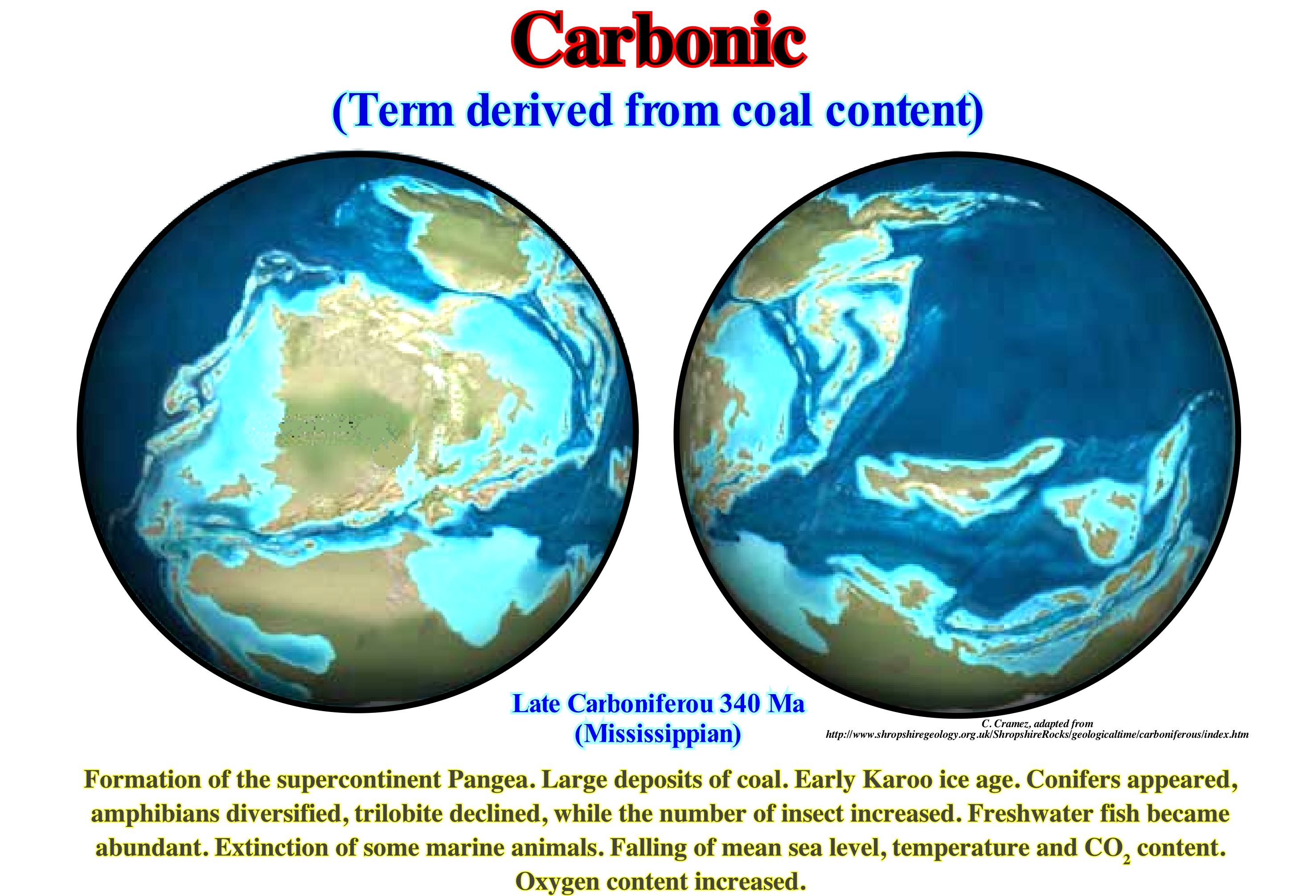
The Carbonic (Carboniferous) was a time of great transformations. The great continent of the "Old Red Sandstone" was eroded and, once again, the sea covered the region that today corresponds to the central part of England. What is today Wales and England, i.e., the Roman Britain, were close to the equator. Throughout the Carboniferous, the variations of the absolute (eustatic) sea level* have changed a lot. One of the main reasons for these changes was the formation of a supercontinent, but other reasons, such as the occurrence of intense glaciation, are equally advanced. Glacial and inter-glacial periods** alternated several times. As Britannia was near the equator, of course, it did not, directly, suffer the effect of ice, but just the sea level changes induced by the glacial and inter-glacial periods. During the glacial periods, as much water turned to ice, the sea level (absolute or eustatic) fell. On the contrary, during the inter-glacial periods, with the melting of the ice of the ice caps, the level of the absolute sea rose. The stratigraphy of the central part of England suggests a great number of falling and rises of the absolute or eustatic sea level induced, mainly, by the glacio-eustasy. The relatively lowstand periods are represented by sandy deltas and coal levels formed from plant debris. During highstand periods, deltas are submerged and fine limestone horizons settle on top of delta sands and coals. During the Carboniferous, this alternation of sands, coals and limestones is typical of central England. It was repeated many times, until the region was later exhumed. Today, with all that is said about anthropogenic (man-made) global warming, the Carboniferous Period seems to us very strange. The amount of oxygen in the atmosphere was about 30%, which is much higher than at present-time (21%). Such a percentage of oxygen makes the air very thick and rich, which seems, theoretically, to hinder the evolution of certain species. The CO2 content was also much higher than today. Currently, rich countries regulate these substances in parts per billion and spend billions of dollars to avoid hypothetical risks.
(*) Do not confuse absolute or eustatic sea level which is the sea level referenced to the Earth' centre, with the relative sea level ,which is local and referenced, in general, either to the base of the sediments (op of the continental crust) or to the seaf-loor and which is the result of the combination of absolute sea level and tectonics.
(**) A glacial period or glaciation is a cold paleoclimate phase and a geological period of the Earth during which a significant portion of the continents is covered with ice. A inter-glacial period is a period separating two glaciations, during which average temperatures are, relatively, high. The present inter-glacial period is the Holocene, which has lasted since about the end of the Pleistocene about 11,700 years ago.
Cascading Current................................................................................................................Courant de cascading (Refroidissement)
Corrente de arrefecimento / Corriente de cascada / Cascading Strömung / 层叠电流 / Каскадное течерие (охлаждение) / Cascata corrente (raffreddamento) /
Falling water flow due to an increase in density as a result of a decrease in temperature. In winter, the water covering the continental shelves or the shallower parts of the lakes loses heat (more or less, at the same rate as the thermocline above deep-water) and its temperature decreases rapidly. The increase in density induced by the decrease in temperature forces the water to flow to the deeper parts.
See: « Stream »
&
« Upwelling Current »
&
« Turbidity Current »
These observations, which illustrate a cooling current, were made on the outskirts of Buchillon on the northern shore of Lake Geneva (Switzerland). An area of shallow water, with a depth between 1-4 m and a width of 50-200 m borders the shores of the lake. In addition, the water-depth increases with a slope between 4-20°. Daytime heating periods (± 5 hours) alternate with cooling periods. The heat flux of the lake surface was calculated using the data collected on a vertical mast located in the area. The surface floatation flux was calculated using the formula β = -gαH / CPρ, where CP is the specific heat of water, g is the acceleration of gravity, ρ is the density of water, and α is the coefficient of thermal expansion*. The air temperature at night, which is ± 6 ° lower than the surface temperature of the lake, produces a positive mean fluctuation flux of the Earth's surface. The Monin-Obukov** length scale characterizes the distance between the surface where wind strength and buoyancy are equally effective in producing turbulence and is defined as L = - uⁿ 3 / κB, where κ = 0, 4 is the von Karman constant uⁿ the estimated friction velocity in the water assuming that the wind force is balanced by the stress on the water surface. The mean value of L, during the cooling periods, of -2.5 (± 6.3 m), implies that the convection of the mixture caused by the wave breaking occurred at a depth greater than about -2L, i.e., ± 6 m. The vertical temperature profiles shown were made using a CTD (conductivity, temperature, depth) pattern along sections perpendicular to the margins. After long cooling periods, a relatively cold layer of water, with thickness between 2-15 m, forms on the slope between a depth of 10 m and thermocline depth (usually 80-150 m).
(*) The coefficient of thermal expansion, which, generally, varies with temperature, is the relative expansion (strain) divided by the change in temperature. Thermal expansion is the tendency of matter to change in shape, area and volume in response to a change in temperature.
(**) The Monin-Obukhov length is used to describe the effects of buoyancy on turbulent flows, particularly in the lower tenth of the atmospheric boundary layer. A simple definition of the Monin-Obukhov length is that height at which turbulence is generated more by buoyancy than by wind shear.
Catastrophism (Principle)...................................................................................................................................Catastrophisme (Principe)
Catastrofismo / Catastrofismo (principio) / Katastrophismus / 灾变 / Катастрофизм / Catastrofismo /
Doctrine that explains the differences in fossil forms found at successive stratigraphic levels as being the product of repeated catastrophic events and repeated creations. This theory is, generally, associated with the French naturalist Baron Georges Cuvier (1769-1832).
See: « Uniformitarianism (principle) »
&
« Paleontology »
&
« Supercontinent »
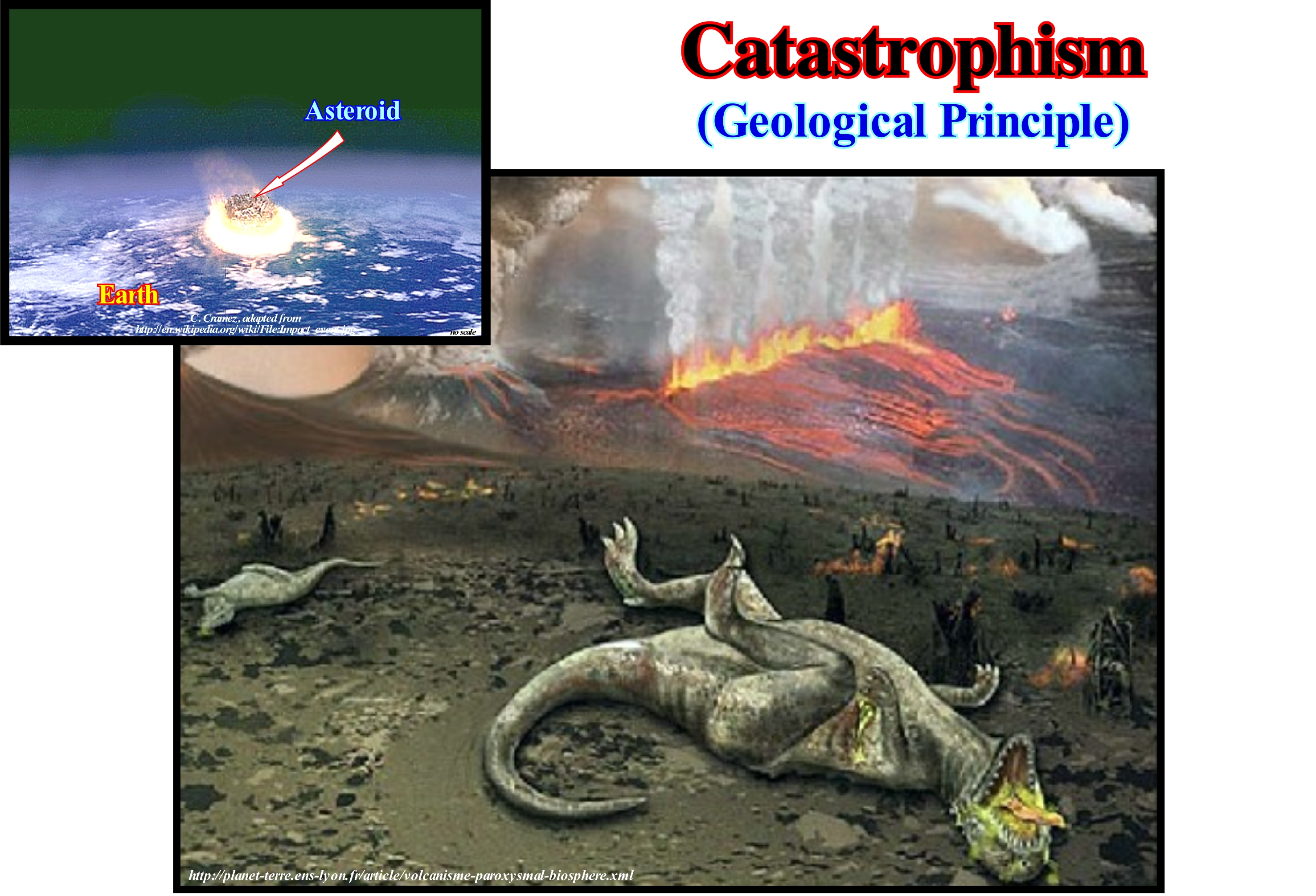
Catastrophism is the opposite of Uniformitarianism*. Uniformitarianism has been refuted in recent years, not only by palaeontology, but also by tectonics. Catastrophic events such as the eruption of Mt. Helena, in 1980**, corroborate catastrophism. Before the introduction of Uniformitarianism, Catastrophism was the most accepted geological doctrine. At present, catastrophism seems to be the most accurate interpretation of Earth's geological history. Since 1980, there has been a dramatic change in the attitude of geoscientists to catastrophism due to the hypothesis of Alvarez and colleagues: "The sedimentary horizons at the Cretaceous / Tertiary boundary with a high concentration of iridium underline an episode of mass extinction at the end of Cretaceous period caused by the impact of a large asteroid ". Catastrophism is supported by a whole series of ancient legends, such as the Flood (Deluge Myth***), which is known in almost every part of the world and which probably corresponds to a global catastrophic geological event (important absolute or sea level rise induced by the defrost of ice-caps). The inclination of the Earth's axis of rotation (origin of the year's seasons) and the Moon's formation are associated with the contingency (eventuality) and the catastrophism. The most, likely, explanation is a collision with asteroids early in the formation of the solar system. Stratigraphic and palaeontological records suggest, always, catastrophic marine events. Sedimentary rocks (sandstones, siltstones, shaly rocks, calcareous rocks, etc.) are nothing other than the result of relative sea level rises that induce the deposition of rocky horizons on top of each other by hydrological sorting (process by which objects settle in a fluid, often water based on factors such as size and density). In the same way, animals, whose fossil remains lie within the sedimentary layers, seem to have been buried and preserved, more or less, catastrophically. Fossils, like rocks, were sorted according to density, otherwise the shells would have rotted or would have been eliminated. About 95% of the fossils discovered to date are marine invertebrates associated with a marine catastrophism. Of the remaining 5%, about 4.74% are plant fossils, 0.25% are terrestrial invertebrates (including insects), and 0.0125% are vertebrates (especially fish). About 95% of all terrestrial vertebrates discovered to date are represented by less than one bone.
(*) Uniformitarianism, also known as the Doctrine of Uniformity, refers to the invariance in the principles underpinning science, such as the constancy of causality, or causation, throughout time, but it has also been used to describe invariance of physical laws-through time and space. Though an unprovable postulate that cannot be verified using the scientific method, Uniformitarianism has been a key first principle of virtually all fields of science (https://en.wikipedia.org/ wiki/Uniformitarianism)
(**) On May 18, 1980, a major volcanic eruption occurred a Mount St. Helens, a volcano located in Skamania County, in the State of Washington. The eruption was the most significant volcanic eruption to occur in the contiguous 48 U.S. states since the much smaller 1915 eruption of Lassen Peak in California. It has often been declared as the most disastrous volcanic eruption in U.S. history. The eruption was preceded by a two-month series of earthquakes and steam-venting episodes, caused by an injection of magma at shallow depth below the volcano that created a large bulge and a fracture system on the mountain's north slope (https:// en.wikipedia.org/wiki/1980_ eruption_of_Mount_St._Helens).
(***) A flood myth or deluge myth is a narrative in which a great flood, usually sent by a deity or deities, destroys civilization, often in an act of divine retribution. Parallels are often drawn between the flood waters of these myths and the primeval waters found in certain creation myths, as the flood waters are described as a measure for the cleansing of humanity, in preparation for rebirth. Most flood myths also contain a culture hero, who "represents the human craving for life". (https://en.wikipedia.org/wiki/Flood_myth)
Catch-up Carbonate............................................................................................................................Carbonate de récupération
Carbonate de recuperação / Carbonato de recuperación / Catch-up-Carbonat, Recovery - Carbonat / 追赶起来碳酸盐 / Возобновляемый карбонат / Catch-up carbonato, Recupero carbonato /
Carbonate interval with oblique geometry (progradational) deposited when the rate of carbonate production exceeds accommodation (available space for sediments created by relative sea level rise). Under these conditions, the carbonate material is required to deposit seaward of the platform edge by progradations, more or less, oblique.
See: « Keep-up Carbonate »
&
« Relative Sea Level Rise »
&
« Reef »
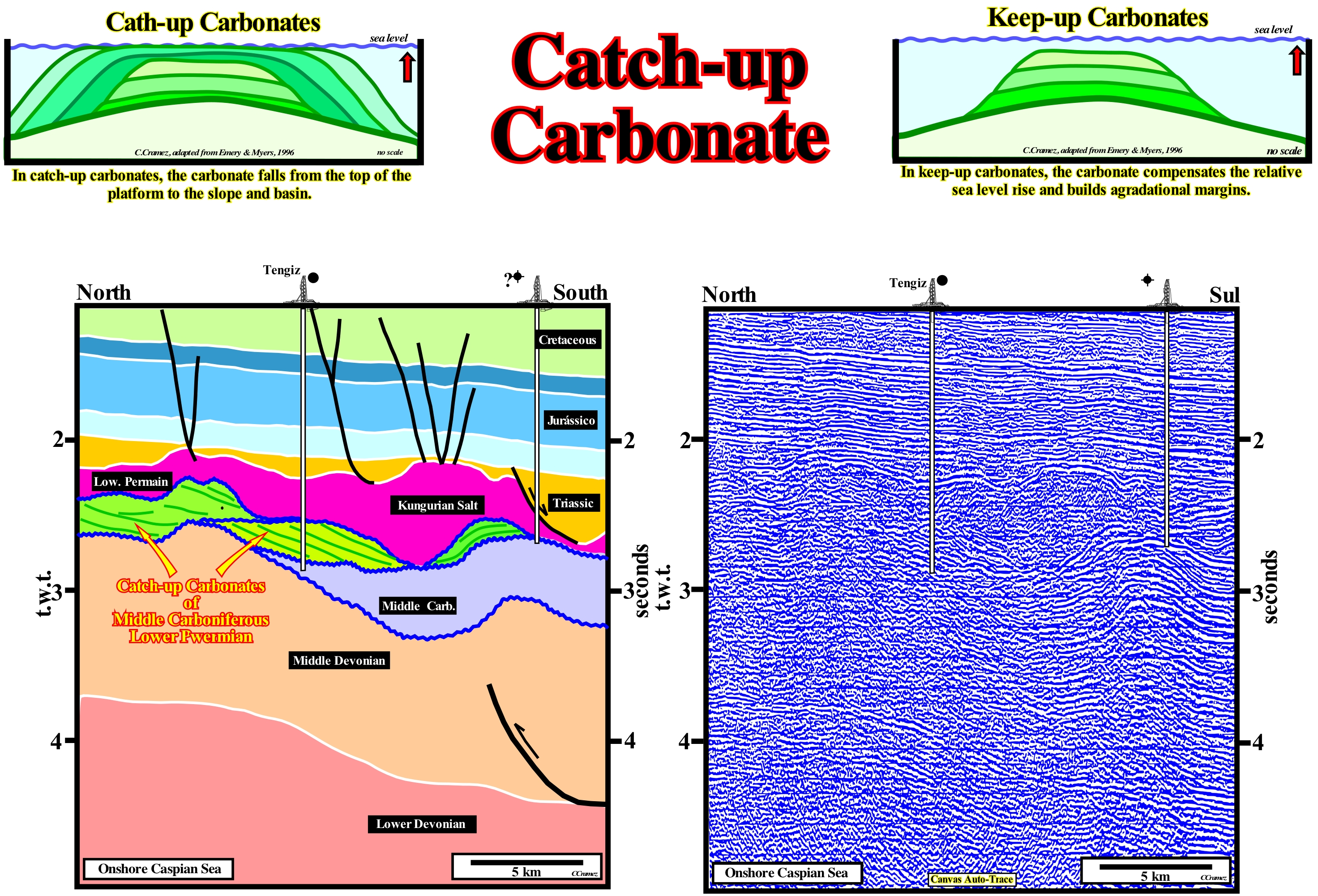
The Tengiz oil field is located in Kazakhstan, in the pre-Caspian basin whose thickness varies between 5 - 24 km and is dominated by the Permian (Kungurian) salt, which was deposited over carbonates and terrigeneous sediments of Late Proterozoic and Early Paleozoic. In the classification of the sedimentary basins of Bally & Snelson (1980), this onshore corresponds to a perisutural basin* (foreland basin or the depression that develops adjacent and parallel to a mountain fold-belt), in which the substratum is composed of platforms or grabens and not by faulted blocks. The salt interval is covered by deposits of Late Permian, Mesozoic and Cenozoic that were very deformed by the halokinesis. The discovery well, drilled in 1979, found a significant oil accumulation in the Middle Carboniferous carbonates covered by Middle Permian shales and by the massive salt. The oil from this field, which comes from the production wells at very high temperature and with very high pressure (perhaps the highest in the world), contains a large proportion of gas that is rich in SH2 which can be very poisonous. The reservoir-rock of Tengiz oilfield (Kazakhstan) is a typical example of catch-up carbonated deposits, although many geoscientists consider that aggradation is positive and predominant in relation to the progradation. As illustrated on this tentative geologically interpretation of a Canvas auto-trace of a detail of a seismic line, which crosses the field, under the Kungurian salt (sealing-rock), the Middle Carboniferous/Lower Permian carbonates (rock-reservoir) were, in part, eroded during the relative sea level fall that preceded the deposition of the evaporites, which have an obvious oblique progradational geometry. Such a geometry, which is, probably, the result of a rate of carbonate production that exceeded the rate of relative sea level rise and that, therefore, forced the platform to grow, laterally, (progradation), contrasts with the aggradational geometry that in certain carbonated platforms is retrogradational. A retrogradational geometry implies a rate of carbonate production lower than the rate of creation of available space, which forces the base level of the platform to move continentward. In this case, if the difference between the two rates is too great the platform can be placed below the photic zone and the formation of carbonate ceases. The deposition of catch-up limestones can be summarized from the following sequence of events: (i) A rapid relative sea level rise (marine ingression) ; (ii) Increased water-depth with decreased carbonate production ; (iii) A slow relative sea level rise allowing the construction of the platform, with a progressive decrease in water-depth and an increase in carbonate production ; (iv) A recovery of the water-depth that allows the maximum carbonate production ; (iv) A carbonate formation superior to the creation of available space ; (v) An insufficient accommodation for the amount of carbonate created, which forces the lateral growth of the platform (progradation predominant). As shown in the geological schemes, the keep-up carbonates are deposited mainly in the transgressive intervals (TI) of the sequence-cycles, whenever the production and accumulation of carbonate compensates the relative sea level rise, i.e., the increase of accommodation. That is why the predominant geometry is aggradational. Keep-up carbonates are, preferably, deposited in the regressive systems tracts (HPW or LPW) of the sequence-cycles, since their progradational geometry suggests the space available for the sediments is not sufficient to accommodate all the carbonate material produced: once he tumbles from the top of the platform to the slope and the basin of the carbonated belt. There are five main types of carbonate platforms: (i) Rimmed with reefs or calcareous sand shoals at the edge of the platform and shaly sands in the lagoon or open platform ; (ii) Type Ramp, in which the carbonated sands of the shoreline pass, at the base of the ramp, to shaly sands and deep water muds ; (iii) Epeiric, with tidal plains and protected lagoons ; (iv) Isolated Platforms, controlled by the orientation of the dominant winds and (v) Dead or Drowned, when their are under the photic zone. On this auto-trace, due to the abrupt change of the water-depth, the seismic horizons west of the platform edge, in a depth version seismic line, are much deeper than the other horizons and some, probably, subhorizontal.
(*) In theory, the petroleum potential of perisutural basins, especially, the generating petroleum sub-system, may be associated with the petroleum potential of the substratum (rocks of lacustrine origin in the grabens or half-grabens) or associated with the sediments of the basin itself, since these basins are located between the folded belts and adjacent cratons, in semi-closed continental or marine environments conducive to the development and preservation of source-rocks.
Catch-up Cycle.................................................................................................................................Cycle de carbonates progradants
Ciclo de carbonatos progradantes / Ciclo de carbonatos progradantes / Cycle-Karbonate progradierende / 循环碳酸盐prograding / Цикл размывания карбонатов / Ciclo di Carbonati progradanti /
Interval of catch-up carbonates (progradational geometry) separated by keep-up carbonates (aggradational geometry).
See: « Catch-up Carbonate »
&
« Keep-up Carbonate »
&
« Relative Sea Level Change »
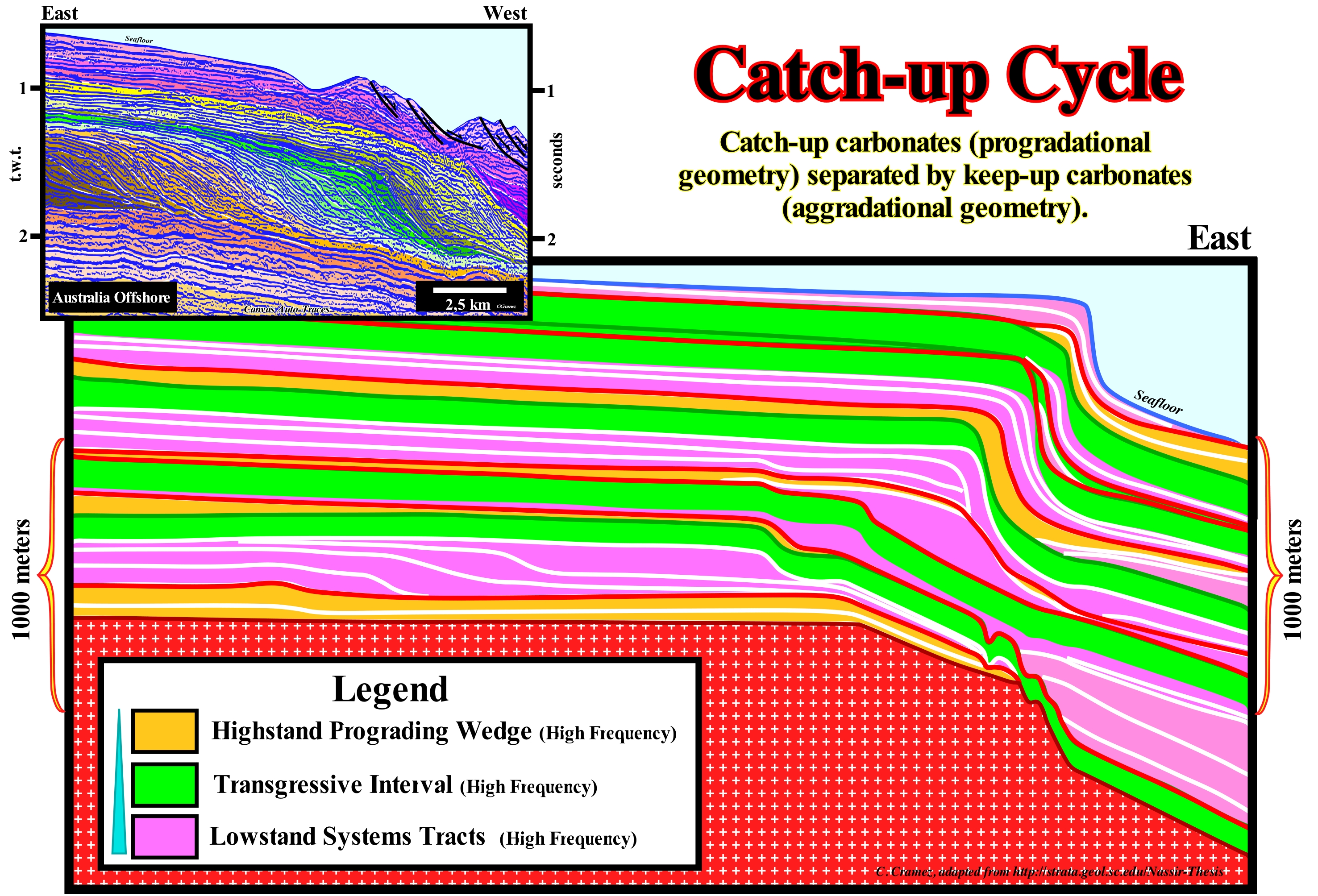
The cycles of progradational carbonates are very well known. This is, particularly, true in the Permian Basin of the USA, where the works of Sarg et al. (1999), Kerans & Fitchen (1995) and Kerans & Kempter (2002), laid the groundwork for the architecture of high frequency carbonate deposits. The advanced geological models took into account: (i) Sequential Stratigraphy parameters (sea level changes, subsidence, water-depth, compaction, etc.); (ii) The Carbonate Production in the Platform and (iii) The Sedimentation of Clastics in the Basin (a favourable condition for the accumulation and preservation of hydrocarbons in the basin). The stratigraphic column is composed of sedimentary intervals, which have a comparable "duration" of the sequence-cycles, which are induced by 3rd order eustatic cycles, i.e., eustatic cycles with a duration between 0.5 and 3-5 My. Each of the sedimentary intervals is sub-divided into high frequency cycles, which can be induced by 4th or 5th order eustatic cycles. Each of these high frequency cycles consists of sedimentary systems tracts associated with a relative sea level rise (which may occur in acceleration or deceleration) and small falls of the relative sea level (local sea level referenced to any point on the Earth's surface, which can be the sea-floor or the base of the sediments, and which is the result of the combined action of the absolute or eustatic sea level, supposed global and referenced to the Earth's centre and tectonics). Its limits were identified on the basis of unconformities and presence of karstification (usually associated with an outdoor exposure or under a small water-depth). On the tentative geological interpretation of a Canvas auto-trace of a detail of an Australia offshore seismic line, illustrated in the upper left corner of this figure, the progradational carbonates are predominant at the base of the regressive phase of the post-Pangea continental encroachment cycle, above the aggradational clayey sand sediments of the transgressive phase*. Catch-up carbonates, whose progradational geometry is characteristic, are associated with: (a) A rapid relative sea level rise ; (b) An increase in the depositional water-depth with a decrease in carbonate production ; (c) A slow relative sea level rise, which allows the construction of the carbonated platform ; (d) A recovery of the depositional water-depth, which allows a maximum production of carbonate ; (e) A carbonate formation higher than the available space's creation and (f) An insufficient accommodation (space available for sediments) that forces the lateral growth of the platform. On the contrary, the keep-up carbonates, whose geometry is aggradational, are deposited during continuous and slow relative sea level rises, so that the created accommodation is, completely, filled by the newly formed carbonated material. The combination of all these conditions allows the carbonate platforms to be favoured and developed, whether they are: (i) Rimmed, with reefs or calcareous sand shoals on the rim of the platform and clay sands in the lagoon or on the open platform ; (ii) Type Ramp, in which the carbonated shoreline sands pass, at the base of the ramp, to clay sands and deep-water muds ; (iii) Epeiric, with tidal plains and protected lagoons ; (iv) Isolated, controlled by the orientation of the dominant winds and (v) Dead or Drowned, when under the photic zone. Recall that: (i) A sedimentary systems tract is a lateral chain of contemporary and genetically related depositional systems that make-up a sequence-cycle ; (ii) Each subgroup of sedimentary systems tracts is associated with a segment of the curve of relative sea level change inducing the sequence-cycle ; (iii) There are two groups of sedimentary systems tracts: a) Lowstand Systems Tracts (LST) and b) Highstand Systems Tracts (HST) ; (iv) In a complete sequence-cycle, from top to bottom, we recognize: 1) Highstand Prograding Wedge (HPW) ; 2) Transgressive Interval (TI) and 3) Lowstand Systems Tract (LST), in which there are three sub-groups: (A) Submarine Basin Floor Fan (SBFF) ; (b) Submarine Slope Fan (SSF) and (c) Lowstand Prograding Wedge (LPW).
(*) Taking into account the auto-trace scales, it is easy to see continental slopes have a dip that is, unlikely, with a sand/shale lithology. In fact, the angle of repose is much higher in carbonate deposits than in clastic deposits. It is interesting to note that in the vast majority of academies, to illustrate delta processes, teachers are obliged to use examples of progradational carbonates, since the angle of the slope is more important and therefore more, easily, recognized (delta slopes are, rarely, recognized on conventional seismic lines).
Cave.................................................................................................................................................................................................................................................................Grotte
Gruta / Gruta / Höhle / 洞穴 / Пещера / Grotta /
Underground natural cavity large enough for a man to explore it. Certain geoscientists use the term grotto just for subterranean cavities where sunlight does not penetrate. The science that is dedicated to the study and exploration of natural cavities, as well as, the formation of caves, grottos, fountains and groundwater, is the Speleology. Synonym Grotto.
See: « Cave (grotto) »
&
« Stalactite »
&
« Limestone »
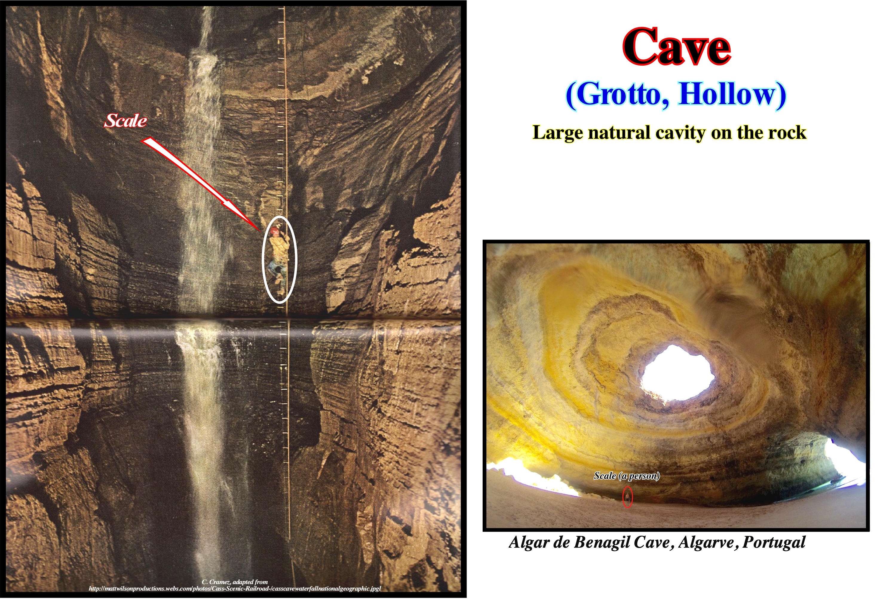
Traditionally, Geology encompasses the study of rocks on the Earth's surface. The age of the rocks can be found by examining the fossils embedded within them. The composition of rocks can be studied by physical and chemical analysis, such as their hardness, brittleness, and dissolve in an acid or not. The caves can contribute to the study of surface rocks. They provide access to the underground environment, which is, often, not altered by physical limitations of the surface, such as plants, soil, and surface change. The caves may be formed by: (i) Dissolution of a soluble rock, such as limestones, but also dolomites, salt, gypsum, etc. ; (ii) Corrosion, when the erosive action of currents carrying rocks and other sediments erodes a certain sedimentary interval ; (iii) Fracturation, when the more soluble horizons of a sedimentary series dissolve between the less soluble horizons, which implies, sooner or later, a collapse of the less soluble horizons ; (iv) Gravity, when falling rock blocks, which are stacked at the base of a slope, create cavities large enough to be considered as caves. In addition to these types of caves, which are subsequent to sediment deposition, the caves that form at the same time as the surrounding rocks and, which some authors call, primary caves can not be forgotten. This type of caves is often found in association with volcanic sedimentary environments where volcanic flows often form tubular caves (the outer lava solidifies, while the hotter internal lava continues to flow). Within the primary caves associated with volcanism, there are also: (a) Rifting Caves; (b) Inflation Caves and (c) Vertical Pipelines. Do not forget, that there are also glacial grottos either on the ice or under the glaciers due to ice melting. Summarizing: The following types of caves are often considered: (i) Solution Caves ; (ii) Primary Caves ; (iii) Sea Caves or Littoral Caves ; (iii) Corrosional Caves or erosional Caves ; (iv) Glacier Caves ; (v) Fracture Caves ; (vi) Talus Caves and (vii) Anchialine Caves*.
(*) Anchialine caves (from the Greek Anchialos, «near the sea ») are, usually coastal, containing a mixture of freshwater and sea water, occurring in many parts of the world, and often containing highly specialized and endemic fauna).
Cave (Grotto)....................................................................................................................................................................................................................................Caverne
Caverna / Caverna / Höhle, Cave (Höhle) / 洞穴 / Пещера / Grotta /
Natural underground cavity resulting from slow processes of dissolution and erosion of rocks by water. Some geoscientists have suggested the term cave should be applied just to underground cavities, in which daylight does not penetrate practically. The exploration and study of caves is the main activity of speleologists, whose science is the speleology.
See:« Limestone »
&
« Erosion »
&
« Dissolution »
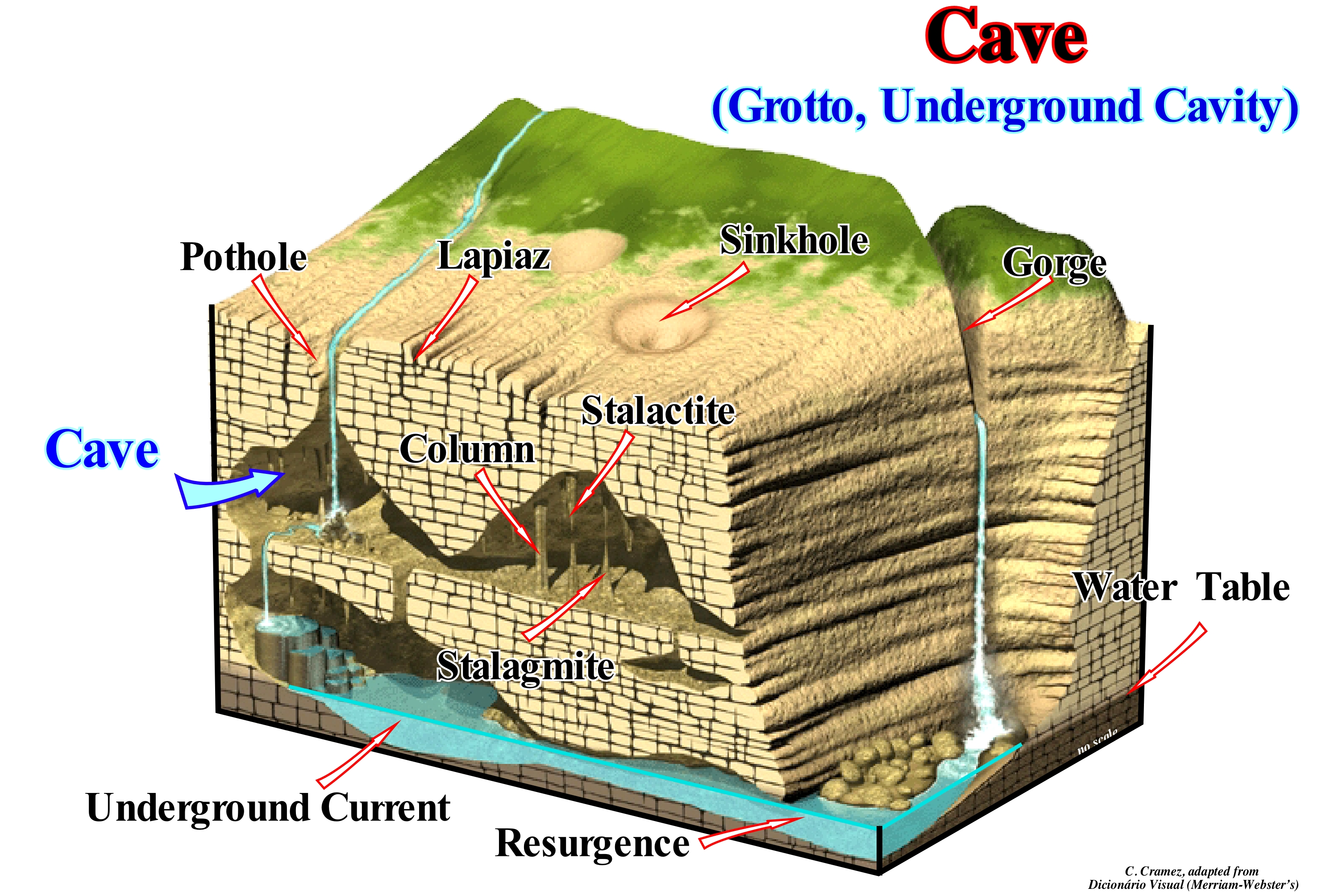
Speleogenesis is the formation and development of caves, which are formed by various geological processes, involving a combination of chemical processes, water erosion, tectonic stresses, micro-organisms, pressure, atmospheric influences and even excavation. The vast majority of caves form in calcareous rocks by dissolution, but they can form in any type of soluble rock. Important caves were recognized in chalk, dolomites, marbles, granites, salt, sandstones, fossil corals and in gypsum. The largest caves by dissolution are located in limestones, because they are easily dissolved by rainwater and underground streams charged with carbonic acid (CO3H2). The dissolution of limestones produces a typical topography known by the name of karst which is characterized by sink-holes* and underground drainage systems, as illustrated in this block diagram. In carbonate rocks and, particularly, in limestones, caves are ornamented, almost always, by carbonate formations produced by a slow precipitation of calcium carbonate (CO3Ca),i.e., by speleothems (from the Greek spelaion - "cave deposit"-). In this clock diagram, caves, either under potholes** or under sink-holes, are recognized stalactites, stalagmites and columns. Other speleothems such as curtains, flags, cauliflowers, eccentrics, flowers, waterfalls and travertine dams can also be deposited. The underground water-course, probably, responsible for the dissolution of limestones and formation of caves is, in this example, well visible and, as indicated, the water-plane is roughly equivalent to the height of its resurgence (spring). The caves of Lechuguilla and Carlsbad (New Mexico, USA) are typical examples of caves by dissolution, formed by the action of SH2 (coming from the underlying oil fields) which mixed with the groundwater formed sulphuric acid that partially dissolved the limestones.
(*) Depressions or holes, in the ground, caused by some form of collapse of the surface layer.
(**) Also called evorsions, swirl-hole or giant's kettles are smooth, bowl-shaped or cylindrical hollow created by water erosion of bedrock. A shallow solution closed depressions found on flat gently sloping rocks.
Cementation (Reef).......................................................................................................................................................................................Cimentation
Cimentação / Cementación / Zementierung / 胶结 / Цементация / Cementazione /
One of the four processes that operate in the formation of reefs. Such a processes are: (a) Constructive, such as the growth of carbonate organisms ; (b) Destructive, which can destroy or cause damage to the growth of a reef, such as the action of sea waves and bio-erosion (biological destruction) ; (c) Sedimentation, i.e., the accumulation of biogenic matter, created by the intense biological activity around a reef and the debris of the reef itself and (d) Cementation. The cementation that has a great influence on the shape of a reef, can be precocious and important, as is the case in many ancient and recent reefs. As a consequence of these four processes (constructive, destructive, sedimentation and cementation), a great variety of morphologies and internal structures can be recognized in the reefs.
See: « Geological Principle »
&
« Differential Compaction »
&
« Lithostratigraphy »

The sedimentary rocks form from small pieces of rocks (sedimentary particles). Wind and water currents transport the sediments and deposit them in, more or less, sub-horizontal layers, usually, on the bottom of the sea or at the bottom of a lake. The deposited sediments are transformed into rocks by two geological processes: (i) Compaction (decreasing the volume of a sediment mass, usually due to a continuous deposition of sediments at the same site although other causes are possible) and (ii) Cementation (filling of the space between the debris by mineral substances). When the sedimentary particles are deposited, they become sediments that are, gradually, buried due to the overlapping of other sediments and so subjected to high pressures and temperatures that begin to agglutinate the grains against each other. As the depth of burial increases, the sedimentary grains are glued together by the formation of new minerals, as the cement binds the grains of sand in the mason's mortar. During the compaction process certain rock minerals are dissolved and then precipitate in the space between the sedimentary grains reducing the porosity. The minerals most, often, cementing the grains of a sedimentary rock are calcite (CaCO3), silica (SiO2), iron oxides and clay minerals. The geological processes of erosion, deposition, compaction and cementation can take millions of years to transform the deposited rock fragments (sediments) into coherent and hard sedimentary rocks. The greater the cementation of a smaller sedimentary rock is its porosity (free and interconnected space between the sedimentary grains) and its permeability (possibility that fluids flow through it), which are important characteristics of the rock-reservoir. The compaction depends on the sediment facies (lithology and associated fauna in a given environment). A clayey sedimentary interval compacts much more than a sandy interval. When a sandy interval, such as the sandy filling of an incised valley, is within or below a clayey interval, such as the shales of a transgressive interval, the geometry between the different facies changes due to the different compaction of the sands and clays. A sandy filling, more or less, isopach within a shaly interval, by differential compaction acquires a fusiform (spindle-shaped) geometry. The different compaction of the rocks bordering a fault (faulted or displaced blocks) deforms the original fault plane, which allows geoscientist to predict the most likely lithology of the layers in terms of compaction. A clay is more compactable than a sandstone, which is more compactable than limestone. In sedimentary basins with an important evaporitic horizon (salt basins) the differential compaction, between the salt and salt overburden, can create up and around the salt domes significant deformations. The simple friction between the salt and the rocks around it can create folds (friction drag folds) that, generally, form while the sediments are poorly consolidated. However, in most cases the salt is less resistant than the rocks around it, and the frictional folds do not form. The presence of folds in the layers around the salt domes, by rotation and compaction is very common. As the salt is, practically, incompressible, while the other sedimentary rocks are compacted in depth, large drag zones can form. On the other hand, differential compaction can cause apparent trailing folds along salt structures that become thinner up. When there is a forced intrusion of salt in the layers of the cover, in association with the normal accommodation faults, small blocks or "laps ** can be pushed upwards during diapirism. Another folding mechanism is thinning of the salt layer towards the dome, which causes a compensatory subsidence that induces a marginal syncline or, on a large scale, an expulsion basin ("mini-basin").
(*) The density of the salt does not change with depth. Its density is between 2.15 and 2.17 g|cm3, depending on the amount and composition of the accessory minerals, whatever its burial. This is not the case for other sedimentary rocks. They increase in density as they are buried. In depth there is a point of inversion between the density of the salt and the rocks around it. Above the inversion point, the salt is denser, while below the inversion point the adjacent rocks are denser.
(**) In salt tectonics, a flap is an upturned sediment wedge (facing upwards) against the flank of a diapir. Such wedges, which are located above the top of the autochthonous salt, are raised and rotated by the rise of a salt diapir.
Cenozoic..............................................................................................................................................................................................................................Cénozoïque
Cénozoico / Cenozoico / Känozoikum / 新生代 / Кайнозойский / Cenozoico /
The geological Era that began about 65 Ma (millions of years ago) and continues until today.
See: « Paleozoic »
&
« Gondwana »
&
« Era »
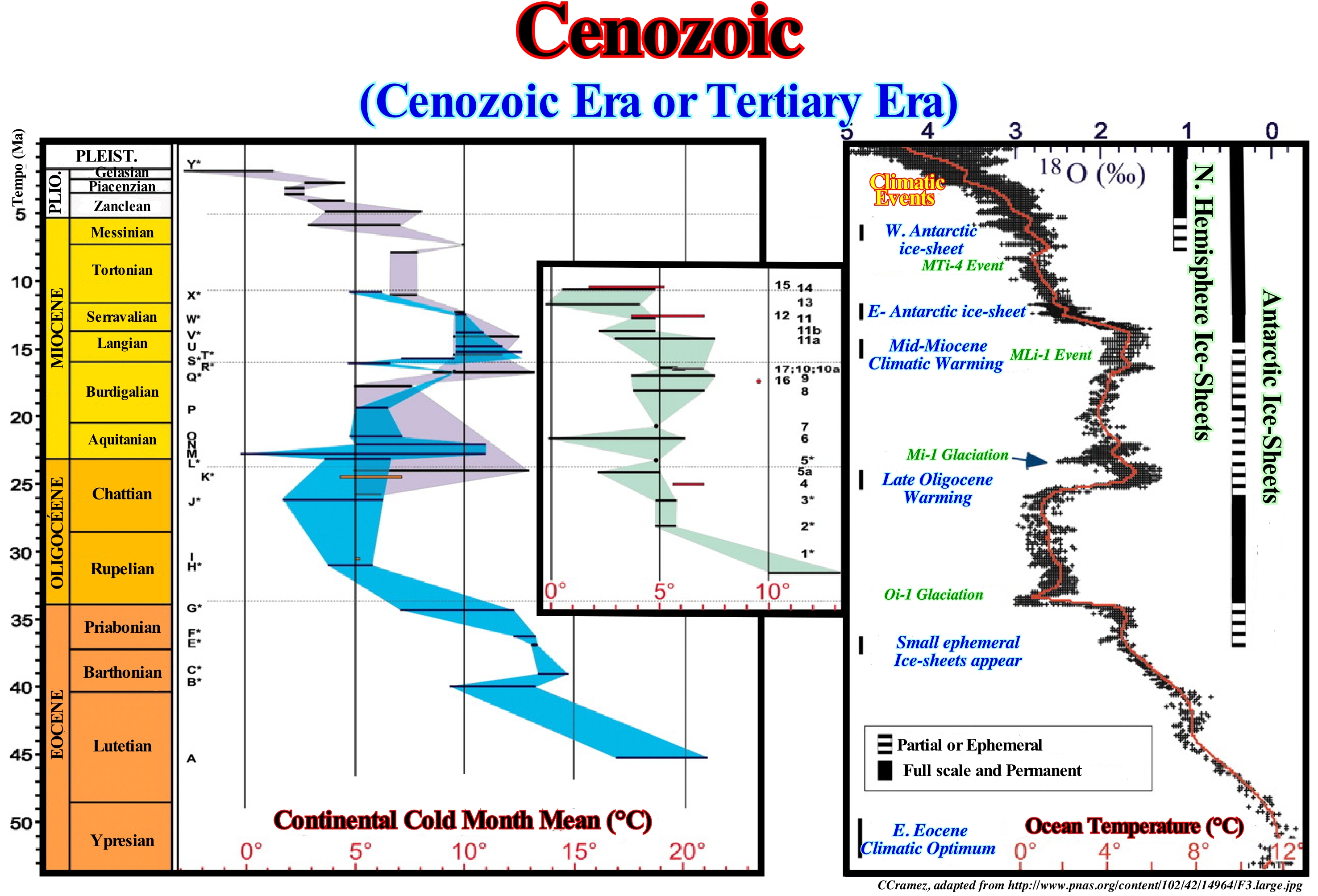
The Cenozoic Era or Cenozoic (Tertiary Era or Tertiary) is a division of the geological time scale that belongs to the Phanerozoic Eon. Within the Phanerozoic, the Cenozoic follows the Mesozoic. The Cenozoic began about 66 million years ago and extends to this day. The name Cenozoic comes from the Greek and means "new life". At present, the Tertiary Period, which is not recognized by the International Commission on Stratigraphy, comprised the Cenozoic Era, except for the last 2.5 million years, when the Quaternary Period began. During the Cenozoic, India collided with Asia (55-45 million years ago) and Arabia collided with Eurasia, closing the Tethys Sea about 35 Ma. As a consequence, the great alpine folding formed the main mountain ranges of southern Europe and Asia, such as the Pyrenees, the Alps and the Himalayas. During the Cenozoic, the fragmentation and migration of the continents, derived from the break-up of the supercontinent Pangea, continued and, progressively, the Earth's surface took its present configuration. The average temperature of the oceans has fallen, more or less, regularly since the Early Eocene Climatic Optimum* (EECO) to today. During this fall the warm periods of the Late Oligocene and the Middle Miocene are noted. Two basic geological processes are responsible for the major events that occurred during the Cenozoic: (i) Continental or Tectonic Collision and (ii) Oceanic Expansion. The four large continental fragments derived from the small supercontinent Gondwana moved northward and collided with Laurasia. Of these collisions, whose climax happened in the Early Miocene, great mountain chains were formed. The expansion of the North and South Atlantic continued, contributing to the deformation of the eastern margin of Africa and the western shores of North and South America as the continents were pushed against adjacent tectonic plates. The continental fragments resulting from the fragmentation of the small supercontinent Gondwana are South America, Africa, India and Australia. South America was not pushed far enough northward to cause a major collision with North America. The impact between Africa (which continues to move northward) and Europe has been relatively weak. The Mediterranean micro-plates have been variously arranged and compressed as Africa moves northward. The African plate attempts to dive beneath the European plate, to create a subduction zone, have produced important shortenings on the European plate, of which the Alps, the closure of the Tethys Sea** (now reduced to small bodies of water like the Mediterranean and Black Sea) are good examples.
(*) The available paleoclimatic records (e.g., Zachos et al., 2001 Science 292, 2008 Nature 451) indicate that the Earth experienced in the Early Paleogene a pronounced warming trend that peaked during the Early Eocene Climatic Optimum (EECO; ca. 50 – 52 Ma, basically in Chron C23n) that represents the interval, ice free, with the highest global temperature recorded in the past 70 My (Berichte Geol. B.-A., 85 (ISSN 1017-8880) – CBEP 2011, Salzburg, June 5th – 8th)
(**) The Tethys Sea or Tethys Ocean was an ocean during much of the Mesozoic Era located between the small supercontinents Gondwana and Laurasia, before the opening of the Indian and Atlantic oceans during the Cretaceous Period.
The western Tethys Sea covered many small plates, Cretaceous islands arc and micro-continents. Small oceanic basins (Valais Ocean, Pimont-Liguria Ocean, Meliata Ocean) were separated from each other by continental terranes on the Alboran, Iberian and Apulian plates. The precursor to the Tethys Sea was the Paleo-Tethys Sea, that existed for about 400 million years. It was an ocean that started to open during the Middle Cambrian, along the northern margin of the paleo-Gondwana continent. It grew during the Palaeozoic , and finally closed during the Late Triassic .
Chandrasekhar Limit............................................................................................................................Limite de Chandrasekhar
Limite de Chandrasekhar / Límite de Chandrasekhar / Chandrasekhar-Grenze / 钱德拉塞卡极限 / Предел Чандрасекара / Limite di Chandrasekhar /
The mass of a white dwarf star can not exceed 1.4 times the mass of the Sun.
See: « Sun »
&
« Stellar Evolution »
&
« Star »
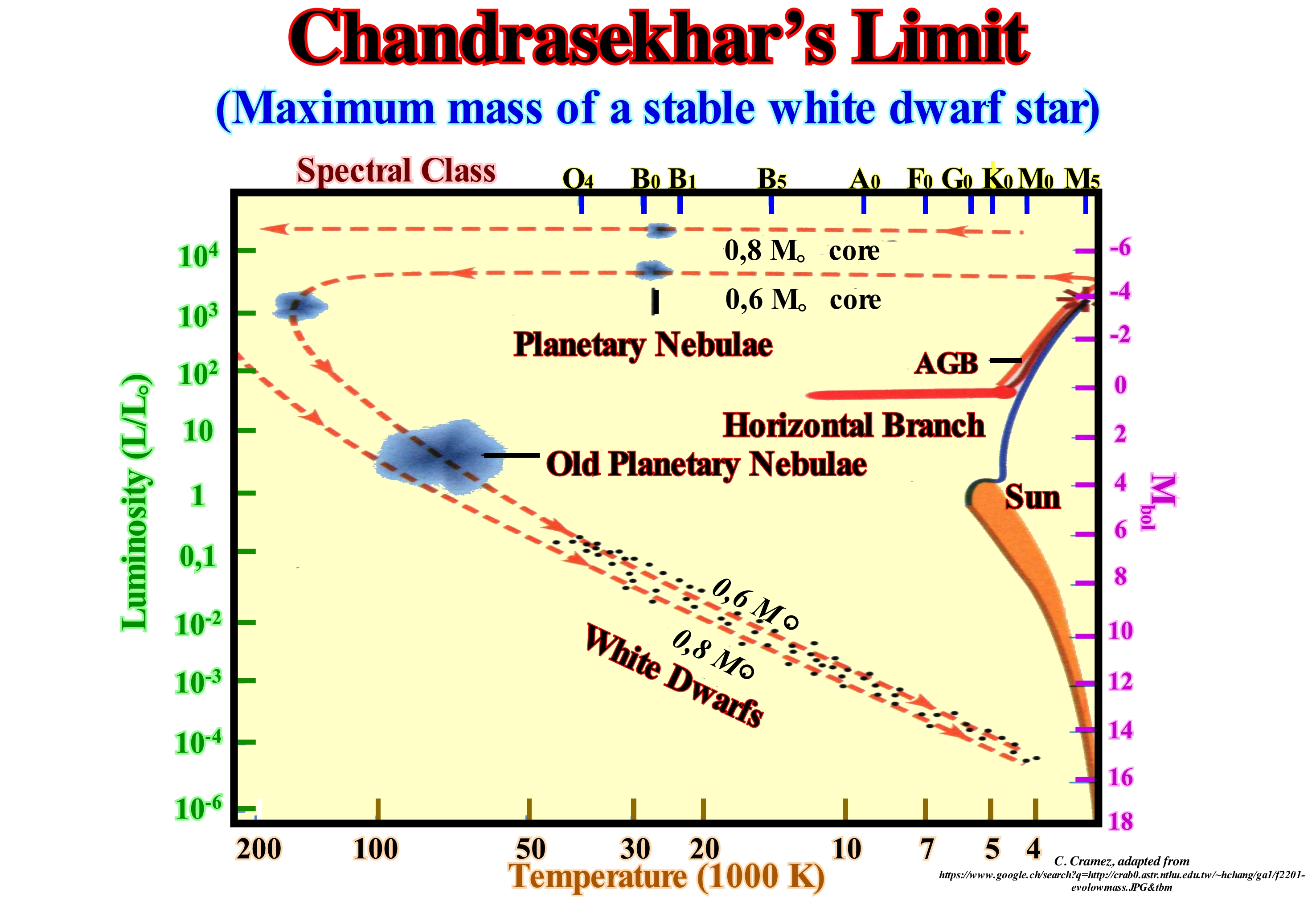
The Chandrasekhar limit represents the maximum mass possible for a white dwarf star (one of the final stages of the stars that consumed all its energy) supported by the electron degeneracy pressure, and is approximately 3 x 1030 kg, about of 1.44 times the mass of the Sun. If a white dwarf (usually about 0.6 times the mass of the Sun) has exceeded that mass by aggregation, it will collapse due to the effect of gravity. It was thought that this mechanism would initiate explosions supernova type, but this theory was abandoned during the 1960s. The current perspective is that a white oxygen-carbon dwarf reaches, in its interior, a sufficient density to initiate a nuclear fusion reaction before reaching the mass limit. When iron-core stars exceed this limit, they collapse, and it is thought that this process initiates a Type Ib, Ic, and II supernova, releasing an immense amount of energy and causing a "flood" of neutrinos. The precise value of the limit depends on the chemical composition of the star. The formula of Chandrasekhar is Mch = ⎨(ω30 √ 3π) /2⎬ (hc /G)3/2⎨ 1 / (μe mH)2⎬, where h is the reduced Planck's constant (or Dirac's constant*), c is the speed of light, G is the universal gravitational constant, mH is the mass of the hydrogen atom, μe is the average molecular mass per electron, and ω30 ≠ 2.018236 is the mathematical constant related to the Lane-Eden equation (model the structure of a thermodynamic system whose state equation is that of a poly-tropic fluid and subjected to the exclusive influence of the gravitational field produced by its own mass). A white dwarf may have an arbitrary mass with a volume, inversely proportional to its mass. By increasing mass, the typical energy at which the degenerative pressure forces the electrons to create a white dwarf is not negligible relative to the rest mass. The speed of electrons is close to the speed of light, and special relativity must be taken into account. The classical approach is no longer appropriate. As a result, it has been found that a limited mass arises due to self-gravitation and body with spherical symmetry is supported by degenerative pressure (http://pt.wikipedia.org/wiki/Limite_de_ Chandrasekhar)
(*) Planck's constant ℏ (used to describe the size of quanta, relating in particular the energy of a photon, E, to its frequency ν) divided by 2π, symbolized h. The equation for photon energy is E=h.c.λ, where E is photon energy, h is the Planck's constant , c is the speed of light, in vacuum, and λ is the photon's wavelength. As h and c are both constants , photon energy changes in inverse relation to wavelength λ.
Channel (Deposit)............................................................................................................................................................................................Chenal Rempli
Canal preenchido / Canal relleno / Kanal zu füllen / 通道填充 / Заполненный канал / Riempimento di canale /
Channel that was later filled by sediments. In tentative geological interpretations of seismic lines, certain geoscientists have the tendency to call "channel" to a "channel filling". This leads to many confusions and it is, basically, wrong. A channel is a negative morphological anomaly (erosion), in which a stream of water flows. A filled channel or more precisely the filling of a channel, is a sedimentary body subsequent to the formation of the channel. A channel is the bed of a stream. The filling of a channel is a sedimentary interval. Synonym for Channel Filling.
See: « Oxbow »
&
« Incised Valley»
&
« Turbidite »
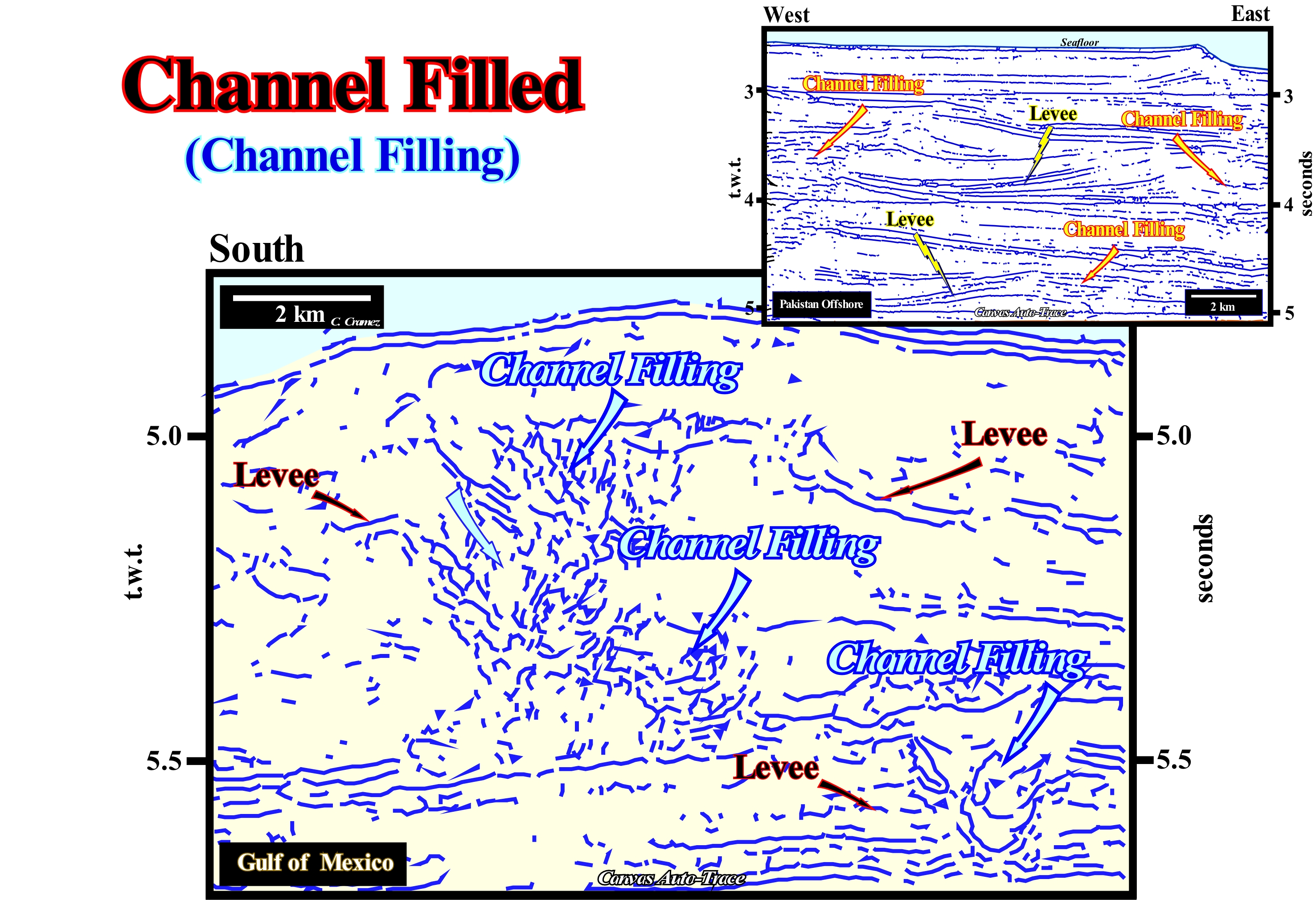
These auto-traces of details of seismic lines from the deep offshore Gulf of Mexico and offshore Pakistan illustrate the misconceptions associated with a poor terminology. A large majority of geoscientists, even with experience in the geological interpretation of seismic lines, observing these auto-traces will say that the arrows indicate turbidite channels, which is basically wrong. Probably, excepting, a possible small erosion of the substrate, which may be caused by the first turbidite currents, beneath the turbiditic levee (natural marginal dikes, visible in the lower right corner), it can be said that there is no erosion. What many geoscientists interpret as a channel, through which the turbidite currents travel is, often, simply the depression (area without deposition) between the natural turbiditic marginal dikes (overbank deposits), which gradually formed as the levees were deposited. Make an experiment. When you go to the beach, fill a bucket with water and sand. Then, launch the contents toward the sea simulating a turbidite current. You will see two lateral lobes are formed separated by an area without deposition (where the current you created has more energy). Such a current carries more downstream the finer sedimentary particles, which are deposited in a small distal lobe. Fill the bucket again with water and sand, and then throw the contents, more or less, in the same place. You will see that the two lateral lobes overlap the first ones exaggerating the depression between the lateral lobes underling the area without deposition. If you continue to make more launches, i.e., if turbidite or gravity currents continue to pass in the same place, you will find that the currents are, more or less, channelled by the depression between the lobes, which will become increasingly exaggerated. Such an exaggeration of the depression between the lateral lobes, which simulate the turbiditic natural marginal dikes (levees), is created simply by staking of lateral lobes and the absence of deposition. All this means that the morphology of the "gull wings" structures of P. Vail (submarine slope fans), which any geoscientist recognizes, easily, in the auto-traces illustrated in this figure, can be formed without significant erosion or incision caused by turbidite currents. Moreover, taking into account the seismic resolution, an absence of erosion in a seismic line, does not necessarily mean that in the field there may be a small incision of the order of 20-30 meters. Over time, the position of the depression between the levees migrates vertically and laterally, partly due to partial filling, which is well visible in these tentative interpretations. The more natural marginal dikes (levees) are deposited, the more the depression without deposition is marked, which forces the turbiditic currents to use it (channelling) to bring the sedimentary particles toward the deepest part of the continental slope and the abyssal plain. The first natural turbiditic marginal dykes, i.e., the oldest, are deposited, practically, at the same level as the area without deposition between them which is the embryo of the depression (that is, particularly visible in the offshore seismic line shown in the upper right corner of this figure). When turbiditic currents lose speed and competence to transport solid debris of varying sizes, the depositional system is diverted or abandoned and the depression between natural dikes is filled (in retrogradation) during the retreat phase, by more recent sediments (of the same sequence-cycle) than the sediments that form the turbidite natural dykes. This geological mechanism has nothing to do with the formation of the natural river-banks and the river channel fills. In these auto-traces, it is easy to see despite the diachronism between the filling of the depressions and the natural marginal dikes, they are, practically, at the same level, which is not the case with the fills of the fluvial channels, where the fill of the channels are lower than natural dikes. The sandy horizons of natural marginal dikes can be considered as potential reservoir-rocks. However, given their small size and thickness and, above all, the lack of communicability between different levels of sand, the amount of hydrocarbons stored in a possible trap is always small and often not economic.
Channel (River)..........................................................................................................................................................................................................................Chenal
Canal / Canal / Kanal / 渠道 / Канал / Canale /
Depression along which a water-stream flows. A channel should not be confused with the filling a channel, which many geoscientists tend to forget. When a geoscientist describing an electrical log or a seismic line says: "This, here, is a channel", most of the time, it is referring to the filling of a channel and not to the morphological depression where, previously, flowed the water-course.
See: « Incised Valley »
&
« Channel Fill »
&
« Unconformity »
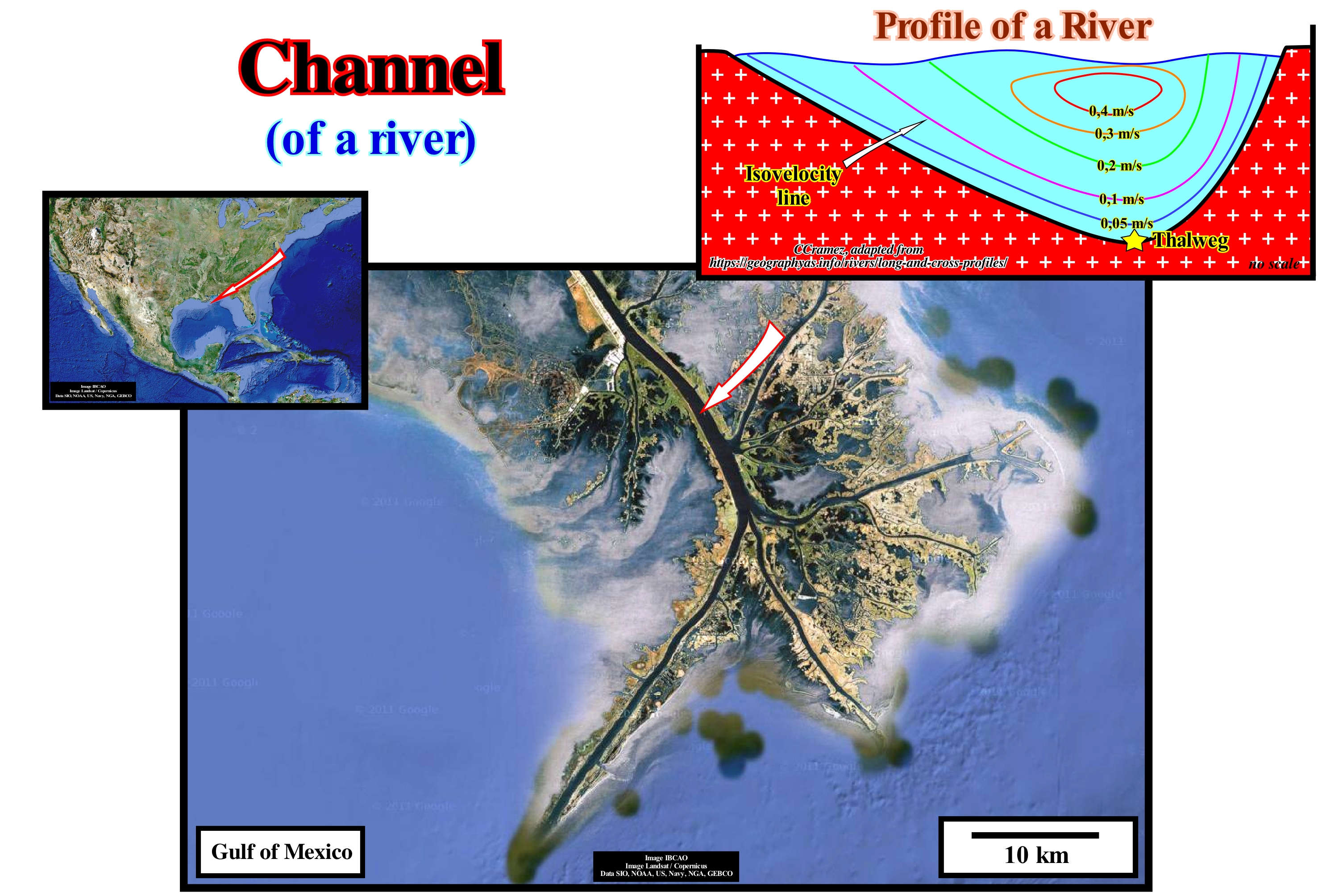
In this figure, the main channel of the finger delta (when its plain extends across several narrow, long, finger-shaped lobes) of the Mississippi River, that is, the narrow, deep, erosive depression that puts in communication the Mississippi River with a most important water-body (Gulf of Mexico) is, perfectly, visible. It is along the channel of a river (or bed) that water flows, with different velocities, as illustrated by the iso-velocities (lines along which the flow velocity of water is the same). The flow velocity is most important in the central part of the channel and near the water surface. In a channel profile, as shown in the sketch, the lowest point of the channel is the thalweg. However, in three dimensions, the thalweg (a term that comes from the German "thalweg" and means "valley path") is the line along a valley or a river that joins the deepest points. As a result of this, it is important to take into account the temporal variation of a river's thalweg, especially when it is taken as the natural boundary between two countries. The river that has, at the confluence point, the deepest thalweg, is considered, generally, as the main river. The term canal is used to designate several things like, for instance: (i) The tight passageway between land and sandbanks, used by navigation ; (ii) The natural or artificial access to a port that is, often, maintained by dredging and defined by buoys (it is also called channel) ; (iii) Long depression in the sea-floor that serves as a transit route to water and sedimentary particles ; (iv) The arm of a river through which the waters are diverted ; (v) The flow path of a metallurgical furnace ; (vi) A pipe ; (vii) A tube ; (viii) The radio or television station, etc. In geology and, particularly, in tentative geological interpretations of seismic lines, as in Sequential Stratigraphy, the term channel is used by many geoscientists to designate the sediments that filled the old bed of a stream and not the bed itself, which is wrong . A channel is the depression of the terrestrial crust over which a stream runs, i.e., the bed or stream bed, not the set of sediments that can later fill the channel. For instance, an incised valley is the deepening of a river valley (created by the action of running water that causes erosion of the terrain) when the provisional equilibrium profile* of the river that originated it is broken, as is the case when of a significant relative sea level fall displaces the mouth of the water-courses seaward and downward. The filling of a channel or of an incised valley is a stratigraphic interval characterized by a geometry and a lithology, even if the fill geometry depends greatly on the filling facies and compaction. If the filling is sandy, due to differential compression, the geometry becomes biconvex. The top and bottom of the filling exhibit a convex geometry. If the fill is shaly (the channel or incised valley will just be recognized on seismic lines if there is an acoustic impedance contrast between the filling and the substrate), it molds, more or less, the water-course bed. The base has a concave fusiform geometry and the top has a convex morphology. Theoretically, a channel (erosional depression) is, genetically, associated with erosion. It is, always, posterior to the substrate, which it erodes and pre-dates the sediments that fill it. At this point there is much confusion. In submarine slope fans, for instance, many geoscientists call turbiditic channel to the filling of the depression between the natural marginal dikes (levees) where the turbidity currents flow. In most cases, the depression between the turbidite natural marginal dikes (levees) shows no erosion and is contemporaneous with the natural marginal dikes that form it. A river needs to dig a bed to flow, whereas a turbidite current, in general, does not. A turbidite current flows on a, more or less, inclined surface respecting the principle of least effort**. The natural marginal river dikes are always higher than the filling of a fluvial channel, which is not always the case in turbiditic deposits.
(*) The ideal equilibrium profile of a river is never reached. Globally, a hydrographic basin erodes and the load becomes weaker and, one might imagine, an ideal moment in which the inclination of the current would be sufficient for its flow (all transport would have disappeared). Under these conditions, the current would reach its ideal or definitive equilibrium profile. However, such a profile is never achieved.
(**) The principle of least effort is a broad theory that covers diverse fields from evolutionary biology to web-page design. It postulates that animals, people, even well-designed machines will, naturally, choose the path of least resistance or "effort". It is closely related to many other similar principles
Channel Fill................................................................................................................................................................................Remplissage de Chenal
Preenchimento de canal / Relleno de canal / Füllkanal / 河道填充 / Заполнение канала / Riempimento di canale /
A channel fill, that is to say, the filling a channel, particularly, when it is of fluvial origin, may have multiple geometries. Nevertheless, the filling by onlapping appears to be, by far, the most frequent.
See: « Reflection Configuration »
&
« Lowstand »
&
« Relative Sea Level Change »
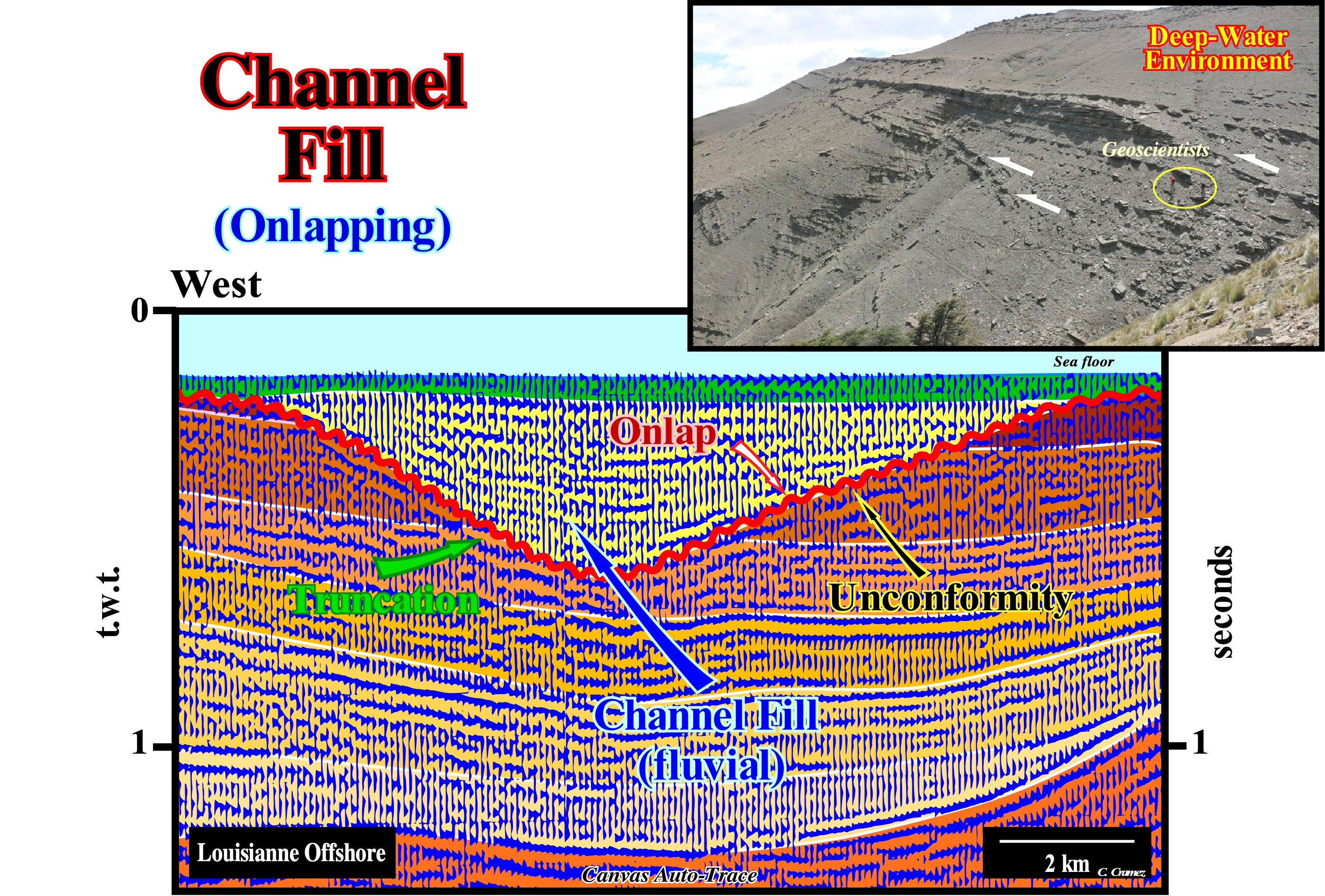
First of all, it should be borne in mind that what most geoscientists call, in the field or on a seismic line, a submarine canyon or a canal is, actually, the filling of an old submarine canyon or of an old channel along which a water-course flowed. In fact, a submarine canyon or submarine gorge is a cliff-shaped valley (carved, more or less, at a peak), located on the continental slope or even on the ocean floor, which may or may not be, partially or totally, filled with sediments. Similarly, an incised valley is the valley resulting from the erosion of the underlying layers by a fluvial stream whose mouth moved seaward following a significant relative sea level fall and which was, later, filled during the deposit of the lowstand prograding wedge of the associated sequence-cycle. The relative sea level is the result of the combined action of absolute (eustatic) sea level and tectonics (subsidence of the sea-floor when the sediments are lengthened or uplift when the sediments are shortened, although in certain cases, when there is diapirism, the sediments can be lengthened. Absolute or eustatic sea level is supposed to be global and referenced to the Earth's centre. It is dependent on: (i) Tectono-Eustasy, which is controlled by the volume variation of the ocean basins in association with sea-floor spreading following supercontinents' break-ups ; (ii) Glacio-Eustasy, which is controlled by the variation of water volume of the oceans as a function of the amount of ice (assuming that the amount of water, in all its forms, is constant since the Earth's formation, around 4.5 Ga) ; (iii) Geoidal-Eustasy, which is controlled by the distribution of ocean water caused by variations in the terrestrial gravity field (where gravity is stronger than normal, sea level is thrown toward the Earth's centre) and (iv) Thermal expansion of the oceans or steric sea level rise (when the temperature of the oceans increases, the density of the water decreases and, for a constant mass, the volume increases). It is most correct to say, for instance, that a given channel fill and not a channel, has a parallel or progradational internal configuration. On this tentative of geological interpretation of a Canvas auto-trace of a detail of a seismic line from Louisiana offshore (United States), a relative sea level fall displaced the coastal onlaps downward (negative aggradation) and seaward (negative continental encroachment). The sea level was lower than the basin edge, which, during the lowstand systems tracts group, and particularly, during the upper sub-group, i.e., the lowstand prograding wedge (LPW), is the last basin edge of the preceding sequence-cycle. This relative sea level fall exhumed the old platform (if the basin had a shelf) or raised even more the coastal plain (relatively). A subaerial erosion slowly eroded the platform and the upper part of the exhumed continental slope, creating an erosional surface, i.e., an unconformity. It is this unconformity, which is illustrated on this tentative interpretation by the corrugated line coloured in red. In this area, as the water-course's mouths were displaced seaward and downward by the relative sea level fall, the water-courses were forced to incise their beds to re-equilibrate their broken provisional equilibrium profiles. Due to the incision of the water-courses, incised valleys and probably submarine canyons were later filled, when the relative sea level began to rise in acceleration (which means that marine ingressions were increasingly more important). It was probably in this way that the filling of the incised valley illustrated in this auto-trace (colored in yellow) was formed. The old incised valley was fossilized by sediments that lapout against the unconformity by onlaps, which are also observed on the auto-traces of perpendicular seismic lines passing through the filling. The internal configuration of this filling is, slightly, divergent to the centre of the sinform (extensional structure rather than compressional such as a syncline). In this particular case, the absence of differential compaction in relation to the surrounding sediments (despite the poor burial), suggests a shaly facies of the sediments filling the old incised valley. Compaction, sediment diagenesis by gravity and differential compaction can form different structures in sedimentary rocks. Non-tectonic folding structures, as illustrated in this filling can be formed by differential compaction or by under-water slumpings.
Channel Floor Lag (Turbidites)..........................................................................................................Dépôt Résiduel (Fond de chenal)
Depósito residual / Depósito residual (fondo de canal) / Kanalboden Lag / 频道落地滞后 / Остаточные отложения (дно канала) / Deposito residuo di canale /
A deposit of varying thickness, sometimes, lenticular, formed by the coarser material that a turbidite current carries and which accumulates in the deeper parts of the current bed.
See: « Channel Fill »
&
« Clay Plug »
&
« Incised Valley »
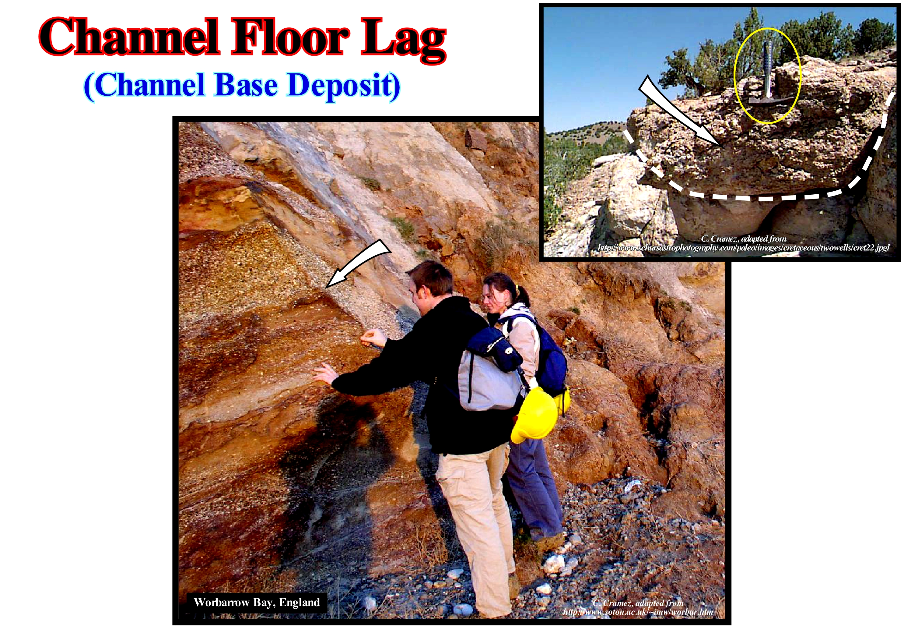
Residual deposits (channel floor lags), such as those illustrated in these outcrops, are formed by sorting and abandoning of the larger and heavier sedimentary particles of a current, while the lighter and smaller ones continue to be transported downstream. Many residual deposits are, sometimes, enclosed in the sediments, which travel along the channels and are removed by lateral currents. Others, on the other hand, are relatively stable and durable. All geoscientists know, for instance, that gold and other heavy minerals are common in residual deposits, but they are not, unfortunately, as frequent as gravel* or blocks** of shoals. Gravel and blocks, relatively large, often, seen at the base of many valley deposits, just above the rocky substrate, are apparently residual deposits concentrated by the repetitive and continuous removal of the smaller particles. A particle block or gravel can be carried by a stream at least during floods, although the deposits of which these particles are a part are, generally, stable. The deposition occurs when the energy of the water-course is not strong enough to support the particles transported and these are deposited by a process that the geoscientists called null point hypothesis. This hypothesis explains how the sediments are deposited according to the granulometry of the grains. Theoretically, this is the consequence of the influence of hydraulic energy, which induces a decrease in grain size, i.e., a grain is deposited when the force of the fluid equals gravity for each grain size. This concept may also explain why a sediment of a certain size can move to a position where it is in equilibrium with the flows acting on it. Thus, it is necessary to distinguish between a residual deposit of a current and the coarse deposits accumulated, previously, during periods when the current had a greater competence or when it carried a greater amount of sediments (when it had higher charge). These types of deposits are not exclusive to fluvial environments. It is often found in turbiditic depositional systems and in particular with the submarine basin floor fans (SBFF) when they are not connected to the lower break of the continental slope. Indeed, as long as a turbidity current enters the abyssal plain, it begins to decelerate and to lose competence (the ability of a water-course to carry a sediment with a maximum weight compatible with its velocity), which allows the coarse deposits which they carry are, generally, deposited in small negative anomalies of the substrate which favour deceleration and form residual deposits several hundred meters or even kilometers upstream of the main lobe. However, the energy developed by a water-course, turbiditic or not, that is to say, its erosion, potentiality, is proportional to its flow rate (volume of water per unit of time) and to the square of its velocity, which changes along its trajectory ***. This type of deposits is very well known in the Swiss Alps flysch, where they are quite rich in heavy minerals that can sometimes be exploited economically. In the geological model of large turbidite systems (type I of Emiliano Mutti), shown in the following figure, the residual deposits are, almost always, present in the transport zone between the lobes of large turbiditic rocks and the basin edge. This means they are associated with the basal unconformity of the sequence-cycle and not with the paraconformity which correlates downstream with the unconformity (erosional surface) which suggests they correspond, most likely, to the filling of a depression caused by the erosion of a turbidite current.
(*) Gravel is a sedimentary particle whose granulometry varies from gravel / granule (diameter 2-4 mm) to very large block (diameter 2,048-4,096 mm). Gravel particles are the constituents of sedimentary rocks called conglomerates or breccias, which are, in reality, rudites.
(**) The blocks, which may be small, medium, large and very large, are sedimentary particles whose diameter varies respectively between 256-512 mm, 512-1,024 mm, 1,024-2,940mm and 2,048-4,096 mm.
(***) In the case of a fluvial current, the velocity is not constant throughout the section. It is maximum a little below the surface, in the middle plane of the current and minimum at the bottom of the bed near the edges.
Channelized Facies (Turbidites)........................................................................................................Faciès de Chenal (Turbidites)
Fácies de canal / Facies de canal (turbiditas) / Channel-Fazies (Turbiditen) / 通道相(浊流) / Фации канала / Facies di canale (torbiditi) /
Turbiditic facies (P. Vail) of submarine basin floor fan (SBFF). This facies is best recognized in the E. Mutti model, particularly, in medium-sized turbiditic systems (Type II), which are deposited during highstand geological conditions upstream of the turbidite lobes near the base of the continental slope.
See: « Turbidite »
&
« Basin Floor Fan »
&
« Contourite »
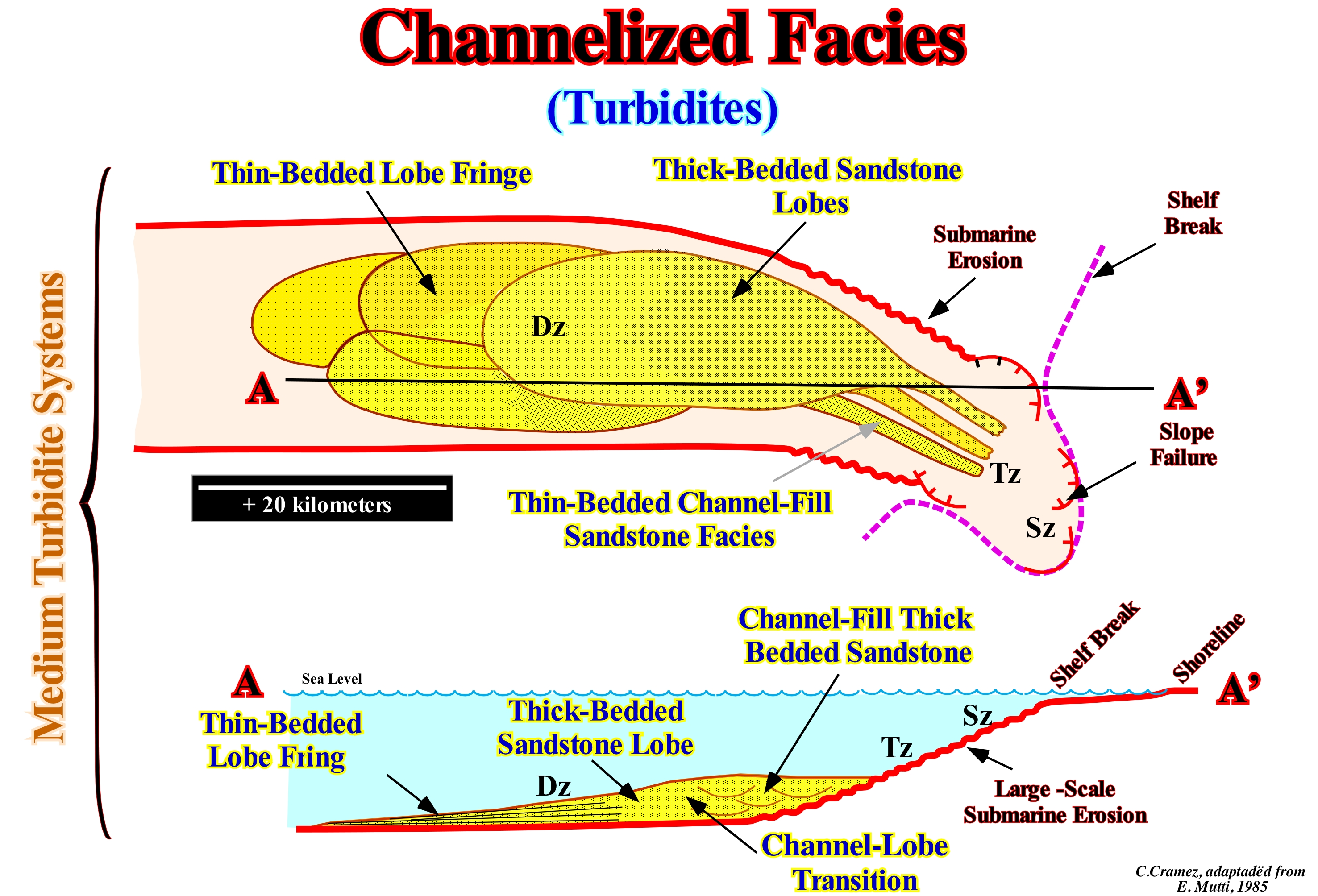
In the classification of the turbidite systems of E. Mutti *, these systems are divided into three large groups, depending on the amount of material transported by the turbidite currents, which are, mainly, induced by failures and landslides of the continental slope (when the basin has a shelf, i.e., when, within the associated sequence-cycles, the shoreline is located much upstream of the continental edge) or the basin edge (when the basin has no shelf, which means that the shoreline is, more or less, coincident with the continental edge). As illustrated in these sketches, medium-sized turbidites (or Mutti's Type II) include all turbidite systems where sandy facies are deposited, above all, in the lower parts of the channels (or depressions) in the seaward prolongation of the river mouths. These systems form extensive channelled bodies, which pass, downstream, to sandy lobes. Type II systems are very coarse and mainly composed of channelled deposits. A decrease in grain size favours the development of lobules, which are less developed in volume and extent than the lobes associated with large size turbiditic systems (Type I). The most, widely, used classification of turbidite systems are based on the volume and texture of the gravitational flux linked to the shore physiography or the granulometry of the coastal systems and that in the classification proposed by Mutti in 1985, assuming the turbidity currents have a high degree of freedom, i.e., in the absence of effective obstacles along the slope and taking into account the efficiency concept (Mutti, 1979), the turbidite systems were subdivided into three types: (i) Type I or Large Turbidite Systems (LTS) ; (ii) Type II or Medium Turbidite System (MTS) and (iii) Type III or Small Turbidite System (STS). Type I or Large Turbidite Systems (LTS) are characterized by: a) Failures in the continental slope ; b) Large-scale underwater erosion, i.e., erosion along the continental slope ; c) A transfer zone at the base of the continental slope and d) Deposition of lobes in the abyssal plain. Type II or Medium Turbidite System (MTS) are characterized by: a) Coastal depositional systems near the continental margin ; b) Erosion along the upper continental slope ; c) Deposition directly at the base of the continental slope ; d) Absence or a small transfer zone at the base of the continental slope. Type III or Small Turbidite System (STS) are characterized by: a) A synchronous deposition of the continental edge ; b) Rectilinear or sinuous channels along the continental slope ; c) Terminal lobes of sandstone at the end of rectilinear channels ; d) Terminal silt lobes at the downstream end of the sinuous channels. Certain geoscientists consider the Mutti type II turbidites corresponds, more or less, to P. Vail's submarine slope fans (SSF), in which the natural marginal dikes (levees) and the filling of depressions between them and/or channels (when there is erosion) are preponderant. The differences between the model of deposition of the turbidites (deep-water) of P. Vail and of E. Mutti, nevertheless, are important. For Mutti, the geological context is highstand (sea level higher than the basin edge or the continental edge). Mutti admits the possibility of turbidite deposits in association with significant falls of the relative sea level, i.e., associated with unconformity, as is the case in the Vail model, but for him the vast majority of turbidite currents are induced by large-scale undersea erosions associated with failures of the continental edge and slope (as illustrated in this figure) and river flood periods. As corroboration is not synonymous with verification (nor validation), it can be said that both models are corroborated by observation data (field and seismic). In the North Sea, for instance, the Mutti's model is more often corroborated than Vail's. Erosional scars are quite well visible on the continental slope. They develop during highstand geological periods. However, in other areas and, particularly, in the Atlantic type (associated with the formation of new oceanic crust) or non-Atlantic type (associated with the formation of megasutures) divergent margins, the Vail's model is difficult to refute.
(*) Mutti, E., 1979 - Turbidites et cones sous-marins profonds. In Homewood, P., ed., Sedimentation Detritique (Fluvial, Litoral et Marine), Institut de Geologia, Université de Fribourg, pp. 353-419. Mutti., E., 1985- Turbidite Systems and their relations to depositional sequences. In Zuffa, G. G., ed., Provenance of Arenites: NATO-ASI Series, D. Reidel Publishing Co., Amsterdam, Pp. 65-93. Mutti, E., and Normark, W. R., 1987- Comparing examples of modern and ancient turbidite Systems: Problems and Concepts. In Leggett, J. K., and Zuffa G. G., eds., Deep water classic deposits: models and case histories. Graham & Trotman, lndon, pp. 1-38.
(**) Local sea level referenced to base of the sediments or to the sea-floor that is the result of the combined action of absolute (eustatic) sea level, which is supposed to be global and referenced to the Earth's centre and the tectonics.
Chaotic Mound......................................................................................................................................................................Monticule Chaotique
Montículo caótico / Montículo caótico / Chaotische Hügel / 混乱的土堆 / Хаотичный холм / Monticello caotico /
A mound-shaped structure in which the internal configuration of the stratification planes or reflectors is very disordered and sometimes chaotic.
See: « Climbing Toplap Mound »
&
« Reflection Configuration »
&
« Overbank Deposit »
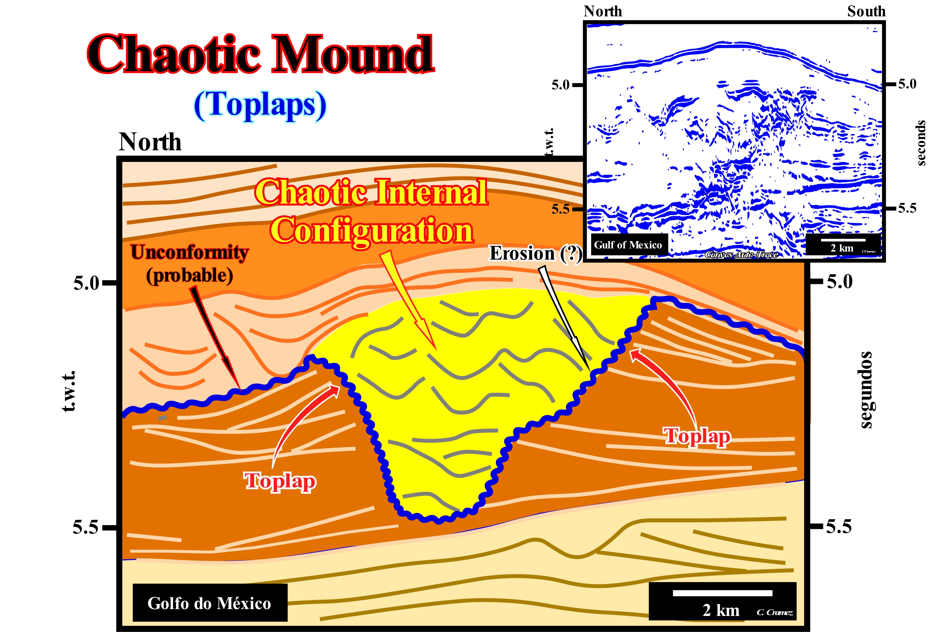
On this tentative geological interpretation of a Canvas auto-trace of a detail of a deep offshore seismic line shot in the Gulf of Mexico, the filling of the depressions (in yellow) between overbank deposits (turbidite natural marginal dikes, i.e., levees) create small mound anomalies with a internal configuration, usually, chaotic. When the morphology of top of the filling is convex, it is, likely, the fill has a sandy facies, which means that such a morphology is the result of a differential compaction. Otherwise, that is to say, when the morphology of the top of the filling is concave, usually, the facies is shaly. As illustrated on this tentative interpretation, the geometrical relationships and reflector terminations are characteristic of the submarine slope fans, which are deposited under lowstand geological conditions (sea level lower than the basin edge). The two lower sub-groups of the lowstand systems tracts group, i.e., the submarine basin floor fans (SBFF) and the submarine slope fans (SSF), are the only sedimentary intervals of the sequence-cycle deposited during significant relative sea level falls. During the final part of deposition of the submarine slope fans (SSF), it is possible that the relative sea level, is already rising (the relative sea level is the result of the combined action of the absolute sea level, which is supposed to be global and referenced to the Earth's centre, and the tectonics). The other systems tracts sub-groups that with the submarine fans constitute, usually, a sequence-cycle, are the lowstand prograding wedge (LPW), the transgressive interval (TI) and highstand prograding wedge (HPW) can just be deposition when there is an increase of available space for the sediments (increase of the accommodation). During the transgressive interval, the accommodation increasing is induced by marine ingressions (or increments of a marine ingression) increasingly important. They emphasize a relative sea level rise in acceleration. During the lowstand prograding wedge (LPW) and the highstand prograding wedge (HPW), the marine ingression (or increments of marine ingression) are increasingly smaller. They emphasize, relative sea level rises in deceleration. In the curve of the relative sea level changes, the crescent concave geometry sectors (1st and 2nd derivatives of the curve are positives) underline a relative sea level rise in acceleration, while the sectors with a crescent convex geometry (1st derivative positive and 2nd derivative negative) emphasize a relative sea level in deceleration. This means that at the level of a sequence-cycle, to have deposition (exception made for submarine fans that are associated with turbiditic currents), the relative sea level must always rise. To say, there is a "transgression" when the sea level rises or to say there is a "regression", when the sea level falls, without specifying the hierarchical level of deposition (continental encroachment cycles, continental encroachment subcycles or sequence-cycles) and, in addition, do not say what is meaning of transgression and regression, is to have no idea of the basic principles of stratigraphy, in particularly, sequential stratigraphy*. Seaward of the basin edge, where the basin and slope submarine fans are deposited, there is always space available for the sediments, once the water-depth is important. The only thing that is needed to have deposition is the presence of turbidite currents with sedimentary particles. The occurrence of turbiditic currents is paramount. When the turbiditic currents, that transport the sedimentary particles basinward, lose velocity, they deposit coarser particles under the form of lobes, usually, on either side of the current depression. The thinner sediments are transported farther seaward by the central part of the current, which being more energetic has a greater transport capacity. The relative depression formed between the first two lateral lobes channels the following turbidite currents, which have to overflow the depression to deposit the sedimentary particles under form natural marginal dikes (levees). Progressively, the central depression becomes, more and more, important and can even be accentuated by erosion at the base by the turbidite currents. Since the terrigeneous influx decreases, the depression between the natural marginal dikes (levees) is often filled, in retrogradation, by sediments with a chaotic internal configuration.
(*) At the level of continental encroachment cycles and sub-cycles, when the absolute (eustatic) sea level rise there is a global marine transgression with associated global sedimentary transgression (retrogradational geometry). When the absolute sea level falls, there is a global marine regression with deposition of a global sedimentary regression. At the level of sequence-cycles, when the relative sea level (absolute sea level + tectonics) falls, there is deposition in the deeper parts of the basin deposition of turbidite depositional systems (submarine basin floor and slope fans). When the relative sea-level rise, there is always deposition. However, if the sea-level rise in acceleration (increments of the marine ingression increasingly important), the associated sedimentary regressions (deposited during the stability periods of the relative sea level) are increasingly smaller, which create a retrogradation geometry (sedimentary transgression). If the sea-level rise in deceleration (increments of the marine ingression increasingly smaller), the associated sedimentary regressions are increasingly important, which develops a progradational geometry (sedimentary regression). In other words, at the level of sequence-cycles there are only sedimentary regressions, which can be increasingly important (progradational geometry) or increasingly smaller (retrogradational geometry). Certain geoscientists call the set of increasingly important "sedimentary regression", and the increasingly smaller " sedimentary transgression", but in such a terminology a sedimentary transgression is just a set of sedimentary regressions increasingly smaller.
Chaotic Filling................................................................................................................................................................Remplissage Chaotique
Preenchimento caótico / Relleno caótico / Füllen chaotischen / 杂乱填充 / Хаотичное заполнение / Riempimento caotico /
Disorderly configuration of strata or reflectors, which fill a sedimentary anomaly. In general, the sediments of such a filling are deposited in a slope environment (continental or deltaic) or in a glacial environment.
See: « Onlap »
&
« Reflection Configuration »
&
« Relative Sea Level Change »
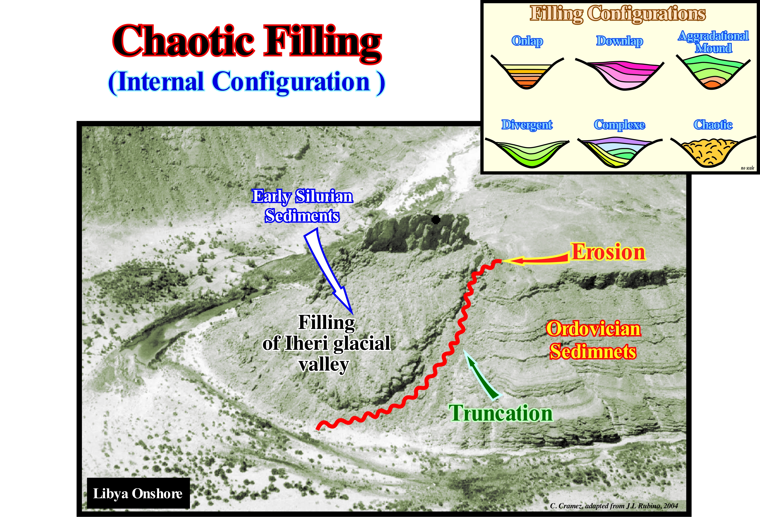
In this photograph, taking into account the external geometric patterns (onlaps and truncation), one can, easily, recognize a depression filling. In the same way, the internal configuration of this depression filling can be considered as chaotic. There is, practically, no continuity of the bedding planes. In this particular case, erosion was controlled by glacial events, probably, induced by thickening (advancement) and thinning (retreating) of a glaciers. Certain geoscientists but, above all, a lot ecologists, mistakenly, prefer speak of advance and retreat of glaciers. In any case, often, but not always, the advance of a glacier along its valley correlates with an absolute (eustatic) sea level fall, that is to say, with a fall of the supposed global sea level referenced to the Earth's centre. The eustatic sea level is dependent on: (i) Tectono-Eustasy, which is controlled by the volume variation of the ocean basins, function of the sea-floor spreading ; (ii) Glacio-Eustasy*, which is controlled by the variation of ocean water volume as a function of the amount of ice** ; (iii) Geoidal-Eustasy, which is controlled by the distribution of ocean water caused by variations in the terrestrial gravity field and (iv) Thermal expansion of the oceans or steric sea level rise (if the temperature of the oceans increases, the density of the water decreases and, for a constant mass, the volume increases). However, only glacio-eustasy is at the same time important, i.e., over10 meters and fast (duration less than 1 My). In other words, with a glaciation the absolute or eustatic sea level falls. That was the case during the Quaternary glaciations. On the contrary, when ice begins to melt, that is, from the beginning of deglaciation, the absolute sea level rises and the glacial valleys released from the ice are flooded even before sea level floods the coastal plain. This means that at least the distal part of the glacial valleys (near the fluvio-glacial plain) is flooded, and largely filled, in lowstand geological conditions (sea level lower than the basin edge of the stratigraphic cycle). So, a large part of the filling of the glacial valleys is done during the late phase of deposition of the lowstand prograding wedge (LPW). This early filling of the glacial valleys has a parallel internal configuration. It is the most upstream part, which often presents a chaotic configuration, as illustrated in this photograph (filling the Iheri glacial valley, Libya onshore). In regional geological terms, it can be said that on the Algeria/Libya onshore and, particularly, in the geographic basin of Ghadames (a cratonic basin in the Bally and Snelson classification of the sedimentary basins), Ordovician sediments have suffered intense glacial erosion. Such a glacial erosion created a series of glacial valleys oriented, more or less, North-South. Later, during the Lower Silurian marine ingression, the lower part of the Ordovician glacial valleys (incision age) were filled by sediments synchronous of late-stage of the lowstand prograding wedge, before being fully filled by the transgressive sediments of the Upper Silurian. The sediments rich in organic matter ("Hot Shales"), which constitute one of the main source-rocks found in this area, are found in the early filling. In fact, it is possible to say the Early Silurian shales, rich in organic matter ("Hot Shales") are the source-rocks of more than 80-90% of the Paleozoic hydrocarbons of North Africa. They generate, also, an important part of the hydrocarbons founded in Arabian Peninsula. In the majority of cases, these shales deposited, directly, over the Late Ordovician glacial sandstones, during the beginning of the Early Silurian marine ingression following of the melting of the Ordovician ice cap. In the North Africa / Arabia region, the deposition of the main shaly interval, rich in organic matter, was restricted the Early Silurian. During such a short period (between 1 and 2 million years) of the Rhuddanian stage of the Landovery Epoch, there was a favourable combination of factors that led to the development of an exceptionally strong oxygen deficiency in the area (the post-Rhudanian are organically lean and have no source-rock characteristics).
(*) During the last glacial maximum, the terrestrial volume of the ice sheets produced an absolute sea-level lowering of about 120-130 m. In contrast, melting of the Greenland and Antarctic ice sheets would cause sea-level rises of 5.5 and 60 m, respectively. In some of the tectonically stable areas of the world, the glacio-eustatic sea-level variations have been reconstructed. (https://www.climate-policy-watcher.org/environmental-change/glacioeustasy-and-glacioisostasy.html)
(**) Glacio-isostasy is defined as the alteration of the earth crust (lithosphere) through unloading and uploading of ice mass during major glacial cycles, which attributed to addition and removal of glacial ice. In simplest term glacio-isostasy represents the loading or unloading of ice. The worldwide process of glacial isostatic balance results in the process whereby the Earth’s shape and gravitational field are made to order in retort to the large-scale changes in surface mass load.(https://link.springer. com/referenceworkentry/10.1007%2F978-90-481-2642-2_213). The crustal deformation varies with the rigidity of the crust. The depression at one place must be compensated elsewhere, and hence marginal displacement of the crust involving upward bulging may be one aspect of this compensation (Peltier R.W., 1980). The distance between the margin of the ice sheet to the fore-bulge depends on the flexural parameter of the crust, or the amplitude of bending of the lithosphere, which is mainly related to lithospheric density, thickness and elasticity. Glacio-isostatic recovery can be considered as a process that accelerates rapidly and then slows gradually. Glacio-isostatic recovery in response to deglaciation can be subdivided into three phases (Andrews, 1970): (1) Restrained rebound occurs beneath a thinning ice sheet. This period is not recorded by direct sea-level data because the area is covered by ice. (2) Post-glacial uplift is the rebound phase after deglaciation. Relative sea-level variations can be recorded by means of geomorphological and sedimentological evidence. (3) Residual uplift is the rebound that takes place several thousand years after the region is deglaciated. Some regions that were occupied by ice sheets during the last ice age are still rising at present because of the long response time of lithospheric recovery. In many areas isostatic uplift is considered not to be complete. Highland Britain still rises by almost 0.2cmyr_1 (Shennan, 1989), the Gulf of Bothnia by 0.8-0.9 cm yr"1 (Broadbent, 1979), while the eastern Hudson Bay area in Canada experiences an uplift of about 1.1cm yr-1 (Hillaire-Marcel, 1980). (https://www.climate-policy-watcher.org/environmental-change/glacioeustasy-and-glacioisostasy.html)
Charge (Stream)........................................................................................................................................................................Charge d'un cours d'eau
Carga de corrente / Carga de corriente / Laden eines Streams / 负载流 / Твёрдый дебит (водного потока) / Carico di un corso d'acqua /
Amount of sedimentary particles carried by a water-course, expressed by the particle volume rate, passing through a given section of a channel, per time unity.
See: « River »
&
« Capacity (stream) »
&
« Channel »
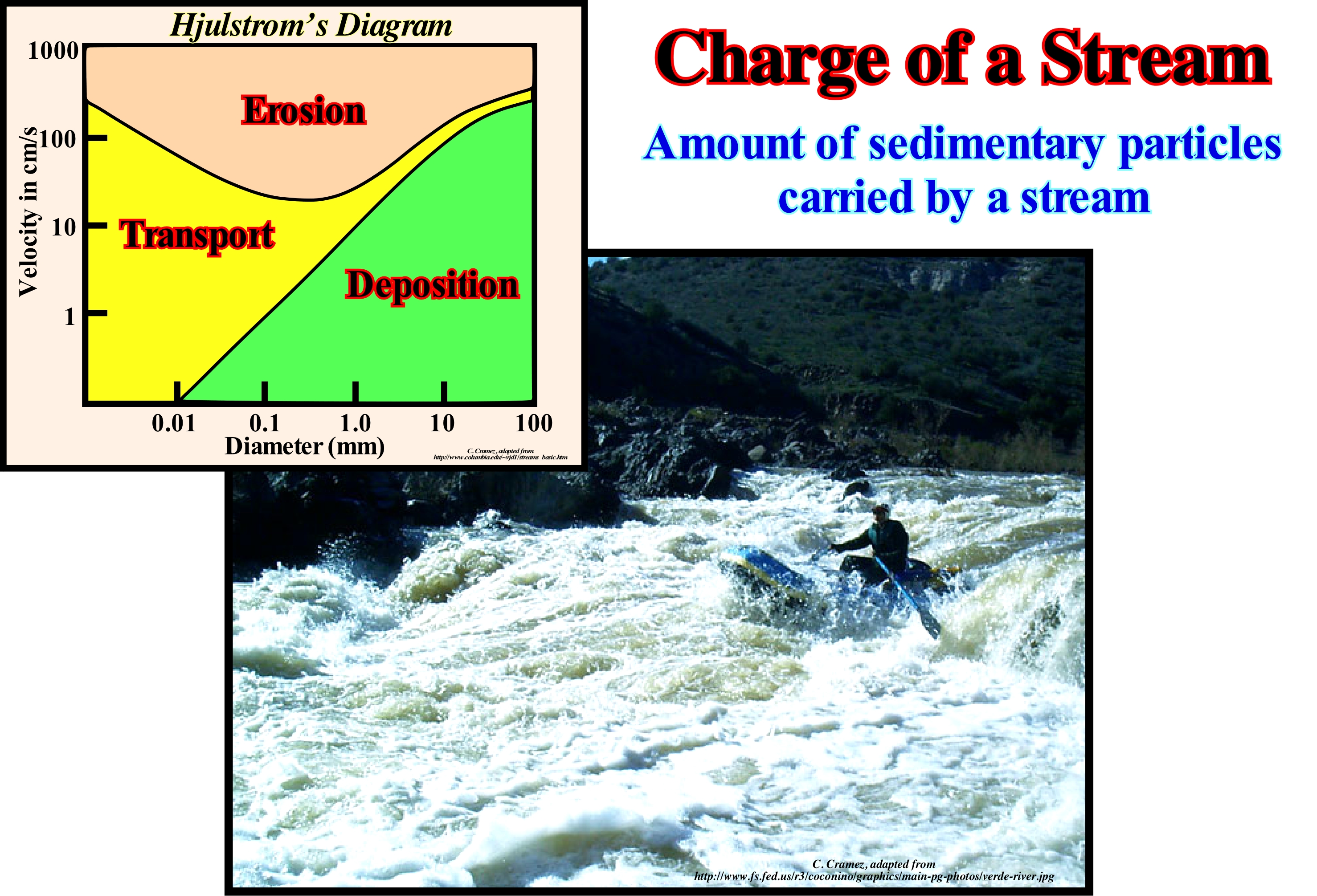
A water-course flows laminarly (the water molecules move parallel to one another), when their velocity is low and the stream's bed regular. At high velocity, the flow is turbulent, i.e., the water molecules do not move parallel to one another, but in a chaotic way. The streams carry in dissolution, ions, in suspension, fine particles of clay and silt, and by traction or salting, coarse particles such as sand and pebbles. In the diagram shown in the left corner (Hjulstrom's diagram*), one of the curves represents the minimum velocity that a stream needs to have to erode sediments (of various sizes) from the bed. The other curve represents the minimum velocity required for it to carry sediments of various sizes. For coarse sediments (sand, pebbles), less speed is needed to initiate erosion than to transport them. For smaller particles (clay, silt), a stronger speed is required to erode them than to carry them, since fine particles have strong cohesion resulting from electrostatic attractions. The competence of a current refers mainly to the heavier particles that the current can carry. As illustrated in the Hjulstrom's diagram, competence depends on the velocity of the stream, which is a function of the slope of the thalweg (the mid-line of a stream of water where the two sides of a valley intersect). The faster the current, the heavier the particles it can carry. Competence also depends on the importance of shear** in the stream bed. When the velocity of the stream is small (about zero) near the bed, and increases upwards toward the surface, the higher the velocity variation rate near the bed the greater the shear applied to the sedimentary particles resting on the bed. The capacity or charge of a current is the maximum of solid material it can carry. It depends on the discharge and velocity, since velocity affects competence. As velocity and discharge*** increase, competence and capacity increase, but not in a linear fashion.
(*) The simplified Hjulström's diagram shows how fast the flow velocity of a stream must be to have erosion, transport or sedimentation of debris of a certain size. A water-course erodes a rock at a specific velocity of water flow. Of course, it must be faster for larger debris than for smaller debris. If the flow velocity of the water-course decreases, as is the case when the bed's dip of a stream becomes small, the transported sedimentary particles may settle to the bottom of the bed. It can be said that there is transport of sedimentary particles between erosion and sedimentation. (http://ks-net.ch/es/fachgebiete/bagger/Hjulstr% C3%B6mdiagramm.html)
(**) In physics shear stress refers to a stress state that will cause shearing (deformation of a material substance in which parallel internal surfaces slide past one another) when it exceeds a material's shear strength.
(***) In hydrology, discharge is the volumetric flow rate of water that is transported through a given cross-sectional area. It includes any suspended solids (e.g. sedimentary particles), dissolved chemicals, or biologic material in addition to the water itself.
Charge (Seismic)................................................................................................................................................................................................Charge sismique
Carga sísmica / Carga sísmica / Seismischer Belastung / 地震荷载 / Сильный донный нанос / Carico sismico /
Combination of explosives to produce seismic energy (part of the potential energy released during an explosion or another type of seismic source that is converted into elastic seismic waves that propagate away from the source through the Earth and cause vibrating ground motions).. The seismic charge is specified by the amount and type of explosives used. Synonym of Seismic Energy Source.
See: « Reflection Seismic »
&
« Seismic Line »
&
« Seismic Resolution »
Any explosion on the surface or within the ground produces a shock wave. By detecting reflection or refraction waves from a surface source, geoscientists are able to map geological structures, in which hydrocarbons are sometimes present. The way these waves cross the terrain also allows determining the geological elements that control the flow of groundwater, such as the geometry and stratigraphy of alluvial aquifers or paleo-channels, where groundwater flows more easily. Basically there are two types of seismic methods: (i) Reflection Seismic*, which uses the principles of seismology to estimate the properties of the Earth's subsurface based on the reflection of seismic waves ; (ii) Refraction seismic**, which uses the propagation of waves along interfaces between geological levels and allows to estimate the velocity model and the dip of the layers. The first can be used at sea or on land. It is mainly used in petroleum research. The second one, which was, widely, used at the beginning of hydrocarbon research, is currently used, mainly, in geotechnical engineering. The shock wave created either by the impact of a mass on a metal plate, on the surface, or by the explosion of a seismic load inside the ground (or water), is reflected in the different sedimentary layers in an unlike way, which allows cartography of the layers. The harder, i.e., the layers with higher impedance (product of the density by the velocity of the waves that cross them) are the ones that give a reflected wave with a stronger signal. Although the fundamental principles of the two types of seismic are the same, the acquisition equipment and procedures differ greatly. On land, the source of energy is, usually, dynamite (placed inside a small well) or a vibrating mechanism (placed on trucks) called Vibroseis. Unlike dynamite, the sign of Vibroseis is not impulsive. It lasts between 7 to 40 seconds. To emit its signal, Vibroseis vibrates with frequencies ranging from 10-60 Hz (frequency unit, equivalent to 1 s-1, frequency of a periodic event, whose period is a second) . As in the field, the space between the reflectors (sedimentary interfaces) is smaller than the wave-length of the Vibroseis signal, the recording of the reflections overlaps, what makes the raw data (untreated) of the Vibroseis difficult to interpret. Therefore, the traces have to be processed to produce substitution traces with a signal equivalent to that of the source.
(*) Seismic reflection uses field equipment similar to seismic refraction, but field and data processing procedures are employed to maximize the energy reflected along near vertical ray paths by subsurface density contrasts. Reflected seismic energy is never a first arrival, and therefore must be identified in a generally complex set of overlapping seismic arrivals – generally by collecting and filtering multi-fold or highly redundant data from numerous shot points per geophone placement. Therefore, the field and processing time for a given lineal footage of seismic reflection survey are much greater than for seismic refraction. However, seismic reflection can be performed in the presence of low velocity zones or velocity inversions, generally has lateral resolution vastly superior to seismic refraction, and can delineate very deep density contrasts with much less shot energy and shorter line lengths than would be required for a comparable refraction survey depth. (http://www.enviroscan.com/home/seismic-refraction-versus-reflection)
(**) Seismic refraction involves measuring the travel time of the component of seismic energy which travels down to the top of rock (or other distinct density contrast), is refracted along the top of rock, and returns to the surface as a head wave along a wave front similar to the bow wake of a ship. The shock waves which return from the top of rock are refracted waves, and for geophones at a distance from the shot point always represent the first arrival of seismic energy. (http://www.enviroscan.com/home/seismic-refraction-versus-reflection)
Chévy-Manning Formula..........................................................................................................Formule de Chévy-Manning
Fórmula de Chévy-Manning / Fórmula de Chévy-Manning / Chevy-Manning Formel / 雪佛兰-曼宁公式 / Формула Шези-Маннинга / Formula di Chévy-Manning /
Formula used to determine the water flow rate in an open channel or pipeline.
See: « Flux (flow) »
&
« Channel »
&
« River »
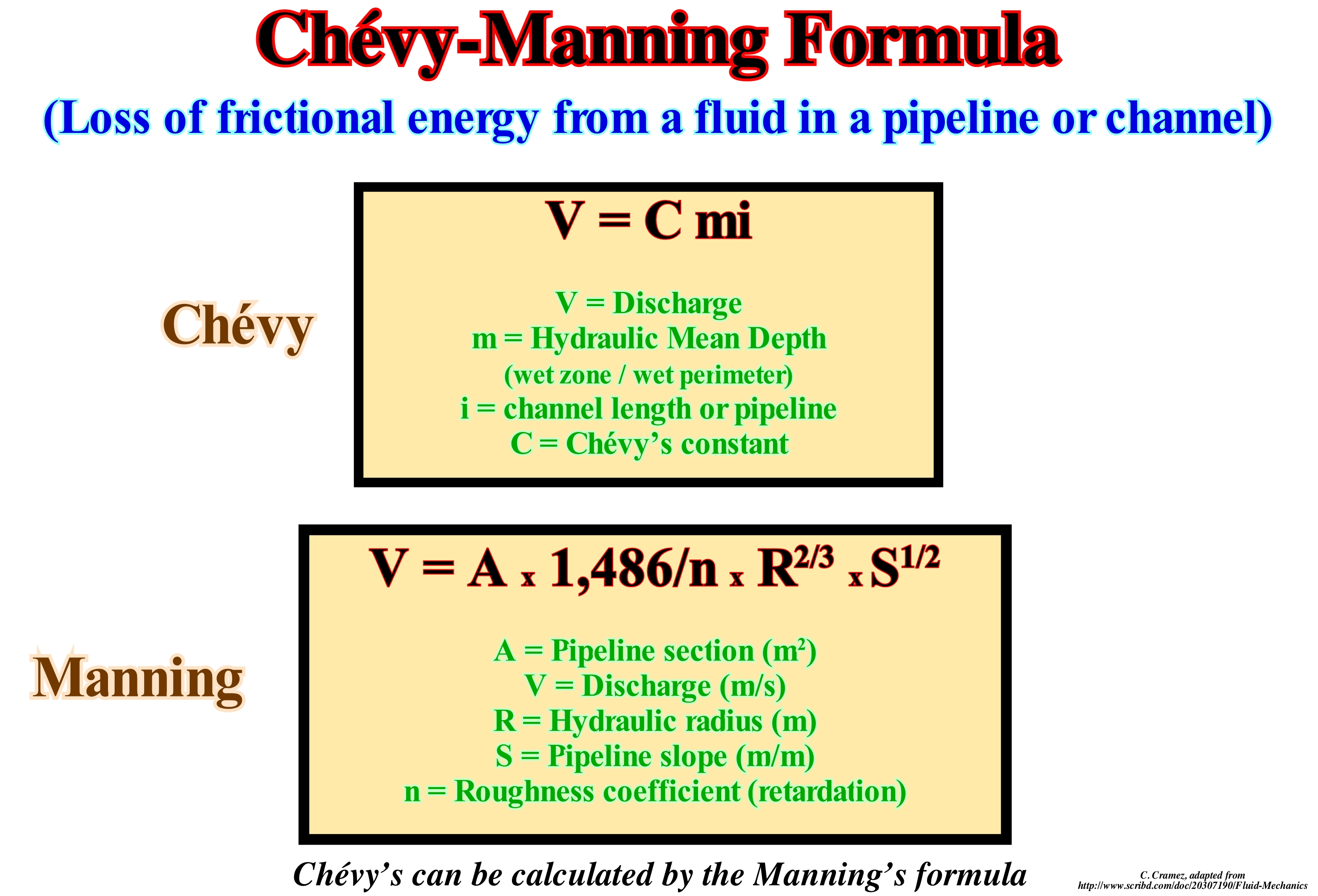
Hydraulic radius is a measure of flow efficiency along a channel. The flow velocity along the channel depends on its cross-sectional shape (among other factors). The hydraulic radius is the characterization of the channel that intends to capture such an efficiency. Based on the shear stress constant in the limit assumption, the hydraulic radius is defined as the ratio between the cross-sectional area of the flow channel and its wetted perimeter (the part of the perimeter of the cross-section that is "wetted"), where: (i) Rh is the hydraulic radius (m) ; (ii) A is the cross-sectional area of flow (m2) ; (iii) P is wet perimeter (m). The greater the hydraulic radius, the greater the channel efficiency and the less likely the river will be flooded. For channels of a given width, the hydraulic radius is higher for the deeper channels. The hydraulic radius is not half the hydraulic diameter as the name may suggest. It is a function of the shape of the pipe, channel or river where water flows. In the wide rectangular channels, the hydraulic radius is approximated by the flow depth. The measure of a channel's efficiency (ability to displace water and sediment) is used by engineers to assess channel capacity. In open channels, the Darcy-Weisbach equation (equation relating the pressure loss - due to friction over a given length of a pipe to the average velocity of the fluid flow) is valid using the diameter as equivalent tube diameter. For various reasons, empirical resistance coefficients (Chézy, Gauckler-Manning-Strickler) were, and still are, used. The Chézy coefficient was introduced in 1768, while the Gauckler-Manning coefficient was first developed in 1865, before the resistance flow experiments done in the 1920s and 1930s. Historically, both the Chézy and Gauckler-Manning coefficients were taken as functions of the roughness. But it is now well known that these coefficients are constant only for a range of flow rates. Most friction coefficients (except, perhaps, Darcy-Weisbach's friction factor) are about 100% empirical, and they only apply to turbulent water flows under constant flow conditions.
Chimney Rock (Spike rock)....................................................................................................---..............................................................Pinacle (Piton)
Pináculo (espigão)/ Pináculo / Saüle, Pfeiler / 巅峰 / Остроконечная скала (пик) / Pinnacolo /
Rock, generally, of carbonate facies, with a spike morphology.
See: « Deposition (carbonates) »
&
« Reef »
&
« Transgressive Interval »
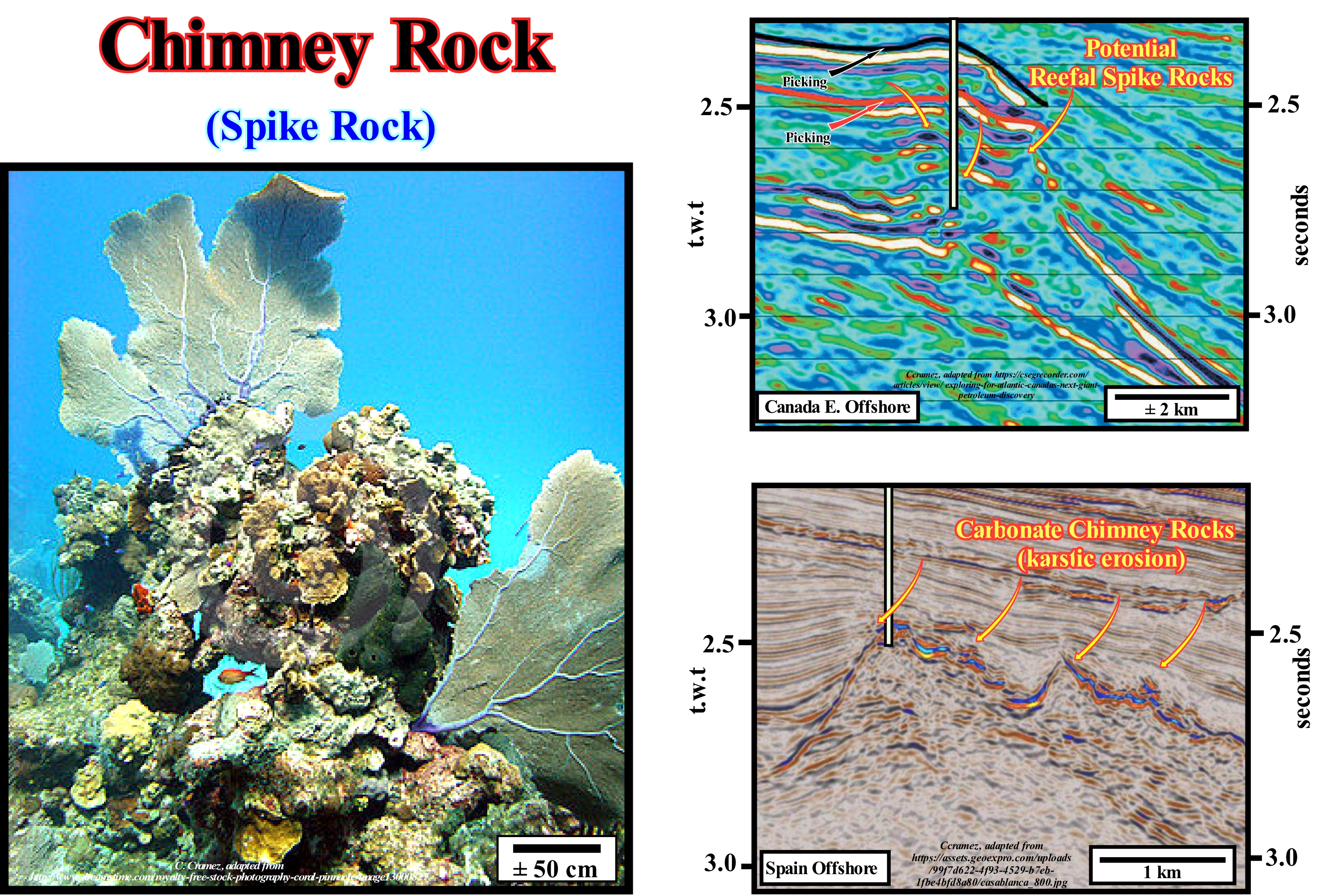
The photograph is part of a carbonate pinnacle about 30 meters high, where most of the chimneys exhibit multiple pinnacles. The porous structure of these organic constructions and the morphology of the external surfaces provide a fantastic habitat for micro-organisms and small animals to settle there. Usually, chimney rocks or pinnacles develop inside the lagoon of a building of corals. Whatever the shape of the reef, with no particular or linear shape (barrier reefs, annular reefs and others), they always have a number of common characteristics: (i) The external submarine slope (facing the sea) which may have more than 45 ° inclined and even having cornices is made up of living coral on the top, and on the base of dead coral and numerous debris amalgamated to the reef by calcareous algae ; (ii) The crest with Lithothamnion*, which forms the outer margin of the part of the reef that emerges, which only exists on the side where the waves break, since the Lithothamnion alga lives, in contrast to coral, in areas of violent surf (as Lithothamnion algae develop very well above sea level, they can exceed the level of properly coralline buildings, their appearance is very irregular and important for the integrality of the reefs, since they cement various pieces of calcium carbonate) ; (iii) The platform, which is a very irregular zone that only appears during low tide and is formed of dead coral on which small colonies of living coral flourish (in detail, the platform consists of a succession of micro-atolls in the centre of which the coral dies and disappears under the limestone sand, on the platform are formed islands of coral reefs that agglomerate in carbonate sandstones, which rival in height with the crest of Lithothamnion, the platform forms to the around the lagoon, with which it communicates, an internal slope); (iv) The internal slope is much less inclined than the external slope, and (v) The lagoon is a vertical succession of carbonated sand bottoms and pinnacles of living coral reaching almost the surface during low-tide, which proves that the coral lives perfectly in the lagoon; the depth of the top of the pinnacles within the lagoon varies approximately between 3 and 13 meters.
(*) Lithothamnion is a genus of thalloid red alga comprising 103 species. Its members are known by a number of common names. The monomerous (having one member in each whorl), crustose thalli are composed of a single system of filaments which grow close to the underlying surface. Lithothamnion reproduces by means of multiporate conceptacles. (https://en.wikipedia.org/wiki/Lithothamnion)

