
Artesian (Well)...............................................................................................................................................................................................................Artésien (Puits)
Poço Artesiano / Artesiano (pozo) / Bohrbrunnen / 自流井 / Артезианская скважина / Pozzo artesiano /
Well that allows water, flowing through a porous rock (at a certain depth), to rise to a given height above the surface of the soil. This happens when, locally, the pizometric surface* is above the topographic surface.
See: « Formation Water »
&
« Hygroscopic Water »
&
« Stream »
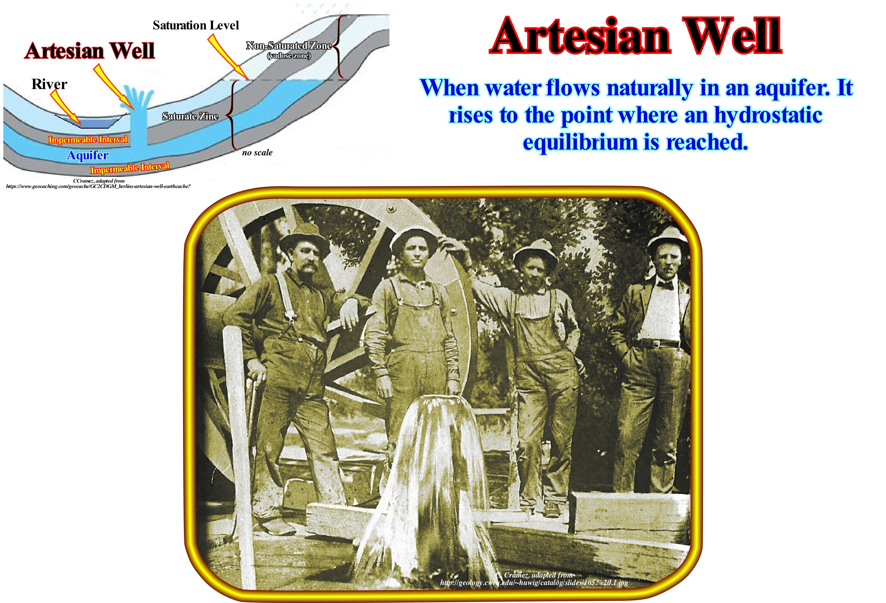
The artesian water production, which does not require any pumping, seems to defy gravity, but in reality the pressure, which accumulates between layers of rock, is released when the water finds a way into the open air. For hundreds of years, artesian wells have been drilled to utilize the cold and filtered water they produce from a relatively small depth. The artesian wells are so called due to wells that the Carthusian monks, around 1126, drill in the region of Artois (northern France) to stock up on drinking water. Geologically, an artesian well, as illustrated above, is a well that allows the flow of natural groundwater without any pumping being necessary, which implies that the pressure is sufficient for the water to reach the surface of the ground. In general the aquifer from which ground water is produced is a porous rock, such as a sandstone or limestone, which is sandwiched between two impermeable rock layers. This type of aquifer** is designated as captive or confined aquifer. In this way, the water retains sufficient pressure, that when it encounters an outlet, it overcomes the force of gravity and rises to the surface of the ground, as shown above (photograph and geological section). The recharge of an aquifer occurs when the water table or piezometric surface (upper level of the water of a saturated zone) in its recharge zone has an elevation higher than the elevation of the wellhead. Do not confuse aquifer (geological formation with good porosity and permeability, which allows the circulation and storage of water), with aquicluso, i.e., with a geological formation that stores water, but does not release it. An aquifer exposed in all its extension to the surface (recharge zone) and which is limited only by the lower impermeable layer is a free aquifer. Fossil water aquifers are artesian if the surrounding rocks exert sufficient pressure for the water to rise to the surface. That is, more or less, what happens when an oil exploration well encounters a hydrocarbon-saturated reservoir-rock, that is to say, that oil and gas only rise, naturally, to the surface if the pressure is large enough.
(*) The imaginary surface to which groundwater rises under hydrostatic pressure in wells or spring. The surface or ground level or water table of an aquifer is the altitude or depth, relative to the surface of the ground, of the boundary between the saturated and unsaturated zone of water in the aquifer.
(**) Continuous aquifers can be classified, depending on the pressure to which the water is subjected, in water tables or free and confined. In the former the water in the pores of the aquifer is under atmospheric pressure as if it were in an open-air reservoir. In the second, the aquifer is confined between two impermeable layers and the water is under a pressure greater than atmospheric pressure. They are the confined aquifers that can supply water to the artesian wells, to which the well's mouth is lower than the water table of this aquifer.
Arctic Delta..............................................................................................................................................................................................................Delta Arctique
Delta Árctico / Delta boreal, Delta Ártico / nördlich Delta / 北极三角洲 / Арктическая дельта / Delta artico /
When the delta plain is subject to annual climatic changes induced by the floods caused by the thaw and, in particularly, by the partial melting of glaciers.
See:« Delta »
&
« Delta Plain »
&
« Topset Bed (of a delta) »
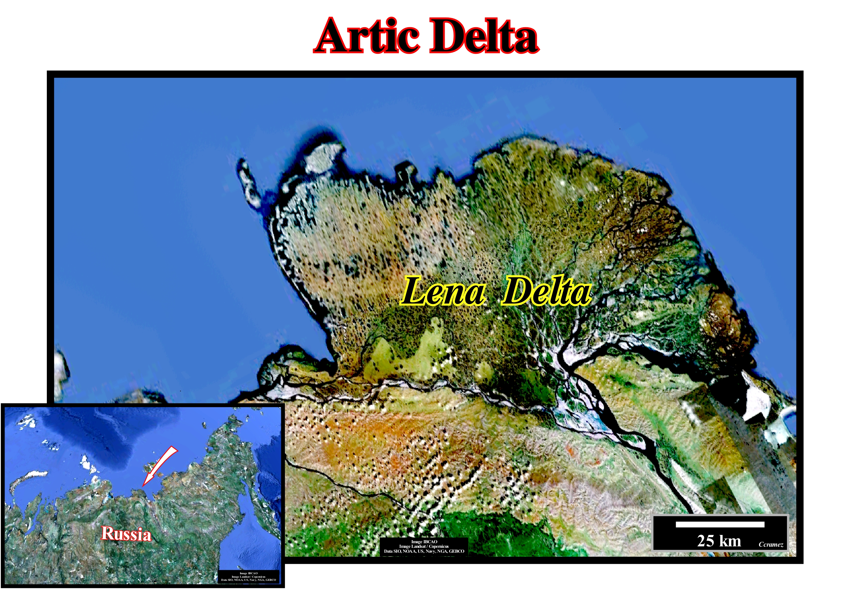
The Lena River is one of the ten largest rivers in the world. It begins westward of Lake Baikal (the lake with the largest volume of fresh water) and flows northward, for about 4,400 kilometers, along which it is fed by more than 2,500 tributaries. As it can be seen in this figure, its route ends in the Laptev Sea (Arctic Ocean), where it enters and where the sedimentary particles, which it transports, have created an important delta building. The main tributary rivers of Lena are: (i) Aldan with 2,273 km in length ; (ii) Vitin with 1,837 km ; (iii) Olekma with 1,436 km ; (iv) Vilui with 2,650 km; (v) Linde 804 km and (vi) Nyuja with 798 km. The first three tributaries come from the West, while the others come from the East. In the southern part of the hydrographic basin*, rain and groundwater are the main sources of water feed. In the northern part of the basin, on the contrary, the importance of snow is preponderant. As the river approaches the Arctic, the influence of the hake on water (groundwater included) is almost nil. During spring and summer flooding controls the water level, which is much lower during the fall. The Lena River discharges into the Sea of Laptev on average and, per year, about 540 km3 of water. It carries about 12 million tons of alluvial and about 40 million tons of dissolved material into the sea. The sedimentation of the delta building, whose thickness exceeds several thousands of meters, depends on the climatic conditions and, mainly, the thaw. The river gels from mid-October to mid-April. In mid-June the river flows freely to its mouth where the sedimentary particles it carries, whether by traction, saltation, suspension or dissolution, are deposited and form a huge delta building several kilometers thick. However, the thickness of the Lena delta building, which can reach several thousands of meters, the average thickness of the delta that compose it is around 30/50 m, i.e., that one must not confuse a delta with one deltaic building, as well as a prodelta (connected to the delta) with continental slope (connected to the deltaic building).
(*) The hydrographic basin or drainage basin is the drainage area of the main river and its tributaries.
Ascending Granular Flux...................................................................................Écoulement Granulaire Ascendant
Fluxo Granular Crescente / Flujo granular ascendente / Aufsteigende granulären Fluss / 递增颗粒流量 / Поднимающийся гранулированный поток / Flusso granulare ascendente /
Flow of an upward granular medium caused by the force of a fluid, which moves in or on top of the granular layer, in which the most important flow does not always occur in the upper part of the granular layer.
See: « Debris Flow »
&
« Turbulent Flow »
&
« Mud Flow »
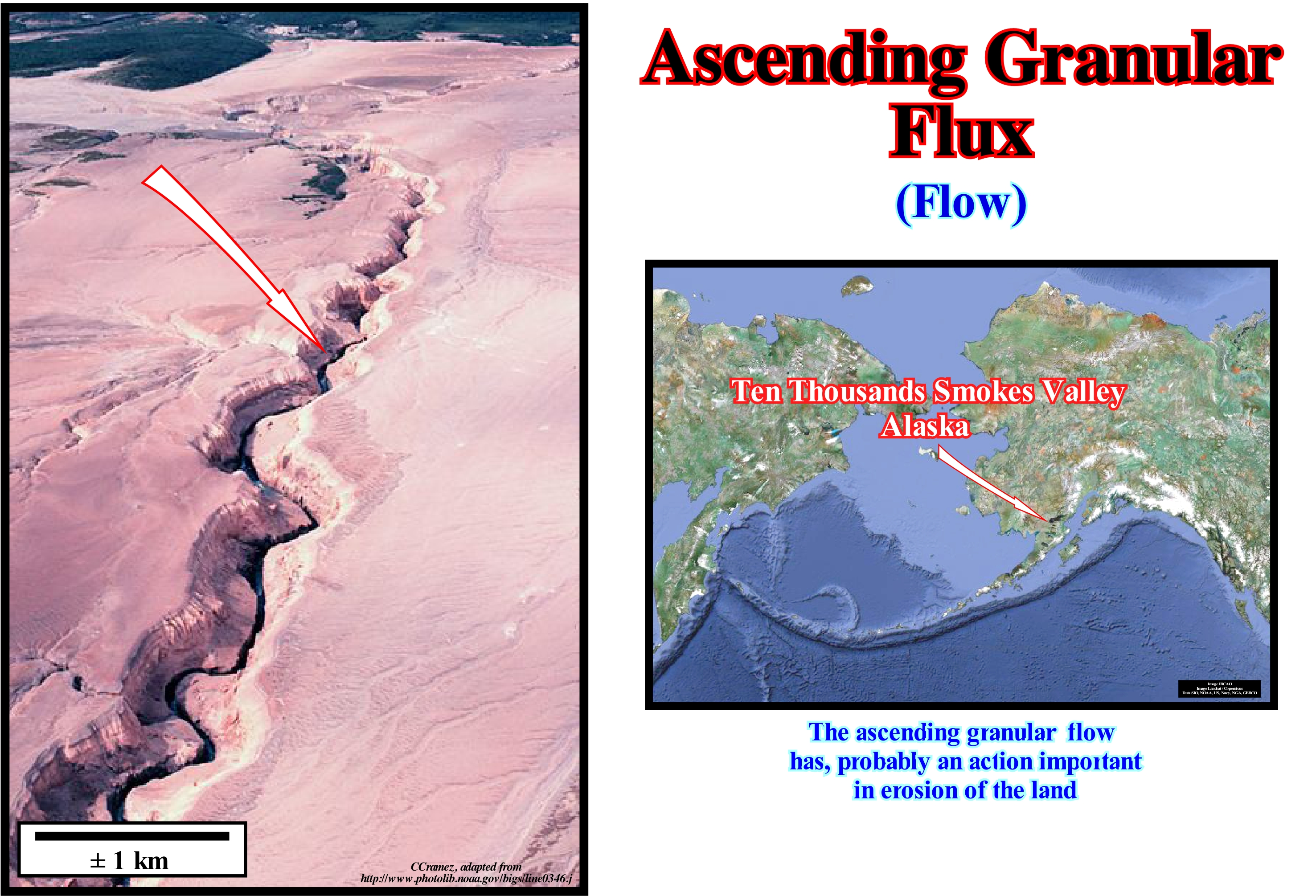
The response of a granular layer to the force of a fluid flowing through or over it has been the subject of much research for more than a century. This phenomenon is at the centre of a large number of geological and practical problems. The prediction of the granular flow for a known fluid flow is fundamental to understanding not only how beaches and deltas evolve, but also to understand how the mountains are eroded and how landscapes form. Certain sedimentary phenomena can not be understood without realizing the combined action of the fluid/granular flow (two phases). The microscopic details of the response of a layer when forced by a fluid raises important questions about: (i) The nature of the flow, near an irregular and or permeable wall ; (ii) The movement of a grain on a rough surface and (iii) The dynamics of the granular avalanches. Given some measures of the flow intensity of a fluid, geoscientists try to predict the granular flow from the properties of the granular material, such as size, shape, coefficient of friction, compaction, etc. An important aspect of the problem to consider first is the start of granular flow. As the granular stacking surface affected by gravity relative to the angle of rest, the granular layers driven by the fluid flow are considered static below a certain fluid flow threshold. Several empirical curves relate some measurements of the fluid that forces the beginning of the granular flow with the properties of the grains have been proposed. When the flow is turbulent, the forced bed is stochastic (random), but with data, the presence of a granular (even very small) flow can be detected for any mean value of the forcing fluid. Even when the flow is laminar, the rough surface of the floating granular layer generates a local fluid stress, yet deterministically related (time-dependent) of the surface of the sediment pack.
Ash Plume.................................................................................................................................................................................................Panache de Cendres
Pluma de Cinza / Pluma de ceniza / Esche Plume / 火山灰羽 / Поток пепла / Pennacche di cenere /
Cloud of pyroclastic which, often, lies at the vertical of an erupting volcano and that is, fundamentally, composed of volcanic ash and water vapour. The finer particles of an ash plume can be transported up to several hundred or even thousands of kilometers.
See: « Tephra »
&
« Volcanism »
&
« SDRs (Seaward Dipping Reflectors) »
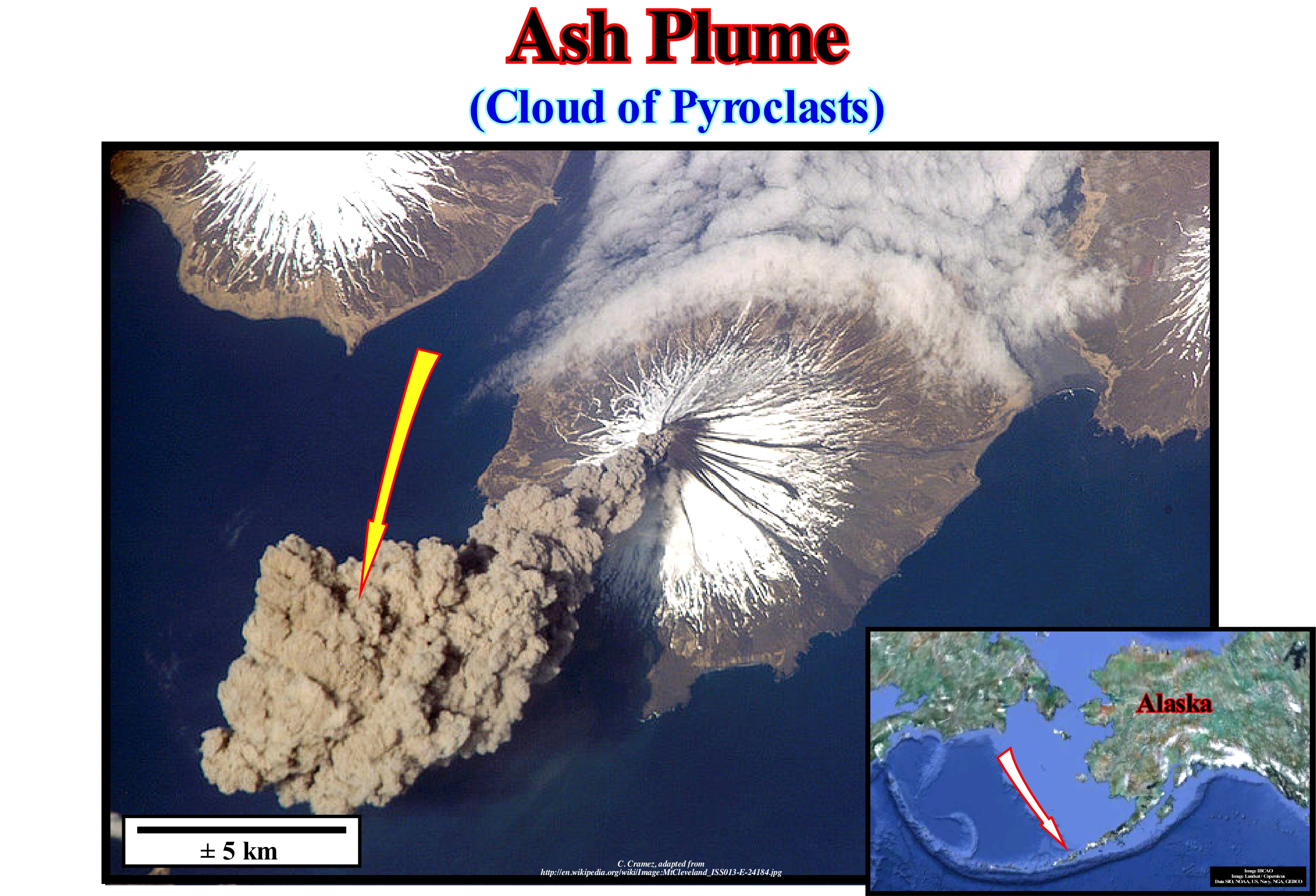
This figure illustrates an important ash plume on Cleveland Mount, which forms the western part of Chuginadak Island in the central part of the Alaskan Aleutian Islands. This mountain corresponds to a stratiform volcano, i.e., a high volcano, conical, composed by a succession of layers of lava, tephra and volcanic ash. This type of volcano called, also, composite volcano has very dipping slopes and periodic explosive eruptions. The lava forming this type of volcano is, generally, viscous and solidifies quickly. The magma forming the lava is of felsic nature, i.e., that it has a great amount of silica (like the rhyolites, dacites and andesites). The mafic magma is present, but in very small quantities. The volcanic ash forming the ash plume consists of tephra (pieces of rock and powdered glass created during eruptions) of small size. The particles are, generally, less than 2 millimetres in diameter. The violent nature of the volcanic eruptions, which involve water vapour, turns the magma and solid rocks around the cracks into clay-like particles and sand. Volcanic ash creates breathing problems in populations living close to the volcano and when they are very abundant can create a cooling of the global temperature, as appears to have been the case after the great eruption of Krakatoa on 26/27 August 1898, which liberated, according to certain geoscientists, about 13,000 times the energy released by the atomic bomb (13/16 kT) that destroyed Hiroshima during World War II. The ashes after falling to the ground, when cemented, form a solid rock that is called volcanic tuff. The more or less periodic ejection of large amounts of ash produces ash cones that can destroy many of the local ecosystems and lead to the collapse of habitations. As they create very fertile soils, populations, of course, are located around the volcanic regions which amplifies, in a significant way, the natural catastrophes.
Asphalt....................................................................................................................................................................................................................................................Asphalte
Asfalto / Asfalto / Asphalt / 沥青 / Асфальт / Asfalto /
Viscous liquid, usually, dark brown to black, or slightly melted solid bitumen, composed, almost entirely, of carbon and hydrogen. Asphalt is, easily, soluble in carbon disulfide. It has a colloidal structure and it is nonvolatile. Asphalt is thermoplastic at temperatures between 150° C - 200° C and has insulating and adhesive properties.
See: « Bitumen »
&
« Tar Sand, Oil Sand »
&
« Petroleum »
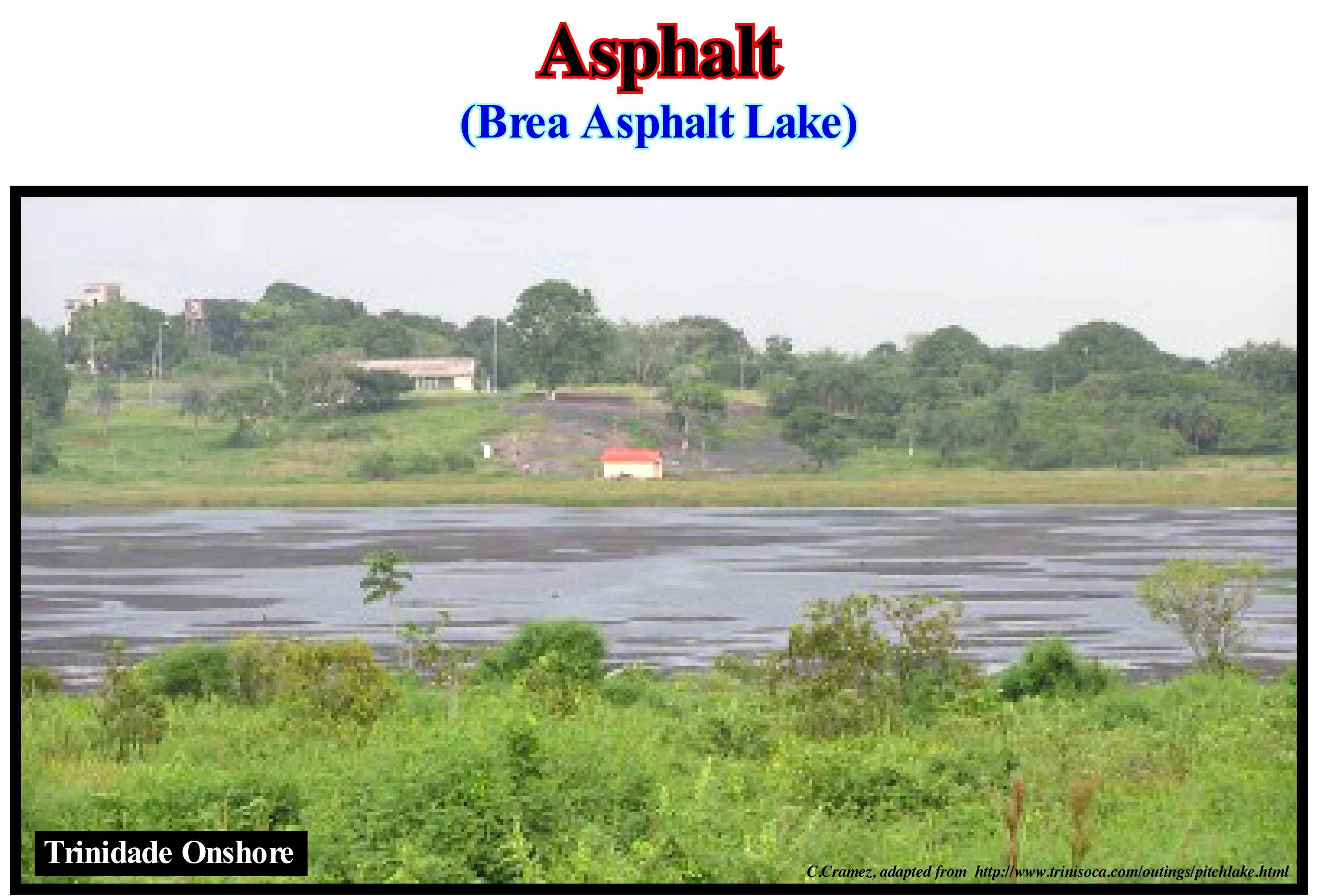
On the onshore of Trinidade, near the capital Port of Spain, the village of "La Brea" is famous for its asphalt lake, which is one of the three most important natural asphalt lakes in the world. It was the asphalt lake that gave the name to the village, since in Spanish, "brea" means asphalt or asphaltic sand. The remaining reserves of this lake are between 6 and 10 Mt (millions of tons), which, at the rate of current extraction, gives reserves for about 400 years. The other important asphalt lakes are: (i) "La Brea Tar Pit" in California and (ii) "Menes *" in Venezuela, where there are several asphalt lakes with varying dimensions. The Menes have conditioned oil exploration in this country. In fact, in Venezuela, most of the non-heavy oil reserves were discovered by drilling "the menes" or the surrounding areas. The same seems to have happened on the island of Sumatra. Many asphalts occur as viscous impregnations in sandstones, siltstones and limestones. In most cases, these occurrences are considered to be old oil reservoir rocks, in which the lighter constituents (more volatile constituents) have disappeared along the migration or since they were exhumed. Relatively pure asphalts are known in California. Although asphalt exudations have been known for a long time in various parts of the world (there are several references in the Old and New Testaments), the most well known and greatest are those of Venezuela and Trinidad. As asphalt can be extracted from petroleum in commercial quantities by the removal of volatile components, it is an inexpensive building material for cementation and waterproofing. Three distinct types of asphalt are extracted from petroleum residues: (i) Used in road paving (almost viscous runoff); (ii) The one used to insulate the roofs, coat pipes, paints and laminated paper (weaker viscosity) and (ii) One with very limited applications since its viscosity is temperature dependent.
(*) Mene is the name given by the indigenous populations of Venezuela to an exudation of oil.
(**) According to some of our Japanese friends and colleagues (who worked in the Mitsubishi company in the 1970s) the asphalt exudation near the east coast of Sumatra (about Singapore latitude) were known to the Portuguese navigators who called them "Minas de Asfalto", which they used to caulk the boats. This is how a small village in this area came to be known (and still is today) as Minas. At the beginning of the Indonesian invasion, the Dutch attempted to destroy most of the oil installations to prevent them from being used by the Japanese invaders. At the end of March 1942, the Japanese army had full control of the oil fields. During the rest of the war years, the Japanese not only produced the known oil reserves, but drilled a few wells. In 1944, they drill the discovery well of a gigantic accumulation of oil, which they, of course, called Minas. However, the location of this well appears to have been prepared in 1941 by Caltex ("California Texas Oil Company"). The Japanese held total control of the oil field in Indonesia until 1945.
Asphaltite..................................................................................................................................................................................................................................Asphaltite
Asfaltito / Asfaltito / Asphaltit / 沥青岩 / Асфальтит (твердый битум) / Asphaltite /
Set of hydrocarbons, generally, solid of dark colour, in the cracks and fractures of the sedimentary deposits or crystalline aggregates. Any of the solid natural bitumens soluble in carbon disulfide and melting above 110° C is regarded as an asphaltite.
See:« Bitumen »
&
« Hydrocarbon »
&
« Seep »
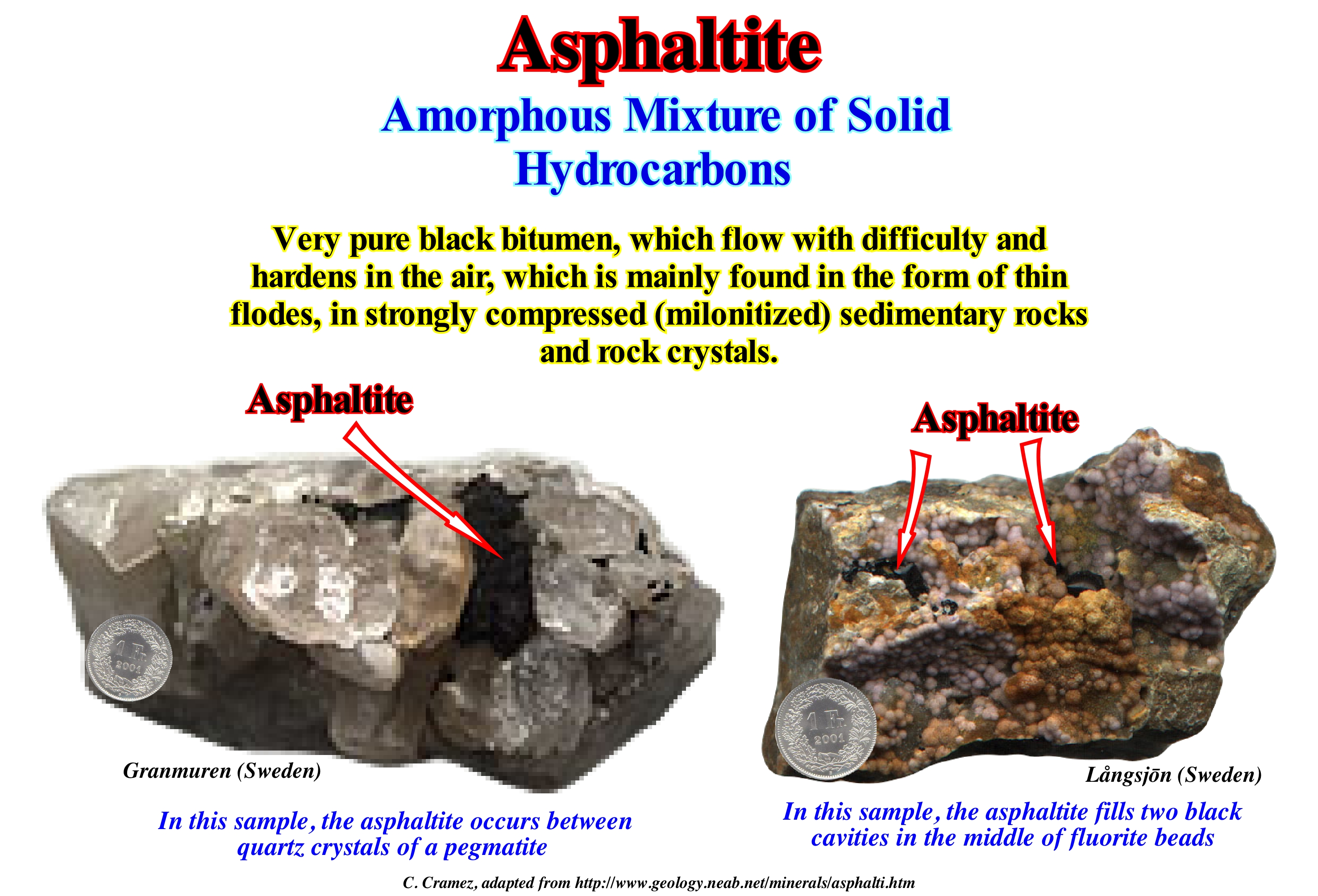
In this photograph, the asphaltite, which is a mineral, is associated with rock crystals. This organic mineral has a very varied chemical composition, once, that it corresponds to a mixture of hydrocarbons. The asphaltite is amorphous and, in general, black in colour. It can occur as a liquid or viscous mass, but usually hardens when exposed to air. Asphaltite is often found in association with pegmatites and milonitized zones (fracture zones, sometimes active along which rocks are crushed and crushed), through which deep hydrocarbons migrate to the surface. Three varieties of asphaltites can be distinguished: (i) Gilsonite, which is a registered trademark used for a natural black bitumen used in the manufacture of acids, alkaloids, and impermeable coatings ; (ii) Grahamite, which is a solid, black, hydrocracked, fissured, soluble in carbon disulfide and chloroform and (iii) Bright Tar, which is a variety with a bright, conchoidal fracture that resembles gilsonite, but which has a higher density and a higher percentage of carbon. The great majority of geochemists consider that the asphaltites are derived from a salt lake sapropel* and that their properties are function of the deposition environment where they formed. The asphaltites fuse with difficulty, while the asphalts fuse easily. Asphalts occur with or without appreciable percentages of mineral matter, while asphaltites often have very little associated mineral matter. Asphaltites are common in the Uinta basin (Colorado, USA), where they are considered to be derived from the Upper Eocene sediments of the "Green River" formation, which is formed by petroleum silts with high carbonate content.
(*) Aquatic sediment rich in organic matter and formed in an oxygen-poor sedimentation environment as a body of stagnant water.
Asthenosphere.............................................................................................................................................................................................Asthénosphere
Astenosfera /Astenósfera / Asthenophere / 软流圈 / Астеносфера / Astenosfera /
External zone of the Earth's mantle. The asthenosphere is situated under the lithosphere. It is much less rigid than the lithosphere. The asthenosphere has a plastic behaviour due, probably, to a partial melting of the mantle material. It is in the upper part of the asthenosphere, where the velocity of the seismic waves is relatively low, that are located the tectonic plates which form part of the lithosphere.
See: « Lithosphere »
&
« Crust »
&
« Earth »
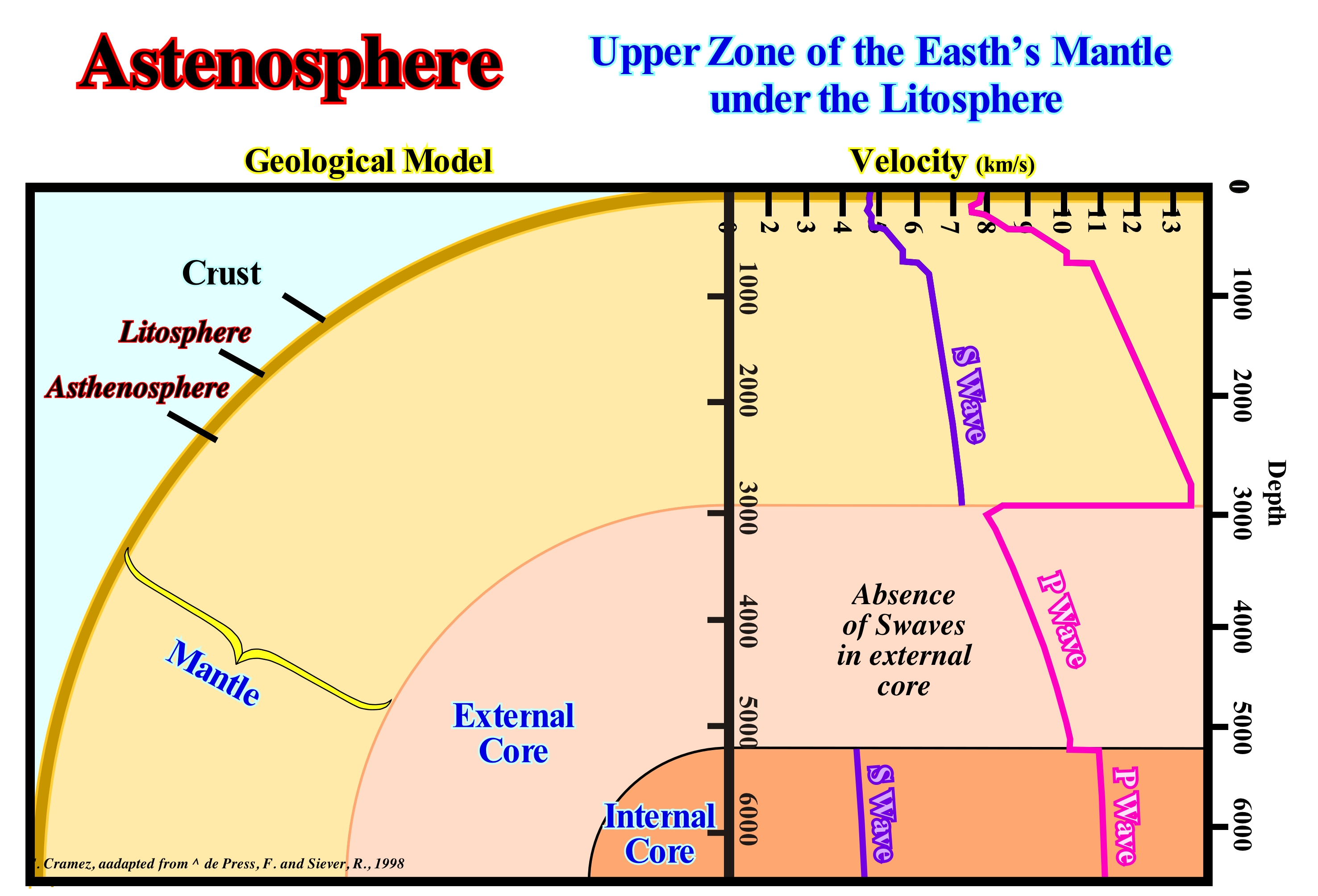
The Earth has a diameter of 12,714 km, along the poles and 12,756 km, along the equator. The Earth has a mass of 5.9736 x 1024 kg, a volume of 1,083 x 1027 cm3 and an average density of 5.517 g/cm3 (close to the surface of the continents, it is about 2.7 g/cm3 at the ocean floor, about 3.0 g/cm3). The Earth is a differentiated planet, that is, the material components that form it are separated and segregated according to their density. The denser materials are concentrated near the centre and the less dense materials near the surface. The different layers are recognized on the basis of their compositions and their physical properties. Thus, it can be said that the Earth consists of three concentric layers with different petrographies: (i) Crust (continental and volcanic, which may be subaerial or oceanic) ; (ii) Mantle and (iii) Core. On the basis of physical properties (rheology), the Earth can be divided into: (a) Lithosphere; (b) Asthenosphere; (c) Mesosphere and (d) Core. The boundary between the mantle and the core is marked by an abrupt decrease in the velocity of the P waves (compression waves) and by a non-propagation of the S waves (shear wave), which strongly suggests that the inner core is probably, liquid. The boundary between the crust (or crust) and upper mantle is marked by an increase in the velocity of the seismic waves (above the low speed zone or LVZ zone). Thus, when one speaks of asthenosphere and lithosphere, that is, of the rheology of the layers, they may contain one or several petrographic divisions. The lithosphere, for example, includes the crust, which can be continental or volcanic and the upper part of the mantle. The asthenosphere, which in Greek (asthenēs) means weak sphere, is under the lithosphere. It has an average thickness of 200 km and is characterized by a temperature and pressure large enough that part of the rocks that constitute it, lose resistance and merge, which allows them to flow sideways and vertically. The depth of the asthenosphere depends directly on the thickness of the lithosphere, which varies between about 100 km under the oceans (some kilometers above the ocean ridges) and about 170 km under the continents. The distinction between the lithosphere and asthenosphere is based on the mechanical behaviour of the rocks. The transition from one area to another is, generally, defined by the isotherm of plus or minus 1,350° C, since at such a temperature, most of the rocks become ductile, which allows the upper layer or the lithosphere to move. The upper part of the asthenosphere is called the low velocity zone ("LVZ").
Astronomic Theory of Paleoclimates......................Théorie Astronomique des Paléoclimats
Teoria Astronómica dos Paleoclimas / Teoría astronómica de los paleoclimas / Astronomische Theorie der Paläoklimate / 古气候天文学理论 / Астрономическая теория палеоклиматов / Teoria astronomica di paleoclimates /
Theory suggesting that climate change are governed by insolation variations*.
See: « Climatology (Modern) »
&
« Milankovitch Cycle »
&
« Glacio-Eustasy »
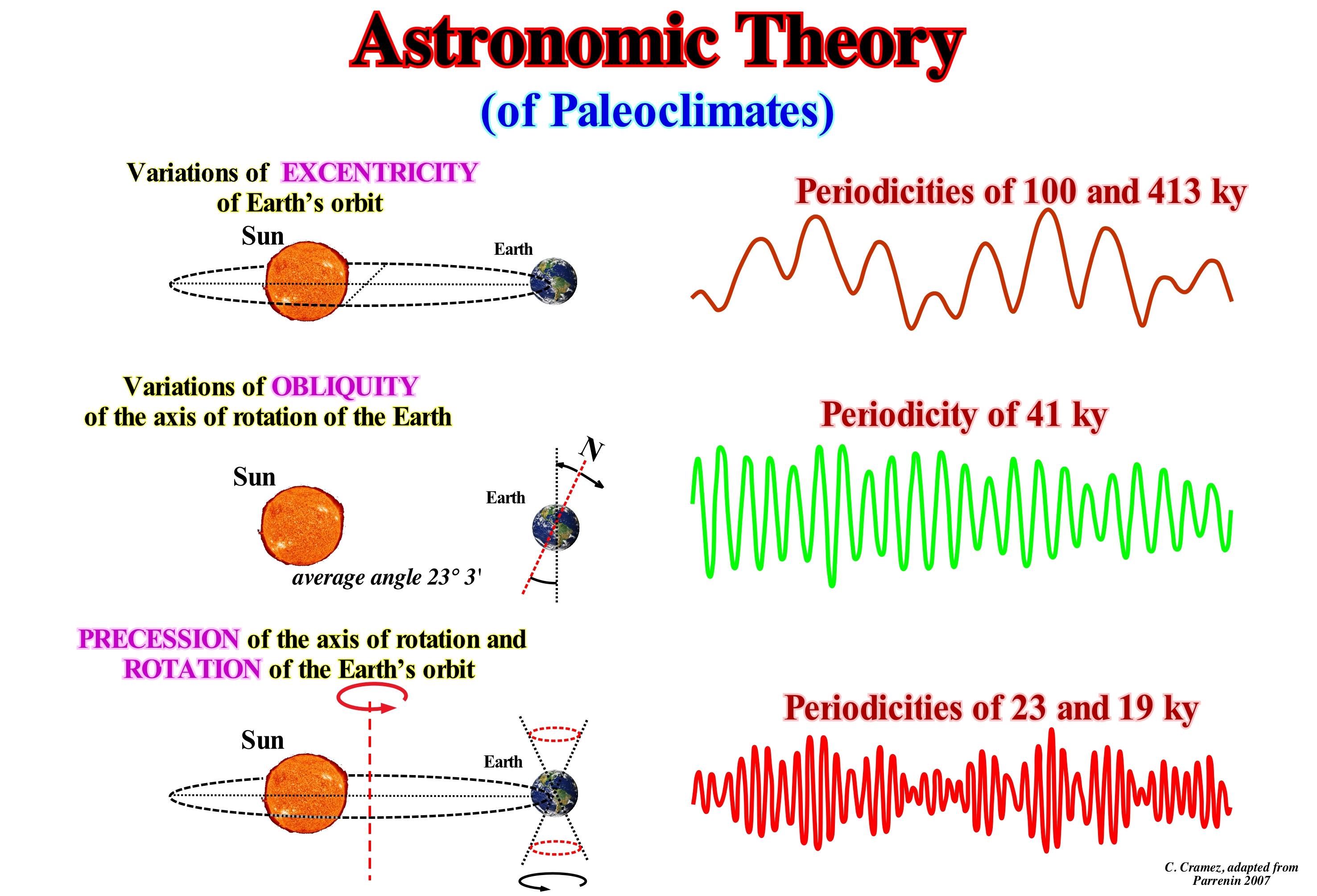
The astronomical theory of paleoclimates explains climatic variations occurring, periodically, between tens and hundreds of thousands of years. Such variations are recorded in deep-marine sediments, ice caps and continental rocks. The origin of these climate cycles lies in the variations of the solar energy that Earth receives. Certain of these changes are amplified by retroactive mechanisms, which characterize the natural behaviour of the climate system, such as albedo (ratio of the amount of electromagnetic energy reflected by a surface to the amount of reflected energy, which in the particular case of energy solar received by the Earth is the ratio of solar energy reflected and received by the Earth's surface), water vapour** and vegetation-temperature relationships. The majority of climate models use three main parameters to explain the chain of processes that determine climatic variations at the geological scale (tens/hundreds of thousands of years). They are illustrated in this figure: (i) Eccentricity Variations of the Earth's orbit, as the Earth passes all six months, alternately, in the perihelion (closest to the Sun) and in the aphelion (point far from the Sun) is the difference between these two distances that determines eccentricity ; (ii) Variations in the Obliquity of the Earth Rotation Axis (variations in the angle between the axis of rotation and the plane of the orbit, which remains confined between 21.8° and 24.4°, i.e., the axis of rotation oscillates around a cone with a complete cycle that lasts 25,765 years) and (iii) Precession of the Rotation Axis (rotation axis change or gyroscopic effect) and Rotation of the Earth Orbit, due to the inclination of the axis and the translation of the Earth around the Sun. At the poles, there is alternation between the period of sun and darkness. It was Milankovitch the first geoscientist that show insolation variations are, mainly, controlled by these three factors. The eccentricity of the Earth's orbit ellipse has two cycles: (a) 413 ky and (b) 100 ky. The obliquity of the axis of rotation of the Earth has a cycle of 41 ky and the precession of the axis of rotation has periods of 23 ky and 19 ky corresponding to the frequency of the decimetric alternations observed in the outcrops of the sedimentary rocks. Although the astronomical theory of the paleoclimates (also known as the Milankovitch theory) explains a number of important points of paleoclimate (especially frequency and distribution) such as the thickening (advance) and thinning (retreat) of glaciers. It faces a number of problems that remain to be solved, such as the great amplitude of 100 ky of glacial cycles, the change from 41 ky to 100 ky of the great glaciations about a million years ago. From the astronomical theories proposed to explain the origin of the glacial epochs, previous to the Milankovitch theory, the theory of the British scientist James Croll (1821 - 1890), that developed the first theory of the climatic changes based on the changes in the orbit of the Earth, must be cited (https://it.wikipedia.org/wiki/Teoria_ astronomica_delle_glaciazioni). According to Croll, the origin of secular climatic variations must be sought in secular variations in the Earth's orbit, combined with the precession of the equinoxes and the displacement of perihelion, however, and to the difference of Milankovitch, later he did not ascribe to changes in elliptical slope: (i) The eccentricity of the orbit depends the different duration of the seasons, whereas the precession depends on the position of the spring equinox, and therefore, the winter in a given hemisphere will happen to the Earth in perihelion or aphelion ; (ii) Whatever the eccentricity and position of the equinox, the total amount of solar radiation that receives a hemisphere is equal to the quantity received in the opposite hemisphere. Intuitively, it is understood that if during a half revolution the Earth is closer to the Sun and the greater the intensity of the radiation received ; (iii) During the other half of a revolution, the intensity of the radiation is lower, but the duration of sunshine is longer ; (iv) As the duration of the two winter is not the same, it will not be equal to the average daily intensity of the radiation received by the two hemispheres during the respective winter ; (v) One hemisphere will have a long, cold winter, the other a short and relatively warm winter. Precession, combined with the displacement of perihelion, changes in the two hemispheres every 10,500 years approximately, and each hemisphere must therefore have a glaciation interspersed with interglacial periods, over a complete period of 21,000 years, and the (in this sense, the Croll theory does not differ much from that of Joseph Alphonse Adhémar (Paris, February 1797 - Paris, 1862).
(*) In meteorology, insolation means the quantity of solar energy received, but can be, also, synonymous with sunshine, that is to say, the duration of exposure of a site to the Sun.
(**) Although the media (social communication), but also many of the geoscientists working and receiving funding from the Intergovernmental Panel on Climate Change (IPCC) are always saying, that an CO2 increasing in the atmosphere generates a rise of terrestrial temperature, science can not corroborate this since the atmosphere contains very little CO2 (about 0.037%), which absorbs less energy than water vapour and much less than water droplets from the clouds. My mother that was not a geoscientist always said " as the sky is starry, it will make cold, so you must take another blanket to bed."
Astronomic Unity.................................................................................................................................................................Unité Astronomique
Unidade astronómica / Unidad astronómica / Astronomische Einheit / 天文单位 / Астрономическая единица / Unità astronomica /
Average distance between the Sun and Earth. The symbol of the astronomical unit is Au,
See: « Sun »
&
« Earth »
&
« Early Universe »
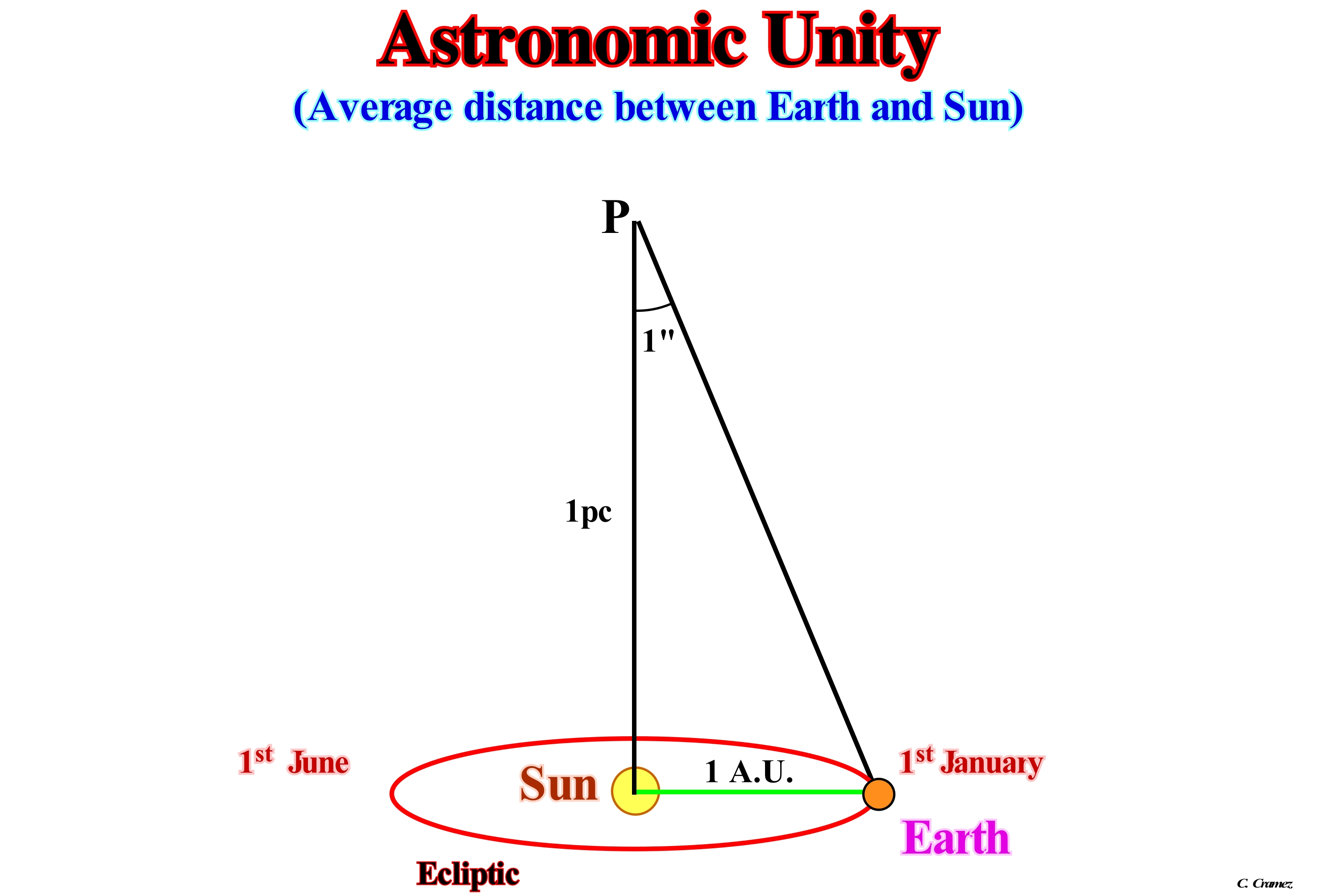
In astronomy, the astronomical unit (AU) is a unit of distance, more or less equal to the average distance between Earth and the Sun. As illustrated in this figure, it is widely used to describe the orbit of planets and other celestial bodies in the planetary astronomy, which is approximately 150 million kilometers (14 9597,870 km). The astronomical unit is the radius of the circular orbit of a planet of negligible and disturbance-free mass whose average motion is "K" radians per day around the Sun, where "K" is the Gaussian gravitational constant, with the unit of time of the solar day and the unit of mass, the mass of the Sun. This unity is then related to the dimensions of the solar system and to the movement of the Earth. In practical terms, the astronomical unit can be defined as the average distance between the Earth and Sun. Its accepted value is currently: 150 000,000 km. One light year = 9.5 x 10¹² km = 9.5 trillion km = 9.5 billion km and one parsec 1 parsec = 3.26 a.l. (light-years). Thus, it can be said that 1 UA = 150 Mkm. It was in the second century BC that the Greek astronomer Hipparchus attempted to make the first known calculation of the distance between Earth and Sun, taking advantage of the total eclipses of the Moon. His method, however, was rather imprecise and resulted in several inaccurate values. At the beginning of the seventeenth century, determination of the distance from Earth to Sun was the most important of astronomy. Edmund Halley proposed a method based on the parallax of the observation of two astronomers located far from each other to observe the transit of Venus on the solar disk. It is best to evaluate this distance. However, given the rarity of the phenomenon, it was only in 1631 and 1639 that this phenomenon occurred and then it was possible to apply the Halley method to calculate it as being about 150 million kilometers. Currently, modern methods of deflection of the radio waves are used for a more precise evaluation of this distance. By definition, the astronomical unit is dependent on the heliocentric gravitational constant, which is the product of the gravitational constant G and the solar mass M. Neither G nor M can be measured with great precision in SI units, but the value of its product is known observing the relative position of the planets (Kepler's third law). Only the product is needed to calculate planetary positions for an ephemeris*, which explains why ephemeris are calculated in astronomical units rather than in SI units.
(*) A an ephemeris from the ancient Greek "ἐφημερίς" , meaning every day. Ephemerides (plural of ephemeris) are astronomical tables by which we determine, each day, the value of a characteristic quantity of a celestial object, as for instance the trajectory of naturally occurring astronomical object as well as artificial satellites in the sky , i.e., the position (and possibly velocity) over time.
Astronomical Cycle...........................................................................................................................................................Cycle astronomique
Ciclo Astronómico / Ciclo astronómico / Astronomische Zyklus / 天文周期 / Астрономический цикл / Ciclo astronomico /
General term for the each of the cycles: (i) Exccentricity of Earth's orbit (± 100,000 years) ; (ii) Precessionof the Earth's axis rotation (± 19,000/24,000 years) and (iii) Inclination of the axis rotation (± 40,000 years). The astronomical cycle, due to the alternation of the angles and distances from which the solar energy reaches the Earth, changes the period of global warming and cooling, affecting the movement of glaciers, ice caps and inlandsis. Astronomical cycle produce significant variations of the space available for sediments (accommodation) in accordance with the sea level changes.
See: « Milankovitch Cycle »
&
« Astronomic Theory of Paleoclimates »
&
« Equinoxial Precession »
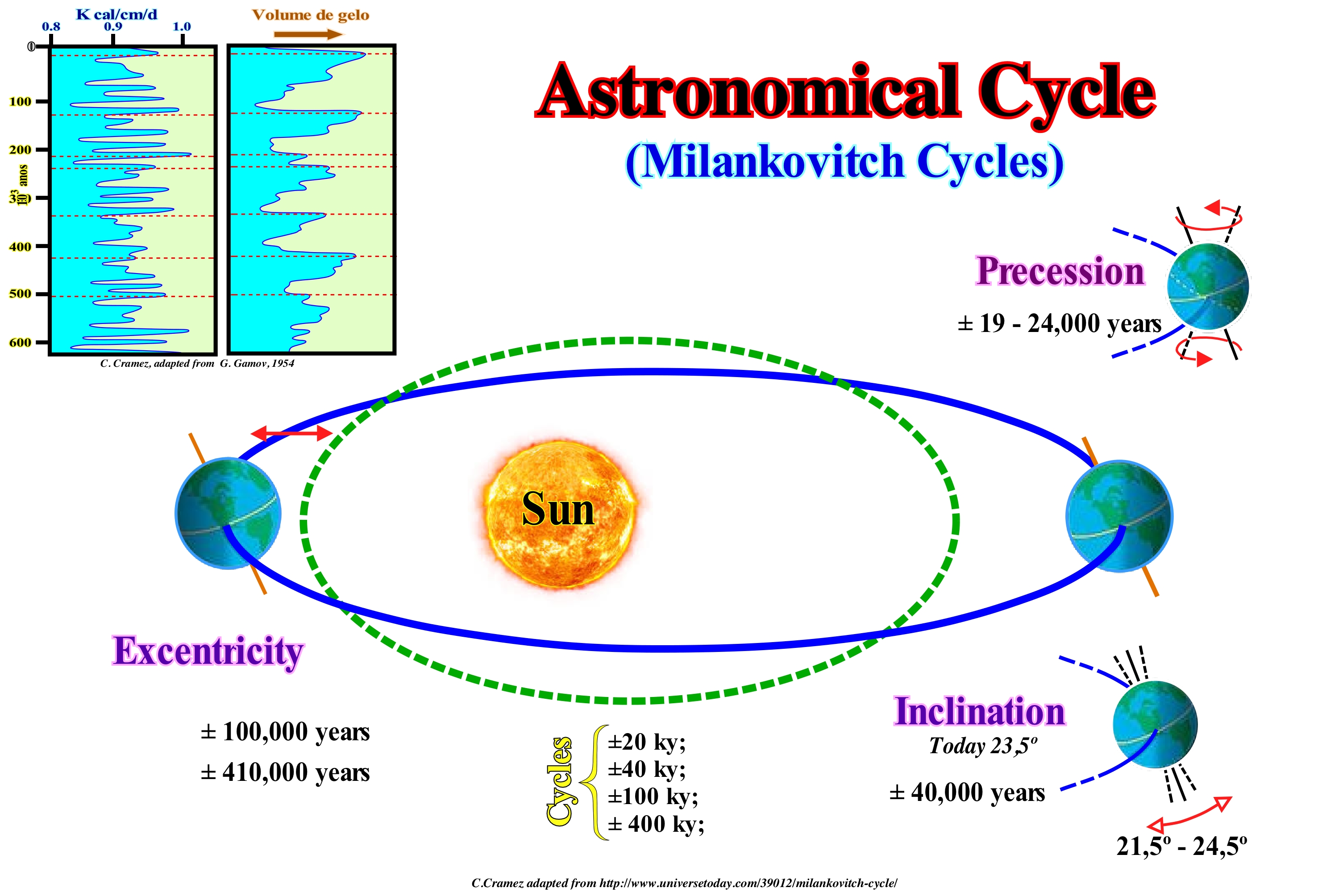
In 1941, the mathematician Milutin Milankovitch formulated a theory on glaciations, in which climate changes* are the result of the fluctuations of the seasons, determined by the variations of Earth's orbital elements: (i) Eccentricity, which corresponds to the shifting from an orbit of the circular form, which varies between 0 and 1 (the eccentricity of the Earth's orbit is, on average, 0.0167) ; (ii) Inclination of the Rotation Axis and (iii) Latitude of the Perihelion, i.e., of the point where the Earth is closest to the Sun (precession of the Earth's perihelion). Milankovitch identified two major astronomical cycles with durations of 60 ky and 120 ky. The so-called Milankovitch curve, constructed from the analysis of variations in the Earth's orbit, represents the amount of solar energy received at a given latitude. It corresponds to the insolation curve, generally, at 65° of latitude and a certain geological time. Geoscientists tested Milankovitch's hypotheses by analysing the sedimentary cycles but failed to refute them. They have taken samples from the sea-floor and measured the isotopic ratios at various points (carbon isotopes, for example, provide information about the paleo-productivity and nutrient availability in the oceans and lakes, just as they are used to estimate paleo-temperature and paleo-salinity in a sedimentary basin, over geological time). They found that the isotopic ratios were cyclical and dating the samples from the cores, they found that the most frequent cycles are 23 ky, 60 ky and 120 ky. Recently, in a core of Triassic rocks (> 200 million years old), geoscientists found that the smallest sedimentary intervals in the core had more than 20,000 varves and that the precession cycle (in the Triassic) was about 20 ky. As the Earth rotates, the Earth's axis does not align with the ecliptic axis. It precesses around it, just as a spinning top precesses about the vertical axis to the ground. Precession has no major effect on the stations, since the Earth's axis maintains its slope** of 23.5° from the ecliptic axis while precessing around it. The precession of the axis of rotation of the Earth is caused by the disturbances of the Moon and the Sun in the oblate Earth. It causes , at the time of a season, the Earth is in a different position in the orbit around the Sun, with the passage of time. The precession of Earth's perihelion is, mainly, caused by the gravitational perturbations of the giant planets, Jupiter and Saturn over the Earth's orbit. These disturbances make the precession to the Sun have a period of about 21,000 to 23,000 years, and not in the period of 25,770 years of precession to the stars. This effect, from the change of perihelion date, has little influence on the seasons, at the present time. The eccentricity of the Earth's orbit ranges from almost 0 (current 0.017) to about 3 times the current (0.07), on a time scale of the order of 100,000 years. Precession is the change in the axis of rotation of an object, which can be explained by the vectorial analysis of the torque*** and the angular momentum (amount of movement associated with an object that executes a rotation movement around a fixed point). At present, Earth has a precession cycle of 25,770 years, which corresponds to the variation of the ecliptic in relation to the equator line. Geoscientists have found that the precession cycle is modulated by an eccentricity cycle of about 100 ky, since five groups of short intervals formed a larger hierarchy interval. Likewise, they failed to refute the eccentricity cycle of 400 ky, since the largest sedimentary intervals were formed by four intervals of lower hierarchy. In the scientific method, what counts is refutation and not validation. No physical measure is represented by a single number but by a range of numbers (imprecision). In science, not just any "empiricism/theory" confrontation can be made without the calculation of uncertainty. Also, no scientific theory is corroborated or refuted in an absolute way and much less verified. The variation of perihelion, precession and eccentricity of the Earth's orbit around the Sun are due to the effects of many bodies in the solar system. Another effect of many bodies is that of the obliquity of the ecliptic (from 22.1° to 24.5 °), around the mean value of 23.4°, with a period of the order of 41 thousand years, known as the cycle of Milankovitch, was proposed in 1920 to explain the ice ages. Evidence suggests that the most important climate cycle is of the order of 100,000 years, which coincides with the cycle of eccentricity. On the other hand, the variation of the eccentricity alone is a factor that less influences the variation of the sunshine on Earth.
(*) Climate is the set of physical conditions that reign in the atmosphere over a more or less, important period (30 years) chosen in function of the variability of the phenomena that are wanted to study. The meteorology studies the evolution of the weather that it does in the short term, whereas the climatology studies it in the long term. Take into account both the duration and the magnitude of the climatic changes, several geoscientists proposed the following hierarchy : (i) Pulsations, that last a few years or a few decades and which are perfectly reversible (e.g., series of years of raining or drought) ; (ii) Oscillations, that last from a few centuries to a few millennia, but are reversible (e.g., the Little Ice Age) ; (iii) Fluctuations, that are spread out over tens, hundreds of thousands of years and have mark cyclic character (e.g., the evolution of the Quaternary) ; (iv) Mutations, that lasted millions, tens or hundreds of millions of years that have a irreversible character (e.g., irreversible upheavals of the Earth’s surface).
(**) Inclination of the Earth's axis is, certainly, the result of the collision of the Earth with an asteroid at the beginning of the formation of the solar system.
(***) When a force F applied at a point P, with respect to a point O, the binary or torque is the product of the intensity F of the force by the distance d from the point O to the line of action of the force.
Atmosphere..................................................................................................................................................................................................................Atmosphère
Atmosfera phère / Atmósfera / Atmosphäre / 气氛 / Атмосфера / Atmosfera /
The layer of gases envelopping a celestial body whose mass is sufficient to induce a gravity force able to retain it. Such a retention depends on the value of gravity and temperature of the atmosphere. Higher the force of gravity and lower the temperature, more stable will be the atmosphere around a celestial body.
See: « Earth »
&
« Supernova »
&
« Big Bang (theory) »
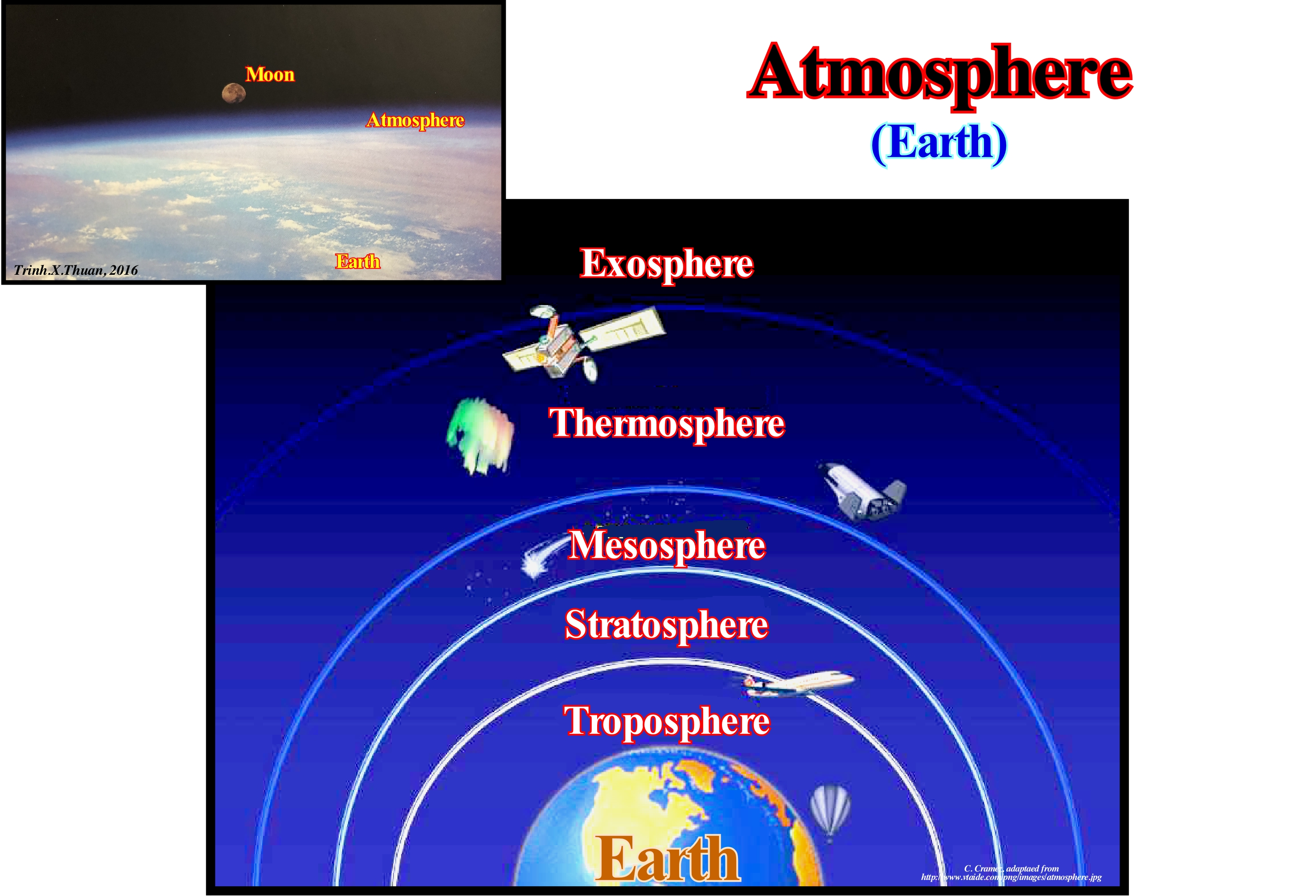
The atmosphere is the envelope of gases that surrounds a planet that it holds because of its pulling force. In addition to providing an essential supply of oxygen, the Earth's atmosphere also controls the temperature and protects it against the effects of solar radiation, making life possible. Changes in atmospheric conditions: (i) Movement (wind) ; (ii) Temperature ; (iii) Water content ; (iv) Precipitation (rain), constitute the climate. Concerning the chemical composition of the atmosphere, three main components are evident: (a) Nitrogen; (b) Oxygen and (c) Argon, as well as a large number of secondary components, among which carbon dioxide, helium, neon, krypton, xenon, hydrogen and oxides of nitrogen. Many other components exist in the form of traces due to volcanic and industrial activity. The temperature variation of the atmosphere is complex. The gradient corresponding to a drop in temperature in the first kilometers above the Earth's surface, is then reversed several times, which allows the sub-dividing of the atmosphere into several layers separated by the so-called pauses or inversions. The closest layer of Earth, which marks the climate, is the troposphere. Above the troposphere lies the stratosphere, which stretches between 10-16 km to, or about 50 km. The mesosphere is located above the stratosphere, more or less, between 55 km and 80 km. The mesosphere contains the mesopause and a large part of layer D, which is a region of low ionization. Above the mesosphere, the thermosphere is bounded by more or less 80 km of altitude and the edge of the atmosphere. It is in this last layer of the atmosphere that it receives from the Sun an enormous amount of radiant energy, that happen nocturnal luminous phenomena particular, as, for example, auroras. The outermost part of the atmosphere is the exosphere, which has very few molecules with an appropriate velocity to escape into interstellar space. The pressure exerted by the weight of a planet's atmosphere is called atmospheric pressure. The atmospheric pressure and the density decrease rapidly, more or less, exponentially with altitude. Atmospheric pressure is low in cyclones and high in anti-cyclones. Solar energy is radioactive. The Sun's temperature (± 5,377 ° C) explains its wide spectrum, ranging from ultraviolet (UV) rays to infrared (IR) through the visible spectrum. The part of this energy that is intersected by the Earth is, on average, 342 W / m2. Before the solar energy enters the atmospheric envelope it is filtered. In the stratosphere, a first filtering is done, with the intersection of a portion of ultraviolet (UV) waves by ozone, which absorbs about 22% of energy. The remaining 72% enters the troposphere but a substantial part (about 26% of the initial energy) is absorbed or reflected by the numerous particles that are there, as well as by the top of the clouds (atmospheric albedo). Thus, the initial solar flux is reduced to about 52%. Since it reaches the oceanic or continental substrate, about 5% is reflected (surface albedo), meaning that due to the atmosphere just 47% of the initial solar energy reaches the surface of the Earth.
Atoll.........................................................................................................................................................................................................................Atoll, Île Corallienne
Atol / Atol / Atoll / 环礁 /Атолл (кольцеобразный коралловый риф) / Atollo /
Low island, formed by annular coral reef, continuous or interrupted by small channels, involving a shallow central lagoon. At the bottom of the lagoon grow corals, often, in pinnacle forms or in spherical shaped heads.
See: « Atollon »
&
« Reef »
&
« Lagoon »
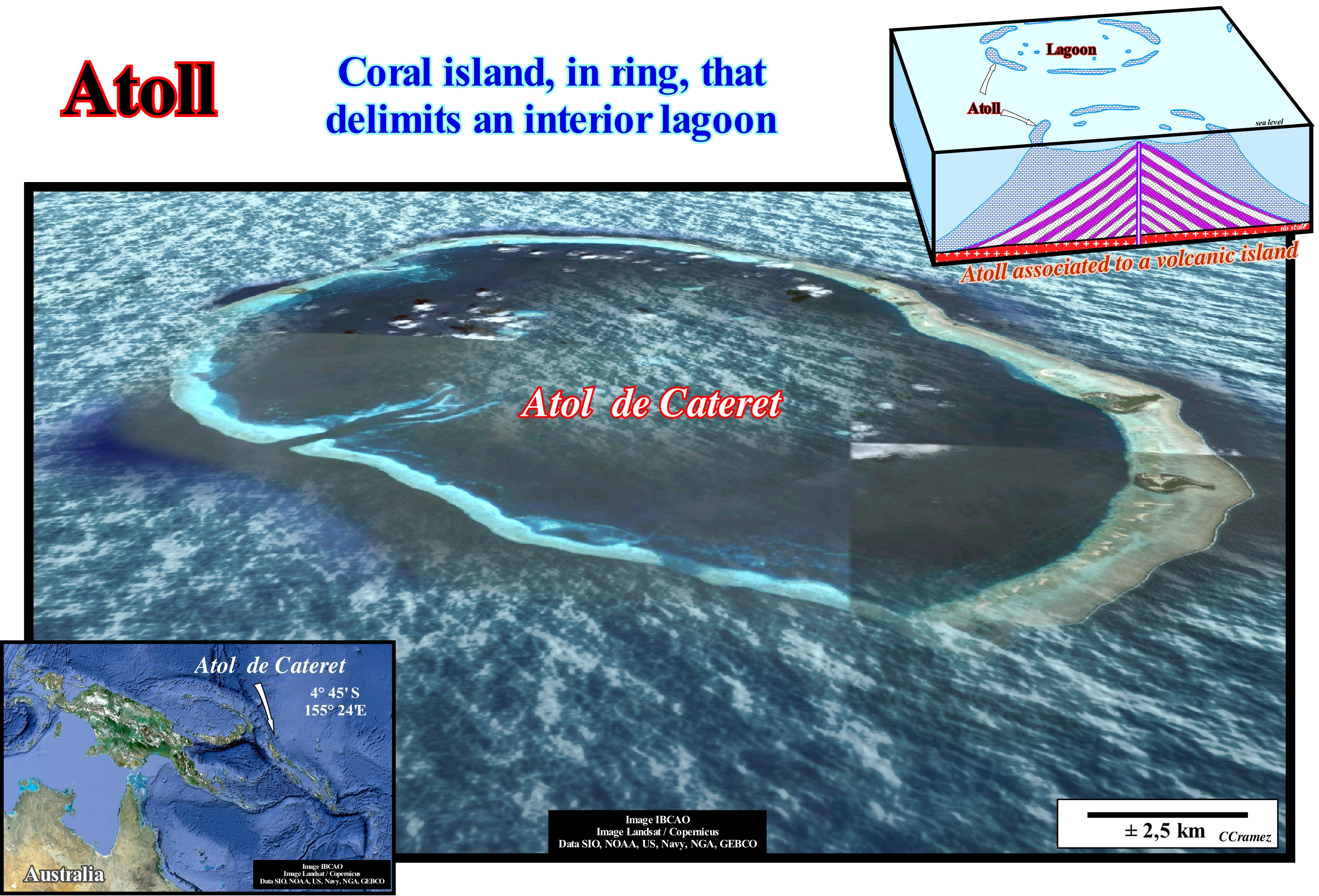
On surface, a coral reef appears as a ring-shaped or horseshoe-shaped reef emerging from deepwater and even close to lagoon, which is sometimes called atolls lagoon islands. Atolls are the consequence of the growth of tropical marine organisms. They are found only in warm tropical waters. The formation of the vast majority of atolls can be summarized as follows: (i) Corals settle and grow around an oceanic island, usually, a volcanic island, forming a fringed reef ; (ii) Under favourable conditions, the reef expands and the interior of the island sinks ; (iii) Eventually, the island sinks completely, leaving the fringe of corals on surface, which continues to develop with a lagoon, more or less, open in the central part. When a volcanic island is situated in an area where the temperature is hot enough to allow the growth of reefs, which counterbalance subsidence, the island is said to be at Darwin's point*. On the contrary, when a volcanic island is located on a site outside the conditions of formation and development of corals, it is, partially, eroded and, sooner or later, it sinks into an underwater mound. The distribution of atolls is very instructive. Most of the world's atolls are in the Pacific Ocean, with concentrations in the Tuamotu Islands (Rangiroa 1,762 km2, land area 79 km2), Carolina, Marshall, Coral Sea, and in groups of islands such as Kiribati, Tuvalu and Tokelau. In the Indian Ocean the most important atolls are the Maldives (Ari atoll 2,252 km2, land area 69 km2, North Male 1,565 km2, land area 69 km2 and Huvadhu 3,152 km2, land area 38.5 km2, which is about 250 islands), Laccadive Islands, Chagos archipelago (12,642 km2, land area only 4.5 km2) and the outer islands of the Seychelles. The Atlantic Ocean does not have large groups of atolls except the eight atolls of eastern Nicaragua. In most cases, the land area of an atoll is very small compared to the total area.
(*) Do not confuse with the Darwin's tubercle (as called Darwin's point), which is present in approximately 10.4% of the population. This acuminate nodule represents the point of the mammalian ear. This atavistic feature is so called because its description was first published by Charles Darwin in the opening pages of The Descent of Man, as evidence of a vestigial feature indicating common ancestry among primates. However, Darwin himself named it the Woolnerian tip, after Thomas Woolner, a British sculptor who had depicted it in one of his sculptures and had first theorised that it was an atavistic feature. (http://www.weirduniverse.net/blog /comments/darwins_point)
Atollon.............................................................................................................................................................................................................................................Atollon (Faro)
Atolon (Faro) / Atolón / Atollen / 法鲁 / Небольшой атоллоподобный риф / Faro /
Set of small chained atolls.
See: « Atoll »
&
« Faro (atollon) »
&
« Reef »
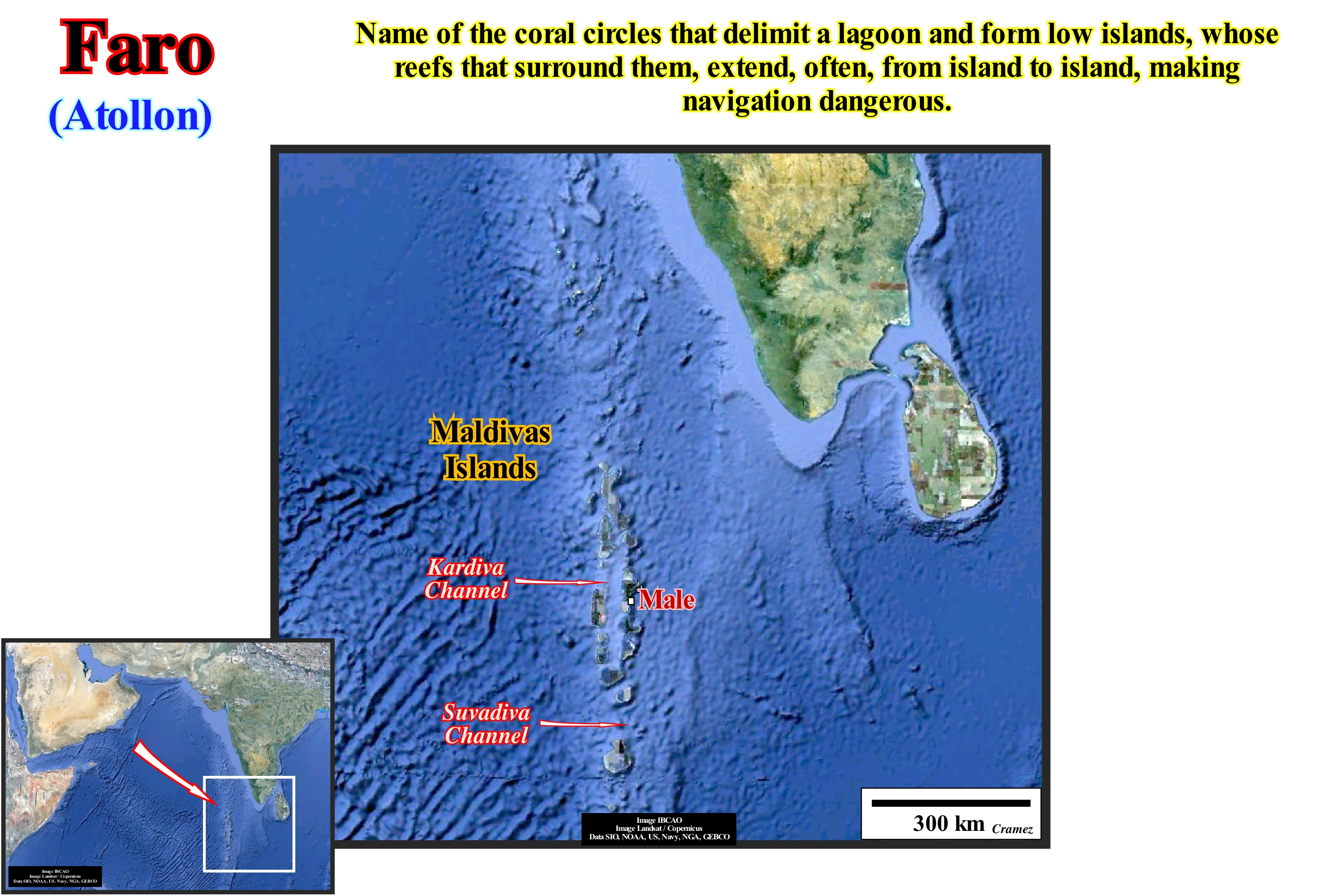
This image recognizes,clearly, the different chained atolls that form the atollon of the Maldives. Each atoll corresponds to a low island, formed by an annular coral reef, continuous or interrupted by small channels, involving a shallow central lagoon. At the bottom of the lagoon grow corals, in the form of pinnacles or spheres of spherical geometry. At the outer margin, on the shelf of the reef, there are banks of coral sand, that constitute islets or are arranged in steps of beach due to the surfing of the waves. In the morphology of the atoll platform there are sometimes blocks of reef limestone cut into mushrooms or head-shaped. When the channels between the reef islands are deep they allow navigation and constitute the channels of passage (channel of Kardiva and Suvadiva). In geological history, many atolls die during relative sea level rises. The atolls survival and, consequently, of an atoll implies that coral growth counterbalances relative sea level rise (eustasy more tectonics, i.e., uplift or subsidence of the sea -floor) in order to get a, more or less, constant water-depth that corals like. Otherwise, corals will be found under a large water-depth and, progressively, they will die, especially, if the relative sea level rise is controlled more by subsidence than by eustasy (in this case, the rate of subsidence seems to be faster than the rate of eustasy). The same happens with the carbonated platforms, which created in the sequential analysis a great subject of discord between the Vail's scholl and Schlager's school. Vail considers that an unconformity (erosional surface) is always associated with a relative sea level fall causing exhumation of the calcareous platforms and thus the death of the corals since these can be put above sea level. W. Schlager considers that certain Vail's unconformities, particularly on carbonated platforms, do not correspond to significant relative sea level falls but rather to significant relative sea level rises placing the carbonate platform below the photic zone preventing the formation of carbonate. Thus, in this case, there is no erosional surface, which, in sequential analysis, limits stratigraphic cycles, but rather a drowning surface.
(*) Do not forget that level can be absolute (eustatic) and relative. The absolute (eustatic) level is supposed to be global and referenced to the Earth's centre. The absolute sea level is dependent on glacio-eustasy, tectono-eustasy, geoidal-eustasy, and the temperature of the oceans (steric sea level rise). The relative sea level is local and referenced either to the top of the continental crust (base of the sediments) or to the sea-floor. The relative sea level is the result of the combined action of absolute (eustatic) level and tectonic (subsidence or uplift of the sea-floor).
Atom......................................................................................................................................................................................................................................................................Atome
Átomo / Átomo / Atom / 原子 / Атом / Atomo /
Basic unit of matter composed of a dense nucleus surrounded by a cloud of negatively charged electrons. The nucleus is composed of a mixture of protons (positively charged particles) and neutrons (electrically neutral), except in the case of hydrogen, whose nucleus has no neutrons.
See: « Matter & Antimattter »
&
« Nuclear Fission »
&
« Radiometric Dating »
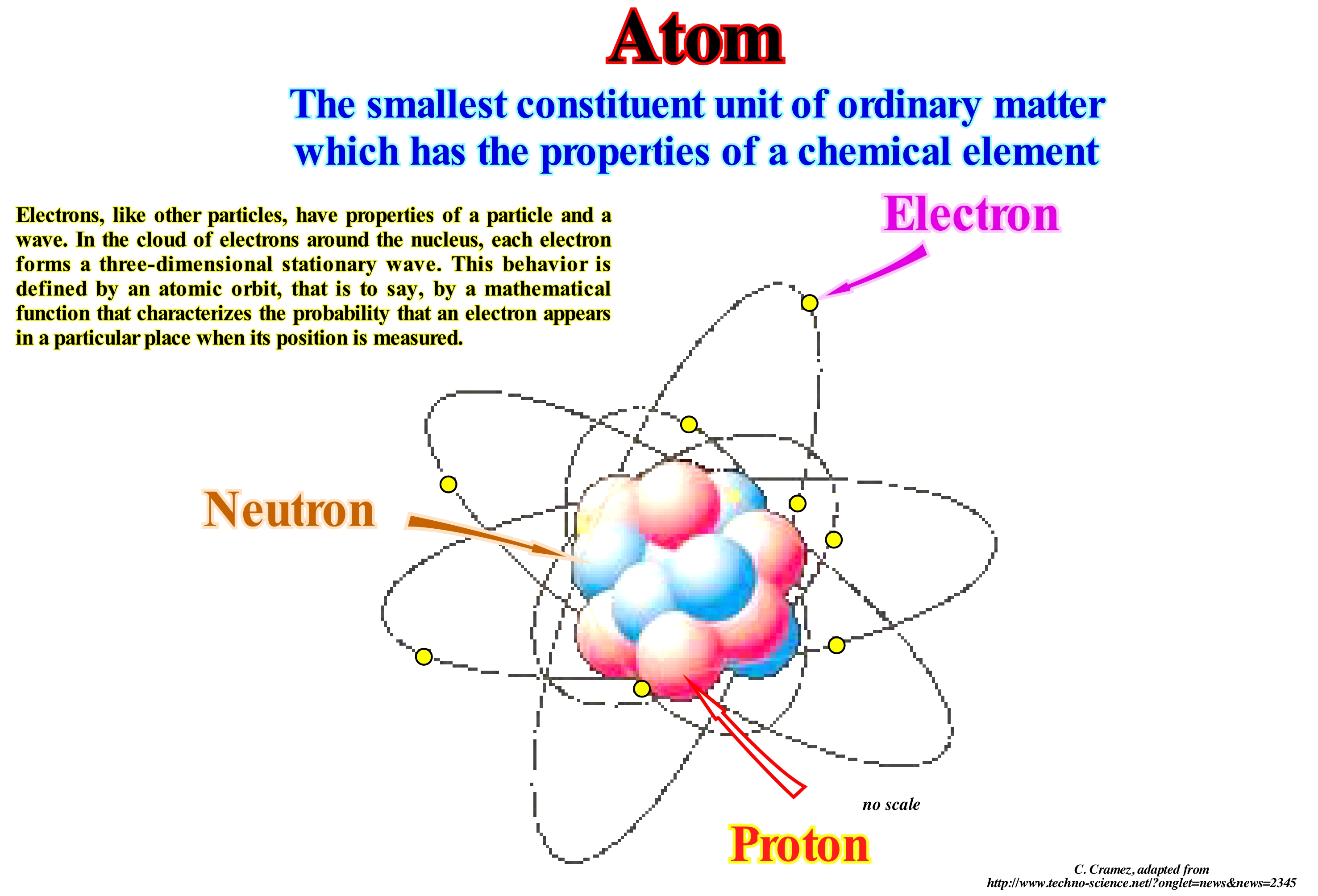
The atoms are very large. They have to be, because it contains many accumulated things. It is true we often think of atoms as being very small things, but this happens just because we are very large. To realize the greatness of an atom, imagine that it expands until the size of the nucleus becomes equal to the size of a man. Under these conditions, the atom would then be a thin mist of electrons scattered over a sphere of 100 km radius. The nucleus of the atom of the most common type of hydrogen has a simple positively charged particle that scientists call proton. The atom of a rare type of hydrogen, called deuterium, has a nucleus with a proton and a neutron. Neutrons have a negative charge. Protons and neutrons form all nuclei except the typical nucleus of hydrogen consisting of a single proton. For this reason protons and neutrons are, collectively, called nucleons. Protons and neutrons are considered as elementary particles although they are made up of simpler particles called quarks. Quarks are fundamental units of matter that form not only protons and neutrons but also other elementary particles called mesons. Three quarks form a proton or a neutron and two quarks form a meson. The nucleons and mesons are, collectively, called hadrons. All of them are made up of quarks. Quarks can not be plucked from the particles they form once they are thrown against each other by a force called strong magnetic force or strong force that increases with distance. It can be said that the quarks are linked to each other by bands corresponding to what scientists call gluons. Quarks have properties called flavours and colours. There are six flavours and each of them has three colours. Elementary particles with opposite charge to normal occur in nature. They are produced in nuclear reactions and can be made in the laboratory. This type of matter with inverted electric charge is called antimatter. Negative protons or anti-protons and positive or positron electrons are anti-matter. Anti-matter is short-lived since a positive electron encounters or collides with a normal (negative) electron or a negative proton collides with a normal proton, i.e., with a positive proton, its mass is transformed into energy . Electrons in an atom are attracted to the protons of the nucleus by weak electromagnetic force. This force connects electrons within an electrostatic potential around the nucleus, which means that an external source of energy is needed for an electron to escape the atom. The closer an electron lies to the nucleus, the greater the attractive force. The electrons near the centre require more energy to escape than the more distant electrons. Electrons, like other particles, have properties of a particle and a wave. In the cloud of electrons around the nucleus, each electron forms a three-dimensional stationary wave, i.e., a wave that does not move relative to the nucleus. This behaviour is defined by an atomic orbit, i.e., by a mathematical function that characterizes the probability that an electron appears in a particular place when its position is measured Just a certain set of orbits exists as other possible wave patterns quickly decay to a more stable shape. Each atomic orbit corresponds to a certain level of energy. An electron can change its state to a higher level of energy, absorbing a photon. In the same way, an electron, with a certain energy, can fall into a lower energy state, radiating energy in the form of a photon. The energy differences of the quantum states are responsible for the atomic spectra.
Atrophied Delta.................................................................................................................................................................................................................Delta Atrophié
Delta atrofiado / Delta atrofiado / geschwund Delta / 萎缩三角洲 / Истощенная дельта / Delta atrofizzato /
When erosion and sedimentary transport equilibrate, reducing, substantially, the delta plain, which is, often, reduced to a small seaward advance of the shoreline.
See: « Delta »
&
« Delta Front »
&
« Bottomset Bed (of a delta) »
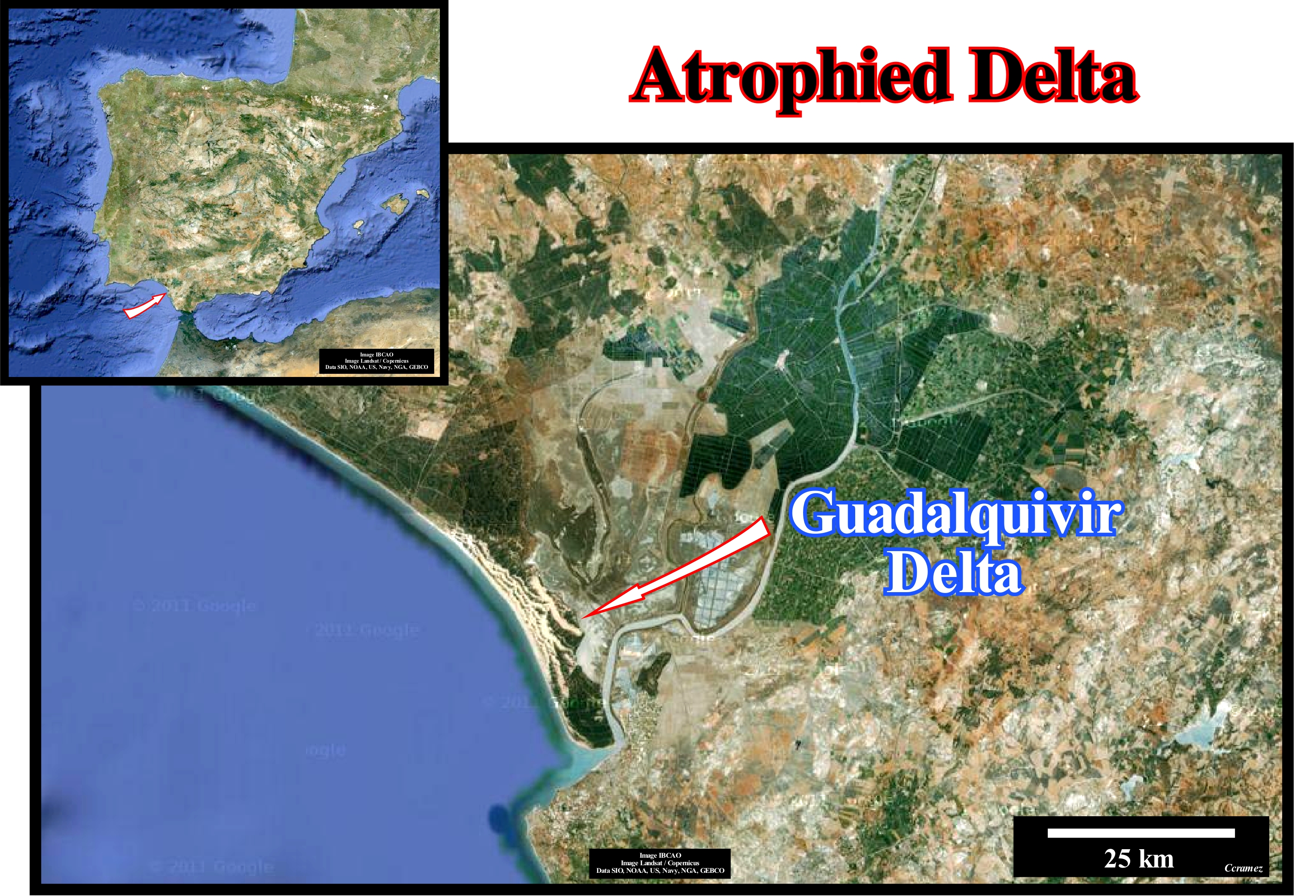
The Guadalquivir delta building , illustrated in this satellite image, is located on the south-west coast of Spain (Andalusia) near the Gulf of Cadiz. The Guadalquivir River (Wadi Al-Kabir) is the second largest river in Spain. It is born in the Sierra de Cazorla and flows to SW, passing through the city of Córdoba and Seville, to empty into the Gulf of Cadiz, near Sanlúcar de Barrameda, where it built a delta of the atrophied type. Erosion and transport of marine agents reduced the deltaic plain to a small ledge. With a length of 660 km and a drainage area of about 57,527 km2, the Guadalquivir flows into the Atlantic Ocean, with an average discharge per second of about 230 m3. Its drainage area (land area from which all surface flow flows via a series of streams, rivers and possibly lakes into the sea at a single outlet, estuary or delta) is one of the most varied natural environments in Europe. It contains almost half of the plant species of the continent and almost all of North Africa. This region on the ancient maps of the fifteenth century and, particularly,, on the map of Ibn Ben Zara* (shows northern Europe and glaciers as they were 12,000 years ago and the Mediterranean, whose level corresponds to what existed in the last ice age) the Guadalquivir delta does not exist. The Ibn Ben Zara map (circa 1497 AD) shows a large bay at the mouth of the Guadalquivir, while the less ancient maps, as well as, current satellite photographs, as illustrated in this figure, show a delta that, although atrophied, is about 80 km long by about 50 km wide. The bay on the map of Ibn Ben Zara should, probably, represent the coastline prior to the formation of the delta. If this is true, the formation of the delta should be related to recent absolute (eustatic) sea level changes (supposed global and referenced to a fixed point which is generally the Earth's centre), i.e., related to the glacio-eustasy induced by the melting of the Quaternary ice caps. The last ice age occurred roughly 2.5 Ma ago. It induced a significant absolute sea level fall of about 125 meters. As the evaporated water of the oceans was stored as ice caps and glaciers on the continents and in ice-seas , in the oceans. The thaw and a more temperate climate led to an absolute sea level rise (about 130 meters from the last 19,000 years) and the expansion of human activities, inaugurating the current geological period, i.e., the Holocene, which begun 10,000 years ago. This conjecture is corroborated by the hypotheses advanced by certain geoscientists who think Ibn Ben Zara had in their possession older maps of Central and South Europe illustrating the geographic conditions of the time when the ice caps began to melt, more or less, between 11.5 k and 10 k years ago. It seems the Guadalquivir delta building attracted the attention of Plato, who in the Timaeus and Critias, speaking of the disappearance of Atlantis, the lost paradise, says people lived on an island in the Atlantic, beyond the Pillars of Hercules (Straits of Gibraltar). The Guadalquivir delta building is a serious candidate for this disappeared paradise thanks to an earthquake and tsunami. In fact, the large circular structures, suggested by observations made from satellites and radar surveys, underneath the Doñana National Park** can be interpreted as traces of a city, especially that Plato tells us about a city with a series of channels in the form of circles around a central temple.
(*) The inscriptions on the edge of Ibn Well Zara portolano or rutter (known as a periplus or "sailing-around" book, in classical antiquity, that Portuguese navigators of the 16th century called it a roteiro, French a routier and Spanish a derroterro) suggest that it was made in 1497 in Alexandria (Egypt). The original of this document is now in the Vatican Library in Rome (Borgiano VII or nautical map of the Mediterranean). This portolano was considered by the French historian and politician Jacques Victor (Paris 1821-1901) the best of all nautical charts. However, it has three anomalies that can only be accepted under the condition of seeing the cartography of that time from a very different angle from that of today: (i) Guadalquivir mouth (now a delta) is described as a bay ; (ii) Aegean Sea is full of small islands, whereas at present it is not the case ; (iii) Ireland and England are represented by glaciers that no longer exist. In fact, it is possible that this portolano copied a much older document, attributed to the final period of the last Earth's ice. Jacques Victor was, already, referring to an unidentified world civilization that would have existed between 6,000 and 10,000 years ago, which knew perfectly : a) The Earth's volume ; b) Its entire geography ; c) How to calculate exactly the latitude and longitude and d) To apply the cartography to the flat and spherical trigonometry. It is easy to imagine the astonishment of the great majority of the geoscientist. In fact, if such affirmations are accepted, the time of the birth of human civilization has to be much retreated, but also have to find arguments to explain why is this civilization disappear as that of the Sumerians (the first known civilization) at the beginning of the fourth millennium BC.
(**) The Doñana National Park is located in the southern part of the province of Huelva (Andalusia). It extends through three provinces: Huelva , Seville and Cadiz. It is the largest biological reserve in Spain and also throughout Europe, with a huge area of protected area with more than 50,000 hectares.
Authigenesis...............................................................................................................................................................................................................Authigenèse
Autigénese / Autigénesis / Authigenesis / Authigenesis (新矿物) / Аутигенезис / Autigenesi (minerali nuovi) /
Process by which new mineral phases are crystallized in sediments or rocks during diagenesis. The new minerals can be produced by: (i) Reactions involving phases, already, present in the sediment or rock ; (ii) Precipitation of materials introduced into the fluid phase or (iii) A combination of original and introduced components. Authigenesis, which generally overlap with the alteration and cementation, usually, involve recrystallization and can produce a total substitution. The most frequent authigenic phases are silicates, such as, for instance, quartz, alkali feldspar, zeolites, halite, gypsum, tourmaline, glauconite, etc.
See: « Diagenesis »
&
« Authigenic »
&
« Porosity »
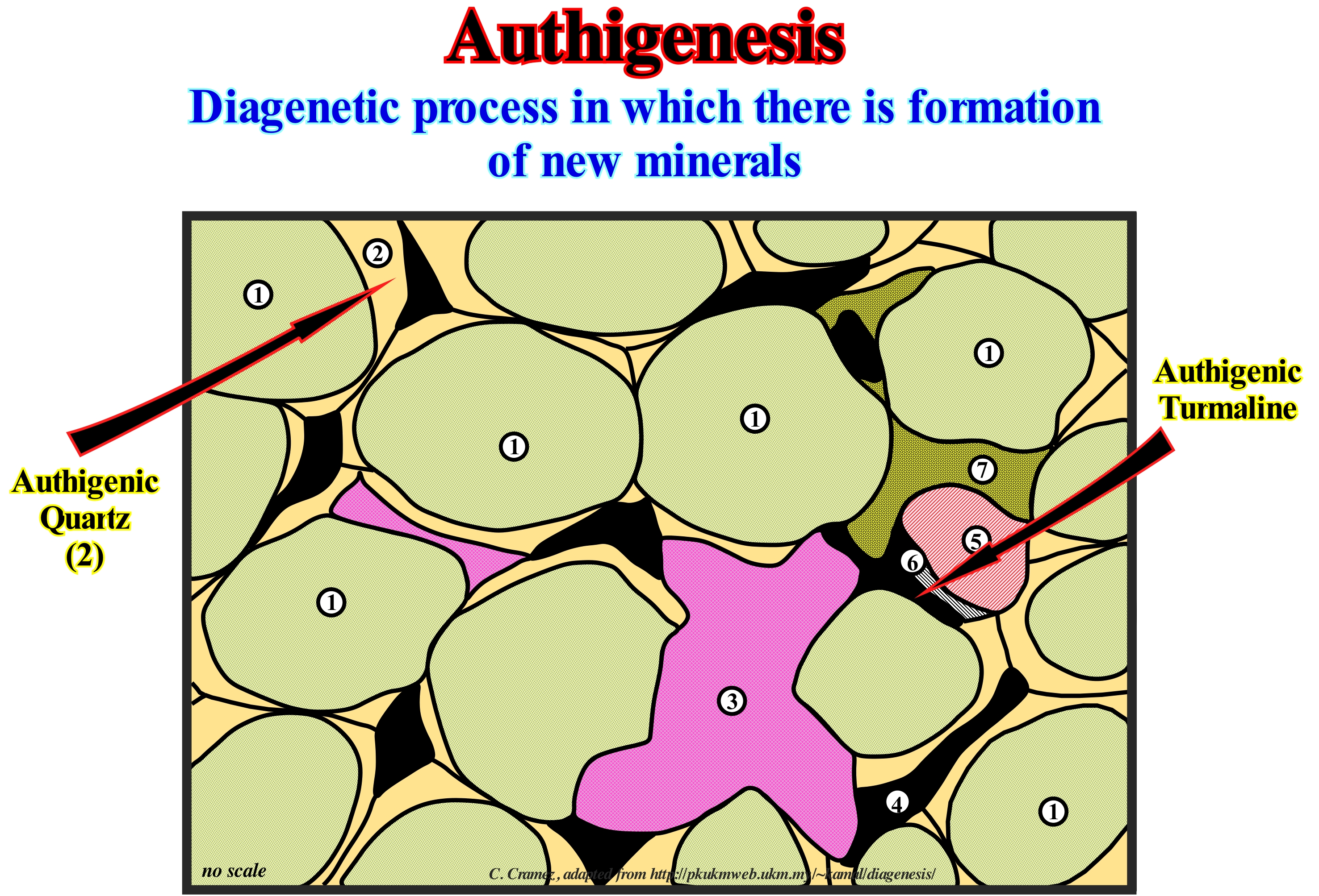
Authigenesis, which overlap, generally, with alteration and cementation involves, usually, recrystallization and can produce a total substitution. The most frequent authigenic phases are silicates, such as, for instance, quartz, alkali feldspar, zeolites, halite, gypsum, tourmaline, glauconite, etc. On this tentative interpretation of a thin section (or petrographic thin section), where: (1) Detrital quartz ; (2) Authigenic quartz (growth) ; (3) Calcite ; (4) Pores ; (5) Tourmaline ; (6) Authigenic tourmaline (growth) and (7) Hematite (cement), the autigenesis is well illustrated. The presence of authigenic glauconite in a rock and, in particular, in sandstones is very important in the sequential stratigraphy. It allows not only to identify the transgressive interval of a sequence-cycle (stratigraphic cycle induced by 3rd order eustatic cycles, i.e., with a time duration between 0.5 and 3-5 My), but also the turbidite deposits when it is associated with coal debris. When in the cuttings of an exploration well, we found authigeneous glauconite, the most probable is the rock from which the cuttings come is a rock associated with a transgressive interval, since the authigeneous glauconite forms on the shelf under a water-depth of about 60 meters. In addition to the glauconite, cuttings of coal are found in the well debris, the most likely is they come from a turbidite deposited (material transported from the continent and from the shelf, which was deposited, very quickly, in the deep parts of the basin, where oxygen content is very low, if not zero). If, on the contrary, if just coal debris are found in the well cuttings (absence of authigeneous glauconite), the most probable is they are associated with a non-marine rock. These criteria, often referred as Selley's criteria, are used by geoscientists who supervise the exploration wells. Obviously, for a mineral to be precipitated from a fluid, such as from sea-water, it must be super-saturated with respect to that mineral. So if we consider calcite, the deposition area (precipitation) must, necessarily, be above the carbonate compensation depth*, or that the water pore is, sufficiently, saturated due to the dissolution of other grains for precipitation to take place.
(*) Carbonates, present in the vast majority of sedimentary rocks, as well as, in fossil and microfossil shells, are in balance with the other physio-chemical parameters of sea-water. However, beyond a certain depth (depth of compensation of the carbonates), they tend to dissolve, mainly due to an increasing in pressure. Above this same depth, they, tend on the contrary, to deposit or to precipitate.
Authigenesis (Neocrystallization).....................................................................................................................................................Néocristallisation
Neocristalização / Neocristalización / Authigenesis (Verfestigung) / Authigenesis (石漠化)/ Аутигенез / Neocristalisazione (Litificazione) /
Process by which new mineral phases are crystallized in sediments or sedimentary rocks during the diagenesis*.
See: « Diagenesis »
&
« Authigenic »
&
« Compaction »
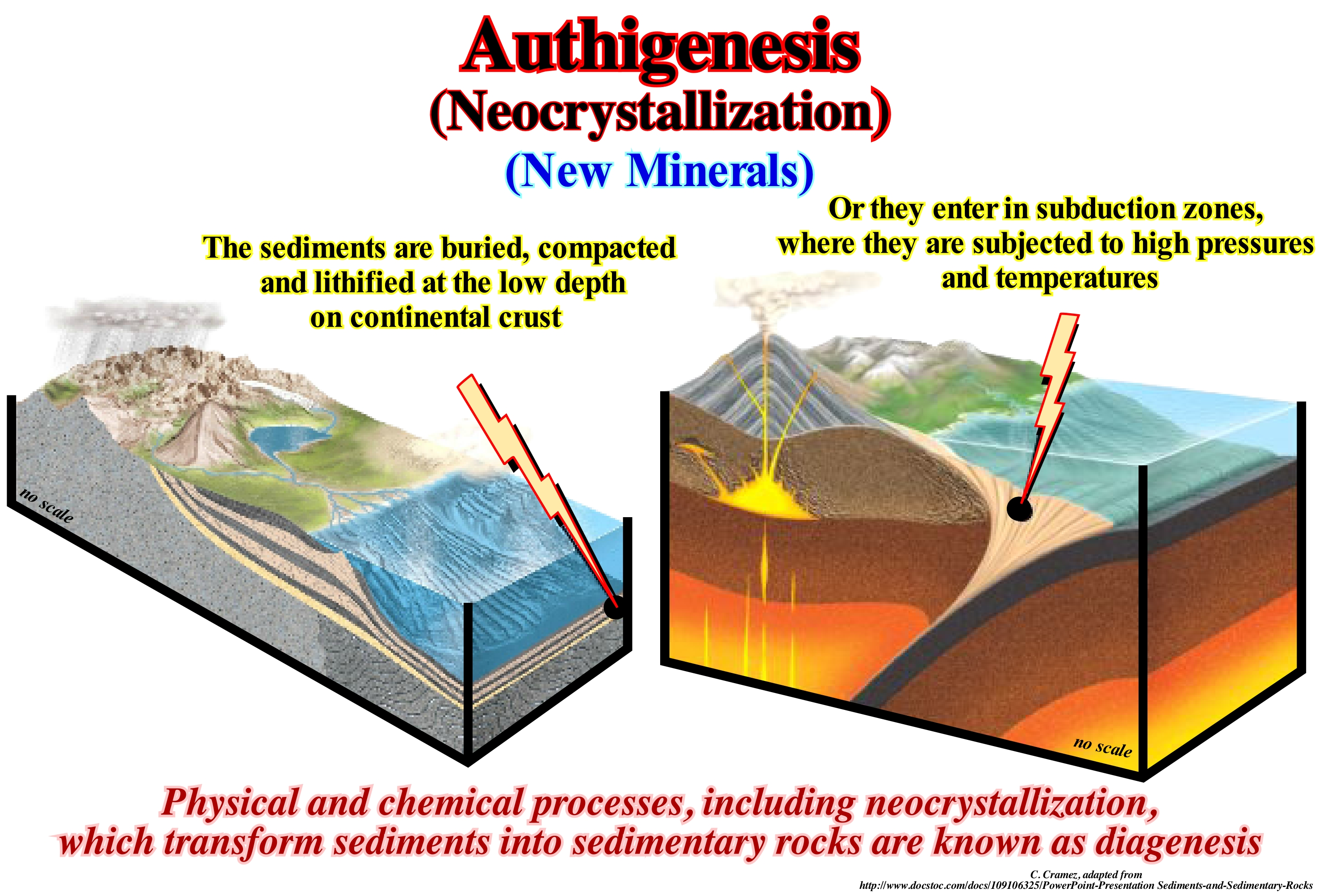
One of the most important neoformation minerals in the sequential stratigraphy and petroleum industry is glauconite, which is a variety of clay rich in iron, that can be found in the form of granules, grains or intergranular cement and which has a density between 2.4-2.95 g/cm3. Authigenic glauconite forms in the distal parts of the shelf, under very restricted geological and geochemical conditions, where the sedimentation rate is, relatively, weak. A set of scientific studies has shown that glauconite minerals are, currently, formed, preferably, under a water-depth of the middle and distal shelf, in association with the transgressive interval (sedimentary systems tract). When during the drilling of an exploratory well, the geoscientist, in charge of the instantaneous logs, observes, in the drilling debris (cuttings**), sands with glauconite of neo-formation, he advances, immediately, as a working hypothesis, that such a sand comes, probably, from transgressive interval. However, as the whole hypothesis, such a conjecture has to be tested. He will check if the debris, contain, also, fragments of coal. If it finds them, the hypothesis is refuted and it emits a new hypothesis: "The sands with authigeneous glauconite and coal, probably, come from turbidite deposits". In the case, that coal debris are not present, the advanced hypothesis is not refuted and has to be considered. The identification of glauconite is important not only to interpret sedimentary environments and to establish correlations, but also to locate the most probable reservoir-rocks and potential stratigraphic traps.
(*) Change of sediments or sedimentary rocks into a different sedimentary rock during and after lithification (rock formation) at temperatures and pressures less than that required for the formation of metamorphic rocks (changes from weathering excluded).
(**) Cuttings, drilling cuttings ou drill cuttings are rock debris torn off by the tool during drilling. The cuttings are brought to the surface by the drilling fluid, usually mud.
Authigenic (Sediments).................................................................................................................................................................................Authigénique
Autigénico / Autigénico / Authigenens/ 自体 / Aутигенный / Autigenico /
Mineral that grew "in situ" during or after lithification*.
See: « Diagenesis »
&
« Glauconite »
&
« Transgressive Interval »
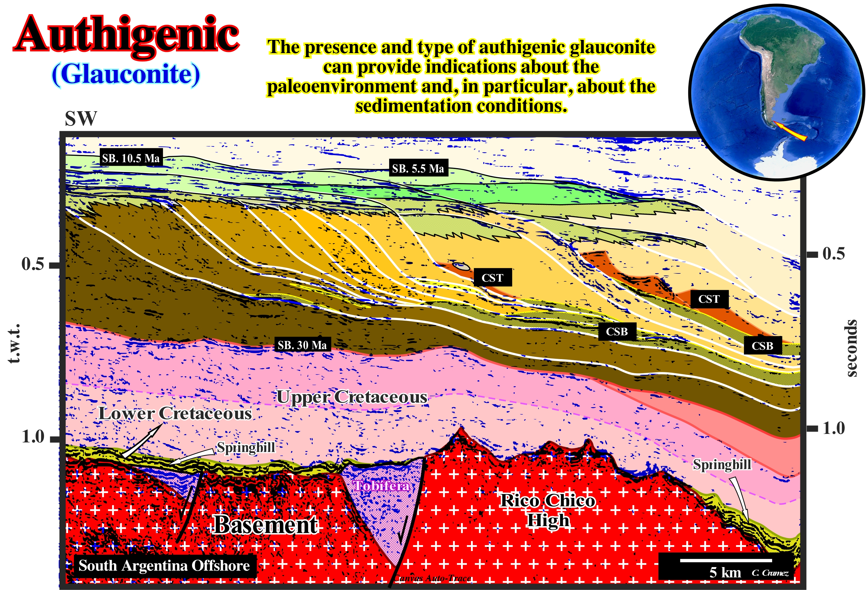
Autigenic minerals give valuable indications about the depositional environment and allow, also, us to criticize, i.e., to test tentative geological interpretation of seismic lines. In this particular example of a tentative geological interpretation of a Canvas auto-trace of an offshore seismic line from the Austral geographic basin (Argentina), the results of the logs of the wells indicate the presence of abundant detrital authigenic glauconite** at two sedimentary intervals. The first interval corresponds to the Springhill formation (Lower Cretaceous). This formation, which corresponds to the transgressive interval of the base of the divergent margin, fossilizes the rift-type basins of the small supercontinent Gondwana, which, here, are, mainly, filled by volcanic material (Tobifera formation). The sandstones of the Springhill formation are the main reservoir-rocks of the Austral basin. In the field, the retrogradational geometry and the coating of the stratification planes by authigenic glauconite corroborate the hypothesis of a transgressive interval at the base of the divergent margin, as proposed on this tentative. The second interval in which detritus of authigenic glauconite were found in the debris of drilling (cuttings) corresponds to the set of the submarine basin floor fans (SBFF) of the Late Middle Miocene, which are well visible in the abyssal plain seaward of the successive basal continental slope edges. When an exploration well passed through the submarine basin floor fans (SBFF), the geoscientists, who supervised the advancement and geology of the well, found in the drilling detritus debris of glauconite (a mineral that forms on the continental shelf under a about 60 m) and debris of coal (non-marine rock that forms on the coastal and delta plains, which is easily oxidized). The presence of these two materials in the drilling detritus implies a very rapid terrigeneous transport of the sediments from the platform and the coastal plain to deep environments poor in oxygen. This allowed to corroborate the advanced conjecture, i.e., that the rocks crossed by the well, probably, correspond to submarine basin floor fans (SBFF) as suggested by the seismic lines. Note that these materials can also be found in the submarine slope fans (SSF).
(*) Lithification is the process in which sediments (mineral and organic particulate matter settle on the bottom of the water when the hydrological conditions no longer can transport it or keep it in suspension) compact under pressure, expelling connate fluids (trapped in the porous during deposition) and gradually become solid rock.
(**) Aluminosilicate hydrated of iron and magnesium, of formula K, Na) (Fe3+, Fe2+, Al, Mg)2 3[Si3 (Si, AL) O10] (OH)2, 4H2O, the glauconite crystallizes in the monoclinic system. It is, rarely, observed in small hexagonal crystals, but rather in small rounded grains or spherules with a diameter ranging from 1 to a few millimeters. Its crystallinity appears only under the microscope, and most of the time in large enlargements. This mineral is then formed of small tangled lamellae. Dark green in color, greenish-black, the luster is usually vitreous or greasy depending on the compositions. Its hardness is 2 to 3 and its density is of 2.2 to 2.8 g/cm3. Glauconite is very common in sedimentary rocks accumulated in the sea (sands, clays, carbonate rocks, phosphorites), in relatively low depths, in areas near the coast and in current marine deposits (green vessels, sands). This mineral mainly forms in the bottoms of 200 to 1800 meters, although it has also been observed, but in smaller quantities, in inferior or superior depths (https://www.universalis.fr/encyclopedie/glauconite/).
Auto-trace (Tracing, picking)..............................................................................................................................................................................Auto trace
Autotraço / Rastreo automático / Automatische Verfolgung / 自动跟踪)/ Авто след / Traccia automatica /
When the main reflectors of a seismic line are underlined manually or automatically.
See: « Paleowater Depth »
Autochthone (Authigeneous).......................................................................................................................................................................Autochtone
Autóctono / Autóctono / Autigeneous / 自生 / Автохтон (коренной житель) / Autoctono /
Material that is in the place where it formed or was deposited.
See: « Allochthone, Allothigenous »
&
« Halokinesis »
&
« Compensatory Subsidence »
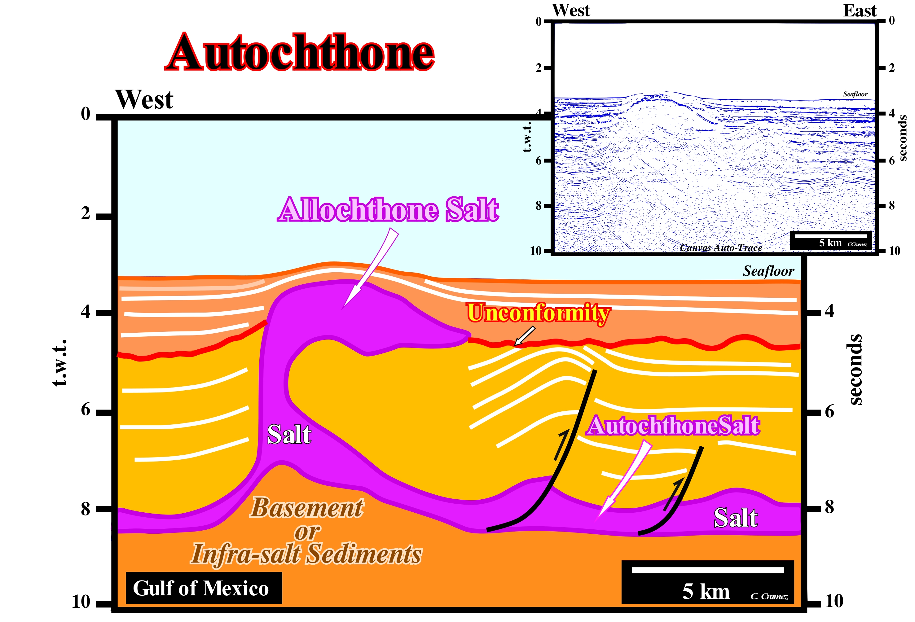
On this attempt of geological interpretation of a seismic line off the deep Gulf of Mexico, it is, easy, to distinguish the allochthonous salt and autochthonous salt. On this tentative geological interpretation of a Canvas auto-trace of a Gulf of Mexico seismic line, it is, easy, to distinguish the allochthonous salt and autochthonous salt. Autochthone salt is in its original stratigraphic position of deposition, while allochthone salt is not. In this example, the two salt horizons communicate through a vertical salt structure, but they are, often, separated by sub-vertical salt welds. There may be several orders of allochthony. In some salt basins, there may be second or third generation domes, i.e. salt domes formed from a first-order allochthonous (second generation dome) or second-order dome (3rd generation dome). On this tentative geological interpretation, the unconformity, which was, locally, tectonically enhanced, was not induced by the salt tectonics, but by a regional compressional tectonic regime (compensation of the extension of the sediments platform and of the sediments of the upper part of the continental slope), which shortened the abyssal sediments and salt. As illustrated on this tentative interpretation, the sediments of the sea-floor covering the allochthonous salt structure were lengthened (and not shortened) by the diapiric movement of the salt. This lengthening is the result of an extensional tectonic regime developed as the salt moved to the upper stratigraphic levels. The lengthening of the sediments is made just by normal faults, which in this particular case are, more or less, radial around the salt structure and with an opposite polarity. However, these normal faults are not represented on the attempt to interpret, because the relative displacement of the fault blocks is smaller than the seismic resolution of the seismic line. The structure at the sea-floor, even if it is convex upwards (bell-shaped) does not correspond to an anticline structure (shortening structure), but to an antiform, which is an enlightened structure created by a local extensional tectonic regime. In addition, the antiform at the sea-floor is more recent than the compressional structures (anticlines and reverse faults) visible under the unconformity. The sediments below the unconformity were shortened, while the sediments above it were lengthened.
Autocycle (Carbonates)..........................................................................................................................................................................Autocycle (carbonates)
Autociclo / Autociclo (carbonatos) / Autocycle (Karbonate) / 摩托车(碳酸盐岩) / Автоцикл / Autociclo (carbonati)
Depositional model proposed by R. Ginsburg (1971) for carbonate intervals composed of a stacking of upward-deepening cycles ABC, in which the depositional water-depth increases.
See: « Deposition (carbonates) »
&
« Upward-Deepening Cycle ABC »
&
« Transgressive Interval»
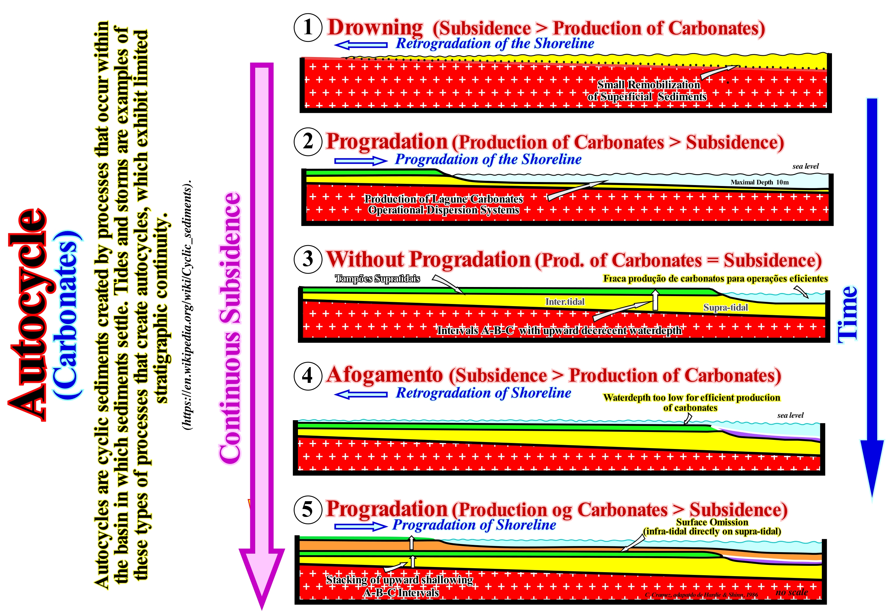
The geological model illustrated in this figure, like any other model, is a mathematical or mental construction made by geoscientists to describe field or seismic observations (all observations are function of expectations and the theory adopted by the observer), assumes constant and continuous subsidence and, at the same time, a rate of production of carbonate material* self-regulated by the amplitude of progradation. In phase 1, the subsidence (movement of a land surface moving downward, relatively, to a reference level such the absolute or eustatic sea level or mean sea level **) is more important than the production of carbonate material. The result is a rise of the relative sea level (local and referenced to any point on the Earth's surface which can be the top of the continental crust, i.e., the base of the sediment base or the sea-floor) implies a retrogradation movement of the shoreline (roughly equivalent to the depositional coastal break of the depositional surface), that is to say, a marine ingression. During this phase, there is a small remobilization of the surface sediments. Since the production of carbonate material is more important than subsidence (phase 2, in this figure), there is a progradation of the shoreline (seaward displacement of the shoreline), which corresponds, more or less, to a fall of the relative sea level (combined action of absolute sea level and tectonics). During this phase, lagoon carbonates are formed and the dispersion systems are very operational. In phase 3, the production of carbonate material compensates for balances the subsidence. The relative sea level remains, more or less, constant, which causes a seaward displacement of the shoreline (outbuilding) but, practically, without aggradation (upbuilding). This progradation is made by oblique progradations formed only by the dipping seaward segment. The upper subhorizontal segment is always absent but, in some cases, the lower sub-horizontal segment may be present. These progradations contrast with the sigmoid progradations (when the three segments of a chronostratigraphic line : (i) Upper subhorizontal ; (ii) Dipping seaward and (iii) Lower subhorizontal, are present). In sigmoid progradations there are always an aggradation (upbuilding), i.e., there are always a marine ingression. It is at this stage that a supra-tidal plug is formed above the inter-tidal deposits (between the tides). Phase 4 is a repetition of phase 1. A new relative sea level rise (new marine ingression) occurs. Since the subsidence is not compensated by the formation of carbonate material, there is rise of the relative sea level, which, again moves the shoreline continentward. However, the water-depth, at least in the beginning, is too small for efficient carbonate production. The most important point of this geological model is that the rate of production of the carbonate material becomes lower than the subsidence rate since the progradation of the shoreline greatly reduces the extent of the lagoon. The production rate will only be recovered when the lagoon again reaches a water-depth of 1 to 2 meters due to subsidence to allow an efficient production and dispersion of the carbonated sedimentary particles. This factor introduces a hiatus in the deposition. This is why, almost always, the subtidal sediments (which are not exposed during low-tide) rest, directly, on the sediments deposited in the supra-tidal zone, also known as the splash zone (spraying zone, supra-littoral zone). The supratidal zone is the area, which is sprinkled with salt, regularly, during the highest spring-tides, but is not submerged by sea-water. The sea level, reaches this elevated area, only, during the storms, particularly, if they happen during high-tides.
(*) The production of carbonate material in depth can be represented by a curve that shows the production acme, more or less, at 5-10 meters of water-depth and then rapidly decrease till the base of the photic zone, which is the carbonate limit production.
(**) The absolute sea level is referenced to a fixed point that is, generally, the Earth's centre. Sea level varies, greatly, in time and space. It is affected by tides, wind, atmospheric pressure, local gravity differences, temperature, salinity, subsidence, etc. To determine the mean sea level, the best thing to do is to determine a place and calculate the average level at that point and use it as a reference point. Generally, from hourly observations made over a period of about 30 years, it can be calculated to be average for that measurement point. An average whether it is sea level or temperature, to have meaning it must cover a rather long period. The World Meteorological Organization (WMO) recommends that it covers 30 years: from there one can speak of « normal ». As a rise in sea level is perhaps the most familiar effect of climate change and, probably, the one with the most consequences, it is important to indicate, always, which sea level (absolute, relative, mean sea level, high-tide, etc.) and how it was calculated.
Autocyclic (Mechanism)..........................................................................................................................................................Autocyclique (Mécanisme)
Autocíclico / Autocíclico (proceso) / Autocyclique (Mechanismus) / 摩托车(机制) / Автоциклический (механизм) / Autociclico (meccanismo) /
Event or process responsible for sediment accumulation, which is part of the sedimentary system itself. Tides or storms are examples of the types of processes that create autocycles. Autocyclic processes are, sometimes, called autogenic processes. These mechanisms contrast with the allocyclic mechanisms, which are, also, responsible for sediment accumulation, but are external to the sedimentary system itself. Examples of allocyclic mechanisms include relative sea level changes, tectonics, climate, etc. Synonym of Autogenic (process).
see: « Controlling Parameter (Sequential Stratigraphy) »
&
« Relative Sea Level Change »
&
« Climate »
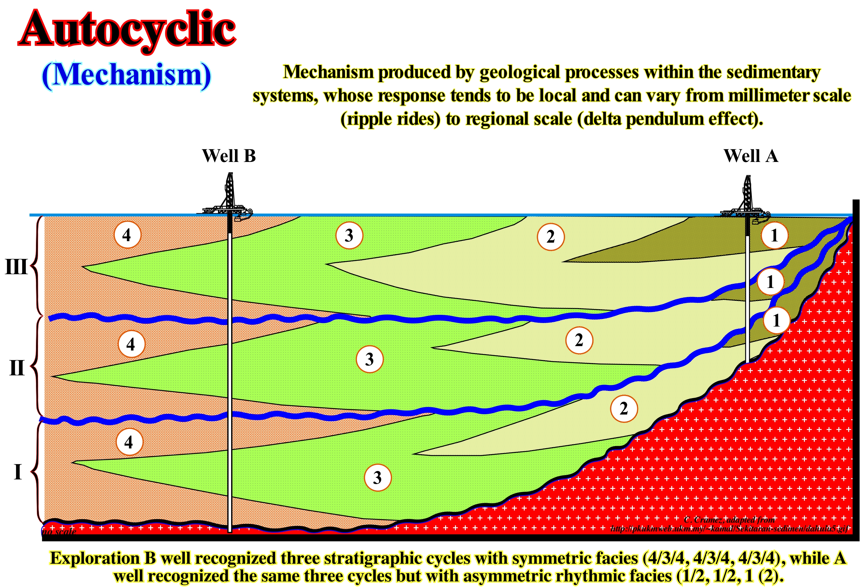
In geology, as illustrated in this geological section, based on a tentative geological interpretation of a seismic line calibrated by two exploration wells (well A and well B), autocyclic processes (processes that are an integral part of the geological system) are very common. They exist in fluvial systems, such as the size, configuration of a river channel, etc., as well as in glacial systems (development of glaciations and glacial deposits), marine deposition systems, etc. In a glacier system, for instance, the maximum extent of a glaciation, most often, corresponds to the coldest period of glaciation, during which there is thickening and spatial expansion of the ice caps and the ice-seas towards the equator. However, for each type of glacial event, the reaction sequence is autocyclic: (i) Rapid heating ends a long episode of cooling (with greater sensitivity in the low latitudes to external causes, such as orbital and solar) ; (ii) A supply of humidity from an ice-free ocean is a condition, sine qua non, to form glacial buildings ; (iii) The syngenetic extent of the polar desert (areas where the evapotranspiration* exceeds twice the annual precipitation and an average temperature during the warmer month of less than 10° C, for example in the Antarctic**) to the equator is a factor that limits the ice reserve. Likewise, the accumulation of strata in a sedimentary systems is the result of the interaction of autocyclic (or autogenic processes, which as mentioned above, are part of the sedimentary system itself) and allocyclic (or allogenic, i.e., mechanisms that are not part of the sedimentary system). The allocyclic processes are better understood than the autocyclic. Among allocyclic processes, we can mention the climate, eustasy (variations of the absolute or eustatic sea level), tectonics, changes of the relative sea level (combined action of t absolute sea level and tectonics). As the characteristics and importance of the autocyclic processes are poorly known, they are very difficult to deduce from the natural sedimentary systems. That is why certain geoscientists perform a whole series of experiments in order to unravel the main interactive factors. Recently, the autocyclic evolution was evaluated, separately, for three different types of sedimentary systems: (i) Alluvial fans; (ii) Deltas and (iii) Tidal deltas. The cyclicity of sedimentary deposits, which was a subject of discussion during the last century, seems to be considered by most geoscientists to be eustasy-induced (changes of the absolute or eustatic sea level, which is supposed to be global and referenced to the Earth's centre). The cyclicity of the available space for sediments (accommodation), which is given by the combination of the available space created by absolute or eustatic sea level changes and the available space created or reduced by tectonics ***. Within a sequence-cycle, upstream of the basin edge (continental edge when the geological conditions of the basin, at the level of a sequence-cycle, are highstand) during the deposit of the group of highstand systems tracts (transgressive interval, TI and highstand prograding wedge, HPW of a sequence-cycle), the amount of available space for sediments (accommodation) is mainly created by the vertical movements of the seafloor (uplift or subsidence), while cyclicity is mainly induced by variations in absolute or eustatic sea level. In other words, the rate of absolute sea level changes (eustasy) is much faster than the rate of tectonic variations.
(*) The term evapotranspiration is, mainly, used to describe the loss of soil water by evaporation and loss of water from the plants by transpiration. However, in this glossary, it is used in a more general sense to refer process of natural transfer of water in the vapour state from the Earth's surface to the atmosphere. Thus, it includes water from the evaporation of water, in the liquid or solid state (glaciers and ice caps), soil, and transpiration of plants.
(**) Antarctic ice forms a glacial ice cap, while Arctic ice (excluded Greenland) forms a sea of ice.
(***) In the first case, there is subsidence that is, usually, associated with a sediment lengthening created by a regional or local extensional tectonic regime. In the second case, a sedimentary shortening induced by a regional or local compressional tectonic regime occurs.
Autogenic (Incision).............................................................................................................................................................................Autogénique (Incision)
Autogénica / Autogénica (incisión) / Autogenes / 自体 / Автогенный / Autogeno /
Literally, autogenic means "self-formation". An autogenic fluvial incision, for instance, designates an incision made by the water-course itself.
See: « River »
&
« Point Bar (fossil) »
&
« Incised Valley »
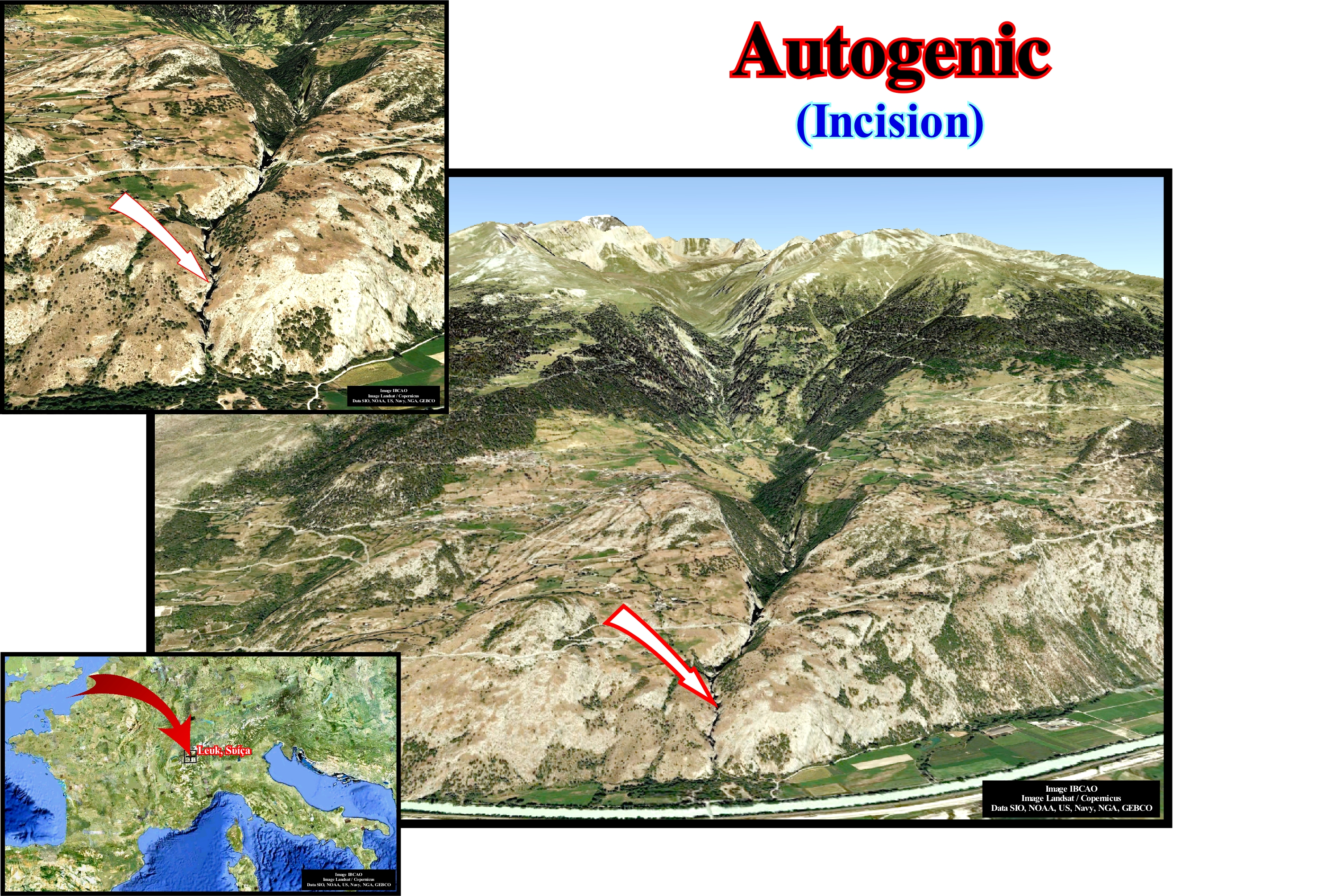
Although the incision illustrated in this photograph may be considered as autogenic, in this particular case the water-course, which eroded the rocky substratum, was localized and accentuated its action along a zone of fragility of the rocks induced by the relative movement of the faults blocks of a normal fault. Autogenic incisions are most, often, associated with relative sea level falls, induced by the combined action of eustasy and tectonics (uplift or subsidence of the sea floor). At a relative sea level fall, the shoreline and coastal deposits move seaward. If the relative sea level fall is significant, it may happen that the entire continental platform is exhumed and a new shoreline located on the upper part of the continental slope. The displacement of the shoreline, which can reach hundreds of kilometers, displaces, also, the mouth of the water-course seaward (towards the basin) and downward (negative aggradation of the coastal onlaps). Such a displacement, causes the rupture of the provisional equilibrium profiles of the water-courses. In this way, the water-courses are forced to dig (autogenic incision) their beds and exhumed the platform in order to new provisional equilibrium profiles can be reached (a definitive profile of equilibrium is never reached). Later, when the relative sea level begins to rise and before the first transgressive flooding surface of the exhumed platform, the incised valleys (autogenic incisions) are filled by sediments, usually, sand and clay, contemporaneous with the deposition of the upper part of the lowstand prograding wedge (LPW) deposited seaward of the basin edge. It is the incised valley fills, that allow geoscientists to identify the unconformities (erosional surfaces induced by significant relative sea level falls) limiting the different stratigraphic cycles, whether they are continental encroachment cycles or of higher hierarchy. Upstream of the continental edge, which may or may not correspond to the basin edge, particularly, when unconformities are not tectonically enhanced (angular unconformities), erosional surfaces are difficult to recognize, particularly, on seismic lines.
Autogenic (Process).........................................................................................................................................................................Autogénique (processus)
Autogénico / Autogénico (proceso) / Autogenem (Prozess) / 自体(过程)/ Autogeneic (процесс) / Autogeneic (processo) /
Process belonging to the sedimentary system itself. A river channel (size and configuration), tides and storms, for instance, can be considered as autogenic processes. Synonym of Autocycle (process).
See: « Autocycle »
Autolith...............................................................................................................................................................................................................................................Autolithe
Autólito / Autolito / Autolith / Autolith (火成岩片段 ) / лит (включение более древней изверженной породы) / Autolito /
Fragment of an igneous rock included in a igneous of later consolidation, being both derived from the same magma. An oval, rounded or elongated accumulation of ferromagnesian minerals, of uncertain origin, inside a granite rock. Sometimes synonymous Xenolith.
see « Granite »
&
« Xenolith »
&
« B-Type Subduction (Benioff) »
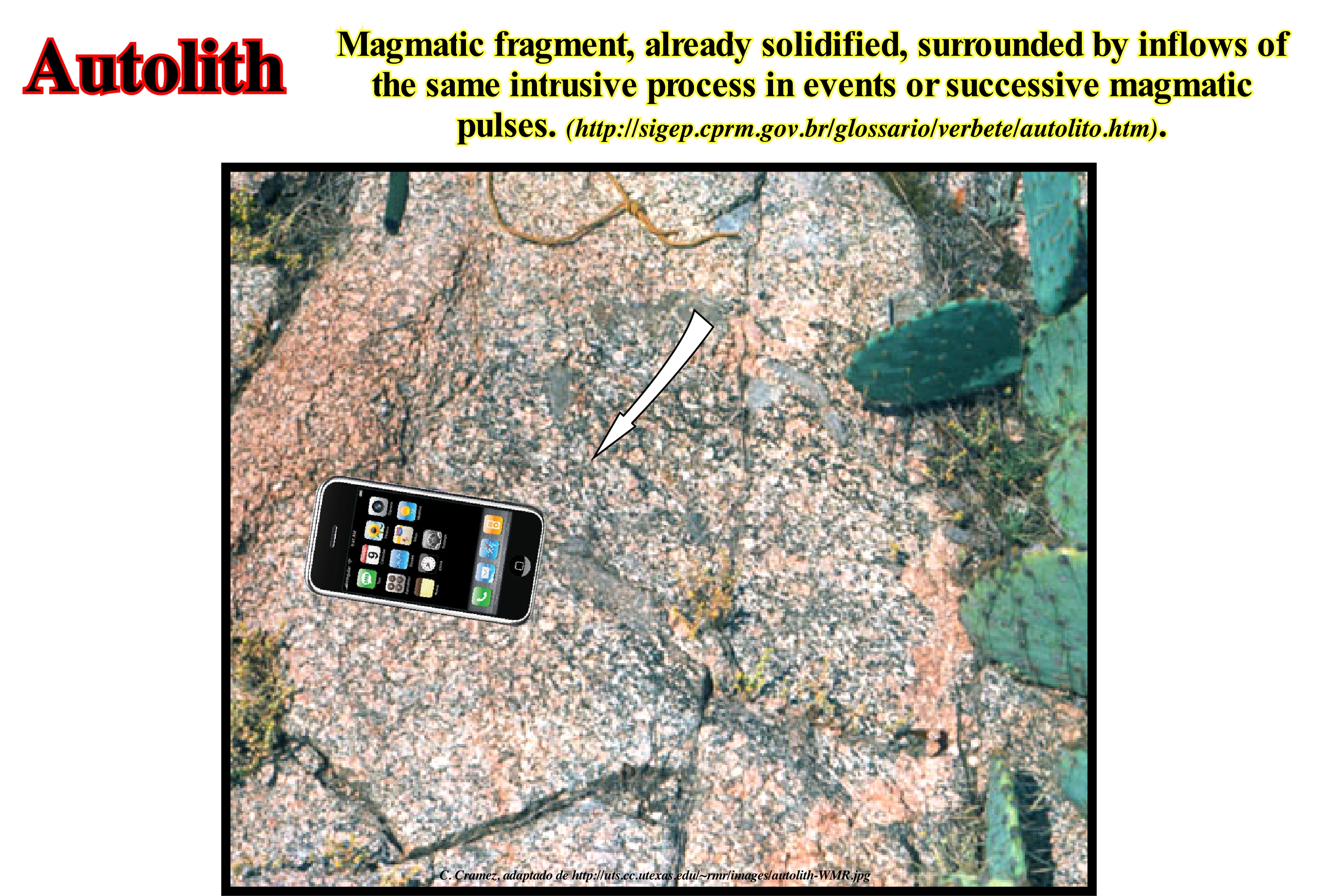
The visible inclusion in this photograph of a porphyritic granite is an autolith rich in biotite, suggesting two distinct phases of granite formation. The first phase, represented by a dark granite was, sufficiently, competent to fracture, while the second phase was still, more or less, liquid to incorporate into the first (autolith). For some geoscientists autoliths are xenoliths (fragments of rocks that are involved in a larger rock during the phase of development or consolidation). For others, xenoliths are inclusions that are not derived from the same magma and correspond, sometimes, to very different rocks. Thus, when a fragment of limestone is contained within a volcanic rock, the term autolith is not appropriate to denominate it, since it has a, completely, different origin and composition (usually, it is torn from the walls of the rocky the volcanic magma crossed to rise to the surface). In this case, it is preferable to say the limestone block is a xenolith of the volcanic rock. The same happens with certain granitic rocks, as for example, in a migmatite*, in which xenoliths of sedimentary rocks, more or less, metamorphosed and granitized can be recognized. Not all granite rocks are the result of the crystallization of a magma. In some cases, sedimentary rocks can be buried deep and, progressively transformed into granite. That is to say, that in this case the formation of granite (granitization**) or very similar rocks is done by metamorphic processes, as opposed to the igneous processes in which the granites are formed from a magma (liquid) of sialic composition. In a granitization, the sediments are transformed into the solid or partially molten state by processes requiring the addition and removal of various chemical components such as solid diffusion, vapor transport or aqueous solution movement. Thus, it can be said that in the first case the inclusions are autolithic, but not in the second, they are simply xenoliths.
(*) Mixture of metamorphic rock and igneous rock . It is created when a metamorphic rock such as gneiss, partially, melts, and then that melt recrystallizes into an igneous rock, creating a mixture of the unmelted metamorphic part with the recrystallized igneous part. (https://en.wikipedia.org/wiki/Migmatite)
(**) Granitization is an essentially metamorphic process by which a solid rock is converted into a granitic rock by the entry and exit of material, without passing through a magmatic stage. Some authors include in this term all granitic rocks formed from sediments by any process, regardless of the amount of melting or evidence of movement. The precise mechanism, frequency, and magnitude of the processes are still in dispute. (https://www.mindat.org/glossary/granitization).
Autotrophic, Autotroph (Organism)..................................................................................................Autotrophique (organisme)
Autotrófico / Autotrófico (organismo) / Autotrophen / 自养 / Автотрофный / Autotrofi /
Organism capable of synthesizing organic matter from inorganic compounds. Autotrophs or autotrophics produce their own sugars, lipids and amino acids, from CO2 as a source of carbon, and ammonia or nitrates as a source of nitrogen.
See: « Bacteria »
&
« Viruses»
&
« Photosynthesis »
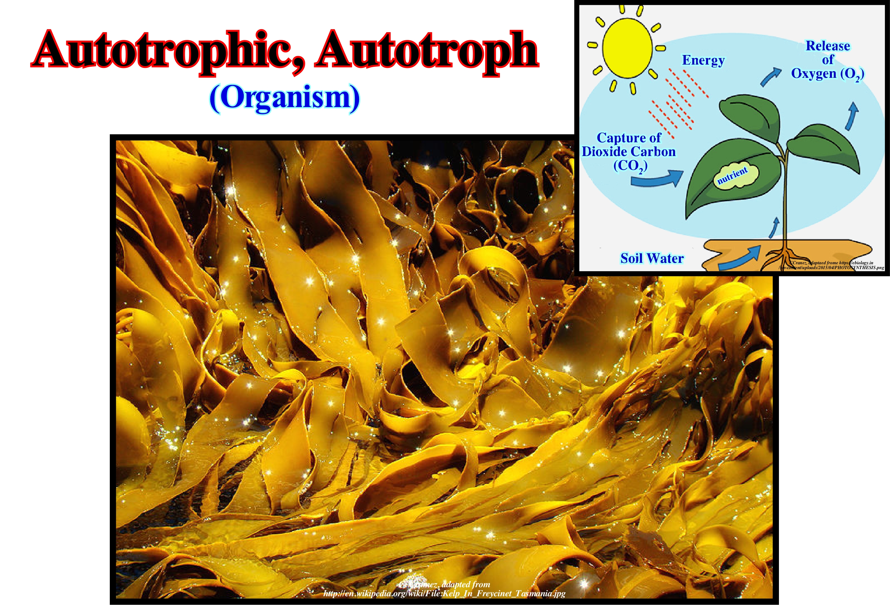
Organisms that use light to synthesize organic compounds are called auto trophic photosynthetic. Organisms that oxidize compounds, such as hydrogen sulfide (H2S) for energy, are called autotrophic chemosynthetic. Photosynthetic include green plants, certain algae and sulfur pigmented bacteria. Chemosynthetics include iron bacteria, nitrifying bacteria and non-pigmented sulfur bacteria. The algae* illustrated in this figure are brown algae (Feofyceae class). They are typically autotrophic organisms, which are producers in the food chain. Autotrophic or autotroph organisms are able to fix carbon, that is, they do not use organic components as a source of energy or carbon. They draw energy from the environment in the form of sunlight or inorganic products and use it to create energy-rich molecules such as carbohydrates. This mechanism is known as primary production. Many autotrophic organisms use water as a reducing agent. Others may use hydrogen compounds such as hydrogen sulfide (hydrogen sulphide). Autotrophic organisms can be phototrophic and lithotrophic. The former use light as a source of energy, while the latter oxidise inorganic compounds, such as hydrogen sulfide, sulphur, ammonia, etc. Non-autotrophic organisms, that is, heterotrophic or heterotrophs, take autotrophs off their food. They rely on autotrophs for the energy they need. Heterotrophics obtain energy by breaking down the organic molecules (carbohydrates, fats, and proteins) acquired by food. Carnivorous organisms depend, ultimately, on autotrophs, because the nutrients from their heterotrophic prey come from the autotrophs consumed.
(*) Algae are a very diverse group. These aquatic organisms range from unicellular microscopic beings to multicellular organisms that form very large and showy colonies. Algae make one of the greatest contributions of oxygen to the planet. It is estimated that they participate with about 50% of the global photosynthesis. Currently, the term algae refers to organisms that have cells with nuclei (eukaryotes) excluding blue-green algae that belong to the kingdom of bacteria (Phylum Cyanobacteria). The great diversity of algae forms a group with diverse (polyphyletic) kinship. The most important and well-known groups belong to two different kingdoms: (i) Green algae (Chlorophyta) of the kingdom Plantae and (II) Red algae red (Rhodophyta) and chestnuts (Heterokontophyta) belonging to the kingdom of Protista (http://www.biodiversidad.gob.mx/species/gran_familia/plants/algae/algae.html)
Aventail (Turbidites)...................................................................................................................................................................................................................Tablier
Apron / Apron / Schürze (Turbiditen) / 围裙(地质) / Фартук (геология) / Apron (geologia) /
Clay deposit located at the base of submarine slope fans (SSF) of a sequence-cycle. Turbiditic overbank deposits and levees (marginal natural dykes), as well as turbidite channel fillings (or depressions between the lobes) cover, generally, the aventail, which in some cases is deposited, directly, on the submarine basin floor fans (SBFF) of a sequence-cycle when they onlap against the base of the continental slope. Synonyms of Apron.
See: " Apron"
Average Storm Wave................................................................Limite moyenne d'action des vagues de tempête
Acção das vagas (mar agitado, limite médio) / Acción de olas (mar agitado) / Aktion der Wellen (raue See, Durchschnittsgrenze ) / 平均风浪限制行动 / Средний предел действия штормовых волн / Limite medio di azione di onde di tempesta /
When the erosive action of waves reaches a depth of about 30 meters, which means the distance between two successive waves (distance between two crests or two consecutive troughs) is about 60 meters, i.e., half the wavelength.
See: « Major Storm Wave Base »
&
« Depositional Base Level »
&
« Relative Sea Level Change »
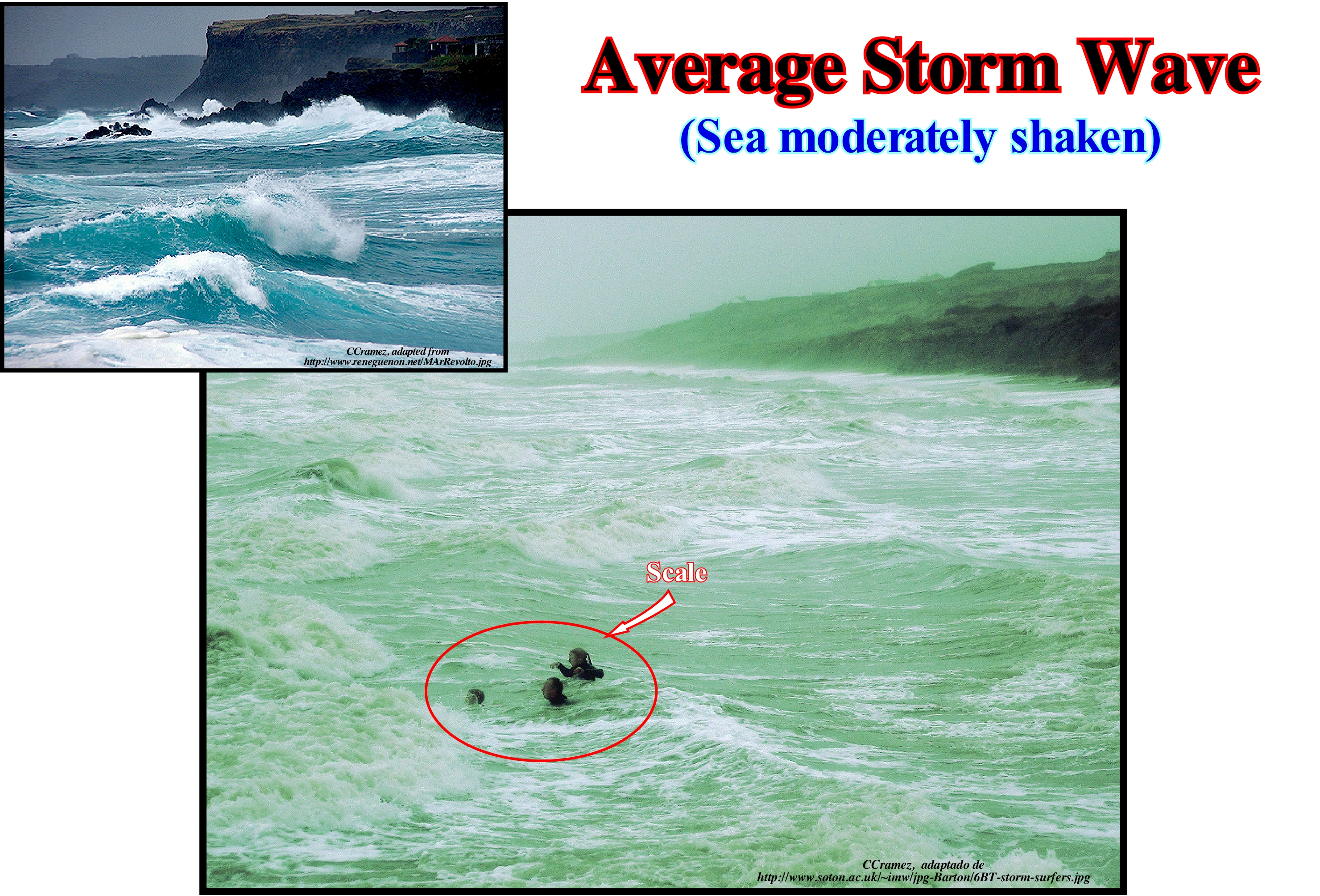
When the sea is agitated, as illustrated in these photographs, it is, generally, very muddy. It contains much suspended material, mainly, drawn to the sea-floor by the erosive action of the waves. As in these examples, the wavelength of the waves (distance between two crests or two successive troughs) is, more or less, 40 m, it can be said that erosive action reaches a depth of about 20 m. At a given point, the depth of the erosive action of the waves is, approximately, half the wavelength of the waves. The speed of the waves varies with the depth of the sea floor. It corresponds, in fact, to a phase velocity (speed at which a point, characterized by a certain phase in a simple periodic wave, moves in space). The distinction between waves and swell (deformation of the water surface of seas, oceans, or large lakes due to wave propagation) is quite delicate. Roughly, it can be said that the swell is a very regular oscillation profile, very regular, connected to a moving depression, and propagates over very long distances, that is, mainly in the great oceans. On the contrary, the waves, which represent what certain Portuguese fishermen call "sea of wind" are oscillations formed in situ under the influence of a local wind, to the condition that it exceeds 1.5 to 2 meters per second. The particles of the surface of the water put in movement by friction of the wind follow circumferences, in a vertical plane oriented to axis of the wind. These surface particles impart a certain movement by friction to the underlying water particles, but the diameter of the circles described by them decreases exponentially with depth. Outside the wave surf zone, it is not the moving water particles, but the crests and troughs of the waves, i.e., the phase of the surface of the water (think of the movement of an object floating in the sea). The surf zone and the area where the waves of oscillation (propagate only vertically when the depth is equal to or greater than the wave-length) are transformed into translation waves (they propagate horizontally, provided that the water blade is less than half the length of the wave). In terms of sequential stratigraphy, it can be said that the erosive action of the waves is responsible for the ravinment surfaces created, mainly, during the eustatic paracycles inducing the deposit of the transgressive interval (TI) of a sequence-cycle. Within a sequence-cycle, the mechanism for forming such ravinment surfaces can be summarized as follows: (i) During the deposition of the lowstand prograding wedge (LPW), coastal onlaps fossilize the continental slope of the preceding sequence-cycle, since the basin has no shelf, i.e., the shoreline, during the lowstand prograding wedge, does not emphasize a true continental edge ; (ii) Since relative sea level rises in acceleration, the depositional coastal break of the depositional surface is individualized and displaced landward (marine ingression) ; (iii) Such a displacement of the shoreline initiates a shelf with a water-depth equivalent to the relative sea level rise, which, at same time, individualizes, downstream, a new basin edge, which corresponds to the shelf edge ; (iv) During the relative sea level rise, which, here, is in acceleration, the erosive action of the waves produces a ravinment surface (small erosion) in the sea-floor. The ravinment surface is, later, progressively fossilized by the sediments deposited during the stability period of the relative ea level, which occurs after the marine ingression, as the shoreline moves seaward ; (v) The progradation of the depositional coastal break and the associated coastal sediments ends with a new accelerating relative sea level rise, which displaces the shoreline again continentward, creating a new ravinment surface ; (vi) A new stability period of the relative sea-level follows the eustatic paracycle (there is no relative sea level fall between the eustatic paracycles), which again allows deposition forcing the shoreline to move seaward and so on ... until the relative sea level rise again but in deceleration (beginning of the highstand prograding wedge (HPW) of the sequence-cycle). The sea level is absolute or eustatic, when it is referenced to the Earth's centre and it is relative relative when it is referenced to any of the Earth's surface, which may be the base of the sediments (top of the continental crust) or the sea-floor. The relative sea level is the result of the combined action of absolute sea level and tectonics (subsidence or uplift of the sea-floor).
Avogadro's Law...................................................................................................................................................................................................................Loi d'Avogadro
Lei de Avogadro / Ley de Avogadro / Avogadrosches Gesetz / 阿伏伽德罗定律 / Закон Авога́дро / Legge di Avogadro /
At the same temperature and pressure, equal volumes of gas contain the same number of molecules (set of atoms identical or different, united to each other through chemical bonds).
See: « Kinetic Theory »
&
« Atom »
&
« Gas »
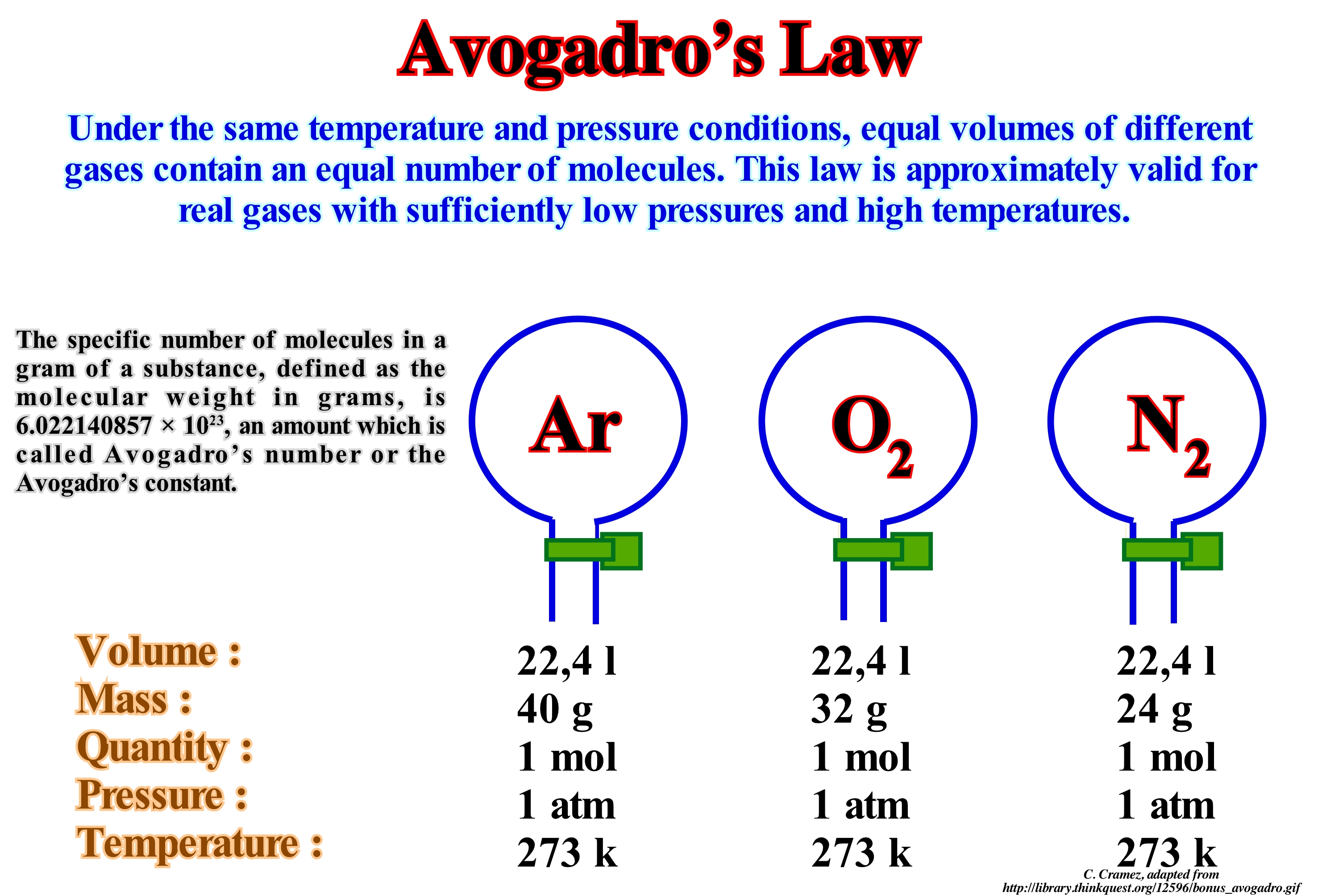
Avogadro's law went unnoticed around 50 years ago. In 1811, when Avogadro proposed his law, very little was known about the atoms and molecules*. Avogadro has held that Gay-Lussac's law" (volumes of gases that combine or which are produced by chemical reactions are always in relation to small integers**, for example one volume of nitrogen and three volumes of hydrogen produce two volumes of ammonia, these volumes are in a ratio of integers 1: 2: 3) gave a way to prove that an atom of a molecule are not the same thing. He suggested that the particles (now known as molecules) nitrogen, which is composed of two atoms. A nitrogen (nitrogen) molecule is N2. Likewise, the hydrogen molecule is H2. When one volume (one molecule) of nitrogen combines with three volumes (three molecules) of hydrogen, two volumes (two molecules) of ammonia, NH3, are produced. The idea that a molecule consists of two or more connected atoms was not understood by the chemists of that time. Avogadro's law was forgotten until 1858, when the Italian chemist Stanislao Canning (1826/1910) explained the need to distinguish between atoms and molecules. From Avogadro's law, one can deduce that the number of molecules of all gases, at the same temperature and pressure, must have the same volume. This number has already been determined experimentally. Its value is 6.0221367 (± 36) x 1023, which is known as Avogadro's number (or Avogadro's constant). The Avogadro number is a quantity unit, such as a tens (= 12) or result (e.g. = 20). One can speak of Avogadro's number of atoms, molecules, grains of sand, people, or auto-mobiles. A mole (mole symbol) is the mass of an Avogadro number of anything. Thus, 1 mole of 1H atoms is equal to 1.008 grams; 1 mole of 12C atoms is equal to 12 grams; 1 mole of H2O molecules is equal to 18 grams. The terms "Avogadro number" and "mole" are interchangeable. The example illustrated in this figure translates well Avogadro's law describing the ratio of the molecules of a gas to the volume of its vessel. Volume (V) = Constant (K) x Molecules (n). When a balloon is filled, two things can happen: (1) Air introduction into the balloon or (ii) Air flow from the balloon to the outside. If one does not fill the balloon sufficiently, it can be said that the air is not enough, which is a direct observation of Avogadro's Law. The more air is placed inside the balloon, the greater its volume, because the volume of the balloon is the volume of the gas trapped.
(*) An electrical neutral group of two or more atoms held together by chemical bonds. Molecules are distinguished from ions by their lack of electrical charge. However, in quantum physics, organic chemistry, and biochemistry, the term molecule is often used less strictly, also being applied to polyatomic ions.
(**) Volumes of gases that combine or which are produced by chemical reactions are always in relation to small integers, for example one volume of nitrogen and three volumes of hydrogen produce two volumes of ammonia , these volumes are in a ratio of integers 1: 2: 3
Avulsion...............................................................................................................................................................................................................................................Avulsion
Avulsão / Avulsión / Ausriss / 撕脱 / Внезапное изменение русла реки / Avulsione /
Abrupt and violent change of the trajectory of a turbiditic current. There is avulsion when a turbiditic current abandons the anomaly where it flows (turbiditic channel or depression), to take another route. Unlike a river, a turbidite current does not, necessarily, have a bed. The first natural turbiditic levees (natural marginal dykes) lie at the same level as the current, while the first fluvial levee (natural marginal dikes of a river) deposit far above the river bed.
See: « Turbidite »
&
« Flow-Stripping (turbidites) »
&
« Basin Floor Fan »
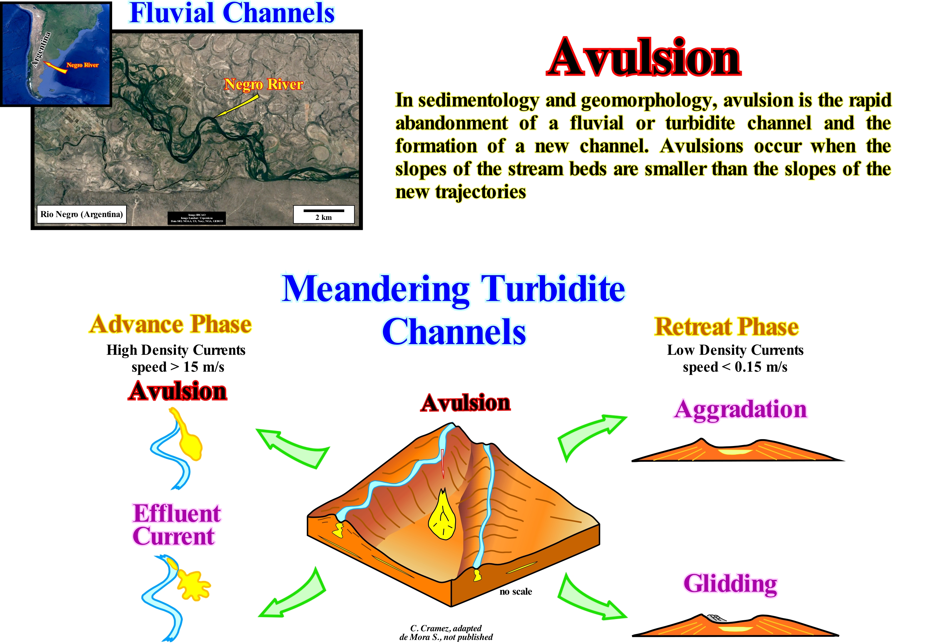
Unlike a river, a turbidite stream does not, necessarily. have a bed. The first natural turbiditic levees (natural marginal dykes) lie at the same level as the current, while the first fluvial levees (natural marginal dikes of a river) deposit far above the river bed. In Peter Vail's turbidite depositional systems, induced by significant relative sea level falls, i.e., deposited under lowstand geological conditions (sea level lower than the basin edge), as well as in Emiliano Mutti fluvio-turbidite deposition, associated, above all, with catastrophic floods produced, generally, during lowstand geological conditions, whenever a geoscientist uses the term turbidite or turbiditic channel, he must always specify what he means by "turbiditic channel*. Indeed, the term "turbidite channel" is abusive and creates, in most cases, many confusions. The genesis of a turbidite channel corresponds in no way to that of a river channel. In the same way, a turbidite current does not correspond, in any way, to a fluvial current. A water-course, such as a river, for example, needs to have a bed (river bed or stream bed) along which it flows. When a river overflows, natural levees (fluvial natural marginal dikes) form above the river-bed. A turbidite current does not need to have a bed to flow. When it decelerates, as it reaches the base of the continental slope, the transported material deposits, forming two, more or less, elongated lateral lobes looking the abyssal plain. On the deepest part of the abyssal plain, it deposits a distal lobe, more or less, conical with the apex pointing toward the continental slope. The space between two lateral lobes (often called, but erroneously "turbidite channel") represents just the place of passage of the fastest part of the turbidite current that, decelerating, will deposit the material, still transported, more downstream. When you go to the beach, fill a bucket, with which the boys, usually, play, with sand and sea-water and throw the content on sand on the beach. You will, easily, verify that the sandy content is deposited on two lateral mounds separated by a zone in which nothing has been deposited and another mound at the end of the flow. If you repeat this operation several times, flipping the contents of the bucket always, more or less, in the same place, you will find that, progressively, the side lobes overlap, exaggerating, more and more, the area without deposition between them. It will also be noted that there is, practically, no erosion between the lobes and that, progressively, the currents which you form when you throw the contents of the bucket on the sand are channelled, i.e., they are, more or less, forced to pass by the depression between the mounds. In geology, a channel is a natural ditch (natural water-way) along which a stream flows. If the current is fluvial, the fluvial channel can be referred to, and if the current is turbiditic, it is possible to speak of a turbiditic channel, only when the current eroded the substratum. When fluvial or turbidite channels are abandoned and filled by sediments they form fluvial channels fills or turbidite channels fills, but not "fluvial channels" or "turbiditic channels", as many geoscientists say. This is particularly frequent on the tentative geological interpretation of seismic lines. In turbidite systems, the consequences of avulsion, i.e., the consequences of an abrupt change in the trajectory of a turbidite current, and effluent currents (currents emanating practically, from one-point) are, sometimes. visible within a sequence-cycle, especially in the submarine slope fans (SSF). It is in the advancing phase (when the height of a turbiditic current exceeds the capacity of the depression formed between the turbidite levees), that a part of the current, at least, overflows. In theory, a complex of turbiditic currents has two phases: (i) Advance or Progradational Phase, when the density and velocity of the currents is important and characterized by avulsions and flow-stripping (or effluent) currents and (ii) Retreat or Aggradational Phase, when the density and speed of the currents is weak. The retreat phase is characterized by silting (accumulation) by aggradation and gliding the edges of the depression between the side lobes along which the streams flow. It is during the retreat phase that the vast majority of depressions between the levees are filled, forming, often, excellent reservoir-rocks, as is the case, for example, in the northern offshore of Angola (South Congo geographic basin).
(*) Moore (1978) used the term turbidite channel for all those underwater path (not canyons) through which water and sediments flow in turbidite systems (Moore et al., 1978 - Sedimentology and Paleobathymetry of Engine Encore-Slope PostScript, Flash Island, InDesign , The Journal of Geology, Volume 88, Premium 2 Mar., 1980). WR Normark (1978) proposed the use of the term of fan valley for the valley that has natural marginal dikes (levees) and is located in the upper fan, while the channels developed in the medium and low fan le called distributive channels (Normark, WR 1978 Fan Valleys, channels, and depositional lobes on modern submarine fans: characters for recognition of sandy turbidite environments Am. Assoc. Petr. Geol. Bull, 62 (6) 912-931).
Axial Jet.....................................................................................................................................................................................................................................................Jet Axial
Jacto axial / Chorro axial / Axiale jet / 轴向射流 / Осевая струя / Getto assiale /
In geology, an axial jet or axial flow is a water-stream characteristic of a hypopycnal current. When stream enters a water-body (by definition less dense) it propagates in a cone-shaped with a certain apical angle.
See: « Planar Jet »
&
« Delta »
&
« Turbidite »
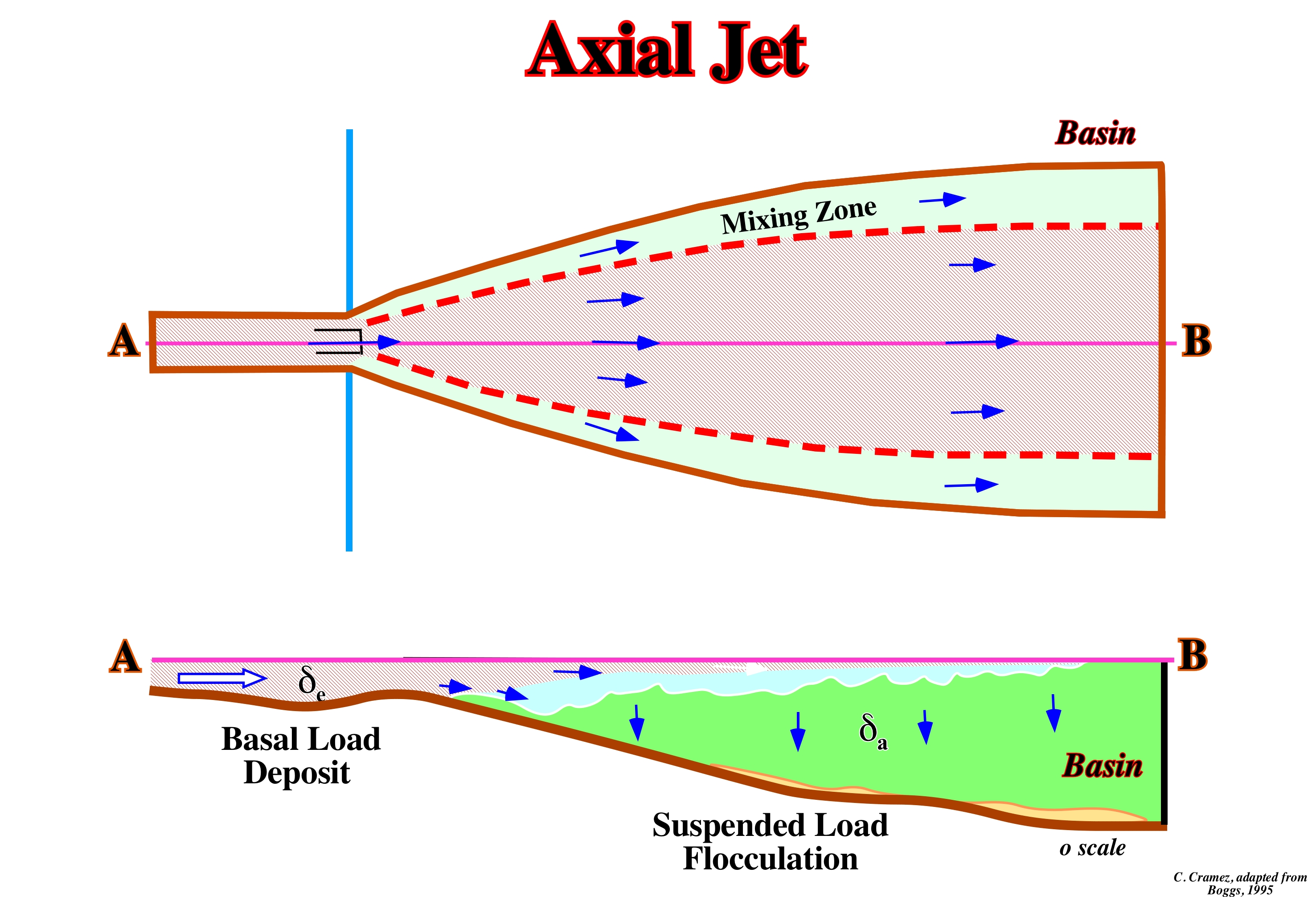
A river has: (i) A spring, which is the place where the river originates (rise) ; (ii) A bed that is occupied by the water of the river ; (iii) The banks, which are the land surrounding the river and (iv) The mouth, which is the place where it ends, which may be the sea, a lake or another river (in this case the river is called affluent). A river transports sedimentary particles in a number of different ways: (i) Material in solution (water, which by percolating the rocks, dissolves diverse substances which are then transported in solution) ; (ii) Mechanical and colloidal suspension material (a stream of water has the ability to hold solid particles in suspension due to its velocity and turbulence) and (iii) Material by drag and jumping (salting). The movement of the water creates a horizontal pressure on the bed, which increases with the speed and viscosity of the water. If the bed is made of incoherent material, it will be set in motion by the force of the water. Larger sedimentary particles are pushed and, often, fail while smaller ones roll and jump in a disordered motion. It is the set of transported material that determines the density of the stream entering the basin or drainage basin (set formed by the main stream and the tributaries of the catchment area of a water-course, i.e. all the land drainage of the water from the precipitations for this watercourse, which is measured in km2). When the density of a stream is less than the density of the water-body in which it flows, as shown in this figure, the flow of the river is said to be hypopycnal. Under these conditions, the water of the river flows over the water of the receiving water-body by an axial jet stream, gradually, depositing the clay particles to form, generally, a prodelta. The clay particles cease to be suspended by flocculation* (they agglutinate due to the ratio of the positive/negative charge created by sea water). Situations of this type are common when a river enters the sea or to salty lake, since the great density of the sea-water separates, easily, the basal load of the load carried in suspension. The basal load of a stream is composed of particles of significant granulometry, such as sand and gravel, which are transported either by salting, sliding or rolling on its surface. Due to the volume and density of the particles, the velocity of the bed load is much slower than that of the flow. The hypopycnal flow is frequent, when the river carries material, mainly relatively, fine in suspension responsible for the formation of most of the deltas. In addition to the hypopycnal flow, there are, also, hyperpycnal and homopycnal flows. If the water density of the river is greater than the density of the receiving water, the river flow is hyperpycnal. The river water plunges into the bottom of the water-body, such as a turbidite stream, with a planar jet flow in the central part and a mixing zone on the outside. A reception basin (catchment basin) is land depression (usually with significant dipping) where the runoff waters accumulate giving rise to water-courses with a rapid and irregular flow. If the water density of the river is, more or less, equal to that of the receiving water, the river flow is homopycnal and the sedimentary particles deposit forming a bank of mouth and, often, a Gilbert-type delta (alluvial sedimentary particles deposit, directly, in the sea or into a lake when the shoreline is near the bayline), particularly where the river current carries a significant sandy load. The way the river mixes with the water of the receiving basin, the friction of river water and the buoyancy ** of river water at the mouth, must also be taken into account in order to understand the depositional systems induced by the river discharge.
(*) The process in which the colloids (one or more of the components have, at least, one of their dimensions between 1nm to 1μm), leave suspension in the form of aggregates, forming larger particles (called flakes). Flocculation differs from precipitation since before of flocculation, the colloids are simply suspended in a liquid and not actually dissolved. In a flocculated system there is no formation of a denser material on the bottom of the container, since all the flocs are in suspension.
(**) The Archimedes principle states that "an object totally or partially immersed in a liquid undergoes the action of a vertical force, from the bottom up, of equal intensity to the weight of the fluid displaced by that object". I = ρ.g.V where I is the impulse, ρ is the density of the fluid, g is the acceleration of gravity and V is the volume of fluid displaced. Archimedes concluded that a body that floats displaces an amount of fluid equal to its own weight. Note that this "fluid" is not necessarily water, and may even be a gas. (http://ciencia-em-si.webnode.pt /products/principio-de-flutuabilidade/).
Axis of Oceanic Expansion (Axis of spreading).......................................................................Axe d'expansion
Eixo de Expansão / Eje de expansión (oceánica) / Achserweiterung (ozeanische) / 轴膨胀(海洋) / Ось распространения (океаническая) / Axis espansione (oceanica) /
Hypothetical axis that defines the rotation of one or a pair of lithospheric plates and which is totally independent of the geographic axis of rotation of the Earth.
See: « Deep Sea-floor »
&
« Mid-Oceanic Ridge »
&
« Subduction Zone »
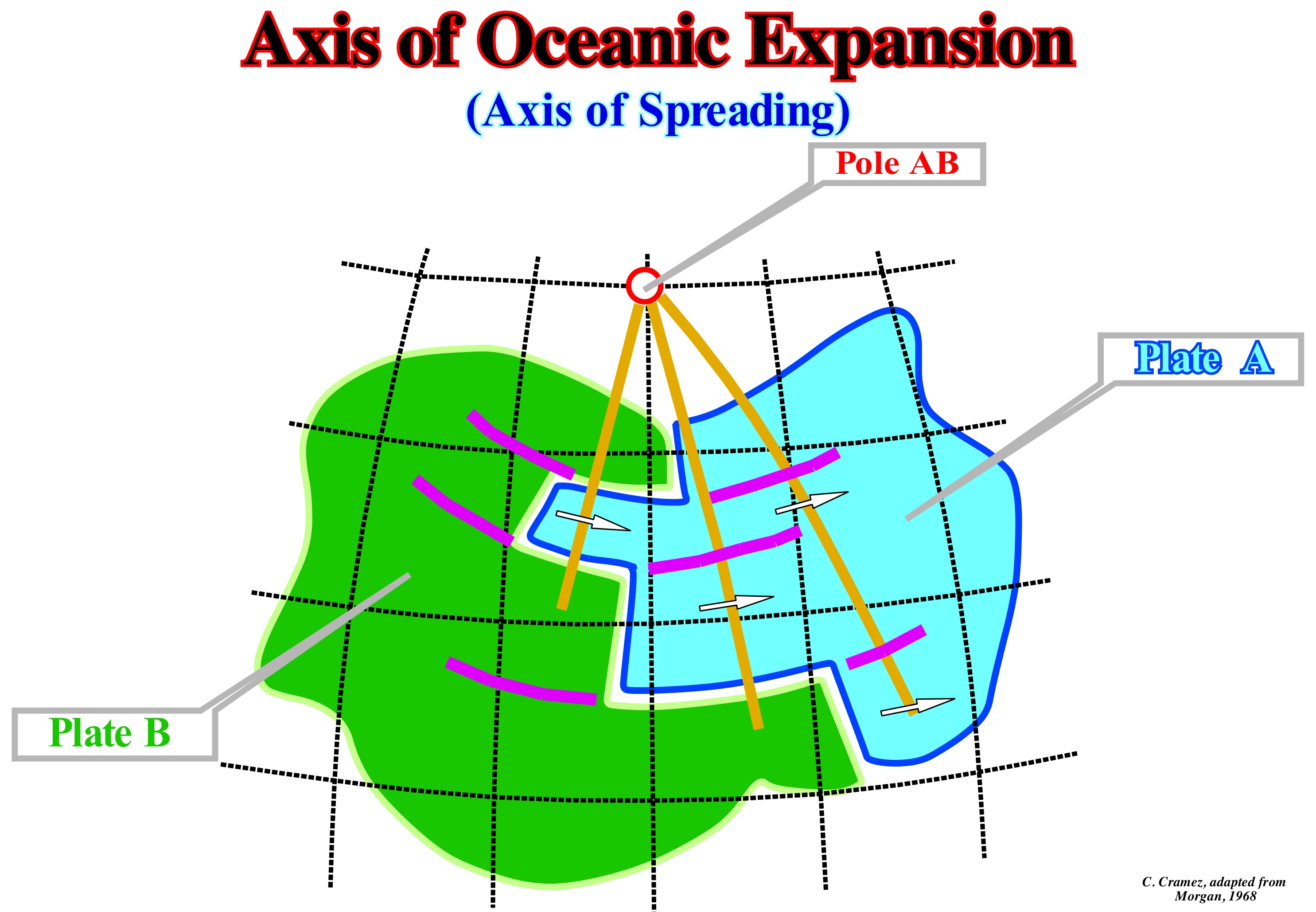
On a sphere, all the caps move around an axis. This axis passes through the centre of the sphere and cuts the surface at two points, called centres of rotation or Euler poles. Such a rotation of a shell can be described from another shell (relative motions) or from a reference system located inside the sphere (absolute motions). All points in the same shell spin around the pole with the same angular velocity* (degrees or radians per time). However, they have different linear velocities (linear velocity increases with distance from pole). The trajectories of the movement of the points of a shell are circular (smaller circles of the sphere) centred on the pole. Thus, the reconstruction of the movement of lithospheric plates is, easily, explained by Euler's theorem. The movement of a rigid material on the Earth's surface can be described in terms of rotation around two fixed points or poles (the movement of a plate on the surface of the Earth depends only on the angle of rotation). The poles and angles of rotation of the different lithospheric plates describe the movements that the different continents carried out on the Earth's surface during the geological evolution. The boundary between two lithospheric plates is, in most cases, the mid-oceanic ridge. The lateral displacements of the mid-oceanic ridge (transform faults) are apparent. Transform faults have nothing to do with strike-slip faults. Contrary to many people's beliefs, the mid-ocean ridges, where the new oceanic crust forms, are not faulted and displaced by strike-slip faults. Such displacement is just active where there is formation of new oceanic crust. As long as the oceanic crust solidifies all the lateral displacement is impossible. The directions of displacement correspond to the directions of the old faults existing in the lithosphere of the supercontinent before it was elongated and breakup, that is to say, before the lithosphere reached a thickness of about 10/15 km. It has to be taken into account that, when a lithosphere is lengthened, in association with thermal anomalies (cause or effect), at beginning, the enlargement is due to normal faults with formation of rift-type basins, as the thickness of the lithosphere decreases. However, according to certain geoscientists, once the thickness of the lithosphere reaches about 10-15 km, that is, when it is, strongly, injected by volcanic material of the asthenosphere, it can no longer be lengthened by normal faults. It breaks, that is to say, the volcanic injections become predominant along the old faults and zones of fragility of the thinning lithosphere of the supercontinent and the material of the asthenosphere ends up to individualize two lithospheric plates. It is these directions of the old faults and fractures that condition the direction of the transform faults and the orientation of the mid-oceanic ridges. In the sketch illustrated in this figure, the lithospheric plate B moves in relation to plate A. The transform faults (fracture zones between the displacements of the ridges) and the mid-oceanic ridges limit the two lithospheric plates. The AB pole is the common pole of the relative motion of plates A and B, if it is the point of intersection of the meridians, which are perpendicular to the transform faults. The hypothesis of continental drift was presented by A. Wegener in 1912. However, and despite Wegener's arguments, in the absence of a satisfactory explanatory mechanism, it was not accepted by a large majority of geoscientists. The arguments presented by Wegener, as indeed those of his successors, were based just on the observation of the continents. The bottoms of the oceans, which account for about two-thirds of the Earth's surface and whose knowledge is crucial to understanding the Earth as a whole, were largely unexplored. This situation changed, after World War II with the development of oceanography and underwater observation techniques. It was the gradual discovery of the ocean floor that allowed the implementation of the mobilistic ideas, which conjecture that there are horizontal displacements to the surface of the Earth.
(*) The direction of the angular velocity is given by the axis of rotation, and the rule of the right hand indicates the positive direction, as follows: by wrapping the fingers of the right hand following the direction of rotation, the direction of the angular velocity is indicated by your right thumb.
(**) In a three-dimensional space any movement of a rigid solid which maintains a constant point must also leave a complete axis constant, which means that any composition of rotations on a rigid solid with arbitrary axes is equivalent to a single rotation on a new axis, called the Euler pole.
Azimuth.....................................................................................................................................................................................................................................................Azimut
Azimute / Azimut / Azimut / 方位角 / Азимут /Azimut /
The horizontal angle measured in the direction of the movement of the needles of a clock between a direction on the Earth's surface and a direction of reference, usually the North.
See: « Dip »
&
« Depositional Dip »
&
« Depositional Strike »
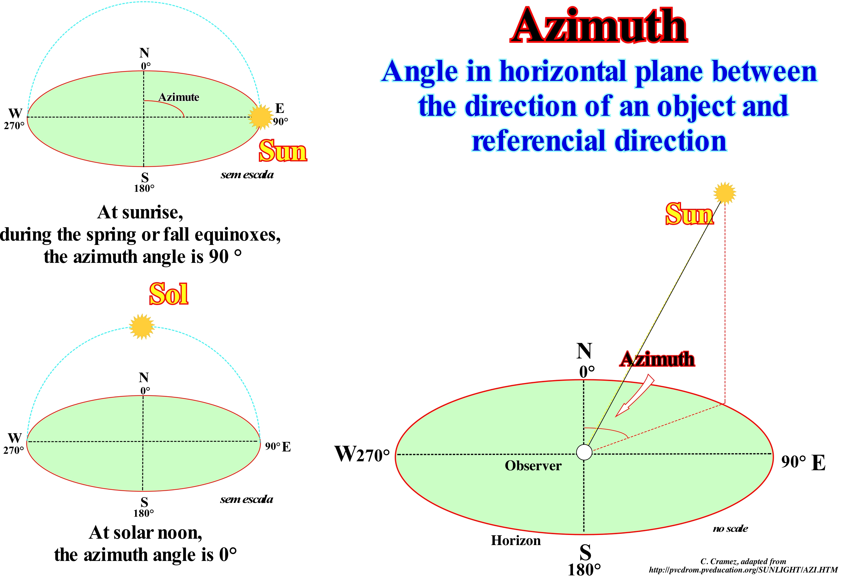
The word azimuth is derived from Arabic and means direction. Azimuth is, usually, measured in degrees. The concept of azimuth is used in many practical and industrial applications, whether in navigation, astronomy, cartography, mining, artillery, etc. In astronomy, the azimuth is the angular distance (measured in the direction of the movement of the needles of a clock) from the southern point of the horizon to the intersection with the horizon of the vertical circle passing through a star. In navigation, the azimuth is defined as the horizontal angle measured in the direction of the needles of a clock from the north or meridian. The term azimuth is, also, used in the military context and above all in artillery, where it is defined as the direction of fire. Azimuth in air navigation is defined as the direction of flight at a certain point in the aircraft. In the mining industry, the azimuth or meridian angle is the angle measured in the direction of the needles of a clock of any meridian or reference plane. A typical example of azimuth is the determination of the position of a star in the sky. The star is the point of interest, the reference plane is the horizon or the surface of the sea, and the reference point vector points to the north. Azimuth is the angle between the north point and the perpendicular projection of a star over the horizon. It can be said that the azimuth angle is the angle between the north, indicated by the compass, and the direction of the sunlight. As illustrated in the diagrams of this figure, at noon, the sun is, practically, southward in the northern hemisphere. As illustrated, the azimuth angle varies through the day. On the equinoxes, the Sun rises, directly, to the East and lies directly to the West, independently of latitude, but with an azimuth angle of 90° at sunrise and 270° at sunset (note that it is not the sun that rises or sets, but the dipping Earth that rises, since it is the Earth that orbits the sun and not the opposite). In general, the azimuth angle varies with latitude and with time during the year. The mathematical equations for calculating the position of the Sun during the day are well known to those interested. Taking into account the atmospheric refraction, i.e., due to refraction, the sunrise occurs, slightly, before Sun crosses the horizon line. The light of the Sun is deviated or refracted, since it enters the Earth's atmosphere.

