
Palasome (Mineral)......................................................................................................................................................................................Palasome (Minéral)
Palossoma/ Palasoma (mineral) / Palasoma (Die Host-Rock oder Mineral in einer Ersatz - Anzahlung) / Palasoma (主机岩或更换矿床矿物) / Первичный минерал / Palasoma (la roccia ospitante o minerale in un deposito di sostituzione) /
Rock or mineral from which another rock or mineral (metasoma) can form. Synonym with Paleosoma.
See « Metasoma (mineral) »
&
« Quartz »
&
« Diagenesis »
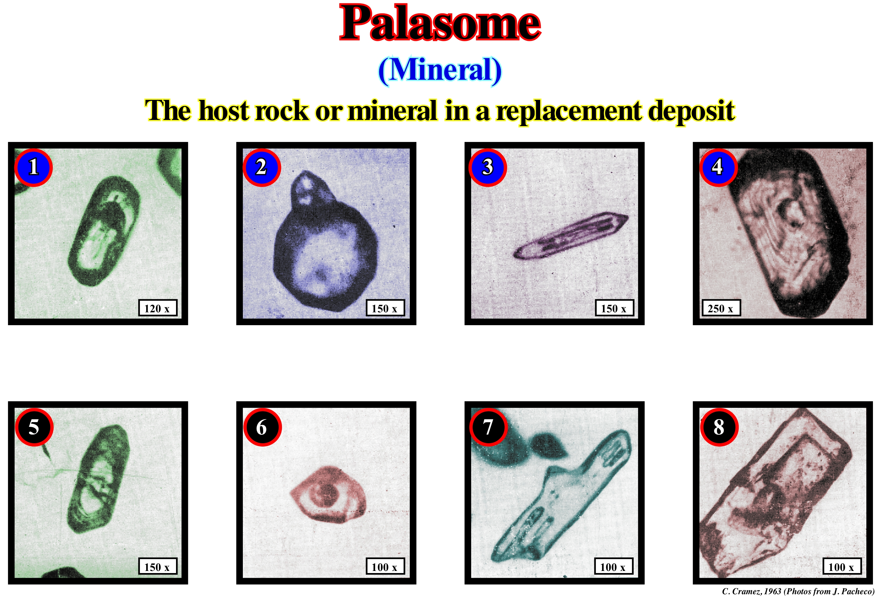
Palasomes are minerals or rocks, which are replaced by metasomatosis. They are what certain geoscientists call the rocks or mineral hosts. During the crystallization process of a magma, in a first step, crystals may form, which are later involved or fossilized by the growth of minerals, which form in the later stages of crystallization. The minerals, which formed first, are included in the minerals that formed later. In the same way, inclusions can also be formed and included in the host mineral during metasomatism processes. The inclusions and palasomes are always solid, and may assume well defined crystalline forms (such as pyrite within emeralds or diamonds within diamonds, zircons within zircons or quartz crystals, etc.), or rounded (such as apatite and calcite within certain rubies or zircon within certain zircons). In this figure, there are above all shown zircon palasomes (the number 8 is an anatase palasome). These palasomes suggest that the granite from which they were taken is probably of metasomatic origin. Indeed, the presence of rolled zircon grains (as 1 and 6) included within zircon metasomas seems to falsify (refute) the hypothesis of a granite magmatic origin. Probably, granitic rock resulted from chemical alteration (one rock or mineral process being transformed into another) from other rocks by interaction with liquids. It is this kind of chemical alteration that geoscientists call metasomatism. Such a change must occur when the rock, or the mineral, is no longer in a melt phase, i.e., in a liquid phase resulting from or not from the melting of a solid material at high temperatures, so that it is considered as meta-somatic. The metasomatic rocks can be very varied and often difficult to characterize. Often, and notwithstanding their great extent, they may be so little altered that the only evidence of the metasomatic alteration is a slight colour change or an increase in the crystallization of the clay minerals (micas). In these cases, a good petrographic and petrological study are essential for understanding the genesis of these rocks.
Paleo-Tethys.........................................................................................................................................................................................................................Paleotétis
Paléo-Téthys / Paleo-Tetis / Paläotethys / 古特提斯洋 / Палеотетис / Oceano Paleo-Tetide /
Ocean that, in the Paleozoic, separated the small supercontinents Gondwana and Laurasia. The opening of the Paleotethys Sea began in the Silurian on the northern margin of Gondwana.
See: « Tethys Sea »
Paleobathymetry..........................................................................................................................................................................Paléobathymetrie
Paleobatimetria / Paleobatimetría / Paläobathymetrie / 古水深 / Палеобатиметрия / Paleobatimetria /
Water-depth during a sedimentary deposit. Upstream of the depositional coastal break coastal, it is, practically, zero, meaning that the available space for the sediments, created by a relative sea level rise, is completely filled. Downstream of the depositional coastal break, it increases, progressively, since only part of the available space (shelfal accommodation) is filled. Synonym of Paleowaterdepth.
See: « Shelfal Accommodation »
&
« Relative Sea Level Rise »
&
« Bathyal »
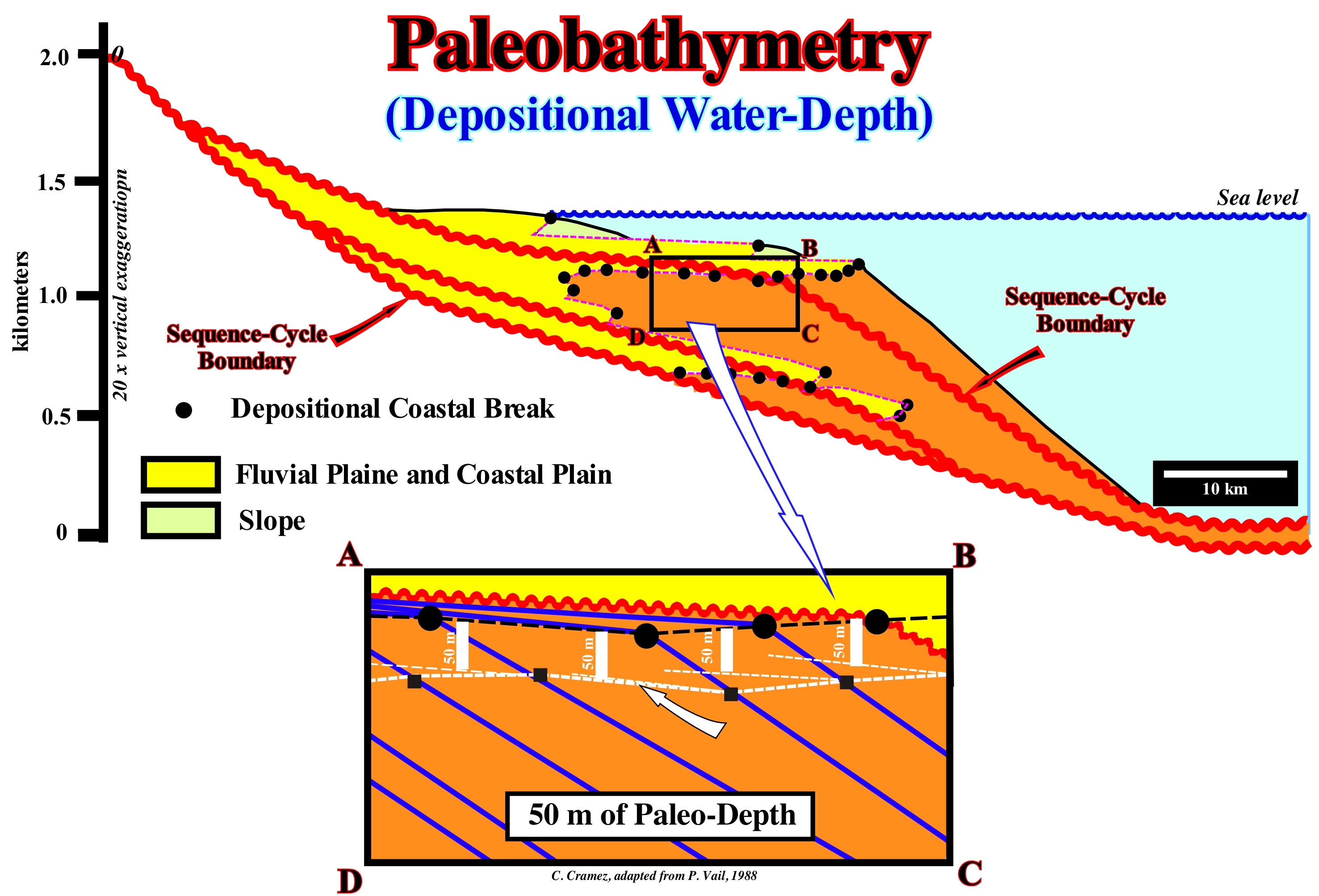
Paleobathymetry is the determination of the old water-depth at the time of deposition which provides an interpretation of the paleoenvironments used in petroleum exploration, since it gives important indications for determining the depositional history of a sedimentary basin. Benthic foraminifera are, commonly, used for this purpose. Animals that live on the sea floor, also, provide precious information. Many species live within a, relatively, limited interval of water-depths in patterns, normally, related more to the distribution of the water-body within the basin than, directly, with bathymetry. Paleobathymetry can also be determined from the geological interpretation of seismic lines in terms of sequential stratigraphy. During the transgressive interval (TI) of the highstand systems tracts group (HSTG) of a cycle-sequence*, the shoreline (more or less, the depositional coastal break of the depositional surface) moves away from the continental edge (in certain cases, it may coincide with the shoreline), since a shelf is, gradually, formed between them. In fact, during the transgressive interval (TI), marine ingressions are increasingly important, while sedimentary regressions, which they induce, are increasingly smaller. Such an association, which, collectively, some geoscientists call transgressions, creates a retrogradational geometry, which means that at the end of each sedimentary regression the shoreline is less and less progradational, which increases the extent of the shelf. At the beginning of the highstand prograding wedge (HPW), the extension of the continental shelf is maximal (the shoreline and associated coastal deposits occupy the most proximal positions). However, as the decelerating rise in relative sea level (sea level resulting from the combined action of tectonics and absolute or eustatic sea level, which is referred to the Earth's centre) continues, the shoreline, progressively, moves seaward, gradually, reducing the length of the shelf. The shoreline approaches the continental edge, which under these highstand geological conditions emphasizes the basin edge. Over time (in the absence of a relative sea level fall), from a certain point, the basin has no shelf, since the shoreline coincides with the basin edge (continental edge). This is the end of the 1st phase of the highstand prograding wedge. From this moment begins the second phase of development of the highstand prograding wedge (HPW). The basin has no more continental shelf and the shoreline coincides, more or less, with the continental edge, which also functions as the basin edge. Theoretically, upstream of the depositional coastal break of the depositional surface, which coincides with the basin edge (basin without continental shelf) or not (basin with a shelf), the all increase of available space for sediments (accommodation) created by a relative sea level rise (which is in acceleration or deceleration), is filled by sediments. However, seaward of the depositional coastal break, only a part of the available space is filled. The accommodation is equal to the thickness of the deposited sediments plus the water-depth. The paleo-depth of the depositional water, as illustrated in the geological sketch of this figure, can be, easily, calculated in the geological and seismic sections. For this, it is enough to individualize: (i) Chronostratigraphic lines that emphasize depositional surfaces (blue reflectors in detail A, B, C, D) ; (ii) In each chronostratigraphic line, it is evident that the depositional coastal of the depositional surface corresponds roughly to the shoreline (black circles) ; (iii) The line passing through the depositional coastal breaks (dotted black line), which underlines a zero depositional paleo-depth ; (iv) For each chronostratigraphic line, consider as the reference plane the sector continentward of the depositional coastal break that corresponds, more or less, to the coastal plain (zero of depositional paleo-depth) ; (v) Draw a plane parallel to the reference plane at the point (on the same chronostratigraphic line) where you want to determine the depositional paleo-depth ; (vi) The vertical distance, between this plane and the reference plane, gives th depositional paleo-depth at that point of the delta slope or the continental slope scale function ; (vii) The line joining the black squares emphasizes a depostional paleo-dfepth of 50 m.
(*) A sequence-cycle is a stratigraphic cycle induced by a third order eustatic cycle, that is, induced by an eustatic cycle with a time-duration between 0.5 My and 3-5 My. A sequence-cycle is composed of sedimentary systems tracts that can be grouped into two groups: (i) Lowstand Systems Tracts Group (LSTG) and (ii) Highstand Systems Tracts Group (HSTG). The lowstand systems tracts group is composed of three sub-groups of systems tracts, which from the bottom to top area: a) Submarine Basin Floor Fans (SBFF) ; b) Submarine Slope Fans (SSF) and c) Lowstand Prograding Wedge (LPW). The highstand systems tracts group consists of two sub-groups that, from the bottom to top are: d) Transgressive Interval (TI) and e) Highstand Prograding Wedge (HPW).
Paleoclimatology............................................................................................................................................................................Paléoclimatology
Paleoclimatologia / Paleoclimatología / Paläoklimatologie / 古气候学 / Палеоклиматология / Paleoclimatologia /
Climate change of the past. Modern climatology, which is based on a large number of observations made over a short period of time, which, correspond, often, to direct measurements of the properties and characteristics of the atmosphere, oceans and ice, explains, badly, climate changes, i.e., the paleoclimatology.
See: « Climatology »
Paleocurrent...........................................................................................................................................................................................................Paléocourant
Paleocorrente / Paleocorriente / Paläocurrent (Current fossilen) / 充注 / Палеотечение / Paleocorrente (corrente fossil) /
Old current that existed in a geological past, such as a direction of flow, which can be inferred either from the cross bedding stratifications (current ripples) or from other sedimentary structures induced by the paleocurrent.
See: « River »
&
« Flux »
&
« Paleobathymetry »
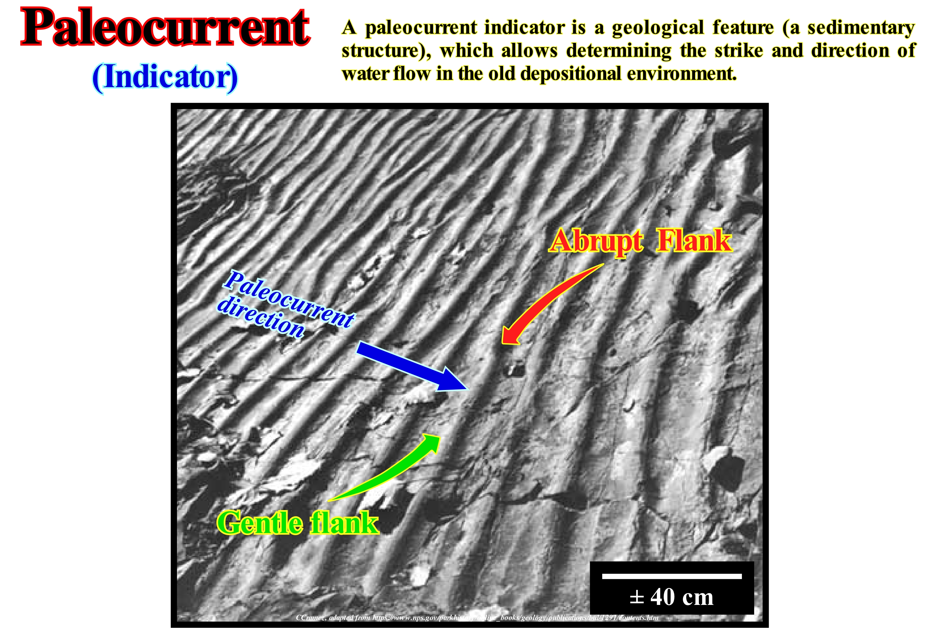
Paleocurrents are vectors that indicate the direction of flow of the currents, which deposited sediments on the Earth's surface in a geological past. The study of modern seas, estuaries and rivers has shown that there is a clear relationship between physical geography and the currents that exist in it. The currents imprint on the deposits associated with their characteristics, which later can be deduced by the study of the geometry and shape of the stratification planes of the sedimentary layers. The study of the paleocurrent allows to define, the geometry of the sedimentary basins and the dispersion patterns of the sediments. Potter & Pettijohn (1977) suggested the large-scale study of paleocurrents could even be used to understand the crustal evolution of the continents, their limits, age of uplifts and tectonics. There are other structures, such as stromatolites* that indicate the direction of the paleocurrent. Stromatolites can develop in an elongated shape, which underlines the direction of the currents, or can be, more or less, inclined and asymmetrical and used to determine the direction of the currents and the orientation of the coastline. At Shark Bay, in Australia, stromatolites were used to reconstitute the paleocurrent during deposition of Proterozoic sediments. These studies corroborate the hypothesis that the elongated, elliptic and columnar forms of the stromatolites are parallel to the direction of the waves and more or less perpendicular to the coastline (although they may, sometimes, be oblique to the coastline). It seems that in certain cases (old sediments), the stromatolites can also be oriented in parallel to the shoreline (shoreline deduced from sedimentary structures).
(*) More or less stratified accretional structures formed in shallow water by retention, bonding and cementing of sedimentary grains by microorganism films, especially cyanobacteria - blue-green algae.
Paleogeography..................................................................................................................................................................................Paléogéographie
Paleogeografia / Paleogeografía / Paläogeographie / 古地理学 / Палеогеография / Paleogeografia /
Study the geography of the geological past, including the Earth's surface patterns, the distribution of the continents and oceans, as well as, the ancient mountain ranges and other terrestrial elements.
See: « Supercontinent »
&
« Wilson's Cycle »
&
« Depositional Environment »
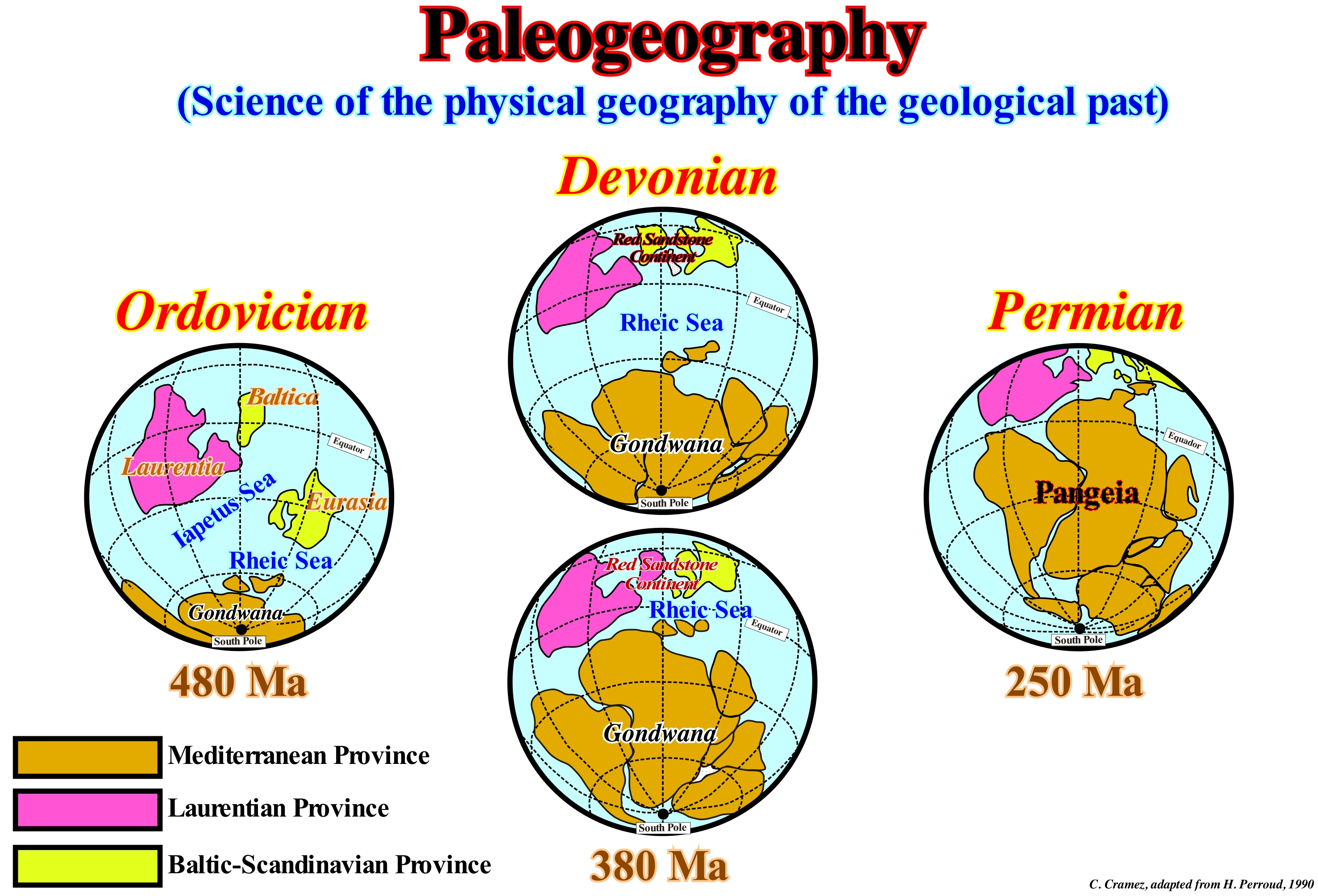
On a large scale, paleogeography studies the positions, surfaces, topography and geology of the continents, as well as the bathymetry of the oceans. On the small scale, paleogeography studies the paleogeographic contexts of the sedimentary basins or environments in which certain geological formations have formed. In this type of study it is essential to define the geological time of the data used, which can be done by biostratigraphy (i.e., zone, stage or epoch) or from the existence of particular deposit environments such as an evaporite or delta basin. All the geosciences contribute directly or indirectly in this type of studies, since, the successive paleogeographies suggest a lot on the evolution of the Earth's surface, hydrosphere and biosphere. Most paleogeographic data are placed on maps, which include paleogeographies that show the positions of continents and, eventually, outcrops during a particular geologic time. Besides scientific value, this type of map has an economic value (for example in the delimitation of areas where the presence of certain natural resources is more probable). This figure shows, on a large scale, the main paleogeographies during the Paleozoic until the formation of the Pangea supercontinent. During the Ordovician, it can be said most of the continental mass was located in the southern hemisphere and distributed in four great continents: (i) Gondwana (Africa, South America, Australia, India, Antarctica) ; (ii) Laurentia ; (iii) Baltica and (iv) Eurasia. The Iapetus Sea* separated Laurentia and Baltica from Eurasia. Eurasia was separated from the Gondwana small supercontinent by the Rheic Sea**. During the Devonian, the Iapetus Sea was closed with the formation of the old red sandstones continent (Caledonian orogeny). At the same time, the Gondwana began to move northward, beginning the closing of the Rheic Sea (Hercynian orogeny). During the Permian, the Rheic Sea closed, completely, with the Hercynian orogeny, which originated the formation of the Pangea supercontinent, which then fractured individualizing different continents that correspond, more or less, to the present continents.
(*) The Iapetus Sea was situated in the southern hemisphere, between the Laurentia, Baltica and Avalonia continents. The Iapetus Sea closed with the Acadian, Caledonian and Taconic orogenies, when the Laurentia, Baltica and Avalonia collide to form the Euramerica continent.
(**) The Rheic Sea was one of the main Paleozoic Oceans that separated the two small supercontinents Gondwana and Euramerica (Laurentia-Baltica-Avalonia). The Rheic Sea closure was the result of the assembly of the Pangea supercontinent and the formation of the Hercynian - Appalachian - Ouachita orogenies. Presently, its suture stretch from Mexico to Turkey (around 10,000 km).
Paleolatitude..........................................................................................................................................................................................................Paléolatitude
Paleolatitude / Paleolatitud / Paläolatitude (Breite in der geologischen Vergangenheit) / Paleolatitude (在过去的地质纬度) / Палеоширота / Paleolatitudine /
Latitude (location on Earth to the north or south of the equator) of a continent or any other part of the Earth's crust in the geological past. Due to the oceanic expansion (sea floor spreading), continents changed of latitude, in a meaningful way, during the different geologic periods.
See: « Sea Floor Spreading »
&
« Polar Wandering »
&
« Baltica »
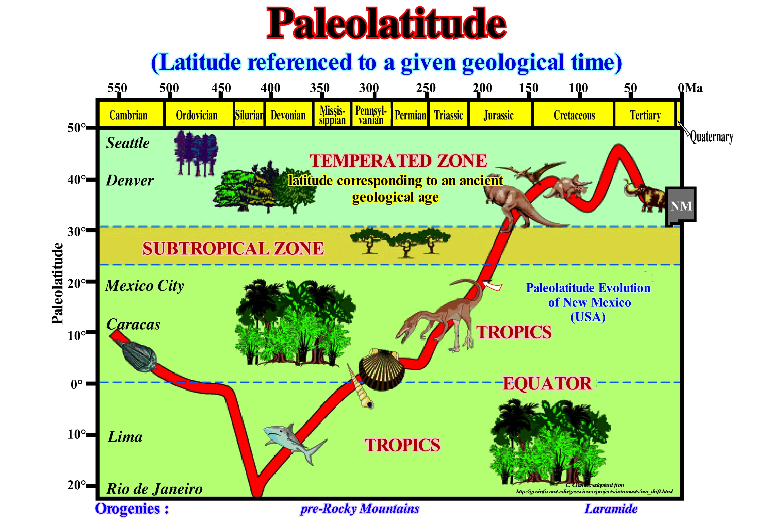
When the paradigm of Lithospheric Tectonic Plates was accepted by most geoscientists (in the 1960s and 1970s), paleomagnetic data began to be used to interpret the drift of the continents and thus to determine the paleolatitudes of the continents throughout the geological history. As illustrated in this figure, the influence of the continental drifting (in this case the evolution of New Mexico paleolatitude, USA) on climate, geomorphology and habitat through geological time is more than evident. The paleomagnetic poles became available to all continents and their temporal distributions on the globe, defined trajectories of apparent pole drift (APD). That is to say, for the same continent and for ever younger rocks, the virtual poles (geographic coordinates where the Earth magnetic poles should be located to explain the acquisition of remaining magnetization by a particular rock) follow a trajectory to the current Earth's poles. For America and Europe, the trajectories of the virtual poles are different, but both tend towards the current geomagnetic pole*. It is important not to forget that the position of the paleomagnetic pole, i.e., the point corresponding to a mean of the virtual magnetic pole for a period of 10,000/100,000 years, relatively, to the continent sampled does not give the paleolongitude of the continent. Also, do not forget that the distance from the paleomagnetic pole to the area sampled, reflected by the magnetic inclination**, provides a direct estimation of the continent paleolatitude. Therefore, the samples must be oriented so that the angles of declination and inclination of the paleomagnetic field can be determined, so that the angles measured in the laboratory can be related to the angles of the Earth reference (to the condition, of course, that the Earth's magnetic field can be assimilated to the field of a dipole whose axis coincides with the axis of rotation of the Earth and located at its centre).
(*) One of the geomagnetic pole, i.e., one of the antipodal points (points on the surface, which are diametrically opposite) where the axis of a best-fitting dipole intersects the Earth's surface
(**) Or magnetic dip is the angle made with the horizontal by the Earth's magnetic field lines, which varies at different points on the Earth's surface.
Paleomagnetic Stratigraphy.............................................................................Stratigraphie paléomagnétique
Estratigrafia Paleomagnética / Estratigrafía paleomagnética / Paläomagnetische Stratigraphie / 古地磁年代学 / Палеомагнитная стратиграфия / Stratigrafia paleomagnetiche /
Branch of the stratigraphy in which the remnant magnetization of a rock is used to place it on the magnetic scale constructed from the temporal variations of the Earth's magnetic field.
See: « Stratigraphy »
&
« Sequential Stratigraphy »
&
« Magnetostratigraphy »
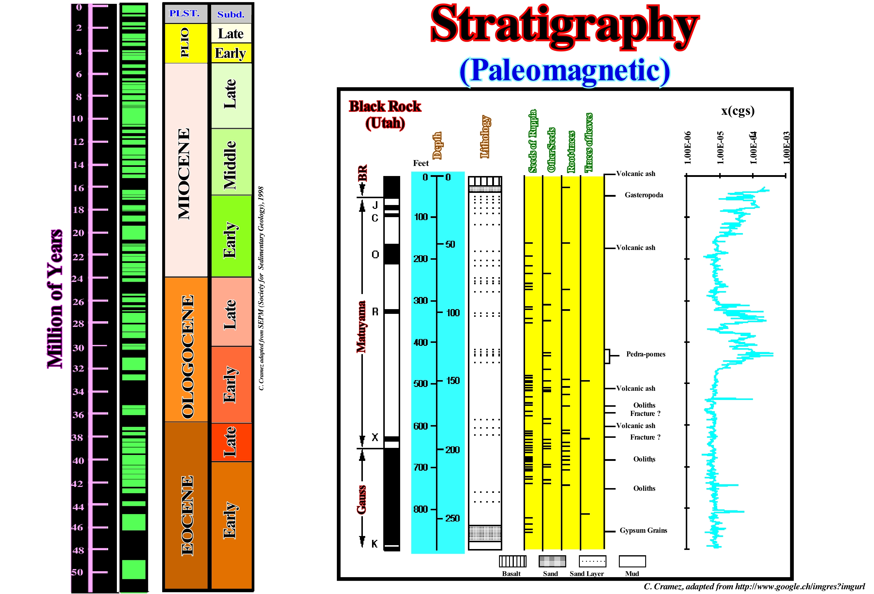
As shown in this figure in addition to the sequential and genetic stratigraphy, the Transgression/Regression stratigraphy* (T/R) stratigraphy, the Isotopic stratigraphy and paleomagnetic stratigraphy can also be considered. Magnetism is closely linked to the movement of electrons in atoms. The moving electric charge produces a magnetic field. The Earth's magnetic field varies with time. At high temperatures, all materials are paramagnetic (unlike diamagnetic materials, paramagnetic are not attracted to magnets). Materials with electrons not arranged in pairs undergo a phase transition with ferromagnetic behaviour below a certain temperature called the Curie Point. At a higher temperature, all ferromagnetic material loses its magnetic characteristics (768° C for iron). At temperatures below the Curie point, the magnetic moments of ferromagnetic materials are partially aligned with the Earth's magnetic field. A magnetic mineral crystallized above the Curie point and then cooled acquires a remnant thermal magnetism (RTM) in the same direction and with an intensity proportional to the applied magnetic field. If a magnetic mineral is formed by chemical alteration or metamorphism at a temperature below the Curie point, it acquires a chemical remnant magnetism (CRM). If a given rock with magnetic minerals is cooled and later altered with growth of new magnetic minerals, remnant thermal magnetism (RTM) and chemical remnant magnetism (CRM) may have different directions. If magnetic particles are released from a rock, transported and deposited on a new rock at a temperature below the Curie point, the particles are oriented according to the magnetic field at the time of sedimentation (magnetism of remnant deposition or MRD), which is about of 1,000 times weaker than the magnetism of a lava, where each small dipole is, perfectly, aligned with the applied field. Do not confuse a magnetic field (movement of electric charges) with an electric field, which arises only with a charge, and which is perpendicular to it. In favourable circumstances, paleomagnetic stratigraphy is a unique stratigraphic tool that allows precise global dating and correlations between sedimentary columns of different environments. In fact, inversions of geomagnetic field polarity have important applications in stratigraphy because they occur in a very short period of time in comparison with periods of polarity stability, which means they can be, easily, defined and accurate manner in the stratigraphic column. On the other hand, unlike biostratigraphic events, inversions of polarity occur, simultaneously, across the Earth and are not influenced by environmental conditions, which allows for correlating different environments (volcanic, marine and continental). However, since magnetic inversions have very little individuality, magnetostratigraphy is, often, used in association with other methods, such as biostratigraphy or radiometric dating. The results that can be expected from the magnetostratigraphy depend on several factors, the most important being (https://books.google.ch/books?isbn=2710809109): (i) The rate of geomagnetic inversion during the considered period (it is, for example, very high during the Miocene, but there are no inversions during Turonian, Cenomanian and Albian) ; (ii) The existence of a reference scale (GPTS or Geomagnetic Polarity Time Scale), which is well established for the entire Cenozoic and part of the Mesozoic ; (iii) Magnetic properties of the rock and preservation of the NRM ("Natural Permanent Magnetization" ) in the studied interval. This figure shows the Cenozoic paleomagnetic stratigraphy based on the inversions of the Earth's magnetic field. Times of normal magnetic polarity (as at present) are represented in black and times of inverse polarity, in white. Also, in this figure the correlation between Stratigraphy, Sedimentology, Paleontology and Paleomagnetism of the Pliocene / Pleistocene lacustrine sediments in the lake of the Black Rock well drilled in Utah (USA) is illustrated.
(*) Transgressions area increasingly important marine ingressions and increasingly smaller sedimentary regressions. Regressions are increasingly smaller marine ingressions and sedimentary regressions more and more important.
Paleomagnetism............................................................................................................................................................................Paléomagnétisme
Paleomagnetismo / Paleomagnetismo / Paläomagnetismus / 古地磁学 / Палеомагнетизм / Paleomagnetismo /
Study of ancient magnetic fields (sometimes preserved in the magnetic properties of rocks), changes in position and inversions of magnetic poles in the geological past.
See: « Sea Floor Spreading »
&
« Polar Wandering »
&
« Magnetostratigraphy »
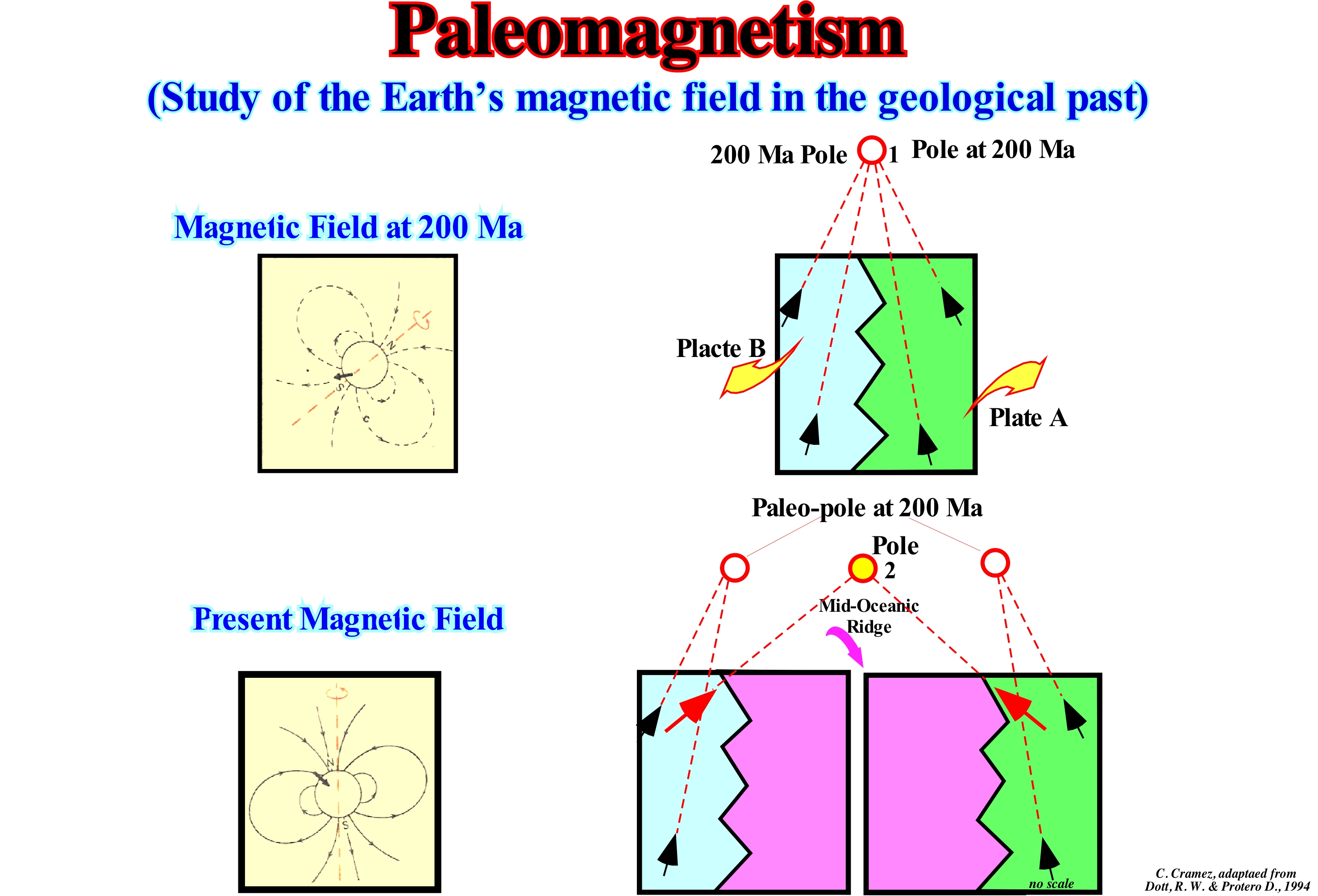
Paleomagnetism is the study of the records of the Earth's magnetic field, which is preserved in various magnetic minerals through geological time. Paleomagnetism has shown that over time, the Earth's magnetic field varied, greatly, both in orientation and intensity. It may be said that certain geoscientists study the ancient magnetic fields by measuring the orientation of the magnetic minerals of the rocks at the time of their formation (remnant magnetism) to determine the most probable configuration of the Earth's magnetic field at the time of deposition, according to the observed orientations. The magnetic north pole has, constantly, shifted relative to the Earth's rotation axis, which means that magnetism is a vector and that a variation of the Earth's magnetic field can be determined by the magnetic declination and inclination and paleo-intensity. In this figure, the magnetization of the rocks that constitute the lithospheric plates A and B indicate a certain paleomagnetic pole (1). However, 200 My later (that is, after 200 million years of oceanic expansion), the magnetization of the rocks indicates, of course, another pole (2). The geoscientists realized, soon, that in reality it were the poles that remained fixed and the continents moved horizontally, more or less, independently. In addition, geoscientists noted, also, that the direction of the fossil magnetization of the rocks corresponded to the current (normal) or inverse magnetic field. Magnetic inversions occurred, at irregular intervals, throughout the Earth's history. The ages and patterns of these inversions were determined from the oceanic expansion and dating of the associated volcanic rocks. In 1963, it was suggested that the linear magnetic anomalies observed at the surface of the oceanic crust were induced by bands magnetized alternately in opposite directions.
Paleontology....................................................................................................................................................................................................Paléontologie
Paleontologia / Paleontologia / Paläontologie / 古生物学 / Палеонтоло́гия / Paleontologia /
Study of the fossils, i.e., of the remains of ancient living beings in order to be able not only to reconstitute them, but also to use them to establish evolutionary relations. Science of the fossils, old life forms and their evolution.
See: « Fossil »
&
« Geological Time »
&
« Relative Age »
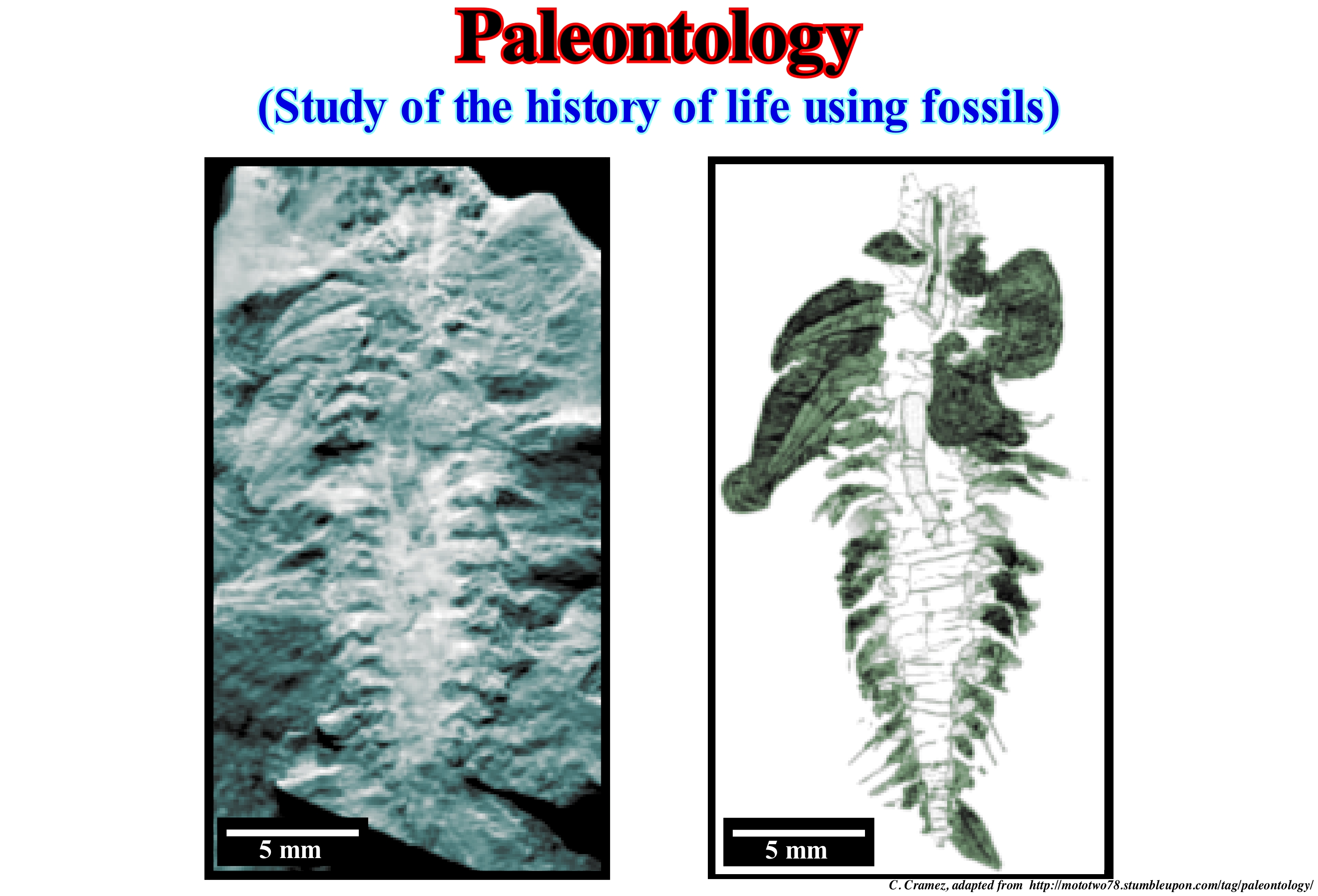
Paleontology allows the reconstitution of ancient sedimentary environments and, above all, biostratigraphy, in which the distribution of fossils observed through geological time is used not only for dating but also for correlations. Paleontology links the sciences of geology and biology, drawing its main principles and methods from both, and thus interconnecting them. Over time, paleontology was subdivided into different disciplines: (i) Vertebrate paleontology, which focuses on the study of vertebrates, from fish to mammals ; (ii) Invertebrate paleontology, which focuses on the study of invertebrate fossils such as molluscs, arthropods, worms and echinoderms ; (iii) Paleobotany, which studies the fossils of plants ; (iv) Palynology, which deals with the study of pollens and spores produced by terrestrial and protists plants and (v) Micropaleontology, which studies the fossils of micro-organisms independently of the group to which they belong. In this figure, a fossil of an ancient worm with no end (macaeridium) is shown on the left, and its graphic representation on the right. This fossil is from an unusual creature of the macaerid group. It is an invertebrate without a backbone, which existed, about, about 180 million years ago between 485 and 305 million years ago. In the graphical representation, the different shades emphasize: (a) Trunk ; (b) Members; (c) Hairs ; (d) Shield plates ; (e) Intestines and (f) The linear dorsal structure. The discovery in the SE of Morocco of this exceptional fossil, which preserved the evidence of the animal's soft tissues, solved a paleontological riddle about the origins of an extinct group of strange animals resembling a terrestrial mollusc, but with a series of bands of plates of the mineralized shell. Whereas evolution, throughout the geological history, produced a great diversity in the body of the animals, certain groups, highly, distinct, as, the trilobites and ammonites, extinguished.
Paleosoma (Mineral, rock).................................................................................................................................................Paléosome (Minéral, roche)
Paleossoma / Paleosoma (mineral, rocca) / Paleosoma (bestehend aus einer Migmatit vor der Bildung) / Paleosoma (组成的混合岩,其形成之前)/ Палеосома / Paleosòma /
Rock or mineral from which another rock or mineral (metasoma) can form. Synonym with Palasoma.
See: « Palasome (mineral) »
&
« Quartz »
&
« Metasoma (mineral) »
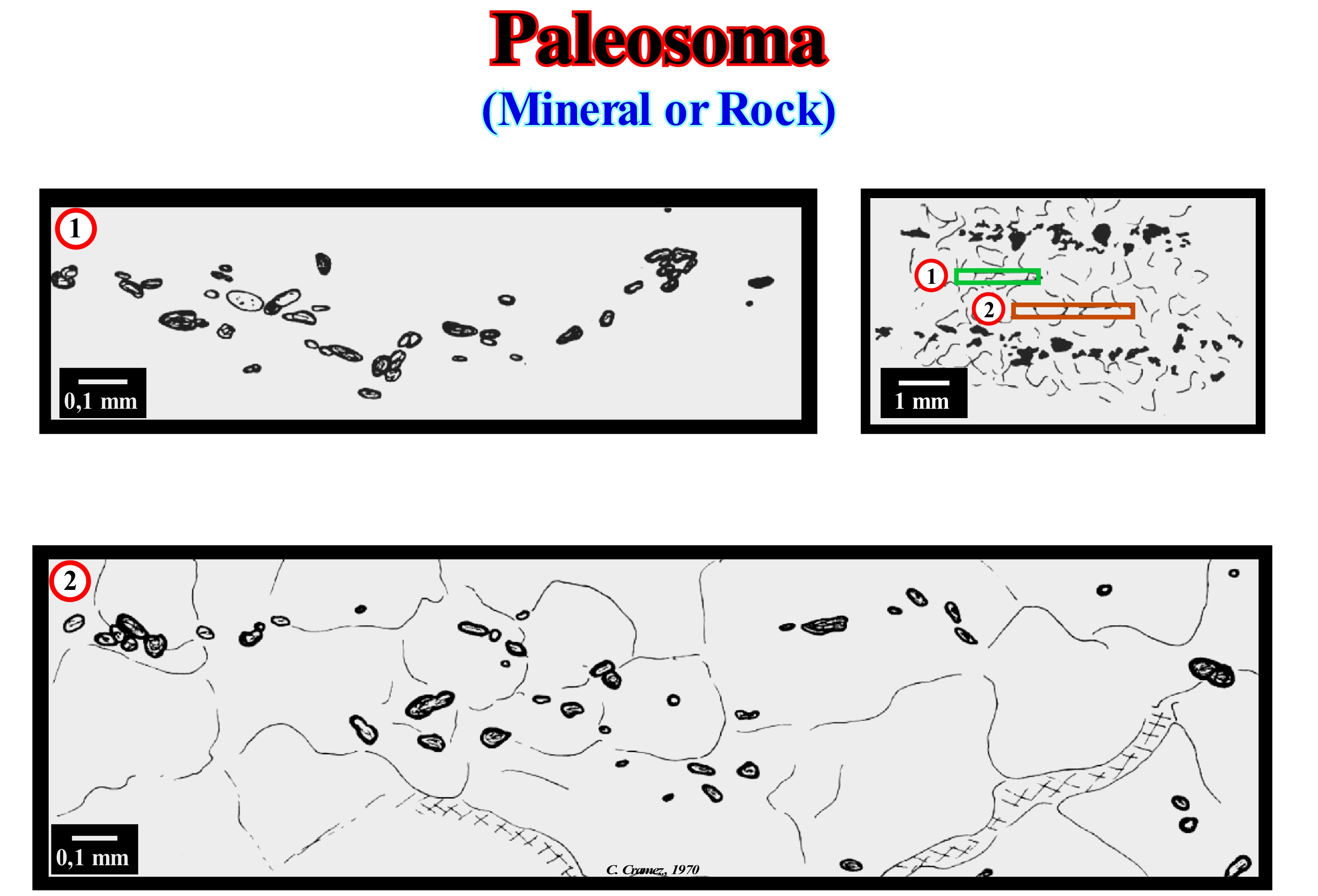
This figure shows a thin section (top right) and two details (1 and 2) of a migmatite (Norway onshore), which resulted from the metasomatosis of a paleosoma (supracrustal rock with basic composition). The microscopic study suggested: (i) A potassic metasomatosis, which was responsible for the decalcification of plagioclase, in which potassium replaced the calcium of the anortite and allowed the crystallization of a more albitic plagioclase ; (ii) The augite that is in the form of relics in the migmatites has become amphibole, which has, sometimes, retained the morphology of the pyroxenes ; (iii) Using the available alumina, potassic metasomatosis also transformed amphibole into biotite ; (iv) Epidote formation is also linked to metasomatosis and appears as a byproduct of the chloritization of biotite ; (v) Potassium metasomatosis was accompanied by a siliceous metasomatosis, as suggested by the structure of the myrmekites (vermicular, or wormy, intergrowth of quartz in plagioclase) ; (vi) The transformation of amphibole into biotite, the reaction between microcline and plagioclase or the substitution of calcium alkali feldspars are probably the source of silica ; (vii) Pegmatites are parallel to bedding and schistosity, but in the field, the presence of paleosoma enclaves is evident. Although most iron-magnesium minerals have been digested, some of them have resisted granitization by creating characteristic mineral and paleosoma enclaves. In this thin section, the rock, which is formed by alternations of quartz-feldspathic and iron-magnesian beds, shows that the accessory minerals are not exclusively bound to the melanocratic beds, but are also found in the quartz-feldspar beds, where they have a more or less regular way. These are mainly zircon, sphene and apatite that come from the previous rocks and that resisted the metasomatosis, which transformed the paleosoma into migmatites (metasoma rock). These minerals form what Wegmann (1935) called mineral enclaves.
Paleowater Depth ....................................................................................................................................................Paléoprofondeur d'eau
Paleoprofundidade de água / Paleoprofundidad de agua / Paleowater (Fossil Wasser) Tiefe / 古水(火水)深度 / Палеоглубина / Profondità di paleowater (acqua Fossil) /
Water-depth under which a given sedimentary interval has deposited. Upstream of the depositional coastal break, the water-depth is, practically, zero, that is to say, the available space for the sediments (accommodation), created by a relative sea level rise, is completely filled. Downstream of the depositional coastal break increases, progressively, since only part of the available space (accommodation) is filled.
See: « Shelfal Accommodation »
&
« Paleobathymetry »
&
« Relative Sea Level Change »
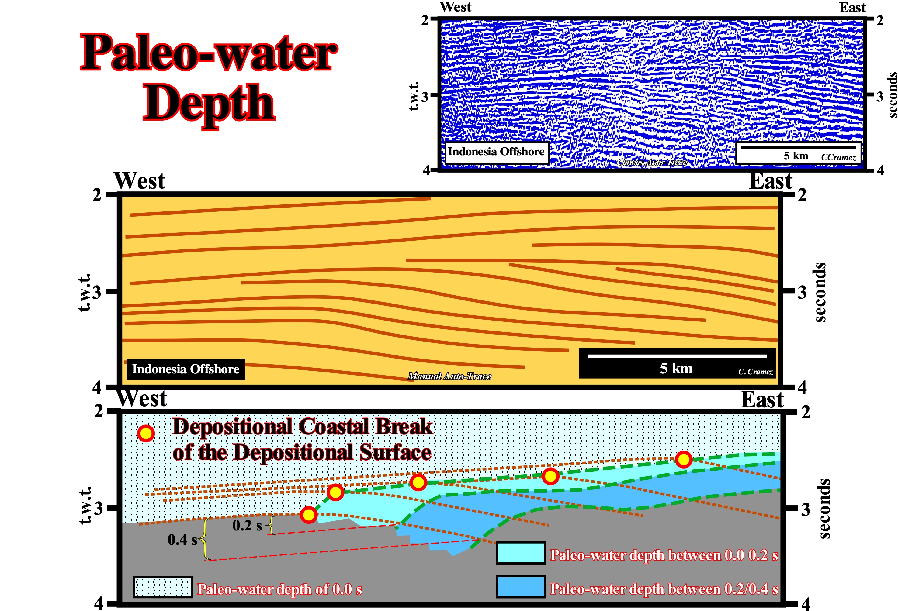
Within a sequence-cycle which is a stratigraphic cycle induced by a 3rd order eustatic cycle, i.e., induced by an eustatic cycle of time-duration between 0.5 My and 3-5 My, the sedimentary processes that form it can meet in two groups: (i) Lowstand Systems Tracts Group (LSTG) and (ii) Highstand Systems Tracts Group (HSTG). The lowstand systems tracts group, which is the lower group, is composed of three subgroups of sedimentary systems tracts, which from the bottom to top are: a) Submarine Basin Floor Fans (SBFF) ; b) Submarine Slope Fans (SSF) and c) Lowstand Prograding Wedge (LPW). The highstand systems tracts group consists of two subgroups that, from the bottom to top, are: d) Transgressive interval (TI) and e) Highstand Prograding Wedge (HPW). Under lowstand geological conditions, i.e., when the sea level is lower than the basin edge, during the lowstand prograding wedge (LPW) deposit, the shoreline coincides, more or less, with the coastal plain edge, which means that the basin has no shelf. In highstand geological conditional, i.e., when the sea level is higher than the basin edge, the position of the shoreline in relation to the continental edge is variable. During the deposition of the transgressive interval (TI) and the 1st phase of development of the highstand prograding wedge (HPW), the shoreline is upstream of the continental edge, which is also the basin edge, since the basin has a continental platform, i.e., a shelf. However, although at the beginning of the highstand prograding wedge (HPW) the basin has a continental shelf, after a certain moment, due to the progradation of depositional coastal break of the deposition surface (more or less the shoreline), the continental shelf is, totally, fossilized by progradations of the highstand prograding wedge. It is the end of the 1st phase of development of the highstand prograding wedge. From that moment, the basin has no more shelf (continental platform). It is the beginning of the 2nd phase of development of the highstand prograding wedge, during which the shoreline is, more or less, coincident with the continental edge. These geological conditions are sometimes exaggerated on the seismic lines, since, due to seismic resolution*, all transgressive intervals (TI) with a thickness less than 30-40 meters can not be highlighted. In other words, if on a seismic line, within a sequence cycle, there is a 20-meter water-depth on a continental shelf, the basin is interpreted as having no shelf-and the depositional coastal break of the deposition surface, which is , roughly equivalent to the coastline, is considered to coincide with the continental edge. Since the depositional coastal break of a chronostratigraphic line is recognized, a rough evaluation of paleobathymetry is possible as is the case on the auto-trace illustrated in this figure. In this auto-trace (where the main reflectors of a seismic line are, automatically or manually, underlined by pencil strokes) of a detail of an Indonesia offshore seismic line, illustrated in this figure, it can be said that depositional coastal break of the deposition surfaces correspond to the successive basin edges, since they mark the boundary between the coastal plain and the upper part of the continental slope within each sequence-cycle. Seismically, i.e., taking into account the seismic resolution, it can be said that in this auto-trace there are basins (since several sequence cycles are visible) that have no shelf. It is easy to identify the depositional breaks along the reflectors (chronostratigraphic lines). They mark the successive positions of the continental edge (basin edge and more or less the shoreline). The line joining them (dashed) is diachronic. It cuts off all chronostratigraphic lines. Assuming that, in time, upstream of the basin edge (in highstand geological conditions), the paleo-water depth is zero. To determine the paleo-water depth in the continental slope sediments, simply take the part of the reflector upstream of the basin edge (which is here also then depositional coastal brea) as a reference line and take it off, parallel, down a certain amount of time (in this example 0.20 and 0.40 milliseconds). The intersection of these lines with the chronostratigraphic reflector indicates the sediments deposited with a paleowater depth of 0.20 and 0.4 milliseconds (double time).
(*) Minimum distance between two interfaces to have two different reflections or minimum thickness that a sedimentary interval must have for there to be reflections distinct from the top and base of the interval.
Paleozoic...............................................................................................................................................................................................................................Paléozoïque
Paleozóico / Paleozoico / Paläozoikum / 古生代 / Палеозой / Paleozoico /
Era of geological time that lasted from 570 Ma (millions of years ago) to 245 Ma.
See: «Geological Time »
&
« Geological Time Scale »
&
« Eon »
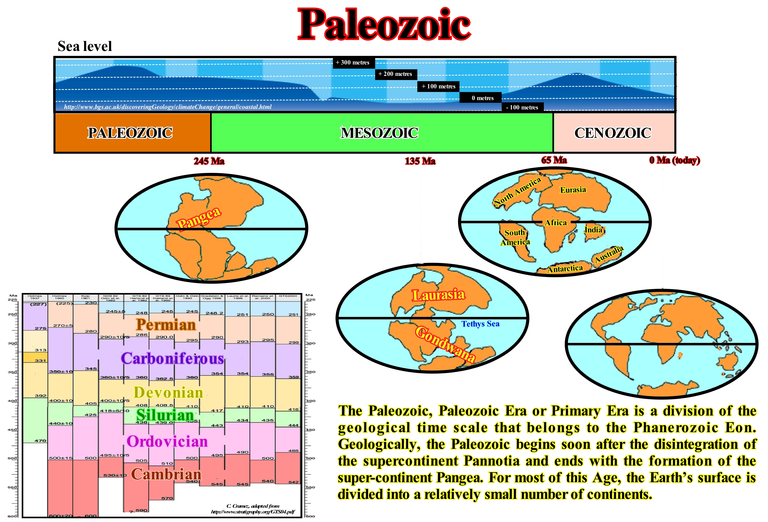
In this figure are illustrated the time limits of the Paleozoic geological periods according to different authors (from left to right): (i) Holmes, 1937; (ii) Holmes, 1960; (iii) Kulp, 1961; (iv) NGS 82 (Odin et al., 1982); GTS 82 (Harland et al., 1982); GTS 89 (Harland et al., 1990); Odin & Odin, 1993; Gradstein & Ogg 1996; Laurie et al., 1996; Remane et al., 2000); GTS 2004. Paleozoic paleogeography began with the dispersion of the continents resulting from the break-up of the proterozoic supercontinent (Protopangea or Rodhinia) in the southern hemisphere and continued with a progressive grouping of the continents near the equator during the Carboniferous. The result was the formation of a new supercontinent named Pangea, which presented a great variety of climate. During this long time period, the tectonic activity at the edges of the lithospheric plates was very important. Several times, a large part of the southern Gondwana small supercontinent (large Paleozoic continent composed of South America, Africa, Antarctica, India and Australia) was covered by ice caps: (a) During the Silurian in North Africa ; (b) During the Devonian, in South America and (iii) During Carboniferous and Permian, on all southern continents. Although glacial oscillations have, constantly, affected sedimentation and eustatic variations, it may be said that the Paleozoic corresponds to the Phanerozoic first order eustatic cycle. Overall, the sea level rose during the dispersal of the continents, resulting from the break-up of the Protopangea and began to fall since the continents began to approach each other to form the supercontinent Pangea. All modern phyla of the animal kingdom (similar classes form a phylum, similar phyla forms a kingdom: Kingdom ➙ Phylum ➙ Class ➙ Order ➙ Family ➙ Genus ➙ Species) and a part of plants of the plant kingdom were, already, represented in the Paleozoic. Several groups of animals, which developed and prevailed during this Era, were extinguished before the end of the Paleozoic. The development of terrestrial vegetation culminated in the Carboniferous period. Terrestrial tetrapods appeared before the end of the Devonian. Marine fossils suggest that numerous extinctions and global geochemical events occurred, in particular, at the end of the Paleozoic. As illustrated above, the Paleozoic Era was a highstand Era (sea level higher than the basin edge) .
Palinspatic Section........................................................................................................................................................Coupe palinspatique
Secção Palinspática / Sección palinspática / Palinspatic Abschnitt, Palinspatic Wiederaufbau / 复原剖面 / Палинспатический разрез / Sezione palinspatica, Ricostruzione palinspatica /
Geological section in which geological bodies are restored to their original geographical positions before the sediments have been deformed (shortened or lengthened).
See: " Formation (geological) "
&
" Geological Section"
&
“ Restored Section ”
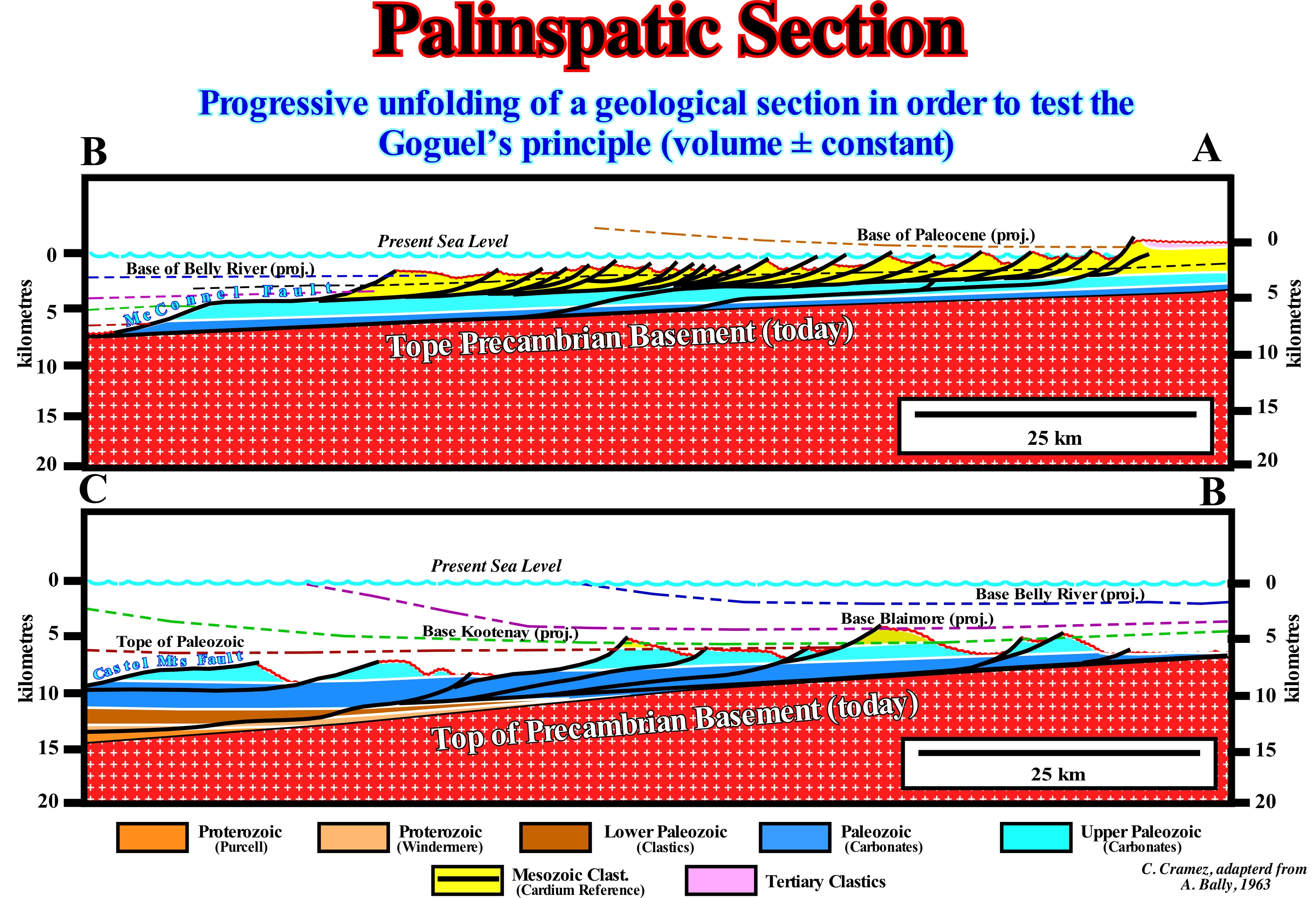
There are, at least, four kinematic models for restoring geological sections (either made with field data or made from tentative geological interpretations of seismic lines (in depth): (i) Fault-bend-fold method ; (Iii) Vertical and inclined shears and (iv) Flow parallel to the faults (ftp://ftp.ufrn.br/pub/biblical/ext/bdtd/AlexFA_Cap9_ate_final.pdf). The first method assumes that the deformation of the layers is accompanied by flexural sliding along the bedding planes that function as slip surfaces where deformation between the strata is minimal. The rigid block rotation restoration (does not apply to areas with folded structures) preserves the lengths and internal angles, being applicable to faulted sections with nondeformed blocks, as found in domino-like structural styles. In curvilinear faults, the collapse of the hangingwall can be devised by linear homogeneous displacements along the vertical or inclined sliding planes at an angle to which a series of points located in the hangingwall are translated parallel to the regional diving line. The flow parallel to the fault method consists of moving material points in the faulted block along lines parallel to the main fault. In the section shown in this figure, all imbrications and thrusts (reverse faults dipping more than 45°) are shown in their present-time and restored positions. The displacements along the section line were neglected and, to facilitate construction, the restoration was made in relation to the present-time dip of the basement and an unspecified reference point was taken to the West. Nowhere in the section or its restoration, the Paleozoic is, completely, absent. The geoscientist who made this palinspatic section assumed that no major structural unit was eliminated by erosion. He calculated a sedimentary shortening in the order of 50%, that is, a shortening of about 160 km to the "Main Mountains" (Main Range of Canadian geoscientists). The understanding of fold/fault relationships is of little importance to predict orogenic contraction when geological or seismic data are available to indicate the stratigraphic cut-off of the faulted blocks (reverse faults, thrusts). On the contrary, a perfect understanding of the fold/fault relationships is fundamental, when the location of a cut-off* stratigraphic omission is in the lower block-failure. An anticline structure (a convex fold in the direction of the most recent strata, created by a compressional tectonic regime**, i.e., shortening) can be interpreted as: (i) A fold induced by a fold propagation fault, i.e., when the fold forms at the end of the fault, where movement along the detachment plane has stopped, but not in the upper block (footwall) of the fault ; (ii) A transported fault propagation fold, when the fold in the upper failed block forms at the forefront of reverse fault ; (iii) A simple ramp hanging-wall anticline. The main errors result from the confusion between the case of a fold induced by the propagation of a fault (i) and the others (ii) and (iii). In the case of a transported fault propagation fold (ii), the depth displacement is small, while in other cases the displacement is unknown. The line/length balancing and the assumption of a plane deformation are the basic assumptions of Goguel's two-dimensional simple balancing (1948) : (i) A deformation plane within a thrust, with the y-axis perpendicular to the plane of the section ; (ii) A displacement along the faults parallel to the plane of the section. The error induced by the deformation plane in the thrust is related to: (1) A change in volume ; (2) A deformation perpendicular to the plane of the section and (3) A deformation perpendicular to the strata.
(*) Cut-off lines are where a layer gets truncated by a fault, and for a given offset layer there are two such cut-off lines on either side of the fault. When an exploration well cross a normal fault there is a stratigraphic interval that is not recognized by the well that geoscientists call cut-off stratigraphic omission.
(**) A compressional tectonic regime is characterized by an ellipsoid of the effective stresses (σg, geostatic pressure ; σp, hydrostatic pressure and σt, tectonic vector) by a horizontal σ1 (major axis of the ellipsoid). When σ2 (horizontal axis of the ellipsoid) is horizontal and σ3 (small axis of the ellipsoid) vertical, the sediments are shortened by cylindrical folds, reverse faults and thrusts. When σ2 (mean axis of the ellipsoid) is vertical and σ3 (small axis of the ellipsoid) horizontal, the sediments are shortened by slip faults and conical folds.
Pangea..........................................................................................................................................................................................................................................................Pangée
Pangeia / Pangea / Pangaea / 盤古大陸 / Пангея / Pangée /
Supercontinent formed at the end of the Paleozoic, which consisted of two small supercontinents: (i) Gondwana to the south and (ii) Laurasia to the north.
See: « Supercontinent »
&
« Continental Collision »
&
« Rodhnia »
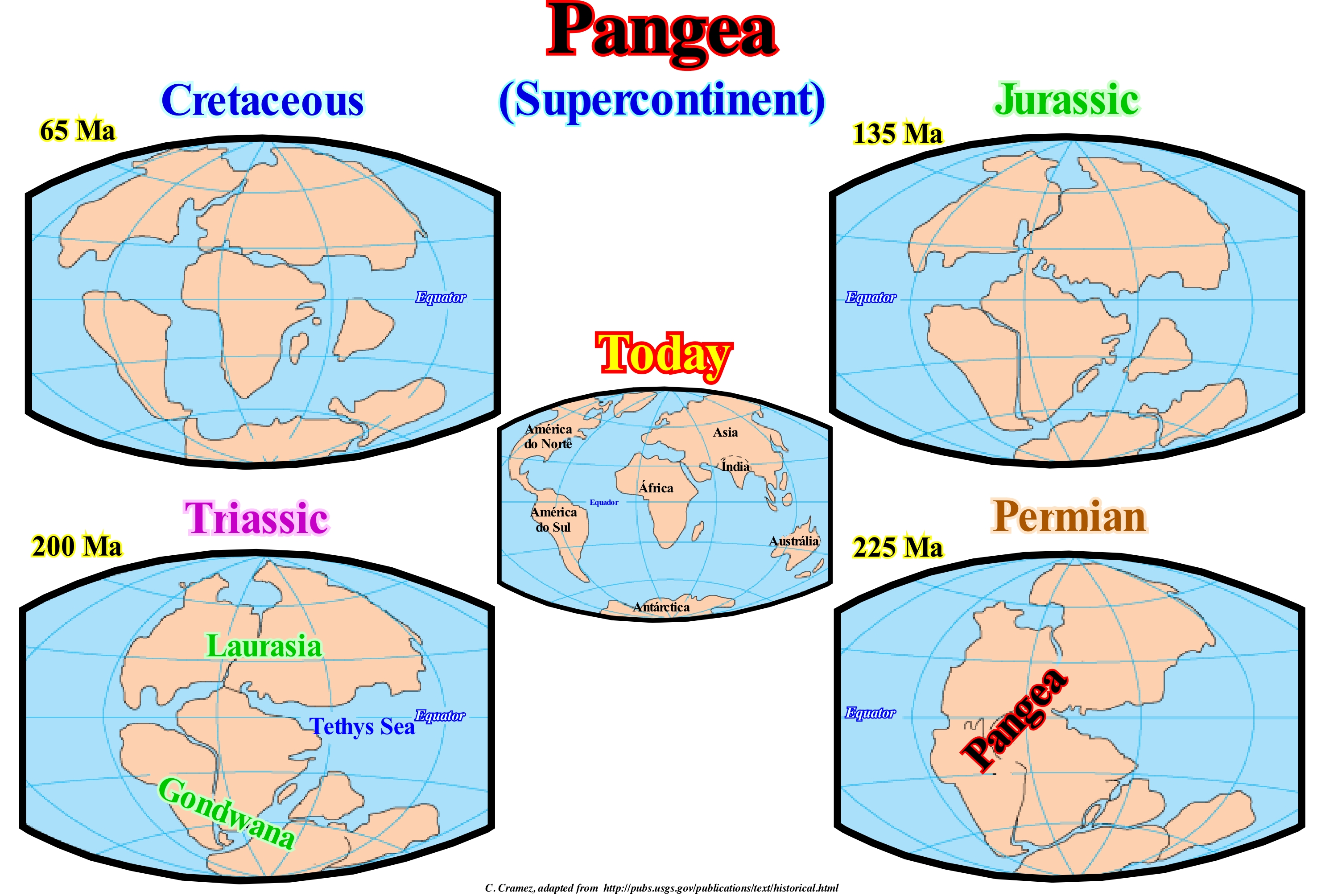
The term Pangea, which in ancient Greek means "All the Earth" derives from the junction of pan ("πᾶν", all, in Greek) and Gaia (Goddess of the Earth), designates the supercontinent that existed during Late Paleozoic and Early Mesozoic. Two small supercontinents make up the Pangea supercontinent. To the north, the small supercontinent Laurasia, formed by the junction of the continent Laurentia (North America) and the continent Eurasia (excluding India) and to the south, the Gondwana small supercontinent, which can be subdivided into East Gondwana (Africa, Eastern Antarctica, Australia India, Madagascar, Arabia, New Guinea, North China, South China, Indochina and Tarim geographic Basin) and Western Gondwana (Amazonas, Rio de la Plata craton, West Africa, Florida, Avalonia and Southern Europe). The Pangea supercontinent was surrounded by the Panthalassa Ocean*, which included the Tethys Sea between the Laurasia and Gondwana small supercontinents, which can be considered as the proto-Mediterranean. In 1858, the geographer Antonio Snider-Pellegrini illustrated in two maps the hypothesis that the present-time American and African continents were, in the geological past, together before separating later. At the beginning of the twentieth century, Alfred Wegener advanced the hypothesis that a large continent, which he termed Pangea, existed before it fractured at the beginning of the Mesozoic, and that the individual fragments of the supercontinent separated from each other, till the Present. In this hypothesis, which the geoscientists called the continental drift, Wegener admitted the Pangea supercontinent began to break to about 225/200 million years ago and that it has fragmented, more or less, in the continents that we know today. Wegener's hypothesis was based, primarily, on the fact that, for him, South America and Africa have complementary coastlines, which had already been advanced three centuries earlier by Abraham Ortelius. Wegener also noted the presence of very similar geological and fossil structures of animals and plants on both coasts, although today they are separated by thousands of kilometers across the Atlantic Ocean. Wegener conjectured that it was, physically, impossible for many of these organisms to swim or be transported over such a long distance. For him, the presence of similar fossils on both coasts of South America and West Africa was evidence, that in the past, the two continents had been glued together. In Wegener's hypothesis, continental drift, after the Pangea break-up, explained not only the presence of similar fossils on both sides, but also evidence of significant climate change on both continents. The discovery of fossils of tropical plants (coal deposits) in Antarctica also suggested that this icy land was once situated near the equator. Although the idea of the Wegener supercontinent was fought for many years, the advent of Plate Tectonics corroborated Wegener's basic idea, but not the details and, above all, the mechanisms of break-up and separation of the continents. In Plate Tectonics Theory, it is not the continents that move, as in Wegener's hypothesis, but the lithospheric plates that carry the continents with them as a treadmill does. After the formation of Pangea, in the Permian, almost all the Earth was agglutinated in this supercontinent. Only the Yangtze craton (South China), part of Indochina and the Cimmerian microcontinent are separated by the Tethys Sea. The Pangea took the form of a "C", whose centre was on the equator. It was limited, at the level of the equator, by a great mountain belt (Hercynian orogeny) oriented East-West. The entire central area, from 40° South to 40° North, was formed of large deserts that covered most of present North America, South, Africa and Europe. The Northern Europe (the present area of the North Sea) was covered by a shallow inland sea, very salty and connected, occasionally, to the ocean. Europe was separated from Siberia by a narrow, shallow sea that linked the ocean Panthalassa (to the north) and the Tethys Sea (to the south). This sea was limited, from the Siberia side, by the Ural Mountain Belt.
(*) The first and main basic difference between sea and ocean is its territorial extension. The oceans occupy large extensions and are delimited by portions of land (in fact, they are the emerged lands that are delimited by the oceans), while the seas are much smaller and are, usually, delimited by the continents in a good part of their entrances (http: // spanish.hear-it.org spanish.youth.hear-it.org.br).
Pannotia............................................................................................................................................................................................................................................Pannotie
Pannótia / Pannotia / Pannotia, Vendia, Größeres Gondwanaland / 潘諾西亞大陸 / Паннотия / Pannotia, Supercontinente vendiano /
Ocean that, in the Paleozoic, separated the Gondwana and Laurasia small supercontinents. The opening of the Paleotethys sea began in the Silurian on the northern margin of Gondwana.
See: «Proto-Pangea»
Panthalassa................................................................................................................................................................................................................Panthalassée
Pantalassa / Pantalassa / Panthalassa / 泛古洋 / Панталасса / Panthalassa /
Great ocean that existed on Earth before the Pangeia breakup, in which the ocean currents were simple and slow, with a climate, probably, hotter than today.
See: « Gondwana »
Paraconformity......................................................................................................................................................................................Paraconformité
Paraconformidade / Discordancia paralela no erosional, Paraconformidad / Diskordanz paraconformable Schichten /侵蚀不整合没有平行 / эрозионно Несогласие не параллельны / Paraconformità /
Flat surface that separates two set of layers parallel to each other. For some geoscientists, it is a kind of unconformity in which strata are parallel. As there is no apparent erosion, a paraconformity resembles a simple stratification plane. In shallow-water, a paraconformity may correspond to an unconformity (cryptic). In deep-water, it may correspond to a boundary between two stratigraphic cycles.
See: « Disconformity »
Paralic (Zone)................................................................................................................................................................................................................Paralique (Zone)
Parálica / Parálica (área) / Paralische / 海陆过渡相 / Паралическая (зона) / Paralici /
Region corresponding to the track between the breaking of the sea-waves and the land always emerged. The region or the paralic area is, also, known as the coastal region. Synonym of Littoral.
See: « Shoreplatform »
&
« Onshore »
&
« Tidal Flat »
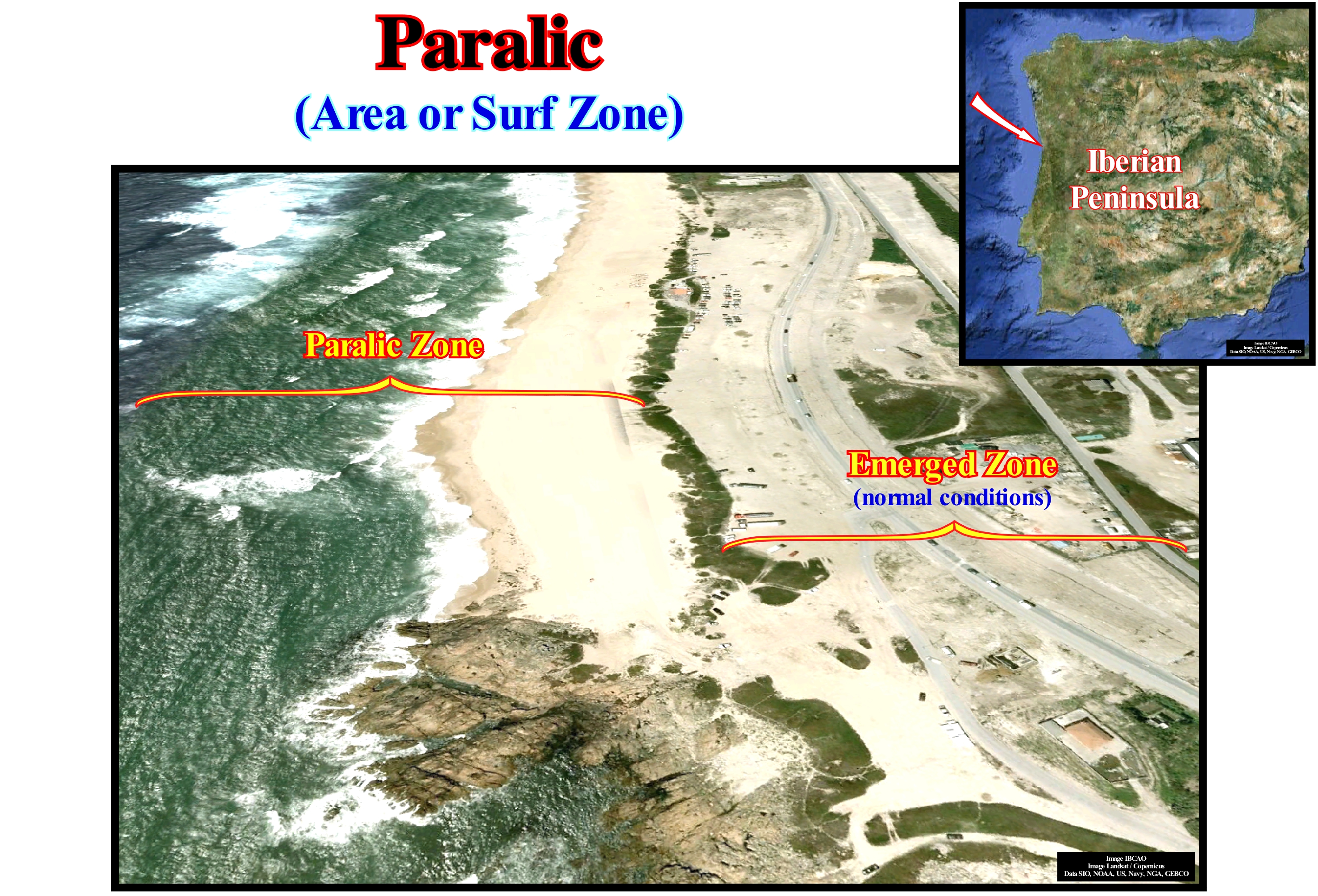
Paralic environments and deposits (which lay close to the coast, but often comprise small marine intercalations) provide geoscientists with many samples for study, simply because they are very easy to locate (along the beaches, in marshes, etc.), and also because many tests* (anatomical shell structures,which take the form of a box, particularly when they are rounded, with natural openings or can be easily separated into two halves) or shell, which may contain one or more chambers bound by a small aperture) are preserved and accumulated in these regions, sometimes due to turbidity currents. The main characteristic of the paralic or brackish environments is that they occur in transition zones between the marine and continental domains. As an example of paralic environments we can mention: (i) The estuary (aquatic environment of transition between a river and the sea) ; (ii) The coastal lagoons (bodies of water with little flow, located near the coastline, generally without stagnant water, smaller than a lake , natural or not) ; (iii) Marshes (a flat area of abundant herbaceous vegetation that remains largely flooded, usually located in areas where the flow of water is slow) ; (iv) Low-tide areas and coastal areas vulnerable to entry fresh water. Among the parameters that affect ecology, that is, the relation of living beings to each other and to the environment, of these systems we can mention: (a) Climatic zones ; (b) Horizontal distribution of salinity ; (iii) Mixing of fresh and salt water ; (iv) Energy of waves and wind currents ; and (v) Soils nature. Anthropogenic pollutants affect, also, the ecology of these systems. Paralic environments, which are situated between the marine and continental domains, are, extremely, different in size, morphology and genesis. The regional climatic and hydrographic conditions, together with the local hydrological standards, induce a great variety and variability of the physical-chemical parameters and the sedimentary deposits. In contrast, biological populations are characterized by species, strictly, linked to this type of environment. The qualitative and quantitative zonal organization is independent of salinity and they are, relatively, stable despite variations in the environment. The original biological characteristics allow the paralic environment to be considered as an autonomous ecological domain. The parameter that seems to control the distribution of organisms and the characteristics of the populations can be described as the moment of the renewal of elements of marine origin at any point (confinement in relation to the sea). A confinement scale can be determined from biological data, which relate to the near paralic domain (sea), where marine species still persist and further upstream, the distal paralic environment, which is, characterized, by the appearance of fresh-water or by evaporitic associations that change, gradually, to the continental domain. The paralic zones are very suitable for incarbonization**, i.e., the natural process carried out in anaerobic environments where enrichment of organic matter occurs in carbon by progressive loss of hydrogen, nitrogen and oxygen. In order to explain the enormous accumulation of vegetal remains originating in the coal basins, two hypotheses of formation are allowed: (a) Autochthonous Formation and (b) Allochthonous Formation. The autochthonous formation occurs in zones of exuberant vegetation, whose remains are deposited in the same place under anaerobic conditions, which prevents putrefaction, that is, in the environment of quiescent and paralic continental waters such as marshes or lagoons, which originate limnic basins (associated or coming from lakes) or intra-continental. Allochthonous formation occurs when plant debris is transported and deposited at a location other than plant growth (plant roots or trunks are tilted, the coals are rich in ash and sand, and rarely retain complete impressions of plants. are very varied and discontinuous and marine fossils are frequent).
(*) An external shell. The form and composition of forams tests are the primary means by which forams are identified and classified. Most have calcareous tests, composed of calcium carbonate. In other forams, the tests may be composed of organic material, made from small pieces of sediment cemented together (agglutinated), and in one genus, of silica. Openings in the test, including those that allow cytoplasm to flow between chambers, are called apertures. The test contains an organic matrix, which can sometimes be recovered from fossil samples. (https://en.wikipedia.org/wiki/Foraminifera#Tests).
(**) In the incarbonization there are two phases: (i) External phase, which occurs near the surface and is a biochemical process produced by micro-organisms, under anaerobic conditions in which peat will originate and (ii) Internal phase, which occurs at different depths.
Paralic-Deltaic (Environment)...............................................................................................Paralique-deltaïque (Environnement)
Parálico-Deltaico / Parálico-deltaico (ambiente) / Paralische-deltaischen (Umwelt) / 近海三角洲 (环境)/ Паралическая- дельтовая (среда) / Paralici-deltizia (ambiente) /
Sedimentary environment occurring near or at sea level, but which is not truly marine. Examples of paralic depositional systems are deltas, estuaries, etc. In petroleum exploration, a large part of the reservoir-rocks are deposited in delta paralic environments, which, in general, have a, particularly, important oil recovery factor.
See: « Depositional Environment »
&
« Delta »
&
« Depositional System »
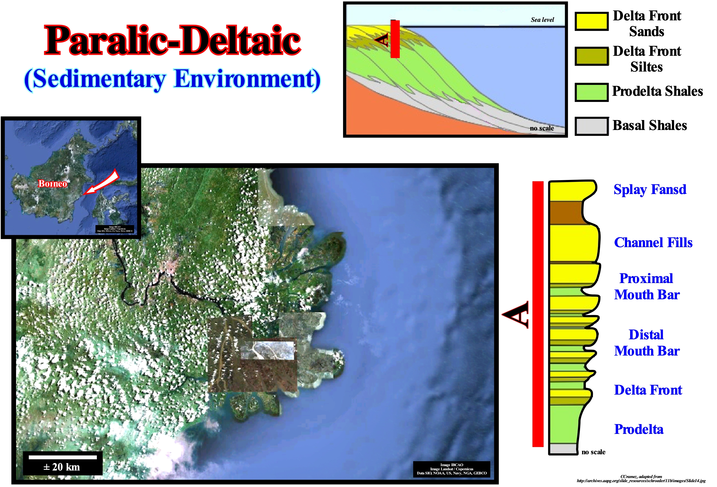
On a large scale, the paralic reservoir systems, such as the one illustrated in this figure (Mahakam Delta, located on the Borneo Island offshore), respond, very sensitively, to the absolute (eustatic) sea level (supposed global sea level, referenced to the Earth's centre) and to the relative sea level (local sea level, referenced to the base of the sediments or to any point on the Earth's surface, such as the sea floor). In fact, the paralic depositional systems respond to both marine ingressions (relative sea level rises) and marine regressions (relative sea level falls). Although marine ingressions and marine regressions emphasize displacements of the shoreline, respectively, continentward and seaward, in order to avoid confusion, it is essential to always take into account the scale of the speech or the scale of the work, i.e, what is the hierarchy of eustatic cycles and stratigraphic cycles considered. For example, during the transgressive phase of a continental encroachment cycle (stratigraphic cycle induced by a 1st order eustatic cycle), the absolute (eustatic) sea level rose and during the regressive phase of the same stratigraphic cycle, the absolute (eustatic) cycle fall. However, at the level of a sequence-cycle (stratigraphic cycle induced by a 3rd order eustatic cycle), It can not be said that during the transgressive interval (TI), which corresponds to sedimentary transgressions, the relative sea level rose and that during the high level prism (PNA), which corresponds to sedimentary regressions, the relative sea level dropped . At the scale of a sequence-cycle, in order to have deposition (turbidite depositional systems excluded), the relative sea level must always rise, that is, there must be an increasing in accommodation (space available for the sediments). In a sequence-cycle, during the transgressive interval (TI), the relative sea level rises in acceleration (marine ingressions are increasingly important and sedimentary regressions are increasingly smaller) and it rises deceleration (increasingly smaller marine ingressions and increasing important sedimentary regressions) during the highstand prograding wedge (HPW). In a delta depositional system, changes in sedimentary influx induce, almost always lateral displacements of the deposition centre (pendulum effect), which can produce, locally, a marine ingression (relative sea level rise). One consequence of such lateral displacements is that deltas, estuaries and coastal depositional systems exhibit, often, a stacking of sedimentary intervals with different depositional environments. Each of these intervals contains, often, reservoir-rocks for hydrocarbons with displacement pressures* very different from the overlying and underlying rocks. At a smaller observation scale (hierarchy of sequence-paracycles), within these intervals (sedimentary systems tracts), can exist a great variety of sandy-bodies, such as channel fills, delta fronts, proximal turbidites, etc., with characteristics (width, thickness, lateral extension, geometry) and internal properties (coarsening upward or thinning upwards, etc.) very different. The paralic sandy reservoir-rocks can be thick and very extensive, but pass, laterally, to restricted and thin rocks. The former, generally, have good petrophysical characteristics (porosity, permeability, etc.), water planes and spill-points**, structurally, defined, and, in general, have a high recovery factor (oil) .The second, are less efficient reservoir-rocks with low porosity and permeability and lower recovery factors. However, as they have a more limited extent, they are more conducive to the formation of non-structural or stratigraphic traps, either morphological or morphological by juxtaposition.
(*) The displacement pressure may be defined as the pressure required to form a continuous filament of hydrocarbons in the pores of a sealing-rock. It is, usually, inferred from the injection pressure at 10% saturation for two reasons: (i) Most reservoir-rocks have a pronounced plateau along which saturation increases rapidly (the pressure at 10% or 40% saturation gives a similar displacement pressure) ; (ii) The saturation measurements required to create a continuous line of hydrocarbon filaments range from 5-17% with an average of 10%.
(**) Structurally low points in a hydrocarbon trap that can retain hydrocarbons. Since a trap has been filled to its spill point, more storage or retention of hydrocarbons is not possible because of lack of reservoir space within that trap. The hydrocarbons seep out or leak, and continue to migrate to the surface unless they are stored (trapped) elsewhere.
Parallel Configuration................................................................................................................................................Configuration parallèle
Configuração paralela / Configuración paralela / Parallele Konfiguration / 并行配置 / Параллельная конфигурация / Configurazione parallelo /
Set of seismic reflectors interpreted as strata deposited, more or less, parallel. The geometric relations are determined at the time of deposition, i.e., always before the sediments are eventually deformed.
See: " Stratal Patterns "
&
" Reflection Configuration "
&
" Abyssal "
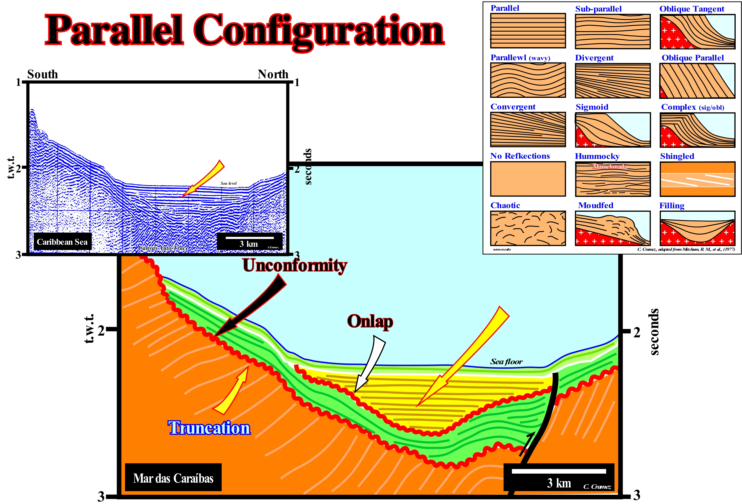
In the field or on a seismic line, a parallel configuration must be observed in all directions. On the other hand, it is always referenced to the moment of deposition. On this tentative geological interpretation of a Canvas auto-trace of a detail of a Caribbean Sea deep offshore seismic line, the most recent sedimentary interval (light green) has a parallel internal configuration, which is also recognized on the perpendicular seismic line. This interval lies in unconformity (the onlaps are perfectly visible) over an interval which, too, has a parallel internal configuration. In turn, this interval (colored in yellow) rests on a substrate (deformed by tectonics and colored in green), which also exhibits a parallel internal configuration. All visible seismic reflectors on this tentative interpretation are chronostratigraphic lines. The unconformities (wavy lines in red) are not underlined by any seismic horizon. They are deduced from the seismic surfaces (defined by the reflection terminations) that characterize the erosional surfaces, i.e. by the aggradational and truncations surfaces. A chronostratigraphic line is, in general, constituted by three segments: (i) Upper Horizontal Segment ; (ii) Seaward Dipping Segment (iii) Lower Horizontal Segment. The upper horizontal segment represents the sediments deposited in shallow water (usually platform sediments). The seaward dipping segment represents slope sediments, whether continental slope or prodelta, which depends, primarily, on the vertical scale (geological interpretation is dependent on the observed scale and the observer's expectations). The height of a delta slope varies between 20 and 50 meters (a stacking of deltas, which geoscientists call a delta building, can reach thousands of meters, while the height of a continental slope is always greater than 200 meters). Obviously, when the height of a progradation is between 100 and 300 meters, other elements are necessary to decide if the slope should be associated with a delta or not. The lower horizontal segment represents sediments deposited in deep-water. On this tentative interpretation, it is evident that the first interval (more recent, colored in yellow), is formed by deep-water deposits (pelagic or turbiditic). In contrast, it is likely that the oldest interval (colored in brown), which has been shortened (folded and faulted by reverse faults) corresponds to platform deposits (shallow-water). The intermediate interval (coloured in green), which has a parallel configuration and which has also been, slightly, shortened, consists of sediments deposited in deep-water. Thus, there is an unconformity, that is, an erosional surface (tectonically enhanced) between the oldest and intermediate intervals. An unconformity exists within the green interval, alongside the reverse fault (onlapping, probably, coastal onlaps are evident). The unconformity between the intermediate and the most recent interval (also tectonically enhanced), suggests that a compressional tectonic phase was active until the beginning of recent deposit (yellow). Different types of internal configurations are, schematically, illustrated on this figure: (i) Parallel, set of seismic reflectors interpreted as layers deposited in parallel ; (ii) Subparallel, set of seismic reflectors interpreted as strata deposited, more or less, in parallel ; (iii) Oblique/Tangent , the seismic reflectors or associated strata, have a decreasing dip toward the base ; (iv) Parallel Wavy, when the reflectors are undulated, more or less, parallel ; (v) Divergent, when the reflectors move away from each other ; (vi) Oblique Parallel, set of seismic reflectors with a parallel/oblique pattern, that is, set in which the strata end up downdip with a relatively important slope ; (vii) Convergent ; (viii) Sigmoid ; (ix) Sigmoid/Oblique Complex ; (x) No Reflections, absence of seismic reflections, which translates into seismic intervals either homogeneous, non-stratified, very deformed or even intervals with a very strong inclination ; (xi) Hummocky, a set of seismic reflectors, interpreted as strata, that form topographic anomalies or sedimentary positive anomalies above basal level, typical of organic and volcanic constructions ; (xii) Shingled, when the reflectors have a progradational geometry with a very low dip overlapping each other ; (xiii) Chaotic, with disordered reflectors ; (xiv) Mounded set of reflectors with a global nipple-shaped geometry and (xv) Filling, set of seismic reflectors, interpreted as strata, which fill the negative topographic anomalies of the underlying strata.
Parapodia....................................................................................................................................................................................................................................Parápode
Parápode / Parápode / Parapodium / Parapodium (配對的副產物) / Парапо́ / Parapodium /
One of the muscular lateral projections of the body of the annelid polychaetes. They are, generally, arranged in pairs in the segments of the body are used for locomotion and breathing. A parapodia may have a single branch or two. In the case of two branches, the dorsal is called the notopodium and the ventral neuropodium.
See: « Plankton »
&
« Benthos »
&
« Benthonic (organism) »
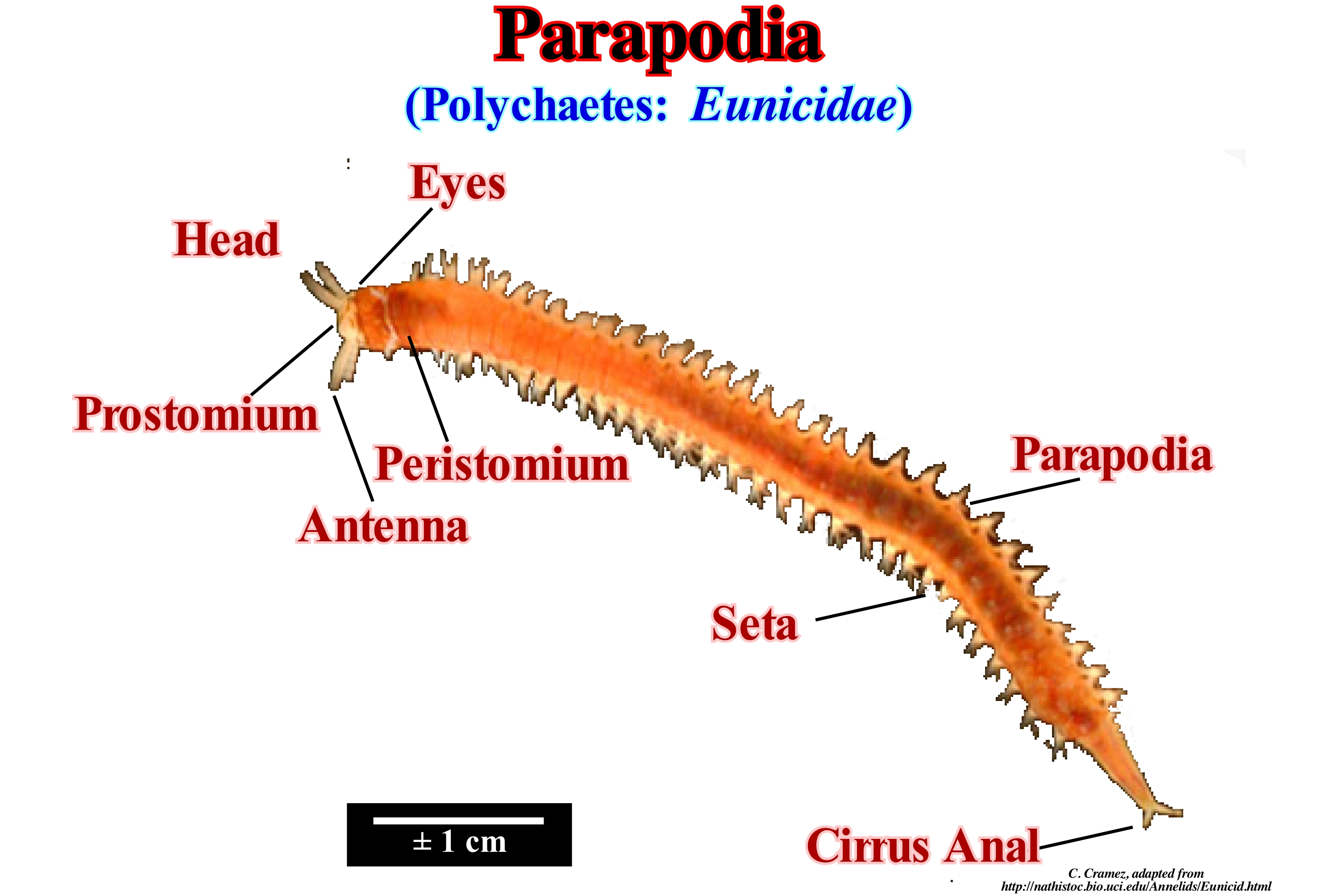
The well-developed parapods have a structure similar to that of the Nereis parapods. They are composed of two well-developed branches, a dorsal called the notopodium and a ventral, called the neuropodium, each of which consists of several lobes. The notopodium has, on its dorsal margin, a small pointed structure with sensory functions, the dorsal cirrus, and is composed of three lobes. The dorsal lobe is the most developed and has a foliate appearance. It is a gill (respiratory tract of fish and some other animals) and, as such, performs fundamental functions in gas exchanges, which are processed through a network of well-developed capillary vessels. In a ventral position in relation to the brancia (gill), two other lobes appear and a set of chitinous - notosetae. The neuropodium is smaller than the notopodium and also has three lobes and a set of silks (neurosetae), as well as a small ventral cirrus located on its ventral margin. Each parapodia is supported by two modified silks called needles: one supports the notopodium and the other the neuropodium. From what is known, at the moment, it is known that the parapods of the most primitive species were double-branches (parapods only with a branch are said monobranches). The existence of two branches in the parapodes represents a primitive condition. Parapods, however, have evolved into a variety of forms, performing in the present species numerous functions, such as locomotion, gas exchange, protection, fixation, reproduction, creation of water currents related to ventilation and food, etc. (http://www.biorede. pt/text.asp?id=630). Do not forget that the body of the oligochaetes is segmented and is divided into: prostomium, peristomium and pygidium. The mouth is ventral and is present in peristomium, while the anus is located in the pigment. Some polychaetes do not have specific structures for gas exchange, these being ensured by the whole surface of the body.
Parasequence...................................................................................................................................................................................Paracycle séquence
Paraciclo-sequência / Paraciclo secuencia / Parasequenz / 准层序 / Парасеквенция / Parasequenza /
Bed or a set of beds, more or less, conforming, genetically, linked and bounded by two consecutive ravinment surfaces induced by marine flooding (marine ingressions). A sequence-paracycle (parasequence for certain geoscientists, particularly in the early days of sequential stratigraphy) is the stratigraphic unit deposited during an eustatic paracycle. Although most of the sequence-paracycles are associated with successive relative sea level rises (marine ingressions) of the relative sea level curve, two particular types of sequence-paracycles may exist within a sequence-cycle: (i) Periodic and (ii) Episodic. The former are linked to the Milankovitch orbital cycles and deposited, preferably, during the transgressive intervals (TI). The episodic sequence-paracycles are deposited, preferentially, in highstand (HPW) and lowstand prograding wedges (LPW) are, in most cases, caused by delta lobe shifts. Episodic sequence-paracycles are called subsequences by certain geoscientists, who reserve the term parasequence for the periodic sequence-paracycles.
See: « Eustasy »
&
« Eustatic Cyle »
&
« Stratigraphic Cycle »
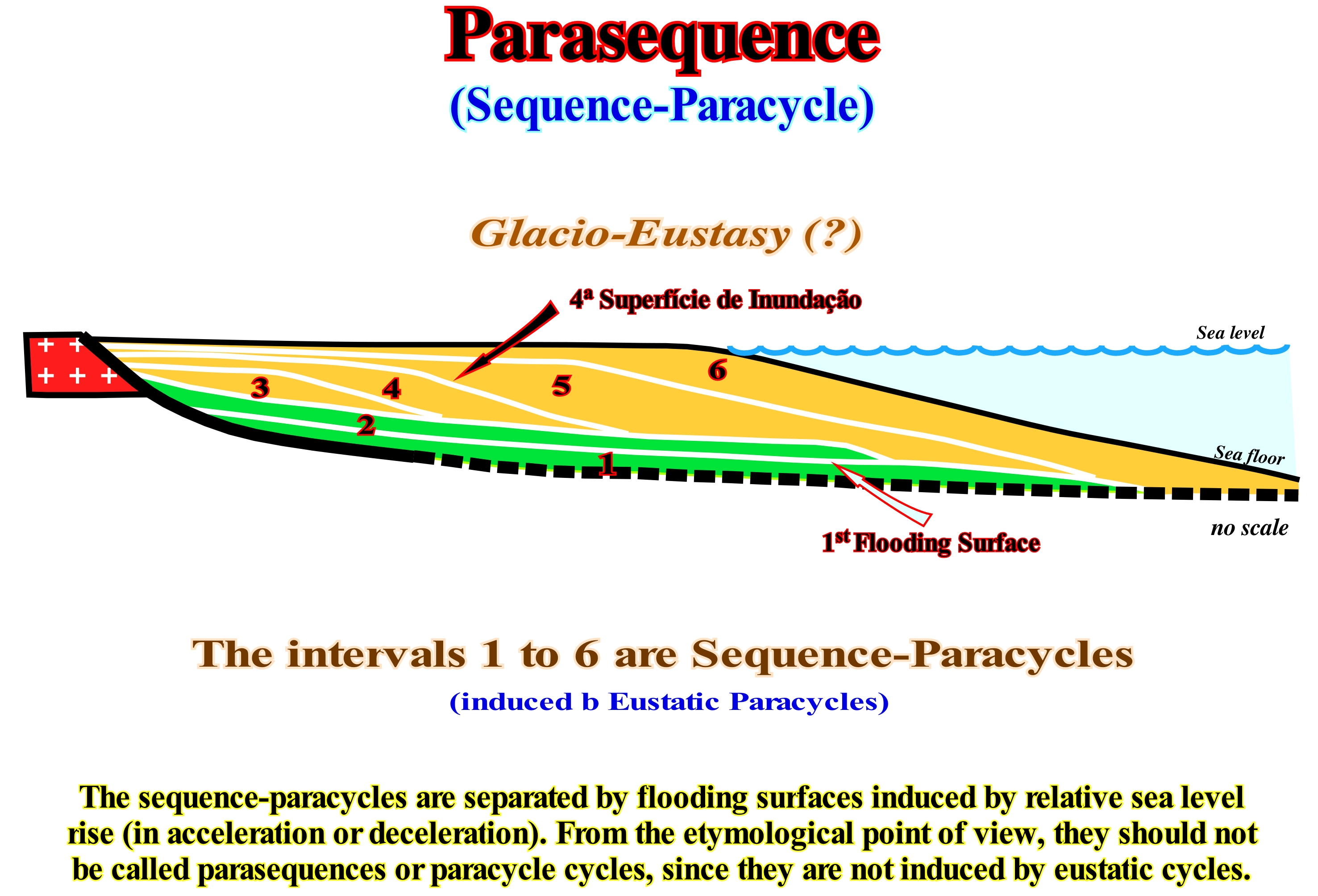
Unlike eustatic cycles (which are deduced from relative* or absolute sea level changes), which are limited by significant sea level falls, eustatic paracycles are limited by successive relative sea level rises without fallings between them. However, eustatic paracycles have, more or less, long stability periods of relative sea level. Obviously, and as its name implies, an eustatic paracycle is not an eustatic cycle. A set of eustatic paracycles may form an eustatic cycle, when it is limited between two significant relative sea level falls. Similarly, a sequence-paracycle, which is induced by an eustatic paracycle, is not a true stratigraphic cycle, since it is not bounded by two unconformities, i.e., by two erosional surfaces, but by two ravinment surfaces or two transgressive surfaces (limited between two marine ingressions, which are become increasingly larger or increasingly smaller). From the semantic point of view, one should not say parasequence cycle or parasequence (term that has fallen into disuse), but preferably sequence-paracycle. Although it is said t a sequence-paracycle is induced by an eustatic paracycle, it should not be forgotten that the relative sea level rise (i.e, the marine ingression) that emphasizes the eustatic paracycle floods the continent, displacing the shoreline continentward, thus increasing the available space for the sediments, i.e., increasing the accommodation. The deposition occurs during the stability period of relative sea level that follows each marine ingression (whether it is in acceleration or deceleration, that is, greater or smaller than the previous ingression). Thus, as the sediments (clastic) are, generally, deposited by sigmoid progradations, the shoreline moves seaward until a relative sea level rise occurs and again the shoreline is displaced continentward. This series of events continues until there is a significant relative sea level fall that puts the sea level lower than the basin edge, i.e., that exhumes the sediment deposited upstream of the basin edge, whether it coincides (basin without platform) or not (basin with platform) with continental edge. All the sequence-paracycles correspond to sedimentary regressions, once they settle-down as the shoreline moves seaward, which means that all the sequence-paracycles have a progradational geometry, more or less, well marked function of the representation scale. In general, each sequence-paracycle corresponds to a lateral association of synchronous and genetically linked depositional systems, which means that, in general, a sequence-paracycle has a, more or less, pronounced progradational geometry, However, there are exceptions. A sequence-paracycle can be formed by several sedimentary systems tracts. In addition, taking into account the seismic resolution, when the sequential stratigraphy is performed from seismic data, it is evident that a sequence-paracycle is, generally, formed by several sedimentary systems tracts. That is why within a sequence-cycle, it is more correct to gather the sedimentary systems tracts in group and sub-groups. The sequence-paracycles form all the stratigraphic members of the two groups of sedimentary systems tracts of a sequence-cycle. Thus, it can be said they are the building blocks of the lowstand prograding wedge (LPW), the transgressive interval (TI) and the highstand prograding wedge (HPW). During the transgressive interval (TI), the floodplain areas individualizing the different systems tracts, are associated with relative sea level rise in acceleration, whereas during prograding wedges (highstand and lowstand), they are associated with relative sea level rise in deceleration. In certain cases, especially, during delta episodes, the flood surfaces that individualize the delta lobes can be induced by the pendulum effect of the delta depocenters.
(*) The relative sea level is a local sea level referenced either at the base of the sediments (top of the continental crust) or at the sea floor, or at any other fixed point on the land crust. It is the result of the joint action of absolute (eustatic) sea level, which is supposed to be global and referenced to the Earth's centre, and tectonics (subsidence when the sediments are lengthened or uplift when the sediments are shortened).
Parasequence (Sequence-paracycle).......................................................................................................................................Paraséquence
Parasequência / Parasecuencia / Parasequenz / 准层序 / Парасеквенция / Parasequenza (Geologia) /
The term parasequence is replaced in this glossary by sequence-paracycle. It corresponds to a succession of layers or group of layers, genetically, related and limited by marine flooding surfaces or their correlative correlations. The sequence-paracycles, which are often suggest an upward decreasing water-depth, are induced for eustatic cycles and deposited during the time interval that occurs after each marine ingressions (creation or increase of available space). The term sequence-paracycle seems preferable to parasequence. Its deposition is associated with a simple relative sea level rise (marine ingression), which is followed by a period of relative sea level stability.
See: « Stratigraphic Cycle »
&
« Eustatic Cyle »
&
« Sequence-Cycle »
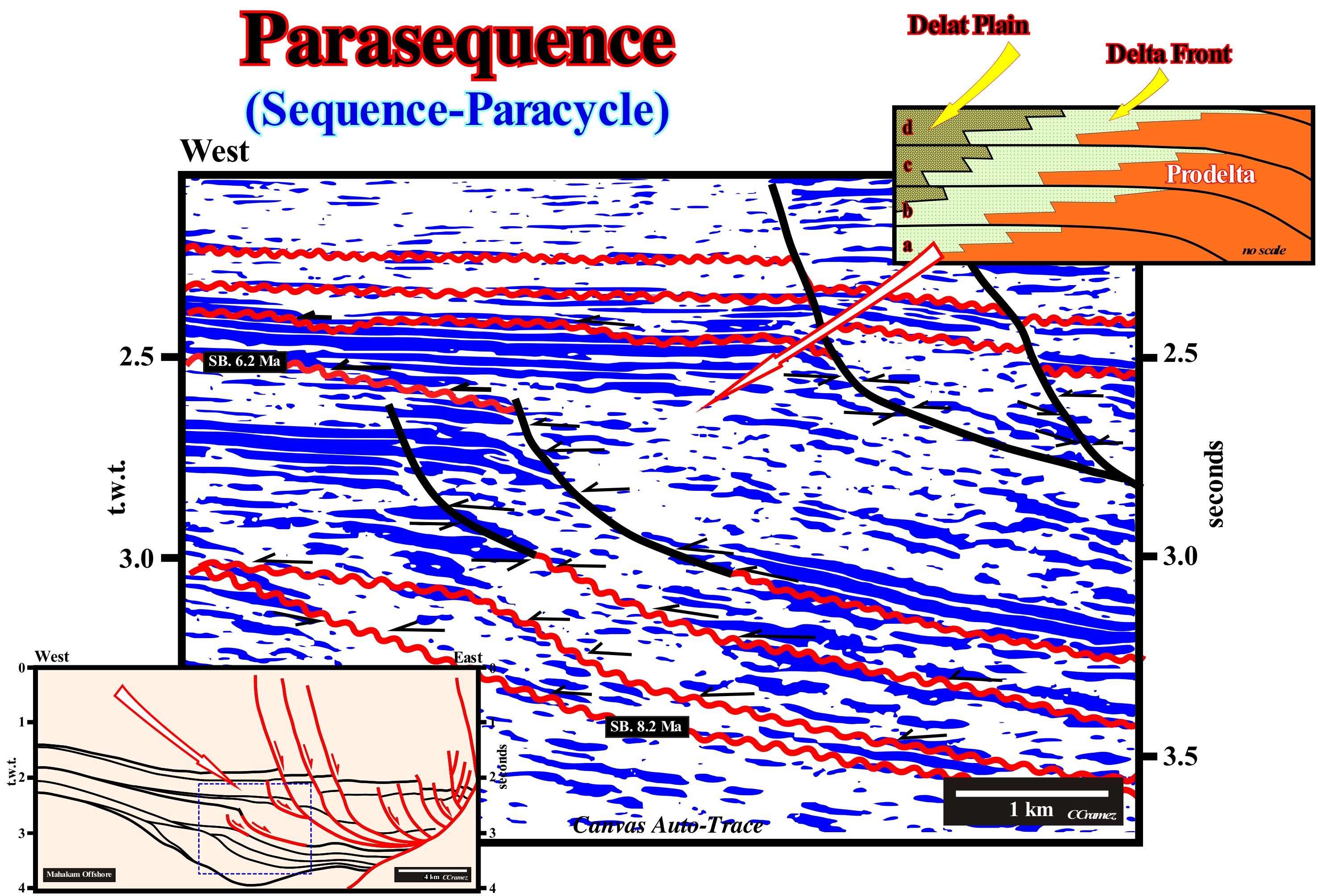
As illustrated on this tentative geological interpretation of a Canvas auto-trace of East of Borneo (Indonesia) of a seismic line (detail) and, particularly, in the upper geological scheme of this figure, the sequence-paracycles correspond to the sediments that settle-down during the stability periods of relative sea level (local sea level, referenced to the bas of the sediments or to the sea floor) separating successive increments of a relative sea level rise (result of the combined action of absolute or eustatic sea level, which is supposed to be global and referenced o the Earth's centre, and tectonics (subsidence of the sea floor when the sediments are lengthened or uplift, when the sediments are shortened). The sequence-paracycles are deposited in association with the eustatic paracycles, that is to say, with the marine ingressions, whose time-duration is, generally, 100,000 years. Between the eustatic paracycles there are no relative sea level falls, but a stability period of the relative sea level. The sediments are deposited during the stability periods of relative sea level between the marine ingressions. They filling the available space for the sediments (accommodation) created by the preceding marine ingression. Everything seems to pass, more or less, as follows: (i) A marine ingression (relative sea level rise or eustatic paracycle) moves the shoreline continent continentward, creating a ravinment surface on the pre-existing sediments, putting them under a certain water-depth (accommodation) ; (ii) As long as the relative sea level rise stops, there is a, more or less, long stability period of relative sea level (stillstand sea level), during which the shoreline moves seaward as the available space for the sediments, created by the marine ingression, is filled by sediments that, in general, exhibit sigmoid progradations ; (iii) A new marine ingression (eustatic paracycle) occurs, which, again, displaces the shoreline continentward and so on, until a significant relative sea level fall, puts the sea level lower than the basin edge. It is important to note that marine ingressions may be in acceleration or deceleration. In the first case, a marine ingression is more important than the previous one and in the second case, is the opposite, i.e., the marine ingressions is less important than the previous one. The geometry of each sequence-paracycle is progradational, since the sediments are clastic and come from the continent. In fact, when the marine ingression is in acceleration, the shoreline and the depositional coastal break of the depositional surface, move continentward, depending on the amplitude of the ingression and the morphology pre-existent sediments (substrate). Such displacement increases the continental shelf extension and tends to decrease the terrigeneous influx. If the continent has a poorly marked topography, the displacement of the shoreline to the continent, that is, the continental encroachment, can reach hundreds of kilometers. During the continentward displacement of the shoreline, there is no deposition. On the contrary, a slight erosion of the sea floor, often, forms a ravinment surface. It is during the stability period of relative sea level that occurs after each marine ingression that, progressively, the shoreline moves seaward at the same time as a sequence- paracycle is deposited. Each sequence-paracycle is composed of a lateral association of different depositional systems, synchronous and, genetically, associated. A delta*, which is a sequence-paracycle is composed of three depositional systems, characterized by a lithology (facies) and associated fauna: (i) Lower Beds, usually consisting of shales and sometimes by turbidite sands (proximal turbidites) ; (ii) Prodelta, characterized by oblique beds dipping seaward and (iii) Upper Beds, which are, more or less, horizontal, formed, mainly, by sands (delta front) in the distal sector and silts and shales in the proximal sector (delta plain). This is, perfectly, illustrated in the geological model in which four transgressive surfaces that emphasize four marine ingressions of, more or less, constant amplitude delimit four paracycles (a, b, c, d) within which the prodelta shales (in orange) pass, continentward to delta front sands (in yellow), which, in turn, pass, to the siltstones of the delta plain.
(*) Do not confuse delta with delta building. The first is, generally, 20 to 60 meters thick, whereas a delta building, which is a, more or less, vertical stacking of several deltas, can reach thousands of meters, as is the case in Congo Delta Building or in Mississippi Delta Building.
Parasequence Cycle...........................................................................................................................................................................Cycle paraséquence
Ciclo parasequência / Ciclo parasecuencia / Parasequenz Zyklus / 准层序周期 / Цикл парасеквенции / Ciclo parasequenza /
Expression to avoid since it does not correspond to a cycle, but to a paracycle which is succession of more or less conforming sedimentary layers, genetically, linked and bounded by two consecutive ravinment surfaces induced by marine floods (marine ingressions). The term cycle parasequence which is a language error must be called sequence-paracycle, since it is not limited by unconformities but by flooding surfaces. A sequence-paracycle is the stratigraphic unit deposited during an eustatic paracycle. Certain geoscientists consider two types of seuence-paracycles: (i) Periodic and (ii) Episodic. The periodoc are linked to the Milankovitch orbital cycles and are deposited, preferably, during the transgressive intervals (TI) of the sequence-cycles. The episodic sequence-paracycles are preferably deposited in the highstand (HPW) or low-level (LPW) prograding wedges in association with the lateral displacements of the delta lobes (pendulum effect). Certain geoscientists call the eposodic sequence-paracycles subsequences.
See: « Stratigraphic Cycle »
&
" Milankovitch's Cycle"
&
" Relative Sea Level Rise "
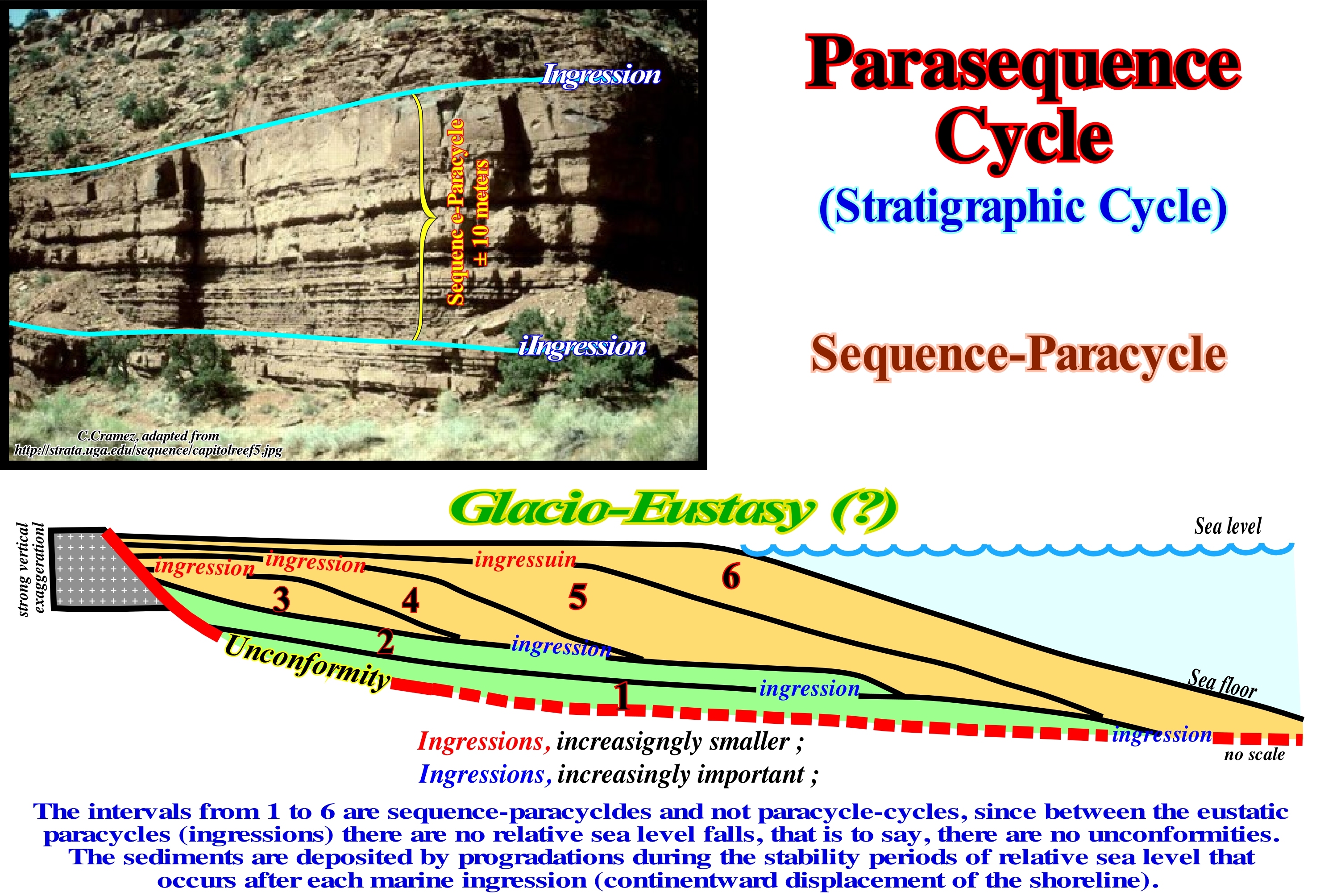
The term "parasequence cycle" or simply "parasequence" used at the beginning of sequential stratigraphy by the EPR geoscientists (Exxon Exploration Production Research) is in this glossary replaced by sequence-paracycle A sequence-paracycle is induced by an eustatic paracycle, which certain geoscientists mistakenly call 4th or 5th order eustatic cycles, because it has no cyclicity. A sequence-paracycles corresponds to a set of relative sea level rises, i.e., to a set of marine ingressions and the more or less long stability periods of relative sea level, during which the sediments settle-down. In other words, each sequence-paracycle is the result of a marine ingression and a sedimentary regression. The first creates the space available for the second, i.e., for the sedimentary regression, which occurs during the stability period of relative sea level. During the marine ingression, the shoreline (depositional coastal break of the depositional surface, that is, more or less, coincident, with the shoreline, especially on the seismic lines, due to the seismic resolution) is displaced continentward producing on the pre-existing topography a ravinment surface. On the contrary, during the sedimentary regression, the shoreline moves seaward. Thus, a more or less vertical set of sequence-paracycles is induced by a succession of eustatic paracycles, with no relative sea level falls between them, which are fossilized by sedimentary regressions. Such a set of sequence-paracycles may be retrogradational or progradational. In the first case, the marine ingressions are increasingly important (the relative sea level rises are increasingly important or, in other words, the relative sea level rises are in acceleration), which implies that sedimentary regressions are increasingly smaller. In the second case, the progradational geometry of the set of sequence-paracycles is due to a succession of increasingly smaller marine ingressions (relative sea level rises in deceleration) and increasingly important sedimentary regressions. The term transgressions is used to denote an increasingly important set of marine ingressions and the associated increasingly smaller sedimentary regressions, while the term "Regression" is used by most geoscientists to designate the set of marine ingressions increasingly smaller and the associated increasingly important sedimentary regressions*. Between the eustatic paracycles there are no relative sea level falls, which means that they are not eustatic cycles, and hence it is preferable to call them eustatic paracycles, that is, parts of an eustatic cycle. The time-duration of an eustatic paracycles ranges from 0.1 to 0.5 My, which corresponds to the time interval between the two flooding surfaces that separate them. The sequence-paracycles are bounded by ravinment surfaces, induced by the action of waves during each relative sea level rise (ingression). As shown in this sketch, within a sequence-cycle, the retrogradation of sequence-paracycles is, particularly, well visible in the transgressive interval (TI). The progradational sequence-paracycles are visible in the highstand prograding wedge (HPW) and in the lowstand prograding wedge (LPW). The transgressive interval (TI) of a sequence-cycle is a set of retrogradational sequence-paracycles, deposited during stability periods of relative sea level, which separate the successive relative sea level rises in acceleration. Likewise, a lowstand prograding wedge (LPW) is a, more or less, vertical stacking of progradational sequence-paracycles, which are deposited during the stability periods of relative sea level occurring between the different relative sea level rises in deceleration. Each sequence-paracycle corresponds, in fact, to one or several sedimentary systems tracts (facies tracts), that is, it corresponds to a lateral and synchronous association of different lithologies, genetically, linked. It is at the hierarchical level of the sequence-paracycle that geoscientists can, more easily, predict lithologies. The identification of the sequence-paracycles is easy in the field, at the natural 1: 1 scale, but, relatively, difficult on the tentative geological interpretation of the seismic lines, since most of the time, due to the seismic resolution, the sequence-paracycles are below the seismic resolution. Sometimes, several sedimentary systems tracts may be individualized within a sequence-paracycle, i.e., between two consecutive ravinment surfaces.
(*) Some geoscientists say that a "Transgression" is the set of "Regressions" increasingly smaller, which for us is not very convincing.
Parasequences Set.................................................................................................................................................Sucession de paraséquences
Conjunto de parasequências / Conjunto de parasequencias / Parasequenz Set / 准层序继承 / Комплекс парасеквенций / Successione di parasequences /
Sequence-paracycle (periodic) with retrogradational geometry that make up the transgressive interval (TI). Van Wagonner does not limit the use of this term to a specific subgroup of sedimentary systems tract. It also uses it to designate the sequence-paracycles with progradational geometry of a highstand prograding wedge (HPW) or a lowstand prograding wedge (LPW). The term sequence-paracycle, used in this glossary, is much less confusing than parasequences, whether it be periodic or episodic.
See: " Continental Encroachment Cycle "
&
« Parasequence Cycle »
&
« Stratigraphic Cycle »
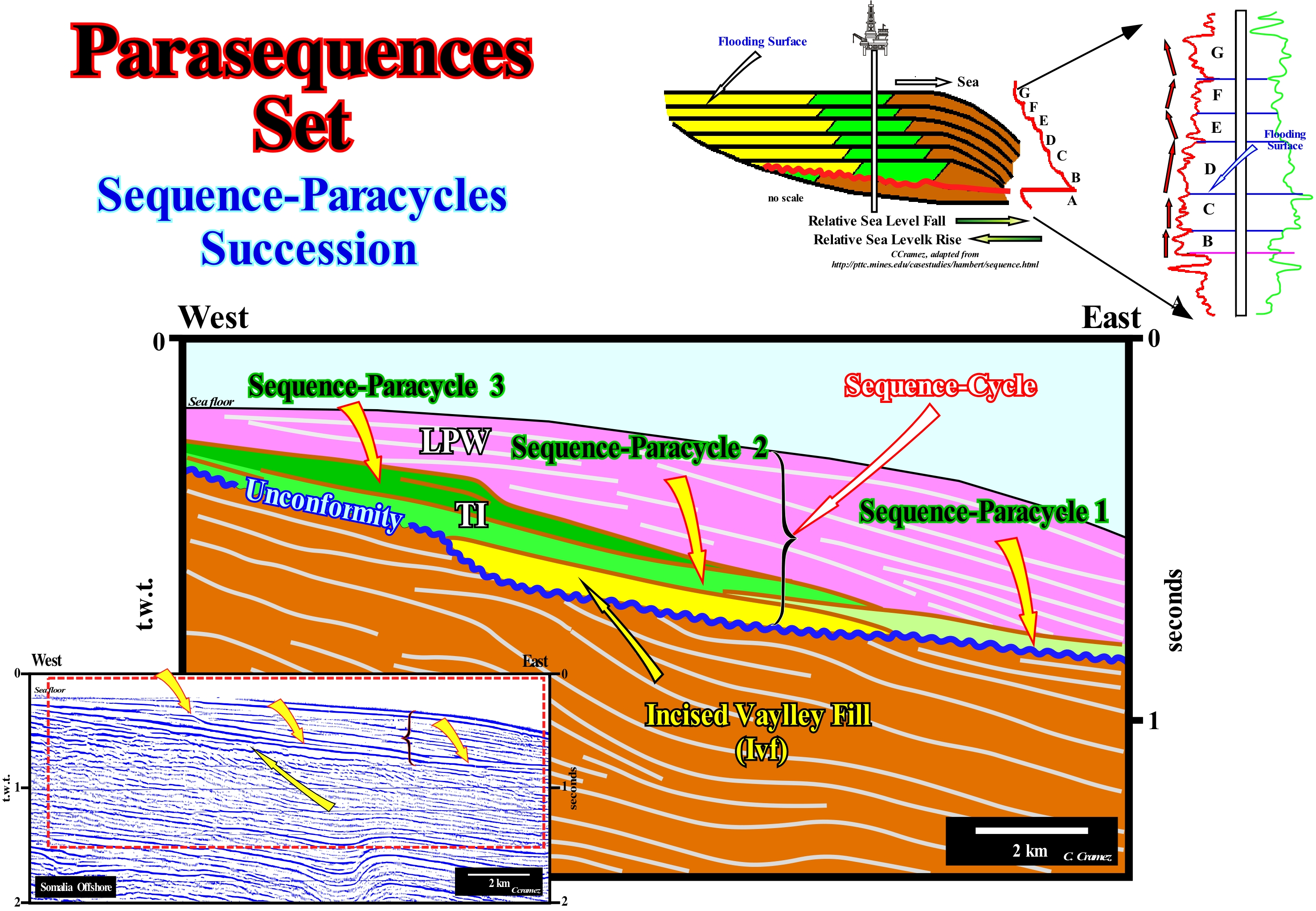
Take into account that the term parasequence is not very correct and should, whenever possible, be replaced by sequence-paracycle. At the hierarchical level of a sequence-cycle, a parasequence is associated with eustatic paracycle (marine ingression, that is, a relative sea level rise without being followed by a relative sea level fall) and not an eustatic cycle (relative sea level change limited between two significant relative sea level falls). A sequence-paracycle is deposited during the stability period of the relative sea level that occurs after a relative sea level rise (marine ingression) and that between two consecutive eustatic paracycles there is no relative sea level fall. A set of sequence-paracycles, which initially the Exxon geoscientists called set of parasequences, corresponds a subgroup of sedimentary systems tracts, during which the relative sea level always rises. Within a sequence-cycle, the relative sea level rise accelerates during: (i) The transgressive interval (TI) and (ii) During the lowstand prograding wedge (LPW). However, it rise in deceleration during the highstand prograding wedge (HPW). There is no relative sea level fall between each sequence-paracycle. A set of sequence-paracycles is not induced by an eustatic cycle, but is part of an eustatic cycle, hence the designation of paracycle. As illustrated on this tentative geologically interpretation of a Canvas auto-trace of a detail of a Somalia offshore seismic line, which offshore corresponds to a Atlantic-type divergent margin covering rift-type basins, the cyclicity of relative sea-level changes is given here by the sequence-cycle, bounded between the unconformities (blue wavy line) and the sea floor. In this incomplete sequence-cycle, since the subgroups of the lowstand systems tract group (LSTG) are not visible (they are present eastward of the seismic line), from top to bottom, we, easily, recognize: (i) An incised valley fill (Ivf), coloured in yellow, which underlines the erosional surface induced by the relative sea level fall and which was filled during the deposit of the upper part of the lowstand prograding wedge (LPW), which is not visible on this tentative, but it is well developed eastward of the seismic line ; (ii) A transgressive interval (TI), which is composed of the stacking of three sequence-paracycles, induced by three successive relative sea level rises (without relative sea level falls between them, but with stability periods of sea level), during which the sediments were deposited ; (iii) A highstand prograding wedge (HPW) characterized by a progradational geometry that contrasts with the retrogradational geometry of the transgressive interval. The retrogradational geometry of the transgressive interval corresponds to the vertical stacking of three progradational sequence-paracycles increasingly less extensive, induced by three increasingly important marine ingressions (relative sea level rises in acceleration). The amplitude of the progradational sequence-paracycles of the transgressive interval decreases upwards, since at each relative sea level rise, the extent of the continental shelf increases. Such an increasing, necessarily, decreases the terrigeneous influx, which becomes insufficient, So, the depositional coastal break of the depositional surface (more or less the coastline) of each sequence-paracycle, progrades less than that of the previous sequence-paracycle. The set of marine ingression and associated sedimentary regressions induced by them, which form the transgressive interval of a sequence-cycle, corresponds to what certain geoscientists, collectively, call sedimentary transgressions. It may also be called 3rd order sedimentary transgressions to specify the hierarchical level of interpretation and which is the relative sea level considered. A downlap surface exists between the transgressive interval (TI) and the highstand prograding wedge (HPW). As illustrated in the geological scheme and in the results of the electric logs, it can be said that a relative sea level rise corresponds to a succession of marine ingressions and the associated sequence-paracycles (sedimentary regressions). However, marine ingressions may be accelerating, i.e. increasingly important or increasingly smaller (decelerating). In the first case, the sequence-paracycles (increasingly smaller sedimentary regressions) form a transgressive interval, whereas in the second, they form a prograding wedge (lowstand or highstand) with increasingly important sedimentary regressions.
Parasite (Reflection)........................................................................................................................................................................................Parasite (Réflexion)
Parasita / Parásita (reflexión) / Parasit (Reflexion) / 寄生虫(反射) / Паразит / Parasite (riflessione) /
Diffraction on seismic lines induced by a non-geological object such as a boat, iceberg, in marine lines, or automobile, factory, etc., in land lines.
See: « Reflection Seismic »
&
« Acoustical Impedance »
&
« Seismic Reflection »
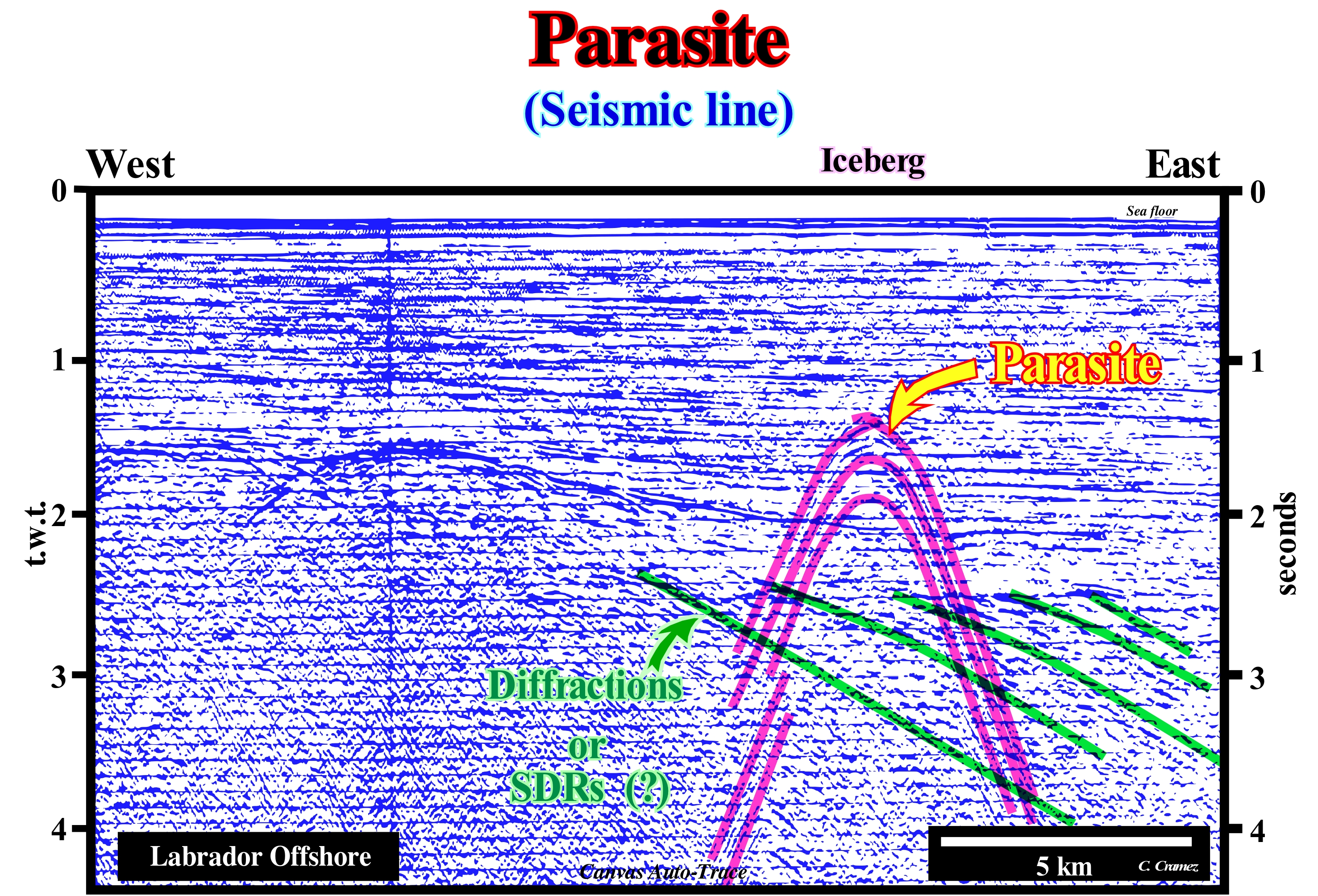
First of all do not forget that a diffraction is a type of event produced by the radial dispersion of a wave on new wave fronts after the wave encounters a discontinuity, such as a fault plane, an unconformity or an abrupt change in the type of rock. In an unmigrated seismic line, the diffractions appear as hyperbolic or umbrella-shaped events (an adequate migration of seismic data uses the diffracted energy to correctly position the reflections). In this unmigrated seismic line from the Labrador offshore, the parasite reflections induced by an iceberg are, perfectly, visible. At the time of the shooting, an iceberg was located about 1 km away from the seismic boat. These parasite reflections, which have no geological significance, should not be confused with the diffractions, which, on the contrary, may give interesting geological indications. In this example, the diffractions (in green) are associated with the topographical irregularities ("cuestas") of the basement unconformity, which is constituted by Precambrian supracrustal rocks. In the migrated version of this seismic line, the geometry of the parasite reflections associated with the iceberg is reversed (hyperbolas up rather than down). In the interpretation of the reflection seismic data, the main problem is to distinguish the arrivals, which represent primary reflections, to transform their times of arrival in depth and to draw the map of the reflective horizons. In addition, the interpreter must take into account other types of arrivals, which may contain important information such as multiple reflections and diffractions. The recognition and identification of seismic arrivals is based on five parameters: (i) Coherence ; (ii) Amplitude Variation ; (iii) Character ; (iv) Curvature (induced by inclination) and (v) Normal Curvature. The first parameter is by far the most important. A wave recognized as such, when it hits a geophone, has the same effect on other geophones. If the wave is strong enough to surpass all the energy, which arrives at the same moment at the geophone, the traces will all look like one another during the time-interval the wave reaches the surface. It is this semblance that is called coherence. The amplitude variation is a criterion that takes into account the growth of the amplitude of the traces resulting from the arrival of an energy in phase. Character is the distinctive aspect of the waveform, which allows one to distinguish a particular arrival. Curvature is the systematic difference of arrival times from one trace to another. Currently, non-migrated seismic lines are only used if no migrated lines are available in the area where they were taken.
Parvafacies........................................................................................................................................................................................................................Parvafáciès
Parvafácies / Parvafacies / Parvafacies (Rock zwischen Pläne stratigraphischen-Zeit) / 分相 / Парвафации / Parvafacies (Rocca tra i piani stratigrafico-time) /
Sediments of a magnafacies between certain chronostratigraphic horizons, or the key layers, through a magnafacies. A parvafacies is a limited chronostratigraphic unit, laterally, or a chronostratigraphic unit of different facies formed at the same time. The terms magnafacies and parvafacies were first used by Caster (1934) to mark the difference between lithostratigraphic and chronostratigraphic units.
See: « Magnafacies »
&
« Lithosome »
&
« Chronostratigraphy »
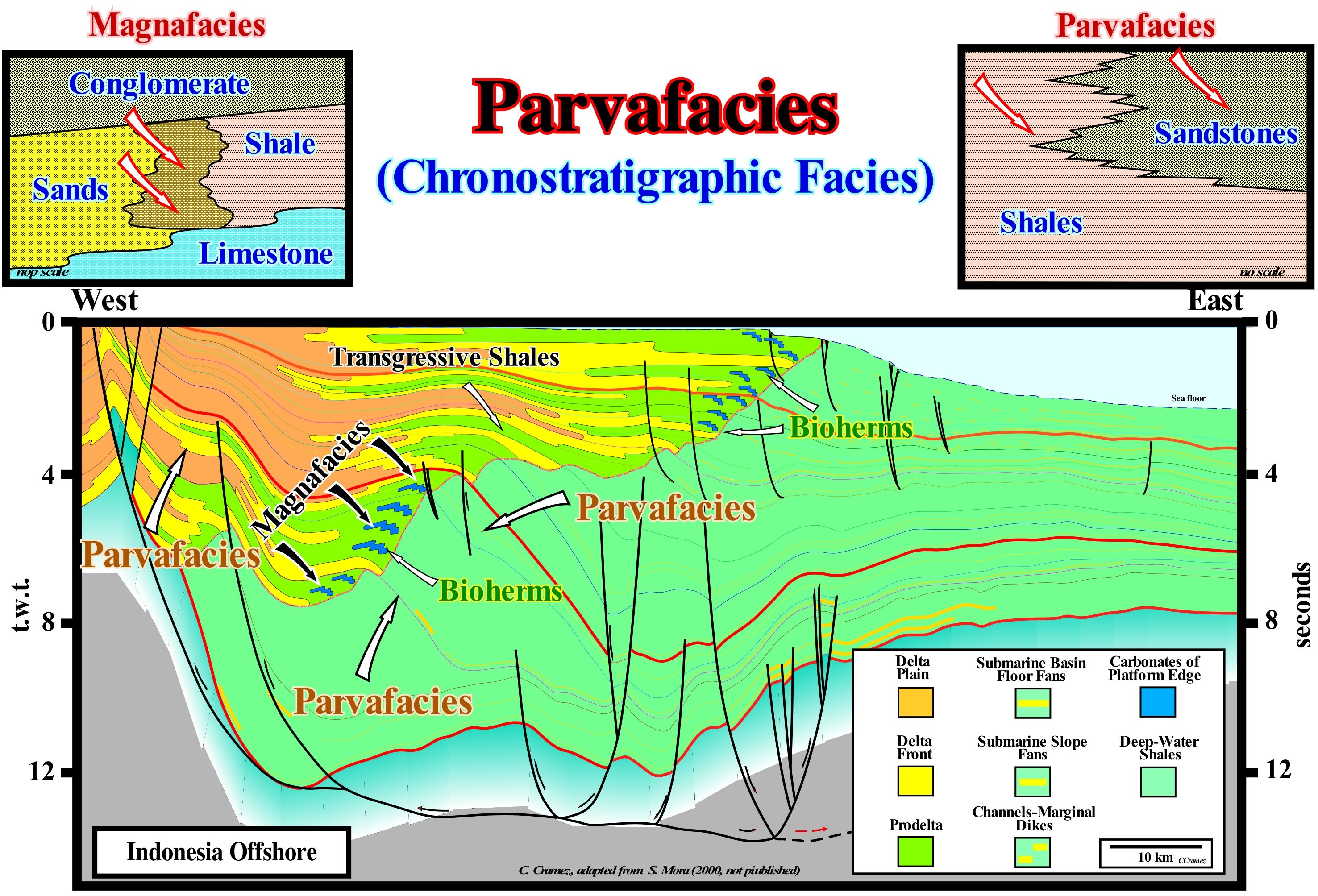
The offshore of the Borneo (east coast) and particularly the Kalimantan (Indonesia) offshore of corresponds to the stacking of several basins of the classification of the sedimentary basins of Bally and Snelson (1980). Thus, on a basement that, locally, can correspond to an old mountain belt, was deposited: (i) A back-arc basin, within which are distinguished two sedimentary tectonic phases: (i.1) A rifting (lengthening) phase or characterized by a differential subsidence and (i.2) A sag phase, which is characterized by thermal subsidence and (ii) A non-Atlantic divergent margin, which has been, locally, deposited in association with the break-up of lithosphere from the back-arc basin, which initiated a sea floor spreading, easily visible in regional seismic lines. Obviously, these basins were not produced by sedimentation, but by tectonic and thermal processes. Subsidence, which may be differential, thermal or flexural, may have different causes: (i) A thermal anomaly ; (ii) A tectonic activity ; (iii) A sedimentary charge ; (iv) A thermal contraction during crust cooling, etc. In the case of Kalimantan offshore, the differential subsidence, from the rifting phase of the back-arc basin, is associated with a lithosphere lengthening induced, probably, by a thermal swelling with a swelling of the isotherms. The lengthening of the lithosphere is, naturally, due to a normal fault systems, since there is no other way to length the lithosphere or the sedimentary intervals, which may or not synchronous with the lengthening (in the first case the sediment thickness increases in direction of the fault plane). Thermal subsidence, which played the main role in the evolution of the back-arc basin during the sag phase, that is, after the cessation of tectonic subsidence, was induced by a deep lithospheric cooling (isotherms tightening) that caused a thermal contraction (subsidence thermal) to recover the isostatic equilibrium. As can be seen on the tentative geological interpretation of a seismic line from this Indonesia offshore, illustrated in this figure the difference between a magnafacies (continuous and homogeneous belt of sedimentary deposits, characterized by similar lithologic and palaeontological characters, but extending obliquely to the time-lines) and a parvafacies (chronostratigraphic unit of different facies formed at the same time) is relatively easy to recognize. A magnafacies is a complete lithologic member or a perfect stratigraphic unit, with the same facies (lithology), but of different ages. This tentative interpretation also illustrates, on a regional basis, the eastward development of a delta depositional system, i.e., the Mahakam delta building (do not say the Mahakam delta, since a delta is, generally, 20 to 60 meters thick, while a delta building, which is a, more or less, vertical association of several deltas of different ages, can reach thousands of meters. Seismically (take into account the vertical resolution), for most of the time, at the level of the sequence-cycles, it can be said that the basin had no continental platform (shelf). The depositional coastal break of the depositional surface almost always corresponded to the continental edge, which seems to have always operated as basin edge. The transgressive intervals, with prodeltas of about 20-30 meters thick, are thin and are below the seismic resolution. Hence, they are difficult if not impossible to recognize (the visible developments on this tentative interpretation correspond to continental slopes). The presence of bioherms that laterally are part of a parvafacies (change of facies along the same chronostratigraphic line), but which, vertically, form a magnafacies (the same lithology that cuts obliquely the chronostratigraphic lines), emphasize, in an indirect way, the most important transgressive events. In the absence of these organic constructions, which induce amplitude anomalies along certain reflectors, it would be very difficult to identify the transgressive intervals, since the transgressive shales are not very evident.
(*) Calcareous or dolomitic sedimentary rocks, usually compact and poorly stratified, formed in a shallow marine environment by the construction activity of colonial corals and by the accumulation of other organisms.
Patch Reef..................................................................................................................................................................................................................................Récif isolé
Recife isolado / Arrecife de coral aislado / Isolierte Korallenriff / 补丁礁 / Изолированный риф / Barriera corallina isolato, Corale reef isolato /
Small, isolated, circular or oval reef construction near the large reefs and generally, within the lagoon. The top of an isolated reef is almost at the surface of the water and may be above sea level during low tide. Isolated reefs form in calm waters, either in the lagoon of a rimmed platform or in the waters protected by barrier reefs. Gradually, the reef sinks and the corals continue to grow. If the sinking is complete an atoll is formed, that is to say, reefs around a lagoon.
See: « Reef »
&
« Transgressivo Interval »
&
« Deposition (carbonates) »
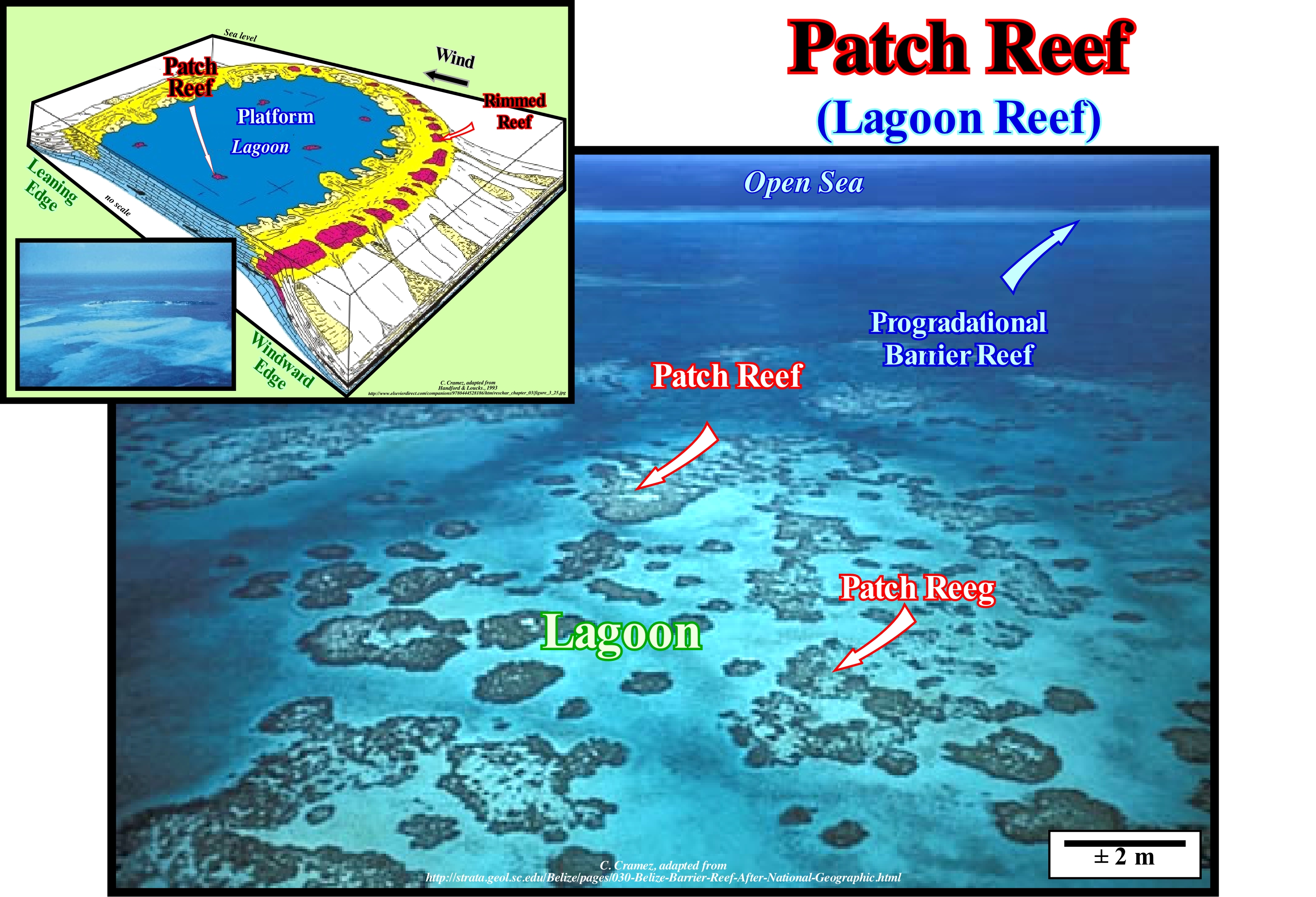
The term reef can be: (i) A cliff or a group of cliffs in the water near the coast or (ii) A geological formation along the coast. A coral reef refers to a marine habitat that is among the most biodiverse environments on the planet. A reef is formed by some species of coral (animals belonging to the group of cnidarians) able to secrete a limestone exoskeleton, along with limestone algae that produce thin slabs of calcium carbonate, which accumulate and cement the reef structure. The corals are coelenterates, with a digestive cavity, and secrete a limestone exoskeleton. Corals are colonial organisms that mostly build limestone skeletons. Such skeletons are responsible for the rocky structure called coral reefs. The blocks built in coral reefs are the skeletons of several generations of algae, corals and other reef-building organisms that are composed of calcium carbonate. As a function of their shape, size and distance to the mainland, reefs are, generally, classified into: (i) Fringed reefs ; (ii) Barrier reefs ; (iii) Faros ; (vi) Atolls ; (vii) Tabular Reefs. Fringed reefs which are simple and more or less connected to the coastline (continents or islands), as found in the Caribbean and near Florida and the Bahamas; is the most common type of reef. Barrier reefs are linear or semicircular constructions separated from the mainland by channels; the typical example is Australia's Great Barrier Reef, the largest in the world, which extents for more than a thousand kilometers along the Australian coast. Faros (atolls within the lagoon), have a more or less ringed. Patch Reefs or Solitary Reefs, typically have a more or less important platform. ) Reef Mounds (rarely used term) are reef insulated in deep-water, often associated with landslides or instabilities of barrier reefs. Atolls are ring-shaped structures with a central lagoon, which develops in relatively deep waters, generally, on former submerged volcanoes. Tabular Reefs which, like atolls, form in deep-water, but which, unlike these, have no lagoons. In this photograph, small solitary reefs (patch reefs) within the lagoon of an isolated carbonate platform (not connected to the mainland) are easily recognized. The barrier reef that developed on the windward side of the platform (side of the reef that receives the wind) is visible on the top (white horizon) of the photograph. This type of carbonated platform (isolated platform), whose width can reach 100 kilometers, is characterized by the fact that the facies are very controlled by the orientation of the prevailing winds. On the windward shore (side where the wind blows or receives the wind), progradational reefs and sandy bodies are formed, while in the leeward margin (margin edge in the direction where the wind blows or the wind lets the wind pass), the sediments are more muddy. In the calm waters of the lagoon, isolated reefs are very frequent, many of which, during low tide, have the top above water level. In addition to this type of carbonated platform there are other types in which solitary reefs can grow: (i) Rimmed Platforms, which are characterized by the presence of reefs or reefs reefs in the edge of the platform and clay sands and shoal reefs in the lagoon; they develop in calm waters and their width can vary between 10 and 100 km ; (ii) Carbonated Ramps, which can reach 100 km wide and where reefs are not very frequent, the carbonated sands of the coast line pass at the base of the ramp to clay sands and deep water mud ; reefs are not very frequent ; (iii) Epeiric Platforms, whose width can reach 10,000 km, and which are characterized by the presence of tidal surfaces and lagoons protected by solitary reefs and (iv) Dead or Drowned Platforms, which are under the photic zone (the relative sea level , during the last 10,000 thousand years, rose and fall several times and was at least three times above the current sea level, which favoured its development).
Peat.......................................................................................................................................................................................................................................................................Tourbe
Turfa / Turba / Torf / 泥炭 / Торф / Torba /
Accumulation of vegetal matter, partially, decomposed. According to Wikipedia, in volume there are about 4 Tm3 of peat in the world (about 2% of the 3 Mkm2 occupied by the continental surface), which contains about 8 G terajoules (TJ = 1012 J) of energy. However, contrary to what the European Parliament has suggested to the Commission (14 December 2006), peat can not and should not be considered as a source of renewable energy.
See : « Coal »
&
« Biogenic Gas »
&
« Organic Matter (types) »
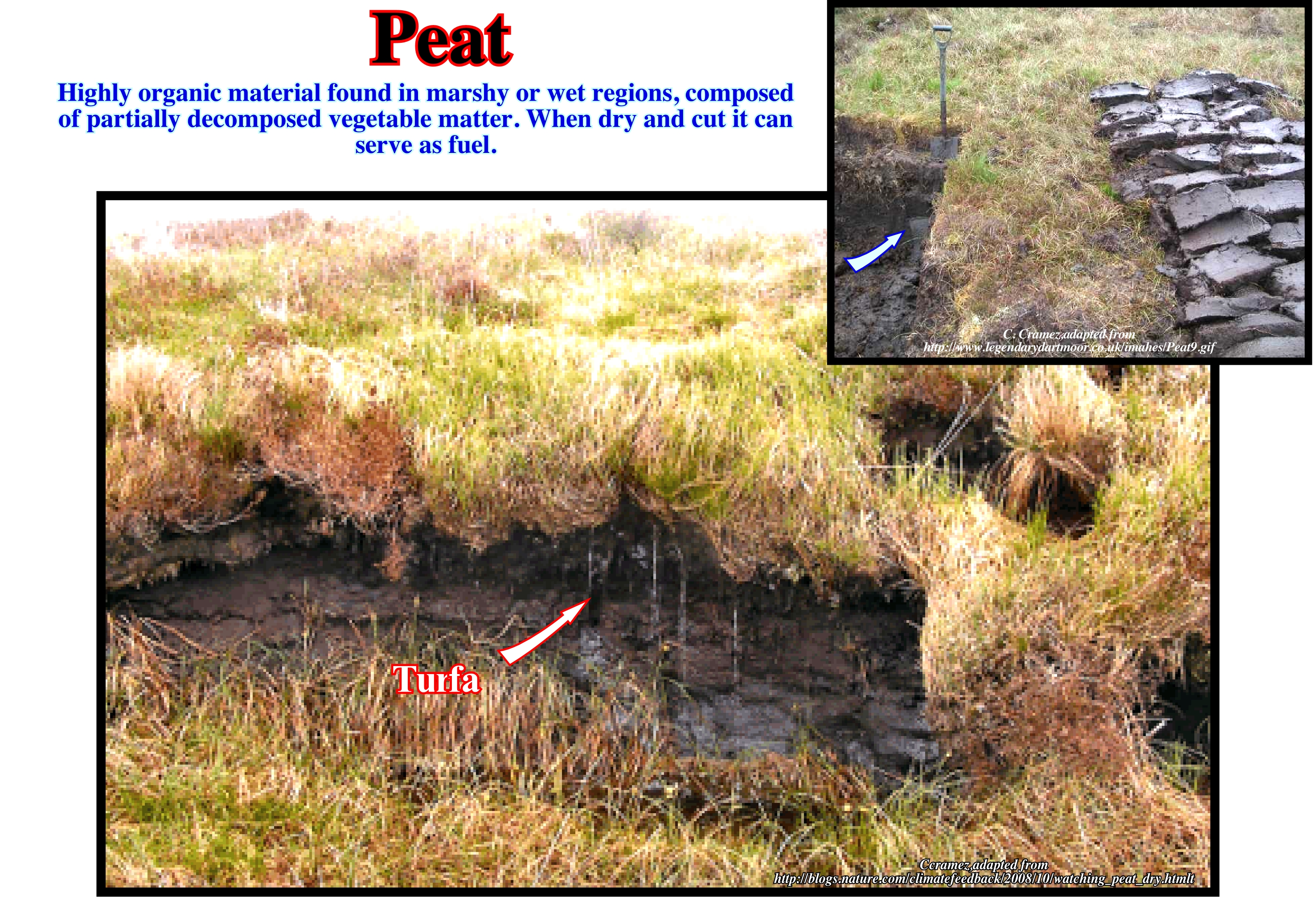
Peat has formed on the Earth's surface for more than 350 million years. The amount of carbon associated with the peat is of the order of 550 Gt. Peat is, generally, formed in marshy regions, when acidic and anaerobic environmental conditions prevent the organic material from being, completely, decomposed. It is composed, mainly, of marshy vegetation, that is, of trees, grass, fungi and organic debris (insects, animal corpses, etc.). Under certain circumstances, the decomposition of animal corpses (in the absence of oxygen) is inhibited, which delights archaeologists. The growth of peat layers and the degree of decomposition (or humification) depend mainly on the composition and degree of water saturation. Peat formed under conditions of high humidity grows more rapidly and is less decomposed than peat formed in drier areas, allowing geoscientists to use it as a potential indicator of climate change. The composition of peat (types and quantities of organic elements) can also be used to reconstitute ancient ecologies (relations of living beings with their natural environment). Under certain conditions, peat is the first stage of coal formation. The most important modern peat bogs have formed in high latitude areas, since glaciers of the last ice age (about 9,000 years ago) began to thin (retrograde), with a growth velocity of about 1 millimetre per year. As peat bogs store carbon, if they dry up (which is happening in several countries), they will release more carbon into the atmosphere than industrial emissions for dozens of years. This problem is, totally, ignored by most environmentalists and politicians, since peat-lands can not be penalized with dollars on the carbon (C02) released.
Pebble...............................................................................................................................................................................................................................................................Gravier (Gravillon)
Cascalho (seixo) / Guijarro / Geröll, Kies / 鹅卵石 / Галька / Ghiaia /
Gravel or pebble is a clasto of a rock with a diameter that in the scale of φ (phi) of Krumbein ranges from -2 to -6, i.e., between 4 and 64 millimeters, which means that it is a very imprecise term.
See: « Sorting (sediments) »
&
« Alluvial Fan»
&
« Granulometry »
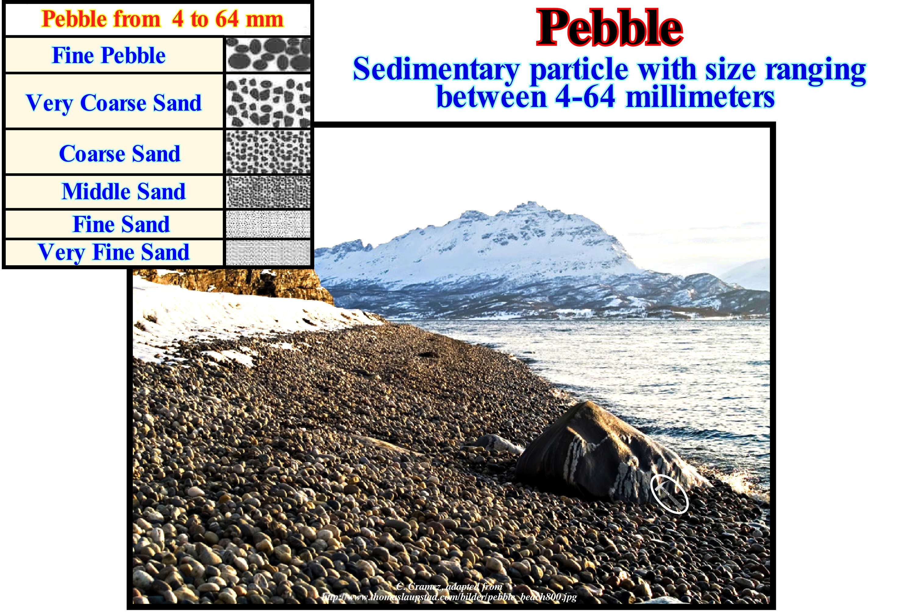
This northern Norwegian beach (the mountain to the deep is the Drangen mountain) is very particular. It is filled by millions of pebbles and is very sloped, making it difficult to walk along it. When the waves spill out the noise the pebbles make when they roll against each other is simply fantastic. A beach composed mainly of pebbles is a pebble beach (a term that is not very precise, since the diameter of the particles varies between 4 and 64 mm). These beaches have very particular characteristics with respect to the erosion of the waves. They have infrequent ecological niches, in which are rare species and some in extinction. In the classification of Krumbein when φ is lower -8 (upper diameter 256 mm) the sedimentary particle is called a block (boulder). When φ is between -6 and -8 (diameter between 64 and 256 mm) the particle is called a pebble. When φ is between -5 and -6 (diameter between 32 and 64 mm) the particle is also called pebble. When φ is between -4 and -5 (diameter between 16 and 32 mm) it is coarse gravel. When φ is between -3 and -4 (8 and 16 mm) it is medium gravel. Gravel is fine when φ is between -2 and -3 (diameter between 4 and 8 mm) and very fine when φ is between -1 and -2 (2 and 4 mm). When φ is between 0 and -1 (diameter between 1 and 2 mm) it is very coarse sand. The coarse sand has a φ between 1 and 0 (between 0.5 and 1 mm). Sand is average when φ is between 2 and 1 (0.25 - 0.5 mm), thin when φ is between 3 and 2 (125 and 250 μm) and very fine when φ is between 4 and -3 (62.5 - 125 μm). When φ is between 8 and 4 (diameter between 3.9 and 62.5 μm) it is a silt. The clay has a φ greater than 8 (diameter less than 3.9 μm) and a colloid when φ is less than 10 (1 μm). The USCS classification, much used to describe soil texture and granulometry, is much simpler: (a) Ballast, when more than 50% of the particles are retained in a 4.75 mm mesh net; (b) Sand, when 50% of the particles are retained in a 4.75 mm net; (c) Lime and Clay, when more than 50% of the particles pass through a 0.075 mm net.
Pediment.......................................................................................................................................................................................................................................Pédiment
Pediment (frontão, talude) / Pedimento (geología) / Pediment / 前冲(地质)/ Педимент (предгорная скалистая равнина) / Pedimento /
Sediment, flattened and slightly bulged, with a relatively important slope depositional dip on living rock at the foot of arid or semi-arid mountains. Any relatively flat, rocky surface that occurs at the base of a mountain. An erosional surface that forms the base of a retrograding mountain or escarpment. The formation of a pediment is due to the lateral erosion of planar water currents, carrying abundant detrital material. The pediments, which are, sometimes, confused with alluvial cones, are common in desert basins as "Basin & Range" type.
See: « Coastal Non-Marine Deposit »
&
« Alluvial Fan»
&
« Alluvial Plain »
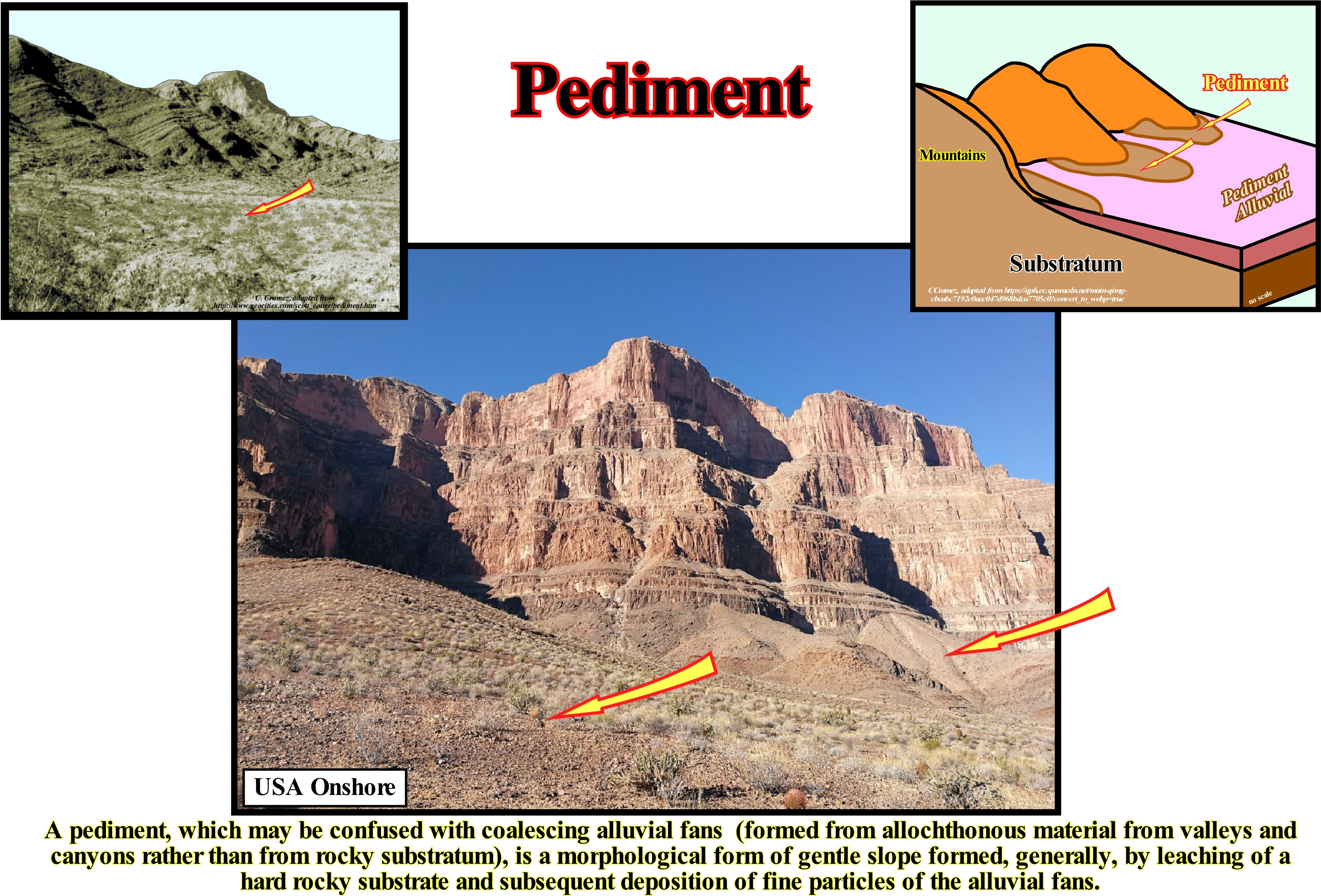
The mountain front is an imaginary boundary between a mountainous area and a low sloping lowland, whether it be a pediment or an alluvial fan. A pediment is a slightly sloping erosional surface or low relief plain formed by a water-course in an arid or semiarid region at the base of a recessed mountain front. A pediment fossilizes a rocky substrate that is, typically, covered by a thin, discontinuous veneer of soil and alluvium derived from the mountainous regions. Most of the alluvial material is in transit through the pediment as it moves during storms and windstorms. The pediments are not to be confused with alluvial fans which are aggradational deposits of alluvium deposited by a stream of water, which leaves a canyon, on a surface or a valley. Once the water-course reaches the valley, as it is no longer confined, it can migrate back and forth, depositing alluvial sediments over an extensive area. Seen from above, an alluvial fan has a lobular geometry with the apex near the gorge. Alluvial fans formed by multiple canyons along a front of mountains join to form a continuous aggregate of fans called piedmont (piedmont alluvial plain or foothill plain). They are the piedmont alluvial plains of Piedmont, which are often misinterpreted as pediments. The problem of terminology and definition of a pediment has become almost more important than the problem of its formation. For Hadley (1967), a pediment is a low relief erosion surface, partially, covered by a veneer or thin layer of alluvium that slopes in the opposite direction to the inclination of the mountain escarpments of the arid and semi-arid environments. However, other geoscientists consider that a pediment is found in all parts of the world, even in humid climates and not exclusively in arid climates. Other geoscientists have described pediments with thicknesses over 6 meters which is in perfect contradiction to the veneer of Hadley's definition. A pediment often appears as a, more or less, flat area of a gravel veneer, sandy or not, between areas with extensive outcrops of bare or slightly altered rock. A pediment is, usually, formed in association with the erosive regression process of cliffs, typical of arid to semi-arid climates, in the flat areas (foothills) along steep areas and in the fronts of alluvial fans. The rare torrential rain showers, typical of arid and semiarid climates, transport the fragments of the high areas and disperse them over the low flat areas, concentrating them as thicker gravel deposits on topographical bottoms and in silted river channel valleys and (http://sigep.cprm.gov.br /glossario/index.html). In fact, a mountainous front always falls under the action of disintegration and gravity. However, when the debris is coarse, they accumulate on the side of the mountain thus making it difficult to form an erosion slope. On the contrary, when debris is fine, as is the case, for example, in granitic regions, the flow, aided by lateral erosion, cleans the base of the mountain and creates a sharp slope rupture. For French geoscientists and, in particular, for M. Derrau (1958), it is important to differentiate the slopes of erosion, properly speaking, from pediments. The slopes of erosion develop on the basis of the structural reliefs of the rough rocks, where, sometimes, at the base of a relief there are several slopes of erosion one on the other. The pediments are, usually, erosion slopes that form in association with a hard (usually crystalline) rock that turns into sand (the abrupt limiting pediment upstream is not of structural origin). This photograph illustrates the Mojave Desert pediment in California (USA), where development of pediments and alluvial fans is associated with the rising of the mountains and the subsidence of the adjacent basins. The pediments reflect a relative static balance between erosion of materials from mountainous areas and deposition in adjacent basins. The dip of the terrain is sufficiently smooth so that the weathering and transport of sediment from the mountainous areas and the pediment takes place without significant incisions of the waterways. In many areas of the Mojave region it is almost impossible to see where a pediment ends and alluvial fans begin, however, geophysical data and drilling of water wells show that in many places sedimentary basins are adjacent to the pediment areas (https: // pubs.usgs.gov/of/2004/1007/fans.html).
Pedolith.............................................................................................................................................................................................................................................Pédolithe
Pedólito / Pedolito / Pedolith (mit mehreren pedogenen Prozesse) / Pedolith (几成土过程) / Педолит / Pedolito (con diversi processi pedogenetici) /
Surface geological formation that has undergone one or more pedogenic processes, i.e., processes that add, transfer, transform or remove constituents that form the soils.
See: « Soil »
&
« Erosion »
&
« Leaching »
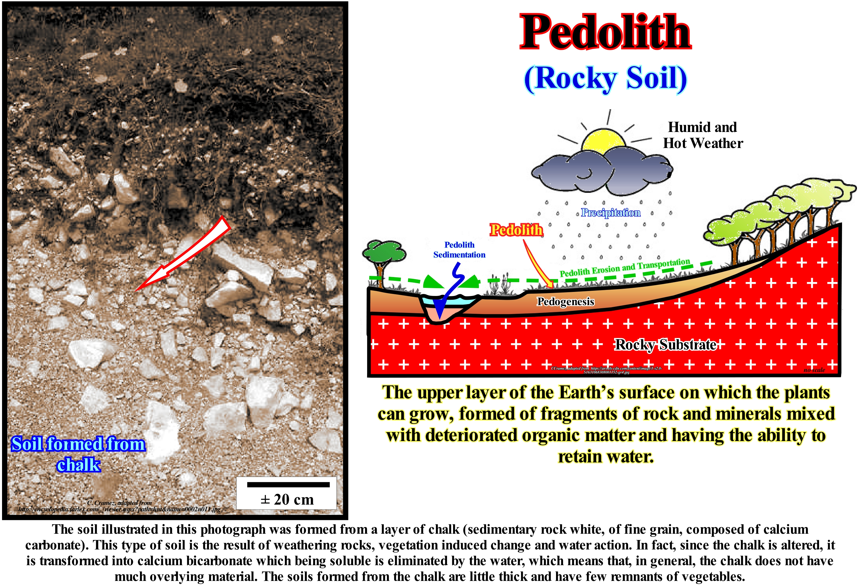
On Earth, the regolith, i.e. ,the layer of loose heterogeneous material covering the firm rock, may be subdivided into several components: (i) Soil or pedolith ; (ii) Alluvial and other material transported by wind, glacier, marine and gravitational processes ; (iii) Saprolite which is generally divided into upper (firmly oxidized rock), inferior (rock solid weathered) and fractured (when alteration is limited to fractures). Note that saprolite is the clay-rich, earthy-looking surface deposit of reddish colour resulting from the alteration of igneous, sedimentary or metamorphic rocks, characteristic of humid and tropical or subtropical climates. The upper part of the profile of a regolith is referred to as the pedolith and includes: (a) Saprolite material in which the original pattern was destroyed and a new pattern formed and (b) Material that was submitted to pedogenic processes (soil formation). This description is very general and differs from the original pedological definition, which is restricted to the redeposition of lateritic sediments, or to sediment-derived soils. When the pedolith is used in reference to the top of the regolith profile above the saprolite and so it refers to the combination of the horizons A and B of the soils. The pebble is composed of the surface of horizon A, a mixture of minerals and organic matter, and the horizon B, characterized by an accumulation of clay, iron, aluminum, organic material or a combination of these. Below this the horizons C and R are recognized, which are equivalent to the saprolite and the substrate, respectively. A soil is described by a vertical cut from the surface of the terrain to the firm rock on which the soil sits. The profile is divided into layers called horizons. The horizon A, or top of the soil soil, is the upper layer, which consists mainly of humus and living organisms and some mineral material. Most of the soluble materials are leached and released from this layer or taken to the B horizon. The B horizon, or subsoil, is the layer where most of the nutrients accumulate and is enriched in clay minerals. The horizon C is the layer of weathered material at the base of the soil.
Pelagic (Deposit).....................................................................................................................................................................................................Pélagique (Dépôt)
Pelágico / Pelágico (depósito) / Pelagische / 远洋 / Пелагическое (отложение) / Pelagici /
Marine deposit that accumulates on the abyssal plain, away from the terrigenous influx sources. In general, a pelagic deposit has less than 20% terrigenous (or tephra) particles, and the particle diameter is less than 10 microns. When the pelagic sediments are mixed with the terrigenous sediments the sediments are said to be hemipelagic.
See: « Benthos »
&
« Accommodation »
&
« Facies »
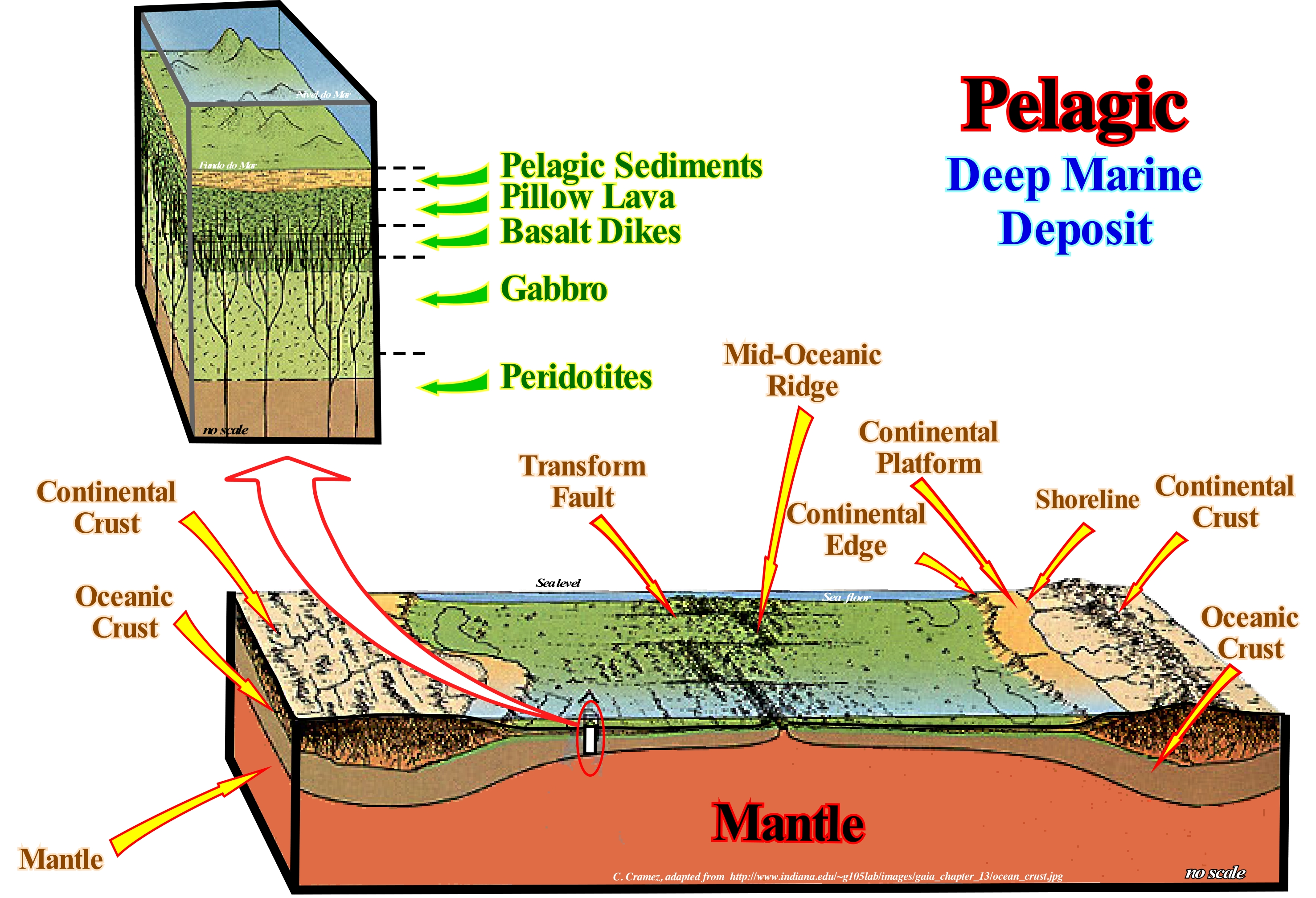
Deep-water sediments, which lie at depths of more than 500 m (continental slope and abyssal plain), represent about two-thirds of the Earth. That is why there are many types of deep-water sediment. Many geoscientists have been studying these sediments for many years, particularly, the carbonated muds, which cover about half of the ocean floor. In this figure, drilling cores taken on the abyssal plain always show above the oceanic succession (peridotite, gabbro, basalt dikes and pillow lavas) a, more or less, important interval of pelagic sediments. In the Pacific Ocean, the percentage of pelagic sediments represents 53% of the total surface. In the Indian Ocean it is 24% and 23% and in the Atlantic Ocean 23%). Pelagic sediments are composed of: (i) Foraminifera ooze, about 47% (Pacific Ocean 36%, Indian 54%, Atlantic 65%) ; (ii) Brown clay, about 38% (Pacific Ocean 49%, Indian 25%, Atlantic 30%) ; (iii) Diatoms ooze, about 12% (Pacific Ocean 10%, Indian 20%, Atlantic 7%); (iv) Radiolaria ooze, about 3% (Pacific Ocean 36 %%, Atlantic 65%) and (v) Pteropod ooze (gastropod molluscs measuring a maximum of 2 cm in length), about 0.5%. Geoscientists studying marine geology, by understanding simple concepts about sedimentary processes of deep-water, are able to predict, with a high degree of precision, the type of sediments that are found in the ocean floor. In sequential stratigraphy, and especially in petroleum geology, the basin and basin cones are the most important deep sediments. They may contain excellent reservoir rocks and form nonstructural, mainly morphological, traps. Unlike other deep sediments, the submarine fans are deposited during relative sea level falls (seaward of the basin edge) with an instantaneous (geologically) deposition time.
Pelagic (Organism).....................................................................................................................................................................................Pélagique (Organisme)
Pelágico / Pelágico (organismo) / Pelagische (Lebewesen) / 远洋(众生) / Пелагический (организм) / Pelagico (essere vivente) /
Organism living in the open sea above the seabed. Pelagic organisms do not always remain in the same area. They have the possibility of swimming. This term may also refer to fine sedimentary particles that decant slowly through sea water.
See: « Benthos »
&
« Accommodation »
&
« Facies »

Pelagic organisms live in the water column, more or less, far from the sea floor. They can float (also called plankton) or swim (also called nekton). If pelagic organisms live in the first 100 m of the ocean's water column where sunlight penetrates, sufficiently, they are known as epipelagic. Below them live the mesopelagic (living in the middle of the water column) and the bathypelagic (living on the sea floor). Pelagic organisms can be: (i) Autotrophic ; (ii) Hydrotrophic (iii) Decomposers. Autotrophic absorb solar energy and transfer inorganic mineral nutrients into organic molecules (primary production, i.e., the base of the food chain), such as algae, sea grass , etc. Hydrotrophic are dependent on the autotrophs, i.e., they have to eat to obtain energy sources. Decomposers, living from dead plant and animal material and from the excretions of living organisms, thus ensuring a return to the substances contained in organic matter. Decomposers are the ultimate link of energy transfer between organisms in a food chain (such as fungi and bacteria). Pelagic organisms are divided into five functional groups: (a) Viruses ; (b) Bacteria ; (c) Phytoplankton ; (d) Zooplankton and (e) Nekton. Pelagic organisms may also be divided in size into: (1) Femoplankton, between 0.02 and 0.2 μm ; (2) Picoplankton, between 0,2 and 2 μm ; (3) Nanoplankton, between 2 and 20 μm ; (4) Microplankton, between 20 and 200 μm ; (5) Mesoplankton, between 0.2 and 20 mm; (6) Macroplankton, between 2 and 20 cm and (7) Megplankton, between 20 and 200 cm. Finally: (a) The term pelagic is also used to denote eggs that are transported by ocean currents ; (b) Benthos and benthic are terms referring to organisms living on the sea floor or within the substrate and (c) Sessile is the term used to denote a benthic organism which is attached to the substrate, i.e., which has a petiole or peduncle.
Pelagic Bacteria................................................................................................................................................................................................Bactérie pélagique
Bactéria pelágica / Bacteria pelágica / Pelagischen Bakterien / 浮游细菌 / Пелагическая бактерия / Batteri pelagici /
A group of free heterotrophic bacteria, which use the dead organic matter of the substrate, either in particles (debris) or in a dissolved form. The functionalities of these bacteria have been developed in favor of aerobic and anaerobic processes that allow the bacteria to use the substrate also under anoxic conditions.
See: « Bacteria »
&
« Cyanobacteria »
&
« Anoxic (environment) »
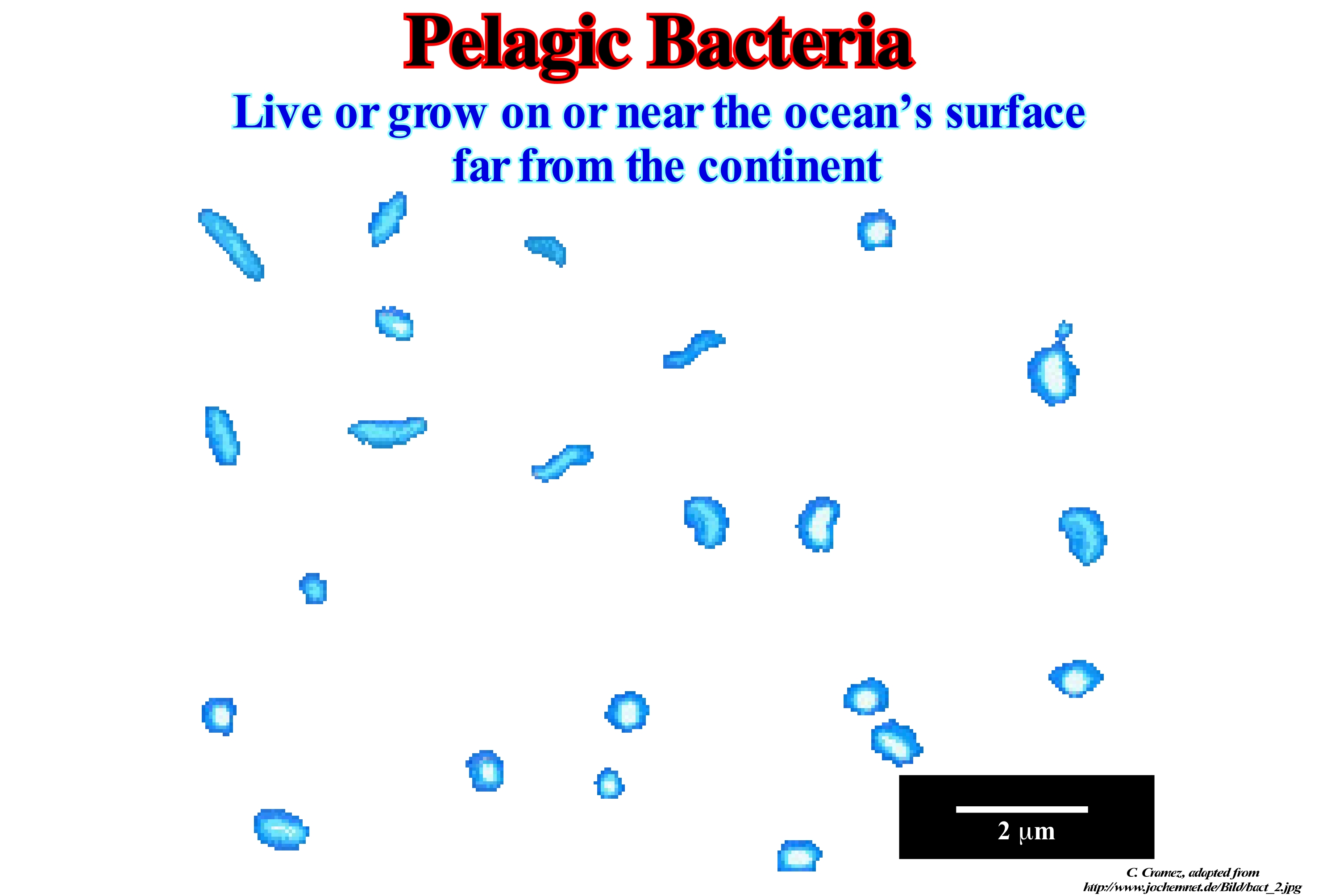
To perform the metabolism (set of chemical reactions that occur at the level of cells), bacteria, like all other cells, need energy. Triphosphate adenosine (ATP) is the universal biochemical energy source. ATP is common to all life forms, but the oxidation/reduction reactions involved in its synthesis vary depending on the organisms and environments of the biosphere. Bacteria live, practically, in all environments of the biosphere. They can use a wide variety of carbon and energy sources. Bacteria can be classified according to their type of metabolism, function: (i) The sources of carbon and energy used for their growth ; (ii) The electron suppliers and (iii) The electron acceptors. The cellular energy of chemotrophic bacteria is chemical energy, while that of phototrophs is of light origin. The carbon source of autotrophic bacteria is carbon dioxide (CO2), while the organic substances in the substrates are the carbon source of heterotrophic bacteria. It is possible to distinguish two possible sources of protons (H +) and electrons (e-). Bacteria that reduce the mineral compounds are called lithotrophic, while those that reduce the organic substances are called organotrophic. Bacteria can be divided into four major nutritional types depending on their carbon and energy sources: (i) Photoautotrophs, which use light as a source of energy and carbon dioxide (CO2) as a source of carbon; (ii) Photoheterotrophs, which are developed by photosynthesis, that is, they assimilate CO2 in the presence of an electron supplier ; (iii) Chemoautotrophs, which use inorganic matter by reductive assimilation of CO2 and as a source of energy; (iv) Chemoherotrophs, which use organic substrates as sources of carbon and energy. Many bacteria live in environments that are considered extreme and are therefore called extremophiles, for example: (i) Thermophiles - living in hot springs ; (ii) Halophytes - living in salt lakes ; (iii) Acidophiles and Alkalinophiles - live in acid or alkaline environments and (iv) Psychrophiles or cryophiles - the bacteria that live in the glaciers.
(*) Living space and self-sustaining dynamic processes from about 4.5 Gy on the surface of the Earth.
Pelagic Sediment....................................................................................................................................................................Sédiment pélagique
Sedimento pelágico / Sedimento pelágico / Pelagische Sediment / 深海沉积物 / Пелагические осадки / Sedimenti pelagici /
Deep-water sediment consisting of very thin debris that slowly decanted from sea level. The deep sediments can be divided into three categories: (i) Terrigenous ; (ii) Pelagic ; (iii) Authigenic. The most frequent pelagic sediments are: clay, foraminifera ooze, silica ooze, etc.
See: « Clay »
&
« Ooze »
&
« Pelagic (organism) »
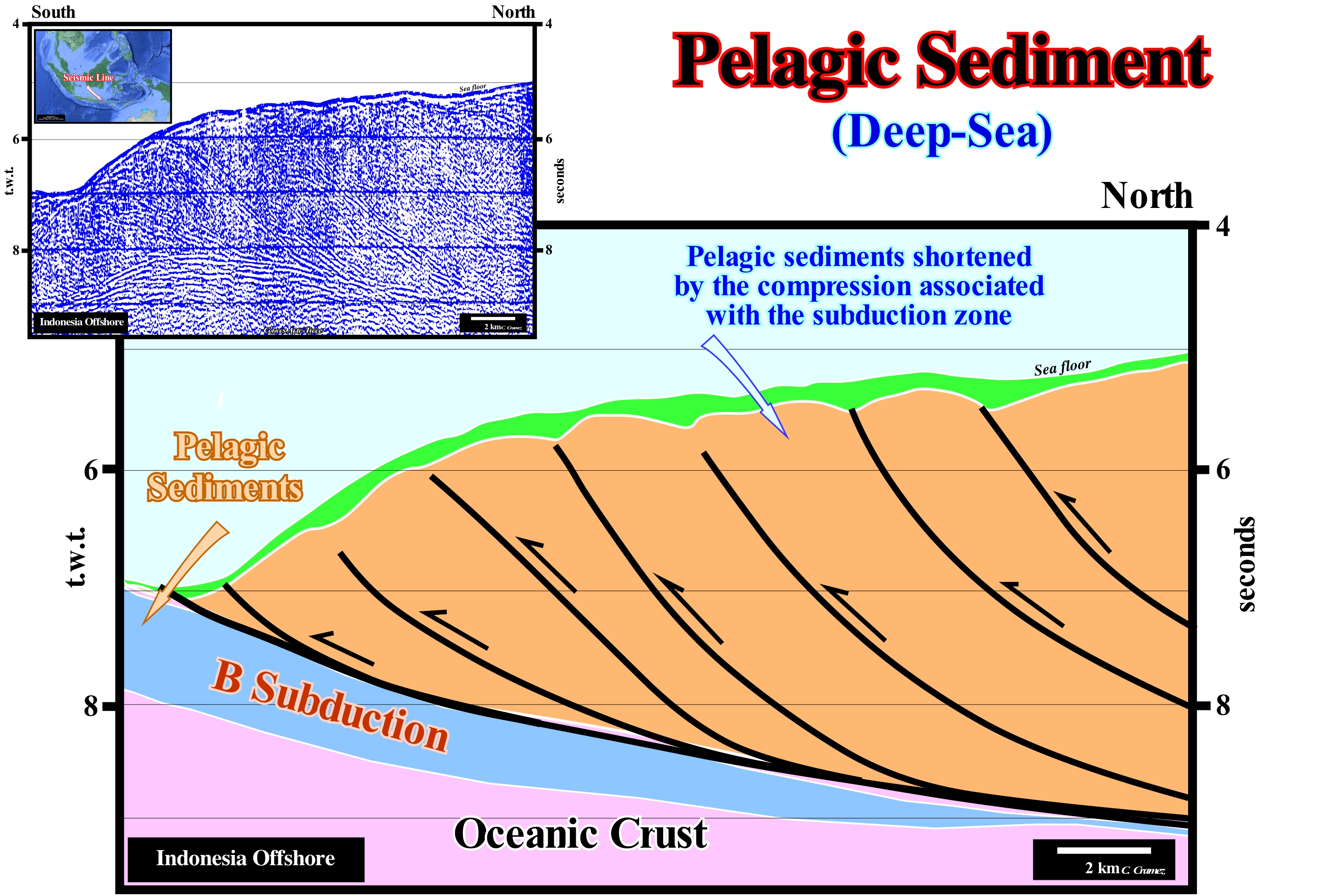
Pelagic sediments are biogenic sediments that contain at least 30% of skeletal remains of marine organisms and make up about 60% of the ocean floor, especially away from the shoreline, where the presence of terrigeneous sediments is very weak, almost nonexistent, as is the case illustrated in this Canvas auto-trace of an offshore seismic line of the Lombok island (Indonesia). Clay minerals make up most of the nonbiogenic components of pelagic sediments. While a wide variety of animals and plants contribute to organic matter, which accumulates in marine sediments, few organisms contribute, significantly, to the production if deep biogenic sediments, which are both limestone and siliceous biomuds. The rates of distribution and accumulation of biomuds in oceanic sediments depend mainly on three factors: (i) Rate of biogenic particle production on the surface of oceanic waters ; (ii) Rate of dissolution of these particles in the water column and after reaching the bottom of the ocean and (iii) Dilution rate of the terrigeneous sediments. The abundance and distribution of organisms that produce biogenic sediments depends on environmental factors such as the amount of nutrients and temperature of the oceanic waters in which these organisms live. The rate of dissolution is dependent on the chemical composition of the oceanic waters through which the skeletal remains decant from the bottom of the sea and interstitial waters in contact with which the sediments accumulate and are buried. The chemical composition of deep waters is, in turn, influenced by the contribution rate of skeletons and organic matter in surface waters. On the other hand, the chemical composition of deep waters is also highly dependent on the rate of circulation and the time they take to enrich themselves in CO2 and other by-products of biotic activity.
Pelagosite..................................................................................................................................................................................................................................Pélagosite
Pelagosite / Pelagosita / Pelagosit / Pelagosite (方解石综艺) / Пелагосит (разновидность кальцита) / Pelagosite (varietà de calcite) /
Variety of calcite having a higher content of magnesium carbonate, strontium carbonate, calcium sulfate (gypsum) and silica. Pelagosite occurs as a crust of superficial limestone (millimeters thick), which is white, gray or brownish. Most geoscientists think that it forms in the intra-tidal zone by spray sea and evaporation, but an algal contribution can not be excluded.
See: « Calcite »
&
« Limestone »
&
« Algae »
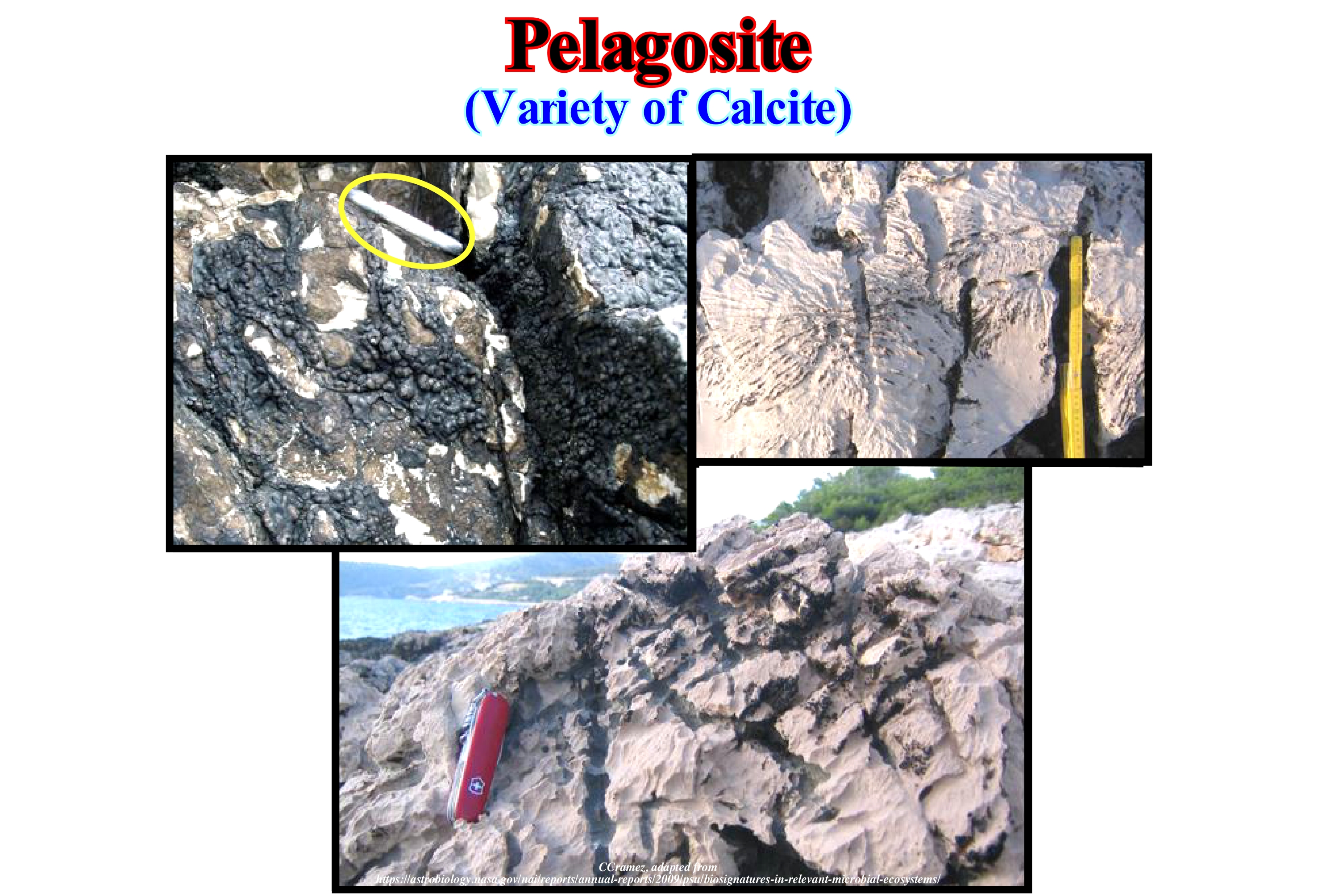
Some geoscientists consider as pelagosite the superficial crust of limestone a few millimeters thick, usually white, grey or brownish with a pearly luster, formed in the intertidal zone by salt and evaporation, and composed of calcium carbonate with higher levels of magnesium carbonate, strontium carbonate, calcium sulfate, and silica than are normally found in the sediments of normal clay and carbonate sediments. Pelagosite is a variety of calcite (CO3Ca) that was first identified near the island of Pelagos (Palagruea) offshore Croatia by R. Moser. In this figure, the pelagosite is a dark mineral, brilliant pysolithic that encrusts the rocks of the coast lines exposed to the sea-spray. X-ray diffraction and microscopic studies of the samples taken in the outcrops illustrated above have shown that pelagosite is a two or three microns thick aragonite deposited on dark and clear slides and that it appears to record climactic cycles, and particularly cycles of sunspots. Based on tectonic studies, the vast majority of geoscientists assume that the age of the pelagosite crusts, along the Adriatic coast, varies from present to tens of thousands of years. As illustrated in this photograph, the role of biology in the precipitation of pelagosite crusts is suggested by its growth in limestones with strong textures of chemical corrosion. The study of thin films of pelagosite shows that the darker layers are not kerogen. The material that produces the black colour is formed by very fine particles that probably imprisoned air bubbles or perhaps the black colour is induced by the diffraction of the pelagosite crystals.
Pelite......................................................................................................................................................................................................................................................................Pélite
Pelito / Pelita / Pelite / 泥质 / Пелит / Pelito /
Clastic metamorphic rock in which the grain size is less than 1/16 mm (originally sand or silt). Examples of pellte are slates, shales, etc.
See: « Sediment »
&
« Clay »
&
« Granulometry »
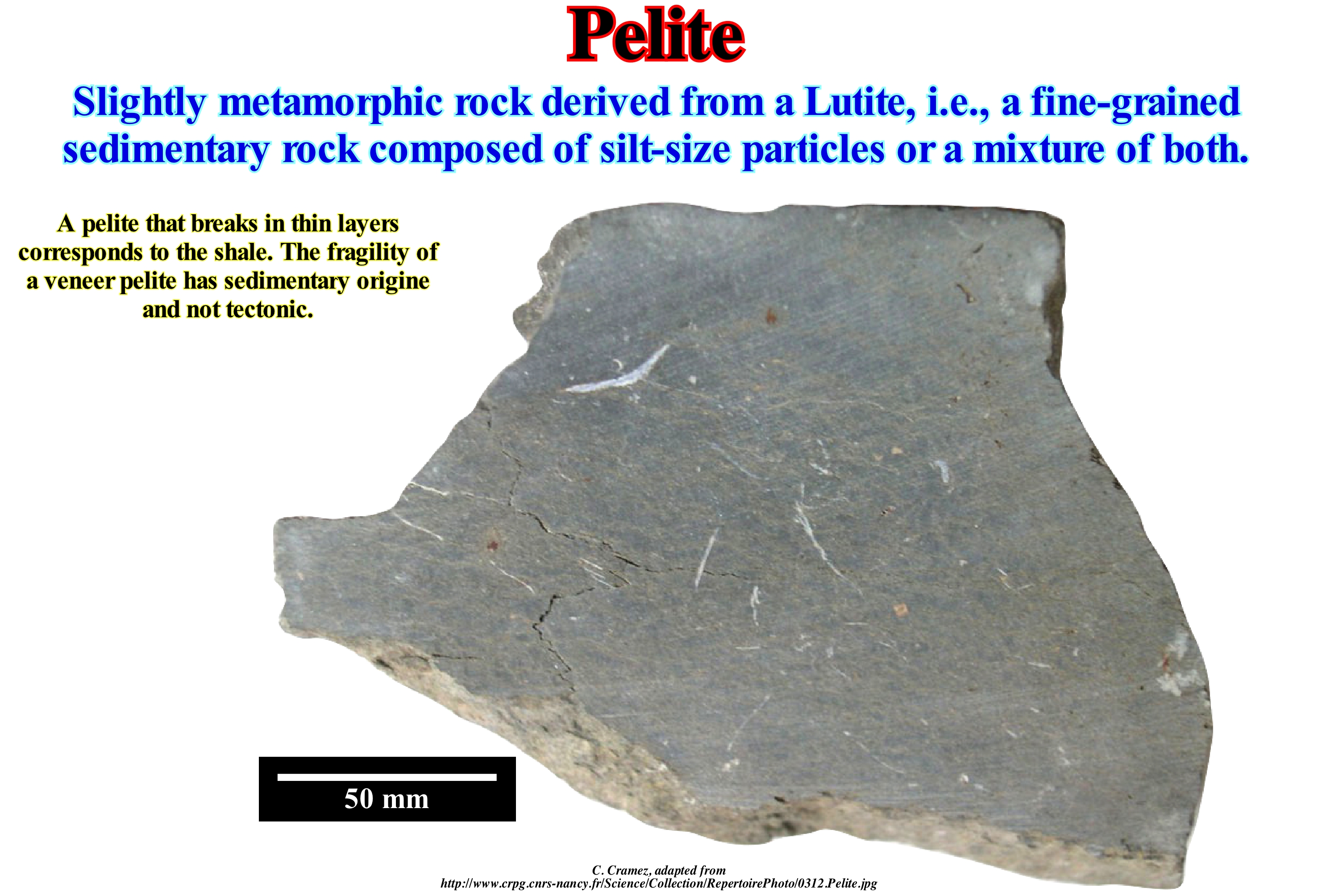
In general, function a decrescent granulometry, the sedimentary particles are subdivided into three types: (i) Gravel ; (ii) Sand and (iii) Clay. Pettijohn (1975), in the classification of sedimentary particles and rocks, based on simple descriptive terms, such as grain-size, while avoiding terms such as clay or shaly, which imply a chemical composition. On the other hand, he used the terms of Greek origin for metamorphic rocks and those of Latin origin for non-metamorphic rocks. The metamorphic rocks (Greek terminology) derived from gravel, sand and clay are, respectively: (a) Psefite; (b) Psamite and (c) Pelite. For non-metamorphosed rocks, Pettijohn used Latin terminology and thus designated them as: (1) Rudite ; (2) Sandstone and (3) Lutite. Thus, the term pelite, which has a Greek root (Hairs = clay), should, normally, be used to designate, more or less, metamorphic sediments, that is, recrystallized due to a change in physicochemical conditions (heat, pressure and introduction of chemically active fluids). Do not confuse pelite and pilite. The term pilite refers to an olivine which has been, partially, and pseudomorphologically substituted by a carbonate-chlorite-actinolite group, and which can just be identified on a thin sheet. It may be said that the pelites are metamorphic rocks derived from protoliths (lithological precursor of a metamorphic rock) rich in aluminum (shales, turbidite sludges, etc.). Metamorphic rocks with sandstones such as protoliths are called quartz-feldspathic. The minerals present in the pelites are, often, indicators of pressure and temperature: (A) Andalusite indicates a metamorphism of low pressure ; (B) Cyanite, a high pressure metamorphism ; (C) Silimanite, a high temperature metamorphism ; (D) Chlorite, a low temperature metamorphism ; (E) Biotite, a moderate temperature metamorphism; (F) Garnet, a moderate temperature metamorphism ; (G) Staurolite, a high to moderate pressure ; (H) Chloritoid, one moderate to high pressure ; (I) Cordierite, one low pressure ; (J) Paragonite, a high-pressure metamorphism, etc. The pelites, psefites and psamites are almost always in the pelagic intervals that deposit between the submarine fans.
Pendulum Effect...................................................................................................................................................................................Effet de pendule
Efeito de Pendulum / Efecto de péndulo / Pendel-Effekt / 钟摆效应 / Маятниковый эффект отвеса / Pendolo effetto/
Pendular lateral displacement of the progradational deposition centers of a delta due to a lack of available space. The lateral displacements of the delta lobes (formed by a more or less vertical stacking of several deltas forming the delta buildings) are magnificent examples of the pendulum effect. When a delta lobe is shift laterally, the moat that surrounds it and the reentrancies (tidal flats) that exist on each side of the lobe, also move, which produces, locally, significant marine ingressions that allow the deposition of clayey rocks rich in organic matter which, in certain cases, can be considered as potential source-rocks.
See: « Delta »
&
« Marine Regression »
&
« Relative Sea Level Change »
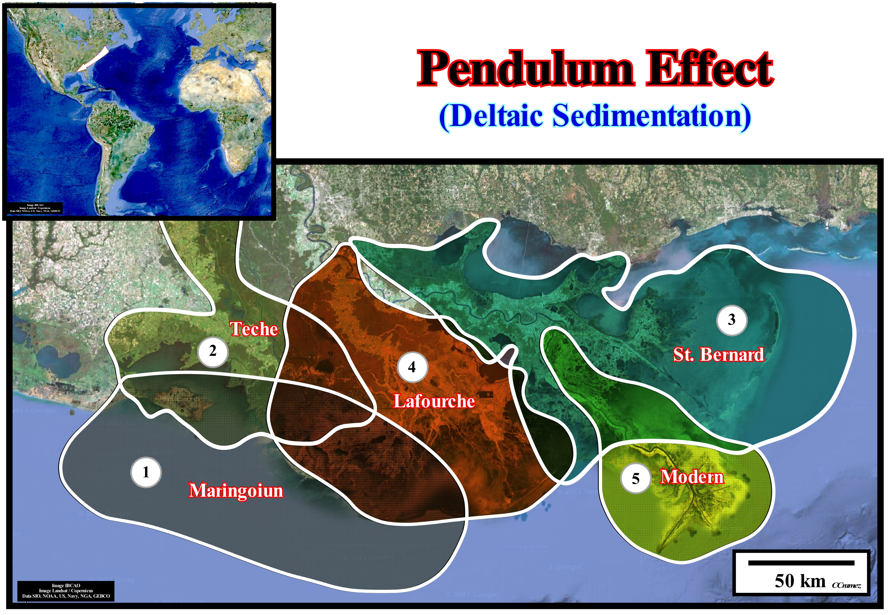
The concept of the pendulum effect in constructing a progradational interval, such as for example, in the construction of a delta building, was, probably, described for the first time by Dailly (1976) in the Niger Delta. Since a water-course reaching the sea, deposits a delta building, the space available for the sediments, i.e., the shelfal accommodation, decreases over the delta building and remains, more or less, constant on the sides of the building. If the relative sea level (local sea level, referenced to any point on the Earth's surface, which can be the sea floor or the base of the sediments) remains constant, i.e., if the accommodation does not vary, the next delta building will be deposited laterally to the previous one, i.e., it will be deposited where there is space available for the sediments. It is this deviation of the depocenters delta or delta building, to the right or left of the initial building, which is called a pendulum effect. Dailly described the pendulum effect on Niger's great delta building, more or less as follows: (a) The Niger delta building (not to confuse a delta building, which can reach thousands of meters, with a delta, whose thickness is, rarely , exceeds 30/60 meters) corresponds to a large delta depocenter, that is to say, the zone of a sedimentary basin in which a certain stratigraphic unit reaches its maximum thickness (more than 4 km of thickness) ; (b) It is the result of a seaward progradation of the shoreline (around 40 Ma), with an average speed of 5 km/My ; (c) At present-time, the peripheral trough, which forms around the depocenter, is underlined by two tidal flat ingressions on each side of the delta lobe ; (d) During the formation of the delta building, similar local ingression formed due to lateral displacements of the depocenters ; (e) They are recorded in geological sections by local marine ingressions (sedimentary regression between them) ; (f) These displacements, such as those of a pendulum, are recognized by the deposition of retrogradational shaly rocks (during stability periods of relative sea level that occurs after each marine ingression), between the sandy lobes, which correspond to sedimentary regressions. The shaly rocks, which are, generally, rich in organic matter, largely control the distribution of petroleum belts (location of potential source-rocks). This concept was later applied to the large Mississippi River Delta Building, which began to form around 7,000 years and within which different delta buildings were highlighted. As shown in this figure, from the earliest to the most recent, the following delta buildings may be recognized: (i) Maringoiun ; (ii) Teche ; (iii) St. Bernard ; (iv) Lafourche and (v) The modern delta building. The pendulum movement of these buildings is evident. The Maringouin Delta Building formed between 7,500 and 5,500 years ago when relative sea level rose rapidly*. The Teche delta building formed between 5,500 and 3,500 years ago after the relative sea level rise in deceleration. The St. Bernard Delta Building formed between 4,000 and 2,000 years ago, after an avulsion that caused the relocation of the river to East of the current city of New Orleans. The Lafourche Delta Building formed between 2,500 and 500 years ago due to a second avulsion that caused the river to shift westward of New Orleans. The Modern Delta Building (in the last 1,500 years) has formed the Plaquemines/Balize delta, also known as Delta in Bird's Foot, between the St. Bernard Delta Building and the of Lafourche Delta Building. If we consider the modern delta building, it can be said between 1974 and 1990, the rate of loss land is, in average, 1,072 acres (4,338 km2) per year or 1.6% per cent of the existing land area. Between the mid 1950's and 1974, the estimated loss land rate for the basin was 2,890 acres (11,695 km2) per year. This loss is the result of compaction, subsidence, hurricanes, tidal erosion, relative sea level rise and human activities. The total area of land lost over the past 60 years is about 113,300 acres (458,508 km2).
(*) The result of the combination of absolute (eustatic) sea level, which is supposed to be global and referenced to the Earth's centre, and the tectonic, that is, subsidence, when the predominant tectonic regime is extensional or uplift, when the predominant tectonic regime is in compressional.
Peneplanation (Wilson's cycle)...................................................................................................................................................Pénéplanation
Peneplanação / Peneplanación (ciclo de Wilson) / Peneplanation / Peneplanation (对准) / Образование пенеплена / Peneplanation /
One of the tectonostratigraphic phases of the Wilson's cycle: (i) Stable Continental Craton ; (2) Thermal Anomaly (hot spot) and Lengthening (rifting) of the craton ; (3) Breakup of the Lithosphere, with creation of new oceanic crust and formation of two divergent margins ; (4) Oceanic expansion (Ssea floor spreading) which, little by little, transforms the young divergent margins into mature margins due to the cooling and increasing density of the oceanic crust ; (5) Subduction, since the density of the oceanic crust is very large, it is divided in two parts and one of them plunges under the other one creating a convergent margin, with formation of a volcanic arc and uplift of a mountain range on the overriding lithospheric plate ; (6) Divergent Margin / Volcanic Arc Collision, forming a mountain belt (note the divergent twin margin at the other end); (7) Peneplanization (of the mountain belt) and new subduction of the oceanic crust with the twin margin creating another convergent margin ; (8) Continent / Continent Collision and closure of the ocean created between the two initial divergent margins and (9) End of the Wilson's cycle with the formation of a new stable continental craton.
See: « Wilson's Cycle »
Peneplain................................................................................................................................................................................................................................Pénéplaine
Penplaníc / Peneplanicie / Rumpffläche / 准平原 / Пенеплен (предельная равнина) / Pianura /
Plain low, more or less, horizontal produced by a long and continuous erosion.
See: « Erosion »
&
« Provisional Equilibrium Profile (river) »
&
« Continental Collision »
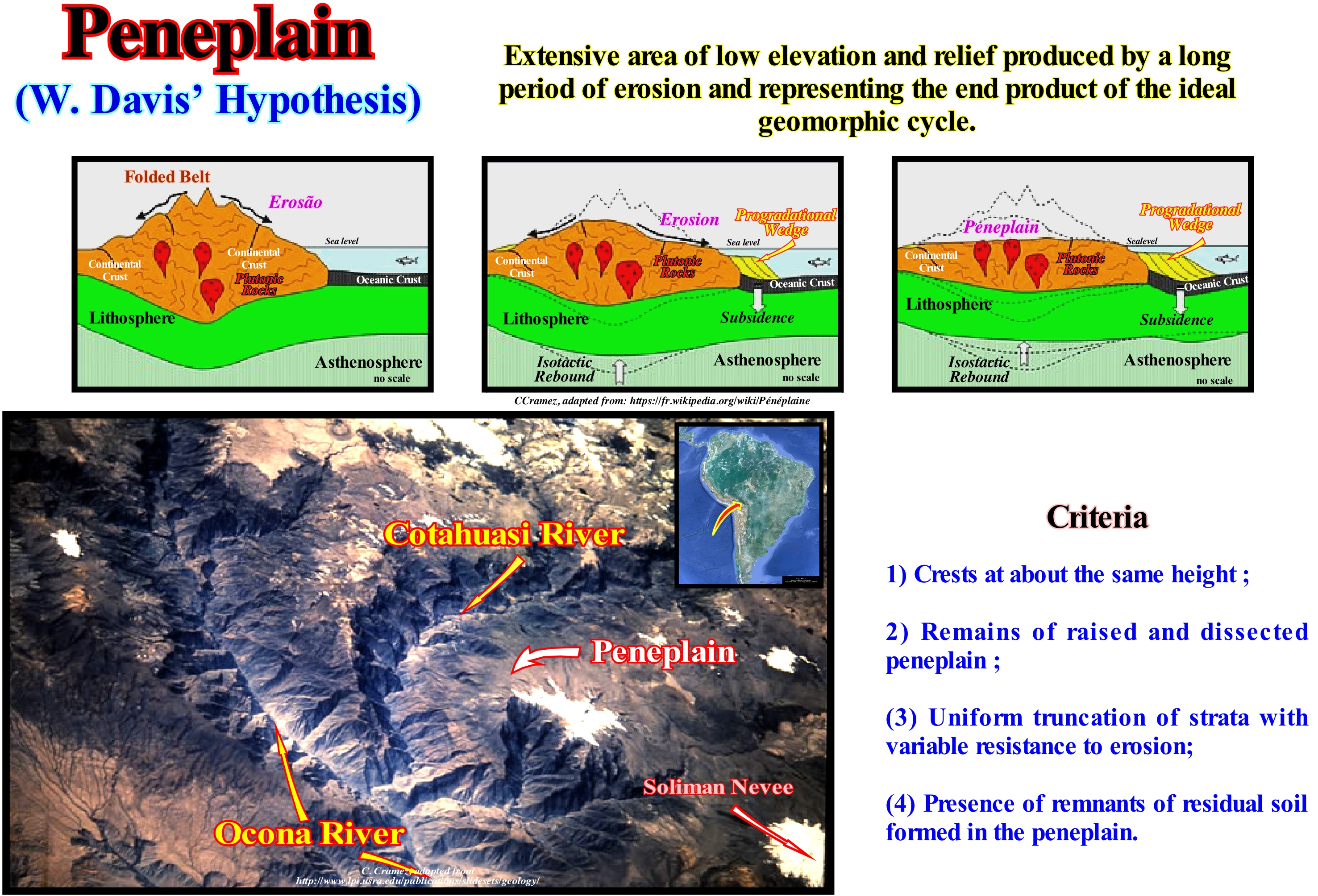
Were the Italian engineers (1697), who first defined the equilibrium profile of a river: (i) The water-courses modify the shape of the bed, either by erosion or deposit, in such a way that, finally, there is an equilibrium between strength and resistance ; (ii) The dip of the currents varies due to the bed resistance and in inverse ratio to the ordinary current flow* ; (iii) Water tends to give the bed a concave profile upwards. If at any point in the longitudinal profile of a water-course, it has an equilibrium dip, i.e., an inclination such that it does not deposit alluvium and does not dig more over its entire width, the river is in a provisional equilibrium, that is to say, it has along its course a slope just sufficient to evacuate the charge and overcome the internal frictions. However, this profile is not definitive, as the water-course continues to deepen (there is erosion upstream, since materials are supplied). Overall, the basin is eroded and the charge becomes weaker and, one might imagine, an ideal moment in which the slope of the stream is just sufficient for the flow of the stream and all the transport having disappeared. Under these conditions, the current would reach its ideal or definitive equilibrium profile. However, such a profile is never achieved. Posamentier and Vail (1988) think when a current finds a water-body almost immobile and its speed decreases, more or less, instantaneously, there is deposition and, particularly, delta deposition. On the other hand, they consider that in the provisional equilibrium profile of the water-course there is an obvious slope break, which they called bayline, which separates alluvial deposits (deposits without influence of relative sea level changes) and deposits of the coastal plain that are deposited under the influence of sea level variations. The bayline concept of the Posamentier and Vail was based on the following conjectures: (a) The coastal plain is formed by progradation of sea floor rather than by exhumation ; (b) The sediments that accumulate on the coastal plain during the progradation of the shoreline (seaward displacement) are part of what is called the coastal wedge or coastal prism, which includes fluvial and shallow-water deposits ; (c) The coastal prism is wedge-shaped and extends continentward by coastal onlapping on the pre-existing topography ; (d) The upstream boundary of the coastal prograding wedge is the bayline, which can move upstream when the shoreline progradation is accompanied by aggradation (vertical deposition or upbuilding) ; (e) The bayline is the boundary between the coastal plain and the alluvial plain ; (f) Upstream of the bayline, relative in sea level changes have, practically, no influence on depositional systems. Certain geoscientists consider that the basic idea of Posamentier and Vail, i.e., that delta deposition occurs when a water-course encounters an immobile water-body that controls its provisional equilibrium profile, is not the bayline, but the mouth of the water-course, which means that the head or apex of the deltas is not the bayline but the mouth of the watercourses. Thus, when speaking in the provisional equilibrium profile of a river, the geoscientist must say whether profile is in relation to the bayline (Vail position) or to the mouth of the current (Miall position). However, as shown in this figure, the presence of lakes deforms, significantly, the provisional equilibrium profile of the rivers. In a given area, in the absence of lakes, the provisional equilibrium profile of the rivers, as well as the baseline level, is lower when lakes are present in the considered area. The baseline level of deposition may be given relative to the sea level, in the case of rivers that flow there or in relation to closed seas and lakes. Titicaca Lake, which is more than 3,800 m in altitude, is the base level of most Bolivian plateau rivers, such as Tanganyika Lake, which is at an altitude of about 700 m, is the base level of most of the rivers of the Albertine Rift region. Within a sequence-cycle, the base level of a region, which determines the equilibrium profile of the watercourses changes with relative sea level. During a marine ingression (relative sea level rise), the base level rises, which increases the depositional area. During a sedimentary regression (relative sea level rise in deceleration or fall slowly) the opposite occurs, the area subject to erosion increases which creates a strong terrigeneous influx.
(*) The flow rate of a river is the quantity of water expressed in cubic meters per second elapsed (m3/s) at a given point in its course. If the point of the water-course is not specified, the number indicates the flow at the mouth or at the confluence with another river. The rate of flow or runoff varies during the year, depending on the contributions of rain or melted ice as well as evaporation. The normal flow changes during the year constitute the hydrological regime of the river.
Penitent (Ice)...................................................................................................................................................................................................................Pénitent (Glace)
Penitente / Penitente (hielo) / Penitent (Eis) / 忏悔(冰) / Раскалывающийся лёд / Penitente (ghiaccio) /
Block of compacted snow or ice of a glacier with a column-shaped form resulting from solid condensation and / or melting.
See: « Glacier »
&
« Erosion »
&
« Ablation »
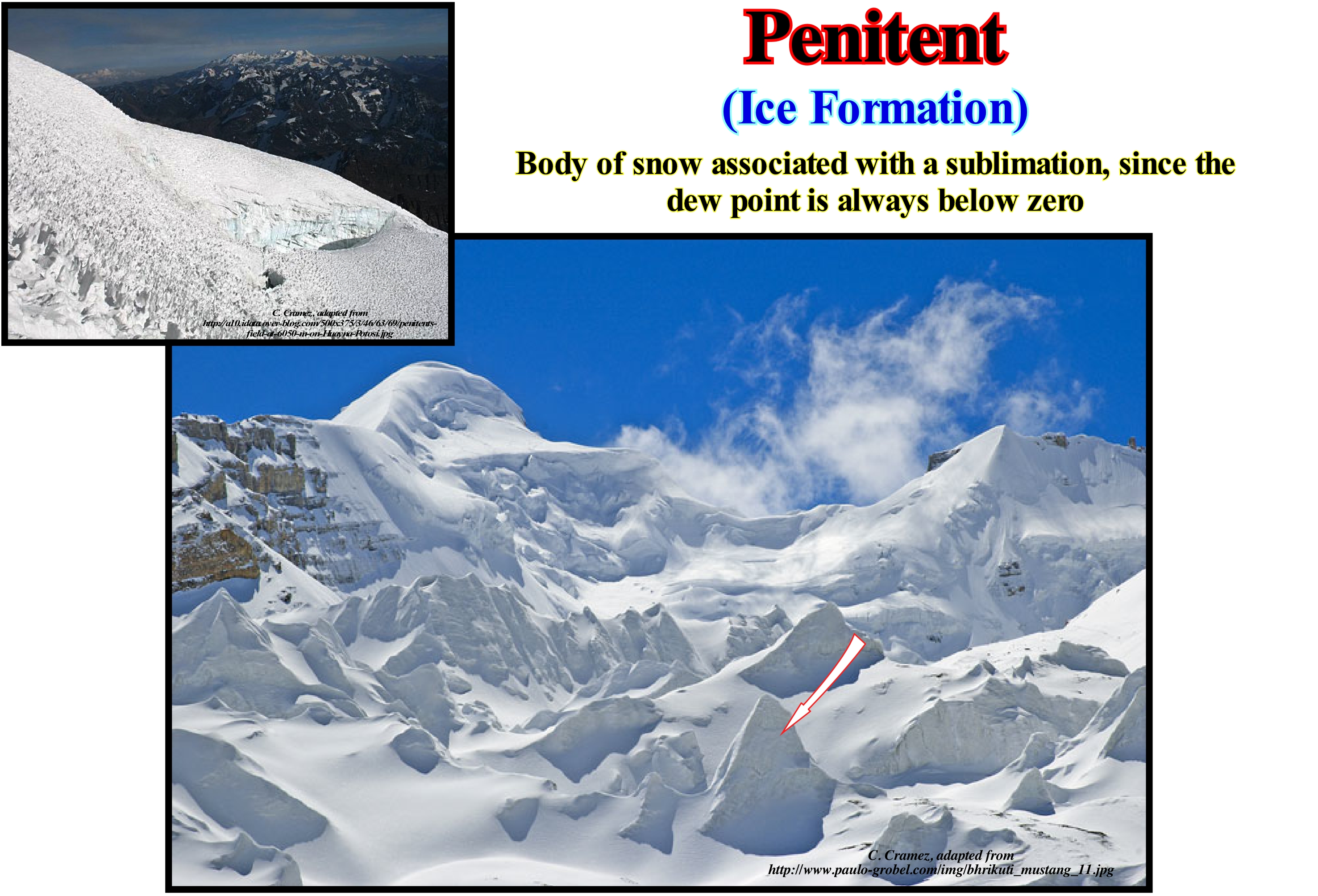
The penitents are the slides, more or less parallel to the névé*, with a height varying from a few centimeters to several meters, aligned, generally, East-West and dipping toward the sun. Penitents result from the irregular ablation of the surface of a snow or ice field under particular atmospheric conditions, i.e., long periods without precipitation in clear and very dry weather, allowing differential ablation between the depressions (fusion) and ridges (sublimation). Tropical glaciers, due to the seasonal variations, have a different behaviour from the alpine glaciers. The Alpine glaciers accumulate snow in the winter that melts in the summer. In both tropical glaciers both processes occur simultaneously. In the Andes, there are glaciers in the outer tropical zone (Peru, Bolivia), where thawing and accumulation occur during the rainy season (November to March) and glaciers in the inland tropical zone (Ecuador), where accumulation and thaw occur all year round. The great penitents develop, mainly, in the tropical glaciers of the outer zone of the Andes (Peru, Bolivia). In these regions, their size is, more or less, that of a man's height, so that their form and regularity give the impression of a religious procession during Holy Week, hence the name, of penitents. A glacier does not retreat. The ice does not turn around and goes back. The retreat refers to the position of the glacier. A glacier does not retreat, but may decrease in extent, which occurs, mainly, in the lower parts of the glacier, that is in front of it. The force that displaces the glacier is gravity. A glacier is always moving from the highest to the lowest points, whether the glacier is in a thinning or thickening phase. We prefer to say that a glacier thin or thickens, since by definition a glacier is an downhill ice flow. During the 20th century, the general tendency of glaciers is thinning, which, however, is not uniform. Many glaciers, such as those at Mont Blanc, had periods of thickening around 1910, and between 1970 and 1980, which contradicts the secular tendency to thinning.
(*) Névé is a young, granular type of snow which has been partially melted, refrozen and compacted, yet precedes the form of ice. This type of snow is associated with glacier formation through the process of nivation, i.e., the geomorphic processes associated with snow patches . The primary processes are mass wasting and the freeze and thaw cycle, in which fallen snow gets gets compacted into névé or firn. (https://en.wikipedia.org/wiki/Névé).
Pennsylvanian.................................................................................................................................................................................................Pennsylvanien
Pensilvaniano / Pensilvaniano / Pennsylvanium / 宾夕法尼亚纪 / Пенсильванский / Pennsylvaniano /
Subperiod of the Carboniferous period. It lasted approximately 25 My (million years), between 325 Ma and 299 Ma (millions of years ago). As for any other geological period, the rocks that define this subperiod are well identified, but the exact dates of the beginning and end are approximate (several million years). The name Pensilvanian comes from the state of Pennsylvania (USA), where outcrops of rocks of this age are very abundant.
See: « Paleozoic »
&
« Geological Time »
&
« Carboniferous »
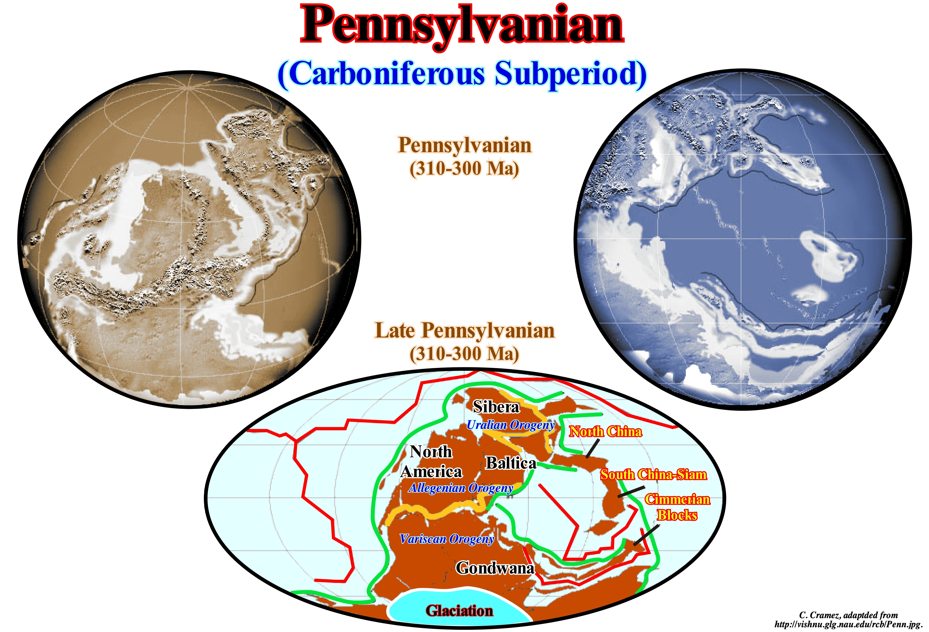
In the Carboniferous, at least in the Carboniferous of North America, there are two stratigraphic groups deposited in different geological conditions. The shallow-water marine conditions of the Early Carboniferous were followed by nonmarine sedimentary environments (coal abundance) during the Late Carboniferous. In Europe, the Carboniferous is formed by the Mississippi and Pennsylvania that form a sedimentary interval of more or less nonmarine deposits. The Pangea supercontinent, which was formed during this geological time, caused the uplift of the ocean floor when the continents collided with each other to form a number of mountains, including the Appalachian Mountains. Periods of glaciations occurred on the Gondwana small supercontinent of during the Late Carboniferous, which contributed, greatly, to the decline of marine environments and sea level changers, which destroyed much of the coastal sedimentary environment. There seems to have been no extinction of the fauna and flora in association with this glaciation, which is not the case with the extinction that occurred in the Devonian. The great terrestrial animals during the Carboniferous were the amphibians (and their descendants, as, the reptile branches). With the climate changes occurring during the Late Carboniferous, the plants changed, as well as the terrestrial animals. Many geoscientists consider that Gondwana glaciations are, primarily, responsible for these changes. Others consider that as tetrapods developed amniotic(*) eggs, they liberated themselves from water to reproduce and thus withstood climate change better. Amphibians, even today, need to return to the water to lay their eggs.
(*) Amniotes are a clade of tetrapod vertebrates comprising the reptiles, birds and mammals, i.e., that have a membrane surrounding the foetus. Amniotes lay their eggs on land or retain the fertilized egg within the mother, and are distinguished from the anamniotes (fishes and amphibians), which typically lay their eggs in water. (https://en.wikipedia.org/wiki/Amniote)
Perched Lowstand.......................................................................................................----------------..................Prisme de bas niveau perché
Prisma de nível baixo suspenso / Prisma de nivel bajo suspendido / Prisma Low-Level gehockt, Gelegen lowstand / 栖息低位 / Приподнятый низкий уровень моря / Prisma di bassi livello arroccato /
Lowstand prograding wedge deposited in association with an unconformity type-II, when the relative sea level fall is not, sufficiently, important to put the sea level below the basin edge. This type of lowstand prograding wedge is deposited when in a ramp context, a small relative sea level fall during the deposition of the upper lowstand prograding wedge (ULPW) is not important enough to create an unconformity type-I.
See: « Basin Setting »
&
« Lowstand Systems Tract »
&
« Systems Tract »
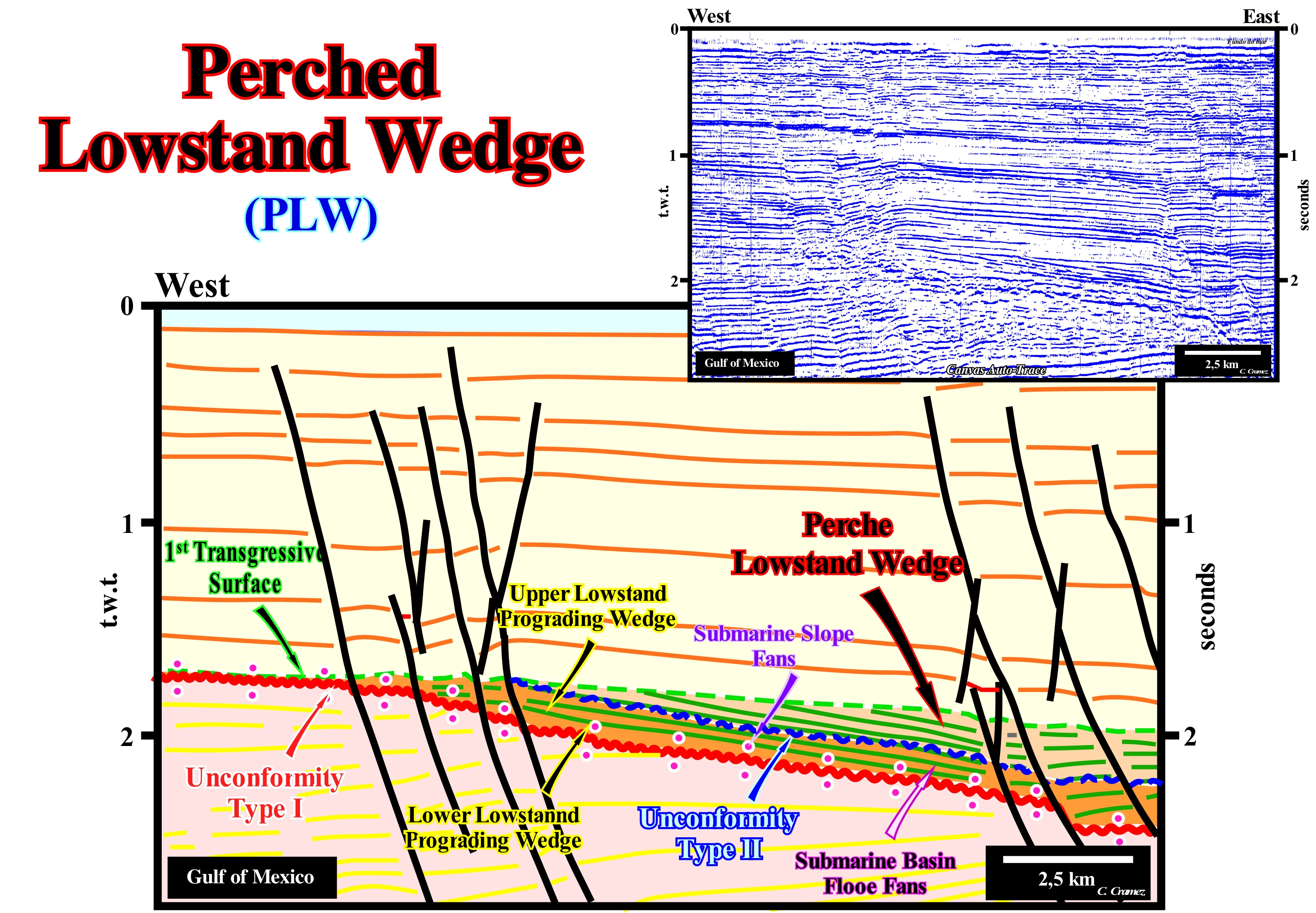
Ramp geological contexts in the lowstand systems tracts group (LSTG), during the deposition of submarine basin floor fans (BFF), submarine slope fans (SSF) and lowstand prograding wedge (LPW) subgroups are frequent in the Gulf of Mexico. They are, often, associated with salt tectonics and, in particular, with the tectonics induced by the flows (lateral and vertical) of the salt horizons (halokinese). On this tentative geological interpretation of a Canvas auto-trace of a detail of a Gulf of Mexico* seismic line, the tectonic disharmony (underlined by the red circles) induced by the lateral flow of the allochthonous salt (salt weld) and by an unconformity type-I (coloured corrugated line in red), which underlines the lower limit of a sequence-cycle. Taking into account the morphology of this unconformity, a ramp geological context is more than probable. It is very difficult to notice a slope break along this erosional surface, which can be considered as the most probable of the basin edge. In this particular case, the basin edge, which is the last basin edge of the preceding sequence-cycle, is underlined, probably, by the slope break of the visible unconformity in the western part of the auto-trace, in association with normal faulting. During the relative sea level fall, which led to the formation of this unconformity, submarine basin floor fans (SBFF), submarine slope fans (SSF) were deposited along the continental slope (since the basin had no shelf, at least seismically) and the lower lowstand prograding wedge (LLPW), which are very difficult to separate from each other. The relative sea level stopped falling and began to rise (in acceleration, i.e., increasingly important marine ingressions), the water-depth increased, significantly, and the shoreline moved continentward. During the stability period of relative sea level occurring after each eustatic paracycle (ingression), as the terrigeneous influx was important, the shoreline, gradually, moved seaward as sediments deposited in the form of the lower and upper lowstand prograding wedge. A small relative sea fall induced an unconformity type-II (discordance emphasized by the beautiful wavy blue-coloured dashed line) on which a perched lowstand prograding wedge was deposited. As the suspended low-level prism geometry is progradational, the seaward displacement and, slightly, downward of the coastal onlaps allows its identification. A perched lowstand prograding wedge is, more or less, the deep-water equivalent of a forced regression** that, normally, develops in highstand geological conditions. Nowadays, the great majority of geoscientists do not speak either in lowstand prograding wedge or in bordering prograding wedge (BPW), but in forced regressions induced by the of the seaward movement of the shoreline following a relative sea level fall, regardless the terrigeneous influx, which triggers erosion, both in nonmarine and in shallow-water environments, which means that the water-course incisions are accompanied by the development of coastal deposits. Therefore, because a forced regression can be developed in both highstand and lowstand geological conditions, it is advisable to always specify what kind of forced regression is being discussed or to reserve the term forced regression, just when the geological context is lowstand and use perched lowstand prograding wedge when sea level is below the basin edge.
(*) The east offshore of the United States corresponds to a stacking of different basins from the sedimentary classification of Bally and Snelson (1980). In a regional seismic line, generally, from the bottom up, one recognizes: (i) A basement or a Paleozoic fold belt, that works like an infrastructure and that corresponds to the Pangea supercontinent ; (ii) Rift-type basins that lengthened the supercontinent lithosphere prior to its break-up and (iii) An Atlantic-type divergent margin, formed at the base by a thick accumulation of lava flows, which deposited during the subaerial volcanic and oceanic expansion. In the divergent margin two sedimentary tectonic phases are recognized. The transgressive phase, which was deposited during the rise of the absolute (eustatic) sea level (supposed to be global and referenced to the Earth's centre), which is covered by the regressive phase that was deposited during the absolute sea level fall during the Mesozoic / Cenozoic 1st order eustatic cycle. Locally, the transgressive phase has a parallel geometry, but globally it is retrogradational, since it is the result of the set of increasingly important marine ingressions and associated sedimentary regressions, increasingly smaller. During the regressive phase, whose geometry is progradational, as we can easily see in this tentative interpretation, marine ingressions become increasingly smaller and sedimentary regressions, associated, increasingly important.
(**) A relative sea-level fall of a dozen of meters induces a strong seaward displacement of the paralic depositional systems, which is called by certain geoscientists of "forced regression." As the erosion of the exposed region extends, an unconformity occurs, materialized by an erosional surface and by the superposition of continental sediments on the previously deposited coastal and marine sediments. This unconformity forms the boundary of a new depositional sequence-cycle.
Percolation........................................................................................................................................................................................................................Percolation
Percolação / Percolación / Perkolation / 渗滤 / Перколяция (просачивание) / Percolazione /
Critical physical process that describes for a system, a transition from one stage to another. In geology and, particularly, in pedology (one of the branches of study of soil), percolation is a flow of water in the soil under the effect of gravity.
See: « Leaching »
&
« Soil »,
&
« System (theory) »
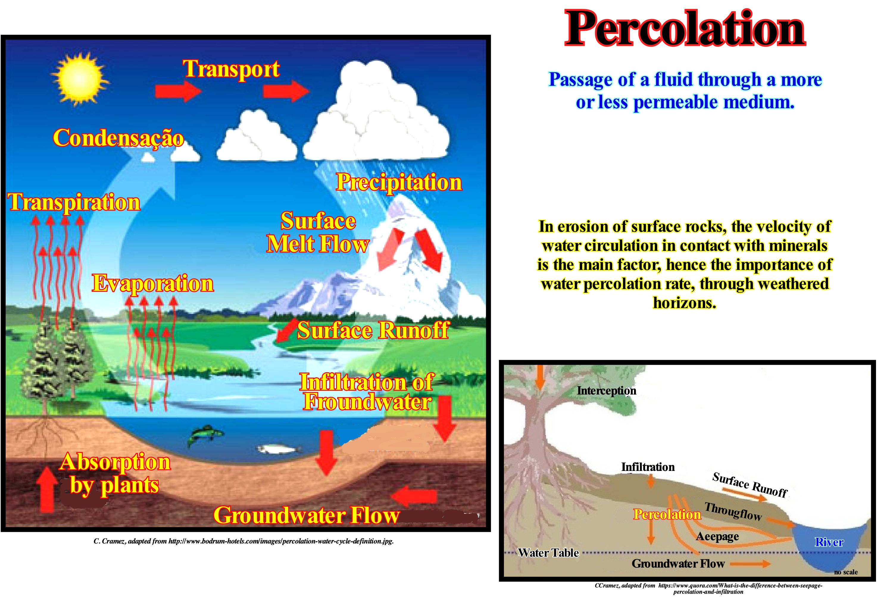
Percolation is a critical physical process that describes, for a system, the transition from one state to another. The term percolation can be used in several contexts. In general, percolation is a boundary phenomenon associated with the transmission of information through a network of sites and links that may, depending on their state, transmit or not information to neighbouring sites. Percolation was first studied in 1957 by Hammersley who tried to understand how the soldiers' gas masks became ineffective. The term percolation comes from a similar phenomenon which is the passage not of a gas but of water through the percolator of the coffee machine which is a filter in the same manner as a gas mask. In this particular case, the information is the fluid, water or gas, the sites are the pores of the filter that relay the information if they are not blocked. The percolation limit corresponds to the appearance in the system of an agglomerate of infinite size, which is mathematically described as a second-order phase transition. In pedology, as illustrated in this figure, percolation is a water flow in the ground cover due to gravity. Darcy's law describes the relationship between water depth and infiltration rate, as in the case of surface waters that feed a water table. In ecology, percolation theory is one of the theoretical tools tested for the study and modeling of the ability of individuals and the population to migrate (flow) within a landscape, which is in any way compared to a porous medium in which each species circulates more or less easily. In physics, percolation is the bridge that is created to allow the passage of a fluid, as long as it reaches a certain critical amount, over a partition (for example a wall). In everyday life, the term percolation is mostly used in hospitality. Tea or coffee is obtained by percolation under high pressure.
Pericynthian..............................................................................................................................................................................................................Pericynthian
Pericintião / Pericintiano / Pericynthian (Astronomie) / Pericynthian(天文) / Перицинтиан / Pericynthian (astronomia) /
Point of trajectory of a spacecraft that is closest to the Moon.
See: « Orbit »
&
« Apocynthian »
&
« Moon »
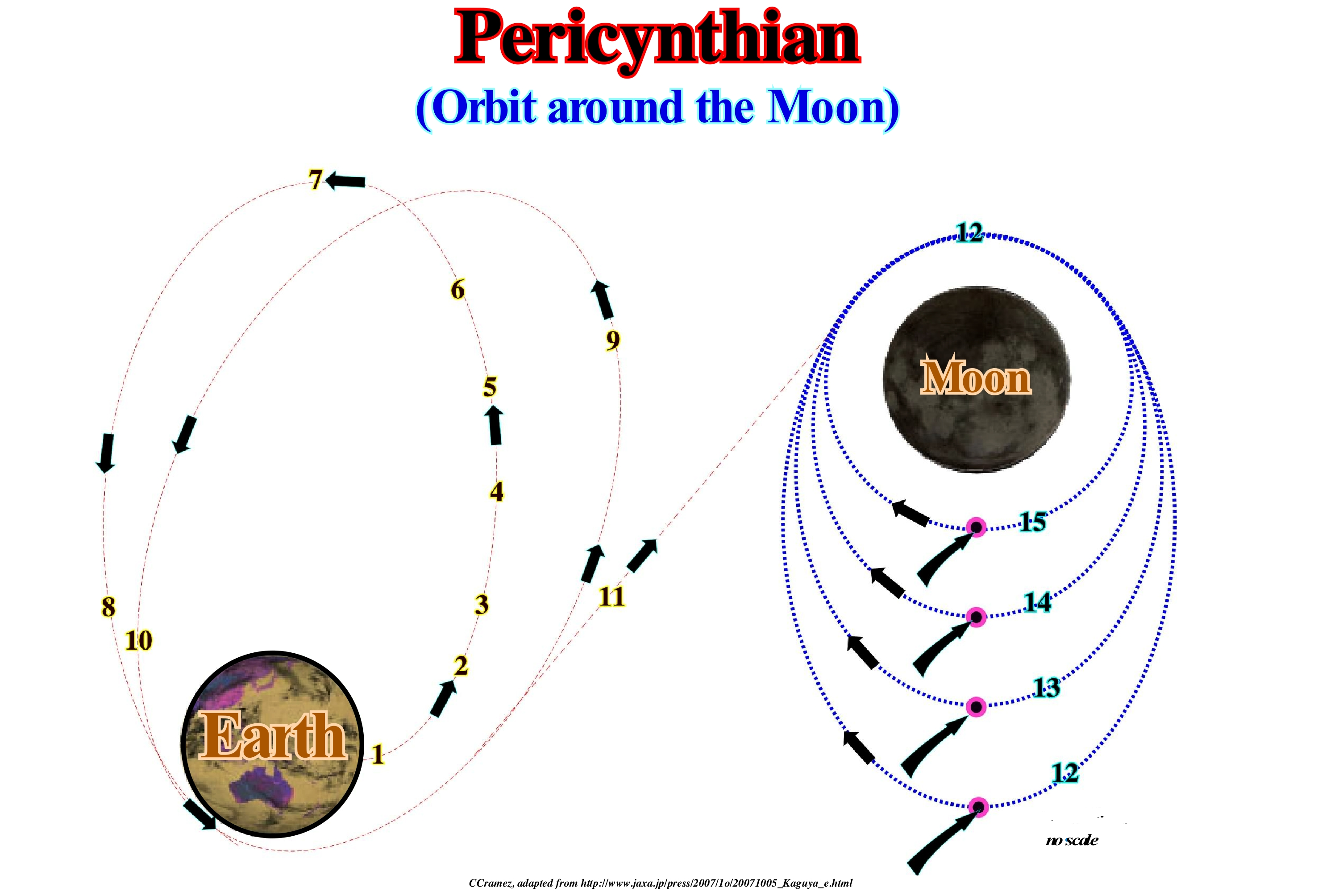
As illustrated, an artificial satellite is any man-made body placed in orbit around the Earth or any other planet. Nowadays, unlike what happened at the beginning of the history of artificial satellites, the term satellite is, practically, used as a synonym of artificial satellite. This term is used when you want to distinguish them from natural satellites such as the Moon. They are currently in orbit, in addition to Global Positioning System satellites, communications satellites, scientific satellites, military satellites and a large amount of space debris, that is, one should not refer to satellites just as a means of transporting data or just a means of mapping or spying on the terrestrial system. A satellite undergoes a certain acceleration that is independent of its mass but depends on the altitude at which the satellite is. The satellite's trajectory will depend on its acceleration and initial conditions: (i) The initial position and (ii) The initial velocity. Newton's thoughtful experiment explains why satellites do not fall to Earth, although they are, constantly, drawn by the gravitational force to the Earth's centre. Newton imagined a very powerful cannon capable of launching projectiles at great distances. He imagined this cannon placed at a high altitude. If the altitude is sufficiently large, the cannon is out of the Earth's atmosphere and the air resistance is negligible. If the cannon fires a projectile with a low speed, the projectile will lose altitude until it falls to Earth. But if the speed of the projectile exceeds a certain value, the projectile when it falls will already fall "off the Earth". If the initial velocity of the projectile is sufficiently high, the projectile falls continuously without ever reaching the Earth. By increasing the velocity, the projectile can travel at greater distances until the projectile encircles the Earth in an approximately circular orbit. In this motion there is no force beyond the gravitational force and the projectile will continue in orbit around the Earth (motion of a particle with initial velocity, actuated by a force of constant intensity whose direction varies continuously, being at each instant perpendicular to the velocity ) (http://en.wikipedia.org/wiki /Satellite_artificial.)
Peridotite....................................................................................................................................................................................................................................Péridotite
Peridotito / Peridotita / Peridotit / 橄欖岩 / Перидотит / Peridotite /
One of the components of the series of plutonic rocks that form the greater part of the terrestrial mantle. The peridotites are ultramafic rocks of granular structure, consisting mainly of olivine associated with other ferromagnesian silicates, essentially pyroxenes.
See: « Crust »
&
« Sima »
&
« Moho (Mohorovičić's discontinuity) »
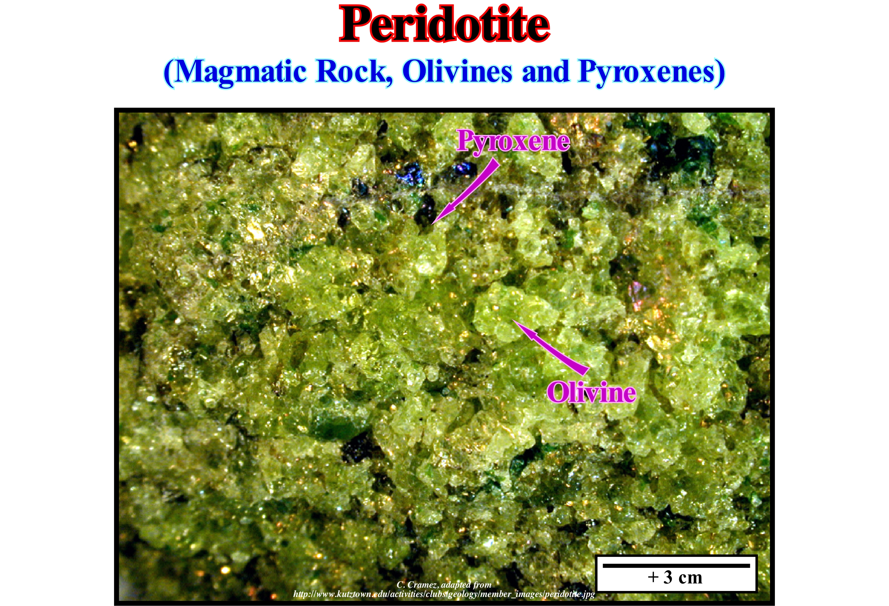
Different types of peridotites may be distinguished according to their proportions in olivine, orthopyroxenes and clinopyroxenes: (i) Dunite consists of more than 90% olivine (typically with a Mg / Fe ratio of 9:1) ; (ii) Wehrlite is, mainly, composed of olivine, but also of clinopyroxene ; (iii) Harzburgite is, mainly, composed of olivine, but also of orthopyroxene and basaltic-type components ; (vi) Lherzolite is, mainly, composed of olivine, orthopyroxene (usually enstatite) and clinopyroxene. A lherzolite also has a large proportion of basaltic compounds (garnets and clinopyroxenes). Partial melting of the lherzolite and extraction of the liquid part may leave a solid residue of the harzburgite type, rich in olivine and, relatively, rich in orthopyroxene, but poor in clinopyroxene. This is due to the fact that clinopyroxene melts at a lower temperature than orthopyroxene or olivine. Continuing the partial melting process, one arrives at a rock consisting almost of olivine, that is a dunite (the temperature continued to increase and the orthopyroxene melted in turn). Peridotites form on the Earth's mantle, 40 to 70 km below the Earth's crust. Peridotites can only be formed under conditions of pressure and temperature, which have no comparison with the conditions in which we live. When they surface, the peridotites have undergone a huge uplift. Most of the samples collected in the outcrops of peridotites exhibit obvious signs of a major uplift (diaclases and faults). Peridotites are, often, altered by serpentinization, in which periodotes (named olivine when used as a precious stone) are, completely, transformed into amphibole and serpentine (a group of minerals of hydrated phyllosilicate of magnesium and iron). They contain mineralizations in chromium, nickel, cobalt, platinum and sometimes diamonds. The colour of the peridotites is dark oily yellow or dark green. The peridotites are fully crystallized.
Perihelion......................................................................................................................................................................................................................................Périhélie
Periélio / Perihélio / Perihelion / 近日点/ Перигелий / Perielio /
The lower apside (point where an object, in an elliptical orbit, is the shortest distance from its center of attraction) of a planet in relation to the Sun, i.e., the point of the orbit of a planet on which the planet is closest to the Sun.
See : « Aphelion »
&
« Milankovitch's Cycle »
&
« Apside »
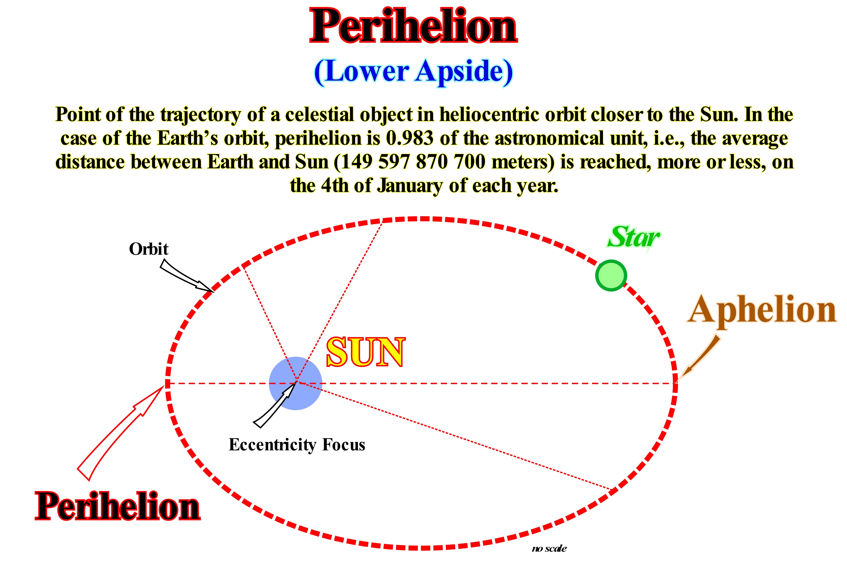
As illustrated in this scheme, perihelion is the point of the orbit of a natural or artificial celestial body, which is closest to the Sun. The opposite of perihelion is aphelion. As the orbits of the celestial bodies are elliptic, they can be defined in space by six parameters which allow to calculate, precisely, the path of the body in orbit: (i) Eccentricity ; (ii) Half of the Great Axis ; (iii) Inclination ; (iv) Length of the Ascending Node ; (v) Argument of the Perihelion ; (vi) The moment of passage to the perihelion. Eccentricity-is the distance of the foci in relation to the centre of the orbit (relation between the distance from the centre of the orbit to the sun and half of the great axis). Half of the Great Axis is half the distance separating perihelion from aphelion (controls the size of the orbit). Inclination is an angle (between 0° and 180°), which makes the plane of the orbit with a reference plane (usually the plane of the ecliptic, i.e., plane containing the Earth's trajectory). Length of the Ascending Node is the angle between the direction of the vernal point (one of the points of the celestial sphere where the celestial equator and the ecliptic intersect) and the line of the nodes (defined by the inclination and ecliptic intersection) ecliptic. Argument of the Perihelion is the angle formed by the line of knots and the direction of the perihelion (straight line to which the Sun belongs and perihelion of the object trajectory), in the plane of the orbit. The moment of passage to the perihelion makes it possible to prognosticate the position of the body in orbit at any other instant. When speaking of the period of an orbiting object, it is generally about its sidereal period, but there are several possible periods: (a) Sidereal period - time between two passes of the object in front of a distant star (absolute period) ; (b) Anomalistic period - time between two passages of the object in its perihelion (shorter or longer than the sidereal if perihelion is in precession or recession ; (c) Draconic or Nodic period - time between two passages in its ascending node or (e) Tropic period between two moments of the object to the right ascension zero (equivalent to the terrestrial longitude on the celestial sphere) and (e) Synodic period - time between two moments in which object have the same aspect (conjunction, quadrature , opposition, etc.).
Perigee........................................................................................................................................................................................................................................................Périgée
Perigeu / Perigeo / Perigäum / 近地点 / Перигей / Perigeo /
Point of the orbit of a star or a natural or artificial satellite closer to Earth (opposite of apogee). The lower apside (where an object in an elliptical orbit is the shortest distance from its center of attraction) of the Moon's orbit, that is, the point of the Moon's orbit where it is closest to the Earth.
See : « Aphelion »
&
« Milankovitch's Cycle »
&
« Apside »
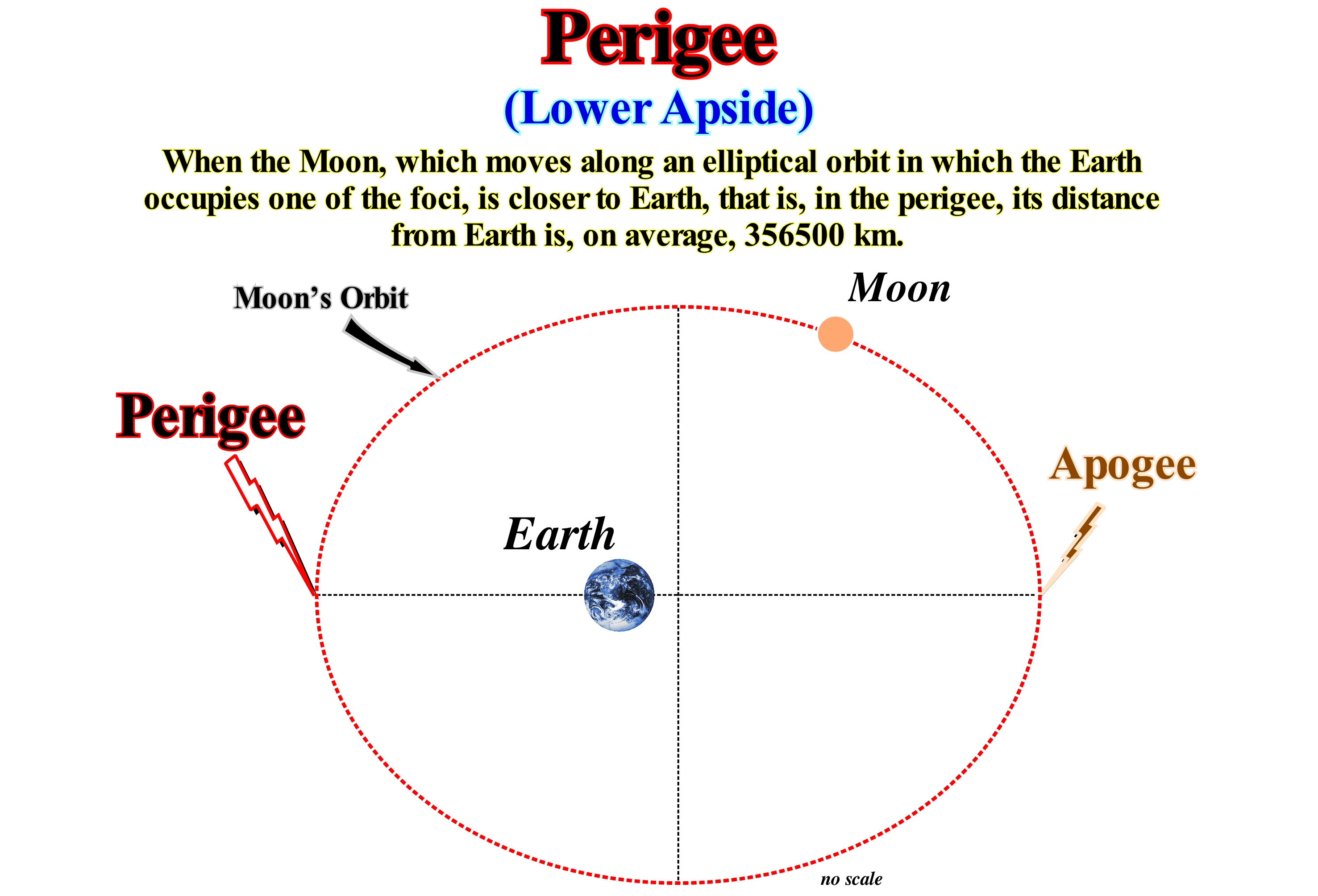
The term perigee refers to the point of the lunar orbit closest to Earth, which is about 356,375 km from our planet. The perigee corresponds to the perihelion, which indicates the position in the orbit of a planet or any other body of our solar system in revolution around our star that takes it to its smaller distance of the Sun. More generally, it is possible also speak of perihelion. Like its apogee antonym, the term perigee can also be used in relation to any other natural or artificial satellite belonging to the Solar System. The period of time that passes between two passages of the Moon in the perigee is called the period of anomalistic revolution, which is about 27.55 days, or more exactly, 27 days, 13 hours, 18 m and 33.1 s. Our solar system has nine known planets, in orbit more or less circular around the Sun: (i) Four terrestrial planets (Mercury, Venus, Earth, Mars) ; (ii) Two lower planets and (iii) Four giant planets (Jupiter, Saturn, Uranus, Neptune). Pluto, the ninth planet so far the least explored, just as small planets are not included in this classification. Seen from Earth, the planets are located above the ecliptic. Apart from Mercury and Venus, all planets in the solar system have natural satellites. While the Earth has only one and Mars two, a much larger number of moons revolve around the giant planets: (a) 16 around Jupiter, including the 4 that were recently discovered, 18 around Saturn, probably around 21 of Uranus and 8 around Neptune, while Pluto seems to have only 1. The planets outside the solar system are called exoplanets. A few months ago, it was still thought that all the planets revolved around a star. It seems that under the "Search for Origins" program scientists have found a planet orbiting a binary system (two nearby celestial bodies orbiting a common centre of mass).

