
Stratal Surface..........................................................................................................................................................Surface de stratification
Superfície de estratificação / Superficie de estratificación / Stratifikation Oberfläche / 层面 / Пластовая поверхность / Superficie di stratificazione /
Physical stratigraphic surface separating two sedimentary levels. The stratification surfaces include laminae, beds or other thicker stratigraphic units. They represent periods of no deposit or abrupt changes in depositional environments.
See: « Bed »
&
« Stratification (sediments) »
&
« Hiatus »
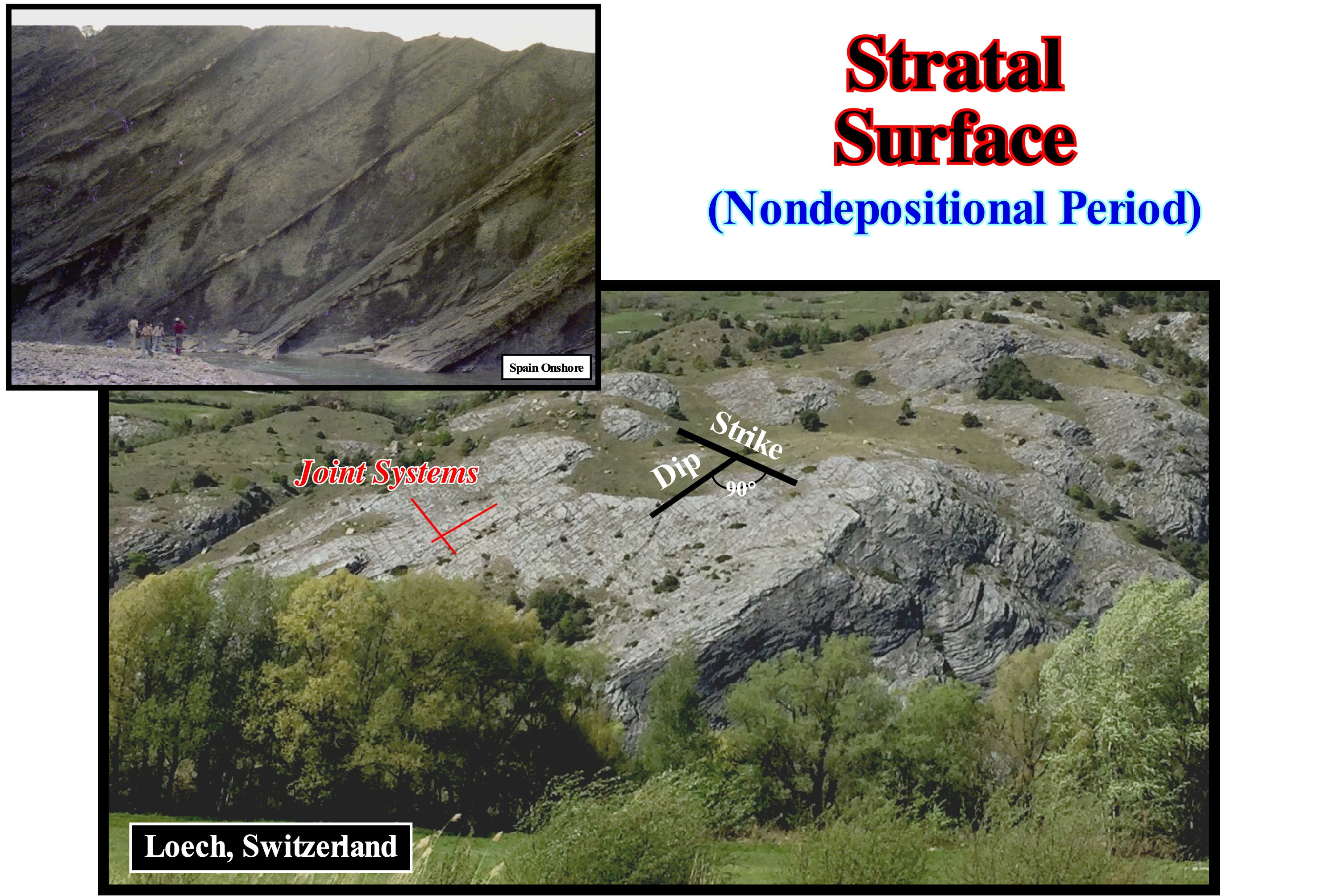
As shown in this photograph, sedimentary beds are bounded above and below by surface or bedding planes, which are, generally, the easiest elements to identify in an outcrop. They are used to subdivide the rocks into beds and to determine the order and relative time of accumulation of the sediments that form them. The characteristics of the bedding surfaces or planes, whether they are, more or less, eroded, cemented, perforated, or bioturbated, are used in the interpretation of sedimentary rocks. Some geoscientists, based, mainly, on observations made in fluvial sediments, consider that four major types of bedding surfaces can be considered: (i) Concordant, that is, without significant erosion (normal stratification) ; (ii) Nonconcordant but without significant erosion ; (iii) Concordant with Erosion and (iv) Nonconcordant with Erosion. Recall a discontinuity can designate a transition or contact between: a) Different sedimentary facies (lithologies) ; b) Intervals separated by a hiatus (absence of significant deposition) ; c) Intervals with different densities, etc., and they consider: 1-Stratigraphic Discontinuities ; 2-Sedimentary Discontinuities; 3 -Lithological Discontinuities ; 4-Tectonic Discontinuities, etc. A bedding surface is a stratigraphic discontinuity. Within this family of discontinuities, which is the most important in sequential stratigraphy, several types can be recognized: (i) Concordants, when there is continuity between the successive intervals ; (ii) Paraconform or Paraconformities, when there is no difference in attitude between overlapping intervals, but there is a hiatus due to the absence of significant deposition between them ; (iii) Nonconformities (heterolytic discontinuities of certain geoscientists), when there is a contact between a sedimentary interval and an older igneous body ; (iv) Disconform or Disconformity, when the layers of the intervals are parallel on one side and the other side of the contact surface which does not conform to regional stratification ; (v) Discordant Discontinuity or Unconformities when the two interval are separated by an erosional surface induced by a relative sea level fall ; (vi) Tectonically Enhanced Unconformities, when the sediments of the interval overlapping an unconformity were deformed by tectonics (shortened or lengthened) ; (vii) Intrusive Discontinuities, when an igneous body traverses a sedimentary series ; (viii) Mechanics, when they are induced by faults, etc. (https: // estpal13. wordpress.com / 2013/06/04 / discontinuities-sedimentary-and-stratigraphic /). The origin of the bedding planes remains puzzling. Certain geoscientists think that many bedding planes are, probably, formed by the erosion of sediment not, or little, consolidated on the surface of the deposit. The weight of the sediments, immediately below the surface, causes the sediments to lose water and compact a little, which makes them more cohesive. If the surface of the sediments is subject to an erosive agent (storm waves, tidal currents, river currents, turbidite flow, etc.), the bedding surface erodes a part of the sediments, truncating the less cohesive ones and exhuming the more firm lower sediments. When deposition resumes, it is on the firmer surface that the new sediments will deposit. It can be said that the difference in density between uncompacted sediments (with lots of water) and slightly compacted sediments (with less water) can create a bedding plane. If the deposition takes a while to resume the bedding plane is, in general, perforated by Glossifungites (ichnofacies representing a set of holes). Obviously, the bedding planes are chronostratigraphic surfaces. On the seismic lines, it is evident that bedding plans can not be evident (the seismic resolution is seldom less than 30/40 m), which means that the seismic reflectors do not correspond to bedding surfaces. However, groups of layers with similar lithological and physical characteristics can form, more or less, homogeneous sedimentary intervals or packages that can define sedimentary interfaces that are, perfectly, visible in the seismic data. The great majority of seismic reflectors are induced by these interfaces that allow a seismostratigraphy, which the scale of the cycles follow, translates and gives, in a, more or less, way the stratigraphy and the geological history of the basin.
Stratal Termination..........................................................................................Terminaison et géométrie d'une strate
Terminação e geometria de um estrato / Terminación y geometría de un estrato / Kündigung und Geometrie eines Stratum / 地层的终止和几何形状 / Окончание и геометрия пласта / Terminazione e la geometria di uno strato /
One of the geometric relations that allow to define the unconformities (erosional surfaces) and to predict the environments and depositional systems. There are five main types of terminations: (i) Onlap; (ii) Downlap ; (iii) Truncation ; (iv) Toplap and (v) Apparent Truncation. The most frequent geometries of the strata are the same as those of the seismic reflectors.
See: « Geometric Relationship (strata, reflectors) »
&
« Downlap »
&
« Reflection Termination »
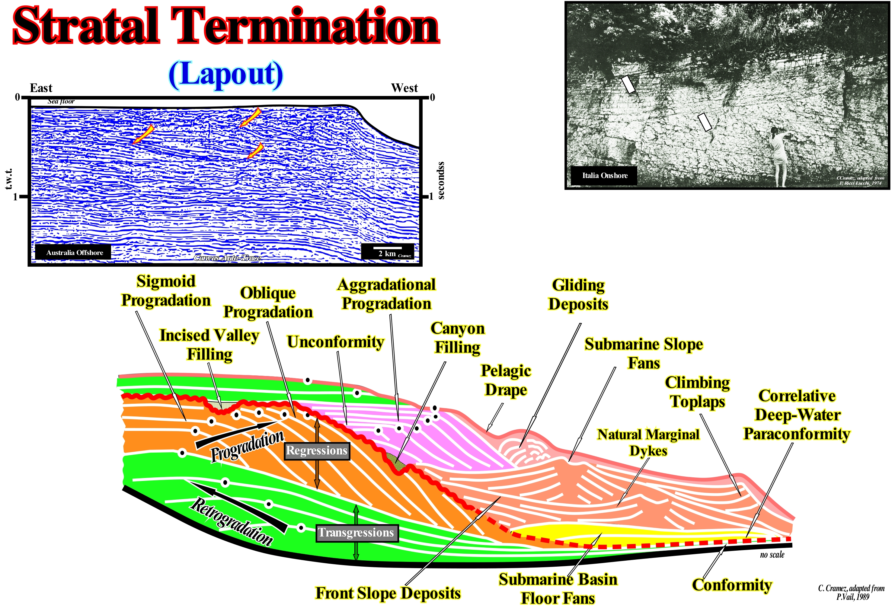
All types of terminations of the strata are illustrated in this sketch, in which a large number of depositional systems can be seen, which lie in the stratigraphic cycles called sequence-cycles, which are induced by eustatic cycles of 3rd order, whose time-duration varies between 0.5 and 3/5 My. In this particular geological sketch, two incomplete sequence-cycles are represented. They are separated by an unconformity, that is, by an erosional surface induced by a relative sea level* fall, which put the level of the sea lower than the basin edge (continental edge when the basin has a continental shelf or during the 2nd stage of development of the highstand prograding wedge, PNA, of a sequence-cycle). At the level of a sequence-cycle, in the deep part of the basin, the limit between the two sequence-cycles is made by a paraconformity that correlates, upstream, with the unconformity. In addition to the geometric relationships between the strata, the erosional surface limiting the sequence-cycle is also emphasized by the filling of an incised valley upstream of the last basin edge of the lower sequence-cycle and the filling of a submarine-canyon downstream. The lower sequence-cycle consists of the two groups of sedimentary systems tracts deposited under highstand geological conditions, that is, the transgressive interval (TI), green coloured, and the highstand prograding wedge ((HPA) coloured in orange. The transgressive interval (lower sub-group of highstand systems tracts group) has a retrogradational geometry, whereas highstand prograding wedge (HPW) has a progradational geometry. The retrogradational geometry of the transgressive interval (TI) is the result of the stacking of increasingly smaller smaller sedimentary regressions induced by increasingly important marine ingressions, while the progradational geometry of the highstand prograding wedge (HPW) is the result of overlapping , more or less, vertical of increasingly important sedimentary regressions induced by increasingly smaller marine ingressions. A downlap surface separates the transgressive interval (TI) from the highstand prograding wedge (HPW). The upper sequence cycle-consists of the lowstand systems tracts group (LSTG), coloured in blue, in which the three subgroups of sedimentary systems tracts that comprise it are recognized. From the bottom to top, they are: (i) Submarine Basin Floor Fans (SBFF) ; (ii) Submarine Slope Fans (SSF) and (iii) Lowstand Prograding Wedge (LPW), and by the lower highstand systems tracts sub-group, i.e., the transgressive interval (TI). The submarine basin floor fans (SBFF) have a rectangular morphology with abrupt boundaries between the different lobes. The submarine slope fans, which are formed by complexes of turbiditic natural marginal dikes (levees) and fills of the depressions between them, have an internal geometry, similar to the wings of a seagull in flight (the wings simulate the natural marginal dykes). The lowstand prograding wedge (LPW) has, of course, a progradational geometry, but most of the sequence-paracycles are spindle-shaped (sigmoid progradations) which creates an important aggradation, but largely inferior to the progradation. The terminations and shape of the reflectors define the geometric relations that can be interpreted as relations between strata. Several types of terminations (lapouts) can be considered within interval with two mainly configurations: (1) Convergent, set of seismic reflectors, interpreted as strata, that thin sideways towards the basin (can develop anywhere within a stratigraphic cycle, should not be confused with onlapping over unconformities) ; (2) Divergent, set of seismic reflectors, interpreted as strata, which thicken laterally, etc. In this figure, note the difference in scale between the photograph (strata on the Italy onshore) and the seismic reflectors of an auto-trace of an Australia offshore seismic line.
(*) Do not forget that in sequential stratigraphy it is fundamental not to confuse the relative sea level with absolute (eustatic) sea level. The first is a local sea level, referenced to any fixed point on the Earth's surface, which can be the base of the sediments (top of the continental crust) or the sea floor. The second is supposed to be global and referenced to the Earth's centre. The relative sea level is the result of the combined action of absolute (eustatic) sea level and tectonics (subsidence or uplift of the sea floor). The absolute sea level is the result of the combination of: i) Tectono-Eustasy that is controlled by the volume variation of the ocean basins in association with oceanic expansion following the break-up of the supercontinents ; (ii) Glacio-Eustasy, which is controlled by the variation of water volume of the oceans as a function of the amount of ice (assuming that the amount of water in all its forms is constant since the formation of the Earth, around 4.5 Ga) ; (iii) Geoidal-Eustasy, which is controlled by the distribution of ocean water caused by variations in the Earth's gravity field (where gravity is stronger than normal, sea level is thrown to the centre of the Earth) and (iv) Thermal expansion of the oceans or steric sea level rise (if the temperature increases, the density of the water decreases, and for a constant mass, the volume increases). During a given geological time, the combination of the eustatic curve (absolute sea level changes curve) and the tectonics (subsidence of the sea floor, when the predominant tectonic regime is in extension or uplift, when the predominant tectonic regime is compressional) gives the curve of the relative sea level changes.
Stratification (Sediments)..............................................................................................................................................Stratification (Sédiments)
Estratificação (sedimentos) / Estratificación (sedimentos) / Stratifizierung (Sediment) / 分层(沙) / Слоистость (осадка) / Stratificazione (sedimento) /
Accumulation or arrangement of sediments in strata or layers, laminae, etc.
See: « Stratum »
&
« Turbidite »
&
« Steno's Laws »
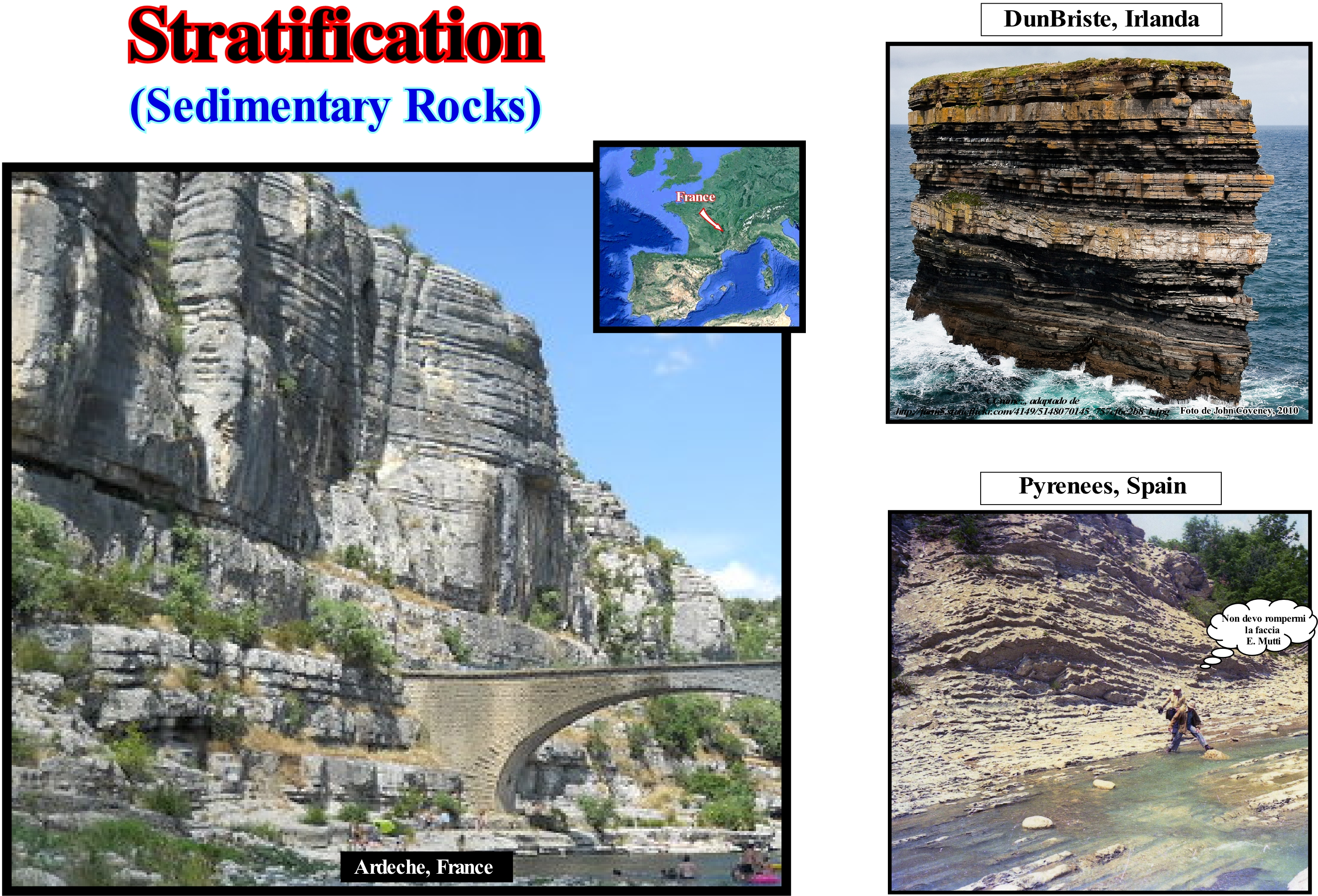
As illustrated in these photographs of the Ardeche River, in France, and from Dunbrooke stack* on the coast of Ireland, and from the turbidites of Spain onshore (Pyrenees), the sediment stratification is the vertical stacking of a set of strata, that is, of rock levels with consistent internal characteristics that distinguish them from contiguous levels. Clastic sediments are deposited in more or less horizontal horizons called strata or beds (layers). This arrangement results from the tendency of water and also wind to spread sediments of the same type at relatively thin levels over a large area and over a period of similar environmental conditions. When environmental conditions change at the deposition site several things can happen: (i) Different types of sediment can be deposited at the top of the previous layer ; (ii) There may be a period of time during which the sediments do not settle (hiatus) ; (iii) The original layer can be eroded, etc. However, as the depositional environment is the same, the type of deposited sediments tends to be more similar within the same level than at two different levels. Sediments tend to be more similar within the same layer than in different layers. However, lateral continuity has limits. A particular layer may be, relatively, thin and pinchout (disappear laterally) without leaving any particular record of the deposition time in the area of pinchout. The type of sediment that characterizes one layer may, laterally, change gradually in another type within the same level, suggesting that the depositional environment may also gradually change laterally. Certain combinations of sedimentary environments favour abrupt discontinuities of sedimentary levels of the same type. The sands and shales deposited by a river are, in general, discontinuous, due to the repetitive periods of floods. Other sedimentary environments are more conducive to the continuity of the layers. The pelagic shales deposited in the deep parts of the basins exhibit a great lateral continuity. In any way and in any sedimentary environment, the stratification always characterizes a lateral continuity much greater than vertical. Lamination and stratification are not synonymous. Lamination is a succession, the small scale, of thin horizons (called laminae), which occurs in sedimentary rocks. Lamination is, usually, smaller and less pronounced than the stratification. Laminations are often regarded as planar structures one centimetre or less thick, while the beds (stratification) are larger than one centimetre. However, structures from a few millimeters to several centimeters have been described as laminae. A sedimentary rock can have both laminae and beds (layers). On the seismic lines, since the resolution is of the order of two or three tens of meters, it is evident that the reflectors do not correspond to strata, but to interfaces between sedimentary intervals of significant thickness with different acoustic impedances. Thus the stratification observed on the seismic lines that many geoscientists call seismic stratification has very little to do with the sediment stratification, previously, described. Likewise, it should not be forgotten that to have sediment deposition and stratification there must exist accommodation (available space for sediments), which is created by a marine ingression (relative sea level rise or eustatic paracycle). However, during a marine ingression, which moves the continentward the shoreline with the formation of a ravinment surface, there is no deposition. Sedimentary particles deposition occurs during the stability period of relative sea level (result of the combined action absolute or eustatic sea level, referred to the Earth's centre of the Earth and tectonics) that follows the rise of the relative sea level, during which the shoreline moves seaward as the sedimentary particles settle down to form a sedimentary regression. When a geoscientist says that there is a relative sea level rise, in general it is not referring to a single ingression, but to a succession of ingressions (increments) in acceleration or deceleration, without relative sea level falls between them.
(*) The stacks in the DunBriste area are formed by sediments deposited during the Lower Carboniferous, some 350 million years ago, when sea temperatures around Ireland were much higher than today. These erosive structures are at the origin of a series of legends, among which one says that pagan chief, who lived in the region where today the stacks are, having refused to convert to Christianity, St. Patrick hit the ground with his wooden staff, dividing the promontory where the chief lived.
Stratification (Water).........................................................................................................................................................................................Stratification (Water)
Estratificação (água) / Estratificación (agua) / Schichtung (Wasser) / 分层(水) / Расслоение (воды) / Stratificazione (acqua) /
Layered arrangement of a water-body. The layers are differentiated by a density contrast, which is the result of temperature, salinity or a combination of the two.
See: « Contour Current »
&
« Ocean Current »
&
« Steric Sea Level Change »
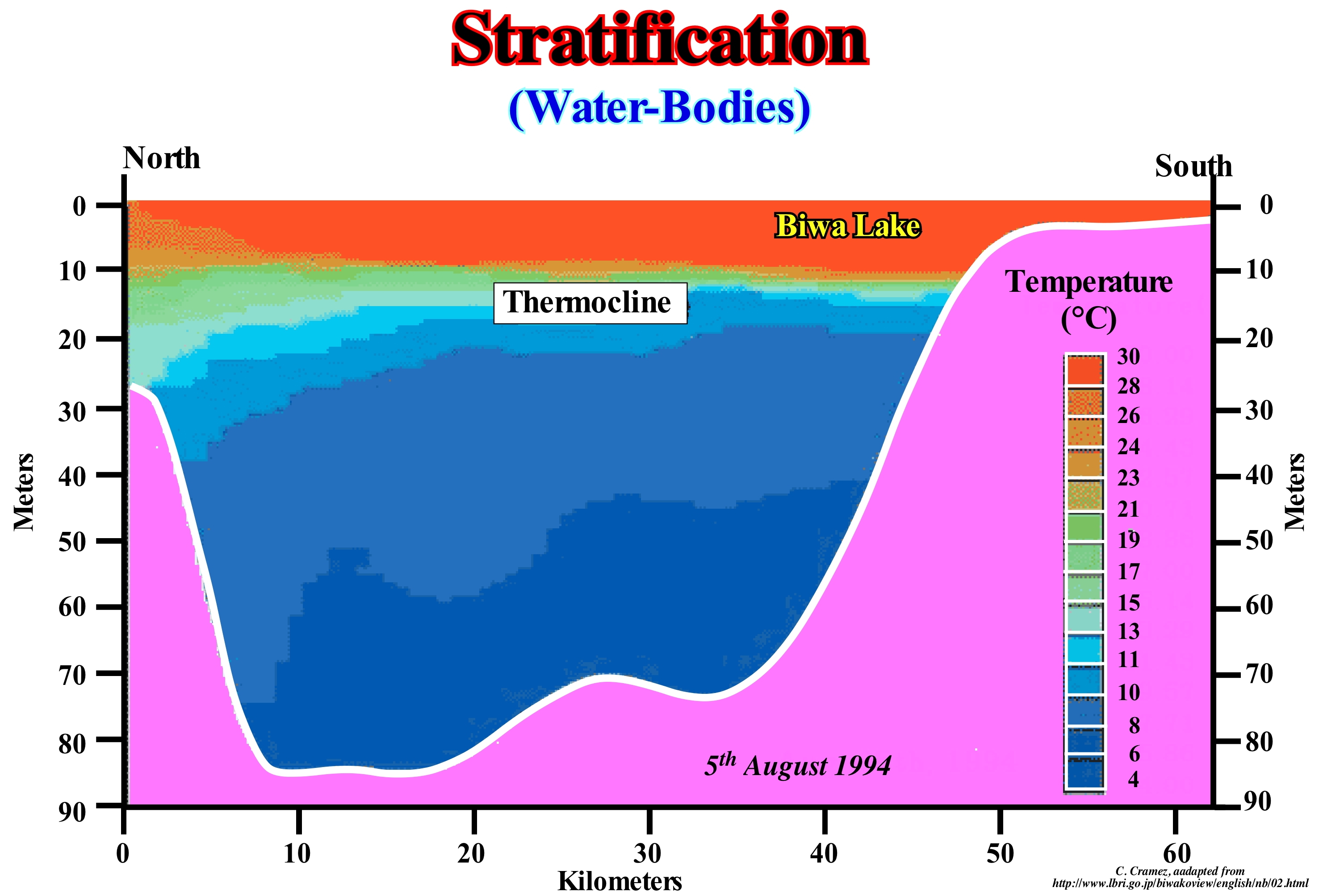
Within a water column, the mixing layer is characterized from top to bottom by poor gradients of water characteristics, which may increase, sharply, downward, so that the values of these characteristics are linked to those of the deep-waters. The transition zones are designated according to the characteristics considered by terms using the suffix "cline". Thus we can speak of pycnocline (density), halocline (salinity), thermocline (temperature), oxycline (oxygen), etc. Water stratification occurs when water with high and low salinity (halocline), or hot and cold water (thermocline) form layers that act as barriers to miscibility of the water (miscible, i.e., that can be mixed). The thermocline corresponds to a sudden change in temperature at a given depth of a water-body. In low and middle latitudes, under the surface layer of the sea, there is a layer with maximum decrease of temperature per unit of depth, that is called thermocline. In high latitude regions such as the polar regions the sea does not have any thermal, cold stratification, which allows easy mixing between surface water and deep-water. In oceanography, halocline is a interval of water column in which the salinity of water changes rapidly with depth. It designates a strong vertical gradient of salinity. It may be permanent, such as occurs at the mouth of a river, or transient, such as occurs after a heavy rain at sea. As salinity affects the density of sea-water, it exerts, for instance, an important role in the vertical stratification of water. An increase in salinity of 1 kg/m3 creates an increase in density of about 0,7 kg/m. In areas of medium latitude, when there is an excess of evaporation, in relation to precipitation, the surface water becomes saltier than deep-water. In these regions, vertical stratification is mainly driven by the difference in temperature between hotter surface waters and cooler deep-waters. The process of formation of dense waters is mainly linked to the reduction of temperature or increase of salinity due to the formation of ice, generally, thermohaline currents originate in high latitudes. These cold, dense waters sink and slowly flow towards the equator. Turbiditic currents are subaquatic and turbulent density currents in which the density difference is caused by suspended sedimentary particles as they transport the grains in a solution composed of water and dispersed sedimentary particles, which are kept in suspension due to turbulence. The thermocline is a relatively thin, but very characteristic horizon of the oceans, lakes or even the atmosphere, where the temperature changes much more rapidly, in depth, than what happens in the overlying and underlying horizons. In the ocean, the thermocline separates the upper horizons, where the water is very mixed and agitated, from the deep lower horizons, where the water is almost at rest. The halocline circulation refers to the global ocean circulation induced by differences in the salinity of ocean waters**. Depending on the seasons, latitude and turbulence created by the winds, the thermocline can be semi-permanent or change a lot of thickness and depth. Thermocline has a great importance in the distribution of aquatic organisms, it acts as a barrier to them, since changes in water temperature imply changes in density, viscosity, pressure, solubility and oxygen, which in turn can influence the buoyancy, locomotion and respiration of organisms. This figure illustrates the thermal stratification of the water of Biwa Lake in Japan. In summer, the gradient (rate of change of a physical quantity as a function of distance or time) changes very, sharply, between hot, surface water, and the underlying cold water. The barrier between these two levels, i.e., the thermocline, corresponds in this example to a (light blue) horizon, whose thickness is about 10 meters, and whose depth is 15 meters in the southern part of the lake and about 30 meters in the North. In this lake, in addition to the surface waves, which are often as high as the sea waves, the thermocline propagates like a great wave across the lake.
(*)The thermohaline or thermosaline circulation refers to the global ocean circulation induced by the differences in ocean water density due to variations in temperature or salinity in some surface ocean region. The increase in density can occur due to cooling of the water, excess evaporation on precipitation or even the formation of ice and consequent increase of salinity of the surrounding waters. (https://pt.wikipedia.org/wiki/Horizontal_culture).
(**) The speed of these currents is very small. It is about 1 cm/s. Using the concept of residence time, which is the average time a given substance (deep water in this case) stays in the ocean before being recycled, it may take about 500 to 1,000 years to replenish all the deep water of the Atlantic Ocean , for example.
Stratification Index.................................................................................................................................................Indice de stratification
Índice de estratificação / Índice de estratificación / Index Schichteinteilung / 分层索引 / Индекс слоистости / Indice di stratificazione /
Number of beds in a stratigraphic unit defined as the number of beds multiplied by one hundred and divided by the total thickness: (number of beds x 100) / thickness
See: « Stratification (sediments) »
&
« Strata »
&
« Formation (geolological) »
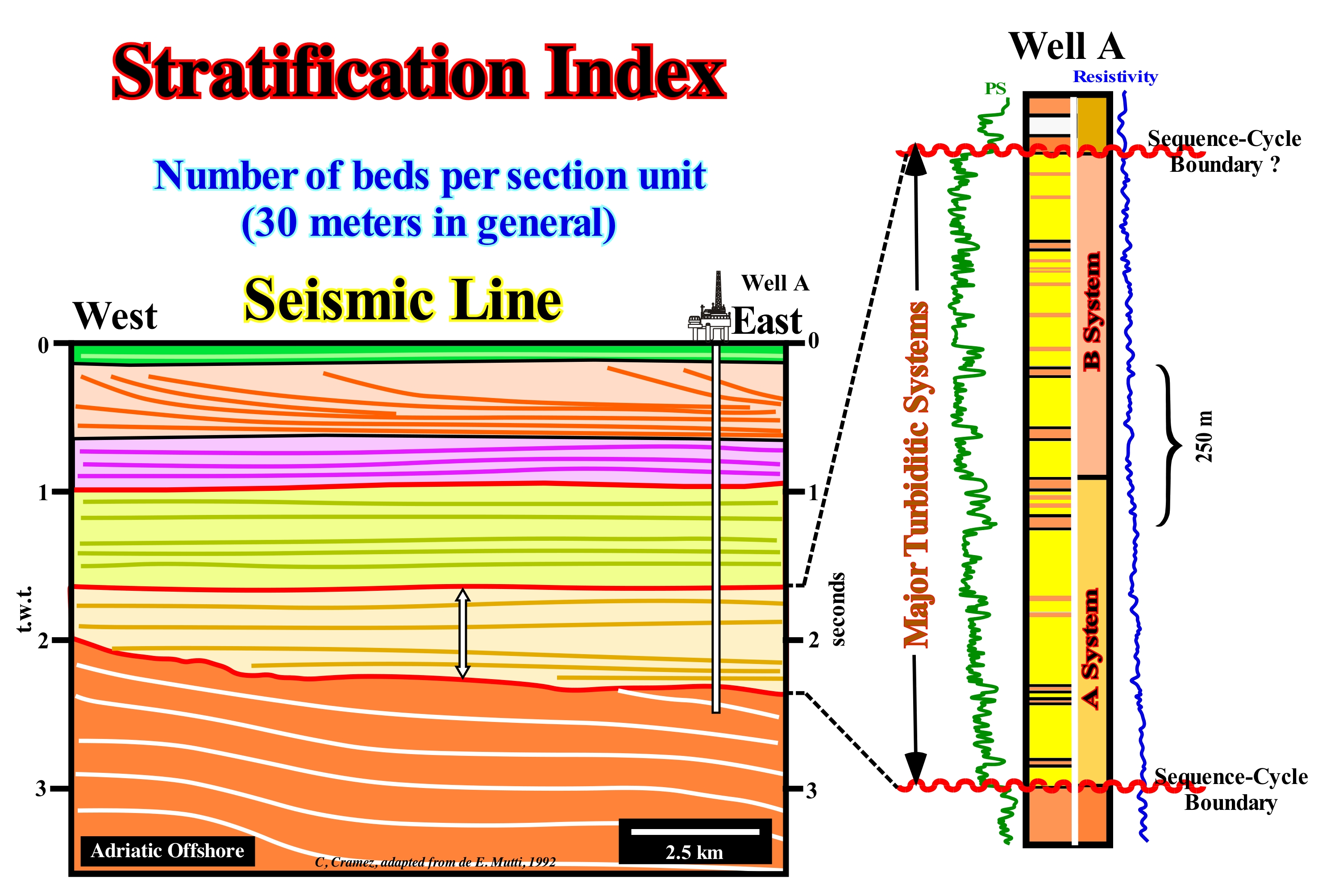
The stratification index is significant when each layer underlines a particular geological event and independent of the relative sea level change, that is, of accommodation, which is the case of turbiditic deposits. Each turbidite lobe represents a current of turbidity induced or not by a relative sea level fall (there are turbiditic deposits deposited during highstand geological conditions). In platform deposits, the stratification index is dependent on the creation of available space for the sediments (accommodation), that is, relative sea level rises, not from geological time. Stratigraphic systems, such as in the Silurian or Cretaceous, deposits are episodic, incomplete, with numerous erosion and nondeposit hiatus, and they do not translate the equivalent duration of geological time. The hiatus of the great majority of the stratigraphic sections is, generally, more important than the total time of effective deposition of the preserved sediments. The deposition time is inversely proportional to the settling velocity, i.e., the higher the sedimentation velocity, the shorter the deposition period. Most periods of no deposition go unnoticed. This has led some geoscientists to consider the sedimentary records as short periods of "terror" separated by long periods of "calm" where nothing or almost nothing happens. The validity of the stratification index depends, also, on the preservation of deposits. Some, such as fluvial and, in particular, overbanking deposits, have a weak preservation (they settle down above the base depositional level). Others, such as the turbidite deposits, illustrated in this figure, which underline episodic geological events have an excellent preservation. Finally: (i) Bedding surfaces represent a small hiatus ; (ii) If the hiatus is large, the surface is considered an unconformity (the term large is relative and depends on the time scale considered) ; (iii) The term unconformity is used when the hiatus is by erosion; (iv) The hiatus varies along a bedding surface and (v) The stratification concept is dependent on the time scale and the rocks considered.
Stratigraphic Cycle......................................................................................................................................................Cycle stratigraphique
Ciclo estratigráfico/ Ciclo estratigráfico / Stratigraphischen Zyklus / 地层周期 / Стратиграфический цикл / Ciclo stratigrafico /
Sedimentary interval induced by an eustatic cycle, limited by two unconformities and by their correlative paraconformities in the deep part of the sedimentary basin.
See: « Eustatic Cycle »
&
« Relative Sea Level Change »
&
« Sequential Stratigraphy »
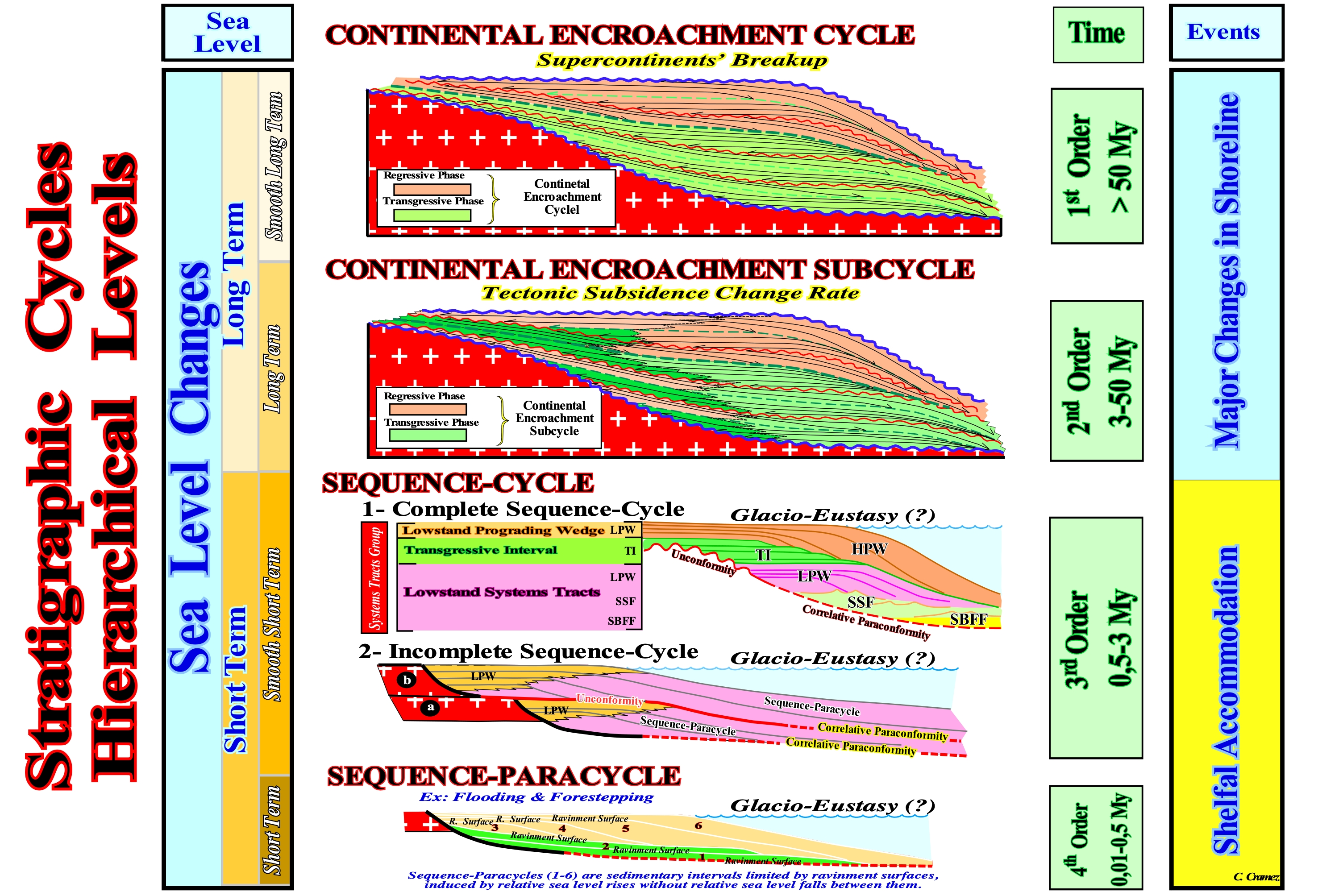
One of the basic principles of sequential stratigraphy is the conjecture that stratigraphic cycles are induced, primarily, by eustasy (changes of the absolute or eustatic sea level, i.e., from the supposed global sea level referenced to a fixed point, which is, in general, is the Earth's centre, The absolute sea level is dependent on (i) Tectono-Eustasy (controlled by the volume variation of the ocean basins) ; (ii) Glacio-Eustasy (controlled by the variation of ocean water volume, mainly associated with the amount of ice) ; (iii) Geoidal-Eustasy (controlled by the distribution of ocean water caused by variations in the terrestrial gravity field) and (iv) Thermal expansion of the oceans or steric sea level rise (if the temperature of the oceans increases, the density of the water decreases and for a constant mass the volume increases.) Eustasy is the main factor responsible for cyclicity and an important factor in the creation of available space for sediments (accommodation). As far as cyclicity is concerned, since B. de Maillet (around 1690) and Lavoisier (1789) until today, almost no geoscientist has any doubts. With regard to the amplitude of space created during a relative sea level rise, it depends, fundamentally, on subsidence and/or uplift of the sea floor, since, relative sea level is the result of the combined action of absolute (eustatic) sea level and tectonics. The hierarchy of stratigraphic cycles depends on the order of the eustatic cycles, which induced them. In general, in seismic stratigraphy, made from seismic data (taking into account the seismic resolution), three main stratigraphic cycles are considered, which are deposited during 1st, 2nd and 3rd order eustatic cycles, that is, cycles eustatic cycles with time-durations, respectively, greater than 50 My (1st order), between 50 and 3-5 My (2nd order), between 3-5 and 0.5 My (3rd order*): (i) Continental Encroachment Cycle ; (ii) Continental Encroachment Subcycle; (iii) Sequence-Cycle and High Frequency Cycles **. The sequence-paracycles that form a sequence-cycle are not cycles. There is no relative sea level fall between them. They are bounded by flooding surfaces. Continental encroachment cycles are associated with the break-up of supercontinents (Protopangea or Rodhinia and Pangea supercontinent, for instance), as it is the case of the two Paleozoic continental encroachment cycles of the Phanerozoic. Continental encroachments subcycles are associated with changes in velocity of tectonic subsidence (sediment thickness plus water-depth decreased by the isostatic compensation effect, due to sedimentary overload, and increased compaction effect). Sequence-cycles are associated with relative sea level changes, in which glacio-eustasy plays an important role. In fact, the imprisonment of water in the glacial caps and glacier during glaciations decreases the volume of water in the oceans, which creates a significant absolute (eustatic) sea level fall and causes a displacement of the shoreline seaward (marine regression). On the contrary, the melting of the ice caps and glaciers, during the thaw, creates an absolute sea level rise with a consequent water encroachment over the continents, creating a marine ingression or marine transgression. The sequence-paracycles are, also, associated with glacio-eustasy. Sequence-cycles are the building blocks of sequential stratigraphy. It is from the study of the sequence-cycles, which are composed of different groups and subgroups sedimentary systems tracts, that lithological predictions can be advanced. The terminology here presented is less misleading than the, initially, proposed by the Exxon geoscientists (Megasequence, Supersequence, Sequence and Parasequence), since it takes into account two basic characteristics of Geology: (i) All geological interpretation is scale dependent and (ii) In a hierarchy the criteria of discernment must be constant. On a seismic line the differentiation between a deltaic and continental slope is only possible if the seismic line has a vertical scale (time or depth) and a horizontal scale (metric). It is for this reason, that for a time, many geoscientists working in oil companies (the first to use sequential stratigraphy) interpreted Exxon's megasequences as "mega" sequence-cycles consisting of "mega" sedimentary systems tracts, which is totally wrong, and that led some of them to predict "mega" turbidites, which the exploration wells, totally, refuted.
(*) Under certain conditions (in certain depocenters when the deposition rate is very high) 4th-5th order eustatic cycles may consider, which many geoscientists call high-frequency cycles, when the cycle duration ranges from 0.5 to 0, 01 My. However, this high frequency eustatic cycles are not to be confused with eustatic paracycles (limited between flooding surfaces) which may have, more or less, a similar time-duration.
(**) High frequency stratigraphic cycles can be considered as sequence-cycles with a time-duration less than 0.5 My duration, since they are induced by eustatic cycles with a time-duration less than 0.5 My.
Stratigraphic Boundary.............................................................................................................................Limite stratigraphique
Limite estratigráfico / Límite estratigráfico / Stratigraphische Grenze / 地层界线 / Стратиграфическая граница / Confine (limite) stratigrafica /
Surface that separates different lithologies induced by different depositional environments. There are two families of stratigraphic boundaries: (A) Physical stratigraphic surfaces (stratification, diachronic discontinuity, etc.) and B) Lithofacies or biozones surfaces, which may be synchronous, when parallel to the stratification planes or diachronic when oblique.
See: « Biozone »
&
« Sequence Cycle Boundary »
&
« Stratal Surface »
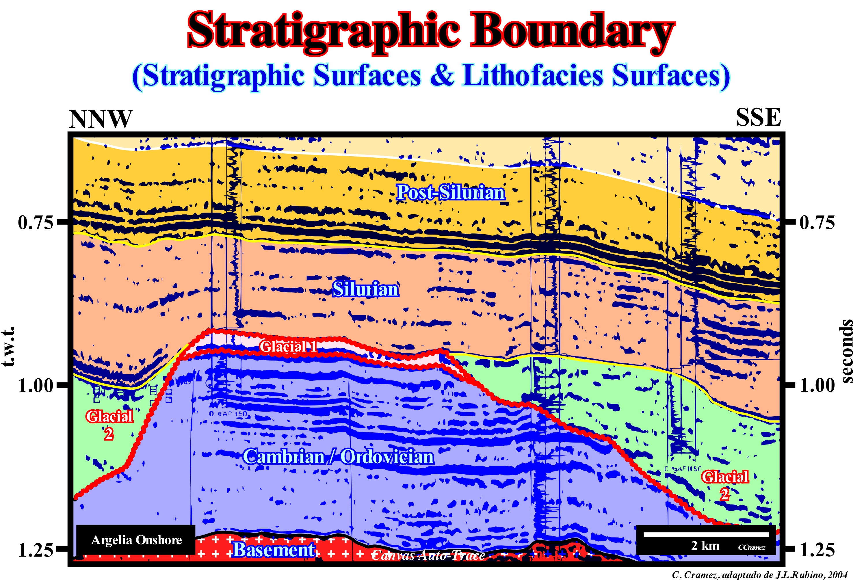
In sequential stratigraphy, the stratigraphic boundaries that interest us most are the boundaries between the stratigraphic cycles, that is, the unconformities (erosional surfaces) created by significant relative sea level falls, which has nothing to do with the five types suggested by the International Stratigraphic Guide (ISI, 1980), where the prefixes holo-, para-, lento-, no- and hypo- are used to designate certain characteristics of the units or a stratigraphic boundary, but, in fact, any geoscientist use them. We only consider the unconformities and the downlap surfaces. On this tentative geological interpretation of a Canvas auto-trace of a detail of a seismic line shot in Algeria onshore , from bottom to top, different sedimentary intervals, limited by unconformities, can be recognized: (i) The Basement, that corresponds to a Precambrian substrate ; (ii) A Cambrian / Ordovician interval, with a, more or less, parallel internal configuration, which rests in discordance on the Precambrian basement and which was, deeply, eroded during the Late Ordovician glaciations (the filling of glacial valleys is evident) ; (iii) A Glacial interval (Glacial 1), almost concordant with the Cambrian/Ordovician complex, and, practically, with no internal reflectors ; (iv) Filling of the Glacial Valleys, created during the great phase of glacial erosion of the Late Ordovician (Glacial 2), whose internal configurations are sub-horizontal, probably related with the Silurian marine ingressions, with which are deposited sediments rich in organic matter (potential source- rocks) ; (v) A Late Silurian shaly interval with a parallel internal configuration, parallel with the filling of the underlying glacial valleys and (vi) Post-Silurian sediments, which have a parallel internal configuration. The erosional surfaces of glacial origin that delimit the glacial cycles appear, often, to be angular unconformities (cryptic unconformities tectonically enhanced), while the boundaries between the different marine intervals correspond to, more or less, cryptic * eustatic unconformities, induced by significant falls of the relative sea level. The relative sea level is a local sea level, referenced at any point on the Earth's surface, which can be the base of the sediments or the sea floor and which is the result of the combined action of absolute (eustatic) sea level (supposed global and referenced to the Earth's centre, and tectonics). The internal configuration of the glacial intervals is, practically, without reflections, whereas the marine intervals have a parallel internal configuration. The boundaries between these intervals are stratigraphic. They underline a hiatus, which when important, corresponds to an unconformity. Along a stratigraphic boundary the hiatus varies from place to place. The concept of bedding or stratification surface is totally dependent on the time scale and the rocks considered. Unconformities, in the deep parts of the basins, have a minimum hiatus that gives the age of unconformity (age of the relative sea level fall, which created the erosional surface that characterizes it and that in deep-water correlates with a paraconformity). The boundaries of a sequence-cycle correspond to erosional surfaces in the proximal part of the basin (coastal plain, platform and upper continental slope) and to their correlative paraconformities in deep-water). The age of an unconformity can just be, correctly, determined dating to the pelagic horizons that cover the turbiditic layers of the submarine basin floor fans. The Earth's climate history since 2.5 Ma was controlled by Milankovitch's planetary orbit variations, comprising alternating periods of glaciation and thawing with a dominant frequency of 41,000 years. Concurrently, eustatic sea level fluctuated from 70 to 130 meters, causing marine ingressions and rapid sediment regressions of the shoreline on all continental shelves of the world.
(*) Unconformity that is not, at least locally, tectonically enhanced and difficult to recognize. This type of unconformity is very frequent in basins where extensional tectonic regimes are predominant. This is particularly true continentward of the basin edge and in deep-water. The unconformities are cryptic, since the erosion that characterizes them is difficult to put into evidence. Continentward of basin edge, just the fills of the incised valleys underline, clearly, the erosional surface, which accompanies the relative sea level fall. Seaward of the basin edge, fillings of submarine canyons and valleys allow the identification of the limits of the stratigraphic cycles, that is, the unconformities and their correlative paraconformities.
Stratigraphic Map.........................................................................................................................................................Carte stratigraphique
Mapa estratigráfico / Mapa estratigráfico / Stratigraphische Karte / 地层剖面图 / Стратиграфической карта / Mappa stratigrafica, Carta stratigrafica /
Map that includes several data to show a set of attributes of strata such as: (i) Distribution of sedimentary environments ; (ii) Thickness of certain stratigraphic intervals ; (iii) Type of sediment in a certain interval ; (iv) Strike and dip of the strata and (v) Any other characteristic of the strata of a given area.
See: « Geological Section »
&
« Stratigraphy »
&
« Correlation »
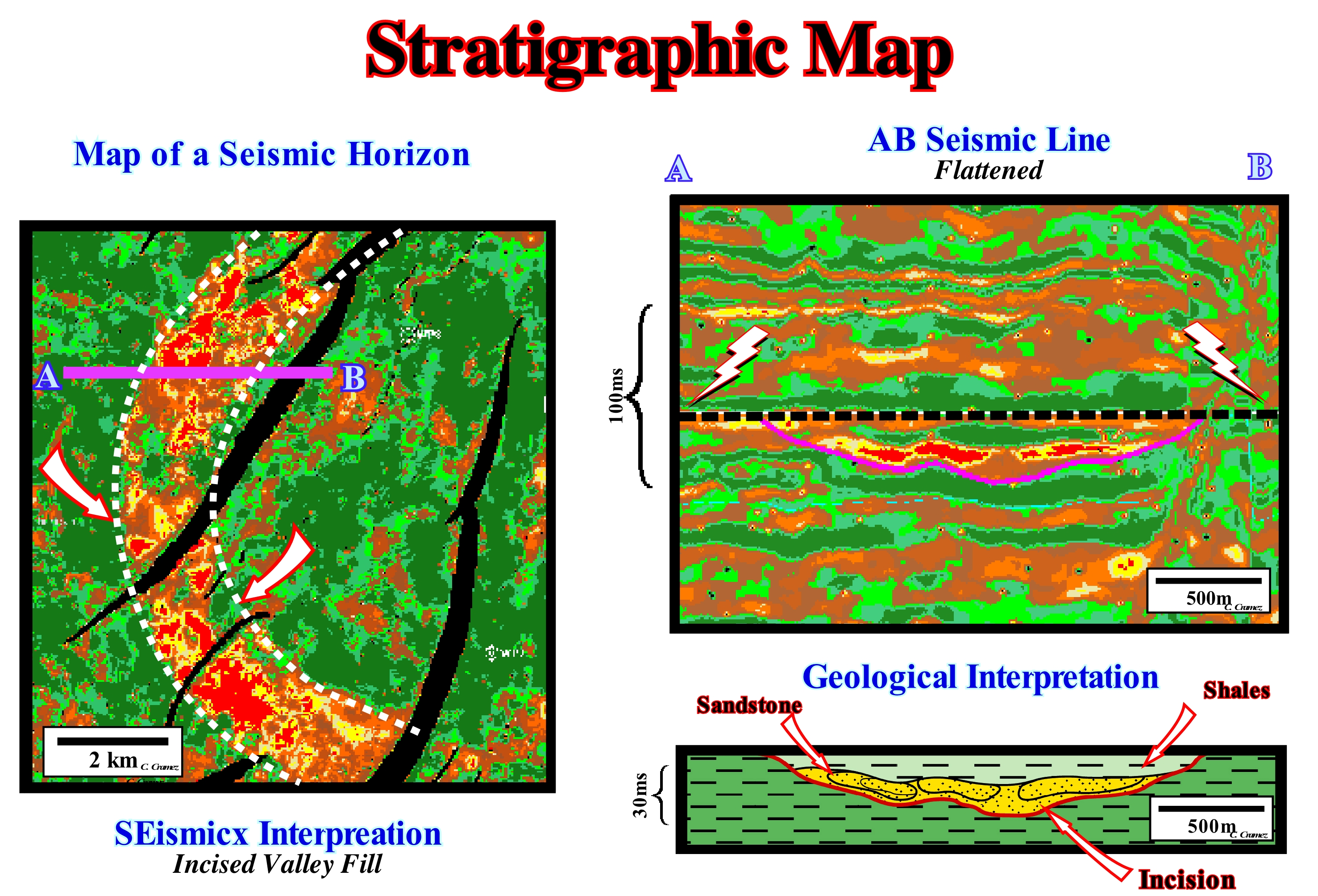
On this tentative geological interpretation of certain seismic data (3D) of a Thai oilfield, certain sedimentary attributes are illustrated. In the map on the left, is illustrated the map of the seismic amplitude along a given reflector (in fact, it is not the amplitudes of a reflector but rather the stacking of amplitudes of a time interval of, more or less, 100 milliseconds). This type of map corresponds, roughly, to a geological map (with a flat topography) and is interpreted in the same way. The problem is that at present-time, the vast majority of geoscientists, who work in the oil companies, can not read a geological maps. In this example, a number of normal faults and the filling of an old channel are, easily, recognized. Regionally, this filling corresponds to an incised valley fill, which a water-course was forced to incise since the provisional equilibrium profile of the water-courses were broken by a significant relative sea level fall. Indeed, a relative sea level fall may displace several kilometers seaward the shoreline and, thus, the mouth of the rivers. Since the relative sea level (eustasy plus tectonics) begins to rise, the incised valley is filled during the final deposition of the lowstand prograding wedge (LPW), that is to say, immediately before relative sea level floods the plain coast and, once again, displaced the mouth of the rivers continentward. The geometry of the incised valley fill is, perfectly, visible on the seismic line (right at the top). On this line (flattened in relation to the first flooding surface of the transgressive interval), the base of the incision is underlined by a continuous line (in red) and the first flooding surface by a dashed line. The sandy fill (reservoir-rock of the oil field) is underlined by strong seismic amplitudes as illustrated in the geological interpretation (bottom right).
Stratigraphic Thickening...........................................................................................................Épaisseur stratigraphique
Espessura estratigráfica / Espesor estratigráfico / Stratigraphische Dicke / 地层增厚 / Стратиграфическая мощность / Spessore stratigrafica /
Thickness of a stratigraphic unit measured perpendicular to the surfaces that limit it. In an exploration well, the stratigraphic thickness is equal to the perforated thickness (measured vertically) multiplied by the cosine of the dip of the stratigraphic unit.
See : « Dip (bed)»
Stratigraphy.............................................................................................................................................................................................................Stratigraphie
Estratigrafia / Estratigrafía / Stratigraphie / 地层学 / Стратиграфия / Stratigrafia /
Geology branch studying the arrangement of rocks in layers. Mainly, used in the study of sedimentary and volcanic rocks. The stratigraphy encompasses several subdivisions such as litostratigraphy, biostratigraphy, seismic stratigraphy, sequential stratigraphy, genetic stratigraphy, etc.
See: « Stratum »
&
« Seismic Stratigraphy »
&
« Relative Age »
The term stratigraphy is the description of all the rocky bodies that form the Earth's crust and its organization into distinct and useful mappable units, based on their intrinsic properties or attributes, in order to establish their distribution and relations in space and their succession in time, and to interpret the geological history. Thus, it can be said that the stratigraphy has three purposes: (i) To determine the age of the rocks from the fossils that they contain ; (ii) To determine the environment, in which the rocks formed, from the physical and chemical characteristics of the rocks and their fossils ; (iii) Correlate the rocky horizons that occur in different regions or on different continents. When a sedimentary column is divided into parcels limited by unconformities (erosional surface created by a significant relative sea level fall), stratigraphy is said to be sequential (Vail). In sequential stratigraphy, the basal level (*) and its behaviour controls the sediment stacking pattern. Above the base level, erosion and transport dominate, while below the base level the sediments accumulate and are preserved. In sedimentary basins connected to the sea, the basal level is controlled by the combination of eustasy (absolute or eustatic sea level changes) and tectonics (subsidence or uplift of the sea floor), while in the endorheic basins (not connected to the sea), the climate and tectonics control variations of the base level. In other words: (i) In periods of high base level, there is much space to be filled by the sediments ; (ii) In periods of low base level is the opposite, there is little space and therefore the sediment easily fill the accommodation. The consequences of these, more or less, opposite situations are sedimentary transgressions and regressions. In the first case (high base level or rising), the sediments are not distributed throughout the basin, being confined in continental environments (rivers, lakes) and near the coastline. If the base level continues to rise (increasing the available space), the shoreline is, progressively, withdrawn, registering a marine transgression. In the second case (low base level or falling), the available space is quickly filled by the sediments, and the continuous sedimentary charge produces a sedimentary regression. When the sedimentary column is divided into packages bounded by downlap surfaces (use of the maximum flood surface as the boundary) the stratigraphy is said to be genetic. For Galloway (1989), the sedimentary basin margins are characterized by repetitive episodes of degradation, punctuated by periods of retrogradation. The resulting stratigraphic units, genetically related, consist of: 1) Depositional systems ; 2) Nondeposition surfaces and 3) Thick intervals affected by gravity tectonics and the crustal response to syndepositional structural discontinuities produced by the sedimentary charge. These units are limited by hiatus surfaces that register the maximum marine flood of the basin margin. Sequential stratigraphy is, particularly, used by geoscientists working in oil companies, since potential reservoir-rocks all terminate onlaps (coastal or marine) against the unconformities. Genetic stratigraphy is very useful in determining the location of the most likely potential marine source-rocks, since they are associated with the climax of marine ingressions. Chronostratigraphy (time) is based on the physical relationships between rocks, whether they are determined in the field, electrical logs or seismic lines. As in the seismic lines the continuity of the interfaces far exceeds the continuity observed in the field, they are used to determine chronostratigraphy. High-hierarchical stratigraphic intervals, such as sequence-cycles, sedimentary systems tracts and depositional systems, can be individualized in the field and under favourable conditions on the seismic lines. Eustatic cycles, which induce stratigraphic cycles, have a typical hierarchy. On the scale of electrical records and seismic interpretation, stratigraphic intervals can be correlated to define sedimentary units within a certain time span. Chronostratigraphic correlations (time correlations) contrast with the lithological correlations, which define rocky units deposited in similar sedimentary environments. The electrical correlations of chronostratigraphic intervals are dependent on the continuity and type of sediments within the strata. The seismic correlations are more reliable than the electrical log correlations, but the resolution of the seismic lines is much weaker than the resolution of the electrical logs. A simultaneous use of chronostratigraphy and lithostratigraphy gives excellent results mainly in the understanding of the geological hiatuses.
(*) Do not confuse base level with the relative sea level, since the base level may be subaerial.
Stratigraphy(Objectives)...................................................................................................................................................Stratigraphie (Objectives)
Estratigrafia / Estratigrafía (objetivos) / Stratigraphie (Ziele) / 地层学 (目标) / Стратиграфия (цели) / Stratigrafia (obiettivi) /
The stratigraphy has three main objectives: (i) To determine the relative age of rocks relative to each other and from their fossils ; (ii) To determine the environments in which the rocks formed, using their physical and chemical characteristics and their fossils and (iii) Correlate the layers of rocks that occur in different regions or even in different continents.
See: « Stratigraphy »
&
« Sedimentary Environment »
&
« Deposition (clastics) »
In addition to the main objectives of the stratigraphy: (i) To determine the relative age of rocks relative to each other and from their fossils ; (ii) Determine the environments in which the rocks formed, using their physical and chemical characteristics and their fossils ; (iii) To correlate the layers of rocks that occur in different regions or even in different continents, in the petroleum exploration, it also allows: (a) Determine potential source-rocks, that is, rocks rich in organic matter, that when buried, can generate hydrocarbons ; (b) Determine the most likely reservoir-rocks, that is, rocks with a porosity and permeability that allow them to store hydrocarbons and, in that case, an eventual economic production and (c) Determine the sealing-rocks, which can close vertical (structural traps) or laterally the reservoir-rocks (nonstructural traps, whether morphological or morphological by juxtaposition*). The determination of potential source-rocks is easier in the genetic stratigraphy, in which the different sedimentary packages are limited by downlap surfaces, which means that the genetic stratigraphy divides the stratigraphic column into cycles of sedimentary transgresions-regression. Within a sequence-cycle, that is particularly true upstream of the continental edge (limit between the slope and the continental shelf), where the sequence-cycles are just constituted by the transgressive interval (increasingly important marine ingressions and increasingly smaller sedimentary regressions), and the highstand prograding wedge (increasingly smaller marine ingressions and increasingly important sedimentary regressions), since, globally, the lowstand systems tracts group (submarine basin floor and slope fans and lowstand prograding edge) are regressive (when submarine basin floor fans basin are not well developed). Potential marine source-rocks are, generally, associated with the interfaces between sedimentary transgressions (set of increasingly important marine ingressions or eustatic paracycles and increasingly smaller sedimentary regressions) and sedimentary regressions (set of increasingly smaller marine ingressions or relative sea level rises in deceleration and increasingly important sedimentary regressions), i.e., associated with downlap surfaces. A marine transgression is a sea level rise (relative or eustatic) that moves the shoreline continentward, with a small ravinment surface forming in the pre-existing topography, but without deposition. This means that a marine transgression increases or creates available space for the deposition, which occurs only during the stability period of relative sea level which occurs after marine ingression. The relative sea level is a local sea level referenced to base of the sediments (top of the continental crust) or to the sea floor, which is the result of the combined action of the tectonics (subsidence or uplift of the sea floor) and absolute (eustatic) sea level, which is supposed to be global and referenced to the Earth's centre. The reservoir-rocks are more easily determined in sequential stratigraphy, which subdivides the stratigraphic column into discrete sedimentary packages, that is, by erosional surfaces induced by significant relative sea level falls. All potential reservoir-rocks, whether deposited in low or highstand geological conditions, are onlapping against unconformities, either by marine onlaps (for the reservoir-rocks associated with the submarine basin floor or slope fans) or by coastal onlaps (for reservoir-rocks of the lowstans prograding wedge, transgressive interval and highstand prograding wedge). The location of the sealing-rocks is more difficult since it requires a stratigraphic analysis at the hierarchical level of the sequence-paracycles, which are deposited during the stability period of relative sea level that occurs after each eustatic paracycle or, in other words, after each increment of relative sea level rise, that form the different subgroups of sedimentary systems tracts of a sequence-cycle. During a relative sea level rise there may be several marine ingressions, but between them there is no relative sea level fall.
(*) Morphological traps by juxtaposition correspond to what many geoscientists mistakenly call traps against fault, forgetting that a fault never can create a trap. All that a fault can do is to juxtapose rock intervals with different displacement pressures, which can develop a trap by juxtaposition if the geometrical conditions are appropriate.
Stratosphere.............................................................................................................................................................................................................Stratosphère
Estratosfera/ Estratósfera / Stratosphäre / 平流层 / Стратосфера / Stratosfera /
The second largest layer of Earth's atmosphere, above the troposphere and below the mesosphere. The stratosphere underlines the stratification of the atmosphere as a function of temperature. The layers above the stratosphere are warmer and the underlying layer (troposphere) is colder.
See: « Atmosphere »
&
« Troposphere »
&
« Hadley's Cell »
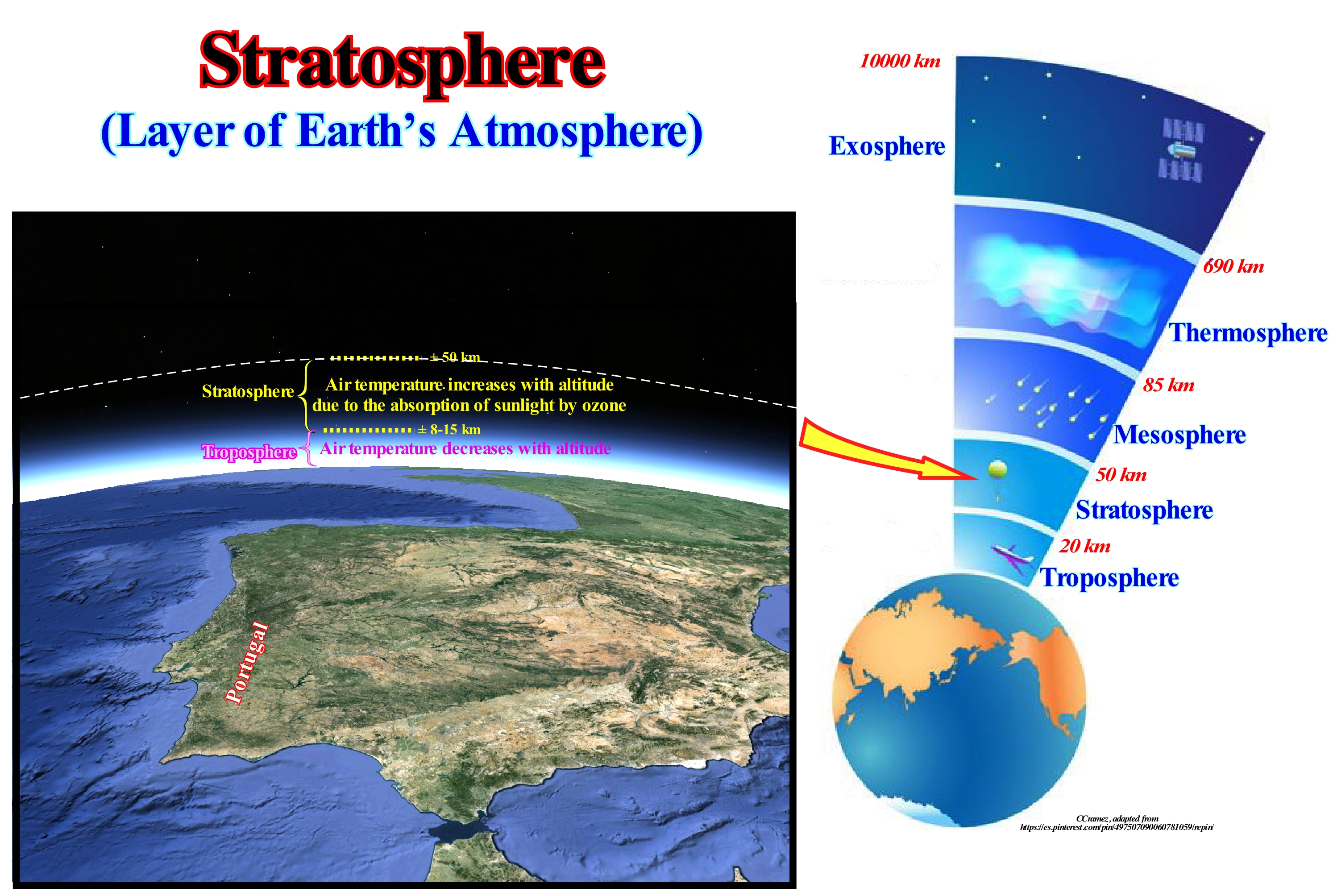
The atmosphere has a very strong vertical pressure gradient. It varies rapidly per unit distance. This decrease in atmospheric pressure with altitude is, more or less ,regular and follows a logarithmic function. On the contrary, the variation of the temperature with the altitude is much more complex. The gradient of temperature drop in the first kilometers above the Earth's surface inverts several times (pauses), which individualizes several layers. The stratosphere is the large atmospheric layer above the troposphere (lower main layer of the atmosphere). It is limited between altitudes of about 12 to 42 kilometers. The temperature of the air increases, slowly, with the height in the stratosphere, unlike in the troposphere, where the temperature decreases, rapidly, with height. This rare structure in temperature evolution is caused by the absorption of sunlight through the ozone layer* (the lower stratosphere, which surrounds the Earth and which has large amounts of ozone and thus protects the entire Earth from much of the coming ultraviolet radiation of the sun). All the time (state of the atmosphere) stops at the top of the troposphere (called tropopause). The stratosphere is, essentially, cloud-free. When a high storm with anvil shaped clouds, it is very likely that the anvil cloud is bumping into the lower part of the stratosphere. Frequent storms in the troposphere are characterized by lightning and thunder, produced by one or more cumulonimbus clouds (also known as storm clouds). A typical storm cloud has a diameter of 10-20 km, reaches altitudes of 10-20 km, lasts on average 30-90 minutes and moves with a speed of 40-50 km/h. They can be identified by their wide, shiny, whitish top, which projects toward the winds forming a ledge called anvil. That is why certain geoscientists speak of Anvil clouds, which are mostly formed of ice and are located at the top of thunderstorms. The central portion of the anvil clouds contains heavy snow, which melts when it falls into hot air air, thus becoming rain. About 50% of the rain produced by storms is formed this way. Few planes can fly in the stratosphere since the air is so thin that there is not enough lift to keep it in the air. However, some spy planes, such as U-2 and SR-71, can fly at the bottom of the stratosphere.
(*) Triatomic allotrope (O3) that is, one of the forms of the chemical element oxygen that is much less stable than the diatomic oxygen (O2) and which forms when the oxygen molecules (O2) break due to the ultraviolet radiation and the atoms Separately, they combine individually with other oxygen molecules
Stratotype................................................................................................................................................................................................................................Stratotype
Estratotipo / Estratotipo / Stratotyp (Aufschluss geben) / 层型剖面(露头类型) / Стратотип / Stratotipo (affioramento-tipo) /
Designates an outcrop of a stratigraphic unit or stratigraphic boundary that serves as a reference. A stratotype is a specific set of strata used to define or characterize a stratigraphic unit or boundary.
See: « Maker Bed »
&
« Stratigraphy »
&
« Climate »
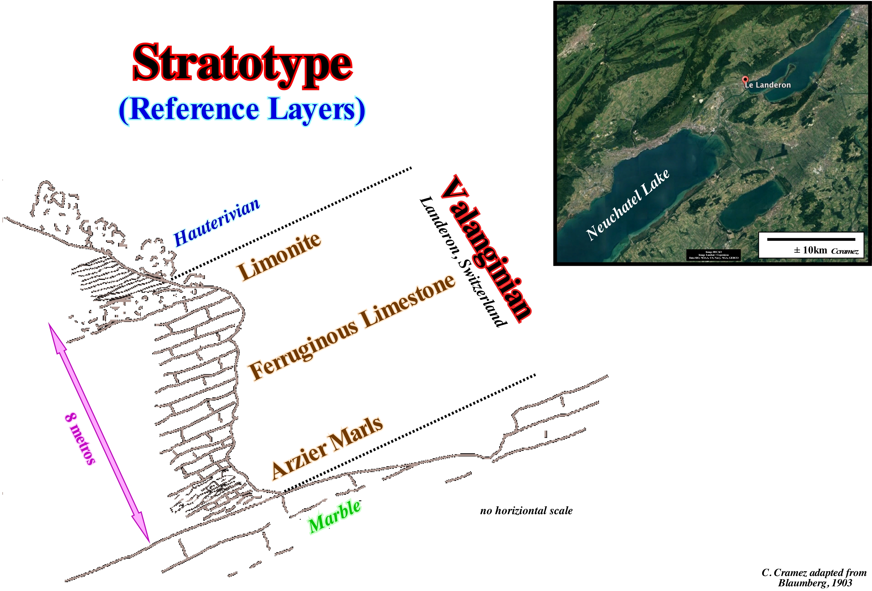
A stratotype can be defined as either a unit as a whole (stratotype unit) or as a boundary between two units (boundary stratotype). The International Commission on Stratigraphy suggests that a stratotype section must has: (i) A defined in stratigraphic sections that have good outcrops, of sufficient thickness that guarantees a significant time interval ; (ii) A continuous sedimentation, with no hiatus or condensed levels near the limits ; (iii) No tectonic or synsedimentary alterations ; (iv) Nonmetamorphism or strong diagenetic changes ; (v) Paleomagnetic and geochemical signals can be identified ; (vi) Abundance and diversity of well preserved fossils throughout the section ; (vii) Absence of facies changes in or near the boundaries ; (viii) Favourable environments for biostratigraphic correlations over long distances ; (viii) Be located in an accessible location, i.e., no remote or expensive shipments are required. Some authors consider different types of stratotypes stratigraphies (https://fr. wikipedia.org/wiki/Stratotype): (i) Holostratotype ; (ii) Parastratotype ; (iii) Lectostratotype ; (iv) Neostratotype ; (v) Hipostratotype. Holostratotype is the original stratotype chosen and described as the reference outcrop at the moment of definition of the stratigraphic unit. Parastratotype is the determination described at the same time as the holostratotype and in general in the proximity, to increase its definition. Lectostratotype is a stratotype, chosen after the definition of the stratigraphic unit, in the absence of a holostratotype, to serve as a reference; it can be chosen outside the zone type. Neostratotype is a new stratum chosen to replace a disappeared stratotype. Hipostratotype is defined a posteriori to complete the knowledge of the unit or a boundary (different paleogeographic domain). This figure shows the Valanginian stratotype (2nd floor of the Early Cretaceous), which is characterized by a series of events that suggest environmental and climatic variations. These events are neither catastrophic nor instantaneous, such as the Maastrichian event, but reflect gradual changes in the global biospheric balance. The three typical Valanginian regions are Jura (Switzerland), Provence (France) and Friuli (Italy, near Trieste). All these regions are situated on the North (Switzerland and Provence) and South (Friuli) shores of the Tethys Sea* (West sector). In Switzerland (Landeron), the Valanginian is about 8 meters and consists of three intervals: (i) Arzier Marls ; (ii) Ferroginous Limestone and (iii) Limonite. At that time (± 135 Ma), Pangea was being fractured. Volcanism was very active and the climate warm and humid in almost all areas. The temperature gradient between the poles and the equator was, relatively, small due to the efficiency of the latitudinal heat transport. The occurrence of glendonite (a form of calcite formed at low temperature, which suggests the presence of glaciers) in the Late Valanginian suggests a global cooling. The period between the Valanginian and Hauterivian is characterized by a δ13C carbon isotope increase of about 1.5%, which was found in the pelagic sediments of the oceans. Fe-rich sediments are frequent in Valanginian deposits, as well as Mg and P (phosphorus) deposits. The sea level rose, though less than in the middle Cretaceous. The Valanginian represents the first anoxic event of the Cretaceous, which produced fewer mother rocks than the Aptian-Albian event. The drowning of the carbonated platforms was accompanied by a great sedimentary rupture and a major biota crisis in the shallow seas. Another stratotype was defined in the French commune of Berrias, in the department of Ardeche in France, which is known all over the world, because geoscientists and in particular Henri Coquand, discovered, in 1852, a limestone layer typical of the Early Cretaceous, age to which he gave the name of Berriasian (http://www.berrias-et-casteljau.fr/article.php3?id_article=27). It was at bed of Graveyrou river, near the old quarries of Berrias, that Coquand discovered these limestone rocks. To know what the Berriasian is we must travel 140 million years ago, when the Jurassic had just finished. We would see that the plain that today goes from Privas to Ales was covered by a sea one full of belemenites and ammonites and that the climate was warm, tropical, and slightly to the north of that sea, in the continent, great dinosaurs, still present, walked between palm trees and ferns. These geological conditions, that is, the Berriasian, lasted between five and six million years.
(*) Sea that existed between the two small supercontinents Laurasia (to the North) and Gondwana (to the South) that constituted the supercontinent Pangea that existed between 540 and 200 million years ago.
Stratum (Bed)........................................................................................................................................................................................................................................Strate
Estrato / Estrato / Stratum, Schicht / 阶层 / Слой (пласт) / Strato, Giacimento /
Sedimentary body of tabular geometry individualized, to the naked eye, of the lower and upper levels either by lithological changes or by changes in the deposit conditions.
See: « Sequential Stratigraphy »
&
« Stratigraphy »
&
« Bed »
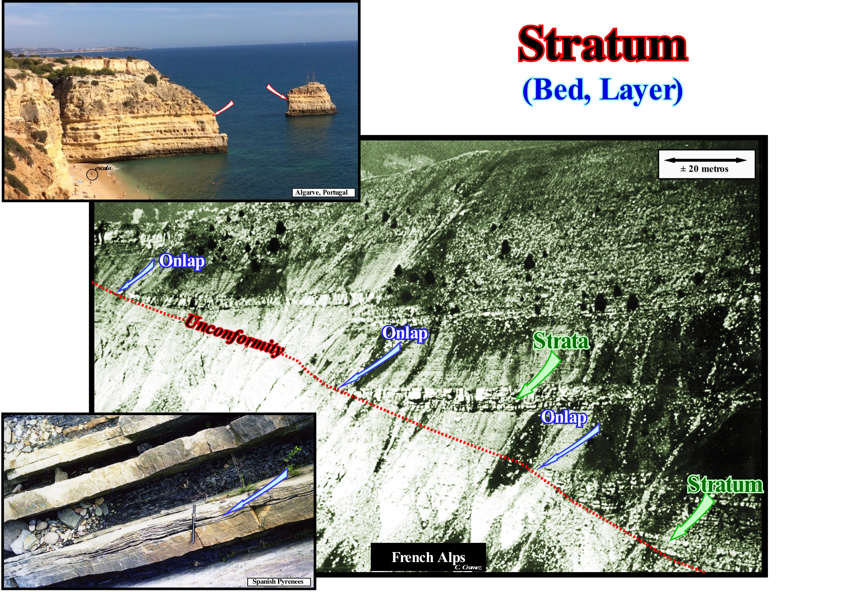
Stratum is the name given to each of the layers in which the sedimentary, pyroclastic and metamorphic rocks (when these are the consequence of sedimentation processes) are divided. In general, a stratum is deposited, more or less, horizontally (as is the case in the coastal photography of Portugal, Algarve). However, horizontal and uniform strata evolve under the action of tectonic stresses, with changes in structure behaviour (inclination and even inversion) and shape (folding). In addition, some strata may have, from their deposition, different dips between them and different thicknesses, as is the case in a cross-bedding. The genesis of cross-bedding is quite simple, when associated with the deposition of sedimentary particles transported by rivers when they reach the foothills of a mountain chain and form alluvial fans, terraces and other forms of accumulation. These sediments are arranged according to gravity and intersect with each other due to the changes in river courses that deviate from the great floods. These are often sporadic as is the case in arid climates, simply because the previous flood has produced an accumulation that the river must contour to deposit the sediments with different inclination, direction and thickness. Over time, these deposits of sand or shales can be consolidated and form sedimentary rocks, maintaining the original arrangement of the sediments that formed these deposits. Certain geological events may give rise to more or less planar rocky levels, which can not be considered strata, such as the plates that form perpendicular to the tectonic stresses during the metamorphism, not to mention the sills (igneous masses of tabular form, often, horizontal and introduced, laterally, between strata) and in the laccoliths (concordant igneous intrusions injected between two sedimentary strata, with a dome or mushroom form). Only on the continental and delta slopes are the strata deposited at a certain angle seaward (tilting towards the deep part of the basin). In similar environmental conditions, water and wind tend to spread the sedimentary particles of the same type, relatively thin, but over a large area. If the environmental conditions change at the deposition site, it may happen that: (i) Different types of sediment may settle down above the previous deposits ; (ii) There is a period of time during which the sediments are not deposited or (iii) The original deposit can be eroded. When the depositional environment is the same, the type of deposited sediment is similar on all successive depositional surfaces. Sediments tend to be more similar within a stratum (depositional surface) than in different strata. On the other hand, lateral continuity has limits. Even within a stratum there may be lithological changes. All strata are lapout, laterally, that is, they disappear, leaving no particular record of the depositional time in the pinchout area. When the sediment type, which characterizes a stratum, changes laterally, within the same level and, gradually, this means that, probably, the deposition environment has also changed, laterally, gradually. In the photograph of the French Alps (sandstones of the Annot formation) an unconformity is very visible. It corresponds to an erosional surface or is correlated, upstream, with an erosional surface induced by a significant relative sea level fall. The strata that are overlapping rests against it by onlaps (marine in this case, since the environment of deposition is foredeep-water). The unconformity seems to have been tectonically enhanced, since the underlying strata are truncated. The strata overlying the unconformity correspond to submarine basin floor fans, that is, to sandy turbidite lobes that were deposited instantaneously (in geological terms) in the deeper parts of the basin. On top of each lobe (stratum), not to be confused with set of lobes (strata, strata) was deposited thin layer of pelagic shales whose age allows to date not only the submarine basin floor fans, but also the unconformity, since they date the minimum hiatus between the underlying sediments (lower sequence-cycle) and the overlying sediments (upper sequence-cycle) that corresponds, practically, to the age of relative sea level fall that induced the unconformity. The same is true, though on a smaller scale, of the turbidite deposits of the Spanish Pyrenees, as illustrated above.
Stream....................................................................................................................................................................................................................................................Ruisseau
Corrente (córrego) / Arroyo / Bach / 溪 / Ручей / Ruscello /
Water-course flowing in a confined manner, i.e., in a bed defined by lateral banks. Function of its location and of certain characteristics, a stream can refer to a brook, creek, torrent, channel, distributive, river, etc.
See: « Depositional Base Level "
&
« Fluvial Deposition »
&
« Bayline »
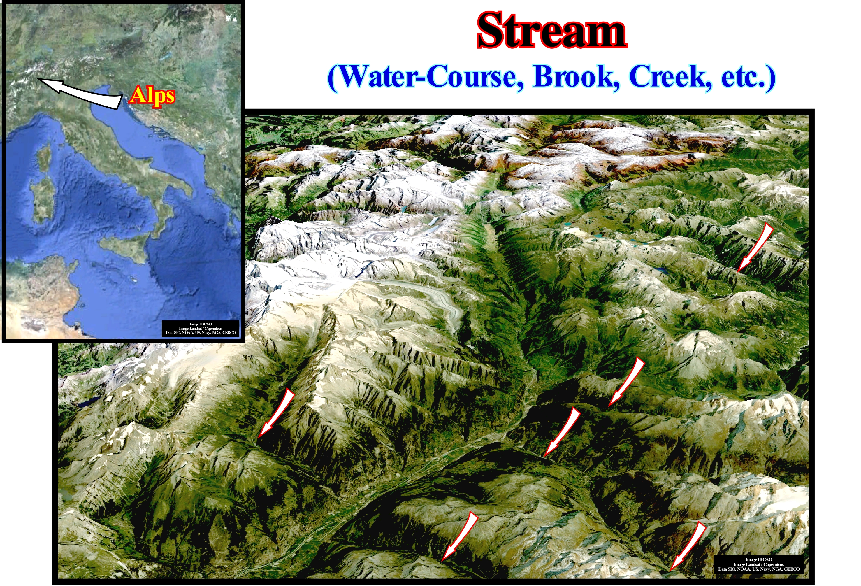
A stream or a water-course or water-low is any body of flowing water, such as rivers, brook, creek, rivulet, run, runnel, among others. A river is a natural course of water, usually freshwater flowing in the direction of an ocean, lake or other river. A stream is a groove or trough which runs a lot of water, that is, a body of water smaller than a creek that flows into the sea or into a water body. A stream is a water-course, navigable or not, greater than brook or runnel and smaller than a river. A brook is a stream of water, smaller than a river, which flows into the ocean or into another course (part of the freshwater environments). A stream is a rather bulky and not permanent water-course. A torrent is a type of special watercourse because it is characterized by its impetuosity and unevenness. A run is a tight path between mounds in which water can seep out during the rainy season. A stream, river, stream, etc., are water streams which, under the action of gravity, flow downstream by reducing their potential energy, which varies in space and time, depending on the volume of water, flow gradient and his bed. Viewed in cross section, streams and rivers have a bed, often of stones or gravel, though clay or silt are not unknown and a pair of banks which constrain the river on either side. By convention the names left bank and right bank are allocated looking downstream away from the source. The opposite direction is, of course, upstream. Sometimes a river is artificially diverted, to make it easier to use for shipping. This is sometimes called canalisation. The new course is known as a navigation or cut. The two alternative routes are known as channels, which word may also be used in perfectly natural rivers for branching sections or the deeper navigable part where the flow is strongest and the water deepest. (https://www.quora.com/What-are-the-parts-of-the-river). In a stream the following parts can be distinguished: : (i) The Spring ; (ii) The Source ; (iii) The Headwaters ; (iv) The Confluence ; (v) The Run ; (vi) The Bar ; (vii) The Riffle ; (viii) The Channel ; (ix) Rapids ; (x) The Floodplain ; (xi) The Thalweg ; (xii) The Wetted Perimeter ; (xiii) The Knickpoint ; (xiv) The Waterfall or Cascade ; (xv) The Mouth ; (xvi) Drainage basin ; (xvii) The Gaging Station. The Spring* is the point at which the stream begins or emerges from an underground path through poorly consolidated sediments or caves (the latter case being particularly frequent in calcareous regions where karsification is abundant and where a current may have an underground course, more or less, long before it emerges. The spring is the point where groundwater flows out of the ground, and where the surface of the aquifer meets the ground surface. The Source is the spring from which the current originates or any other point that originated it. The source is simply the point at which it starts, i.e. the original point from which the river or stream flows. A river's source is sometimes a spring. The Headwaters is the part of the current near the source (term used, especially when the current has several sources). The Confluence is the point where two currents come together (when two distributives have approximately the same importance, the confluence may be called a fork. The Run is the rectilinear segment where the stream flows without agitation (swimming-friendly area), the current it is deeper and flows more slowly. The Bar is a shoal that develops in a stream as sediment is deposited as the current slows or is impeded by wave action at the confluence. The Riffle is the segment or area where the flow is shallower and more turbulent. The Riffle is segment or area where the water depth is lower and more turbulent. The Channel is the depression created by the erosion that allows the flow of the current. The Floodplain is the region adjacent to the stream which is subject to being flooded when the stream overflows. The Thalweg is the longitudinal section of the river or the line connecting the lowest point of the channel from the source to the mouth. The Wetted Perimeter is the line on which current surface meets the channel walls or the perimeter of the cross sectional area that is "wet". The Knickpoint is the point on a stream's profile where a sudden change in stream gradient occurs. The Waterfall or Cascade is the fall of water where the stream goes over a a knickpoint. The Mouth is the point at which the current is discharged and which, generally, corresponds to the shoreline, possibly via an estuary or delta. The Drainage basin is the area of land where water flows into a stream. The Gaging Station is the demarcation point along the current path which is used as the reference mark and where the control apparatus are installed. A river basin or drainage basin for a water-course refers to the whole of the territory and of tributary rivers that drain the waters for this structural water-course, which usually flows into an ocean. A river basin may be: (i) Exorheic, when the waters drain directly or indirectly into the sea ; (ii) Endorheic, when the waters fall in a lake or closed sea ; (iii) Cryptorheic, when the waters flow into calcareous rocks (they are porous), generating subterranean lakes (caves) ; (iv) Arheic, when the river dries at a certain point in its course or when its waters are directed to groundwater levels. The drainage network or hydrographic network designates the natural or artificial systems capable of draining surface water, usually from the rains, which are composed of channels connected to each other, and to this set of connected channels is called the drainage network . Drainage nets can be either artificial or natural. A natural network can be: dendritic, rectangular, radial, centripetal, parallel, cross, annular, complex, etc.
Stromatolite............................................................................................................................................................................................................Stromatolithe
Estromatólito / Estromatólito / Stromatolith / 叠层 石 / Строматолит / Stromatoliti /
Accretional structure, more or less, stratified formed in shallow water by the capture, enveloping or cementing of sedimentary grains by biofilms of microorganisms, especially by cyanobacteria (commonly known as blue algae).
See: « Cyanobacteria »
&
« Algae »
&
« Photosynthesis »
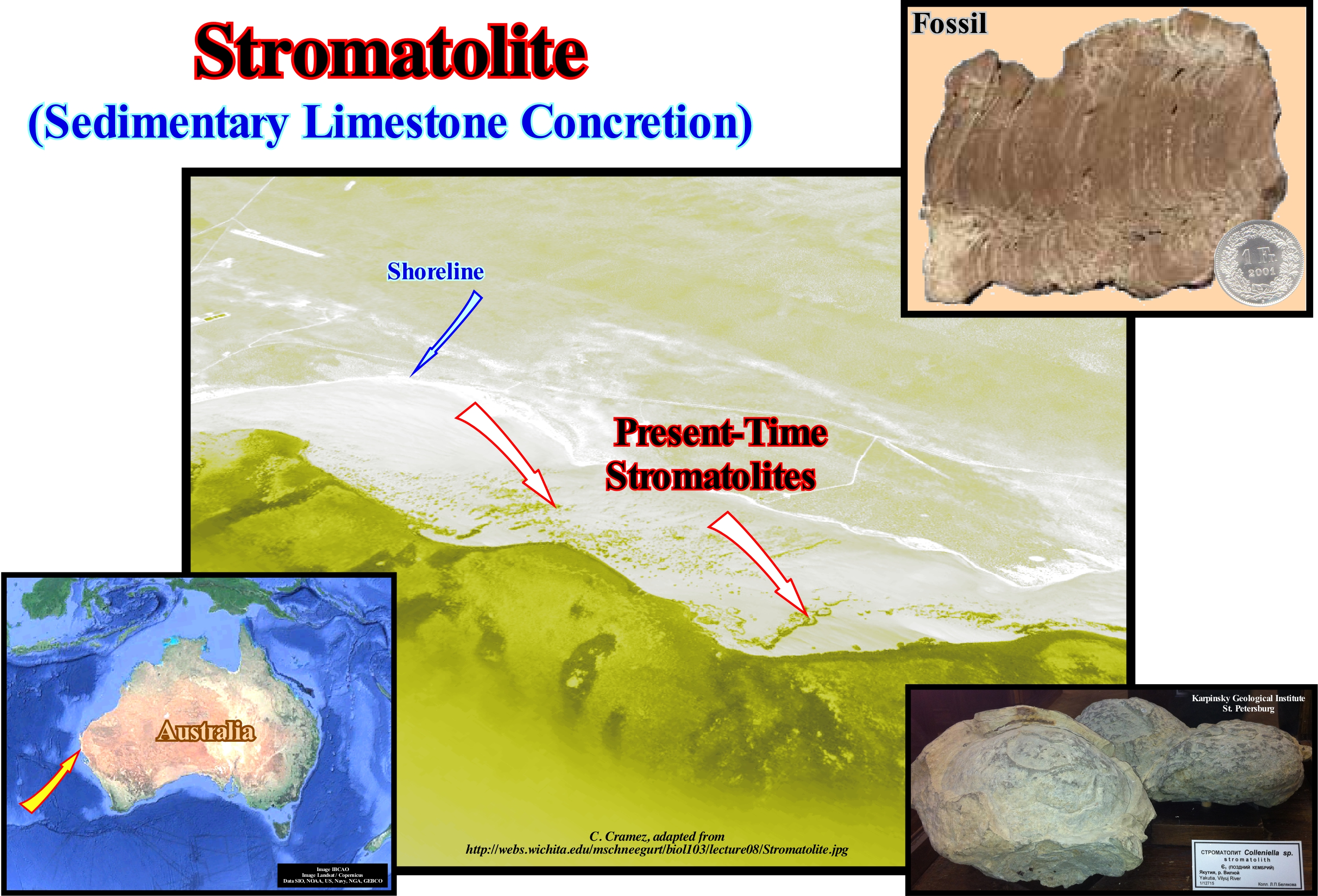
A stromatolite, as a structure, is not living, only the bacteria that constitute it are. Depending on the cases, the inside of a stromatolites may be almost, totally, full or have a significant amount of voids in which the bacteria or other organisms hide. Most of a stromatolites column is solid, except for a thin surface layer which is the living part. This living layer is formed by a jelly of filaments of cyanobacteria, as in bacterial carpets. The stromatolites column is constructed by capturing and sedimentation processes. The filament jelly : (i) Holds the sedimentary particles between its filaments ; (ii) Induces the sedimentation of sedimentary particles, thanks to its photosynthetic activity, consuming CO2, decreasing the CO2 partial pressure in this micro-environment, which promotes the precipitation of CaCO3 ; (iii) The particles are trapped and then welded together, constituting a series of solid crusts that form a solid rock called cyanobacterial laminitis. Stromatolites have been around for 3.5 billion years, as fossils found in western Australia suggest, but they exist on all continents. Early scientific publications suggested that stromatolites reached a maximum extent and diversity of shapes and structures in the Precambrian (about 1.5 billion years ago), which would have held to about 700 million years. However, more recent data show that the number and diversity declined much earlier than the benefit of other species. Many geoscientists now think it most likely that stromatolites were the only way of life, or the most dominant form of life up to about 550 Ma, which means that the decline of diversity was initiated earlier than the first if you thought. On the contrary, its persistence is more than 1 billion years. The peak diversity was probably between 1/1.3 Ga and then fell to 75% of that level (between 1.0 and 0.7 Ga) and finally fell to less than 20% of this diversity at the beginning of Cambrian.
Structural Basin................................................................................................................................................................................Bassin structural
Bacia estrutural/ Cuenca estrutural / Strukturelle Becken / 构造盆地 / Структурный бассейн / Bacino strutturale /
The term basin is here misused, since it, generally, describes a platform of more or less uniform thickness, which has been deformed in no way by crust movements (subsequent to the accumulation of strata). The sediments have a convergent dip towards a central area, but do not thicken toward that area. The typical example of this inadequate designation is the famous "Paris Basin", i.e the geographic Paris Basin, which does not correspond in any way to a sedimentary basin, but to deformed platform.
See: « Basin (sedimentary) »
&
« Megasuture »
&
« Shelf »
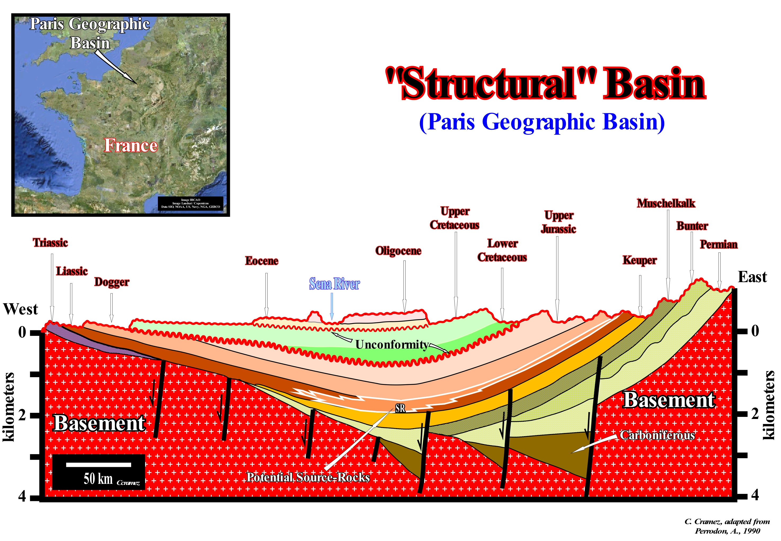
In the vast majority of cases, what many geoscientists call a structural basin is a large structural object formed by the deformation of previously sub-horizontal strata. This means that the synclines are considered as structural basins and that the term basin is used in its very broad sense: concave valley, wide and circular, surrounded by higher ground, to the centre of which run and converge water-courses. Such a definition is not only morphologically but implies that the basin is posterior to the sediments than form it (before deforming the sediments it is necessary to deposit them). In geology and in sequential stratigraphy, particularly, this does not seem to us to be very correct, since the term basin designates the place where the sediments are deposited and not the place where and how they were deformed. The geological section illustrated in this figure roughly shows the structural and stratigraphic configuration of what is often termed the "Paris Basin". However, taking into account the definition of a sedimentary basin: low ground crust area, with a variable geometry, almost circular to linear, usually of tectonic origin and in which sediments can be deposited which always thicken to the deepest and central part which is the most subsiding, it is evident that this geological section, strongly suggests that the "Paris Basin" is a deformed continental shelf, which was raised at east and at west, and not a sedimentary basin. It is this type of structure that certain geoscientists call structural basin. However, this designation just makes sense if the deformation is synchronous with the deposition. If the deformation is posterior to the deposition, as seems to be the case in the Paris basin, the structural specification is poorly applied and that is why in this figure the structural specification is enclosed in quotation marks. A sedimentary basin is a structure in extension (lengthening), of sinform geometry (fold in whose nucleus the rocks are more recent than the surrounding layers), more or less circular in which the layers dive and thicken, slightly, to the centre, which does not correspond to what is observed in this geological section. In this figure, with the exception of Carboniferous halfgrabens (lengthening structures, induced by a differential subsidence, and formed by normal, more or less parallel faults, in which the dip of the fault plane is, roughly, in the same direction, that is, faults with the same vergence or slope), which are the rift-type basins on which a divergent margin of Mesozoic age has been deposited, the thickness of the stratigraphic intervals is, practically, constant (although there are several tectonically enhanced unconformities, that is, several angular unconformities). The sediments dip towards the centre of the structure but they do not thicken (regionally erosion is, certainly, not very important). This means that the sinform geometry is posterior to the deposition and that probably the sediments were deposited in a platform environment or in an abyssal plain, since the internal configuration of the sedimentary intervals is parallel* (subhorizontal at the depositional time). However, several observation data refute the second hypothesis (abyssal plain environment). The petroleum-generating subsystem (Lias source-rocks) is located, mainly, in the Central and East area of this section. According to some geoscientists, the evolution of the organic matter of these potential source-rocks is dependent on the erosion associated with the Late Cretaceous and Tertiary unconformities, that is, the burial of the source-rocks. This implies that before the erosion, which produced the unconformities, the organic matter of the source-rocks had already reached maturity. This hypothesis, it seems that until today, has never been tested. The geometric relations observed on the seismic lines, which are, more or less, summarized in this geological section suggest a more refutation than a corroboration of such hypothesis. Similarly, when a geoscientist speaks of the Neuquen Basin (onshore Argentina) or the Kwanza Basin (onshore and offshore Angola), he is not talking about sedimentary basins, but geographic basins that correspond, in geological terms, in general, to he spatial and temporal stacking of different types of basins from the classification of the sedimentary basins of Bally and Snelson, which we adopt in this glossary.
(*) Obviously, when the internal configuration of a sedimentary or seismic interval is parallel, two things are possible: (i) The coeval dipping beds (continental or delta slope, function of the scale) are downstream, and in this case the subhorizontal intervals are, probably, platform deposits or (ii) The coeval dipping beds are upstream and in this case the subhorizontal intervals are, probably, deep-water deposits.
Structural Truncation...................................................................................................................................Troncature structurale
Truncatura strutural / Truncación estructural / Strukturelle Trunkierung / 结构截断 / Тектонический срез / Troncamento strutturale /
Abrupt termination of a stratum (or seismic reflector) induced by a structural event: (i) Shortening (reverse fault); (ii) Lengthening (normal fault) ; (iii) Gravity sliding ; (iv) Flow of a mobile substrate; (v) Igneous intrusion, etc.
See: « Unconformity »
&
« Erosion »
&
« Reflection Termination »
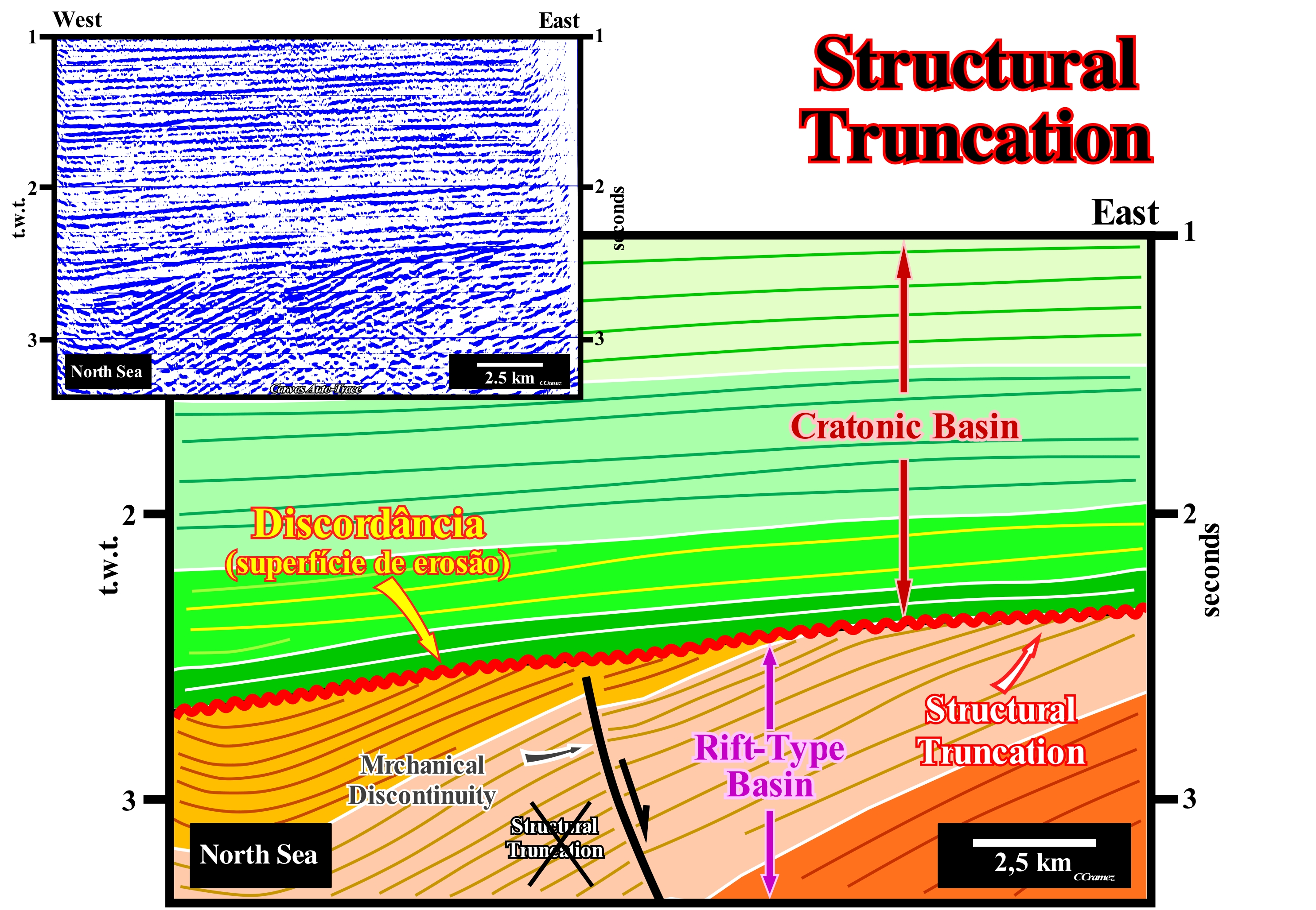
For many geoscientists, the expression "structural truncation" is not good. She misleads. In geology, the term truncation is, generally, used synonymously with erosion. For most geoscientists, a truncation implies erosion. The discontinuity of the layers or reflectors observed, for instance, in the event of a fault (reverse or normal) has nothing to do with a truncation, but with a mechanical discontinuity*. Erosion can only be done by erosive agents (water, wind, ice, etc.). The tectonics, whether it is by shortening (when the ellipsoid of the effective stresses is elongated) or lengthening (when the ellipsoid of the effective stresses** is oblong), does not erode the sediments. Tectonics deforms sediments. However, if the tectonic deformation is by shortening, the sediments are uplifted and can be exposed to erosive agents if they are exhumed, that is, if they are raised above sea level. In other words, to have erosion (regional or global), there must be a fall of a relative sea level (local sea level referenced to any point on the Earth's surface, which can be the base of the sediments or the sea floor).The relative sea level is function of tectonics (subsidence or uplift of the sea floor) and eustasy (absolute or eustatic sea level changes, which is the global sea level, referenced to the Earth's centre). At Rice University, Houston (Texas, USA), P. Vail and A. Bally used to say: (i) When σ1 is vertical (ellipsoid major axis the effective efforts), the sediments are elongated, creating a subsidence, which induces a rise in sea level, which creates or increases the available space for the sediments, which favours deposition and (ii) When σ1 is horizontal, the sediments are shortened and uplift, which induces a relative sea level fall, which when significant creates an erosional surface, that is, an unconformity. As in the vast majority of sedimentary basins, eustatic changes (variations in absolute or eustatic sea level) are much faster than tectonic movements, almost all geoscientists (except for the rare naive "structuralists" i.e., inductivists geoscientists), consider that the cyclicity observed in geological records is due to eustasy or eustatism, as the French geoscientists say (variation of the mean sea level in relation to the continents assumed stables, which implies that an eustatic rise or fall has the same amplitude in all regions of the globe). On this tentative interpretation of a detail of a North Sea seismic line, which from a geological point of view, corresponds to the stacking of a cratonic basin over rift-type basins. Toplaps are the visible under the unconformity (erosional surface) correspond to true truncations. The sediments underlying the unconformity were shortened and obviously uplift. The uplift produced a relative sea level fall, which exhumed the sediments allowing the erosional agents to disaggregate, corrode and level them. This type of lapout (termination) has nothing to do with the terminations of the reflectors against the fault planes (mechanical discontinuities), produced by the relative movement of the faulted blocks (lower central part of this tentative interpretation) where any layer or reflector disappears by erosion and many geoscientists continue, by habit, to wrongly call "structural truncation."
(*) Within the lithological discontinuities, which are the most important in sequential stratigraphy, we can recognize: (i) Concordant discontinuities, when there is continuity between successive intervals; (ii) Paraconform Discontinuities or Paraconformities, when there is no difference in attitude between overlapping intervals, but there is a hiatus due to the absence of significant deposition between them ; (iii) Nonconform Discontinuities or Nonconformities (which certain authors call Heterolithic Disconformities), when there is a contact between a sedimentary interval and an older igneous body ; (iv) Discontinuous Discontinuities or Disconformities, when the layers of the intervals are parallel on one side and the other side of the contact surface which does not conform to the regional stratification; (v) Discordant Discontinuities or unconformities when the two intervals are separated by an erosional surface induced by a relative sea level fall ; (vi) Enhanced Discordant Discontinuities or Tectonically Enhanced Unconformities, when the sediments of the interval overlapping an unconformity were deformed by tectonics (shortened or extended) ; (vii) Intrusive Discontinuities, when an igneous body traverses a sedimentary series ; (viii) Mechanical Discontinuities, when they are induced by faulting, etc. (https://estpal13.wordpress.com/2013/06/04/descontinuidades-sedimentares-e-estratigraficas/)
(**) The effective stresses are the geostatic pressure or σg, hydrostatic pressure or pore pressure, σp, and the tectonic vector σt.. It is the combination of these efforts that effectively deform the sediments and not only the tectonic vector and that is why even with a σt>0 the sediments can be widened.
Stylolite...............................................................................................................................................................................................................................................................Stylolithe
Estilólito / Estilólita / Stylolith / 缝合线 / Стилолит / Stylolite /
Irregular boundary between two portions of a rock, usually, limestone, formed by the insoluble residues of the rock material that was dissolved above and below it.
See: « Stylolitization »
&
« Dissolution »
&
« Goguel's Law »
A stylolite is a surface, or a more or less irregular contact occurring, generally, in the carbonate rocks and which underlines a penetration between two blocks of the same rock. The vast majority of geoscientists think that stylolites are formed, diagenetically, by differential movements, under pressure, and accompanied by dissolution. Stylolites are surfaces that occur within a particular rock, usually, carbonate, along which there has been a dissolution, which is underlined by the insoluble clay minerals that remain in the same place even after the calcite has been dissolved and transported to other areas. The stylolites result mainly from the compaction and pressure of the fluids during the diagenesis and which can be more or less lengthened by a subsequent flow of the groundwater. Stylolites appear on outcrops and hand samples as irregular zigzag discontinuities, which are, often, enhanced by clay insolubles, iron oxides or organic material. Studies on stylolites and other structures induced by pressure of mineral solutions suggest that they may have several origins. Among them, the pressure of the solutions is, generally, accepted as the most likely. However, there are a number of problems with the genesis of stylolites. In the diagrams illustrated in this figure, the peak of the stylolites always corresponds to the σ1, that is, the main axis of the ellipsoid of the effective forces (sum of the geostatic pressure, hydrostatic pressure and the tectonic vector). In the field studies, the determination of σ1 allows determining the tectonic regime that affected the region. If σ1 is vertical, the sediments were lengthened by an extensive regime and the direction of the normal faults, which allowed the lengthening, is parallel to σ2. If σ1 is horizontal, the sediments were shortened by a compressive tectonic regime, either by synclines/anticlines or reverse faults. The direction of the folds and fault planes of the reverse faults is parallel σ2. Note that there is only one way to extend the sediments (normal faults) and two to shorten them (folds and reverse faults).
Styolitization........................................................................................................................................................................................................Stylolitisation
Estilolitisação / Estilolitización / Styolites Bildung / 的缝合线的形成 / Формирование стилолитов / Formazione di styolites /
A diagenetic process of formation of the stylolites by a vertical differential movement caused by the pressure exerted on the rocks, in general, carbonates, which is accompanied by a partial dissolution.
See: «Stylolite »
&
« Limestone »
&
« Goguel's Law »
These sketches show how the direction of the peaks of the stylolites underlies the direction of the ellipsoid's principal axis of the effective stresses (σ1), since the plane of the stylolites gives the plane of intersection between σ2and σ3. As in this example σ1 is horizontal, the sediments were shortened either by folds (anticline or syncline), by reverse faults, or by a combination of reverse faults and folds. The direction of the structures that shortened the sediments, i.e., the direction of the axial plane of the anticlines or the direction of the plane of the faults is always parallel to the σ2. If σ2 is horizontal (σ3 vertical), the faults that affect the sediments are inverse faults and the folds will be cylindrical. If σ2 is vertical (σ3 horizontal), the faults, which shorten the sediments, will be strike slip faults and the associated folds will be conical, meaning that they are not exactly perpendicular to σ1. When the stylolites peaks are vertical, that is, the sediments were lengthened by an extensive tectonic regime, since the σ1 is vertical. In this case, the direction of the normal faults is parallel to σ2. Thus the axis σ2 is given by the intersection of two normal faults with opposite polarity (inclination). This sketch also shows how one can roughly calculate the amount of material that has dissolved during the deformation. If we imagine a fossil, for instance, a trilobite, before and after the stylolitization, it is easy to calculate, more or less, the amount of material that disappeared by dissolution. This is important, especially, in limestone regions, to know, for example, whether or not the geological cuts have been balanced, since almost all methods of balancing are based on Goguel's law. This law says that during the deformation the amount of material is, more or less, constant (taking into account the compaction). However, as illustrated in this figure, in the case of carbonate rocks a significant dissolution can significantly alter Goguel's law.
Subaerial Accommodation...............................................................................................Espace disponble subaérien
Espaço disponível subaéreo / Espacio disponible subaéreo / Subaerische Unterkunft / 陆上住宿 / Свободное пространство в нижних слоях атмосферы / Spazio disponibile subaereo, Alloggio subaerea /
Space available for fluvial sediments when the bayline migrates downstream, after a relative sea level fall. The available subaerial space can be, locally, defined by the space between the old and new provisional equilibrium profile of a watercourse.
See: « Accommodation (for sediments) »
&
« Equilibrium Point »
&
« Provisional Equilibrium Profile (watercourse) »
Within a sequence-cycle, during the second phase of development of the highstand prograding wedge (HPW), since the basin no longer has a shelf (the seaward displacement of the shoreline implies a gradual vanish of the platform continental that exists during the first phase of development), when the relative sea level* begins to fall, the point of equilibrium (point where relative sea level change and subsidence are equal and compensate) is displaced seaward, as well as the bayline. The concept of the bayline was defined by Posamentier and P. Vail as follows: (i) The sediments that accumulate in the coastal plain during the progradation of the shoreline are part of the coastal wedge (coastal prism), which includes fluvial and shallow-water deposits ; (ii) The coastal prism has the wedge shape and extends continentward by onlapping over the preexisting topography ; (iii) The upstream boundary of the coastal wedge is the bayline, which may move uphill when the shoreline progradation is accompanied by aggradation ; (iv) The bayline is the boundary between the coastal plain (domain of coastal and shallow-water depositional systems) and the alluvial plain (fluvial sediment domain) ; (v) Upstream of the bayline, relative sea level changes have no influence in the depositional systems. When the seaward displacement of the equilibrium point reaches the bayline and both move seaward, a subaerial accommodation is added and an aggradation begins by coastal onlaps. The sedimentation continues until the relative sea level fall reaches the inflection point of the relative sea level changes curve. Then, the equilibrium point and the bayline move seaward with the formation of a type I unconformity (turbidite depositional systems in the deep part of the basin). Certain geoscientists insist that, theoretically, the available space for sediments (accommodation) represents a three dimensions space, associated with a certain availability of sedimentary particles, and that it is not really independent of sedimentation. This three-dimensional space can not be defined, correctly, because the difficulty of distinguishing a real accommodation from a space that, probably, will not be filled by the sediments. As shown in this figure, the available subaerial space for the fluvial sediments (**), when the bayline migrates downstream, following a relative sea level fall, is defined, sometimes, by the space between the old and the new provisional equilibrium profiles. This concept can not easily be used because the provisional equilibrium profiles of the currents, used for this purpose, are difficult to recognize. Subaerial accommodation can be determined from the stratigraphic base level (ratio between accommodation, "A", and terrigeneous influx, "S", i.e., the A/S ratio). A ration "A/S" positive > 1 means that the terrigeneous influx can not fill the available accommodation causing, potentially, a flooding of the alluvial plain (accommodation is always greater than the sedimentary charge). If the ratio "A/S" is equal to 1, there is a balance between accommodation and terrigeneous influx, resulting in expanded sequences that have a high probability of being flooded. When "A/S" is zero or negative, there is no accumulation, but transfer without deposition of sediments (transfer zone), and formation of regional erosional surfaces or sequence boundaries. In the evolution of the alluvial sequence schematised in this figure, at the hierarchical level of the sequence-cycles: (A) A relative sea level rise involves deposition of subaqueous deposits (transgressive interval) and alluvial deposits ; (B) Since relative sea level rise slow down there is a coastal progradation (highstand prograding wedge, HPW) and alluvial retrogradation and (C and D) A significant relative sea level fall implies a seaward and downward displacement of the coastal erosion and the formation of a sequence boundary, which allows the deposit of the lowstand sedimentary systems tracts group of the new sequence-cycle.
(*) Local sea level and referenced either as the sediment base or the sea floor and is the result of the combined action of absolute sea level, which is the global sea level, referred to the Earth's centre, and tectonics.
(*) In sequential stratigraphy, fluvial sediments are those deposited upstream of the bayline.
Subaerial Complex (Late highstand subaerial complex)..............Complexe sub-aérien (Haut niveau tardif)
Complexo subaéreo / Complejo subaereo (nivel alto tardío) / Späte Highstand subaerische komplexen / 晚高位陆上复杂 / Поверхностный комплекс системы высокого уровня моря / Complesso sub-aerea (alto livello del mare in ritardo) /
Top of the highstand prograding wedge (HPW) deposited when the rate of relative sea level rise is in deceleration and very small. Often, considered as synonymous with Late Highstand Prograding Complex.
See: « Highstand »
&
« Systems Tract »
&
« Marine Regression »
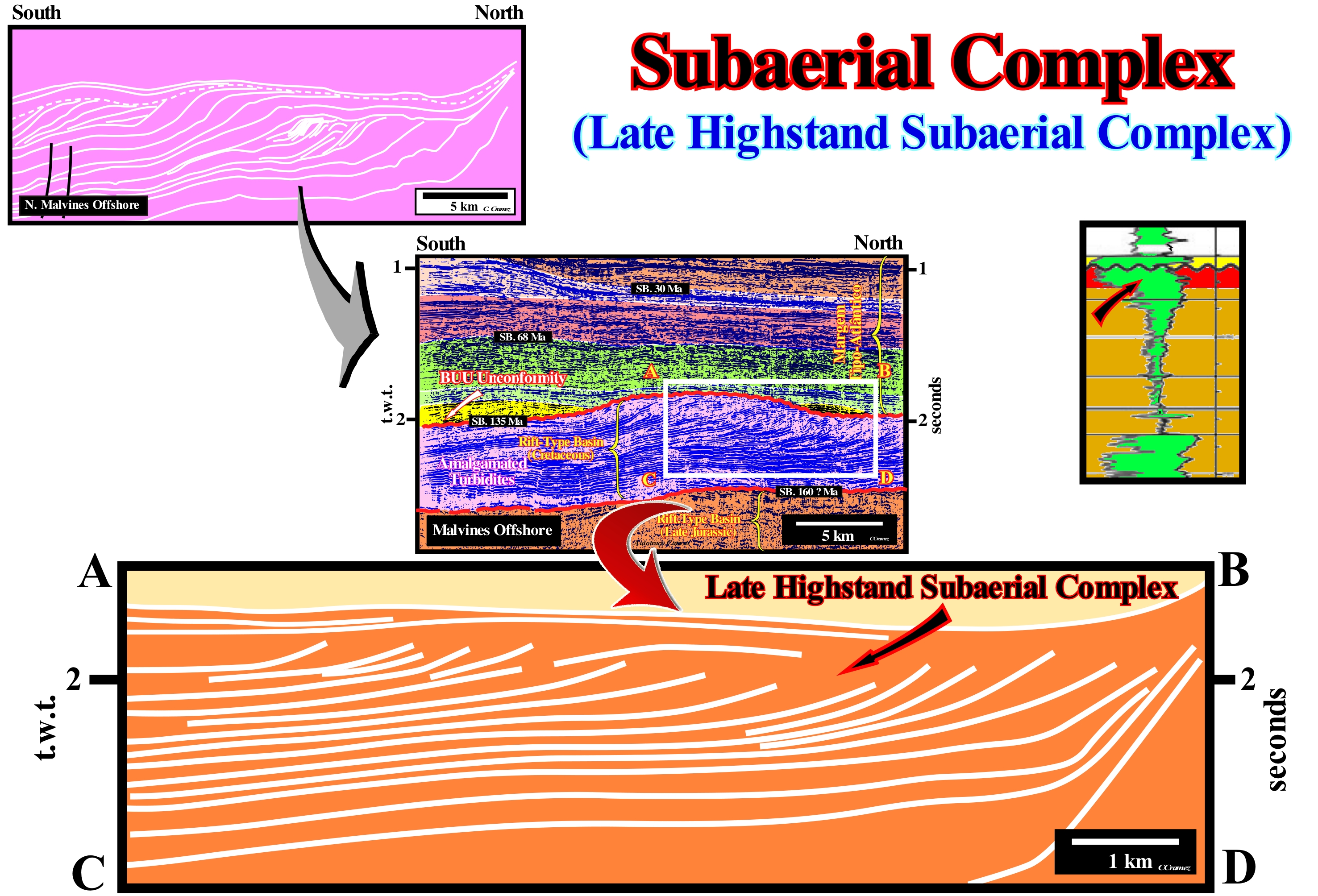
The Malvinas offshore (Argentina) corresponds to the stacking of several types of basins of the classification of Bally and Snelson (1980). On regional seismic lines it is easy to recognize from the bottom to top: (i) Precambrian Basement or a Paleozoic folded belt ; (ii) Late Jurassic/Early Cretaceous rift-type basins ; (iii) Atlantic-type divergent margin. The breakup of the lithosphere of the Gondwana small supercontinent (southern part of the Pangea supercontinent) is emphasized by the interface between the rift-type basins and the divergent margin, which is underlined by important subaerial lavas flows. These lavas correspond to SDRs, i.e., in the slang of the petroleum geoscientists, a set of seismic reflectors dipping and thickening seaward, which correspond mainly to volcanic spills with small intercalations of sand-shaly sediments. At present time, the vast majority of geoscientists consider SDRs postdate the breakup of the lithosphere and that they do not have any hydrocarbon generating potential. However, in the last century, a large majority of geoscientists considered the divergent margins and particularly the South Atlantic offshores were non-volcanic. They interpreted the SDRs as rift-type basin sediments, not only rich in organic matter, but predating the breakup of the lithosphere. Unfortunately, all the results of the wells drilled in the Atlantic offshores have recognized a facies, basically, volcanic and a total absence of organic matter. On this tentative geological interpretation of a Malvinas (Falklands) offshore seismic line, a progradations interval is, easily, recognized, even if, sometimes, the top of the clinoforms is not well visible due to a lack of acoustic impedance contrast between the dipping and the horizontal segments of chronostratigraphic lines. Although the amplitude of these clinoforms decreases northward (to the left in this tentative interpretation), they underline, most likely, the successive slopes of the continental margin. The amplitude of the clinoforms associated with the prodelta seldom exceeds 30/60 m, which means that it is lower than the seismic resolution of th seismic line and therefore such clinoforms would be invisible. In any case, the geometry of the reflectors suggests, strongly, a decreasing in the depositional water-depth with the deposition of the clinoforms and, probably, a subaerial environment with a sandy lithology in association with the toplaps (these lapouts are very visible in the central and north, that is, leftward of the progradating complex, within the rectangle ABCD). This conjecture will not be falsified if the well logs are similar to those shown in the top right corner of this figure. These logs (gamma ray and resistivity) allow us to recognize from the bottom o top: (i) Submarine basin floor fans (SBFF) and probably, also, submarine slope fans (SSF), characterized by gamma ray morphology, more or less, cylindrical ; (ii) A lowstand prograding wedge (LPW) characterized by a gamma ray morphology coarsening and thickening, which suggests a depositional water-depth, progressively, smaller and a sandy facies (lithology and associated fauna) at the top ; (iii) An unconformity (black wavy line), i.e., an erosional surface induced by a relative sea level fall, between the subaerial deposits of the highstand prograding wedge (underlined by the arrow) and the sediments filling an incised valley ), which formed during the relative sea level fall, which induced the unconformity, since the provisional equilibrium profiles of the water-courses was broken. The incised valley was filled during the deposition of the terminal portion of the underlying lowstand prograding wedge. A small transgressive interval (TI) seems to have been deposited over the incised valley filling (coloured interval in yellow). In these logs, the evidence of an unconformity is, totally, dependent on the recognition of the filling of incised valley. In this particular case, not only the facies of the filling is sandy, but their limits are abrupt as well. These facts corroborate the presence of a significant erosional surface that can not in any way be interpreted as a ravinment surface associated with the marine ingression that floods for the first time the coastal plain of the lowstand prograding wedge (LPW), i.e., the boundary between a lowstand prograding wedge (LPW) and the transgressive interval (TI) within a sequence-cycle.
Subaerial Expansion Centre (Tephrachronology).....................Centre d'expansion subaérienne
Centro de expansão subaérea / Centro de expansión subaérea / Subareal Expansion Zentrum / 地表扩张中心 / Центр подземного развития / Centro di espansione subaereo /
Place where the material of the Earth's mantle is, via fractures associated with the breakup of the lithosphere, extruded in a continental or subaerial environment, where it can flow laterally (toward the continent). In an aquatic environment the volcanic material is rapidly solidified, which means that it can not flow. Synonym with Subaerial Spreading Center.
See: « Tephrachronology »
Subaerial Lava (SDR)...............................................................................................................................................Lave subaérienne (SDR)
Lava subaérea (SDR) / Lava subaérea / Subaerischen Lava / 地表的熔岩 / Поверхностная лава / Lavica subaerea /
Lava deposited, immediately, after the breakup of the supercontinent, whereas the centers of expansion are still subaerial and not marine. The subaerial lava flow and taper continentward. Notwithstanding, the fact that they dip to the mainland, during the outflow, over time, due to the overload of the newer subaerial lava,progressively, the oldest ones begin to dip seaward, even before the expansion centers become submarine to extrude the oceanic crusta (pillow lava).
See: « SDR (seawrd dipping reflectors) »
&
« Pangea »
&
« Tephrachronology »
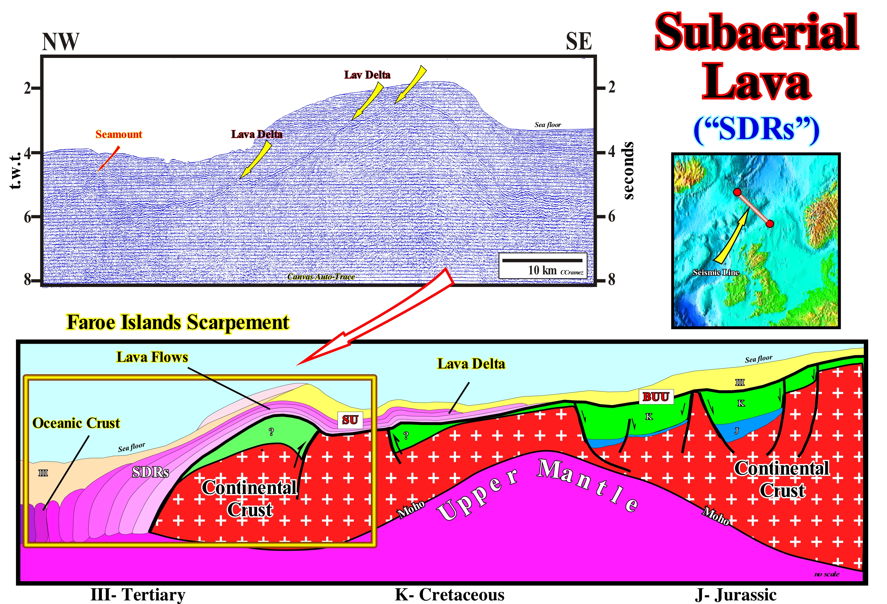
The tentative geological interpretation of a Canvas auto-trace of a detail of a North Sea regional seismic line, more or less, parallel to the geological section shown in this figure, suggests. the formation of the subaerial lavas associated with the breakup of the supercontinents or Seaward Dipping Reflectors (SDRs), during the lengthening of a supercontinent produced, usually, by the development of a thermal anomaly under the lithosphere. The thickness of the lithosphere reaches, more or less, 10/20 km, it is, highly, injected by basaltic dikes and the basaltic material becomes preponderant, relatively, to the sialic material (mnemonic word, formed by silica and aluminum, used to denote a group of "minerals" calculated arbitrarily in the CIPW * classification, essentially feldspar and quartz. The lengthening of the lithosphere of the supercontinent is the origin of the formation of rift-type basins (generally halfgrabens dipping outward of the thinning zone), which are filled, generally, by nonmarine, often, lacustrine sediments which, locally, may be rich in organic matter. When the lithosphere reaches such a thickness, which corresponds, more or less, to a rate of lengthening of 4, the lithosphere can no longer be lengthening by normal faults (there is no other way to lengthen the sediments). The lithosphere breaks, by excess of injected mantle material, locally, individualizing two new lithosphere plates, separated by expansion centres (volcanoes) from which subaerial lava flows continentward of the individualized plates, as illustrated in this figure for the European plate (North Sea). The thickness of each subaerial lava flow (volcanic material could not flow under water ; it is, rapidly, solidifies) decreases continentward until each spill disappears by pinchout over the continental crust of the former supercontinent. As the lithospheric plates move away, more volcanic material comes to the surface and new volcanic spills overlapping the previous flows. The overburden imposed by the overlapping of the lava flows will, progressively, force the expansion centrers, that is, the volcanoes, to sink into the sea-water that begins to encroach the area, until they are totally submerged. From that moment, the volcanic material expelled by the expansion centrer is, quickly, solidified, since it can not flow under water. It is from this moment on that the oceanic crust is formed: a series of vertical volcanic sheeted dykes, attached to one another, without significant flowing of volcanic material (pillow-lavas). The passage from the subaerial volcanic crust to the oceanic crust is well visible at the left end of this tentative interpretation. The term SDRs ("Seaward Dipping Reflectors") strongly emphasizes their unknown lithology when geoscientists brought such reflectors to light. It was with well results of DSDP≠342 that geoscientists recognized the volcanic nature of reflectors. The geological profile (without scale), suggests that the morphology of the sea floor is the result of a tectonic inversion. The normal fault, bordering (eastward) a rift-type basin, was reactivated, recently, in reverse fault which shortened and uplifted not only the subaerial lavas flows (with evident lava deltas), but the Tertiary sediments that fossilize them, as well.
(*) The CIPW standard (http://www.uwgb.edu/dutchs/Petrology/cipw01.htm) was developed in the early 20th century by petrologists Cross, Iddings, Pirsson and the geochemist Washington. The calculation of the CIPW normative mineralogy is based on typical minerals that can be precipitated from anhydrous melt at low pressure, and simplifies the typical igneous geochemistry observed in nature with the following restrictions: (i) The magma crystallizes under anhydrous conditions of so that hydrated minerals are not formed (hornblende, biotite) ; (ii) Ferromagnesian minerals are considered free of Al2O3 ; (iii) The Fe / Mg ratio for all ferromagnesian minerals is assumed to be the same ; (iv) Several minerals are considered incompatible, so nepheline and / or olivine never appear with quartz in the standard.
(**) The oceanic crust can be divided into three layers: (I) Layer 1, which has an average thickness of 0.4 km, is composed of poorly consolidated sediments (tiny shells of marine organisms, usually calcareous and siliceous or volcanic ash and terrigeneous sediments transported by turbidity), often absent near the mid-oceanic ridges, but which along the continental margins are mainly terrigeneous sediments ; (II) Layer 2 is, generally, subdivided into two parts: a) layer 2A corresponding to about 0.5 km of finely crystalline vitreous to basalt volcanic material, generally in the form of cushioned lavas and b) layer 2B, which corresponds to about 1.5 km of diabasic dikes ; (iii) Layer 3 is formed by slowly cooled magma and consists mainly of coarse grains and ultramafic rocks. This layer forms more than two-thirds of the volume of the oceanic crust, which on average is about 5 km thick.
Subage (Geological).......................................................................................................................................................................................Sous-âge (Géologique)
Subidade (geológica) / Sub-edad (geológica) / Unter-Alter (geologische) / - 年龄(地质) / Подпериод (геологический) / Sotto-età (geologica) /
Subdivision of a geological age, i.e., a small geological time interval. A subage is the time during which a substage was deposited, in the same way, that the Cretaceous Period is the geological time during which the rocks of the Cretaceous System were deposited.
See: « Geological Time Scale »
&
« Age »
&
« Geological Time »
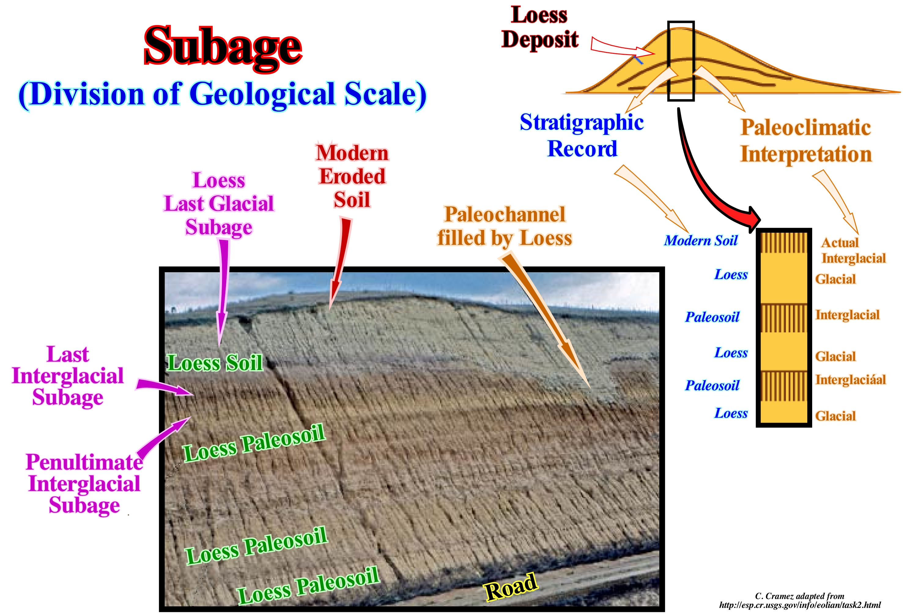
As can be seen in this scale Paleozoic time, proposed by Harland et al. (1982), subtypes are very small time intervals and cannot be represented on conventional time scales. They are used to date sedimentary bodies associated with high frequency eustatic cycles, such as those induced by thickening (advancing) and thinning (retreating) of glaciers during the Pleistocene epoch. Similarly, as illustrated above, some of the ages of the early Permian (epoch), namely, the Asselian, Sakamarian, Artinskian, or Kungurian, may be, locally, subdivided if, on the ground, or into the boreholes, and set different formations, members or horizons (rocks) are in evidence. The Kungurian stage, for example, which begins with the appearance of the conodons Neostreptognathus pnevi and N. Capture and ends with the appearance of the conodon Jinogondolella nanginkensis, outcrops in the Ural Mountains, either in Russia or Kazakhstan. In the southern region, it is formed by terrestrial rocks and lagoon sediments. Several types of evaporite shallow-water sediments and non-marine sediments deposited as lateral facies. Elsewhere, conglomerates, sands and red sandy deposits are frequent. In the eastern region, the evaporite intervals formed by alternations of gypse, halite and potash form the Kama River geographic salt basin. Marine limestones occur, for example, in the province of Perm (from which the name Permian is derived) and reef limestones occur in the western part of the Mughalzhar Mountains. All of this allowed geologists to consider various subareas in the Kungurian, which were deposited in the following subits: (i) Irenian, (ii) Folipovian and (iii) Saranian. However, given the difficulty of dating during the Paleozoic, the substages and subages are much more used in recent geological times, particularly in the Pleistocene era, where the dating of the thickening (advancement) and thinning (retreat) of the ice caps are much easier.
Subaqueous Deltaic Plain (Submarine delta plain).............................Plaine deltaïque submersible
Planície deltaica submersa / Planicie deltaica submarina / Submarine Ebenedelta / 水浸三角洲平原 / Затопляемая дельтовая равнина / Piana deltizia sommergibile /
Part of the delta plain that is always submerged. It is characterized by a weak slope, near or inferior to 1° and by an irregular topography due to the channels that cross it and the sandy banks. The subaquous deltaic plain terminates by an edge, often of an arched shape, with more or less irregular contour, which is the delta front.
See: « Delta »
&
« Coastal Plain »
&
« Prodelta »
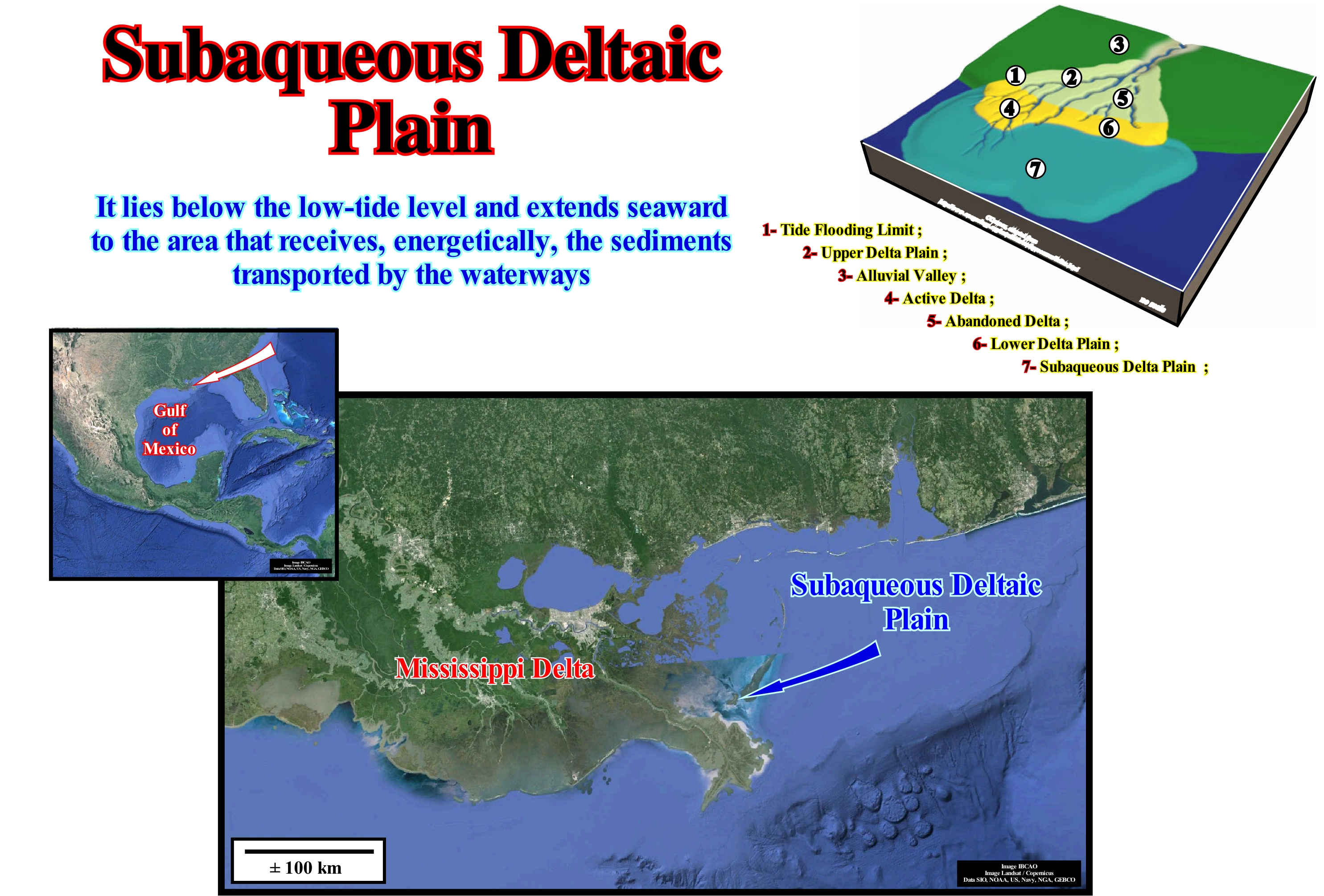
From upstream downstream, the physiographic elements of a delta are: (i) Upper or subaerial delta plain, which can be divided into high upper delta plain (active or abandoned) and low upper delta plain (active or abandoned) ; (ii) Lower subaqueous or submerged delta plain ; (iii) Delta front; (iv) Prodelta; (v) Bottom of the delta (subhorizontal bottom layers which are, sometimes, present in certain delta types, and in which turbidite sandy horizons may be found). These physiographic elements, characterized by typical depositional systems, are synchronous and genetically associated. They form a sequence-paracycle and settle during the stability period of the relative sea level (local sea level, referenced to the base of the sediment or any other point on the Earth's surface, such as the sea floor) that occurs after the relative sea level rise (eustatic paracycle). A vertical stacking of paracycles of this type, that is, of deltas, of the same sedimentary systems tracts of different sequence-cycles, forms what the geoscientists call a delta building. Just as a building is a multi-story, which can be more than 100 m high, although each floor is only 2.40 meters high, a delta building can have several hundred, even thousands of meters of height, although each delta that composes it has a maximum of 50-60 meters of thickness. This photograph of the present-time Mississippi delta, clearly, shows the submerged deltaic plain, which is, generally, located slightly upstream of the delta, which marks the rupture between the upper horizontal layers and the dipping layers that form the delta slope. When speaking of subaqueous delta plains, it should be borne in mind that a delta is a form of mouth of a stream characterized by a positive balance between accumulation and degradation and that, therefore, the delta plain and the shoreline prograde. This occurs when the erosion and transport capacity of the marine agents is less than the current capacity to deposit sedimentary particles next to the depositional coastal break of the deposition surface (more or less the shoreline). Some geoscientists consider that the fluvio-marine dynamics, in a delta formation, is associated with a relative sea level fall. Seismic data suggest that such an association is, probably, wrong, as in the delta front not only progradates seaward (outbuilding), but also aggradates (upbuilding) since the terrigeneous influx is, sufficiently, large. In this case, one can speak of sedimentary regression. Coastal deposits move seaward. When the terrigeneous influx is not very large, the delta front progrades seaward, but without significant aggradation. When the terrigeneous influx is insufficient, for the same relative sea level rise, the delta front advances less and globally, that is, at the end of several accelerating marine ingressions, it can move landward. In this case, geoscientists speak of retrogradation. Upstream of the basin edge or continental edge (in certain cases, such as during the deposition of a lowstand prograding wedge, the continental edge is not the basin edge), deposition can only occur if the space available for the sediments increases. With each increment of available space, which is the result of the additions of a significant marine ingression, the shoreline moves landward, producing a ravinment surface in the sediments already deposited. It is during the stability period of the relative sea level occurring after each increase in relative sea level rise that the shoreline and the coastal deposits (delta front) prograde seaward exceeding or not, function of the terrigeneous influx and the extent of marine ingressions, the position they had before the preceding relative sea level rise. If marine ingressions are accelerating, that is, increasingly important, sedimentary regressions will become increasingly smaller and, in general, the shoreline shifts landward (retrogradation). If, on the other hand, marine ingressions are decelerating, that is to say, increasingly smaller, the associated sedimentary regressions will be increasingly important and the shoreline and coastal deposits will move globally seaward ( progradation).
(*) The relative sea level is the result of the combined action of absolute (eustatic) sea level (supposed global, referenced to the Earth's centre) and tectonics (subsidence of the sea floor when the sediments are lengthened by a tectonic regime or uplift when the sediments are shortened by a compressive tectonic regime).
Subdelta..............................................................................................................................................................................................................................................Subdelta
Subdelta / Subdeta / Unterdelta / 亚三角洲 / суб-дельта / Sub-delta /
Secondary delta induced by crevasse splays or the delta deposited following a bed shift of the main river (Mississippi subdeltas, for instance).
See: « Achafalaya (delta lobe) »
Subduction (Wilson's Cycle)............................................................................................................................................................................Subduction
Subducção / Subducción / Subduktion / 俯冲 / Субдукция (погружение одной литосферной плиты под другую) / Subduzione /
One of the tectonicoestratigraphic phases of the Wilson's cycle: (i) Stable Continental Craton ; (2) Thermal Anomaly (hot spot) and Lengtheninig (rifting) of the craton, with formation of rifte-type basins (usually halfgrabens with opposite vergence on each side of the thermal anomaly) ; (3) Breakup of the Lithosphere, with creation of new oceanic crust and formation of two divergent margins ; (4) Oceanic expansion (sea floor spreading which, little by little, transforms the young margins into mature margins due to the cooling and increasing density of the oceanic crust ; (5) Subduction, since the density of the oceanic crust is quit important, it is divided in two parts and one of them plunges under the other one creating a convergent margin, with formation of a volcanic arc and a mountainbelt on the overriding lithospheric plate ; (6) Divergent Margin / Volcanic Arc collision, forming a Mountain Chain ; (7) Peneplanation (mountain chain) and new subduction of the oceanic crust with the twin margin creating another convergent margin ; (8) Continent / Continent collision and closure of the ocean created between the two initial divergent margins and (9) End of the Wilson's cycle with the formation of a new stable continental craton.
See: « Wilson's Cycle»
Subduction Zone.......................................................................................................................................................................Zone de subduction
Zona de subducção / Zona de subducción / Subduktionszone / 俯冲带 / Зона движения по разломам / Zona di subduzione /
Area, more or less, rectilinear along which a lithospheric plate dives beneath another plate. When the descending plate is oceanic, the subduction zone is called the Benioff type (B-type subduction). When the descending plate is continental, the subduction zone is called the Ampferer type (A-type subduction). A-type subduction zones are underlined by a foreland basin, whereas B-type subductions are underlined by a: (i) Oceanic trench ; (ii) Alignment of volcanoes and (iii) Deformation of the crust, which often causes the formation of mountains.
See: « Continental Collision »
&
« Abyssal Trench »
&
« B-Type Subduction (Benioff) »
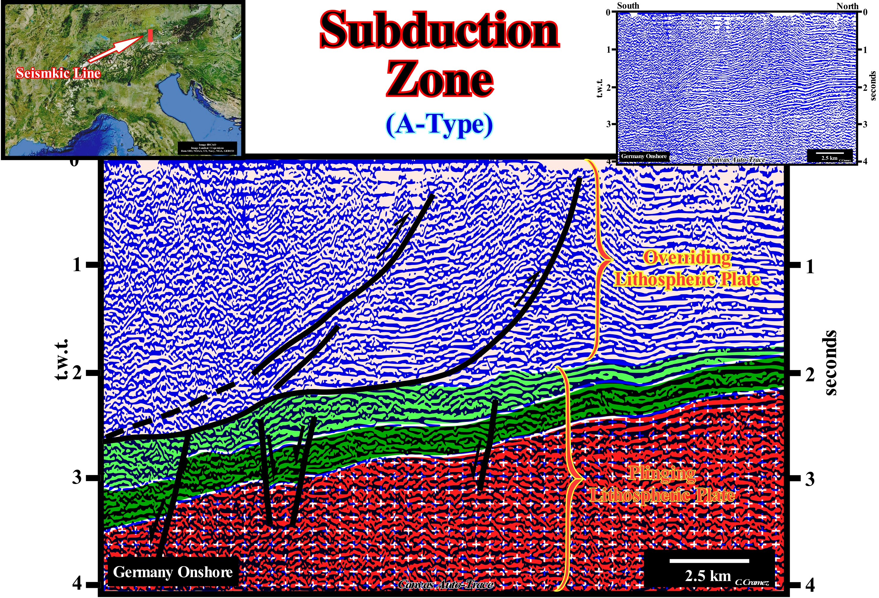
This tentative geological interpretation of a Canvas auto-trace of a detail of a German onshore seismic line illustrates an Ampferer or A-Type subduction zone, in which both lithospheric plates are continental. The sediments of the Mesozoic descending plate were lengthened by normal faults created by an extensive tectonic regime (σ1 vertical, corresponding to the largest axis of the ellipsoid of the effective stresses, i.e., the sum of the geostatic pressure σg , pore pressure σp and of the tectonic vector σt), while the sediments of the Cenozoic overriding plate were shortened by reverse faults and folds created a compressional tectonic regime (σ1 horizontal and σ3 vertical). In the A-type subduction zones, since both plates are of the same nature and density, there is, practically, no consummation of lithospheric material, but rather accretion (if it is not compensated by erosion). This means that the descending plate does not penetrate the asthenosphere. On the contrary, in the Benioff or B-type subduction zones, as the descending lithospheric plate is oceanic in nature, and overriding plate is continental (oceanic in some cases), the descending plate, denser, enters the asthenosphere* (the uppermost zone Earth's mantle, less rigid, that lies beneath the lithosphere, about 80 to 200 km below the surface), where it is consumed. For these reasons, many geoscientists consider that the true subduction zones are just the B-type, since they counterbalance the creation of oceanic crust in the mid-ocean ridges. The mobility of plaques appears as the superficial manifestation of more important and deeper movements affecting the mantle. The idea of convection of the mantle, very fought, in the early twentieth century, has, progressively, made its way. Energy considerations based on measurements of the heat flux or the contents of the radioactive elements of mantle rocks lead to theoretical estimates of the energies put into play comparable to convection throughout the mantle. In the mantle, the source of energy may be the decay of radioactive elements contained within it or the heat of the Earth's core. These energy sources are capable of creating convection currents. The mid-oceanic ridges are the surface manifestations of the ascending mantle currents. The subduction zones underline the descending currents. The distribution of the boundaries between the plates appears as an apparent manifestation of the convective system of the mantle, which translates the non-stationarity of the convective movements. The continents are moving. The ridges move or disappear. Therefore, the distribution of the convection currents varies over time. The oceans do not open or close by a pendulum movement, but they transform and evolve according to regimes whose geometry is continuously variable. Both types of subduction cause earthquakes. However, the foci or hypocenters (rupture points) of earthquakes associated with a subduction of A-Type are more superficial than those induced by B-Type subduction. On the other hand, only in the B-Type subduction zones form volcanoes that are, more or less, aligned parallel to the oceanic trench (or abyssal trench, which corresponds to a very deep sea, between lithosphere plates), probably, due to the consummation of the descending plate in the asthenosphere (formation of new magma). The smaller the distance between the volcanic arc and the steeper oceanic trench more dipping is the descending plate (large subduction angle). An oceanic trench may be adjacent and, more or less, parallel to a continental margin or to an insular arc when it is separated from the mainland by a backarc basin. The slopes of an ocean trench are asymmetrical. The slope on the ocean side is less pronounced, while on the continent or island side it is steeper and characterized by "mélanges", i.e., by a complex mixture of continental and oceanic sediments. An orogenic, seismic and volcanic activity exists, often, in the continental area.
(*) The Earth's internal structure can be studied from the petrographic and rheological point of view. Under the petrographic point, it can be divided into three concentric layers: A) Crust ; B) Mantle ; C) Core. From a rheological point of view (relation between stress and deformation in materials capable of flowing), the Earth is divided into four concentric layers: 1) Lithosphere ; 2) Asthenosphere ; 3) Mesosphere and 4) Core. The lithosphere, which is a rheological division of the Earth, encompasses the Upper Mantle, under the isothermal 1350° C (beginning of the low-velocity zone of the seismic waves) and the Crust (continental or volcanic), which is separated from the mantle by the Mohorovičić discontinuity which underlines a significant increase in the velocity of seismic waves.
Submarine Canyon....................................................................................................................................................................Canyon sous-marin
Canhão submarino / Cañón submarino / Unterseeische Furchen / 海底峡谷 / Каньон (овраг) / Canyon sottomarino /
Steep valley or submarine gorge, strongly embedded in the seafloor of the continental slope. A submarine channel is induced by a relative sea level fall or by an uppwelling marine current. Submarine canyons allow the transportation of the sediments to the deep parts of the ocean basins and correspond, in part, to the bypass zones of the turbidite depositional systems.
See: « Unconformity »
&
« Lowstand »
&
« Bypassing »
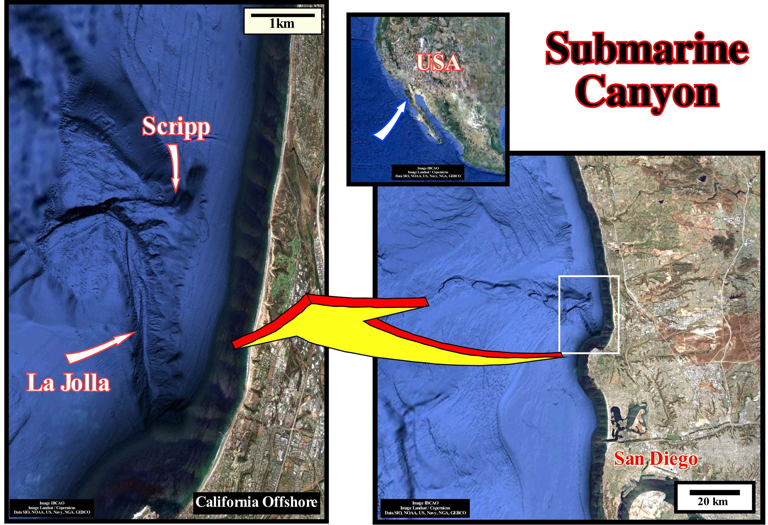
These images illustrate the representation of two submarine canyons of La Jolla and Scripps (California, USA). These representation were created from an important database containing thousands of bathymetric measurements. The La Jolla Canyon (in the right photograph north of the city of San Diego) is wider than the Scripps Canyon. The Scripps canyon, which is well illustrated in the photograph on the left, is in the upper part formed by three branches that deeply incised the Eocene limestone muds and sands, which form the sea floor north of San Diego. In general, submarine canyons are, preferably, formed on the upper slopes of the continental shelf, near the continental edge, where the erosive action associated with falls of the relative sea level (local sea level referenced to any point on the Earth's surface, which can be the base of the sediments or the sea floor and which is the result of the combined action tectonics and the absolute or eustatic sea level, which is referenced to the Earth's centre) still makes sense. When upstream of a submarine canyon there is an important river, as is the case, for example, in the Congo offshore (Congo canyon and Congo river), it is very likely that the canyon was started by the erosive action of the river during a significant relative sea level fall. When a significant relative sea level fall and put it below the continental edge, the entire coastal plain and/or shelf (water column between 0 and 200 meters), depending on whether the geological conditions were lowstand or highstand, are exhumed, as well as the upper part of the continental slope. The shoreline moves seaward, sometimes, more than a hundred kilometers, and the provisional equilibrium profile of the rivers is broken (the ideal equilibrium profile of a river is never reached). In this way, the rivers are forced to incise their beds to get a new provisional equilibrium profile. It is this incision that often begins the formation of a submarine canyon, downstream of the old continental edges, which will then evolve in varied ways, as a function of relative sea level changes and terrigeneous influx. However, certain submarine canyons, located on the middle to upper continental slope, seem to be formed, independently of river evolution, in association with upwelling submarine currents. This is what certain geoscientists call submarine valleys. In the middle/upper continental slope of the Gabon offshore there are, more or less, parallel submarine valleys oriented west/east (roughly perpendicular to the shoreline), upstream of which, that is, on the continental shelf, does not exist any delta depositional system, which could explain its formation during a relative sea level fall. The most probable origin of these submarine valleys is, often, explained as a consequence of Ekman's transport, i.e., as a consequence of the horizontal displacement of the layers of the surface waters of the ocean by the action of friction of the wind in surface. The water carried by a marine current decreases in depth due to the Coriolis effect*, which creates ascending submarine currents that erode, from the bottom up, the upper middle part of the continental slope. Wind blowing on the ocean displaces the surface water layer, but the Coriolis force deflects the movement to the right in the Northern Hemisphere and to the left in the Southern Hemisphere. This deviation propagates downward through the viscosity and thus obtaining a significant mean transport off of the surface winds axis. Around a cyclonic depression (more or less closed zone, of low atmospheric pressure with respect to the one of the neighbourhood and at the same level), under the effect of the wind, the water between the surface and the thermocline (relatively, little thick within which the temperature changes, rapidly, with depth) is transported and diverted by Coriolis force to the outside of the depression creating a divergence. The water layer at the centre of the depression is less thick and to compensate for this loss of mass, the water from the depths rises to the surface, propelled by the pressure of external water columns to the depression. This same mechanism can be used to explain the upwelling currents of the Gabon offshore, which create a large part of the submarine valleys of this region. When the wind blows parallel to the shoreline and the force of Coriolis (**) moves it away from the surface currents, a void space is created, which deep water immediately fills upstream.
(*) In a reference system in uniform rotation, moving bodies, when seen by an observer in the same frame, appear to be subject to a force perpendicular to the direction of their movement.
(**) A force that causes the movement of water to the right (in the northern hemisphere) around the water piles in the oceans. These water flows are called gyres. The rotation of the North Atlantic is separated into four distinct currents: (A) Equatorial North Current ; (B) Gulf Stream ; (C) North Atlantic Current and (D) Canary Current. The water piles where the gyres are formed by the inward movement of the water due to Eckman's transport.
Submarine Canyon Fill........................................................................................Remplissage de canyon sous-marin
Preenchimento de canhão submarino / Relleno de cañón submarino / Füllen von U-Boot-Schlucht / 海底水道填充 / Заполнение подводного ущелья / Riempimento di canyon sottomarino /
This terminology is not very correct since, in most cases, there is no erosion associated with so-called "canyons or submarine channels" (associated with turbidite deposits). In general, they correspond to a bathymetric anomaly created by no deposition between the natural levees associated with decelerating turbidic currents.
See: « Reflection Configuration »
&
« Lowstand »
&
« Relative Sea Level Change »
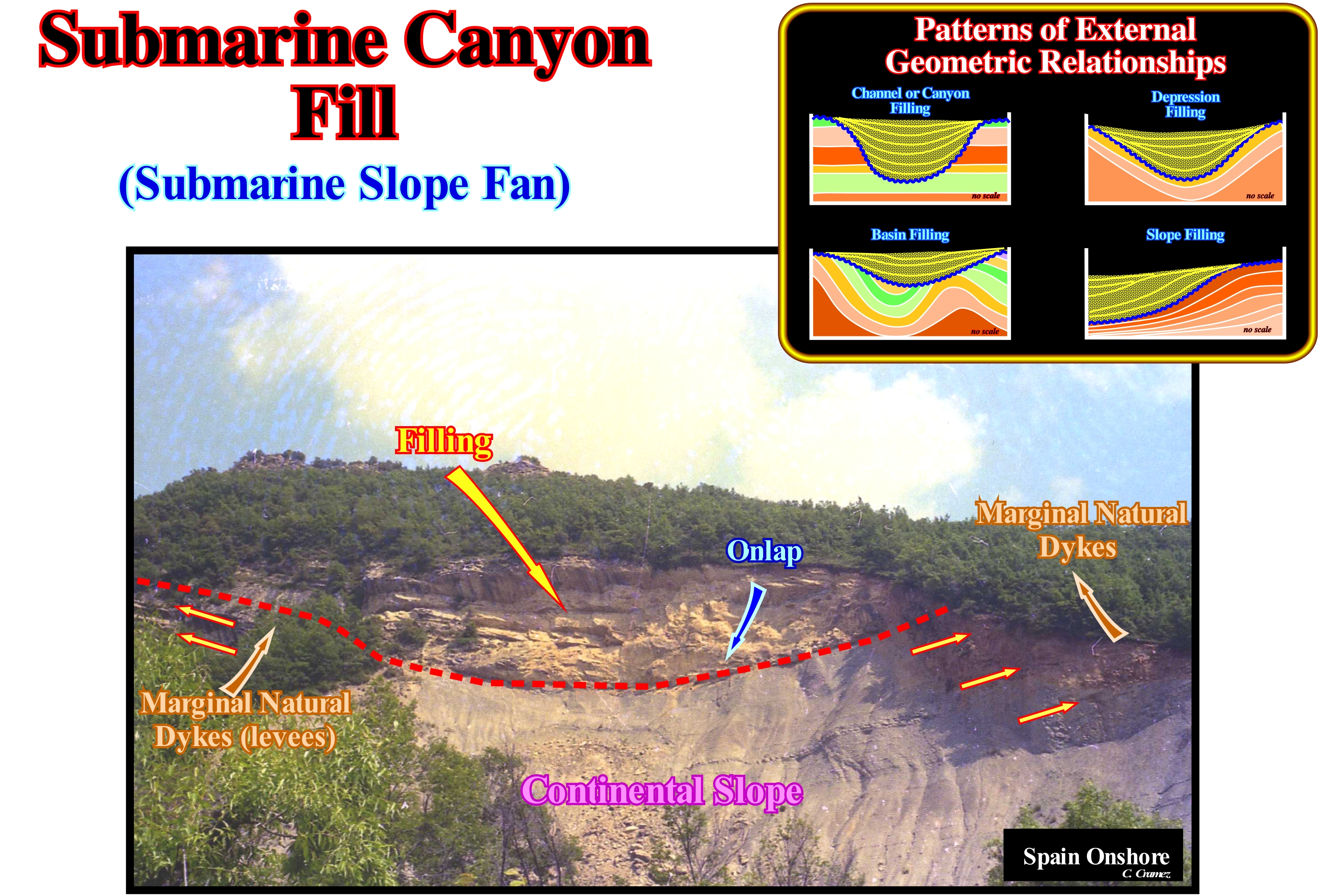
In this example (Spanish Pyrenees), the internal configuration of the filling of a turbiditic "canyon" is parallel and the successive layers of filling are onlaps (marine, deep-water). As can be seen, the sediments underlying the turbidite "canyon" are concordant with the base surface of the canyon. In these conditions, it is difficult to admit an erosion surface between the two sets, especially a surface induced or caused by the passage of the turbidite currents. In most cases, in so-called "canyons" or turbidite channels, there is no erosion or, therefore, it is insignificant. Everything is probably going on as follows: (i) When a turbiditic current reaches the abyssal plain, it begins to decelerate and loses the carrying capacity ; (ii) Two more or less elongated and parallel turbiditic natural marginal dykes (levees) settle down on either side of the central portion of the current in deceleration, where the velocity is stronger and which leads the sedimentary particles, in general, to where they deposit in the form of a central lobe ; (iii) If the next turbidity current passes at the same site, it is in part channelled through the nondepositional area between the natural marginal dikes deposited by the first current and so the process repeats ; (iii) The natural marginal dikes (turbidite levees) of this current deposit above and out of the first, at the same time, that the fastest and most energetic part of the current flows through the area of nondeposition to settle down the distal lobe more far ; (iv) By this process, the nondepositional area, channels, more and more, the currents, which exaggerate the morphology between the natural marginal dikes and the nondepositional area, which is fulfilled, later, in retrogradation, provided that the system loses competence.
Submarine Delta..............................................................................................................................................................................Delta sous-marin
Delta submarino / Delta submarino / Submarin delta / 水下三角洲 / Подводная дельта / Delta sottomarino /
When the fan is submarine with a weak slope formed in the external part of an estuary, what individualizes it from the submarine basin floor fans and slope fans (turbidites). This type of delta is, in general, the result of the submersion of a, more or less, evolved delta.
See: « Delta »
&
« Submarine Fan »
&
« Lowstand Prograding Wedge »
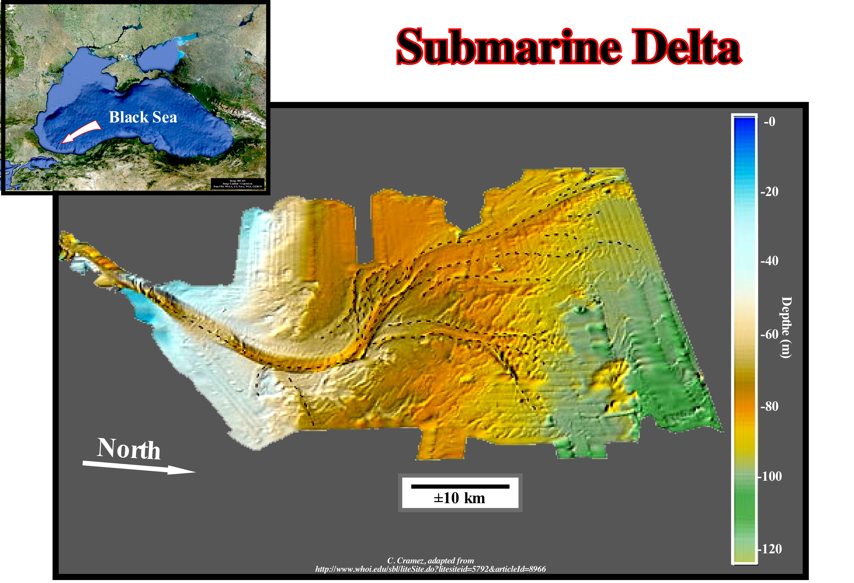
A delta or submarine fan is an accumulation of terrigeneous sedimentary particles at the bottom of the sea with the apex at the mouth of an incised gorge/canyon) on the continental slope. Submarine canyons have steep beds with high walls along which the sediments are transported by turbiditic currents to the deeper parts of the sea. At the base of the canyons, the slope break and the confinement slow the currents and the transported sedimentary particles begins to settle down. The finer particles settle down since the currents begin to decelerate. Thus, the sediments of a submarine delta consist, basically, of successive layers of sand-shale material, each of which exhibits a thinning and finning upward granulometry*. Low-relief submarine valleys and natural marginal dykes, very common in these depositional systems, branch out and down into distributive channels, which distribute the sedimentary particles along the entire delta, as they migrate, laterally, in the same way than the delta distributaries of a river. This map illustrates an ancient submarine delta on the Black Sea formed, probably, during the last great glaciation. When the absolute (eustatic) sea level fell due to the formation of the great glaciers and ice caps, the Black Sea ceased to be in communication with the Mediterranean Sea and became a large lake. The absolute sea level fall broke the provisional equilibrium profile of the water-courses, since the river mouths moved downstream and downward. The water-courses were forced to erode their beds to re-establish provisional equilibrium profiles, which increased the terrigeneous influx (sedimentary supply). In these lowstand geological conditions (sea level lower than the basin edge), the lake shores were abrupt and the water-depth decreased rapidly (most of the sequence-cycle had no continental shelf). Since the water-courses entered the lake, the currents lost the capacity to transport and the transported sedimentary particles deposited at the top of the continental slope forming a submarine delta. The geometry of the distributive, in the upper part, suggests the presence of several lobes and, also, that they were deposited by pendulum process. A delta lobe grows for a certain time, but at a certain moment, when accommodation is insufficient, it is abandoned and another lobe begins to form laterally, where there is more space available for sediments (accommodation). When the absolute (eustatic) sea level rose as a result of the thaw, the communication with the Mediterranean Sea was restored. The sedimentary influx decreased, strongly. The depositions coastal break of the depositional surface was displaced tens of kilometers upstream, which put the delta under a great water-depth, that is to say, the delta became a submarine delta located in a starved sedimentary basin. According to Galloway, taking into account the dominant forces in the formation process, deltas can be classified into three main types: (i) River Dominated Deltas, i.e., deltas dominated by the terrigeneous influx of the rivers ; (ii) Wave Dominated Deltas, i.e., deltas dominated by sea waves and (iii) Tidal Dominated Deltas, i.e., deltas dominated by tidal activity and tidal currents. The river dominated deltas are trimming and have many distributaries with marshes, bays or tidal flats in the inter-distributary regions. They occur when the river current and sedimentary transport are strong and other effects, such as rework by waves or tides, are smaller. These deltas tend to form large delta lobes in the sea, which may have little more than the distributary channel, and have a natural marginal dikes (levees) exposed above sea level. Due to their resemblance to a bird's paws, they are often referred in the geological literature as a "bird's foot delta", as is the case of the deltas of the Mississippi Delta Building. When much of the floodplain between the distributary channels is exposed above sea level, the delta displays la lobated form. Wave dominated deltas are more regular, exhibiting curved and arched shapes with frequent beach ridges, as in the Nile or Niger delta buildings, where the surfing of the waves causes a mixture of fresh-water and salt-water, so that the flow, immediately, loses its energy and deposits all its load along the coast. Tidal dominated deltas occur in areas with high tides or high speed tidal currents. Such deltas often resemble an estuarine bay filled with many elongated islands parallel to the main tidal stream and perpendicular to the shoreline, such as the deltas of the Brahmaputra and Mahakam delta buildings. The deltas of the Mississippi and Yukon delta buildings are typical river dominated (dominated by the terrigeneous influx carried by the rivers). The deltas of the Senegal San Francisco delta buildings are dominated mainly by the activities of the sea-waves.
(*) A sediment interval is said to be coarsening and thickening upward when the size of the grains and the thickness of the layers increases upwards. In the same way, an interval is thinning and finning upward when the the size of the grains and the thickness of the layers decreases upwards. The evolution of the thickness of the layers is what some geoscientists call stratonomy, which can be coupled to the granulometry. Coarsening when the granulometry of the layers increases upward and finning upward when it decreases upward. Thus, a coarsening and thickening upward is an interval that is at once the granulometry and the thickness of the beds increase upward.
Submarine Erosion....................................................................................................................................................................Érosion sous-marine
Erosão submarina / Erosión submarina / Submarine Erosion, Erosion unter - marine / 海底侵蚀 / Подводная эрозия / Erosione sottomarina /
Erosion under water, such as in shallow water, due to the action of waves. In stormy conditions, the wave base level does not exceed 10/20 m depth. At a great depth, the contour currents, turbidic currents, and bottom currents (density contrast) are the most frequent cause of submarine erosion, which can fully mobilize deep deposition systems.
See: « Relative Sea Level Fall »
&
« Turbidity Current »
&
« Submarine Canyon »
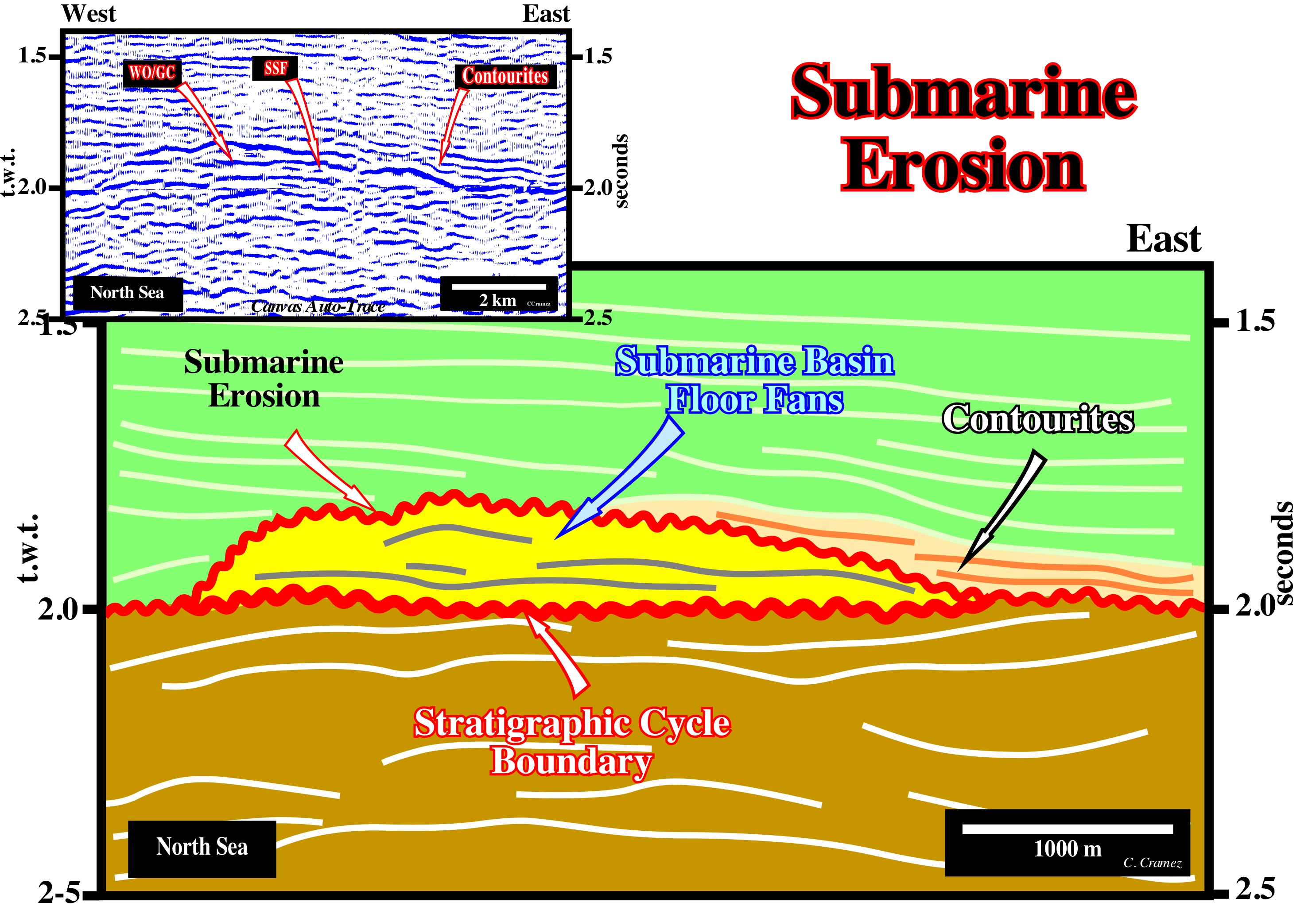
On this tentative geological interpretation of a Canvas auto-trace of a detail of a North Sea seismic line, submarine erosion in a deep environment is illustrated. This is relatively rare. Theoretically, in deep environments, where turbidite deposits are, largely, predominant, stratigraphic cycles are not limited by unconformities (erosional surfaces), but by correlative paraconformities, that is, by surfaces, which correlate upstream with unconformities. A significant fall of the relative sea level (local sea level referenced to the base of the sediments, i.e., to the top of the continental crust or to the sea floor, and which is the result of the combined action of tectonics and the absolute or eustatic sea level, supposed to be global and referenced to the Earth's centre) exhumed all environments situated upstream of the upper limit of the continental slope (which may coincide, more or less, with the shoreline), on which the erosive agents will act. In the deepest parts of the continental slope and marine glacis there is no erosion associated with the relative sea level fall. If, by chance, the geometric relations and terminations of the reflectors (lapouts) suggest an submarine erosion this is, certainly, induced by anything other than a relative sea level fall. On this tentative interpretation, the erosion of the submarine basin floor fans (SBFF) was, probably, caused by the action of contour currents, which flow parallel to the base continental slope, as a result of the balance between gravitational forces and the Coriolis effect. These currents eroded, partially, the submarine basin floor fans. The eroded sand was deposited, not far from the source, under the form of contourites. The internal configuration of the submarine basin floor fans is, practically, parallel and, more or less, subhorizontal or slightly wavy, while the internal configuration of the contourites is parallel, but the internal reflectors dip strongly (about 10-15° to East, in this example). One criterion allowing to test this interpretation (presence or not of contourites) is the mineralogical study of the well cores. The contourites do not have a clayey matrix. This means that they have good characteristics of reservoir-rocks, which is not always the case of the sediments that form submarine basin floor fans. On the other hand, the contourites are very rich in heavy minerals (zircon, allanite, grenades, etc.). The first time we heard to speak in contourites, was in a field trips, in the 60's (long before the advent of Sequential Stratigraphy), when Bouma put in evidence, in the flysch * of the Swiss Alps, channels induced by contours currents, which were, later, filled by sedimentary material transported by turbidite currents flowing, more or less, perpendicularly to the bathymetric anomalies. Such a channel fills, that Bouma called contourites, have a sandstone facies, with no clay matrix and very rich in heavy minerals. These filling structures correspond, more or less to the contourite recognized on North Sea seismic lines. In the Alpine flysch the contourites, that are, particular, rich allanite and zircon, were very sought by allochthonous to explore the heavy minerals. According to Mitchell, N. C., 2004 (American Journal of Science, Vol. 304, September, 2004, p. 590-611), fills of submarine canyons on the continental slope of the Atlantic Ocean exhibit morphological properties similar to those of fluvial channel fills. The inverse exponential relationship between the channel gradient "S" and the contributory area "A" (S ∽ A-ɸ) of the incised rivers can be interpreted using models in which the erosion rates of the bed (Ė) depend on "A" and "S" according to Ė∽AmSn, where the term Am represents the effect of increasing downstream discharge. For areas of spatially balanced, the model predicts the inverse relationship S A. It argues that erosion of the canyon bed by turbidity currents involves processes similar to erosion of the river bed so that a similar model could be used to help to interpret aspects of the canyon morphology and the differences between canyon systems. However, the discharge and flow of energy do not vary downstream in submarine canyons, just as in the river networks, because the tributaries are not, normally, active simultaneously.
(*) The flysch is a German Swiss term designating a detrital sedimentary deposit consisting of an alternation of sandstones and marls that have accumulated in the deep oceanic basins in the closing phase in the framework of an orogenesis. The flysch is deposited in a quiet depositional environment of low energy. The thicker layers (which require a lot of energy to settle), which underline interruptions to the calm environment, are associated with mass transport fluxes from the orogenic wedge, which often correspond to turbidite currents. Currently, and especially in sequential stratigraphy, the flysch corresponds to the submarine basin floor fans that form the lower sub-group of lowstand systems tracts group.
Submarine Expansion Centre.........................................................................Centre d'expansion sous-marin
Centro de expansão submarino / Centro de expansión submarino / Submarine Expansion Zentrum / 海底扩张中心 / Центр подводного развития / Centro espansione sotto-marino /
Place where the material of the terrestrial mantle is, via fractures associated with the breakup of the lithosphere, extruded in an aquatic (mainly marine) environment, where it can not flow laterally, and solidifies, in situ, in the form of pillow lavas or sheeted dykes.
See: « Tephrachronology »
Submarine Fan (Submarine delta)..........................................................................................Cône de déjection sous-marin
Cone de dejecção submarino / Cono de deyección submarino / Schwemmkegel U-Boot / 冲积扇潜艇, 海底扇 / Подводный конус выноса / Cono alluvionale sottomarino /
Sedimentary fan, consisting of sediments coming from the mainland and deposited on the sea floor, in deepwater, i.e., at the base of the continental slope. Morphologically, a submarine fan is similar to an alluvial fan, but its apex is located in the mouth of a submarine canyon that has been incised in the continental slope.
See: « Submarine Delta »
&
« Submarine Slope Fan »
&
« Lowstand »
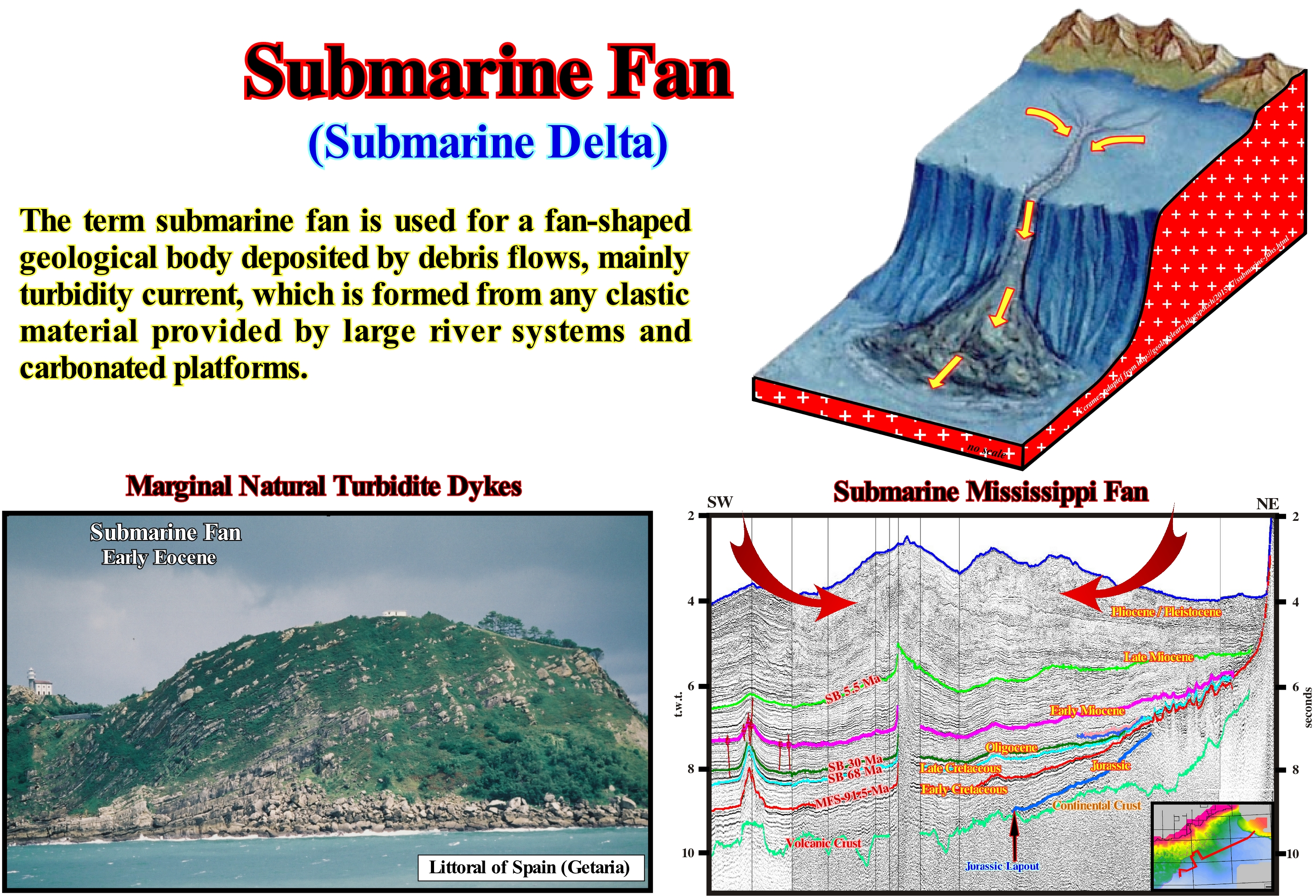
As illustrated in this figure, in general, submarine canyons have very steep profiles with very high walls. Wall collapses are common. Throughout the canyons, the passage to the abyssal plain of turbidity currents (mother currents of turbiditic deposits) is very frequent. When a turbidity current (dense and stratified stream with sedimentary particles in suspension caused by a submarine avalanche) reaches the base of a submarine cannon, the gradient break and current confinement forced the transported material to be deposited either in traction (transport by drag* and by rolling) or in suspension. The finer particles are deposited further away as the turbidity current decelerates. In slope sedimentary environments, either continental or deltaic with a marked topographic gradient, the strong erosion of the submarine canyons and along the slope, induced by a significant fall of the relative sea level (local sea level referenced to any point of the Earth's surface which may be the sea floor or the base of the sediments) may destabilize basin edge and cause a sharp failure with an important downward sedimentary sliding as a subaquatic gravitational flow, usually, laminar at the base and turbulent at the top. Such gravitational flow moves, generally, at high speed as a turbid mass of sedimentary particles of various sizes. The transported sedimentary particles are deposited in a gradual and/or rhythmic manner as a function of the hydraulic forces of such a flows. They fill the submarine canyons either in the proximal lobes, at the base of the slope, forming submarine fans, which in sequential stratigraphy may correspond to submarine basin floor fans (SBFF) or to submarine slope fans (SSF). The sediments that form a submarine fan ** are deposited in successive sandy lobes, within which the coarser material deposits on the base and the finer material on the top. In the submarine fans are formed valleys, generally, shallow, but with turbiditic natural marginal dikes 8levees), that allow the passage of the most recent currents. Downstream, the valleys branch into submarine distributive channels, which serve to distribute the transported sedimentary particles throughout the fan. The lateral migrations of the distributive channels are very frequent. The submarine fans can coalesce, laterally, and form the lower part of the marine glacis (in this case they correspond to the submarine slope fans). They can form either in highstand geological conditions due to instability of the basin edge and river floods, or in lowstand geological conditions when sea level is lower than the basin edge (in the Mutti's model for certain turbidite submarine fans). Their formation does not require an increase in space available for sediments (relative sea level rise). The sedimentary environment in which they settle down has enough water-depth. Many of the deep valleys of the submarine fans are not induced by erosion. They are associated with nondepositional zones between the natural turbiditic marginal dikes (turbidite levees). When a turbiditic current reaches the abyssal plain, it decelerates and begins to deposit the sedimentary particles that it carries forming sediments. They begin by depositing, more or less, symmetrical lobes on each side of a nondepositional zone along which the less dense or smaller-sized sedimentary particles continue further seaward. If later turbidic currents decelerate near the nondepositional zone, they will use it to flow and overbanking the already deposited natural marginal dikes. If more turbidite currents use this same nondepositional zone, the currents will be, more or less, channelled and their overflow will increase the channelled geometry of the nondepositional zone, which begins, gradually, to take the form of a valley.
(*) The transport is carried out by dragging when the grain displacement is subparallel and close to the sediment / fluid interface and thus, as in jump transport, contact between the grains can cause new grains to be moved by pushing.
(**) A nonsubmarine dejection cone or simply a dejection cone (also called an alluvial fan or alluvial cone) is a poorly selected and poorly worked debris material that forms in the foothills of the valleys, where the thalwegs of the valleys found a flat area, almost always coincident with an alluvial plain or a lacustrine area.
Submarine Hill (Abyssal)...............................................................................................................................................................Colline abyssale
Colina submarina (colina oceânica) / Colina abisal (submarina) / Abyssisch Hügeln / 深海丘陵 / Абиссальный холм / Collina abissale /
Low relief on the ocean floor. Generally, the submarine hills are located in the basins isolated by the old dorsal and oceanic slopes. The height of an submarine hill can reach several hundred meters and its diameter can sometimes exceed tens of kilometers. Approximately 85% of the Pacific Ocean floor and 50% of the Atlantic Ocean floor correspond to abyssal hills. For most geoscientists, Submarine Hill is synonymous of Oceanic Hill.
See: « Seafloor »
&
« Continental Rise »
&
« Submarine Basin Floor Fan »
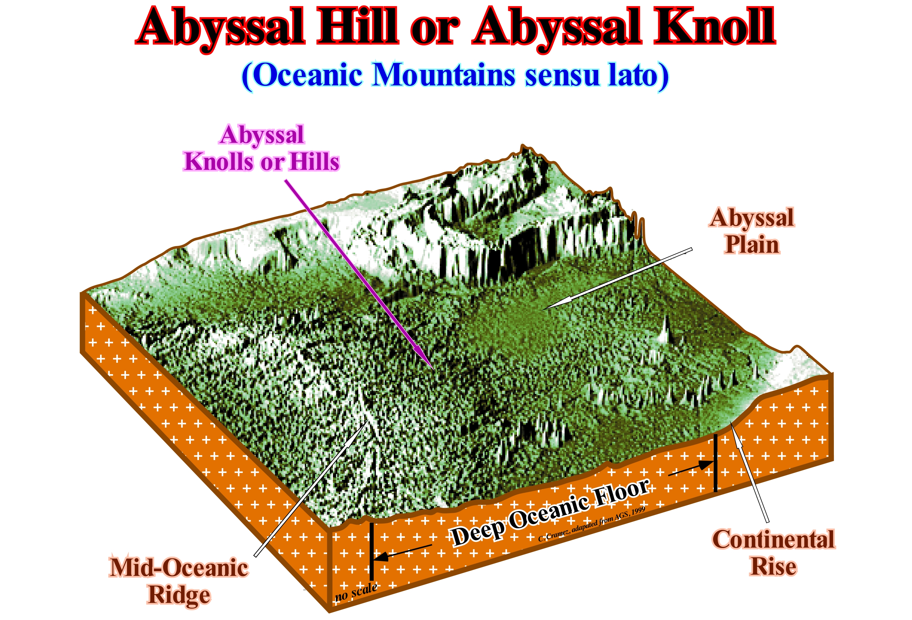
The abyssal plain (abyssal basin of certain geoscientists) designates the deepest part of the ocean, usually between 2,000 and 6,000 meters deep. It extends from the base of the continental slope to the oceanic ridges. This plain is, sometimes, interrupted by hills (with heights between 200 meters and 1,000 meters) or even by submarine mountains of volcanic origin with elevations of over 1,000 meters, which may give rise to oceanic islands. Although the abyssal plain is, always, below the photic zone, marine life can be abundant (blind fish, giant octopus, algae, decapod crustaceans, etc.), in particular, together with the deep oceanic sources (hot and nutrient rich) associated with the sea floor spreading and especially near the rift of the mid-ocean ridges. In this figure, in the ocean floor, which is bounded between the mid-oceanic ridge (or oceanic dorsal or submarine ridge) and the base of the continental slope, the abyssal or submarine hills are easily identifiable, particularly in the abyssal plain. As it can be seen, the mid- oceanic ridge, which is part of the immersed mountain chain that is about 60,000 km long and which is, currently, the longest mountainous chain on Earth, is displaced, laterally, by transform faults*, which are the type of boundaries between lithospheric plates in which there is no formation or consumption of rock material. These faults, which are only active among the segments of the mid-oceanic ridge, are, partially, hidden due to the deposition of turbidite and pelagic deposits. This scheme does not refute the conjecture advanced by a great majority of the geoscientists, according which the abyssal hills correspond, roughly, to told mid-oceanic ridge. Undoubtedly, as the sea floor spreading progresses, the more recent oceanic crust introduced along the rift of the mid-oceanic ridge pulls continentward the ancient ridges which begin, gradually, to cool down. This cooling causes the ridges to deepen as their density increases. On the other hand, this scheme shows, perfectly, the topography of the sea floor decreases (increasing bathymetry) from the mid-oceanic ridge (highest value) to the abyssal plain. The topography of the sea floor varies constantly not only because of the advance of oceanic expansion (sea floor spreading) but also because of its velocity. The faster the seas floor spreading spread, the more pronounced the topography of the sea floor. These variations of the sea floor topography modify the volume of the ocean basins, which forces the absolute (eustatic) sea level (sea level referenced to the Earth's centre) to rise or fall creating the 1st order eustatic cycles, once the hypothesis that the amount of water, in all its forms, is constant since the Earth's formation (around 4.5 Ga), has not yet been refuted. At the hierarchical level of the continental encroachment cycles (induced by 1st order the eustatic), when the absolute or eustatic sea level falls, overall, the coastal deposits prograde forming a first order sedimentary regression. On the contrary, when the absolute sea level rises, the coastal deposits move continentward (retrogradation) forming a 1st order sedimentary transgression. However, this is not true at the hierarchical level of sequence-cycles. Indeed, excluding the submarine basin and slope fans that can be deposited during significant relative sea level fall, all other sub-groups of sedimentary systems tracts forming a sequence-cycle require a relative sea level rise to be deposited (here we are talking about relative sea level, i.e., sea level referenced to a local point which may be the sea floor or base of the sediments, not absolute or eustatic sea level). Within a sequence-cycle, when the relative sea level rises in acceleration (increasingly important marine ingressions) sedimentary transgressions** (set of increasingly important marine ingressions and increasingly smaller sedimentary regressions) are deposited. When relative sea level rises in deceleration, increasingly important sedimentary regressions, which form, collectively, a 3rd order sedimentary regression, are deposited.
(*) A transform fault is a type of fault whose relative motion is, predominantly, horizontal, either sinister (lateral to the left) or dextral (right side). A transform fault is a conservative boundary between two lithospheric plates. It does not create or destroy the lithosphere. These faults terminate abruptly and are connected, at both ends, to other faults, rifts or subduction zones. In the deep ocean, most transform faults are, partially, hidden by pelagic sediments, where they suggest a displacement of the divergent boundaries of lithosphere plates that is not true, accommodating sea floor spreading. These faults can run onshore, where they are very destructive, such as St Andre Fault, in California.
(**) One could also speak of a third-order sedimentary transgression.
Subsequence.......................................................................................................................................................................................................Sous-séquence
Subsequência / Sub-secuencia / 序列 / Подсерия (отложений) / Sottosequenza /
Particular type of paracycle sequence (sedimentary deposit made during the stability period of relative sea level that occurs after a true or apparent marine ingression). There are two types of sequence paracycle-sequences: (i) Periodic paracycles sequences and (ii) Episodic paracycle-sequences. The former are associated with Milankovitch's orbital cycles. The seconds are associated with lateral displacements of the delta lobes. The episodic paracycle-sequences within a sequence-cycle, are very common in high level prisms (PNA) and low level prisms (PNA) in association with delta buildings.
See: « Fifth Order Eustaic Cycle »
Subsequence Cycle....................................................................................................................................................................Ciclo subsequência
Cycle sub-séquence / Ciclo sub-secuencia / Subsequenz Zyklus / 序列周期 / Цикл подпоследовательностей / Ciclo sottosequenza /
Sedimentary interval within highstana systems tract (transgressive interval TI and highstand prograding wedge, HPW ) and lowstand prograding wedge (LPW) defined by lateral displacements of depositional centers induced by either sedimentary influx or accommodation. These variations, which are usually due to the abandonment of the deltaic systems, are translated by lateral displacements basinward of the coastal onlaps. Subsequence cycles are not controlled by eustatism (absolute or eustatic sea level changes) and as such should not be confused with sequence-cycles. Wagonnier, uses the term episodic parasequence as synonymous of subsequence-cycle. We prefer to restrict the term parasequence to the periodic sequence-paracycles (such as the sedimentary intervals of the transgressive intervals. TI, bounded between two flooding surfaces and controlled by Milankovitch orbital cycles).
See: « Stratigraphic Cycle »
&
« Eustatic Cycle »
&
« Sequential Stratigraphy »
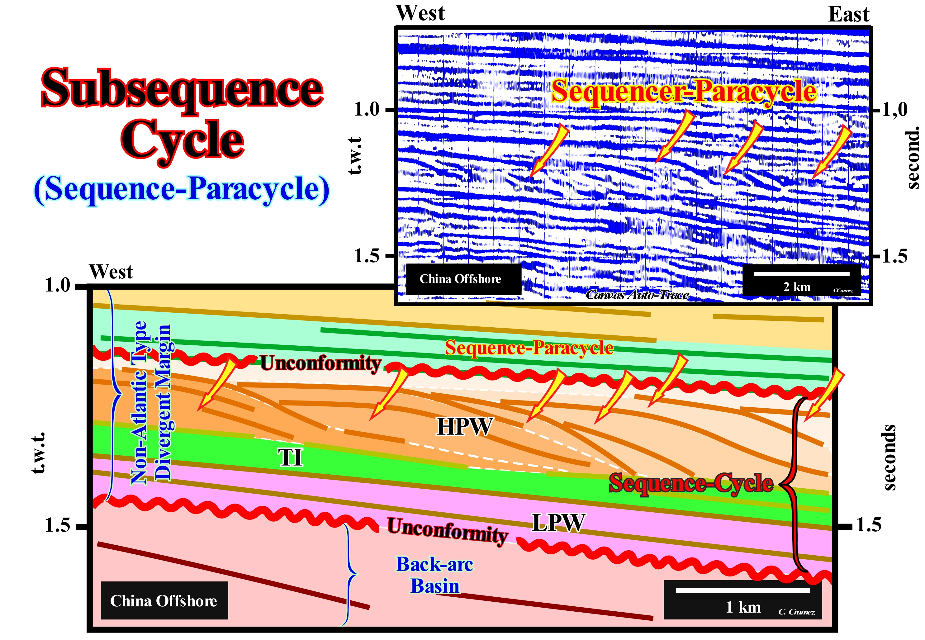
On this tentative geological interpretation of a Canvas auto-trace of a detail of an China offshore (divergent continental margin of non-Atlantic type (*) overlying a back-arc basin) seismic line, delta lobes (intervals coloured in brownish tones) above the transgressive interval (TI) of the sequence-cycle (limited between two unconformities underlined by red wavy lines, which emphasize significant relative sea level fall), can be interpreted as subsequence-cycles or as we prefer to say episodic-paracycles. The conjecture that in the deltaic intervals, the displacements of coastal onlaps (negative aggradation) are caused by variations in the terrigeneous influx is difficult to refute. This hypothesis was advanced by the French geoscientists of the Elf oil company, in the 1970's. in the Nigerian delta building, and is known under the name of "pendulum effect". Each eustatic paracycle moves continentward the shoreline (more or less, the depositional coastal break of the depositional surface, particularly, on the seismic lines), that is to say, that the shoreline it is forced to regress, due to the marine ingression. An eustatic paracycle is followed by a stability period of relative sea level, during which the sediments settle down to form what the geoscientists call a sequence-paracycle, before another relative sea level rise moves, again, the shoreline continentward and a new stability period take place, etc., etc. This means that: (i) During the relative sea level rise, which moves continentward the shoreline, only a ravinment surface is produced on the sediments forming the pre-existing topography ; (ii) It is during the stability period of relative sea-level, whose time-duration may be, more or less, long, the deposited sediments, gradually, displace searward the shoreline, forming what geoscientists call a sedimentary regression (**) ; (iii) There is any cyclicity in the relative sea level changes, because there is any relative sea level ; (iv) Each delta lobe, induced by the displacement of the terrigeneous influx, does not correspond to a sequence-cycle, but to sequence-paracycle, that EPR's geoscientist ("Exploration Production Research" of Exxon) called, in the early times of sequential stratigraphy, a subsequence cycle. When the relative sea level is stillstand, as long as a delta lobe is deposited, in front of the mouth of a river, the water-depth decreases and, after a certain time, there is no more space available for the sediments (accommodation) to settle over the lobe. The water-course with its terrigeneous influx moves, laterally and seaward of the already deposited lobe, where there is sufficient space available for a new lobe to be deposited. This lateral and downward displacement creates an apparent negative aggradation, which, as illustrated, is, rapidly, fossilized by onlapping. The coastal onlaps associated with such a negative aggradation are not associated with a relative sea level fall and the onlapping surface can not be considered as an unconformity, since there is no erosion associated. It is important to remember that: a) A delta lobe corresponds, generally, to a delta and not to a deltaic building ; (b) A delta is a sedimentary systems tract, that is to say, a lateral association of depositional systems (more or less, a Gressly's facies, i.e., a lithologic interval with a typical fauna, deposited in a determined environment), synchronous and genetically linked ; (c) Depositional systems forming, generally, a delta are, from the mainland to the sea : 1- Clay sandstones and silts of the delta plain and delta front sands ; 2- Prodelta shales and 3- Shales of the base of prodelta, which contain, sometimes, turbiditic sands (proximal turbidites) ; d) A sequence-paracycle is formed by one or more sedimentary systems tract.
(*) A non-Atlantic divergent margin develops in a compressional geological setting (within a megasuture) in association with an oceanization (sea floor spreading), i.e. in association with a marginal sea formation.
(**) The shoreline moves seaward (outbuilding, generally, with upbuilding) ), solely, due to the terrigeneous influx, the relative sea level is constant, which means no marine regression. The relative sea level is a local sea level referenced to any point on the Earth's surface, which can be the sea floor or the base of the sediments and which is the result of the combined action of the g tectonics and the absolute (eustatic) sea level, which is referenced to the Earth's centre.
Subsidence..........................................................................................................................................................................................................................Subsidence
Subsidência / Subsidencia / Subsidenz / 沉降 / Оседание / Subsidenza /
Slow sinking of a part of the Earth's crust. There are several types of subsidence. In the divergent margins and in the extensional basins, subsidence is created, mainly, by a thermal contraction of the crust and mantle. In compression basins, it is mainly induced by the bending of the lithosphere in response to sedimentary overload and thrusting.
See: « Eustasy »
&
« Halokinesis »
&
« Relative Sea Level Change »
In the history of sinking (lowering of an area of land in relation to the surrounding land), it is necessary to differentiate the total subsidence (thickness of sediments plus water-depth) of tectonic subsidence. The tectonic subsidence is equal to the reduced total subsidence of the isostatic compensation effect (due to sedimentary overload) and increased compaction effect. The diagenetic compaction can be presented under two aspects: (a) Chemical and (b) Mechanical. Chemical compaction encompasses the dissolution of minerals under pressure, whereas mechanical compaction does not encompass chemical processes, but physical aspects such as change in intergranular packing and deformation or breaking of individual grains. The tectonic subsidence can reach about 40% of the total subsidence. As illustrated in this figure, Greenlee (1989) calculated on the USA eastern continental margin, using the results of the COST B-2 drilling in New Jersey offshore and the stratigraphic data deduced from the seismic lines, fluctuations in relative sea level change ; (ii) The tectonic subsidence ; (iii) Total subsidence; (iv) Paleobathymetry (bathymetry of the marine environment in which the deposition of a given lithological unit, which characterizes a moment of geological history in which it occurred) ; (v) The long term eustatic curve (curve of the absolute or eustatic sea level changes *), and proposed the most probable mechanisms of subsidence. After the breakup of the lithosphere of the Pangea supercontinent, Greenlee admitted three cycles of thermal cooling. In the first two, it conjectured a slow Atlantic opening, which then accelerated as sedimentary transgression/sedimentary regression cycles**, more or less, contemporaneous with an important volcanic event, were deposited. The calculation of subsidence and paleobathymetry were corroborated by more recent data. The evolution of geological events seems to have not withstood recent refutation tests. The volcanic event (hot spot, i.e., a thermal anomaly inside the Earth, associated with mantle convection systems responsible for volcanism occurring within tectonic plates) is underlined by sub-aerial lavas (SDRs) (more or less 179.5 Ma), and which fossilized, locally, the rift-type basins that formed during the rifting phase in which subsidence was differential. The first opening phase of the Atlantic was sub-aerial, by lateral deposition of the lavas from the expansion centres, and only later, when the expansion centres sank (ocean crust formation) and the opening became oceanic oceanic) and thermal subsidence. All these conjectures were, perfectly, corroborated by the recent drilling wells in the US Atlantic offshore. On the tentative geological interpretation of a Vietnam offshore seismic line, illustrated in this figure, the differential subsidence, during lengthening or rifting from an internal back-arc basin, is obvious. In the non-Atlantic-type divergent margin, which fossilizes the back-arc basin, subsidence is thermal, as indeed in the divergent margin of the East of the United States studied by Greenlee, and seems to be the result of the cooling of the thermal anomaly that caused the lengthening of the lithosphere (differential subsidence). As no normal faults of the back-arc basin affects the divergent margin (offshore of Vietnam), many geoscientists suggest that since the differential subsidence (thermal anomaly, i.e., isotherm rise) stops, thermal subsidence (isothermal descent) begins. the result of a cooling and not a heating.
(*) The absolute sea level is the result of the combination of: i) Tectono-Eustasy that is controlled by the volume variation of the ocean basins in association with oceanic expansion following the rupture of the supercontinents ; (ii) Glacio-Eustasy, which is controlled by the variation of water volume of the oceans as a function of the amount of ice (assuming that the amount of water in all its forms is constant since the formation of the Earth, around 4.5 Ga) ; (iii) Geoidal-Eustasy, which is controlled by the distribution of ocean water caused by variations in the Earth's gravity field (where gravity is stronger than normal, sea level is thrown to the centre of the Earth) and (iv) Steric seas level rise or thermal expansion of the oceans (if the temperature increases, the density of the water decreases, and for a constant mass, the volume increases).
(**) Many geoscientists say transgressions/regressions cycle, forgetting that the term transgression, above all, refers to the advance of the sea on the continent, that is to say, to a marine ingression. Therefore a geoscientist should always say cycles of sedimentary transgressions/sedimentary regressions when he is referring to the cycles of the retrogradational and progradational intervals, which are separated by a downlap surface.
Substage (Geological)........................................................................................................................................................................Sous-étage (Géológique)
Subandar (geológico) / Sub-piso (geológico) / Substage (geologische) / 台下(地质) / Подъярус (геологический) / Sottostadio (geologico) /
Stratigraphic unit (strata) deposited during a geological subage. A substage applies to rocks and not to time. Generally, the substages are used to denominate to glacial episodes, like, the substage Woodfordian that is part of the Wisconsian stage.
See: « Systems Tract »
&
« Geological Time Scale »
&
« Geological Time »
The vast majority of geoscientists divide rocky geological intervals into: (a) Eonothem ; (b) Erathem ; (c) System; (d) Series; (e) Stage ; (f) Formation ; (g) Member and (h) Horizon. In the standard chronostratigraphy (Hardenbol, J., et al., 1998), only four intervals are considered: (i) Erathem, such as Mesozoic ; (ii) System, such as Jurassic ; (iii) Serie, such as Lower Jurassic or Lias and (iv) Stage, such as Toarcian, which is the upper floor of Lias. The time equivalents of Erathem, System, Serie, and Stage are, respectively, Era, Period, Epoch, and Age. The sub-stages are the subdivisions of the stages. The substages are, mainly, used in Pleistocene Epoch (between 1.6 Ma and 10 ka). During this time (glacial epoch) a large part of North America and Eurasia was, periodically, covered by ice caps. The thickening (advancement) of glacial caps alternated with periods (thousands of years) of thinning (retreat). Several ice/thaw cycles of glacial caps occurred during the Pleistocene. These cycles induced by climate changes produced significant eustatic variations. During inter-glacial ages (subdivisions of a geological epoch), the climate (in certain parts of the globe) was pleasant and similar to the current climate. The succession of the glacial ages can be recognized by the glacial stages, that is to say, by the sediments deposited by the glaciers (moraines and tills). The frontal moraine (stage and substages) represent the ages and subages during which the glaciers and the ice caps had a thickening greater than today. Many of the moraines and tills are separated from each other by nonglacial soils and sediments, which emphasize interglacial ages and subages. The study and dating of moraines, as illustrated in this figure, allowed the individualization of four sub-stages (Mankato, Cary, Tazewel and Iowan) in the Wisconsian (stage equivalent to Wurm in North America).
Subterranean Stream.................................................................................................................................................Courant souterrain
Corrente Subterrânea / Corriente subterránea / Unterirdische Stream / 地下流 / Подземное течение / Flusso sotterraneo /
Water-course flowing through underground cavities.
See: " Stream "
&
" Cave "
&
" Erosion "
Groundwater encompasses all water of meteoric origin that lies within the soil and underlying rocks. Its distribution is, of course, very large, but as its geomorphological effects operate, mainly, through solutions, its influence is more important in limestone soils, where it can even flow, permanently, in the form of subterranean currents. However, most of the time, the underground currents resurface creating underground sources as shown in this photograph. In order to have subterranean currents it is necessary, first of all, that the surface water (mainly, the water that flows on the Earth's) passes in depth. There are several ways in which surface water passes to underground water. However, the most typical, and perhaps most frequent, occurs in calcareous regions. In these regions, the sedimentary layers are almost always very fractured by different systems of fractures. The progressive widening of these fractures, as well as that of fault planes, by groundwater produces a drop in the level of hydrostatic equilibrium. Over time, surface water currents are losing more and more water through the widespread fractures of limestone and at a certain moment, they are even, permanently, replaced by underground currents. Underground captures are, particularly, frequent when rapid water table falls are produced by the incision (nesting) of the large currents. These captures are easier when two rivers or two neighbouring streams are incised at different levels. The upper river water is often diverted to the lower level through the water separation line. A large topographic variety results from the combination and interaction of surface and subterranean currents. The simplest and most frequent topographic form, through which surface water passes underground, is the sinkhole (natural depression on the topographic surface caused by removal of soil or underlying rock or both by water). However, over time, due to corrosion, the sinkholes widen and turn into blind valleys that are more or less elongated basin with steep ends.
Succession (Meanders).............................................................................................................................................................................................Succession
Sucessão / Sucesión (meandros) / Nachfolge / 继承 / Последовательность; разрез (осадков) / Successione /
Process, by which what was once a river will one day become a forest. Over time, the bow of the meander (loop) widens, continuously, until the throat (or knot) of the meander disappears completely. Eventually, the arch of the meander isolates itself from the river's path creating an oxbow, which when water forms a very typical lake, in the form of a horseshoe. Once the water ceases to flow in the old river bed, a lake is formed, where the fine and organic sediments settle, in situ, by decantation. Later, this entire complex can become a swampy area, which often evolves in a meadow where trees are easily rooted.
See: « Oxbow (channel) »
Summer Accumulation (Varve).............................................................................................................Accumulation estivale
Acumulação Estival / Acumulación estival / Sommer Anhäufung / 夏季積累 / Летнее накопление / Accumulo di stato (a varva) /
Sediments deposited at the bottom of a lake, usually, proglacial, during the summer, i.e., when the distributive channels are not frozen and can transport sediments to the lake.
See: « Varve »
&
« Winter Accumulation (varve) »
&
« Proglacial Lake »
A rhythmic stratification*, in which parallel horizons, with different lithologic compositions, alternate, is, perfectly, illustrated, in this photograph (outcropping on the western shore of Lake Michigan, USA), by the variations induced by climate changes associated with the seasons. Sedimentation in proglacial lakes is very different in summer and winter. Coarse sediments, which are lighter, deposit during the summer. During winter, when the distributive channels and the surface of the lakes are frozen, only the thinner sediments, which are darker (rich in organic matter) deposit, at the bottom of the lake, since the terrigeneous influx (sedimentary supply) is very weak. It can be said that a varve represents the annual sedimentation, which is constituted by a pair of horizons: (i) A thick and clear, corresponding to the summer accumulation and (ii) Another formed by thinner and dark sediments, corresponding to the winter accumulation. When such alternation is visible (low burial and poor diagenesis), it allows the correct dating of the varves, provided a recent or old reference point is available. The layers of ice from an ice cap, glacier or ice-sea correspond, also, to a rhythmic stratification of the snow. The dating of the layers of ice, which is indispensable for the study of the gases contained in the bubbles of the ice-cores, which is now very fashionable, is more difficult than the dating of the varves. If ice dating is easy, when you see yearly variations, it is much harder when yearly variations are not detectable in depth. In this case, a series of hypotheses about the compaction and accumulation of ice, as well as a calibration to reference points (known volcanic eruptions, for example) or to cosmogonic measurements, is necessary. If the ice dates are affected by many inaccuracies, the temperature measurements deduced from the isotopic variations** of the hydrogen or oxygen of the water are also measured. Modern climatology (a study of climate, its variations and its impact on various human activities or not) which is characterized by a very large number of direct observations made over a very short period of time is a bad indicator of climate change***. On the contrary, paleoclimatology (a study of past climate from the records they left in sediments, ice, wood, etc.) is a good indicator of climate changes, although the number of observations is very limited. Knowledge of the climate past is an inverse function of its antiquity (J-P Vigneau, 2005, Climatologie, Armand Colin). The meteorology studies the evolution of the time are in the short term, whereas climatology studies are in the long term. Climate is, generally, defined for an arbitrary 30-year time interval that is more or less adjusted according to the climatic changes to be highlighted and the statistical methods used for this purpose (A. Foucault, 2016- Climatologie et Paleoclimatologie, Dunod, ISBN 978-2-10-75460-1). Every geography of climates is based on the calculation of averages of situations and measured elements, which are nothing other than didactic comforts that caricature reality. In terms of climate, as in many others, society does not like the changes, in particular, the climate changes that have existed since the Earth formed at about 4.5 Ga. Take into account both the duration and the magnitude of the climate changes, several geoscientists proposed the following hierarchy : (i) Pulsations, that last a few years or a few decades and which are perfectly reversible (e.g., series of years of raining or drought) ; (ii) Oscillations, that last from a few centuries to a few millennia, but are reversible (e.g., the Little Ice Age) ; (iii) The Fluctuations, that are spread out over tens, hundreds of thousands of years and have mark cyclic character (e.g., the evolution of the Quaternary) ; (iv) Mutations, that lasted millions, tens or hundreds of millions of years that have a irreversible character (e.g., irreversible upheavals of the Earth’s surface).
(*) In general terms, the expression rhythmic or cyclic sedimentation, as certain geoscientists say, refers to a repetition in a succession of rock units that are organized in a particular way. However, for others, rhythmic sedimentation is so comprehensive that it may include all sedimentation and therefore has no special significance ("Essentially, all deposition is cyclic or rhythmic" W. H. Twenhofel, Principles of Sedimentation, 1939). For some geoscientists, they suggest significant generalizations, from an apparent disorder, that form the basis of genetic interpretations.
(**) The influence of the glacial and thermal effect on the oxygen isotope ratios of carbonates is still under discussion. Caesar Emiliani, who was the first (1952) to show the isotopic stages in the Quaternary, thought that the thermal effect was more important than the glacial effect. Today, however, most geoscientists think otherwise. It appears that the isotopic variations determined in the carbonates of the foraminifera throughout the Quaternary, 2/3 would be a consequence of the glacial effect and only 1/3 due to the temperature. This conjecture is, mainly, based on the correlation between the isotopic curves of the deep benthic foraminifera and the pelagic foraminifera. If temperature was the dominant parameter there should be a temporal discrepancy between the record of the pelagic foraminifera, which live in the surface layers of the ocean and thus, immediately, sensitive to temperature fluctuations, and the record of the benthic foraminifera living on the ocean floor that is a thermally stable environment.
(***) The term climate change or climatic change refers to a change in the statistical distribution of weather patterns when this change lasts a long period of time (hundreds to millions of years). Climate change can be caused by several factors, such as: (i) Variations in solar radiation received by the Earth ; (ii) Plate tectonics (continental drift) ; (iii) Solar Cycles ; (iv) Volcanic eruptions ; (iv) Biotic processes (certain human activities can be considered as anthropogenic causes of climate change).
Sun-Spot Cycle........................................................................................................................................................................................................Cycle solaire
Ciclo solar / Ciclo solar / Sonnenfleck-Zyklus, Solar-Zyklus / 太阳黑子周期 / Цикл солнечных пятен / Ciclo solare (macchie solari) /
Variation in number and frequency of visible spots in the Sun. Powered by the inductive action of internal flows of the Sun, the solar cycles control: (i) Structure of the Sun's atmosphere (corona and wind) ; (ii) Irradiation of the Sun ; (iii) Flow of the solar radiation of small wavelength (ultraviolet until X-rays) ; (iv) Frequency of eruptions, injections and other eruptive phenomena and (v) Flow of cosmic rays entering the solar system.
See: « Sun »
&
« Climate»
&
« Natural Greenhouse Effect »
Sunspots appear in groups. They can grow in a few hours and disappear in a few months. Their number and the area they occupy at a given moment indicate the extent of the Sun's activity. At times, the Sun presents us with a stained face; at others, none are found. Solar activity is not therefore constant over time: it obeys an 11 year cycle. At the beginning of a solar cycle, the spots appear at high latitudes and come closer to the equator; the magnetic activity then reaches its maximum. In the end, the spots disappear and the next cycle begins. Each new cycle is due to the regeneration of the magnetic field inside the Sun. It's a kind of giant dynamo that talks on its own. Solar cycles were discovered in 1843 by S.H. Schwabe. After 17 years of observations, he found a periodic variation in the average number of sunspots seen from year to year on the solar disk. Rudolf Wolf compiled and studied these and other observations by reconstructing the solar cycles up to 1745. Wolf and other astronomers found it useful to define a standard index of sunspots, which still remains to be used today. The average duration of sunspot cycles is about 11 years (about 28 cycles between 1699 and 2008). Cycles with durations between 9 and 14 years were observed and also, significant variations in amplitude. The solar maximums and minimums refer, respectively, to periods of maximum and minimum counts of sunspots. The individual sunspot cycles are divided from a minimum to the next. Following the numbering scheme established by Wolf, the cycle 1755-1766 is traditionally numbered "1". The period between 1645 and 1715, during which time few sunspots were observed (Little Glacial Age, LGA). This time is now known as the Maunder minimum, in honour of E.W. Maunder, who researched, extensively, this peculiar event, first observed by G. Spörer. In the second half of the 19th century. It was also observed (independently) by R. Carrington and Spörer that as one cycle progresses, sunspots first appear in the mid-latitudes and then ever closer to the equator until reach the solar minimum. This pattern is best visualized in the form of the so-called butterfly diagram, constructed by E. Walter and A. Maunder in the early twentieth century. The physical basis of solar cycles was clarified in the early 20th century by G.E. Hale and his collaborators, who in 1908 showed that sunspots, whose formation lasts for days or weeks and lasting between weeks and months, were, heavily, magnetized (the first detection of magnetic fields outside Earth). They showed that the magnetic polarity of sunspots: (i) It is always the same for each hemisphere over a given cycle ; (ii) It is opposite in each hemisphere during the same cycle ; (iii) It is inverted in both hemispheres from one solar cycle to the next. Hale's observations revealed that a solar cycle is a magnetic cycle with an average duration of 22 years. However, as almost all manifestations of the solar cycle are insensitive to magnetic polarity, it continues to be spoken "solar cycles of 11 years." Later, H, Babcock and his son showed that: (a) The solar surface is magnetized, even out of the sunspots ; (b) The weaker magnetic field is a first order dipole and (c) The dipole also undergoes inversion of polarity with the same period as the solar cycles. This suggests that a solar cycle is a magnetic space-time process developed throughout the Sun. The causes of solar cycles are still under debate. Some geoscientists suggest a connection with the tidal forces induced by Jupiter and Saturn. The magnetic field of the Sun structures its atmosphere and the outer layers to the crown and even the solar wind. Solar activity is strongly modulated by the solar magnetic cycles since they serve as energy source and dynamic motor for the Sun. As illustrated above, solar cycle 23 is ending. The first sunspot of the cycle of 24 became visible on 01/01/2008. Another spot, appeared in the northern hemisphere (with the right magnetic polarity), on 04/14/2008. Sunspots not only have a connection to geomagnetic activity on Earth, but also play an important role in climate change. In the last thousands of years, there have been many periods when there were not many sunspots found in the Sun. The most famous is a period from about 1645 to 1715 (Maunder Minimum). This period corresponds to the middle of a series of exceptionally cold winters throughout Europe known as Little Glacial Age (LGA). Scientists are still debating whether the decrease in solar activity helped cause the LGA, or whether cooling occurred at the same time as the "Minimal Maunde". A period called "Medieval Maximum", which lasted from 1100 to 1250, apparently had higher levels of sunspots and solar activity. This time, this period coincides (at least partially) with a period of warmer climates on Earth called the "Middle Medieval Period". Sunspot counts have been higher than usual since about 1900, prompting some scientists to call the time we are now "Modern Maximum" (http://www. Windows.Ucar.edu/tour/link =/sun/ activitysunspot_history.html). Reconstruction of past solar activity before solar stains were counted by radioisotope analysis can be done using tree rings to calibrate for date and analyzed changes in 14C measurements that are understood as a reflection of solar activity. It is believed that changes in the production of energy particles from the Sun (the solar wind) modulate 14C production in the upper atmosphere. The magnetic properties of the solar wind change with the variation of the sunspots, leading, in turn, to variations in 14C production (Stuiver et al., 1991). The effect of the solar wind is such that the high production of 14C is associated with periods of low number of sunspots. From the changes in how the 14C responds, you can produce graphs, as above, to analyzed the solar energy changes in the last 1,000 years. However, it would be well to note that these proxies are not the same thing as the amount of light that hits the Earth. That is why they are considered as a proxy. More sunspots correlate with more solar radiation, but one does not measure the other directly. it seems that there is a cause and effect relationship between sunspots and auroras. The more sunspots there are, the more active the sun is, the stronger its wind and the more the auroras abound. Their frequency thus reaches a maximum approximately every eleven years, this corresponds to the maximum of sunspot activity.
Supercontinent..........................................................................................................................................................................................Supercontinent
Supercontinente / Supercontinente / Superkontinent / 超大陆 / Суперконтинент / Supercontinente /
A land mass or geological body that contains more than one continental nucleus or craton. The continents resulting from the breakup of the Precambrian supercontinent (Protopangea or Rodhinia) were later added to form the Pangea supercontinent at the end of the Paleozoic.
See: « Continental Collision »
&
« Pangea »
&
« Rodhinia »
Geoscientists dealing with paleogeography use the terms supercontinent and small supercontinent to designate a uniform geological body encompassing all of the currently known continents, i.e., the present-time continents, which have sometimes been agglutinated in one or a few lithospheric plates. It is said that the Pangea supercontinent was formed by the Laurasia small supercontinent to the north and the Gondwana small supercontinent to the south, each consisting of several continents, such as Laurentia (in the Laurasia small supercontinent ) and Australia (in the Gondwana small supercontinent). The first supercontinent that the geoscientists were able to reconstruct is known as the Vaalbara supercontinent, which formed from protocontinents and agglutinated about 3.8 Ga, and was later split about 2.8 Ma. The Kenorland supercontinent was formed about 2.7 Ma and fractured about 2.5 Ga on different continents called: (i) Laurentia ; (ii) Baltica ; (iii) Australia and (iv) Kalahari. The Columbia supercontinent formed and broke for a period ranging from 1.8 to 1.5 Ga. The Rodhinia or Protopangea supercontinent , illustrated in this figure, fractured about 750 Ma. One of the fragments of the Proto-Pangea included large parts of the continents now situated in the southern hemisphere. Plate tectonics once again aggregated fragments of the individualized continents during the rupture of Rodhinia to form the Pangea supercontinent, at the end of the Paleozoic era. Recent geological studies suggest that supercontinents form in cycles (fracturing, dispersion, and agglutination), the duration of which ranges from about 250 My to 450 My, according to geoscientists. Assuming that the amount of water in all its forms is constant, since the formation of the Earth about 4.5 Ga, it can be said during the fracturing and dispersion of the continents (decrease of the volume of the ocean basins), the absolute or eustatic sea level (supposed to be global and referenced to the Earth's centre) rises and it fall during the agglutination of the continents (increase of the volume of the ocean basins). The Rodhinia supercontinent, illustrated in this figure, formed about 1.1 Ga. The size and configuration of the Rodhinia are very speculative. The continent North America seems to have formed the nucleus of Rodhinia. The eastern part of North America was adjacent to the western part of South America and it was adjacent to Australia and Antarctica. Some geoscientists propose the following chronological list of supercontinents, which covered a considerable amount of the Earth area (usually between a quarter and a half): 1) Vaalbara (about 3.8 Ga) ; 2) Ur (about 3.0 Ga) ; 3) Kenorland (about 2.7 Ga) ; 4) Nena (about 1.8 Ga) ; 5) Columbia (about 1.8 Ga) ; 6) Atlantica (about 1.8 Ga) ; 7) Rodhinia (about 1.1 Ga) ; 8) Pannotia (about 600 Ma) ; 9) Euramerica (about 400 Ma) ; 10) Pangea (about 300 Ma) ; 11) Gondwana (about 200 Ma) ; 12) Laurasia (about 200 Ma). Certain geoscientists consider that the lithosphere is, currently, formed by the small supercontinent Eurafrasia and by the small supercontinent Americas and that in the future there will be the Aurica supercontinent (*), within 300 million years, as a result of the closing of the Atlantic and Pacific oceans. For many geoscientists, Earth's history can be seen as a series of formations and fractures of supercontinents. Such cycles of supercontinents or Wilson cycles (opening and closing of ocean basins due to plate tectonics) influenced, probably, the recording of rocks more than any other geological phenomenon. Although periodicity in tectonic processes has been recognized long before plate tectonics, which gives an explanation of its difficult to refute, the recognition of supercontinent cycles is, relatively, recent (the cycle of a supercontinent was first proposed for less of 50 years). The cycles of supercontinents easily explain first-order transgression / regression cycles: (1) Absolute (eustatic) sea level is highest when oceanic spread is predominant (volume of ocean basins decreases due to formation and volume of the oceanic ridges) ; (2) The absolute (eustatic) sea level is lower when the continents aggregate to form a supercontinent (the volume of the basins is maximum, since the volume of the oceanic rides is minimal). The transgression/regression sedimentary cycles of higher order, that is of second and third order imply geological factors other than the volume variation of the ocean basins.
(*) http://www.techitt.com/300-milhoes-anos-os-oceanos-fechar-ao-um-supercontinente-surgira/
Supersequence Cycle...............................................................................................................................................Cycle super-séquence
Ciclo supersequência / Ciclo súper-secuencia / Zyklus Supersequenz / 周期超层 / Цикл надпоследовательностей / Ciclo supersequenza /
Sedimentary interval deposited during a second order eustatic cycle (eustatic supercycle of P. Vail) corresponding to a continental encroachment subcycle. A supersequence cycle is, usually comprised, of 5-7 sequence-cycles, limited by significant relative sea level falls. The supersequence-cycles are grouped into sets of three or four units to form a continental encroachment cycle. The sucessions of supersequence-cycles, with a duration of 36-40 My, seem to be the preponderant ones in the geological history.
See: « Stratigraphic Cycle »
&
« Eustatic Cycle »
&
« Continental Encroachment Cycle »
The term "supersequence cycle" used by EPR (Exxon's "Exploration Production Research") at the beginning of the stratigraphy sequence was replaced by "Continental encroachment Subcycle" (Duval et al., 1993) for obvious reasons: (i) The geological interpretation depends on the observer's expectations, but also on the scale of the observed ; (ii) Not only, "supersequence" means a very large sequence or a very large sequence-cycle, which is not the case of the interval considered by the Exxon geoscientist ; (iii) In association with a "supersequence cycle" or only "supersequence" there are neither "submarine superfans" nor "transgressive superintervals", but rather a vertical overlap of more or less well-defined sequence-cycles. That is why, in collaboration with B. Duval (from Total SA) and Peter Vail (from Rice University, Houston), we suggested to call a "supersequence cycle" a continental encroachment subcycle, which is induced by a 2nd order eustatic cycle characterized by a time-duration between 3-5 My and 50 My and limited between two unconformities. Within a continental encroachment subcycle, not only two tectono-sedimentary subphases may be recognized: a) Transgressive subphase at the base and b) Regressive subphase at the top, separated by a significant downlap surface, but also a number of sequence-cycles. In this tentative geological interpretation of a Canvas auto-trace of a West India offshore regional seismic line, which corresponds to a divergent margin of Mesozoic/Cenozoic age Atlantic type overlying the Mesozoic age rift-type basins (*), within the cycle (induced by the Mesozoic/Cenozoic eustatic cycle), which at the base is limited by the unconformity associated with the break-up of the lithosphere (BUU) and the sea floor, several continental encroachment subcycles can be recognized (old "supersequences"). The unconformities, which limit the continental encroachment subcycles, emphasize downward displacements (negative aggradation) and seaward (progradation), of the coastal onlaps. In this particular case, that is to say, when the aggradation is negative, certain geoscientists say that coastal onlaps prograde downward (downbuilding). On the contrary, when aggradation is positive, they say that the coastal onlaps prograde upward (upbuilding). According to the stratigraphic signature, proposed by P. Vail and his students, which is corroborated (not to be confused with verified, since in Geology nothing can be proved to be true) by the exploration wells drilled in this region, the main unconformities are, from top to bottom: SB. 5.5 Ma ; SB. 10.5 Ma ; SB. 25.5 Ma ; SB. 30.0 Ma and SB. 68.0 Ma. The unconformity SB. 10.5 Ma (Ma and not My, since, by convention, Ma designates a geological age, that is, years ago and My any time interval) is the lower limit of the continental encroachment subcycle bounded by SB. 5.5 Ma and SB. 10.5 Ma. The interval between BUU unconformity (unconformity of the breakup lithosphere) and the SU unconformity (discontinuity at the top of the subaerial lavas) is mainly composed of lava flows (subaerial volcanic crust) after the breakup of the lithosphere (BUU). These subaerial lavas pass, laterally, to pillow-lavas (volcanic sheeted dikes, since volcanic material can not flow under water), which constitute the true oceanic crust. On this tentative interpretation, as in most of the divergent volcanic margins, the subaerial spills that make up the famous Seaward Dipping Reflectors (SDRs), cover to a large extent the basement (continental crust of Gondwana) and the outermost rift-type basins, which formed before the break-up of the Gondwana lithosphere, as illustrated in the central part of this tentative interpretation. At present, it may be said that the term "supersequence cycle" used by Exxon geoscientists in the 1980s has been, virtually, abandoned, since a "supersequence" has nothing to do with a large sequence cycle, as such a term suggests.
(*) The rift-type basins develop within the lithosphere of the small supercontinent Gondwana when the lengthening preceding the break-up of the lithosphere, which means that the divergent margin, locally, can fossilize either the continental crust of the small supercontinent Gondwana or the rift-type basins.
Superposition (Dating)............................................................................................................................................................................Sobreposition
Superposição / Superposición (datación) / Überlagerung / 叠加 / суперпозиция / Sovrapposizione /
Concept of dating, in relative age, in stratified rocks. In a series of non or slightly deformed sedimentary rocks, the upper layer is always the youngest and the lowest layer is always the oldest.
See : « Geological Principle »
&
« Lateral Sedimentation »
&
« Relative Age »
In 1667, Nicholas Steno argued that as the fluids, which decanted into the Earth, in the same way, that crystals are deposited during a chemical reaction, strata deposited on top of a nondeformed sedimentary interval are more recent than the layers deposited at the bottom. This hypothesis, which today is for all geoscientists evident and known as Steno's superposition principle, was one of the important contributions to Geology. This principle, which allows relative rock datations between nondeformed (or slightly deformed) sedimentary intervals, as illustrated in this figure, can and should be apply to all tentative geological interpretation of seismic lines, since very rarely petroleum companies shot seismic lines in the mountain ranges where, the seismic intervals can be very deformed and even inverted. Steno realized that other geological processes could create apparent exceptions to his laws of superposition and Horizontality. He argued that the formation of caves could, for example, remove part of a lower layer, and that the collapse of a cave could carry large pieces of a top downward. He also noted that rocks can be raised by underground forces. Modern geoscientists recognize that sloping, folding, and faulting may complicate the analysis of a stratigraphic sequence. Just as a molten rock can force its trajectory through the surrounding rocks and can, sometimes, be compressed between the older layers of the rock, which is also an exception to Steno's law. However, such anomalies to Steno's superposition law leave physical evidence on the deformed rocks. Thus, for example, fractured rock layers may be broken or metamorphosed along a fault plane. There are many other principles in geology, which certain geoscientists consider "obvious," but which a few centuries ago were not at all obvious. For example: (i) Principle of Composition - a rock represented by fragments in another rock is older than the rock that contains them ; (ii) Original Lateral Continuity Principle - the sedimentary layers are deposited in lateral continuity ; (iii) Principle of Original Horizontality - the sedimentary layers deposit horizontally ; (iv) Principle of Intersection - the most recent lode (vein) move the oldest lodes ; (v) Principle of Intrusion - an igneous intrusive rock is younger than the one it penetrates ; (vi) Principle of Fossil Succession - the distribution of fossils is not unpredictable, it follows a definite vertical sequence; (vii) Principle of Uniformitarianism - geological changes are due above all to ongoing processes and changes such as those currently observed ; (viii) Principle of Catastrophism - the changes that occurred on Earth were due to the occurrence of major natural disasters ; (ix) Principle of Ochkam * - plurality should not be invoked without necessity: "Pluritas non est deponent sine necessity", etc. As more modern principles can be mentioned: (a) Principle of Goguel, during the deformation, the volume of the sediment remains, more or less, constant; (b) Walther's principle, vertically succeeding facies in the conforming strata succeed ,laterally, in adjacent environments ; (c) Dextrological Principle, if a reference system rotates in a clockwise direction the deflection is to the left of the object, in the direction of motion ; (d) Principle of the Carbonated Bucket, growth of an edged carbonate platform is determined by the growth of the edge ; (e) Principle of the Drift of the Continents, the continental masses have a small density and, for that reason, they floated on the dense masses of the ocean, moving and changing the surface of the planet ; (f) Principle of Plate Tectonics, it is not the continents that move, but the lithospheric plates that contain these continents ; (g) Principle of Neocatastrophism, admits Uniformitarianism as the main guide, but does not exclude that occasional catastrophic phenomena have contributed to any changes in the earth's surface, etc.
(*) This principle is the predecessor of the so-called KISS principle ("Keep It Simple, Stupid".) In the "Critique of Pure Reason", Kant accepts the maxim that "rudiments or principles should not be unnecessarily multiplied (entia praeter necessitatem non esse multiplicanda)" and says that this is a regulating idea of the pure reason underlying the theorization of scientists on nature (Kant, 1781/1787, pp. 538-9).
Supernova...............................................................................................................................................................................................................................Supernova
Supernova / Supernova / Supernova / 超新星 / Сверхновая звезда / Supernova /
Sudden and catastrophic explosion of a star that consumed its reserves of fuel (hydrogen). The heavier elements, which are essential for life, are formed during the events that lead to the formation of a supernova and the core of it.
See: « Climate »
&
« Star »
&
« Glaciation »
This figure represents a set of images used by NASA to create the online animation of a supernova, which is, among all known explosive events, the most energetic. The brightest explosion of a supernova was seen in the year 1054. It was this explosion that created the Crab Nebula. As this nebula is 6,500 light years from Earth, the supernova explosion occurred 5,450 years before Christ. Such an explosion occurs at the end of a star's life when its nuclear fuel is consumed and is no longer supported by the release of nuclear energy. The explosion is so violent that many nuclei of the heaviest elements are broken. A large amount of neutrons are released (the heavier elements are comparatively richer in neutrons than the lighter elements). The released neutrons are rapidly, captured by lead and bismuth core to form heavy elements such as thorium, uranium, etc. When a star is, sufficiently, massive, its nucleus collapses, which releases an enormous amount of energy and causes a very large shock wave that ejects into the interstellar space the envelope of the star. The result of such a collapse may be a very rotating neutron star, which can be observed many years later as a pulsar. In massive stars with core between 1.1 (Chandrasekhar limit for the iron core) and 3 solar masses, the implosion (gravitational collapse of a star when its nuclear fuel reserves run out) forces the core electrons to combine, with the protons forming neutrons. The core transforms into a very compact neutron star, with a radius between 5 and 15 km and a density similar to that of nuclear matter (1014 g/cm 3. As the implosion conserves angular momentum, the neutron star rotates rapidly (more or less, a full rotation every six hours). The nucleus of a massive star is smaller than that of the sun because of its high density.
Supraglacial Moraine........................................................................................................................................Moraine supraglaciaire
Moreia Supraglaciária / Morena supraglaciar / Supraglazialen Moräne / supraglacial碛 / Надледниковая морена / Morena supraglacial /
Material on the surface of the glacier, including the lateral and median moraine, as well as, fragments of rocks and dust from the rocks that fell from the atmosphere.
See: « Moraine »
&
« Glacier »
&
« Ground Moraine »
One of the most typical examples of supraglacial moraine occurs along the 7 km of Scharffenbergbotnen, Heimefrontfjella, Dronning Maud Land, Antarctica (Hattestrand, C. & Johansen, N., 2005). The surface of the ice is characterized by blue ice fields (areas with less than 50,000 km2 of ice, which are often found in very cold climates and at very high altitudes where there is not enough precipitation) and is partly covered by complex of supra-glacial moraine. The debris cover of the supra-glacial moraine is, generally, thin (less than 50 cm) and rests on glacial ice (crystalline, intercellular ice, compacted and with a density of 0,83-0,93 km-3), and in which the surface morphology (small ridges and melting holes) reflect the irregularities of the underlying ice. The debris consists mainly of subangular clasts of the local rock substrate. For the geoscientists who have studied this moraine, it has a history, entirely, supraglacial. The colluvium (loose sediments deposited or accumulated at the base of a slope or gravity barrier) and preexisting moraines were brought to Scharffenberbotnen, mainly SSO, due to the advance of the glacier during the last glacier maximum in the region. The debris cover of the supraglacial moraines extends up to about 200-250 meters above the present ice surface on the surrounding slopes of the Scharffenberbotnen and generally less than 100 meters above the present ice surface on the slopes outside the glacial valley. This underscores, probably, the height of the ice surface in the region when the last glacial maximum. The deposit of supra-glacial moraines in the valley at that time and its preservation in the region to date indicates that the center of ablation, local, and probably blue ice fields were present in the Scharffenberbotnen during the last glacial maximum, which has been a persistent feature ever since. In a wider context, it can be said that supraglacial moraine constitue an environement, still little used, to reconstruct the extent of the ice fields. Moraines that create topographic forms are: (i) Lateral moraines ; (ii) Medial moraines ; (iii) Underground moraines ; (iv) Frontal moraines ; (v) Recessional moraines and (vi) Terminal moraines.
Sun................................................................................................................................................................................................................................................................................Soleil
Sol / Sol / Sonne / 太阳 / Солнце / Sole /
The star in the center of the solar system. The Sun has a diameter of about 1,392,000 kilometers and its mass is about 99, 86% of the mass of the solar system.
See: « Earth »
&
« Early Universe »
&
« Cosmic Ray »
The sun is a star in the vicinity of the Milky Way galaxy (about 26,400 light years from the centre of the galaxy), about 2/3 of the galactic radius that takes the entire solar system through space at a speed of 220 km/s (remember that the speed of rotation of the Earth is about 30 km/s). That is to say, that the Sun gives a complete turn to the Milky Way in about 225 My and that since its formation, there are about 4.5 Ga, it has made 20 laps around the centre of the galaxy. Such a movement of the Sun suggests that the total mass of the Milky Way within the Earth's orbit is about 100 billion (109) the mass of the Sun. The Sun * is the most prominent and largest celestial object in our solar system (which extends up to 1 light-year, or 10,000 billion kilometers, i.e., till Oort's cloud), since it contains approximately 98% of the total mass of the system. Imagine a model with a reduced scale, where the Sun is only a ball 1 centimetre in diameter ; the Earth will be a grain of sand turning 1 meter away ; Pluto a dust turning at 40 meters; the Kuiper belt extends up to 55 meters ; the heliosphere at 100 meters ; and the Sort’s cloud (cloud of distant comets) up to 100 kilometers. A this scale, the nearest star, i.e., the Proxima Centauri, is ball of 1 centimetre of diameter at 4,000 kilometers. About 109 Earths would be needed to cover the Sun's disk and within it would account for 1.3 million Earths**. The visible outer layer of the Sun is the photosphere (***), which has a temperature of 6,000° C. This layer has a stained appearance due to turbulent eruptions of energy to the surface. Solar energy is generated at the core of the Sun where the temperature is about 15 M° C and the pressure is 34 G times the atmospheric pressure at sea level. These temperature and pressure conditions permit the occurrence of nuclear reactions. These are actually reactions that cause the fusion of four protons or nuclei of hydrogen to form an alpha particle or helium nucleus. As the alpha particle is approximately 0.7% less massive than four protons, the mass difference is expelled as energy and transported to the surface of the Sun, through a process known as convection, where it is released as light and heat. The energy generated in the core of the Sun takes about a million years to reach the surface. Every second 700 million tons of hydrogen are converted to helium ashes. During this process 5 million tons of pure energy are released and therefore, as time passes the sun is becoming lighter. The chromosphere is above the photosphere. Solar energy passes through this region to pass out of the centre of the Sun. Flakes and flames rise from the chromosphere. Faculas are bright hydrogen clouds that appear in regions where sunspots are about to form. Solar flares are bright filaments of hot gas that emerge from regions with sunspots, which correspond to dark depressions in the photosphere with a typical temperature of about 4,000° C. The solar corona is the outermost part of the solar atmosphere. It is in this region that the solar prominences appear. Solar prominences are immense clouds of bright gas that emerge from the top of the chromosphere. The solar corona is the outermost part of the solar atmosphere, where the solar prominences appear that are immense clouds of bright gas that emerge from the superior part of the chromosphere.
(*) The average density of the Sun is about 1.4 g/cm3, more or less, the density of the coal. As long as the Sun continues to produce energy, it will remain at that average density. As hydrogen continues to be transformed into helium, such as time, the concentration will increase since hydrogen will decrease. The concentration of helium which was originally about 27% is currently about 62% and will be 100% within 6 Ga. When all helium in the Sun's nucleus turns into carbon, the Sun ceases to produce energy and the nucleus collapses in its own centre, which creates a large amount of energy. The expansion of the Sun will exceed the orbit of March and it will become a super-giant red star, and its luminosity will increase from 1000 to 10,000 times.
(**) The Sun has a radius of 695,900 km which corresponds to 2.3 seconds light (if the Earth were in the centre of the Sun the Moon would be halfway to the surface). The Sun is formed by practically two gases, since the hydrogen forms 72% and the helium 27%. Different layers can be highlighted in the Sun: (i) Photosphere ; (ii) Convective layer ; (iii) Radioactive layer and (iv) Core.
(***) The photosphere, which emits the light we see, has a thickness of about 500 km and a density 1,000 times less than the density of air at sea level. It consists mainly of neutral hydrogen atoms and has a temperature of about 5,770° K. Locally, the photosphere is interrupted by sunspots that are holes in the photosphere held by strong magnetic fields. Sunspots that form at medium latitudes and move to the equatorial region, have a temperature of 1,500 ° C as the surrounding areas and that is why they are darker. Some sunspots can reach 50,000 km in diameter and can last for several months. The activity of sunspots has a periodicity of about 11 years. The convective layer, which has a thickness of about 100,000 km and a temperature between 8,000 K and 1,2 x 10⁶ K, has a convective movement. It receives energy from the radioactive layer and transmits it to the photosphere. The radioactive layer is about 270,000 km thick. The density increases in depth and the temperature can reach 6 x 10⁶ K. The core has a radius of about 170,000 km. The density is 40 g/cm3 at the top and reaches 260 g/cm3 in the centre of the Sun where the temperature reaches 15 million degrees Kelvin.
Surf Zone (Breakers)....................................................................................................................................................................Zone de déferlement
Zona de rebentação / Zona de rompiente / Brandungszone / 冲浪区 / зона прибоя / Zona dei frangenti, Zona di surf /
Zone where the oscilattion waves transform into translation waves. Zone of the coast affected by the advance and retreat movement of sea water imposed by the swash currents (uprush and backwash currents).
See : « Major Storm Wave Base »
Surface Currents....................................................................................................................................................................Courants de surface
Correntes de superfície / Corrientes de superficie / Oberfläche Ströme, Oberflächenmeeresströmungen / 表面流 / Поверхностные течения / Correnti superficiali /
One of two types of ocean currents: (i) Surface Currents (surface circulation) and (ii) Deep Currents (thermohaline circulation). The surface currents make up about 10% of all ocean water and correspond to the waterdepth of the first 400 meters of the oceans.
See: « Ocean Current »
Surge Current................................................................................................................................................................................Courant d'ondulation
Corrente de ondulação / Corriente de oleaje / Ripple-Strom, Stoßstrom, Wellenbrandungsströmen / 浪涌电流 / Волнообразное течение / Corrente di ondulazione (a causa delle onde) /
Current resulting from the accumulation of water near the coast, due to the breaking of the waves and the type of incidence with which the waves reach the coast. Several types of surge current can be distinguished: (i) Swash currents ; (ii) Uprush current ; (iii) Backwash current; (iv) Zigzag current or Beach Drifting current (coastal or longitudinal drift); (v) Undertow and (vi) Rip or Concentration current, etc.
See: « Retrogradation »
&
« Outline of Breakers»
&
« Surf Zone »
In this sketch, taken from M. Moreira (1984), the main surge currents are represented, i.e., the main currents resulting from the accumulation of water near the shoreline, due to the surfing of the sea-waves and the type of incidence of the waves in the coast : (1) Uprush Current, wave of translation* that is directed towards the shoreline ; (2) Backwash Current, a translation wave which is directed seaward flowing flowing in the direction of the sea floor slope ; (3) Beach drifting or zigzag current, a current that forms as a consequence of the accumulation of water and sediments by the uprush and backwash currents, when the surf is oblique to the shoreline ; (4) Rip Current, transverse or oblique current to the shoreline, which is directed towards the open sea, affecting the superficial and deep mass and that beyond the surfing zone it opens in a fan, dividing in branches that return to the shoreline with the uprush current ; (5) Longshore current, a body of water that moves along the shoreline, outside the surf zone, due to the water accumulation of backwash current currents and swirl of the beach drifting, when the surf is oblique to the shoreline, as well as (6) Swell direction and (7) Longshore ridges (large amplitude ripples up to 1 meter which form at the outer edge of the shoreface and alternate with longshore ridges. Translation waves* are propagated by a current that is directed towards the coast (uprush current). The uprush current is caused by the transformation of the oscillation waves into translation waves, since the waves surfing. The seaward flow depends on the slope of the sea floor, as long as the uprush current ceases to exist. It results from the inversion of the uprush current due to the loss of energy caused by the slope and friction on the sea floor. Many geoscientists call the uprush and backwash currents swash currents or of surfing currents. Certain geoscientists attribute the origin of this current to the flow of the waters accumulated in the band of the swash currents that channelled by the longshore ridges, will hit in the beach drifting, creating a vergence in the area of shock and whirls that go again seaward. This current is recognized by the presence of interruptions on the line of surf crests. The undertow current is the current (if it exists) that moves along the sea floor and drains the backwash current seaward. The swell waves are the deformation of the sea surface , oceans or great lakes due to the propagation of the waves, corresponding to a periodic oscillation of a mass of water, due to the propagation of a movement originated by the wind. Due to a damping phenomena, in the open sea, the waves does not propagate to the bottom, not being thus modified by them. The maximum depth beyond which the oscillatory motion of the waves is not felt is called the cymatopause. By the height of a wave you can know how deep is the bottom of the sea. When the wave action reaches the sea floor it is delayed, that is, the propagation wavelength decreases. As a result, the incoming water accumulates and causes the crest of the wave to grow and become more angular. The inclination of the wave (the ratio between its height and wavelength) increases until, when it reaches a value of about 1/7, the water can no longer support itself and the wave breaks: depth of the water is about 1.3 times the height of the wave (the vertical distance between the trough and the next crest). The distance to the shoreline where this phenomenon occurs depends on the slope of the sea floor. If the bottom of the sea is very steep, many small waves will break on the coast. If the bottom is more, gently sloped, the waves will break further. Therefore, the surf zone is a good indication to know the water-depth.
(*) That spreads horizontally, since the waves have broken. Indeed, when a wave breaks the water of the crest flows through the front face and continues to cross the breaking zone, which means that in the translation waves the water moves, which is not the case in the waves of oscillation, which travel, but the water does not go anywhere, since it does a circular motion: it goes forward and upward, when a crest passes, and downward and backward when the trough passes.
Suspended Valley (U-shaped valley).........................................................................................................................Vallée suspendue
Vale suspenso / Valle suspendido / Hängendtal / 暂停山谷 / Висячая долина / Valle sospesa /
Valley formed in the mountains when a glacier erodes part of the mountain at a higher rate than in other places. The suspended valleys are, mainly, on top of the mountains, which means that their talwegs does not reach sea level. Often, glaciers move from the top to the base of the mountains along the ancient dry valleys of the rivers. Normally, the suspended valleys form near the streams that are part of a mountainous drainage system.
See: « Karst »
&
« Dry Valley »
&
« Blind Valley »
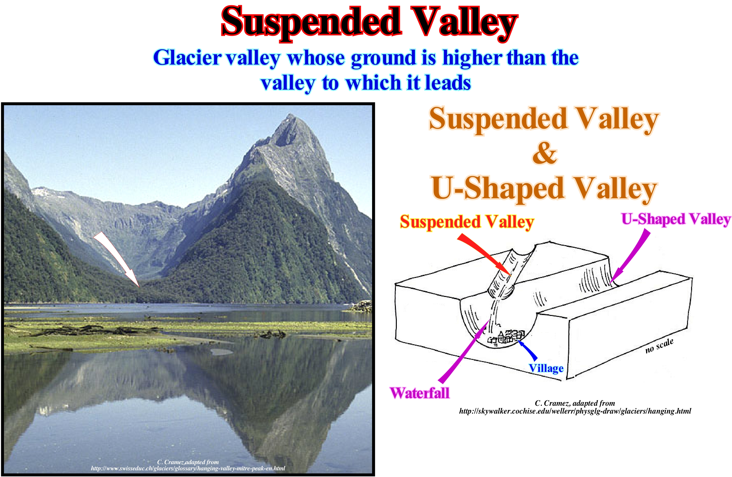
As illustrated, a suspended valley is a typical valley of a glacial landscape (where glaciers flowed, in the geological past), where a tributary of the main glacial valley, showing a sharp gap between the two, which is, sometimes underlined by a waterfall. The main glacier valley is always much more excavated or incised by the action of the main glacier, than the suspended valleys tributaries. All glacial valleys have a U-shaped cross-section, while valleys of fluvial origin have a cross-section in a V-shape. A glacial valley is, partially, filled by glacial deposit systems such as moraines and tills, and its walls, as well as the bed, are smooth and show slickensides that were made by the rocks that the glacier transported. "Moutonnée" rocks (rocks on which a mass of ice has flow and which exhibit a geometry similar to that of a sheep's back) are, particularly, interesting since their shape indicates the direction of movement of the ice. We must not forget that a glacier is, above all, a stream of ice. It exists just as long as the glacier flows, that is, while accumulation compensates the ablation. When ablation more important than accumulation, a glacier does not shrink (it does not reverse as a car). It continues to flow down-hill but thinning. This must be taken into account when talking about retreat and advancement of a glacier, which is very fashionable today, since many people and. especially. politicians begin to realize that climate change has always existed in geological history. From the point of view of sequential stratigraphy, the presence of suspended valleys in a particular region suggests relative sea level rises (glacio-eustasy) in different phases.
Suspension (Transport)..............................................................................................................................................................Suspension (Transport)
Suspensão (transporte) / Suspensión (transporte) / Federung (Verkehrs-) / 悬架(运输) / Остановка, временное прекращение (транспорт) / Sospensione (trasporti) /
One of the ways of transport sediments in a stream.
See : « Littoral Current, Longshore Drift »
&
« Wave Action Level »
&
« Intertidal Beach »
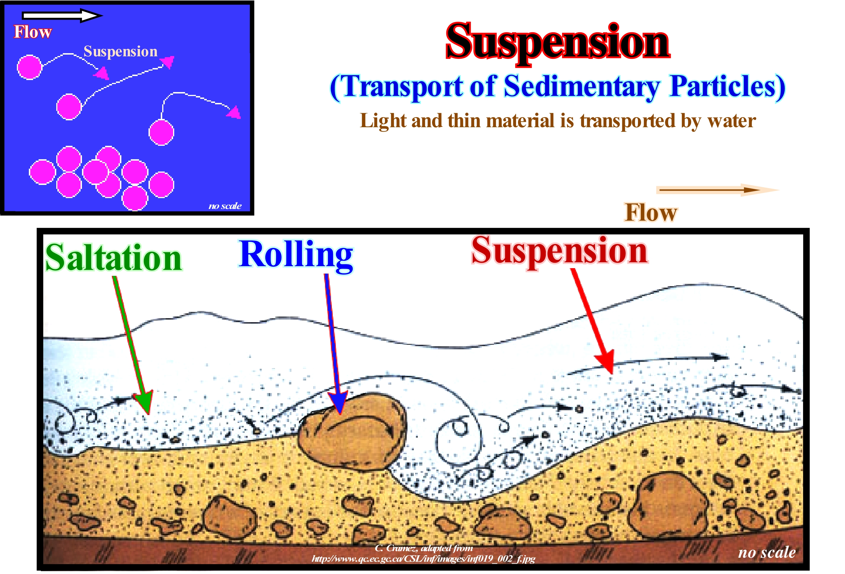
Solid sedimentary particles (detritus or clasts) are, usually, transported due a combination of the force of gravity acting on the sedimentary particles and/or the movement of the fluid, in which the sedimentary particles are dragged, rolled or suspended. An understanding of sedimentary particles transport is, generally, used in natural systems where the particles are clastic rocks (sand, gravel, pebble, etc.), silt or clay. The fluid may be air, water or ice. The force of gravity acts to displace the particles on the surface, more or less, inclined where they rest. The transport of sedimentary particles due to fluid movement occurring in rivers, oceans, lakes, seas and other water-bodies due to currents and tides, as well as, in glaciers and on land under the influence of wind. Sedimentary particles transport due to gravity only occurs on inclined surfaces, generally, on slopes, cliffs, and near the boundary between the platform and the continental slope (when the basin has a shelf) or between the boundary of the coastal plain and the continental slope when the basin has no platform. Sedimentary particles transport knowledge is used to determine whether erosion or deposition occurs, the magnitude of erosion or deposition, the time and distance it will occur. The load or suspended material is, generally, supported at the bottom and middle of a current and a large part moves where the speed of the current is normal. In addition to suspension transport, sedimentary particles can be transported by salting and traction. Saltation is a transport process where sedimentary particles of sand or gravel size when drawn by fluid are, usually, displaced by jumps. In a traction transport, the sedimentary particles are swept in the sense of the flow by rolling, slippage, dragging and even jumps. The understanding and significance of the primary sedimentary structures in terms of physical, biological and chemical processes occurring during or immediately after deposition is the starting point for the analysis of the sedimentary rocks and the environments, in which they were deposited. Therefore, knowledge and understanding of the type of sedimentary transport is very important.
Suture Zone...........................................................................................................................................................................................................Zone de suture
Zona de sutura / Zona de sutura / Suturzone / 缝合带 / Зона сочленения / Zona di sutura /
Collision between two lithospheric plates. A suture zone is, generally, characterized by an intense deformation, metamorphism, and introduction of bands of mafic material and ultramafic oceanic rocks. The term megasuture was proposed by A. Bally (1975) to describe the Earth's moobile regions (mountain chains with foldedt and faulted rocks) that testify to the complexity of the accretion and deformation phases undergone by geological bodies when compressive tectonic regimes are predominant.
See: « Continental Collision »
&
« A-Type Subduction (Ampferer) »
&
« B-Type Subduction (Benioff) »
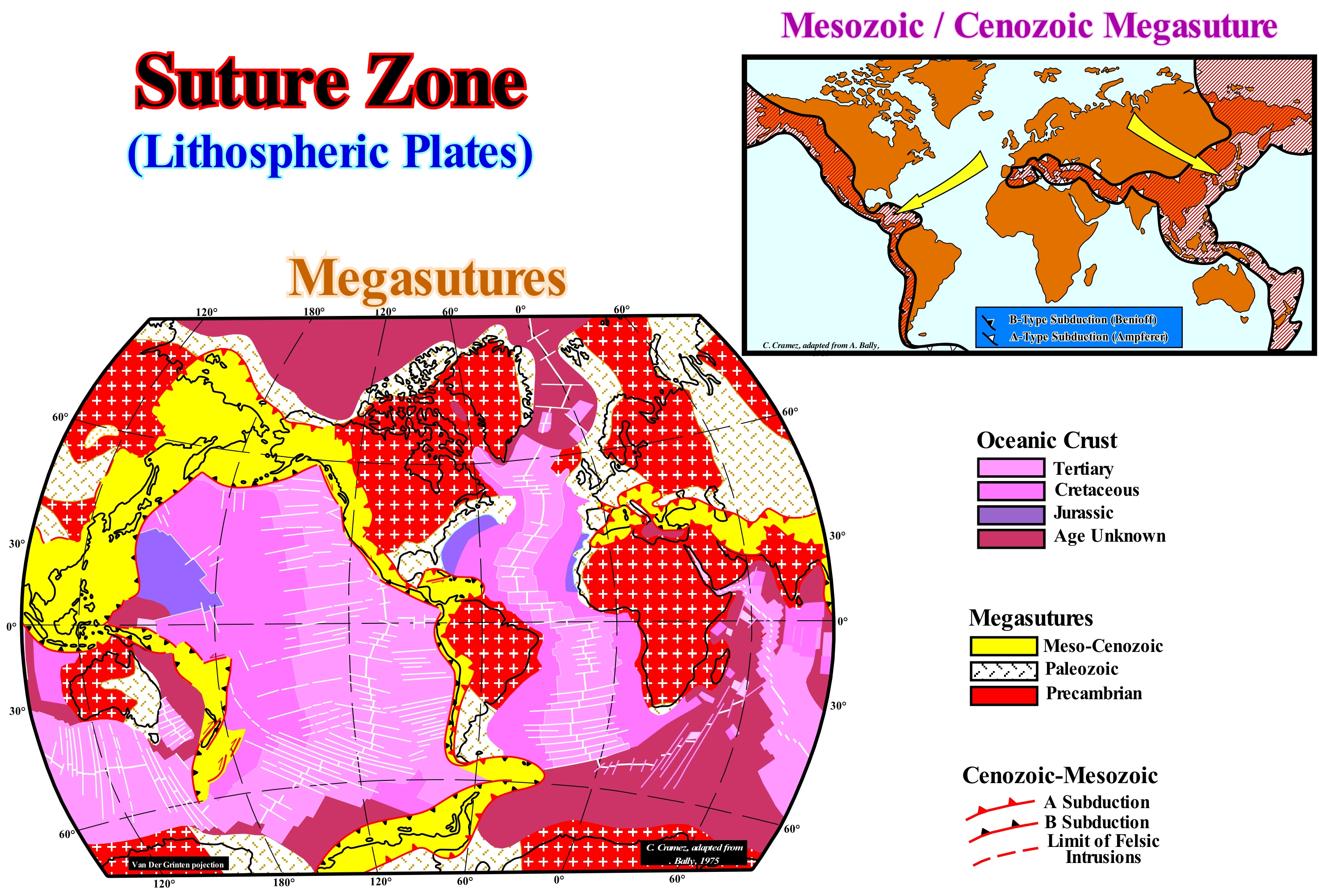
The most typical example of a suture zone is, certainly, the Mesozoic-Cenozoic megasuture illustrated in this sketch. This megasuture encompasses all products of the orogenic and igneous activity postdating the Pangea supercontinent and the associated basins, in particular, the episutural basins (developed within the megasuture as, backarc basins, in which the lengthening can be very important and create an oceanization, i.e., the break-up of the lithosphere with formation of new oceanic crust and a marginal sea, in which a non-Atlantic type divergent margin is developed) and the mountain chains with folded and faulted rocks. This megasuture represents the counterpart of the oceanic expansion (seafloor spreading) that has occurred since the end of the Paleozoic era (more or less 250 Ma). During the formation of a megasuture, although compressional tectonic regimes (shortening of the sediments) associated with the subduction zones are predominant, extensional regimes (lengthening of sediment) and the formation of sedimentary basins also play a very important role. A megasuture can be considered as a suture zone formed by a Continent/Continent or Continent/Volcanic Arc collision with a, more or less, important mobilization of the granito-metamorphic basement. It encompasses the associated orogenic zones and sedimentary basins. The Mesozoic/Cenozoic megasuture, as illustrated above, encompasses all the geological bodies associated with the subduction phenomena of A and B-type that have occurred since the Permian/Triassic until today. It represents the counterpart of the oceanic expansion that accompanied the dispersion of the continents after the break-up of the supercontinent Pangea. In a way, it can be said that the oceanic crust and the divergent margins are the distensive equivalents (in extension, lengthening) of the shortened structures created in the compressional zones associated with the convergent margins. Note that there may be stretching structures, such as half-grabens and grabens, created by a tectonic regime with a positive tectonic vector (σt). The map of the different deformation episodes gives approximately the current position of the successive megasutures forming the Earth's continental crust. This cartography allows us to address the location of the ancient oceans (oceanic crust) that formed and closed following oceanic expansion and continental collisions. The Paleozoic megasuture is represented only by continental crust and A-type subduction zones (Ampferer). The absence of Paleozoic oceanic crust is explained by a very intense subduction-B (Benioff) mechanism that would have, practically, consumed the entire oceanic crust. The orogenic zone that constitutes the Precambrian megasuture, also, does not show, any evidence of Archaeozoic ocean crust. In sequential stratigraphy, erosional surfaces induced by significant falls of the relative sea level (local sea level, referenced at any point on the Earth's surface, which is the result of the combination of tectonics and absolute or eustatic sea level, which supposed to be global referenced to the Earth's centre) play an important role, since unconformities and their deep-water correlative paraconformities limit the different stratigraphic cycles (continental encroachment cycles, continental encroachment subcycles, sequence-cycles and high frequency cycles) and in the formation of megasutures. In fact, the volume of ocean basins increases as a megasuture forms, which implies a fall of the absolute sea level (Tectono-Eustasy that is controlled by the volume variation of the ocean basins in association with oceanic expansion following the break-up of the supercontinents), since geoscientists assume that the amount of water, in all its forms, is constant since the formation of the Earth around 4.5 Ga.
Syncline..............................................................................................................................................................................................................................................Synclinal
Sinclinal / Sinclinal / Synklinale / 向斜 / Синклиналь / Sinclinale /
Fold with a concave shape, in which the layers plunge towards the center of the structure. In geological maps, synclines are, easily, recognized by a succession of increasingly young layers to the center of the structure. Synclines are structures created by compressive tectonic regimes and therefore should not be confused with synforms that are created by extensive regimes. In a syncline, the sediments are shortened, while in a sinform they are lengthened.
See: « Anticline »
&
« Trap (petroleum, gas) »
&
« Synform »
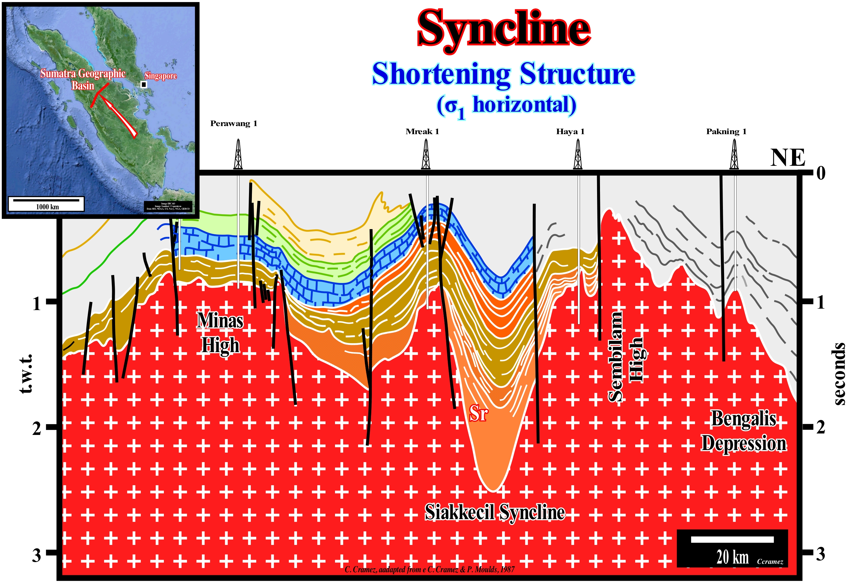
On this tentative geological interpretation of a succession of seismic lines from the north of the island of Sumatra (Indonesia), it is obvious that the sediments were shortened by a compressional tectonic regime. This regime was characterized by an ellipsoid of the effective stresses (geostatic pressure plus pore pressure plus tectonic pressure) oblong, meaning that the σ1 axis (main axis) was horizontal and the sediments were shortened. The shortening was made, mainly, by cylindrical folds (anticline and syncline) and reverse faults. This means that the σ3 axis (the smallest axis of the effective stress ellipsoid) was vertical. The axial direction of the anticlines and synclines, as well as, the great majority of the direction of the planes of the reverse faults, is perpendicular to the direction of σ1. There can be no formation of normal (synchronous compression) faults in association with the anticlines or synclines, in particular at the crest of the structures. If there are normal faults, they are either more recent or older than shortening, but not contemporaneous. When they are older, they have, in general, been reactivated (function of the angle between the direction of failure and the direction of σ1) as reverse faults during shortening, although in certain cases they may maintain an apparent normal geometry locally (when inversion of faulted blocks is not total). When, normal faults are more recent, they have the typical geometry of stretching faults. As you have, probably, already seen, the great majority of the visible faults in this tentative interpretation are the old normal faults created during the rifting (extension = lengthening) phase of back-arc basin, which were reactivated during the shortening. In this way, the axial direction of the anticlines and synclines may, locally, be slightly different from the direction of σ1.
Synform..............................................................................................................................................................................................................................................Sinforme
Sinforma / Sinforma / Synform / Synform(几何)/ Синформа / Synform (geometria) /
Concave structure, similar to a syncline, i.e., in which the layers plunge towards the center, but induced by an extensive tectonic (regional or local) regime. Contrary to a syncline, a sinform develops during extension tectonic regimes, which means that the sediments are lengthened ina sinform, while they are shortened in a syncline.
See: « Goguel's Law »
&
« Uplift »
&
« Plate Tectonics Theory »
Angola offshore and particularly the northern Angola offshore corresponds to the stacking of several basins of the classification of the sedimentary basins of Bally and Snelson (1980). On regional seismic lines it is easy to recognize, from the bottom to top: (i) A basement that often corresponds to a Paleozoic flattened mountain belt ; (ii) Jurassic Terminal/Early Cretaceous Rift-type basins, which lengthened the lithosphere of the small supercontinent Gondwana before its breakup ; (iii) Atlantic-type margin divergent, whose sedimentary column can be divided into two large sedimentary tectonic intervals: (i) Transgressive phase with globally retrogradational geometry and (ii) Regressive phase, which fossilizes the transgressive phase and exhibits a progradational geometry. Some geoscientists, taking into account the important deposition of a salt layer (evaporites) in the divergent margin, consider two large sedimentary intervals: a) Infrasalt interval and b) Suprasalt interval. These two intervals are, easily, recognized on the seismic data, since the presence of the salt interval creates a tectonic disharmony. The sediments of the suprasalt interval are deformed by halokinese and rafting tectonics (induced by gravity and salt), whereas the infrasalt sediments are, more or less, undeformed. On this tentative geological interpretation of a Canvas auto-trace of a detail of a seismic line of this offshore, it is, easy, to verify that synform structures are associated with the halokinese (tectonic salt without tectonic vector). They formed as the salt flowed sideways and vertically. In fact, when the salt flows, the flow creates a void, which is filled by the already deposited sediments or by synchronous sediments of the flow. As many geoscientists say, nature has a horror of emptiness. The filling of the empty space is done by lengthening the overlying sediment which can only be done by normal faulting. Most of the time, as is the case in this tentative, normal faults are not visible because their jumps are very small and inferior to the seismic resolution. However, these normal faults are, perfectly, visible in dipmeters logs and, above all, in drilling cores. It is important to note that in this particular auto-trace the geometry of the synforms was later, slightly, deformed, since during the Pliocene the sediments were shortened by a compressional tectonic regime (constraint by the ocean ridges), such onlaps, in the upper part (above the salt bulbs), suggest it. This deformation has nothing to do with the uplift (lengthening and non-shortening) that the proximal part of this offshore suffered during the Late Tertiary and is quite visible on the tentative interpretation of this seismic line, shown in the upper right corner of this figure. Constraint** by the mid-oceanic ridges contributed to the formation of vertical salt sutures (2nd order sutures), which separate allochthonous from autochthonous salt, although the main mechanism was the difference in density between salt and sediment. The sediment compacts as they are buried, which increases their density. The salt does not compact. The density of the salt is, more or less, constant in depth (2.15 / 2.17 as a function of the magnesium content). A salt dome with vertical walls (cylindrical geometry) is a physical impossibility. There is a level of inversion, above which the salt is denser than the sediments. Above this point (inversion point), the salt exerts a pressure against the sediments which is not compensated by the pressure that the sediments exert against the salt. Underneath the inversion point, it is the opposite, the pressure that the sediments exert against the salt is not compensated by the pressure that the salt exerts against the sediments and for that reason the salt flows forming a salt structure with the geometry of a drop. The disconnection of the salt drop (allochthonous salt) may be total or not of the source salt rock (not to be confused with the oil source rock) that is the autochthonous salt horizon.
(*) The brine of the evaporites was enriched in potassium by the presence of subaerial lavas, deposited, immediately, after the break-up of the lithosphere, in the sea floor. Indeed, the spilitisation of the basalt of sub-aerial volcanism is, probably, the origin of the formation of the potassium rich and poor MgSO4 that constitute the salt interval Angola offshore.
(**) Constraint by oceanic ridges and descending lithosphere plates are informal terms used in the literature of Plate Tectonics. These expressions designate the associated horizontal forces: (i) The horizontal compression resulting from the differences in elevation between the oceanic expansion centre and the ocean floor, and (ii) The tensile effects of an oceanic lithosphere plate originating from the downward movement along a subduction zone of Benioff (B-type subduction).
Synodic Period (Moon)...................................................................................................................................Période synodique (De la Lune)
Período Sinódico / Período sinódico (de la Luna) / Synodische Periode / 会合周期 / Синодический период (Луна) / Periodo sinodico /
Time between two consecutive new moons, which is, on average, 29.530589 days. Same as Synodic Lunar Month.
See : « Sidereal Period (Moon) »
&
« Moon »
&
« Draconic Period (Moon) »
The Moon moves around the Earth, which walks around the Sun. As the Moon makes a full orbit around the Earth, it moves 1/12 of the distance of its orbit around the Sun. As can be deduced from this diagram, this means that starting from a position of New Moon, the Moon has to go through a complete orbit and a little bit to return, again, to be between the Earth and the Sun. The time that takes the Moon to go from the position from New Moon to New Moon is called the synodic month, which, on average, is equal to 29.530589 days. Because the Earth's and Moon's orbits are not circular and since Earth and Moon do not move at a constant velocity, the actual time between a New Moon and the next New Moon ranges from 29.27 to about 29.83 days. The orbit of the Moon is inclined relative to the plane of the ecliptic and that the points of intersection of the orbit and ecliptic are the nodes (ascending and descending). Thus, the Moon to be in alignment and between the Earth and the Sun, must be in the same plane of the ecliptic and in one of the two nodes. Therefore, the time the Moon spends to go from a node along its orbit and back is not exactly the same as the time of a single orbit due to the precession of the Moon's orbit, since the plane of the Moon's orbit, as well as the nodes, rotate back around the Earth once every 18.6 years. The space between two moon passages in the perigee (point of the orbit of a star or an artificial satellite closer to Earth, the point opposite the perigee is apogee), which is about 356,375 km from our planet, is called the period of anomalistic revolution, which is about 27.55 days, or, more exactly, 27 days, 13 hours, 18 minutes and 33.1 seconds. In addition to the synodic month there are other ways to consider how long it takes the Moon to complete an orbit: (i) Sidereal Month, which is the time the Moon takes to make a complete return to Earth in relation to the fixed stars, and which is about 27.3 days ; (ii) Draconic Month, which is the time that elapses between two passages of the Moon by the same node ; (iii) Tropic Month, which is the time between two consecutive phases of the Moon and (vi) Anomalistic Month, which is the time the Moon spends between two consecutive perigee positions.
Synthem...........................................................................................................................................................................................................................................Synthème
Sintema / Sintema / Synthem (chronostratigraphischen Einheit) / 构造层 / Синтема / Sintema (unità cronostratigrafica) /
Discordant interval or sedimentary interval limited between two type I or type II unconformities. It is important not to confuse a discordant stratigraphic interval with a stratigraphic cycle called the sequence-cycle, since a sequence-cycle is limited by unconformities and their deep-water correlative paraconformities.
See: « Sequence-Cycle »
&
« Type I Unconformity »
&
« Basin Edge »
Contrary to a sequence-cycle, which is a sedimentary interval, deposited in association with a 3rd order eustatic cycle, whose time-duration varies between 0.5 and 3/5 My, limited between two erosional surfaces (called by the geoscientists unconformities). Beyond the continental edge (whether it is the basin edge or not), in the deeper parts of the basin, an unconformity passes to a correlative deep-water paraconformity. A stratigraphic discordant interval or synthem, in general, can just be identified in the upper continental slope and upstream of the basin edge, where, theoretically, there may be erosion. Indeed, erosion induced by relative sea level fall is, often, just materialized by the filling of submarine canyons (onlaps and toplaps by truncation on the upper continental slope), and by the filling of incised valleys upstream of the continental edge (at the level of a sequence-cycle, where the basin has a continental shelf.) Note the relative sea level is the local sea level, referenced to any point on the Earth's surface, which it can be the sea floor or the base of the sediments (top of the continental crust) and which is the result of the combined action of the tectonics (subsidence or uplift of the sea floor) and the absolute or eustatic sea level (supposed global and referenced to the Earth's centre ). The absolute (eustatic) sea level is dependent on (i) Tectono-Eustasy, (ii) Glacio-Eustasy, (iii) Geoidal-Eustasy and (iv) Steric Sea-Level Rise or Thermal expansion of the oceans. As stratigraphic units limited by unconformities, the most frequent synthems are, probably, limited by regional and interregional unconformities and therefore have an important thickness (comparable to the stratigraphic continental encroachment subcycles). The term synthem is recommended for such units. It is very useful in the cratonic basins, where the stratigraphic column is, essentially, composed of intervals deposited under a relatively shallow water-depth (upstream of the basin edge). The term interthem was proposed by certain geoscientists to designate small stratigraphic unit limited by more local unconformities, with a thickness and time interval equivalent to the formations and geological stages. The prefixes "sub" and "super" may, eventually, be used for higher hierarchies. The southern offshore of the Bears' island (Bjørnøya *), which corresponds to the stacking of different sedimentary basins of the classification of Bally and Snelson (1980) that, from the bottom to top, are: (i) Basement or mountain folded belts ; (ii) Rift-type basins formed before the breakup of the lithosphere of the associated supercontinent and (iii) An Atlantic-type divergent margin. On this tentative geological interpretation of a Canvas auto-trace of a seismic line from this offshore, the rift-type basins between the substrate (Paleozoic folded mountain belt) and the divergent margin, which is bounded by two unconformities (upper unconformity is, clearly, angular, which means that it has been tectonically enhanced) and therefore it can be said that this basin forms a synthem. As the great majority of the sediments filling this and other rift-type basins are nonmarine, small internal disharmonies, often, permit, as is the case in this tentative interpretation, to subdivide the synthem into subsynthems. This geological interpretation corroborates the conjecture, often admitted, a priori, that the lengthening of the supercontinent, probably, induced by a thermal anomaly (differential subsidence) ends with the breakup of the lithosphere. In fact, the great majority of the normal faults responsible for the lengthening of the lithosphere and the formation of rift-ype basins do not extend to the divergent margin, except when it is, locally, reactivated, as is the case of the fault bordering this rift-type basin. The thermal subsidence created by the cooling and collapse of the thermal anomaly and responsible for the formation of the greater part of the available space during the divergent margin, began when the differential subsidence stopped. However, as the breakup unconformity of the supercontinent was tectonically enhanced (toplaps by truncation of the sediments underlying the unconformity), a shortening of the margin substrate (basement, Paleozoic folded belt and rift-type basins) must have occurred between the differential and thermal subsidence.
(*) The Bear Island (Bjørnøya) is part of the Svalbard archipelago (Norway) located on the edge of the Arctic Ocean and Atlantic Ocean, between Greenland to the West, and the Franz Josef Archipelago to the East and Continental Europe to the South, whose outcrops of geological layers and the fossils they contain provide a better understanding of tectonic plates. Like the island of Spitzberg, which is the largest of the archipelago, Bjørnøya is also populated.
Synthem (Interval)..................................................................................................................Intervalle stratigraphique discordant
Intervalo estratigráfico discordante / Sintema, Intervalo estratigráfico discordante / Synthem (diskordant Intervall) / Synthem(不和谐的间隔) / Несогласно залегающий стратиграфический интервал / Sintema (intervallo discordante) /
Sedimentary interval limited between two type I or type II unconformities. It is important not to confuse the discordant stratigraphic intervals with a sequence-cycle. Sequence-cycles are limited by unconformities or by their correlative deepwater paraconformities, i.e., they can be identified downstream of the basin edge, in the deep parts of the basin. Discordant stratigraphic intervals are limited to the coastal plain and to the top of the continental slope where erosion is significant. Synonym with Synthem.
See: « Unconformity »
&
« Interthem »
&
« Sequence-Cycle »
Before the advent of sequential stratigraphy, practically, before the 1970s, a discordant stratigraphic interval or synthem, which could be divided into subsynthems, was a unit of allostratigraphic classification, that is, a unit defined and identified on the basis of the unconformities limiting It. One can say a discordant unit (synthem) corresponds, in most cases, to a stratigraphic cycle limited by two unconformities, that is, by two erosional surfaces induced by falls of sea level. The sea level can be relative, that is, local and referenced to the base of the sediments (top of the continental crust) or to the sea floor and absolute or eustatic, i.e., the global sea level, referenced to the Earth's centre. High hierarchical stratigraphic cycles, such as continental encroachment cycles, are controlled by absolute (eustatic) sea level, while low hierarchical stratigraphic cycles, such as sequence-cycles, are controlled by relative sea level, which is the result of the combined action of absolute sea level and tectonics (subsidence or survey). Downlap surfaces are not erosional surfaces. The intervals limited by downlap surfaces are, preferably, used in genetic stratigraphy, but little in sequential stratigraphy, where the intervals considered, whatever their hierarchy, are limited by erosional surfaces or correlative deep-water paraconformities. On this tentative geological interpretation of a Canvas auto-trace of a detail of a Namibian offshore seismic line, which corresponds to the stacking of different basins* of the sedimentary basins classification of Bally and Snelson (1980), a discordant stratigraphic interval (synthem) is bounded between two Type I unconformities (which puts the relative sea level lower than the basin edge exhuming, totally, the continental shelf). The age difference between the two unconformties is less than 3-5 My and the interval between them is a sequence-cycle that has been deposited in association with a 3rd order eustatic cycle (whose time-duration is between 0.5 and 3-5 My ). The lower unconformity is characterized by onlaps of overlying sediments, toplaps by truncating the underlying sediments and an incised valley fill. The upper unconformity is characterized by the filling of submarine canyons and the onlapping of the basal sediments of the overlying sequence-cycle. This sequence-cycle is incomplete. It is formed only by the lowstand systems tracts group (LSTG), in which, from bottom upwards, the three sub-groups of systems tracts can be identified: (i) Submarine Basin Floor Fans (SBFF) ; (ii) Submarine Slope Fans SSF) and (iii) Lowstand Prograding Wedge (LPW). The highstan systems tracts group (HSTG), which is formed by two subgroups (Transgressive Interval, TI, and Highstand Prograding Wedge, HPW) were not deposited. The submarine basin floor fans (SBFF) have a, more or less, parallel internal configuration and abrupt boundaries, while the submarine slope fans (SSF) have a wavy configuration. This wavy configuration is given by channels (or depressions) and natural marginal dikes (levees) complexes, that is, by the structures that P. Vail called "gull wings". The lowstand prograding wedge (LPW) has a characteristic progradational geometry. The progradations are, above all, oblique (progradation much more important than aggradation). In the distal part of the progradations, turbidite anomalies are formed following the failures and landslides of the lowstand prograding wedge. When the edge of the lowstand prograding wedge (LPW) coincides with the shoreline, the instability ruptures of lowstand prograding wedge appear to occur every time the slope angle reaches the critical stability angle.
(*) In the regional seismic lines from bottom to top the following sedimentary basins can be recognized: (i) A more or less flattened folded belt that functions as a basement, which may, locally, correspond to Precambrian granitic rocks ; (ii) Early Late Jurassic/Cretaceous Jurassic age basins, which developed during the lengthening of the small supercontinent Gondwana and (iii) An Atlantic-type divergent margin, which began with the deposition of thick outflows of subaerial volcanic material, which was corroborated by several exploration wells.
Synthetic Natural Gas (SNG)...................................................................................................Gaz naturel synthétique (GNS)
Gás natural sintético / Gas natural sintético (GNS) / Synthetisches Erdgas / 合成天然气 / Синтетический природный газ / Gas naturale sintetic /
A few years ago, synthetic natural gas was just gas made from coal. At present, this designation encompasses all "green" gas which is, generally, made from biomass. Today, it can be said SNG designates the entire natural gas substitute in order to reduce as much as possible the use of fossil fuels and the emission of greenhouse gases.
See: « Methane »
&
« Coal Bed Methane »
&
« Natural Gas »
This sketch illustrates a proposition of two-stage "green" natural gas production (Holland): (i) Biogas improved until around 2013 and (ii) Synthetic natural gas since 2015. In the short term, the project would start with an improvement of the biogas produced by the biological digestion of materials such as manure and then the production of synthetic natural gas. The technology is available and can, already, be marketed in small projects using, locally, available biomass. Conventionally, the term biogas refers to gas produced by digestion or anaerobic fermentation of organic matter: (i) Manure ; (ii) Sewage sludge ; (iii) Municipal solid waste ; (iv) Biodegradable waste, etc. Commercial processes (catalysts) for the methanization of carbon monoxide (CO) and hydrogen (H2) are also already available. The societies Lurgi and Haldor/Topsøe, for example, already construct systems of methanization*. In general, methanization processes are carried out at higher pressures than those predicted in synthetic natural gas (GNS) plants, i.e., more or less between 20 and 30 bars instead of 7 bars. These systems are designed with gas cycles and temperature controllers to prevent thermal degradation of the catalysts. When methanization is carried out at low pressure, the increase in adiabatic temperature (thermodynamic transformation that takes place without heat exchanges with the outside) is smaller. Therefore, methanization can be carried out, adiabatically, without gas cycles and in simple containers without internal cooling. Three methane-reactors, with intermediate cooling, are sufficient to obtain a sufficient conversion of CO and H2. Although the source of fossil fuels (oil, gas and coal) is associated with old biomass, they are not considered biomass, since they contain carbon that has long exited the conventional carbon cycle.
(*) Methanization is anaerobic digestion, or methanic digestion, which transforms organic matter into compost, methane and carbonic gas by a complex microbial eco-system, operating under conditions of zero oxygen (http://www.boilermaking-citp.com/equipment-methanization.php).
System........................................................................................................................................................................................................................................................Système
Sistema / Sistema / System / 系统 / Система / Sistema /
Set of elements interconnected in order to form an organized whole. The systems are found in various disciplines, such as biology, medicine, geology, petroleum geology, computer science, administration, etc.
See: « Depositional System »
&
« System (theory) »
&
« Geological Time »
The term system comes from the Greek where it means "to combine," "to fit," "to form a set." The whole system, whether it be geological, petroleum, or otherwise, has a general goal to be achieved. A system is a set of functional organs, components, entities, parts or elements and the relationships between them. The integration between these components can be accomplished by flow of information, flow of matter, flow of energy, etc. The good integration of the components of a system is the synergy, which determines that the transformations occurring in one of the parts will influence all the others. The high synergy of a system makes it possible for it to fulfil its purpose and achieve its goal efficiently. A system is more than the simple sum of its parts. The Cartesian method (individual study of the parts to understand the whole) does not work, particularly, in the petroleum geology. In this figure is illustrated one of the many study charts of an petroleum system (genetic relation between a source-rock and an accumulation of oil), with a risk analysis, a probability calculation of success (noneconomic geological) and a calculation of the reserves in Minimum (5% of cumulative probability), Mean or most likely (cumulative probability curve inflection point) and Maximum (90-95% cumulative probability). A petroleum system consists of three subsystems: (i) Generator Subsystem; (ii) Migration-Entrapment Sub-system and (iii) Preservation Subsystem , in which different petroleum parameters should be considered: (a) Source-Rock; (b) Reservoir-Rock; (c) Sealing-Rock (lateral and vertical); (d) Maturation (organic matter) ; (e) Migration; (f) Trap; (g) Preservation*, etc. It is the interaction between all these parameters that can create a petroleum system, which can be: (i) Known System, symbolized by a sign of affirmation (!), when, based on geochemical information, a positive correlation is defined between a generating rock (source-rock) and the petroleum found ; (ii) Hypothetical System, symbolized by a point (.), when a source rock has been identified, but there is no information, in particular geochemistry, to correlate such source-rock with the petroleum found and (iii) Speculative System, symbolized by a question mark (?), when the presence of a source-rock or an oil field are defined by geological and geophysical evidence. Do not confuse system, which is a whole formed by several interconnected parts, with theory. A theory is a coherent set of hypotheses tested (guesses or conjectures, which can be refuted, but never verified) by evidence and reasoning, which has a great explanatory power, which is to say, that a theory is a set of inter-connected hypotheses based in evidence or observations, in reasoning or logical, coherent and internally consistent. A scientific approach to petroleum systems is a holistic approach, in which the Whole (system) is more than the sum of the parts (petroleum parameters), which means that studies of the characteristics of petroleum parameters, rarely, allow to recognize the petroleum system characteristics. Systems theory says open systems those that undergo interactions with the environment where they are inserted. In this way, the interaction generates feedbacks that can be positive or negative, creating a regenerative self-regulation, which in turn creates new properties that can be beneficial or harmful to the whole independent of the parts. Every organization is an open system, just like every petroleum system. Closed systems are those that are not influenced by the environment in which they are inserted, in such a way that it feeds on itself. Entropy only remains constant in closed systems. Just as it is impossible to try to understand how a car works by looking at its parts separately, the observer may not be able, even, to understand what a car is by looking at its parts. The same is true with a petroleum system. You need to understand how the different parts of the system interact. This interaction of the elements of the system is called synergy. The entropy of a system can be considered as the disorder or absence of synergy. A system stops working properly when internal entropy occurs. (https://pt.wikipedia.org/wiki/System_theory_of_the_systems)
(*) Preservation time begins immediately following the formation-migration-accumulation process and continues to this day. It encompasses all the changes in accumulations during this period. During the preservation-time, remigration, physical and biological degradation, or complete destruction of petroleum may occur. The re-migrated petroleum (tertiary migration) during the preservation-time can accumulate in reservoir-rocks formed after the formation of the petroleum system. The intensity of the tectonic activity conditions the preservation of the initial reservoir-rocks or the existence of re-migrations. If the accumulations are destroyed along the time of preservation, obviously the petroleum system ceases to exist. (http://geomuseu.ist.utl.pt/GSP2009/ Introduction% E7% E3o% 20GSP / GSP% 20defini% E7% F5es% 20PT1A.pdf).
System (Theory).........................................................................................................................................................................................................Système (Théorie)
Sistema (teoria) / Sistema (teoría) / Systemtheorie /系统理论 / Система (теория) / Teoria dei Sistemi /
Set of interactive and interdependent entities, real or abstract, that form a whole.
See: « Depositional System »
&
« Petroleum System »
&
« Geological Time »
Many of the geoscientists using Sequential Stratigraphy use adopt an analytical or reductionist methodology, which is based, primarily, on the mechanical conception of nature and man (Descartes), that is to say, on the conception that everything and everyone can be divided into parts each time which can be analyzed and studied separately. They follow the old Cartesian analytic paradigm with which western science has progressed greatly: "The Whole is equal to the sum of the Parts." Some geoscientists still believe that in certain complex geological systems, such as tectonics, paleontology, stratigraphy, etc., the behaviour of the "Whole" can be understood from the study of the "Parts". They think it is possible to understand (not to be confused with describing) the filling of a sedimentary basin by making only analytical studies of sedimentary intervals (whether they are continental encroachment cycles, continental encroachment sub-cycles or sequence-cycles). They work by induction and try to progress from the particular to the general, that is, from the "Parts" to the "Whole," rejecting the hypothesis that "Theory precedes Observation" (K. Popper). However, the vast majority of geoscientists know that the great scientific shock of the last century was the introduction of systems, which can not be understood by analysis. In a systemic approach the fundamental concepts are: (i) Entropy (every system undergoes more or less important deterioration) ; (ii) Syntropy, also called Negentropy or Negative Entropy (for the system to continue to exist, it has to develop opposing forces to entropy ; (iii) Homeostasis (ability of the system to maintain equilibrium) ; (iv) Heterosexuals (since there is improper action or wear of the system, it tends to balance). The holistic or contextual method (or systemic method) and the global way of thinking, which implies that the properties of the Parts of a Whole are not intrinsic and that the "whole" "Is more than the sum of the" Parties ", are undoubtedly finding a growing acceptance in the scientific community. In petroleum geology, for example, the petroleum system, which is a genetic relationship between a source-rock and an accumulation of hydrocarbons. An oil system ("Whole"), as illustrated above, consists of several sub-systems: (i) Generating Subsystem ; (ii) Trapping / Migration subsystem* ; (iii) Preservation-Subsystem (encompasses changes in accumulations during the preservation period, such as re-migrations, physical and biological degradations or complete destruction of hydrocarbons), etc. However, the petroleum system is much more than a simple addition of the generating, trap/migration and other subsystems. In a sedimentary basin if there is one of such subsystem, the presence of an petroleum system is impossible. In petroleum exploration, it is not worth starting to spend money on seismic if, for instance, geoscientists did not recognize in the stratigraphic column of the basin, one or more, sedimentary intervals rich in organic matter, i.e., one or several potential source-rocks, which may form the generating subsystems if they are or have been sufficiently buried. The probability of finding a petroleum system (i.e., the "Whole"), that it be (i) Known (!) ; (ii) Hypothetical (.) or (iii) Speculative (?) is the product of the probability of presence of the petroleum parameters (i.e. the "Parts"), mainly of the source-rock, reservoir-rock, migration (age of migration in relation to the age of the trap) and preservation. If the probability of presence of one of these parameters is zero, the probability of presence of the petroleum system will be zero. A petroleum system is Known (!) when, on the basis of geochemical information, a positive correlation is defined between a source-rock and the petroleum found. A petroleum system is Hypothetical (.) when a source-rock has been identified, but there is no information, in particular, in geochemistry, to correlate such source-rock with the petroleum found. A petroleum systems is Speculative (?) when the presence of a source-rock or an oil field are defined by geological and geophysical evidence.
(*) The migration of hydrocarbons through the source-rock is called primary migration (do not forget the transformation of the kerogen into petroleum produces an increase in pressure in the rock, since the volume occupied by the oil is larger than the volume occupied by the kerogen). The migration of hydrocarbons from the source-rock to the rock-reservoir is called secondary migration, whose mechanism of which derives from the pressure of hydrocarbon fluids relative to the water present in the rock-reservoir pores. The secondary migration ceases when the capillary pressure of the reservoir-rock exceeds the pressure force towards the upper layers. The migration of hydrocarbons during a remigration is a tertiary migration. Hydrocarbons migrate mainly through fractures, faults, porous rocks until they find a trap or the surface.
Systems Tract.............................................................................................................................................................................................Cortège sédimentraire
Cortejo sedimentar / Cortejo sedimentario / Prozession sedimentären / 游行沉积 / Цикл осадконакопления / Processione sedimentaria /
Lateral chain of contemporary depositional systems that make up the subgroups and groups that form the sequence-cycle. Each subgroup of systems tract is associated with a segment of the curve of relative sea level change that induces the sequence-cycle. The segments during which the lowstand prograding wedge (LPW) and the transgressive interval (TI) are deposited have a positive 1st and 2nd derivatives (the function is increasing and has a concave geometry or, in other words, the rate relative sea level rise is in acceleration). The segment during which the highstand prograding wedge (HPW) is deposited has a positive 1st derivative, but the 2nd derivative is negative (the function is increasing and has a convex geometry, which means that the rate of relative sea level rise is in deceleration). The sedimentary systems tracts can be recognized in outcrops, seismic lines and electrical diagrams. There are two groups of systems tracts. In a complete sequence-cycle, from top to bottom, we recognize: (i) Highstand system tract (HST), within which there are two subgroups (the Bordering Prograding Wedge, i.e., BPW fell in disuse): a) Highstand prograding wedge (HPW) and b) Transgressive Interval (TI) and (ii) Lowstand Systems Tract (LST), within which there are three subgroups: c) Lowstand prograding wedge (LPW) ; d) Submarine Slope Fan (SSF) and e) Submarine Basin Fllor Fan (SBFF).
See: « Depositional System »
&
« Sequential Stratigraphy »
&
« Accommodation »
In this sketch are summarized the basic principles of sequential stratigraphy, when this is done at the hierarchical level of the sequence-cycles. These stratigraphic cycles are deposited in association with the 3rd order* eustatic cycles, which last between 0.5 and 3-5 million years and are, probably, induced by glacio-eustasy (variation of the global level of the sea due to increase or decrease the total volume of water stored in the oceans due to the formation or melting of ice on the continents) and tectonics (subsidence or uplift of the sea floor). The variations induced by the formation and melting of the ice seas have an influence, not only small and local, but above all contrary to that of the ice caps, since ice is less dense than water. Sequence-cycles with all other stratigraphic cycles are limited by unconformities (erosional surfaces induced by significant relative sea level falls). In addition the age difference between the lower and upper unconformities must be between 0.5 and 3-5 Ma, so that the interval is associated with a 3rd order eustatic cycle. Sequence-cycles are formed by different sedimentary systems tracts (lateral chains of contemporary depositional systems and genetically deposited during a certain segment of the curve of the relative sea level changes that induce the sequence-cycle, as illustrated in the Time / Eustasy diagram). It is important to note, that in the model illustrated in this figure, the subsidence parameter of the sea floor is zero, i.e., all available space for sediments (accommodation) is created by absolute sea level changes (upstream of the continental edge the chronostratigraphic lines are horizontal). That is why the sea level changes in the diagram Time versus Eustasy (absolute sea level curve). As illustrated, upstream of the edge basin, an exploration well (well A) just recognizes the sedimentary systems tracts sub-groups deposited at highstand geological conditions that form the highstand systems tracts group, that is, the transgressive interval (TI) and the highstand prograding wedge (HPW). In deep water (wells B and C) the lowstand systems tracts group (LSTG), which is formed by three systems tracts sub-groups: (i) Submarine basin floor fans (SBFF) ; (ii) Submarine slope fans (SSF) and (iii) Lowstand prograding wedge (LPW), is predominant. The other systems tracts sub-groups, which form the highstand systems tracts group, i.e., the transgressive interval (TI) and the highstand prograding wedge (HPW), are very condensed. The bordering prograding wedge (BPW) also called the subgroup of descending systems tracts (DST) in the P. Vail model is separated from the sequence-cycle by a type II unconformity. This type of unconformity, which the EPR (Exxon Exploration Production Research) geoscientists defined in the 1970s in association with a small relative sea level fall that does not put sea level lower of the basin edge, that is to say, that exhumes, just, part of the platform, fell in disuse. In the field, but especially on seismic lines, it is very difficult to individualize, which means that the systems tracts of the bordering prograding wedge has, practically, disappeared from the literature of sequential stratigraphy. They form, at large extent, what is now called forced regression. Hunt and Tucker (1992) highlighted the importance of the architecture of the coastal deposits settle down during the relative sea level fall and incorporated the bordering systems tracts at the top of the sequence-cyle, that is to say, the boundary unconformity is placed above and not under the systems tracts the bordering prograding wedge (BPW). For them, although the sub-aerial unconformity starts at the beginning of the falling phase, erosion and incision continue until the end of the falling phase of sea level. An important distinction is now made between regression and forced regression. In both processes there is a decrease in accommodation in relation to the rate of terrigeneous influx. However, a (normal) regression occurs when the rate of increase in accommodation is smaller than the rate of sedimentation, whereas in a forced regression, which is a specific case, accommodation decreases due to a relative decrease in sea level (the shoreline moves basinward and downward). Forced regressions are independent of terrigeneous influx changes.
(*) The term "3rd order eustatic cycle" is somewhat abusive since these cycles correspond to variations of relative sea level and not eustatic or absolute sea level which is global and referenced to the Earth's centre.
Within a complete sequence-cycle, from top to bottom, we can recognize the following sedimentary systems tracts subgroups:
1- Highstand Prograding Wedge (HPW)
It is deposited when the relative sea level is higher than the basin edge. It is characterized by a progradational geometry. The progradations alternate from sigmoid to oblique at the end of the highstand period, which translates into a purely lateral advancement of the sediments (outbuilding), since there is no space available for the sediments. This subgroup of systems tracts is, usually, composed by two sedimentary packages with slightly different geometries:
1.1- Lower High Level, characterized by sigmoid progradation (outbuilding and upbuilding). Similar to the transgressive interval. Corresponds to the 1st phase of development of the highstand prograding wedge (basin with continental shelf).
1.2- Upper High Level, characterized by oblique progradtions (outbuilding) and consisting of delta sediments, beach or storm. Corresponds to the beginning of the 2nd phase of development of the highstand prograding wedge (basin without continental shelf). Characterized by sediments deposited highstand geological conditions. The upper high level and the subaerial high levels are synonyms.
2- Transgressive Interval (TI)
Sub-group of sedimentary systems tracts deposited during a rise of the relative sea level in acceleration. It is composed of a set of sequence-paracycles (periodics, whose retrogradation continentward testifies an increase in depositional water-depth). Certain authigeneous minerals are, often, found in the distal part (more marine), where the sedimentation rate is poor. Sediments are deposited, preferably, on the coastal plain.
3- Lowstand Prograding Wedge (LPW)
As a function of the geological context, this group of sedimentary systems tracts is presented in three different configurations associated to geological settings, where the passage coastal plain / basin is made: (i) By a well-marked continental slope ; (ii) By a growth fault and (iii) By a gradual dipping ramp. In general, the lowstand systems tracts group consists of three sub-groups: (i) Submarine basin floor fans (SBFF) ; (ii) Submarine slope fans (SSF) ; (iii) Lowstand prograding wedge (LPW) and, locally, incised valley fillings (Ivf). In a ramp context, the lowstand systems tracts are, generally, composed just by (a) lower lowstand prograding wedge , (b) upper lowstand prograding wedge and locally, incised valley fillings.
3.1- Submarine Basin Floor Fans (SBFF)
These submarine fans are deposited when the relative sea level falls faster than the subsidence of the basin edge. The relative sea level fall produces a total exhumation of the coastal plain and the formation of incised valleys and submarine canyons, which direct the sediments basinward where they deposit in the form of submarine fans.3.2- Submarine Slope Fans (SSF)
These submarine fans are deposited when the rate of the relative sea level fall begins to decrease. They are composed of complex turbidite deposits (turbiditic natural marginal dikes, depressions and channels), sometimes, in association with massive outflows and landslides.3.3- Lowstand Prograding wedge (LPW)
Upper lowstand systems tracts subgroup. It is generally progradational and it is deposited while the sea level is low but ascending. It is adjacent to the continental slope and participates to filling of incised valley and canyons, created during the relative sea level fall responsible of the lower unconformity of the sequence-cycle.4- Bordering Prograding Wedge (BPW) or Descending Systems tracts (DST)
This subgroup of sedimentary systems tracts, practically, disappeared from the interpretations of Sequential Stratigraphy. In large part, it has been replaced by the concept of forced regression. Theoretically, it is deposited when the relative sea level falls, close to depositional coastal break of the deposition surface, but downstream of the platform edge (continental edge). The sediments deposit near the basin edge, which retains its stability in the absence of marked erosion.
Systems' Theory...................................................................................................................................................................Théorie des systèmes
Teoria dos sistemas/ Teoría de los sistemas / Systemtheorie / 系统理论 / Теория систем / Teoria dei sistemi /
The Whole (system) is more than the sum of the Parts, i.e., that the characteristics of the system can not be defined by the characteristics of the Parts.
« System (theory) »
&
« Plate Tectonics Theory »
&
« Systems Tract »
The systems' theory studies the abstract organization of phenomena, independent of their formation and present configuration. In a simplified way it says that the "Whole" is more than the sum of the "Parts". As suggested in this figure the understanding of a glacier system will never be obtained by studying its different elements in isolation. Systems' theory investigates all principles common to all complex entities and models that can be used to describe them. Systems' theory, whose first statements date back to 1925, was proposed in 1937 by the biologist Ludwig von Bertalanffy, who reached his peak of dissemination in the 1950s. Von Bertalanffy's researches were based on a different view of scientific reductionism, i.e., the idea that scientific explanations must be continually reduced to the simplest entities possible, Occam's razor is the basis of this type of reductionism, hitherto applied by conventional science. Some geoscientists say that it was a reaction against reductionism and an attempt to create scientific unification. The three basic conjectures of systems' theory can be summarized as follows: (i) A system is a set of interactive and interdependent "Parts" that together form a unitary "Whole" with a certain purpose and perform a certain function ; (ii) A system can be defined as a set of interdependent elements that interact with common objectives forming a "Whole" and where each of the component elements behaves, in turn, as a system whose result is greater than the result that the units they could have worked independently (any set of "parts" joined together can be considered a system, provided that the relations between the parts and the behaviour of the "whole" are the focus of attention) ; (iii) A system is a set of coordinate "parts", forming a complex or unitary "whole". According to systems' theory, instead of reducing an entity (a stratum for example) to the individual study of the properties of its "parts" or elements (minerals), we must focus on the arrangement of the "Whole", that is, on the relations between the interconnecting and interacting. One can not detect the behaviour of the "whole" as a function of the "parts" or, in other words, the study of the particles of a given element, whose individual behaviour, although predicted, can not indicate the position or movement of the "whole". This theory is fundamental in sequential stratigraphy where the understanding, for example, of a post-Pangea continental encroachment cycle (stratigraphic cycle induced by the first order eustatic cycle after the break-up of the supercontinent Pangea), can not be obtained just by the study of the sequence-cycles (stratigraphic cycles induced by third order eustatic cycles, whose time-duration ranges from 0.5 to 3/5 My) and, as the understanding of a sequence-cycle, can not be obtained just by study of the sedimentary systems tracts,that is, by the study of the lateral associations of synchronous and genetically connected depositional systems, which are deposited during the stability period of the relative sea level, which occurs after each marine ingression. That is why geoscientists, in sequential stratigraphy, progress from the "general" to the "particular" rather the opposite. In the same way, the understanding of a petroleum accumulation can only be obtained by the understanding of the associated petroleum system, that is to say, of the "Whole" that encompasses all the elements and geological processes necessary to the existence of a petroleum accumulation. In fact, if there is an oil or gas accumulation, it is necessary the presence of source-rocks (sedimentary rocks rich in organic matter), reservoir-rocks, sealing-rocks. In addition to the presence of these rocks, three geological processes are fundamental: (1) Burial so that the organic matter of the source-rocks reaches maturation (oil window) ; (2) The formation of traps ; (3) The migration, which transports the hydrocarbons generated by the source-rocks to the reservoir-rocks of the traps. All these conditions must occur synchronously with respect to geological time.
(*) Reductionism is the philosophical position characterized by the thesis that the properties of the "Whole" can be reduced to the properties of their "Parts", reducing the number of elements in a theory or conclusion, which can be applied to phenomena, theories, meanings, objects and even explanations . Three forms of reductionism are recognized: (i) Methodological, which deals with the reduction of scientific and philosophical explanations to the least possible statement ; (ii) Theoretical, which deals with the reduction of the power of explanation and prediction from one theory to another, and ; (iii) Ontological, which seeks to reduce reality to the smallest possible number of substances or entities. (http://www.infoescola.com/filosofia/reducionismo/).
Syzygy............................................................................................................................................................................................................................................................Syzygie
Sizígia / Sizigia / Syzygium / 朔望 / Сизигия / Sizigia /
One of the two positions (conjunction or opposition) of a celestial body when the Sun, the Earth and the celestial body are aligned in a straight line.
See: « Conjunction (astronomy) »
&
« Earth »
&
« Orbit »
In Oceanography, the tides of syzygy are tides that occur in the new and full moons, when the lunar and solar effects reinforce each other, producing the highest high-tides and the lowest-tides. Indeed, as illustrated in this figure, i.e., the adjective of syzygy, it describes the alignment of three or more celestial bodies of the same gravitational system along a line. In other words, in astronomy, a syzygy is a straight configuration of three celestial bodies (such as Earth, Sun, and Moon) in a gravitational system. This term is, generally, used in reference to the Sun, the Earth and either the Moon or a planet, where the latter is in conjunction (this means that when viewed from somewhere, usually, from Earth, two celestial bodies appear close to one another in the sky, which is, also, sometimes known as an apules) or opposition (when two celestial bodies are on opposite sides of the sky when viewed from a particular place, usually, Earth, i.e., two planets are in opposition to each other another when its ecliptic length differ by 180°). The eclipses of the Sun and the Moon occur in moments of syzygy. This term is, also, applied to every instant of new moon or full moon when the Sun and Moon are in conjunction or opposition, even though they are not exactly on a line with Earth. The term syzygy is, often, used in astronomy more, generally, to describe particular configurations of planets, as in the case of March 21, 1894, around 11:00 p.m., when Mercury travelled through the Sun, seen from Venus and Mercury, and Venus simultaneously passed the Sun seen from Saturn. The transit, in astronomy, is the passage of an inferior planet in front of the Sun, or of a moon or its shadow on the face of a planet. Syzygy is also used to describe situations in which all planets are on the same side of the Sun, although they are not necessarily along a straight line. The term syzygy is also used in mathematics, medicine, music, philosophy, zoology and other science disciplines with to describe totally different things.
Swallow Hollow..............................................................................................................................................................................................Évier (Spéléologie)
Perda (sumidouro) / Sumidero / Swallow hohl (Höhlenkunde) / 燕子空心(洞窟) / Слив (спелеология) / Smarrimento, Affondare (speleologia) /
Point where a surface watercourse disappears underground, or, for some geoscientists, the lateral or basal crevice or orifice that feeds a polje during the rainy season and serves for the eater flow in the dry season.
See: « Karst »
&
« Subterranean Stream »
&
« Polje »
The photograph shown at the top right of this figure shows a sink that removes water from the river that overflows the main bed during the rainy season when the amount of water the river carries is greater than the volume of the bed. As can be seen, the bed of the river, like the swallow hollow, is carved in calcareous rocks where the phenomena of dissolution and chemical erosion are very abundant. Most of the time the water that flows on the surface may disappear altogether in a swallow hollow, as illustrated in the diagram of this figure, and often it disappears into several swallow hollows, which certain geoscientists also call the entrance, after a subterranean path, more or less, complicated to resurge or exit, in a topographically lower area, as illustrated above. However, sometimes water disappears in a sinkhole without its resurgence point being exposed, as if it were lost in a deep towel or directly on the sea bed. Between the point of entry and the exit point, the course of the underground stream is entirely independent of the layout of the ancient surface rivers. There is no submarine current under the canyons (subaerial or submarine). The directions of the submarine currents sometimes cut off those of the missing subaerial currents. The underground passage is made by wells and galleries, whose sections differ according to which the stream flows freely, by gravity with interposition of air to the normal pressure between the water and the vault of the galleries, or overpressure in what the speleologists call wet vaults. In the first case, the sections of the galleries are very variable and the rooms with stalactites are very frequent. In the second case, the profile of the galleries is, more or less, elliptical, since it is modelled by dissolution. These galleries, where water circulates overpressure may present against slopes and siphons which sometimes create intermittent resurgence.
Swamp Gas.............................................................................................................................................................................................................Gaz des marais
Gás dos pântanos / Gas de los pantanos / Sumpfgas / 沼泽气体 / Болотный газ / gas di palude /
Methane produced in the marshes, at ambient temperatures, by the action of bacteria on organic matter, mainly, vegetable matter.
See: « Methane »
&
« Biogenic Gas »
&
« Coastal Marsh »
One of the first geoscientists to say that swamp gas ("ignis fatuus" fire of the idiots) was inflammable was Corliss, WR (1832): "Swamp water is ferroginous and covered with an iridescent crust. As I suspected there was some connection between these flames and the air bubbles, I located during the day the place where the bubbles were more abundant, and I visited the during I was very great when I observed the flames and I did not hesitate to approach them, but when they approached they disappeared, and all the attempts I took to observe them were ineffective, and on another day, at twilight , I returned to the place and waited for the fall of the night. The flames became little by little visible, but redder than before, which shows that the gas burned all day. Convinced that they would return again, when the agitation donate I stood, still and motionless, and I saw that they began to appear little by little. How I could reach them I tried to burn them to a piece of paper, but because of my breathing I could not. So I put a handkerchief between the front of my face and saw that the paper became, little by little, brown and covered with a viscous liquid. Then I used a strip of paper and had the pleasure of seeing him burn. The gas was obviously flammable, not phosphorescent, as some claimed ". In this figure, the gas bubbles that rise to the surface of the swamp are probably methane, as they ignite as a burning match approaches and burns (as in the case described by Corliss) This gas results from the decomposition of the organic matter at the bottom of the marsh, where there is no oxygen or very little, which allows the development of anaerobic bacteria, i.e. bacteria that do not tolerate oxygen and high concentrations of sulfate. Although the vast majority of geoscientists think that swamp gas results from the disintegration of fats, cellulose and proteins by anaerobic bacteria, others dispute this origin, which means that the origin of the swamp gas origin is subject to controversy.
Swash & Backwash..............................................................................................................................Courant d'afflux et de retrait
Espraiamento e Ressaca / Espraiamento y resaca, Corriente de entrada y retirada / Schwungschrift und Backswash, Einschaltstrom und Rückzug / 浪涌电流和戒断 / Течение прилива и отлива / Flutto montante (getto di riva) e risacca /
Movement of sea water towards the beach after the sea waves have broken (synonymous with uprush current). The swash current, which some geoscientists call the reflux current, is the current that returns to the sea after spreading and joins the wave motion on the next crest. For other geoscientists, the spreading encompasses the two currents associated with the surf of the waves, which they call swash currents.
See: « Shoreface »
&
« Troughs & Bars (shoreface) »
&
« Uprush Current »
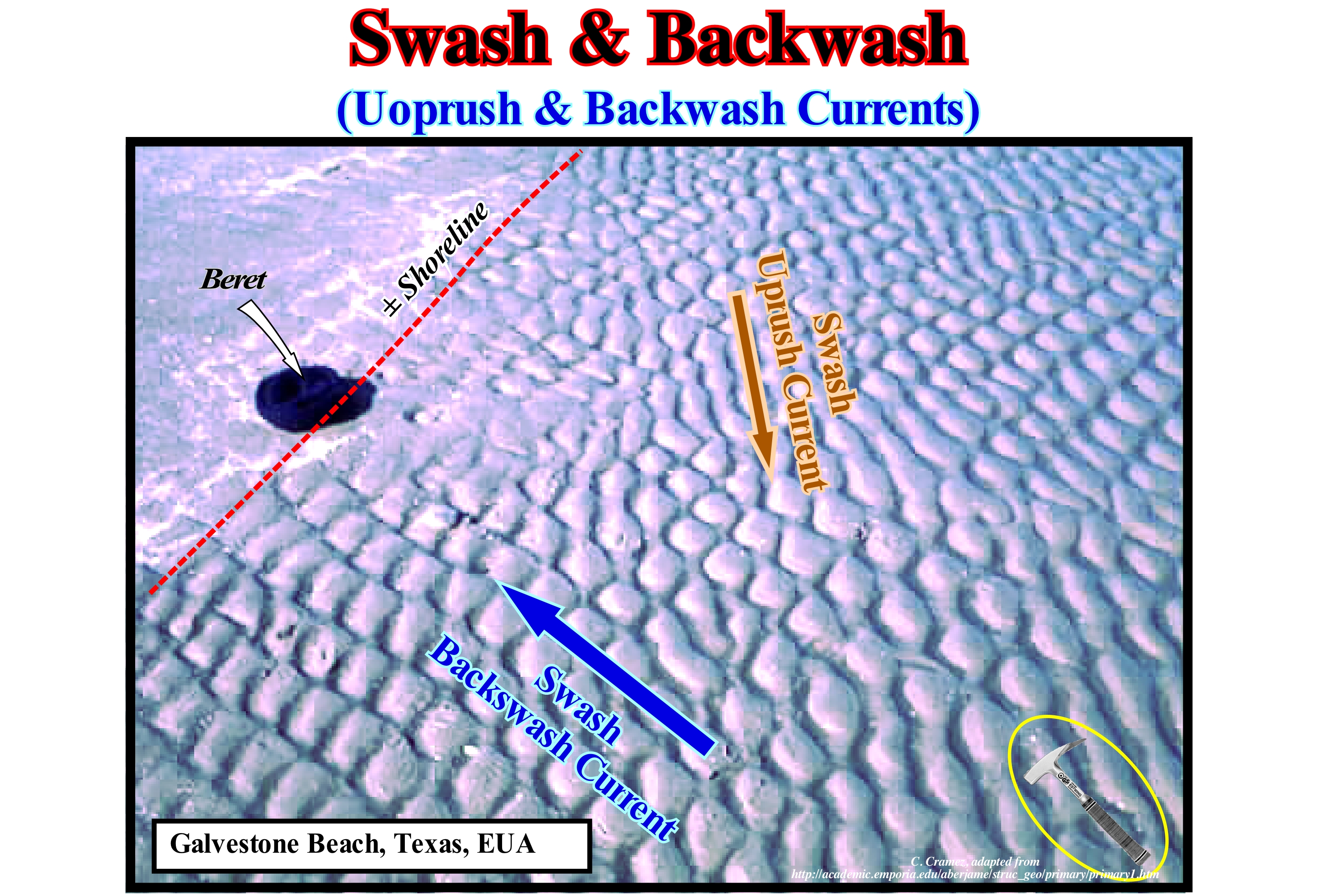
This photograph taken at Galvestone Beach (Texas, USA), illustrates the result of the interaction of the swash (flow of flow) and the backwash (reflux current). The oblique coastline pattern is produced by the swash currents (spreading), while the perpendicular pattern is produced by the backwash currents. Swash transports sand and other particles (little heavy) into the beach. The direction of the swash varies with the wind. The hangover or of backwash current is, always, perpendicular to the shoreline. Theoretically, the swash and backwash can be explained as follows: (i) When the depth of the sea-water is about 1/3 of the height of the sea-waves, i.e., when the steeper parts of the waves incline 60° or more, the waves become unstable and the waves become unstable and the top falls forward, which means that the waves break ; (ii) Since a wave breaks in turbulent foam masses, the water begins to move to the beach under the action of its own momentum (vector whose magnitude is the product of the force intensity - wave weight - by the distance the line of action of the force) ; (iii) On the beach, the moment of the wave transports it continentward by a current, which is called an uprush current ; (iv) The uprush current washes the beach and transports the sand and (v) This current loses energy, due to the friction of the sea floor and the slope, and reverses direction, causing the backwash current to flow seaward according to the slope of the bottom ; (vi) This movement of water searward is only evident at the surface (it exists only up to a depth of about 1 meter). In detail, when a wave breaks, the backwash current moves seaward towards the next crest. As the direction of the uprush current is, more or less, towards the wind, i.e., perpendicular to the direction of the sea-waves, and the direction of the backwash current is, always, perpendicular to the shoreline, the interaction of the two currents creates a current, more or less, parallel to the shoreline.
Swash Current......................................................................................................................................................................................Courant de déferlement
Corrente de rebentação (corrente de ressaca) / Courant de déferlement / Corriente de la rompiente / Klippenbraudungsströmung / 斜电流 / Прибойное течение / Flutto montante, Getto di riva /
Current or currents that formed after the breaking of the waves. There are two swash currents : (i) Uprush Current and (ii) Backwash Current.
See: « Surge Current »
&
« Uprush Current »
&
« Breaking »
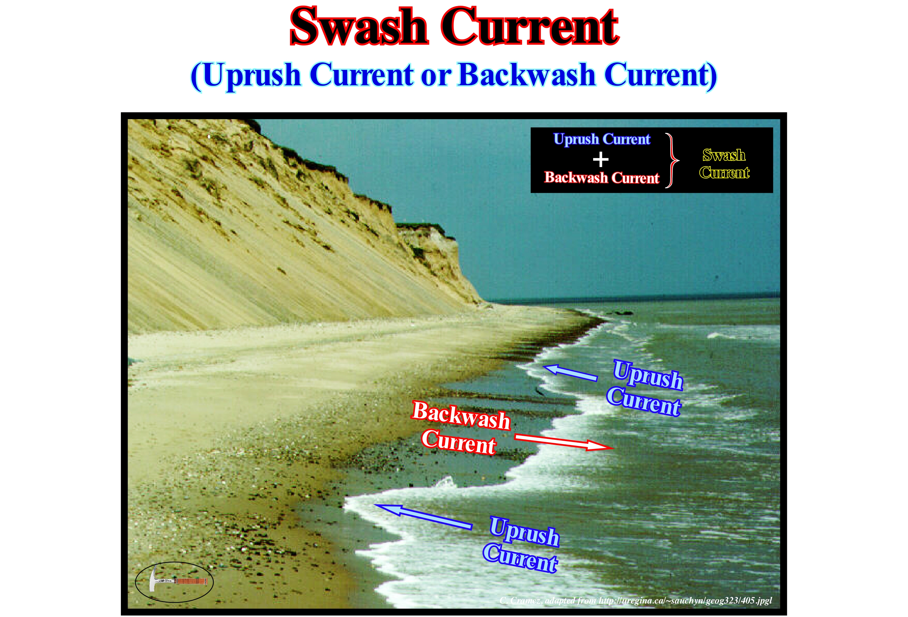
In this photograph, the swash currents are more than evident. The current flowing to the beach is the uprush current (rise) and the current flowing seaward is the backwash current (withdrawal). Of course, the swash currents are formed whenever a wave breaks. When there are three or four waves that break before reaching the coastline, there will, necessarily, be several uprush and backwash waves. Often, a wave breaks because there is a backwash current flowing in front of the crest. The backwash current should not be confused with the undertow current, which certain geoscientists do not recognize in their existence, nor with the rip current (also called concentration current). A backwash current exists until it collides with the crest of the next wave, while the rip wave cuts all crests of waves in the surfing zone. This is, in fact, a way to identify them. If you are on the beach and you see an interruption in the line of surf crests, move away from the interruption zone, because you can be dragged off by a rip current. These currents, which are, generally, perpendicular to the shoreline, may also be oblique and running offshore carrying not only surface water but also some deep-water. Since they leave the surfing zone, they are divided into several branches and return to the shoreline with the uprush currents. Knowing this, if one day you are caught by a rip current, do not panic. Let it lead you out of the surfing zone, where it is, practically, inactive, begin to swim. At the beginning laterally (± 10 meters) and then to the shoreline, taking advantage of the uprush current. When the direction of the sea-waves is parallel to the shoreline, the two swash currents flow, practically, in the same direction and therefore no beach drift current is formed. In contrast, when the waves are oblique to the shoreline, the formation of a beach drifting current is likely since the swash currents are not parallel.
Swash Currents...................................................................................................................................................................................................Courants de ressac
Correntes da ressaca / Corrientes de resaca / Swash Ströme / 斜电流 / Прибойные течения / Swash correnti, Correnti delle zona di battigia /
Currents formed after the breaking of the waves. There are two swash currents : (i) Uprush Current and (ii) Backwash Current.
See: « Surge Current »
&
« Uprush Current »
&
« Breaking »
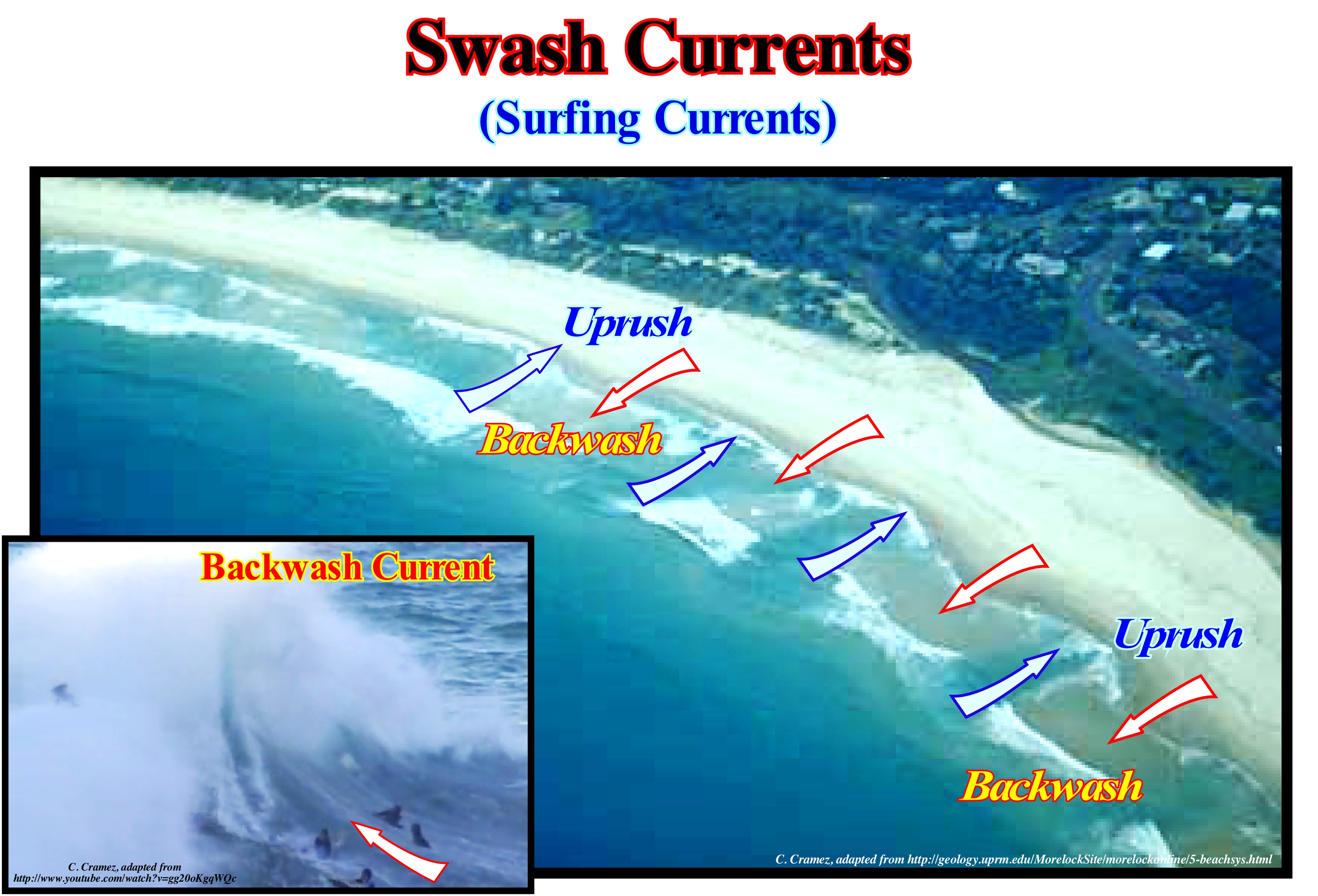
When a sea wave breaks, it creates a water current, which is directed toward the beach. This current called the uprush current is the first swash current (rising current of certain geoscientists). However, as it moves toward the mainland, it loses energy and very quickly reverses itself and begins to move seaward as the seabed declines. This current, which is directed seaward, is the second swash current and is called the backwash current, although some geoscientists prefer to call it withdrawal current. As the backwash current goes seaward it only exists until it meets the crest of the next wave as illustrated in this figure. When the direction of the waves is parallel to the shoreline, the uprush and backwash currents, i.e., the swash currents flow in the same direction, but in opposite directions. When the direction of the sea-waves is oblique to the shoreline, the direction of flow of the uprush current (perpendicular to the direction of the waves) is different from the direction of flow of the backwash current, since it flows along the slope from the sea floor. In this case, a coastal current (or beach drifting) is formed which is, more or less, parallel to the shoreine and which moves in the direction given by the uprush current. The swash currents, particularly the backwash current, are not to be confused with the rip current, which often drag unconscious bathers seaward. A rip current corresponds to a channel of agitated water, with a lot of rippling, that go seaward and with a different colour. Thus, it breaks the continuity of the crest of the wave that approaches the coast. The rip currents, that are, generally, perpendicular to the shoreline, drain to the open sea shifting not only the surface water, but also deep-water. However, beyond the surf zone, they open into fans, dividing into branches that return to the coast with the uprush current. That is why, if one day, you are caught by a rip current, do not panic. Let it drag you out of the surfing zone, where the current is no longer active, then swim to the beach avoiding it that is, generally, no more than 10 m wide.
Swash Mark..........................................................................................................................................................................................Trace d'ondulation (Drainage)
Marca de drenage (marca de marulho) / Traza de ondulación / Wasser Linie / 十字标志 / Верхняя отметка прибоя / Traccia di ondulazione /
Sedimentary structure produced by wind or water (currents and waves) that moves through the deposits of sand or mud. The ripple or drain marks formed by the action of water can be of two types: (i) Ripple marks produced by the currents, which are asymmetrical, with the sloping side oriented in the direction of the current and (ii) Ripple marks produced by the waves, which are symmetrical, almost with a sinusoidal profile and indicate a sedimentary environment dominated by oscillation waves.
See: « Uprush Current »
&
« Backwash Current »
&
« Surge Current »
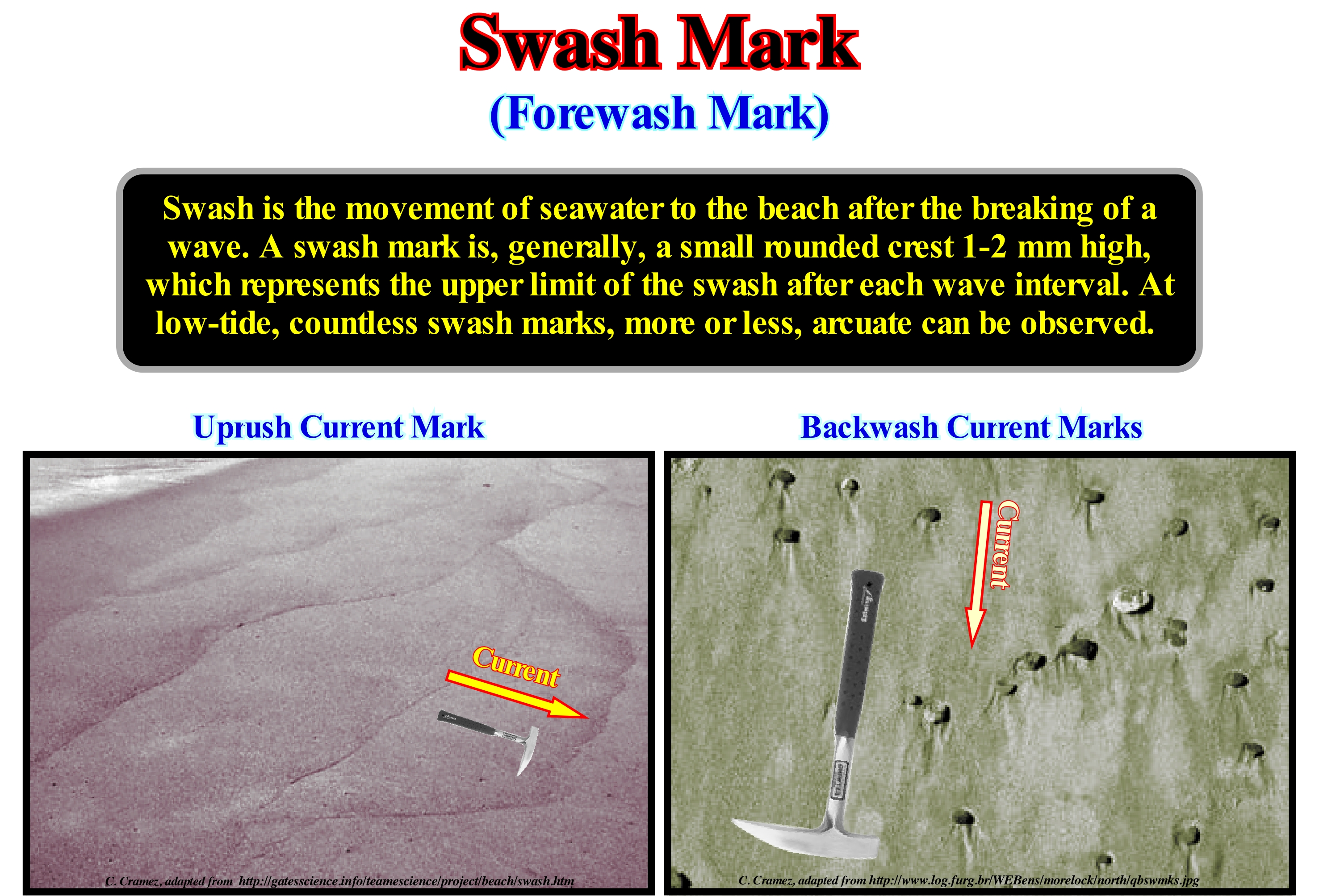
The term rippling refers to the swash (translation waves*), that is, the rise of water on the shoreline, following the breaking of the waves. A uprush or swash bar is a sandy accumulation formed on the swash platform of a downstream delta that migrates through it over the action of the waves. As illustrated in this figure, a thin, wavy or arched line or small crest of sand, seaweed or other debris on a beach are considered as ripple marks, which underlines the maximum irruption wave uprush. The uprush or flood markings are made up of alignments of materials carried by the uprush currents in the high-tide and abandoned during backwash, indicating the upper limit reached by the uprush current. The backwash ripple marks are in the form of grooves or only darker sand traces (due to the concentration of heavy mineral grains), with divergent arrangement from an obstacle (pebble, shell etc.) that causes the bifurcation of the flow during backrush (Moreira, 1984). Ripple marks, entirely composed of roughly coarse sand, are usually found on coarse sand or gravel beaches. These ripple marks are, generally, between 10 and 30 centimeters wide and a few millimeters or centimeters high. Certain observations made, mainly, on fine sand beaches show that ripples are, rarely, more than a few millimeters high and are, usually, composed of material that floats easily in surface water (such as, for example, mica flakes and shell fragments). The ripple marks composed of coarse sand have an increasingly smaller thickness towards the sea. In the same way, its granulometry decreases seaward. Apparently, the flow rate limit is marked by a grain concentration in which grain size and grain velocity decreases in depth. Larger grains are transported at higher speeds than smaller grains. At the maximum feed rate of an uprush current, a ripple mark is deposited, which shows a decrease in the thickness seaward, as well as a decrease in the grain size in depth.
(*) Since the waves have already broken, the water previously on the ridge flows through the front face and continues to cross surfing zone. In broken waves the water actually is displaced, which is not the case in the oscillating waves, in which the movement of the water is circular (forward and upward when a ridge passes, and down and back in the passage of a trough).
Swash Zone.........................................................................................................................................................................................................................Ressac (zone)
Ressaca (faixa) / Resaca / Brandung / 斜带 / Зона наката / Zona de swash /
Space traveled by the surf or swash currents.
See: « Swash Currents »
&
« Uprush Current »
&
« Breaking »
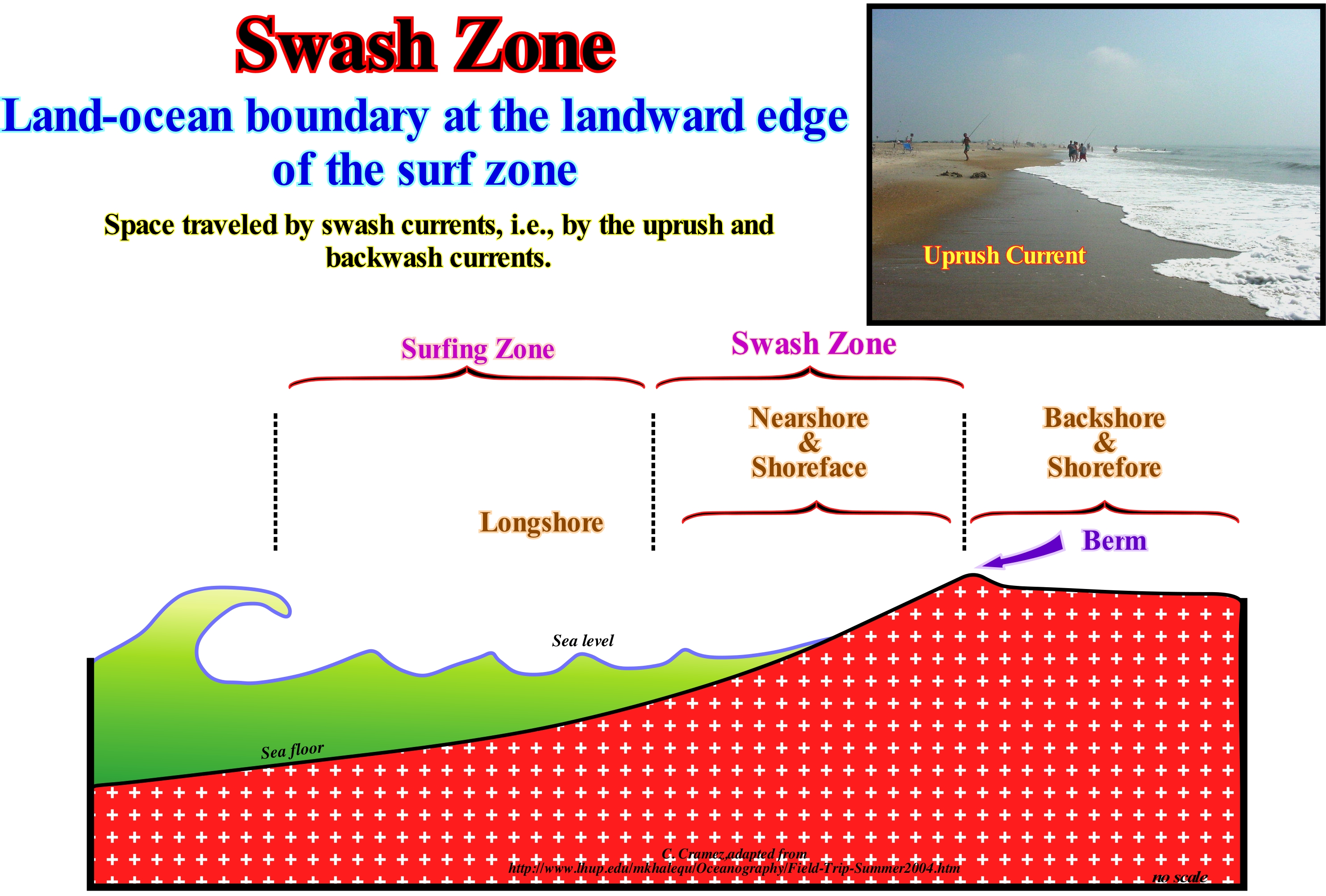
The swash range corresponds to the swash, that is, zone of action of the waves on the beach, which varies according to the water levels, and which extends between the maximum limit of that of the uprush current. When the depth of the sea floor is less than half the wavelength of the waves, the crests of the waves of oscillation become very abrupt and the crests break towards the continent, which transforms the waves of oscillation into waves of translation. As a result of which the waves burst, as is, generally, said, a stream of water is formed in the direction of the continent which moves, more or less, parallel to the direction of the waves. This current is called the uprush current, whose intensity decreases as it moves in the swash range, until its movement is zero. From this moment, another swash current is formed, which now moves from the mainland seaward. It is the backrush current. However, in the backrush current the motive force is no longer the force created by the wave burst, which is perpendicular to the wave direction, but the gravity. Thus, the backrush current is oriented, perpendicularly, to the slope of the beach and not, in parallel, to the direction of the waves. The swash currents have different directions (when the direction of the waves is oblique to the shoreline). It is this difference in the direction of the swash currents that creates the so-called coastal drift current, which is more or less parallel to the coastline and which can have a very important erosive action. The swash domain, which certain geoscientists call the swash zone is the area where the uprush current and the backwash current are active. The swash range is also known as the coastal zone, since it is also the area at the edge of the sea, in which the seabed is exposed during low-tide and submerged at high-tide, i.e., the inter-tidal area. This area is characterized by: (i) A supply of water ; (ii) Wave action is important ; (iii) Significant sun exposure and temperature variations and (iv) A strong salinity, since salt-water stagnant in puddles or puddles evaporates and causes salt deposits.
Swash Zone (On the beach)......................................................................................................................................................................Zone d'estran
Zona de espraiameneto / Zona de rompiente de ola en la playa / Swash Zone / 斜带 / Зона наката / Zona di battigia /
Part of the beach where the waves displace the coastline, that is to say, the snapshot between the wet part (with water) and the dry part (without water). Synonym with Surfin Zone.
See : « Limit of Backrush »
&
« Shoreline »
&
« Shoreface »
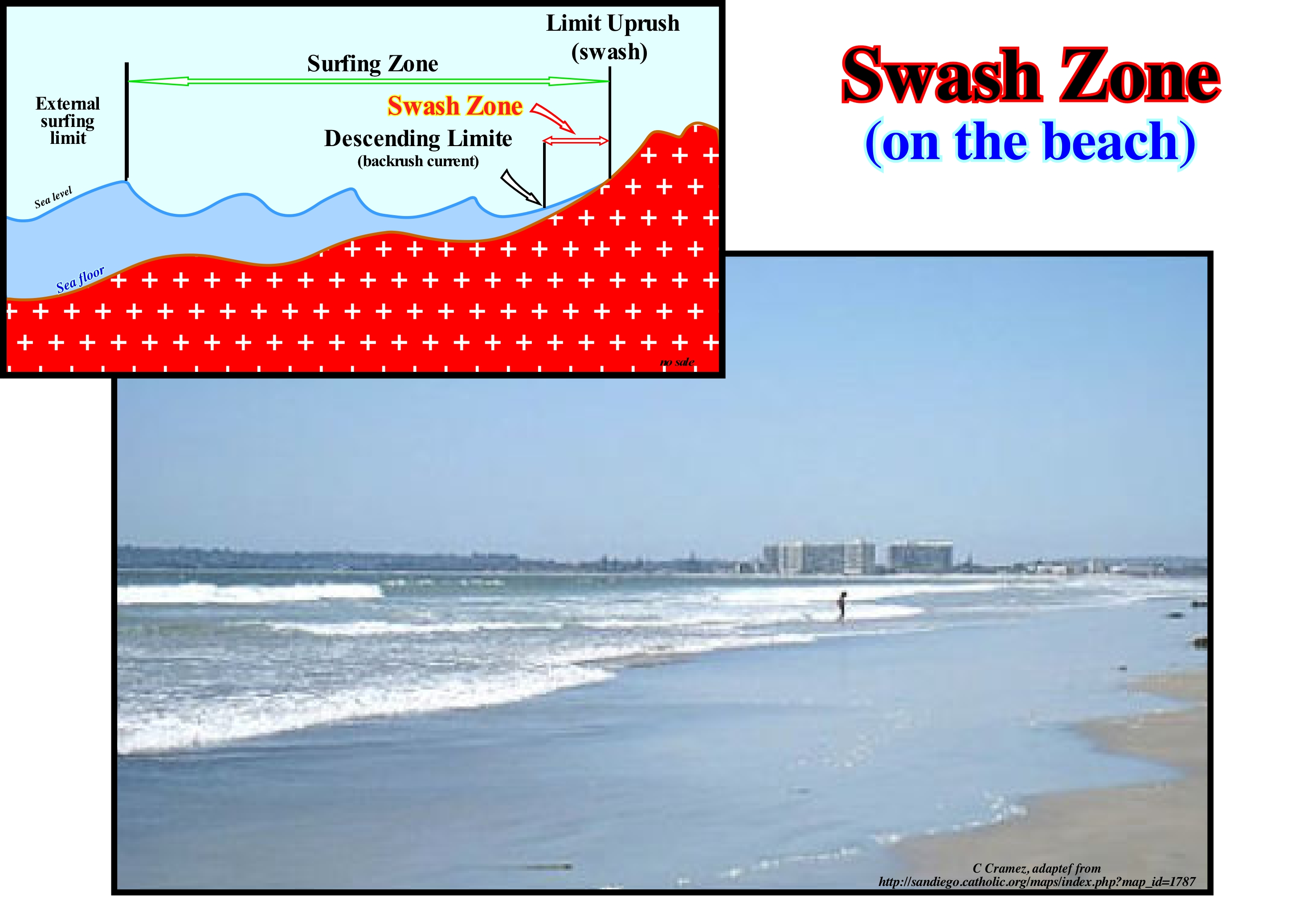
This photograph gives an instantaneous position of the shoreline (dry-wet limit) in the swash zone. On the other hand, as shown in the diagram (top left of this figure), the swash zone is limited upstream by the uprush limit and, downstream, by the backwash limit. The swash area, which is also called the swash strip, is the beach region, alternately, covered by the uprush and backwash currents of inflow induced by wave breaking (surfing). The uprush current is the swash current, which is directed towards the coast, after the surfing of the waves. The backwash current is the swash current, which is directed seaward. The first one advances to the beach, perpendicularly, to the direction of the waves, while the second (backwash), which results from the inversion of the uprush, due to the loss of energy caused by the inclination and attrition of the sea floor, follows the slope of the sea-bottom. As the direction of the sea-waves is not always parallel to the shoreline, the swash currents (uprush and backwash) may follow different trajectories. The swash zone is a highly dynamic environment in which currents have flow velocities often exceeding 2 m/s. In the swash zone, a large amount of sediment is transported from coast to coast and downstream, and the difference between upstream and downstream transport determines whether the beach is eroded or whether, on the contrary, it progrades seaward. It is in the swash zone that the erosion of the shoreline is more evident. The morphology of a beach is determined by the complicated interactions between waves, currents, sedimentary transport and by its own morphology. Many hypotheses and models based on diverse concepts of the forces and interactions in question have been proposed to explain the morphology of beaches. Do not confuse the swash area, which is the swash band, with the swash that is the intertidal band, that is, space between the highest and lowest tide levels.
Swell (Sea)...........................................................................................................................................................................................................................Houle (Ondulation)
Ondulação / Oleaje (del mar) / Schwelle, Dünung / 膨胀 / Волнение (волн) / Gonfiarsi /
Deformation of the water surface of the seas and oceans due to the spreading of the sea waves, i.e., is a series of mechanical waves that propagate along the interface between water and air and so they are often referred to as surface gravity waves. The swell is characterized by a large period (30-300 seconds), great wavelength (several hundred meters) and a relatively important height (several meters). It is created by storms and travels at great speed (several hundred kilometers per hour) through the ocean (sometimes more than 10,000 km) without great loss of energy. When approaching the continent, the amplitude of the swell increases significantly.
See: « Absolute Sea Level »
&
« Sedimentary Structure »
&
« Middle Sea Level »
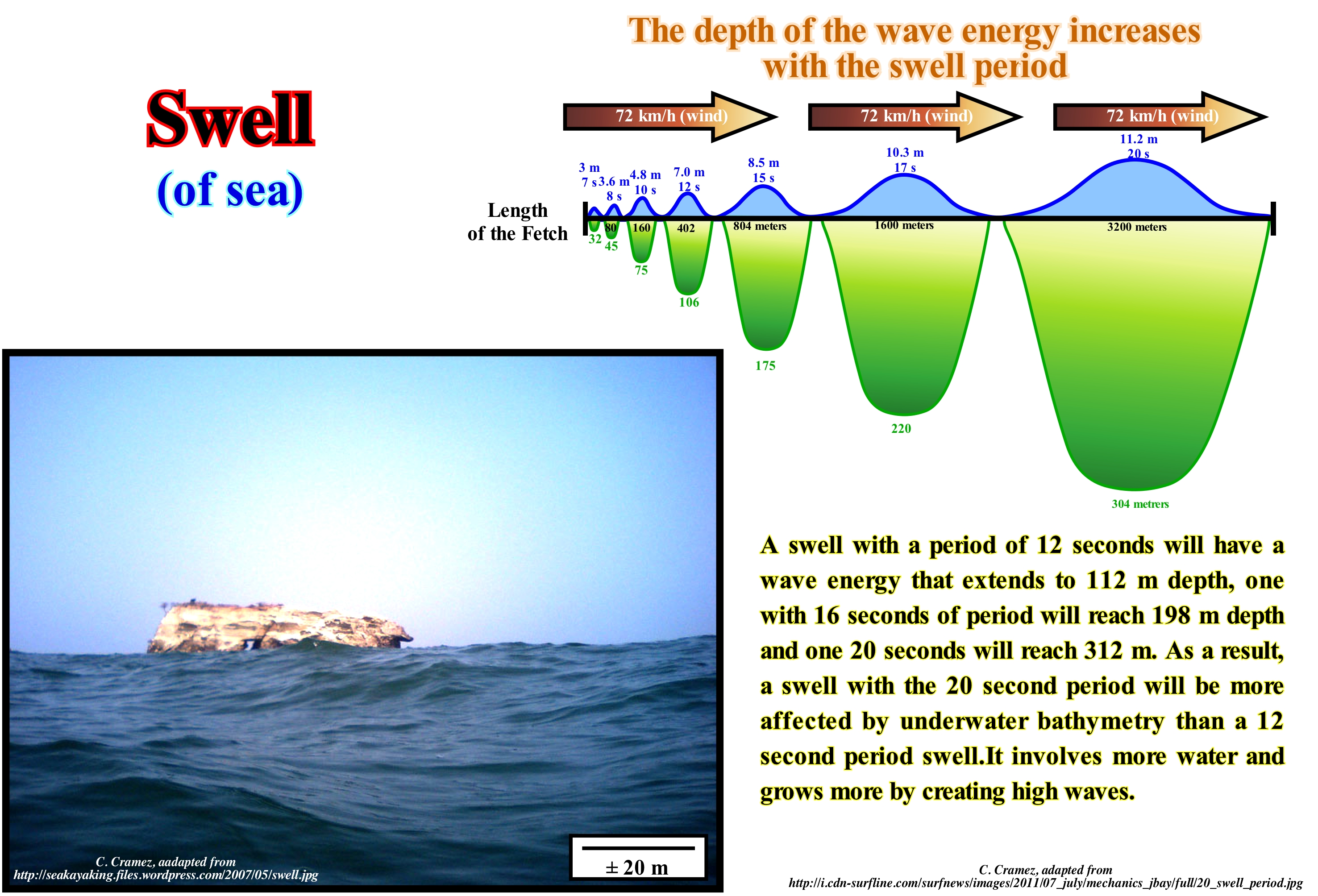
Ocean swell or swell is an undulating movement of the surface of the sea, created by a wind field far from the permanent observation area, which produces a particular noise. It is a special case of no-surf wave. Surfers (those who practice the sport known as "surf", on which they stand on a surfboard, glide over the waves) call it "marola" or small waves of the sea. The sea contains varied component periods that give it an uneven appearance. At great depth, the velocity of these components is proportional to their period. The proportion decreases as the depth decreases, which does not qualitatively alter the phenomenon. The waves created by the wind blowing on a given width propagate during their movement by a diffraction phenomenon, which reduces the contribution of the components in the wave propagation direction, and particularly when they are shorter. The shorter components are therefore, gradually, abandoned, giving an impression of regularization while the significant height decreases. The oceanic swell, in fact, corresponds to the set of rippling sequences that propagate on the ocean from distant areas, where they were, usually, created by storms that cause the winds on large oceanic areas, called wind. The waves that form in these wind tracks are called waves or breezes when they are large in size. Waves, generally, do not have a coherent direction and also do not have a definite form. However, when they move away from the winding track that created them and go to the areas of ocean with weak wind, the waves tend to align and to group in series, creating then the oceanic swell. A particular oceanic swell has a well-defined direction, velocity, and size, which work in practice as a swell fingerprint, differentiating it from other swell on the ocean. The wave spectrum defines which ripples are traveling over the ocean at a particular point, because unlike wind, in the ocean, there may be several ripples at the same time. When the waves reach the beach, depending on their characteristics, the waves will increase in size and strength. The oceanic swell is characterized by the height between the crest and the trough (double the amplitude ranging from a few centimeters to several meters) and the wavelength or period (usually of the order of ten seconds). It is a phenomenon that is not periodic and can be interpreted as a sum of an infinite number of very small sinusoidal components. The average period of crests, regardless of the definition that is given for that expression, increases during propagation by loss of the shorter components. It is an indicator of the intensity and size of the storm that generated the ripple. Often barely perceptible in the open sea, the ripple amplifies near the shore where the depth of the sea water decreases where it can reach several meters and burst. Once generated in storms, waves of great periods can spread over tens of thousands of kilometers. This propagation which follows the geodesics on the surface of the Earth (large circles on the planes passing through the centre of the earth) is in practice impeded by the presence of continents. Several observations were made on the waves coming from the antipodes (i.e., 20,000 km of route). Do not forget that it is not the water particles that move, but the troughs and crests induced by the trace of the orbits described by the water particles (the troughs follow the base of the orbits while the crests follow the tops). Put another way, in oceanic waves, it is not water that moves, but the surface phase of water. It is all like the "waves" made by spectators of a football challenge, which in a collective and synchronized movement, rise in lines, raise their arms and sit down again, giving the visual impression of a great wave running through the field benches. Obviously, the spectators do not move, what moves are the crests and troughs that they create by an orbital movement of raising and lowering the arms. Since a certain wave has a well defined direction, this direction will define, for example, good or bad conditions for the practice of surfing in certain places. With the advent of the Internet the forecast of good conditions of waving can be divulged, easily and quickly, which proved a real revolution in the world of surfing.

