
Conformable........................................................................................................................................................................................................................Conforme
Conforme / Conforme / Konforme / 顺应性 / Соответствующий / Conforme, Continuo /
Geometric relationship between two layers or seismic intervals, when there is no evidence of erosion or hiatus, which does not mean that there is no an unconformity (erosional surface) between them. Synonym of Concordant.
See: « Concordant »
&
« Concordance »
&
« Aggradation »
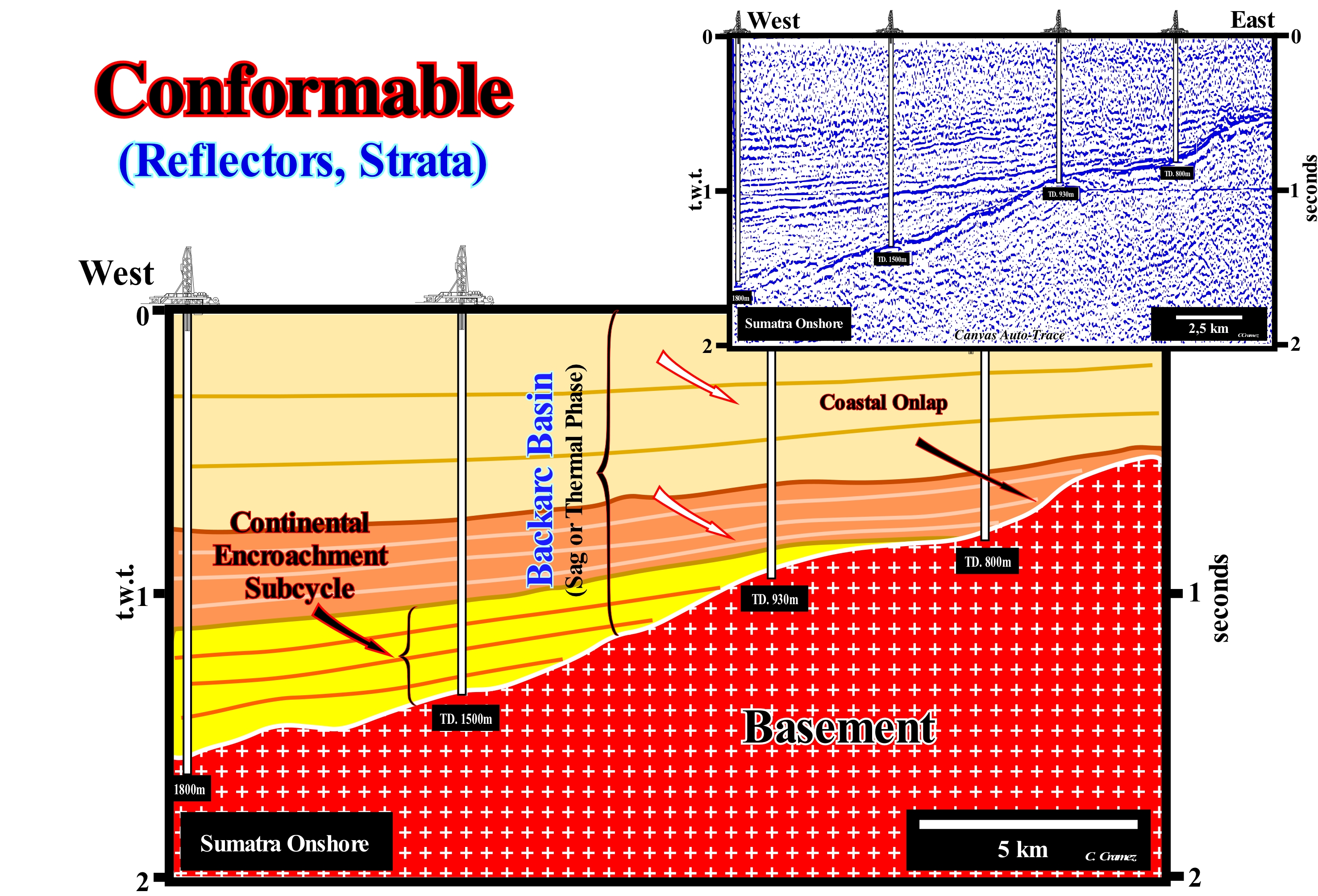
The onshore of the island of Sumatra (Indonesia) corresponds to the stacking of several basins of the classification of the sedimentary basins of Bally and Snelson (1980). From bottom to top, in a regional seismic line of this onshore, one can recognize: (i) A Mesozoic basement, often, a Mesozoic Folded Mountain Belts ; (ii) A back-arc basin, formed by two tectono-sedimentary phases. At the base, the rifting or lengthening phase, characterized by a differential subsidence, which is covered by the sinking or sag phase characterized by a thermal subsidence. On this tentative geological interpretation of a Canvas auto-trace of a detail of a seismic line of this onshore, just the basement and the sediments of the sag phase (thermal subsidence basin) are visible. The three sedimentary intervals deposited above the basement (granite-gneiss or fold mountain belt) all have a parallel internal configuration. This type of configuration suggests the sediments were deposited either on a shelf (water-depth <200 m) or in deep-water (abyssal plain). As the basement outcrops eastward at this seismic line, it is most likely, that the three sedimentary intervals have been deposited in shallow-water. The seismic lines in the continuation of the line of this tentative geological interpretation suggest the presence of a continental slope dipping westward. Taking into account the internal configurations of these three intervals, the boundaries between them are concordant (in this sector). They correspond to unconformities, i.e., erosional surfaces. However, when an unconformity is not tectonically enhanced, the erosional surface is just evident in the vicinity of the basin edge, which can coincide or not with the continental edge (basin without shelf or with a shelf). Is near the basin edge, that submarine canyons are formed in association with a significant relative sea level fall. Landward the basin edge, which sometimes corresponds to the limit between the continental slope and the shelf, erosional surfaces (unconformities) are recognized only when incised valleys fills are present. On this tentative interpretation, the boundaries between the considered intervals (probably continental encroachment sub-cycles) are conformable. Laterally, they correlate with evident unconformities, that the geoscientist, who made the tentative interpretation, identified near the continental edge (submarine canyons fills and toplaps) or by the evidence of incised valley fillings. On the sequential stratigraphy, which is based on the identification and cartography of the unconformities, the study of the geometrical relations between the reflectors, in the vicinity of the basin edges, is primordial. The seismic lines showing the continental slopes within the different sedimentary intervals are those allowing the more coherent tentative interpretations. For some geoscientists, a discontinuity denotes a transition or contact between intervals either with different densities, such as the Mohorovičić discontinuity, either with different sedimentary facies or between intervals separated by a hiatus (absence of significant deposition). In Geology there are several types of discontinuities: (1) Stratigraphic Discontinuity ; (2) Sedimentary Discontinuity; (3) Lithological Discontinuity ; (4) Tectonic Discontinuities, etc., Among the lithological discontinuities, which are the most important in the sequential stratigraphy, we can recognize: (i) Concordant Lithological Discontinuities, when there is continuity between successive intervals ; (ii) Paraconform Lithological Discontinuities or, simply, Paraconformities, when there is no difference in attitude between overlapping intervals, but there is a hiatus due to the absence of significant deposition between them ; (iii) Non-Conformable Lithological Discontinuities, or simply Non-Conformities (which certain authors call Heterolithic Unconformities), when there is a contact between a sedimentary interval and an older igneous body ; (iv) Discontinuous Lithological Discontinuities or Disconformities, when the layers of the intervals are parallel on either side of the contact surface which does not conform to regional bedding ; (v) Discordant Lithological Discontinuities or Unconformities when the two intervals are separated by an erosional surface induced by a relative sea level fall ; (vi) Enhanced Discordant Lithological Discontinuities or Tectonic Enhanced Unconformity, when the sediments of the interval underlying the inconformity were deformed by tectonics (shortened or lengthened) ; (vii) Intrusive Lithological Discontinuities, when an igneous body traverses a sedimentary series ; (viii) Mechanical Lithological Discontinuities, when they are induced by faulting, etc. (https://estpal13.wordpress.com/2013/06/04/ descontinuidades-sedimentares-e-estratigraficas/)
Conformity...........................................................................................................................................................................................................................Conformité
Conformidade / Conformidad / Konformität / 一致性 / Согласие (согласное напластование) / Conformità /
Term used to indicate that there is no physical evidence of erosion or nondeposit along the surface separating the younger strata from the strata forming the older interval.
See: « Concordant »
&
« Concordance »
&
« Aggradation »
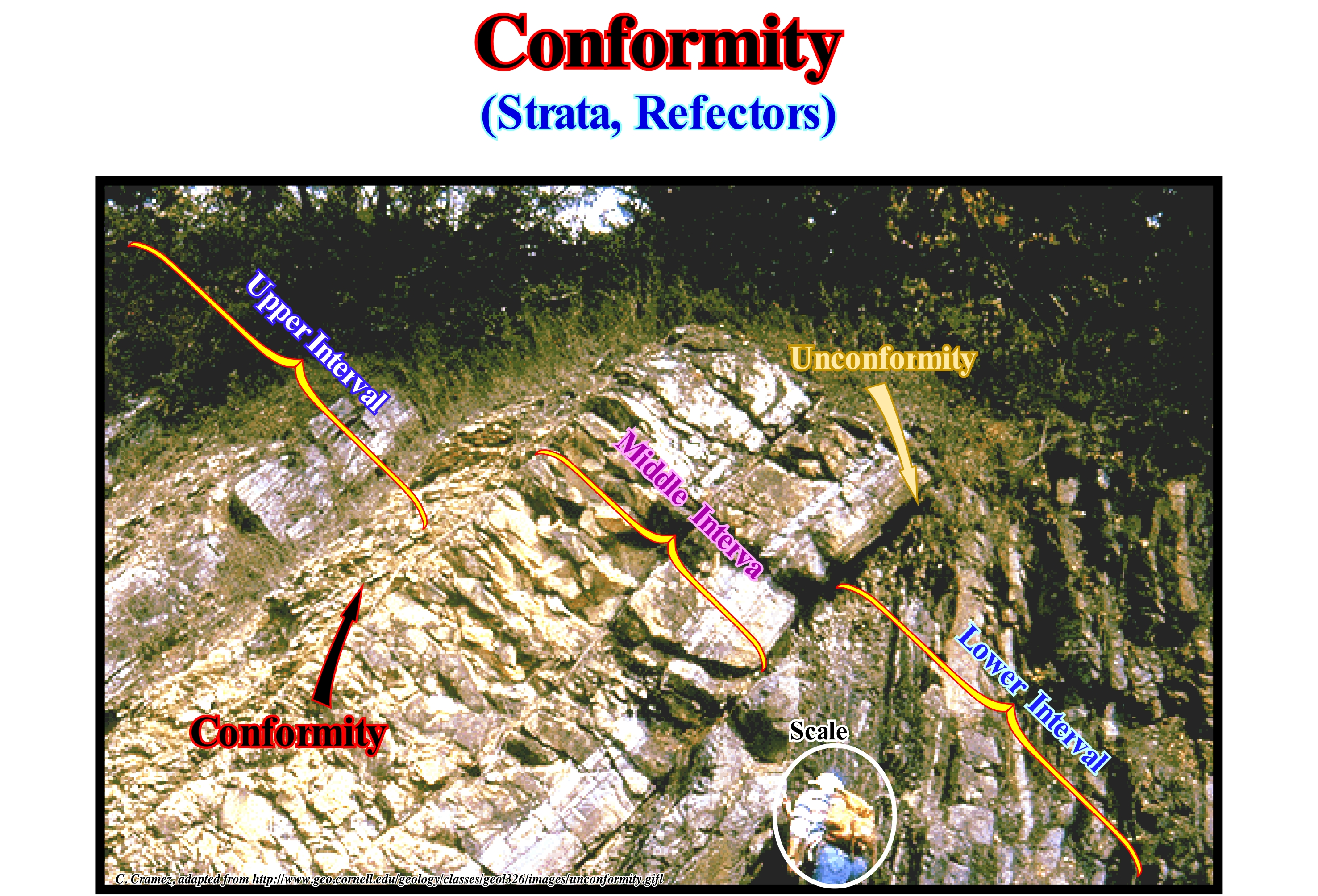
In this outcrop (the scale is given by the geoscientist who observes the lower sedimentary interval) one sees, perfectly, a tectonically enhanced unconformity (angular unconformity) between the lower and middle interval that have different lithologies (facies). The upper and middle intervals, which are constituted by a series of, more or less, parallel layers, conform to each other. They are separated (in this place but not in others) by a conformity that, roughly speaking, is parallel to the bedding planes of the two intervals. As an unconformity is an erosional surface, induced by a relative sea level fall, it corresponds to a hiatus, which is, relatively, important. On the contrary, a conformity or the bedding planes, illustrated in this outcrop, correspond,also, to an erosional surface, but the hiatus is very small. This is why when an unconformity is not tectonically enhanced, which is the most frequent case, the differentiation between an unconformity and conformity is subtle, since the assessment of the hiatus (time of exposure) is very difficult. In sequential stratigraphy all unconformities are induced by relative sea level falls* and not by tectonics. First, except perhaps in foreland basins (foredeep basin), relative sea level changes are much faster than tectonic changes, which means the cyclicity of the depositional systems is given by eustasy rather than by tectonics. Secondly, a tectonic uplift, whether induced by a compressional (shortening) or extensuonal (lengthening) tectonic regime, does not imply, necessarily, erosion. To have erosion, the sediments have to emerge, i.e., they have to be exposed to erosive agents (water, wind, ice, etc.). For this there has to be a significant relative sea level fall. It can be said an unconformity, which corresponds to an erosional surface, is induced by a significant relative sea level fall which shifts the coastal onlaps seaward and downward. Such displacement exhumes the shelf (if the basin at such a moment has a shelf), transforming it into a coastal plain exposed to erosion agents. The age of an unconformity corresponds to the age of the relative sea level fall. The best way to date an unconformity is to determine the age of the submarine basin floor fans, deposited almost instantaneously (in geological terms), during the relative sea level fall and not after the relative sea level rises (ingressions) as it is the case for all the other sedimentary systems tracts sub-groups. Local or regional tectonics (usually compressive) can enhanced (by exaggeration of geometric relations) an unconformity and transform it into a tectonically enhanced unconformity, which certain geoscientists call angular unconformity. With regard to the terminology used to designate a transition or contact between sedimentary intervals with different facies or between intervals separated by a hiatus (absence of significant deposition), the term discontinuity is often used. However, it is, also, used to designate a transition or contact between geological intervals with different densities, such as Mohorovičić (Moho) discontinuity or Conrad discontinuity. In Geology there are several types of discontinuities: (1) Stratigraphic Discontinuity ; (2) Sedimentary Discontinuity; (3) Lithological Discontinuity ; (4) Tectonic Discontinuities, etc., Among the lithological discontinuities, which are the most important in the sequential stratigraphy, we can recognize: (i) Concordant Lithological Discontinuities, when there is continuity between successive intervals ; (ii) Paraconform Lithological Discontinuities or just Paraconformities, when there is no difference in attitude between overlapping intervals, but there is a hiatus due to the absence of significant deposition between them ; (iii) Non-Conformable Lithological Discontinuities or just Non-Conformities (which certain authors call Heterolithic Unconformities), when there is a contact between a sedimentary interval and an older igneous body ; (iv) Discontinuous Lithological Discontinuities or Disconformities, when the layers of the intervals are parallel on either side of the contact surface which does not conform to regional bedding ; (v) Discordant Lithological Discontinuities or Unconformities when the two intervals are separated by an erosional surface induced by a relative sea level fall ; (vi) Enhanced Discordant Lithological Discontinuities or Tectonically Enhanced Unconformity, when the sediments of the interval underlying the inconformity were deformed by tectonics (shortened or lengthened) ; (vii) Intrusive Lithological Discontinuities, when an igneous body traverses a sedimentary series ; (viii) Mechanical Lithological Discontinuities, when they are induced by faulting, etc. (https://estpal13.wordpress. com/2013/06/04/ descontinuidades-sedimentares-e-estratigraficas/)
(*) Relative sea level is a local sea level referenced to the sea floor or the base of the sediments (top of continental crust). It is the result of the combined action of absolute (eustatic) sea level and tectonics (subsidence or uplift of the sea floor).
Conjunction (Astronomy).........................................................................................................................................................Conjuntion (Astronomy)
Conjoncção / Conjunción (astronomía) / Konjunktion (Astronomie) /结合(天文) / Соединение (солнцестояние) / Congiunzione (astronomia) /
Apparent meeting or passage of two or more celestial bodies. The Moon is in conjunction with the Sun in the New Moon phase, when it moves between the Earth and the Sun (side facing the Earth is dark). In this situation, the forces of gravity of the Sun and Moon are added producing strong tides with a great difference between high and low-tides. Lower planets, with smaller orbits than Earth (Venus and Mercury), have two types of conjunctions with the Sun. The inferior conjunction occurs when the planet passes between Earth and Sun. The superior conjunction when the planet passes to other side of the Sun.
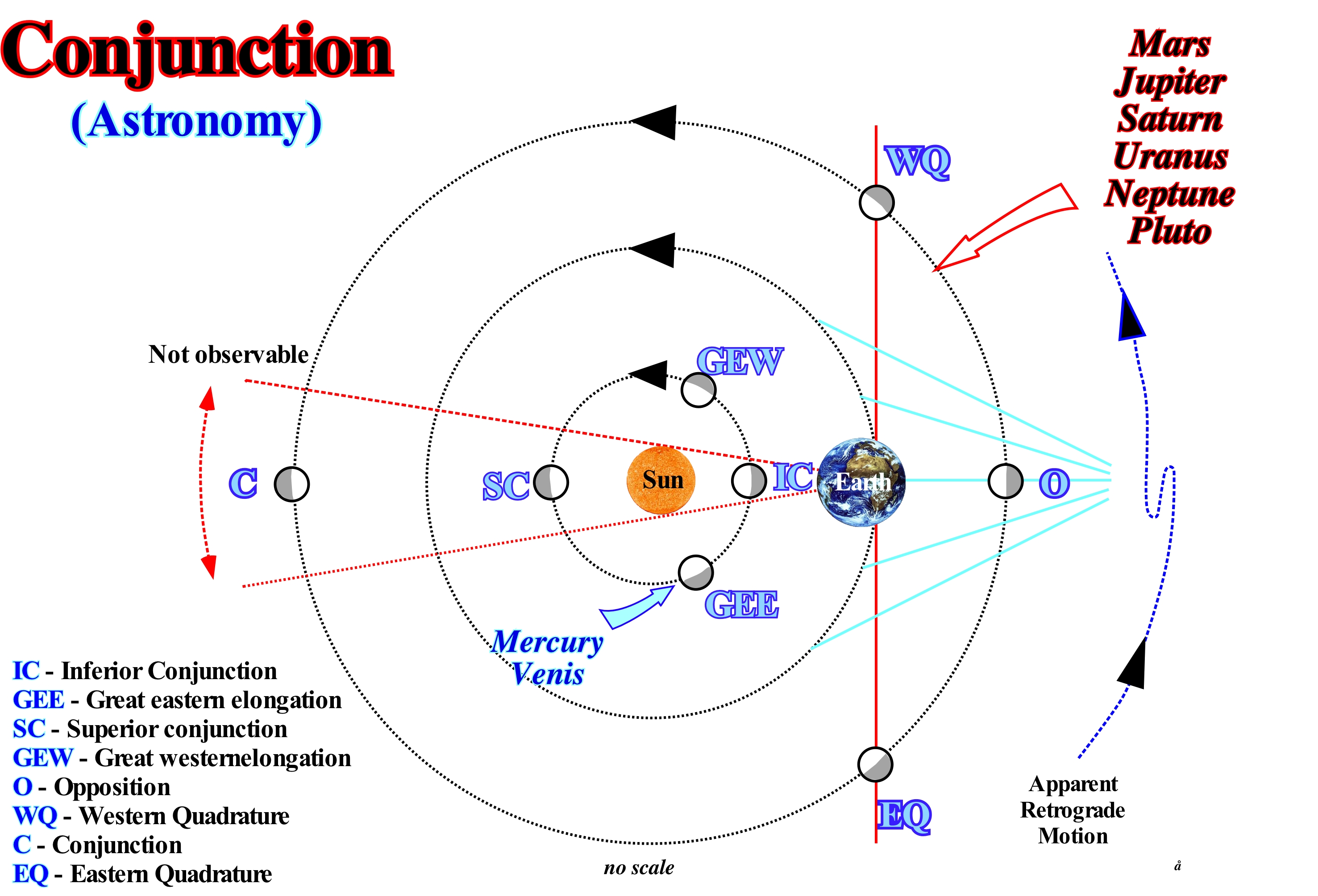
The term conjunction was, originally, used to designate the phenomenon defined just for the position of the observer and not for the celestial relations. However, for instance, for the Moon and the Sun observed from Earth, the term conjunction may apply to both conjunction positions (both Sun and Moon observed together in a single direction or with a similar ecliptic length) and the term opposition (both the Sun and the Moon observed, separately, in opposite directions or with a 180° ecliptic longitude difference). More generally, in the particular case of two planets, this means they have, simply, the same right ascension (one of two coordinates of a point on the celestial sphere) and therefore the same hour angle (one of the coordinates used in the coordinate system equatorial to describe the position of a point on the celestial sphere) This is called conjunction in right ascension*. The 360° of the equator are called degrees of right ascension. There is also the term conjunction in ecliptic longitude. In such conjunctions both objects have the same ecliptic longitude. Conjunction in right ascension and conjunction in ecliptic longitude, usually, do not occur at the same time but in most cases, almost, at the same time. In a triple conjunction is possible that a conjunction just right ascension (or ecliptic longitude) occur. At the moment of conjunction, no matter whether in right ascension or in ecliptic longitude, the planets involved are together on the celestial sphere. In most of these cases, one of the planets seems to pass north or south of the other. The term "triple conjunction" is used in two different ways: (i) Conjunction of three stars (e.g., Venus, Jupiter, Moon) ; (ii) Conjunction between two stars, reproducing three times in a row. Many geoscientists think that a three-star conjunction does not exist, since only two stars can have the same celestial longitude (or direct ascension) simultaneously.
(*) Term for one of the two coordinates of one point on the celestial sphere when using the equatorial coordinate system and the other coordinate is the declination.
Conodont....................................................................................................................................................................................................................................Conodonte
Conodonte / Conodonte / Conodonte / コノドント / Конодонты / Conodonta /
Vertebrate primitive, now extinct, that existed and evolved more than 540 Ma, between the Paleozoic and the Early Mesozoic (from the Late Cambrian to the Upper Triassic).
See: « Paleontology »
&
« Fossil »
&
« Paleozoic »
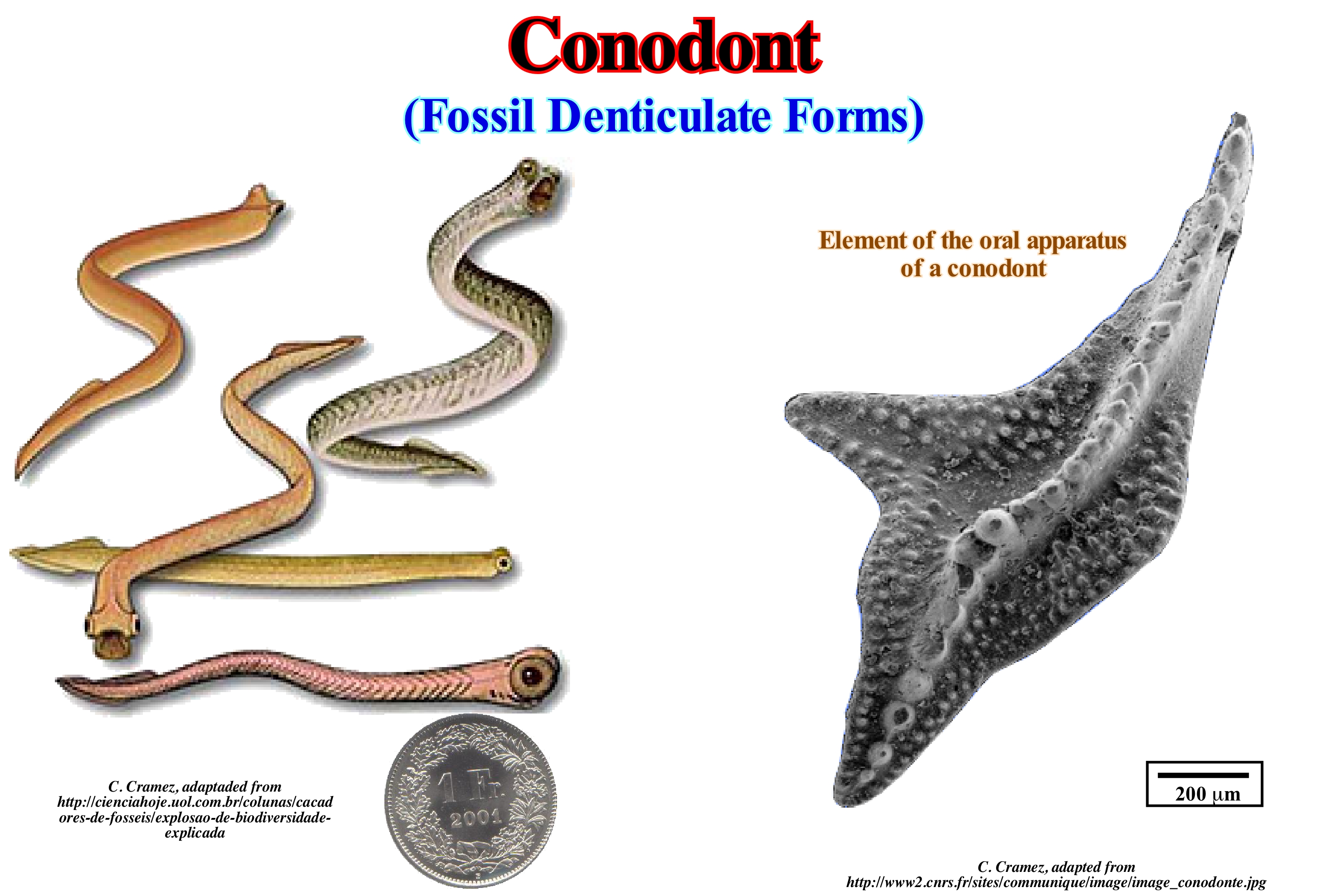
Until recently, these vertebrates were known only for small structures composed of apatite (calcium phosphate) similar to teeth (hence its name), with a size between 0.25 and 2 millimetres. These micro-fossils have been known for a long time and are an important tool in the relative dating of sedimentary rocks and in the petroleum exploration. In fact, for a long time paleontologists have debated whether the conodont elements belonged to worms, molluscs or even plants. The most likely answer was to wait until 1983, when the first complete records of these animals were found on the rocks of the Lower Carboniferous (about 340 million years ago) of Scotland (near Edinburgh) and were named Clydagnathus. These findings established, almost definitively, the fossil structures belonged to primitive fish, with an elongated body similar to that of worms, but with notochord (flexible rod-shaped body found in all embryos of all chordates), structures like fins and a pair of well-developed eyes. In general, conodonts have a size of about 4 cm. Although rare, complete specimens were also found in the United States, Africa, and the Amazon basin (Brazil). It was concluded that: (i) Conodonts are denticular fossil forms that appeared in the Precambrian and disappeared in the Triassic, when extinction occurred at the end of this period ; (ii) Most of them represent the teeth of a certain vertebrate animal, that is of a chordate (phylum of the animal kingdom characterized by having a dorsal cord or notochord) ; (iii) The fossils of this vertebrate present a complete set of pieces of conodonts at the level of what is its head ; (iv) This vertebrate, on average, reached about forty millimetres ; (v) He would have eyes and be like a current (though smaller) eel. The conodonts (name derived from the union of the Greek terms kônos = cone and odontos = teeth) are, currently, grouped in the class of Euconodonts (true conodonts) and placed among the Chordates near the base of the phylogenetic tree of vertebrates.
Conrad Discontinuity.................................................................................................................................Descontinuité de Conrad
Discontinuidadede Conrad / Discontinuidad de Conrad / Conrad - Diskontinuität / 康拉德不连续 / Поверхность Конрада / Discontinuità di Conrad /
Sub-horizontal surface in the continental crust from which the velocity of the seismic waves increases in a discontinuous way. In the continental areas, this discontinuity is, generally, between 15 and 20 km deep. It is not found in the oceanic areas. Most geoscientists consider the Conrad's discontinuity as the boundary between the Upper and Lower Crust.
See: « Crust »
&
« Moho Discontinuity »
&
« Lithosphere »
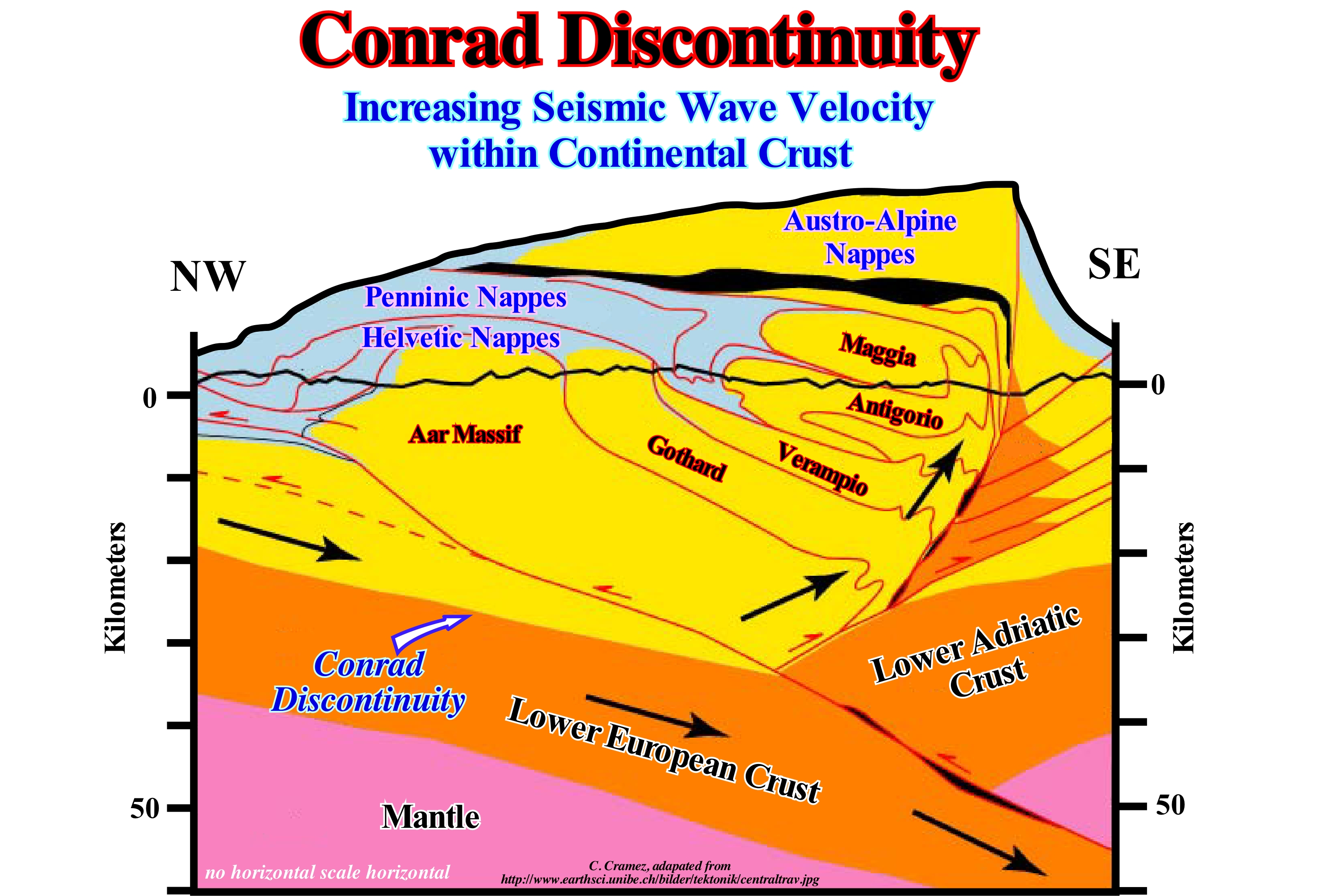
Conrad's discontinuity is considered as the boundary between the upper and lower continental crust. This discontinuity is not as pronounced as Mohorovičić's discontinuity and is not recognized in certain continental regions. Until the middle of XX century, the upper crust in continental regions was considered as composed of felsic rocks like the granite (SIAL*), and the lower crust as composed by mafic rocks more rich in magnesium, as, for instance, basalt (SIMA). The geoscientists at that time considered that Conrad's discontinuity should correspond to a sudden contact between two chemically distinct layers of the crust, i.e. between the SIAl and SIMA. From the 1960s this hypothesis was, strongly, contested. From the study of the seismic waves, the geoscientists found that between 7.5 and 8.6 km below the Earth's surface, there is an evident discontinuity. Such a discontinuity means that above it, the seismic waves travel at a velocity a very different than below it. It is this discontinuity, which is found under all the continents that is called: Conrad's discontinuity. Geoscientists hoped to find a sudden and significant change in rock type (granite/basalt) at the time of the drilling of Conrad's discontinuity in Kola province. The Zapoliarny well (name of the nearest Russian town in the peninsula of Kola), that began on May 24 of 1970 and ended in 1989, had the objective of drilling as deep as possible (up to 15,000 meters) in order to cross the Earth's crust to better understand its composition and the internal Earth's mechanisms and eventually recognize the Conrad's discontinuity or the Mohorovičić's discontinuity. Unfortunately, Russian geoscientists did not find any transition up to 12 kilometers deep (more or less the total depth of the well). This was a big shock and it means that today, nobody knows what Conrad's discontinuity represents. Probably, it does not correspond to any kind of lithological change, faulting or limit of any kind. It is important not to forget that the modelling of this invisible structure of the Earth's crust depends on a realistic tentative interpretation of seismic records.
(*) SIAL is a somewhat obsolete term, which designates the rocks that form the main part of the continental crust, which are located on darker and denser rocks, that outcrop the bottom of the oceans and that form the SIMA. The term sial emphasizes the fact that the rocks composing it are, mainly, formed by silicates rich in aluminium and not of magnesium, as is the case of the rocks that form the SIMA.
Conservation of Energy (Principle).....................................................................................Conservation de l'énergie
Conservação da energia / Conservación de energía (principio) / Erhaltung der Energie / 能量守恒 / Принцип сохранение энергии / Conservazione dell'energia /
According to this principle, developed during the 19th century, energy can neither be created nor destroyed. Energy can just be transformed into another form of energy*. However, Einstein's famous equation: E = mc2, forced scientists to modify this principle, since it showed that matter and energy can be transformed into one another.
See: " 2nd law of Thermodynamics"
&
" Goguel's Law "
&
" Stellar Evolution "
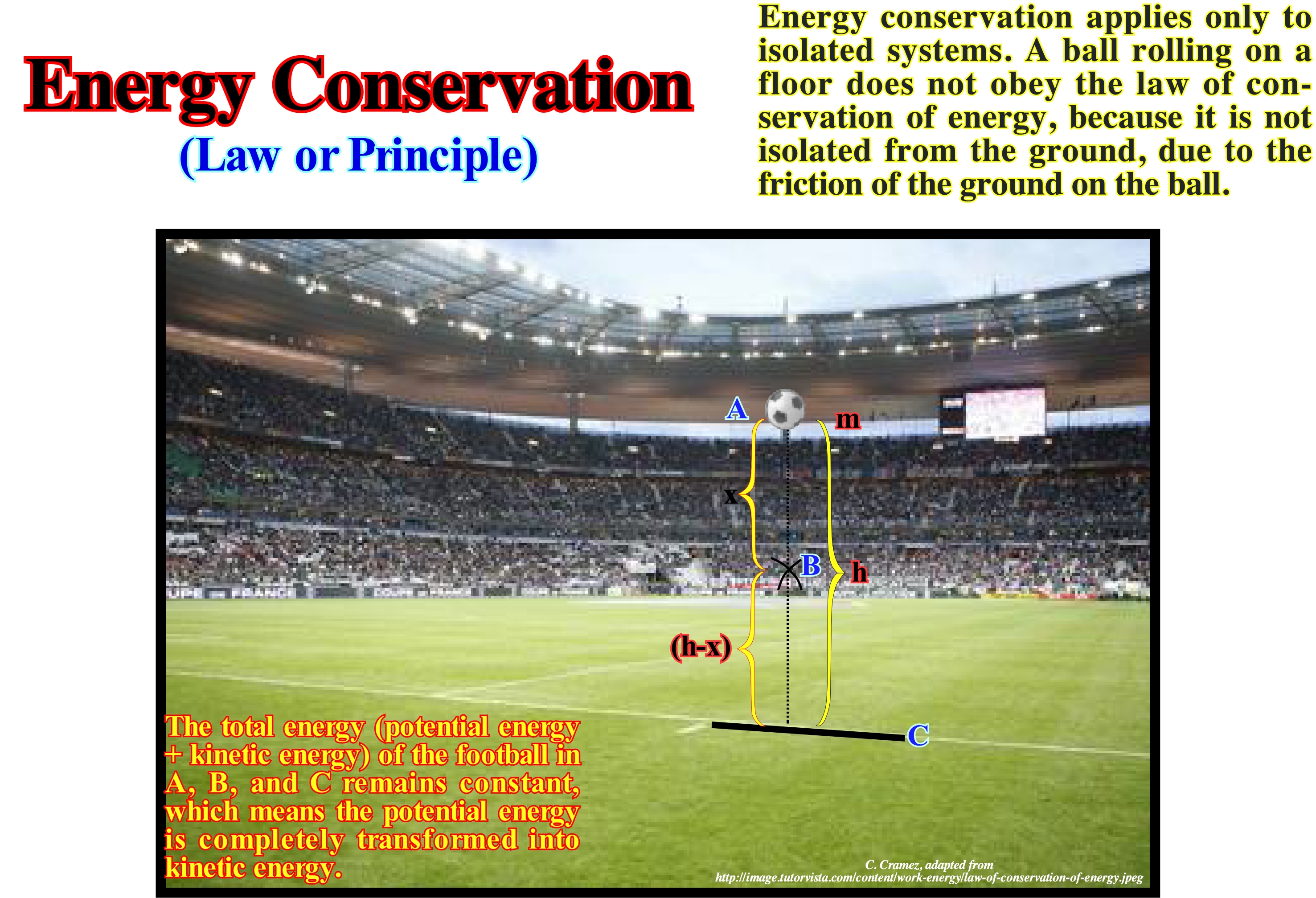
There are just two types of energy: (i) Kinetic energy, i.e., the ability to do work through the movement and (ii) Potential energy, i.e., the ability to do work through the position. However, we often meet terms such as electrical energy, chemical energy, nuclear energy such things do not really exist. They are just practical abbreviations for specific combinations of the kinetic and potential energy. The so called "electrical energy" is just the potential energy of negative charge electrons in the presence of positive charges. As indicated by P. Atkins(2003), the exception to this universality of the kinetic and potential energy is the energy of electromagnetic radiation, such as the energy of light, such as the one transported from the Sun to Earth. The law of conservation of energy** says that energy can not be created or destroyed, but that it is transformed from one form to another. This law is, as we shall see below, also valid when any body, such as a soccer ball, goes into free fall. As illustrated in this figure, suppose a soccer ball of mass m positioned above the field the height "h" (rest position) and that we let it fall to the grass. In this case, we have to show that the total energy (potential energy + kinetic energy) of the ball at points A, B and C is constant, i.e., the potential energy is, completely, transformed into kinetic energy. At point A, the potential energy is equal to mgh = 1/2 (m.v2) = 1/2 (m .0) = 0 (since the velocity of the ball is zero since it is at rest, the total energy in A = potential energy + kinetic energy = mgh + 0 = mgh (equation 1). At point B, the potential energy is equal to mgh = mg (hx), since the distance from the ball to the ground is hx). Thus the potential energy = mgh - mgx = 1/2 (m.v2). Since the ball has travelled the distance x with a velocity v, we can use the third equation of motion to obtain the velocity of the ball, v2- u2= 2.aS, where u = 0, a = g e S = x, so v2 - 0 = 2.gx or v2 = 2.gx The kinetic energy = 1/2 (mv2) = 1/2 m. At the point C, the potential energy is equal to mxg0 (h = 0) = 0. The energy at the point B = potential energy + kinetic energy = mgh - mgx + mgx = mgh (equation 2) and the kinetic energy is = 1/2 (m.v2). Since the distance travelled by the ball is h, then v2- u2 = 2.aS, on of u = 0, a = g and S = h, that is, v2 = 0 = 2.g.h or v2 = 2.g.h. Kinetic energy equal 1/2 m.v2 = 1/2 m.2.g.h = m.g.h. Thus the total energy at C = 0 + m.g.h = m.g.h (equation 3). It is clear that equations 1, 2 and 3 show that the total energy of the soccer ball remains constant at any point along its trajectory. We can conclude that the law of conservation of energy is not refuted by the fall of any object.
(*) According this principle, there are no renewable energies. What is renewable are the transformation processes (e, g, wind, solar, hydraulic etc.) but not the energies. Energy is the ability to do a work. Neither the heat nor the work are energy forms. Both are methods to transfer energy from one place to another. Work is a method, heat is another. The energy can be transferred either through work or heat.
(**) Conservation of Energy is regarded as one of the most fundamental and best known laws of physics. Yet some physicists and cosmologists claim that the law of energy conservation and related laws for momentum, actually, break down in Einstein's theory of gravity described by general relativity (https://www.google. com/search?client=safari&rls=en&q=Energy+conservation+and+Relative+theory+ (physics)&i.e.=UTF-8&OE=UTF-8). Some physicists continue to offer pedagogical arguments for why energy conservation in general relativity does not work. All of these are fallacies yet they seem convincing to many people including some physics experts (http://vibrator/ PDF/1305.0034v1.pdf).
Conservation of Linear Momentum...............................................................Moment linéaire (Conservation)
Momento Linear (conservação) / Momento linear (conservación) / Erhaltung der linearen Dynamik / 线性动量守恒 / Сохранение импульса силы / Conservazione della quantità di moto /
The total moment of a closed system of objects (without interactions with external agents), is constant. One of the consequences of this law is that the centre of mass of any system of objects will always have the same speed, unless it is affected by force outside the system.
See: « Momentum »
&
« Kinetic Theory »
&
« Big Bang »
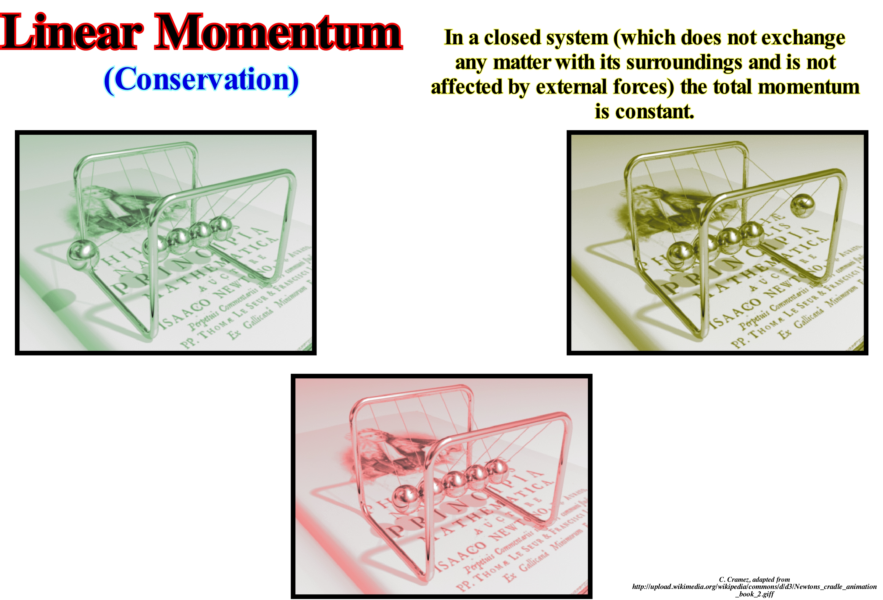
Moment is the product of inertia by velocity. Inertia is the tendency that all things have not to change, and velocity means how fast a thing moves. The impulse translates the tendency that a moving object have to not slow down. The moment is of two types: (i) Angular and (ii) Linear. Both types are conserved in any collision. Conservation means that nothing is lost. The linear momentum is the tendency of an object to move in a certain direction always with the same velocity. It is the product of the inertia of the object by its velocity. The conservation of linear momentum when applied to a collision as illustrated or to the collision between a tennis racket with a ball allows one to write an equation before and after, defining the sum of the racket and ball moments before the collision equal to the sum moments after the collision. The moment of the racket is the product of its mass and the linear velocity of the centre of mass. The moment of the ball is the product of its mass by its linear velocity. The centres of the mass of the racket and the ball are not on the same line, so, one can talk of eccentric impact. In the case of an eccentric impact such as this, there is a stabilizing force exerted by the player to maintain the axis of rotation of the racket during impact. The impulsive stabilizing force multiplied by the time of such an operation gives an additional impulse to add in the equation in order to preserve the momentum in the chosen direction. Note that the only direction, that matters here, is the direction of the player in relation to the net. Concerning the signals, the convention is that the velocity is negative towards the player and positive towards the net. The mass of the racket multiplied by the linear velocity before the collision plus the mass of the ball multiplied by the linear velocity of the ball plus the impulsive reaction multiplied by the time of impact is equal to the mass of the racket multiplied by the linear velocity of the racket after the collision plus the mass of the ball multiplied by the linear velocity of the ball after the collision.
Constructive Process (Reef).............................................................................................................Processus constructif (Récif)
Processo Constructivo / Proceso constructivo (arrecife) / Konstruktiver Prozess (Riffe) / 建设性的进程(礁) / Конструктивный процесс (рифы) / Processo costruttivo (scogliere) /
Constructive biological process, such as, the growth of carbonate organisms.
See : « Reef »
Consumer (Organism).......................................................................................................................................................Consommateur (Organisme)
Consumidor / Consumidor (organismo) / Verbraucher / 消费者 / Потребитель / Consumatore /
Organism that can not synthesize its own food. It is dependent on complex organic substances for its nutrition.
See: « Heterotrophic »
&
« Autotrophic »
&
« Photosynthesis »
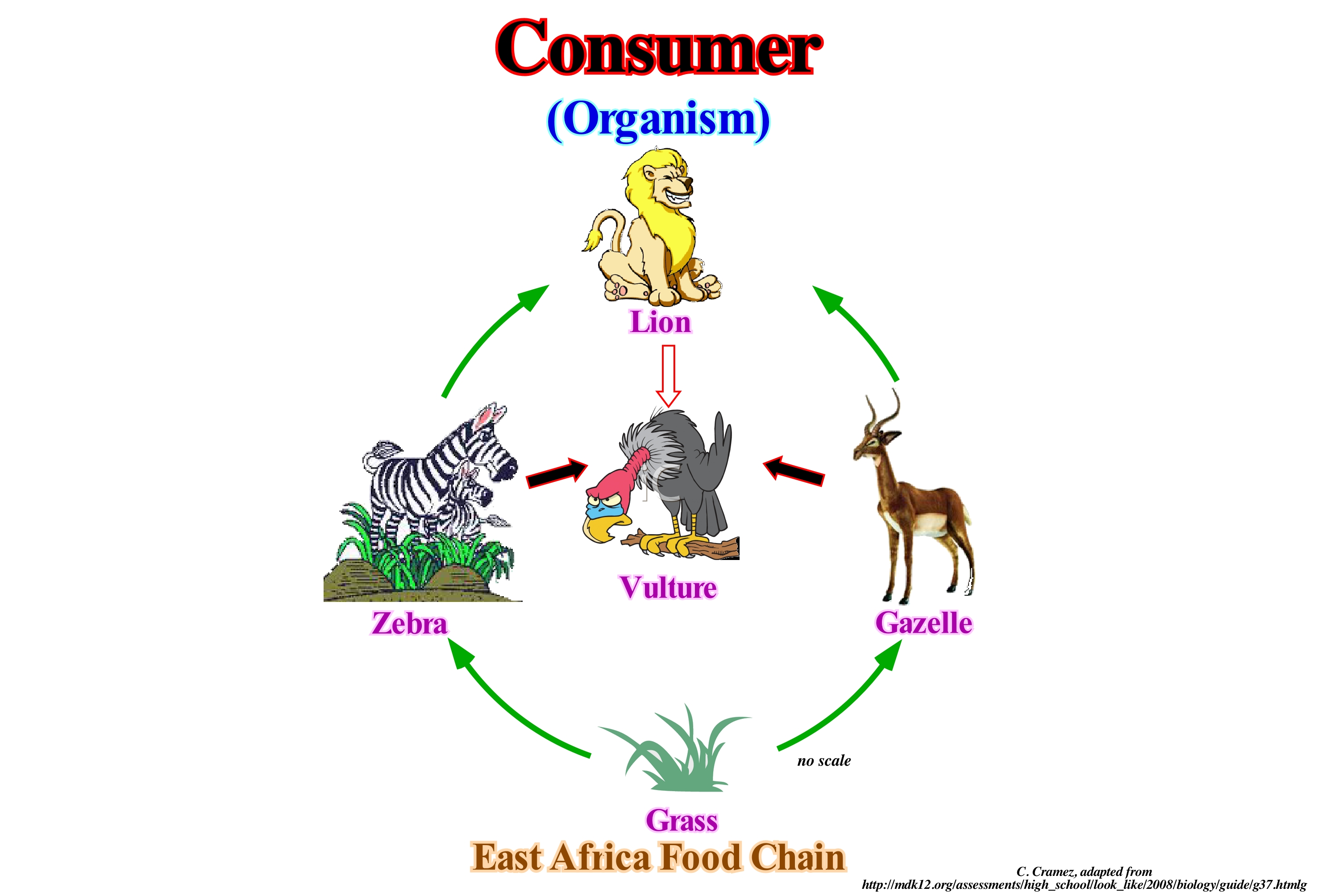
Consuming organisms, unlike autotrophs (organisms that produce complex organic components such as fats, carbohydrates, proteins, etc., from simple inorganic molecules using light energy or inorganic chemical reactions) are heterotrophs, i.e., they use organic carbon in their development, eating other heterotrophs or autotrophs. The consumer organisms decompose the complex organic compounds produced by the autotrophs, which are, of course, producers. In the sketch represented in this figure there are producers, consumers and decomposers*. The herbs are producers and all other consumers. However, the zebra and the gazelle are primary herbivorous consumers, while the lion is a secondary carnivorous consumer and the vulture is, primarily, a decomposer. In this sketch there is a predator-prey relationship in each trophic level of this food chain (the trophic level of an organism is the position that it occupies in the food chain), as for example: grass/gazelle ; herb/zebra ; gazelle lion ; zebra/lion ; lion/vulture. This food chain can be represented by a pyramid with four trophic levels: (i) At the base, the herb ; (ii) At the second level, the zebra and the gazelle ; (iii) At the third level, the lion and (v) At the top of the pyramid, the vulture. This pyramid shows how energy is distributed between each trophic level. The herb represents the most energetic level, while the vulture represents the least energetic. Only about 10% of an organism's energy passes to the next trophic level. About 90% of the energy is used by the body or released into the environment. In a healthy community, the producers represent the largest population, while the population of the decomposers is the smallest.
(*) Living beings, such as certain bacteria and fungi, that attack cadavers, excrement, plant remains and, in general, organic matter dispersed in the substrate, decomposing it into mineral salts, water and carbon dioxide, which are then reused by the producers in a natural recycling process.
Continental Collision.........................................................................................................................................Colllision Continentale
Colisão continental / Colisión continental / Continental Kollision / 大陆碰撞 / Столкновение континентальных плит / Collisione continentale /
When two continental lithospheric plates approach each other, closing, progressively, the sea separating them, to finally come into contact forming a A-type subduction. One of the lithospheric plates plunges (descending plate) under the other (overriding plate), which compels the rocks of the overriding plate to shorten forming a mountain folded belt.
See: « A-Type Subduction (Ampferer) »
&
« Megasuture »
&
« Supercontinent »
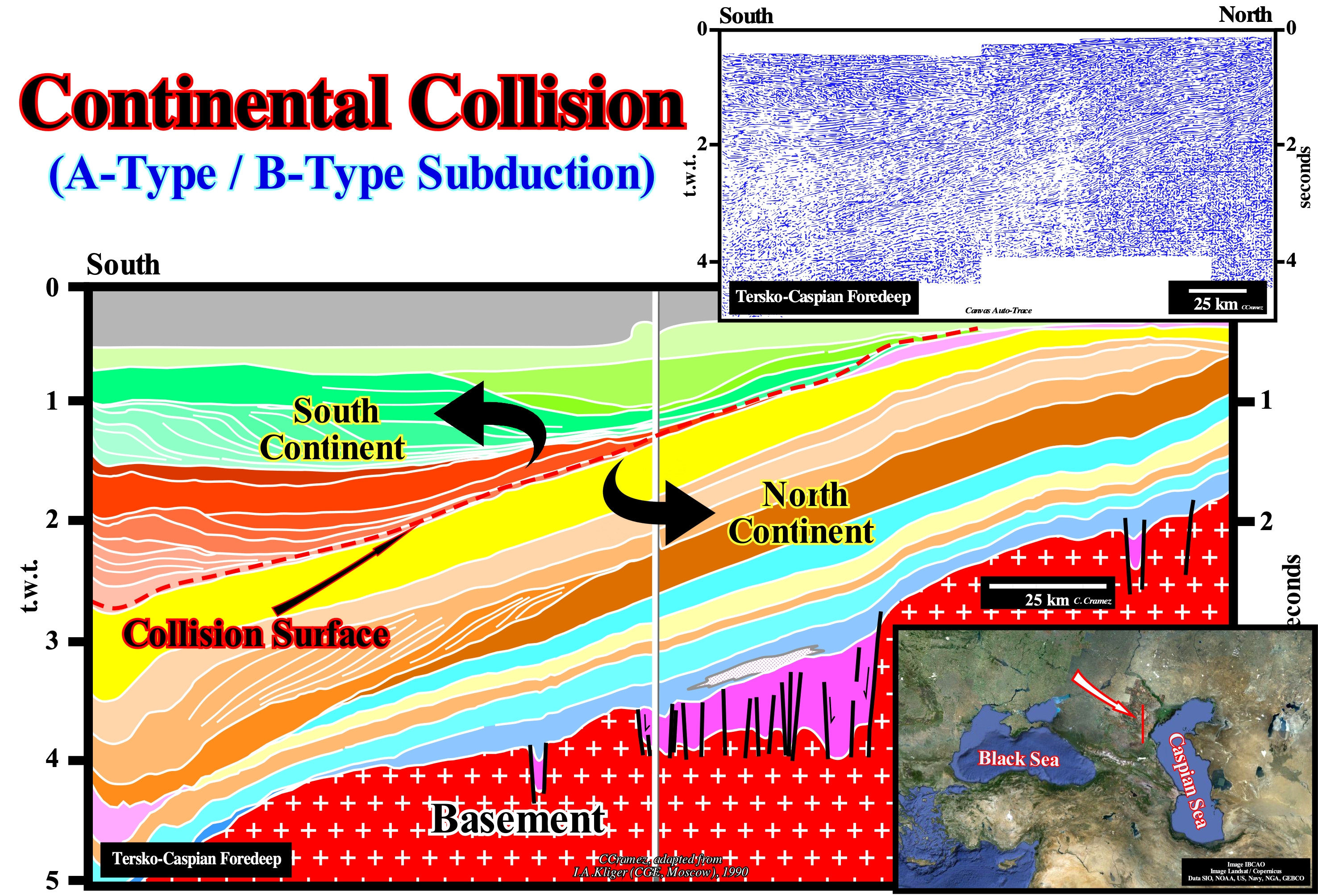
On this tentative geological interpretation of a Canvas auto-trace of a seismic line of the north-west onshore of the Caspian Sea (folded mountain belt in the classification of the sedimentary basins of Bally and Snelson (1980), it is, easy, to recognize a collision between two continental lithospheric plates and the subsequent closure of the sea that existed between them. The A-type subduction zone (Ampferer) between the two plates is, easily, deduced taking into account the geometric relationships between the reflectors and the seismic surfaces (surfaces defined from the reflector terminations, i.e., from the lapouts). A-type or Ampferer subduction zones are places where a part of the sialic continental crust dips under a megasuture to a relatively important depth, what implies the development, in the sedimentary cover, of large-scale detachments, folds and reverse faults. Initially, most adherents of Plate Tectonics Theory accepted, hardly, the notion of A-type subduction, since the continental lithosphere having a smaller density tends to: (i) Float and (ii) Resist a signification plunging. Currently, almost all geoscientists accept A-type subduction, especially, after the work of Molnar and Gray (1979), which demonstrated that the lower continental crust can enter into subduction when individualized from the upper crust. On this tentative interpretation, it can be deduced that, at a given time, there were two small supercontinents. One to northward and the other southward of a sea that separated them (Tethys Sea**), with their respective continental divergent margins. The southern divergent margin of the North lithospheric plate, that fossilized the rift-ype basins and basement (well visible on this tentative interpretation), is easily recognized by the southward dipping progradations of the regressive phase of the post-Pangea continental encroachment cycle, that formed the old continental slope of the North continent (Eurasia small supercontinent). The transgressive phase of the post-Pangea continental encroachment cycle is emphasized by aggradational intervals deposited after the break-up of the lithosphere over the rift-type basins and the basement (intervals with blue and beige), which have, globally, a retrogradational geometry. Likewise, the old northern divergent margin of the south lithospheric plate of the Tethys Sea is, easily, recognized by the progradations dipping northward (perfectly visible in the upper left of this tentative interpretation). The intervals of the transgressive phase of the post-Pangea continental encroachment cycle are not visible in this auto-trace. This old margin forms, currently, the overriding plate of the Ampferer subduction zone (A-type subduction). The lower or descending plate of this subduction zone is formed by the old northern margin of the Tethys Sea. Of course, the Tethys Sea, which existed between these two ancient continental masses, closed, progressively, as the small supercontinents approached one another. Such a continental collision (attention to the term collision, since in Plate Tectonics there is no transformation of kinetic energy into deformation energy, but simply loss of resistance of the sediments to deformation) has created a compressional tectonic regime, characterized by an elongated ellipsoid of the effective stresses. The effective stresses are the stresses that deform, effectively, the rocks, i.e., the stresses resulting from the combination of geostatic pressure (σg), pore pressure or hydrostatic pressure (σp) and tectonic vector (σt). This tectonic regime was responsible for the formation of the folded mountain belt (not visible on this tentative interpretation) existing on the overriding plate, southward of this area. The mechanism of an A-type (or Ampferer) subduction zone, in which both lithospheric plates are continental, or rather dense, is very different from that of a B-type (or Benioff) subduction zone, in which the descending plate is oceanic (very dense) and the overriding plate is, generally, continental (less dense). In the first case, as none of the plates plunges under the other, the shortening and uplift of the sediments are very strong. In the case of the B-type subduction, as the descending lithospheric plate is oceanic, it plunges, easily, under the overriding plate, which is, slightly, shortened and crossed by magmatic material coming from the mantle and, in part resulting, from the melt of the material of the descending plate.
(*) When a portion of the sialic crust dips under a complex of folds, thrusts and strike slip faults such as in the Alps, Eastern Venezuela, Himalayas (plunging of the Indo-Australian continental plate under the Eurasian continental plate). The mechanism of this type of subduction is very different from the mechanism of a B-type subduction, since the density of the two plates is very similar, which is not the case in a B-type subduction.
(**) A titan, daughter of Uranus and Gaia, that from her union with her brother Oceanus the oceanids were born.
Continental Encroachment..................................................................................................................Empiétement continental
Invasão continental / Invasión continental / Eingriff, Continental Übergriff / 大陆侵占 / Континентальное затопление / Invasione continentale /
Horizontal distance between two consecutive onlaps. It indicates the morphology of the unconformity that the onlaps fossilize. To the same relative sea level rise, the flatter the morphology of unconformity, the greater the continental encroachment is. It can be positive (relative sea level rise) or negative (relative sea level fall). Function of the nature of the onlaps, it can be coastal or marine. Within a sequence-cycle, the continental encroachment is coastal in highstand systems tracts and marine in the lowstand systems tract. To have deposition the continental encroachment must be positive, except for the lower members of the lowstand systems tract (submarine slope fan and submarine basin floor fans), which are deposited during relative sea level falls (negative continental encroachment).
See: « Relative Sea Level Change »
&
« Aggradation »
&
« 1st Order Eustatic Cycle »
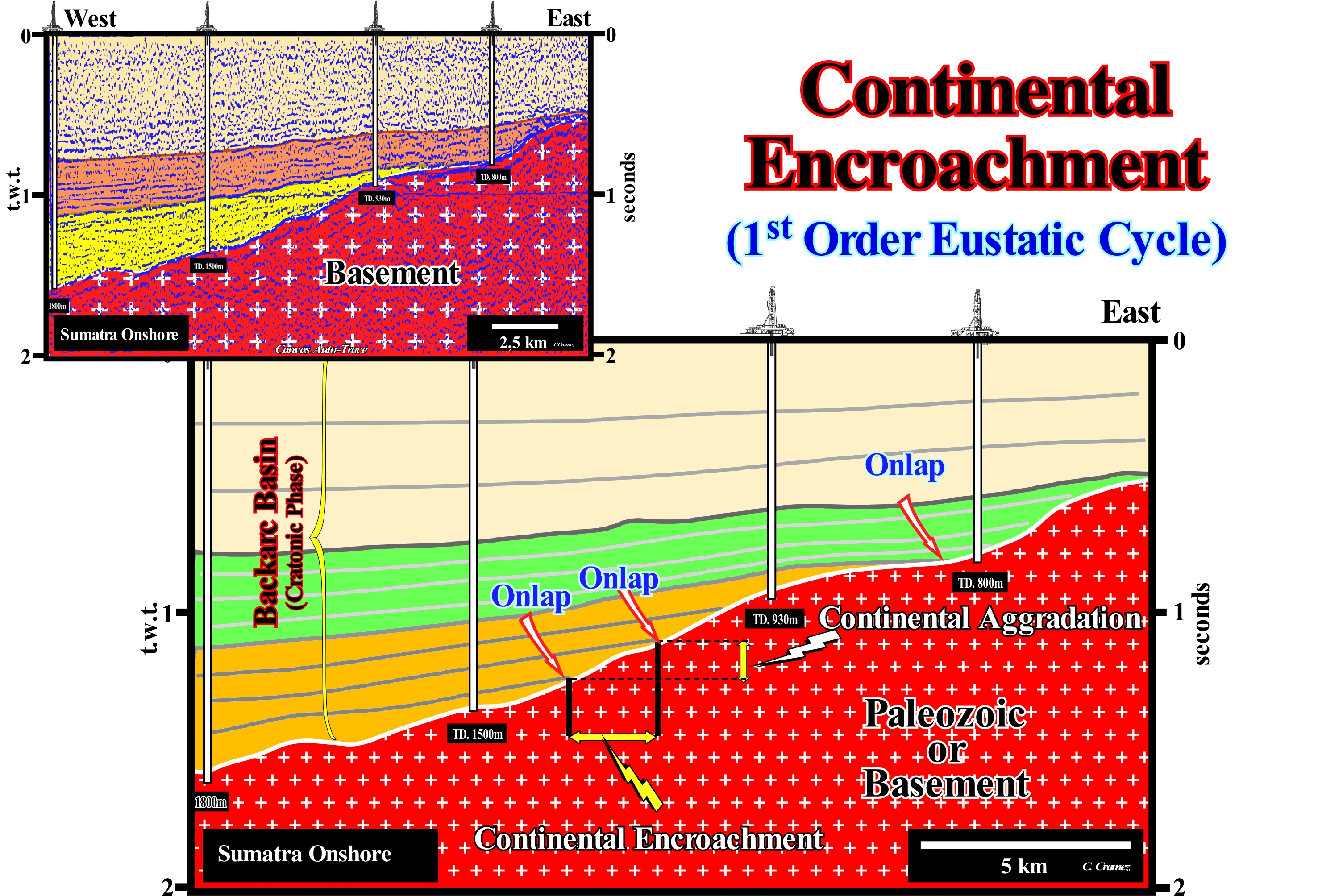
The onshore of the island of Sumatra (Indonesia) corresponds to a back-arc basin in the Bally and Snelson sedimentary basin classification (1980), This basin type is induced by a type B subduction (Benioff subduction). Within a back-arc basin, two tectono-sedimentary phases can be evidenced that, from bottom to top: (i) A rifting or lengthening phase, characterized by differential subsidence and (ii) A sinking or sag phase characterized by a thermal subsidence. On this tentative interpretation of a Canvas auto-trace of a detail of an onshore seismic line, the onlapping of the sediments of the sag phase (cratonic phase as certain geoscientists say) fossilize the unconformity, which limits the substratum (Paleozoic or Pre-Cambrian sediments). This fossilization of the substratum followed a relative sea level rise* (result of the combined action of absolute or eustatic * sea level and tectonics**)that, initially, displaced landward the shoreline. However, during deposition, which occurred during stability period of the relative sea level, progressively, the shoreline is displaced seaward. At each increment of the sea level rise(eustatic paracycle), the shoreline is displaced continentward (marine ingression). At the end of each landward displacement of the shoreline (increment of the marine ingression) there is a stability period of relative sea level, during which the deposition resumes moving the shoreline seaward (no deposition occurs when the level of the relative sea rises). Considering two consecutive reflectors, as illustrated on this tentative interpretation, it is easy to see the termination of the lower reflector is lower and further seaward than the termination of the next reflector (upper). The distance between the two terminations, measured horizontally, gives the continental encroachment value in meters (the horizontal scale of the seismic lines is metric), while the vertical distance between the terminations gives the continental aggradation in milliseconds, since the vertical scale of the seismic lines is in time (double time). In this case, the continental aggradation is positive. The termination of the most recent reflector is above the termination of the preceding reflector. If the termination of the most recent reflector is lower than that of the preceding reflector, the continental aggradation is negative. A negative continental aggradation suggests an unconformity between the two reflectors, i.e., a significant relative sea level fall (local sea level referenced to any point on the Earth's surface, which can be the sea-floor or the base of the sediments), which put the sea level lower than the basin edge. Such relative sea level fall exhumed part of the basin to erosional agents. Knowing the velocity of the seismic waves in the sedimentary interval limited between the two reflectors, the calculation of the continental aggradation and the continental encroachment are easily determined. When the continental encroachment is very large (e.g., 100 km), for a relative sea level rise of 10 meters, the pre-existing topography (geometry of the discordance that limits, underneath, the considered sequence-cycle) is very planar. If the water-depth is very small, the shelf is impossible to recognize on the seismic lines due to the seismic resolution. Of course, most geoscientists, looking at this tentative interpretation, wonder what the exploration team was trying to find with these four wells. Knowing that the first well drilled was the deepest well (1,800 meters), located at the western end of this tentative and that the results were negative, the surprise will certainly be even greater. Since I was in this research team (1973), I give you the answer. Geologically, there is nothing to find in the last three wells. They were drilled, just, to amortize the price of the rig (in this case helicopter-transported ). It sounds like a joke, but it's not. In an exploration team composed of several oil companies, the operator earns, often, money by making dry wells.
(*) Global sea level referenced to the Earth's centre that is dependent on: (i) Tectono-Eustasy which is controlled by the volume variation of the ocean basins ; (ii) Glacio-Eustasy, which is controlled by the variation of ocean water volume as a function of the amount of ice ; (iii) Geoidal-Eustasy which is controlled by the distribution of ocean water caused by variations in the terrestrial gravity field, and (iv) Thermal expansion of the oceans or steric sea level rise (if the temperature of the oceans increases, the density of the water decreases and, for a constant mass, the volume increases).
(**) Subsidence of the sea floor if the predominant tectonic regime is in extensional or uplift when the tectonic regime is compressional. However, in certain cases, in particular, in sedimentary basins with evaporite levels, there may be an uplift of the sea floor, although the tectonic regime is in extensional.
Continental Encroachment Cycle.......................................................Cycle d'empiètement continental
Ciclo de invasão continental / Ciclo de invasión continental / Continental Eingriff Zyklus / 大陆侵占周期 / Цикл континентального обводнения / Ciclo di invasione continentale /
Stratigraphic cycle induced by a 1st order eustatic cycle (time-duration > 50 My). The Phanerozoic is composed by two continental encroachment cycles. The earliest is associated with the Paleozoic 1st order eustatic cycle, while the most recent (post-Pangea continental encroachment cycle), which has not yet ended, is associated with the Mesozoic / Cenozoic 1st order eustatic cycle.
See: « Stratigraphic Cycle »
&
« Eustatic Cycle »
&
« Onlap »
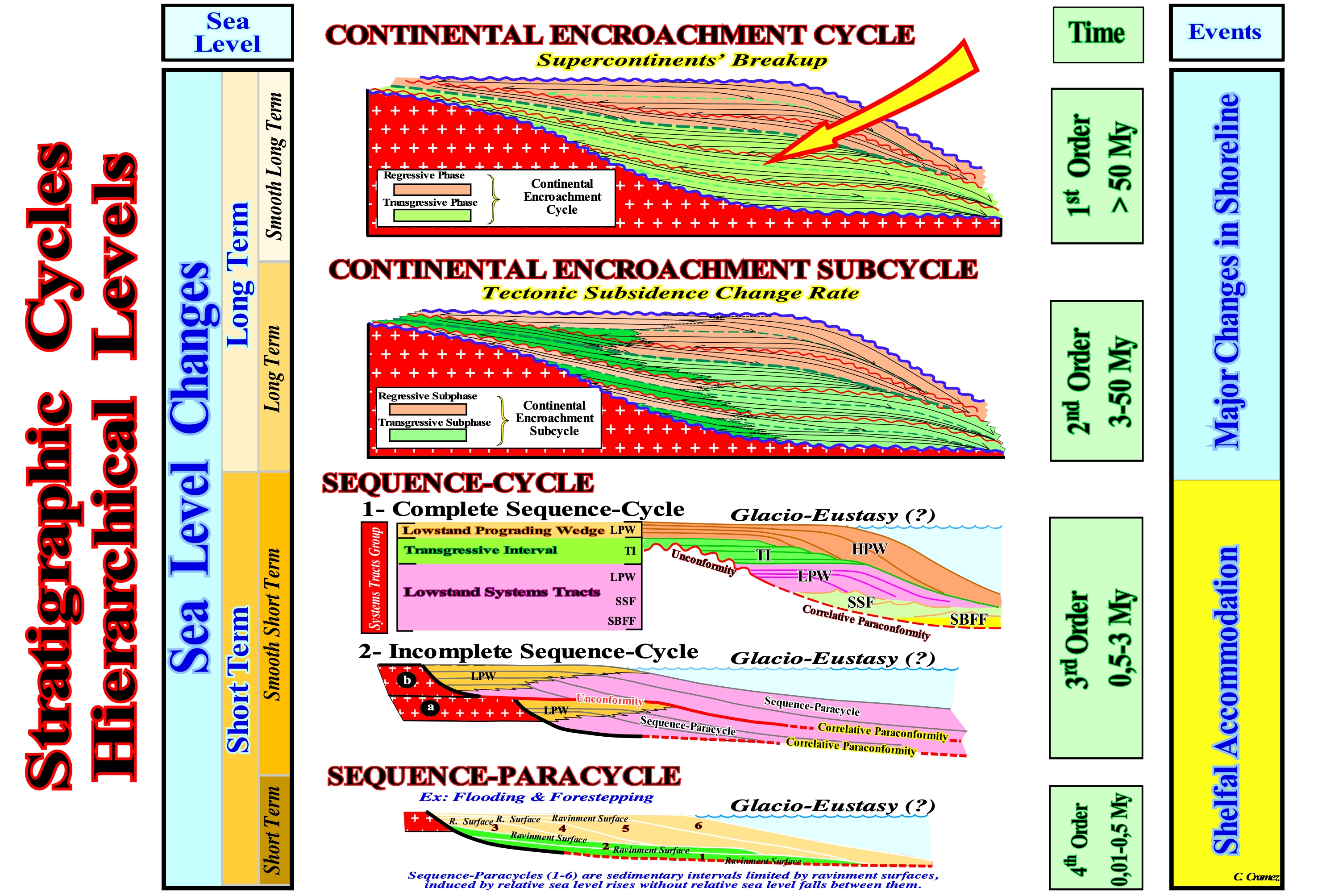
The geological structures and, especially, the stratigraphic intervals, have a hierarchical nature that imply different levels of stratigraphic interpretations. The relativity of hierarchies, known as the dualism of Janus (*), is an important feature of the systemic scientific approach (studies holistic systems ** and attempts to develop logical, geological, engineering, and logic mathematical structures in which systems physical, mental, cognitive, social, and metaphysical can be studied. Not geoscientists' knowledge progress from the general to the particular, but they can not study geological events in isolation. Geological structures are multilevel, each of them forms a whole in relation to its parts and, at the same time, is a part of a larger whole. In the hierarchy of stratigraphic cycles proposed by Duval et al. (1993), four main levels are considered: (i) Continental Encroachment Cycles induced by 1st order eustatic cycles associated with supercontinents' breakups ; (ii) Continental Encroachment Sub-cycles induced by 2nd order eustatic cycles associated with the rate of tectonic subsidence (total subsidence decreased from the effect of isostatic compensation and increased from the effect of compaction), which varies with the velocity of oceanic expansion (sea floor spreading); (iii) Sequence-cycles, induced by 3rd order eustatic cycles which are defined by changes of the relative sea level (local sea level referenced to any point on the Earth's surface as the sea floor or the base of sediment, which is the result of the combined action of tectonics and absolute or eustatic sea level, in which Glacio-Eustasy plays a very important role ; (iv) Sequence-paracycles induced by the increments of relative sea level rises, i.e., by marine ingressions. The term sequence-paracycle seems to be more appropriate than parasequence-cycle or parasequence of the Exxon's geoscientists. Each sequence-paracycle is formed by one or several depositional systems tracts. A stacking of of sequence-paracycles (parasequences of the EPR geoscientists, i.e., Exxon's Exploration Production Research), which are associated with successive relative sea level rises (marine ingressions) without relative sea level falls between them, forms a sequence-cycle. A stacking of sequence-cycles forms a continental encroachment sub-cycle, while a stacking of continental encroachment sub-cycles forms a continental encroachments cycle. The available space for the sediments (shelfal accommodation) of these stratigraphic cycles is created by the eustatic cycles, respectively, of 1st, 2nd, 3rd and 4th order, i.e., by eustatic cycles with time-durations greater than 50 My, between 50 and 3-5 My, between 0,5 and 0.5 My and between 0.5 and 0,01 My. The conjecture that a stratigraphic cycles is induced by an eustatic cycles, is one of the main hypotheses of the sequential stratigraphy, since for the Vail's school, all unconformity (erosional surfaces induced by significant relative sea level falls) are, basically, controlled by absolute (eustatic) sea level chances and not by tectonics (subsidence or uplift of the sea floor, for instance)). For Vail, the subsidence increases, substantially, the available space for sediments (accommodation) but, under normal geological conditions, it does not produce any cyclicity (alternation of depositional and erosional periods). Cyclicity is produced by absolute sea level changes. Erosion requires exposition to the erosion agents of the deposited sediments, what implies, necessarily, a significant in relative sea level fall. The rise of a salt dome, by diapirism, deforms the sediments overlying the salt-mother horizon, but if they are not exhumed there will be no erosion and consequently no unconformity. The continental encroachment cycle (1st order eustatic cycles) are associated, indirectly, to the break-up of the supercontinents. When a supercontinent agglutinates, the volume of the ocean basins increases and for a constant amount of water in all its forms, since the Earth's formation (cornerstone hypothesis), the level of the oceans falls. When a supercontinent break-up and the derived continents disperse, the volume of the ocean basins decreases due to the formation of the ocean ridges and, for a constant amount of water, the sea level rises.
(*) Roman God of beginnings and ends, of choices or selections, of passages and doors. It is two-headed and it is. almost always, represented with a face turned to the past and another face to the future. It is celebrated on January 1 (Januarius), which marks the beginning of the year in the Roman calendar.
(**) That they can only be studied in an integral and integrated way and not by an isolated or particular approach of its constituents.
Continental Encroachment SubCycle..................Sous-cycle d'empiétement continental
Subciclo de invasão continental / Sub-ciclo de invasión continental / Continental Eingriff Teilzyklus / 大陆侵蚀子循环 / Подцикл распространения континента / Sottociclo di sconfinamento continentale /
Stratigraphic interval induced by a set of 2nd order eustatic cycles. It is, more or less, equivalent to Vail's old supersequence.
See:« Supercontinent »
&
« Eustatic Cycle »
&
« Stratigraphic Cycle »
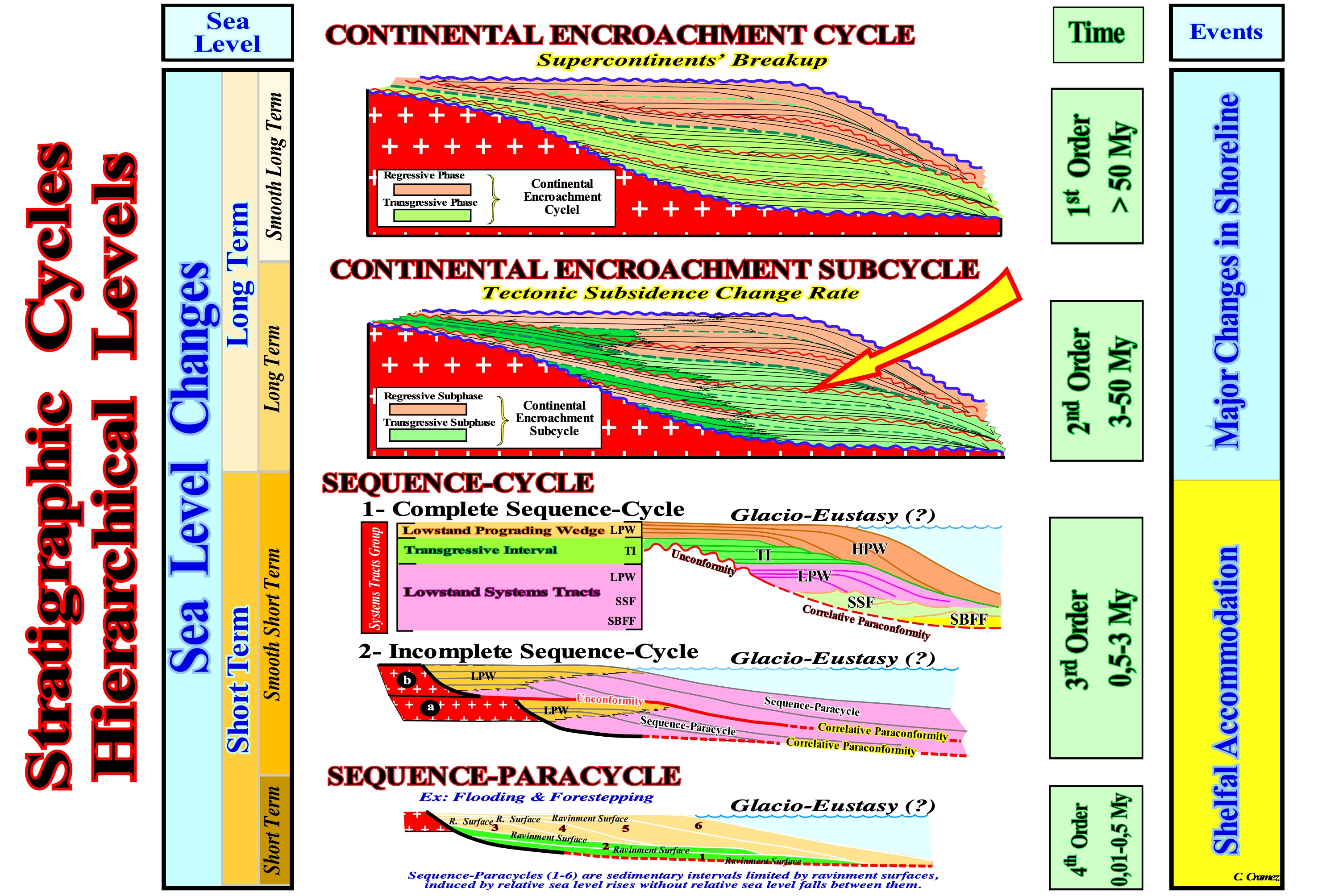
As shown in this figure, the hierarchy of stratigraphic cycles proposed by Duval et al. (1993) considers three major stratigraphic cycles and a sequence-paracycle (formerly called by EPR, i.e., Exploration Production Research of Exxon, paracycle sequence): (i) Continental Encroachment Cycle ; (ii) Continental Encroachment Subcycle ; (iii) Sequence-Cycle. These stratigraphic cycles are associated, respectively, to eustatic cycles of 1st, 2nd, 3rd and 4-5th order. The orders of the eustatic cycles are determined by their time-duration. A 1st order eustatic cycle has a time-duration of more than 50 My (millions of years). A 2nd order cycle lasts between 3/5 and 50 My, a 3rd order between 3/5 and 0.5 My and a 4-5th order 0.5 and 0.1 My. A sequence-paracycle (which certain geoscientists call a parasequence cycle), as its name suggests, is not associated with a true eustatic cycle. The stacking of several eustatic paracycles corresponds to a relative sea level rises with no relative sea level falls between them. In sequential stratigraphy, sea level can be of two types: (i) Relative, which is the local sea level, referenced to any fixed point on the Earth's surface, which can be the base of the sediments (top of the continental crust) or the sea floor and (ii) Absolute or eustatic, which is supposed to be global and referenced to the Earth's centre. The relative sea level is the result of the combined action of absolute (eustatic) sea level and tectonics (subsidence or uplift of the sea floor). The absolute sea level is the result of the combination of: i) Tectono-Eustasy that is controlled by the volume variation of the ocean basins in association with oceanic expansion following the break up of the supercontinents ; (ii) Glacio-Eustasy, which is controlled by the volume of water in the oceans as a function of the amount of ice (assuming the amount of water, in all its forms, is constant since the Earth's formation, around 4.5 Ga) ; (iii) Geoidal-Eustasy, which is controlled by the distribution of ocean water caused by variations in the Earth's gravity field (where gravity is stronger than the normal, sea level is thrown to the Earth’s centre) and (iv) Steric sea level rise or thermal dilatation of the oceans controlled by the temperature (if the temperature increases, the density of the water decreases and, for a constant mass, the volume increases). Relative sea level rises (marine ingression) are separated by stability periods of relative sea level during which deposition takes place. When the relative sea level rises there is no deposition, but creation or increase of the available space for the sediments (shelfal accommodation). The shoreline moves continentward creating a ravinment surface on the preexisting topography. A stacking of sequence-paracycles corresponds to a set of sedimentary systems tracts (a sequence-paracycle may represent a single or several sedimentary systems tracts), which form a sequence-cycle which, when complete, is formed by a lowstand systems tracts group (LSTG) and an highstand systems tracts group (HSTG). Within the lowstand systems tracts group (LSTG), there are three sub-groups: (a) Submarine Basin Floor Fans (SBFF) ; (b) Submarine Slope Fans (SSF) and (c) Lowstand Prograding Wedge (LPW). Within the highstand systems tracts group (HSTG)*, two sub-groups are considered: (d) Transgressive Interval (TI) and (e) Highstand Prograding Wedge (HPW). This classification is more coherent than initially proposed by Vail. The boundaries between continental encroachment cycles, continental encroachment subcycles and sequence-cycles correspond, always, to unconformities, i.e., to erosional surfaces, induced by relative rather than absolute sea level falls. In the case of sequence-paracycles, the boundaries correspond to ravinment surfaces (floodings, which may be considered as minor erosional surfaces induced by consecutive relative sea level rises). Continental encroachment sub-cycles are induced by 2nd order eustatic cycles, which appear to be generated, mainly, by changes in the rate of tectonic subsidence. Within a continental encroachment sub-cycle there is a downlap surface, which separates a transgressive sub-phase (retrogradational geometry) of a regressive sub-phase (prograding geometry). In association with the interface between the transgressive and regressive sub-phases, marine potential source-rocks can be deposited.
(*) In certain cases, but mainly at the beginning of the sequential stratigraphy, in the highstand systems tracts group (HSTG), geoscientists considered, also, a Bordering Prograding Wedge (BPW), which was separated from the highstand prograding wedge (HPW) by a type II unconformity, which also fell into disuse. At present, geoscientist speak of forced regressions, which certain geoscientists include within the sequence-cycle to which the highstand prograding wedge belongs. Others place it above the upper unconformity of the sequence-cycle.
Continental Margin (Divergent)........................................................................................................................Marge Continentale
Margem continental / Márgen continental (divergente) / Continental-Marge (divergent) / 陆缘(发散) / Континентальная окраина материка / Continental margine (divergenti) /
Zone of the ocean floor that separates the thin oceanic crust from the thick continental crust. In the classification of the sedimentary basins of Bally and Snelson, (1980), adopted in this glossary, a continental divergent margin is the sedimentary interval that is deposited above rift-type basins after the break-up of a supercontinent (Atlantic-type margins) or after lithosphere breakup of a back-arc basin (non-Atlantic margins).
See: « Continental Platform »
&
« Continental Slope »
&
« Continental Rise »
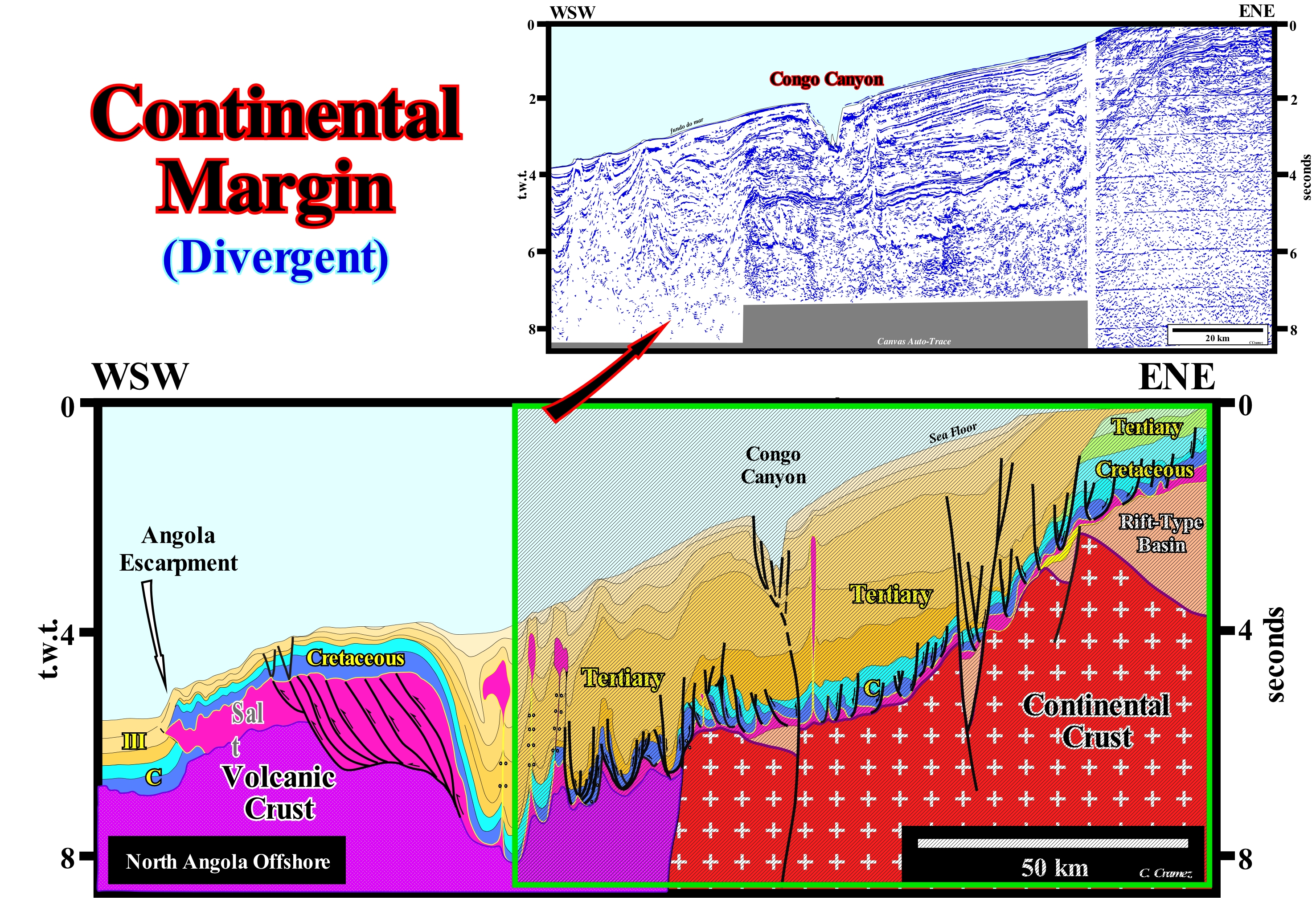
In the classification of the sedimentary basins of Bally and Snelson (1980), there are two types of continental divergent margins: (a) Atlantic type and (ii) non-Atlantic type. Both are associated with the formation of new oceanic crust*. However, Atlantic type divergence margins develop in areas where tectonic regimes in extension (lengthening) are preponderant (outside of the megasutures), while non-Atlantic divergent margins develop within the megasutures,i.e., in areas where the prevailing tectonic regimes are compressional (ellipsoid of the effective stresses with the major axis horizontal, i.e., when σ1 is horizontal). This tentative geological interpretation of a Canvas auto-trace of a composite seismic line of the Angola offshore, illustrates an Atlantic-type continental margin divergent, in which during its development, the predominant tectonic regimes were extensional (the sediments were lengthened). However, as illustrated on the tentative of interpretation, in the deep-part of the margin, locally, existed, locally and still exists (the sea floor is affected) a compressional tectonic regime associated with the gravity flow of the salt interval (colored in light violet). The sedimentary lengthening induced by the lateral flow of the evaporitic horizon in the proximal and middle part of the margin is compensated by a shortening in the deep-part of the margin, where the enormous thickness of the evaporites (mainly halite) is, clearly, posterior to the deposition and is the result of stacking of thrusts constituted, mainly, by evaporites. This geometry is very young and of tectonic origin. On this tentative interpretation from the bottom to top, we recognize: (i) The continental crust, in which rift-type basins (half-grabens structures) were developed during the lengthening of the lithosphere, before the break-up of the small Gondwana supercontinent ; (ii) The break-up of the lithosphere, which occurred since the lithosphere reached the lengthening limit (β ± 4), i.e., when the crust thickness, locally, was reduced to 10/15 km (the break-up was made by an excessive injection of material from the sublithospheric mantle), which individualized the African and the South American lithospheric plate, initiating an oceanic spreading between them ; (iii) A volcanic crust, probably sub-aerial, which has formed since break-up of the lithosphere occurred, as the expansion centres were not yet marine and marks the beginning of the divergent margin; this volcanic sub-aerial crust is characterized by reflectors that incline seaward (towards the expansion centres), however, laterally it passes to the volcanic oceanic crust ; (iv) An Atlantic divergent continental margin, which is formed by two tectono-sedimentary phases: (a) The transgressive phase with a retrogradational geometry, i.e., thickening continentward, since it is associated with absolute (eustatic) sea level** rise and (b) The regressive phase with a progradational geometry associated with the absolute (eustatic) sea level fall induced by the volume increasing of the ocean basins, as a consequence of the diminution of the oceanic mountains caused by the agglutination of the continents, and by the subduction of the old oceanic crust along the subduction zones (formation of a new supercontinent). On this tentative interpretation, the regressive phase is, easily, recognized by its progradational geometry. The retrogradational geometry of the transgressive phase is, largely, hidden by halokinese and salt tectonic, mainly in the central and distal part of the margin.
(*) The oceanic crust can be divided in three layers: (i) Layer 1, which has an average thickness of 0.4 km, is composed of poorly consolidated sediments (tiny shells of marine organisms, usually, calcareous and siliceous, or volcanic ash and terrigeneous sediments transported by turbidity currents), often absent near the mid-oceanic crests, but which along the continental margins are, mainly, terrigeneous sedimentary particles ; (ii) Layer 2 is, generally, sub-divided into two parts: a) Layer 2A corresponding to about 0.5 km of finely crystalline vitreous to basalt volcanic material, generally, in the form of pillow lavas and b) Layer 2B, which corresponds to about 1.5 km of diabase dikes ; (iii) Layer 3 is formed by slowly cooled magma and consists, mainly, of coarse grains and ultramafic rocks ; This layer forms more than two-thirds of the volume of the oceanic crust which, on average, is about 5 km thick.
(**) Global sea level, referenced to the Earth's centre, induced, mainly, by the volume decrease of the ocean basins due to the formation of the oceanic mountains associated with the sea floor spreading (assuming the amount of water, in all its forms, is constant since the Earth's formation around 4.5 Ga).
Continental Platform (Shelf)...........................................................................................................Plate-forme continentale
Plataforma continental / Plataforma continental / kontinental Schelf / 陆架 / Континентальный шельф / Piattaforma continentale /
Part of the continental margin extending seaward as a sloping surface, from the shoreline (or prodelta base) to the basin edge (beginning of the continental slope). The average depth of the continental platform, i.e., of the shelf is, roughgly, 130 meters. Synonym of Shelf, Platform.
See: « Basin Edge »
&
« Shoreline »
&
« Alluvial Plain »
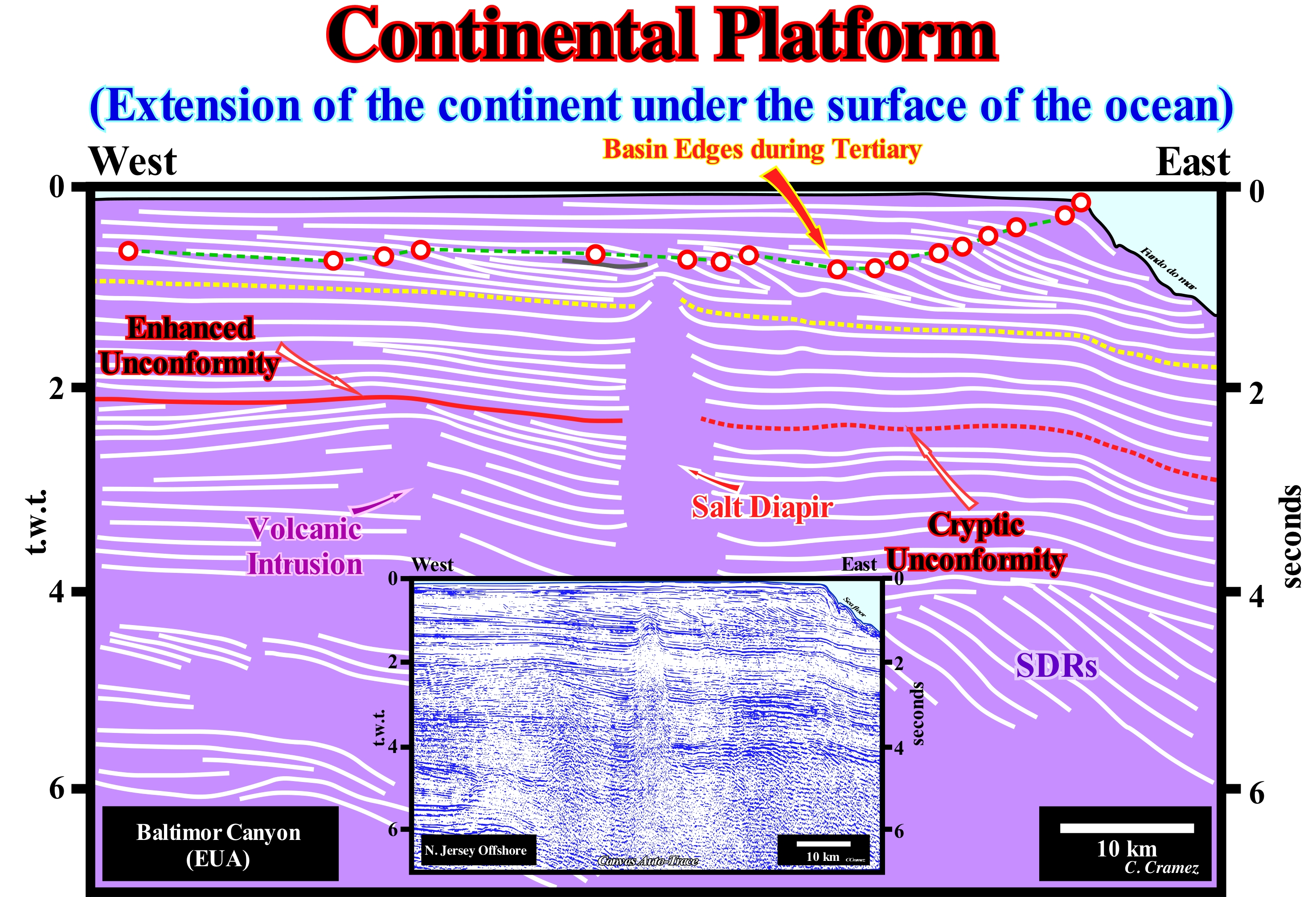
When a geoscientist says platform, in general, he id referring the continental shelf, which, is the slightly sloping surface of the sea floor, limited between a water slide from 0 to 200 m. Continental shelf is an oceanographic term. In geology, things are a little more complicated. To avoid misunderstandings, it is always important to know if the term platform is being applied to a sedimentary context where the clastics are predominant or to a carbonate context. In normal geological conditions, the water-depth of a limestone platform can not exceed the depth of the photic zone, otherwise there can be no carbonate formation, i.e., no photosynthesis. Photosynthesis is a physical-chemical process, at cellular level, performed by beings living with chlorophyll*, using CO2 (carbon dioxide) and H2O (water), to obtain C6H12O6 (glucose) through the energy of the Sun, according to the following equation: Sunlight +12H2O + 6CO2→ 6O2 + 6H2O + C6H12O6. A carbonated platform may coincide with a continental shelf but, in general, this seems to be an exception. In fact, a continental shelf, whose depth varies between 0 and 200 meters, is a physiographic province, which is part of the continental margin morphological structure (submarine extension of the continental block) whereas a carbonate platform is a sedimentary body that has a topographical relief and is composed of calcareous deposits formed "in situ", i.e., autochthonous calcareous deposits. Most geoscientists consider five categories of carbonate platforms: A) Rimmed Platforms, which are characterized by the presence of reefs or limestone sands (carbonated sandbank covered by shallow sea-water) on the edge of the platform and clay sands in the lagoon or open platform ; this type of platform forms in calm waters and its extension varies between 10 and 100 km. B) Ramp Type Platforms, in which the carbonated sands of the shoreline pass, at the base of the ramp, to clay sands and deep-water muds ; in this type of platform the reefs are rare and the width of the ramp can reach 100 km. C) Epeirial or Epiric Platforms, which are characterized by the presence of tidal surfaces and protected lagoons ; the width of an epeiric platform can reach 10,000 km. D) Isolated Platforms, in which the facies (lithology) is very controlled by the orientation of the dominant winds ; these platforms have reefs and sandy bodies, such as rimmed platform, in the windward margin (facing the side where the wind blows), but in the leeward margin (in the direction where the wind blows), the sediments are more muddy ; an isolated platform can reach 100 km wide. E) Drowned Platforms, when they are under the photic zone (there is not enough light for photosynthesis, i.e., use of carbon dioxide and water to obtain glucose through the energy of sunlight). As illustrated on this tentative geological interpret of a Canvas auto-trace of a New Jersey offshore regional seismic line, in a geological context in which clastics predominate, within a sequence-cycle, induced by an eustatic cycle with a time-duration between 0.5 and 3- 5 My, the basin has a shelf just during the highstand systems tracts group, that is to say, during the transgressive interval (TI) and during the first phase of development of the highstand prograding wedge (HPW). During the the 2nd phase of development of the highstand prograding wedge, the shoreline coincides with the continental edge (at least on the seismic lines). In this example, seismically and taking into account the seismic resolution, it can be said that throughout the Tertiary the margin had no shelf. The shoreline coincided with the continental edge, which also emphasizes the basin edge. However, recently, due to Glacio-Eustasy (thawing of the ice-caps, glacier sheets and glaciers), the absolute (eustatic) sea level** rose, more or less, 120 meters creating the present-time highstand geological conditions.
(*) The chlorophylls (from the Greek χλωρος Chlorobi, "green" and φύλλον, fýlon, "leaf") are a family of green pigments found in cyanobacteria and all organisms containing plastids in their cells, which includes plants and various eukaryotic algae. Chlorophyll is an extremely important biomolecule, fundamental in photosynthesis, a process that allows plants and algae to absorb energy from sunlight. (https://es.wikipedia.org/wiki/Clorofila).
(**) Global sea level referenced to the Earth's centre.
Continental Rise (Glacis).....................................................................................................................................................Glacis continental
Sopé continental / Base de la pendiente continental / Kontinentale Aufstieg / 大陆隆 / Нижняя часть континентального склона / Ascesa continentale /
Part of the continental margin located at bottom the continental slope near the abyssal plain. The continental rise dips to the abyssal plain with slopes ranging from 1:40 to 1: 2,000. It has, generally, a very flat topography, although, locally, it may be affected by submarine canyons induced by deep-ocean currents. For some geoscientists, the continental rise is synonymous with lower continental slope.
See: « Abyssal Plain »
&
« Continental Platform »
&
« Continental Slope »
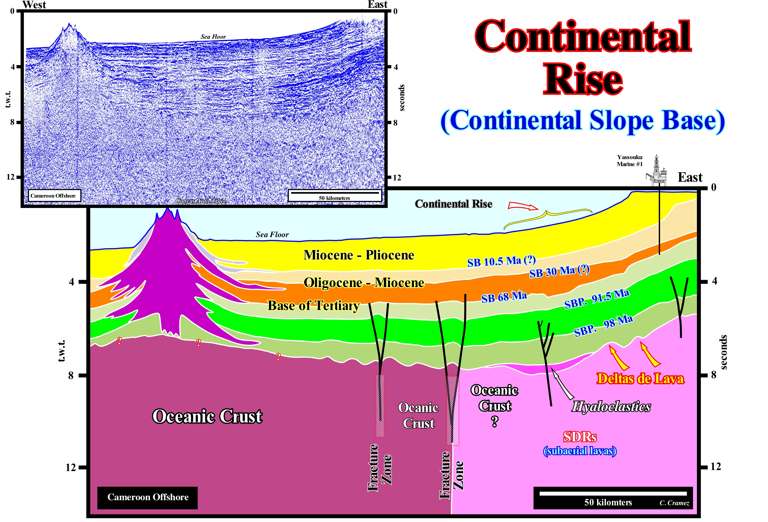
Cameroon offshore corresponds to the stacking of several basins of Bally and Snelson (1980) sedimentary basins classification. In a regional seismic line, as illustrated in this figure by the tentative geological interpretation of a Canvas auto-trace of a seismic line of this offshore, it is easy to recognize, from bottom to top, the following sedimentary basins: (i) A basement constituted, generally, in the proximal part of the offshore, by a Paleozoic flattened mountain range ; (ii) Late Jurassic / Early Cretaceous rift-type basins, which lengthened the lithosphere of the Gondwana small supercontinent before its break-up, and (iii) A Mesozoic/Cenozoic Atlantic-type divergent margin. On this tentative interpretation, the current continental rise is very well visible. The continental rise corresponds to the zone near the lower break of the continental slope, i.e., more or less, the passage of the continental slope to the abyssal plain. As you can see, its dip is, relatively, small, but largely superior to that of the abyssal plain (keep in mind the scales of this auto-trace which is, greatly, exaggerated vertically). It is in the continental rise that the turbidity currents, that transport the sedimentary particles to the abyssal plain, begin to decelerate to deposit them in submarine basin floor fans (SBFF) or in submarine slope fans (SSF). On this tentative interpretation it is interesting to note: (i) The absence of rift-type basins, which are located upstream of this seismic line, in the continental crust ; (ii) The sub-aerial volcanic crust postdates the break-up of the lithosphere (break-up of the Gondwana small supercontinent), and thus posterior to the the rift-type basins, which develop during the lengthening of the continental crust ; (iii) The boundary between the sub-aerial volcanic crust and the oceanic crust is made, on this tentative, by a fracture zone (extensional strike-slip fault) ; (iv) In the distal part of this offshore, the divergent continental margin (Atlantic type) rests, directly, on the volcanic crust, which is sub-aerial, when formed by lava flows and on the oceanic crust, when formed by pillow lavas covering volcanic sheeted dykes ; (v) During the post-Pangea* transgressive phase of the stratigraphic continental encroachment cycle, which is limited between the volcanic crust and the downlap surface 91,5 Ma (Cenomanian/Turonian), two transgressive intervals are, relatively, well recognized ; (vi) The first interval, deposited during the Albian, is bounded by the downlap DS. 98 Ma ; (vii) The second interval, deposited during the Cenomanian/Turonian, is limited, by the downlap surface 91.5 Ma, which emphasizes the maximum of the marine ingression created by the absolute or relative sea level (**) rise following the post-Gondwana sea floor spreading ; (viii) The potential marine source-rocks of this offshore are associated with these downlap surfaces ; however, the richest in organic sediments seems to be Cenomanian/Turonian downlap surface DS. 91,5 Ma ; (ix) An important volcanic apparatus has, recently (geologically), erupted from the sea floor about 200 km from the shoreline, probably, in association with a major fracture zone.
(*) Function of the order, i.e., function of the time-duration of eustatic cycles, which create the space available for sedimentation, the hierarchy of stratigraphic cycles can be presented as follows: (i) Continental Encroachment Cycles, induced by 1st order eustatic cycles, whose time-duration is greater than 50 My ; (ii) Continental Encroachment Sub-cycles, induced by 2nd order eustatic cycles (duration between 50 and 3-5 My) ; (iii) Sequence-Cycles, induced by 3rd order eustatic cycles, whose time-duration is between 0.5 and 3/5 My ; (iv) Sequence-paracycles, which are induced by eustatic paracycles (increments of relative sea level rises). As its name suggests the sequence-paracycles, are not stratigraphic cycles. There is no relative sea level fall between them, but just a stability period of the sea level, during which sediments are deposited. In 1st order eustatic cycles, the absolute (eustatic) sea level changes are preponderant. In 2nd order eustatic cycles, the absolute (eustatic) sea level may or may not be preponderate depending on the geological conditions. In 3rd order eustatic cycles, relative sea level changes (local sea level, referenced to any fixed point on the Earth's surface and which is the result of the combined action of absolute or eustatic sea level and tectonics) are, largely, preponderant.
(**) The absolute (eustatic) sea level is the result of the combination of: (i) Tectono-Eustasy that is controlled by the volume variation of the ocean basins in association with oceanic expansion following the rupture of the supercontinents ; (ii) Glacio-Eustasy, which is controlled by the volume of water in the oceans as a function of the amount of ice (assuming the amount of water, in all its forms, is constant since the Earth's formation around 4.5 Ga) ; (iii) Geoidal-Eustasy, which is controlled by the distribution of ocean water caused by variations in the Earth's gravity field (where gravity is stronger than normal, sea level is thrown to the Earth's centre) and (iv) Steric rise of the sea level or thermal dilation of the oceans (if the temperature increases, the density of the water decreases and, for a constant mass, the volume increases).
Continental Shelf (Shelf)........................................................................................................................................................................Plate-forme
Plataforma (continental) / Plataforma / Schelf / 大陆架 / Шельф (платформа) / Piattaforma continentale /
A portion of the continental margin extending as a sloping surface basinward from the coastline to a, generally, well-marked break in the sea floor, which marks the upper limit of the continental slope. The average water-depth of the platform is 130 meters and the maximum depth is 200 meters. Synonym of Continental Shelf.
See: « Coastal plain »
&
« Continental Slope »
&
« Basin Edge »
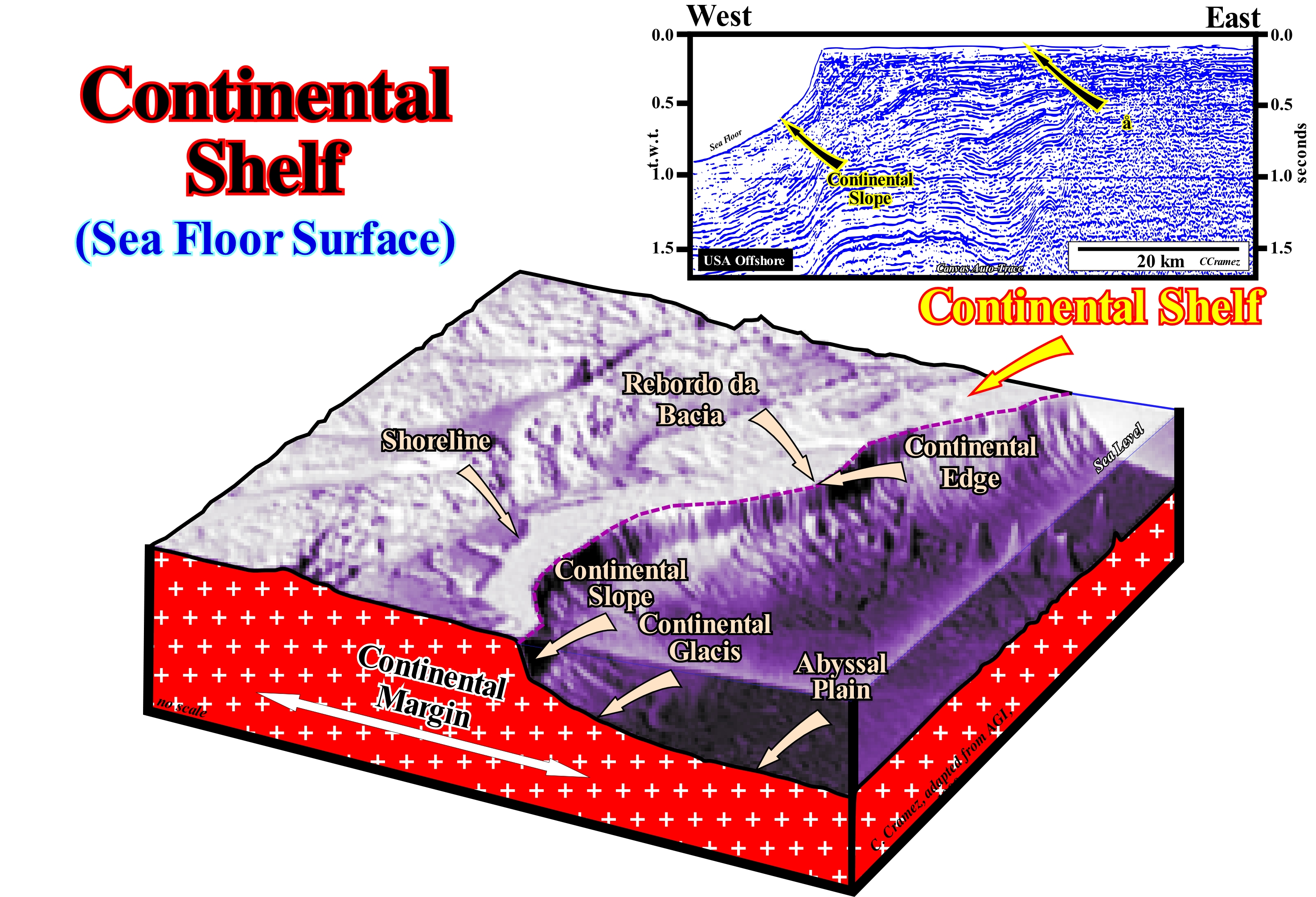
From the mainland to the deep sea, along a depositional surface, as along a complete chronostratigraphic line, there are five slope breaks: (i) Bayline, between the alluvial plain and the coastal plain (delta plain included) ; (ii) Depositional Coastal Break (more or less the shoreline), between the onshore and offshore ; (iii) Base of Prodelta, between the prodelta and continental shelf (when the basin has a shelf) ; (iv) Platform Edge (when the basin has a shelf, i.e., when the shoreline is located landward of the continental edge), between the platform and continental slope ; (v) Base of the Continental Slope, between the continental rise and the abyssal plain. What is, commonly, called continental shelf corresponds to the surface between the basin edge and the base of the prodelta, under highstand geological conditions (when sea level is higher than the basin edge). However, the term platform is used by certain geoscientists to design flat surfaces developed in certain carbonate depositional systems. In a sequence-cycle, which is induced by an eustatic cycle* lasting between 0.5 and 3-5 My (3rd order eustatic cycle), the sedimentary basin has periods during which it has no continental shelf. These periods are associated with the lowstand systems tracts group (LSTG) and the 2nd phase of a highstand prograding wedge (HPW), which is the upper sub-group of the highstand systems tract group (HSTG). In sequential stratigraphy, particularly, in seismostratigraphy (when sequential stratigraphy is made on seismic data, which implies that certain details are not visible due to the resolution of the seismic lines), only during the highstand systems tracts group ( HSTG) is that the basin has a continental shelf: (i) during the transgressive interval (TI) and during the 1st phase of the highstand prograding wedge (HPW). For this reason, two development phases are considered in the highstand prograding wedge. During the 1st phase, the basin has a shelf, but not during the 2nd (the shoreline coincides with the basin edge, which coincides, also, with the continental edge). When a significant relative sea level fall occurs, the relative sea level becomes lower than the basin edge and a new stratigraphic cycle begins, with the deposit of submarine fans, in the deepest part of the basin. During the deposition of the submarine fans (SBFF and SSF) and the lowstand prograding wedge (LPW), the basin has no platform and the basin edge is the last basin edge of the previous stratigraphic cycle. When relative sea level floods for the first time the coastal plain of the lowstand prograding wedge, the shoreline moves continentward, creating a shelf and a ravinment surface on the coastal plain of the lowstand prograding wedge. The water-depth and the extent of the platform increase as the relative sea level rises in acceleration (increasing increments or marine ingression increasingly important). Since the relative sea level begins to rise in deceleration (increments, progressively, smaller), the highstand prograding wedge (HPW) begins to deposit, which gradually reduces the extent and the waterdepth of the continental shelf. From a given moment, the basin no longer has a platform (2nd stage of the highstand prograding wedge) as the basin edge takes a new position, which coincides with the continental edge, until a significant relative sea level fall occurs producing an erosional surface (unconformity) that emphasizes the end of the stratigraphic cycle and the beginning of a new one. Between the increments of relative sea level rise, which are induced by small marine ingression that belong to a marine ingression of higher order (in acceleration or deceleration) there are stability periods of the relative sea level during which sediments (sequence-paracycles) are deposited, as the shoreline moves seaward, before moving again continentward during the next marine ingression.
(*) The term eustatic is, generally, used in association with the absolute (or eustatic) sea level which is the global sea level, referenced to the Earth's centre. Thus, when we speak of a 1storder eustatic cycle whose duration is greater than 50 My, there is no problem with terminology, since the eustatic cycle corresponds to a cycle of the absolute or eustatic sea level curve. However, this is not true for a 3rd order eustatic cycle, since it refers to a cycle of the relative sea level changes, which is the local sea level, referenced to the base of the sediment base (top of the continental crust) or to any other point on the Earth's surface, such as the sea floor, and which is the result of the combination of absolute sea level and tectonic (subsidence or uplift of the sea floor).
Continental Shelf-Break......................................................................................................................................Rebord Continental
Rebordo continental / Borde continental / Schelfkante, Kontinental Rand / 大陆架边缘 / Обрыв континентального шельфа / Bordo del continente /
Break on sea floor that marks the perimeter of each continent. During glacial periods (lowstand), the continental shelf-break (or continental edge) is, practically, subaerial. It is under water and during interglacial periods (highstand) in epicontinental seas and gulfs, as is, presently, the case. Within a sequence-cycle, the continental edge is sub-aerial during the deposition of the lowstand prograding wedge (LPW) and during the deposition of the 2nd phase of development of the highstand prograding wedge (HPW). During the transgressive interval (TI) and during the 1st phase of development of the highstand prograding wedge (LPW), the continental shelf-edge is under water. During the deposit of the submarine fans, it can be said the continental edge is sub-aerial, since it corresponds, according to some geoscientists, to the basin edge of the previous sequence-cycle.
See: « Continental Platform »
&
« Depositional Coastal Break »
&
« Continental Slope »
In general, geoscientist call continental edge to the dip break of the sea floor that marks the beginning of the continental slope. The continental edge underlines either the boundary between the continental platform (shelf) and the continental slope when the basin has a shelf, either the boundary between the coastal plain and the continental slope when the basin has no shelf. In the first case, the continental edge, which is also the basin edge, is several kilometers (depending on the morphology of the basin) of the depositional coastal break which, roughly, coincides with the shoreline (particularly true on seismic lines due to seismic resolution). In the second case, under lowstand geological conditions, the continental edge coincides, roughly, with the shoreline, but the basin edge is located much further upstream. It corresponds to the last continental edge of the highstand prograding wedge of the preceding sequence-cycle, if the sequence-cycle is complete. At the hierarchical level of the sequence-cycles, when the sea level is low (in this case, it is not necessary to specify whether it is relative or absolute sea level), this means the sea level is lower than the basin edge, as is the case, when the basin has no shelf. When the sea level is high, it is above the basin edge, as is the case, when the basin has a platform (transgressive interval - IT, and 1st phase of development of the highstand prograding wedge - HPW). The stratigraphic cycle said sequence-cycle, which is induced by a 3rd order eustatic cycle (its time-duration varies between 0.5 My and 3/5 My) is the building block of the sequential stratigraphy. During the lowstand systems tracts group (LSTG), i.e., when the basin has no shelf, from the bottom to top, we recognize three sub-groups: (i) Submarine basin floor fans (SBFF) ; (ii) Submarine slope fans (SSF) and (III) Lowstand prograding wedge (LPW). The basin edge is the last continental edge of the preceding sequence-cycle, which continues to be the continental edge until the submarine slope fans are deposited. The continental edge, emphasized by the submarine slope fans (SSF), is reinforced and accentuated by the deposition of the lowstand prograding wedge (LPW), which, obviously, is not the basin edge. During the deposition of the highstand systems tracts group, i.e., during the deposition of the transgressive interval (IT) and the highstand prograding wedge (HPW), the continental edge is the edge of the lowstand prograding wedge, which also is the basin edge, while the shoreline is located upstream, as a function of the extension of the shelf. During the 1st phase of development of the highstand prograding wedge (HPW), the situation is, practically, the same and the basin has a shelf. However, the extent of the platform is smaller, since marine ingressions are in deceleration (becoming less important) and the associated sedimentary regressions are increasingly important. Thus, with the progradation of the coast line, after a given moment, the basin is no longer a shelf. The shoreline (especially on seismic lines) becomes the new continental edge, which is at the same time the basin edge: it is the beginning of the 2nd phase of development of the highstand prograding wedge (HPW), during which the basin has no shelf. In the map illustrated in this figure, areas where the continental edge is, significantly, offshore (where there is a major continental shelf, such as in B) are, easily, recognized. In other cases, as in A, take into account the scale, it can be said the continental margin has no shelf. This is particularly true on seismic lines, since a water-depth of 30 m is, generally, lower than the seismic resolution on conventionally seismic lines used in petroleum exploration. In the geological sketch, illustrated in the lower left corner of this figure, the continental edge (which here coincides with the basin edge) is, at the same time, also the shoreline, which means that the geological conditions are highstand, but the basin has no shelf: the last deposited sedimentary interval (top of the yellow range) corresponds, probably, to an interval of the 2nd phase of development of a highstand prograding wedge (HPW).
Continental Slope (Borderland).................................................................................................................................Talus Continental
Talude continental / Talud continental / Kontinentalalagfall / 陆坡 / Континентальный склон / Pendenza continentale /
Zone of continental margin dipping seaward, located between the platform (shelf) and the continental rise. The continental slope has a, relatively, strong slope between 3-6° and is, mostly, composed by deep-water sedimentary rocks, usually, shaly rocks.
See: « Continental Platform »
&
« Basin Edge »
&
« Talus, Slope »
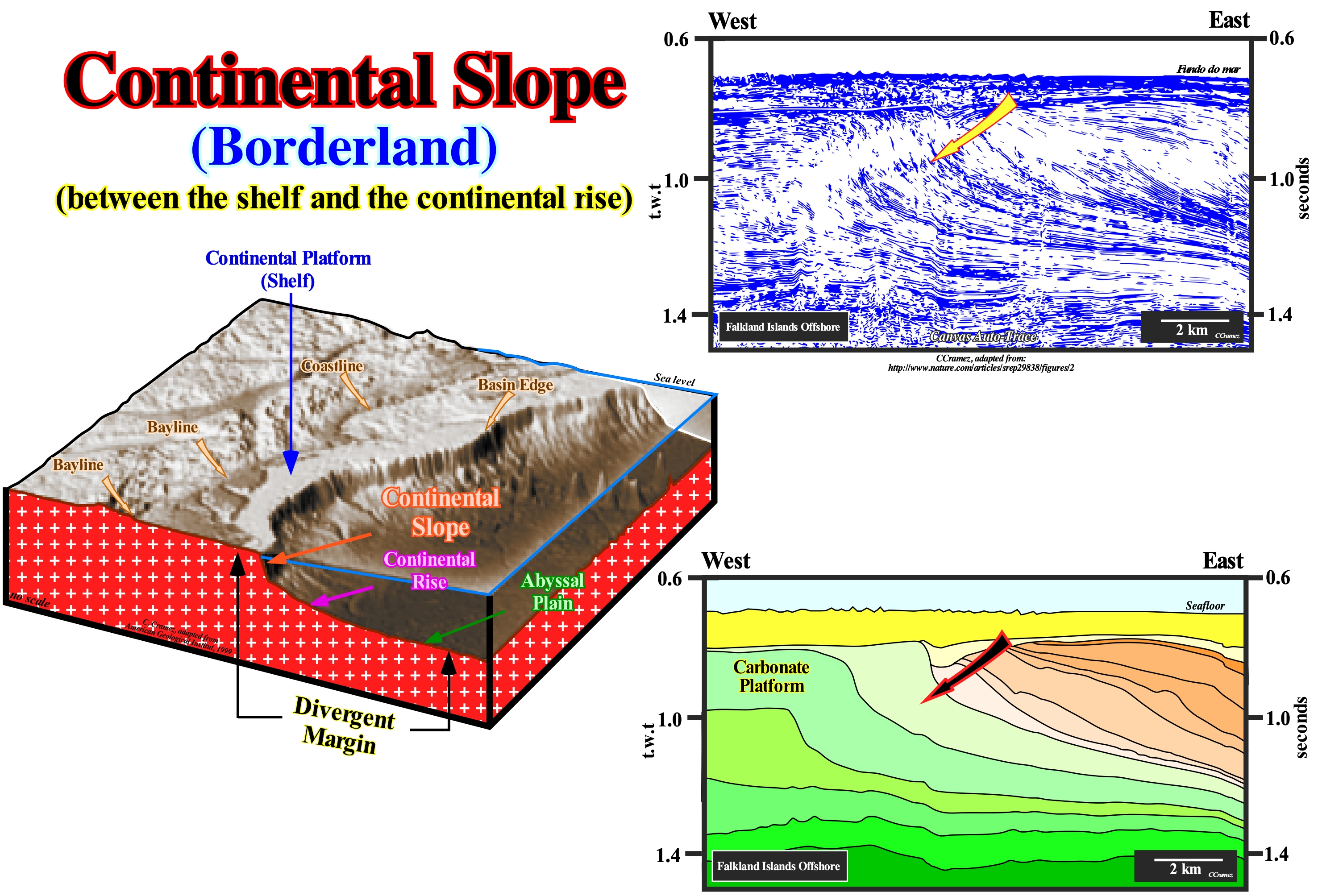
In this block diagram of a continental divergent l margin, illustrated in this figure, it is easy to recognize the dip break of the depositional surface, which delimit the main sedimentary environments. From the continent to seaward, we recognize: (i) Bayline, which separates the coastal plain from the alluvial plain, i.e., the line that limits downstream the fluvial from the paralic deposits (located near the coast showing, simultaneously, marine and continental features) ; (ii) Shoreline, which limits the coastal plain from the continental shelf (separates the paralic sedimentation from marine shallow-water sedimentation) ; (iii) Basin Edge, which in this case corresponds to the continental edge, since the basin has a platform and marks the outer boundary of the continental shelf (when, at the sequence-cycle level, a basin has no shelf, the basin edge is located upstream of the continental edge and is, in general, the last continental edge of the preceding sequence-cycle) ; (iv) Basal continental slope break, which separates the continental slope from the continental glacis ; (v) Basal continental glacis, which corresponding more or less, to the limit of the abyssal plain. The concept of bay-line advanced by Posamentier and Vail (1988) is still subject to controversy. It is based on conjecture that delta deposition occurs when a water-course encounters a water-body , almost immobile, and its velocity decreases almost instantly, with which many geoscientists do not agree. Posamentier considers that: (i) The coastal plain is formed by progradational processes of sea bottom rather than exhumation ; (ii) The sediments that accumulate in the coastal plain during the progradation of the shoreline are part of the coastal wedge (or coastal prism), which includes fluvial and marine shallow-water deposits ; (iii) The coastal prism is wedge-shaped and extends continentward by onlapping over the pre-existing topography. Thus, it can be said that the bay-line is the upstream limit of the coastal prism. The bay-line can move landward when the progradation of the shoreline is accompanied by aggradation and that it is the limit between the coastal plain and the alluvial plain. Upstream of the bay-line, relative sea level changes have no influence on depositional systems. When, within a sequence-cycle, the shoreline coincides with the continental edge, the basin has no shelf. These geological conditions occur during regressive episodes, particularly in lowstand geological conditions (when sea level is lower than the basin edge.) In highstand, during the second phase of development of the highstand prograding wedge (HPW), the basin also has no shelf (in this particular case the continental edge is also the basin edge). This is, perfectly, visible in the Canvas auto-trace of a detail of a seismic line from the Maldives offshore, illustrated in the upper right part of this figure, in which the continental slopes are predominant in the western part of the auto-trace. They are, progressively, built by the sigmoid and oblique clinoforms (progradations) that displace seaward the continental edge. This happens, when, globally, the basin has no shelf. The displacement of the continental edge has been interrupted several times by significant relative sea level falls, which created erosional surfaces (unconformities) that individualize the various sedimentary packages recognized on this tentative interpretation. They, probably, correspond to continental encroachment subcycles and not to sequence-cycles. A continental slope has, always, a height of higher than 200 meters. Consequently, it can not be confused with a delta slope, which exceeds, rarely, 60 meters in height. However, when a delta building develops, i.e., when several deltas stack, more or less, vertically, as, for instance, in the Niger delta building or in the Amazon delta building, the building height can reach several thousands of meters, the continental slope can be considered as an stacking of delta slopes.
Continental Terrasse..............................................Plate-forme d’accumulation marine (Terrasse continentale)
Terraço Continental / Terraza continental / Kontinentaltafel, Kontinental Terrasse / 大陆台地 / Континентальная терраса / Continental terrasse /
Set of the first three physiographic provinces: (i) Coastal plain; (ii) Continental shelf or Continental Platform and (iii) Continental slope. The other provinces are: (iv) Lower continental slope and (v) Abyssal Plain.
See: « Physiographic Province »
Contour (Isohypse)....................................................................................................................................................................Curve de niveau (isohypse)
Curva de nível / Isohipsa, Curva de nivel / Isohypse, Höenlinie / 曲线水平 / Изогипса / Curva di livello /
Curve that joins points with equal altitude value.
See: « Contour Map »
&
« Orogenesis »
&
« Physiographic Province »
A map in isohypses, like the map illustrated in this figure, is nothing more than a topographic map, i.e., a type of map characterized by large-scale details and a quantitative representation of the relief, that uses, usually, isohypses or contour curves as the contour lines in cartography, although, in the past, a variety of methods of representation have been used. In fact, as is easy to see in this figure, when more important is the relief more close are the the contours to each other. On a escarpments with a slope close to the vertical, like the flanks of the volcano illustrated in this figure, the isohypses are very close to each other and overlapping if the escarpment is vertical. On the contrary, the greater the distance between isohypses the more flattened is the topography, which means that a horizontal area is limited upstream and downstream by the same isohypse. Conventional topographic maps show not only contours, but also any type of stream or other water-bodies, forest cover, built-up areas or individual buildings (function of the scale), and other features and points of interest. Nowadays, maps with isohypses have multiple uses, as, for example, in the urbanization, architecture, in the earth sciences, etc. All geological maps have a topographic basis on contour lines. Geological maps are not like other maps. Geological maps, like all maps, are made to show where things are. But while isohypses maps show the topography, the distribution of roads or rivers or county boundaries, a geological map shows the distribution of geological resources, including the different types of rocks and faults. In geological maps, geology is represented by special colours, lines and symbols. A good geological map reading allows geoscientists to better understand the geology illustrated on the map. If the boundaries of a geological formation (a colour for instance) cross the valley of a river or other water-course without being "apparently" diverted by topography, this means the layers constituting the geological formation are vertical. If the boundaries of the formation are parallel to the isohypses the layers are horizontal or subhorizontal.
Contour Current........................................................................................................................................................................Courant de contour
Corrente de Contorno / Corriente de contorno / Kontur Strom / 轮廓电流 / Контурное течение / Corrente di contorno /
Ocean current flowing along isopicnic lines (of equal density), more or less, parallel to bathymetric contours. A water-course with the same density flowing along the contours of the lower part of the continental slope, which is, often, responsible for deposition of contourites. Sometimes called Geostrophic Current.
See: « Coriolis Effect »
&
« Ekman Movement »
&
« Contourite »
Low atmospheric pressures and ocean currents tend to raise the sea level by about 1 meter. On the contrary, high atmospheric pressures and divergent sea currents tend to lower the sea level by about 1 meter. Water flowing from high to low does not flow along the maximum slope but along Coriolis effect* contour lines (lines joining points of equal value for a given parameter). The Coriolis effect corresponds to the change of course of any moving body on the Earth's surface rightward, in the Northern Hemisphere and leftward, in the Southern Hemisphere, due to the Earth rotational direction and velocity, which, near the equator is, more or less, 1,666 km/h, but decreased towards the poles. The vertical circulation of the ocean currents can be induced either by : (i) Action of the winds (resurgence) or (ii) Sea density differences (thermohaline circulation). In certain regions of the oceans, water can move, vertically, to the surface or to the seafloor as a result of the surface circulation winded-driven that carries water away out or toward these regions. In certain areas of the ocean, this phenomenon of upwelling is characterized by the rise of deep-water, usually, cold and nutrient-rich. As a consequence, these areas have, generally, a high primary productivity, which may later favour the development of potential source-rocks. However, much of the vertical circulation of water in the oceans is, mainly, related to changes in surface water density. An increase in density may occur due to: a) Water cooling ; b) Excess evaporation on rainfall or c) Ice formation and consequent increase in salinity of surrounding waters. On this tentative geologically interpretation of a Canvas auto-trace of a detail of a North Sea seismic line, it is, likely, that the contour currents* have been responsible for the partial erosion of the submarine basin floor fans (SBFF) of certain sequence-cycles and the re-deposition of the eroded sediments, not very far, under the form of contourites. The unconformity or the correlative paraconformity (which correlates, upstream, with unconformity) at the bottom of the submarine basin floor fans (coloured in red) is associated with a significant fall of the relative sea level*** , which exhumed the former continental shelf, transforming it into a coastal plain and created a series of turbidity currents. These currents are responsible for the deposition of the submarine basin floor fans (SBFF). After the deposition of the submarine basin floor fans, the action of the contour currents, which did not flow along the maximum slope lines, eroded, partially, the basin floor fans (dark blue colored erosional surface). The released sedimentary particles were carried by contour currents. The coarsest sediments were, again, deposited under the form of mounded sedimentary structures (contourites), while the clay fraction continued to be transported and dispersed along the base of the continental slope. Contourites differ from the submarine basin floor fans (SBFF) by their internal dipping parallel configuration (depositional dips can be higher than 10-15°). Submarine basin floor fans have a parallel internal configuration, more or less, sub-horizontal. The sandstones of the contourites do not have a clayey matrix, which is not the case for the sands of the submarine basin floor fans. On the other hand, the contourites are rich in heavy minerals, such as zircon, allanite, garnets, etc. Later, both basin floor fans and contourites were fossilized by the deep and distal sediments of the lowstand prograding wedge (LPW), which began to settle since the relative sea level began to rise (in acceleration). The submarine slope fans, that are not visible in this auto-trace, deposited westward of the area where the seismic line was shot.
(*) It was in his article "Sur les équations du mouvement relatif des systèmes de corps" (1835) that Gaspar-Gustave Coriolis mathematically described the force that should have its name - the Coriolis force - which appears as an additional component to the centrifugal force, which is also an inertial force felt by a body in relative motion. An inertial force is an apparent force acting on the masses when they are observed from non-inertial reference (Newton's laws are not verified), i.e., from a point of view in accelerated motion (in translation or in rotation).
(**) Contour currents flow along the continental glacis of the ocean basins and are, in general, relatively, narrow and well defined.
(***) Local sea level referenced at any point of the land surface which is, usually, is the seafloor or the base of the sediments and which is the result of the combined action of the eustatic or absolute sea level and tectonic. Absolute sea level is the global sea level, referenced to the Earth's centre or to a satellite.
Contour Map..............................................................................................................................................................................................Carte de contours
Mapa de contornos/ Mapa de contornos / Contour Karte / 等高线图 / Контурная карта / Mappa di contorni /
Map constructed from contour lines (isolines). Each contour line (two-variable function) is the curve along which the function, for example, the altitude, has a constant value.
See: « Map »
&
« Isochron »
&
« Map Projection »
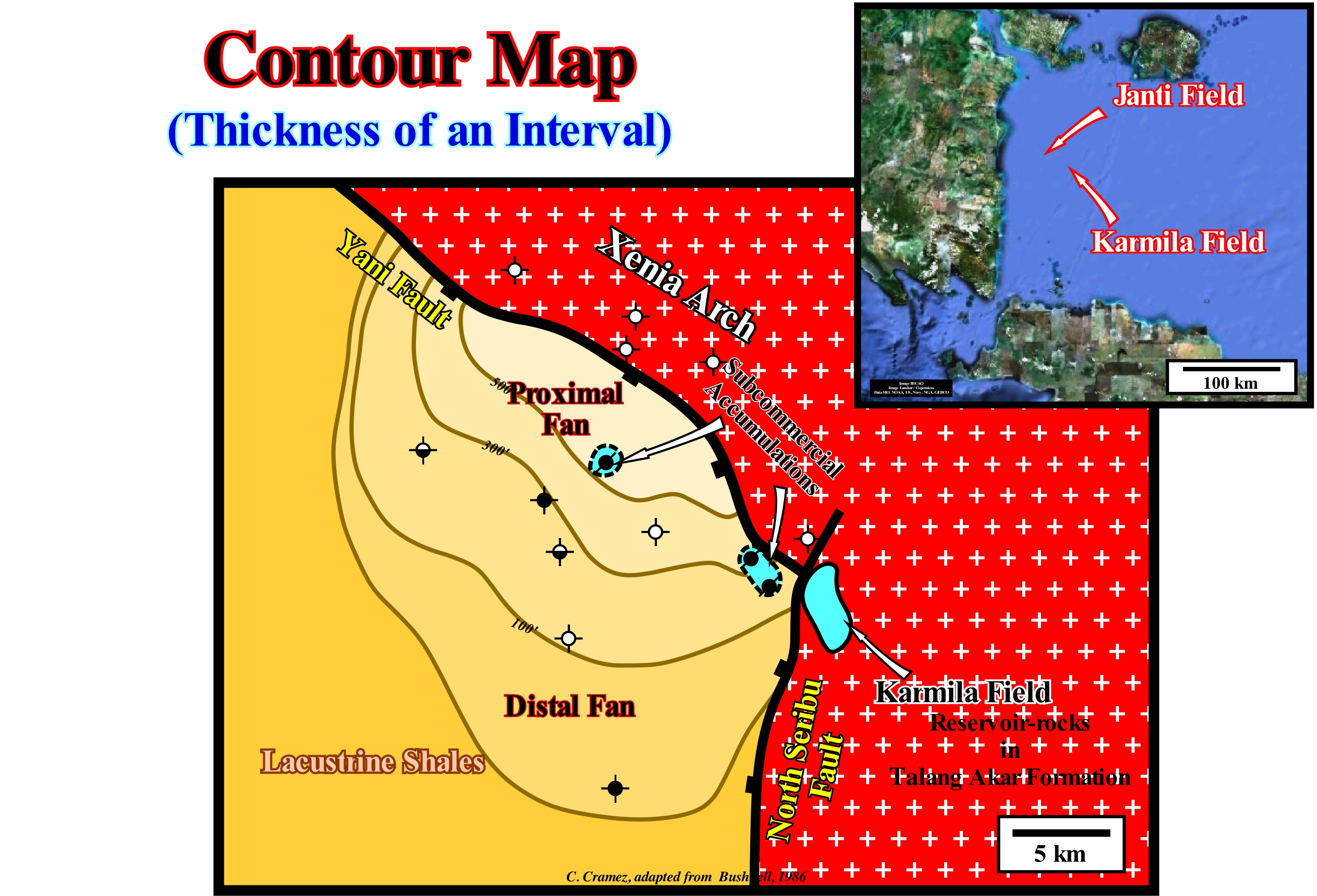
The contour map shown in this figure corresponds to the map of top of the rock-reservoir of a non-economic accumulation of oil. Note the presence of a small field (Karmila field) at the level of the sands of the Kalang Akar formation, just above the basement. In fact, the basement (underlined by the white crosses on a red background), which forms the Xenin structural arch, is separated from the sedimentary series by two important normal faults (Yani and North Seribu) which, in certain areas, were slightly reactivated as reverse faults, during the compressional tectonic regime, which occurred later in this back-arc basin. The sedimentary series, which constitutes the rifting phase of the back-arc basin, are formed by an alternation of alluvial fans with potential reservoir-rocks and organic rich lacustrine shales (potential source-rock). The structural map of the top of the alluvial fan interval, illustrated in this figure, defines a morphological trap. The fan is covered by the lacustrine shales, i.e., by the source-rock, which also function as sealing-rock. This alluvial fan was drilled several times. Some wells are dry, i.e., they did not find any hydrocarbons. Others wells found hydrocarbons, but in quantities insufficient to be considered as economically profitable fields (sub-commercial accumulations of oil), and others with only petroleum shows. This trap, which many geoscientists regard as structural, since it has a structural component, well marked on this map, has nothing to do with a structural trap. A true structural trap has its own closure, such as an anticline structure. The map of the top of the reservoir-rock interval the rock-reservoir defines a structure that dips in four orthogonal directions ("four way dip" structure). It is easy to see the trap illustrated in this map by the top of the alluvial fan does not satisfy the conditions of a structural trap. The top of the reservoir rock does not dip in four directions. The north closure of the rock-reservoir is by juxtaposition against the rocks of the basement.
Contourite...............................................................................................................................................................................................................................Contourite
Contornita / Contornita / Contourite / Contourite, 概要 / Контурит / Conturiti /
Deep-water deposit associated with submarine basin floor fans and, genetically, induced by contour currents created by Coriolis force. The contourites are formed by thick packets of fine sand (without clay matrix), with a progradational geometry and an ascending slope (climbing toplaps). Certain geoscientists, such as Bouma, called contourites the deep-sea structures (filling of channels by a lateral terrigeneous influx), found in the Swiss flysch, characterized by a significant abundance of heavy minerals such as zircon, allanite, etc.
See: « Systems Tract »
&
« Basin Floor Fan (submarine) »
&
« Contour Current »
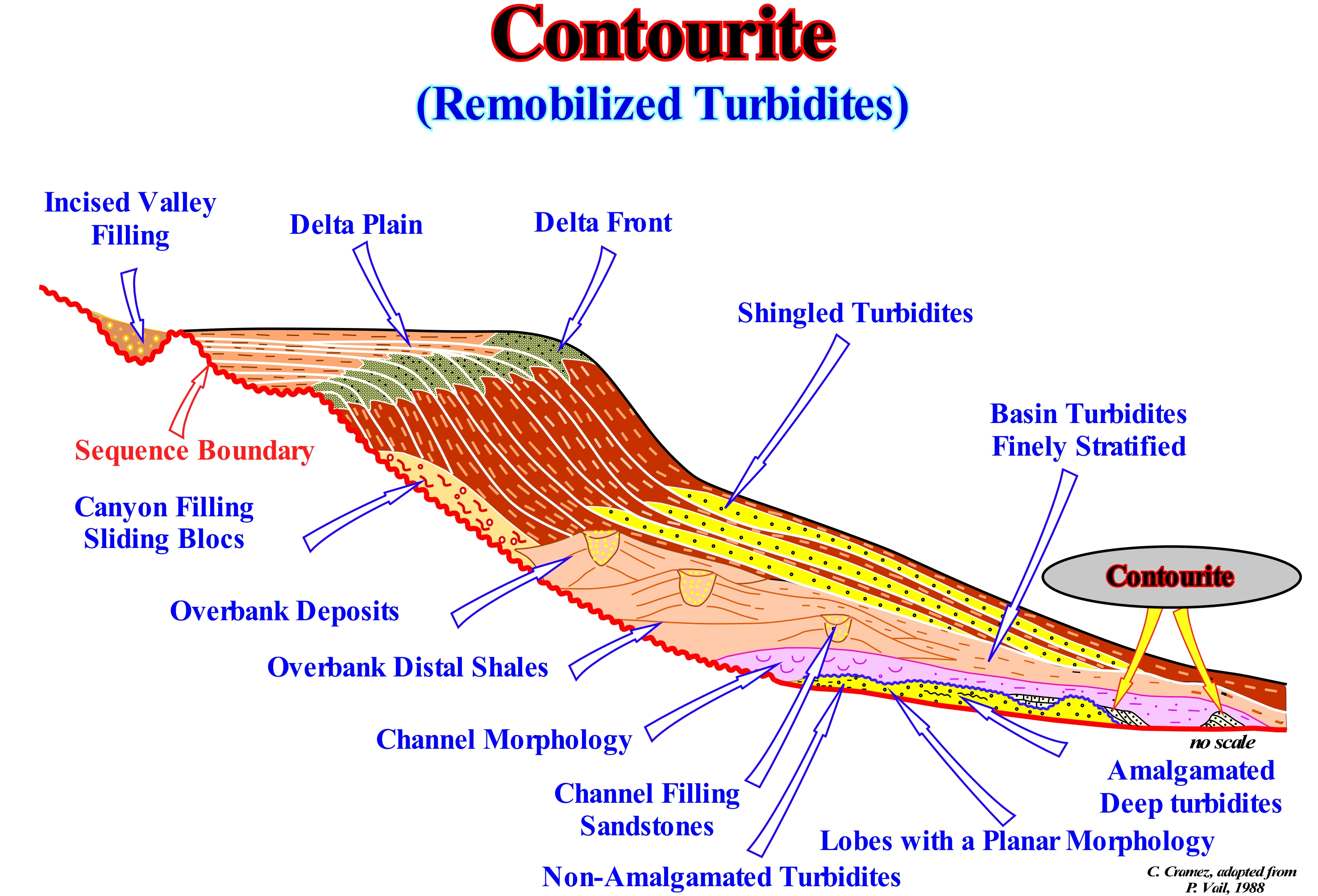
Several types of turbidite deposits are associated with the lowstand systems tracts group (LSTG). In the lower sub-group, i.e., in the submarine basin floor fans (SBFF), the following depositional systems can, usually, be recognized: (i) Amalgamated Deep Turbidites ; (ii) Turbidites non- amalgamated ; (iii) Planar Lobes ; (iv) Depressions or Channels Fillings ; (v) Finely Stratified Basin Turbidites and (vi) Contourites. As suggested in this scheme, the lobes of submarine basin floor fans can be eroded by deep currents as for instance by contour currents* (a particular type of abyssal currents, unidirectional, almost in geostrophic equilibrium and quite controlled by the sea floor topography since its kinetic energy is attenuated by friction, which creates an exogenous effort on the sea floor). The material eroded by these currents can be re-deposited, sometimes not very far, in the form of contourites. The contourites are, easily, differentiated from the submarine basin floor fans (SBFF) not only by their geometry but, above all, by the facies and internal structure. Their lithology is sandy without clayey matrix, which is not the case in the sandy intervals of the submarine basin floor fans. On the other hand, the contourites are very rich in heavy minerals, such as allanite, zircon, garnets, etc., reason why, sometimes, they are mined**. The internal configuration of the submarine basin floor fans is, more or less, parallel (sub-horizontal). The contourites have a tilted internal configuration with angles than can reach 15°. In the middle sub- group of the lowstand systems tracts, that is to say, in the submarine slope fans (SFF)), one can recognize: (a) Overbank deposits (levees, i.e., natural marginal turbiditic dykes) ; (b) Overbank distal shales ; (c) Channel (erosion) or depressions fillings (between opposite levees), which can have a sandy or shaly facies (lithology) ; (d) Canyon fillings and sliding blocks. The term channel is, here, used in its geometrical sense and not in its genetic sense. Often, certain "channels" are not created by erosion, induced by the turbidite currents, but due to an absence of deposition. This is, often, the case of the depressions between the turbidite natural marginal dikes (levees with opposite vergence). When a channel or depression is filled by sand, the morphology of the filling becomes biconvex by differential compaction. In contrast, when the facies is shaly, the initial morphology becomes convex/concave (concave at the upper limit). In the upper sub-group of lowstand systems tracts, i.e., in the lowstand prograding wedge (LPW), on the base of the progradations, there are, sometimes, shingled turbidites (the geological sketch illustrated in this figure, which has no scale, is greatly exaggerated vertically). The unconformity which limits, at the bottom the sequence-cycle (in this sketch just the lowstand systems tracts group is illustrated ) is evident down to, more or less, the level of the submarine slope fans. Downstream, the unconformity passes to a correlative paraconformity, since there is any geometrical difference between the stacking intervals, but a hiatus due to the absence of significant deposition between them. In sequential stratigraphy within the lithological discontinuities it is, often, possible to differentiate: (i) Concordant Discontinuities, when there is continuity between successive intervals ; (ii) Paraconform Discontinuities or Paraconformities, when there is no difference in attitude between overlapping intervals, but just a hiatus due to the absence of significant deposition between them ; (iii) Nonconform Discontinuities or Nonconformities, when there is a contact between a sedimentary interval and an older igneous body ; (iv) Disconform Discontinuities or Disconformities, when the layers of the both intervals are parallel to the contact surface which is not in accordance (conform) with regional stratification ; (v) Discordant Discontinuities or Unconformities when the two sedimentary intervals are separated by an erosional surface (relative sea level fall) ; (vi) Tectonically Enhanced Unconformities (angular unconformities), when the sediments of the interval underlying an unconformity have been deformed by tectonics ; (vii) Intrusive Discontinuities, when an igneous body crosses a sedimentary series ; (viii) Mechanic Discontinuities, when they are induced by faulting.
(*) Bottom currents associated with the relative movement of water-bodies induced by density differences, as a function of temperature and salinity variations. The velocity of these currents can be correlated with the density gradient intensity. There are records of contour currents with speeds of even 3ms-1, as in the Gulf of Cadiz (Spain). The interaction of these currents with the bottom morphology increases or decreases their velocity. They are very affected by the ocean floor topography, which gives them erosive and depositional characteristics. The bottom currents, together with the synsedimentary structural control are the main factors that can influence and modify turbiditic deposits. (http://www.academia.edu/ 22282645 / Contornitos_e_as_curentes_de_fundo).
(**) On this subject, it is interesting to note that when A. Bouma, in the 1960s, studied the Swiss Alpine flysch, he called "contourites" the sand fillings, without clay matrix and rich in heavy minerals (mined by the Swiss peasants), that he interpreted as turbiditic channels filled by a lateral sedimentary influx.
Controlling Parameter (Sequential stratigraphy)............................................................Paramètre de contrôle
Parâmetro de controlo / Parámetro de control (estratigrafía secuencial) / Steuerparameter (Sequenzstratigraphie) / 控制参数(层序地层学) / Определяющий параметр / Parametri di controllo (stratigrafia sequenziale) /
One of the four parameters, namely, Eustasy, Tectonics, Terrigeneous influx and Climate that control sequential stratigraphy. The interactions between these parameters determine the different configurations of the intervals, which are, easily, recognized in the sediments. The effects of tectonics and eustasy produce relative sea level changes, which control the available space for sediments (shelfal accommodation). The terrigeneous influx controls the amount of available space that is filled. The tectonics and climate control the quantity and type of sedimentary particles. Each of these parameters has a stratigraphic signature and a certain rate of variation that can be recognized in the rocks.
See: « Sequential Stratigraphy »
&
« Eustatic Cycle »
&
« Stratigraphic Cycle »
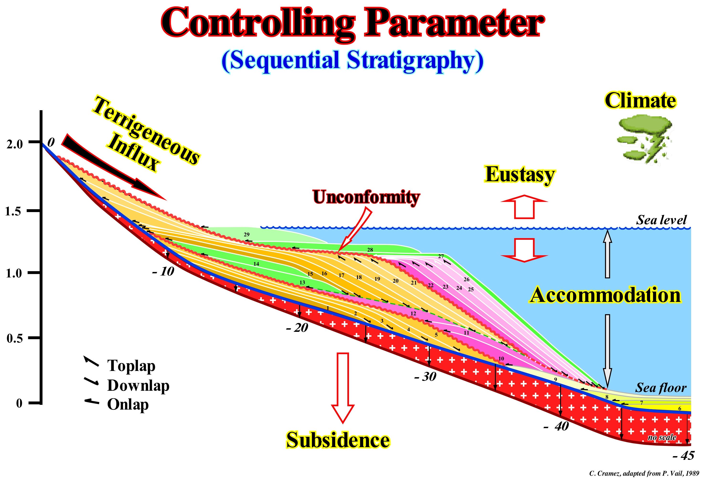
The main parameters controlling the depositional systems deposited in a sequence-paracycle (lateral association of synchronous and genetically linked depositional systems) are indicated in this sketch: (i) Eustasy (absolute or eustatic sea level changes) ; (ii) Tectonics ; (iii) Terrigeneous Influx and (iv) Climate. The combined effects of tectonics (subsidence of the sea level, when sediments are lengthened or uplift, when sediments are shortened) and eustasy (changes of the absolute or eustatic sea level, i.e., of sea level supposed global and referenced to the Earth's centre) induce relative sea level changes, which control the available space for sediments (accommodation, mainly shelfal). Sedimentary uplift occurs during compressional tectonic regimes (characterized by σ1 horizontal*). Subsidence occurs, mainly, during extensional tectonic regimes (characterized by vertical σ1). Downstream of the continental edge, which may or may not be the basin edge, there is, generally, sufficient space available for sediments (accommodation), especially when the basin has a shelf. However, at the level of a sequence-cycle, accommodation changes may be positive (relative sea level rise**) or negative (relative sea level fall). In the first case, there is deposition. In the second case there is erosion and often formation of a unconformity, when the relative sea level fall is significant and put it lower than the basin edge. The terrigeneous influx controls how much space available, created by a relative sea level rise, is filled and the seaward displacement of the shoreline, as it is the case during the transgressive interval (transgressive systems tracts of certain geoscientists) of a sequence-cycle. Tectonics and climate control the quantity and type of sediments. Each of these parameters has a signature and a certain rate of change, which can be recognized in the rocks and, partly, on the seismic data. P. Vail, like most geoscientists, believes that eustatic changes have a higher rate of change than other parameters, and so the eustasy controls the geometry and the cyclicity of the sedimentary intervals. However, De Maillet, in the seventeenth century, and Lavoisier, in the seventeenth century, were, certainly, the earliest scientists to consider eustasy as the main responsible for the cyclicity of coastal sedimentary deposits. In the long term (continental encroachment cycles and 1st order eustatic cycles, whose duration is greater than 50 My) the absolute or eustatic sea level changes are induced by the tectono-eustasy created by the supercontinents' breakup. At the hierarchical level of 2nd order eustatic cycles (duration between 3-5 and 50 My), relative sea level changes seem to be induced by basement movement mechanisms (tectonic subsidence), which operate over periods of tens of millions of years. In the short term (sequence-cycles), the causes of eustatic variations (3rd order and higher) are still very controversial, but glacio-eustasy (controlled by the glaciation/deglaciation cycles or loading and unloading induced by the addition and removal of ice from the glacial caps) seems to have a predominant influence. In general, absolute sea level changes are responsible for the cyclicity of relative sea level changes, while tectonics (subsidence or uplift of the sea floor) determine the amplitude of accommodation changes.
(*) The greater ellipsoid axis of the effective stresses (combination of the geostatic pressure σg, hydrostatic pressure or pore pressure σp and tectonic vector σt).
(**) The sea level can be absolute (eustatic) or relative. The first is supposed global sea level referenced to the Earth's centre , while the relative sea level is the local sea level, referenced to the base of the sediments (top of the continental crust) or any other point of the Earth's surface, such as the sea floor. The absolute or eustatic sea level is dependent on: (i) Tectono-Eustasy which is controlled by the volume variation of the ocean basins ; (ii) Glacio-Eustasy, which is controlled by the variation of ocean water volume as a function of the amount of ice ; (iii) Geoidal-Eustasy which is controlled by the distribution of ocean water caused by variations in the terrestrial gravity field, and (iv) Thermal expansion of the oceans or Steric sea level rise (if the temperature of the oceans increases, the density of the water decreases and, for a constant mass, the volume increases). The relative sea level is the result of the combined action of absolute (eustatic) sea level and tectonics.
Convergent Reflection Configuration......................................................Configuration convergente
Configuração convergente / Configuración convergente / Konvergente Reflexion Konfiguration / 收敛反射配置 / Схема сходящихся отражений / Configurazione convergente (riflessioni) /
Set of seismic reflectors, interpreted as strata that thins sideways basinward. This type of geometry can develop anywhere within a sequence-cycle. This configuration should not be confused with the termination of onlaps along an unconformity.
See: « Stratal Patterns »
&
« Reflector Configuration »
&
« Compensatory Subsidence »
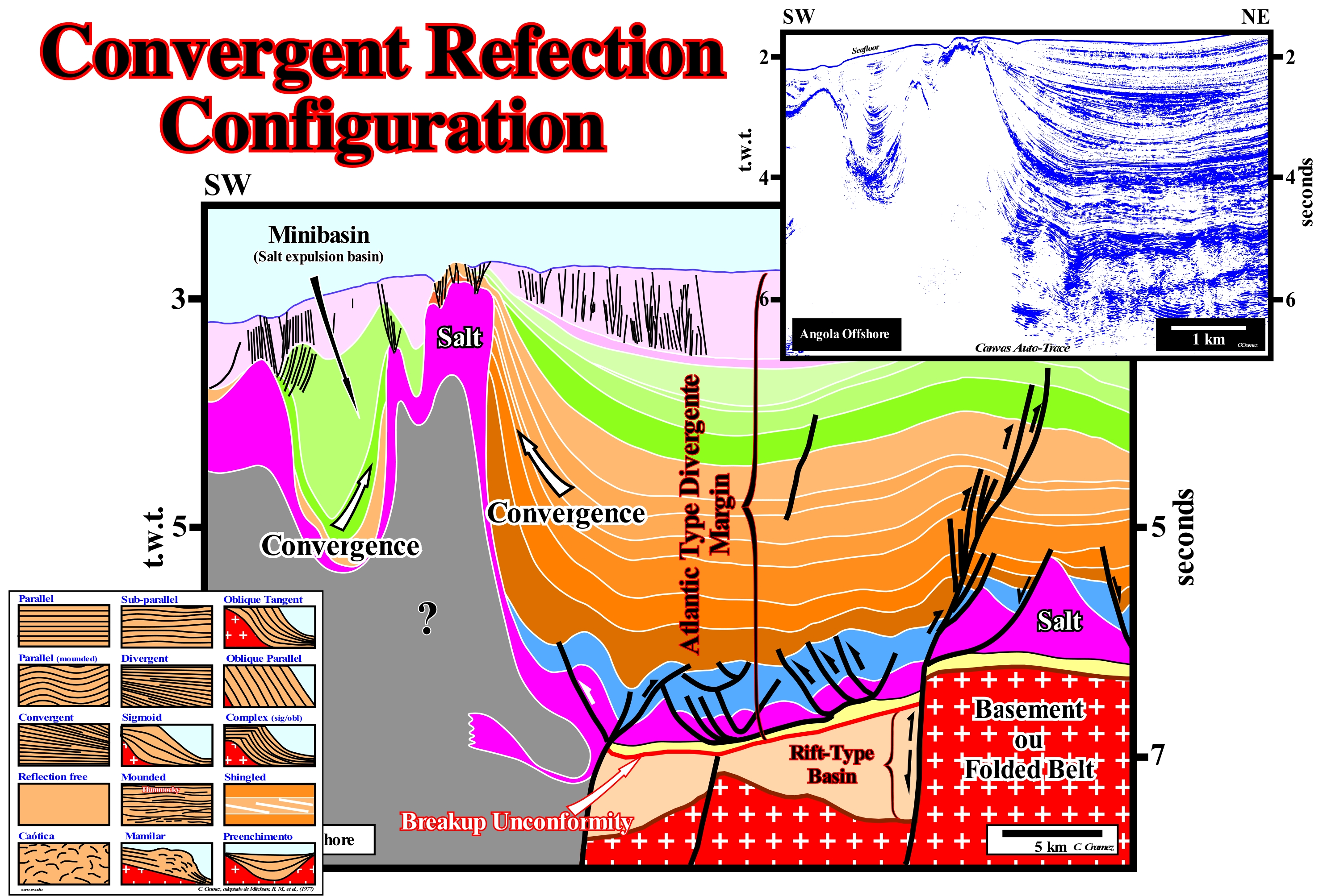
The Angola offshore, whether the Kwanza or Congo geographic basins, as the vast majority of West African offshore, corresponds to the stacking of three types of sedimentary basins, of different ages, from the classification of the sedimentary basins of Bally and Snelson (1980), which from bottom to top are: (i) Paleozoic Folded Belt, more or less, flattened, or Precambrian Basement ; (ii) Late Jurassic-Early Cretaceous Rift-type Basins and (iii) Atlantic-type Divergent Margin, whose age extends from the Early Cretaceous to the Present. The rift-type basins, formed during the lengthening of the Gondwana small supercontinent correspond, almost always, to half-graben with the bordering fault dipping seaward*, are separated from the divergent margin by the break-up unconformity, which underlines the Gondwana break-up. The most distal rift-type basins, i.e., those close to the break-up zone, are fossilized by sub-aerial volcanic lavas that flow from the expansion centres toward the individualized lithospheric plates (African and South American plates). This means that the SDRs (Seaward Dipping Reflectors), i.e., the lava flows not only thin outward toward the mainland, but their dip increase seaward (due to the overloading of more recent flows). On this tentative geological interpretation of a Canvas auto-trace of a detail of an Angola deep-offshore of a seismic line, where the salt tectonics (halokinesis) is very intense, the sedimentary intervals with a convergent internal configuration are predominant. The seaward convergence of the reflectors, within a sedimentary interval, implies necessarily a divergence continentward, before its pinchout against an unconformity. It is quite important to clarify the direction of convergence. On this tentative interpretation, the convergence of seismic reflectors, which correspond to chronostratigraphic lines (stratification planes or interfaces between layer packets), is almost always in the direction of second generation salt domes (rooted in an allochthonous salt level). In fact, above the upper limit of the rift-type basins (visible at the bottom of the interpretation), i.e., above the unconformity associated with the break-up of the Gondwana lithosphere, which is here underlined by the base of the yellow interval (lower right part of the tentative interpretation), a relatively thick evaporitic interval was deposited. The evaporitic interval (in violet) under the action of its own weight and the weight of the overlying sediments (overburden), was destabilized and flowed, progressively, lateral and vertically (the density of the salt is, more or less, constant in depth, what means that the salt does not compact). Considering that, theoretically, the salt, whose density 2.15 - 2.17 g/cm3 does not vary in depth and that it becomes plastic under a vertical pressure of ± 110 bars (unit of pressure equals 105 Pa), it can be said the initial thickness of the evaporitic horizon exceeded 500 meters. Salt lateral flow induces, always, a compensatory subsidence (local subsidence induced by flow or evacuation of a mobile interval, which develops in association with halokinesis and shalokinesis) and a sedimentary lengthening oft he salt overburden. That is why all salt-induced structures have, always, associated normal faults. The only way to length the sediments is by normal faulting (this is why normal vertical faults are a physical impossibility, since they do not wide or short the sediment). In areas where the salt thickness decreased due to the salt-flowage, it is created, locally, more available space for the sediments (accommodation). If such a available space is filled, the thickness of the sedimentary interval is, locally, increased producing a convergent internal configuration in direction of the area where the thickness of the salt remained, more or less, constant. In the same way, it can be said the internal configuration is divergent towards the area where the thickness of the salt has decreased. These internal configurations exist, always, in the sedimentary intervals filling the minibasins induced by salt evacuation, which are limited, all around, by salt structures, as shown in the upper left part of this tentative interpretation.
(*) This is a very important feature to differentiate the sediments that fill the rift-type basins from the lava flows. The sediments filling the rift-type basins, generally, dip continentward, while the lava flows dip, always, seaward. In other words, when in a tentative interpretation a seismic line from an Atlantic-type divergent margin, the geoscientist interpreted reflectors dipping seaward as sediments of a rift-type basin, the probability that he has been mistaken ("errare humanum est") is quite large: a tentative interpretation has to be, always, tested or criticized.
Conventional Gas........................................................................................................................................................................Gaz conventionnel
Gás convencional / Gas convencional / Konventionelle Gas / 常规天然气 / Обычный (традиционный) газ / Gas convenzionali /
Gas from the different sedimentary deposits that, historically, have provided most of the natural gas used to date and which was formed, conventionally, in the catagenesis and metagenesis zones. As conventional gas reserves decline (and price increases), significant quantities of non-conventional gas have been produced in recent years.
See: « Methane »
&
« Gas »
&
« Biogenic Gas »
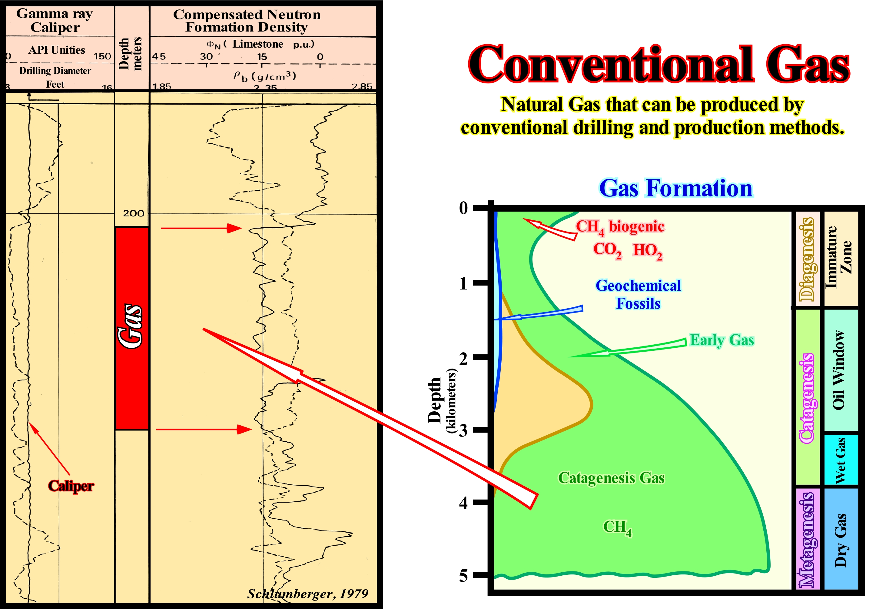
This figure shows how geoscientists, working in oil companies, detect conventional gas in exploration wells, in this particular case, in a well drilled in southern Algeria. They use the FDC-CNL electrical tool* records (neutron and density logs). The apparent density of a formation is lower due to the fact that it contains less dense fluids and, also, because the ratio between the electronic density (which is what the tool measures) and the specific mass is somewhat different in the presence of gas than for a rock that contains oil or water. Also, as can be seen in these electrical logs, the neutron porosity is lower due to the fact that the formation (reservoir-rock) is less rich in hydrogen. This exploration well is calibrated, as suggested by the calliper log. Conventional gas is not only conditioned by its origin (source-rock), but also by the reservoir-rock where it was stored. In terms of gas resources, conventional gas, i.e., freely flowing gas represents, probably, a small amount of resources when compared to non-conventional gas, which may have very different origins: (i) Biogenic gas, which is formed by the decomposition of the organic matter of the shallow sand-shale intervals ; (ii) Coal gas (or coal bed methane), which is a natural gas that exists within the coal structure ; (iii) Gas from the Impermeable Sands, i.e., sands with very low permeability ; (iv) Gas from Low Permeability Organic Shales**, which can be produced, sometimes, by fracturing ; (v) Gas clathrates, i.e. contained in clathrate hydrates ; (vi) Swamp Gas ; (vii) Gas from bottom of lakes ; (viii) Synthetic Natural Gas or SNG, which is produced either from coal or from biomass, etc.
(*) The development of electrical tools has henceforward been intense. There are now tools that can cope with extremely highly resistive muds (oil-based muds or gas as the borehole fluid), which rely upon electromagnetic coupling and an induced alternating current (induction logs). The induction log measures, actually, conductivity and hence is, sometimes, called the conductivity log. The modern tool for measuring resistivity in high salinity (low resistivity) muds is the laterolog, which focuses its current into a thin sheet to improve vertical resolution and penetration depth. The laterologs measure resistivity in the conventional sense, and are usually referred to as resistivity tools. Both the induction logs and the laterologs come in different types, which are sensitive to different depths of penetration into the borehole. Hence resistivity determinations for the invaded, partly invaded and undisturbed rock zones can be measured. In addition, there is a range of smaller electrical devices (micro- resistivity tools), which are designed to measure the resistivity of mudcake. There are also Array Logs, which are state of the art tools, and electrical measurements are used at high resolutions (small scale) to image the interior of the borehole electrically. (http://homepages.see. leeds.ac.uk /~earpwjg /PG_EN/CD%20Contents/GGL66565%20Petrophysics%20English/Chapter% 2019.PDF)
(**) In several language the granslation of terme shale by quite vague terms (e.g., "schiste" in french) designating any rock likely to be debited in thin laminae.
Cope's Law............................................................................................................................................................................................................................Loi de Cope
Lei de Cope / Ley de Cope / Cope-Gesetz / 应付的法律 / Закон Коупа / Legge di Cope /
The size body of a species increases with time. Animals tend to be getting bigger with time. Cope came to this conclusion studying the dinosaurs, and particularly, the iguanodon.
See : « Theory of Evolution »
&
« Jurassic »
&
« Paleontology »
Cope's law says lineages of a population tend to increase in size over evolutionary time. Although this law has been corroborated in many cases, it does not seem true at all levels or in all clades*. Larger bodies are associated with higher fitness for a number of reasons, although there are also some disadvantages either individually or at one level of the clade. Clades including very large individuals are more prone to extinction, which may act to limit the maximum size of organisms. A directional selection seems to act on the size of organisms. It has a much smaller effect on other morphological features, although it is possible that this hypothesis has resulted from sampling. This selective pressure can be explained by a number of advantages in terms of mating success and survival rate. Larger organisms prevent or repel predators and catch prey more easily. In the same way, they reproduce or kill competitors, more easily and resist better the rapid changes in climate. (http://en.wikipedia.org /wiki/Cope's_rule). The Cope law, is very common among mammals. A large size favours the ability to prevent predators and trap prey, and increases reproductive success as well as improves thermal efficiency. In addition, in large carnivores, competition for food tends to be, relatively, intense and larger species tend to dominate and kill smaller competitors. Progenitors of carnivorous lineages can be animals, such as foxes and coyotes, with natural selection favouring not only the largest size, but the best adaptations to eating meat. In addition, the evolution of predator size is likely to be influenced by changes in prey size. A significant trend of a larger size has been documented for large mammals in North America, including herbivores and carnivores, in the Cenozoic (Valkenburgh Van et al., 2004).
(*) A clade is a a group of animals or other organisms derived from a common ancestor species.
Coquina (Lumachel).....................................................................................................................................................................................................Lumachelle
Lumachela / Lumachela, Coquina (roca) / Coquina (rock) / Coquina(岩) / Ракушечник / Lumachella /
Detrital limestone, slightly or moderately, cemented, composed of fragments of shells. Clastic limestone composed, mainly, of fragments of fossils, which suffered a considerable abrasion and transport before reaching the deposition site.
See: « Limestone »
&
« Detritus, Debris »
&
« Reservoir-Rock (HC) »
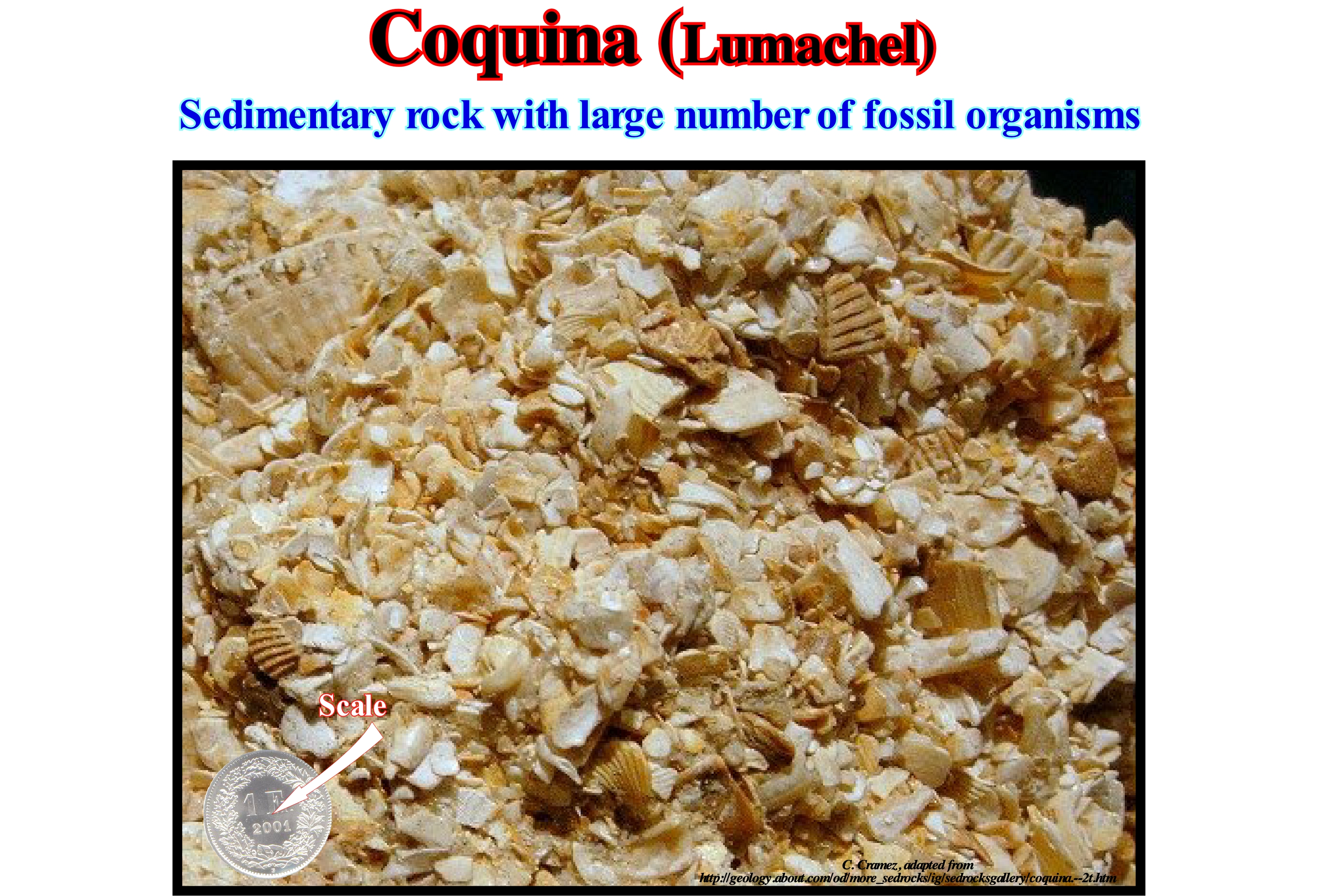
As illustrated in this photograph, a lumachel, sometimes called coquina (Spanish term meaning shell) or calcarenite, is an endogenous rock constituted by deutogenic sediments (secondary origin), mainly fragments of shells. As the shells are made of calcium carbonate, coquinas can be considered as endogenous limestones (formed by debris), but not protogens (formed by precipitation of calcium carbonate). Coquinas are formed near the coastline, where the action of the waves is strong and able to select sediments, as suggested by the broken but polished particles (abrasion of the sea-waves) that constitute them. Many limestone rocks have fossils, but coquinas are exclusively made up of fossils, as can be seen in the coquina illustrated in this figure. A very cemented coquina (lumachel) is, often, referred as coquinite, as well as a limestone consisting mainly of shell fossils, which lived where they were deposited (in situ or on-site deposit), sometimes called coquinoid limestone. Some geoscientists go further and differentiate the coquinas and allochthonous coquinoid limestones (formed by fragments that have not been transported) from the coquinas and coquinoid autochthone limestones (formed by fragments that have been transported from other sites). Many coquinas are formed from reef and sub-reef material. This facies is, mainly, represented near reefs and often contains green algae of the genus Gymnocodium, Macroporella and Mizzia. Also, fusilins and gastropods may be very frequent. The coquinas were used as a paving material, since being little cemented. They break, easily, into their components (fragments of coral beds) and thus can replace the gravel obtained by fragmentation of the rocks, which are much more expensive to obtain. On the other hand, as coquinas often contain phosphorus-rich compounds, they are used in certain countries as fertilizers.
Coral..................................................................................................................................................................................................................................................Coraux (Corail)
Coral / Coral / Koral / 珊瑚 / Кораллы / Corallo /
Marine organism of the class Anthozoa (phylum of the Cnidarians or, more popularly, coelenterates) like, for instance, sea-anemones. Corals live in colonies formed by similar individuals in the midst of other colonies formed by different individuals. These groups, which can form large reefs, especially, in the equatorial oceans, have the possibility of segregating calcium carbonate which allows them to produce a skeleton very resistant to the sea-waves.
See: « Deposition (carbonates) »
&
« Relative Sea Level Change »
&
« Reef »
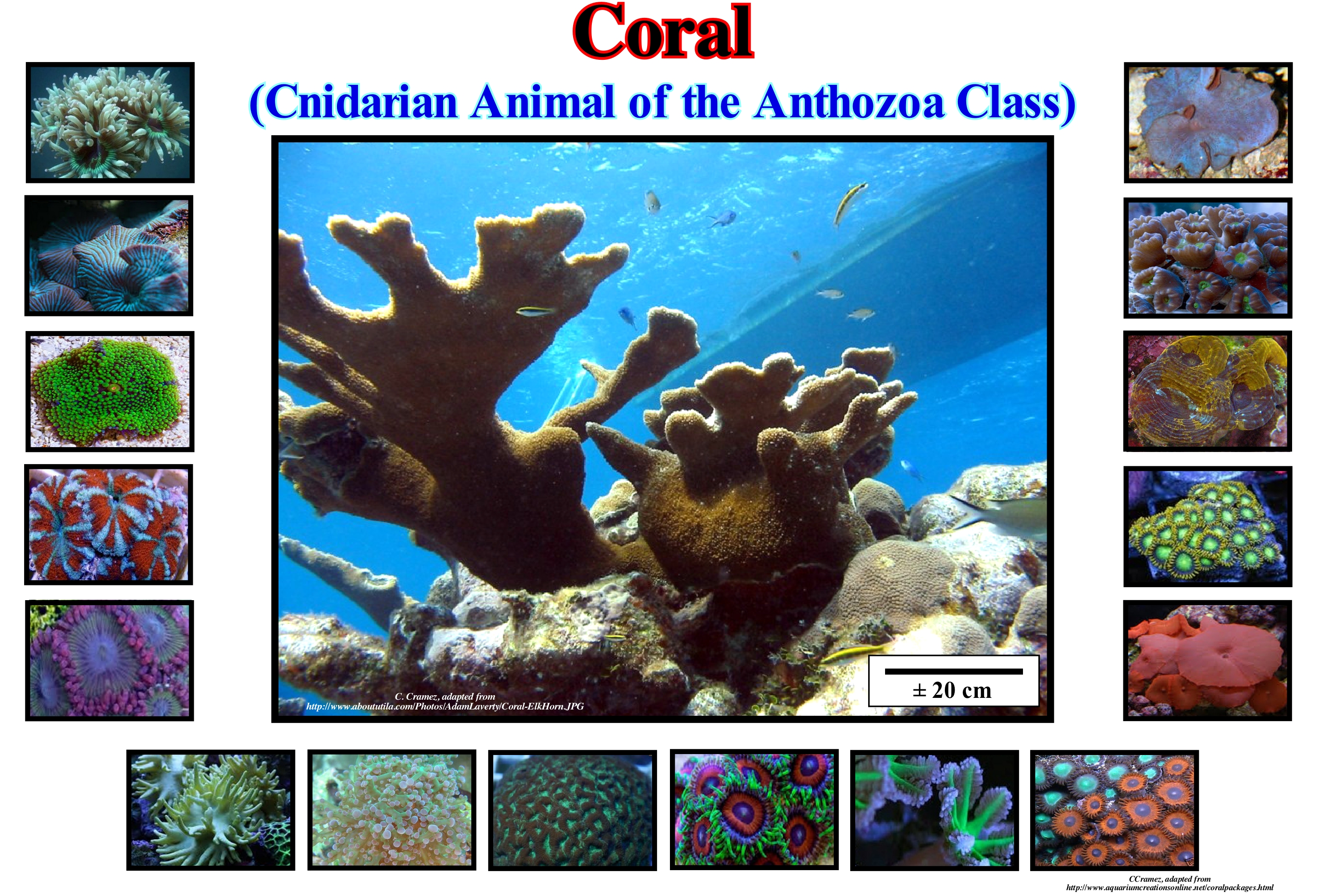
Coral is the common name of coelenterates or cnidarians of the suborder of the madreporanians, that can be presented in two forms: (i) Polyps or (ii) Jellyfish. The former have the cylindrical body, generally fixed by one end in a rock, while the free end have tentacles around the mouth. The second has the body in the form of an umbrella, with tentacles that are distributed along the margin of the body, in the centre of which is the mouth. Jellyfish swim freely, although, generally, in a limited way, or are transported by water currents. A coral (coral head), which many people think is made up of a single individual, is, actually, made up of thousands of individuals, genetically identical, that geoscientists call polyps whose thickness is less than a centimetre. After several generations, the polyps leave their skeleton, which is characteristic for each species. Normally, the coral head grows by non-sexual reproduction of the polyps. However, they can also be reproduced by ovulation with corals of the same species by the simultaneous release of gametes during certain nights of intense moonlight. Although corals have appeared in the Cambrian, about 542 Ma. Their fossils are rare until the Ordovician, a period in which rugged (Rugosa Rose) and tabular corals have become very common. At certain geological times, corals were very abundant, as they are today in the tropical and transparent seas of certain parts of the world. Like modern corals, ancient corals built reefs, of which some are still recognized in the carbonate sedimentary rocks. Corals are not restricted to reefs. Lonely corals have been found on rocks where no reefs have ever been found (such as the Cyclocyathus that occur in Gault's shaly formation in England). Fossil reefs are not made entirely of corals. Algae, sponges, and remains of echinoderms, brachiopods, bivalves, gastropods and even trilobites, which lived on the reefs are sometimes preserved within them. Many of these corals can be considered as fossil indexes (which have their onset at the beginning of a geological period and their extinction at the end of the same period), since they allow the geoscientists to date the rocks in which they are. Coral reefs are, generally, associated with shallow tropical seas. However, recent ocean floor exploration using acoustic and submersible methods has surprisingly revealed deepwater coral ecosystems both on the shelf and slope continental, as well as on oceanic ridges. Corals are particularly sensitive to climate change. Temperature changes, but also pollution and storms have destroyed many corals. The largest coral reef in Europe is located in Portugal, in the Algarve, off the coast of Portimão (http: //www.ins.pt/conteudo/430461/23/portugal-possui-o-maior-recife- of-coral-of-europe). It is known as the "Ocean Revival" and the way it was done is amazing. There are several water parks located in Europe, but in the Algarve there is a special, where visitors can only enjoy the fun with a bottle of oxygen, goggles and diving suit. In order to create this artificial reef, it was necessary to sink four Portuguese warships deliberately and thus to achieve the necessary conditions for the proliferation of marine life. Before being sunk, these ships were completely cleaned of all harmful and dangerous materials to marine life, the environment and divers. Always watched and accompanied by the Canadian Artificial Reef Consultant, this was a work with 100% guarantees of success and its location has been chosen carefully because it is a zone of calm and safe waters for diving, staying 300 days a year (at least). Artificial reefs * contribute to the biodiversity of the sea, increase fishing capacity, protect the coast from storms and erosion and also contribute to the tourist value of the region.
(*)Although there is no universally accepted definition of what an artificial reef is, in Europe it was possible to find a consensus among those engaged in the study of these artificial habitats, which defines an artificial reef as "a structure deliberately placed on the seafloor, totally submersed, which seeks to imitate some of the characteristics of natural reefs". Thus artificial reef, structures as diverse as: concrete or steel modules, industrial waste (such as old ships, oil extraction platforms, carcasses, airplanes and other means of transportation, and low-cost opportunity materials such as tree branches, bamboo, stone, etc.) (http://www. oceanrevival.org/en/project/recifes-artificias.html).
Coral Knoll (Coral knob)................................................................................................................................................................................Tête de corail
Cabeço / Cabeza de coral / Coral Kopf, Korallen Knoll / 珊瑚山丘 / Коралловый холм / Testa di corale, Corallo Knoll /
Colony of spherical and massive coral that grows in atoll lagoons. When the shape of the colony resembles a human head, certain geoscientists speak of "black heads".
See: « Littoral Clints »
&
« Reef »
&
« Lagoon (carbonates) »
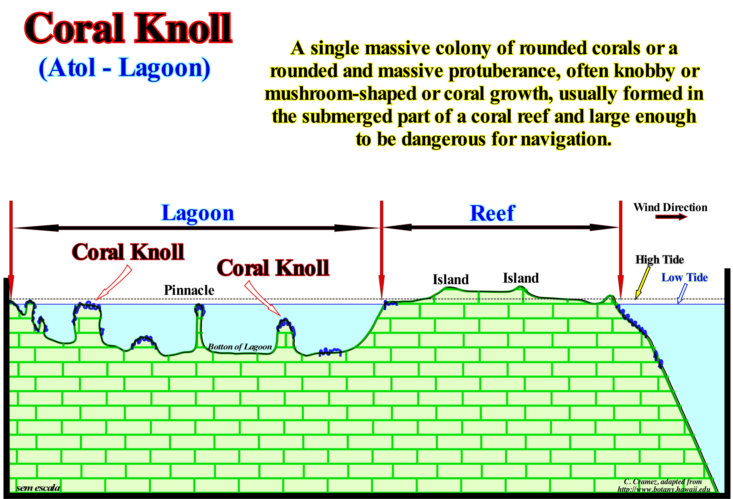
Sometimes on a carbonate platform*, the basin edge (top of the continental slope) is marked by organic constructions, which form a reef (more or less mounded, stratified or massive structure, built by carbonate sedentary organisms, especially coral, mainly, by the remains of these) and with small islands that appear even during the high tide. Reefs resist the action of the waves and form higher than the coeval sedimentary deposits of the surroundings. In rimmed carbonated platforms, reefs develop, mainly, on the windward margin. Upstream of the reef, a lagoon of relatively small depth, but which may vary greatly, is developed usually. At the bottom of the lagoon, as illustrated in this sketch, pinnacle-shaped corals and, more or less, spherical shapes are grown. Coral knolls can reach large dimensions, which makes them very dangerous for navigation, once they almost never outcrop (even at low tide). In general, these organic constructions are, preferably, formed during transgressive stratigraphic episodes, i.e., during relative sea level rises in acceleration (combined action of absolute sea level and tectonics, either subsidence or uplift of the sea-floor). In a sequence-cycle, when the first flooding of the coastal plain (passage from the lowstand prograding wedge to the transgressive interval), the shoreline moves continentward, usually, several tens of kilometers, creating a water column of few meters above the old coastal plain, which becomes a continental shelf. If the velocity of relative sea level rise allows for the development of reef constructions (assuming all other conditions are present), a small carbonated anomaly (reef) may form near the old shoreline, i.e., near the continental edge, regardless the sedimentation near the new coastline (do not confuse continental edge with basin edge, as they may not match). The successive relative sea level rises accentuate the preexisting morphology, creating, progressively, the morphology illustrated in this figure.
(*) Most geoscientists consider five categories of carbonate platforms: (i) Rimmed Platforms, which are characterized by the presence of reefs or limestone sands of shallow (carbonated sandbank covered by shallow sea water) on the edge of the platform and clay sands in the lagoon or open shelf; this type of platform forms in calm waters and its extension varies between 10 and 100 km ; (ii) Ramp Platforms, in which the shoreline carbonated sands pass, at the base of the ramp, to clay sands and deep-water mud ; in this type of platform the reefs are rare and the width of the ramp can reach 100 km ; (iii) Epeirial (or epíric) platforms, which are characterized by the presence of tidal surfaces and protected lagoons ; the width of an epeiric platform can reach 10,000 km ; (iv) Isolated Platforms, in which the facies (lithologies) are very controlled by the orientation of the dominant winds ; these platforms have reefs and sandy bodies, such as the rimmed platform, in the windward margin (facing the side where the wind blows), but in the leeward margin (in the direction where the wind blows), the sediments are more muddy ; an isolated platform can reach 100 km wide ; (v) Dead or Drowned platforms, when they are under the photic zone (where there is not enough light for photosynthesis, i.e., use of carbon dioxide, CO2, and water to obtain glucose through the energy of sunlight). Platforms connected to the continent are divided into two large families: (1) Ramp Type and (2) Top-Flatened Type. In ramp type platforms two sub-types can be considered: (1.1) Monoclinal and (1.2) Distal Steepened. In top-flattened platforms there are also two sub-types: (2.1) Nonrimmed and (2.2) Rimmed. It is in the subtype (rimmed platform) that the designation of abrupt carbonated platform is more frequent.
Coral Reef......................................................................................................................................................................................................................Récif de corail
Recife de Coral / Arrecife de coral / Korallenriff / 珊瑚礁 / Коралловый риф / Barriera corallina /
Reef lime bank, biogenic, consisting of the external skeletons of colonies of coral polyps associated with fouling algae, calcareous algae, especially of the genus Lithothamniun and debris of coral limestone that waves accumulate in the reef itself, all cemented by precipitation calcite.
See: « Reef Mound »
&
« Transgressive Interval »
&
« Deposition (carbonates) »
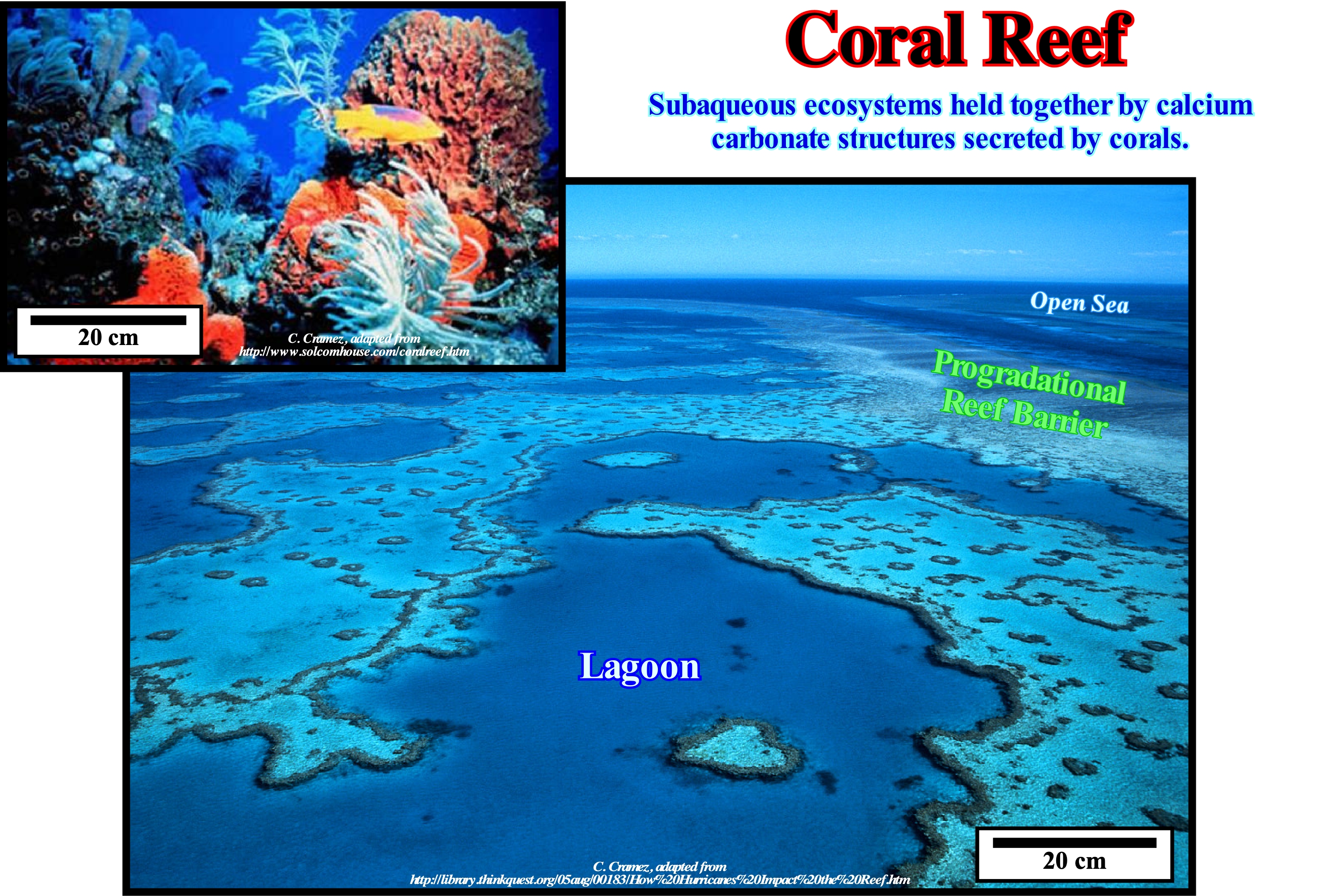
The term reef can be: (i) A rock or a group of rocks in the water near the coast or (ii) A geological formation along the coast, formed by polyps of corals. A coral reef refers to a marine habitat that is among the most biodiverse environments on the planet (https://educacao.uol.com.br/disciplinas/biologia/recifes-de-corais-1-barreira-atol- and-fringe-types-of-the-marine-environment.htm). Reefs are formed by some species of coral (animals belonging to the group of cnidarians) able to secrete a limestone exoskeleton, together with limestone algae that produce thin slabs of calcium carbonate, which accumulate and cement the reef structure. A reef is formed by: (i) Several species of coral and (ii) Calcareous algae that produce thin slabs of calcium carbonate, which accumulate and cement the reef structure. Corals are coelenterates ("cele" means hollow and "whole" means bowel), with a digestive cavity, and which secrete a limestone exoskeleton. Corals are colonial organisms that mostly build limestone skeletons that are responsible for the rocky structure. The building blocks on coral reefs are the skeletons of several generations of algae, corals and other reef-building organisms, which are composed of calcium carbonate. As a coral reef grows, it establishes a skeletal structure by fitting each new polyp. Coral reefs grow in the photic region of the tropical seas, with a wave action strong enough to keep food and dissolved oxygen in the water. Waves, fish (like parrot-fish), sea urchins, sponges and other organisms break the coral skeletons into fragments that fall into the reef structure. Many other organisms living in the reef community contribute to the reef's calcium carbonate backbone in the same way. Coral reefs are, actually, the main contributors to the structure, at least in parts of the reef subjected to the greatest forces by waves (such as the reef facing the open ocean). These algae contribute to the construction of the reef through the deposit of limestone in leaves on the surface of the reef thus contributing to the structural integrity of the reef. Many species of coralline algae form nodules or develop on the surface of the fragments by widening them. The crust protects reef-forming species to withstand pressures and attenuating waves that otherwise would destroy most corals. Often, this crust forms a shield on the ridge of an outer edge of the reef (reef crest or reef margin), particularly, on the reefs of the Pacific Ocean. The corals forming the reef live in symbiosis with the zooxanthella algae **, which live inside their tissues. Thus, they only form in clear water, usually, above 50 m deep, so that algae can carry out photosynthesis. On the other hand, the water temperature should be higher than 20° C for calcium carbonate to be secreted by the corals and calcareous algae, which is essential for the construction of the reef. Among the most famous reefs are the Great Barrier Reef, north of Australia (a huge coral reef consisting of about 2,900 reefs, 600 continental islands and 300 coral atolls, located between the beaches of north-eastern Australia and Papua -New Guinea, which is more than 2200 km long, with a width varying between 30 and 740 km. (https://en.wikipedia.org/wiki/ Grande_Barreira_ de_Coral) and Great Barrier Reef of Belize. http://en.wikipedia.org/wiki/Recife_de_coral).
(*) In marine and lacustrine ecosystems, the photic zone is one in which sunlight penetrates. Its depth is very variable, depending on the turbidity of the water. It is called euphotic depth or euphotic level the depth at which the light intensity is reduced to 1%, from which it penetrated into the surface, the limit below which the light intensity is not enough for photosynthesis. Some light may reach 700 or more meters in depth, but the boundary of the euphotic zone, with sufficient light for photosynthesis, may be only a few decimetres in very turbid waters of rivers and marshes, or approaching 200 m , which is the typical value in tropical regions of the oceans with very clear waters (https://es.wikipedia.org/wiki/Zona_fótica).
(**) Zooxanthella are a type of unicellular algae living in symbiosis with corals and some nudibranchs (marine gastropod molluscs that have unprotected gills, as their name suggests). Zooxanthella live in the tissues of coral polyps. Zooxanthella are responsible for the development of many corals in tropical waters that are poor in nutrients, develop by absorbing carbon dioxide (CO2) released by corals and supplying various nutrients back. The amino acids produced by polyps stimulate the production of glycerol, which is directly related to coral breathing. Some species of nudibranchs, such as Spurilla neapolitana, also have zooxanthella in their tissues, probably from the anemones that kill and consume. (http: //dictionnaire.sensagent.leparisien.fr/Zooxantela/pt-pt/)
Coriolis Effect................................................................................................................................................................................................Effet de Coriolis
Efeito de Coriolis / Efecto de Coriolis / Corioliskraft / 科里奥利力 / Эффект Кориолиса / Forza di Coriolis /
Effect resulting from an inadequate application of Coriolis acceleration (acceleration necessary for an object to follow its path when in motion, relative to a rotating frame of reference). All bodies moving to the surface of the Earth are, apparently, diverted to the right, in the Northern Hemisphere, and to the left in the Southern Hemisphere.
See: « Ekman Movement »
&
« Ekman Spiral »
&
« Benguela Current »
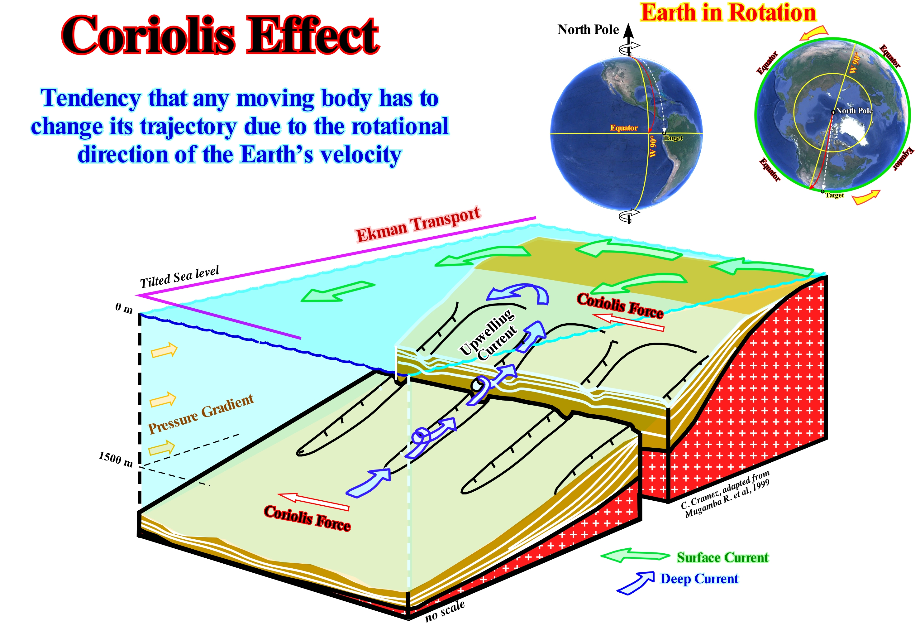
In order to understand the effect of Coriolis ((http://www.geografia.fflch.usp.br/graduacao/apoio/Apoio/Apoio_Elisa/flg0355/filespdf/ For%C%A7a_ de_Coriolis.pdf), we must not forget that: (i) All points on Earth have the same angular velocity and Coriolis force acts on all bodies ; (ii) A point near the equator rotates faster than a point near the north pole ; (iii) Objects on the floor, such as a house, rotate at the same speed as the floor ; (iv) Coriolis force has no effect on fixed objects on the ground ; (v) The speed were is a person and the speed of the point where he is going is very close so that he feels any difference ; (vi) If the velocity, relative to the rotational system (Earth), is zero, the Coriolis force is zero ; (vii) If an object moves southward or northward and is not, firmly, attached to the ground, it maintains its initial velocity to East (east) as it moves ; (viii) If the object travels eastward, it continues to move eastward with the same speed until a force is exerted that changes its speed ; (ix) The objects thrown from the equator to the north maintain the east component of the velocity in the same way as the objects standing on the equator ; (x) When an object distances itself far enough from the equator, it does not move in the same way as the objects located on the equator ; (xi) When an object distances itself enough from the equator, it does not move further eastward with the same velocity as the ground under it ; (xii) If an immobile person throws a ball eastward, the ball moves in a straight line (gravity omitted) ; (xiii) If the person moves to a new position, the East definition for it has changed and the ball does not move further East-West, it seems to have have been deflected out ; (xiv) As the person does not feel the Earth's rotation, the natural conclusion is that a mysterious force took the ball out of its path causing it to move away from the axis of rotation. Thus, in the same way, when a small mass of air begins to move under the effect of the pressure forces, the Coriolis force comes into play and deflects its trajectory to the right, if the movement occurs in the Northern Hemisphere and for the left if it happens in the southern hemisphere. This deviation will continue until the Coriolis force balances the force created by the differences of pressure. In this case, the wind will follow the equal pressure curves and the circulation is geostrophic. In the same way (http://suburbanisations/oceanographic/counter-revolutionaries), as the winds tend to move, more or less, circularly due to the Coriolis effect, that deflects its original movement, when blowing in the ocean surface causes an accumulation of water in the central portion of the large wind belts at the mid-latitudes of each hemisphere. This phenomenon occurs due to the Ekman spiral,* which demonstrates that the resulting average flow of water has a direction perpendicular to that of the wind. This convergence of water to a certain region has two consequences: (i) Elevation of the water level leading to a water hill and (ii) Thickening of the surface layer. The water hills, characteristic of regions of surface water convergence, are small, and rarely exceed 2 meters. However, the response of water to this ocean topography is as it happens on land, i.e., running downhill because of the force of gravity. However, this movement does not occur in a straight line, but is deflected by Coriolis effect, to the right in the Northern Hemisphere and to the left in the Southern Hemisphere. The water movement resulting from the balance between the force of gravity and the deflection caused by the effect of Coriolis, is also called geostrophic current and is one of the main components contributing to the formation of large oceanic surface currents. This block diagram illustrates the formation of submarine valleys by the upwelling currents diverted leftward by Coriolis force. The bottom currents are created by a pressure gradient produced by the surface currents offset by the Ekman motion. The surface currents, created by the wind, manifest in depth, but the speed and direction change due to the Coriolis effect. The Ekman spiral is the configuration of the current movement in depth. Ekman's transport is the movement of the current produced by the wind. The movement of the water in the Ekman spiral has a Coriolis deflection at 90° from the wind direction.
(*) One can consider a certain mass of water as a set of layers. The upper layer driven by the wind carries the layers immediately below. In each of these layers, the velocity is, progressively, decreased by the friction between the water molecules and, due to the Coriolis effect, it changes, also, its direction (right in the Northern Hemisphere and left in the Southern Hemisphere). This change in direction of the current even reaches a certain depth to reverse the direction of the surface. The surface currents move at about 2% of the wind speed that originates them. Such a phenomenon is called the Eckman spiral . It persists until the friction no longer has the strength to push any layer, usually not to exceed a few tens of meters deep. The great importance of this phenomenon lies in the fact that the resulting average flow has a direction perpendicular to that of the wind.
Coriolis Force (Oceanic gyre)....................................................................................................................................................Force de Coriolis
Força de Coriolis / Fuerza de Coriolis / Coriolis-Kraft / 地球自转偏向力 / Кориолисова сила / Forza di Coriolis /
A force that causes the water to move to the right (in the Northern Hemisphere) around the water heaps in the oceans. These water flows are called ocean gyres. The rotation of the Atlantic North is separated into four distinct currents: (A) Equatorial North Current; (B) Gulf Stream, (C) North Atlantic Current and (D) Canary Current. The water heaps where the gyres are formed are formed by the inward movement of the water due to Ekman's transport.
See: « Turbidític Current »
Corrasion.....................................................................................................................................................................................................................................Corrasion
Corrasão / Corrasión, Cincelado / Korrasion, Abschleifen / 侵蚀 / Корразия / Corrasione /
Process of mechanical erosion of the Earth's surface. Corrasion occurs when materials are transported across the Earth's surface by running water, waves, glaciers, wind or gravitational movement downslope. Wear of the small fine particles of a rock in a river or on the seabed by the action of friction (abrasion) and its collapse to the top of the sedimentary substratum. In general, corrasion refers to the erosion and transport of a current. Corrasion involves the abrade of the particles carried by a current due to impact and trituration.
See: « Erosion »
&
« Stream »
&
« Major Storm Wave Base) »
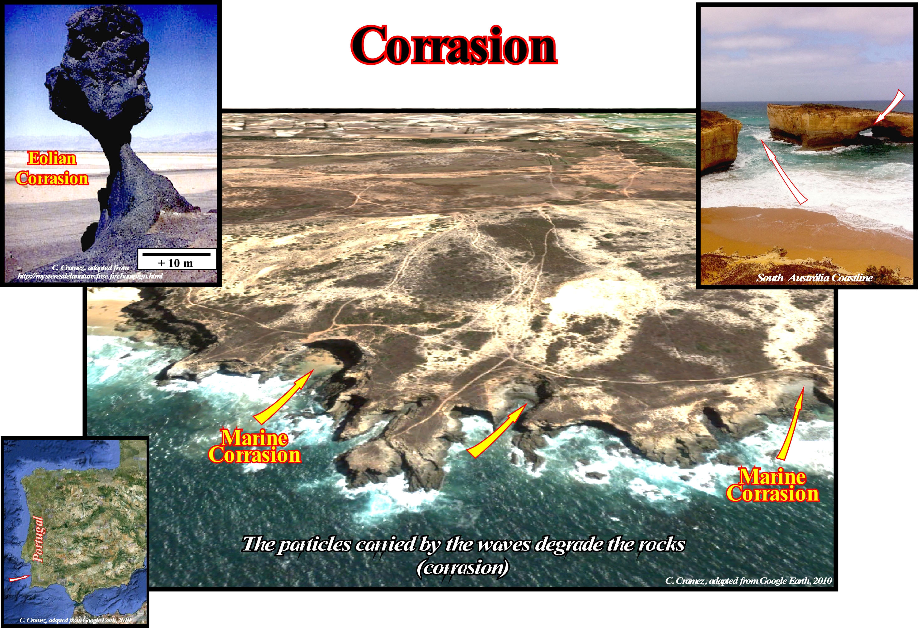
The term corrasion is used to describe the erosive action on the rocks by solid particles carried by wind or water and projected against these rocks. Also, this term applies to the wear of the rocky surfaces at the base of a water-stream, whether a river, sea or glacier by the action of sand, which many geoscientists call abrasion, and the deposition of the detritus uprooted to form slopes, more or less, important, as it happens, for the most part of the base of the cliffs. The term abrasion refers more to the mechanical scraping of a rocky surface by friction between the rocks and the moving particles during their transport by the wind, glaciers, gravity, currents of water or erosion. After friction (in physics, friction is an interaction that opposes the relative movement between the two systems in contact), the moving particles dislodge the less resistant debris from the rock walls, which in part can be dissolved. The intensity of the abrasion depends on the hardness, concentration, speed and mass of the moving particles. It can be said that most of the time the term corrasion refers to erosion by flow and transport, i.e., wear of rock surfaces when water, ice or wind flows over them, produced by the impact or action of crushing of particles that it carries. Mushroom-shaped rocks*, such as those illustrated in the picture, which are part of the most typical landscapes found in the deserts, are the characteristic result of a wind farm. The most typical forms have a narrow peduncle, between the head and the foot, which are much wider. The maximum efficiency of this type of runner is between 1 and 1,50 m, which is the maximum height that can be reached by most grains of sand, which move by jumping on rocky surfaces. The run decreases progressively to the ground as the wind speed decreases as it approaches the ground. In summary: (i) Wind erosion is the action of rock destruction and wind relief ; (ii) Wind action is, especially, noticeable in areas where soils and rocks are not protected by vegetation, i.e., in arid and hot regions and in very cold regions ; (iii) Wind has two ways of eroding: a) By deflation **, it carries the fine elements of the rocks after they have been attacked by mechanical disintegration and b) By corrasion, i.e., attack of the rocks by throwing of the solid elements carried by the wind (especially by sands formed of very hard quartz) ; (iv) Corrasion is the process of physical wear of rocks by impact and/or friction of particles carried by wind, water or ice ; (ii) Abrasion is the process of erosion or erosion of rocks by impact and/or friction/friction of particles or fragments carried by wind, glacial, fluvial, marine, turbidite currents and by the coming and going of waves ; (iii) The surface of the rocks that are attacked by corrasion is shiny with an oily appearance, but frosted under a microscope ; (iv) Rocks composed of strata with hardness other than erosion may produce cavities, holes, grooves and rocks in mushroom ; (v) Corrasion of pebbles (mineral or rock fragment with a diameter greater than 4 mm and smaller than 64 mm) can produce flat faces: tetrahedra with a base and three faces exposed to the winds and more rarely dreikanters*** ; (vi) Deflation is the erosion by the wind with the superficial removal of the finer fragments, often remaining a layer of pebbles and pebbles on the eroded surface ; (vii) Dunes in deserts or beaches are wind deposits ; (viii) Corrasion associated with deflation creates on the rocks shapes and figures typical of desert regions.
(*) Mushroom-shaped rocks, also called rock supports of rock or pedunculated blocks are the rocky shape resulting from the differential erosion caused by the wind. Some rocks, such as granites, when subjected to the action of weathering agents take on particular forms. The pedunculated blocks are thinner at the base than at the top. They look like of mushrooms or giant rain hats. A wind that contains sand is a natural agent of effective corrasion, since the impact of particles at high speed wears out the solid surfaces.
(**) Deflation in geology is wind erosion of loose material from flat areas of dry and not cemented sediments such as those occurring in deserts, dry lake beds, flood plains, and glacial drainage plains. Clay and silt particles are captured by swirls of wind and can be carried for hundreds of kilometers, which are then deposited to form loess deposits. Local areas subject to deflation may result in deflated cavities or basins, which may vary from 3 m in diameter and less than one meter deep to several kilometers in diameter and several hundred meters deep. If an area is eroded to the water table, more deflation is prevented unless the water table is also reduced by evaporation. Some oasis in the Sahara have been formed this way and may be below sea level. The dune deposits are formed on the leeward sides of the basins from which the sand was blown.
(***) A "dreikanter" (German term meaning "three sides") is a pyramid shaped pebble with three sides carved by the action of winds (ventifact).
Correlation.........................................................................................................................................................................................................................Corrélation
Correlação / Correlación / Korrelation / 相关 / Корреляция / Correlazione /
Method of establishing the contemporaneousness (synchronism) of the rocks, sedimentary intervals or geological events of an area, with the rocks, sedimentary intervals or geological events of another area.
See: « Geological Section »
&
« Stratigraphic Cycle »
&
« Systems Tract »
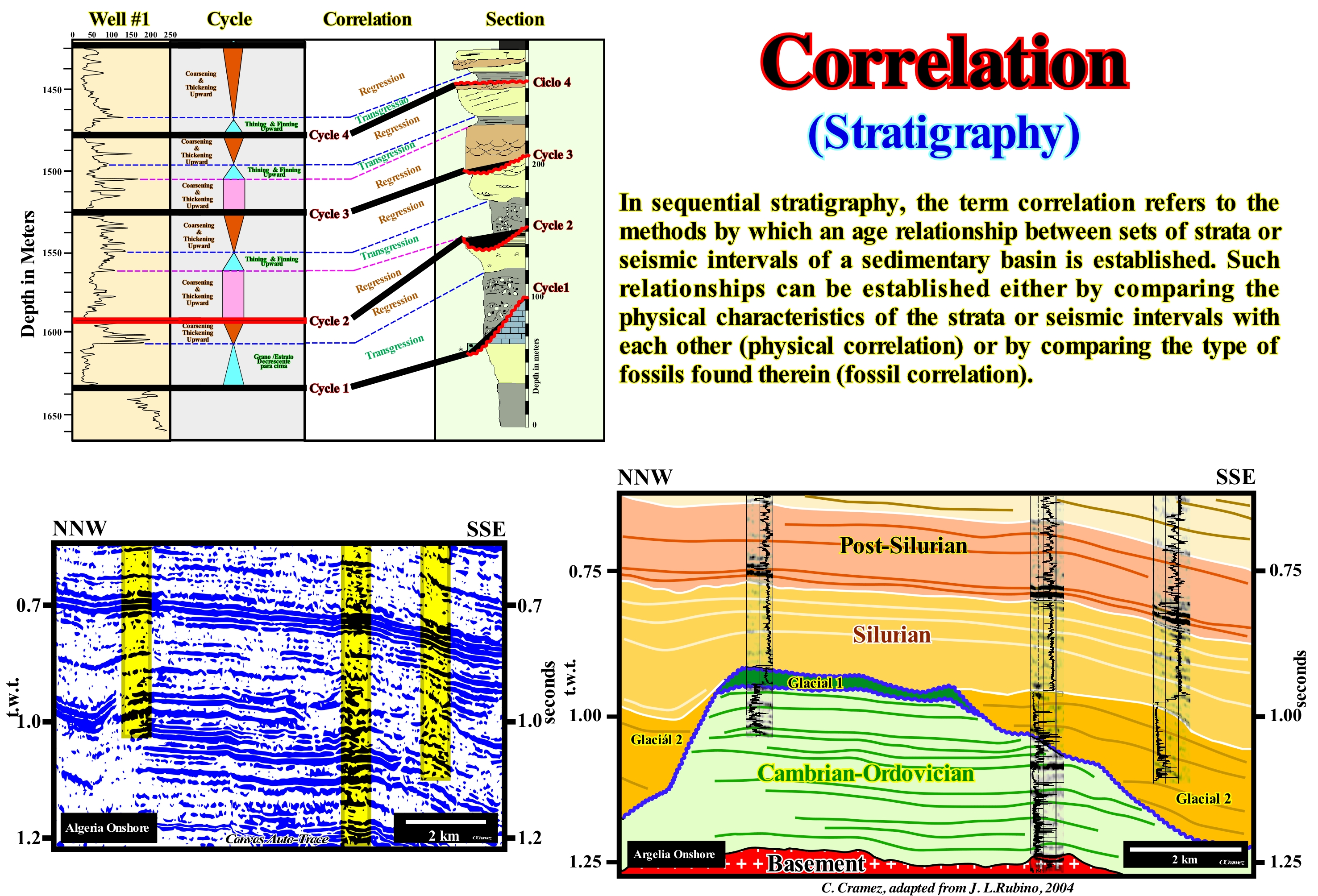
On this tentative geological interpretation of a Canvas auto-trace of an Algeria onshore seismic line, the results of the three petroleum exploration wells, drilled on this line, allow the correlation of the chronostratigraphic lines, the unconformities (erosional surfaces), the cyclicity of the depositional systems and determine the changes of the absolute (eustatic sea) sea level referenced to the Earth's centre). A scientific approach is a well-defined and demanding practice in which a number of things can not be done, such as taking correlations as a cause-and-effect relationship. The argument that if a geological event A is correlated with an event B, then event B is the cause of A, it is, evidently, false since a correlation can be the product of a single coincidence*. The exploration wells allow to calibrate, in geological terms, the tentative geological interpretations. All tentative geological interpretations of a seismic line have to be calibrated (dating of seismic intervals and discordances) and tested (subjected to refutation tests) by the well results. If the result of the wells refutes a tentative interpretation, another tentative interpretation has to be proposed, which in turn has to be tested and so on. The scientific approach proposed by K. Popper is an approach that denies in denying or denying the consequent (of the "modus tollens" type**): (i) Every hypothesis has a consequence ; (ii) If the consequence is not corroborated ; (iii) The hypothesis is falsified. A theory or hypothesis can never be verified, it can just be refuted. Such a refutationist or falsificionist perspective is K. Popper's great criticism of the inductive procedure, characteristic of the verificationist method (however large the number of particular observations, there is no logical justification for its generalization in all cases). In this sense, the interpretation, in geological terms, of a seismic campaign, shot in a certain sedimentary basin, is an attempt to refute the hypotheses or conjectures admitted a priori by the geoscientist about this basin and not a way to advance hypotheses about this basin (what a geoscientist observes in a seismic line depends on his knowledge and expectations). Hence, it is said in petroleum geology that a geoscientist learn much more when an exploration well is dry (refutation of a hypothesis) than when it encountered hydrocarbons (corroboration of a hypothesis), inasmuch as when the well is dry, he is obliged to advance a new hypothesis or conjecture that will probably be closer to reality. In regional seismic lines, chronostratigraphy and cyclicity can be easily recognized using: (i) The geological context of the area ; (ii) The identification of unconformities (erosional surfaces, induced by relative sea level falls) that limit stratigraphic cycles ; (iii) An adequate hierarchical level interpretation, i.e., what type of stratigraphic cycles should be proposed in the interpretation (sequence cycles, continental encroachment sub-cycles or continental encroachment cycle) and (iv) The relative sea level curve proposed by Vail (the coastal onlap curve). Then, the chronostratigraphy and the cyclicity proposed on the tentative interpretation have to be tested by the results of the wells and the sequential analysis of the electrical logs, which can corroborate or refute the interpretation, but can never verify it, i.e., that it corresponds to reality. In science, refutation, validation and verification are not synonymous. On this tentative interpretation, the seismic intervals interpreted as glacial deposits of the Late Ordovician (glacial 1 and 2) have very different internal configurations than the marine deposits of Cambrian / Ordovician. The former are well marked and parallel, while the latter are chaotic (the continuity of the reflectors is non-existent). Glacial erosional surfaces (unconformities) limiting glacial cycles appear here as angular unconformities, although they have not been tectonically enhanced. The boundaries between the marine intervals of the Silurian and post-Silurian are typical unconformities induced mainly by eustasy.
(*) Climate warming is the direct consequence of the decline of the pirate population as evidenced by the graph showing the negative correlation between the pirate population and the average temperature on Earth "(F. Meynard, 2011- La Légende de l'Effet de Serre, Editions Favre SA, Lausanne, ISBN: 978-2-8289-1158-4.
(**) In proposition logic, modus tollens or modus tollendo tollens (Latin for "mode that denies by denying" or denying the consequent) is a valid argument form and a rule of inference. It is an application of the general truth that if a statement is true, then so is its contra-positive.
Correlative Conformity...............................................................................................................................Conformité corrélative
Conformidade correlativa / Conformidad correlativa / Korrelative Übereinstimmung / 相关整合 / Коррелятивное согласное напластование / Conformità correlabili, Conformità correlativi /
A surface that correlates upstream with an unconformity. This correlation is very important, since it allows to date the unconformity by dating the area where there is continuity of sedimentation or where the hiatus is smaller. In a sequence-cycle, the area in question lies at the base of the sediments deposited during a relative sea level fall (lower continental slope or abyssal plain). Synonym of correlative paraconformity
See: « Unconformity »
&
« Sequence Boundary »
&
« Concordant »
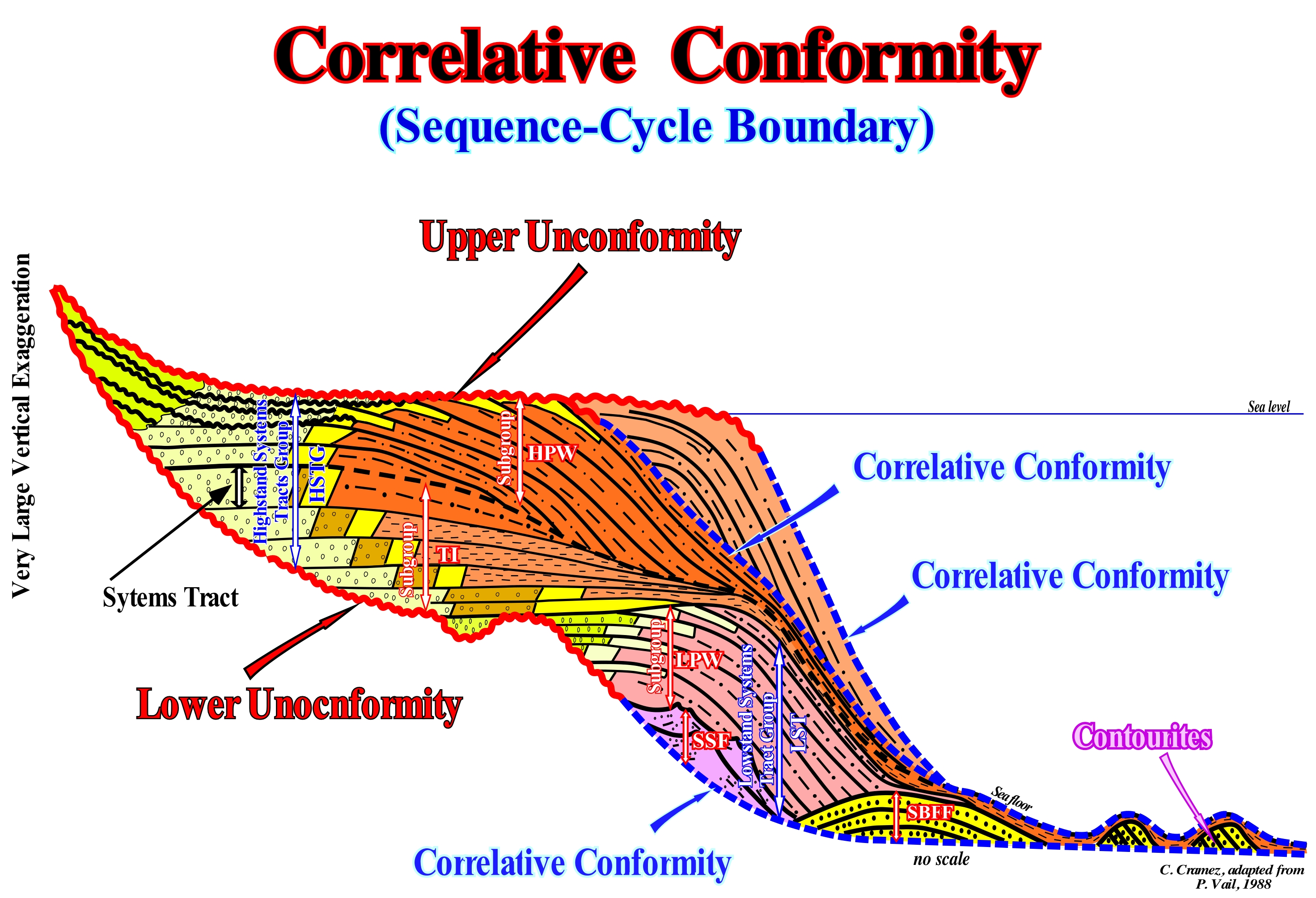
As shown in this figure, the unconformities are erosional surfaces, induced by significant relative sea level falls, which limit the stratigraphic cycles and, in particular, the sequence-cycles, which can be considered as the building blocks of sequential stratigraphy. When the unconformities are not tectonically enhanced, they are just recognized around the basin edge, where erosion is significant. It is in the upper part of the continental slope, near the continental edge (whether the basin has a continental shelf or not), that submarine canyons are developed and where the coastal onlaps of the overlapping cycle-sequence, which fossilize the upper unconformity of the sequence-cycles are more evident. Landward of the basin edge, the unconformities correspond, practically, to conform or paraconformities stratigraphic discontinuities. There is no difference in attitude between the overlapping intervals, but there is a hiatus due to the absence of significant deposition between them. However, many geoscientists use, in a somewhat abusive way, the term correlative conformity. Conformity is a concordant stratigraphic discontinuity, since there is continuity between successive intervals. Under these conditions, i.e., landward of the basin edge, the identification of a unconformity is dependent on the recognition of incised valleys fillings allowing to recognize the erosion induced by the fall of the relative sea level fall (local sea level referenced to sea floor or to the base of the sediments and which is the result of the combined action of absolute or eustatic sea level and tectonics). Seaward of the basin edge, in deep environments, the erosion associated with a significant relative sea level fall, practically, does not exist. Therefore, at the base of the continental slope and the abyssal plain, the limit of a sequence-cycle, which upstream is an unconformity, is a paraconformity or correlative conformity in deep-water (in terms of chronostratigraphy). In sequential stratigraphy, landward of the basin edge, i.e., on the continental shelf or the coastal plain, function of geological conditions, the downlap surfaces do not fossilize the unconformities. Only, in very deep-water, that is to say, in the distal parts of a sedimentary basin, is that, for instance, the downlap surface of the highstand prograding wedge (LPW) or the downlap surface of the lowstand prograding wedge (LPW) may, eventually, fossilize the lower boundary of a sequence-cycle. Just the toplaps (no deposition or by erosion) of the highstand prograding wedge (upper subgroup of the highstand systems tracts group) may suggest an unconformity and characterize a stratigraphic cycle boundary. The toplaps of the lowstand prograding wedge (upper subgroup of the lowstand systems tracts group, LSTG) emphasize a flooding surface, generally, the first transgressive surface (induced by accelerating marine ingression, i.e., more important than previous marine ingression). In this sketch, which is, vertically, exaggerated, it is interesting to note that the internal configuration of the submarine basin floor fans (SBFF) is, more or less, parallel subhorizontal. On the contrary, the configuration of the contourites, which are nothing other than the re-deposition of the sediments pull out of the submarine basin floor fans by the contour currents, is oblique parallel with a dip that can reach 15° - 20° (what is corroborated by the exploration wells, which also show the absence of a shaly matrix and an abnormal amount of heavy minerals). On this subject, it is good to remember that in Geology there are several types of discontinuities (contact between sedimentary intervals with different facies or densities or separated by a hiatus): (1) Stratigraphic ; 2- Sedimentary ; 3- Lithological ; 4- Tectonic, etc. Within the lithological discontinuities can be differentiated: (i) Concordant Discontinuities, when there is continuity between successive intervals ; (ii) Paraconform Discontinuities or Paraconformities, when there is no difference of attitude between overlapping intervals, but there is a hiatus due to absence of deposition ; (iii) Nonconform Discontinuities or Nonconformities, when there is a contact between a sedimentary interval and an older igneous body ; (iv) Disconform Discontinuities or Disconformities, when the layers of the intervals are parallel on both sides of the contact surface which is not in accordance with regional bedding ; (v) Discordant Disconformities or Unconformities when the two intervals are are separated by an erosional surface (relative sea level fall) ; (vi) Reinforced Discordant Discontinuities or Tectonically Enhanced Unconformities, when the sediments of the interval underlying the unconformity were deformed by tectonics; (vii) Intrusive Discontinuities, when an igneous body crosses a sedimentary series; (viii) Mechanics Discontinuities, when they are induced by failures, etc.

