
Thixotrophy (Sediments)............................................................................................................................................................................Thixotrophie
Tixotrofia / Tixotropia / Tixotropie / 触变性 / Тиксотропия / Tissotropia /
Property of certain colloidal* substances, such as clay, which lose consistency or change from a gel to a liquid when agitated, but whose consistency increases when at rest. Property of a loose sediment and gorged with water to become, suddenly, liquid under the effect of a mechanical shock which puts the particles in suspension in the water.
See: « Clay »
&
« Soil »
&
« Compaction »
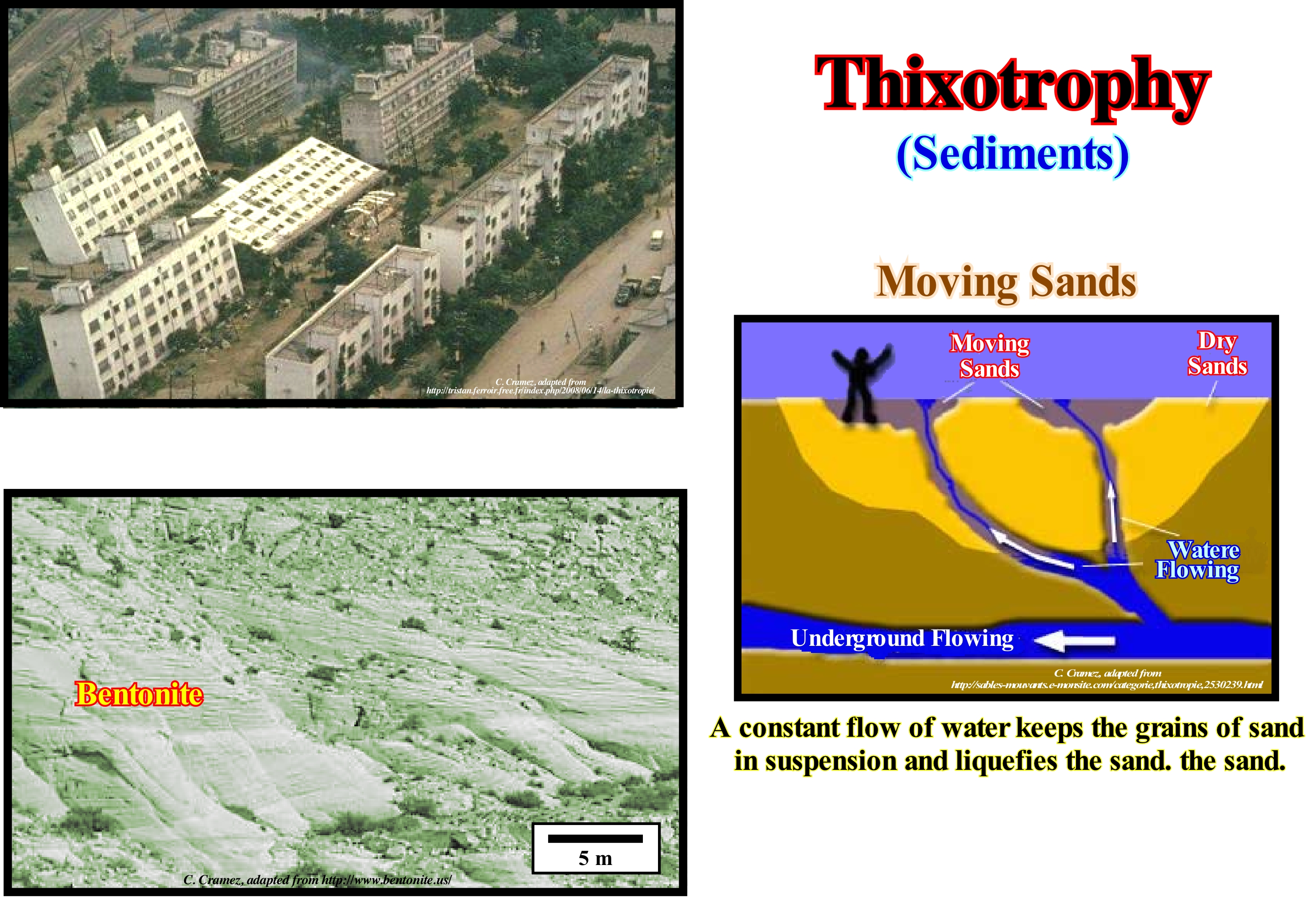
In nature, there are certain mixtures that are thixotrophic. Certain types of clay, for example, are thixotrophic. The shales which are formed of clay, contain solid particles and water molecules, which are contained in a relatively rigid structure. Often, certain dwellings are built on rocks without major problems. However, when an earthquake occurs, for example, even of weak amplitude, the shales, due to agitation, become thixotrophic and the structure of the particle decomposes and disappear like a house of cards. The water molecules are free to move and provide the lubrication, which turns the shales into a liquid state and, in most cases, the houses fall. Ordinary mud, sometimes, also acts this way. If a person is careful to put his feet on the hard, dry surface of the mud, he can cross it without problem. But if she twists her foot as she walks, or if she leans very tightly, her shoes or boots are buried in a liquefied mud. In geology, observed behaviour, for example in thixotrophic shales can have dramatic consequences in the case of earthquakes, as was the case in Niigata, illustrated in this figure. Such behaviour is also used in the mud of oil exploration wells to facilitate drilling work. The moving sands correspond to a natural phenomenon, which most people have seen on film or television, work by the same principle of thixotrophic. However, unlike what happens in the movies, nobody disappears into a moving sand. The formation of moving sand occurs when fine and loose sand particles are subjected to an upward flow of water, which fills the spaces between the grains, reducing the friction between them, which makes the sand behave like a liquid. The viscosity of the moving sand increases with abrupt movements (thixotrophy). So if you get into moving sand you should move slowly and try to float, which is very easy, since the density of a moving sand is much greater than that of salt water.
(*) Systems in which one or more components have at least one of their dimensions within the range of 1nm to 1μm, defined as 1 millionth of a meter (1 × 10⁻⁶ m) and equivalent to one-thousandth of the millimetre.
Time of Levelling (Estuary)................................................................................................................................Temps de nivellement (Estuaire)
Tempo de nivelamento / Tiempo de nivelamiento (estuario) / Zeitabgleich (Mündung) / 时间平(河口) / Время выравнивания (устье) / Tempo di livellamento (estuario) /
Time required for an estuary to complete its cycle. In its simplest form, the leveling time or time of eveling (tl) can be defined as the time required to drain a volume V through an entrance A with a current velocity v, or the time required to replace the volume of water Vf at the rate of flow through the estuary given by the discharge rate of the river R: tf = Vf / R.
See: « Tide »
&
« Estuary »
&
« Mouth of a River »
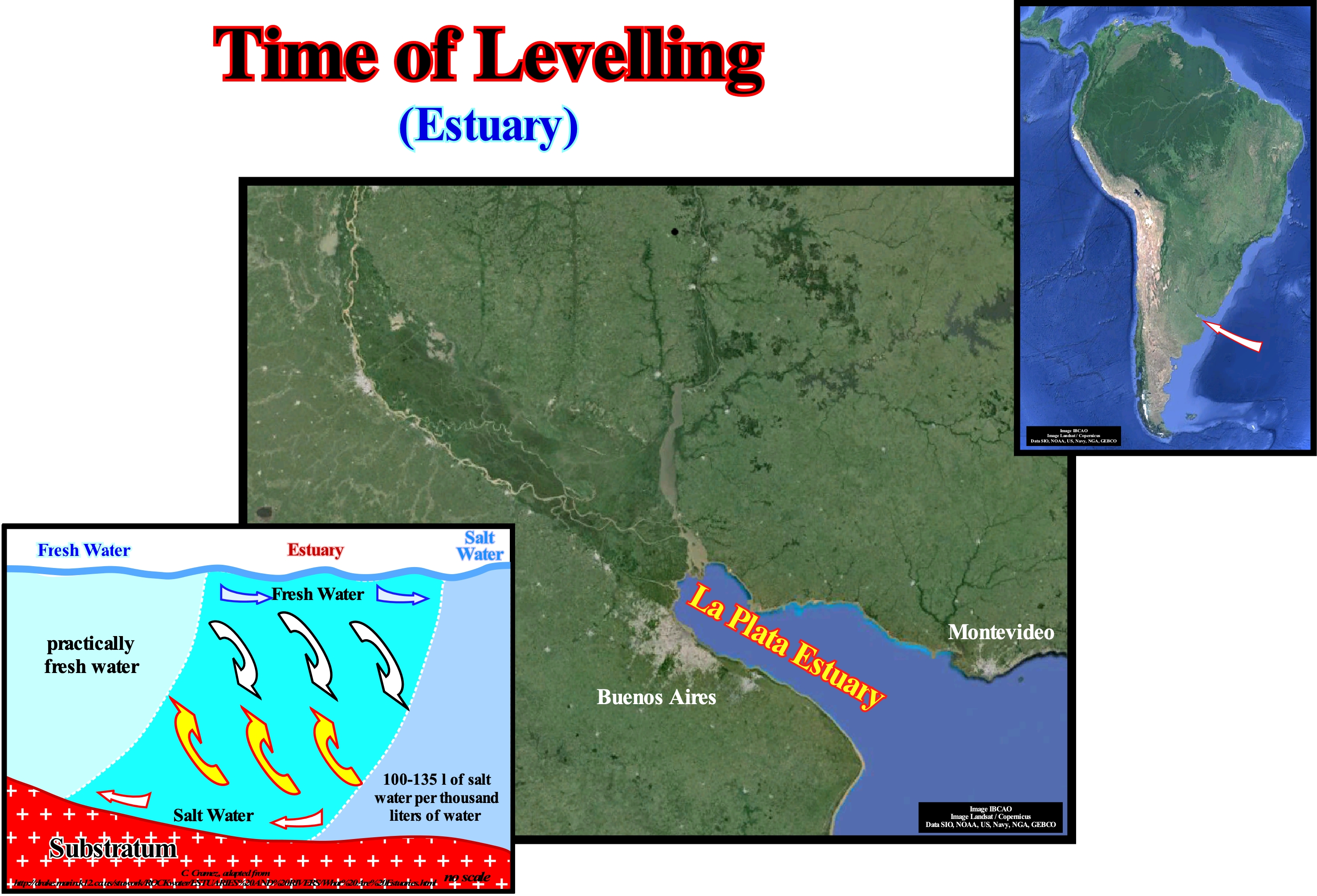
Based on the physical processes responsible for their formation, the vast majority of estuaries can be grouped into four geomorphological categories: (1) Sea level rise ; (2) Sand and sandbank movement ; (3) Glacial processes, and (4) Tectonic processes. Estuaries created by the flooding of the river valleys and estuaries of the coastal plain were formed by the rise in sea level during the last interglacial period (about 15,000 years ago), which flooded the river valleys that returned to their original position when sea level got down. The movement of sand and formation of barrier bars along the shoreline can block water-bodies and form lagoons or estuaries, as is the case of Laguna Madre, Texas. In colder climates, glaciers cut deep valleys into the ground. When glaciers thin, this is when they advance less, during periods of warmer weather, coastal waters fill the valley to form fjord-type estuaries, which are common in New England and Alaska. Finally, earthquakes and faults can cause rapid sinking of coastal areas below sea level and form estuaries produced by tectonics, with, for example, San Francisco Bay, California. The characteristics of water circulation can also be used to classify the different types of estuaries. The movement of water in estuaries is regulated by the ebb and flow of tides, the differences in water and wind density. Most estuaries are influenced by lunar tides, once a day (diurnal) or twice a day (semidiurne). The rise and fall of the water results in a flow of liquid out of the estuary. The estuarine circulation, usually, refers to the movement of residual water (short term) after the removal of tidal effects. The evolution of fresh and salt water within an estuary is shown in the geological sketch on the lower corner of this figure. Such geological model can be applied to the La Plata river estuary between Argentina and Uruguay.
Tidal Channel (Tidal creek)......................................................................................................................................................Chenal de marée
Canal de maré / Canal de marea / Priel / 潮汐通道 / Приливно-отливный канал / Canale di marea /
Channel used by tidal currents, which extends from the ocean to the tidal marsh or tidal plain.
See: « Tide »
&
« Channel »
&
« Swell (sea) »
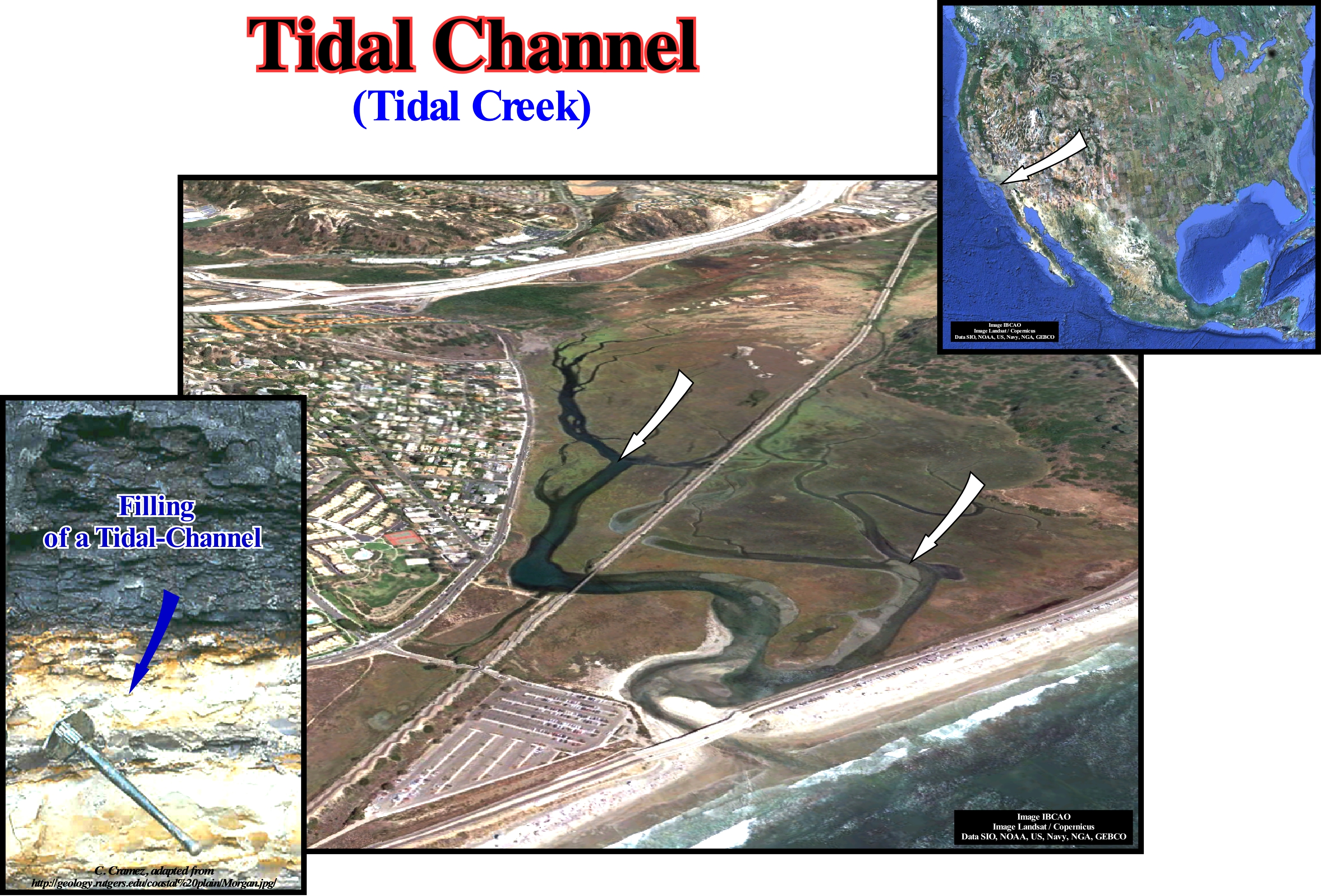
It is when the Moon, Sun, and Earth are aligned, due to the action of the terrestrial tides*, that such an arrangement causes, two convexities form on the Earth' surface (protuberances). One of these convexities is on the side of the Sun and the other in the antipodal position, i.e., on the back of the Earth. As the Earth rotates, over the tidal bulges of the Earth's tides, two high-tides and two low-tides are created per day, relatively, to the mean sea level**. When the Moon, the Sun, and the Earth are, perfectly, aligned (in the new moon and full moon phases) the highest high-tide occurs. When the Moon is, perfectly, out of alignment (in the first and last quarter), the lowest tide occurs (neap tide). The deposits induced by variations in tidal currents correspond, of course, to a pair of sedimentary bodies (tide package). Such a package of tide is formed during a fortnight, i.e., between two successive spring-tides. This translates to a progressive decrease in tidal current (between the spring tide and neap tide), followed by an increase in current intensity (between neap tide and next tide). Since this takes place over two weeks and there are two high-tides per day, a tide package comprises a series of layers arranged in groups of 28 (14 days x 2 tides per day). The material transported along the tidal channels deposits near the mouth forming tide-plains or tidal flats. Three types of tidal plains can be differentiated: (i) Supratidal plain (schorre), when located above the means high water level (shaly facies) ; (ii) Intratidal Plain, which is under water twice a day (clay-sandy facies) and (iii) Infratidal Plain, which is always under water and has a sandy facies. When the tidal channels cross barrier islands or sandbanks, they transport the open ocean water and sand (which can be deposited in or out of the channels) to the lagoons. The sediments are transported to the lagoons during high-tide and can build a small delta (flood delta) upstream of the canal mouth. During the descent of the tide, a delta (ebb delta) may also form upstream of the mouth of the tidal channel.
(*) The tides of the solid part of the Earth are not directly accessible, but certain phenomena manifest the elastic deformation which it undergoes under the action of the force that generates the tides and extends it a few decimetres in the direction of the star and the opposite direction. A similar deformation affects, conversely, the disturbing star. A similar phenomenon is observed in galaxies (set of stars bound by gravity ranging between 10 x 109 to a dwarf galaxy and 10,000 x 1012 to a giant galaxy) when two of them are close enough to each other.
(**) The mean sea level is, usually, obtain by from hourly observations made over a period of about 30 years ( period recommended by the World Meteorological Organization, i.e., by the WMO). As a rise in sea level is perhaps the most familiar effect of climate change and probably the one with more consequently, it is important to always specify what sea level (eustatic, relative, mean, high-tide, etc.) is concerned and how it was calculated.
Tidal Current..........................................................................................................................................................................................Courant de marée
Corrente de maré / Corriente de marea / Strömtide / 潮流 / Приливные течения / Correnti di marea /
One of the horizontal currents resulting from sea level rise and fall (vertical movement) caused by tides, which has a very significant effect on the flow of water into and out of the bays and seaports and which can be used as an energy source.
See: « Tide »
&
« Spring Tide »
&
« Relative Sea Level Change »
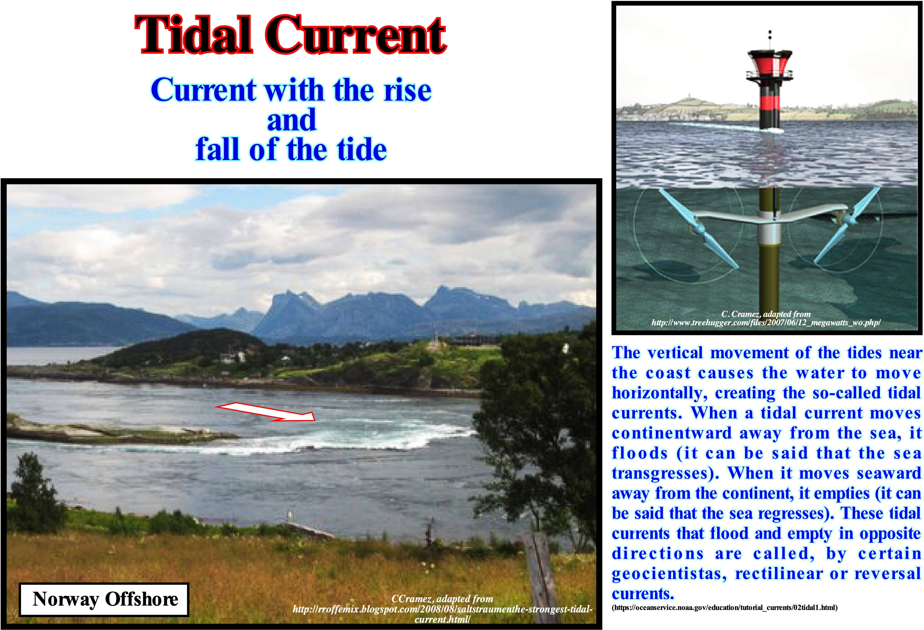
Imagine a long, narrow bay. Considering two points. Point A, near the entrance to the bay, near the sea and point B, upstream, near the land. Imagine that we are at low-tide and that there are no tidal currents in the bay. The tide is rising and arrives at 11am at point A. A person at point B, sees the water level rise until 1pm (high-tide time in B). This means that there is a difference of two hours between the high-tide in A and B. Let's now see what happens throughout the tide cycle. When the tide goes up, the water entering the bay must, slowly, surpass the water to advance, so that this change is not, immediately, observed at point B (whatever the water velocity, it will always take some time to travel a certain distance because of its viscosity). The tidal currents in the bay are now in the flood or upstream phase. When high-tide is reached at point A, the tide is parked at this location, but there is still a flood in the bay because the high-tide has not yet reached the entire bay. A little later, midway between A and B, the flood hits the high tide, but there is still a runoff because the high-tide has not yet hit the B point. Finally, when high-tide is reached across the bay, the current stops. It is often said the slack water (moment immediately before inversion to the inversion of the tidal currents) is half an hour before and after the inversion of the tide. However, in reality, the tidal wave does not exist. It is only an impression induced by the low speed of the current. Although the tide begins to leave the entrance of the bay, the current in the bay, practically, stops. The water level, once again, changes first at the entrance to the bay, while the water inside may still be at high tide. In some areas, tidal currents are so strong that boats must wait for spreading to be able to navigate.
Tidal Delta...............................................................................................................................................................................................................Delta de marée
Delta de maré / Delta de marea / Flutdelta / 潮汐三角洲 / Приливно-отливная дельта / Delta di marea /
Delta formed at lagoon inlets, barrier beaches or barrier bars due to the circulation of tidal currents. There are two types of tidal delta: (i) Flow Delta, which forms on the inner side (facing the lagoon) and (ii) Ebb Delta, which forms on the outer side (sea side).
See: « Delta »
&
« Flow Delta »
&
« Foreset Bed (delta) »

Geoscientists, like Galloway, taking into account the dominant forces in the formation process, classified the deltas into three main types: (i) River-Dominated by the terrigeneous influx of water-courses ; (ii) Wave-Dominated by sea-waves and (iii) Tidal-Dominated by tidal activity and tidal currents. The river-dominated deltas are cut and have many distributaries with marshes, bays or tidal flats in the interdistributary regions. They occur when the water-courses and terrigeneous influx are strong and other effects, such as rework by waves or tides, are smaller. These deltas tend to form large deltaic lobes in the sea, which may have little more than the distributary channel and have a natural marginal dykes (levees) exposed above sea level. Due to their resemblance to a bird's foot, they are referred, often, to in the geological literature as a "bird's foot deltas", as is the case of the deltas of the Mississippi River delta building. When much of the floodplain between the distributary channels is exposed above sea level, the delta displays lobed form. Wave-dominated deltas are more regular, exhibiting curved and arched shapes with beach ridges are frequent, such as in the deltas forming the Nile or Niger delta buildings, where the surf of the waves causes a mixture of fresh water and salt water that the flow loses, immediately, its energy and deposits all its load along the coast. Tidal-dominated deltas occur in areas with high-tides or high speeds of tidal-currents. Such deltas resemble, often, an estuarine bay filled with many elongated islands parallel to the main tidal current and perpendicular to the shoreline, such as the deltas forming the Brahmaputra delta and Mahakam delta buildings. The deltas of the Mississippi River and Yukon River delta buildings are typical of the river-dominated deltas, i.e., those dominated by the terrigeneous influx carried by the water-rivers. The deltas of the Senegal river and San Francisco delta buildings are dominated mainly by sea-wave activities, while those of the Fly River delta building are dominated by the tides and tidal-currents. In this example (Portuguese coast), at present-time, a delta created by the current of a river is recognized. However, before the coastal drifting (longitudinal current that forms on the beaches, in the surfing zone hit by the swash currents, as a consequence of the accumulation of water and sedimentary particles by the uprush and backwash currents when the surf is oblique to the shoreline) had constructed the barrier of the ria (barrier-bar), the deposited material was, largely, dominated and controlled by tidal-currents. As the littoral current (longshore drift, offshore drift) constructed the barrier-bar, the effect of tidal-currents was, less and less, predominant and the ebb delta (formed on the outer side, that is, facing the sea from lagoon openings or tidal coves) was, little by little, eroded. From the moment the barrier-bar isolated, completely, the estuary, the ebb delta was, totally, eroded and the action of the tidal current became insignificant. From that moment, a river delta began to be constructed, that to a large extent, remobilized and replaced the flow delta. The ancient tidal delta became a river-delta. The presence of tidal deltas, as well as, their shape and dimensions, depends, fundamentally, on three main factors: (i) Sedimentation ; (ii) Wave Interaction and Tidal Processes and (iii) Tidal Flow during the tidal-cycle. At present, as probably before the construction of the barrier-bar, the direction of the sea-waves is oblique to the shoreline. In this case, when the waves break, an uprush current (towards the beach) is produced, which moves perpendicularly to the crest of the sea-waves. Since the uprush current wave loses energy, it reverses its direction, and begins to flow seaward (backwash current) following of the great slope of the sea floor. The result is that the interaction of the swash currents (uprush and backwash) induces the formation of a zigzag current or littoral drifting that will deposit the transported sedimentary particles in the areas of lower energy), constructing a barrier-bar so that the shoreline is as straight as possible. In addition to the tidal deltas, other types of delta that can be considered in relation to the dynamics of the delta and the shape of the of the emerging plain are: (i) Abandoned deltas or subdeltas ; (ii) Alluvial deltas ; (iii) Arctic deltas ; (iv) Arcuated deltas ; (v) Atrophied delta ; (vi) Complex or polymorphic deltas ; (vii) Cuspate deltas ; (viii) Finger delta ; (ix) Flood delta ; (x) Closed Delta; (xi) Gilbert-type delta ; (xii) Lava deltas ; (xiii) Lobated deltas ; (xiv) Submarine deltas ; (xv) Storm delta ; (xvi) Wave Deltas ; (xvii) Ebb deltas.
Tidal Delta Plain (Lower delta, lower delta plain).............Plaine deltaïque supérieure (Sommet du delta)
Planície deltaica superior / Planicie deltaica superior / Oberdelta / 上三角洲平原 / Верхняя дельтовая равнина / Delta pianura superiore /
Area upstream of the delta plain, located above the high tide line and extending from the apex of the delta to the zone of tides influence. The average slope of this zone is about 5°. The upper delta plain is above the salt water intrusion level and is unaffected by marine processes. It is characterized by a predominance of forms induced by fluvial processes. It is permanently emerged and subject to flooding. According to certain geoscientists, the rising tide has just an ecological influence, in the distribution of the amphibian ecosystems of the channels margins and banks.
See: « Flooding Delta Plain »
Tidal Deltas.........................................................................................................................................................................Deltas de marée (Deltas de flôt)
Deltas de maré / Deltas de marea / Geneigte Schichtein / 潮流三角洲 / Приливно-отливные дельты / Deltas di marea /
Small, more or less, symmetrical underwater deltas formed at the openings of the lagoons or at the straits due to the circulation of the tidal currents. The delta that forms on the inner side is the flow delta and what forms on the outer side is the ebb delta.
See: « Delta »
&
« Flow Delta »
&
« Ebb Delta »
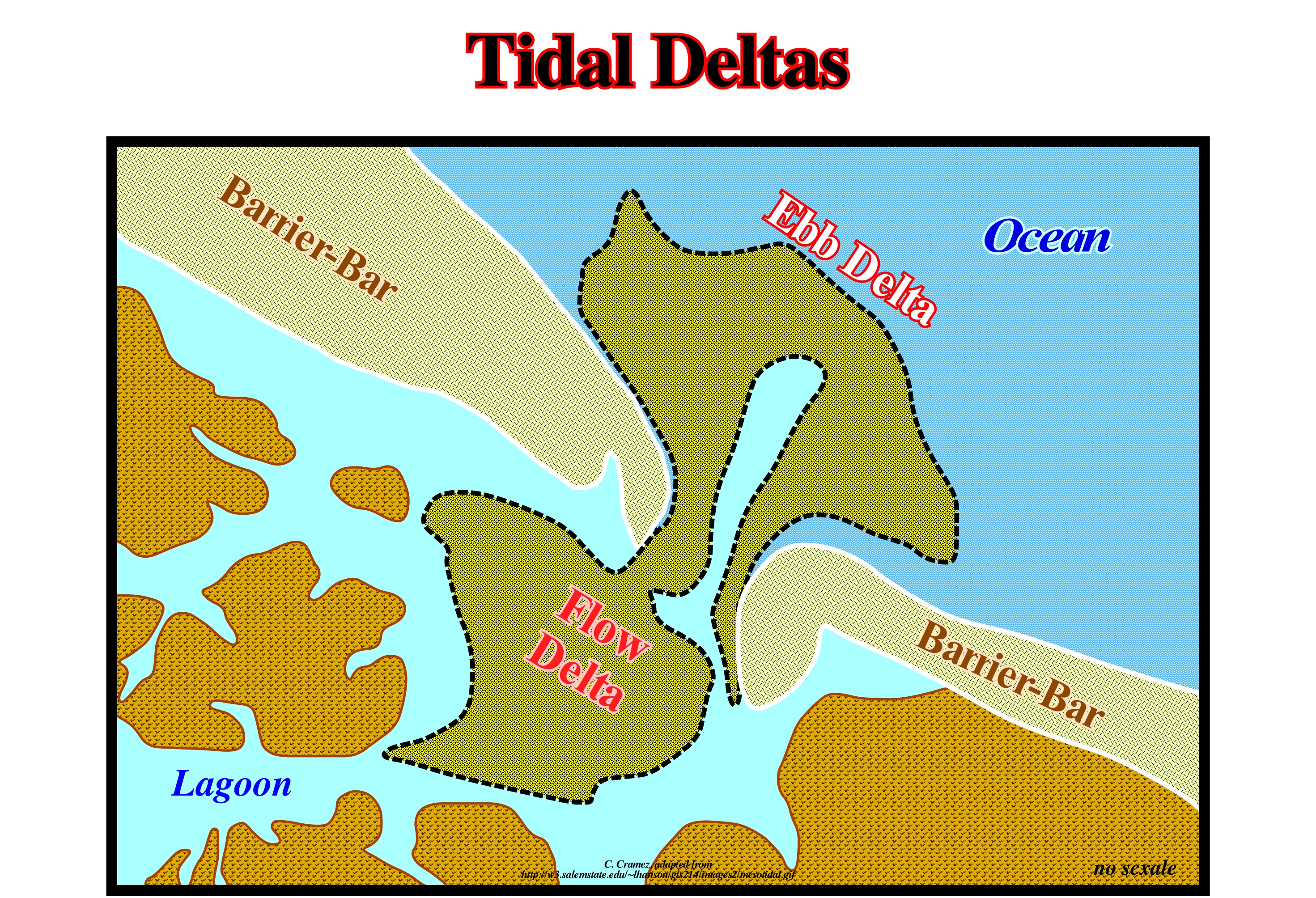
Sedimentary bodies, sometimes of significant size, which are deposited either on the inner side or on the outside of the tidal inlets, are called tidal-deltas, because if they appear on a small scale with the deltas deposited at the mouth of rivers. The presence of tidal-deltas, as well as their shape and dimensions, depends, fundamentally, on three factors: (i) Terrigeneous Influx ; (ii) Interaction of Waves and Tidal Processes and (iii) Tidal Flow. Tidal-deltas are excellent reservoirs of substitute sandy material, i.e., the sediments, in general, the sands of these deltas are, often, used to reestablish the size of the beaches, in particular, the beaches subject to the erosion of the littoral currents and, above all, the beach drift current, also known as the zigzag current (longitudinal current, which forms on the beaches, in the surfing zone hit by the swash currents, as a consequence of accumulation of water and sediments by the uprush and backwash currents, when the breaking is oblique to the shoreline). The tidal delta located on the inner side of the inlet is called flow delta and the located on the outer side (facing the sea) is called ebb delta. The former may be fan-shaped (generally in groups) when the difference between tides is less than 1.5 m or a horseshoe shape (opening seaward) when the difference between tides is greater than 1,5 m. Flood deltas, which form on the open sea side, are subject to the interaction between sea-waves and tidal processes. Its geometry and extension depends on the preponderant energy. If the wave energy is preponderant, the deltas are smaller and distribute along the barrier-bars on either side of the tidal inlet. If the energy of the tides is preponderant, they are large, with several kilometers and distributed perpendicularly to the inlet on either side of the entrance. If none of the energies is preponderant, the deltas on the outside are rectilinear and branched in the inner part.
Tidal Wave (Tsunami)...................................................................................................................................................................................Raz-de-marée*
Maremoto (raz-de-maré) / Maremoto / Grundwelle, Flutwelle / 海震 / Внезапный сильный прилив / Maremoto /
High wave that moves at great speed and catastrophically reaches the coast. The same Harbour Wave, Tidal Wave or Seismic Sea Wave although the meaning varies according the geoscientists.
See: « Tsunami »
&
« Swell (sea) »
&
« Storm Delta »
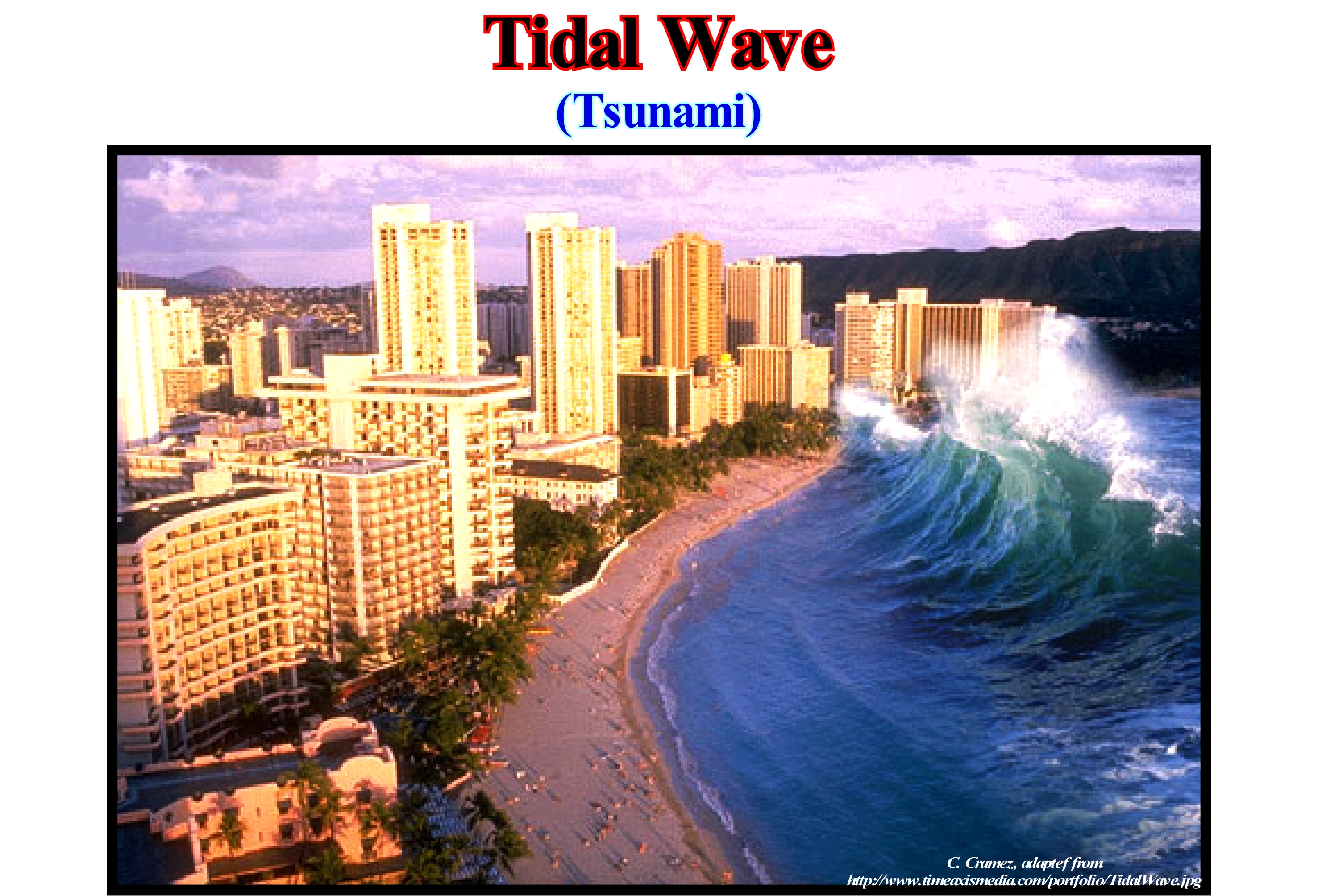
A tidal wave, tsunami is a series of sea-waves caused by the displacement of a large volume of a water-body, such as an ocean or a large lake. Tsunamis occur, very often, in Japan, where about 195 such events have been reported in recent decades. Due to the immense volumes of water and energy involved, tsunamis can devastate coastal regions. Accidents can occur, as waves move faster than humans. Earthquakes, volcanic eruptions and other submarine explosions, landslides and other mass movements, impacts, and other disturbances above or below the water level have the potential to generate a tsunami. A tsunami can be generated when the limits of converging or destructive tectonic plates, abruptly, move and displace, vertically, the overlying water. It is very, unlikely, that these motions can form on boundaries of divergent or transforming plates, since these boundaries do not disturb the vertical displacement of the water column. Earthquakes related to B-type subduction zones generate the majority of tsunamis. Tsunamis or tide-waves have a small amplitude (wave height) and a very long wavelength (often hundreds of kilometers in length) on deep ocean. Therefore, usually, they pass unnoticed in the sea (open sea), forming only a slight ripple, usually, around 300 millimeters above the normal sea surface. They grow in height when they reach shallower water-depths, by a wave-blistering process. A tsunami can occur in any tidal state. Even at low-tide it can flood coastal areas. In 1950, the hypothesis was advanced that large tsunamis could be caused by landslides, volcanic eruptions (e.g., Santorini and Krakatoa) and impacts on the oceans, etc. All these phenomena. quickly, move large volumes of water at a rate faster than water can absorb.
(*) According to Charles le Coeur, "raz de marée" is an obsolete term used to describe all marine accidents that "made the sea overflowing", referring to the effect rather than the cause of the phenomenon. So, the tsunamis, but also a series of big waves, or a storm wave are "raz de marée".
Tide..........................................................................................................................................................................................................................................................................Marée
Maré / Marea / Gezeit, Flut, Tide / 潮 / Морской прилив и отлив / Marea /
Oscillation wave with weak amplitude and great wavelength that forms on the high seas, due to the attraction of the Moon and the Sun on sea surface.
See: « Conjunction (astronomy) »
&
« Moon »
&
« Swell (sea) »
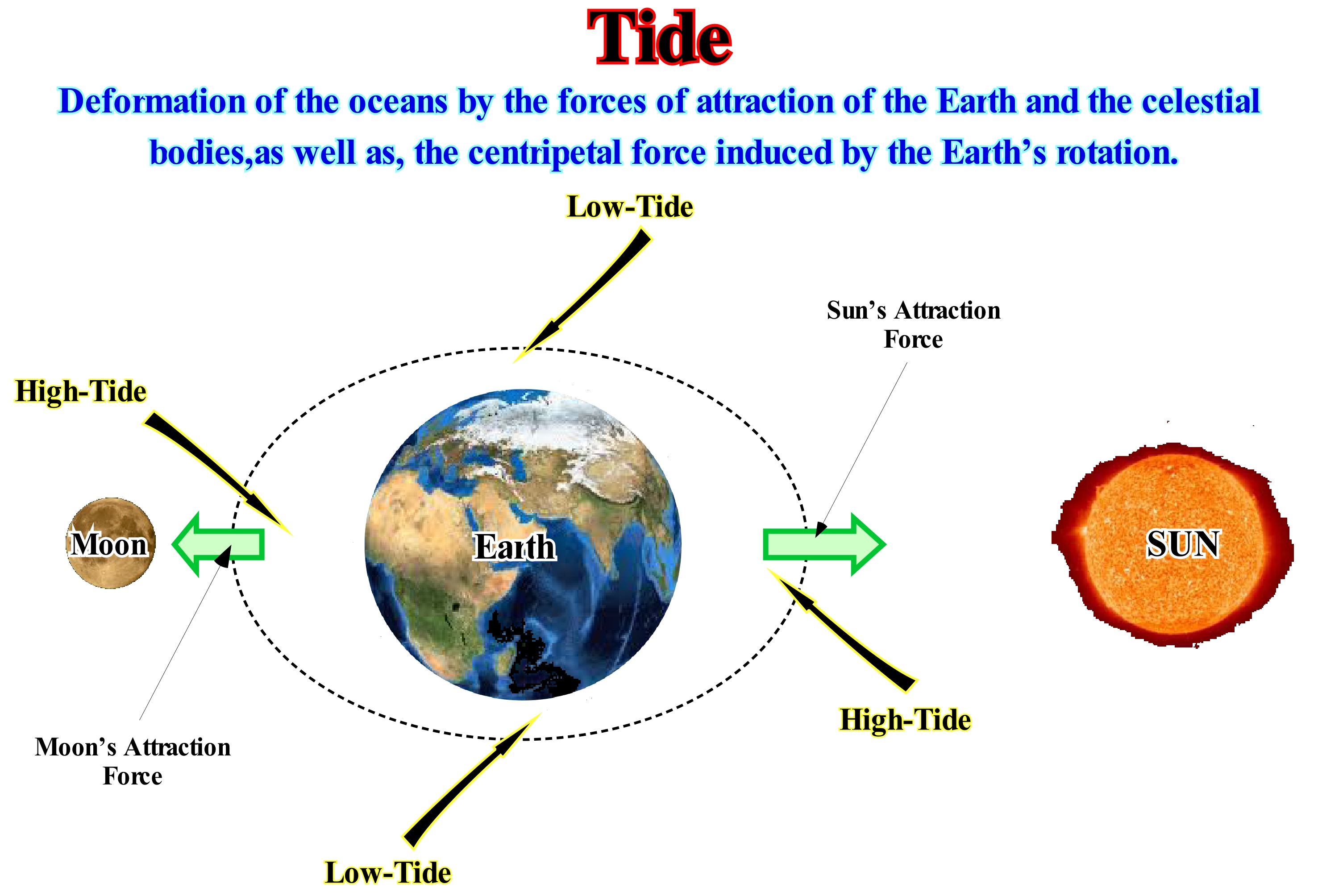
In an ideal terrestrial gravitational field, that is, without interference, the Earth's surface waters would suffer an identical acceleration towards the centre of terrestrial mass, being thus in an isopotential situation. But due to the existence of bodies with significant gravitational fields interfering with that of Earth (Moon and Sun), they cause accelerations that act on the Earth mass with different intensities. As the gravitational fields act with an intensity inversely proportional to the square of the distance, the accelerations felt in the different points of the Earth are not the same. The acceleration caused by the Moon has, significantly, different intensities between the points closest to and farther from the Moon. In this way, the oceanic masses that are closest to the Moon undergo an acceleration of intensity, significantly, higher than the ocean masses further away from the Moon. It is this differential that causes the changes in the height of the masses of Earth's surface waters. When the tide is at its acme it is called high-tide, or full-tide. When the tide is at its lowest level it is called low-tide. On average, the tides fluctuate in a period of 12 hours and 24 minutes. Twelve hours due to Earth's rotation and 24 minutes due to lunar orbit. The height of high and low-tides (relative to mean sea level) also varies. In the new and full moon, the gravitational forces of the Sun are in the same direction as those of the Moon, producing higher tides, called tides syzygies. On the waning crescent moon, the gravitational forces of the Sun are in different directions than those of the Moon, cancelling part of them, producing lower tides called quadrature-tides. High-tide is maximum level of a full-tide. Low-tide is minimum level of an ebb-tide. Stack water or tidal recharge, which occurs between tides, is a short period in which there is no change in level height. Flood-tide is the period between a low-tide and-the following high-tide, when tide height increases. The Ebb (falling) is a period between a succession of high-tide and the following low-tide, when the height of the tide decreases. Tidal height is the height of the water level, at a given moment, relative to the zero hydrographic plane.
Tight Sand Gas........................................................................................................................................................................Sable à gaz (Peu perméable)
Areia de permeabilidade baixa (com gás)/ Arena con gas (poco permeable) / Enge Sand Gas / 致密砂岩气 / Газоносный песок / Sabbia a tenuta di gas /
Low permeability sandstone, currently, at great depth, containing gas, which is sometimes produced by simple fracturing or by hydraulic fracturing, which has been deposited either in shallow water (continental shelf) or at a great depth (continental slope or abyssal plain ). In exceptional cases, the production of this type of gas accumulation can be cost-effective.
See: « Methane »
&
« Gas »
&
« Biogenic Gas »
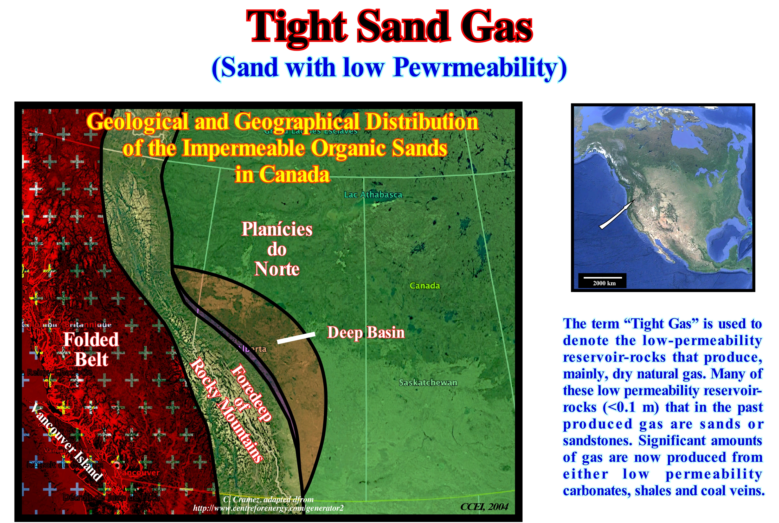
Gas impermeable organic sands * are very low permeability reservoir-rocks (ability of a material, such as a rock, to convey fluids or connectivity of the pores of a rock), which require artificial fracturing so that the gas can flow. In general, they are located in areas where there is conventional gas production in the shallow reservoir-rocks. In the 1970s, some oil companies discovered large amounts of gas (resources) in the deep eastern basin of the Alberta province (Canada), illustrated in this figure. In fact, most rocks in the stratigraphic column are saturated with natural gas (a mixture of light hydrocarbons derived from fossil fuels formed when sedimentary layers rich in organic matter are buried and subjected to high temperature and pressure for millions of years). The rocks have a very low permeability, but as they contain water a gas production is, sometimes, possible. Regions with the same characteristics were found in other basins in different parts of the world. Currently, natural gas is produced from impervious organic sands in Canada, USA, Australia and Argentina. In Canada, these sands are found in the deep basin and foreland basin of the Rockies (British Columbia and Alberta), and in the southern plains of the province of Alberta and the northern plains of British Columbia. USA Geological Services think gas impermeable sands can hold about 460 Tcf (1012 cubic feet) of gas in the United States (about three times the current amount of proven gas reserves) and of which probably 135 Tcf may be technically recoverable, but until recently, it was very difficult or impossible to produce large amounts of gas from impermeable rocks. At present-time, things have changed (gas prices are much higher and new production techniques have been discovered). In the United States, the current production of gas from sand and waterproof clays is about 20% of the total production.
(*) In the oil industry, the term gas impermeable sands refers to low permeability sandstone reservoirs that mainly produce dry natural gas. A reservoir of gas impermeable sands can not produce economically unless the well is stimulated by substantial hydraulic fracturing / or by horizontal wells. This definition also applies to coal methane, shale gas and waterproof carbonate reservoirs.
Till.......................................................................................................................................................................................................................................................................................Till
Tilo / Till / Till (Geschiebemergel) / 直到 / Тилль (ледниковое отложение) / Fino, Glaciale fino, Till /
Unsorted and nonstratified sediments deposited directly by or under a glacier and not reactivated by the melting waters of the glacier.
See : « Glacier »
&
« Moraine »
&
« Outwash Plain »
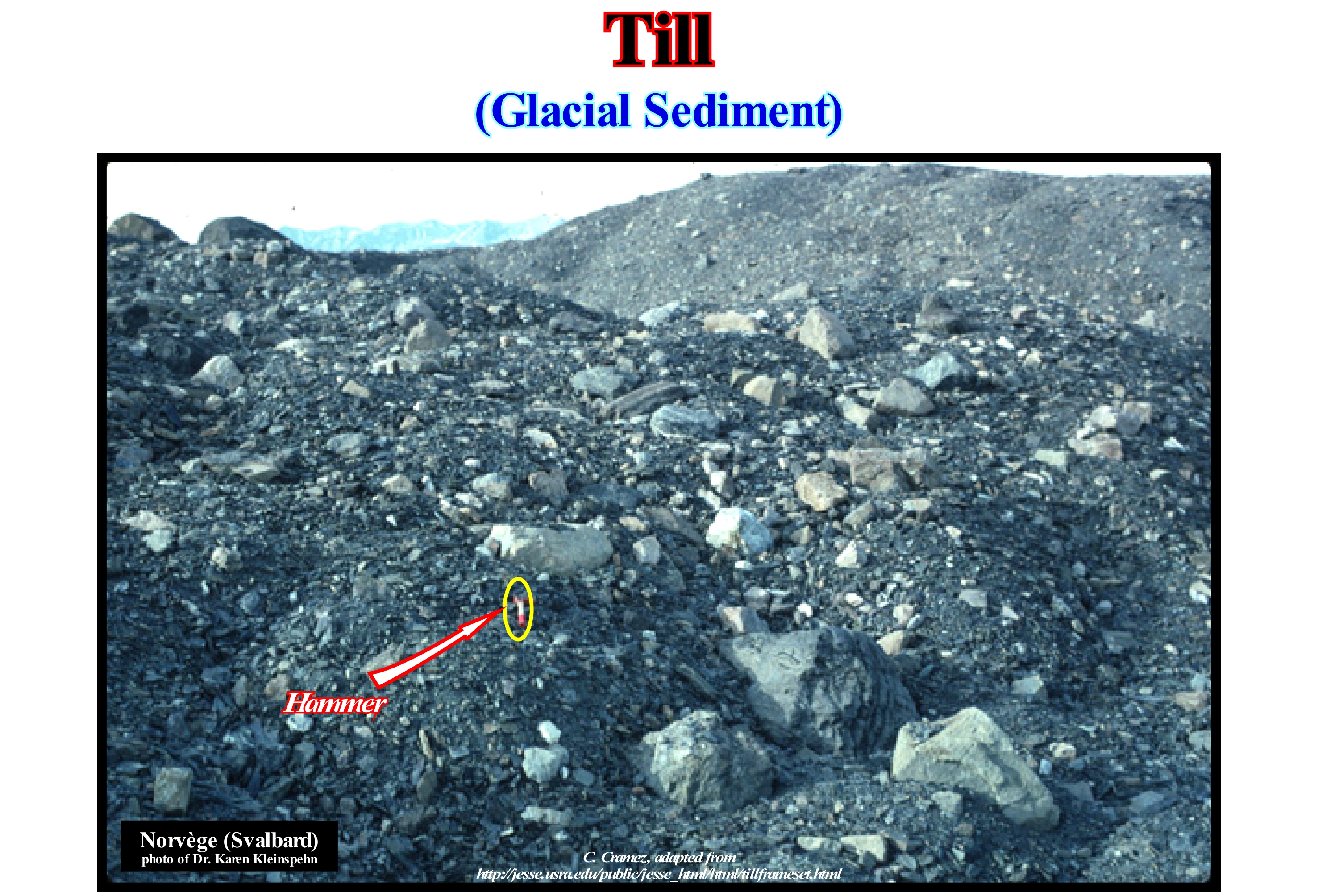
All the sediments that form the moraines are till, which is characterized by an absence of sorting, since, contrary to water and wind, ice has no tendency to calibrate the sedimentary particles that it carries. As illustrated above, large blocks are transported at the same speed and in the same manner as the finer particles. When glacier ice melts or retrogrades, all material that is not then transported by water or wind is left at the melting site forming a chaotic mixture of various sized particles and petrography. It is this heterogeneity, which makes the limestone glaciers characteristic. Before geoscientists admitted and understood the origin of glacial epochs, they spent decades to realize the origin of the tills. At first, they were associated with catastrophic events, such as intense volcanic explosions, which not only projected the blocks at great distances, but also caused the collapse of the surrounding mountains. Certain geoscientists associated the till with large floods, which transported the sediments to the mountainous regions. Others saw in the tiils, the proof of the existence of the Flood ("Diluvium*"). It was only at the beginning of the 19th century that geoscientists realized that a glacier carries not only ice, but also an enormous amount of sedimentary particles of varying size and composition. Several geoscientists began to admit the hypothesis, that when the ice of a glacier (or an iceberg) merges, the sedimentary particles that it carried in front of it, inside or above it, could be abandoned and accumulated on the ground. In this way, till would be an indisputable proof of the glacial epochs, which existed in the recent past. Do not forget that a glacier is like a stream of water, it exists only as ice flows, that is, while accumulation and ablation compensate. If ablation is greater than accumulation, the glacier does not contract, as many people think, it continues to flow but becomes thinner, which means that progressively it goes into retrogradation. So, please avoid expressions as glacial retreat that some amateur ecologists use in an abusive way.
(*) Historically, diluvium was a term in geology for superficial deposits formed by flood-like operations of water, and so contrasted with alluvium or alluvial deposits formed by slow and steady aqueous agencies. The term was formerly given to the boulder clay deposits, which some early geologists supposed had been caused by the Noachian deluge, a concept known as flood geology or diluvianism. (https://en.wikipedia.org/wiki/Diluvium)
Tillite...................................................................................................................................................................................................................................................................Tillite
Tilito (Diamicito) / Tillita / Tillit / 冰碛 / Тиллит / Tillite /
Sedimentary rock resulting from the lithification of a till, i.e., a mixture of clay, sand, coarse sand and pebbles deposited directly by or under a glacier.
See : « Glacier »
&
« Moraine »
&
« Outwash Plain »
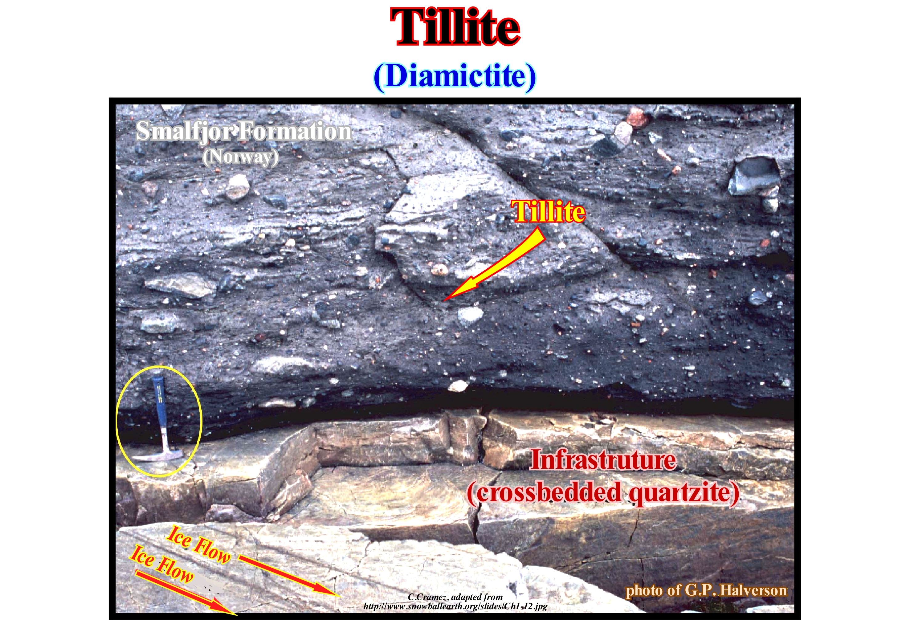
This outcropping near Biggenjarga, on Varanger peninsula (northern Norway), was interpreted in 1981 by H. Reusch (Norwegian Geological Survey), as a illite overlying a subglacial pavement, on top of which the slickensides induced by the base of the glacier (roughness and small starter figures) indicate the direction of the ice flow. He strongly suggested the illite of the Smalfjor formation corresponds to a lithiated till. It was this type of rocks, of Paleozoic age, that were found on both sides of the South Atlantic Ocean, that is, in Brazil and Africa, that reinforced the evidence of the oceanic expansion suggested by the geometries of the coastlines and by the distribution fossil plant Glossopteris (gymnosperm plant, with bare seeds). The tillites also provided hard-to-refute evidence of Precambrian glaciation (Terrestrial Snowball*). The distribution of tillites is difficult to explain in terms of the present geography of the world. However, it is important not to forget that there are about 400 Ma, North Africa was located to the right of the South Pole and that later about 300 Ma, South America, the southern part of Africa, Madagascar, India and Australia were agglutinated near the South Pole. When Pangea fractured all continents (except Antarctica) migrated northward, and much of the ice disappeared from the Earth's surface. As North America and Eurasia are, currently, jammed together around the north pole, it can be said that another glaciation is, certainly, in progress. The tillites, and particularly the tills, often contain alluvial deposits of precious stones and ores that are plucked from the rocks of the substrate during the flow of glaciers. Diamonds have been found in these rocks and sediments not only in the United States (Wisconsin, Indiana, etc.) but also in Canada. Prospectors when they encounter diamonds or gold in this type of sediment following the traces of flow upstream in order to find the diamond source- rocks, such as kimberlites.
(*) On at least three occasions our planet was completely covered with ice. In the last billion years, the Earth has experienced two more global glaciations: the Sturtian glaciation, which began 720 million years ago and, following a brief interglacial episode, the Marinoan glaciation, which ended 635 million years ago. (https://news.cnrs.fr/articles/when-earth-was-a-snowball)
Tilted Onlap.......................................................................................................................................................Biseau d'aggradation basculé
Bisel de agradação deformado / Bisel de agradación basculado / Tilted Onlap, Bevel Verlandung Rocked / 倾斜的上超 / Наклонное подошвенное налегание / Inclinato onlap, Bisello d’aggradazione inclinato /
Apparent termination of a stratum or seismic reflector that looks like a downlap, but which, in reality, is a deformed onlap by tectonics. Deformed or tilted onlap are common in sedimentary basins affected by tectonics and in basins where halokinesis (salt tectonics) or shalokinesis (tectonics of shaly rocks) are active.
See: « Onlap »
&
« Downlap »
&
« Coastal Onlap »
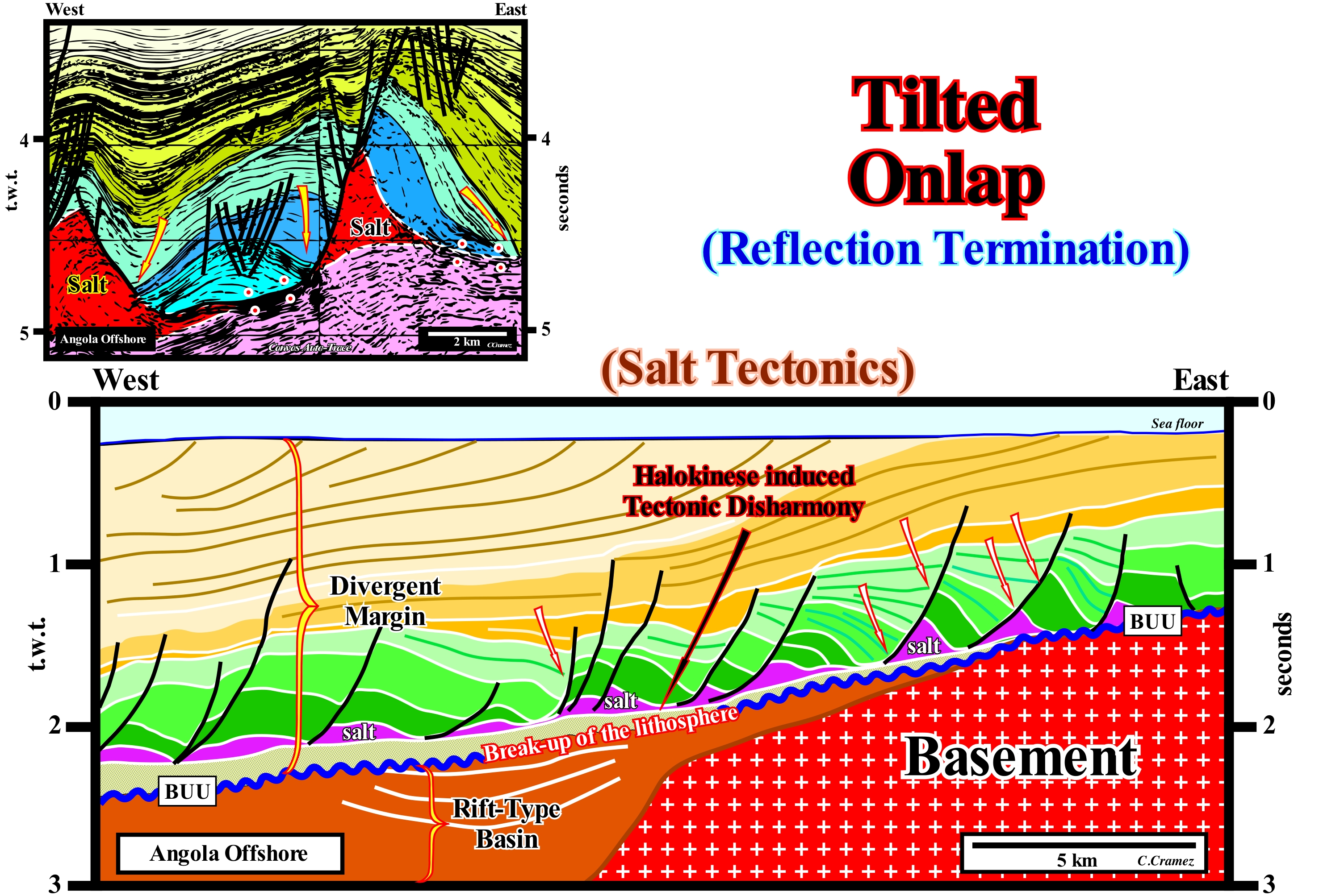
The Angola offshore, where the seismic lines of the auto-traces, of these tentative geological interpretations, illustrated in this figure, corresponds to the vertical stacking of three types basins of the classification of the sedimentary basins of Bally and Snelson (1980). From the bottom to top, it is easy to recognize : (i) A basement that, locally, corresponds to a Paleozoic flattened folded and flattened mountains belt ; (ii) Late Jurassic- Early Cretaceous rift-type basins and (iii) An Atlantic-type Divergent Margin. The rift-type basins forming during the lengthening of the Gondwana small supercontinent, which was part of the Pangea supercontinent, predated the BUU unconformity (acronym for "Breakup Unconformity") that underlines the breakup of lithosphere. The divergent margin underlines the post-Pangea continental encroachment stratigraphic cycle, in which some geoscientists, often wrongly, include the rift-type basins, which was induced by the post-Pangea 1st order eustatic cycle. Locally, at the bottom of the margin, lava flows fossilize the BUU unconformity. A relatively thick evaporitic level allows the subdivision of the margin infra- and suprasalt intervals, which, even in the absence of local salt, due to total or partial flowage (lower than the seismic resolution), are separated by a tectonic disharmony. Tilted onlaps (underscored by arrows) are, easily, recognized in suprasalt interval. The lateral and vertical flowage of the salt (in violet, on upper part of this tentative interpretation and in red, in the lower one), locally, creates a compensatory subsidence, which produces tectonic inversions in the sediments overlying the salt interval. The geometric relationships and the original terminations of the seismic reflectors associated with the postsalt sediments are deformed. Tectonic inversions create, sometimes, structures of antiform geometry, as illustrated in the upper tentative interpretation, which geoscientists call "turtle back". Certain raised or subhorizontal areas, at the time of deposition, become structurally low, due to decreasing thickness of the salt layer caused by lateral salt flowage. The reverse is, also, possible. A low area at the time of deposition may become, relatively, high if the adjacent high area sinks due to the flow of the underlying salt. Due to a compensatory subsidence, induced by a total or partial salt flowage, onlapping (by definition, at the time of deposition) can become an apparent downlapping, as illustrated in these tentatives. A lateral or vertical displacement of the salt causes a lengthening of the overlying sediments, which can be raised (salt domes) or tilted towards the more subsident area. The arrows indicate the areas where apparent downlaps can be recognized which, as stated above, are onlaps which were tilted continentward (eastward) due to the flow of the salt interval towards the basin. The base of the salt horizon, which is, more or less, discontinuous due to the formation of salt welds**, corresponds to a tectonic disharmony which, in these tentative interpretations, dips slightly westward. The meaning of strata or reflectors terminations (lapouts) has a geological value, when they retain their original depositional geometry. An onlap or downlap translates the geometry of the reflectors at the time of deposition. An onlap s translates, always, a sedimentary aggradation induced by a marine ingression or rise of the relative sea level (local sea level referenced to any point on the Earth's surface, which can be the sea floor or the base of the sediments). A deformed or tilted onlap is a lapout that was later affected by tectonics, that is, that was shortened or lengthened, and which may even acquire a geometry similar to that of a downlap.
(*) These turtle-backs have nothing to do with the relict hills of the Nile delta plain that ancient Egyptians called also turtle-backs.
(**) A salt weld is a surface or zone that brings into contact strata, originally separated by an autochthonous or allochthonous salt level. A salt suture corresponds to a negative structure resulting from the flow or expulsion (partial or total) of the salt horizon. In the field or in the drilling core, in most cases it is recognized by an insoluble, more or less, brecciated residue with halite pseudomorphs, but it is too thin to be visible on the seismic data on which it is underlined by a tectonic disharmony. One of the characteristics of the salt welds is the presence of tectonic inversions in the overlying horizons. A salt weld along which there is a slipping or shear movement is termed a salt-scar.
Time Equivalence (By continuity)........................................................................................Équivalence temps (Par continuité)
Equivalência tempo (por continuité) / Equivalencia tiempo (por continuidad) / Zeit Gleichwertigkeit (von Kontinuität) / 时间相当于(连续性) / Временная эквивалентность (непрерывность) / Tempo equivalente (per continuità) /
Process of establishing correlations, in time, by the continuity and synchronism of the reference layers deposited in small intervals of time. This method is used when there are no intermediate intervals (lateral passages of facies) between two geological formations due to the absence of outcrops or the existence of a topographic cut.
See: « Geological Section »
&
« Marker Bed »
&
« Palinspathic Section »
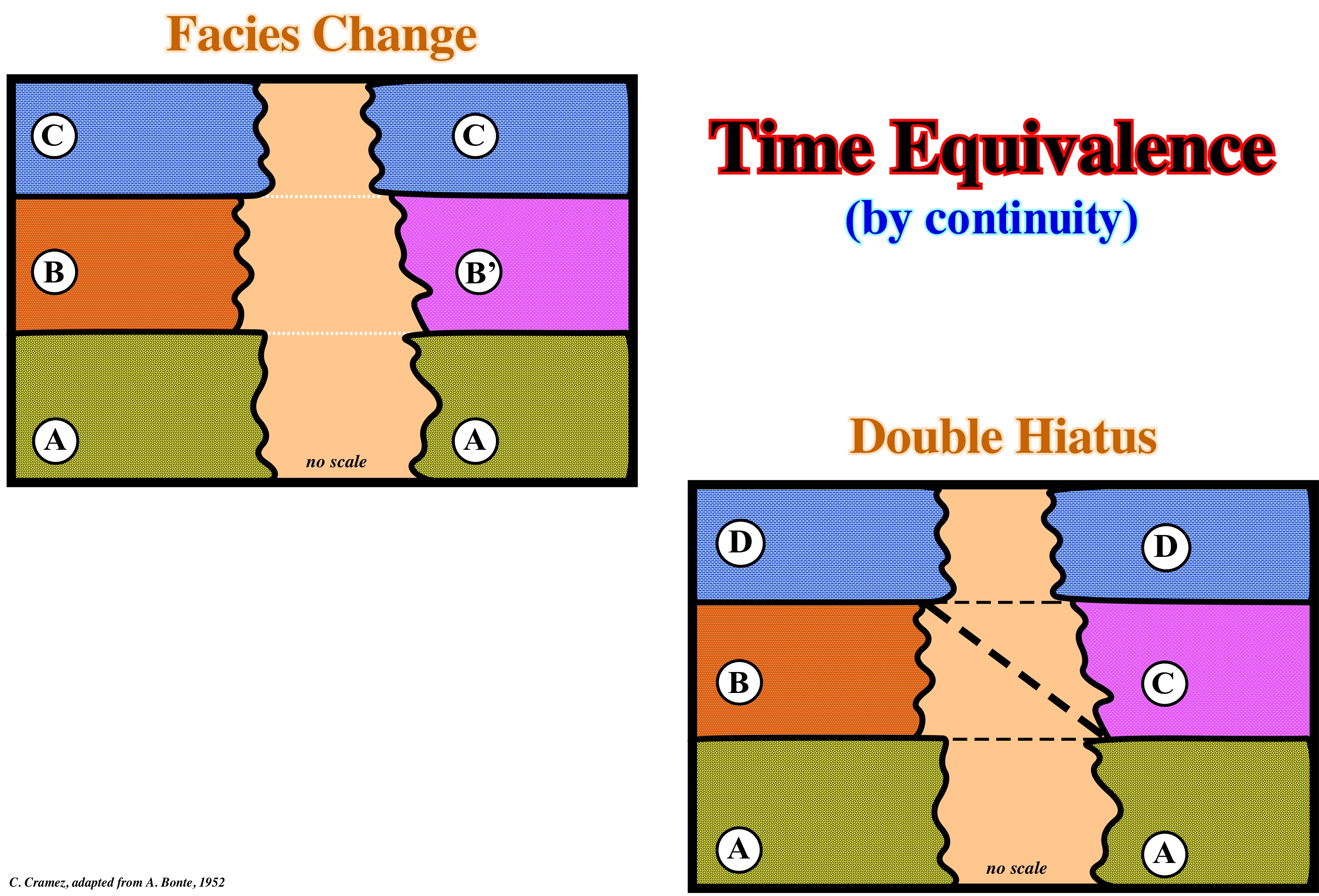
In set theory and algebra the notion of equivalence relation over a set, allows to establish a relation between the elements of the set that share a certain characteristic or property. This allows you to group these elements into equivalence classes, that is, into "packages" of similar elements. Thus it is possible to construct new sets by adding all elements of the same class as a single element that will represent and that defines the notion of set quotient*. In stratigraphy the time equivalence relation can be in: (i) Time by continuity ; (ii) Time by Interdigitations and (iii) Time by stratotype. In this sketch, two correlations in time are represented by continuity (change of facies and double hiatus). In the left sketch, the upper layers (C) are the same on one side and on the other, as are the lower layers (A). The intermediate layers, i.e. the layers or intervals B and B', have different facies, i.e. have a different lithology. However, since layers B and B' are framed by two chronostratigraphic sedimentary intervals (layers C and A), they are more likely to be the same, since the lithology change is continuous and progressive (equivalence time by changes in facies). In the sketch of the right, where the equivalence time is by double hiatus, the change of facies is done in a, totally, different way. The interval B, bounded between layers D and A (on the left side) disappears, laterally, by onlapping, while a new interval (interval C), bounded between layers D and A, on the right side, is deposited in In terms of sequential stratigraphy, these two time equivalents correspond to completely different geological histories. The first equivalence is typical. It corresponds to changes in facies, for example, within a sedimentary systems tract, along which the different depositional systems (lithology and associated fauna deposited in a given sedimentary environment) are synchronous, genetically linked. The second time equivalence implies an unconformity, that is, it implies an erosional surface induced by a significant the relative sea level ** fall, between the interval B and the interval C and that probably the top of the interval A was, slightly or locally, eroded during the exposure phase associated with relative sea level fall. This means that the intervals B and C belong to two different stratigraphic cycles interbedded between intervals A and D. In the left sketch (equivalence time by change of facies***) there are probably three stratigraphic cycles (cycles-sequence?), separated by unconformities whereas in the right sketch, there can be at least four sequence-cycles. The entire stratigraphic cycle, whatever its hierarchy (continental encroachment cycle, continental encroachment subcycle, cycle-sequence, etc.) is always limited between two unconformities, along which the intervals with or potential reservoir-rocks, whether they are low or highstand. Unconformities are erosional surfaces induced by significant relative sea level falls. The sequence-paracycles, which constitute the different subgroups of sedimentary systems tracts of a sequence-cycle, as its name implies, are not induced by eustatic cycles, but by eustatic paracycles, that is, by relative sea level rises (marine ingressions) without fallings between them. The associated sequence-paracycles (deposited during stability periods of relative sea level that occur after each marine ingression) are limited by flooding surfaces rather than by erosional surfaces, although at the base of each marine ingression a ravinment surface may develop.
(*) Mathematical term that refers to a certain mathematical structure that derives from another in which an equivalence relation has been defined.
(**) Local sea level referenced to any point on the Earth's surface, which may be the sea floor or the base of the or the sediments and which is the result of the combined action of the tectonics (subsidence or uplift of the sea floor) and the absolute (eustatic) sea level, which is sea level global, referenced to the Earth's centre.
(***) Set of primary lithological and paleontological features observable in a rocky interval and considered from the point of view of their genesis.
Time Equivalence (By stratotype)........................................................................................Équivalence temps (Par stratotype)
Equivalência tempo (por estratótipo) / Equivalencia tiempo (por estratótipo) / Zeit Gleichwertigkeit (Stratotyp) / 等效时间(层型剖面)/ Временная эквивалентность (стратотип) / Tempo equivalente (stratotipo) /
Method of determining the age of the strata showing, by lateral continuity, its time equivalence with a stratotype.
See: « Geological Section »
&
« Stratotype »
&
« Restored Section »
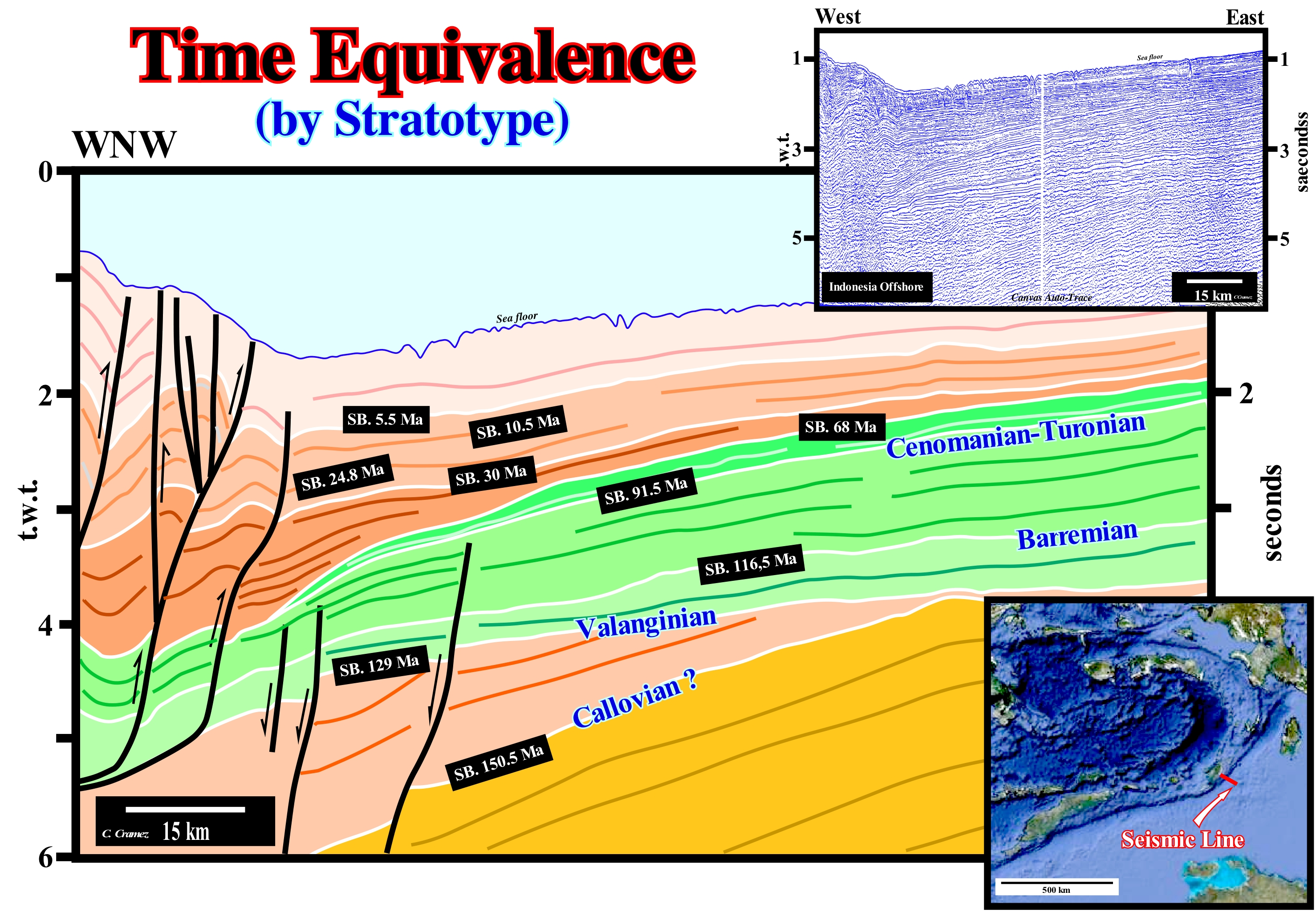
In the theory of sets and in algebra the notion of equivalence relation over a set, allows to establish a relation between the elements of the set that share a certain characteristic or property, which allows to regroup these elements in classes of equivalence, i.e., in " packages "of similar elements. This allows the construction of new sets, adding all elements of the same class as a single element that will represent and that defines the notion of set quotient*. In stratigraphy the time equivalence relation can be in: (i) Time by continuity ; (ii) Time by Interdigitation and (iii) Time by stratotype. In this figure, correlations in time are represented by stratotype. A stratotype is a succession of rocky layers with well-defined boundaries, used as reference and in the characterization of stratigraphic units (e.g., stratigraphic boundaries, periods, etc.). A stratotype is neither more nor less than a stratigraphic succession, which has been approved by authorized geological correlation committees. There are two types of stratotypes: (a) Simple, which as the name indicates correspond to a single cut or stratigraphic section and (b) Compounds that is a set of several stratigraphic sections and which defines the stratigraphic units of classification less than the unit defined in stratotype. The type locality of a stratigraphic unit is the geographical site in which we find the stratotype and, in the great majority of cases, it is attributed its name. Geoscientists speak, also, about the type area, which is the geographical territory in the perimeter of the type locality. On this tentative geological interpretation of a Canvas auto-trace of a detail of a seismic line from the offshore East of Indonesia, the calibration (age) of the main unconformities was made in relation to the age of the stratotypes and the stratigraphic signature of the Neogene, proposed by P. Vail and students (Rice University, Houston, USA). The location map (bottom right corner of the figure) shows that this seismic line illustrates the collision of the Atlantic-type divergent margin of Australia (right) with a volcanic-arc (left). The geometry and internal configuration of the seismic intervals considered in this tentative interpretation should correlate with those observed in offshore Australia. The unconformity SB. 129 Ma (± Valanginian), probably, corresponds to the breakup of the Pangea supercontinent. It separates the rift-type basins, which developed during the lenghtening of the lithosphere (before thew breakup) of the overlying divergent margin. Within the divergent margin, calibration is very easy, since stratigraphic signature of this area is, perfectly, known. It corresponds to the post-Pangea continental encroachment cycle, which consists of two large sedimentary phases. The lower one is the transgressive phase, which is separated from the upper phase (regressive phase) by a downlap surtface (SPB 91.5 Ma), i.e., by the maximum flooding surface whose age is 91.5 million years ago. The transgressive phase has a retrogradational geometry. It increases, globally, in thickness continentward before disappearing by pinchout. The regressive phase has a progradatioinal geometry, which implies that the thickness increases basinward before disappearing by pinchout over the oceanic crust in the distal parts of the margin. All geoscientists know that the Cretaceous interval posterior to the Cenomanian/Turonian is regressive and that the great unconformity between the Mesozoic and the Cenozoic is the SB. 68 Ma. Thus, it is, relatively, easy to recognize on this tentative interpretation the downlap surface 91.5 Ma and the unconformity SB. 68 Ma. The unconformity SB. 116.5 Ma (Barremian) is, equally, easy to individualize. Calibration of Cenozoic unconformities (most of the regressive phase) was done based on the Cenozoic stratigraphic signature. On this tentative geological interpretation one has to take into account the seismic artifact induced by teh change in water-depth, since the seismic waves travel more slowly in the water than in the sediments. In addition, the sediments of the foreland basins (coloured in brown tones) were, locally, raised (more compacted). Thus the unconformity of the Valanginian (SB 129.5 Ma) which on this tentative interpretation plunges, slightly, Westward in a depth version (closer to reality) is, more or less, subhorizontal or even, slightly, slopping Eastward, i.e., toward the Australian craton.
(*) Mathematical term that refers to a certain mathematical structure that derives from another in which an equivalence relation has been defined.
Time Equivalence (By interdigitation)...................................................................Équivalence temps (Par interdigitation)
Equivalência tempo (por interdigitação) / Equivalencia tiempo (por interdigitación) / Zeit Gleichwertigkeit (Verzahnung) / 等价(interdigitation) / Временная эквивалентность (взаимное проникновение) / Tempo equivalente (interdigitazione) /
The process of establishing time correlations between strata using their interdigitations (lateral termination of a sedimentary interval by several interdigitations* each of which is an independent offlap).
See: « Geological Section »
&
« Marker Bed »
&
« Restored Section »
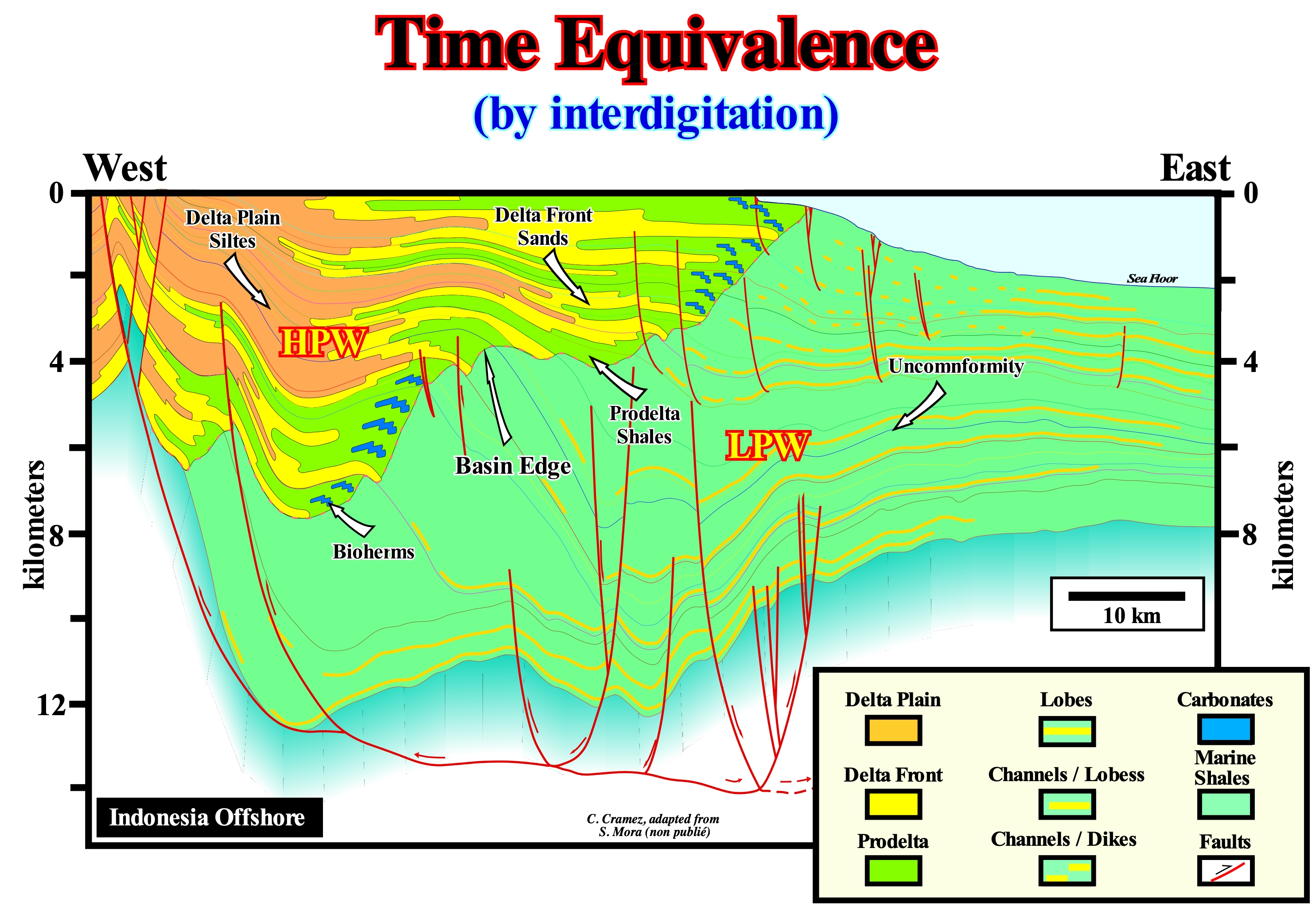
In the theory of sets and in algebra the notion of equivalence relation over a set, allows to establish a relation between the elements of the set that share a certain characteristic or property, which allows to regroup these elements in classes of equivalence, that is, in " packages" of similar elements. This allows the construction of new sets, adding all the elements of the same class as a single element that will represent and that defines the notion of set quotient **. In stratigraphy the time equivalence relation can be: (i) Time by continuity ; (ii) Time by Interdigitations and (iii) Time by stratotype. In this figure, correlations in time are shown by interdigitations. On this tentative geological interpretation of a regional seismic line of the Indonesian offshore (offshore East of the island of Borneo), within the stratigraphic cycles, the correlations between the different facies (lithologies) are time equivalences by interdigitations. Seismic intervals are limited by unconformities, induced by significant relative sea level falls***. The age difference between two consecutive unconformities is, almost always, less than 3-5 My (millions of years), which means that the seismic intervals were deposited during 3rd order eustatic cycles (time-duration between 3/5 My). Thus, it is more than likely that most of these intervals correspond to cycle-sequence. In a first phase of the tentative interpretation, the highstand (HSTG) and lowstand systems tracts groups (LSTG), which form the sequence cycles, were differentiated, which allowed to individualize the different basin edges, are coincident with the upper limit of the continental slope. At this scale (taking into account the horizontal and vertical scale of the seismic line), it is, practically, impossible to map the interdigitations between the different high and lowstand sea levels, or in other words, it is difficult to individualise the periods during which the basin had a shelf (presence of transgressive intervals). Indeed, when the depositional coastal break of the depositional surface (more or less, shoreline) does not coincide with the continental edge, the basin has a platform and the geological conditions are of highstand. It is easy to verify that, as a function of the relative sea-level rise rate, at certain times, gradation (vertical accretion or upbuilding) was important and that in others, the procreation (lateral accretion) was largely predominant. During periods of strong gratification (when the basin has a continental shelf) the continental edge is underlined by bioherms (carbonated constructions). In the highstand systems group (HSTG), the individualization of the transgressive intervals (TI) and the highstand prograding wedge (HPW) allows the mapping the interdigitations between the sands or limestone of the delta front and the shaly rocks of the prodelta such as the interdigitations between the siltstones of the deltaic plain and the sands facing the delta. Theoretically these interdigitations are easy to predict, since a sedimentary systems tracts consists of a lateral association of depositional systems and that each depositional system corresponds to a typical set of a lithology with associated fauna deposited in a particular sedimentary environment. For example, a delta, whose thickness, usually, ranges from 30 to 60 m (not to be confused with a delta building, which is stacking of deltas), is a sedimentary systems tract, in which, from the mainland seaward, different depositional systems: (i) Silts of the delta plain ; (ii) Delta front sands ; (iii) Prodelta shales and (iv) Shales of the delta bottom, in which small proximate turbidite lobes can, sometimes, be deposited. These depositional systems form different types of delta layers: A) Upper subhorizontal beds ; B) Dipping seaward beds and C) Lower subhorizontal beds.
(*) An interlinking that resembles the fingers of two hands being locked together (https://en.wiktionary.org/wiki/interdigitation),
(**) Mathematical term that refers to a certain mathematical structure that derives from another in which an equivalence relation has been defined
(***) Sea level, local, referenced to any point on the Earth's surface, which may be the sea floor or the base of the sediments, and which is the result of the combined action of absolute (eustatic) sea level, which is supposed to be global and referred to the Earth's centre, and tectonics, i.e., the uplift of the sea floor when the predominant tectonic regimes are compressional or subsidence when they are extensional.
Time Gap Surface..............................................................................................................................................................................Surface d’hiatus
Superfície de hiato / Superficie de hiatus / Oberflächen-Lücke / 时间间隔面 / Поверхность распространения временного интервала / Superficie di iato /
Geological surface that underlines a geological time that is not represented by sediments. There are several time gap surfaces (hiatuses). The main ones are: (i) Unconformities ; (ii) Downlap Surfaces ; (iii) Bedding Planes etc.
See: « Transgressive Interval »
&
« Relative Sea Level Rise »
&
« Ravinment Surface »
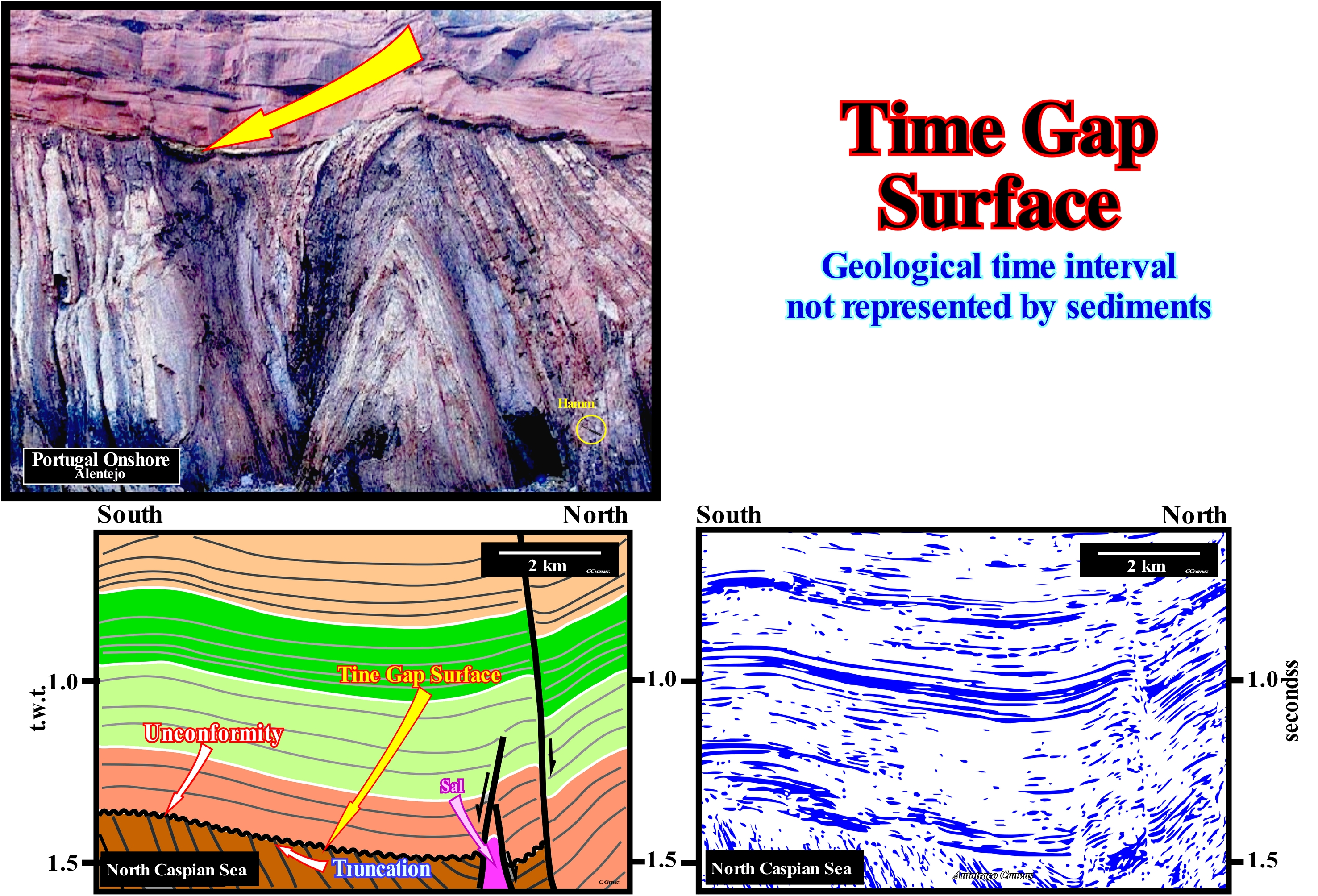
Theoretically, in sequential stratigraphy, an unconformity is a hiatus surface, which corresponds to an erosional surface induced mainly by a significant relative sea level fall, that is, a fall that puts the sea level lower than the basin edge exhuming the shelf (if the basin, at the level of the considered sequence-cycle, had a platform) and the upper part of the continental slope. In this way, the coastal plain or the continental shelf, function of the geological conditions, are exhumed and thus exposed to the erosive agents. When an unconformity is not tectonically enhanced, erosion is only visible in the upper part of the continental slope near the continental edge (which is the basin edge when it has a continental shelf) by the formation of submarine canyons or in the coastal plain, where the rivers create locally incised valleys. Most geoscientists consider that in most sedimentary basins, sea level changes* have a cyclicity that explains better the cyclicity of sedimentary deposits than the tectonic variations. A sedimentary uplift induced by a compressional tectonic regime (shortening) creates just an unconformity, i.e., an erosional surface, if the shortened sediments are exposed to the erosive agents, that is to say, if they are exhumed by a significant relative sea level fall. Without exhumation, in general, there is no unconformity, since there is no hiatus. In sedimentary basins with evaporitic horizons, the lateral flow (compensatory subsidence) or vertical (rising with lengthening of the salt overburden) of evaporites does not induce any unconformity, but only a tectonic disharmony (when there is no exposure to erosive agents). On this tentative geologically interpretation of a Canvas auto-trace of a North Caspian Sea seismic line, an unconformity tectonically enhanced (angular unconformity for many geoscientists) is, easily, recognized by the terminations (lapouts) of the underlying reflectors (toplaps by truncation). The reflectors of the sedimentary packages, posterior to a tectonically enhanced unconformity, are, more or less, parallel to each other and concordant with the erosional surface (white colored lines) that individualize them. Each of these surfaces is a unconformity induced by a significant relative sea level fall although, locally, the halokinese (salt tectonics without tectonic vector) may have contributed to a decreasing of the available space for the sediments (accommodation). Throughout an unconformity, the hiatus decreases seaward, to be practically zero in the deep part of the basin (this is why the age of the basin corresponds, roughly, to the age of the relative sea level fall). In the photograph illustrated in this figure, a tectonically enhanced unconformity is, perfectly, recognized by the toplaps by the truncation of the underlying sediments. Obviously, the truncation of these sediments was not caused by sedimentary shortening, but rather by associated the relative sea level fall (tectonics deform sediments, erosive agents erode them when exhumed following a relative sea level fall). The hiatus associated with this unconformity is the time interval during which no strata have deposited on the depositional surface or, in other words, the hiatus corresponds to the geological time of the strata that were removed by erosion and not to the time at which erosion occurred. The age of unconformity may be recent, say Aquitanian, or more or less, 23 Ma (millions of years ago), but the hiatus can be 200 My.
(*) The sea level can be of two types: (i) Relative, which is a local sea level, referenced to any fixed point on the Earth's surface, which can be the base of the sediments or the sea floor, and (ii) Absolute (Eustatic), which is supposed to be global, referenced to the Earth's centre of the Earth. The relative sea level is the result of the combined action of absolute or eustatic sea level and tectonics (subsidence or uplift of the sea floor). The absolute sea level is the result of: i) Tectono-Eustasy that is controlled by the volume variation of the ocean basins in association with oceanic expansion following the breakup of the supercontinents ; (ii) Glacio-Eustasy, which is controlled by the variation of water volume of the oceans as a function of the amount of ice (assuming that the amount of water in all its forms is constant since the formation of the Earth, around 4.5 Ga) ; (iii) Geoidal-Eustasy, which is controlled by the distribution of ocean water caused by variations in the Earth's gravity field (where gravity is stronger than normal, sea level is thrown to the centre of the Earth) and (iv) Steric sea level rise or thermal expansion of the water of the oceans (if the temperature increases, the density of the water decreases, and for a constant mass, the volume increases).
Time Section (Seismic)..........................................................................................................................................................................Section temps (Sismique)
Secção em tempo / Sección en tiempo (sísmica) / Zeitabschnitt (seismische) / 时间剖面 / Сейсмический временной разрез / Sezione tempo (sismica) /
Conventional seismic line, i.e., with the vertical scale in time and not in depth. The horizontal scale on the seismic lines is always metric.
See: « Depth Section (seismic) »
&
« Transverse Seismic Line »
&
« Seismostratigraphy »
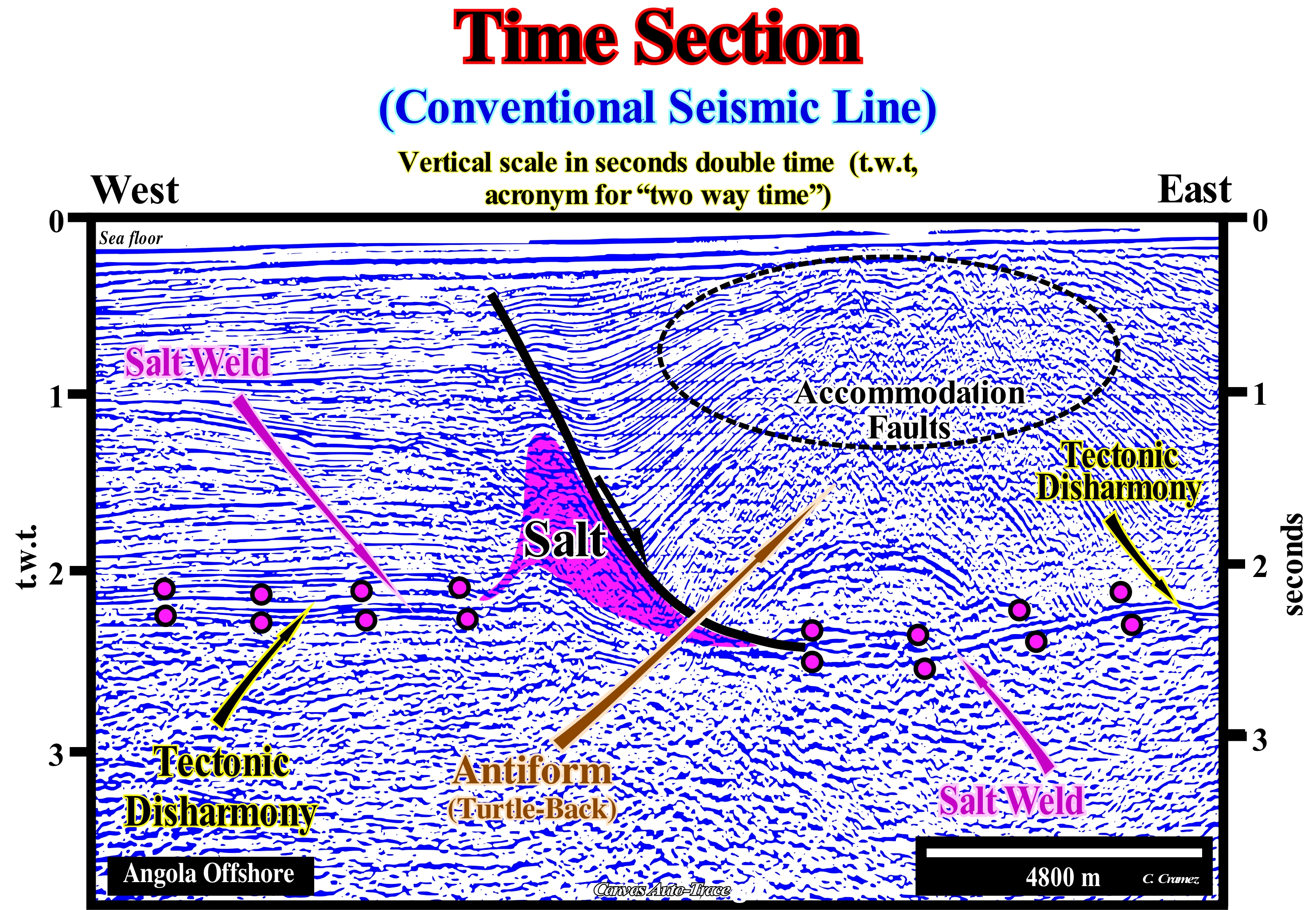
On this Canvas auto-trace of a migrated seismic in in time (double) from the Angola offshore, the tectonic disharmony induced by the lateral flow of the salt (seismically the flow appears to have been total), at the base of the salt interval, is easily recognized. The horizontal scale of the seismic line is metric. However, the vertical scale is in double time (seconds). That means that an isopach sedimentary interval (with a constant thickness) in the field will only be isopach in a seismic line if the velocity of the seismic waves, passing through it, remains constant. If there is a lateral variation of facies (lithology) within the sedimentary interval, in a seismic line, the thickness (in time) is not constant. The same happens in an offshore seismic line when there is a large variation in the thickness of the water-depth. Seismic horizons under a large water-depth are retarded, since seismic waves travel more slowly in water than in sediments. Values of the velocity of the waves P (m/s) for the main environments through which the waves move are: 1) Air, 343 m/s ; 2) Water, 1,450 - 1,500 m/s ; 3) Ice, 3,400 - 3,800 m/s ; 4) Oil, 1,200 - 1,250 m/s ; 5) Dry sands, 400 - 1,200 m/s ; 6) Wet sands, 1,500 - 2,000 m/s ; 7) Clays 1,100-2,500 m/s ; 8) Porous and saturated sand 2,000 - 3,500 m/s ; 9) Marls 2,000 - 3,000 m/s ; 10) Chalk 2,300-2,600 m/s ; 11) Coal 2,200-2,700 m/s ; 12) Salt 4,500-5,500 m/s ; 13) Anhydrite 4,000-5,500 m/s ; 14) Limestones, 3,500-6,000 m/s ; 15) Dolomites 2,000-3,300 m/s ; 16) Granite 4,500-6,000 m/s ; 17) Basalt, 5,000-6,000 m/s ; 18) Gneiss, 4,400-5,200 m/s (http: //gpg.geosci.xyz/ content/ physical_properties/seismic_velocity_duplicate.html). On this preliminary tentative geological interpretation, a tectonic disharmony is underlined by the above and below circles of the salt weld (a surface that joins strata, originally separated by allochthonous or autochthonous salt). The salt interval is only recognized, locally, in association with the normal fault plane, which separates two totally different sedimentary domains. The evidence of tectonic disharmony, which here coincides with a salt weld, is more pronounced on the right side of the seismic line (footwall of the normal fault), where the geometric relationships and terminations of the reflectors are more pronounced. The geometrical relations and reflector terminations allow the recognition of an antiform structure* in the footwall of the large fault, which is an extensional structure, with the geometry of an anticline, but with small normal faults whose throw** is, sometimes, under the seismic resolution, at apex. These faults are contemporaneous with deformation (lengthening) and are not underlined by any seismic reflectors. In contrast, the large normal fault is enhanced by a reflector. The fault plane was injected with salt. Normal small faults are recognized just by the reflector terminations. In depth, that is to say, in an depth version of the original line, the base of the salt interval, which in this version is waved, is subhorizontal. A salt wedge is visible at the base of the hangingwall of the normal fault. It separates two salt welds. The fault plane is horizontal at the top of the salt or in the salt weld. The sediments underlying tectonic disharmony, induced by the lateral flow of the salt, are poorly deformed, while the overlying sediments are strongly elongated by salt tectonics (with tectonic vector) and by halokinesis (without tectonic vector). Do not forget that in seismic lines, fault planes are only emphasized by reflectors when: (i) Fault plane is injected by salt or volcanism ; (ii) The fault plane corresponds to an interface between seismic intervals with very different impedances, for example between sediments and a basement ; (iii) The fault plane is, more or less, subhorizontal or horizontally in depth and (iv) A major clay fault zone is present. These conjectures are not refuted by this auto-trace, where any fault, and particularly no accommodation fault (at the top of the turtle-back structure, which is an antiform rather than an anticline) is underlined by a reflector. Unlike the tectonic disharmony, of subhorizontal geometry, it is emphasized by reflectors. As the original seismic line is in time, the geometry and depth of the tectonic disharmony is, obviously, affected by the lateral variations of velocity that are very important here. By way of example, it may be said that, theoretically, the tectonic disharmony, in depth, must be rectilinear and sub-horizontal.
(*) Extensional or lengthened structures, with a bell-shaped, such as anticlines, have, in general, normal synchronous faults of deformation at the top of the antiforms, since there is only one way of lengthening the sediments, i.e., by normal faulting. In contrast, since the sediments can not be shortened and lengthened at the same time, the presence of normal faults coeval with the shortening is impossible at the top of an anticline (if they exist, they are either posterior or anterior, but in the latter case, they are reactivated as reverse faults during shortening).
(**) Vertical displacement of the faulted-blocks. The fault throw and heave (lateral displacement of rocks due to faulting) are essential elements of a fault and form basic values when exploring and driving to recover the disrupted coal seam for instance.
Time Transgressive Boundary.....................................................................................Limite transgressive (Temps)
Limite transgressivo (tempo) / Límite transgresivo (tiempo) / Zeit transgressive Grenze / 时间海侵界线 / Трансгрессивная временная граница / Limite Trasgressivo Tempo /
Diachronic surface that limits the upper part of a transgressive interval (TI) of a sequence-cycle. This transgressive limit corresponds, sometimes, to a downlap surface.
See: « Stratigraphic Cycle »
&
« Transgressive Interval »
&
« Transgression (marine ingression) »
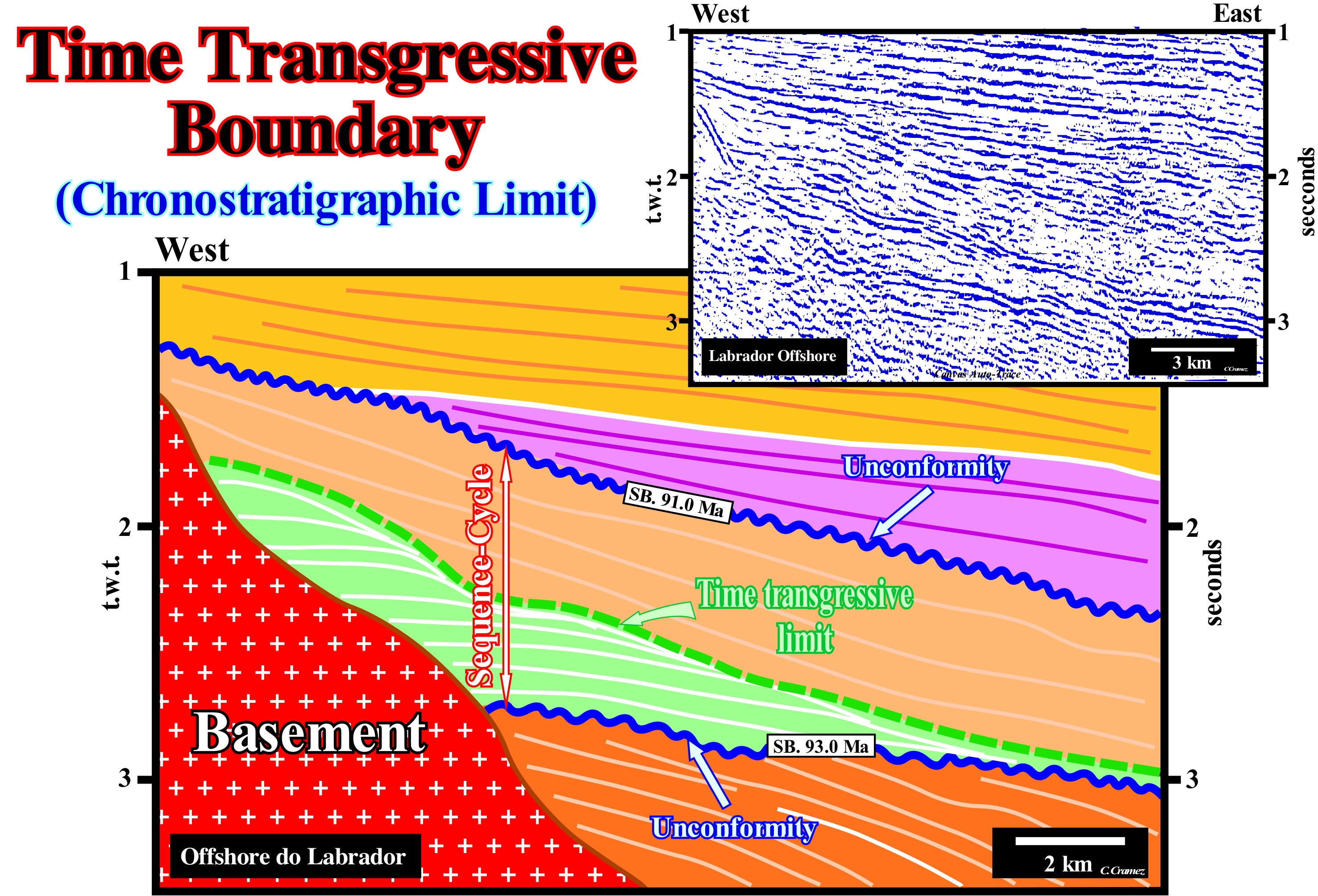
On this tentative geological interpretation of a Canvas auto-trace of a detail of a Labrador offshore seismic line, a sequence-cycle, associated with a 3 rd order eustatic cycle (time-duration between 0.5 and 3-5 My) and limited between two significant relative sea level falls is recognized by the lapouts of the underlying and overlying reflectors. The relative sea level is the local sea level, referenced to the base of the sediments or to the sea floor and which is the result of the combined action of the absolute (eustatic) sea level, which is supposed to be global and referenced to the Earth's centre and the tectonics (subsidence or uplift of the sew floor). The absolute (eustatic) sea level varies according to: (i) Glacio-Eustasy (changes in ocean water volume due to glaciations and melting periods) ; (ii) Tectono-Eustasy (changes in the volume of oceanic basins that function of the oceanic spread, which means that for a constant amount of water, since the formation of the Earth, eustatic sea level rises or falls if the volume of the oceanic basins decreases or increases) ; (iii) Geoidal-Eustasy (variation of ocean water distribution caused by variations in the terrestrial gravity field) and (iv) Thermal expansion of the oceans or steric sea level rise (if the temperature of the oceans increases, the density of the water decreases and, for a constant mass, the volume increases). On this tentative interpretation, as the age difference between the two unconformities is less than 3-5 My (upper limit 91.0 Ma and lower limit 93.0 Ma), it corroborates the interpretation of this interval as a sequence-cycle. However, in this sector, only the highstand systems tracts group (HSTG) is visible. It is formed by two subgroups of sedimentary systems tracts that form the transgressive interval (TI), coloured in green and highstand prograding wedge (HPW), coloured in beige. It is possible that to the East of the seismic line, the lowstand systems tracts group (LSTG), which is formed, by the three subgroups: a) Submarine Basin Floor (SBFF) ; b) Submarine Slope Fans (SSF) and c) Lowstand Prograding Wedge (LPW). The transgressive interval (TI) is recognized by its retrogradational geometry, which is induced by the global continentward displacement to the depositional coastal break of the depositional surface, which corresponds, roughly, to the shoreline. This global displacement of the shoreline is caused by relative sea level rises in acceleration (increasingly important marine ingressions without significant relative sea level falls between them), which create, in the distal part of the continental shelf, geological conditions of starved basin (very small sedimentation rate). With each increase in relative sea level rise, that is, for each marine ingression (more important than the previous one, since the relative sea level rises in acceleration), which corresponds to an eustatic paracycle, a ravinment surface as the shoreline moves continentward. Sedimentation occurs during the stability period of relative sea level that follows each of the increments of the marine ingression. During the stability period of relative sea level, the shoreline, progressively, moves seaward (progradation) as sedimentation occurs forming a sedimentary regression. However, the shoreline does not reach the position (extreme) it had previously due primarily to a deficiency of the terrigeneous influx. A new sea ingression (more important than the previous one) i.e., a new sea level rise occurs, and the depositional mechanism repeats itself until the relative sea level rise is in deceleration. The surface that, overall, underlines the continentward displacements of the shoreline is a transgressive boundary which, of course, is a diachronic surface. Along this surface, the nondeposition hiatus increases seaward, which contrasts with the hiatus associated with an unconformity, which globally decreases basinward, to obtain its minimum value in the deepest part when the submarine basin floor fans (SBFF) of the following sequence-cycle are deposited. In a sequence-cycle the main diachronic surface is the interface between the transgressive interval, TI (retrogradational geometry) and the highstand prograding wedge, HPW (progradational geometry). The transgressive interval (TI) thickens continentward, before pinchout against the lower limit of the sequence-cycle by coastal onlapping. The highstand prograding wedge (HPW) thickens seaward, before pinchout, in the deep parts, by downlapping.
Titius-Bode's Law.......................................................................................................................................................................Loi de Titius-Bode
Lei de Titius-Bode / Ley de Titius-Bode / Titius - Bode Gesetz / 提丢斯 - 波德法 / ПравилоТициуса-Боде / Legge di Titius-Bode /
The distances of some of the planets follow a simple arithmetic formula. he celestial bodies of certain orbital systems, including that of the Sun, orbit about an exponential half of the largest axis of the orbit. This hypothesis corroborated by the orbits of Ceres and Uranus, is refuted by the Neptune's orbit.
Ver: « Sun »
&
« Earth »
&
« Moon »
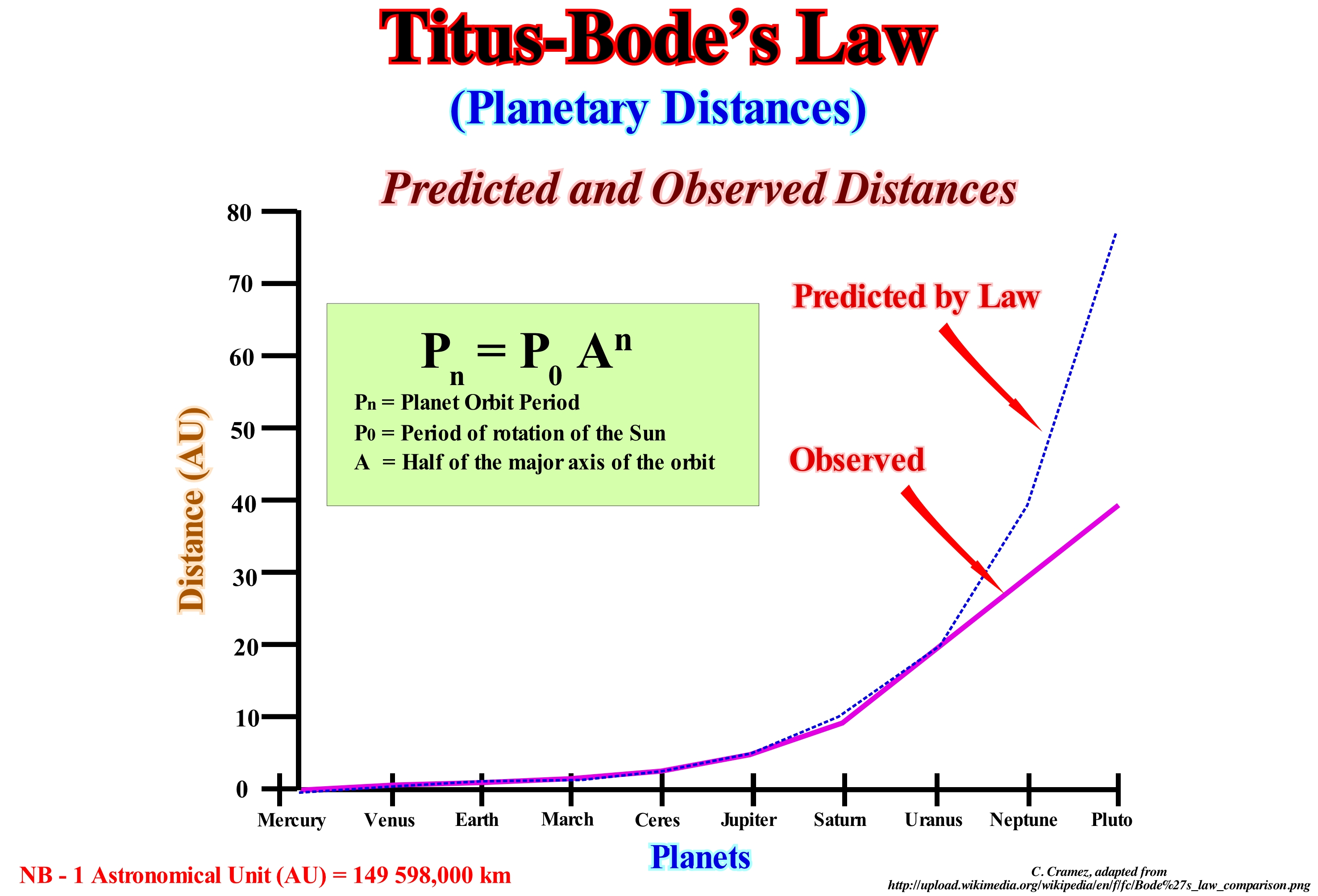
The Titius-Bode' law* (also called simply Bose’s Law) is a very controversial mathematical law, which defines, very roughly, the planetary distances**. It was proposed in 1766 by Johan Daniel Tietz (1729-1796), better known by his Latinized name of Titius, but was first published by the German astronomer Johann Elert Bode (1747-1826), director of the Berlin Observatory that define a sequence that is now known as the Law of Titius-Bode. This law starts from a geometric progression of reason 2, from the second term: 0, 1, 2, 4, 8, 16 and 32. Titius multiplied each of these terms by 3: 0, 3, 6, 12, 24 , 48 and 96 and added 4 units each to give: 4, 7, 10, 16, 28, 52 and 100 and finally dividing by 10: 0.4 / 0.7 / 1.0 / 1.6 / 2.8 / 5.2 and 10.0. If the distance from the Sun to Saturn is taken as 100, Mercury is separated by four pieces from the Sun. Venus is 4 +3 = 7. The Earth 4 +6 = 10. March 4 +12 = 16. After March , there is a space of 4 +24 = 28 pieces, in which no planet is found. Then you arrive to the distance of Jupiter in 4 +48 = 52 parts, and, finally, the one of Saturn by 4 + 96 = 100 pieces. Knowing that an astronomical unit (UA) is the average distance from Earth to the Sun, the values obtained represent the average distances of the planets, in AU, relative to the Sun. The most curious thing about this law is that it predicted the existence of a planet between orbits of Mars and Jupiter, there are 2.8 AU of the Sun. Later this value is attributed to the orbit of the asteroid belt that orbits the Sun at this distance. This law was refuted by the discovery of Neptune and Pluto, which do not follow this law and by the fact that the belts is composed of fragments and not a celestial body. In 1839, American philosopher C. S. Pierce considered Bose’s law as an example of fallacious reasoning, since it is not the result of a scientific method, in particular of the pragmatic method PHT, that is to say: Problem, Hypothesis, Test.
(*) About 4.6 109 Ma, during the formation of the solar system, from the gravitational collapse of a cloud of interstellar gas of density and size that allowed the formation of molecules, formed a central body (Sun) and a certain number (10) concentric rings of gas and dust. The matter of these rings is agglutinated in planetesimals, which are celestial bodies that can reach the size of the Moon and which result from the gravitational agglutination of smaller celestial objects (± 1 km in diameter) which in turn result in collision and agglutination of the grains of cosmic dust. Within each of these rings, except for the fifth ring (from the Sun), the largest planetesimal collected the rest of the matter.
(**) The Titius-Bode's law intends to give the distance of the planets to the Sun. It was proposed by the German astronomer Johann Titius (1729-1796) and popularized by another German astronomer, Johann Bode (1747-1826). According to this law, the distance from a planet to the Sun (r), in astronomical units, is given by the formula: r = 0.4 + 0.3 x 2n, where n = - ∞ for Mercury, 0 for Venus, 8 for the planets between Earth and Pluto, including asteroids. The distance thus calculated for the planets between Mercury and Uranus is, more or less, exact. However, for Neptune and Pluto, which were not known at the time Titus and Bode lived, the distance to the Sun is respectively 29% and 95% greater than actually.
Tombolo (Landform)...........................................................................................................................................................................................................Tombolo
Tômbolo / Tómbolo / Inselnehrung, Hals / 箭头-地峡 / Томболо (песчаная или галечная коса) / Seta Istmo, Tombolo /
Beach or barrier bar that connects an island to the mainland. Spit* of sand that connects a small island to the mainland.
See: « Littoral »
&
« Beach »
&
« Tidal Channel »
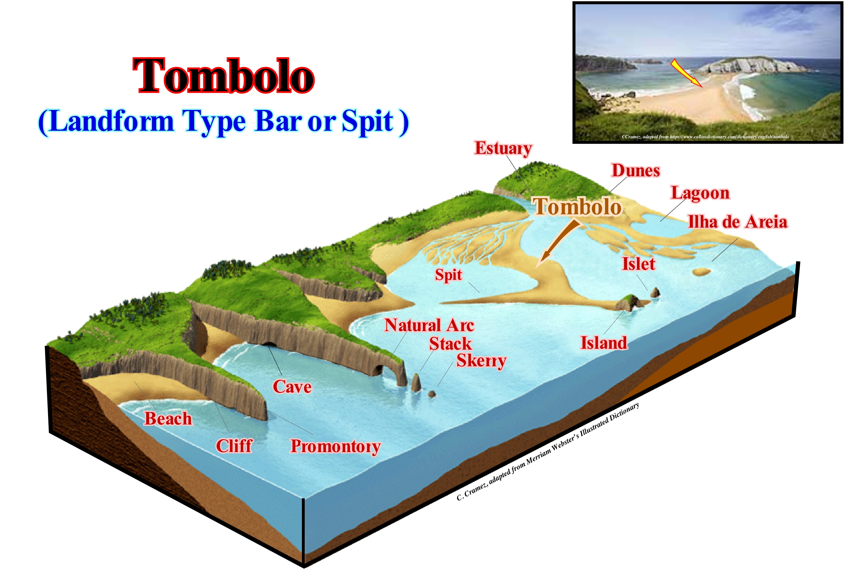
In this figure, in addition to the tombolo, which is the strand or barrier-bars strings (banks and/or spits) that develop between two islands or between an island and the continent, due to the circular currents resulting from the diffraction of the waves around the islands (Moreira, 1984), we can distinguish other morphological forms that are characteristic of many coastal areas: (i) Beach, a type of low coast with a strand made up of detrital, terrigeneous, sand-silt and coarse materials (pebbles and blocks) or, in other words, an accumulation of sand or pebble along the coastline ; (ii) Cliff, which is a rocky wall, very steep, that faces the sea ; (iii) Promontory, which is the headland or end of a cliff or rocky tip (a sharp ledge of the coastline, advanced towards the sea): (iv) Cave, which is a natural subterranean cavity created by a slow dissolution and erosion of rocks by the sea ; (v) Natural-arch, which is an arch pierced by the sea on a cliff near the promontory ; (vi) Stack, which is the rocky spur, high and narrow, which emerges from a platform of erosion and which is often the result of the collapse of a natural-arch, which testifies to a retreat from the top ; (vii) Skerry, which is a rocky protrusion that emerges or, which is almost discovered in the low-tide, and which during the prey is usually submerged (genetically, as suggested in this figure, a pit testifies to the retreat of the abrasion platform and corresponds to the ultimate degradation of a natural-arch and a stack) ; (viii) Spit, which is a coastal barrier-bar, formed by the growth of longshore ridges, with one free end, the tip of the spit, and the other spit on the coast ; (ix) Islet, which is a small island that is, a land surface isolated from the mainland, with little or no vegetation and that cannot support people living there ; (x) Lagoon, which is a shallow body of sea water, separated from the sea by a sandy coastline or by a barrier island ; (xi) Dunes, which are accumulations of sand shaped by the wind ; (xii) Estuary, which is a mouth of a river influenced by the tides. The tombolos may be simple or compound (double or triple), depending on whether they are formed by one or more strands. In the composite symbol, there are sometimes lagoons between the barrier-bar (coast lido-type).
(*) Narrow strip of land that juts out into de sea.
Top Basin Floor Fan Surface..............................Surface supérieure des cônes sous-marins du bassin
Superfície superior dos cones submarinos de bacia / Superficie superior de los conos submarinos de cuenca / Obere Fläche der Kegel in-Meeresbecken / 盆底扇的上表面 / Верхняя поверхность донных конусов выноса / Superficie superiore dei coni sotto-marino di bacino /
Geological surface on which the submarine slope fans (SSF) are deposited and which, in general, is fossilized by overbank deposits, which are easily recognized by downlap with opposite polarities. When the submarine basin floor fans cones (SBFF) are disconnected from the continental slope rise, the upper surface of the basin floor fans can be directly fossilized by the progradation of lowstand prograding wedge (LPW), which may or may not belong to the same stratigraphic cycle.
See: « Submarine Basin Floor Fan »
&
« Lowstand Systems Tract »
&
«Turbidite »
The Namibia offshore, which is constituted by the stacking of several basins of the classification of the sedimentary basins of Bally and Snelson (1980), which from the bottom up are: (i) Basement, which in the majority of the offshore consists of a flattened Paleozoic or Precambrian of a folded belt ; (ii) Rift-type basins, which formed during the lengthening of the Gondwana small supercontinent, probably, in association with the development of a thermal anomaly that thinned the lithosphere before it broke ; (iii) An Atlantic-type divergent continental margin developed in an extensional geological context, that is to say, outside of the megasuture. However, unlike the Angola offshore, no salt horizon has been deposited in the Namibia offshore divergence margin. On this tentative geological interpretation of a Canvas auto-trace detail of a seismic line from this offshore, it is easy to recognize that almost all sequence-cycles individualized above the unconformity SB. 30 Ma (which most geoscientists associate with the absolute or eustatic sea level fall induced by the formation of a glacial cap) are incomplete. The subgroups of lowstand sedimentary systems tract group (LSTG), i.e.: (i) Submarine basin floor fans (SBFF) ; (ii) The submarine slope fans (SSF) and (iii) The lowstand prograding wedges (LPW) are largely predominant. The fills of submarine canyons (Scf) and incised valleys (Ivf), formed by the erosion induced by relative sea level falls (unconformities), which were filled during relative sea level rises, when the upper part of the lowstand prograding wedges (LPW) of the sequence-cycles are relatively easy to identify. This tentative geological interpretation was not made at the hierarchical level of the stratigraphic cycles called sequence-cycles (induced by 3rd order eustatic cycles). In fact, as indicated, the age difference between the unconformities that limit the different sedimentary packages is greater than 3/5 My. That is, they were induced by 2ndorder eustatic cycles (time-duration between 3/5 and 50 My) and that is why they correspond to continental encroachment subcycles. There are, certainly, several unconformities, difficult to recognize at this scale, within each considered sedimentary package. The terminology used on this tentative is abusive and even wrong, since, for example, the considered lowstand prograding wedges (LPW) correspond to a superposition of incomplete sequence-cycles, consisting only of lowstand systems tracts groups that are, often, represented just by the lowstand prograding wedge, without submarine basin floor fans and submarine slope fans. Anyway, between the unconformities SB. 30 and SB. 21 Ma, the upper surface of the submarine basin floor fans (SBFF), associated with SB. 30 Ma is, perfectly, visible (coloured interval in yellow) and largely fossilized either onlapping of the submarine slope (SSF) either by the lowstand prograding wedges (LPW) of the sequence-cycles (incomplete). The SB. 30 Ma is, perhaps, the most conspicuous unconformity in all Africa and South America offshores. It corresponds to a significant of sea level fall, in which the eustatic (absolute) sea level parameter is very important. For most geoscientists, this eustatic parameter seems to be associated with the formation of the Antarctic glacial cap which reached its acme about 19,000 years ago, when the thaw began. The retrogradation of this cap, which today is about 450 km (around 24 m per year), has strongly contributed to the, more or less, 130 meters that the absolute (eustatic) sea level rose after glaciation (the contribution of the ice-seas is zero, since the water is more dense than ice*). Do not forget that in the sequence stratigraphy it is fundamental to differentiate two types of sea level: (i) Relative sea level, local and referenced to any fixed point of the Earth's surface, that is, the base of the sediments or the sea floor and (ii) Absolute or eustatic sea level, which is supposed to be global and referenced to the Earth's centre. Relative sea level is the result of the combined action of absolute or eustatic sea level and tectonics (subsidence or uplift of the sea floor), while absolute or eustatic sea level is the result of the combination of: (i) Tectono-Eustasy ; (ii) Glacio-Eustasy ; (iii) Geoidal-Eustasy and (iv) Steric rise in sea level or thermal expansion of the oceans.
(*) Most liquids shrink as they are cooled because the molecules are moving slower and are less able to overcome the attractive intermolecular forces drawing them closer to each other. Then the freezing temperature is reached, and the substance solidifies, which causes it to contract even more: crystalline solids are usually tightly packed. Water is an exception. When liquid water is cooled, it contracts like one would expect until the temperature drops until about 4 degrees Celsius (39.2 degrees F) is reached. After that, it expands slightly until it reaches the freezing point, 0 degrees C (32 degrees F). As it freezes it expands by about 9%. This is because of the structure of the way the water molecules are structured. ( https://www.quora.com/profile/Richard-Dreiser)
Top Slope Fan Surface.................................................................................................Limite supérieur (Cônes sous-mrins de talus)
Limite superior (cones submarinos de talude) / Límite superior (conos submarinos de talud) / Obere Grenze (Steigung Lüfter), Top Hang Fan Oberfläche / 顶斜坡扇面 / Верхний предел (подводных конусов склона) / Limite superiore (fan sottomarine della pendenza) /
Interface between the two upper subgroups of the lowstand systems tracts group (LSTG), i.e., between the submarine slope fans (SFF) and the lowstand prograding wedge (LPW). As this boundary corresponds to a downlap surface (in this case of the lowstand prograding wedge) it represents a diachronic surface (without chronostratigraphic value).
See: « Stratigraphic Cycle »
&
« Submarine Slope Fan »
&
« Downlap Surfce »
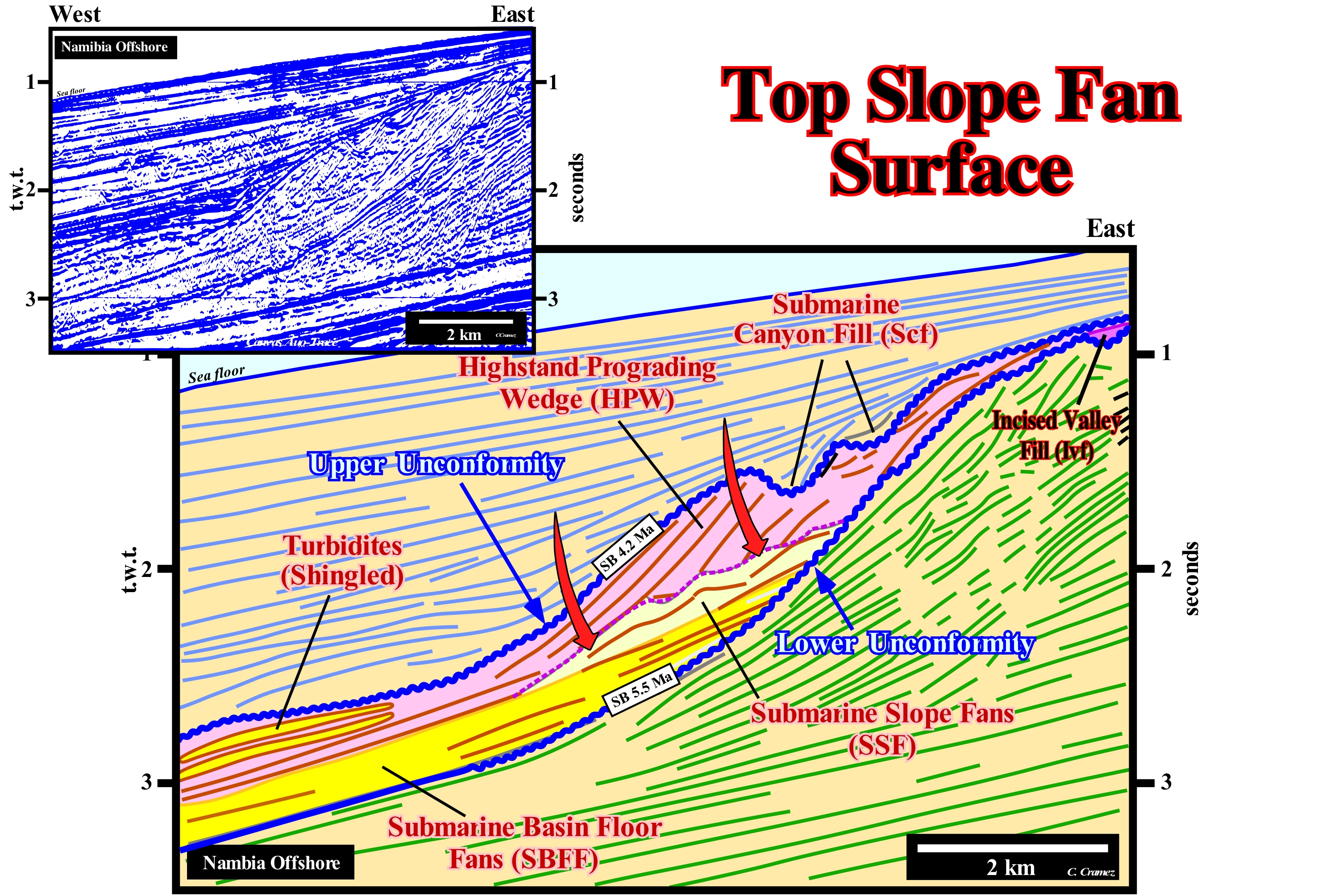
On this tentative geological interpretation of a Canvas auto-trace of a detail of a Namibia offshore regional seismic line, a stratigraphic cycle said sequence-cycle, induced by a 3rd order eustatic cycle (time-duration between 0.5 and 3-5 My), is, clearly, visible between the two unconformities (blue-coloured erosional surfaces). These two erosional surfaces were induced by two significant falls of the relative sea level (local sea level referenced to the base of the sediments or the sea floor, which is the result of the combined action of absolute or eustatic sea level* and tectonics), which put the sea level lower than the basin edge, as suggested by the filling of an incised valley (lower limit of the lower sequence-cycle) and a submarine canyon fill (upper limit of the sequence-cycle). The reflection terminations (coastal and marine onlaps and toplaps by truncation) corroborate the two unconformities, which in the deep environments of the sequence-cycle underline an important hiatus (the minimum gap occurs in the deep part of the basin where the submarine fans are deposited). As the age difference between the unconformities is less than 3-5 My (dating by correlation with a petroleum exploration well, located not very far of the seismic line of this auto-trace), the eustatic cycle, defined between the two consecutive relative sea level falls, is of 3rd order and the associated stratigraphic cycle is a sequence-cycle. However, this sequence-cycle is incomplete. The highstand systems tracts group (HSTG), did not deposit. This systems tracts group is formed by two subgroups. The sedimentary systems tracts of the lower subgroup constitute the transgressive interval, TI, and by systems tracts of the upper subgroup that constitute the highstand prograding wedge (HPW). None of these subgroups were deposited or were eroded during the relative sea level fall that marks the end of the stratigraphic cycle. The first hypothesis is more likely. This sequence-cycle is represented just by the lowstand systems tracts group (LSTTG), in which the three subgroups that comprise it are present: (i) Submarine Basin Floor Fans (SBFF) ; (ii) Submarine Slope Fans (SSF) and (iii) Lowstand Prograding Wedge (LPW). The submarine basin floor fans (SBFF) fossilize the lower unconformity by marine onlaps. These submarine fans have a parallel internal configuration and their boundaries (upper and lower) are abrupt. The submarine slope fans (SSF) are characterized by very particular structures that have a seagull-wings geometry that P. Vail called "Gull Wings". These structures, which correspond to the set of overbanking deposits, that is, the set of turbiditic natural marginal dikes (levees) and the fills of channels or depressions between them, fossilize the submarine slope fans (SSF) by a surface defined by the reflection terminations associated to the natural marginal dikes. The submarine slope fans (SSF), which cover the submarine basin floor fans (SBFF), stand against the unconformity (or its correlative deep water paraconformity) by marine onlapping are, totally, fossilized by the downlap surface of the progradations of the lowstand prograding wedge (LPW), which is, perfectly, visible on this tentative interpretation. It is interesting to note the presence of proximal turbidite fans at the basis of the progradations of the lowstand prograding wedge, whose progradational arrangement resembles that of roof shingled (shingle turbidites). These proximal turbidite deposits, since they are, practically, glued to the base of lowstand prograding wedge progradations are, often, deposited in association with ruptures and failures of the edge of the lowstand prograding wedge, have a very typical electrical log response once its boundaries are abrupt (repetitive cylindrical geometry). Function of edge facies of the lowstand prograding wedge, they can have a different lithologies. When the facies is sandy, these turbidites can be excellent reservoir-rocks and develop morphological traps.
(*) Sea level supposed global referenced to the Earth's centre induced by: (i) Tectono-Eustasy that is controlled by the variation of the volume of the ocean basins ; (ii) Glacio-Eustasy, which is controlled by the variation of ocean water volume as a function of the amount of ice ; (iii) Geoidal-Eustasy, which is controlled by the distribution of ocean water caused by variations in the terrestrial gravity field, and (iv) Thermal expansion of the oceans or Steric sea level rise (if the temperature of the oceans increases, the water density decreases and , for a constant mass, the volume increases).
Top Unconformity.................................................................................................................................................Discordance Supérieure
Discordância superior ( de topo) / Discordancia del tope, Discordancia superior / Top Diskordanz / 首页-不一致 / Угловое несогласие в кровле / Discordanza sottostante, Discordanza superiore /
Unconformity that limits, at the top, a stratigraphic cycle, and particularly a sequence-cycle, which is induced by a 3rd order eustatic cycle, whose duration varies between 0.5 and 3-5 million years. Eustatic cycles are the main responsible for the cyclic creation of the space available for sediments (accommodation).
See: « Unconformity »
&
« Sequence Boundary »
&
« Truncation »
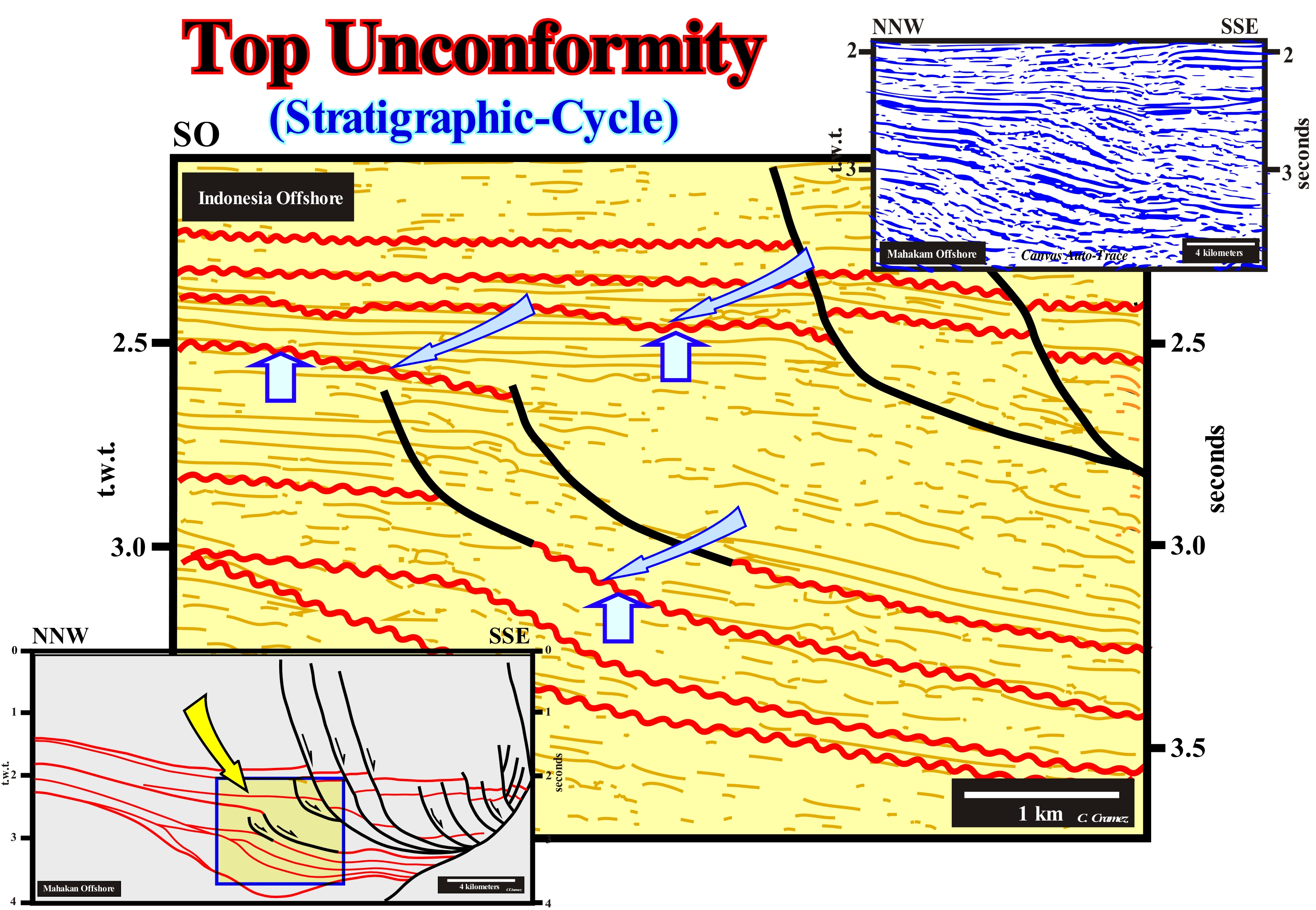
In sequential stratigraphy, all stratigraphic cycles, i.e.,: (i) Continental Encroachment Cycles ; (ii) Continental Encroachment Subcycles and (iii) Sequence-Cycles are limited, at the top and bottom, by unconformities, that is, by erosional surfaces induced by significant falls in relative sea level (local sea level referenced to the bottom of the sea or to the top of the continental crust, i.e., base of the sediments). These stratigraphic cycles are induced by eustatic cycles (cycles of the curve of relative sea level changes), which are, of course, individualized by unconformities. It can be said the unconformities correspond to the limits of the eustatic cycles, which are defined between two consecutive relative sea level falls. An unconformity, whether top or bottom unconformity (the top unconformity of a cycle, is necessarily, the bottom unconformity of the overlapping cycle) corresponds to an erosional surface that is, particularly, visible using the reflections terminations (lapouts) surrounding of the basin edge. The sequence-paracycles, which make up the different groups and subgroups of sedimentary systems tracts are induced by eustatic paracycles, i.e., by successive marine ingressions without significant relative sea level fall between them. In fact, eustatic paracycles are separated from each other by flooding surfaces. Increasingly large numbers of marine ingressions (eustatic paracycles or relative sea level rises in acceleration) and by increasingly smaller marine ingression (eustatic paracycles or relative sea level rises in deceleration) form an eustatic cycle limited between two significant in relative sea level falls. This means that an eustatic paracycle has nothing to do with an eustatic cycle. In the same way, it can be said a sequence-paracycle, which is deposited during the stability period of relative sea level occurring after each marine ingression, has nothing to do with a sequence-cycle. A sequence-cycle is formed by a set of sequence-paracycles that are deposited in association with the different sectors of the curve of relative sea level changes (concave descending, concave ascending and convex ascending sectors*), which is the result of the combination of absolute (eustatic) sea level changes and tectonics (subsidence or uplift of the sea floor). The unconformities are characterized by onlapping of the overlying sediments or by toplaps (truncation or nondeposition) of the underlying sediments. These reflector terminations are not located along the entire erosional surface, but rather in particular locations such as, for example, in incised valleys and submarine canyons or in the vicinity of the basin edge or even in the middle/lower part of the continental slope where the coastal onlaps of the lowstand prograding wedge are well visible. When the relative sea level falls significantly, in general, it becomes lower than the basin edge, forming what, initially, the Exxon Exploration Production Research (EPR) geoscientists called type I unconformity. In this case, the shoreline, where the rivers flow, moves seaward (progradation), sometimes, several tens of kilometers and downwards (negative aggradation). This downward displacement of the shoreline breaks the provisional equilibrium profile of the rivers, which are obliged to excavate (incise) their beds in order to reach a new provisional equilibrium profile, which means that erosion is done, preferably along the water-courses (it is for this reason that on seismic lines the unconformities are difficult to recognize when they are not tectonically enhanced). A river reaches its definitive equilibrium profile or ideal when the slope of the river is such that it just allows the water to flow and that all the sedimentary transport has disappeared. When the river neither deposits nor incise its bed, in a significant way, the slope of the river, throughout its course, allows him, just, to evacuate its load. Such a profile is not definitive, but provisional, since the river continues to transport sediments from the upstream erosion. In association with a relative sea level fall, submarine slumps and canyons can occur near the basin edge, which makes the identification of the unconformities easier in these areas.
(*) When a forced regression is deposited at the end of a sequence-cycle, certain sequence paracycles are deposited in association with the convex descending sector of the curve of the relative sea level changes. We recall a forced regression is the displacement of the shoreline seaward within a sequence-cycle, when the relative sea level falls and when the position of the upper limit of the sequence-cycle, is difficult to locate. For some years now, there has been an important debate regarding the position of the upper limit of the sequence-cycle in the transitions from marine to nonmarine environments.
Topform....................................................................................................................................................................................................................................................Topoforme
Topoforma / Topoforma / Topform (Reflexion Kündigung) / 顶断 (反射终止) / Топоформа / Topforma (terminazione di riflessione) /
One of the almost horizontal sedimentar surfaces deposited at the top of a delta prograding seaward that is the natural continuation of the alluvial plain. Synonym with Upper Bed (of a delta).
See : « Delta »
&
« Depositional Surface »
&
« Foreset Bed ( delta) »

In sequential stratigraphy a delta corresponds to a sedimentary systems tract (lateral association of synchronous and genetically linked depositional systems) deposited during the stability period of relative sea level (local sea level referenced to any point on the Earth's surface, which is the result of the combination of the absolute or eustatic sea level, which is referenced to the Earth's centre centre, and tectonics) that occurs after an eustatic paracycle i.e., after a marine ingression. In general, it may be said a delta corresponds to a sequence-paracycle, although, sometimes, and particularly on the seismic lines several sedimentary systems tracts may form a single sequence-paracycle. Obviously, due to the seismic resolution, most often, a seismic sequence-paracycle corresponds to the vertical stacking of several sedimentary sequence-paracycles (1: 1 scale). Theoretically, a delta consists of three types of beds, which from upstream to downstream, are: (i) Upper horizontal ; (ii) Seaward dipping and (iii) Lower horizontal or subhorizontal. The former, which correspond to what certain geoscientists call topforms (this term is, currently, very little used), form the delta plain and the delta front. The seaward dipping beds form the prodelta and the lower subhorizontal beds form the distal part of the delta, where, under certain conditions, proximal turbiditic systems can be deposited. It is important not to confuse a delta with a delta building. As shown in this figure, either in longitudinal cross-section or in transversal cross-section, a delta, generally, has a thickness ranging between 20 to 60 meters, while the thickness of a delta building, which corresponding to a stacking of deltas, can reach more than 5,000 meters. Taking into account the vertical exaggeration of the sketch represented in this figure, it is more than evident that if a seismic line is represented at the natural scale (1: 1), the different layers that form a delta can not be individualized. The upper bed facies are, generally, silty in the proximal delta plain, and sandy in the distal part i.e. near the delta front. The facies of the seaward dipping beds are shaly, as well as, in general, the facies of the sub-horizontal lower beds. This sketch, and particularly the transversal cross-section shows, clearly, the pendulum effect (pendular lateral displacement of the progradating depocenters due to lack of available space for the sediments) during the deposition of a delta building. At the level of the upper beds it is easy to see that the maximum thickness is always displaced and is, more or less, alternated, which means that, on the maximum thickness of a delta plain (DP), a minimum is deposited. In other words, the depocenters move, successively, rightward or leftward, where available space for the sediments (shelfal accommodation) is appropriate. The trilogy, upper subhorizontal beds - seaward dipping beds - lower subhorizontal beds, which marks a sigmoid geometry of the progradations, is not always complete. However, the presence of dipping beds is mandatory. A delta may not have the upper beds. In this case the geometry of the progradations is oblique. When a delta does not have the lower subhorizontal beds, the progradations do not correspond to true downlaps. The delta front, where sand is, usually, deposited corresponds always to the line of rupture between the upper and lower beds. It is in a delta building that J. Walther’s law, which states that depositional environments change, laterally, over time and, as a consequence, the facies of adjacent depositional environments follow each other as a vertical sequence, which it means that the vertical succession of the facies is the same as the lateral succession, what is, easily, corroborates. In fact, in a delta building, the lateral succession of a) Upper subhorizontal beds, b) Seaward dipping beds and c) Lower subhorizontal beds, implies, necessarily, a vertical succession of c) Lower subhorizontal, b) Seaward dipping beds and a) Upper subhorizontal beds. Since in the field or on a seismic line, a geoscientist has recognized, for instance, seaward dipping beds of a delta, he can deduce that, continentward and upward, the upper subhorizontal beds will be found. However, to differentiate the subhorizontal beds, he has to know where the seaward dipping beds are. If they are upstream the subhorizontal layers will be the lower subhorizontal beds, if they are downstream they will be the upper horizontal beds.
Toplap...................................................................................................................................................................Biseau supérieur de progradation
Bisel superior de progradação / Bisel superior de progradación / Toplap, Bevel bis Progradation, Bevel-Superior Progradation / 锥高达progradation / Регрессивное (кровельное) прилегание / Bisello superiore de progradazione /
Geometric relationship determined by the termination of strata or seismic reflectors, against an overlying surface (upper limit of a systems tract or stratigraphic cycle). This geometric relationship can be created by erosion or absence of deposition (nondeposit). A toplap can be: (i) Coastal ; (ii) Marine and (iii) Nonmarine. Synonym with Top Lapout.
See: « Downlap »
&
« Negative Costal Aggradation »
&
« Geometric Relationship (sequential stratigraphy) »
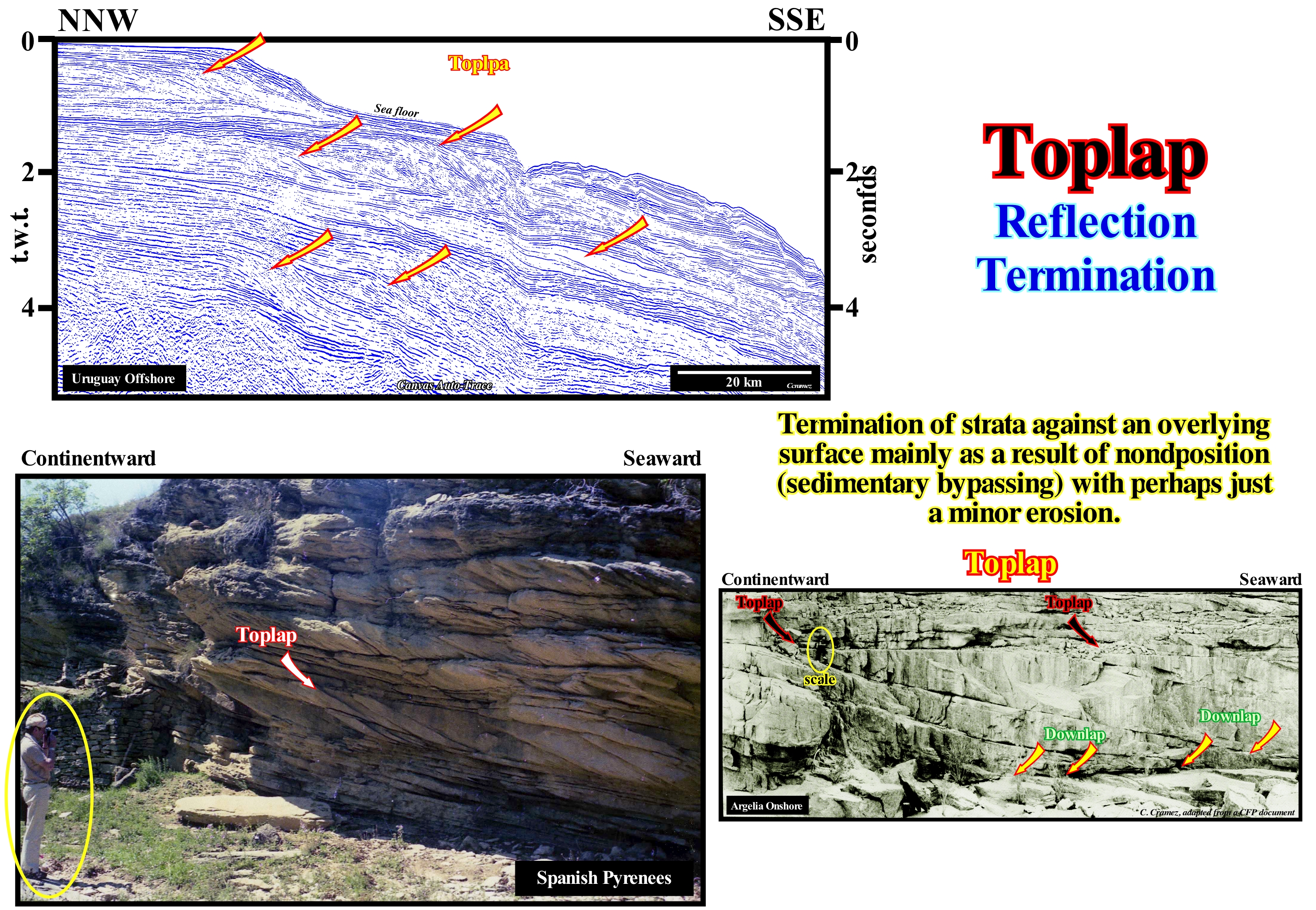
In the lower photograph, the scale is given by a geoscientist, who is close to the toplap (within the ellipse) of a sandy body of fusiform geometry. It is evident that this lapout is not associated with a significant erosional surface, but rather with a nondepositional surface. He does not, necessarily, stress an unconformity. In general, this means it does not correspond to a stratigraphic cycle boundary. In strata or groups of successive dipping beds deposited on each other progradationally basinward (lateral accretion or outbuilding), the lower terminations are downlaps. The shape of each sedimentary body is fusiform. Its thickness increases to a maximum, then thins until disappearing by pinchout. The upper and lower progradational lapouts underline converging intervals, upstream and downstream. On any tentative geological interpretation, whether it be on a seismic line or an outcrop (exposure of the top of a rock or rock interval, close to the surface of the ground and directly observable), always requires a scale. Geology is a dependent scale. If the geoscientist was not present in this photograph to give the scale, an observer would recognize a progradational geometry but he would be unable to interpret it in environmental terms. The scale problem is complicated by the geological interpretation of seismic data. A seismic line, without horizontal scale (metric) and vertical (double time), can not be, correctly, interpreted geologically. Within a sequence-cycle, the progradations associated to a delta interval, developed in a lowstand prograding wedge (LPW). In the highstand systems tracts group (transgressive interval, TI and highstand prograding wedge, LPW) have the same geometry as the progradations of a continental slope or of an oblique stratification within a bed. The horizontal and vertical scales are, completely, different. In a delta, the vertical scale is on the order of tens of meters (the height of a delta slope exceeds, rarely, 30-40 meters). In a continental slope, it is of the order of hundreds or thousands of meters and in a bed it is centimetric or metric. Without the scales, a georadar line (used in geotechnics engineering) can be taken as a 2D seismic line used in petroleum research. An oblique stratification can be taken as a continental slope. The vertical scale of the first is in nanoseconds (10 -9 s), while the vertical scale of the second is in seconds (double time, t.w.t.). If you have questions about this, make a test. Ask a colleague what the average thickness of a delta is. The answer to such a question will be, probably, a few hundred or thousands of meters. If this is the case, your colleague confuses a prodelta (seaward dipping beds of a delta) with a continental slope. The average thickness of a delta is 30/50 meters. However, the thickness of a delta building, such as the Mississippi delta building, which is the stacking of several hundred deltas, exceeds, easily, thousands of meters. On the Canvas auto-trace of an Uruguay offshore seismic line illustrated in this figure, toplaps are obvious (some of them are emphasized by the yellow arrows). Taking into account the vertical scale of the auto-trace, the progradations should be interpreted as continental slopes and not as delta progradations. Their geometry has to be corrected (even if by simple mental experience) of the pitfall induced by the increasing water-depth of the present-time continental slope, since the velocity of the seismic waves is smaller when they cross water than when they cross sediments. The underlying seismic reflectors should be, significantly, raised*. The downlap of the different progradational sedimentary packages is, in depth and at natural scale (1: 1), much less inclined than the one suggested by the auto-trace. Sometimes, the more distal and deeper reflectors underlying a large water-depth may even have a slope contrary to that suggested by the auto-trace of the time seismic line.
(*)The velocity of P waves , which causes the material to be alternately compressed and lengthened, in the direction of propagation varies with the medium. It is 330 m/s in the air, 1,450 m/s in the water and 5,000 m/s in the granite. As sedimentary rocks are compacted with burial, the deeper the rocks are, the faster the waves will pass through them. The highest speeds are reached in gypsum and anhydrite at around 6000 m/s. In dolomites, they vary between 5000 and 5500 m/s, and about 5,000 ms in limestones.
Topset (Chronostratigraphic line).....................................................................................................Segment Horizontal supérieur
Segmento horizontal superior / Segmento horizontal superior (línea cronostratigráfica) / Oberen horizontalen Segment / 顶部的沉积段 / Покрывающий ряд / Segmento orizzontale superiore /
One of the three segments that form a chronostratigraphic line: (i) Upper Horizontal Segment ; (ii) Seaward Dipping Segment and (iii) Lower Horizontal Segment. The upper horizontal segment represents the sediments deposited in shallow water (usually platform sediments).
See: « Parallel Configuration »
Topset Bed (Delta).............................................................................................................................................................................Couche supérieure
Camada superficial ou superior / Estrato superior / Deckgende Schichten / Topset床 / Поверхностный пласт (дельты) / Strato superiore (delta) /
Bed or group of subhorizontal beds of delta deposited in the delta plain, upstream of the depositional coastal break of the depositional surface.
See: « Delta »
&
« Bottomset Bed (delta) »
&
« Sigmoid Offlap »
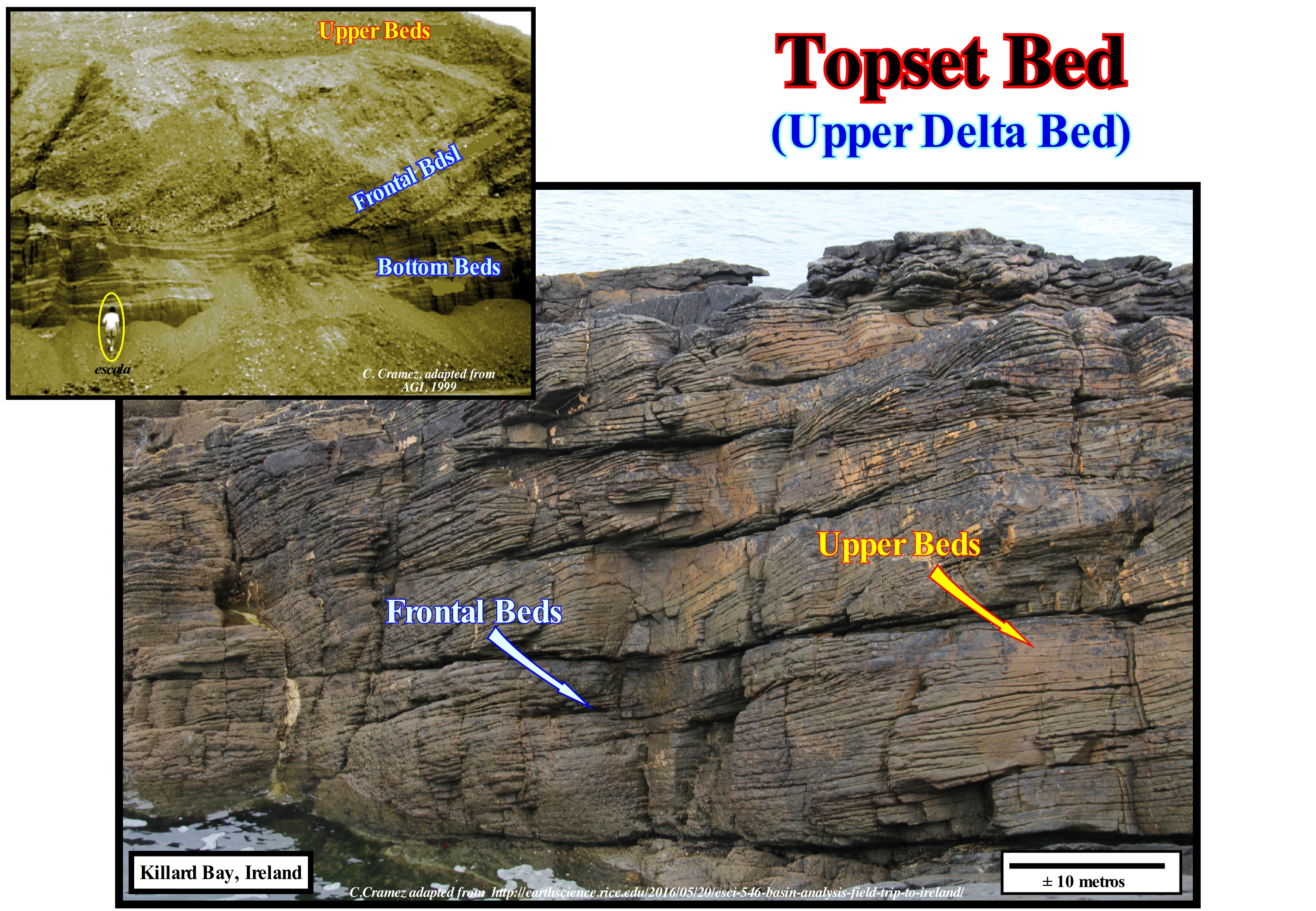
Do not forget that geological interpretations depend on scale and the natural scale of Geology is that of the field, i.e., 1: 1. A seismic line without scales can not be interpreted*. The geometry of a delta slope is the same as that of a continental slope or that of an oblique stratification, which means that in a geological interpretation and, in particular, in the geological interpretation of the seismic lines, it is important to differentiate the uncertainty error (the difference between an individual result and the true value). When the value of a the aggradation is determined (whether it is positive or negative), an error is always made, which can be quantified, numerically, by a margin of error, which depends on the method of measurement. Uncertainty is what we do not know**; it is the result of a combination of error with interpretation, interpolation, and extrapolation of data under influence of the geoscientist. Although errors may be part of the uncertainty of an interpretation, for instance, when a geoscientist interprets certain progradations as a continental slope on the basis of certain measurements, the uncertainty of interpretation is difficult to quantify in the same way as error. In these photographs, taking into account the scale, one can, easily, recognize the three types of layers that are found in most delta: (i) Upper Beds or Superficial Layers, which are more or less subhorizontal and disappear continentward by onlapping ; (ii) Frontal beds or Dipping Layers, which plunge seaward and (iii) Bottom Beds or Basal Layers,which are, also, subhorizontal as the upper layers, but located downstream of the frontal beds and pass, in general, into marine platform deposits. We are talking about beds or layers and not strata (chronostratigraphic units). The strata have a chronostratigraphic value, while the layers, in general, do not. However, roughly, it can be said the upper layers, for example, continue downstream to form the front layers, which, in turn, continue outward to form the basal layers. Thus the three layers, as a whole, form a chronostratigraphic unit as a single stratum. Geoscientists who interpret seismic lines, where it is easier to follow the continuity of sedimentation (albeit indirectly) than in the field, know that they must never forget the scales and they should not confuse a time-line (chronostratigraphy) with a facies-line (lithostratigraphy). In these photographs, without the scale and without the granulometry of the frontal and upper layers, no one could say whether the slopes illustrated are continental or deltaic. In contrast, even without scale, it is easy to see that the chronostratigraphic lines are sigmoidal and that the facies-lines are subhorizontal (particularly on the upper left photo). At the macroscopic scale (scale of geological charts, seismic lines, sedimentary basins, etc.), in the field or in the seismic lines, the time-lines and the facies-lines (lithology) intersect. Only at the mesoscopic scale (outcrops, when there is continuity of bedding planes) and not always, can the chronostratigraphic lines be, locally, coincident with the facies-lines. The upper layers of a delta building (not to be confused with a delta, whose thickness rarely exceeds 30-50 m) are deposited only if there is a relative sea level rise*** (marine ingression or eustatic paracycle). A delta building with a progradational / oblique geometry (without upper beds, can settle over a long stability period of relative sea level). When at the level of a sequence-cycle, the sedimentary basin has a shelf, the delta slope, which is, generally, between 10 and 60 m in height, is located upstream of the continental edge, which, in this case differs, easily, from the shoreline. When the sedimentary basin has no shelf and the continental edge coincides with the shoreline, the delta slope is located at the top of the continental slope, which has a minimum height of 200 meters.
(*) The time when certain manager of petroleum exploration removed the location and scales of seismic lines, whether for reasons of confidentiality or for reasons of interpretation philosophy ("tabula rasa" , i.e., preconceived ideas) no longer exists.
(**) Funtowicz e Ravetz, 1990 - Uncertainty and Quality in Science for Policy, Kluwer, Dordrecht).
(***) The relative sea level is the local sea level, referenced to any point on the Earth's surface, which may be the base of the sediments (top of the continental crust) or the sea floor and which is the result of the combined action of the absolute (eustatic) sea, which is the global sea level, referenced to the Earth's centre, and tectonics (subsidence or uplift of the sea floor).
Total Bypassing....................................................................................................................................................Transit sédimentaire total
Trânsito sedimentar total / Tránsito sedimentario total / Insgesamt Umgehung / 总计绕过 / Абсолютный осадочный переход / Totale scavalcamento /
Transport of sediments through a deposition site to another site. Not to be confused with transposition of sediments in which only particles of a certain size move upstream of the deposition site.
See: « Sequential Stratigraphy »
&
« Depositional Base Level »
&
«Turbidite »

A total bypassing is very difficult to observe, either on the ground or on the seismic lines, since the original deposition site, when it disappeared completely, is very difficult to prove and locate it. However, a partial bypassing, as illustrated on this tentative geological interpretation of a seismic line from NW Australia, is, relatively, easy to visualize, both on the seismic lines (macroscopic scale) and in the field (mesoscopic scale), when outcrops are frequent and with a certain continuity. Let us first of all remember (Theory precedes Observation) that the NW Australia offshore corresponds to the stacking of several basins of the classification of the sedimentary basins of Bally and Snelson (1980). In the regional seismic lines of this offshore it is, relatively, easy to recognize from the bottom to top: (i) A basement that is, often locally, formed into a flattened Paleozoic mountain belt ; (ii) Late Jurassic/Cretaceous Early rift-type basins, which lengthened the lithosphere of the small supercontinent Gondwana thus contributing to its break-up and (iii) An Atlantic-type divergent margin, in which the two phases of the Pangea continental encroachment cycle are, easily, identified: (a) The transgressive phase of retrogradational geometry, deposited in association with a marine ingression induced by the decreasing volume of oceanic basins created by the oceanic expansion (sea floor spreading) that followed the break-up of the lithosphere of the small supercontinent Gondwana and (b) The regressive phase, whose geometry is progradational, deposited during the falling of the absolute (eustatic) sea level (supposed to be global, referenced to the Earth's centre). The absolute sea level is the result of the combination action of: (1) Tectono-Eustasy, (2) Glacio-Eustasy, (3) Geoidal-Eustasy and (iv) Steric sea level rise or thermal expansion of the oceans, which is controlled by rising ocean temperatures (if the temperature increases, the water density decreases and, for a constant mass, the volume increases) induced by the increase oceanic crust subduction along the subduction zones and tectonic collisions. Thus, on this tentative interpretation, three large sedimentary packages can be put into evidence: (A) The sediments of the rift-basin type (coloured purple), in which several normal faults lengthened the lithosphere and contributed to the development of a differential subsidence ; (ii) Sediments of the transgressive phase of the post-Pangea continental encroachment cycle (coloured in green), which are characterized by a parallel internal configuration (aggradation is, largely, predominant) and which, globally, has a retrogradational geometry and (iii) The sediments of the regressive phase of the post-Pangea continental encroachment cycle, characterized by several intervals which, globally, have an eastward progradational geometry (at least in this example), in which, except for the lower interval (yellow coloured) which corresponds to the submarine basin floor fans of a sequence-cycle (progradation exceeds aggradation). At the base of the regressive phase of the post-Pangea continental encroachment cycle, which is separated from the transgressive phase by a major downlap surface, it is, easy, to see that the sediments of the distal part of the first progradational interval, probably due to a series of slumpings, associated with local listric faults, were transported, partially, seaward where they were deposited. This particular type of normal curvilinear faults, which, obviously, horizontalize in depth, on the basis of which a local compressional tectonic regime develops. That means means that in the upper part of listric fault, the geometry and the relative movement of the fault blocks are typical of a normal failure, whereas in the lower part, the geometry and the movements of the faults blocks are, typical, of an reverse fault. This partial sedimentary bypassing induced the deposition of an incomplete sequence-cycle, formed just by the three subgroups of the lowstand systems tracts group, that is, the submarine basin floor fans (SBFF), which is the lower subgroup (coloured in yellow) yellow), which is covered by the submarine slope fans (SSF), which form the intermediate sub-group (beige colour), and the lowstand prograding wedge (LPW) that forms the upper subgroup, which here is colored in violet. Partial sedimentary bypassing induced by contour currents are very common in certain basins, for instance in the deep part of the North Sea cratonic basin in association with turbidite depositional systems.
Total Subsidence............................................................................................................................................................................Subsidence totale
Subsidência total / Subsidencia total / Insgesamt Subsidenz / 总沉降 / Полное оседание / Subsidenza totale /
Total amount of sinking of the initial depositional surface. In sedimentary basins induced by tectonics and compensated by isostasy, the sedimentary loading causes an additional subsidence that, in turn, creates more space for an additional loading.
See: « Glacio-Eustasy »
&
« Subsidence »
&
« Compensatory Subsidence »
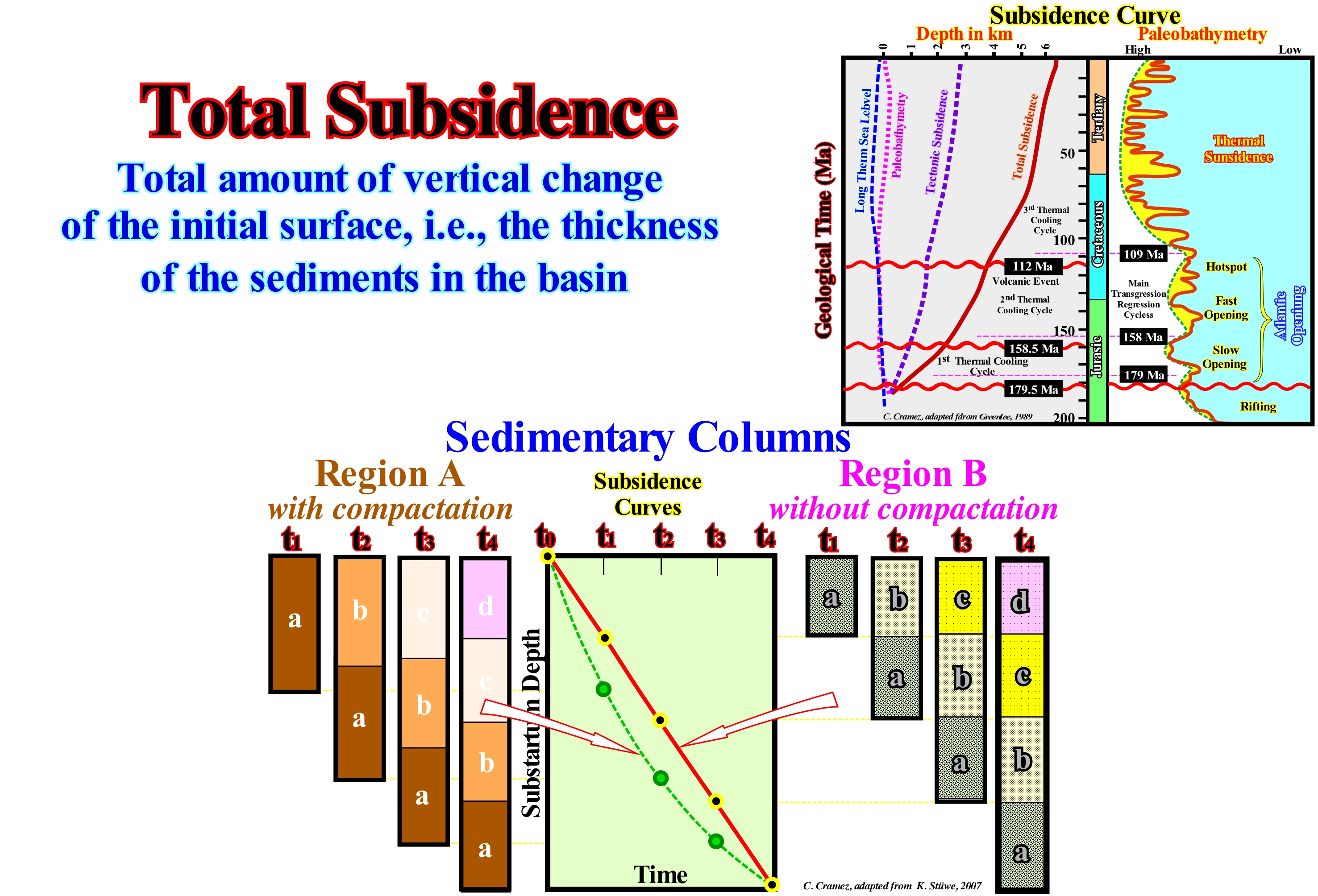
The vast majority of geoscientists differentiate the total subsidence of tectonic subsidence. Total subsidence is marked by the total sinking of the substratum of a basin, whose velocity determines the rate of subsidence. The total subsidence corresponds to the sum of the tectonic subsidence plus the subsidence, induced by the sedimentary loading, plus the height of water plus the value of the compaction (chemical compaction, which includes the dissolution of minerals under pressure and mechanic compaction, which encompasses physical processes, intergranular packing and deformation or breaking of individual grains). The tectonic subsidence, which is, fundamentally, created by tectonic mechanisms (lengthening, cooling and loading) is one of the components of total subsidence. It is equal to the total subsidence (sediment thickness plus water-depth) decreased by the effect of isostatic compensation (due to sedimentary overload) and increased by the compaction effect. As illustrated in this figure to interpret the tectonic processes associated with the formation of a sedimentary basin, the knowledge of total subsidence (thickness of the sediments plus the water-depth) is the starting point.It is necessary to not forget sediments (rocky debris resulting from erosion, chemical precipitation from oceans, valleys, or rivers, deposited in layers of loose particles when the energy of the transporting fluid decreases), it is necessary to determine the original thickness of the sediments, assuming that it was just induced by a change in porosity and not by metamorphism, diagenesis, cementation or dissolution. To determine the contribution of tectonics to subsidence, it is necessary to subtract from the total subsidence the influence of the sedimentary loading. It is what certain geoscientists call "back stripping" (technique used to calculate the depth that would have the basement in the absence of sediment and water loading, which provides a value of the tectonic vector responsible for the formation of the basin). In the right diagram, the influence of compaction in the sedimentary column thickness during the time (t1 - t4) is shown in two different regions, in which the sediments compacted during successive depositions. In the region A, the sediments are compacted. At present-time (t4), the thickness of the sedimentary intervals in the two areas is equal. However, the thickness of the intervals reached in t4 by different histories (sedimentation and subsidence). In region B, the sedimentation rate was constant and any intervals reached compaction. The same thickness of all the intervals at t4 is the consequence of compaction, which balanced the variations ofof the sedimentation rate occurring in the region. In calculating the sedimentation rate do not forget to take into account the sedimentary completeness: "The sedimentary sequences record the passage of geological time as a set of alternations of deposits and sedimentary gaps ; the proportion of these two components defines the stratigraphic completeness*. In fact, the main consequence of the sedimentation processes is the thickness variation of the accumulated sediments over time. Whenever the variation of thickness over a period of time is positive, there remains a record of the existence of a sedimentation system, i.e., a stratigraphic section. However, such a section can be observed in various ways depending on the knowledge and expectations of the geoscientists. For some, the problem that this section of stratigraphy gives is the determination of the detailed correspondence between thickness and time, that is to say, to know its completeness (relation between the actual time of deposition and total geological time. For others, the problem that this stratigraphic section raises is the determination of the nature of the sedimentation system and the determination of its control parameters. If the time between two consecutive unconformities is 10 My and the actual deposition time is 1 My, the completeness is 0.1. In turbidite systems, the completness of the deposits is very small, but the preservation is great. The time of deposition of a deep turbiditic lobe (submarine basin floor fans) is, practically, instantaneous (in geological terms), while the time between two consecutive lobes, during which, practically, nothing happens (at the point of view of deposition), can be thousands of years or more.
(*) Peter M. Sadler, 1981- Sediment Accumulation Rates and the Completeness of Stratigraphic Sections. The Journal of Geology, Vol. 89, No. 5 (Sep., 1981), pp. 569-584.
Traction (Sedimentary particles).............................................................................................................................................................................Traction
Tracção / Tracción (de los sedimentos) / Traktion (Sediment) / 牵引(沙) / Растяжение (осадков) / Trazione (sedimento) /
Sedimentary transport in which the sedimentary particles are swept longitudinally and parallel to the basal surface (on it, near or immediately above), either by rolling, slipping, entrainment, jerking or even jumping.
See: « Sediment Supply »
&
« Flux »
&
« Saltation (transport) »
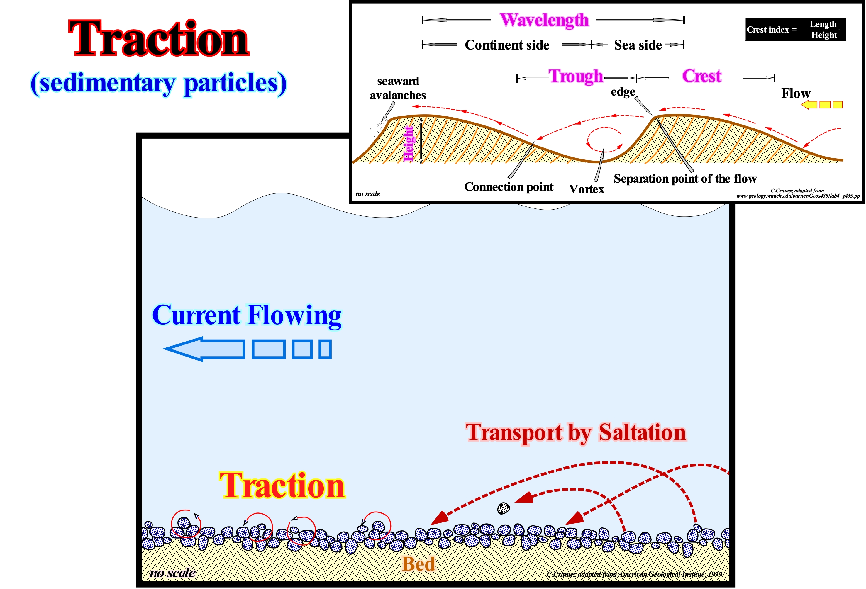
As illustrated in these schemes, in a traction transport, the sedimentary particles are swept in the direction of rolling, slipping, entrainment, jerking and sometimes even by jumping. The understanding and significance of the primary sedimentary structures in terms of physical, biological and chemical processes occurring during or immediately after deposition is one of the starting points for the analysis of the sedimentary rocks and environments, in which they were deposited. Therefore, even small knowledge of fluid dynamics, ecology and chemical processes is very useful. Three particular and basic informations on the flow conditions of the fluids were deduced from the primary sedimentary structures: (i) The suspension and traction mechanisms are fundamentally different (they can be recognized by the different structures they produce in sediments and effects associated with trajectories followed by particles moving under the influence of each of these mechanisms) ; (ii) The effects of grain shocks on cohesion-free sediments due to runoff can also be recognized in the primary sedimentary structures and (iii) Shear effects at the fluid-sediment interface may produce deformations in the cohesive sediments. On the other hand, stratification, which is a primary sedimentary structure (aggradational mechanics) and induced, in most cases by flow, can be done, as shown in the upper part of this figure, by a lateral accretion of the solid bottom loading, i.e. by traction. In this case, the stratification is oblique. The laminations are oblique with a height of less than 3 cm and a length of less than 40 cm. The beds are oblique with a height greater than about 10 cm and a length greater than 10 cm. This type of bedding contrasts with vertical accretion stratification that exhibits parallel and horizontal laminations and beds due to deposition by decantation* of clastic sedimentary particles or by chemical aggradation.
(*) Decantation is the gravity settling of particles in a suspension.
Traction Transport (Rolling transport).................................................................................................................Traction (sediments)
Tracção (dos sedimentos) / Transporte por tracción (arraste) / Transport durch Zug / 牵引运输 / Передвижение тягой / Trasporto per trazione /
When sediments are drawn along the substrate by a fluid, whether it be a water-course or wind, which, in general, implies a direct or indirect participation of the force of gravity. Synonym of Transport by Entrainment.
See:« Charge (stream) »
&
« Flux (outflow) »
&
« Traction (sediments) »
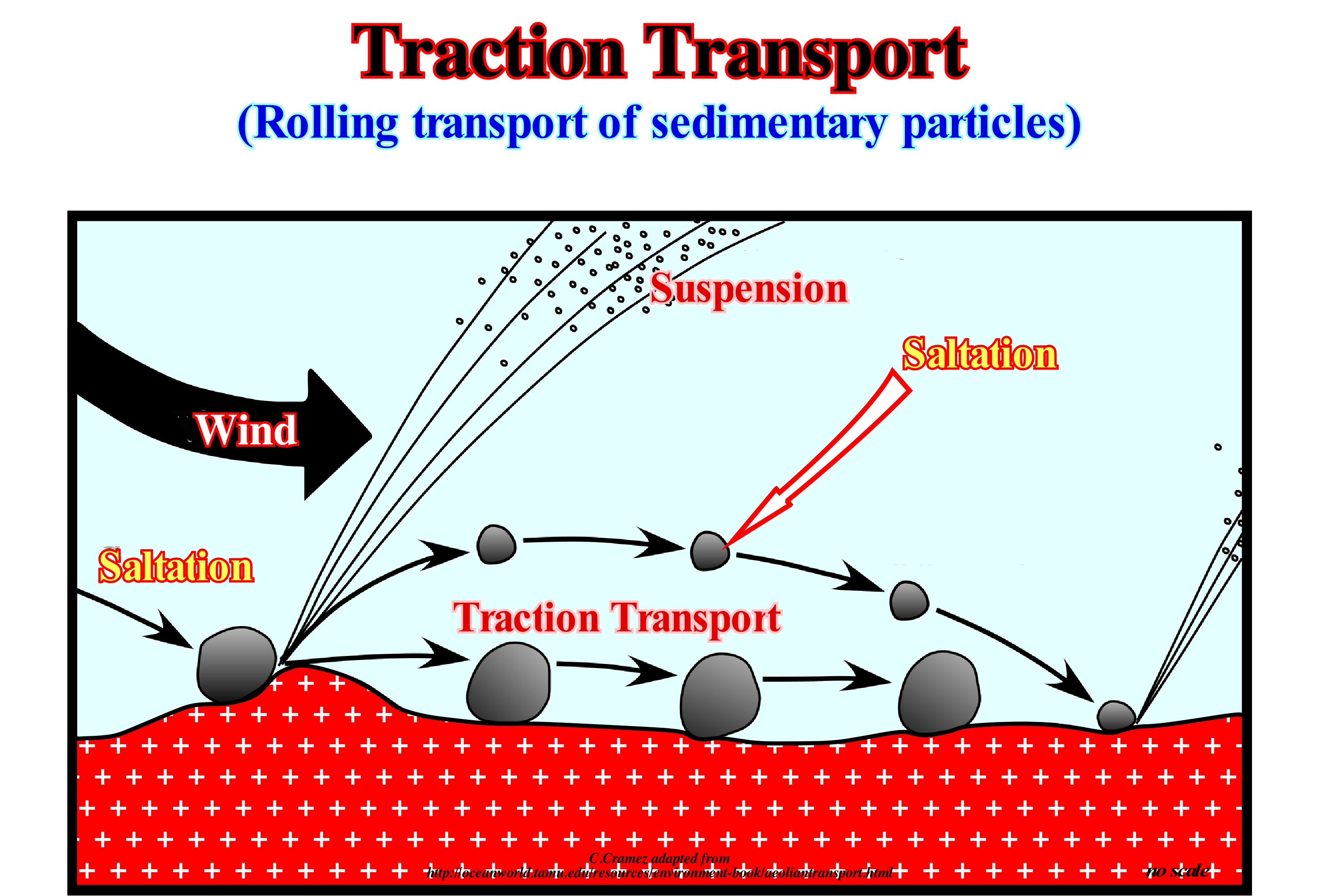
Many geoscientists consider that suspension transport is not part of what is generally called the bedload, although others consider that a large proportion of the sedimentary particles carried in suspension are derived from the solid charge of the bottom or dragged charge. The movement of the grains in permanent or intermittent contact with the bed of a water-course can be done by saltation, rolling or traction. Saltation describes the movement by jumps of the grains near the bed during a vigorous displacement of the bottom load. The grains follow asymmetrical trajectories, which can, usually, be very complicated in water by random or turbulence-induced fluctuations. When the turbulence becomes very strong, there are gradations between true saltations and suspensions. When the descending grains reach the bed, they jump back into the stream, dislodging grains over the bed of the stream or helping to set them in motion, or simply disperse their kinetic energy in the bed. In the air, collisions between grains are more vigorous than in water due to the lower viscosity and greater weight of the immersed grains. The mobilization of grains that rest on the bed is a very important process (in the water, a general cushioning of the impacts occurs and hydraulic lifting forces are probably more important at the beginning of the movement of the grains). When the grains collide with the stream bed and do not jump, their kinetic energy is dispersed by several grains resting in the bed. Some of these grains may, as a result, be pulled over a short distance downstream of the stream or towards the wind. This is the entrainment or dragging phenomenon can get to represent about 25% of the total movement of the solid bottom load in a wind transport. Rolling occurs when fairly large or elongated fragments are set in motion. The rolling is favoured if a large grain moves on a relatively flat surface of smaller grains.
Transform Fault....................................................................................................................................................................Faille transformante
Falha transformante / Falla transformante / Transformstörung / 轉形斷層 / Трансформный разлом / Faglie transformi /
Limit of lithospheric plates exhibiting a pure shear movement. Fault or fracture line associated with the lateral displacements of the mid-oceanic ridges.
See: « Footwall »
&
« Fault »
&
« Mid-Oceanic Ridge »
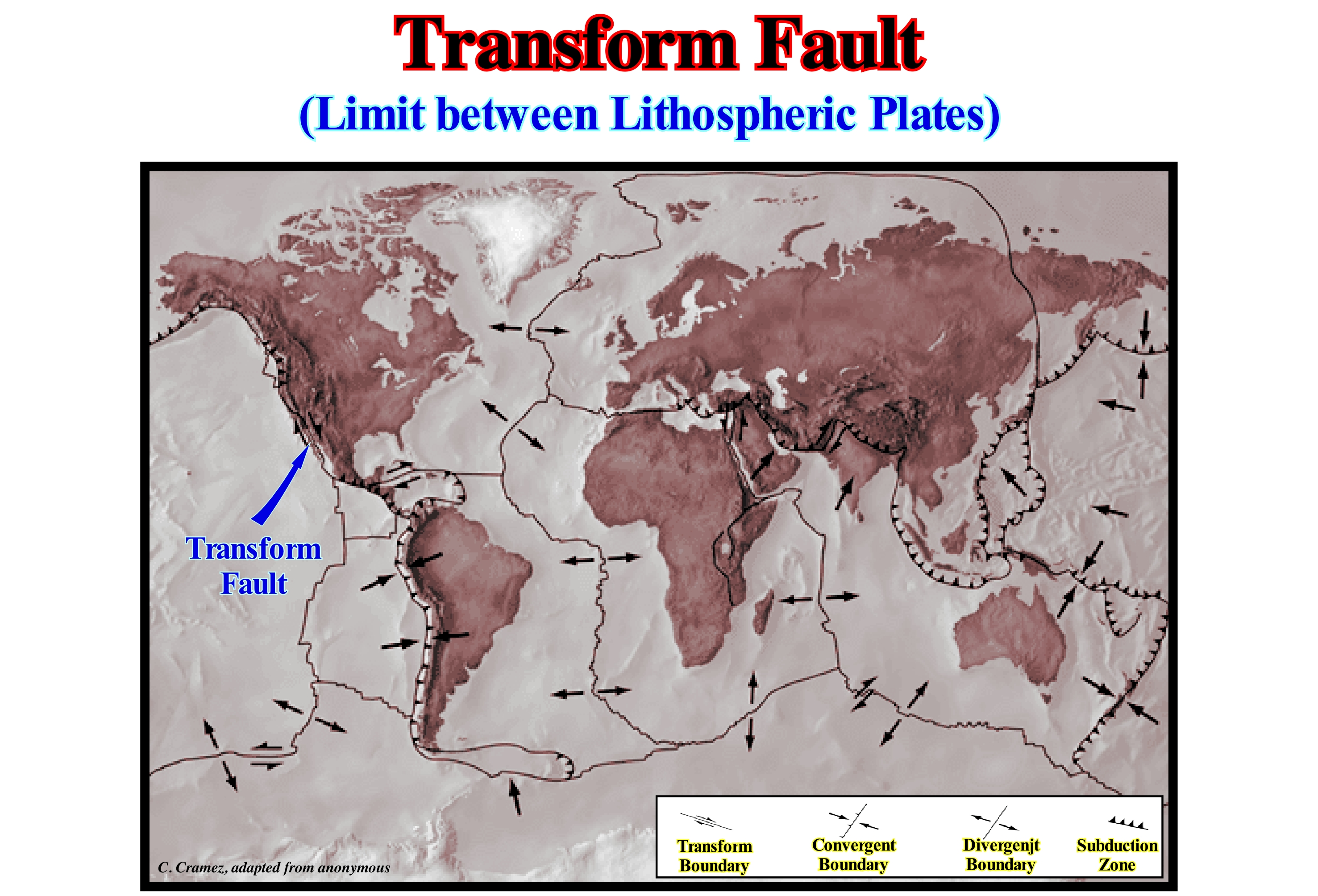
The transform fault of Saint Andrew, which brings the lithospheric plate from North America and the Pacific into contact, between the Gulf of California and San Francisco and which is about 1,200 km long, is, undoubtedly, the best known of all the transform faults. Transform faults are one of three types of boundaries between lithospheric plates. The divergent and convergent boundaries are the other two types. The relative movement along transform faults is horizontal and can be sinistral (if both plates move to the left), either dextral (if both plates move to the right). The vertical movement, practically, does not exist along a transform fault. As explained by Heirtzler JR (1968), the fused from the deep parts of the earth, along the oceanic expansion zone, solidifies and is pushed laterally (due to the uplift of asthenospheric material) as the expansion zone is displaced by a fracture zone (transform fault). Between the two expansion zones, the material on each side of the fracture zone (material of different lithospheric plates) moves in opposite directions and the friction zone between the two crustal blocks causes shallow earthquakes. Many geoscientists, who we do not follow, consider as transform faults the strike slip faults, which do not limit lithospheric plates. The different sectors, which can be highlighted along the oceanic ridges (divergent boundaries) are separated by transform faults along which earthquakes are frequent. These faults are only active between the centres of oceanic expansion (the graben or rift that forms the central part of the ridge). Contrary to a widespread idea among certain geoscientists, the transform faults do not continue continentward, via the oceanic crust. In reality, it is the opposite, i.e., it is the old fracture zones (faults, lithologic contacts, etc.) of the supercontinents, that conditioned the lateral displacements of the line of fracture of the lithosphere and thus the direction of the oceanic expansion and the transform faults.
Transgression (Marine ingression)..........................................................................................................................................Transgression
Transgressão / Transgresión / Überschreitung / 海进 / Нарушение / Trasgressione /
Gradual invasion of the sea on the lands. A large number of geoscientists took the habit of using the term transgression to designate the continentward displacement of coastal deposits. However, the coastal deposits do not have a reverse gear to move mainland. The term transgression to designate the displacement of the coastal deposits to the continent is inappropriate, since, in isolation, all the sequence-paracycles prograde seaward. There is no clastic sedimentary particles, not remobilized, that come from the sea. As one of my colleagues said: "Only mermaids come from the sea". It is a set of increasingly important marine ingressions and associated increasingly small sedimentary regressions, that collectively create a retrogradation morphology, which was called transgressions (sedimentary) by Cesare Emiliani (1992) and not transgression.
See: « Sequence-Cycle »
&
« Transgressive Interval »
&
« Shoreline »
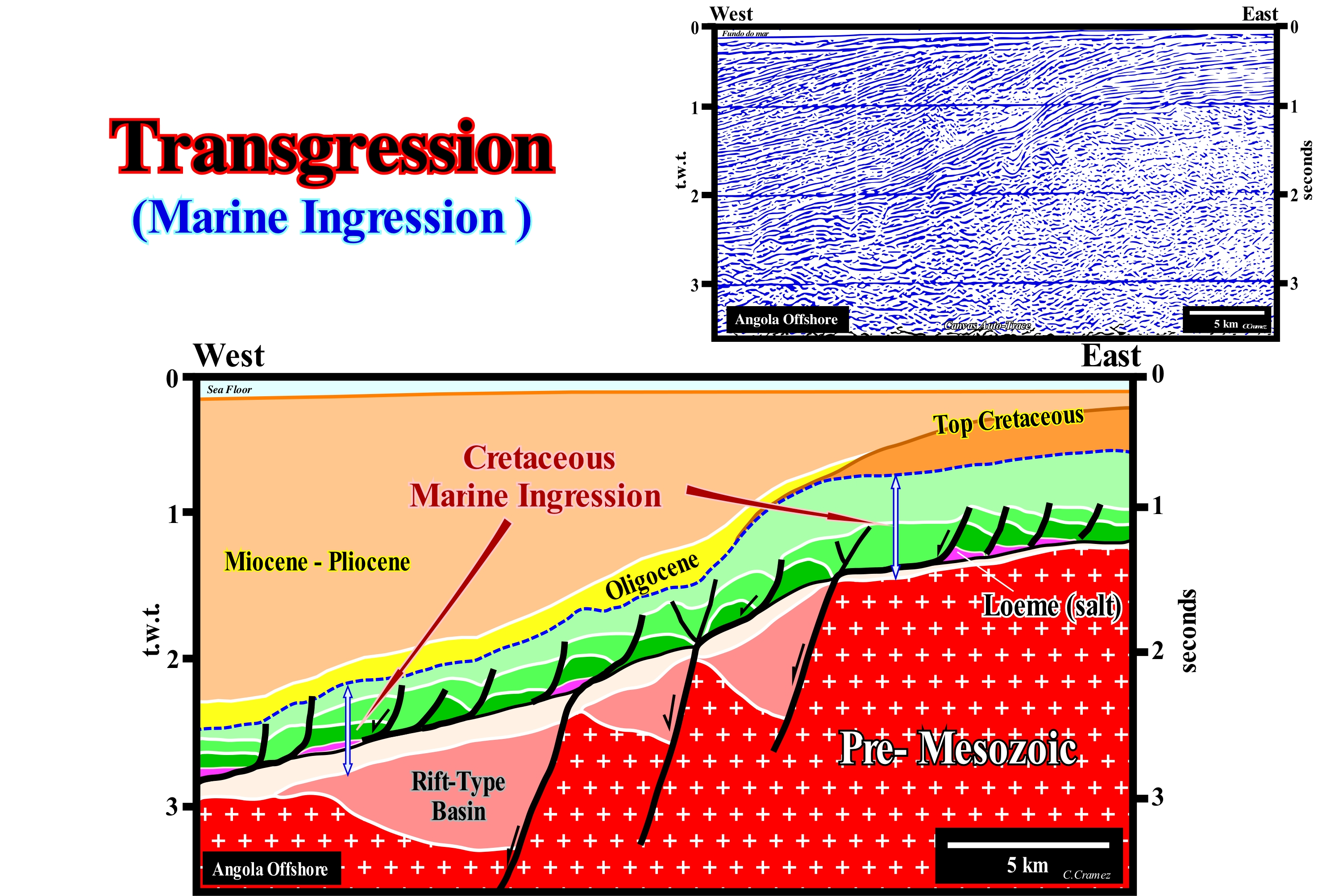
In geology a transgression was always the term used to designate a displacement of the shoreline toward the continent, induced by a rise of sea level* (relative or absolute), which means that a transgression is synonymous with marine ingression (sea encroachment onto the continent). In the University, my I teachers said: "The sea transgresses, but the sediments regress". On this tentative geological interpretation of a Canvas auto-trace of an Angola offshore seismic line, the Cretaceous marine ingression is, easily, recognized by the retrogradational geometry of the associated sediments. The progressive global landward displacement of the depositional coastal break of the depositional surface is, clearly, visible despite the presence, in this offshore, of an important salt tectonics (halokinesis). This displacement created a significant landward thickening of the sedimentary packages, particularly those of Early Cretaceous. The sediments of the Upper Cretaceous (after Turonian) are regressive. Seaward of the basin edge (continental edge when the basin has a shelf), which at the end of the Cretaceous was more or less coincident with the depositional coastal break of the depositional surface (more or less, the shoreline taking into account the seismic resolution), the regressive sediments of the Upper Cretaceous were deposited in relatively condensed stratigraphic sections. The term transgression, when used instead of marine ingression, which we prefer to avoid misunderstanding, should always be associated with the hierarchy of stratigraphic cycles. On this tentative interpretation, the term transgression is associated with the post-Pangea continental encroachment stratigraphic cycle, which was induced by a 1st order eustatic cycle (time-duration greater than 50 My). The transgressive phase of the continental encroachment cycle, was induced by the rise of the absolute (eustatic) sea level that determined the post-Pangea 1st order eustatic cycle. However, the association of a relative sea level rise with a transgression and a relative sea level fall with a regression is erroneous. It is one of the most frequent errors of many geoscientists. In order to deposit sediments continentward of the basin edge (i.e., on the shelf or on the coastal plain), it is necessary create or increase available space for sediments (shelfal accommodation), which can just be done by a relative sea level rise. All clastic sedimentary particles come, always, from the continent. There is no clastic sedimentary particles coming from the sea (coastal currents excluded). In a sequence-cycle, both during the transgressive interval (TI) and during highstand prograding wedge (HPW), the relative sea level must always rise. When it rises in acceleration, the transgressive interval (TI) is deposited. Since it begins to rise in deceleration, the highstand prograding wedge (HPW), which corresponds to a series of increasing important sedimentary regressions, is deposited. The transgressive interval (TI) corresponds to transgressions and not to a transgression. The transgressive interval is an alternation of increasing important marine ingressions (continentward displacement of the shoreline at each eustatic paracycle) and increasingly smaller sedimentary regressions (seaward displacement of the shoreline in association with the sequence-paracycles deposited during the stability periods of relative sea level occurring between the eustatic paracycles). It is this alternation of increasingly important marine ingressions (accelerating) and increasingly smaller sedimentary regressions, whose global geometry is retrogradational, that geoscientists call transgressions (C. Emiliani, 1992).
(*) In sequential stratigraphy it is fundamental not to confuse the relative sea level with absolute (eustatic) sea level. The first is a local sea level, referenced to any fixed point on the Earth's surface, which can be the base of the sediments (top of continental crust) or the sea floor. The second is the sea level, supposed to be global, referenced to the Earth's centre. The relative sea level is the result of the combined action of absolute (eustatic) sea level and tectonics (subsidence or uplift of the sea floor). The absolute sea level is the result of the combination of: i) Tectono-Eustasy that is controlled by the volume variation of the ocean basins in association with oceanic expansion following the rupture of the supercontinents ; (ii) Glacio-Eustasy, which is controlled by the variation of water volume of the oceans as a function of the amount of ice (assuming that the amount of water in all its forms is constant since the formation of the Earth (around 4.5 Ga) ; (iii) Geoidal-Eustasy which is controlled by the distribution of ocean water caused by variations in the Earth's gravity field (where gravity is stronger than normal, sea level is thrown to the centre of the Earth) and (iv) Steric rise of sea level or thermal expansion of the oceans (if the temperature increases, the density of the water decreases, and for a constant mass, the volume increases). During a given geological time, the combination of the eustatic curve (curve absolute sea level changes) and the tectonic (subsidence, when the predominant tectonic regime is in extensional or uplift, when the predominant tectonic regime is of compressional) gives the curve of the relative sea level change rate.
Transgression/Regression Cycle (Sedimentary)...................Cycle transgression-régression
Ciclo transgressão/regressão / Ciclo transgresión-regresión / Transgression-Regression Zyklus / 侵 - 回归周期 / Трансгрессивно регрессивный цикл / Ciclo Trasgressione-regressione /
The sedimentary interval deposited on the continental shelf, in general, during highstand geological, divided by a downlap surface. Within a sequence-cycle, landward of basin edge, a transgression/regression cycle is formed by the transgressive interval (Ti) and highstand prograding wedge (HPW).
See: « Stratigraphic Cycle »
&
« Systems tract »
&
« Relative Sea Level Change »
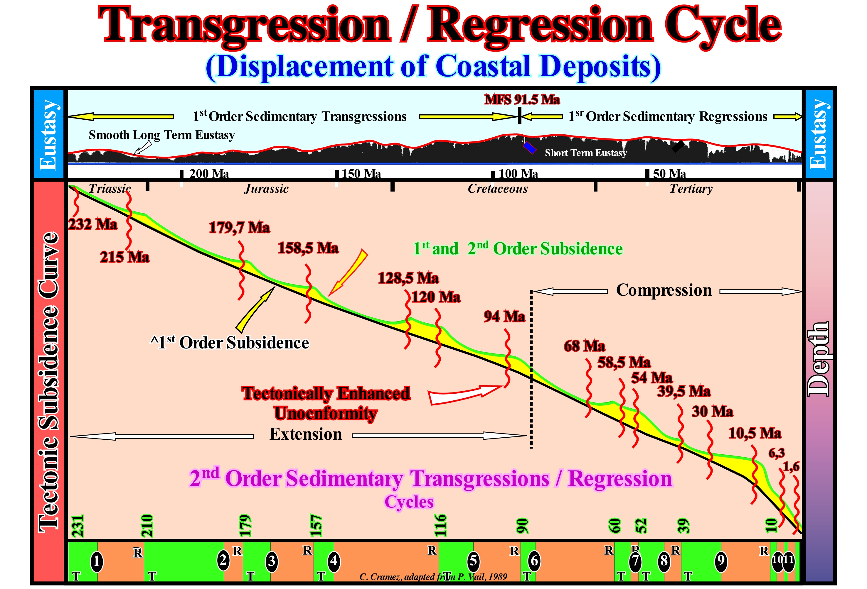
Conventionally, a sedimentary regression represents a displacement of the coastal deposits seaward whereas a sedimentary transgression corresponds to a landward displacement of the coastal deposits. The terms sedimentary regression and sedimentary transgression require that we are talking about a displacement of the coastal sediments and not necessarily of the shoreline (sea level). The shoreline may regress (retrograde towards the mainland) or progress seaward (forward), solely due to variations in relative sea level, without significant sedimentation. A marine ingression (one can, also, say marine transgression) moves the shoreline landward, whereas a marine regression (sea level fall) moves the shoreline seaward, without any significant sedimentation. Clastic sedimentary particles come directly or indirectly from the continent. At the level of the sedimentary systems tracts (sequence-paracycles) the depositional systems are progradational without relative sea level change (the deposition occurs during the stability period of relative sea level occurring after each marine ingression). The coastal deposits of a sequence-paracycle with respect to the coastal deposits of the preceding sequence-paracycle are either progradational or retrogradational (excluding the particular case of a stability of the shoreline, i.e., stillstand). One can not speak of sedimentary transgression or of sedimentary regression in isolation. They are always relative, i.e., they are, always, defined themselves in relation to the preceding coastal deposits. A set of sedimentary systems tracts, that is, a subgroup of sedimentary systems tracts, can displace, globally, the coastal deposits seaward (sedimentary regressions*) or landward (sedimentary transgressions). Coastal deposits do not have a reverse, like an automobile, to move landward. Sedimentary transgressions (and not transgression) is the name given to the set of increasingly important marine ingressions and the associated increasingly smaller sedimentary regressions, which together create a retrogradational morphology. At the level of the sequence-cycles, sedimentary transgressions and regressions are associated with relative sea level rises. In sedimentary transgressions, the relative sea level rises in acceleration, that is, marine ingressions are increasingly important. In a sedimentary regression, the relative sea level increases in deceleration. In sedimentary transgressions, with each rise in relative sea level (at each marine ingression entrance), the shoreline moves landward. Such a displacement increases, considerably, the extent of the shelf and reduces terrigeneous influx (a part of the former coastal plain is submerged). The progradation of the deposited sediments during the stability period of relative sea level, which follows each eustatic paracycle, is not sufficient for the shoreline reach the position it had before the relative sea level rise. A new relative sea level rise shifts, again, the shoreline landward and the deposition mechanism repeats itself until a significant relative sea level fall occurs. Sedimentary transgressions correspond to a succession of smaller and smaller sedimentary regressions. Transgressions/regressions cycles (T/R) are used in the genetic stratigraphy, since the lower limit is a downlap surface. Within each T/R cycle there is always one or more unconformities, function of the T/R cycle hierarchy. As illustrated, there are several orders of T/R cycles, just as there are several orders of eustatic cycles. After the breakup of the Pangea supercontinent, the 1st order T/R has, as the limit, between the transgressive and regressive phase, the maximum flooding surface, which occurred about 91.5 Ma (Cenomanian-Turonian). Absolute sea level rose during the transgressive phase and descended during the regressive phase. Within this cycle there are several 2nd order T / R cycles. The downlap surfaces, which limit the transgressive phase of the regression of the 2nd order T / R cycles, are: DS. 231 Ma ; DS. 210 Ma ; DS. 179 Ma ; DS. 157 Ma ; DS. 116 Ma ; DS. 90 Ma ; DS. 60 Ma ; DS. 52 Ma ; DS. 39 Ma ; DS. 10 Ma. Within each 2nd order T / R cycle, there may be several 3rd order cycles. Each of these cycles consists of sediments belonging to two different but contiguous stratigraphic cycles, since between a sedimentary regression and a sedimentary transgression there is always a unconformity, that is, a significant relative sea level fall.
(*) A set of sedimentary regressions forms what many geoscientists have a habit of calling "Regression". The set of sedimentary transgressions (sequence-paracycles increasingly smaller) form what many geoscientists call a "Transgression."
Transgressions (Transgressive interval)........................................................................................................................ Transgression
Transgressões/ Transgresión salobre / Transgressions / 越轨 / Правонарушения / Trasgressioni /
Term transgression creates, often, confusion. In this glossary, it is replaced transgressive interval (TI) of a sequence-cycle or by sedimentary transgressions as defined by C. Emiliani (1992). It corresponds, within a sequence-cycle, to the set (eustatic paracycles in acceleration) and to the associated increasingly small sedimentary regressions (sequence-paracycle). An eustatic paracycle is a relative sea level rise that is accompanied by a landward displacement of the shoreline, i.e., by a marine ingression. It is during the period of stability of relative sea level occurring after a marine ingression, that sediments forming the sequence-paracycle are deposited displacing seaward the shoreline (sedimentary regression).
See: « Rate of Relative Sea Level Chnage » & « Transgression »
Transgressive Interval (Transgressive systems tract).......................................................Cortège transgressif
Intervalo transgressivo / Cortejo transgresivo / Prozession transgressive / 游行侵 / Тракт трансгрессивных систем / Processione trasgressiva /
Corresponds to P. Vail's "Transgressive Sytems Tracts" (not to be confused with "Transgressive Systems Tract"), which certain geoscientists incorrectly translated as "transgressive system tract." The transgressive interval, whose acronym is TI, is the lower subgroup of the highstand systems tract (HST) of a sequence-cycle. In relation to the curve of the relative sea level changes, which defines the sequence-cycle, the transgressive interval (TI) is deposited when the acceleration of relative sea level rise is the strongest (segment of the curve having the 1st derivative positive and the 2nd derivative, also positive, i.e., the function is increasing and its geometry is concave geometry). Theoretically, the upper limit of the transgressive interval (TI) is the maximum flooding surface, corresponding roughly to the ascending inflection point (1st derivative maximal) of the relative sea level curve, from which relative sea level rise in deceleration (starting of deposition of the highstand prograding wedge). The term roughly emphasizes the fact that the ascending inflection, just as the descending one (unconformity), corresponds, often, more to a segment than to a point of the curve.
See: « Systems tract »
&
« Sequential Stratigraphy »
&
« Transgression (marine ingression) »
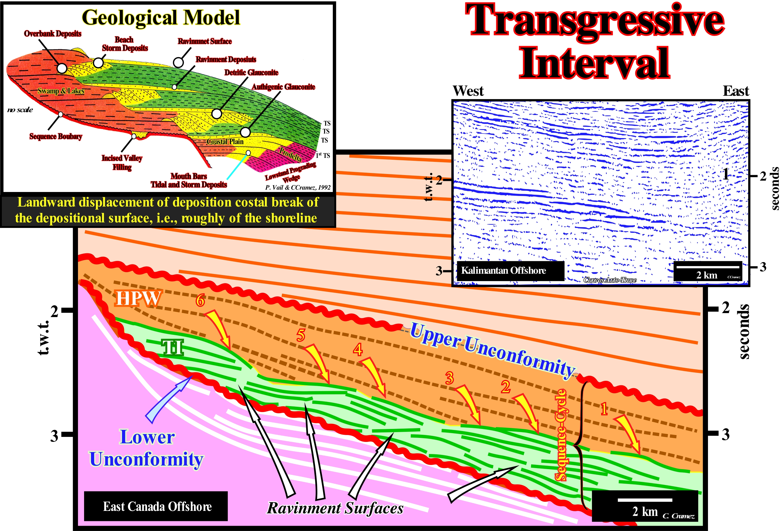
On this tentative geological interpretation of a Labrador Sea seismic line, within a sequence-cycle, induced by a 3rd order eustatic cycle, whose time-duration varies between 0.5 My and 3.5 My, the transgressive interval (TI), which certain geoscientists call, inappropriately, transgressive systems tract is, easily, recognized between the lower unconformity of the sequence-cycle and the highstand prograding wedge (HPW). The reflectors of the underlying sequence-cycle are represented by thick, white traces, while those of the transgressive interval (TI) are coloured in green. The reflectors of the transgressive interval (TI) rest by coastal onlaps against the reflectors of the underlying sequence-cycle emphasizing an unconformity (erosional surface). Within the transgressive interval, the presence of four ravinment surfaces is observed and, between them, the reflectors progradate seaward. The transgressive interval, in its entirety, corresponds to the transgressions of C. Emiliani (1992), i.e., to a set of increasingly important marine ingressions (relative sea level rises) and increasingly smaller sedimentary regressions, which, creates, globally, a retrogradational geometry. The relative sea level is a local sea level, referenced at any point on the Earth's surface, which can be the sea floor or the base of the sediments (top of the continental crust) and which is the result of the combined action of the tectonics (subsidence or uplift of the sea floor) and the absolute (eustatic) sea level, which is supposed to be global and referenced to the Earth' centre of the Earth. As can be seen on this tentative interpretation, as well as in the geological model, since the first relative sea level rise, which floods the preexisting topography, the shoreline (more or less the depositional coastal break of the depositional surface) is displaced landward (marine ingression), creating on the deposited sediments, a ravinment surface. At the same time, a water-depth is created (development of the shelf within the sequence-cycle) and available space for the sediments (accommodation). During the stability period of relative sea level, which follows the marine ingression, the transported sedimentary particles, gradually, deposit in progradational sedimentary packages (sequence-paracycle) moving the shoreline, progressively, seaward, but without reaching its previous position. A shelf is thus initiated, between the continental edge and the new shoreline. A more important marine ingression than the previous one, again, shifts landward the depositional coastal break of the depositional surface, creating a new ravinment surface and increasing, again, the space available for the sediments. At the same time, lowstand geological conditions with a low sedimentation rate, are developed in the distal part of the platform (near the continental edge). More sediments will be deposit during the new stability period, in progradational packages, but, as before, the shoreline does not reach the extreme position it had before this relative sea level rise. New marine ingression, even more important, etc., etc. This geological history is repeated several times, until, finally, the new marine ingression is smaller than the previous one, i.e., until a relative sea level rise is deceleration, what starts the deposition of the highstand prograding wedge (HPW), during the stability period of relative sea level, as the shoreline begins to move, progressively, seaward diminishing the extension of the continental platform (shelf). It is important not to forget that a marine ingression* reduces the Earth's albedo (ratio of reflected light energy to incident light energy), since the sea surface absorbs more solar radiation than the Earth's surface. Thus, probably, the temperature gradient between low and high latitudes is reduced during large marine ingressions. Some of this reduction is attributed to the increase of the CO2 content in the atmosphere, increased volcanic activity along the mid-ocean ridges, and increased organic productivity. On the contrary, a marine ingression contributes to the deposition of fossil-rich marine sediments on the continent, which means that sedimentary regressions interrupt the marine sedimentation on the continent, at same time, as erosion reduces the sedimentary deposits, previously, settle down, which implies that the continuity of marine records in a given region of the continent, rarely, exceeds a few tens of millions of years. Thus a Phanerozoic continuous record can, just, be reconstructed correlating and joining different stratigraphic sections.
(*) During the Phanerozoic geological time, the sea level oscillated more than 600 meters (C. Emiliani, 1992).
Transgressive Surface of Erosion........................................................Surface transgressive d'érosion
Superfície transgressiva de erosão / Superficie transgresiva de erosión / Transgressive Oberfläche der Erosion / 侵蚀的海侵表面 / Трансгрессивная поверхность эрозии / Superficie trasgressiva di erosione /
Surface of submarine erosion, diachronic, induced by consecutive relative sea level rises (without relative falls between them) in coastal sediments or, in other words, submarine erosion envelope induced by a succession of increasingly important marine ingressions, which are separated by smaller and smaller sedimentary regressions. This erosional surface is, more or less, parallel to the envelope of successive ravinment surfaces created by the different increments of relative sea level rise (eustatic paracycles). For some geoscientists, a transgressive surface of erosion is simply the ravinment surface created by a marine ingression in the preexisting topography.
See : « Transgressive Interval »
&
« Relative Sea Level Rise »
&
« Ravinment Surface »
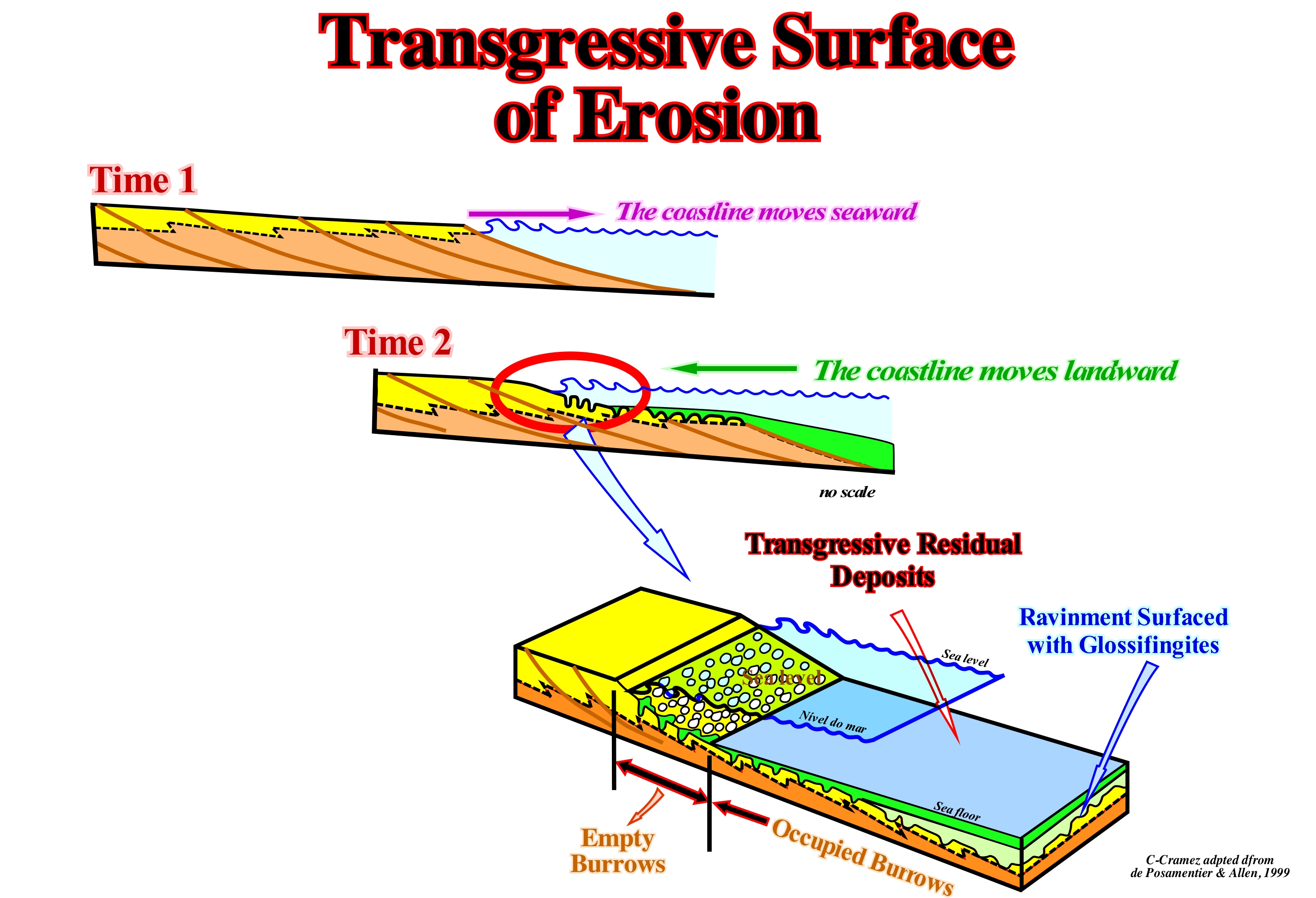
As shown in this figure, a ravinment surface is, usually, associated with the retrogradational (or transgressive) movement of the shoreline. Such a movement occurs, almost always, during the transgressive interval (TI) of a stratigraphic cycle called the sequence-cycle. This retrogradational movement is due to a succession of seaward displacements of the shoreline and coastal sediments, increasingly smaller without significant aggradation. In other words, there are no significant relative sea level falls between the different increments relative sea level rise. There is no relative sea level falls between the eustatic paracycles i.e., there is no unconformities (significant erosional surfaces) between the sequence-paracycles. Obviously, the sequence-paracycles do not settle during eustatic paracycles (relative sea level rises), but during the stability periods of the relative sea level that occur after each eustatic paracycle creating or increasing the available space for the sediments (accommodation). In geology, a shifting of coastal deposits landward, which certain geoscientists mistakenly call "transgression," does not exist, since coastal deposits, unlike a car, have neither engine nor reverse. In fact, the transgressive interval (TI) of a sequence-cycle corresponds to a vertical overlap of increasingly smaller sedimentary regressions induced by increasingly important marine ingressions, i.e., by accelerating increments of the relative sea level, which increase the extent of the continental platform, significantly, reducing, at the same time, the terrigeneous influx. It was this set of increasingly important marine ingressions and increasingly smaller sedimentary regressions, which collectively have a retrogradational geometry that Cesare Emiliani (1992) called "Transgressions." A marine ingression is a relative sea level rise that displaces the shoreline landward (at present it may also be called eustatic cycle or even sea transgression). A marine regression corresponds to a relative sea level fall, which shifts the shoreline seaward. However, sedimentation (marine) occurs only when the shoreline moves seaward, i.e., during marine regressions. During a marine ingression the shoreline moves landward, but there is no deposition. All that is happening is a small erosion on the pre-existing topography that geoscientists call transgressive surface of erosion or ravinment surface**. Thus, it can be said the ravinment surfaces are erosional surfaces, induced by the erosive action of the sea-waves, that form when the water advances over the underlying sedimentary surface. For example, within a sequence-cycle, if the upper part of a lowstand prograding wedge (LPW) has a subaerial part, a ravinment surface will, certainly, form when the relative sea levels flood it (marine ingression). The transgressive surfaces of erosion (ravinement surfaces) are diachronic. They do not correspond to chronostratigraphic lines. They are, rarely, underlined by seismic reflectors. As during the stability period of the relative sea level, which occurs after a relative sea level rise, the shoreline progresses seaward as the sediments of the sequence-paracycle are deposited, glossifungites (vertical, U-shaped or finely branched bio-perforations), generally are formed, which are largely fulfilled during the following increment of the relative sea level rise. The surfaces on which glossifungites occur are mostly interpreted as discontinuity surfaces, bounded between a sedimentary regression (induced by a marine ingression) and where, locally, the sedimentation ceased and erosion occurred due to the seaward displacement of the shoreline and a new marine ingression in acceleration.
(*) Transgression is the gradual advance of the sea over the lands, that is, what the geoscientists call an ingression. Certain geoscientists, in order to avoid misunderstandings, always use a qualifying adjective with the terms transgression and regression. A marine transgression is a geological process in which the sea level rises relative to the ground and moves towards the continent creating floods. In other words, a marine transgression is the advance of the sea over the emerged lands, generating a consequent rise in sea level, also associated with an increase in the depth-water. The opposite of the marine transgression is the marine regression, in which the level of the sea decreases relative to the continent and exposes the previous sea bottom (https://pt.wikipedia.org/ wiki / Transgressão_marinha).
(**) Certain geoscientists reserve the term transgressive surface of erosion to the last ravinment surface of the transgressive interval, which limits the transgressive interval (TI) of the highstand prograding wedge (HPW), which is fossilized by the main downlap surface.
Transportation (Sedimentary particles)........................................................................................................................................Transport
Transporte / Transporte / Verfrachtung / 运输 / Перемещение (отложений) / Trasporti /
Movement of the solid particles, i.e., of the sedimentary particles by the combined action of the force of gravity that on them and / or the movement of a fluid in which the particles are transported.
See: « Sediment »
&
« Traction (sediments) »
&
« Turbidity Current »
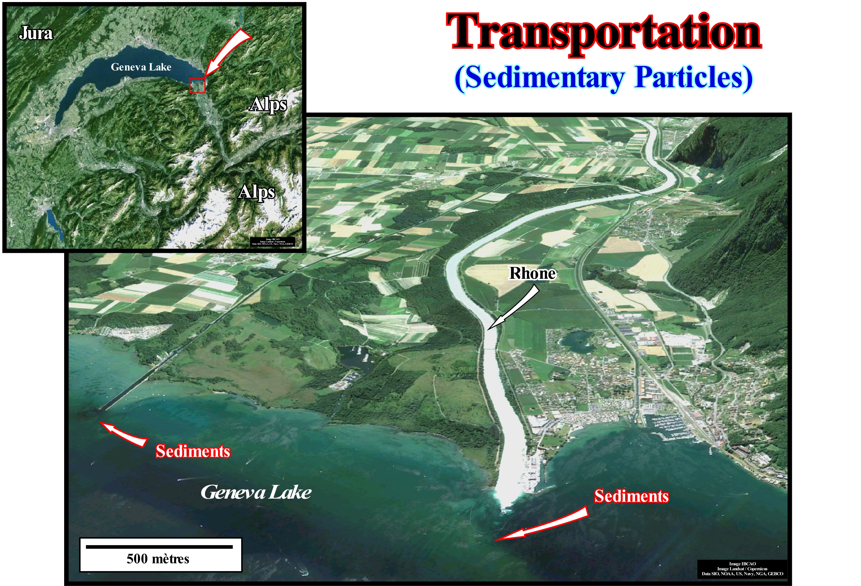
Sedimentary transportation is the movement of solid sedimentary particles, typically, due to the combination of the force of gravity acting on the particles and / or the movement of the fluid in which the sedimentary particles are transported. The case illustrated in this figure (formation of the Rhone delta in Geneva Lake, Switzerland) is the transport of sedimentary particles by fluvial processes related to the flow of water in a natural system. This system is not, entirely, natural, since the Rhone trajectory was, greatly, modified between the towns of Sierre, Sion and Villeneuve, to avoid floods. The changes caused a significant increase in the terrigeneous influx that reaches Geneva Lake (Leman Lake ), since the meanders of the alluvial plain, where a large part of the sedimentary particles (detritus) were deposited, are no longer present (the new trajectory is practically rectilinear). This natural type of sedimentary transport encompasses rivers, streams, glacial lake floods, periglacial currents, etc. The sedimentary particles that are transported by the water may be larger than the particles carried by the air because the water has a higher density and viscosity. In typical rivers the transported sedimentary particles are the size of sand and gravel, but during large floods the rivers can carry larger pebbles and particles. Sedimentary transport is used to solve many of the environmental, geotechnics and geological problems. Sedimentary particles movement is important not only for the fish habitat but also for other river organisms. Managers of heavily regulated rivers that have, often, a major shortage of sedimentary particles due to dams (not the case of the river illustrated in this figure) are often advised to cause short flooding phases to renew the material of the river bed and rebuild sand-bars. The discharge of sedimentary particles into a reservoir formed by a dam forms what is called a reservoir-delta. This delta will fill the basin and, eventually, the reservoir will have to be dredged or the dam will have to be transferred. The knowledge of sedimentary transportation can be used to properly plan the extension of a dam's life.
Transport Zone (Fluvial system)...................................................................................................................................Zone de transport
Zona de transporte / Zona de transporte (sistema fluvial) / Transport-Zone / 运输区 / Транспортная зона / Zona di Trasporto /
One of the zones that make up the fluvial systems: (i) Source Zone (Sz) ; (ii) Sedimentary Transport (or Transfer) Zone (Sz) and (iii) Depositional Zone (Dz).
See : « Fluvial Deposition »
Transverse or Strike Seismic Line............................................................Ligne sismique longitudinale
Linha sísmica transversal / Línea sísmica transversal / Quer seismischen Linie/ 横向地震测线 / Крест золотой сейсмическая линия удар / Linea sismica trasversale /
Line perpendicular or oblique, in a significant way, to the terrigeneous supply.
See: « Marine Onlap »
Trap (Oil or gas)...........................................................................................................................................................................................................................................Piège
Trap / Trampa (petróleo o gas) / Trap / 圈闭 (石油,天然气公司) / Ловушка (нефть, газ) / Trappola (olio e gas) /
Any barrier (structural, stratigraphic, morphological or by juxtaposition) that prevents the movement to the surface of the hydrocarbons generated in depth by a rock rich in organic matter (source-rock). To have trapping, it is necessary a : (i) Reservoir-Rock (with a certain porosity, in which hydrocarbons can be stored) ; (ii) Sealing-Rock (impermeable rock preventing the migration of hydrocarbons, both vertically and laterally) and (iii) Source-Rock (rich in organic matter that was buried enough to its organic matter reach maturation).
See : « Reservoir-Rock »
&
« Sealing-Rock »
&
« Source-Rock »
In addition to the structural traps, which are characterized by a rock-reservoir with its own closure (in all directions, i.e., four way dips, as an anticline structure) and parallel to the closure of the sealing-rock (vertical)*, it is important to distinguish the nonstructural traps. In this type of trap, such as the structural map at the top of the reservoir-rock is not similar to the structural map at the top of the sealing-rock, the definition of the trap implies, necessarily, the structural mapping of the sealing-rock, which is, often, forgotten by geoscientists in charge of petroleum exploration. That is why an accurate classification of the type of trap is imperative. Nonstructural traps may be: (i) Stratigraphic; (ii) By Unconformity ; (iii) Morphological and (iv) Morphological by Juxtaposition. Stratigraphic traps are associated with lithological variations during deposition, while traps associated with unconformities are associated with the erosional surface induced by a significant relative sea level fall, which put sea level lower than the basin edge. Morphological traps are created by sedimentary anomalies, such as reefs and submarine basin and slope fans. In the nonstructural traps and, particularly, in the morphological traps by juxtaposition, the closure of the reservoir-rock is not parallel to the closure of the sealing, which means that the geometry of the reservoir-rock top is not created by a sedimentary shortening (compressional tectonic regime). The morphological traps by juxtaposition are created by tectonic movements, in general, extensional, that put in juxtaposition the reservoir-rock and the sealing-rock (lateral). Contrary to a very accepted notion, there are no trapping against faults (which certain geoscientists even consider as structural traps). Although they have a structural component, created by the differential movement of faulted blocks, a fault (normal or reverse) never closes a rock-reservoir. What closes a rock-reservoir is the sealing-rock (lateral) that is juxtaposed to the rock-reservoir, on the other side of the fault or, more rarely, the fault clay gouge when present between the faulted blocks.
(*) This means that the structural maps, made at the top of the reservoir-rock and the structural map, made at the top of the sealing-rock are more or less equivalent. Under these conditions, a vertical exploration well located at the apex of the structure crosses in a, more or less, ideal position all the sedimentary intervals considered as a potential reservoir-rock (except when the axial plane of the structure is very steep). On the other hand, sealing-rock work not only as vertical sealing, but also as lateral sealing.
Travertine (Geyserite)..................................................................................................................................................................................................Travertin
Travertino / Travertino / Travertin / 洞 石 / Травертин (белый известняк) / Travertino /
A compact and hard carbonate deposit formed, essentially, by external water runoff from a karst region.
See: « Limestone »
&
« Karst »
&
« Dissolution »
As shown in this figure, a travertine is a limestone, composed of calcite, aragonite and limonite, with compact bands, parallel to each other, in which small cavities are observed, where the tones that pass through the white, green or pink predominate, presenting, often, marks of branches and leaves. The travertine, which is also known as limestone tuff. The travertine is formed in the calcareous karst zones by the precipitation of calcium carbonate by fresh water, which causes empty spaces and the deposit of materials in, more or less, parallel bands. There are large quarries of this type of rock in Mexico, Turkey (Pamukkale travertine illustrated ion this figure) and Peru, but the most famous varieties are Italian, with Tivoli travertine being one of the most sought after. Travertine is used as an ornamental stone in architecture, either natural or polished, applied in interior, exterior and decoration. Its use in construction, both in classical Roman architecture and today, is due to its durability, easy application and its aesthetic qualities (the Colosseum in Rome in Italy and the Basilica of St. Peter in the Vatican are built, between other materials, with travertine. Modern travertine is formed from hot, supersaturated and heated geothermal alkaline waters with a high content of CO2 In the emergency zones the water releases CO2 because the atmosphere has a smaller CO2 content, which results in an increase in pH. While the solubility of the carbonate has decreased with increasing pH, precipitation of calcium carbonate takes place. Super-saturation can be enhanced by several factors which reduce the percentage of CO2, such as the interactions air-water in waterfalls or photosynthesis. Calcite and aragonite are found in the travertines of hot springs. Aragonite is, preferably, precipitated when temperatures are hot, while the calcite dominates when temperatures are cooler. When pure and fine a travertine, it is white, but often due to impurities, it is brown or yellowish.
Triassic............................................................................................................................................................................................................................................Triassique
Triásico / Triásico / Trias (Geologie) / 三叠纪 / Триасовый период / Triassico /
Geological period lasted between 248.3 and 205.7 Ma (Hardenbol, J. et al., 1998). It is the first period of Mesozoic Era. Triassic follows Permian (late Paleozoic period) and is followed by Jurassic. The beginning and end of Triassic are underlined by great extinctions. The extinction that marks the end of Triassic seems to be well dated, but like all ancient geological periods, although the formations that define its limits are well known, the advanced dates of the beginning and end of these periods are approximated by several millions years.
See: « Geological Time Scale »
&
« Mesozoic »
&
« Geological Time »
The extinction that marks the end of the Permian left the biosphere very impoverished, but as all the geoscientists know, the biosphere is very resilient and recovers easily. Two single genera of Ammonia (also called ammonites, an extinct group of Cephalopod molluscs that emerged in the Devonian period) survived the end of the Permian, but 4 My later in the Early Triassic, there were already more than 100 genera. The term Triassic derives from the three parts in which it was divided in Europe: (i) Keuper (the most recent) ; (ii) Muschelkalk and (iii) Bunter (the oldest). Bunter deposits, which consist mainly of red sandstone, clayey and conglomerate, suggest very arid conditions similar to those of the Permian. During Muschelkalk, the Tethys Sea began to advance westward and covered a great part the European platform, where shallow water limestones were deposited, which were covered by dolomites with plaster and anyhdrite, suggesting hyper-saline conditions. The upper part of the Muschelkalk (about 50 meters) is formed by an alternation of marine and lacustrine deposits, some of which have carbonized plant remains. The Keuper is, mainly, formed by an interval of about 450 meters thick, consisting of marls of various colours and porous dolomites, suggesting lagoon conditions. The sea during the Muchelkalk did not invade the Russian platform, but extended to NW, that is, to the area occupied today by the North Sea. Reefs grew up on the southern edge of the European platform, in the shallow waters of northern Tethys Sea, where limestones were deposited that became dolomites and today form the NE mountains of Italy, which are known as the Dolomites.
Trilobite..............................................................................................................................................................................................................................................Trilobite
Trilobite / Trilobite / Trilobiten / 三叶虫 / Трилобит / Trilobita /
Extinct arthropod of the taxonomic class Trilobite. Trilobites appeared in the second period of Cambrian period (probably in the Davidian period) and developed during the lower part of Paleozoic era and entered a prolonged decline that led to the almost complete extinction of all orders (except Proetida) in Late Devonian. The last trilobites disappeared in the extinction that occurred at the end Permian about 250 Ma.
See: « Fossil »
&
« Relative Age »
&
« Paleozoic »

The trilobites (three lobes) are called so because their bodies, as can be seen in this photograph, were divided into a central axial lobe in the middle and two pleural lobes on the sides. The head or cephalon had a typical arched shape and often had two eyes (some trilobites were blind). The swelling in the middle of the cephalon is the glabella. On either side of the glabella are the eyes and facial sutures, which separate the so-called maces from the face, which in many species were quite prominent, from the rest of the cephalon. The pleural lobes (or thorax) were made of pleura covering the legs, which were very fragile. The legs of the trilobites were branched (two branches) and supported both the motor branches and the gills. The food particles were stirred up and down the basal of the legs, which certain geoscientists call gnatobases. At the back of the body, the pleura passes into a segment called the pygidium, which is more or less planar and which functions like a tail. In some trilobites the pygidium is very small. In others, it was relatively large and ornamented with pimples. Many of the trilobites lived in shallow waters and were benthic (living in sediments from the seabed, lake or other water-bodies, regardless the depth). They moved on the bottom of the sea and probably fed on debris. Some of the trilobites were pelagic and floated to the surface of the water slide, like a large part of the trilobites of the Cambrian and Ordovician. After the Ordovician, when many orders of trilobites declined and began to die out, survivors tended to be restricted to deep-water environments. As the mouths of the trilobites did not have large jaws, some geoscientists think that trilobites were not predators and ate only tender foods.
Trophic (Level).....................................................................................................................................................................................................Trophique (Niveau)
Trófico (nível) / Trófico (nivel) / Trophische (Pegel) / 营养(一级) / Трофический (уровень) / Trofico (livello) /
Amount of nutrients in a lake. The Trophic Level Index (TLI) is an indicator of lake water quality. Four parameters are combined to determine TLI: (i) Total Nitrogen ; (ii) Total phosphorus ; (iii) Water clarity and (iv) Amount of Chlorophyll a. These four parameters reflect the dynamics of the annual lake cycle.
See: « Depositional Environment »
&
« Lake »
&
« Mesotrophic (lake) »
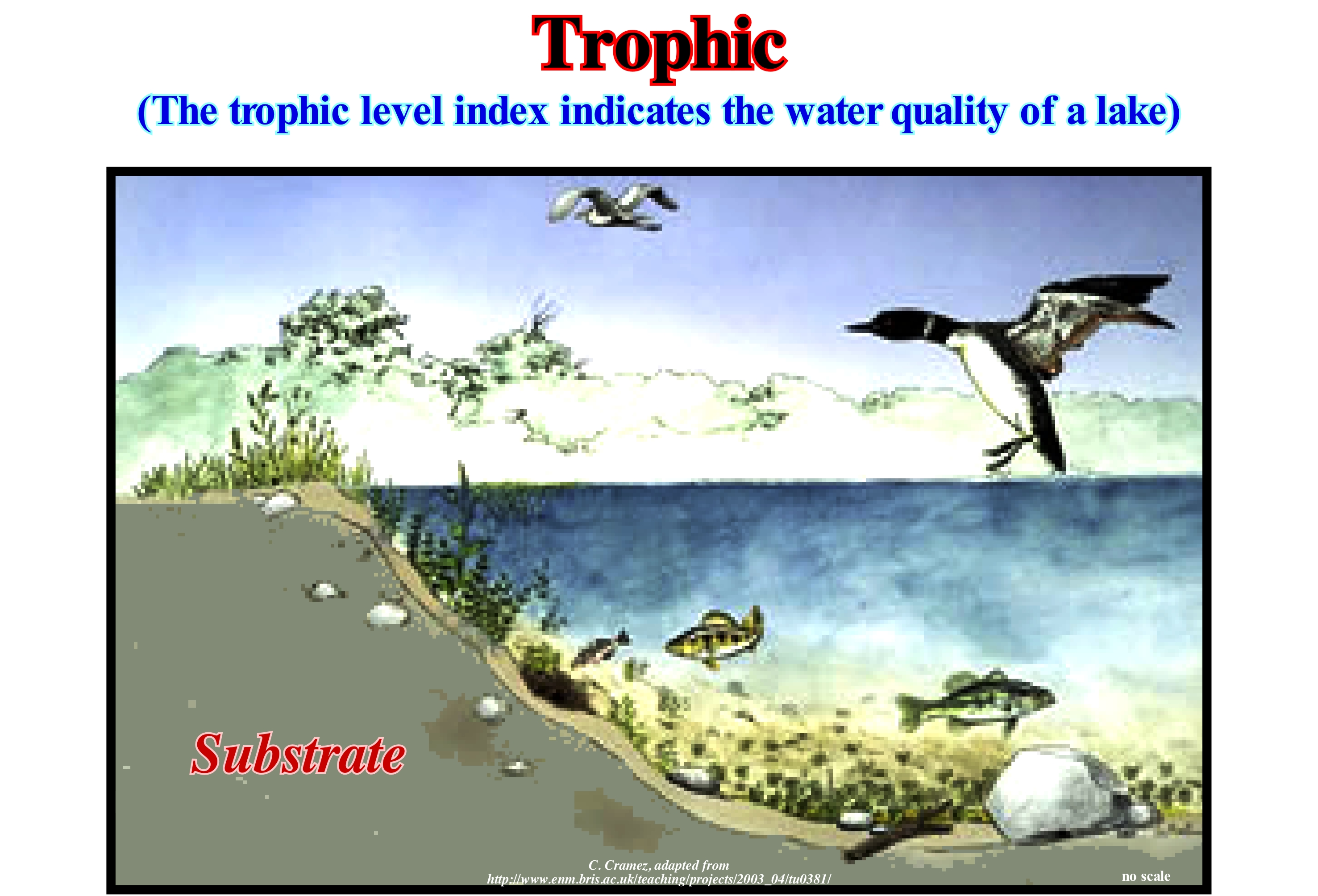
Certain lakes are clear and appear blue because most of the light is absorbed by water. The red fraction of light is heavily absorbed, while the blue fraction is dispersed and reaches our eyes. Lakes that have a lot of suspended algae look green because algae heavily absorb the blue and red fractions of light but reflect the green light. These and other differences between lakes can be analyzed numerically by measuring certain parameters that characterize them. The measurement of these parameters is, often, incorporated to define trophic level, which underlines the capacity that the lake has to support life. Nitrogen and phosphorus are nutrients that affect the amount of algae in a pond. The higher the concentration of these nutrients the more eutrophic (rich en nutrients) the lake. The water transparency, which can be measured with the white Secchi disk, is also used to determine the trophic level of a lake (circular disk, usually white or black and white, which is dipped in water until it is no longer visible). In oligotrophic lakes (with few nutrients), the Secchi disk is seen to a depth of more than 10 meters, whereas in eutrophic lakes the disk disappears to a depth, sometimes less than one meter. The concentration of algae is perhaps the best way to characterize the trophic level, although such a measure is difficult to obtain directly. The amount of chlorophyll-a (pigment present in all algae that makes them appear green and allows them to obtain energy from sunlight, chlorophylline function) is the most used parameter because it indirectly gives the concentration of algae The amount of oxygen also gives, in an indirect way, an idea of the trophic level. Unlike trophic lakes, eutrophic animals often have little or no oxygen in the basal water layers, which allows the preservation of dead organic matter.
Tropic Period (Moon).............................................................................................................................................Péríode tropique (De la Lune)
Período trópico / Período trópico (de la Luna) / Tropic Zeitraum / 北回归线期 / Тропический период (Луна) / Periodo tropico /
Time between a lunar equinox (when the Earth's center is exactly vertical to one point on the Moon's equator) and the next equinox, which is 27.321582 days. The tropic period of the Moon is the time between two successive passages of the Moon by the same ecliptic longitude. Same as Tropic Lunar Month.
See: « Sidereal Period (Moon) »
&
«Moon »
&
« Synodic Period (Moon) »
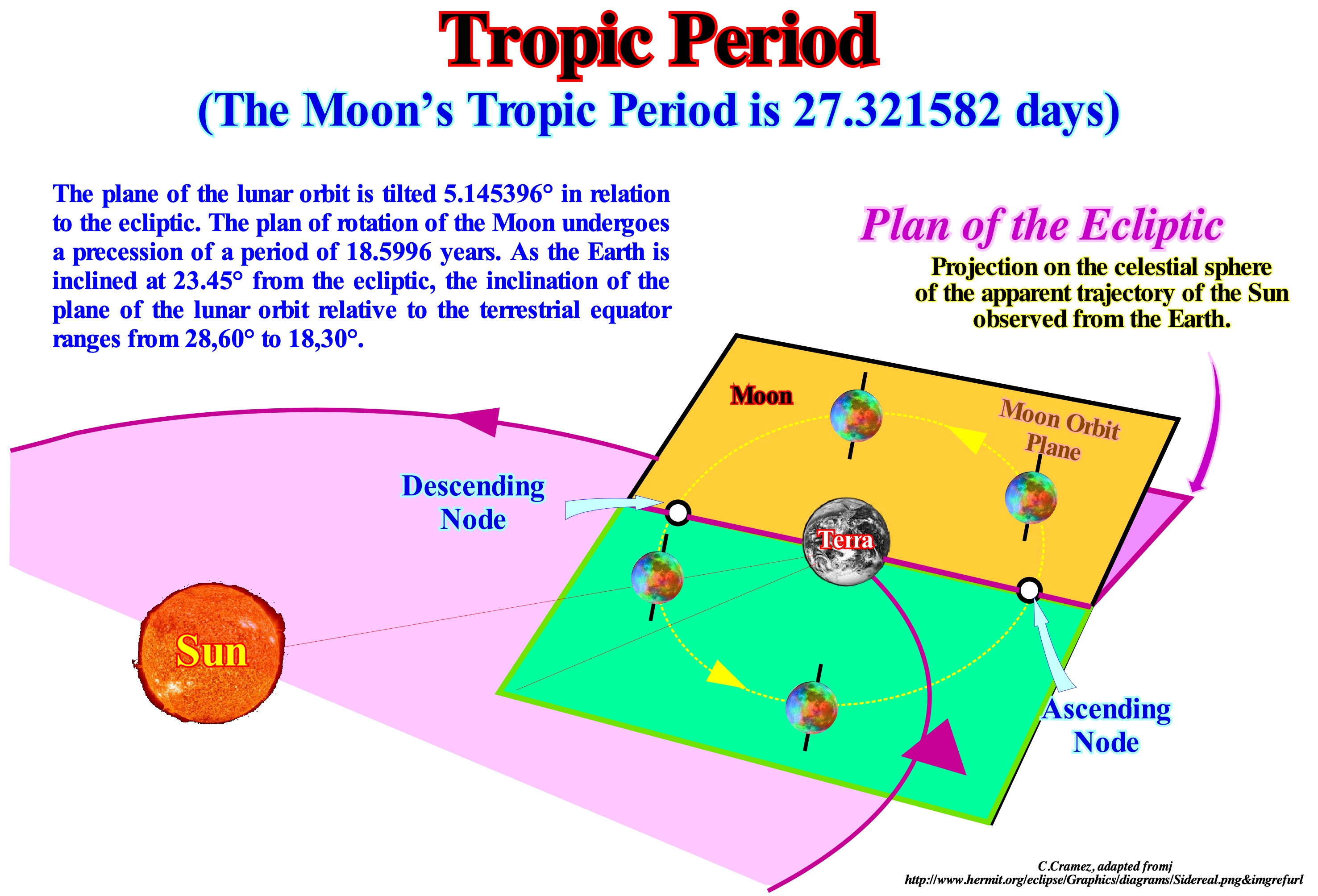
The period of rotation of the Moon is the same as its orbital period. The Moon always shows the same hemisphere to an earthly observer. This synchronous rotation is the result of the friction caused by the tides caused by Earth to the Moon, which progressively retarded the Moon's rotation on itself until the period was the same as that of the Moon revolution around Earth. The effects of the Moon's tide on Earth slow Earth's rotation and cause spacings of about 3.8 cm per year. There are several ways to consider how long it takes the Moon to complete an orbit: (i) The sidereal month ; (ii) The synodic month. The sidereal month is the time the moon takes to make a complete turn to Earth in relation to the fixed stars, which is about 27.3 days. The synodic month is the time that the Moon spends between two phases (for example between two consecutive New Moons), which is about 29.5 days. The synodic month is longer than the sidereal month because the Earth-Moon system shifts a finite distance in its orbit around the Sun during each sidereal month and more time is needed to find the same relative geometry. Other definitions of the duration of the lunar month include the time the Moon spends between two consecutive perimeter positions (called anomalous month), or between two consecutive ascending nodes (draconic month) or between two consecutive phases of the same ecliptic longitude, which is the tropical month. As a result of the slow precession of the moon's orbit, the last three periods are, slightly, different from the sidereal month. The average time of a calendar month (1/12 of a year) is about 30.4 days. Do not forget either the Moon's orbit is tilted relative to the plane of the ecliptic. The points of intersection of the orbit and ecliptic are the nodes (ascending and descending). The Moon to be directly in alignment between the Earth and the Sun must be in the same plane of the ecliptic and in one of the two nodes.
Troposphere.............................................................................................................................................................................................................Troposphère
Troposferra / Troposfera / Troposphäre / 对流层 / Тропосфера / Troposfera /
One of the five layers that make up the atmosphere: (i) Troposphere ; (ii) Stratosphere ; (iii) Mesosphere ; (iv) Thermosphere and (v) Exosphere. The Troposphere is the first layer of the atmosphere, between 0 and ±10 km of altitude. The troposphere is separated from the stratosphere by the tropopause, which is, more or less, between 10 and 20 km in altitude.
See: « Atmosphere »
&
« Stratosphere »
&
« Natural Greehouse Effect »
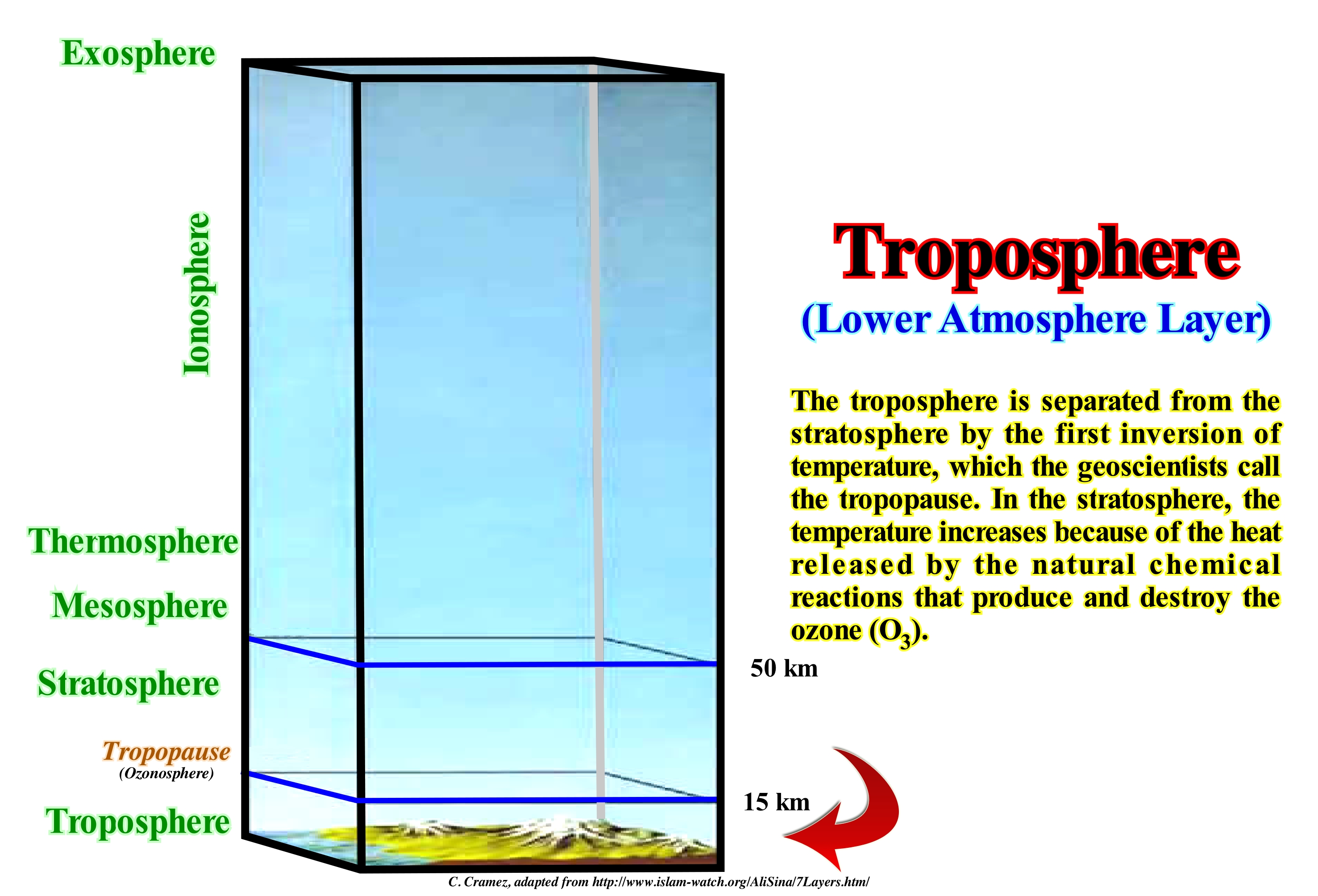
The troposphere is the lowest portion of the Earth's atmosphere. The troposphere contains approximately 75% of the atmospheric mass and 99% of its water vapour and aerosols. The average thickness of the troposphere is 12 km in the middle latitudes. It is thicker in tropical regions, where it can reach 17 km in height and less thick at the poles, but can reach about 7 km during the summer and become indistinct during the winter. The lower part of the troposphere, where the friction of the winds with the surface influences the wind currents, is called the planetary boundary layer, i.e., is the lowest part of the atmosphere which behaviour is, directly, influenced by its contact with the Earth's surface. This layer is normally a few hundred meters thick, and can reach up to 3 km, depending on the relief and time of day. The border region between the troposphere and the stratosphere is called the tropopause, where the temperature stops falling with altitude and then rises. The word "troposphere" is derived from the Greek: "tropos" (to rotate, to mix), reflecting the fact that turbulence plays an important role in the behaviour and structure of the troposphere. Most of the meteorological phenomena that we associate with the daily meteorological time occurs in the troposphere. The chemical composition of the troposphere is essentially uniform and, practically, identical to the composition of the Earth's atmosphere (78% nitrogen and 21% oxygen, in addition to other gases in small proportions), with the notable exception of water vapour. The source of water vapour comes from the surface, through evaporation and transpiration processes. Moreover, the temperature of the troposphere decreases with altitude, and the vapour pressure drops intensely as the temperature decreases. Thus, the amount of water vapour that can exist in the atmosphere falls strongly with altitude. The proportion of water vapour in the Earth's atmosphere reaches its peak near the surface and decreases with height.
Troughs & Bars Ondulation (Ripple mark)..................................................................................................Ride de plage
Ondulação de praia / Ondulación de la playa / Strandripeln / 海滩纹波-商标 / Вал (хребет, складка) / Ondulazione de spiaggia /
Sedimentary structure produced by wind or water (currents and waves), which moves through sand or mud deposits. Beach ripples formed by the action of water can be of two types: (i) Beach ripples (current), which are asymmetrical with the sloping side oriented in the direction of flow and (ii) Wave ripples, which are symmetrical, with a nearly sinusoidal profile, which suggests a sedimentary environment dominated by the oscillation of the waves.
See: « Sedimentation »
&
« Beach Ripple-Mark »
&
« Sand Ripples »
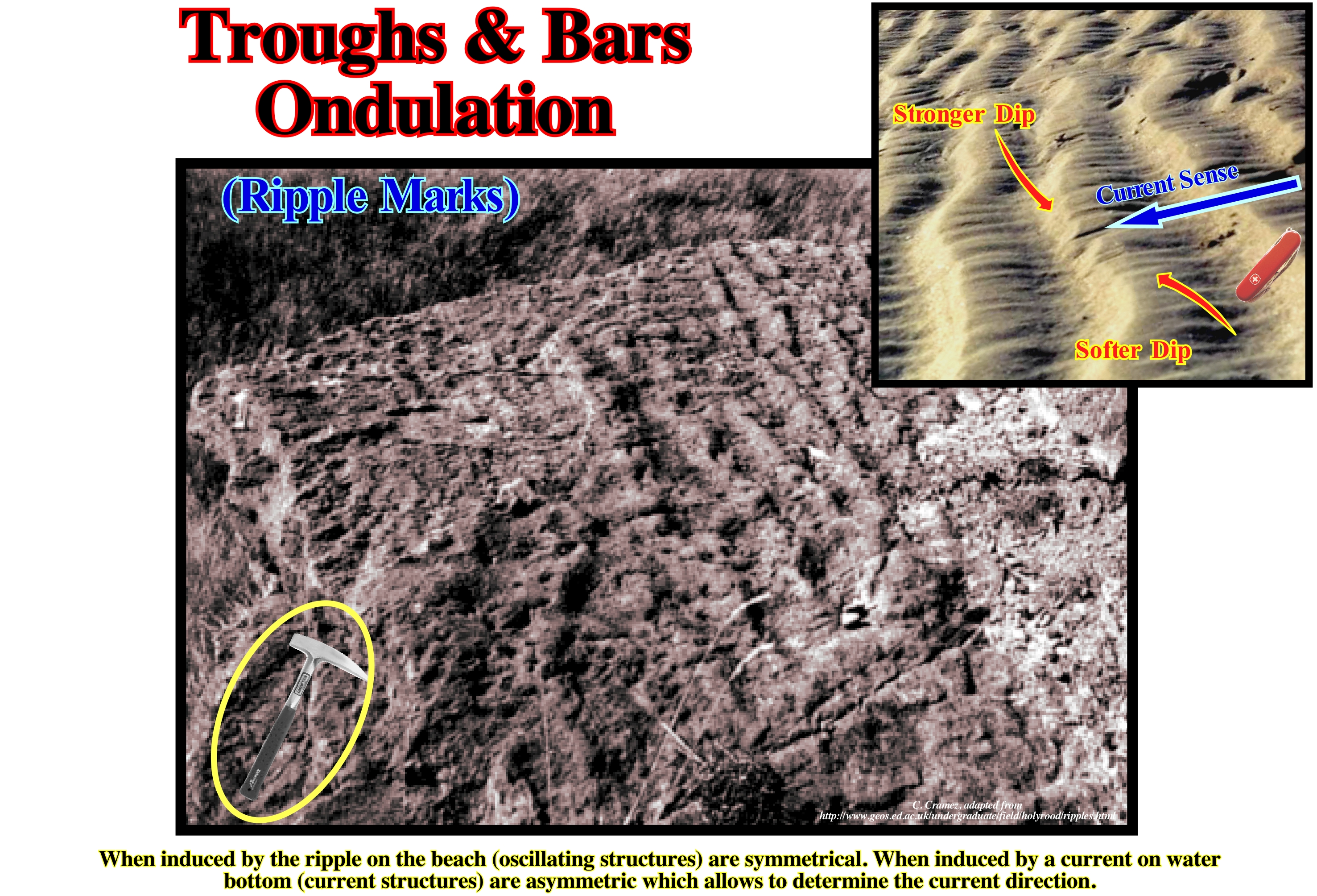
In general, the ripples are periodic wave-like sedimentary structures formed by parallel ridges, more or less regularly spaced and located on the upper face of the sedimentary layers composed mainly of sand. This type of structure is, often, found on the sand surface of the deserts, fluvial and shallow sea deposits. Its dimensions are variable. Beach ripples mean, essentially, that the deposition environment was subjected to the action of wind or water. Wind ripples are probably the rarest in sedimentary records because they have a low probability of being fossilized by preserving sediments. On the contrary, it is, relatively, easy to find them in fossil fluvial and marine sediments, as shown in this photo (Camstone quarry in Scotland, which is formed by a light, almost white limestone, which is, widely, used in construction, for the manufacture of windows and doors), which suggest an oscillating movement, as the profile of the ripples is, practically, symmetrical. Although in most cases a symmetrical profile indicates an oscillating movement, in some cases this geometry can be created by a current. In depositional environments associated with tides, the tidal currents towards the mainland and seaward, generally, produce, more or less, symmetrical ripples and deposit marks. Geoscientists, generally, say symmetrical ripples are produced by oscillatory currents and that asymmetric currents are produced by the flow current.
True Onlap........................................................................................................................................................................Biseau d'aggradation vrai
Bisel de agradação verdadeiro / Bisel de agradación verdadero / Wahre Onlap, Echte Bevel Verlandung / 真上超 / Ясно выраженное подошвенное налегание / Vero onlap, Bisello d’aggradazione vero /
Onlap observed parallel to depositional dip, which corresponds, generally, to the direction of the terrigeneous supply. When two onlap (apparent) are observed in two geological sections or two orthogonal seismic lines there is necessarily a true onlap between them.
See: « Onlap »
&
« Downlap »
&
« Aggradation »
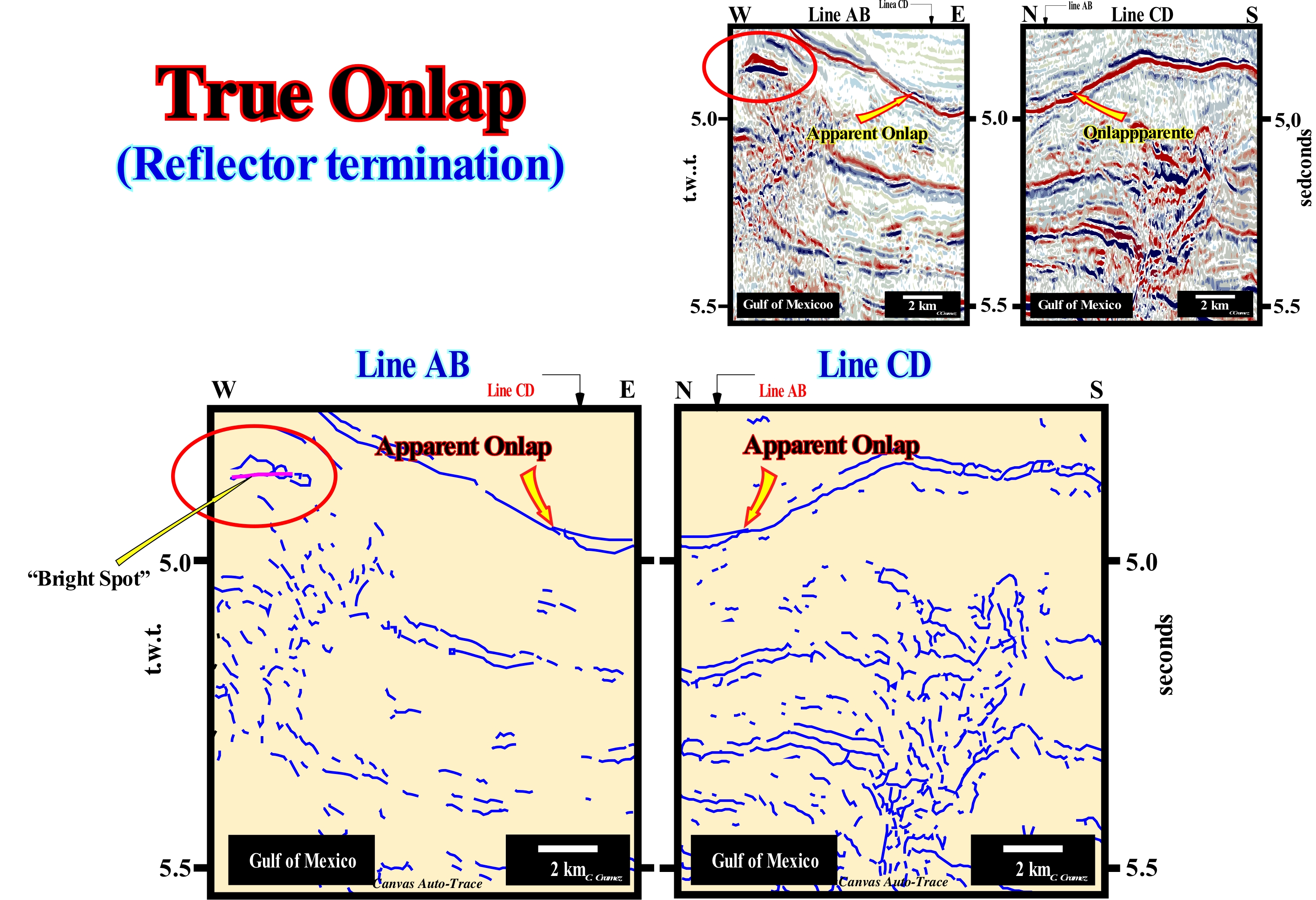
In this figure are represented the main reflectors of the Canvas auto-traces of two details of two perpendicular Gulf of Mexico seismic lines. The geological context of the sedimentary intervals, illustrated in these details, is of continental slope, i.e., the sediments were not, necessarily, deposited horizontal, but probably, slightly, slopping seaward. The onlaps underlined by the red arrows are apparent onlaps, since none of the seismic lines of these two tentative interpretations is oriented in the sense of the regional dip of the continental slope (at the time of deposition). The regional seismic lines from which the auto-traces were made are neither perpendicular nor parallel to the continental slope, but oblique. However, since they are orthogonal to each other (see crossing between lines AB and CD), the onlaps underlined by the arrows correspond to the same seismic reflector and are apparent onlaps. A true onlap (observed along the depositional slope which marks, more or less, the direction of the regional terrigeneous influx), must exist on a seismic line located between the AB and CD seismic lines. The seismic reflectors are associated to the lowstand systems tracts group (LSTG) and, above all, to the middle systems tract subgroup, i.e., the submarine slope fans (SSF). In fact: (i) Turbidite natural marginal dykes (turbidite levees), deposited by the overbanking of turbidity currents and (ii) Fills of depressions between marginal dikes, which certain geoscientists call turbiditic channels (when there is evident of erosion), are easily recognized. As these auto-traces are, relatively, small (4-5 km in length), it is difficult to highlight the paraconformity* (discontinuity between sedimentary intervals, more or less, with the same structural attitude, but separated by significant hiatus by nondeposition), which correlate, upstream, with the unconformity that underlie the relative sea level falls induced by the turbide current responsible for the deposition of submarine fans (submarine basin and slope fans). Within the submarine slope fans (SSF), it is important to differentiate the direction of the regional terrigeneous influx from the direction of the local terrigeneous influx, associated with the overbanking of the turbidite currents. The first influx corresponds, more or less, to the direction of the turbidite currents, which, in most cases, flow following the dip of the continental slope. The second influx is very local and variable. It is induced by overbanking and avulsion (abrupt and violent change of the trajectory of a current) of the turbidite currents. In addition, this local terrigeneous influx has opposing polarities, since the overbanking is, sometimes, done at the same time on either side of the depression where the currents flow towards the deep parts of the basin. When the depression between the natural marginal dikes becomes inactive, i.e., when the turbidite currents no longer use it to flow downdip, it is filled, in retrogradation, when the relative sea level begins to rise. It is said t there is avulsion when a turbidite current abandons the bathymetric anomaly** along which it flows to take another path. Unlike a river, a turbidite current does not need to have a bed (depression of terrain). Natural marginal fluvial dikes are deposited above the river bed (where the river is drained), where the river normally flows, while the first natural turbiditic marginal dikes are deposit at the same level of the turbidite current that have no bed (at least the first currents).
(*) A sequence-cycle is limited between two unconformities, in areas where the relative sea level fall has created an erosional surface and is limited between thee correlative paraconformities in the deep areas where erosion is not operational. A correlative paraconformity emphasizes, in the deep part of the basin, the relative sea level fall. The age of the hiatus associated with the correlative paraconformity gives, more or less, the age of relative sea level fall, i.e., the age of the unconformity. It may be said the correlative paraconformity hiatus is the smallest gap that exists along a boundary (lower or upper) of a stratigraphic cycle and, particularly, of a sequence-cycle.
(**) This bathymetric anomaly can be a turbidite channel, when the current produces an erosion or, simply, the depression (due to absence of deposition) between the turbiditic natural marginal dikes, when there is no erosion. Unlike a fluvial current, a turbidite current does not, necessarily, need to have a bed to flow.
Truncated Mound....................................................................................................................................................................Monticule tronqué
Montículo truncado / Montículo truncado / Abgeschnittene Hügel / 截断丘 / Усеченный холм / Monticello troncato /
A mound-shaped structure in a geological section or seismic line, in which the outer boundary is the result of erosion, which may have a , more or less, truncated the inner layers or reflectors, which define the mound internal configuration. This type of structure is often associated with the contourites.
See: « Reef Mound »
&
« Reflection Configuration »
&
« Erosion »
On this tentative geological interpretation of a Canvas auto-trace of a detail of a North Sea seismic line, it is, easy, to recognize that the original morphology of the submarine basin floor fans (SBFF, coloured in grey) was very affected by the erosion of the contour currents (which flow along isopycnic lines, i.e., of equal density, more or less, parallel to the bathymetric contours of the lower part of the continental slope and which is, often, responsible for the deposition of contourites), which created a truncated mound. Above the unconformity (coloured in red), which separates the rift-type basin, characterized by a differential subsidence (halfgraben structures), from the North Sea cratonic basin, which is characterized by thermal subsidence (isotherms reequilibrium), submarine basin floor fans were deposited. The causes of the subsidence may be a sedimentary loading, a tectonic activity or a thermal contraction during the cooling of the crust. A thermal subsidence corresponds to a cooling of the Earth's surface. In fact, sedimentary basins are not produced by sedimentation, but by tectonic and thermal processes. When a basin forms by lengthening in association with a positive thermal anomaly (induced by a tightening of the isotherms), normal faults control the available space for sedimentation, but this does not seem sufficient to develop a cratonic basin such as North Sea. A deep lithospheric cooling (tightening of the isotherms) is necessary which induces a thermal contraction in order to recover the isostatic equilibrium, which causes, naturally, a thermal subsidence that normally plays the main role in the evolution of the basin after the tectonic subsidence cease. These turbidite fans, deposited during the significant fall of relative sea level (local sea level referenced to the base of the sediments or to the sea floor and which is the result of the joint action of the tectonics and the absolute or eustatic sea level referenced to the Earth's centre), which induced the unconformity between the two sedimentary basins, have a, more or less, parallel internal configuration. Contour currents that eroded a large part of the submarine basin floor fans, laterally and vertically, redeposited the eroded sediments as contourites (coloured in khaki). A part of these contourites even fossilize the submarine basin floor fans. Several petroleum exploration wells have crossed not only the contourites but the submarine basin floor fans as well. The logs of these wells, and especially the dipmeters, corroborate the, more or less, parallel internal configuration of submarine basin floor fans (coloured in grey), suggested by the seismic data, with maximum values of the dip of 1°, practically, in all directions. The results of the dipmeter, obtained in the contourites, show, clearly, the difference between these two types of sedimentary anomalies, since they suggest dips of about 10-15 ° to East. Another important difference for the oil industry between these two sandy bodies is that the reservoir-rocks associated with the submarine basin floor fans, generally, have an important clayey matrix, whereas it does not exist in the contourites, which, on the other hand, are, particularly, rich in heavy minerals, such as zircon, allanite, etc. It should be remembered the flysch is a clastic sedimentary deposit consisting of an alternation of sandstone and marl accumulated in an oceanic basin, in the course of an orogenesis, in particular in the Swiss Alps. It corresponds, practically, to what today is called, in the sequential stratigraphy, turbidite deposits and, particularly, to the submarine basin floor fans. In the 1960s, Bouma recognized in the flysch of the Swiss Alps, channels filled by sands, with no clayey matrix, but with a great amount of heavy minerals, that some peasants exploited economically. Bouma considered that these channel fills were the result of erosion produced by contour currents (bottom currents flowing parallel to the base of the continental slope) and that the fillings, which he called contourites, were directly or indirectly associated with erosion of the flysch.
Truncation...........................................................................................................................................................................................................................Troncature
Truncatura / Truncación / Trunkierung / 截断 / Усечение / Troncamento /
Termination of strata or seismic reflections interpreted as such, along the upper unconformity of a stratigraphic cycle, which is created by erosion, which was, generally, tectonically enhanced (angular unconformity).
See: « Unconformity »
&
« Erosion »
&
« Reflection Termination »
On this tentative geological interpretation of a Canvas auto-trace of a detail of a northern Caspian Sea seismic line, the terminations of the reflectors underlying the unconformity (white wavy line) are toplaps by truncation, i.e., that a part of the sediments underlying the unconformity was eroded after the sediments had been deformed. In sequential stratigraphy, an unconformity is an erosional surface induced by a relative sea level fall*, which put the sea level lower than the basin edge (continental edge when the basin has a shelf), which, in certain cases, is, more or less, coincident with the shoreline (during the 2nd stage of development of the highstand prograding wedge, of a sequence-cycle). Unconformities are, mainly, induced by eustasy (absolute or eustatic sea level changes) and not by tectonics. The sediments have to be exhumed to undergo the action of erosive agents (gravity, rain, wind , ice, rivers, etc.). However, unconformities may be tectonically enhanced and create, what certain geoscientists call angular unconformities. A shortening or a lengthening of the sediments can not produce an unconformity (erosional surface) if the sediments are not exhumed. Just when there is a significant and regional erosion, i.e., when the sediments are exhumed, an unconformity is developed. This is, easy, corroborated in salt basins, where the lateral or vertical flow of the salt deforms (lengthen) the overburden without creating an unconformity, i.e., without the overlying sediments being eroded. Between the infra and suprasalt sediments a tectonic disharmony (not to be confused with an unconformity) is formed. The tectonic disharmony which reaches its paroxysm when the salt layer is totally evacuated forming a salt weld (surface that puts in contact strata originally separated by an autochthonous or allochthonous evaporitic level) which corresponds to a negative structure resulting from the partial or total outflow or expulsion of the salt horizon). In the field or in well cores, a salt weld is, mostly, recognized by an insoluble, more or less, brecciated residue with halite pseudomorphs. Such a residue is too thin to be visible on seismic data, in which it is underlined by a tectonic disharmony. One of the characteristics of a salt welding is presence of tectonic inversions on the salt overburden. On this tentative geological interpretation, it is evident that the unconformity underlined by the white wavy line, which in this particular case coincides with a salt weld was tectonically enhanced (lengthening, followed by a shortening). The area where the seismic line was shot belongs to a sedimentary basin characterized, at the geological point of view, by the presence of a thick Permian saliferous interval (Hungarian, 258/263 Ma) that induced an important salt tectonic. At petroleum exploration point of view, this area is well known due to the recent (2000) discovery of a giant field (Kasaghan), whose reserves (recoverable) seem to be quite important, which is, probably, sufficient to counterbalance the high SH2 content and climate conditions the area. The lateral and vertical flow of salt, deposited on the Artinskian (263 / 268 Ma) shaly source-rocks, deformed and raised (extension, lengthening) the Triassic sediments, which were. partially, eroded before being covered by Jurassic marine sediments. Later, the whole set was shortened (compressed) by a regional compressional tectonic regime associated with the closure of the Tethys Sea (former sea between the NE of the Gondwana small supercontinent and SE of the Laurasia small supercontinent , which replaced the Paleo-Tethys ocean, since the expansion of the Tethys Sea forced the Cimmerian plate to collide with the Laurasia, to, finally, the Tethys Sea replace, completely, the Paleo-Tethys.
(*) Do not forget that in sequential stratigraphy it is fundamental not to confuse the relative sea level with the absolute (eustatic) sea level. The first is a local sea level, referenced to any fixed point on the Earth's surface, which can be the base of the sediments or the sea floor. The second, which supposed to be global, is referenced to the Earth's centre. The relative sea level is the result of the combined action of absolute ( eustatic) sea level and tectonics (subsidence or uplift of the sea floor). The absolute sea level is the result of the combination of: i) Tectono-Eustasy that is controlled by the volume variation of the ocean basins in association with oceanic expansion following the break-up of the supercontinents ; (ii) Glacio-Eustasy, which is controlled by the variation of water volume of the oceans as a function of the amount of ice (assuming that the amount of water in all its forms is constant since the Earth's formation, around 4.5 Ga) ; (iii) Geoidal-Eustasy which is controlled by the distribution of ocean water caused by variations in the Earth's gravity field (where gravity is stronger than normal, sea level is thrown to the centre of the Earth) and (iv) Steric sea level rise or thermal ocean expansion (if the temperature increases, the density of the water decreases, and for a constant mass, the volume increases). During a given geological time, the combination of the eustatic curve (curve of absolute sea level changes) and the tectonic (subsidence, when the predominant tectonic regime is in extensional or uplift, when the predominant tectonic regime is compressional) gives the curve of the relative sea level changes.
Truncation Toplap...................................................................................................................Biseau supérieur par truncature
Bisel superior por truncatura / Bisel superior por truncación / Trunkierung toplap, Bevel-Superior durch Truncation / 截断顶超 / Усеченное кровельное прилегание / Bisello superiore por troncatura erosiva /
Toplap created by an erosional surface associated with the boundary between two stratigraphic cycles, i.e., an unconformity, which may have been tectonically enhanced (angular unconformity). This type of toplap is, mainly, found in the highstand prograding wedge (HPW),when the sequence-cyle is complete or in the ending systems tract of an incomplete sequence-cyle.
See: " Toplap "
&
" Marine Toplap "
&
« Unconformity »
The onshore of Timan-Pechora (Russia) corresponds to the association of a foreland basin and a chain of folded mountains of the classification of the sedimentary basins of Bally and Snelson (1980). The closure of the Uralic ocean (small ancient ocean situated between the Siberia and Baltic continents, which formed in the Late Ordovician) occurred in the Early Permian/Early Triassic. In the north of the folded belt, thrusts with a West vergence produced a large foreland basin of westward of the mountain belt. In contrast, in the north extension of the orogen, in the Taymyr folded belt, the thrusts have a SE vergence. On this tentative geological interpretation of a Canvas auto-trace of a detail of a seismic line of this onshore, an unconformity, i.e., an erosional surface, limiting two seismic intervals is well individualized not only by the onlapping of the upper interval, but also by the toplaps by truncation (erosion) of the underlying interval. Take into account the horizontal scale of this auto-trace in order to understand the morphology of seismic surfaces and mechanical discontinuities* (faults). The onlaps of the intervals overlying the unconformity characterizes a seismic surface (onlapping surface) that underlines the erosional surface, that a significant relative sea level fall has created ("causa debet praecedere effectum", i.e., "there is no effect without cause"). The toplaps of the intervals underlying the unconformity strongly suggest that the unconformity was later tectonically enhanced (tectonics may reinforce an unconformity, but can not create it without the eustasy, which is responsible for the cyclicity of deposition). Although the main shortening of the sediments postdate the unconformity (which is deformed), an eastward slope of the basin, prior to the formation of the unconformity, is suggested by the obliquity of the reflectors and upper lapouts. These lapouts are not the consequence of an absence of deposition, but of a truncation. They formed by the action of erosion, which corroded and truncated the sedimentary layers already deposited. One of the most important points of the stratigraphic analysis is the determination of the age of the unconformity. On this tentative interpretation, the age of unconformity can not be determined correctly, since the original seismic line is very short. All that can be said on this tentative is that the age of unconformity precedes certain intervals (coloured intervals in dark green) and postdate others (coloured intervals in light brown). But this type of dating is not very precise. The accuracy interval is of the order of several millions of years, since in this area the hiatus between the lower and upper sediments is quite large. The age of an unconformity corresponds to the age of relative sea level fall, which can be determined by the age of the associated submarine basin floor fan (SBFF). The age of an unconformity corresponds to the minimum hiatus between the two stratigraphic cycles separating it, which are, usually, sequence-cycles. Such a hiatus is observed in the deep basin where the sequence-cycles are limited, in deep-water, by the correlative deep-waterr paraconformity of the unconformity. The age of the submarine fans deposited, immediately, above this correlative paraconformity corresponds roughly to the age of the unconformity that induced them, since, geologically, the time of deposition of the submarine fans is considered instantaneous. Thus, the age of the pelagic layer (E bed in the terminology of the Bouma sequence) that fossilizes the first turbidite layer, practically, gives the age of unconformity. The reason why the geoscientists use the first pelagic layer and not the first turbiditic layer is that all the fauna and flora of the turbidite layers is transported, which is not the case in the pelagic beds.
(*) Anderson's theory of failure suggests that in the field or in a 1: 1 seismic line, the slope of the fault planes (surfaces of mechanical discontinuities) is about 30° in the normal faults of, more or less, 60° for inverse faults and more or less 90° for strike slip faults. This means, among other things, that there are no normal vertical faults. In very compressed seismic lines (very large horizontal scale), as is the case in this interpretation attempt, the normal fault planes are almost vertical.
(**) In the submarine basin floor fans the deposition of the material transported by the turbiditic currents is carried out according to the sequence of Bouma, which, when completed, is composed from the bottom upwards by 5 beds: (A bed), compact sand, with a well defined base and top gradually passing to the next level ; (B bed), sand structured in parallel laminae ; (C bed), sand affected by wavy sedimentary structures ; (D bed), silt and clay deposited in parallel laminae and (E bed) shales corresponding to a calm and slow accumulation independent of turbidity current.
Tsunami (Seismic wave)................................................................................................................................................Tsunami, Onde sismique
Tsunami, Onda sísmica / Tsunami, Onda sísmica / Tsunami / 海啸 / Цунами / Maremoto /
Sea wave produced by a disturbance of the sea floor (large scale and short duration), such as a shallow earthquake, volcanic eruption, submarine slump, etc.
See: « Storm Delta »
&
« Wave Action Level »
&
« Seismic Wave »
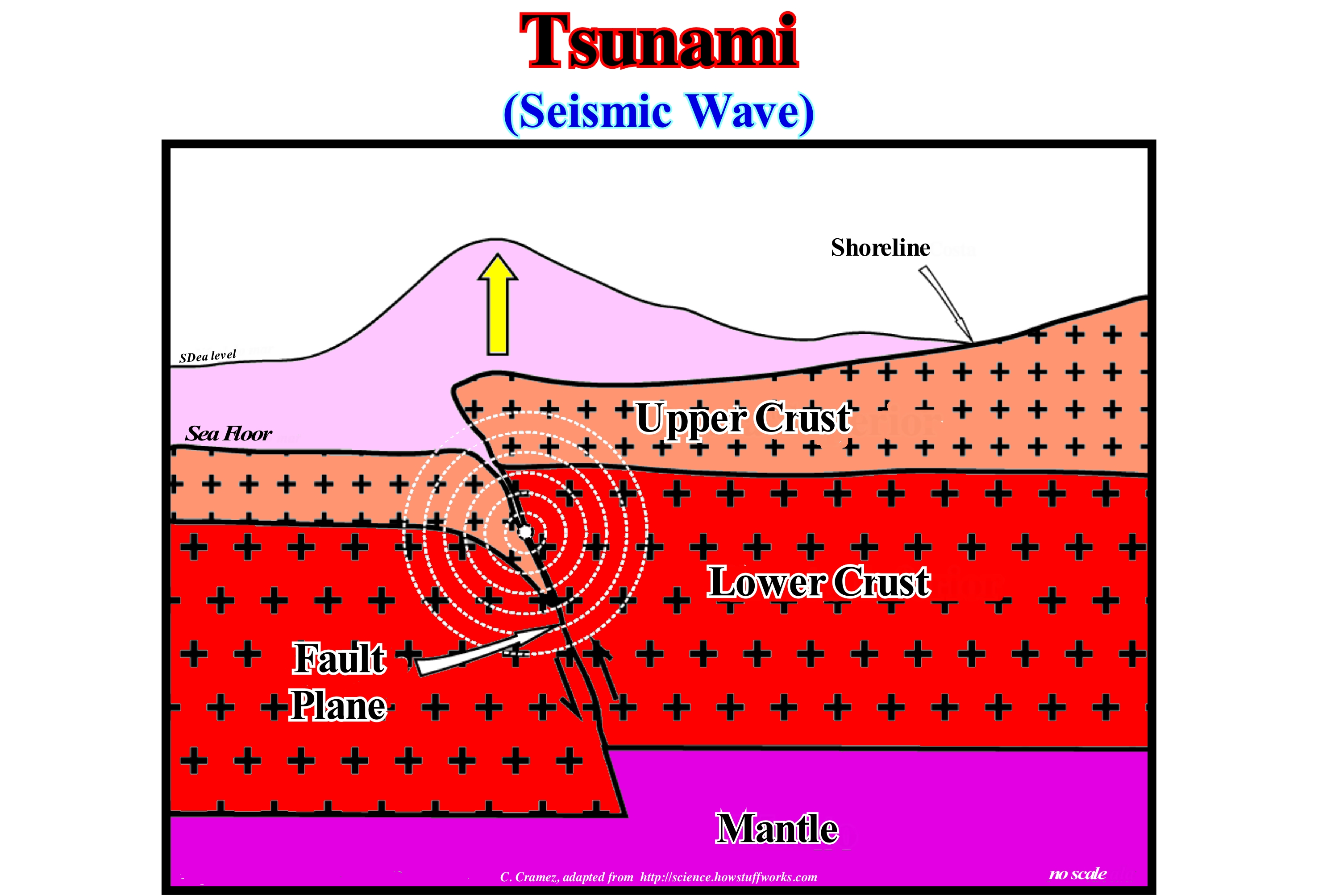
On Earth, the lithospheric plates are in constant motion. They move relative to one another with speeds varying from 2.5 to 5/7 centimeters per year. The movement of the plates occurs in the oceanic ridges, transform faults and subduction zones and can produce earthquakes and volcanic eruptions that can cause tsunamis. In certain subduction zones, the less dense lithospheric plate (usually the overriding plate) may, abruptly, move upwards due to the pressure exerted by the heavier descending plate. This abrupt displacement, as illustrated in this scheme, can produce an earthquake. The focus of the earthquake is the point or area where the first rupture occurred and where seismic waves are generated, while the earthquake's epicentre is the bottom point of the sea (or the surface of the earth) above focus. When a portion of the overriding lithospheric plate is uplift, the released energy is transferred to the sea-water, which pushes the water above sea level. Tsunamis can be said to be very long (3 minutes and 3 hours), of high wavelength (sometimes over 200 km), low amplitude (centimeters to decimetres) and with a high velocity (speeds between 600 and 800 km/h are frequent) produced by coastal or submarine earthquakes. A tsunami of 200 km wavelength and 25 cm amplitude displaces 50,000 tons of water per meter of the shoreline. The damages are, particularly, severe when the water converges to a relatively narrow bay, which can create a wave height (h) of the order of 50 meters. The velocity of the wave (v) is a function of the wavelength (L). If the water-depth is greater than the wavelength (l), the velocity v is equal to (gL/2π)1/2 which is equal to (1.56 L)1/2, where g is the acceleration of gravity (9.81 m/s2). If the water-depth is less than the length of water, the speed is equal (gh)1/2. However, do not forget that the velocity of the wave, actually, means a phase velocity, since what moves is not the water, but the crest and the trough of the wave, that is to say, the phase of the surface of the water.
Tubicolous.....................................................................................................................................................................................................................................Tubicole
Tubícola / Tubicola / Röhrenwurm / 管蠕虫 / Живущий в трубке / Verme de forma de tubo /
Animal that live inside a tube or that have a tubular structure, like certain marine worms.
See : « Fossil »
&
« Coastal Karst »
&
« Shoreface »

The tubicolous or tubiculata are invertebrates polychaetes (class of animals of the annelid phylum constituted by more than 10,000 species, most of them marine), that live in the lower mesolittoral floor of the strand with rock outcrops, inside tubes formed by debris of shells and sand clotted by a hardened animal secretion. They live in colonies fixed to the cliffs and can form steps or cover the abrasion platform. They are annelids, bioconstructors, and have a maximum development in the warm seas. On this subject it can be said that: (i) Some tubicolous species are carnivorous and project from their tube or temporarily abandon it for food (the carnivorous species, generally, have similar adaptations to the wandering polychaete) ; (ii) Most tubular polychaete are sedentary and move very little inside the tube (movement occurs by peristaltic contractions, so the parapods are not very developed and are, sometimes, reduced to small rows of unciniger silks ; circular muscles are, particularly, well developed as are the internal septa) ; (iii) The adaptations of the sedentary tubular species are similar to those that characterize polychaetes that make holes and that also move very little ; (iv) The diversity of tubular polychaetes comes from their various strategies for catching food (these polychaetes may be selective and non-selective detritivorous and filterers ; some have mixed strategies and use pals to select food particles in the sediment or to capture them in the water, and may be considered a selective detritivorous species or a filtering species) ; (v) The filtration capacity of water has evolved in many tubers and there are different ways of doing so ; (vi) The polychaetes are well known to fishermen, who use them as baits, and of some entrepreneurs, whose activity is based on the cultivation of certain species (although the great diversity of this group is probably little known to them) ; (vii) Polychaetes are, extremely, important in assessing the sanitary status of the sea, estuaries and coastal lagoons (http://www.biorede.pt/text.asp?id=446).

