
Dalton's Law.......................................................................................................................................................................................................................................Loi de Dalton
Lei de Dalton / Ley de Dalton / Danton-Gesetz / 丹東的法律 / Закон Дальтона / Legge di Danton /
The pressure of a gas mixture is equal to the sum of the pressure of each gas.
See: « Avogadro's Law »
&
« Natural Gas »
&
« Hydrocarbon »

This law is not to be confused with Dalton's atomic law which says: that all matter is made of atoms and that it can not be created destroyed or divided. Dalton's law is, generally, known as the law of partial pressures, which, as illustrated above, means that the total pressure of a gas mixture is equal to the sum of the partial pressures exerted by each of the gases in the mixture. In a container with a mixture of gases, each gas exerts a pressure equal to what it would be if the gas were alone in the vessel. In the example shown in this figure, the left container containing 5 litres of hydrogen (0.60 mol) exerts a pressure of 2.9 atmospheres. The central container has 5 litres of helium (1.50 mol) at the same temperature (20 ° C) and exerts a pressure of 7.2 atmospheres. The right container is a mixture of 0.60 hydrogen and 1.50 mol of helium. The volume of the mixture is the same, as is the temperature (20° C). The pressure in the container containing the mixture of the two gases is 10.1 atmospheres i.e., equal to the sum of the partial pressures of each gas (2.9 + 7.2 = 10.1 atmospheres). It is this pressure that is called partial pressure. Dalton, an amateur meteorologist for more than 50 years, made very important observations that led him to take an interest in gas studies. The law of partial pressure was an important contribution to the development of kinetic theory of gases, which says gases are composed of molecules that are in constant random motion and that their properties depend on their motion. Dalton's law is not, exactly, followed by ideal or perfect gases (idealized model, for the behaviour of a theoretical gas composed of a set of point particles moving, randomly, and not interacting). These deviations are, considerably, large at high pressures. Under such conditions, the volume occupied by the molecules may become significant in comparison with the free space between them. When the distance between the molecules is small, the intensity of the inter-molecular forces increases, sufficiently, between the molecules of gas to substantially change the pressure exerted by them. None of these effects is considered in an ideal gas model.
Daly's Theory (Reefs)...........................................................................................................................................................Théorie de Daly (Récif)
Teoria de Daly / Teoría de Daly (arrecifes) / Theorie Daly (Riff) / 达利理论(礁)/ Теория Дэли (риф) / Teoria di Daly (corallo) /
This theory suggesting the formation of reefs is, more or less, linked to the warm inter-glacial periods. During the glaciations reefs die and are largely eroded due to the relative sea level falls induced by the formation of ice caps. Glacio-eustasy is the basis of Daly's theory. Other theories suggest the formation of reefs and atolls is, entirely, associated with relative sea level rises (eustasy + tectonics*), irrespectively to glacio-eustasy.
See: « Glacial-Control Theory »
(*) Subsidence (lengthening of the sediments) or uplift (shortening of the sediments).
Darcy's Law...................................................................................................................................................................................................................Loi de Darcy
Lei de Darcy / Ley de Darcy / Darcy-Gesetz / 达西定律 / Закон Дарси / Legge di Darcy /
Expresses the relationship between the instantaneous discharge rate through a porous medium. The viscosity of a fluid and the pressure drop over a given distance. The total discharge (Q in m3/s) is equal to the product of the permeability of the porous medium (κ in area units i.e., m2), the section through which the flow is made (A) and the pressure difference (Pb - Pa), divided by the product of the dynamic viscosity (μ in kg/ms) b the length (L) between the points of pressure drop.
See: « Viscosity (petroleum) »
&
« Flux (flow) »
&
« Porosity »
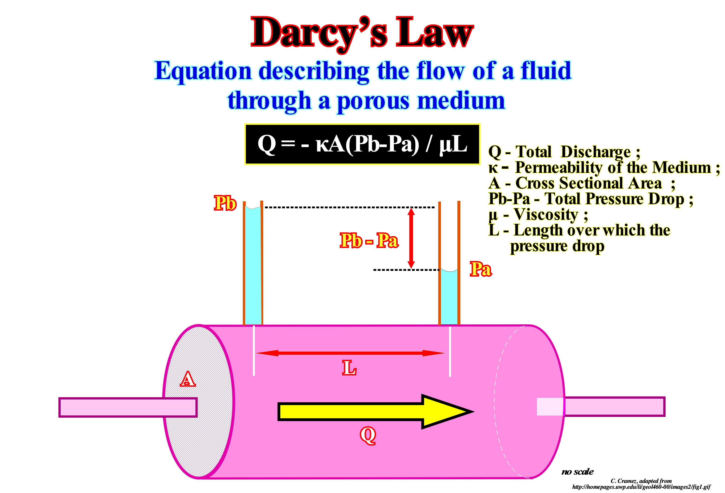
In the dynamics of fluids and hydrology, Darcy's law is an equation that describes the flow of a fluid through a porous medium. This law is the scientific basis for the permeability of fluids used in Geosciences. The permeability of bodies consists of a property of the bodies to allow with greater or lesser ease the flow of water through their pores. Soil permeability, basically, consists in measuring the percolation velocity of the water in a given sample, considering the laminar flow, considering the temperature at the time of analysis. The permeability coefficient, K, is an index used to establish soil permeability parameters. Summing up, the permeability coefficient is a value that represents the rate at which water passes through a sample. Since this index is very small numerically, it was agreed to express its result in the form of potentiation, for example: K = 2.20 x 10⁻⁵ cm/s or K = 1.27 x 10⁻⁷ m/s. As the temperature influences in the final value of K, it was agreed that it should be converted to a final temperature of 20° C, correcting the viscosity of the water at the test temperature: K20° = Kt x (Mt / M20°) where: M20° is the viscosity of water at 20° C and Kt the test temperature coefficient. The same soil according to the situation may have a different permeability coefficient: (i) The void index (e) of the sample is, directly, proportional to the permeability coefficient (the larger the void index the higher the permeability coefficient) ; (ii) The water temperature changes the final result of the permeability coefficient (a temperature increase of the water reduces its viscosity, which reduces the time it takes to pass through it ; (iii) The type of material the smaller particle size will be the permeability coefficient) (http://en.wikipedia.org/wiki/Lei_de_Darcy).
Darwin Seamount........................................................................................................................................Mont sous-marin de Darwin
Monte Submarino de Darwin / Monte submarino de Darwin / Darwin Seeberg / 海底山 / Подводная гора Дарвина / Monte sottomarino di Darwin /
Submarine mount recognized on the seismic lines of the North Atlantic Ocean and corroborated by the results of the DSDP 163/1, which indicated a volcanic facies (more sub-aerial than shallow-water). The terminations and geometry of the seismic reflectors associated with this anomaly, strongly, suggest they are associated with lavas flow. Volcanic material can only flow in a continental or sub-aerial environment, where periods of immersion alternate with periods of exhumation.
See: « Seafloor Spreading »
&
« SDRs »
&
« Abyssal Plain »
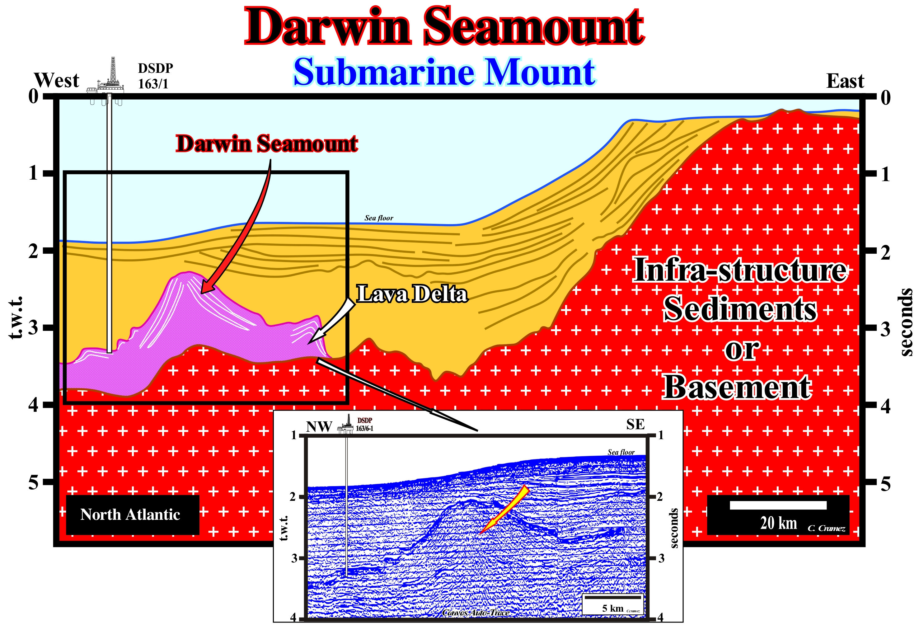
On this tentative geological interpretation of a Canvas auto-trace of a regional seismic line of the North Atlantic Ocean, the great sedimentary anomaly visible in the West part has been interpreted, always, as a submarine mount*. It is known to all English geoscientists as Darwin's Seamount. The results of DSDP** 163/1 corroborated a volcanic lithology, more sub-aerial than shallow-water. The terminations and geometry of the seismic reflectors associated with this anomaly strongly suggest the reflectors were induced by lavas flow (a spill is. generally, conditioned by topography and velocity, which depends on the fluidity of the lava depending on the chemical composition and temperature and on the presence or not of obstacles to the flow. Indeed, the volcanic material can only flow in a continental or sub-aerial environment, where periods of immersion alternate with periods of exhumation and where it forms lava sheets. In the water, the volcanic material "freeze", i.e., it solidifies quickly and can not flow. It tends to form pillow lavas. It is possible that the Darwin's seamount corresponds more to a volcano in the Rockwall depression (rift-type basin developed on the continental crust between Ireland and the Rockwall Bank), which, later, during a marine ingression phase, was covered by the sea, than to a volcano formed on the sea floor. The elements illustrated on this tentative corroborate the first conjecture (immersion of a continental or subaerial volcano), which can summarize as follows: (i) Presence of a depression at the top of the anomaly that can be interpreted as a volcanic crater (surface rupture) by which the magma*** reaches the surface ; (ii) Convergence of the reflectors outward the crater, which means that the flows thin as they move away from the emission centres ; (iii) The convergent internal configuration of the intervals defined by two consecutive reflectors, i.e., the volcanic flows thin, as the distance to the crater increases, until disappearing by downlapping ; (iv) Formation of lava deltas, since a flow enters a water-body (lake or epicontinental sea), the volcanic material "freezes". As it can not flow into water, it forms a structure whose geometry is very similar to delta, in which many geoscientists dare even propose interpretations in sequential stratigraphy ; (v) Three lava deltas are, perfectly, visible on the west flank of the anomaly, which can be interpreted as the result of three transgressive episodes within a globally retrogradational interval ; three rises of the relative sea level (sea level referenced at any point on the Earth's surface such as the sea floor or the base of the sediments and which is the result of the combined action absolute or eustatic sea level, which is supposed to be global and referenced to the Earth's centre and tectonics) are easily recognized ; (vi) On the eastern flank of the submarine mount, the presence of a large lava delta is obvious, but the individualization of relative sea level rise increments is not evident. Note the seismic artefact induced by the abrupt variation of the water-depth (in a depth seismic line, the Darwin's seamount seems less deep). On the other hand, the continental shelf visible in the eastern part of this tentative interpretation is, largely, the result of the isostatic uplift or rebound induced by the melting of the ice of the last glaciation, which had pressed the Earth's surface due to the enormous weight of the ice caps, which means that the reflector terminations on the sea floor are mainly toplaps by erosion (truncation).
(*) A submarine mount is a mountain that rises from the bottom of the ocean but does not reach the average level of the sea. Conventionally, geoscientists consider that seamounts must have a height of at least 1000 m above the surrounding ocean floor. The vast majority of seamounts are extinct volcanoes that rise, abruptly, from depths of the order of 1,000 m to 4,000 m below sea level.
(**) DSDP ("Deep Sea Drilling Project") was an important ocean reservoir drilling project that existed between 1968 and 1983, the results of which were primarily published by Texas A & M University and by Scripps Institution of Oceanography at the University of California , in San Diego.
(***) Rocky body in total or partial fusion that exist below the Earth's surface, under high pressure.
Darwin's Theory (Subsidence, reefs)...................................................................................................Theorie de Darwin (Reefs)
Teoria de Darwin (recifes) / Teoría de Darwin (arrecifes) / Darwins Theorie (Koralle) / 达尔文理论(珊瑚)/ Теория Дарвина (рифы) / Teoria di Darwin (corallo) /
In Darwin's theory, fringed reefs are formed on the edge of the volcanic islands. Later, when the islands sink, the reefs form reef barriers. The subsidence may be caused by sea floor spreading (oceanic expansion) or by the weight of the island. The subsidence may cause a total submersion of the island, leaving a circular reef (atoll) around a lagoon. This theory was not refuted by the research well on the island of Eniwetok (atoll of the Marshall Islands in the Pacific), which reached the top of an ancient volcano around 1,200 meters depth.
See: « Glacial-Control Theory »
Darwin's Theory of Subsidence.................................................Théorie de la subsidence de Darwin
Teoria da subsidência de Darwin / Teoría de la subsidencia (Darwin) / Theorie der Setzungen (Darwin) / 沉降理论(达尔文)/ Теория опускания породы (Дарвин) / Teoria della subsidenza (Darwin) /
The vertical growth of coral reefs is controlled by the subsidence of the sea floor (under conditions of gradual subsidence) and is, generally, associated with the evolution of a volcanic island (volcano).
See: « Rimmed Carbonate Platform »
&
« Reef »
&
« Relative Sea Level Change »
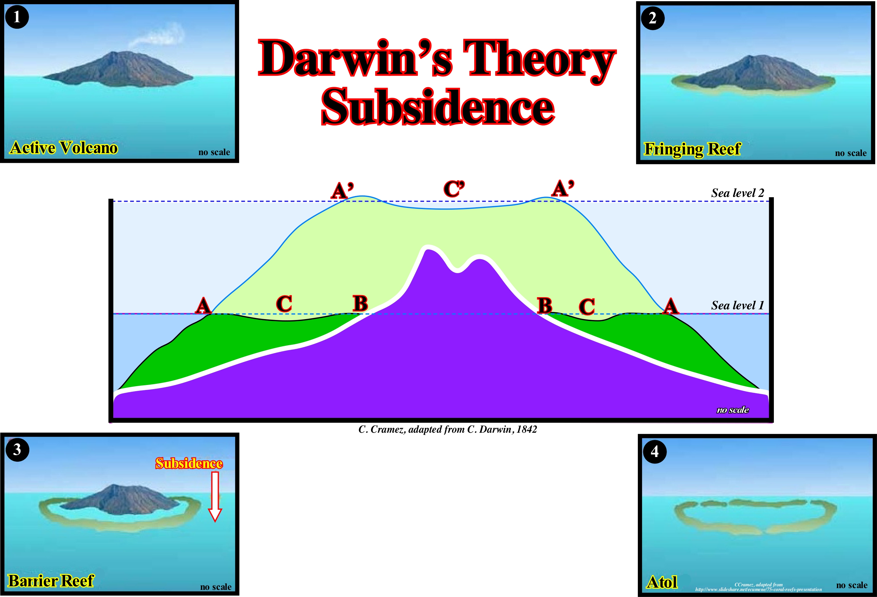
Many speculations were advanced on the origin of the reefs and, particularly, on the origin of the atolls, especially, when geoscientists found that there were no reefs at more than 50/70m of water-depth. There are several theories to explain reef formation. Probably the most correct are those of Charles Darwin and Reginald Daly. C. Darwin, in 1830, after his five-year voyage in the Beagle, during which he had the opportunity to study several reefs advanced the hypothesis that fringed reefs begin to grow along the coast of recent volcanic islands, which sooner or later begin to subsidize. Thus, if subsidence does not occur very rapidly, the reefs can adapt: a) Initially forming a fringe reef ; b) Then a barrier reef and finally c) An atoll, as the island disappears. Darwin's theory, as illustrated in this figure, is the theory of subsidence. According to this theory, fringing or coastal reefs form along the edges of islands and then, with the disappearance of islands, barrier-reef form having a linear or semicircular geometry and are separated from the continent by channels. Subsidence may be caused by: (i) Ocean expansion or sea floor spreading, which causes an absolute (eustatic) sea level rise*, as the volume of the ocean basins decreases to a constant volume of water (in all forms) or (ii) The weight of the island itself. In any case, a continuous subsidence causes the total submersion of the island, leaving a circular reef, i.e., an atoll, around a central salt water-body. This theory was corroborated by drilling made on Eniwetok Island (an atoll of the Marshall Islands in the Western Pacific). The wells recognized, at about 120 meters of depth, the basaltic top of an old volcano. This Darwin's subsidence theory explains, satisfactorily, many but not all reefs. A second theory was suggested by R. Daly ** which gives another insight to the formation of a fringing reefs. Daly suggested glaciations are the main reason for reef formation. He admitted the succession of events leading to the formation of a reef on a flat surface begins with a small fringed reef. The cold waters of the ice age prevented coral growth as absolute sea level fall due to the large amount of water used to form glaciers and ice caps. The part of the reef out of the water was eroded and cut by the sea-waves. After the end of the ice age and the melting of glaciers, absolute sea level rose and coral reefs began to grow again. But this time, they grew, on flat and horizontal surfaces. This theory was, also, corroborated by observation data but, of course, it does not explain all reefs. A third theory suggests the formation of reefs and atolls is just due to an absolute sea level rise as the volume of ocean basins decreases due to the formation of the oceanic mountains (mid ocean ridges). This hypothesis only makes sense if the volume of water, in all its forms is constant, since the Earth's formation around 4.5 Ga (axiom of the sequence stratigraphy that most geoscientists adopt). It can be said all theories describe how some reefs have formed and all of them are corroborated or validated (but not verified) by observation data. However, none of them is entirely correct, nor does it explain the formation of all reefs.
(*) In the stratigraphy two sea levels have to be considered: (i) Relative sea level, which is a local sea level, referenced to any fixed point on the Earth's surface, which can be the base of the sediments or the sea floor and (ii) Absolute (eustatic) sea level, which is supposed to be global sea level, referenced to the Earth's centre. The relative sea level is the result of the combined action of absolute (eustatic) sea level and tectonics (subsidence or uplift of the sea floor). The absolute sea level is the result of the combination of: i) Tectono-Eustasy, controlled by the volume variation of the ocean basins in association with oceanic expansion following the break-up of the supercontinents ; (ii) Glacio-Eustasy, controlled by the volume of water in the oceans function of the amount of ice (assuming the amount of water in all its forms is constant since the Earth's formation 4.5 Ga) ; (iii) Geoidal-Eustasy, controlled by the distribution of ocean water caused by variations in the Earth's gravity field (where gravity is stronger than normal, sea level is thrown to the Earth's centre) and (iv) Steric sea level rise or thermal expansion of the oceans, controlled by ocean temperature rising (if the temperature increases, the water density decreases and, for a constant mass, the volume increases). During a given geological time, the combination of the eustatic curve (curve of the variations of the absolute sea level) and tectonic (subsidence, when the predominant tectonic regime is extensional or uplift, when the predominant tectonic regime is compressional (shortening) gives the curve of the relative sea level change rate.
(**) In the book "Our Mobile Earth" published in 1926, James Natland Daly (1871-1957), who was one of the first proponents of the continental drift theory of Alfred Wegener and Arthur Holmes (https://en.wikipedia.org/wiki/ Reginald_Aldworth_Daly) proposed continental displacement was largely based on the idea that after the Moon separated itself from Earth (a theory that was fashionable in the early twentieth century), but anticipated certain aspects of movement theories of plate tectonics, including the conjecture of a "mesospheric shield" and a slippery basaltic substrate.
Davisian Cycle...................................................................................................................................................................................................Cycle de Davis
Ciclo de Davis / Ciclo de Davis / Davisian Zyklus / Davisian 周期 / Цикл Дэвиса / Ciclo di Davis /
Genetic interpretation of the topography based on the concepts of peneplantation and erosion. According to E. Mutti (1996), uplift and denudation are the main responsible for the formation of deltas induced by floods and fan deltas (Gilbert deltas). Synonym of Erosion Cycle.
See: « Erosion »
&
« Delta »
&
« Turbidite »
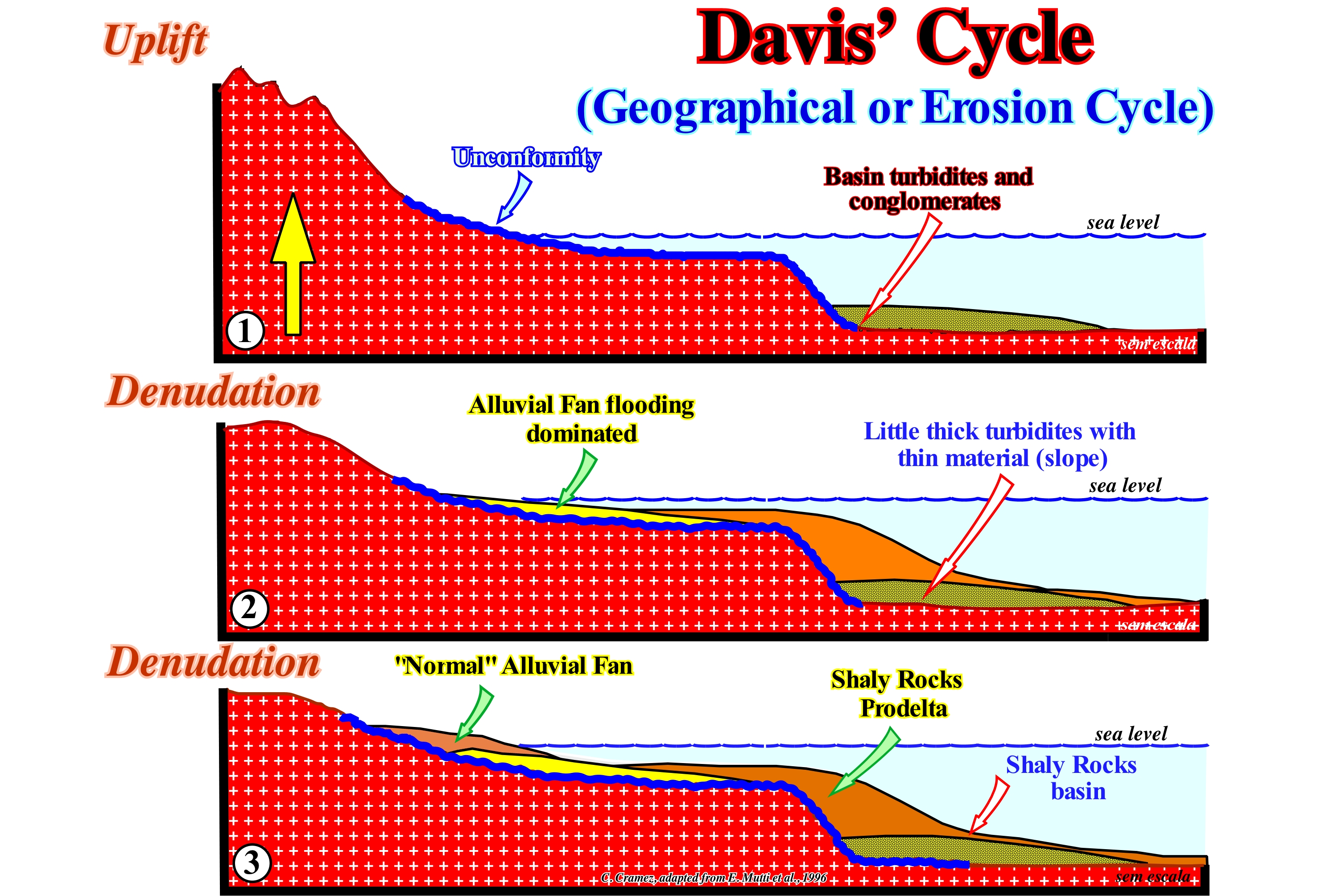
The erosion can be of several types, depending on the agent that acts: (i) Pluvial erosion, caused by rainwater, whose action is slow, but can be accelerated when it encounters a soil without vegetation ; (ii) River Erosion, caused by rivers, perennial or temporary ; (iii) Marine erosion, in which sea-water, reinforced by the presence of sand and silt in suspension, causes erosion through the action of waves, sea currents, tides and turbidity currents ; (iv) Glacial erosion, caused by the movement of glaciers, as well as, by the dilation of water that accumulates in the cavities of rocks in summer and freezes when winter arrives ; (v) Wind erosion, caused by the action of the wind, particularly, by the wind blowing over arid and dry regions, where there is loose sand, capable of being carried by the wind ; (vi) Anthropogenic erosion, caused man, which, in general, does not have great influence, because it is an action of short duration (in geological terms), but that tends to be, more and more, significant. The Davis cycle or erosion cycle, as it is also called, corresponds to a, more or less, ordered series of events through which, it is thought, all rocks, after their formation undergo an uplift phase and, later, a flattening phase by erosion. The main stages or phases of this cycle are: (i) Youth Phase, when the mountains are steep and the irregular provisional river equilibrium ; (ii) Maturity Phase, when the river provisional equilibrium profiles of ten rivers are concave upwards and, more or less, smooth with small incisions ; (iii) Old Age Phase, when the morphology of the terrain corresponds, more or less, to a peneplain. Since the uplift of a part of the terrestrial crust, generally, associated with a shortening of the sediments, induced by compressional tectonic regimes, erosive agents (mainly water, wind and ice) begin to act destroying the surface of the youth phase. The relief acquires a mountainous landscape at the same time as the river valleys widen and the distributaries form large meanders (maturation phase). The continuation of this process ends up levelling the slopes (old age). Although the Davis cycle is, increasingly, used to explain the morphological evolution of the terrain, Emiliano Mutti, as illustrated in this diagram, used it to explain the deposition of turbidites in highstand geological conditions (sea level higher than the basin edge). Mutti has suggested the vertical evolution of flood-dominated river systems is controlled by Davis cycles and basin deposits are, gradually, covered by fluvial-delta systems that over time deposit above and updip of the normal fluviodeltaic systems. Theoretically, an uplift produces a relative sea level fall that puts the sea level below the basin edge (which corresponds to the continental edge when the basin has a continental shelf). Such a relative sea level fall exhumes the shelf and the upper part of the continental slope, which creates, at the same time, an erosional surface, which later, when fossilized, is underlined by an unconformity. In the deep part, turbidite depositional systems are deposited. Mutti and Vail are not in agreement. For Peter Vail, the sea level has to be lower than the basin edge to have deposition of turbidites. For Emiliano Mutti, turbidites can also be deposited in highstand conditions if terrigeneous influx sediment is important, as is the case during floods. The uplift and subsequent denudation are primarily responsible for the deposit of alluvial deltas dominated by floods and, secondly, when the competence of the currents decreases, of the normal alluvial deltas, which fossilize the innermost areas of the alluvial deltas dominated by river floods. Under these conditions, it is evident that Mutti considers climate is a preponderant parameter of the deposition of certain turbiditic systems. Despite the intense criticism of the Davies cycle, this erosion model continues to be part of geomorphology (the branch of Geology that studies the forms of the Earth's surface and for this, identifies, describes and analyses such forms, as well as all its genetic aspects, chronological, morphological). A Davies cycle has never been, completely, refuted and it is corroborated by certain observation data. It is an approach, often, used to establish denudation chronologies. Currently, many geomorphologists consider the deficiencies of this model are, largely, compensated by their high pedagogical value.
Debris, Detritus (geology).............................................................................................................................................................Détritus (Géologie)
Detrito / Detrito (geología) / Schutt, Geröll / 碎片,碎屑 / Детрит, обломки / Detrito /
Sedimentary particle, i.e., a loose and worn grain resulting from the alteration and erosion of the rocks or an organic fragment.
See: « Sediment »
&
« Sedimentation »
&
« Erosion »
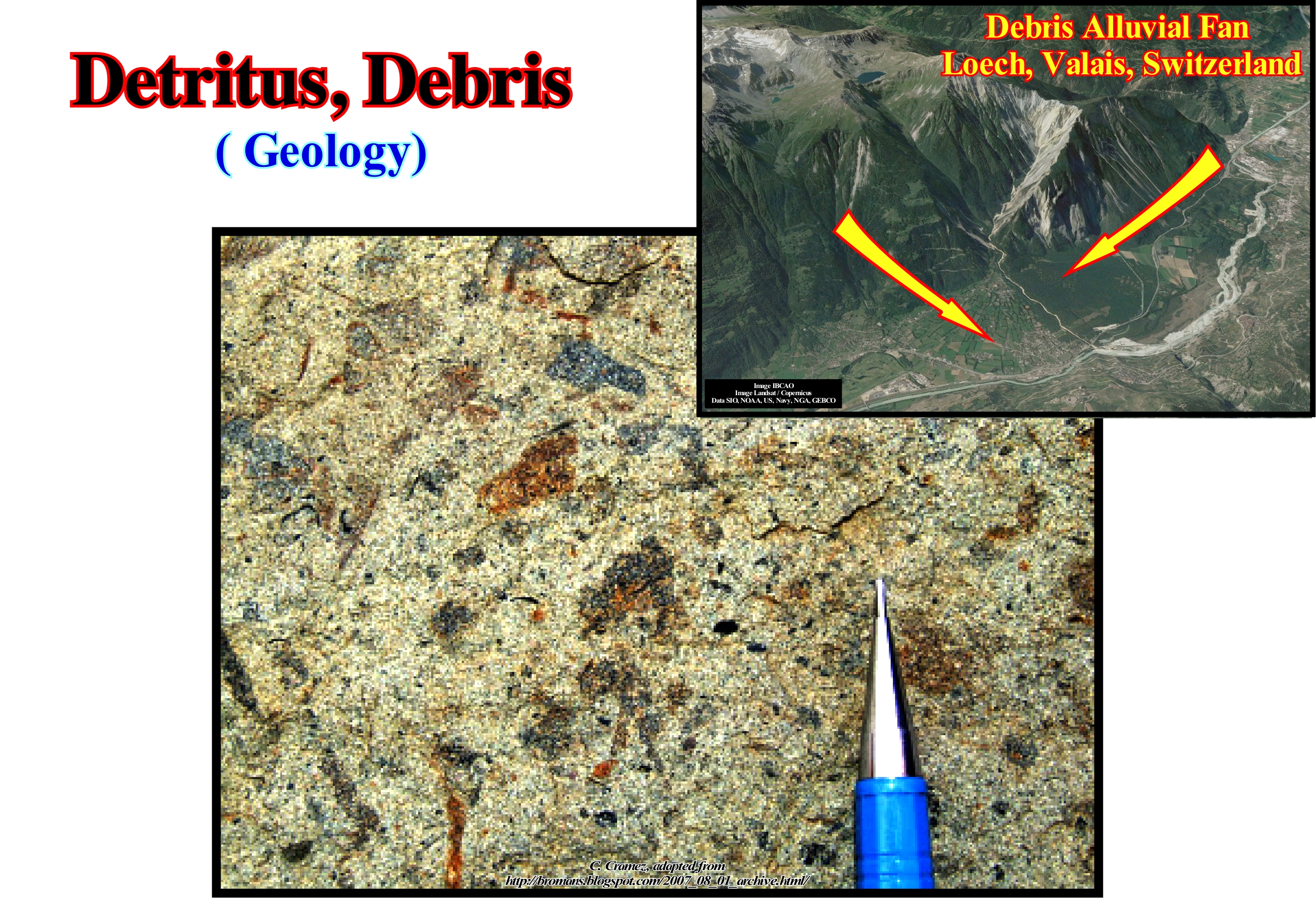
In general, in geology, the term detritus is used to denote a particle derived from pre-existing rocks by weathering processes (decomposition of rocks, soils and minerals by direct contact with the atmosphere) and erosion (abrasion or displacement of solids, that is, a sediment, soil, rock and other particle by wind, water or ice due to gravity or living organisms). Debris can be lithic fragments (when pre-existing rock is easily recognized) or mono-mineral fragments (mineral grains). These particles are often transported by sedimentary processes to depositional systems such as rivers, lakes or oceans, where they settle in more or less stratified sediments or sedimentary layers. Then diagenetic processes can transform them into sedimentary rocks by cementation (deposition process of the dissolved minerals in the interstices of the sediments) and lithification (process by which the sediments are compacted under the action of the pressure that expels the fluids between the pores and gradually turns them into solid rock). Later, the sedimentary rocks, in turn, altered, fragmented and eroded form again debris. Sedimentary particles range from the fine dust transported by high-altitude winds to gigantic erratic blocks moved by glaciers. Standard sieve sizes are: (i) Small Boulder > 250 mm of diameter ; (ii) Large Cobbles between 128 and 256 mm ; (iii) Small Cobbles between 128-64 mm ; (iv) Very Coarse Gravel between 64-32 mm ; (v) Coarse Gravel between 32-16 mm ; (vi) Medium Gravel between 16-8 mm ; (vii) Fine Gravel between 8-2 mm ; (viii) Very Fine Gravel between 4-2 mm ; (ix) Very Coarse Sand between 2-1 mm ; (x) Coarse Sand between 1-0.5 mm ; (xi) Medium Sand between 0.5-0.25 mm ; (xii) Fine Sand between 0.25-0.125 mm ; (xiii) Very Fine sand between 0.125-0.062 mm ; (xiv) Coarse Silt between 0.062-0.031 mm ; (xv) Medium Silt between 0.031-0.016 mm ; (xvi) Fine Silt between 0.016-0.008 mm ; (xvii) Very Fine Silt between 0.008-0.004 mm ; (xviii) Coarse Clay between 0.004-0.002 mm ; (xix) Medium Clay between 0.002-0.001 mm ; (xx) Fine Clay between 0.001-0.0005 mm ; (xxi) Very Fine Clay between <0.0005 mm. In this photograph, taken perpendicular to a bedding plane, a series of organic debris is recognized that are integral part of the rock. In the same way, the small black fragments of carbonated clay are easy to recognize. The presence of organic debris, such as coal, is very frequent in turbidite deposits. In fact, organic debris, when associated with other sedimentary particles, can give valuable indications about the depositional environment. For example, if in a given sample, a geoscientist recognizes coal and authigenic* glauconite debris, the sample probably comes from a turbidite depositional environment. If the sample has coal debris but no glauconite debris, the sample, probably, comes from a non-marine sedimentary environment. If the sample only has glauconite of neoformation, it certainly comes from a rock that has deposited in a marine environment and, probably, of shallow water. This criterion, known by the Selley square, is almost always used by geoscientists who control drilling wells to differentiate deep environments from platform environments.
(*) The term authigeneous (authigenic) refers to minerals or rocky materials that have formed "in situ" instead of being transported and deposited. These minerals such as quartz, chlorite, etc. and the cements that fill the pores of the rocks, are formed during diagenesis. Glauconite and evaporite minerals such as halite are authigenic or deposited where where they are found or observed.
Debris Flow (Detritic flow)..........................................................................................................................................................................Lava torrentielle
Escoada detrítica / Flujo detrítico / Schuttstrom / 泥石流 / Лавовый поток / Colata detritiche /
One of four types of flow that can be recognized in association with turbidite deposition systems: (i) Granular - the dispersion of the material and its maintenance in suspension is promoted by the collision between the particles ; (ii) Liquidated - the grains lose contact with each other, dispersed and kept in suspension by upward water movements ; (iii) Detritic - the flow has a large amount of fine suspended material, which serves as a support for the transport in suspension of some larger elements and (iv) Turbiditic - correspond to turbulent mixtures of water and varied sdiments which, in the aggregate, characterize a current whose overall density is greater than surrounding water.
See: « Turbiditic Flow (flux) »
&
« Sequence Stratigraphy (sequential) »
&
« Detrital Flow »
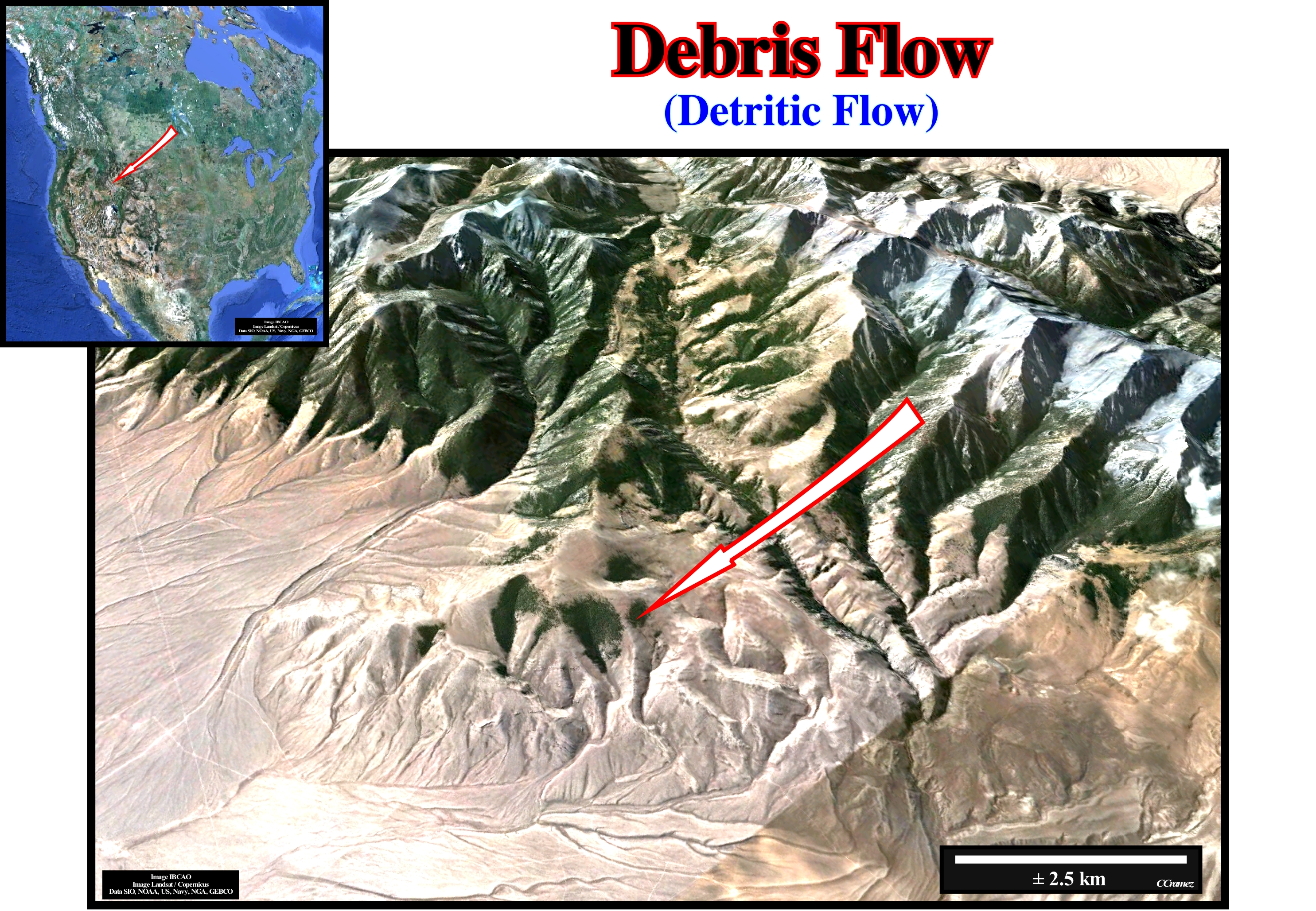
Debris flows are formed when rocky materials, little or not consolidated, become saturated of water and unstable. Due to the force of gravity, they move down-dip and settle, usually, at the foot of the mountains or in the valleys. The end portion of a debris flow forms a lobe or crest, which marks the front of the flow. This lobe contains, often, a large amount of coarse sediments such as pebbles, blocks, etc. Upstream of this lobe, the material is thinner and is composed, mainly, of clay, sand and silt. Debris flow may, eventually, turn into very muddy flood waters since the coarser elements are deposited. They tend to move downstream step by step, since the effects of friction and other barriers to movement have to be overcome. Sometimes the first movements (pulses) or the first flows form natural marginal dikes (levees) that channel the subsequent flows until they branch out. The presence of ancient natural marginal dikes (levees) suggests the recurrence and flow characteristics of a given area, which is important for understanding the formation of alluvial fans. This photograph illustrates the debris flow of the volcanic complex west of the Pashimeroi River in the south central part of Idaho. The geoscientists who studied this flow consider it as a mass of fragments of rocks, soils and muds, in which the average size of the debris is higher than the sand. Some debris flows, such as this one, move slowly (1-2 cm per year). Others, move, almost, instantaneous. They can exceed speeds of 160 km per hour, such as the Huascaran debris flow in the Andes of Peru. In fact, on May 31, 1970, the magnitude 7.7 earthquake that occurred in Peru triggered one of the most catastrophic landslides that ever occurred: the Nevado Huascaran flow. This event is known for the large number of deaths it has caused (about 1,800), and for its geological characteristics. The enormous mass of rock and ice (superior 50 x 106 m3) originated from the western face of the northern peak of the Nevado Huascarán (6,654 m), located about 130 km east of the epicenter of the earthquake. This landslide flowed about 16 km, before reaching the villages of Yungay and Ranrahirca. It slipped about 2 km on a glacier, filled the bottom of the valley at the foot of the slope and then channelled through a gorge. Shortly before the end of the gorge, it divided into two lobes towards the village of Ranrahirca, overbanking the 230 m height of the southern summit of the gorge, continuing towards the village of Yungay (https://books.google.es / books? isbn = 33190499). On this subject it is interesting to mention the studies of J.L. Zêzere on the debris flows that occurred in Portugal induced by earthquakes (http://cerg.u-strasbg.fr/site/cerg_eng/ cerg / intro / index.html ): (i) The detritic flow of Costa do Castelo (Lisbon), which occurred on January 28, 1512, caused the destruction of 200 houses and the death of 2,000 people ; (ii) The debris flow of Santa Catarina (Lisbon), occurred on July 22, 1597 destroying about 220 dwellings; (iii) The debris flow system of Vila Franca do Campo (Azores island) occurred on October 22, 1522 and was responsible for the almost total destruction of the village with the same name and the death of about 5,000 persons. In any of the cases studied, the evidence of a seismic trigger is strong. In the examples that occurred in the city of Lisbon, the Oliveira seismic catalogue (1986) indicates earthquakes in the dates in question with intensity of respectively VIII and VII of the Modified Mercalli scale (determination of the intensity of an earthquake from its effects on the people and on built and natural structures). The debris flow of Vila Franca do Campo was triggered by an important earthquake with an epicentral intensity of X and an estimated magnitude of 6.8 (destroyer in populated areas, wall collapse) on the Richter scale* (for example, the earthquake of 1755 in Lisbon reached magnitudes between 8.7 and 9 on the Richter scale.
(*) Unlike the intensity scale (Mercalli), which is qualitative, the scale that measures the magnitudes is quantitative (Richter), since the magnitude is calculated from data provided by seismograms. The most commonly used magnitude scales is the Richter Scale. It is a logarithmic scale (base 10), which implies that the rise of one unit on the scale represents an increase in the energy released about thirty times greater.
Debris Outflow........................................................................................................................................................................................Coulée de débris
Escoamento de detritos / Flujo de detritos / Schutt, Murgang / 碎片, 泥石流 / Поток обломочного материала / Transporto in massa, Colata /
Rapid, more or less, disordered movement of a turbulent current characterized by a high content of water and rock debris. Movement of unconsolidated material under the action of gravity, similar to the flow of the mortar along a slope. The fastest flows rival the speed of rocky landslides. The debris flows are the quite dangerous land gravitational movements. They can happen at any moment and flood, completely, entire cities. As its name suggests the main components of such flow are rock debris of very variable size. Synonym of Clastic Flow and Detritic Flow.
See: « Flux (flow) »
&
« Submarine Fan (submarine delta) »
&
« Turbiditic Current »
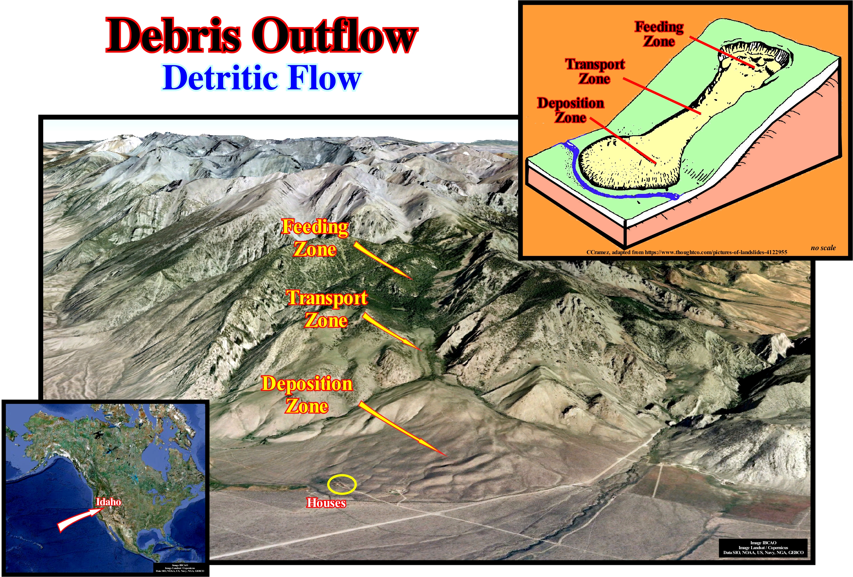
Debris outflows are formed when rocky materials, little or not consolidated, become saturated of water and unstable. Due to the force of gravity, flows down the coast and settle, generally, at the foot of the mountains or in the valleys. The terminal part of a debris flow forms a lobe or a crest, which marks the front or the front of the drain. This lobe often contains a large amount of coarse sediments such as pebbles, blocks, etc. Upstream of the lobe, the material is thinner and is, mainly, composed of clay, sand and silt. The debris flows may, eventually, become very muddy flood waters since the coarser elements are deposited. The flow of debris tends to move downstream through balconies, since the effects of friction and other barriers to movement have to be overcome. The first movements (pulses) form natural marginal dikes that channel the subsequent flows until they branch out. The presence of ancient natural marginal dikes (levees) suggests the recurrence and flow characteristics of a particular area, which is important in understanding its formation. A debris outflow can move on very soft slopes even when the solid fragments represent 80-90% of the total mass of the mass. Speed and distance travelled depends on the nature of the materials, the amount of water, the viscosity of the water/material mixture, the topography, the saturation in water of the soil on which it moves. As illustrated in the geological sketch of this figure, a landslide or debris outflow, as certain geoscientists say, is almost always characterized by the presence of three zones: (i) Feeding Zone, upper area of material collection and departure of the flow ; (ii) Transport Zone, forms by a narrow flow channel and very variable length ; (iii) Deposition or Accumulation Zone, extended terminal lobe in a species of cone of ejection, but of convex profile. This figure illustrates the debris flow from the volcanic complex west of the Pashimeroi River in the south central part of Idaho. The geoscientists who studied this debris flow consider it as a mass of fragments of rocks, soils and muds, in which the average size of the debris is higher than the sand. Some debris flows, such as this one, move slowly (1-2 cm per year). Others debris flows are, almost, instantaneous and can exceed speeds of over 160 km / h, such as Macatia's debris flow (Venezuela, December 1999), which have made an untold number of dead, since the missing are thousands. The Huascarán Nevado outflow in the Andes of Peru, induced by a 7.7 magnitude earthquake, is also one of the most catastrophic debris that has ever occurred (around 1800). Taking into account the risks of debris flows, the large and rapid flows of rocks and debris, also known as stone avalanches, are particularly dangerous, especially in mountainous regions such as Switzerland. Recall the disaster in Elm (Canton of Glaris), in which a debris flow killed 115 people, on September 11, 1881 (*). This flow, which according to Albert Heim was caused by the improper exploitation of a slate quarry, began with small rock slides on each side of the quarry on the mountainside. A few minutes later, all the mass of rock above the quarry fell and flowed through the valley. The movement of the rock fragments, which until then were simple slides and small falls, became an important detritic flow. The rock mass flowed to the other side of the small valley, turned and flowed into the main valley, where it flow about 5 km at high speed before stopping. About 10 Mm3 of rock descended, about 470 m, almost vertically, in 55 seconds, involving enormous kinetic energy. An avalanche of similar but still larger rock fall occurred in Frank (Canada, Alberta) in 1903, causing major loss of life and property. However, these debris flows are much smaller than what occurred on May 31, 1970 in Peru, which buried the city of Yungay and part of Ranrahirca, causing a loss of more than 18,000 lives.
(*)This event was reported by Franz Hohler in his novel "Die Steinflut" (The Flood of Stones).
Decarbonation..............................................................................................................................................................................................Décarbonation
Descarbonatização/ Descarbonatación / Entkohlung, Dekarbonatisierung / 脱碳 / Обезуглероживание / Decarbonatazione /
Removal of carbon dioxide (CO2). Dolomitic rocks, for instance, when heated by granitic intrusions are decarbonated. The decarbonation of minerals, generally, requires a large amount of heat, since such reactions are highly endothermic.
See: « Limestone »
&
« Natural Greenhouse Effect »
&
« Climate »
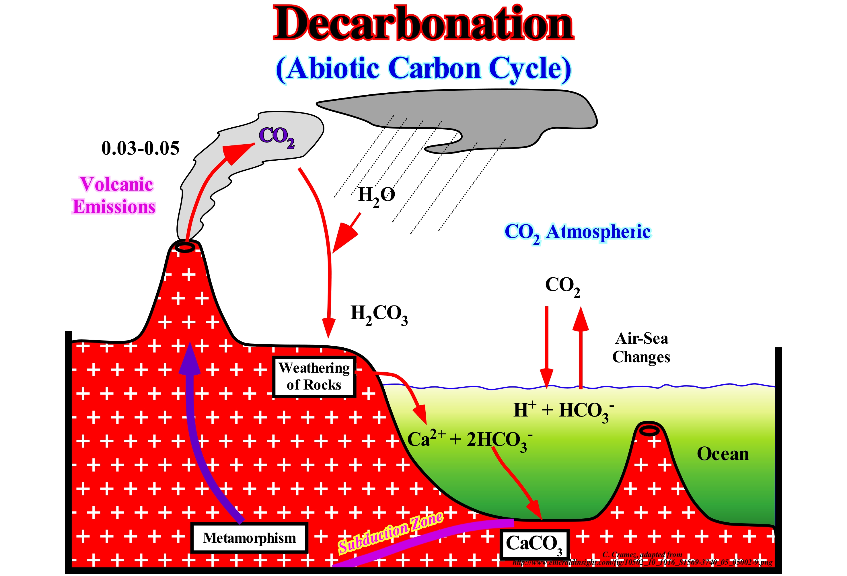
An endothermic chemical reaction is a reaction whose total energy, available in the form of heat (enthalpy *), of its products, at constant pressure, is greater than that of its reagents. This means that an endothermic reaction absorbs energy in the form of heat. Heat** is the energy transferred from one system to another, exclusively, because of the difference in temperature between them. Temperature is the kinetic energy associated with the aleatory motion of the particles (vibration) that make up a given physical system. The decarbonation is highly endothermic. The enthalpy increment is positive (the enthalpy of the reagents is lower than that of the products). The abiotic carbon cycle depicted above illustrates decarbonation without the intervention of living beings. Carbon exchanges between the atmosphere and oceans control the pH*** of these, which can act as a source or sink for carbon. Near the upwelling currents, the ocean functions as a source of the carbon and near the downwelling currents, it acts as a sink. When CO2 enters the ocean it participates in a series of reactions: (a) Dissolution: CO2 (atmospheric) ➝ CO2 (dissolved); (b) Formation of Carbonic Acid: CO2 (dissolved) + H2 ➝ OH2 CO3 ; (c) First ionization: H2CO3 ➝ H+ + HCO3− (bicarbonate ion****); (d) Second ionization: HCO3− ➝ H+ + CO3− (carbonate ion). In the oceans, dissolved carbonate can combine with dissolved calcium to precipitate solid calcium carbonate (CaCO3), mainly in the form of shells of microscopic organisms. When they die, shells accumulate on the ocean floor. Over time, these carbonate sediments form limestones, which are the largest carbon reservoir. The dissolved calcium in the oceans comes from the chemical alteration of carbonate rocks, during which carbonic acid and other groundwater react with carbonate rocks. Subduction and volcanism associated with converging margins return carbon to the atmosphere as carbon dioxide.
(*) Enthalpy is the amount of energy contained in a substance. The enthalpy variation emphasizes the amount of energy attracted or transferred by a thermodynamic system, that is to say, the proportion of energy that a system transfers around it.
(**) Do not confuse heat and temperature. Heat is the energy that passes from one object to another, usually from the hottest to the coldest, which means that heat is an energy of transferring from one system to another. Temperature is the kinetic energy (movement or agitation) of the particles that form a material body or object determined by their physical or chemical characteristics. Heat is external to a body, while the temperature is internal to the body. The heat causes an increase in temperature. The temperature of a body is responsible for the sensation of hot or cold that the body gives us.
(***) pH or hydrogen potential is a measure of the chemical activity of the hydrons (protons or hydrogen ions) in a solution, in particular, in an aqueous solution. PH measures the acidity or basicity of a solution. In an aqueous medium at 25° C a solution with a pH = 7 is said to be neutral. A solution with a pH <7 is said to be acidic (the lower the pH, the more acidic the solution). A solution with a pH> 7 is said to be basic (the higher the pH, the more basic the solution).
(****) Ions are electrically charged particles that can be either positive or negative. An atom (a unit of smaller particles that may exist as a simple substance or chemical element, and which may intervene in a chemical combination) or groups of atoms when they gain electrons give rise to negative ions. An atom or groups of atoms that lose electrons give rise to positive ions. Ions result from atoms or groups of atoms when they gain or lose electrons. Ions that result from atoms are called monatomic ions. Those that result from groups of atoms are called polyatomic ions.
Deceraleted Rise of Relative Sea Level............................................................Montée en décélération
Subida do nível do mar relativo em desaceleração / Crecida en desaceleración, Subida relativa (del nivel del mar) en desaceleración / Anstieg der Verzögerung (NN) / 减速上升(海平面)/ Замедленный подъём уровня моря / Aumento in decelerazione (livello del mare) /
When the space available for sediments, created by the combined action of eustasy and tectonics (subsidence or uplift), decreases gradually, as 15, 10, 8, 5, 0 meters. It is in association with relative sea level rises of this type that, within a sequence-cycle, the highstand prograding wedge (HPW) is deposited.
See: « Third Order Eustatic Cycle »
Decelerated Relative Sea Level Fall.........................................Chute en décélération (niveau de la mer)
Descida em desaceleração (nível do mar relativo) / Caída en desaceleración (nivel del mar) / Verlangsamte Meeresspiegel fallen / 减速海平面下降 / Замедленное снижение (уровня моря) / Caduta di livello del mare in accelerazione /
One of the four sectors that can be distinguished in the curve of a 3rd order eustatic cycle. It is during this sector (relative sea level fall in deceleration) of the eustatic cycle, where the curve is decrescent and concave (the 1st derivative is negative and the 2nd derivative is negative) that occur the deposition of the highstand prograding wedge (HPW) till the inflection point (the 1st derivative is maximal), which marks the limit of the eustatic cycle.
See: « Third Order Eustatic Cycle »
Decomposer (Organism, saprotroph)......................................................................................Décomposeur (Organisme, saprophyte)
Decompositor / Descompositor (organismo) / Destruent / 分解者 / Редуцент / Decompositori /
Organism that break down dead or decomposing organisms and contributes to the natural process of decomposition. Like herbivores and predators, decomposers or saprotrophs are heterotrophs. They use the organic substrates to get energy, carbon and nutrients for their growth and development.
See: « Photosynthesis »
&
« Source-Rock »
&
« Organic Matter (Types) »

When plants and animals die, they become the food of decomposers, such as bacteria* and worms**. The decomposers recycle dead plants and animals into chemical nutrients, such as carbon and nitrogen, which are released back into soil, air, and water. Bacteria, which are small cells, are found everywhere on earth and even at considerable depths. They live in water, air, and land. Bacteria are among the smallest forms of life on Earth. The size of each bacterial cell is variable, but, in average, it can be said, that it is about 1 millionth of a meter, i.e., 1 micron. Any human can contain up to 100 million bacteria in the body. Some bacteria are harmful and cause disease, but others are, particularly, useful. Luckily we all have bacteria in the digestive tract, which kill harmful bacteria and digest food. Bacteria are necessary to turn the milk into cheese, cucumber into pickles, cabbage into sauerkraut, etc. Certain bacteria help to break down dead plants and animals and thus are responsible for recycling nutrients back into the food chain. Without them the useful nutrients would be buried in the sediment and lost forever. Fungi are the main and most common waste decomposers and leftovers from many ecosystems. Unlike bacteria (unicellular organisms), saprotroph fungi grow with hyphae ramifications ***, whose entangled set forms the mycelium. Although bacteria are restricted to growth and feed on the exposed surfaces of organic matter they inhabit, fungi use the hyphae to penetrate organic matter and thus better feed themselves. In addition, only fungi have the enzymes needed to break down lignite. These two factors make fungi the major decomposers in forests.
(*) Bacteria are prokaryotic micro-organisms having a size of a few micro-meters (generally 0.5 to 5 μm in length) and various forms, including filaments, spheres (cocci), stems (bacilli), corkscrews and propellers (spirils).
(**) Phylum of invertebrate animals (with lateral symmetry), protosmos (primary mouth), triblástics (initial embryonic development with three embryonic leaves or layers of embryonic tissue: ectoderm, endoderm and mesoderm), comprising about 20,000 species. Most are hermaphrodites that inhabit marine, fluvial, terrestrial and aerial environments. Many of the most widespread species are parasites that need several hosts, some for the larval stage and some for the adult state. They are the simplest animals that present inter-neurons in addition to a greater neuronal concentration in a certain zone of the organism. They are, therefore, a fundamental advance in the evolution of the nervous system (http: // rosapereirablogbiologia .blogspot.com.es /).
(***) Filaments of cells that form the mycelium (vegetative part of a bacterial colony fungus) of fungi. They are long cylindrical cells with several nuclei or with several septa, but where each cell can have several nuclei; can be simple or branched (https://pt.wikipedia .org/wiki/Hifa).
Deep Currents....................................................................................................................................................................................Courants profonds
Correntes profundas / Corrientes profundas / Tiefe Meeresströmungen, Tiefe Strom / 深海洋流 / Глубокие океанические течения / Correnti oceaniche profonde, Correnti d'acqua profonda /
One of two types of ocean currents: (i) Surface Currents and (ii) Deep Currents (thermohaline circulation). The deep currents form about 90% of the oceans and move in the ocean basins by gravity and forces induced by density differences (depending on the different temperatures and salinity). Deep currents sink into oceanic basins at high latitudes, where temperatures are cool enough to increase density.
See: « Ocean Current »
Deep Sea Floor......................................................................................................................................................................Grand fond océanique
Assoalhado oceânico / Gran Fondo oceánico / Tiefen Meeresboden / 深海海底 / Глубокое морское дно / Fondo marino profondo /
Part of the Earth's crust, submerged by seas and oceans. It is characterized by a diversity of depths, forms and sedimentary environments. Excluding the coastal or paralic region, which corresponds to the surf zone (sea-waves) and to the land always emerged, the oceanic floor is divided into three vast areas: (i) Neritic, Sublittoral or Actic ; (ii) Bathyal and (iii) Abyssal.
See: « Depositional Environment »
&
« Abyssal »
&
« Seafloor »
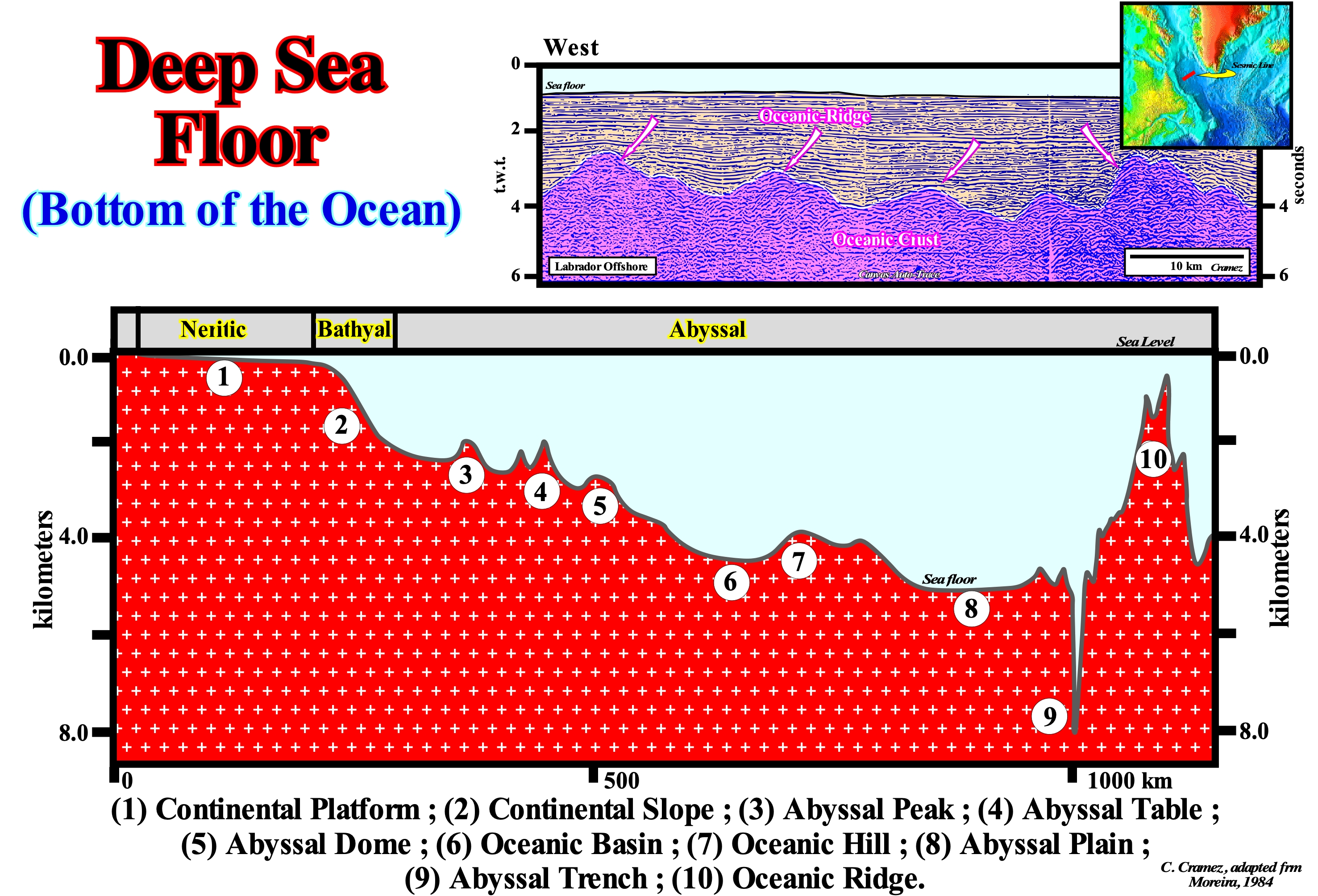
In the geological section illustrated in this figure, morphologically, in the neritic region, when the basin has a shelf, which happens when within a sequence-cycle, the depositional coastal break of the depositional surface (more or less the shoreline) is located landward of the continental edge (which in this case is also the basin edge), we can distinguish the continental shelf (1), which is the part of the ocean floor that, by convention, extends from the intertidal zone to the depth of, more or less, 200 meters. It is on the continental shelf, i.e., updip of the basin edge (continental edge), that the incised valleys are formed following a significant relative sea level fall that put the sea level below the basin edge. As a consequence of this relative fall, the mouth rivers are displaced seaward, breaking the provisional equilibrium profiles. The incised valleys are almost completely filled during the deposition of the upper part of the lowstand prograding wedge (LPW). In the bathyal area (2), between 200 and 2,000 meters of water-depth, the development of submarine canyons is common, many of which are associated with a relative the relative sea level fall responsible for the lower unconformity that limits the considered sequence-cycle. As in the case of the incised valleys developed on the shelf and coastal plain, the submarine canyons are fully filled during the lowstand prograding wedge (LPW) of the sequence-cycle. In the basal part of the bathyal environment, the deposition of submarine basin slope fans (SSF), associated with turbiditic currents, is almost, always, present. In the abyssal region, which has a depth-water higher than 2,000 meters, as shown, several morphological units of the sea floor may exist: (i) Oceanic Floors ; (ii) Abyssal Plains; (iii) Ocean Basins and Depressions; (iv) Oceanic Hills; (v) Abyssal Tables ; (vi) Abyssal Trenches, etc. These units are, more or less, developed according the type of continental margin (divergent, convergent or transform). The morphologies of the ocean floor of a divergent continental margin and a convergent margin are quite different, since they are associated with different geological events. The deep part of the oceanic floor is, generally, constituted by volcanic crust (in the great majority it is oceanic but, locally and, particularly, at the beginning of the oceanic spreading, it may be sub-aerial), which, near the continents, forms the substratum of the sedimentary wedges. Far from the continents, where the terrigeneous influx is weak, the oceanic crust is, usually, covered by a relatively thin interval of fine pelagic sediments (the sedimentary particles may take many years to reach the sea floor), as it appears to be the case in the Labrador offshore, illustrated in this figure. In fact, the seismic lines of this offshore, such as its Canvas auto-traces, show, between the ocean ridges, a sedimentary fill by onlapping (visible in all directions) that corroborate a vertical filling by decantation*. In sedimentological terms, at the level of a sequence-cycle, it can be said: a) The continental shelf is the domain of the shallow-water sediments ; b) The continental slope (bathyal zone and the proximal part of the abyssal zone) is the domain of the lowstand systems tracts group and, particularly, the lowstand prograding wedge (LPW) and the submarine slope fans (SFF) with its natural marginal dikes and overbank deposits ; c) The abyssal zone is the domain of the submarine basin floor fans (SBFF), particularly, when they are disconnected from the submarine slope fans and the domain of pelagic sediments (fine-grained sediments that accumulate as a result of deposition of sedimentary particles in the ocean floor under deep water). In the base of their composition, the pelagic sediments may be: (i) Siliceous ooze**; (ii) Calcareous muds and (ii) Red clays. Do not forget that, in part, it was the morphology of the ocean floor, which suggested Tectonics of Plates, i.e., is the unifying theory explaining how the Earth works.
(*) Process for the separation of mixtures of immiscible liquids or of a liquid and a solid mixture allowing to separate heterogeneous biphasic mixtures, in particular solid-liquid, i.e., sediments and water, based on the differences between the densities of the components of the mixture.
(**) For many geoscientists, the term ooze implies at least 30% of microscopic remains of calcium carbonate or silica from planktonic organisms, which means the particle size of the ooze are, usually, bimodal with a well-defined biogenic fraction (size silt / sand) and another clay-size siliciclastic fraction.
Deep Sea (Carbonate facies belt)................................................................................................................Mer profonde (Ceinture carbonatée)
Mar profundo / Mar profundo (ambiente faja carbonatada) / Tiefsee / 深海(带碳酸盐) / Большая глубина моря / Mare profondo /
Environment, relatively, deep located on the seaward limit of a carbonate belt.
See: « Reef »
&
« Deposition (carbonates) »
&
« Organic Production (carbonates) »
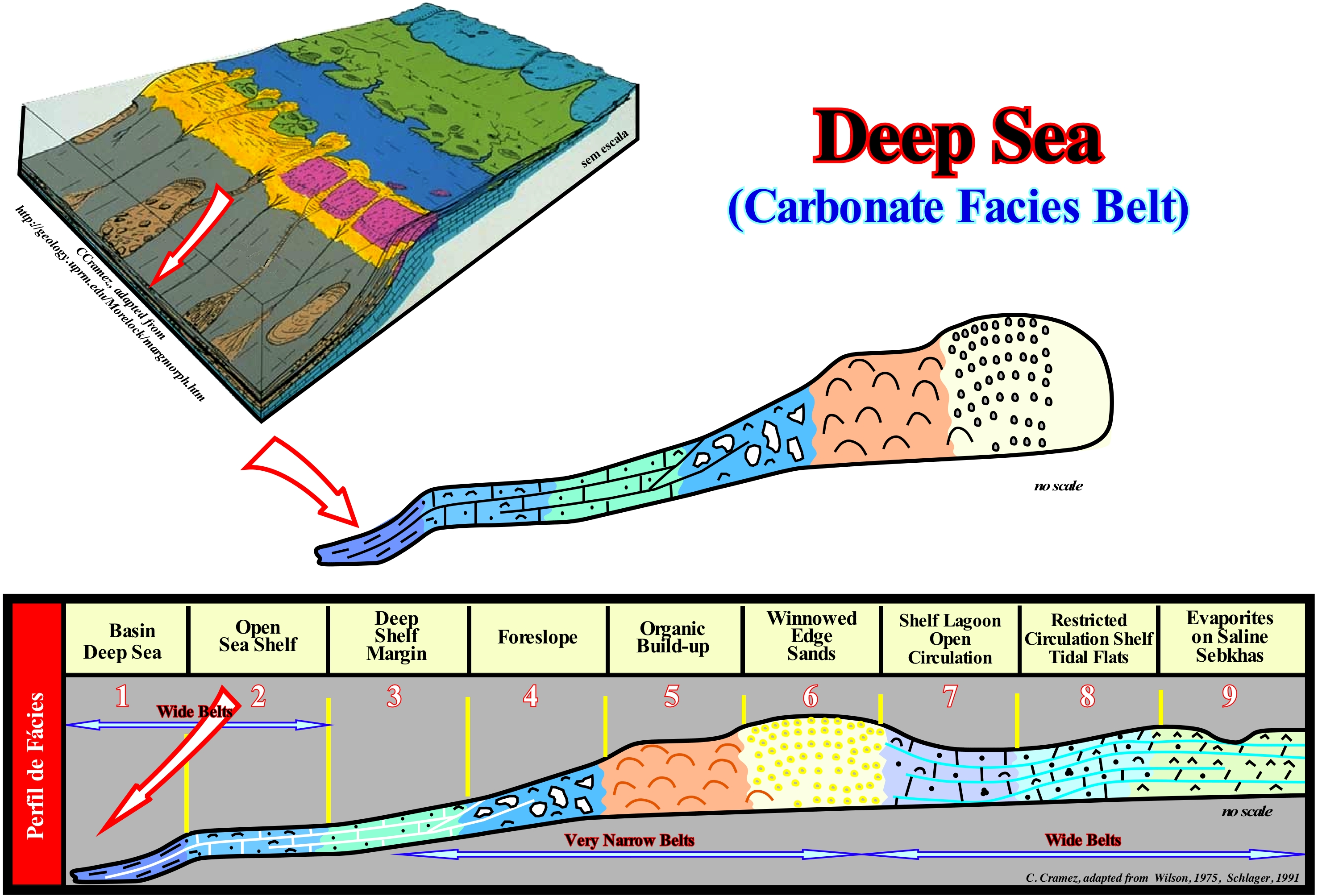
As illustrated in this sketch proposed by W. Schlager (1991), in carbonated belts, from the inner side seaward, several facies and depositional environments can be evidenced: (i) Basin Deep Sea ; (ii) Open Sea Shelf ; (iii) Deep Shelf Margin (platform edge) ; (iv) Foreslope (external slope ) ; (v) Organic Build-up (reefs of platform edge) ; (vi) Winnowed Edge Sands (deflation zone) ; (vii) Shelf Lagoon with Open Circulation ; (vii) Restricted Circulation Shelf and Tidal Flats ; (ix) Evaporites on Saline Sabkhas. The geological context of "Basin Deep Sea" is what is underneath the action of the waves and euphotic or photic zone (where photosynthesis* occurs). A part of this facies and environment reaches, through the thermocline (interval of a water-body in which the temperature changes much more, rapidly, in depth than in the over and underlying intervals), is the domain deep ocean waters. The most characteristic sediments of these facies are pelagic shales, silica carbonates, hemipelagic muds (mixture of biogenetic carbonate material and terrigeneous clays) and turbidites. Near the platforms, we find mixtures of pelagic materials and platform derivatives under the form of muds and periplatform oozes (slope basal carbonates, shallow water carbonates, redeposited carbonates between pelagic carbonates). Redeposited carbonates are carbonates characterized by a re-deposition of shallow-water carbonate sediments in deep water, either by turbidity currents or by landslides. This type of carbonates is frequent in peri-platforms (around a geological platform). The biota (organisms of a given region at a given time) of the "Basin Deep Sea" facies are, predominantly, composed of oceanic associations of plankton. In sediments of the peri-platform benthos (deep water, including the slope and basin), not too deep, may constitute 75% of the biota. Many of the sediments deposited in this environment derive from higher environments and can be transported by turbidity currents or by debris flows. The precise detection and quantification of the different carbonate minerals is fundamental in the coral reef samples before the geochemical and radiological studies, which allows to interpret the alterations in the mineralogical composition of the geological formations made of reef material and associated sediments such as the periplatform muds. There are five main types of carbonated platforms: (i) Rimmed Platforms characterized by the presence of reefs or calcareous sands of basalt in the edge of the platform and clay sands in the lagoon or the open platform ; this type of platform forms in calm waters and its extension varies between 10 and 100 km ; (ii) Ramp-type platforms, in which the carbonated sands of the coastline pass, at the base of the ramp, to clay sands and deep-water muds; in this type of platform the reefs are rare ; the width of the ramp can reach 100 km ; (iii) Epeirial Platforms characterized by the presence of tidal surfaces and protected lagoons ; the width of an epeiric platform can reach 10000 km ; (iv) Isolated Platforms, in which the lithologies are quite controlled by the orientation of the prevailing winds ; they have reefs and sandy bodies, like the rimmed platform, in the windward margin (margin facing the side where the wind blows), but in the leeward margin (opposite the direction from where the wind blows), the sediments are more muddy ; an isolated platform can reach 100 km wide ; (v) Dead or Drowned platforms, when they are under the photic zone. The platforms connected to the continent are divided into two large families: (1) Ramp Type and (2) Top-Flatened Type. In ramp type platforms two subtypes can be considered: (1.1) Monoclinal and (1.2) Distal Steepened. In top-flattened platforms there are also two subtypes: (2.1) Nonrimmed and (2.2) Rimmed. The carbonated platform illustrated in the photograph of this figure is, probably, a ramp-type platform of the monoclinal subtype. According to some geoscientists, this type of platform seems to be more frequent when the processes of carbonate manufacture are of cold water. When carbonate manufacturing processes are associated with tropical climates, usually, the carbonate platforms are edge rimmed (or not-rimmed) or they correspond to mounds of mud with no well-marked edge zone.
(*) Fixation of carbon by green plants under the action of sunlight. The light energy is converted into chemical energy and stored in the form of sugar. Photosynthesis occurs in plants and some algae (Protista Kingdom). Green plants need only the energy of light, CO2 and H2O to make sugar. Photosynthesis occurs in chloroplasts, specifically through chlorophyll.
Deep Sea Rise (Abyssal plain).....................................................................................................................................................Plaine abyssale
Planície Abissal / Planicie abisal / Abyssisch Ebene / 深海平原 / Абиссальная равнина / Pianura abissale /
Region of the ocean floor at the base of the continental slope with a slope* less than 1:1,000. It is, generally, covered with turbidite and pelagic deposits that, obscure, partially the original topography.
See: « Sea floor »
&
« Abyssal »
&
« Shelfal Accommodation »
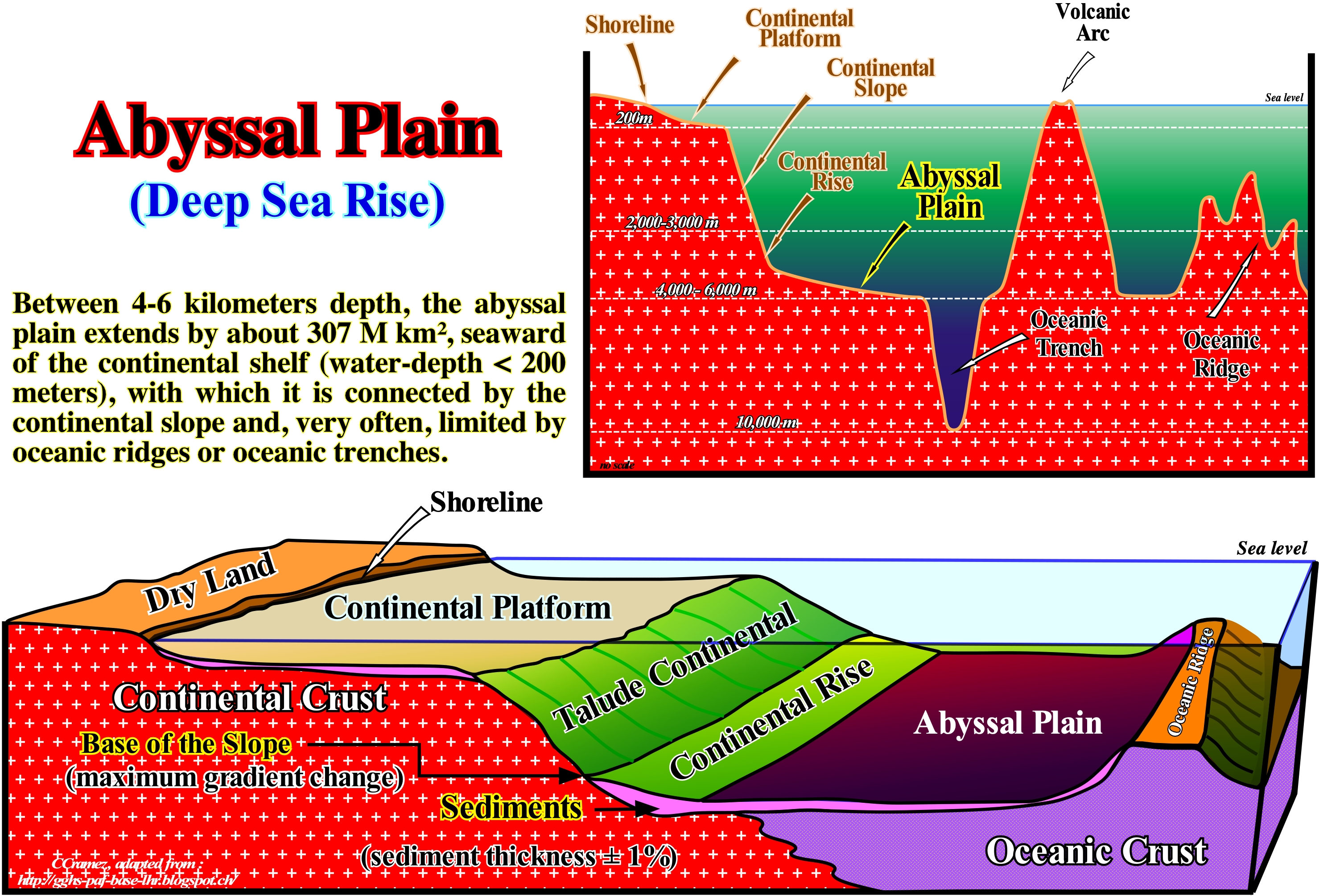
In a extensional (lengthening) geological setting (tectonic regime characterized by ellipsoid of the effective stresses** with the largest axis σ1 vertical), the oceanic floor is, generally, limited between the mid-oceanic ridge (most recent expansion centre) and the base of the slope continental (glacis). In a compressional setting (tectonic regime characterized by ellipsoid of the effective stresses with the largest axis σ1 horizontal), the oceanic floor, as illustrated in this sketch, is most often limited between an oceanic trench (zone of encounter of two plates lithosphere, where one of these plates plunges under the other) and the continental glacis. The oceanic floor corresponds, almost always, to the abyssal plain, on which abyssal hills are identified, easily. The oceanic plain has very large dimensions. It is, almost always, constituted by new oceanic crust, created by the expansion centres or sea floor spreading centres located either in the rift of the mid-oceanic ridge or along the transform faults, which may be evident between the ends of the rift. Do not confuse the rift of the mid-oceanic ridge, which is the zone where the lithosphere undergoes fracturing and separation in two opposite directions as new oceanic crust forms, with a rift-type sedimentary basin (Bally and Snelson classification of sedimentary basins), which lengthen the lithosphere of the supercontinents before the break-up. Transform faults (one of the three types of limits between lithospheric plates, different from the other two, since there is no production or consumption of plates) form a very particular type of faulting. They are just active between the segments of the mid-oceanic ridge and they are, partially, disguised by the deposition of turbidites and pelagic sediments on the abyssal plain. As the oceanic crust of the ocean floor ages, it becomes denser and heavier and it goes, most often, into subduction, i.e., it dives under a sector of the lighter oceanic crust or under the crust continental which is much less denser. Such a plunge creates a B-type subduction zone (descending plate is oceanic), which is recognized without difficulty by the bathymetry of the associated oceanic trench, as is illustrated in this figure. The oceanic crust, which plunges along the subduction zone is, progressively, assimilated by the asthenosphere (upper area of the slightly rigid of mantle lying below the lithosphere, between 80 and 200 km deep, above the isotherm 1250° C). At the same time, an important volcanic arc forms in the overriding lithospheric plate (limits the upper part of the subduction zone). In this way, inexorably, the oceanic mountains, associated with oceanic expansion and the mid-oceanic ridge, go into subduction and disappear, reducing, substantially, the abyssal plain between the continental rise and the oceanic trench. Over time, the entire oceanic plain disappears and the continent, which the lithospheric plate transports, collides with the volcanic arc, closing, completely, the sea that existed between them. Due in part to its great extent, the abyssal plains are considered as a great reservoir of biodiversity. They also exert a significant influence on: (i) The carbon cycle of the ocean ; (ii) The dissolution of calcium carbonate and (iii) The atmospheric concentrations of CO2 (periods of 100 - 1,000 years). The structure and function of abyssal ecosystems are, strongly, influenced by the flow rate of nutrients to the sea bed and by the composition of the material installed there. Factors such as climate change, fishing practices and ocean fertilization should have a substantial effect on primary production patterns in the euphotic zone, which has, certainly, a significant impact on the flow of organic material to the abyssal plain and thus a profound effect on the structure, function and diversity of abysmal ecosystems (http://www.wikiwand.com/en/Abyssal_plain).
(*) Slope is calculated by finding the ratio of the "vertical change" to the "horizontal change" between (any) two distinct points on a line. A slope less than 1:1,000 means that for 1 meter (or 1 km) of vertical change there is 1,000 meters (or 1,000 km) of horizontal change. Sometimes, the ratio is expressed as a quotient ("rise over run"), giving the same number for every two distinct points on the same line. The simple way to think of the formula rise over run is: M=rise/run. M stands for slope. Your goal is to find the change in the height of the line over the horizontal distance of the line.
(**) It is the association of the effective stresses (σ1 σ2 σ3) that deforms the sediments and not the tectonic vector (σt). At a given point, the effective stresses are defined by th combined action of : (i) Geostatic pressure (σg), which is the weight of the sedimentary column that can be represented by a biaxial ellipsoid ; (ii) Hydrostatic pressure or pore pressure (σp), which is the weight of the water column maintained in the pores of the rocks and can be represented by a uniaxial ellipsoid i.e., by a sphere and (iii) Tectonic vector (σt), which corresponds to a tectonic force that acts, more or less, parallel to the Earth's surface. The combination of the geostatic, hydrostatic and tectonic vector pressure can be represented by a triaxial ellipsoid (ellipsoid of the effective stresses), in which the main axis is σ1, the mean axis σ2 and the smaller axis σ3.
Deep Sea Floor (Oceanic basin, oceanic bottom)...............................................................................................................Fond océanique
Fundo oceânico / Fondo oceánico / Ozeanisch Boden / 海洋底部 / Океаническое дно / Fondo oceanico /
Part of the Earth's crust submerged by the seas and oceans, characterized by a diversity of depths, shapes and environments. Excluding the coastal or paralic region, which corresponds to the surf zone and the land always emerged, the ocean floor can be divided into three large regions: (i) Neritic, Sublittoral or Actic, (ii) Bathyal and iii) Abyssal. Sometimes synonymous with Sea Bed.
See : « Abyssal Plain »
&
« Bathyal »
&
« Onlap »
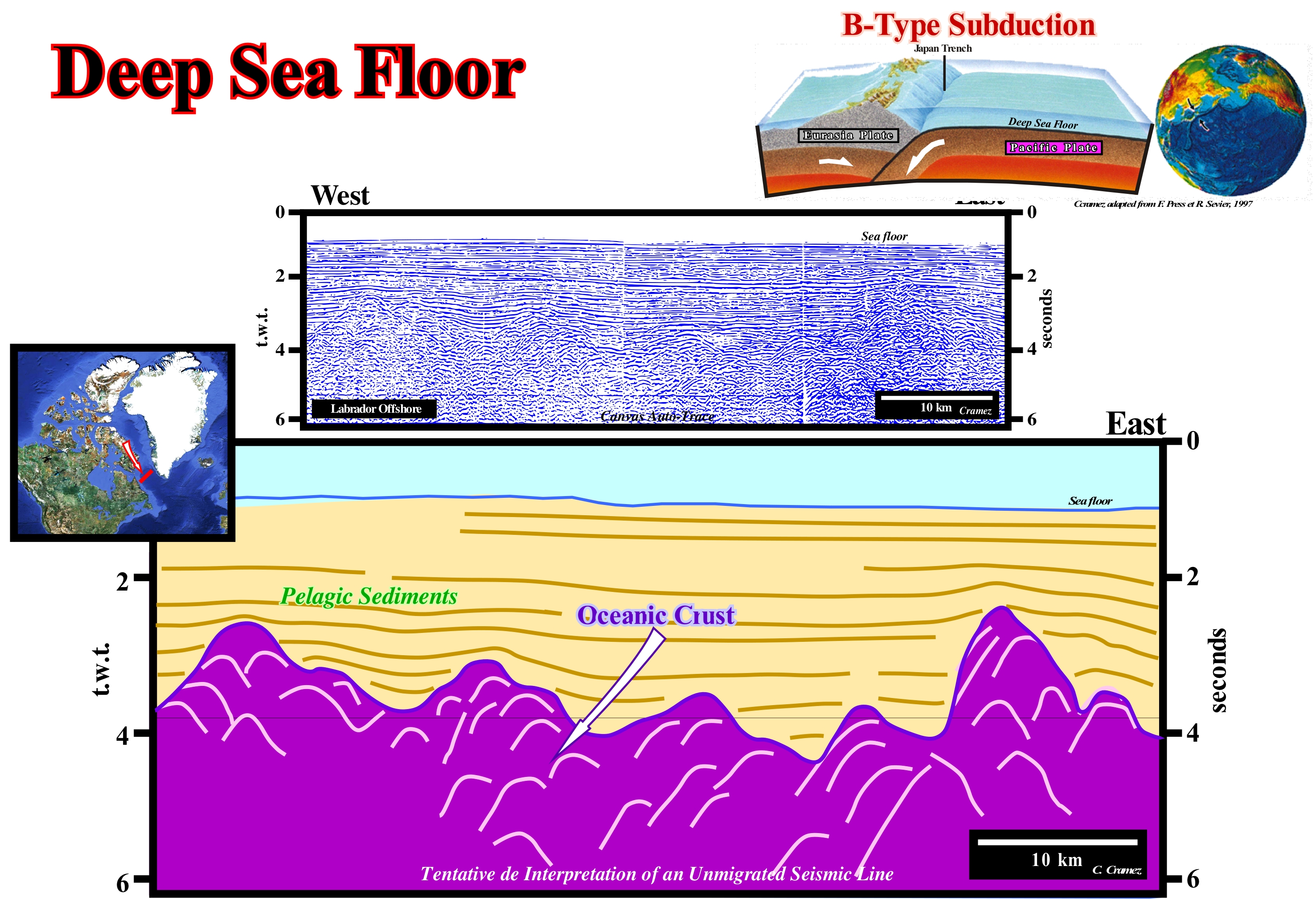
On seismic data, it is found that the deep sediments of the abyssal plain, which, generally, form the ocean floor, often have a parallel geometry onlapping the oceanic crust. The interface between the crust and the abyssal sediments shows a wavy morphology with many associated diffractions (particularly in the unmigrated seismic lines) that mark the oceanic rides (old expansion centers). The ocean floor is induced by the tectonics of the lithospheric plates. All ocean basins are formed of volcanic rocks that have come into the surface (continent or seabed) from the expansion centers located along the mid-ocean ridges. Presently, the oldest rocks that make up the ocean floor are about 200 million years old. They are much younger than the continental crust which, in some places, is more than 4,000 million years old. This figure explains, perfectly, the discrepancy between the age of the oldest rocks that constitute the ocean floor (about 200 Ma) and the age of the continental crust, which in certain areas reaches more than 4.0 Ga. The reason for this difference is very simple. In subduction zones, and particularly in the Benioff or B-type zones (when a lithospheric plate of oceanic composition plunges under a continental plate or under an oceanic plate). The old oceanic rocks are destroyed. The oceanic material returns to the sub-lithospheric mantle, as suggested in this scheme. In contrast, along the mid-oceanic ridges, the ascending material of the asthenosphere is extruded and creates a new oceanic crust that contributes to the expansion of the oceans (oceanic spreading or oceanization) and forces the continents to move away from each other. As the oceanic expansion progresses, not only the surface of the ocean floor increases but also the density of the oceanic crust. Over time, the temperature of the oceanic crust decreases. In this way, the material that forms the ocean bottom furthest distant from the mid-oceanic ridge. from where it emerged, becomes so dense that it plunges under the adjacent material thereby initiating a B-type subduction zone. The formation and subduction of oceanic material characterizes two types of continental margins: (i) Divergent Continental Margins, whether they are of the Atlantic or non-Atlantic type, are associated with the formation of oceanic material and (ii) Converging Margins associated with the B-type subduction where ancient oceanic material disappears along of the subduction zones. Certain convergent continental margins are associated with Ampferer or A-type subduction zones (when two continental lithospheric plates collide, i.e., one under the other), along which, obviously, no oceanic material disappears. The mid-oceanic ridge is composed of a number of segments separated by a system of faults that apparently appear to have displaced an initially straight ridge, but which is not the case. The faults of this very particular fault system, called transform faults, are just active between the ridges, which means (i) they predate, probably, the ridge and (ii) the oceanic spreading is uniform just between two consecutive transform faults . According to certain geoscientists, the transform faults correspond to old fractures or zones of fragility of the associated supercontinent. These fracture zones seem to control and, above all, to locate the break-up zone of the lithosphere and, then, the oceanic expansion. In addition to the transform faults and the mid-oceanic ridges*, very rough ridges, more or less, parallel to the direction of the rift, can not be overlooked. These ridges show, relatively, strong slopes near the rift valley which, progressively, diminish towards the abyssal plain. Oceanic trenches, which emphasize subduction zones where oceanic crust is destroyed, have slopes of about 45° and very large depths (the maximum depth of the Marianas ocean trench is 11,034 meters). Volcanic apparatuses can occur on top of the over-riding lithospheric plate, but water-depth is much smaller than that of the descending plate where seamounts are very frequent. The seamounts are elevations that can reach at least 1,000 m above the seafloor. Most of the seamounts are extinct volcanoes that rise, abruptly, above the surrounding bottoms from depths of the order of 1,000 m to 4,000 m below sea level. In spite of its great height, the top of the submarine mounts can be located to depths that go from a few meters (constituting reefs or submarine bank) to several thousands of meters below the average level of the waters (in this case part of the sea floor). It is estimated that there are more than 30,000 seamounts in the global ocean, with only a few hundred being explored (https: //en.wikipedia.org / wiki / Monte_submarino).
(*) Mid-oceanic ridge develop along 65,000 km long and 1,000 km wide (average) and in which a deep rift valley with a width varying between 25 and 50 km wide.
Deep Shelf Margin (Carbonate facies belt)......................................................Bord de la plate-forme profonde
Bordo de plataforma profunda/ Borde de plataforma profunda (faja carbonatica) / Tief Schelfrand, Bahnsteigkante tief / 深陆架边缘 / Обрыв шельфа / Shelf margin profonda, Piattaforma bordo profondo /
Sedimentary environment of a carbonated belt facies located between the open sea platform and the external slope (foreslope). It is characterized by: (i) A geological context; (ii) A certain type of sediment and (ii) A particular biota. From the continent seaward, the different depositional systems of a carbonate facies belt are: (i) Basin Deep Sea ; (ii) Open Sea Shelf ; (iii) Deep Shelf Margin (platformedge) ; (iv) Foreslope (external slope ) ; (v) Organic Buildup (reefs of platform edge) ; (vi) Winnowed Edge Sands (deflation zone) ; (vii) Shelf Lagoon with Open Circulation ; (vii) Restricted Circulation Shelf and Tidal Flats ; (ix) Evaporites on Saline Sabkhas.
See: « Carbonate Facies Belt »
&
« Reef »
&
« Deposition (carbonates) »
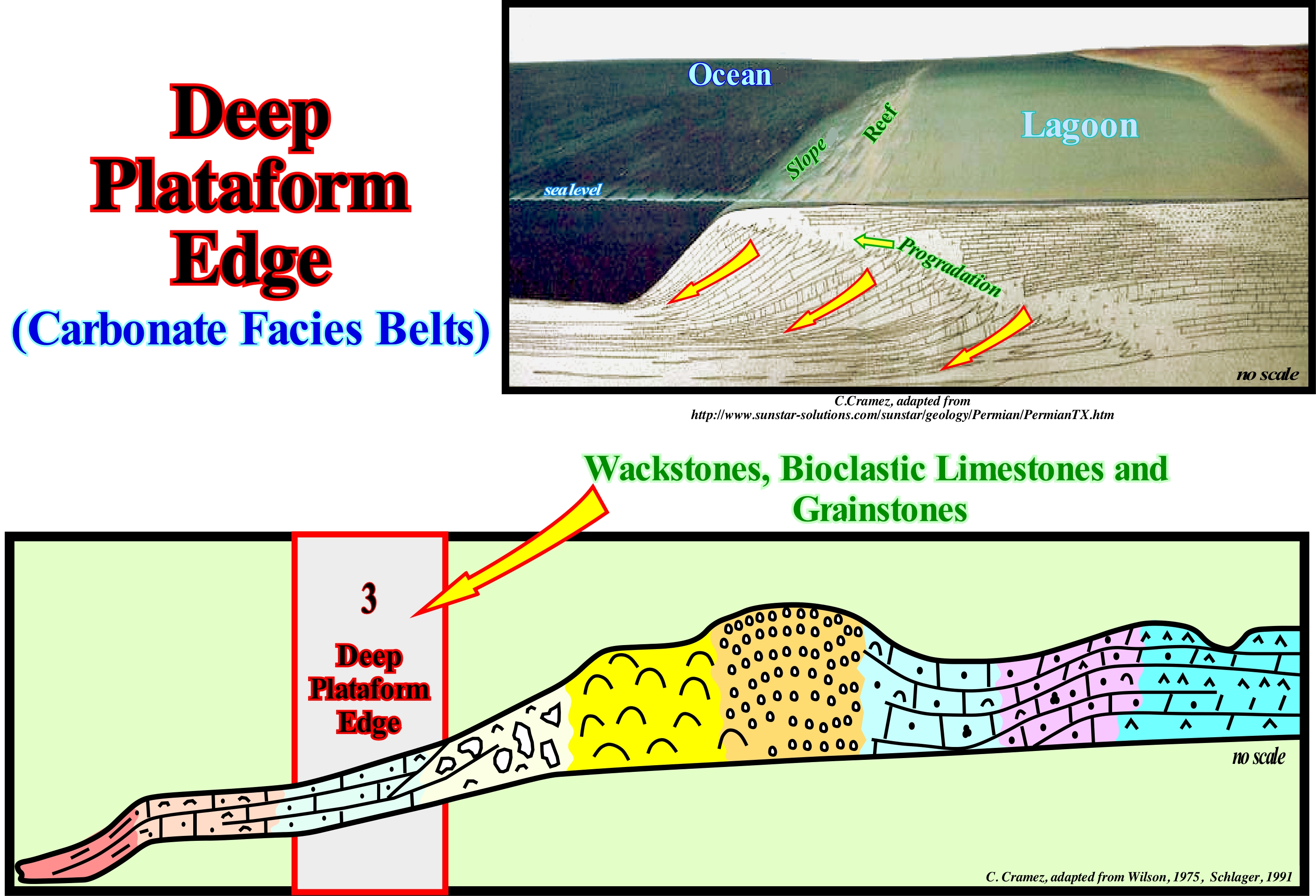
The geological context of this carbonate environment of a carbonated facies belt (submarine or intertidal rimmed platform whose elevation is maintained by the active deposit of shallow water carbonate) is under the action of the waves (calm sea), but can be reached by the storm-waves. This sedimentary environment is within, or slightly below, the euphotic zone (area with enough sunlight for photosynthesis to occur, i.e., between sea level and depth where sunlight is about 1% of surface light). This sedimentary environment forms, more or less, flat surfaces between the active platform (where the organic constructions are preponderant) and the basin. In this context, the term basin may not correspond to the morphological unit downstream of the continental slope. The sediments deposited in this environment are mainly carbonates: (i) Wackstones, i.e., carbonates containing more than 10% of grains with a diameter greater than 20 x 10 meters (20 microns or 20 microns) ; (ii) Bioclastics limestones, i.e., limestones mainly formed by fragments of pre-existing rocks and (iii) Grainstones, which are limestone formed by grains, practically without a matrix (<1% of material with a diameter of less than 20 microns). These limestones are, generally, well stratified and highly bioturbated (a process by which sedimentary particles are displaced and mixed by benthic fauna and flora). The presence of several shells suggests normal marine conditions. The presence of plankton (a set of microscopic plants and animals that live suspended in water and which is the basis of many food chains) is minimal. Limestone flow and finely rolled turbidites are very frequent, as are small monocular anomalies at the base of the slope of carbonated buildings. The main microfacies observed in this environment are: (i) Microbiotic calcisiltites (limestones formed, basically, by silt-size detrital calcite particles) ; (ii) Pelagic micrite (semiopaque crystalline matrix of limestones formed by crystals smaller than 4 microns) and (iii) Bioclastic microbreccia (limestone formed by very small and poorly calibrated bioclasts). The other environments found in a carbonated waist are: (i) Basin Deep Sea ; (ii) Open Sea Shelf ; (iii) Deep Shelf Margin (platform edge) ; (iv) Foreslope (external slope ) ; (v) Organic Build-up (reefs of platform edge) ; (vi) Winnowed Edge Sands (deflation zone) ; (vii) Shelf Lagoon with Open Circulation ; (vii) Restricted Circulation Shelf and Tidal Flats ; (ix) Evaporites on Saline Sabkhas. The basin and the open sea platform form wide belts, as well as the open-circulation platform lagoon, the restricted circulation platform and tidal plain, and the evaporites on saline sabkhas, while the others form very narrow belts. It should be remembered in a, more or less, schematic model of an isolated carbonate platform, the geometry of the sedimentary systems tracts forming it can vary significantly. Thus, within a sequence-cycle, when the formation of the first transgressive surface (first marine ingression, which begins the deposit of the transgressive interval), following a rise of the relative sea level (sea level resulting from the combined action of the eustatic or absolute sea level, which is supposed to be global and referenced to the Earth's centre, and tectonics), the highest points of the preexisting topography are flooded and the carbonate production is initiated. If each of the following marine ingression (in acceleration and without relative sea level fall between them), the available space for sediments (shelfal accommodation) created is filled. When he carbonate production compensates the accommodation increasing, an aggradational carbonated margin is developed, which many geoscientists call the keep-up carbonate margin. Since the relative sea level begins to rise in deceleration (after the maximum flooding surface), the highstand systems tracts that form the high level prism begin to settle. However, as carbonate production, normally, exceeds the rate of creation of available space, the carbonate material is poured out of the aggradational carbonate platform (keep-up carbonates) and deposited in the form of carbonate progradations (slope). In this case, many geoscientists say that the platform is made up of catch-up carbonates. When the relative sea level rise puts the carbonate platform under the photic zone, the carbonate production ceases and the carbonate platform dies by drowning and can later be fossilized by onlapping or downlapping of deep-water siliciclasts.
Deep-Water Setting (Lowstand)............................................................................................................................Contexte de bassin
Contexto de Bacia / Contexto de cuenca / Becken Einstellung / 流域设置 / Положение бассейна / Contesto del bacino /
When the sea level is lower than or very close of the basin edge basin, which occurs during the group of lowstand systems tract (LST) or during the deposition of the 2nd phase of development of the highstamnd prograding wedge (HPW). In this geological context, the shoreline coincides with the upper limit of the continental slope (continental edge). In a sedimentary basin without shelf, three geological contexts are possible: (i) Basin or Deep Sea, when the limit between the coastal plain and the slope is well marked ; (ii) Ramp (gradual change), when the limit between the coastal plain and the slope ias not clear and (iii) Growth Fault, when the limit between the coastal plain and the continental slope is emphasized by a growth fault.
See: « Basin (sedimentary) »
&
« Sequence-Cycle »
&
« Systems Tract (sedimentary) »
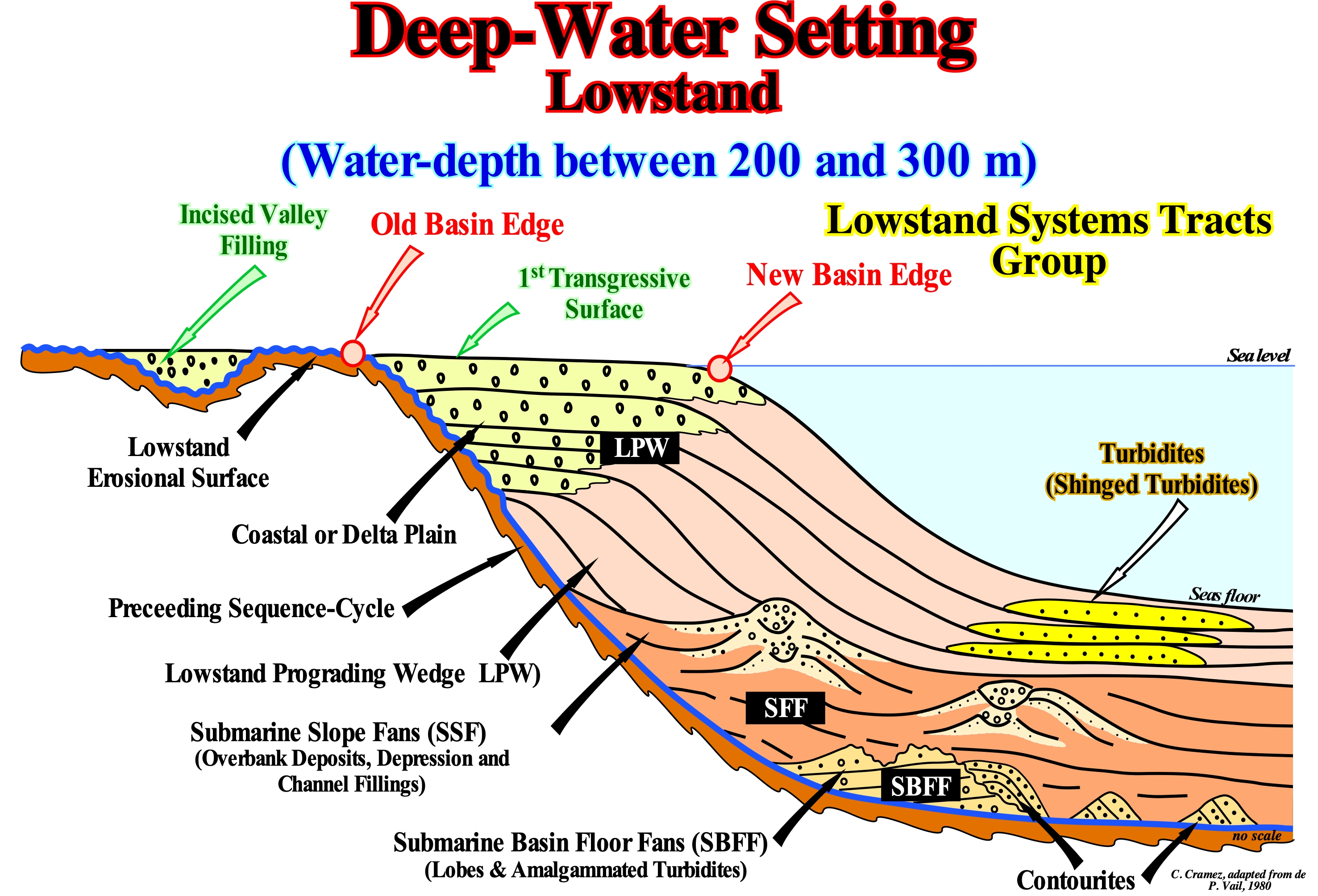
When at the relative sea level it is lower than the edge of the basin*, i.e., in lowstand geological conditions, after the deposition of the submarine basin floor fans (SBFF) and the submarine slope fans (SSF), which are deposited during the relative sea level falls, the shoreline is, more or less, coincident with the depositional coastal break of the depositional surface. During the deposition of the lowstand prograding wedge (LPW), the shoreline coincides, practically, with the coastal plain edge of the lowstand prograding wedge. At each marine ingression, the shoreline line is displaced continentward. Then, as sedimentation resumes, during the stability period of the relative sea level (local sea level referenced to the sea floor or to the base of the sediments and which is the result of the combined action of absolute or eustatic sea level supposed to be global and referenced to the Earth's centre, and the tectonics), which occurs after each marine ingression, the shoreline is displaced seaward. However, it surpasses the position it had in the preceding sequence-paracycle. The rate of terrigeneous influx is greater than the rate of creation of available space for sediments (accommodation). Under these geological conditions, three basin contexts can be distinguished: (i) Abrupt ; (ii) Growth Fault and (iii) Ramp. In the abrupt basin geological context, as illustrated in this sketch, the passage of the coastal plain (plain upstream of the shoreline, formed by a, more or less, flat land, near sea level and with low density of drainage) to the abyssal plain is made by an abrupt continental slope. The boundary between the coastal plain and the basin is well marked. Not only during the upper sub-group of the lowstand systems tracts group, but also during the lower sub-groups (SBFF and SFF). During the lowstand systems tracts group (LSTG), the basin has no shelf and the basin edge is the last basin edge of the preceding sequence-cycle. The lowstand systems tracts group, as illustrated above, is formed by three sub-groups, which from the bottom up are: (1) Submarine Basin Floor fans (SBFF), sometimes with associated contourites ; (2) Submarine Slope Fans (SFF), with the complex channels / natural dikes ("gull wings" of P. Vail) and (3) Lowstand Prograding Wedge (LPW), in which sometimes turbidite lobes on the basis of the progradations (shingled turbidites) are often observed. The incised valleys created during the relative sea level falls, which marks the beginning of a new sequence-cycle, are, generally, filled by, more or less coarse sediments following the relative sea level rise, which controls the the top of the lowstand prograding wedge (LPW). At the end of the lowstand prograding wedge (LPW), when the first flooding surface (beginning of the transgressive interval, TI), the upper limit of the continental slope marks the new basin edge, once a continental shelf forms. The basin edge may or may not correspond to the depositional coastal break of the depositional surface (more or less the shoreline). It depends on whether or not the basin has a shelf. During the transgressive interval of a sequence-cycle, this type of basin context disappears. A continental shelf is formed as the relative sea level rises in acceleration. During the deposition of the highstand prograding wedge (HPW), at a given moment (when the shelf disappears, the second phase of development of the highstand prograding wedge), the shoreline is, more or less, coincident with continental edge and the morphology of the basin is similar to that of an abrupt basin context of the lowstand systems tracts group. It is with this basin context that the turbidite deposits of the P. Vail model (associated with a significant relative sea level fall) are well developed, i.e., the submarine basin floor fans and submarine slope fans. Also, the turbidite lobes deposited at the base of the progradations of the lowstand prograding wedge (shingled turbidites), following instabilities and failures of the continental edge are, in general, almost always present. However, the facies of these turbidites, which depends on the facies of the continental edge, are often shaly, which makes their recognition difficult (the lack of differential compaction does not favour the detection of these sedimentary anomalies).
(*) Within a sequence-cycle, i.e., at the hierarchical level of the 3rd order eustatic cycles, the basin edge is the name given to the continental edge, when the basin has a continental shelf, during the transgressive interval (TI) and during the first phase of development of the highstand prograding wedge (HPW). When the basin has no shelf, i.e., during the lowstand systems tracts group (LSTG), the basin edge is the last continental edge of the preceding sequence-cycle. During the 2nd stage of development of the highstand prograding wedge (HPW), as the basin has no shelf, the basin edge is the continental edge, which is roughly coincident with the shoreline.
Deep-water Setting (Lowstand, abrupt)........................................................................................Context de bassin (Abrupt)
Contexto de bacia (abrupto) / Contexto de cuenca (abrupto) / Tiefes Wasser - Einstellung / 深水设置 / Углубление бассейна / Contesto del bacino (ripido)
Morphology of a lowstand systems tract (LST), characterized by a passage from the coastal plain to the continental slope marked by a significant and, rarely, gradual increase of the water-depth. This type of morphology is typical of periods in which a sedimentary basin does not have a continental shelf,i.e., during the lowstand systems tracts group and during the 2nd phase of development of the highstand prograding wedge (the shoreline or the depositional coastal break coincide, more or less with the continental edge).
See: « Deepwater Setting (lowstand) »
&
« Sequence-Cycle »
&
« Systems Tract (sedimentary) »
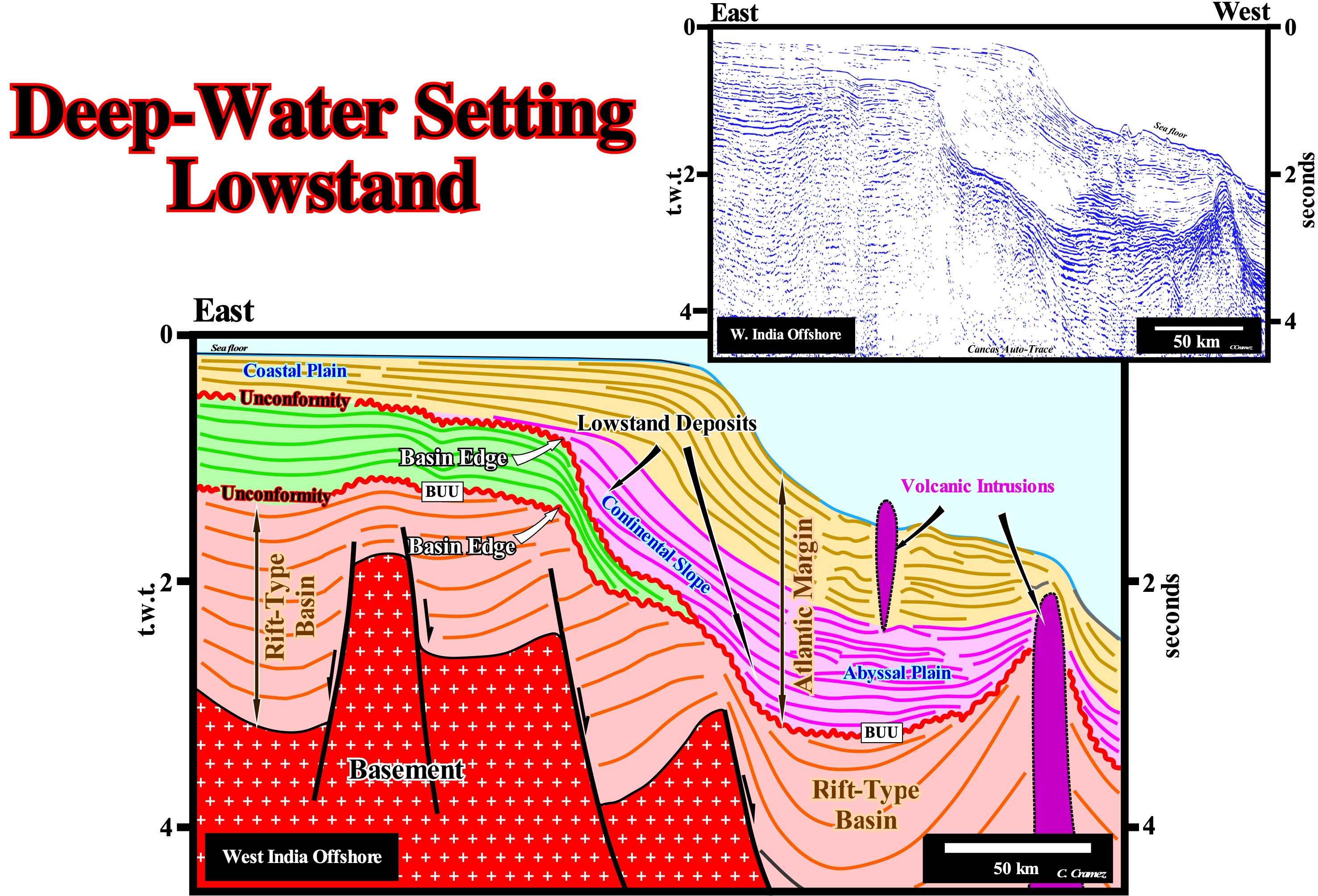
The India offshores (West and East) correspond to the stacking of three basins of the Bally and Snelson (1980) sedimentary basins classification. From the bottom to top, they are: (i) Basement or Paleozoic Folded Belt (Gondwana small supercontinent ) ; (ii) Late Jurassic/Early Cretaceous rift-type basins, emphasizing the Gondwana lengthening before the lithosphere breakup and (iii) Atlantic-type divergent margin ranging from the Early Cretaceous to the Present. On this tentative geological interpretation of a Canvas auto-trace of a regional seismic line of the west offshore, it can be said, at this scale, an abrupt deepwater setting always existed after the break-up of the Pangea supercontinent, particularly during the lowstand deposited deposited during the seismic interval coloured in violet. The unconformity associated with the rupture of the lithosphere (BUU) separates the rift-type basins (predating the lithosphere breakup), mainly filled by non-marine sediments, of the divergent continental margin (Atlantic-type), which is composed, mainly, by marine and paralic sediments (originated near the coast and presenting almost always intercalations of marine sediments). In the divergent margin, the periods during which the basin had a shelf (transgressive episodes) are, relatively, thick and can easily become evident (green colored range). This interval is limited between two unconformities, colored in red. The lower unconformity is the unconformity induced by the lithosphere breakup (BUU). This thick seismic interval, whose geometry is, basically, aggradational, corresponds to the transgressive phase of the post-Pangea continental encroachment cycle, is composed, probably, by several continental encroachment subcycles. Within each continental encroachment subcycle, the sequence cycles (induced by eustatic cycles of 3rd order) are, practically, impossible to individualize at this scale. However, it can be said during these episodes, the shoreline (more or less, the depositional coastal break of the depositional surface) was very far upstream from the basin. The passage from the coastal plain to the basin edge was gradual, although the continental slope (passage toward abyssal plain) was quite marked (very dipping). The relative sea level fall, responsible by the formation of the upper unconformity, put the sea level lower than the basin edge creating lowstand geological conditions, with an abrupt deep-water setting during which the seismic interval, coloured in violet, was deposited. This interval has an filling internal configuration. It seems to correspond to a vertical succession of continental encroachments subcycles or incomplete sequence-cycles, in which the sub-groups of lowstand systems tracts groups are largely predominant, i.e., a large predominance of submarine basin floor fans (SBFF), submarine slope fans (SFF) and lowstand prograding wedges (LPW). This lowstand interval underlies a highstand interval with a well-marked progradational geometry (orange-yellow coloured interval). During the regressive periods of highstand, at this scale, the highstand prograding wedges are, largely predominant. The shoreline at a given point of the evolution of the highstand prograding wedges (2nd stage of evolution) is, seismically, coincident with the continental edge (or continental border). That means the coastal plain was contiguous to the upper continental slope (basin without shelf). Take into account not only the seismic resolution (a continental shelf with a water-depth less than 50 meters can not be recognized in conventional seismic lines), but also the seismic artefact induced by the abrupt change of water-depth between the platform and the abyssal plain. When sea level is low, as is the case during the violet interval of this tentative interpretation, the basin setting is abrupt. The passage from the coastal plain to the abyssal plain (without the continental shelf) takes place on a very steep continental slope (water-depth increases very rapidly), which, of course, favours deep-water deposits and, particularly, depositional systems such as submarine basin floor fans (SBFF) and submarine slope fans (SSF). In other words, when the basin context is abrupt, the occurrence, in the deep parts of the basin, of turbiditic deposits is, highly, probable.
Deflation..........................................................................................................................................................................................................................................Déflation
Deflação / Deflación / Deflation, Auswehung, Abblasung, Windablation / 通货紧 / Дефляция (выдувание) / Deflazione /
Sorting, washing and displacement of loose, dry and finely granulated sedimentary particles (size of clay and silt) by the turbulent action of the wind, as in the sand dunes, along the coastline and deserts.
See: « Deflation Basin »
&
« Desert »
&
« Basin (sedimentary) »
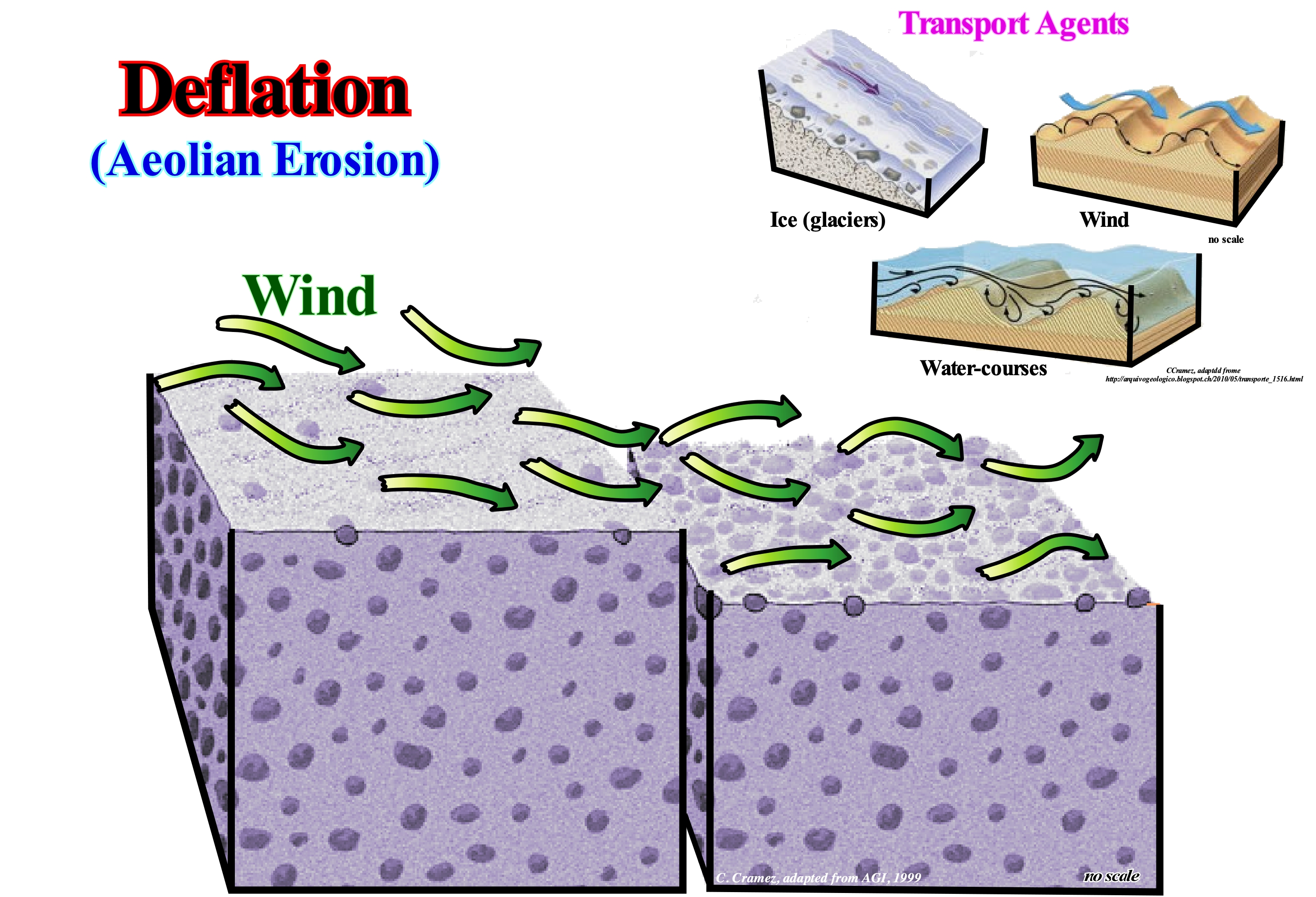
On a large scale, deflation can produce what certain geoscientists call basins by deflation, i.e., large topographical depressions excavated and maintained by wind erosion, which removes unconsolidated material leaving a ring of resistant rocks around the depressions. The genesis of deflation basins, sometimes referred as "wind-scoured basins", is associated with wind turbulence, which erodes, calibrates and transports the loose sedimentary particles to a depositional lobe, creating, at the same time, a depression (deflation basin), in which, sometimes, in the deepest part, a lake forms. The location and geometry of the depositional lobe in relation to the deflation basin allows to determine the direction and amplitude of the wind. Although this type of basin is formed, mainly, in arid or semi-arid areas, a lake, called shallow deflation lake, may occupy the central part of the basin during certain seasons of the year. An important feature of deflation basins is that they are closed and shallow. However, they may collect water or intersect, at its bottom, a groundwater level. Certain geoscientists use the term "basin by deflation" just when the dimensions of these depressions exceed tens of meters in length and a depth greater than 2-3 meters. In other cases, they speak of "cavities by deflation". As in the case of a point bar, where erosion and deposition are synchronous, in the deflation basins, the surface of erosion induced by the wind does not correspond an unconformity. The erosion is not only local but also contemporary of the deposition of the lobe, which is associated with it. This type of basin is, entirely, independent of relative sea level changes. Deflation also exists in glacial environments. That means deflation basins can also form in association with snow. In snow-covered Alpine regions redistribution of snow by the wind is of great importance for understanding the avalanches, source of water and climate. In climates with a lot of snow, deflation can just be active during the summer. Most of the year, the deflation basins are covered by a thick snow, except in the upper parts of its edges, which are somewhat uncovered, but are also cemented by frost. Very little loose and dry sand is produced by thawing and drying by the sun and wind. However, in certain parts of Greenland, the strongest wind erosion occurs during winter. These areas are very arid with negligible precipitation, only greater than 100-125 mm. During the winter, the total amount of snow is too small for the earth to be covered by a continuous layer of snow and large areas exposed to the wind do not have snow.
Deflation Basin..............................................................................................................................................................................Bassin de déflation
Bacia por deflação /Cuenca de deflación/Deflation Becken/ 通货紧 /Дефляционный бассейн/ Bacino di deflazione /
Large topographic depression excavated and maintained by wind erosion, which removes unconsolidated material leaving, generally, a ring of hardy rocks around the depression.
See: « Deflation »
Degradation (Coastal degradation).....................................................................................................Dégradation (De la plage, de la côte)
Degradação / Degradación / Degradierung / 退化的海滩 / Смыв (снос) / Degradazione (spiaggia, costa) /
Wearing away (erosion and transport) of rocks by natural agents or by man. Degradation is opposed to deposition. When there is a balance between degradation and accumulation (deposition), geoscientist talk of degradation.
See: « Deposition (clastics) »
&
« Regradation »
&
« Erosion »
This figure illustrates the degradation of the monolithic mountain of Ayers Rock in Australia (350 meters high and 3600 meters long) by natural agents (mainly wind and rain). Degradation is opposed to sedimentation. There is no sedimentation without degradation (erosion and transport) or, in other words, sedimentation and, in particular, clastic sedimentation, requires a previous phase of degradation, so that the clasts (sedimentary particles), i.e., the constituent elements of the sedimentary clastic rocks. The definition of the term degradation, proposed here, is used in relation to mineral matter and, above all, rocks, whether sedimentary, igneous or metamorphic. The term degradation is, often, used in relation to organic matter (biodegradation), which, as everyone knows, can be aerobic (in the presence of oxygen) or anaerobic (absence of oxygen). Likewise, the term degradation is, often, used to translate the deterioration of the environment by depletion of resources such as air, water, soil, as well as, the destruction of ecosystems (a set consisting of living organisms, biocenosis and the physical environment where they live, biotope) and extinction of wild animals. For geoscientists, the degradation is very useful. However, it can have serious consequences. Soil degradation affects, directly, agriculture. It dramatically reduces soil productivity (progressive disappearance of the top layer, which is the most fertile layer). It can be said environmental degradation is a process whose development implies the loss of natural resources. Man-made contamination, over-exploitation, prolonged use of fertilizers and certainly natural climate changes are important factors of degradation. Sedimentation (all processes related to the movement and deposition of material resulting from soil degradation) within the hydrological system causes, also, important changes: (i) Increased turbidity ; (ii) Colour and (iii) Other phenomena, which are, strictly, of mechanical nature such as erosion, sedimentation (accumulation of debris) from rivers and other waterbodies, as well as coastal areas. In the same way, sedimentation processes make the water of the rivers turbid, which prevents the penetration of sunlight and limits the production of primary producers (plants) to aquatic life. This affects the reproduction and survival of certain species of economic value. Along the coast, the sedimentation of the material resulting from the degradation of rocks and soils affects, significantly, the reefs, i.e., the geological formations constituted by coral reefs (not to be confused with the stacks and pinnacle outcropping at the sea, near the coast), which are of crucial importance for the reproduction of marine species with economic value. Anthropogenic degradation of the coasts is also evidence, as highlighted by the European Environment Agency in its March 2006 bulletin (ISSN 1830-2378): (i) Coastal ecosystems are undergoing damaging and irreversible changes on an ongoing basis ; (ii) Record trends show that in coastal areas changes in land use far outweigh those observed in other areas ; (iii) The growth of man-made areas along European shores is increasing at a rate one-third higher than that of inland areas ; (iv) Demographic changes, restructuring of economic activities, raising living standards and leisure time, and globalized trade models create widespread changes ; (v) In many coastal areas, these factors have led to rapid changes that have, drastically, altered the potential long-term viability of coastal ecosystems and the services they provide ; (vi) There is a strong likelihood that impacts on coastal ecosystems will be exacerbated by climate changes ; (vii) The natural alluvial plains of the main European rivers have almost all been absorbed by development (such as the Rhine, Elbe and Po) ; (viii) The coastal plains recorded the same rate of rapid development with an increase of 1,900 km2 of artificial surfaces between 1990 and 2000, etc., etc. As a consequence, it can be said most coastal areas suffer the so-called "coastal compression" i.e., the expansion of built-up areas and infrastructures to areas closer and closer to the coastline at the expense of natural systems that, normally, function as a barrier between the sea and the land. In addition, this compression increases the vulnerability of coastal zones. It causes, among other things, a sinking of the ground that induces a significant relative sea level rise which is, particularly, dangerous, during extreme phenomena such as storms.
Delta.........................................................................................................................................................................................................................................................................Delta
Delta / Delta / Delta / 三角洲 / Дельта / Delta /
Sediments accumulated when a water-course enters the sea or a lake and its velocity and competence are, rapidly, reduced. Three (some times four) depositional areas form a delta: (a) Delta Plain, the upper part of the delta ; (b) Delta Front, the distal part of the delta where sandy sediments settle and (c) Prodelta, the part of the delta that is under the erosive action of the waves. The prodelta is located seaward of the delta front and dips toward the deep part of the basin into which the delta progrades and where coarse clastic sediments, transported by the water-course, are no longer preponderant. There are several types of deltas, among which we can mention: (i) Abandoned Delta or Subdelta ; (ii) Arctic Delta ; (iii) Arcuate Delta ; (iv) Atrophied Delta ; (v) Complex or polymorphic Delta ; (vi) Cuspate Delta ; (vii) Finger Delta ; (viii) Flow Delta ; (ix) Closed Delta ; (x) Gilbert-type Delta; (xi) Lava Delta ; (xii) Lobated Delta ; (xiii) Tidal Delta ; (xiv) Submarine Delta (xv) Storm Delta ; (xvi) Wave Delta ; (xvii) Ebb Delta, etc.
See: « Delta Plain »
&
« Delta Front »
&
« Prodelta »
As illustrated in this figure, which shows the Zambeze River (Mozambique) delta building, a delta is a geological deposit (sub-horizontal) located at the mouth of a water-stream. It has a triangular or fan-shaped morphology and its crossed by numerous distributive rivers, which sometimes extend beyond that of the coastline. A delta is the result of the accumulation of the sedimentary charge transported by a river that was not removed by the tides, waves or marine currents. In the example illustrated in this photograph, it is easy to recognize: (i) The delta apex or bifurcation point (the more upstream point of defluence of the river channel that marks the upper limit of the delta, as far as the high tide generally goes) ; (ii) The delta plains (the upper delta plain is the area located upstream of the high tide extending from the delta apex to the zone of influence of the tides ; the lower delta plain is the area between the low and high tide limits, i.e., the intra-tidal zone) ; (iii) The mud flats or tidal flats (part of the pelitic strand that is uncovered in the neap tides and covered during the spring tides and storms) ; (iv) A series of beaches (type of coast with strand constituted by terrigeneous detrital materials, sandy, sandy-silty and coarse) ; (v) Spits (small tip, or tongue of sand, elongated, low and narrow, that advances seaward from the coast) ; (vi) Barrier-Bars (accumulations of sand or pebbles forming in the backshore due to the accumulation of sediments by the waves and by the wind) ; (vii) Sand Banks (accumulations of sand in the middle of a water-course, as in a river or along the coast) and (viii) Submarine Dejection Fans (sedimentary fans composed by terrigeneous sedimentary particles deposited on the sea floor, in deep-water, generally, at the base of the continental slope). No one confuses a floor (where there may be several apartments) with a building. In the same way, no one should confuse a delta with a delta building. A delta has a thickness ranging from a few meters to several tens of meters. A delta building (stacking of several deltas), such as the Niger delta building, can reach thousands of meters. In sequential stratigraphy, a delta is a facies systems tract (facies in Amanz Gressly's terminology means, mainly, a lithology with an associated fauna deposited in a given environment), formed by three depositional systems (lithology and typical fauna), synchronous and genetically related: (a) Silts and shales deposited in the delta plain and delta front sands ; the delta front sands are high energy sediments located between the deltaic plain and the prodelta ; they form the upper layer of a delta, which is, more or less, sub-horizontal and located upstream of the layer inclined seaward sea, i.e., upstream of the prodelta, which is, basically, constituted by shales ; (b) Prodelta shales that form the layer of the delta inclined seaward and c) Shales and sometimes turbiditic sands forming the lower layer of the delta. Each of these depositional systems has a characteristic position and geometry along the depositional surface. In some cases, the sediments from the base of the prodelta extend seaward by downlaps (true or false) forming the so-called lower layers of the delta or bottom-set. These layers are, more or less, sub-horizontal, like the upper layers, but unlike these, they are located downstream of the inclined layers, i.e., of the prodelta. Sometimes within the lower layers there may be turbidite sandy deposits (proximal turbidites of certain geoscientists), usually, induced by failures and slides of the delta sediments. The lateral extension of the different depositional systems is very varied. Thus, the silts and shales of the delta plain have about 450 km in the Niger delta building, about 100 km in the Mississippi Delta building, about 32 km in the Rhone delta building and around 16 km in the Rhine delta building. The height of the prodelta constituting these delta buildings is respectively 115, 106, 61 and 36 meters, which means that in conventional seismic lines, the delta slopes are, usually, below the seismic resolution. Several types of delta can be considered as a function of the dynamics of the delta and the shape of the emergent plain: (i) Abandoned delta or Sub-delta ; (ii) Arctic delta ; (iii) Arcuate delta ; (iv) Atrophied delta ; (v) Complex or polymorphic delta ; (vi) Cuspate delta ; (vii) Finger delta ; (viii) Flow delta ; (ix) Closed delta ; (x) Gilbert-type delta; (xi) Lava delta ; (xii) Lobated delta ; (xiii) Tidal delta ; (xiv) Submarine delta (xv) Storm delta ; (xvi) Wave delta ; (xvii) Ebb delta, etc.
Delta Front.................................................................................................................................................................................................................Front du delta
Frente de delta / Frente del delta / Deltafront, Deltavorder / 三角洲前缘 / Передняя часть дельты / Parte anteriore del delta /
Zone downstream of the mouth of a river, where the mouth bar (mouth of the distributary channel) is deposited. The delta front represents the area where the coarsest sedimentary material (usually sand) is deposited. The delta front is mobilized by the waves of the sea, coastal currents, etc. More generally, the delta front designates the area downstream of a delta coastline.
See: « Delta »
&
« Prodelta »
&
« Top-Bed (of a delta)»
This photograph illustrates the sandstone intervals of a delta front, which were deposited during the Cretaceous in the New Mexico basin (USA). In sequential stratigraphy, a delta can be considered as a sequence-paracycle, i.e., as a lateral association of depositional systems (lithology with an associated fauna). A lateral chain of contemporary depositional systems forms a sedimentary systems tract. A sedimentary systems tract corresponds, in general, to a sequence-paracycle, limited between two flooding surfaces. Depositional systems are used to sub-divide, correlate and map synchronous rocks (which are deposited at the same time) and which are, genetically, related, which means that if a depositional system of a sedimentary systems tract is not deposited, the other systems, usually, too, do not deposit. A vertical and progradational stacking of sequence-paracycle form a sub-group of sedimentary systems tracts of highstand, as for instance, the transgressive interval (TI) or of lowstand, as the lowstand prograding wedge (LPW). A delta, in sequential stratigraphy, corresponds to a sequence-paracycle deposited during the period of stability of the relative sea level occurring after the marine ingression (eustatic paracycle) that created the space available for sediment (shelfal accommodation). In a delta, from the continent seaward, four depositional systems (a set of lithologies and associated fauna which, generally, is characteristic) are almost always recognized: (i) Silts of the delta plain ; (ii) Delta front sands ; (iii) Prodelta shales and (iv) Shales or sands of the base of the prodelta*. In terms of original structural behaviour, the strata of the delta plain and the delta front are, practically, horizontal (the dip of the delta front layers shown in this figure is, largely, of tectonic origin and not of depositional origin). The prodelta strata are deposit with a seaward well-marked dip, while the shales or sands of the base of the prodelta are, more or less, sub-horizontal. The delta front corresponds more or less to the slope break of the depositional surface between the delta plain and the prodelta. The dipping layers of the prodelta can extend, more or less, horizontally to the continental shelf, forming what certain geoscientists call the lower sub-horizontal delta layers, in opposition to the upper delta layers located upstream of the prodelta. In certain cases, when the dip of the prodelta strata exceeds the critical angle (stability angle of the prodelta), sub-horizontal lobes of turbidite origin (proximal turbidites) can be deposited in the base of prodelta progradations. Although deltas are more frequent in sequence-paracycles of the highstand systems tracts (mainly in highstand prograding wedge), they can also be deposited under lowstand geological conditions in the lowstand prograding wedge (LPW). A delta should not be confused with a delta building. A delta (a sequence-paracycle which sometimes corresponds to a single sedimentary systems tract) has, generally, a thickness less than 60 meters. A delta building, which is a stacking of deltas, that may belong to a sub-group of sedimentary systems tracts of a sequence-cycle or of different sequence-cycles, can reach thicknesses of several kilometers. Do not say Niger delta (which does not exist), but rather Niger delta building. On the other hand, do not forget, that: (a) Under normal conditions, a delta is not deposited during a relative sea level rise, as many think, but during period of stability of the relative sea level following the marine ingression ; (b) The relative sea level is the local sea level referenced to the base of the sediments (top of the continental crust) or the sea floor ; (c) The relative sea level is the result of the combined action absolute or eustatic sea level (sea level, global, referenced to the Earth's centre) ; (d) The absolute or eustatic sea level is dependent on: 1) Tectono-Eustasy controlled by the volume variation of the ocean basins in association with oceanic expansion following the break-up of the supercontinents ; 2) Glacio-Eustasy, which is controlled by the variation of ocean water volume as a function of the amount of ice ; 3) Geoidal-Eustasy which is controlled by the distribution of ocean water caused by variations in the terrestrial gravity field, and 4) Thermal expansion of the oceans or Steric sea level rise.
(*) When there are sands at the base of the delta, i.e, in the lower delta layers, they are, often, proximal turbidites induced by gravity currents triggered by failures or landslides in the delta front.
Delta Plain..........................................................................................................................................................................................................Plaine deltaïque
Planície deltaica / Planicie deltaica / Deltaebene / 三角洲平原 / Дельтовая равнина / Piana deltizia /
Surface upstream of a large delta that is, more or less, at sea level and which is a combination of distribuary channels with different sedimentary environments between (such as flood plains, for instance). Some geoscientists subdivide the delta plain into two areas: (i) Upper Delta Plain and (ii) Lower Delta Plain.
See: « Delta »
&
« Alluvial Plain »
&
« Prodelta »
The delta plain is the plain of fluvial accumulation seaward of the delta apex (the point of defluence of the river channel, which is further upstream, generally, as far as the high tide penetrates, and which marks the upper limit of the delta). Th delta plain is formed by sandy and pelitic or coarse sediments (particularly in Arctic deltas). In the delta plain, the distributives are inserted (any of the numerous arms in which a river divides to reach its delta) and tidal channels (channels used by tidal currents, which extend from the ocean to the tidal marsh or tidal plain). The upper delta plain is the part extending near the apex and characterized by an average slope near 5° and by the predominance of fluvial forms and processes. It is, permanently, emerged and subject to flooding during floods of streams. The lower delta plain occupies the downstream range of the emerging sector. It is flooded, periodically, by tides and river floods. Its average slope is equal to or less than 1°. In the innermost sector, the delta plain is the domain of lagoons, forested islets (salt marshes, anastomosed channels, etc.), while in the outermost marine sector the barrier-bars, spits, beaches, etc.). Wind forms (dunes) are developed in the external sector, in contact with the sea. A delta is a form of river mouth characterized by a positive balance between accumulation and degradation, which results in the seaward progradation of the shoreline. As can be seen in this figure, the extension of the delta plain of a delta can vary greatly. It has about 450 km at the end of the Niger Delta Building, 100 km at the end of the Mississippi Delta Building, 32 km at the end of the Rhone Delta Building and 16 km at the end of the Rhine Delta Building, etc. Do not confuse a delta with a delta building. A delta, generally, corresponds to a sedimentary systems tract (lateral association of synchronous and genetically related depositional systems), and its thickness, rarely, exceeds 30-60 meters. A delta building is a, more or less, progradational stacking of deltas of different ages, which may or may not belong to the same sequence-cycle, i.e., that may be associated with one or more eustatic cycles. Although the height of a delta slope with a large delta plain is larger than that of a delta with a small plain, it can not be said that the height of a delta slope is a function of the delta plain dimensions. The average height of the delta slope of the deltas forming the above-mentioned delta buildings is respectively 115, 106, 61 and 36 meters. This is very important, especially, in the geological interpretation of seismic lines. The seismic resolution may be close to or even lower than the thickness of a delta. Many geoscientists confuse, sometimes, a delta with a delta building, i.e., they confuse the delta slope with the continental slope. The continental slope may be the result of the vertical stacking of several delta slopes as is, sometimes, the case in a delta building. In terms of sequential stratigraphy, it can be said a delta is a sequence-paracycle induced by an eustatic paracycle that increased the available space for sediments (accommodation, particularly shelfal accommodation) by shifting the shoreline continentward. The available space is filled during the stability period of relative sea level occurring, normally, after each rise of the relative sea level (local sea level and referenced to top of the continental crust, i.e., the base of the sediments or to any other point on the Earth's surface, such as the sea floor. The sediments are deposited by progradations, generally, sigmoid (aggradation and progradation), as the shoreline moves seaward until a new eustatic paracycle take place. Each of these sequence-paracycles is formed by synchronous and genetically linked depositional systems (delta plain siltstones, delta-front sands, prodelta shales and sands (sometimes) in the lower delta layers), which globally, form a sedimentary systems tract.
(*) The relative sea level is the result of the combined action of absolute (eustatic) sea level and tectonics (subsidence of the sea floor, when the sediments are lengthened by an extensional tectonic regime, or uplift of the sea floor, when the sediments are shortened by a compressional tectonic regime.
Delta of the Waves (Storm delta)..................................................................................................................................Delta des vagues
Delta das vagas (delta de tempestade) / Delta de tempestad, Delta de olas / Sturmdelta, Wave-Delta / 波三角洲 / Дельта, образованная волнами / Delta di onde /
Delta with dimensions, relatively, small formed on the inside (upstream) opening of lagoons, bars or barriers, due to the accumulation of materials transported by storm-waves. Synonym of Storm Delta.
See: « Delta »
&
« Flow Delta »
&
« Major Storm Wave Base »
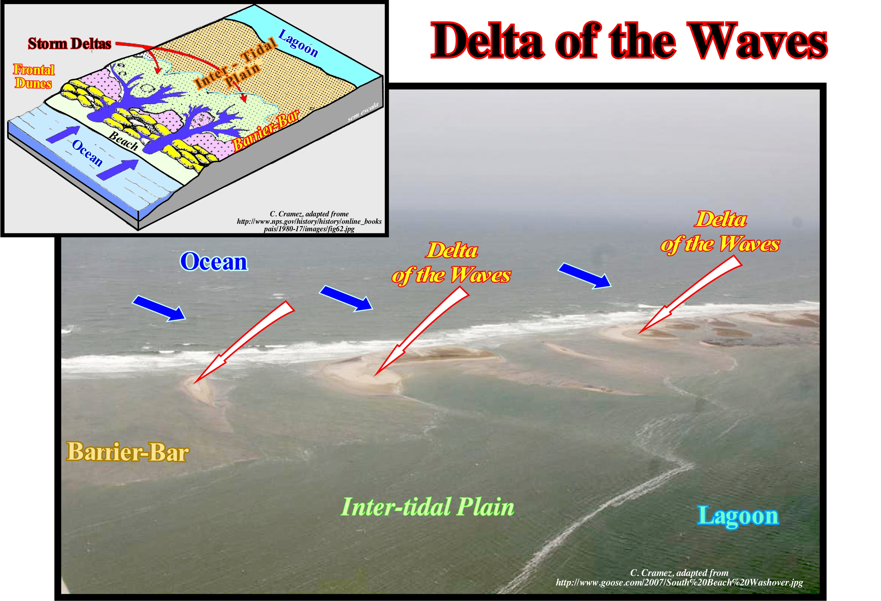
Certain geoscientists call the delta of the waves, a delta-storm. In the geological model of a delta of the waves, it easy to recognizes: (i) The ocean with waves, striking almost, parallel to the shoreline ; (ii) A barrier-bar ; (iii) The inlets or openings of the barrier-bar ; (iv) The intertidal plain, in which the deltas of the waves are deposited and (v) The lagoon. In this photograph, several small deltas of the waves are visible (indicated by the red arrows). Taking into account that these deltas are located in the intertidal plain (between the lagoon and the barrier-bar), the genesis of these deltas is easy to guess. The delta fans are deposited upstream of the opening of the external part openings of the barrier-bars (tidal channels) towards the lagoon. It can be said during tidal storms and equinoctial tides (tides occurring during the syzygies*, i.e., during the new and full moon, near the equinoxes), the waves overflow (preferably using tidal channels) the barrier-bar and deposit on the other side (lagoon) the sedimentary particles that they carry and those that have been eroded during over-banking (as shown in the diagram at the top of this figure). The easiest place for this deltas to form is where the barrier-bas is narrower and particularly in the tidal coves that, often, separate the barrier-bars. In the vast majority of cases, the barrier-bars are deposited in, more or less, long chains where each of them is bounded by two inlets (entrances by which one can navigate), which, roughly, mark the tidal coves. A overbanking of the sea-waves over the barrier-bar causes, above all, a major erosion of the shoreface, beach and dunes. The sedimentary particles released are transported and redistributed, mainly, on the inner side of the barrier-bar (side of the lagoon). On the beach, overbank deposits are limited by a basal erosional surface, which slopes seaward. In the inner part of the barrier-bar, the presence of vegetation remains underneath the overbank deposits indicates very little or no erosion before of deposition behind the frontal dune. In the front of the lagoon, which certain geoscientists call the outer platform of the lagoon (near the barrier-bar), where the water-depth is very small, the overbank deposits accumulate, more or less, horizontally. They have a horizontal or sub-horizontal stratification. As the water-depth increases, the overbank deposits are thicker and characterized by sigmoid progradations (S-inverted) oriented towards the deepest part of the lagoon. Taking into account the dominant forces in the formation process, Galloway classified the deltas into three main types: (i) River Dominated Deltas with strong terrigeneous influx of the rivers ; (ii) Wave Dominated Deltas with high the activity of sea-waves and (iii) Tidal Dominated Deltas characterized by tidal activity and tidal currents. The river dominated deltas are cut off and have many distributaries with marshes, bays or tidal flats in the inter-distributary regions. They occur when the river current and transport of the sedimentary particles are strong and other effects, such as rework by waves or tides, are smaller. These deltas tend to form large delta lobes in the sea, which may have little more than the distributary channel, and have natural marginal dikes (levees) exposed above sea level. Due to their resemblance to a bird's paws, they are, often, referred to in the geological literature as a "bird's foot deltas", as it is the case of the present-time Mississippi River Delta. When much of the floodplain between the distributary channels is exposed above sea level, the delta displays a lobate form. Deltas dominated by the waves are more regular, exhibiting curved and arched shapes with beach ridges are frequent, as in the present-time Nile delta or Niger delta, where the breaking of the waves causes a mixture of fresh and salt water. The flow loses, immediately, its energy and deposits all its load along the coast. Tidal dominated deltas occur in areas with high tides or high speeds of tidal currents. Such deltas resemble, often, to an estuarine bay filled with many elongated islands parallel to the main tidal stream and perpendicular to the coastline, such as the present-time Brahmaputra Delta or the Mahakam Delta. The actual Mississippi River and Yukon River deltas are typical river dominated deltas, i.e., formed by the terrigeneous influx carried by the rivers. The actual Senegal and San Francisco deltas are, mainly, dominated by sea-wave activities, while the actual Fly river delta is dominated by the tides and tidal currents.
(*) When the Sun, Earth and Moon are in alignment. Solar eclipses and lunar eclipses occur during the syzygies. This term is also used for the configuration formed by the Sun and Moon (and Earth) when they are in conjunction (new moon) or in opposition (full moon).
Deltaic Building...................................................................................................................................................................................Edifice deltaïque
Edifício deltaico / Edificio deltáico / deltaischen Gebäude / 三角洲建设 / дельтовая здание/ Edificio deltizio /
In the same way that a skyscraper is a stacking of flats with 2.4 m in height (in average), a delta or deltaic building (skyscraper) is the progradational stacking of a large number of deltas (flats) with average thickness between 30-60 m. Confusing a delta building with a delta corresponds to confusing a continental slope with a prodelta, although, sometimes, a delta slope may exist on top of a continental slope.
See: « Finger Delta »
Deltaic Construction........................................................................................................................................Accumulation deltaïque
Edifício deltaico / Construcción deltaica / Delta Akkumulation / 三角洲建造 / Дельтообразное накопление / Costruzione deltizia /
Sedimentary accumulation in the sea or lake, often triangular, more or less, prominent and associated, usually, with the mouth of a river. The thickness of a deltaic construction can be very important, since it is a vertical stacking of deltas, whose thickness rarely reaches 60 meters. Do not confuse a delta building or deltaic construction with a delta.
See: « Clinoform »
Deltaic System.................................................................................................................................................................................... Système deltaïque
Sistema deltaico / Sistema deltaico / Deltaischen System / 三角洲系统 / Дельтовая система / Sistema deltizio /
One of the many nonmarine depositional systems located near the shoreline and influenced, directly, by relative sea level changes, which are the main factor of the cyclicity of the paralic deposits: (i) Low Fluvial Systems ; (ii) Wind Systems ; (iii) Delta Systems (not all); (iv) Coastal systems (barrier bars) ; (v) Beach Systems (not all). Coastal deposits and areas located above the high tide limit are considered as coastal non-marine environments.
See : « Coastal Non-Marine Deposit »
Density Current.................................................................................................................................................................................................Courant de densité
Corrente de densidade / Corriente de densidad / Stromdichte, Dichtigkeit Strömung / 电流密度 / Плотностное течение / Corrente di densità /
Current flowing as a result of a density difference. In the oceans, density currents are produced by differences in temperature, salinity and turbidity (concentration of suspended matter). Contour currents are a particular case of density currents flowing along the contours of the lower part of the continental slope and not along the lines of maximum dip.
See: « Stream »
&
« Upwelling Current »
&
« Turbidity Current »
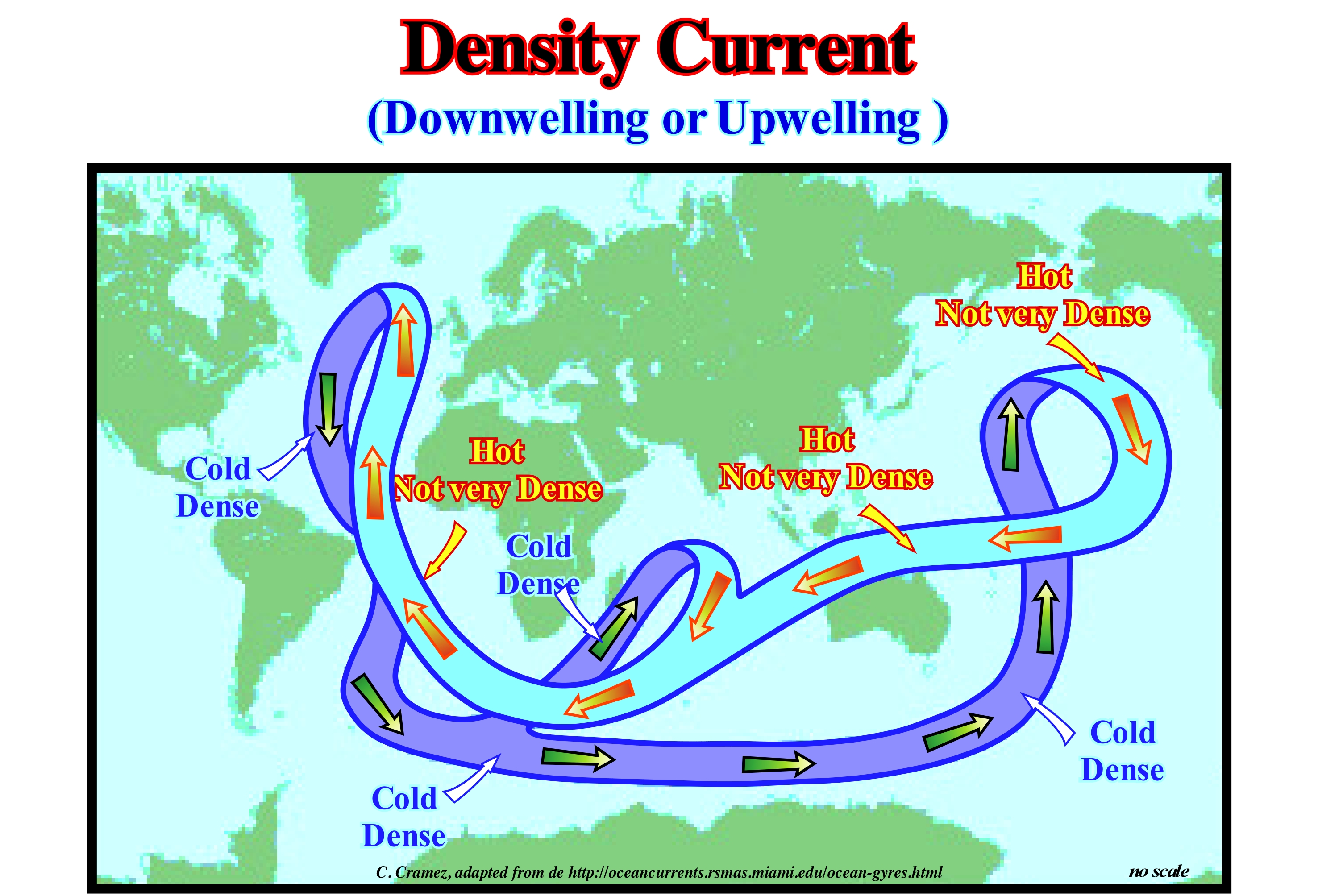
Density currents (thermohaline circulation) are caused by differences in sea-water density, which are, mainly, due to changes in salinity and temperature. The greater the salinity of sea-water, the greater its density. Two very common processes can change the salinity of sea-water and thus their density: (i) Evaporation and (ii) Freezing. Evaporation causes an increase in salinity. Freezing sea-water also increases salinity. Cold water is denser than hot water. Its molecules are tighter against each other. It is in the polar regions that one finds the salt-water, colder and more dense. In the Mediterranean, water has a salinity of about 40 parts per thousand. In the Atlantic the salinity is 35 parts per thousand. When the water of the Mediterranean enters the Atlantic, trough the Strait of Gibraltar, a density current is formed (not shown in this scheme). The salt-water of the Mediterranean sinks to the bottom of the Atlantic Ocean. In the North Atlantic, deep-water is linked to the cooling of salt-water transported by the Gulf Stream from the Caribbean. When the water from the Gulf Stream reaches the Norwegian Sea, it suffers a sudden cooling. As it was, already, relatively dense, due to its strong salinity, cooling further increases the density, which is large enough to dive into the deeper parts of the ocean basin. The density currents influence the climate a lot. It is enough to compare the winter temperatures of European and Canadian cities that are at about the same latitudes. In January, Madrid (latitude 50° N) has an average temperature of 5° C, while the Canadian city of Edmonton (latitude 53° N) has an average temperature of -15 ° C.
Denudation......................................................................................................................................................................................................................Dénudation
Desnudação / Denudación / Denudation / 剥蚀 / Денудация (снос) / Scollate /
Set of geological processes leading to a progressive leveling or lowering of the Earth's surface by disintegration, erosion, dissolution or transport.
See: « Erosion »
&
« Davisian Cycle»
&
« Rock Cycle »
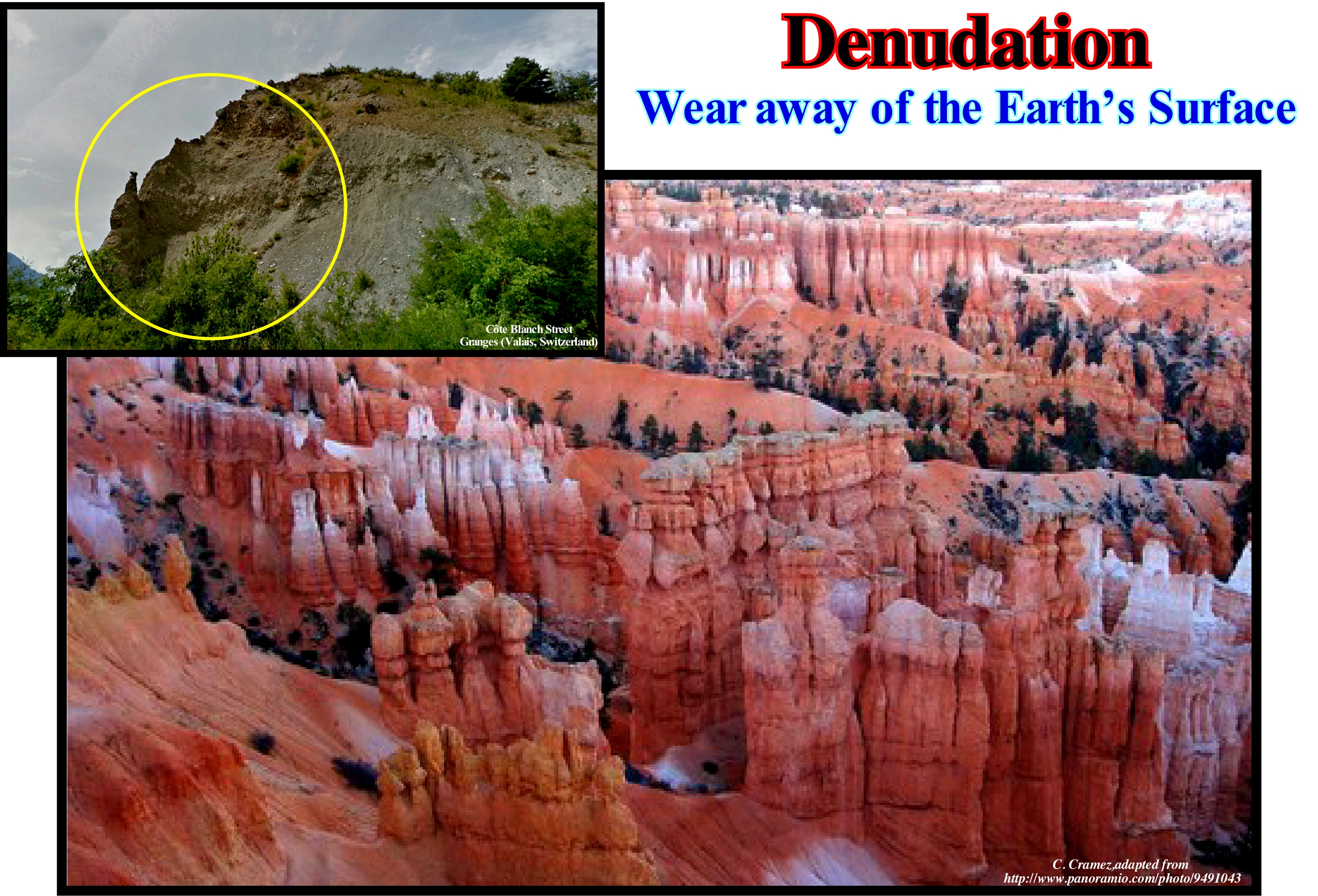
As illustrated in this photograph of the Bryce Canyon, in the State of Utah, the first geological process for denudation (exposure of rock masses or surface formation due to removal of the overlying material by erosion) be efficient is a significant relative sea level fall in order that rocks deposited under a, more or less, important water-depth are exhumed and exposed to the action of erosive agents (rainfall, rivers, wind, snow, sea, wave action, weathering, but also man, seismic waves, earthquakes, volcanism, etc.). This type of relative sea level fall, which is the result of the combination of absolute (eustatic) sea level (supposed global and referenced to the Earth's centre using satellite measures satellite*) and tectonics (subsidence or uplift of the sea-floor**). Since the rocks outcrop, they are exposed to the action of the erosion and weathering agents (a set of processes that cause the disintegration and decomposition of the rocks, due to the action of the atmospheric agents), transforming, in materials less resistant to gravity, erosion and transportation, which facilitates, greatly, the denudation. On seismic lines, an inversion model (calculation process from a set of observations and the factors that caused them) was developed to determine the amount of denudation using the square root sum of the mean velocities derived from the processing of the reflection seismic profiles. This method has several advantages over other methods of determining denudation, such as vitrinite reflectance (***), apatite fission traces, acoustic diaphragm velocity modelling, etc., which are, more or less, restricted to the locations of the research wells. The square root method of velocities assumes a porosity decay, exponentially, with depth and a velocity/porosity ratio, which allows the computation of a square root synthetic profile of the mean velocities. Then, denudation values, at two different stratigraphic levels, are adjusted until there is a match between the calculated and measured values. The success of this method is dependent on the initial porosity of the sediments. There is a relationship between porosity and denudation. Using this method, geoscientists determined a denudation between 0.5 and 1 km along the western coast of Africa during the Neogene terminal (associated with a generalized uplift) and a denudation of about 2.5 km to the Oligocene unconformity (SB 30 Ma). The denudation that occurred in the Late Neogene, in a large part of the West African coastal zone is perfectly visible on the seismic lines of the conventional offshore Angola. The toplaps that characterize the sea-floor, were, probably, created in associated with thermal events that are still poorly defined. The denudation associated with the Oligocene unconformity (SB 30 Ma), which seems to have been induced by the a significant absolute or eustatic sea level fall caused, most likely, by the formation of the Antarctic glacial cap, whose maximum expansion and thickness was reached, during the last glacial age, more or less, 19 ka. Then the ice began to melt. Without taking into account the extension of the associated ice shelf (ice sea), the melting of the ice cap, till today, created a retrogradation of about 450 km (about 24 m per year). It strongly contribute to the post-glaciation rise of the absolute sea level (±130 meters). It may be thought the eustatic sea level fall induced by the Antarctic cap formation was, at least, of the same order (the contribution of the ice seas is null; the water is denser than ice).
(*) The measurements made from the satellites use radar images and not classic images. A radiation is reflected by all obstacles whose dimensions are comparable to the wave-length of the radiation. The wave-length of visible light is slightly less than one micron (10-6 m = 0.000001 meter = 0.001 mm). That is why the clouds are opaque. The particles and the drops that exist in the clouds do not allow the light to cross them. The radars, in contrast, have lengths of about 5.6 centimeters for the Ers satellites. Nothing in the clouds can prevent the passage of this type of wavelength. On the contrary, it is reflected by soil irregularities such as pebbles, vegetation, etc.
(**) Uplift of the sea-floor in associated with the formation of convergent continental margins, whether induced by A-type (Ampferer) or B-type (Benioff) subduction zones, since the volume of ocean basins varies ( as a function of the oceanic spread (the amount of water, by convention, in all its forms, is considered constant since the Earth's formation,around 4.5 Ga).
(***) The study of the reflectance of the vitrinite is a key method to obtain the history of temperature of the sedimentary basins. This method was, initially, used in coal exploration in order to diagnose the thermal maturity of the coal layers. Later, it l became a tool for studying the transformation of kerogens into hydrocarbons. The main attraction of this method is the determination of the temperature ranges corresponding to the generation of the hydrocarbons (60° to 120° C). An appropriate calibration of vitrinite reflectance can be used as an indicator of maturity of source-rocks (reflectance from 0.5 to 0.6% for the begining of the oil window) and reflectance from 0.86 to 1.1% at the end of the window of oil. This means the reflectance of vitrinite indicates the maximum depth reached by the potential source-rocks.
Deposition (Carbonates).............................................................................................................................................................Déposition (Carbonates)
Deposição / Depositación (carbonatos) / Ablagerung (Karbonate), Karbonatsedimentation / 沉积(碳酸盐岩) / Отложение (карбонаты) / Deposizione (carbonati) /
Process by which carbonate settle on sea floor. Carbonates and, especially, shallow-water carbonates, rarely accumulate in a constant and uniform manner. The vast majority of outcrops suggest a rhythmic hierarchy (between thousands and hundreds of millions of years). These rhythms are punctuated by unique events (Milankovitch cycles, auto-cycles, etc.) and by changes in organic and chemical evolution.
See: « Depostion (clastics) »
&
« Milankovitch's Cycle »
&
« Autocycle (carbonates) »
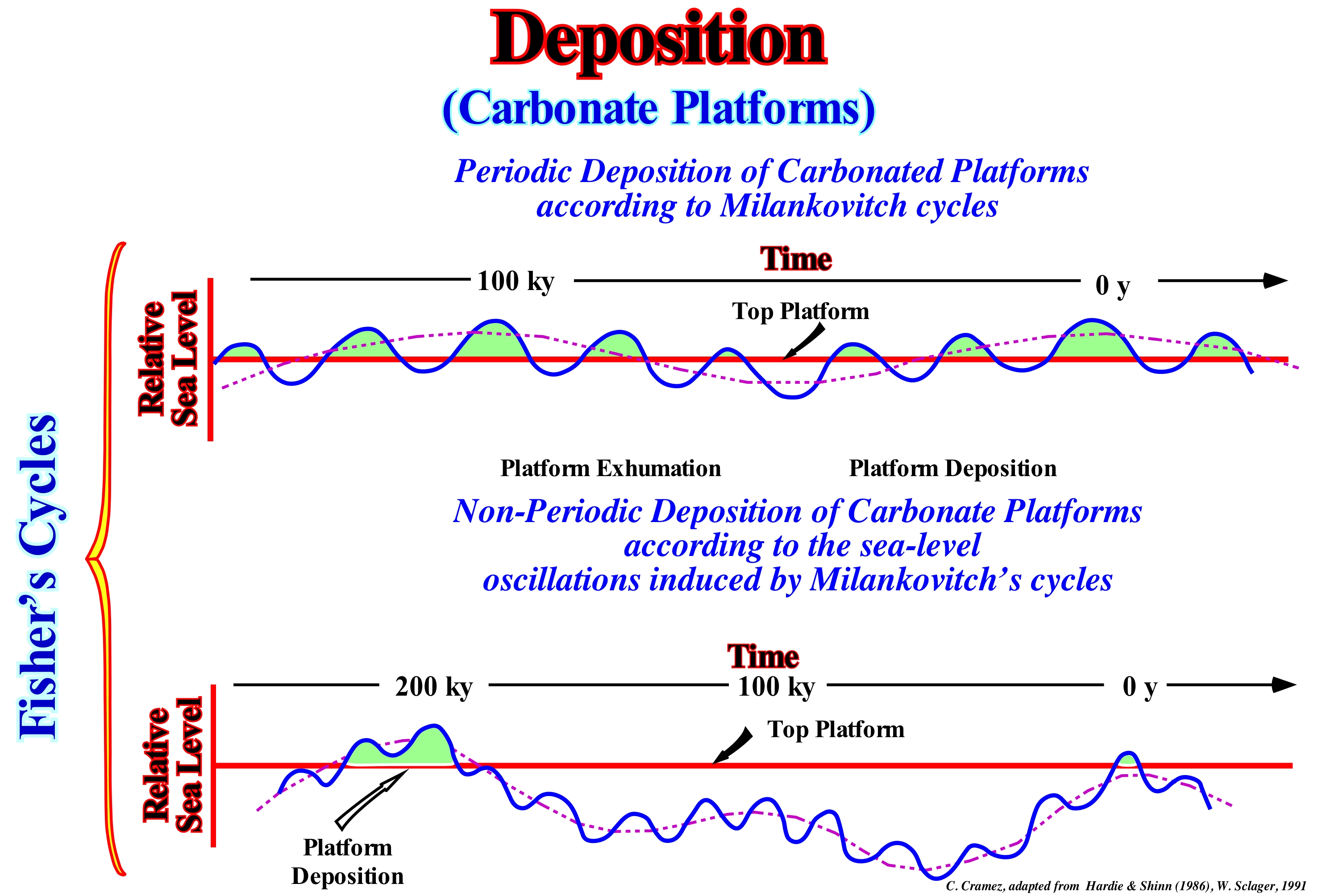
The great majority of geoscientists think the cyclicity of the space available for sediments, i.e., the cyclicity of shelfal accommodation is given by the combination of absolute (eustatic) sea level (taking into account the effects of orbital perturbations) and tectonics (subsidence, when the predominant tectonic regime is extensional or uplift when the predominant tectonic regime is compressional). Earth loses water vapour into space and gains water vapour from space during its movement around the Sun. Milankovitch's cycles, that is to say, sun-induced climate cycles, which create important changes in the cryosphere (parts of the Earth's surface where water is in solid form, including sea ice, lake ice, river ice, glaciers, ice sheets and frozen soil including permafrost) and therefore produces important eustatic changes important. Several cycles of insolation were recognized by Milankovitch with the periods of 19, 23, 41 and 100 ky. In this way, orbital disturbances such as eccentricity* and precession ** are important factors in sea level changes. In these diagrams, it is clear that eustasy (variations of absolute or eustatic sea level, which is supposed to be global and referenced to the Earth's centre) plays a predominant role in the variations of the available space for the sediments. This conjecture seems difficult to refute outside the sedimentary basins formed during compressional tectonic regimens, in particular, outside the foreland and folded belts of the Bally and Snelson (1980) classification of the sedimentary basins. The upper diagram shows the drowning (carbonate platform under a water-depth higher than the photic zone) and the exposure of a carbonated platform due to glacio-eustasy***, produced by the superposition of the 20 ky and 200 ky Milankovitch's cycles. The small variations in the amplitude of the 100 ky cycle produce a set of five cycles of tidal plain deposits. During large variations in the 100 ky cycle, as for example in the Pleistocene, deposition on carbonate platforms is much more erratic and the control by Milankovitch's cycles is not evident. In recent millions of years, the glacial and inter-glacial episodes that the Earth has suffered are caused by cyclical variations of the Earth's motion around the Sun. Milankovitch's cycles correspond to the set of cyclic variations of the orbit eccentricity, inclination and precession of the axis of Earth's rotation. The variations of these three cycles create differences in the solar radiation that reaches the terrestrial surface, which influences the climate and, thus, the thickening and thinning of the glaciers. The first Milankovitch's cycle, which is induced by the eccentricity (between 0 and 5% ellipticity) of the Earth's orbit, has a periodicity of 100 ky. The oscillations associated with eccentricity are crucial for glaciations. The solar energy received at the Earth's surface, during the seasons, varies. The second cycle is induced by the inclination of the axis of rotation in relation to the plane of the orbit. This cycle produces oscillations of 41 k and angles of inclination between 21.5° and 24.5°. The smaller the slope, the more uniform is the distribution of solar radiation between winter and summer. The last Milankovitch's cycle (roughly 20 ky) is induced by the precession of the axis of rotation****, i.e. the conical axis rotation (like a spinning) of the axis of rotation as the Earth rotates at your return. Of course, in the deposition of the carbonates, other factors come into account, such as the climate and water table, etc.
(*)Distance from the ellipse of the Earth's orbit to one of the foci. The Earth rotates slowly around the Sun, but its orbit changes. The eccentricity of the Earth's orbit increases and decreases periodically. The change periods are 60 and 120 ky. A period of eccentricity of 400 ky is also known. The rotation of the Earth's orbit has the same consequences as precession and its effects can be added.
(**) Conical motion of an axis of rotation, as the axis of rotation of the Earth does, perpendicularly, to the plane of the orbit.
(***) Eustatism induced by the climatic variations, that is to say, created by the cycles glaciation/deglaciation (melting). Eustatism created by the variations of the cryosphere (part of the Earth's surface that is permanently frozen). In glacio-eustasy, the adjustment of the lithosphere, in response to the loading and unloading induced by the addition and removal of ice from the glaciers, has to be taken into account.
(****) The Earth's axis is an imaginary straight line that crosses the Earth's centre and both geographic poles, around which our planet rotates. It does not form a right angle with the plane of the Earth's orbit around the Sun, the ecliptic, but rather an angle of 66° 33 ' and its direction to the stars is not fixed. It rotates very slowly around the perpendicular to the plane of the orbit, completing a revolution every 26,000 years and causing the precession of the equinoxes.
Deposition (Clastics)........................................................................................................................................................................Déposition (Clastiques)
Deposição / Depositación (clásticos) / Ablagerung (klastischen) / 碎屑岩沉积 / Обломочные отложения / Deposizione clastica /
Process by which sedimentary particles carried by transport agents associated with erosion (mainly water, wind and ice) fall from the transport medium and settle down, generally, near the depositional coastal break of a depositional surfac surface.
See: « Deposition (carbonates) »
&
« Davisian Cycle»
&
« Fluvial Deposition »
The rivers, oceans, glaciers, winds and the drainage of rain-water have the ability to carry all the sedimentary particles extracted to the rocks. These sedimentary particles, called clasts (from the Greek klastós meaning "broken" or "fragmented") or debris, when the energy of the transport current is not strong enough to support them, they settle by a process called clastic deposition. The deposition of the sedimentary particles (they become sediments) reflects the energy of the transport medium. This is known as the null point hypothesis*. This hypothesis explains how the sediments settle along the coast according to the granulometry of the grains. Everything happens as a consequence of the influence of hydraulic energy, which induces a decrease in grain size or where the force of the fluid equals gravity for each grain size. This concept may also explain why a sedimentary particle of a certain size can move to a position where it is in equilibrium with the waves and flows acting on that particular grain. This sorting mechanism combines the influence of gravity force (induced by the slope of the sea-floor) and the forces created by the asymmetry of the flow. The position where there is no transport is known as the null point (Cornaglia, 1889). In this reprocessed image (MED, Digital Elevation Model) of the Death Valley region of California, it is easy to deduce the effects of erosion and deposition. On the left, in the high areas, erosion (detachment, entrainment and transport) is preponderant, while to the right, in the lower areas, is the deposition that is preponderant. The erosion process stops, the sedimentary particles leave the transport medium and settle down (the sedimentary particles become sediments). In sequential stratigraphy, along a depositional surface (chronostratigraphic surface), which always slopes seaward, but with different slopes. Several slope breaks can be recognized. These slope breaks delimit different depositional environments. From upstream to downstream, the breaks of a depositional surface are: (i) Bay-line or slope break of the fluvial depositional surface, which limits the fluvial deposits (upstream) from delta and coastal deposits, i.e., the upstream limit of the coastal wedge or coastal prism) (probably visible in this photograph) ; (ii) Depositional coastal break, which corresponds, roughly, to the shoreline marks the limit between delta/coastal and marine deposits (such a correspondence is not, especially, evident on seismic lines, since the seismic resolution, generally, does not allow to recognize intervals of thickness less than 20-10 meters) ; (iii) Slope break of the shallow-water depositional surface, which corresponds to the basin edge (when the basin does not have a shelf, it coincides with the depositional coastal break), i.e., it emphasizes the limit between continental slope deposits with those of the platform or with those of the coastal plain (in lowstand the geological conditions) ; (v) Abyssal slope break, which marks the limit between continental slope deposits and the abyssal plain. This rupture often corresponds to the limit between the submarine slope fans (SSF) and the submarine basin floor fans (SBFF). The concept of the bayline was advanced by Posamentier and Vail (1988), who think the delta deposition occurs when a current finds an almost immobile water-body and its speed diminishes, almost, instantaneously. For them, the coastal plain is formed by sea bottom progradation rather than by exhumation, which means that the sediments accumulate in the coastal plain during the progradation of the coast line are part of what is called the coastal wedge (coastal prism), which includes fluvial and shallow-water deposits. The coastal wedge that extends to the continent by onlapping over the preexisting topography is limited upstream by the bayline, which can move upstream when the progradation of the coastline is accompanied by aggradation. When the relative sea level rises or falls, the bayline moves continentward or seaward. For P. Vail, the bayline is the line where the provisional equilibrium profile of the rivers becomes horizontal and where the effects of subsidence and absolute sea level (supposed global and referenced to Earth’s centre) cancel out. If this is the case between the bay-line and the shoreline, there should be a series of bay and lakes, which is not to be always the case. Some geoscientists, as Miall, consider the concept of the bayline is a hypothetical concept. For them the depositional conditions occur at the mouth of the water-courses, near the shoreline, and not in the bayline which is located, sometimes, dozens of kilometers upstream.
(*) Not to be confused with the null point that can be determined along the fault plane of a normal fault when the fault is reactivated by a reverse fault motion.
Deposition Zone (Fluvial).................................................................................................................................................................Zone de dépôt
Zona de Deposição / Zona de depositación (fluvial) / Abscheidungszone / 沉积区 / Зона осадконакопления / Zona di deposizione /
One of the three sedimentological zones, evidenced by Emiliano Mutti, in a fluvial system: (i) Source Zone (SZ) ; (ii) Transport (or Transfer) Zone (TZ) and (iii) Deposition Zone (DZ). It is in the deposition zone that sediments accumulate. The fluvial deposition zone is upstream of the bay-line and the realm of alluvial and fluvial deposits.
See: « Fluvial Deposition »
Depositional Base Level............................................................................................................................Niveau de base (Déposition)
Nível de base / Nivel de base de depositación / Grundlinie / 基线(沉积, 沉积基准面) / Базовый уровень, Основной уровень осадконакопления / Linea di base, Livello base deposizionale /
Position of the relative sea level. It may related to the water surface of lakes and/or local equilibrium surfaces associated with river systems. Normally, unless otherwise noted, the base level is related to the sea level, which is controlled by the combined action of eustasy and tectonics (subsidence or uplift of the sea floor). The level of the action of the sea-waves, i.e., the depth of the erosive action of the waves, is almost always considered as insignificant (particularly on seismic data).
See: « Relative Sea Level Change »
&
« Wave Action Level »
&
« Ravinment Surface »
The depositional base level is the surface where the sediments accumulate or are eroded. It is related to continental erosion and the sediment accumulation zone that is filled or eroded due to the relative of sea level changes considered. Sea level may be: (i) Relative sea level, i.e., local sea level, referenced either at the base of the sediment (top of the continental crust) or, for instance, at the sea-floor and (ii) Absolute or eustatic sea level, which is supposed to be global and referenced to the Earth's centre. Obviously, the local relative sea level is the result of the combined action of absolute (eustatic) sea level and tectonic (subsidence, when the predominant tectonic regime is extensional or uplift, when the predominant tectonic regime is in compressional). The depositional base level is a dynamic surface controlled by: (i) Erosion ; (ii) Deposition ; (iii) Eustasy (variations of absolute or eustatic sea level) and (iv) Tectonics (lengthening or shortening of the sediments). Normally, the base level is given by the relative sea level position, but it may be associated with the surface of the water level of a lake and, or a local equilibrium profile, associated with to river systems. The base level, which is the erosional base level of certain geoscientists, as illustrated in this figure is the altimetric line below which the water-courses can no longer erode and the deposition of the sedimentary particles becomes predominant. The base level may be given in relation to the average sea level*, in the case of rivers that flow there or in relation to closed seas and lakes. The Titicaca Lake, which is at an altitude of more than 3800 m, is the base level of most Bolivian plateau rivers. The Tanganyika lake, which is at an altitude of about 700 m, is the base level of most of the rivers of the region, in particular of the Ruzizi and Malagarasi. This last river, which was once connected to the Congo River, is older than the lake. The Lukuga River is its main effluent, when the level of the lake is very high. The base level of a region changes with relative sea level. During a marine ingression (relative sea level rise), the base level rises, which increases the area of deposition. During a sedimentary regression (relative sea level rise in deceleration or small relative sea level fall) the opposite occurs. The area subject to erosion increases which creates a strong sedimentary terrigeneous influx. In clastic platforms, the base line level is, for some geoscientist, the equilibrium profile of the platform. It represents the counterbalance between the terrigeneous influx and the water movement. Such a balance is a dynamic conceptual balancing surface, which modifies, greatly, the concept of marine balance of certain geoscientists. They consider the marine equilibrium profile as the deepest depth to which the sea floor is agitated by waves during storms. In carbonates, the diversity of deposition profiles and the distribution of facies belts is greater than in clastic systems, which reflects large differences in genetic factors. As the hydro-power depends on the oceanographic conditions of the platform, the differences between the carbonate and clastic systems translate the differences of sedimentary charge. In a sedimentary regime with a stable relative sea level, the variability of the deposition profiles in the different carbonated platforms can be considered as a counter-weight between: (a) The different types of sediments produced; (b) The depocenter (deposition centre) and (iii) Hydraulic power.
(*) The Earth is wider around the equator than between the poles. It is similar to an ellipsoid or spheroid. The terrestrial ellipsoid, which is a rough mathematical figure of Earth's shape, is used as a frame of reference for geodetic, astronomical, and geoscience computations. The geoid is a very complex surface to be described mathematically. It can be easily identified by measuring gravity. The geoid is considered to be roughly equal to the middle sea level. In the oceans, the geoid and the middle sea level are roughly the same. In the continental areas, they may be very different. The terrain (true shape of the Earth) is given by topography and bathymetry. To determine the "middle sea level", the best thing to do is to determine a place and calculate the average level at that point and use it as a reference point. Generally, from hourly observations, made during a period of, more or less, 30 years, it can be calculated as the middle sea level for that measurement point. As a rise in sea level is perhaps the most familiar effect of climate change, and probably the one with the most consequences, it is important to know, always, which sea level is considered (eustatic, relative, middle sea level, high-tide, etc.) and how it was calculated. Different sea levels can be deduced from the morphology of a beach. The level of high spring-tide corresponds, more or less, to the limit between the nearshore and the foreshore (the spring-tides near the equinoxes, which have the maximum amplitude, are named equinoctial tides). The level of the low-tide corresponds to the upper limit of the longshore ridge and longshorerunnels, while the beach escarpment (the last step of the beach), limit between the shoreface and the nearshore, underlines the level high neap-tide (New Moon), at the top, and, more or less, the middle sea level at the bottom.
Depositional Dip...................................................................................................................................................Inclinaison de déposition
Inclinação deposicional / Inclinación deposicional / Ablagerungprozesse Inklination / 沉积底 / Осадочный уклон / Inclinazione di deposizione, inclinazione deposizionale /
Dip of a bed or group of beds at the time of deposition. Unlike the structural dip, which is subsequent to deposition, the depositional dip is primeval. In a sequence-cycle, the depositional dip is, almost always, towards the deep parts of the basin.
See: « Stratal Pattern »
&
« Strata »
&
« Depositional Surface »
Contrary to what was initially thought, not all sedimentary layers settle horizontally. At the macroscopic scale (scale of geological maps and seismic lines), all depositional surfaces have a sigmoid geometry. These surfaces, which have a chronostratigraphic value and correspond almost always to seismic reflectors (the opposite is not always true), are much easier to follow on regional seismic lines than in the field (mesoscopic or outcropping scale). Four major slope breaks are visible along a depositional surface: (i) Bayline break, which is the morphological rupture between the alluvial and the coastal plain (corresponds to the bay-line, which marks the limit between fluvial deposits, deposited with a slope dipping towards the coastal plain) and the subhorizontal coastal deposits ; (ii) Depositional coastal break, which is the rupture between the coastal/delta plain and the delta slope (on the seismic lines, it corresponds, more or less, to the shoreline that may or may not coincide with the dispositional coastal break of the depositional surface), it marks the limit between the subhorizontal coastal/delta deposits and the prodelta shales (dipping seaward) ; (iii) Continental break between the platform and the continental slope (sometimes corresponding to the basin edge), which marks the limit between the sub-horizontal platform deposits and inclined deposits of the continental slope and (iv) Basal break of the continental slope, which underlies the limit with the pelagic deposits of the abyssal plain (submarine fans, which belong to another depositional surface which has no equivalent in the slope or in the platform of a basin). The concept of the bayline, which emphasizes the first break of the depositional surface (limit between the fluvial deposits and coastal wedge), was proposed by Posamentier and Vail (1988). They consider that: (a) Delta deposition occurs when a water-course encounters an almost immobile water-body and its velocity decreases instantaneously ; (b) The coastal plain is formed by processes of sea floor progradation, rather than by exhumation ; (c) The sediments that accumulate on the coastal plain during the progradation of the shoreline are part of what they called coastal wedge, which includes river deposits and shallow water ; (d) The coastal wedge has the prismatic shape and extends continentward by onlapping over the pre-existing topography ; (e) The upstream limit of the coastal wedge is the bay-line, which may move upstream when the progradation of the shoreline is accompanied by aggradation ; (f) The bay-line is the limit between the coastal plain and the alluvial plain ; (g) Upstream of the bayline, relative sea level changes (local sea level referenced to any point on the land surface which can be the sea floor or the base of the sediments and which is the result of the combined action of the tectonics and the absolute or eustatic sea level, which is supposed to be global and referenced to the Earth's centre) have, practically, no influence on deposition systems. On this tentative geological interpretation of a Canvas auto-trace of a seismic line of Argentina offshore, which corresponds to an stacking of several types of basins of the classification of Bally and Snelson (1980): (i) Basement or Paleozoic folded belt ; (ii) Rift-type basins (Mesozoic) and (iii) Atlantic-type divergent margin (Cenozoic), the depositional slopes are quite well visible. Within the rift-type basin (Cretaceous), which is separated from the Atlantic-type divergent margin by the unconformity associated with the breakup of the lithosphere (SB. 135 Ma) of the Gondwana small supercontinent, the rupture of the base of the delta slope i.e., the boundary between the inclined deposits of the prodelta and the sub-horizontal deposits of the base of the delta building is very visible. The presence of proximal submarine fans, induced by instabilities (failures) of the delta front, is possible at the base of the prodelta. Do not confuse a delta, which has, usually, a thickness of less than 100 meters with a deltaic building that corresponds to a stacking, more or less progradational, of several deltas and that can have a thickness of kilometers. On the other hand, it is important to note, within the interval limited by the discordance (coloured in red), the downstream tangential terminations of seismic reflectors define what in sequential stratigraphy is called false downlaps, i.e., they are horizontalized and continue seaward as independent stratigraphic units that are often so thin that they are not captured by the seismic resolution capability.
Depositional Environment.........................................................................................................................Milieu sédimentaire
Ambiente de deposição / Ambiente sedimentario / Sedimentary Umwelt / 沉积环境 / Осадочная среда / Ambiente sedimentario /
Conditions (natural environments) in which sediments settle. Depositional environments describe the combinations of the physical, chemical and biological processes associated with the deposition of a particular type of sedimentary particles and therefore of the rocks that they will form after lithification. The depositional environments are very varied and are found from the deep parts of the oceans to the reefs and corals and even to the glacial lakes of the high mountains.
See : « Sedimentary Environment »
&
« Deposition (carbonates) »
&
« Carbonate Sedimentation (principles) »
In this figure are shown sedimentary bodies deposited in different deposition environments characterized by the morphology, flow energy of the fluids (water, wind, turbidity currents, etc.), biological activity, abundance of various chemical substances and climate: (i) Slope Deposits, which, in general, due to erosion, are conserved, rarely, in the geological records ; (ii) Alluvial Fans which, generally, form on the base of certain topographic forms, especially when the slope break is well marked, and, generally, located upstream of the Posamentier and Vail's bay line ; (iii) Lacustrine Deposits, which are, generally, shaly, and which when rich in organic matter and buried sufficiently, so that the organic matter can reach maturation, can be very good source-rocks (hydrocarbon-bearing rocks) ; (iv) Playa Deposits, that is to say, of an area without vegetation, more or less, flat in the lower part of an undrained desert basin, i.e., a place where during rainy periods ephemeral lakes, supported by stratified shales, mud and sandstones, and often soluble salts (these deposits are sometimes rich in evaporites that form when the lake dries) ; (v) Braided Rivers Deposits, characterized by significant granulometry and deposits along several channels that branching and fusing, more or less, randomly (under certain conditions these deposits can be considered as petroleum or gas reservoir-rocks) ; (vi) Meander Deposits formed, mainly, by sand deposited along rivers with meanders that, unlike braided rivers, have a single channel that meanders in the floodplain depositing point bars and forming abandoned meander lakes with clay-plugs ; (vii) Wind Sand Dunes, which require a constant sedimentary influx of sand and wind to form ; (viii) Delta Deposits, which are deposited in deltas, formed when the rivers discharge into important water-bodies, such as an ocean or lake ; (ix) Swamp Deposits, i.e., sediments deposited in a layer of stagnant and shallow water in which an aquatic vegetation grows and that, in most cases, occupies, in a valley the part abandoned by the waters of a river, like old meanders and river's beds which before were very wide and which were reduced due to a flow reduction of the river ; (x) Spits, composed of acidic sandy deposits (sands that captured chemical pollutants during the travelling from one place to another, such as sulfuric and nitric acid), nutrient poor, more or less, parallel to the shoreline, generally, elongated, produced by sedimentation processes, where different communities that receive the marine influence are found ; the spits can have a vegetation cover adapted to dry conditions poor in nutrients ; (xi) Beaches, which are geological formations composed of loose sedimentary particles of minerals or rocks in the form of sand, gravel, pebbles or pebbles along the coast, where two important areas can be highlighted: a) Surf or Breaking Area, which is the part of the beach where the waves break and b) Strand, that is the part of the beach swept, periodically, by the waves and located between the high-tide and low-tide ; (xii) Reefs, that can be roughly defined as rocky bars of carbonated sand, coral or similar material, which are usually under the water surface, but within the photic zone, reefs can outcrop during the low-tide. These environments are joined by the marine environments of the continental shelf and, particularly, the deep water environments, where turbidite systems (submarine basin floor fans and submarine slope fans) are deposited whenever a significant relative sea level fall takes place, to exhume the continental shelf (if the basin had a shelf) and the top of the continental slope. The relative sea level is a local sea level referenced to a point, which may be, for instance, the top of the continental crust (base of the sediments) or the sea floor and which is the result of the combined action of the tectonics (uplift and subsidence of the sea floor) and the absolute (eustatic) sea level, supposed global and referenced to the Earth's centre.
(*) The bay-line emphasizes the upstream limit of the coastal wedge, which includes river deposits and shallow-water. It can move up-river when the progradation of the shoreline is accompanied of aggradation. The bayline corresponds to the first slope break of a depositional surface, from which a stream ceases to erode, in order to begin, primarily, to deposit. In the provisional equilibrium profile of a river, the bayline corresponds to the inflection point from which the current reaches a provisional equilibrium. The position of the bay-line changes with the position of the shoreline.
(**) The uplift of the sediment may be the result of a shortening induced by a compressional tectonic regime or the result of an lengthening induced by a tectonic regime in extension, sometimes local, as it is the case during the rise of a salt diapir.
Depositional Hiatus.....................................................................................................................................................Hiatus de déposition
Hiato de Depositição/ Hiato de depositación / Ablagerungsbedingungen Hiatus / 沉积间断 / Осадочный разрез / Iato deposizionale /
Nondeposition time interval, as, for instance, the time interval during which, in a sequence-cycle, at a given point, there was no deposition between a transgressive and regressive episode (the gap increases downstream). Synonym of hiatus without deposition, which seems a more correct expression. The geometric relationships associated with a non-depositional hiatus are: (i) Onlaps ; (ii) Downlaps and (iii) Toplaps. Theoretically, this hiatus emphasizes the geological time span during which no sedimentary particles settle on the depositional surface.
See: « Hiatus »
&
« Unconformities »
&
« Downlap Surface »
On the tentative geological interpretation of a detail of a northern Caspian seismic line, it is easy to identify that a progradational seismic interval (colored in yellow), with a complex configuration of the oblique sigmoid type (aggradation and progradation), fossilizes a transgressive interval (colored in green), whose internal configuration seems parallel, but in reality it is retrogradational (in other seismic lines). This progradational interval can be sub-divided into ,at least, two stratigraphic cycles, since an obvious coastal onlap exists within them, which enables to put in evidence a significant relative sea level fall. The same is recognized in the tentative geological interpretation of a Canvas auto-trace of a detail of Northern Caucasus depression seismic line illustrated in the upper left o corner of this figure, in which the deeper progradation interval (colored in dark brown) rests on the interval underlying (colored in blue) by downlaps. The boundary between these two seismic intervals corresponds to major downlap, which marks a hiatus without deposition (also designated by some geoscientists as a deposition hiatus). At the maximum of the transgressive episode, the shoreline was, probably, several dozen, to see even hundreds of kilometers eastward of the area here interpreted, i.e, displaced continentward. At that time, the l shelf was very large and the geological conditions were highstand (sea level higher than the basin edge). Near the basin edge, the geological conditions were not only highstand, but also of starved basin, since the sedimentation rate there was, necessarily, very small. However, in the more proximal parts of the shelf, i.e., near the continent, the sedimentation rate was, more or less, normal. In fact, it can be said that at the level of continental encroachment cycle (associated with 1st order eustatic cycles, whose time-duration is greater than 50 My, since absolute (eustatic) sea level, supposed global and referenced to Earth's centre, began to fall, as the volume of ocean basins began to increase due to the activity of the B-type subduction zones (Benioff) and collisions between the plates (A-type or Ampferer subduction zones), the shoreline began to move, slowly, seaward, as the sediments deposited with a progradational geometry. As illustrated on these tentative interpretations, the downlaps of the progradational interval fossilized, progressively, the no-deposition hiatus between the two intervals. This hiatus increases with the distance to the shoreline, which means that it reaches its acme at maximum of the marine ingression. In other words, the age difference between regressive sediments (progradational) and transgressive sediments (retrogradational) recognized in a exploration well located far from the shoreline (at the time of maximum ingression) is much greater than the age difference between the same sediments when the well is located further upstream (closer to shoreline). The age of the great majority of geological events, such as the age of a discordance (erosional surface induced by a relative sea level fall, i.e., of the local sea level referenced to the base of the sediment base or to the sea floor) is given by the minimum hiatus (closest to a continuity of sedimentation) associated with that surface. This is why the most likely age (which in geology means the age more difficult to refute) of an unconformity is given by the age of the submarine basin floor fans, induced by the fall of the relative sea level responsible of the erosional surface characterizing the unconformity. The age of the submarine basin floor fans may be given, more or less, correctly, in geological terms, by the age of the pelagic clays deposited between the turbidite lobes. In fact, turbidite lobes are considered, geologically, instantaneous (hours or days), while the time of deposition of the pelagic shales, that separate the turbidite sand layers, may be tens of thousands of years. A turbiditic lobe consists of a stratum (or layer) with a large lateral continuity, finning upward, with ripple marks, turboglyphs (turboglyphs old name for flute casts) and marks of objects and a pelagic shale layer (layer E of Bouma). Each turbidite lobe (sand and shale) is deposited as a single event, in which the energy variations of the gravitational flow give the layer typical features.
Depositional Model (Carbonates).........................................................................................................Modèle de dépôt (Calcaires)
Modelo de Deposição / Modelo de depósito (piedra caliza) / Deposit Model (Kalkstein) / 矿床模型(石灰石)/ Депозит Модель (известняк) / Deposito Model (calcare) /
In sequential stratigraphy*, two deposition models were proposed by Vail (1977), one for clastics and another for carbonates. Assuming, for the clastic model, a constant terrigeneous influx and, for the carbonate model, a carbonate production of 7.0 cm / ky (maximum productivity between 3/10 m water depth) with all other parameters similar (eustasy, subsidence, climate, etc.), the geometry of the sequence-cycles recognized in each model looks, apparently, different as can be seen on seismic lines and on the ground. However, at the sequence-cycle hierarchical level, both geological models show the same depositional systems tracts with their characteristic internal configurations.
See: « Depositional Model (sand-shale) »
&
« Depositional Environment »
&
« Stratigraphic Cycle »
In this figure are shown the two mathematical models used to explain a large part of clastic and carbonate deposits. The vertical and horizontal scales are metric, but very different. In the model for clastics: (i) Vertical exaggeration is about 200 times ; (ii) Each line corresponds to a chronostratigraphic surface ; (iii) The spacing between the chronostratigraphic lines is 100 k years and (iv) The terrigeneous influx is constant, which means that the area between two consecutive chronostratigraphic lines is the same. The carbonate model was constructed with the same relative sea level curve as the clastic model. Only the terrigeneous influx was replaced by a carbonate production curve (7.0 cm / ky), which means that, unlike in the clastic model, the area between two consecutive chronostratigraphic lines is not constant. As can be seen, the overall geometry of the two models is very different. In the clastic model there are deposits above sea level, which can not happen in the carbonate model, since the carbonate productivity varies, basically, between 3 and 10 meters of water-depth. On the other hand, the lowstand systems tracts group (LSTG) and, in particular, the systems tracts sub-groups forming by submarine basin an slope fans, are much less developed in the carbonate model. However, the terminations of the chronostratigraphic lines are the same, implying that in both models the same number of sequence-cycles are recognized. The sequence-cycles are induced by the curve of the relative sea level changes, which is the same in both models, and not by the nature of the sediments. Three sequence-cycles are recognized, of which only the intermediate is complete. The oldest sequence-cycle, colored in orange, and the most recent, colored in violet, are incomplete. In the older cycle, just the sedimentary systems tracts forming the subgroup called lowstand prograding wedge (LPW) was deposited. In the most recent cycle the highstand prograding wedge is absent, as well as the lower sub-groups of the lowstand systems tracts group (LSTG), i.e., the submarine basin floor fans (SBFF) and the submarine slope fans (SSF). However, the geometry of the most recent sequence-cycle, which is just formed by the lowstand prograding wedge (LPW) and the transgressive interval (TI), is very different in both models. In the clastic model (sand and clays), relative sea level rises, in acceleration (increasingly important marine ingressions), move the shoreline, which, during the period of stability of the relative sea level occurring after of each marine ingression, moves seaward as the sediments settle (sequence-paracycle). However, the shoreline does not reach the position it had before the sea ingression. With successive marine ingressions, the shelf increases, progressively, while, on the whole, the shoreline moves continentward by individualizing itself from the continental edge (lowstand prograding wedge). In the carbonate model, the successive increases of relative sea level (increasingly important marine ingressions) contribute, mainly, to the reef constructions develop, practically, at the vertical of the continental edge of the lowstand prograding wedge, which means that a shelf is formed with a relatively large water-depth, but which is bordered by organic constructions (reefs). There are different types of carbonated platforms: (i) Rimmed Platforms, with reefs or reefal shoals on the platform edge ; (ii) Ramp-type Platforms, with carbonated sands at the shoreline and shaly sands and deep water muds at the base of the ramp ; reefs are not important ; (iii) Epeirial (or epiric) Platforms, which are characterized by the presence of tidal surfaces and protected lagoons ; (iv) Isolated Platforms, in which the lithologies are controlled by the orientation of the winds ; they have reefs and sand bodies in the windward margin, but in the leeward margin, the sediments are muddy ; (v) Dead or Drowned Platform, when the platform is placed under the photic zone, in which sunlight penetrates and whose depth varies greatly depending on the turbidity of the water.
(*) The sequence stratigraphy of the majority of the geoscientists. We prefer reserve the term sequence just for the stratigraphic cycle (sequence-cycle) induced by a 3rd order eustatic cycle.
(**) Production of carbonates as a function of water-depth. The penetration (intensity) of sunlight in an aquatic environment (sea or lake, for example) decreases, exponentially, when the water-depth increases. The organic matter production curve, in a carbonated basin, can be correlated with the intensity of sunlight by a hyperbolic function. The carbonate production curve has a peak in the zone of light saturation, near sea level, where light is not a limiting factor of production. The peak production is followed in depth by a rapid decrease in production.
Depositional Model (Sand-shale)......................................................................................................Modèle de dépôt (Sable-argile)
Modelo de depósito / Modelo de depósito (arena-arcilla) / Deposit Model (Sand-Ton) / 矿床模型(沙粘土)/ Депозит Модель (песчано-глинистые) / Deposito Model (sabbia-argilla) /
In the clastic deposition model (sand/clay), proposed by P. Vail (1977), the following conjectures were assumed: (1) Eustasy is the main factor controlling the cyclicity of sedimentary deposits ; (2) The sedimentary intervals have a great completeness* ; (3) Eustasy, subsidence, accommodation, sediment transport and climate are the main geological parameters that determine the configuration of the strata ; (4) Changes in subsidence and terrigeneous influx are slower than eustatic changes ; (5) Terrigeneous influx is constant in time and space ; (6) Subsidence, progressively, increases, linearly, towards the deep parts of the basin and (7) The time interval between each chronostratigraphic line is 100 k years (at the geological scale, the deposition processes are instantaneous and catastrophic).
See: « Depositional Model (carbonates) »
&
« Deposition (clastics) »
&
« Stratigraphic Cycle »
On a seismic line, a sequence-cycle (stratigraphic cycle) is a succession of genetic reflections, limited by unconformities (or their correlative deep-water paraconformities), induced by strata deposited during a 3rd order eustatic cycle, i.e., by an eustatic cycle, limited between two consecutive falls of the relative sea level (local sea level, referenced at any point on the Earth's surface as the sea-floor or the base of the sediment and which is the result of the combined action of the tectonics and the absolute (eustatic sea level, which is the global sea level referenced to the Earth's centre or to a satellite). A 3rd order eustatic cycle has a duration between 0.5 and 3-5 My. In this model (sand-shale), P. Vail and his EPR colleagues (Exxon Exploration Production Research) assumed: (i) A given eustatic curve** (constructed from absolute or eustatic sea level changes) ; (ii) A subsidence of the continental edge increasing, regularly, and in a linear manner ; (iii) A constant terrigeneous influx (emphasized by the area between two consecutive chronostratigraphic lines) ; (iv) A negligible erosion and (v) A time difference between each chronostratigraphic line of 100 My or, in other words, each eustatic paracycle has a duration of 100 My (an eustatic paracycle is a relative sea level rise, which is followed by a period of stability of the relative sea level before a new rise without any relative sea level fall between). In this model three sequence-cycles are limited by two erosional surfaces, i.e., by unconformities. The oldest sequence-cycle, which encompasses the intervals 1 to 5, is incomplete, as is the most recent (22 to 29 time lines). The intermediate sequence-cycle (6 to 21) is complete. The two systems tracts groups that, normally, form a sequence-cycle are represented: (A) Highstand systems tracts group (HSTG) and (B) Lowstand systems tracts group (LSTG). During the highstand systems tracts group (HSTG), the sea level is higher than the basin edge, while during the lowstand systems tracts group (LSTG), sea level was lower than the basin edge. In the lowstand systems tracts group (LSTG), the basin has no shelf, whereas in the highstand systems tracts group (HSTG), the basin has a shelf except during the final part (2nd phase of development of the systems tracts subgroup denominated highstand prograding wedge, HPW). In the highstand systems tracts group, two subgroups are identified: (a) Transgressive Interval (TI), colored in green, and (b) Highstand prograding wedge (HPW), colored in orange. The former has a retrogradational geometry, while the latter has a progradational geometry. The lowstand systems tracts group (LSTG) is formed by three subgroups of systems tracts, which from the bottom up are: (a) Submarine Basin Floor Fans (SBFF), colored in yellow ; (b) Submarine Slope Fans (SSF), colored in beige and (c) Lowstand Prograding wedge (LPW), colored in violet. The unconformities, which limit the sequence-cycles, are, relatively, easy to identify near the continental edge by the seismic surfaces defined by the reflector terminations (lapouts): (1) Onlaps and (2) Toplaps by erosion or by non-deposition. In deep water, where erosion is negligible, the unconformities pass, downstream, to correlative paraconformities. As suggested in this geological model, except for the submarine fans (basin and slope) that are deposited during significant relative sea level falls, all other subgroups of sedimentary systems tracts require a relative sea level rise (marine ingression) to create the space available for sediments, i.e., shelfal accommodation. The sedimentary particles are deposited during the stability period of relative sea level occurring after each marine ingression. That is to say, globally, the shoreline moves continentward during the marine ingressions, without deposition and then moves to seaward as the sedimentary particles are deposited.
(*) Relation between the effective time of deposition and total geological time. If the time between two consecutive unconformities is, for instance, 3.0 My and the effective deposition time is 1.0 My, the sedimentary completeness is 0.3.
(**) Mainly controlled by a) Glacio-eustasy (variations of water volume the oceans induced by glaciations and thawing seasons) ; b) Tectono-eustasy (variations of volume of ocean basins function of the oceanic spread) ; c) Geoidal-eustasy (variations of the distribution of the water of the oceans caused by the variations of the field of gravity : if the temperature of the oceans increases, the density of the water decreases and, for a constant mass, the volume increases), and d) By the thermal expansion of the oceans or steric increase (function of the space arrangement of the atoms).
Depositional Sequence (Sequence-cycle)..............................................................................................Séquence de dépôt
Séquence de dépôt / Secuencia de depositación / Ablagerungsbedingungen Sequenz / 沉积层序 / Осадочная секвенция / Sequenza deposizionale /
Stratigraphic unit composed of a succession of strata, genetically, related and limited by two unconformities or their deep-water correlative paraconformities. A depositional sequence is synonymous with sequence-cycle (stratigraphic cycle). Each sequence-cycle or depositional sequence is induced by a 3rd order eustatic cycle and is composed of a vertical and lateral succession of different sedimentary systems tracts. A sequence-cycle is deposited between two inflexion points of the curve of relative sea level changes (eustasy* plus tectonics**).
See: « Sequence-Cycle »
&
« Systems Tract (sedimentary) »
&
« Unconformity »
In this depositional model for siliciclastic intervals (sand/shale) of P. Vail (slightly modified) is represented a stratigraphic cycle said sequence-cycle (induced by a 3rd order eustatic cycle whose time duration is between 0.5 and 3 / 5 My) and the groups of sedimentary systems tracts courts that form it. The geological time between two consecutive chronostratigraphic lines is, more or less, 100 ky. This time corresponds to the time-duration of each eustatic paracycle, which compose the eustatic cycle and not to the actual deposition-time of each sequence-paracycle (or parasequence) that is much smaller. Do not forget that an eustatic paracycle corresponds to a relative sea level rise and that between the succession of eustatic paracycles there are no relative sea level falls between them, but a stability periods of relative sea level, during which the sedimentary particles settle down. A sequence-paracycle is the sedimentary interval deposited during the stability period of the relative sea level between two consecutive eustatic paracycles. Do not forget that sea level can be: (i) Absolute or eustatic, that is, the supposed global sea level, referenced to the Earth's centre and (ii) Relative, i.e., a local sea level referenced at any point of the Earth's surface, as the base of the sediments (top of the continental crust) or the sea floor. The absolute (eustatic) sea level is the result of the combined action of: (i) Tectono-Eustasy, which is controlled by the variation of the volume of the oceanic basins ; (ii) Glacio-Eustasy, which is controlled by the variation of ocean water volume as a function of the amount of ice (assuming the amount of water in all its forms is constant since the Earth's formation, about 4.5 Ga) ; (iii) Geoidal-Eustasy, which is controlled by the water distribution of the oceans caused by the variations of the terrestrial gravity field (where gravity is stronger than normal, sea level is thrown to the Earth's centre) and (iv) Stereic sea level rise or thermal expansion of the oceans, which is controlled by rising ocean temperatures (if the temperature increases, the density of the water decreases and, for a constant mass, the volume increases). On the other hand, relative sea level is the result of the combined action of absolute or eustatic sea level and tectonic (subsidence, when the predominant tectonic regime is extensional or uplift, when the predominant tectonic regime is compressional). When the relative sea level rises (marine ingression), the shoreline moves landward, at the same time as the coastal plain is flooded, which creates a ravinment surface, on the pre-existing topography. This means that when the relative sea level rises there is no deposition. All that there is, is the creation or increase of the available space for the sediments, which later is, partially or totally, filled. A sequence-cycle is limited by two unconformities, induced by two significant relative sea level falls, which put the relative sea level lower than the basin edge (type I unconformity), i.e., a sequence-cycle is bounded by two erosional surfaces. Within a sequence-cycle, from the bottom up, two groups of sedimentary systems tracts (lateral association of depositional systems, i.e., lithologies with an associated fauna, synchronous and genetically linked) are recognized: (i) Lowstand systems tracts group (LSTG) and (ii) Highstand systems tracts group (HSTG). The lower group (LSTG), when complete, is composed of three subgroups: (a) Submarine Basin Floor Fan (SBFF) and, possibly, associated contourites ; (b) Submarine Slope Fan (SSF) and (c) Lowstand Prograding Wedge (LPW), with which are, often, associated incised valley fillings (IVF) and submarine canyons fillings (SCF). The upper group (HSTG), when complete, is formed by two subgroups: (d) Transgressive Interval (TI) and (e) Highstand Prograding Wedge (HPW), with which, in the beginnings of sequential stratigraphy, an associated a Bordering Prograding Wedge (BPW), when, a relative sea level fall was not, sufficiently, important to bring the sea level below the basin edge (type II discordance), which is no longer used today.
(*) The influence of the astronomical disturbances must be taken into account in the eustasy.
(**) Tectonics can induce subsidence or uplift of the sea floor.
Depositional Shelf Break (Depositional surface)........................Rupture (Surface de déposition de la plate-forme)
Ruptura de plataforma / Ruptura (superficie de deposición de plataforma) / Kreuzbandriss (Oberfläche Abscheidung der Plattform) / 沉积大陆架中断 / Осадочный перегиб шельфа / Rottura (superficie di deposizione della piattaforma) /
Term that was abandoned to avoid confusion. It was used to express the dip break of the depositional surface associated with the shoreline or with the platform (limit shelf-continental slope). It was replaced by offlap break (P. Vail), which has a more descriptive meaning. It can be applied to the shoreline (depositional coastal break) and to the shelf break. However, the shoreline, in certain conditions, can become to upper limit of the continental slope. Within a sequence-cycle, during the highstand prograding wedge (HPW), the inclination break of the depositional surface progrades (seaward). Consequently, at a given point, the highstand prograding wedge fossilizes (cover completely) the underlying transgressive interval. At that point, the basin has no shelf. The shoreline (depositional coastal break) becomes the upper limit of the continental slope and so the new basin edge. It is the beginning of the 2nd phase of the highstand prograding wedge (no shelf).
See: « Basin Edge »
&
« Depositional Coastal Break »
&
« Depositional Surface »
As stated above, this expression (depositional shelf break) was abandoned because it just underlined the ignorance of certain geoscientists. Before the advent of sequential stratigraphy, the vast majority of geoscientists happily confused the coastal plain with the continental shelf, especially on the seismic lines, since it is difficult to recognize, on a seismic line, a water-depth lower than 100 meters. In other words: (i) A shelf, by definition, is covered by a water-depth ranging from 0 to 200 meters ; (ii) If the water depth is 50 meters, such an water interval is very close to the seismic resolution of the conventional lines ; (iii) In ordinary language, resolution is the ability to distinguish between objects, i.e., to see a second object in the presence of another ; (iv) On seismic data, the vertical resolution is the minimum distance between two interfaces to two distinct reflections occur, that is, the minimum thickness of a sedimentary interval that induces two distinct reflections one at the top and another at the base ; (v) The length (in time) of the seismic wavelet * produces confusion because successive reflections overlap, so the source of the wavelet must be short ; (vi) In any case, since the vertical resolution of most conventional seismic lines, rarely, exceeds 30-40 meters, a shelf with 50 meters of water-depth is not discernible, and the depositional coastal break, roughly, the coastline, will be interpreted as coinciding with the continental edge, which in this case coincides with the basin edge. In the siliciclastics, during a stratigraphic cycle as a sequence-cycle, limited between two unconformities (erosion surfaces, created by two significant relative sea level falls** spaced between 0.5 and 3/5 million years) and induced by a 3rd order eustatic cycle which time-duration ranges between 0.5 and 3.5 My cycle, the basin just has a continental shelf during the highstand systems tracts group (HSTG), in particular, during the transgressive interval (TI) and during the 1st phase of the highstand prograding wedge (HPW). In this auto-trace of a detail of a China offshore seismic line, all that can be recognized (taking into account the seismic resolution) are the depositional coastal breaks of the depositional surfaces during regressive episodes which, probably, correspond to a succession (lowstand prograding wedges that fossilize submarine fans) or a succession of lowstand prograding wedges with associated proximal turbidites (shingled turbidites) and not the distal breaks of the platform (seismically, there is no obvious platform within the intervals coloured in brown). Theoretically, they are associated with the transgressive interval of a sequence-cycle and thus dissociated from the shoreline, which is located much further upstream. The term depositional shelf break may have meaning in carbonate environments, where the great majority of the sediments are organic in nature and the water-depth rarely exceeds 20 meters. However, a carbonated platform does not always correspond to a continental shelf.
(*) A wavelet is a function capable of decomposing and describing or representing another function (or a series of data), originally, described in the time domain (or another or several others independent variables, such as space), so that we can analyse this other function in different scales of frequency and time. The decomposition of a function with the use of wavelet known as "transforming wavelet" and has its variants continuous and discrete. Due to the ability to decompose functions in both the frequency domain and the time domain, the wavelet functions are powerful processing tools of signals, very applied in data compression, noise elimination, separation of components in the signal, identification of singularities, detection of self-similarity, and much more (https://pt.wikipedia.org/wiki/Wavelet)
(**) The sea level can be absolute (eustatic) and relative. The absolute (eustatic) sea level is supposed global and referenced to the Earth's centre. The relative sea level is the local and referenced to any point on the Earth's surface, such as the sea floor or the base of sediments (top of the continental crust), and it is the result of the combined action of absolute sea level and tectonic (subsidence or uplift of the sea floor). The absolute sea level is a function of: (i) Tectono-Eustasy that is controlled by the volume variation of the ocean basins in association with oceanic expansion following the break-up of the supercontinents ; (ii) Glacio-Eustasy, which is controlled by the volume of water in the oceans as a function of the amount of ice (assuming that the amount of water in all its forms is constant since Earth's formation, around 4.5 Ga) ; (iii) Geoidal-Eustasy that is controlled by the distribution of ocean water caused by variations in the Earth's gravity field (where gravity is stronger than normal, sea level is thrown to the centre of the Earth) and (iv) Steric sea level rise or thermal expansion of the oceans, that is controlled by rising ocean temperatures (if the temperature increases, the water density decreases and, for a constant mass, the volume increases).
Depositional Shoreline Break (Depositional coastal break).....................Rupture (de déposition côtière)
Ruptura costeira / Ruptura (superficie de deposición costera) / Kreuzbandriss (Küsten-Oberfläche Deposition) / 沉积海岸线-断点 / Разрыв (поверхности прибрежных отложений) / Rottura (superficie di deposizione costiera) /
The point, upstream of which the depositional surface is at or near the base level (marine). Seawrd of the depositional coastal break the depositional surface is low. The position of this point coincides, roughly, with the distal part of the delta bars or with the frontal beach deposits. It corresponds to the lowest erosion level of wave action when the sea is calm (fair weather wave base), i.e., more or less, 10/20 meters below sea level. Within a sequence-cycle, the depositional coastal break can be far (landward) or coincident with the upper limit of the continental slope. It is farlandward, during transgressive interval (TI) and during the deposition of the 1st phase of development of the highstand progradinf wedge. It is coincident with the upper the upper limit of the continental slope during the lowstanf systemy tract (LST) and during the 2nd phase of development of the highstand prograding wedge (HPW). In 1990, Vail used the term offlap break, which is not genetic and can be applied to the depositional coastal brealk, as well as, to the shelf break.
See: « Basin Edge »
&
« Depositional Coastal Break »
&
« Depositional Surface »
On this tentative geological interpretation of a Canvas auto-trace of a detail of a seismic line of the United States onshore, several depositional coastal breaks of the depositional surface are recognized. Within the considered sequence-cycle, which is bounded between two unconformities whose age difference is not greater than 3-5 My, which is to say that it was induced by a 2nd order eustatic cycle. Some of depositional coastal breaks coastal are associated with the transgressive interval (TI), colored in green, which has a well-marked retrogradational geometry (the thickness of the interval increases upward, i.e., continentward). The first slope break, which marks the continental edge of the lowstand prograding wedge (LPW), before the first transgressive surface, is outside the auto-trace (it is located westward, where, practically, the transgressive interval disappears). However, three other depositional coastal breaks of the deposition surface are, perfectly, visible within the transgressive interval, the latter of which is enhanced by the presence of a reef build-up. During the transgressive interval (TI), it may be said the shoreline at the end of each sequence-paracycle (sedimentary interval deposited during an eustatic paracycle and bounded by two successive flooding surfaces, i.e., between two successive marine ingressions*), moves to the mainland by moving it further and further away from the basin edge (located westward of this auto-trace), which increases the extent and the water-depth of the continental shelf. During the overlying highstand prograding wedge (HPW), the toplaps of the progradations underline the successive positions of the depositional coastal breaks (corresponding, more or less, to the shoreline) progressively moving seaward. Only the 1st phase of development of the highstand prograding wedge (during which the basin has a shelf) is visible in this auto-trace. Any of these progradations corresponds to a continental slope. These progradations are oblique. Seismically, there is no significant aggradation. They correspond, probably, to barrier bars deposited in association with deltas developed under the influence of waves, which strongly suggests throughout the highstand prograding wedge (HPW), the basin had no shelf. The oblique progradations that emphasize the sedimentary systems tracts of the upper sub group, i.e., of the highstand prograding wedge (HPW). They correspond to deltas developed under the influence of the waves, and they fossilize, gradually, the shelf, which would disappear when the depositional coastal break is at the same time the continental edge, which in this case will also mark the basin edge (this is what is visible in the western continuation of the auto-trace). As the highstand prograding wedge (HPW) of the sequence-cycle, here considered, pinchout and disappears, completely, upstream, a stratigraphic trap is formed. Not only the highstand prograding wedge (HPW) there are barrier bars, which, generally, have good petrophysical characteristics but also because it is covered, directly, by the transgressive interval (TI) of the overlying sequence-cycle, which is rich in sealing-rocks. This highstand prograding wedge (HPW) which pinchout eastward and the oblique progradations that emphasize delta sedimentary systems tracts illustrate one of the world's best-known and studied delta building (Woodbine delta). It forms one of the largest oil fields (East Texas Oil Field). This oil field, discovered in 1930, contains the second largest proven oil reserves in the United States (Alaska not included), more than 6 Gb of oil. Overall, this field is, more or less, 70 km long and 8 km wide (± 570 km2), in which more than 30,000 exploration and development wells have been drilled.
(*) A marine ingression or relative sea level rise is not continuous. Many geoscientists speak of composed marine ingression and simple marine ingression which is an addition of a composite marine ingressions. A relative sea level rise is not done in continuity, but in stages, for example: (i) Relative sea level of 3 m (simple marine ingression) ; (ii) Stability period of the relative sea level ; (iii) Relative sea level rise of 5 m (single marine ingression) ; (iv) Stability period of relative sea-level ; (v) Relative sea level rise of 7 m (simple marine ingression) ; (vi) Stability period of the relative sea-level ; (vii) Relative sea level fall of 10 m (marine regression). In this case, globally, the relative sea level rose, in acceleration, 15 meters (composite marine ingression). Simple marine ingressions are increasing important. The terms simple and composite marine ingression should be used whenever clarification is required.

