
Quadrature (Celestial bodies)......................................................................................................................................................Quadrature (Astres)
Quadratura / Cuadratura (astros) / Quadrature (Sterne) / 正交(星星) / Квадратура (звезд) / Quadrature (stelle) /
Aspect of a celestial body when its direction, seen from the Earth, makes a right angle with the direction of the Sun. When the Moon is in fourth growing or waning, it has a quadrature East or West, respectively.
See : « Moon »
&
« Opposition (astronomy) »
&
« Conjunction (astronomy) »

On this subject do not forget: (i) Elongation is the observed angle of the Earth between the direction of the Sun and the direction of a planet ; (ii) A planet may be in an eastern or western elongation, depending on whether the planet is east or west of the Sun, seen from Earth ; (iii) The elongation of an upper planet varies from 0° to 180°, the elongation of the lower planets varies between 0° and greater elongation (28° for Mercury and 48 ° for Venus) ; (iv) Conjunction, when the elongation is 0 (collinear with the Earth and Sun) ; (vi) A lower conjunction occurs when the planet is between the Earth and the Sun ; (vii) An higher conjunction occurs when the planet is on the opposite side of the Sun relative to the Earth ; (viii) Only the lower planets may be in inferior conjunction ; (ix) Quadrature, when the elongation is 90° ; (x) A planet can be in any square East or West, depending on whether the planet is east or west of the Sun when viewed from Earth ; (xi) The lower planets can never be quadrature ; (xii) Opposition, when the elongation is 180° (colinear with the Earth and the Sun) ; (xiii) In opposition, a planet lies on the meridian of the observer at midnight apparent ; (xiv) The lower planets can never be in opposition. As illustrated in this figure, a higher planet (orbit outside the Earth's orbit) is in West Quadrature when its position is 90° West of the Sun. Thus, it rises around midnight, arrives at the meridian (great circle in the celestial sphere, passing the north and south poles and the zenith, that is, from the point of the celestial sphere that is in the vertical direction ascending to the point of observation) near the sunrise and defines the half-day. The planets Mars, Jupiter and Saturn move, in the Copernican model, into orbits outside the Earth's orbit. They describe, for a period of time longer than a year of 365.25 days, a trajectory longer than the Earth. To determine their distances from the Sun, Copernicus measured the time elapsed between the opposition and the next quadrature and deduced by trigonometry the distance from the planets, expressed in terms of astronomical units.
Quartz............................................................................................................................................................................................................................................................Quartz
Quartz / Cuarzo / Quarz / 石英 / Кварц / Quartz /
Mineral constituted by an interconnected structure of silica tetrahedra (SiO2). It has a hardness of 7 in the Mohs scale and a density of 2.65 g / cm3. It is by far the most abundant mineral in the Earth's continental crust.
See: «Sand »
&
« Gravel »
&
« Sediment »
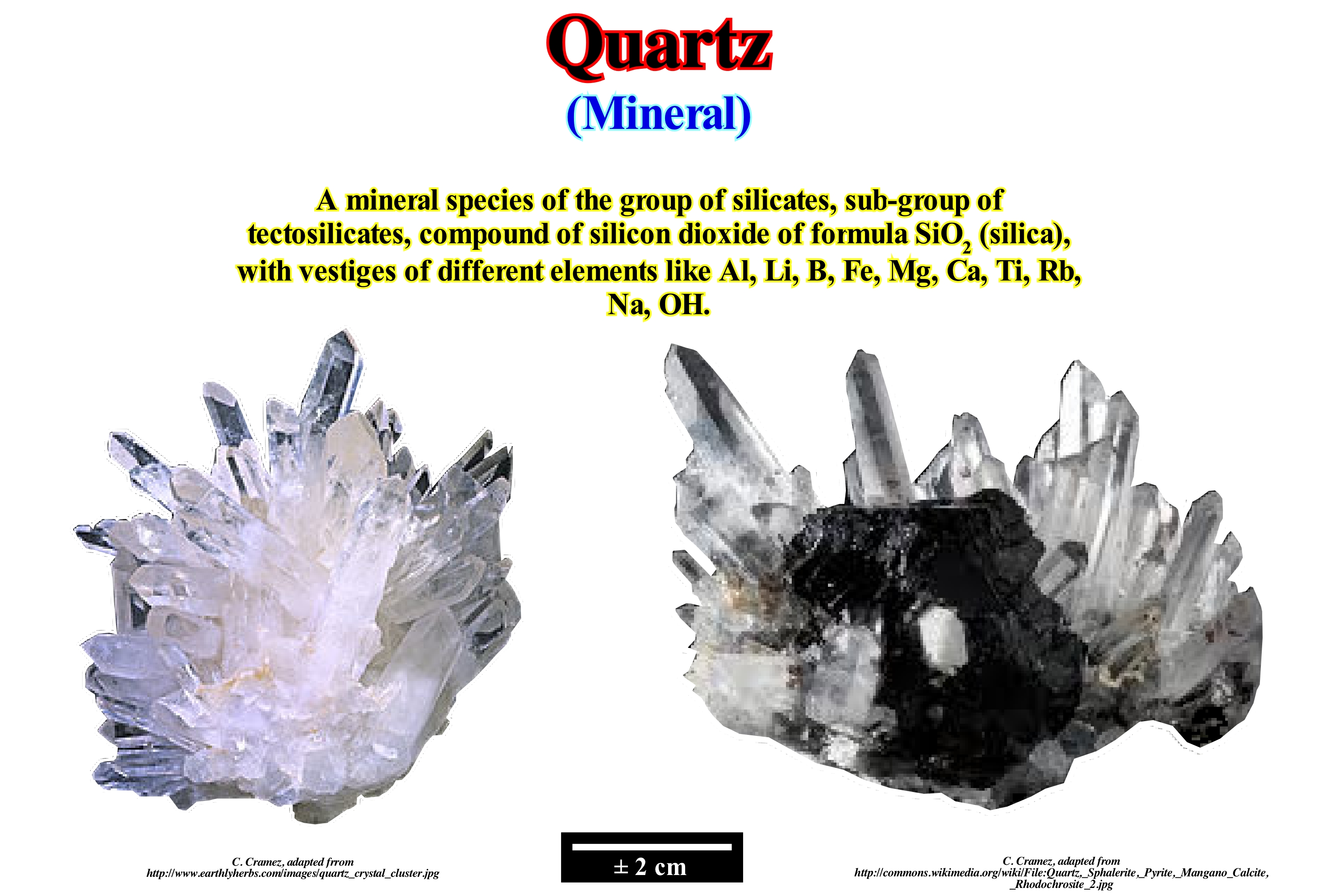
Quartz occurs in lodes or veins (finite volume within a rock, filled with crystals of one or more minerals, which have been precipitated from an aqueous fluid) and in pegmatites (very coarse igneous rock whose grains may exceed 2 centimeters). Very well formed crystals can reach several meters in length and weigh hundreds of pounds. Quartz lode can contain precious metals such as gold or silver and form quartz ores that can be exploited by mining. The erosion of pegmatites may reveal large pockets of crystals known as cathedrals. Quartz is a common constituent of granites, sands, limestones and many other igneous, sedimentary and metamorphic rocks. Quartz crystals have piezometric properties, that is to say, they can develop an electrical potential under the action of mechanical stresses. One of the first uses of this property of the quartz crystals was in the graphon (improved phonograph, which reproduces the sounds recorded on disks). One of the most common uses of the piezometric properties of quartz is oscillatory crystal (electronic circuit that uses the mechanical resonance of a quartz crystal to create an electrical signal with a very precise frequency). The quartz watch uses an electronic oscillation that is regulated by a quartz crystal. The resonant frequency of a quarter crystal changes mechanically when it is subjected to pressure. This principle is used to accurately measure small mass changes with micro-balances (quartz crystals). Pure quartz is usually transparent or translucent. The most frequent varieties of quartz are: (i) Citrine ; (ii) Rose quartz ; (iii) Amethyst ; (iv) Smoked quart z; (v) Milky quartz, etc. Chalcedony is a cryptocrystalline form of silica formed by fine intercalations of the fourth and its monoclinic polymorph moganite.
Quasi-Conformity..............................................................................................................................................................Quase conformidade
Quasi-conformité / Cuasi-conformidad / Quasi Konformität / 拟整合 / Псевдосогласное залегание / Quasi conformità /
Sedimentary interface or seismic reflector, which seems conform, i.e., that it seems in continuity of sedimentation (without hiatus) with the underlying sediments, but that in reality it is not.
See: « Conformity »
&
« Relative Sea Level Fall »
&
« Unconformity »
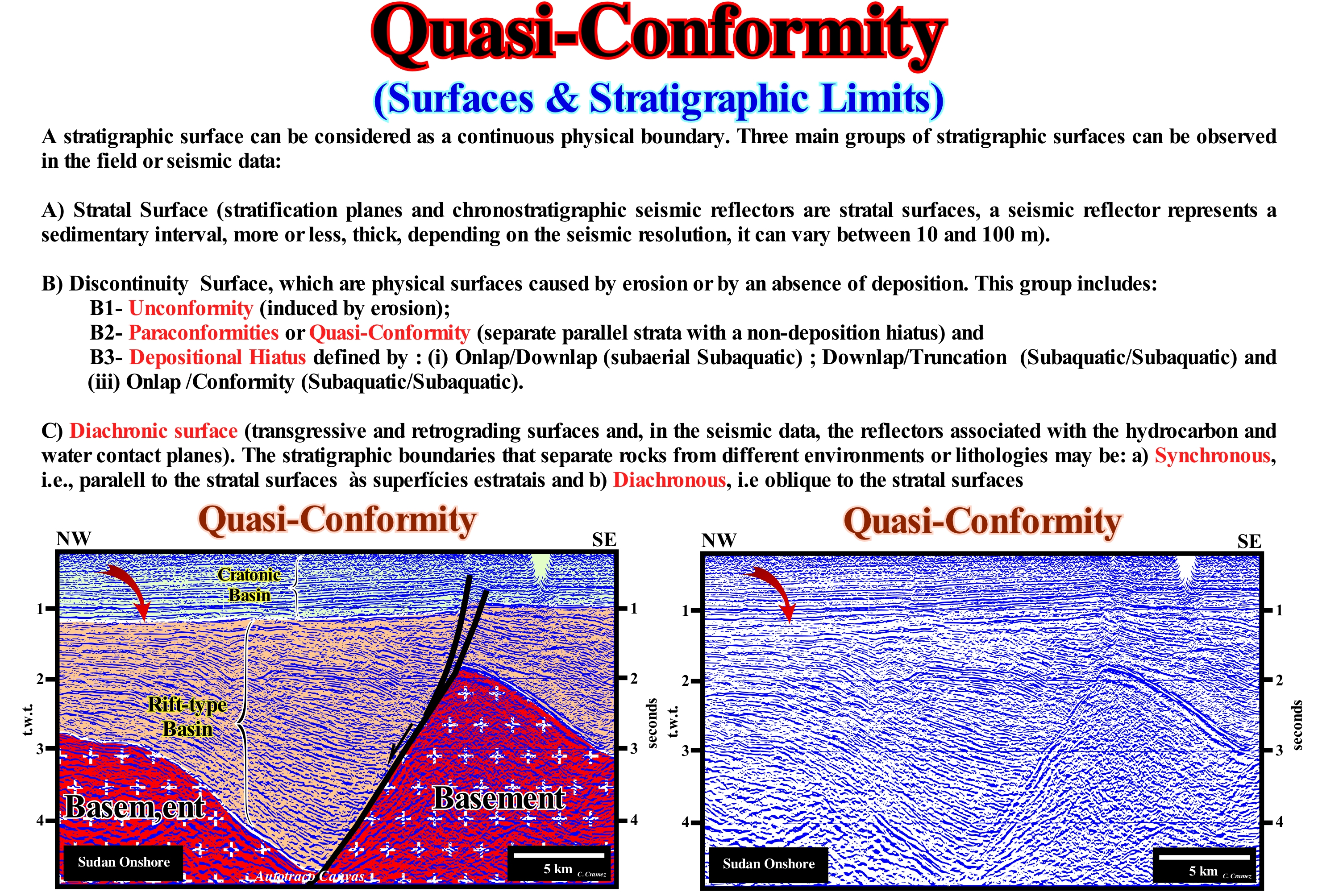
The Sudan onshore corresponds to the stacking of three types of basins from the classification of the sedimentary basins of Bally and Snelson (1980). Theoretically, on a seismic line of this onshore, the geoscientist in charge of interpretation must find, from the bottom up: (i) Basement that, generally, corresponds to a Paleozoic or Precambrian folded mountains belt ; (ii) Cretaceous rift-type basins and (iii) A Mesozoic / Cenozoic cratonic basin. The rift-type basins developed during the lengthening of the small supercontinent Gondwana, probably, in association with a thermal anomaly (isotherms uplift), which induced a differential subsidence, which caused the formation of halfgraben structures in the continental crust. The cratonic basin is, probably, associated with the thermal subsidence created by the cooling of the lithosphere mantle, i.e., by an isotherms subsidence. It can be said lithospheric lengthening (differential subsidence) and isostatic compensation induce a thermal anomaly under the thinned lithosphere or the opposite, cause or effect, which is the thermal anomaly that produces the lengthening and that the thermal anomaly begins to cool, the increase in density presses the lithosphere downward, causing a thermal subsidence. Thermal subsidence occurs exponentially and much more slowly than rapid differential subsidence, as it tries to maintain isostatic equilibrium while the asthenosphere rises, i.e., it cools (the differential subsidence of the lithosphere ceases since thermal subsidence begins). On this tentative geological interpretation of a Canvas autotrace of a detail of a seismic line of this onshore, the interface separating the rift-type basins from the overlying cratonic basin (sag phase for certain geoscientists) can be considered as a quasi-conformity. Seismically, there appears to be no rupture in sedimentation between the two basins basins, although at the SE end toplaps may be brought into evidence, but the reality is, very different. The rift-type basins, which correspond, in this particular case, mainly to lacustrine rocks rich in organic matter (potential source-rocks), which, geometrically corresponding to halfgrabens, were formed due to the continental crust extension. A sediment lengthening can only be achieved by normal faulting, which is, more or less, synchronous with sedimentation. This implies a differential subsidence, which is clearly visible by the increase in sediment thickness against the normal fault planes bordering the halfgrabens. The cratonic basin corresponds to a total change in the type of subsidence. As stated above, during the development of the cratonic basin, subsidence was thermal. Geoscientists still do not know if it is a thermal anomaly (sawing and rising of the isotherms), which produces the lithosphere lengthening, or if it is the elongation that induces the rise of the isotherms. The interface between the two types of basin is marked not only by an important hiatus, but also by a relative sea level fall, since the subsidence induced by the lengthening of the crust no longer exists. The interface, probably, corresponds to an unconformity (erosional surface), but since the relative sea level began to rise, the deposition of the cratonic basin began. Do not forget that all stratal surfaces represent a hiatus. However, when the hiatus is significant, the surface is considered to be an unconformity, which always has a minimum hiatus, which is, often, located in the deep part of the basin. At the level of a sequence-cycle, it is this minimum hiatus that is most appropriate for dating unconformities, i.e., the age of relative sea level fall*.
(*) Local sea level referenced to any fixed point on the Earth's surface, whether the sea floor either the base of the sediments and, which is the result of the combined action of the absolute (eustatic) sea level, which is supposed to be global and referenced to the Earth's centre, and tectonics (subsidence of the sea floor when the predominant tectonic regime is in extensional or uplift of the sea floor when the predominant tectonic regime is in compressional).
Quaternary.....................................................................................................................................................................................................................Quaternaire
Quaternário / Cuaternario / Quartär (Geologie) / 第四纪 / Четвертичный период / Quaternario /
Geological system, which began about 1.8 Ma (millions of years ago) and is part of the Neogene. It consists of two series: (i) Holocene* and (ii) Pliocene, which for certain authors correspond to two geological stages: (a) Calabrian, the lower and (b) Ionian, the upper.
See: « Geological Time Scale »
&
« Glaciation »
&
« Geological Time »
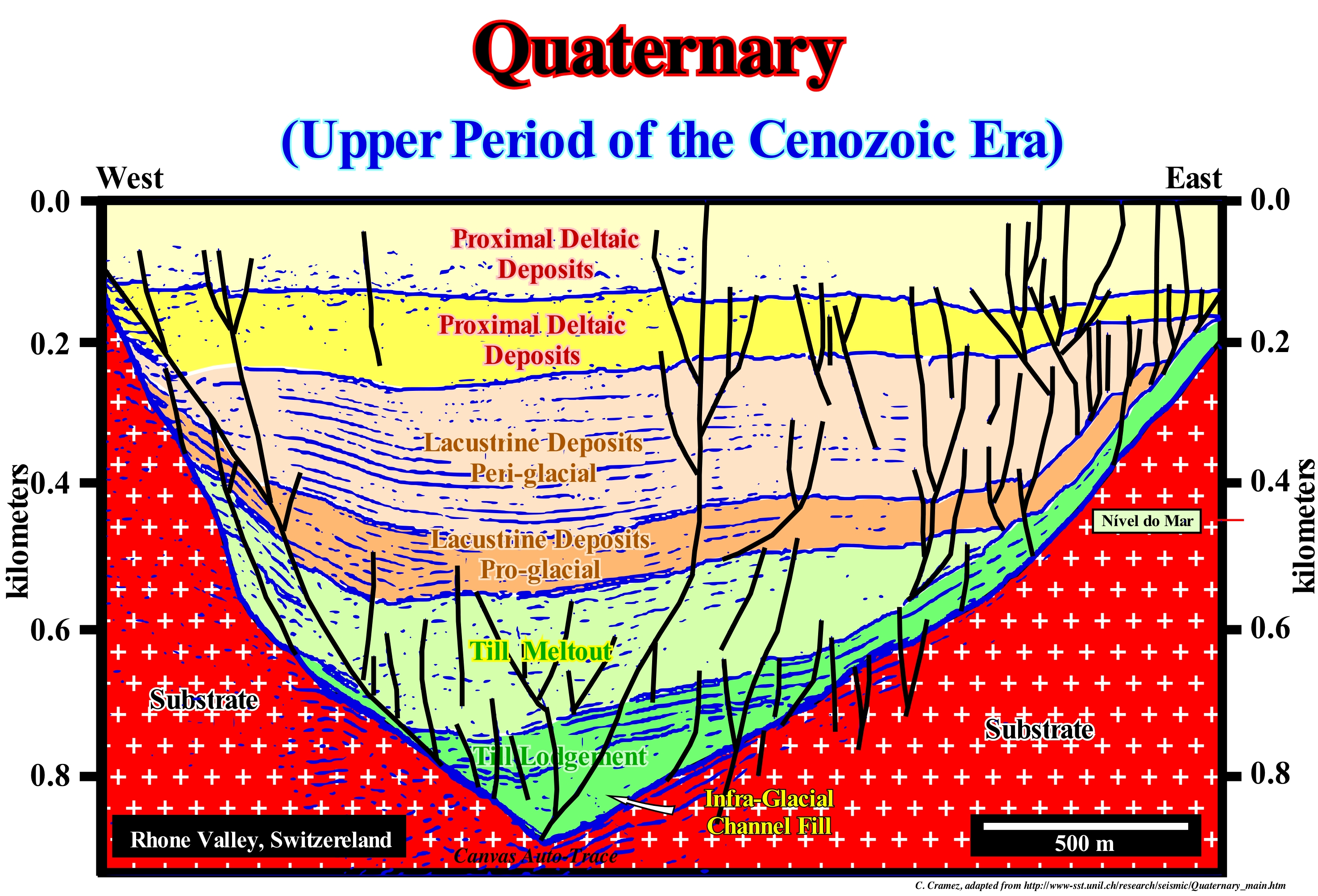
The Quaternary, that is, the last 1.8-1.6 Ma of the Earth's history, represents, more or less, the period of man's existence. In geological terms, this short period of time, which symbolizes about 0.04% of the Earth's history, is irrelevant from a paleontological point of view and, in tectonic terms, represents less than 100 km of oceanic expansion. The most important geological events of this system are certainly: (i) The emergence of the Bosphorus and Skagerrak straits (strait between Norway, SW Sweden and the Jutland peninsula linking the North Sea and Baltic Sea), the closure of which during the glacial epoch transformed the Black and Baltic Sea into great freshwater lakes, before being flooded by the transgression induced by deglaciation ; (ii) The closure of the Bering Strait, between Asia and North America ; (iii) The flooding of the Scablands in North America, etc. In general, as illustrated in this tentative geological interpretation of a seismic line of the "Geothermoval Martigny Project" (Switzerland), most of the Quaternary deposits are associated with the Würm glaciation and the post-glacial period. In this particular case, the Quaternary deposits filled an old glacial valley, whose base is now at about 400 meters below sea level. In this filling, from top to bottom, one can recognize: (a) Lake deposits, poorly individualized at the top of the seismic line ; (b) A proximal delta interval ; (c) Distal delta deposits; (d) Lacustrine, periglacial, well-stratified turbidite deposits ; (iv) Lacustrine pro-glacial deposits ; (v) "Meltout" till, that is, abandoned till by the melting of a debris-rich glacier, in which the debris have, practically, neither been transported nor deformed ; (vi) Lodge till (glacial debris agglutinated in a layer, more or less consistent, but deformed with the movement of the glacier) and (vii) The pre-Quaternary rocky substrate. In paleontological terms, the Quaternary is defined by the appearance of the Benthic foraminifera Hyaline Baltic in the Mediterranean Sea.
(*) As of June 2019, neither the International Commission on Stratigraphy(ICS) nor the International Union of Geological Sciences (IUGS) have officially approved the term Antropocene (epoch dating from the commencement of significant human impact on Earth's geology and ecosystems, including, but not limited to,antropogenic climate change) as a recognized subdivision of geological time although the Anthropocene Working Group (AWG) of the Subcommission on Quaternary Stratigraphy (SQS) of the ICS voted in April 2016 to proceed towards a formal golden spike (GSSP) proposal to define the Anthropocene epoch in the Geological time scale and presented the recommendation to the International Geologicla Congress in August 2016. In May 2019, the 34 member AWG voted in favour of making a formal proposal to the ICS. (https://en.wikipedia.org/wiki/Anthropocene)
Quiescent Period (Magnetism)...........................................................................................Période quiescente (Magnétisme)
Período de acalmia / Período de calma / Ruheperiode (Magnetismus) / 静止期(磁) / Период покоя (магнетизм) / Periodo di riposo (magnetismo) /
Time interval in magnetochronstratigraphy during which the polarity of magnetism did not change, such as the interval between the Santonian (83.5 Ma) and Barremian (121 Ma) during which the polarity remained normal, as it currently is.
See: « Magnetics »
&
" Radiometric Dating "
&
« Polar Wandering »

In this figure is illustrated the geological time in millions of years (Ma) of a part of the Phanerozoic Eon, mainly, of the Mesozoic Era. A part of the Tertiary period, the entire Cretaceous and an Upper Jurassic are represented, as well as, the respective Stages (do not confuse stage with age ; stage is a chronostratigraphic division, i.e., of rocks, whereas age is a geochronological division, that is, a time-division). In the magnetostratigraphy (last column) are drawn the time-intervals during which the polarity of the Earth's magnetic field was normal (N in black) and inverse (I in white). In the Cretaceous, during the intervals of the Campanian and Barremian stages, normal polarity (as at present) remained constant for a long time. Throughout geological history, the Earth's magnetic field has, often, been inverted, with the north pole becoming the south pole and vice versa. Reverse polarities appear at, more or less, regular intervals of thousands or millions of years for reasons which, until now, no one has clearly understood. The long intervals of time in which the magnetic polarity remained constant are designated by the geoscientists as quiescent periods or magnetic calm periods. This magnetic stability seems to be related to the eruption of a superplume (ascension, in the mantle and even in the Earth crust, of enormous quantities of magma, probably originated near the core-mantle interface) that occurred at about 120 Ma (Barremian) and released into the atmosphere, via the volcanoes associated with it, a large amount of carbon dioxide (CO 2). This superplume seems to have not only induced ocean expansion and dispersion of the continents, but also seems to have been the main cause of the rapid acceleration of the expansion velocity (oceanic spread), which tripled during the Middle Cretaceous. With the super-plume eruption, the inversions of the Earth's magnetic field stop for about 40 Ma, that is to say, that the magnetic field remained normal. A single period as long as this one of magnetic stability, but with inverse polarity, occurred during the Carboniferous (between the Late Pennsylvanian and the Early Mesozoic).

