
S Wave.............................................................................................................................................................................................................................................................Onda S
Onda S / Onda S / S-Wellen / S波 / Поперечная сейсмическая волна / Onda S /
Wave that travels through Earth or any other body, displacing the ground, perpendicularly, to the propagation direction. This wave is also called secondary because it travels more slowly than the P wave (longitudinal or compression, which compresses and dilates the terrain, or the body where it travels, in the direction of propagation). An S wave, like a P wave, moves through the geological object through the waves of Love and Rayleigh which are surface waves.
See: « Seismic Wave »
&
« Love's Wave »
&
« Rayleigh's Wave »
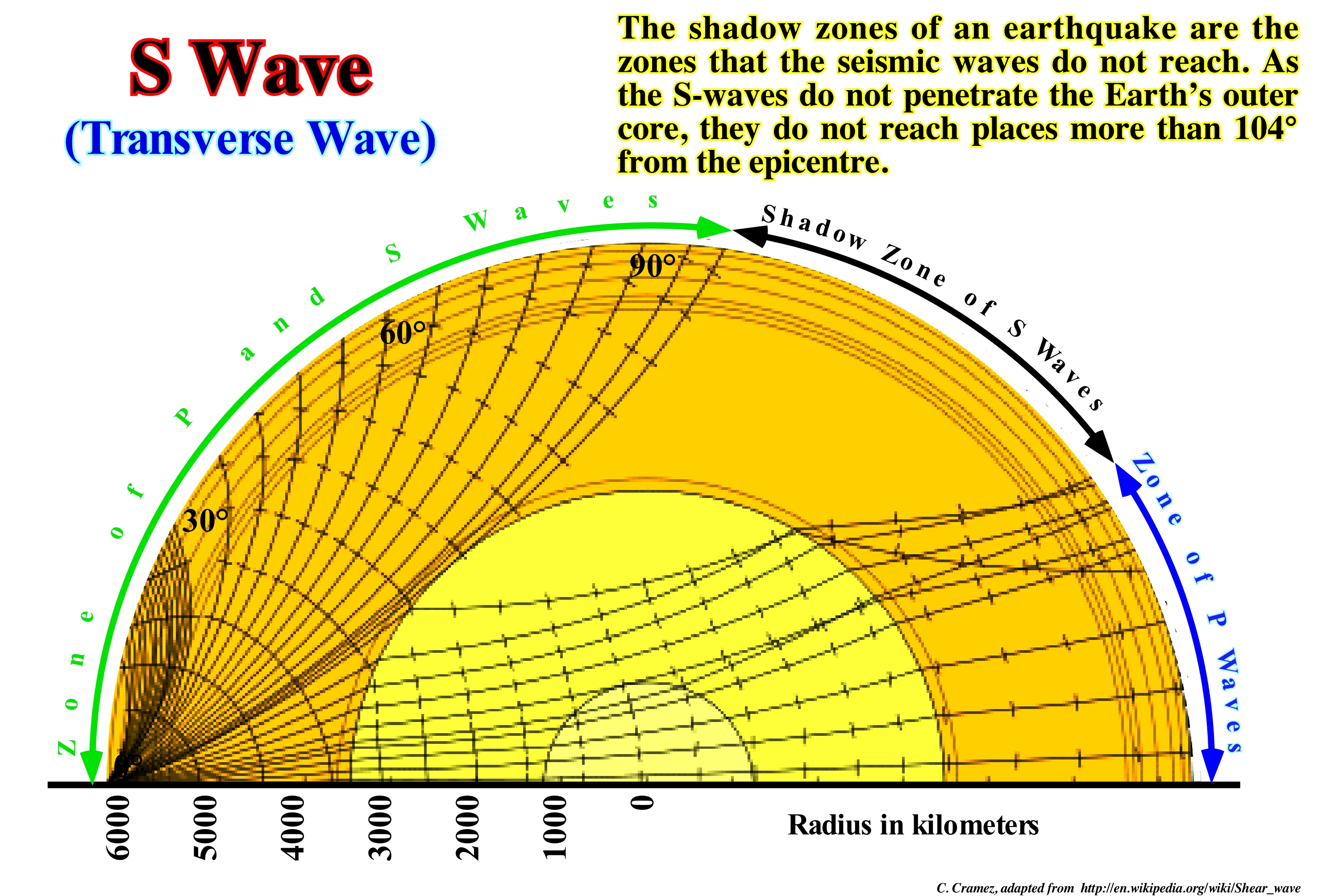
The waves that travel from the hypocenter (or seismic focus, that is, the point where the earthquake occurs in a point depth, the point at the surface resulting from the intersection of the vertical line that passes through the hypocenter is the epicentre) a seismograph are of two types: (i) Surface Waves and (ii) Body or Volume Waves. The former travel to the surface, while the latter travel within the bodies. There are two types of surface waves: (a) Love Waves (b) Rayleigh Waves. Within the volume waves there are two types to consider: (1) P Waves or Longitudinal or Compression Waves, which dilate and compress the particles of the bodies in which they travel in the direction of propagation and (2) S Waves or Transverse or Shear Waves, which push the particles of the bodies where they travel perpendicular to the direction of propagation. S waves travel (through a solid rock) at a speed that is about half the speed of the P waves. On the contrary of the P waves, the S waves do not propagate in liquids or gases. The S waves do not cross the outer part of the Earth's core, which is liquid and therefore forms a shadow zone (S waves) opposite the point where they were created. When geophysicists calculated the P and S wave paths from a hypocenter to the opposite side, they found a shadow zone of the seismic waves, due to the absence of S waves and the large P wave velocity (about 40%), they deduced that the Earth's outer core is liquid. The shadow zone of the S waves also allowed to determine the diameter of the core. This shadow zone extends from the edge of the shadow zone of the P waves (at 104° from the epicentre), and covers the whole section of the earth beyond 104° and up to 256°.
Sabkha......................................................................................................................................................................................................................................Sebkha (sabkha)
Sabkha / Sabkha / Sabcha / 萨布哈 / Солёное болото (в Сахаре) / Sabkha /
Supramareal sedimentary environment formed under arid or semiarid climatic conditions in coastal plains, immediately, above normal high tide level.
See: « Degradation »
&
« Halokinesis »
&
« Alluvial Plain »
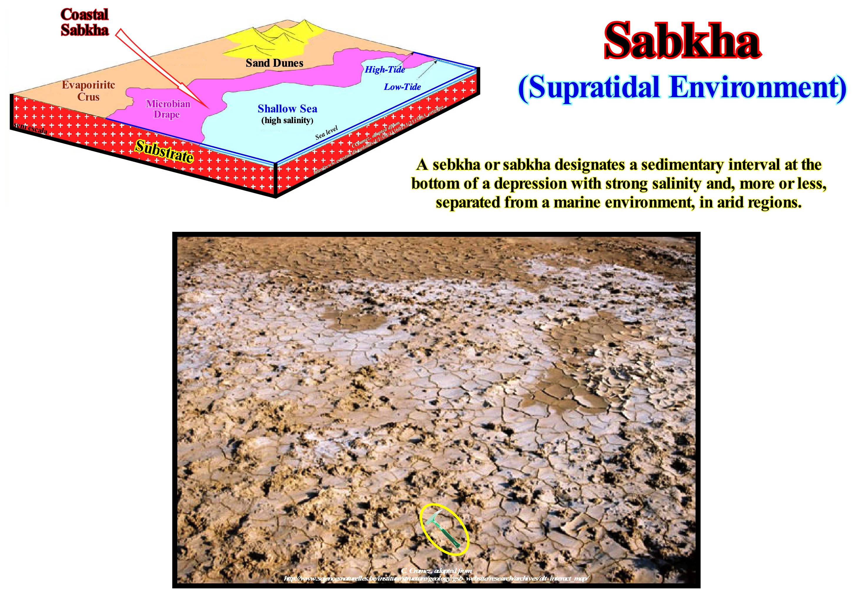
Sabkha is the Arabic name for a flat plain, in which salt minerals are deposited. This term became very frequent in the geological literature since the 60s, at the time of the geological studies of saliferous surface realized, in particular, in the Middle East. Following a small relative sea level rise* (local sea level referenced at any point on Earth's surface, such as the sea floor or the base of the sediments, which is the result of the combined action of absolute sea level and tectonics, i.e. subsidence of the sea floor, when the tectonic regime is extensional, or uplift, when the predominant tectonic regime is in compressional), the coastal plain is flooded creating a continental shelf with a shallow water-depth. An absolute or eustatic sea level fall (supposed global and referenced to the Earth's centre, which is a function of: (i) Tectono-Eustasy ; (ii) Glacio-Eustasy ; (iii) Geoidal-Eustasy and (iv) Thermal dilatation of the oceans or steric sea level rise) can isolate, more or less, important salt-water lagoons which, by evaporation, form a sabkha. In general, a sabkha has a flat topography and is composed of salt-impregnated sandy and clayey sediments immediately, above the water-depth (upper level of an aquifer in which the water pressure equals atmospheric pressure). A sabkha contains, nodules and veins enterocolithic (in the form of bowel folds) of gypsum and anhydrite. A thin crust of halite or plaster may be present in certain areas. Many of the old evaporite sediments exhibit sedimentary characteristics of the sabkhas, such as the occurrence of gypsum nodules. One of the great difficulties that geoscientists encounter when analysing depositional environments is to know what are the factors that characterize a given sedimentary environment. As a typical sabkha environment is, basically, a subaerial environment, it can, actually, lose many of the characteristic indicators by erosion and dissolution. The climate (succession of different states of time that are repeated and succeeded in the atmosphere throughout the year in a given region, determined by temperature, atmospheric pressure, precipitation and wind) is one of the main factors of development of a sabkha. In arid regions where sabkhas form, rainfall occurs, exclusively, during thunderstorms and, on average, does not exceed 4 cm per year. The temperature may exceed 50° C during the day and be negative overnight. Humidity is related to the prevailing wind direction. Humidity is around 20% in the morning. During the afternoon, the interior winds are predominant. At night, the relative humidity can reach 100%, which can create intense fog. The temperature of the water varies with depth. Shallow-water can be about 10° C warmer than deeper water. High temperatures control the evaporation rates, which can reach, for example, in the Persian Gulf, about 124 cm per year, which implies an increase in salinity in the shallow lagoons of about 70 ppt ("ppt" means "parts per thousand" or "0/00"). The effective evaporation rate on a sabkha can reach about 6 cm in all 4-5 M. It is believed that sabkha deposits form some of the most important reservoir rocks. The origin of these hydrocarbons (both gas and oil) may be the microbial mats and the paleosols of mango trees, found in the stratigraphic sequence of the sabkhas, which have up to 8.2% of (TOC, Total Organic Carbon) and hydrogen rates typical of type II marine kerogens. As ancient analogues, one can cite the Permian Kuff, the Jurassic Arab and the Hith anhydrite, Tertiary sedimentary rocks (https://en.wikipedia.org/wiki/Sabkha). Similar deposits are also found in the Williston Basin (Ordovician), the Permian Basin in Texas as well as the Jurassic Gulf of Mexico. Modern sabkhas are present in various forms along the coasts of northern Africa, Baja California and Sharks Bay, Australia.
(*) Kerogen is a mixture of organic chemicals present in sedimentary rocks. They are insoluble in common organic solvents because of their high molecular weight (above 1,000 Daltons). The soluble portion is known as bitumen. When heated within the Earth's crust (oil window at approximately 60° / 120° C, natural gas window at about 120°/150° C) some types of kerogen produce crude oil or natural gas collectively known as hydrocarbons (fossil fuels). When such kerogens are present at high concentrations in rocks, as for example in shales, it is possible that it is a source-rock. In clayey rocks rich in kerogens that have not been subjected to a temperature sufficient to remove the hydrocarbons, they may form bituminous clay deposits. (https://es.wikipedia.org/wiki/Quer%C3%B3geno)
Sahul (Continent).....................................................................................................................................................................................................................................Sahul
Sahul / Sahul / Sahul / Sahul(大陆)/ Сахул (доисторический суперматерик) / Sahul (continente) /
Great continent formed by Australia, Tasmania and New Guinea, which were, more or less, connected by land bridges.
See: « Würm, glaciation »
Salinity Current............................................................................................................................................................................Courant de salinité
Corrente de Salinidade / Corriente de salinidad / Salzhaltigkeit Strömung / 盐度电流 / Солесодержащее течение / Salinità corrente /
Density current of sea water, whose flow is caused, controlled or maintained by its relative high density due to excessive salinity.
See: « Stream »
&
« Downwelling Current »
&
« Rip Current »
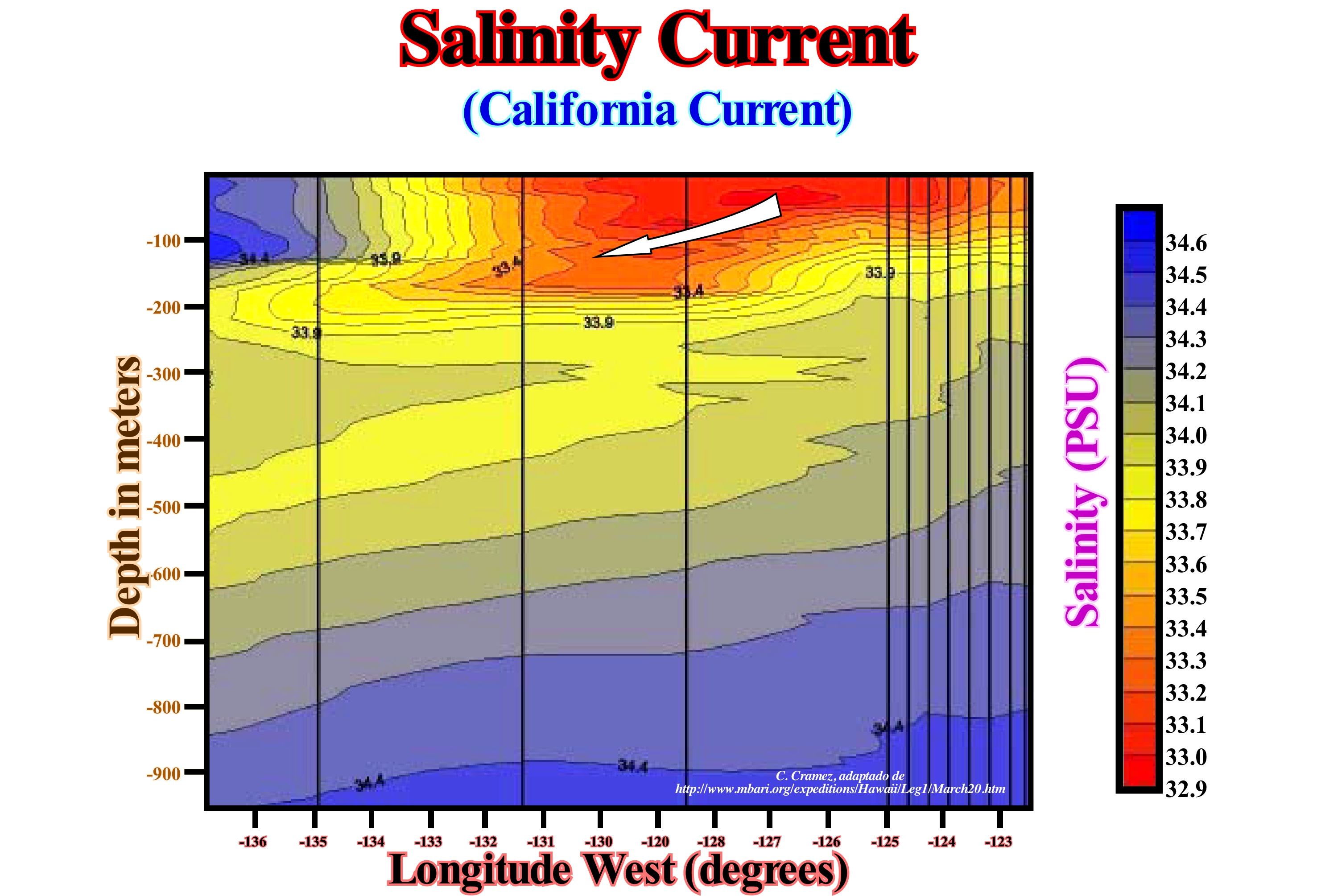
A salinity current is, actually, a density current, in which the flow is caused, controlled and maintained by its relative high density due to excessive salinity. The density currents are kept in motion by the force of gravity acting on a relatively small density difference which may be caused by variations in salinity, temperature or sedimentary particle concentration. Salinity and temperature variations produce the stratification of the oceans. The surface layer, which is disturbed by the waves, is less dense (warmer or less saline) than the deep waters. The oceans are composed of layers of water with distinct chemical and physical characteristics that move more or less independently of each other. Energy can be produced in association with the salinity gradients. This osmotic energy is an alternative renewable energy that does not pollute and does not release CO2. Basically, this energy, which is created from the osmotic pressure difference between fresh and salt water (chemical potential of concentrated or dilute solutions of salt, where the solutions with higher concentration have higher pressure), depends on the evaporation to separate the water of salt. There are several processes to create energy from the salinity gradient, but the most known is by Delayed Osmotic Pressure (DOP). In this process, sea water is pumped into a pressure chamber, where the pressure is less than the pressure difference of fresh water and salt water. Fresh water moves on a semi-permeable membrane and increases its volume in the chamber. As the pressure in the chamber is compensated, a turbine rotates and generates electricity. In other words, since there are two solutions, one of salt-water (A) and one of fresh-water (B) separated by a semi-permeable membrane, only the water molecules can cross the membrane and due to the difference in osmotic pressure between them. The water of solution B will diffuse through the membrane to dilute solution A. The diffusion pressure drives the turbine of the generator that produces the electric energy.
Salt Splitting (Haloclasty).................................................................................................................................................................................Haloclastie
Haloclastia / Haloclastia / Salzsprengung / 盐风化 / Расщепление соли / Sale splitting, Aloclastismo /
Process of mechanical fragmentation of the rocks due to the crystallization of salt from sea salt-spray* and sea water. By evaporation of the salt water, which permeates the cracks of the rocks, the concentrated salt solution and the mineral salts increase in volume.
See: « Salt Spray »
&
« Halokinesis »
&
« Compensatory Subsidence »
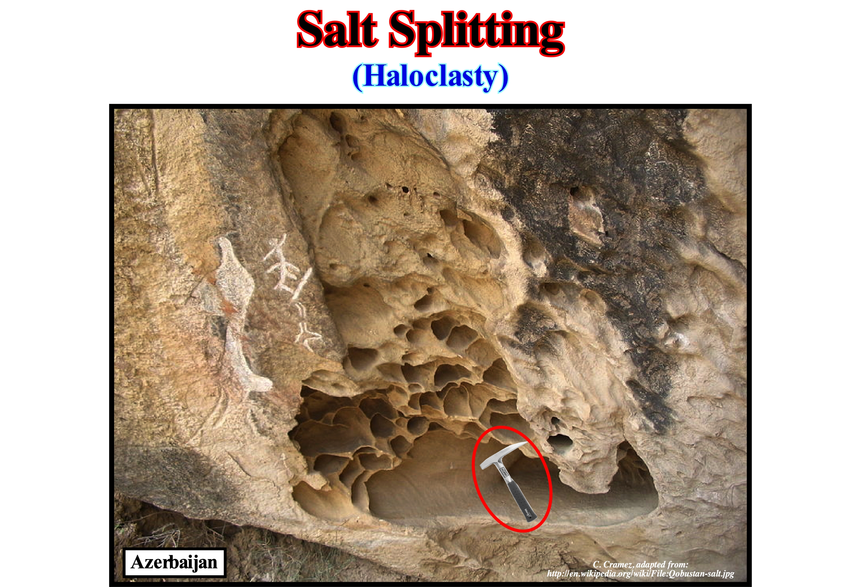
Although some geoscientists translate haloclasty as "salt splitting," haloclasty has nothing to do with what the American authors call "salt splitting" in electrochemical weathering. Haloclasty is a type of physical weathering caused by the growth of salt crystals. The process is initiated when salt water enters fracture or diaclases of the rocks and then evaporates leaving deposit of salt crystals. When the rocks are heated by the simple action of sunlight, the crystals increase in volume, which creates an important pressure on the nesting rock, which in time fractures into, more or less, large pieces. Salt crystallization can also occur when certain solution solutions break down rocks (such as limestone) to form saline solutions of sodium sulfate or sodium carbonate, which, if the moisture evaporates, deposit salt crystals. The most effective salts in disintegrating rocks are sodium sulfate, magnesium sulfate, and calcium chloride. Some of these salts can expand up to three times or more. Haloclasty is, usually, associated with arid climates, where the high temperature causes a strong evaporation and, therefore, the crystallization of the salt. As shown in this figure, haloclasty is, also, very common along the coasts in association with salt-spray. The chemical permeation can be done by: (i) Solution ; (ii) Hydration ; (iii) Hydrolysis ; (iv) Oxidation; (v) Sulfation (addition of sulfur dioxide to limestone produces gypsum - calcium sulphate - which, being more soluble than calcium carbonate, is easily dissolved and washed away by rain) ; (vi) Biological processes. The most common form of weathering or weathering (a set of chemical, physical and biological phenomena that cause rocks and minerals to change) is the release of substances (such as acids) secreted by trees to disintegrate elements such as aluminum and iron in the surrounding soil.
(*) A foam cloud formed by droplets of sea-water and bubbles enclosing saline microcrystals resulting from the surfacing foam that is projected against the shore and transported inland by the wind. Salt-spray is responsible for a characteristic corrosion modeling and the presence of certain biocenoses, that is, balanced associations of animals and plants in the same biotope (the physical environment where the living beings live in an ecosystem) and the formation of other (woody plants) (Moreira, 1984).
(**) When an electric current is applied to sea-water, which causes the separation of a solution, mainly hydrochloric acid, ClH, and a basic solution, especially sodium hydroxide, NaOH.
Salt-Spray (Sea-spray)........................................................................................................................................................................................................Embrun
Salsugem / Rociado y salpicadura / Spritzwasser / 盐雾 / Брызги, водяная пыль / Nebbia salina /
A foam cloud formed by droplets of sea water and bubbles enclosing saline microcrystals resulting from the surfing foam that is projected against the shore and carried inward by the wind. The salt spray is responsible for a characteristic corrosion modeling and the presence of certain biocenoses, i.e., balanced associations of animals and plants in a same biotope (the physical environment where the living beings live in an ecosystem) and the formation of other (woody plants).
See: « Wave Action Level »
&
« Beach »
&
« Brackish-Water »
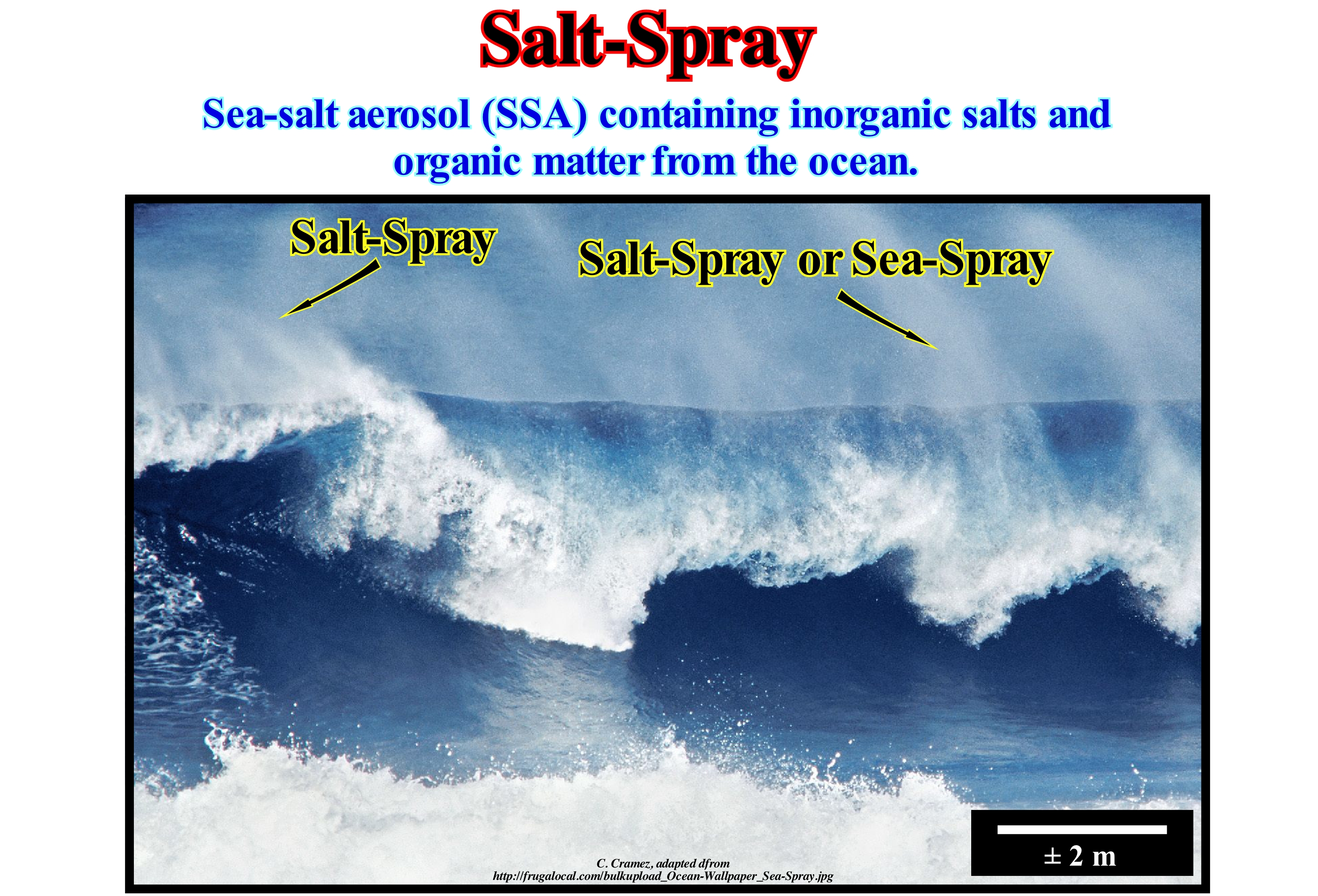
The salt-spray is a spray of sea water (small drops of sea water and air that carries them) that forms when sea waves break or strike against a natural or artificial rock wall. As the salt contains a high concentration of mineral salts (products formed by the neutralization reaction between acids and bases, and cation compounds, i.e., positive ions, and anions, i.e., negative ions), particularly, chlorine anions, it is highly responsible for the corrosion of metallic objects near the coastline. Mineral salts accelerate, greatly, the corrosion process. It is enough to see the corrosion of the metal piers or the cement reinforcement of the piers to understand the corrosive role of the seal. It is well known that salt-spray contributes greatly to the karsification of limestone lines, that is, to the morphogenic process affecting the shorelines constituted by carbonate rocks, which is characterized by the dissolution of calcium carbonate, which is carried under the form of bicarbonate of calcium. This process gives rise to a chaotic aspect surface topography and deep dissolution and runoff forms. The salt-spray is, partially, responsible for the formation of the corrosion alveoli (or bees' nests), which are the small rounded contour holes of depth between centimeters and 2-3 m, excavated in the coherent rocks of the supra-littoral zone that is reached by the salt-spray splashes. In the highest part of the spreading, the runoff from the bubbling drops and foam from the waves can form cutting lapiaz with corrosion ridges. Some geoscientists are even advancing that the sulfur, which releases bromine and chlorine, contributes to the destruction of the ozone layer.
Salt Tectonics (Halokinesis)..........................................................................................................................................................................Halocinèse
Halocinese / Haloquinesis / Halokinese, Salztektonik / 盐构造 / Соляная тектоника / Tettonica del sale /
A form of salt tectonics in which the salt flow is, just, due to its buoyancy, i.e., due to the release of the potential energy of gravity. Halokinesis is induced by lateral and vertical flow of evaporite levels in the absence of any significant lateral tectonic stress, i.e., in the absence of a compressive tectonic regime.
See : « Salt Weld »
&
« Evaporite »
&
« Compensatory Subsidence »
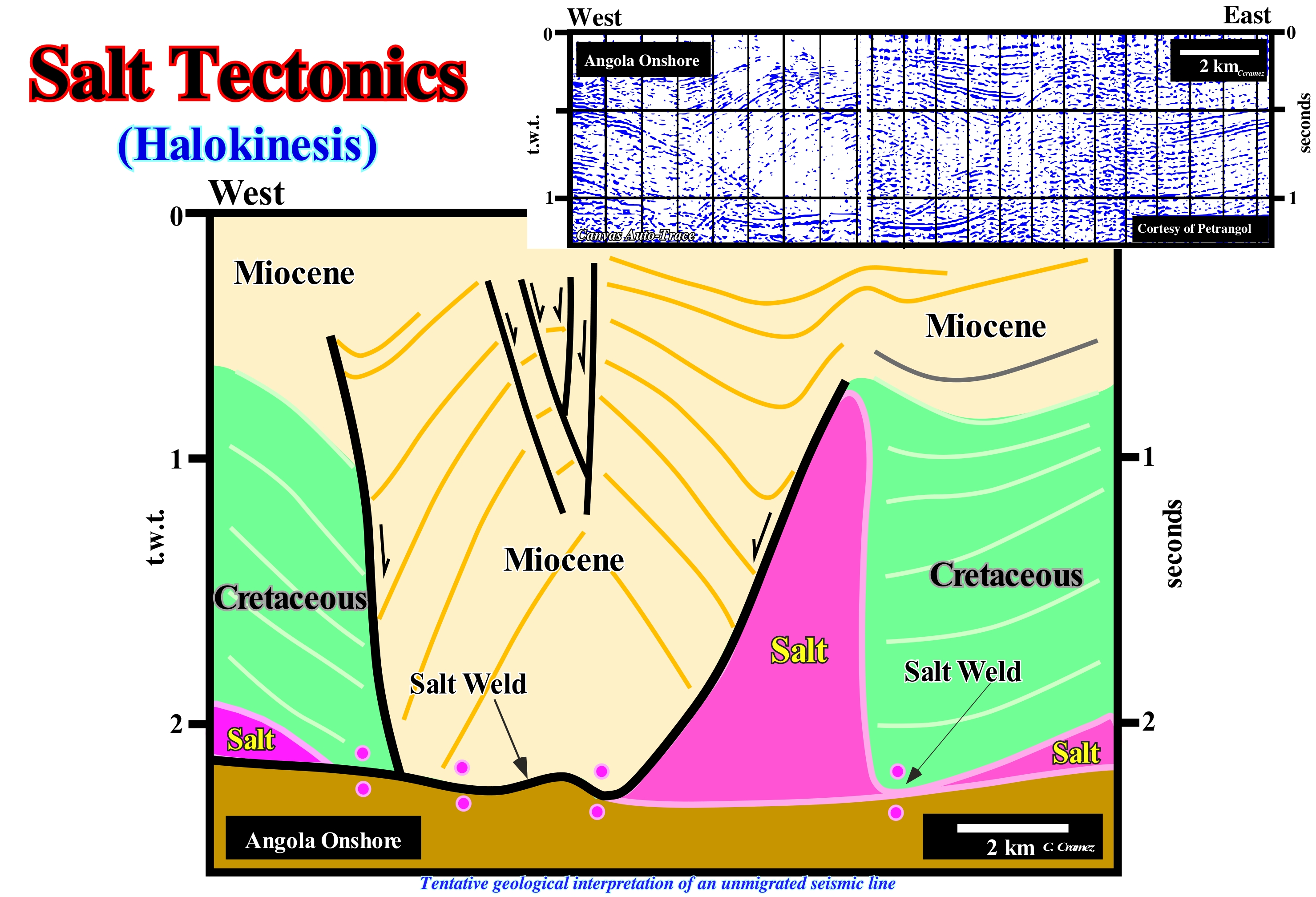
This tentative geological interpretation of a Canvas auto-trace of Angola onshore seismic line, shot in the 1960s (unmigrated line), is, approximately, the same as that proposed by the Petrangol's geoscientists (a subsidiary of the former Petrofina, which was later bought by Total SA). In the 1960s, Petrangol's geoscientists working on the Angola onshore (Kwanza geographic basin) advanced the hypothesis that certain structures and, especially, the variations in sediment interval thickness observed in the field and on seismic lines, could just be explain by a lateral and vertical flow of the saliferous horizons that had been crossed in the wells drilled in the onshore. The salt horizons do not outcrop. An enormous thickness variations of the sedimentary intervals had already been described by the Sinclair's geologists (American oil company), who worked in the Kwanza onshore between 1904 and 1922. Brognon and Verrier (1966) and later Masson (1972), explained the structure illustrated on this tentative interpretation (Quenguela Norte oil field), by a minimal extension (absence of tectonic regime) and a maximum reduction of salt (flow). In the 1990s, Duval, Cramez and Jackson (1992), taking into account the significant shortening (compression) of the sediments observed in the deep offshore area, proposed a, completely, different model, i.e., a model based on an maximum lengthening and minimum salt reduction. Locally, that is, outside the regional geological context, it can be said that: (i) Quenguela's antiform structure ; (ii) The variations of Miocene thickness and (iii) The absence of Cretaceous in the core of the antiform, can be explained by the two models. However, in view of the geological context of the basin, the compressive structures, observed in the deep offshore, can only be explained as a counterpart of the extension of the sediments in the upper (proximal) part of the basin.
Salt Tectonics (Lato sensu)...................................................................................................................................................Tectonique salifère
Tectónica do sal / Tectónica salífera / Salztektonik / 盐构造 / Соляная тектоника / Tettonica del sale /
Lengthening of the sediments involving the salt, or other evaporites as the moving interval. When the sediment compact, they become denser than the salt, whose density (2,15/2,17) remains constant in depth (the salt does not compact). On the pressure of the overlying sediments and independently of any tectonic stress (σt), the salt can flow vertically and laterally (halokinesis), since it can become less dense than the overlying rocks (inversion of density).
See: « Evaporite »
&
« Compensatory Subsidence »
&
« Relative Sea Level Change »
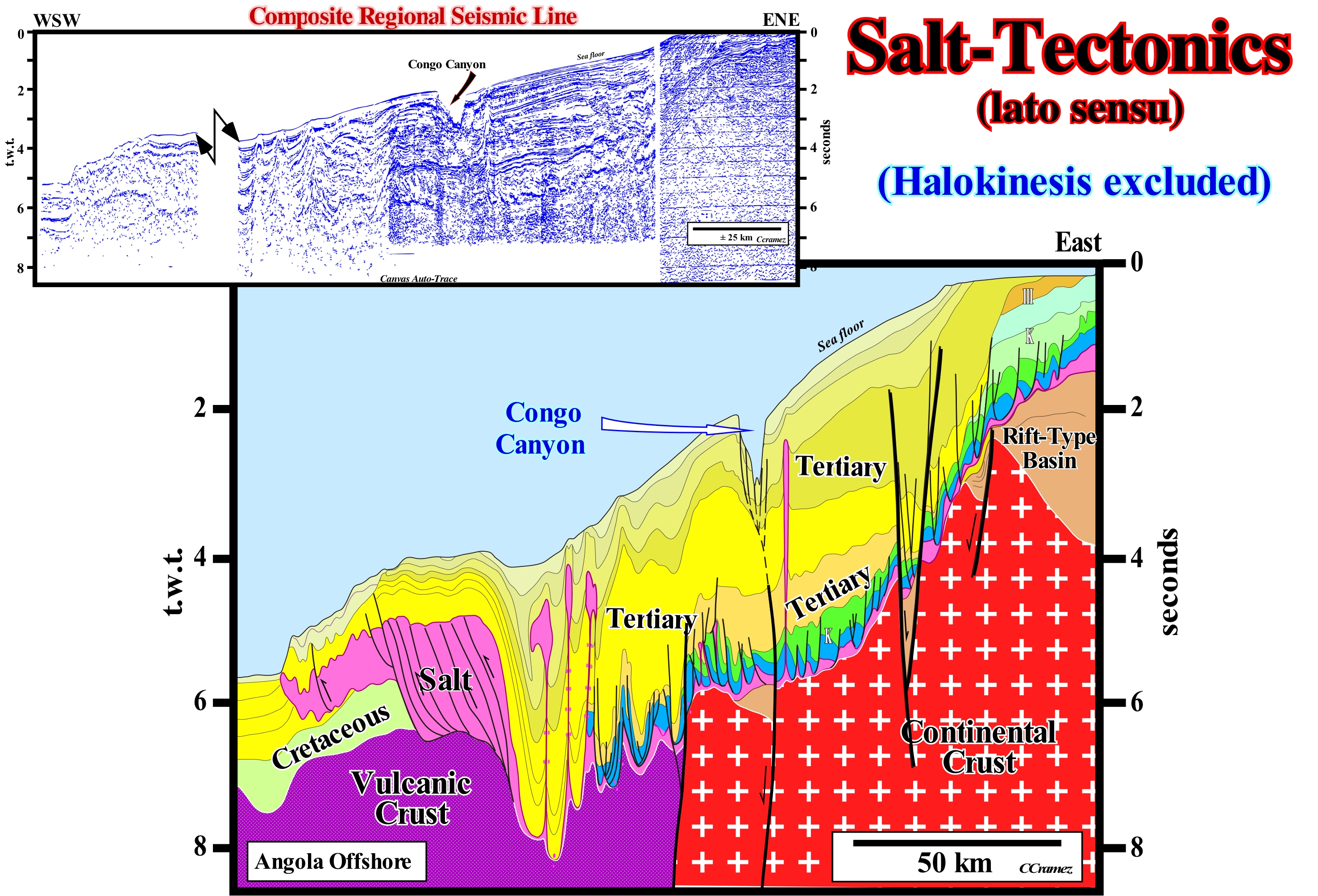
Like any other rock, evaporites are deformed (shortened or lengthened) under the action of the effective forces (σ1, σ2, σ3). However, as stated above, they can deform without any tectonic stress (σt) being present, which induces in overlying sediments important thickness variations due to compensatory subsidence. The salt deformation (lateral and vertical flow) produces an important tectonic disharmony between the infra- and suprasaliferous sediments. The infrasaliferous sediments retain their original positions, whereas the suprasaliferous sediments not, being the lengthening to be synchronous or posterior to sedimentation. The tectonic disharmony is, sometimes, marked by a salt-weld, when the thickness of the salt becomes zero or lower than the seismic resolution. The great majority of geoscientists use the tectonic expression when the dominant tectonic regime is in extension (enlargement, vertical σ1) and halokinesis when the tectonic regime is in equilibrium (lengthening, that is, vertical σ1, but with σ2= σ3). that is, σt= 0). When the predominant tectonic regime is compressive (shortening), the salt-tectonic expression is not used, except that if the salt is, later, deformed itself widening the overlying sediments. As illustrated on this tentative geological interpretation of a composite seismic line from the Angola offshore, in the distal part of the offshore, there is almost always a local compressional tectonic regime induced by the extension produced by the salt upstream. In the Atlantic margins, at small scale, almost all salt structures can be explained by halokinesis, however at large scale, halokinesis is secondary to the salt tectonic (lengthening).
Salt Weld.................................................................................................................................................................................................................Cicatrice salifère
Cicatriz salífera / Cicatriz salífera / Salz Schweißnaht / 盐焊接 / Соляная прослойка / Cicatrice di sale, Saldatura di sale /
Surface or junction zone of strata, originally separated by autochthonous or allochthonous salt. A salt weld is a negative salt structure that results from a complete or nearly complete removal of the salt. On seismic lines, a salt weld is often, partially, filled by salt or salt residues with a thickness less than seismic resolution. One of the most significant characteristics of salt welds is the structural inversion of the overburden. Synonym with SaltSuture and Salt Soldering.
See: « Allochthone »
&
« Halokinesis »
&
« Compensatory Subsidence »
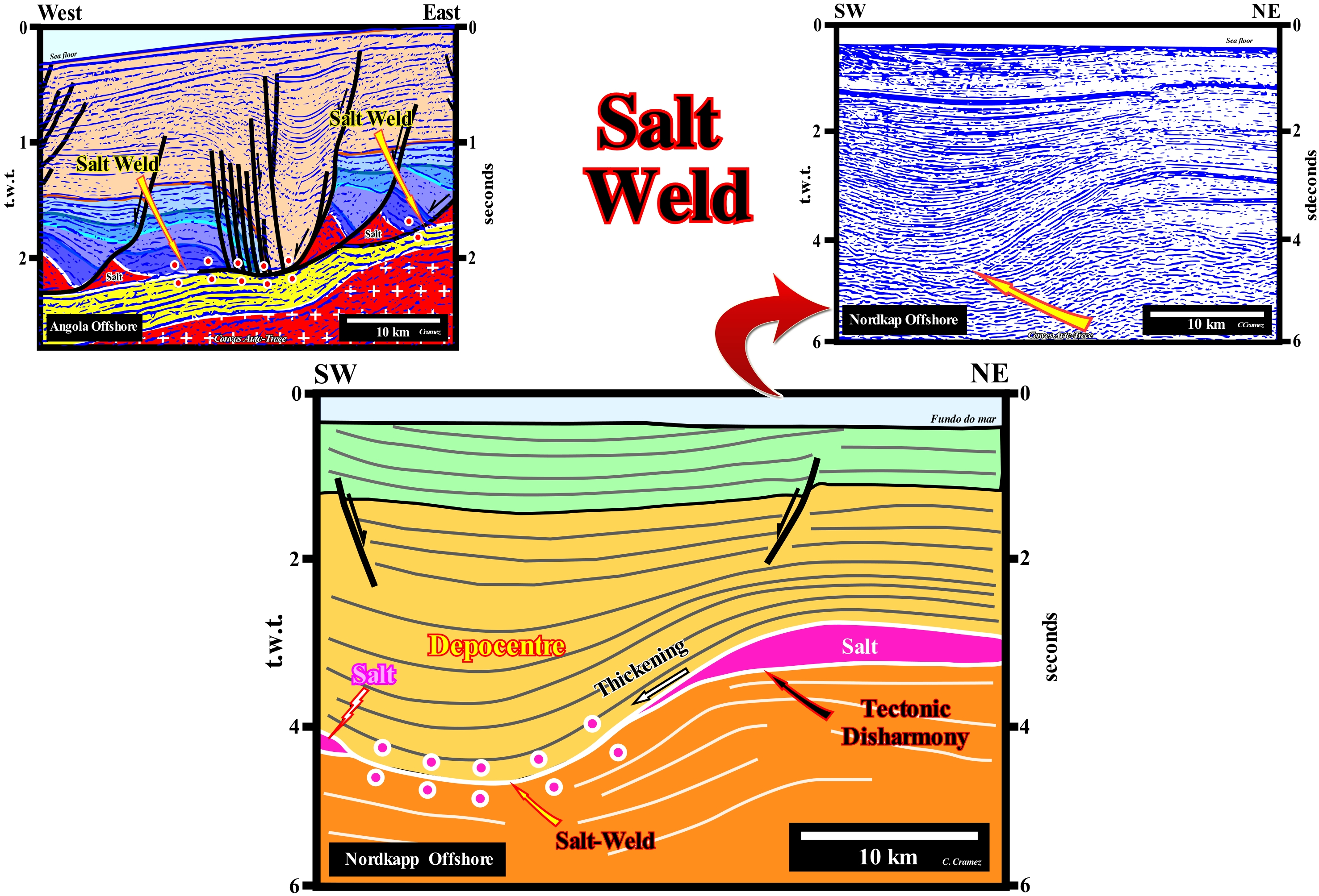
The term salt-scar was first used by the Belgian geoscientists of Petrangol (Petrofina in Angola) in the 1960s, when searching the onshore of the Kwanza geographic basin (Angola). They advanced the conjecture that the lateral variations of thickness of the sedimentary intervals found in the geological sections were induced by lateral flows of a salt interval deposited near the base of the divergent continental margin (Atlantic type) that covers the Late Jurassic/Early Cretaceous rift-type basins. On seismic data, they noticed that certain normal faults and tectonic disharmonies, more or less, filled with salt, were the results of the collapse and lateral evacuation of the salt and, in particular, of certain salt domes. It was to this type of structures that they called salt-scars. These structures were better understood and defined by Total's geoscientists, who explore the areas abandoned by Petrangol after making a large number of noneconomic discoveries and two or three economic oil fields as Quenguela Norte field (around 40 Mb of recoverable reserves). On the tentative geological interpretation of a Canvas auto-trace of a detail of a Nordkapp offshore seismic line (Norway offshore), it is, easy, to recognize a salt weld (also called a salt suture). The evaporitic interval (in violet) is visible on each side of the salt weld, underlined in the tentative interpretation, by small circles above and below the tectonic disharmony, that the lateral evacuation of the evaporites produced. Post-salt sediments are deformed (lengthened) by halokinesis (salt tectonics, σt=0), whereas the infrasaliferous sediments are. practically, nondeformed. On the tentative geological interpretation of seismic lines of basins with salt intervals, geoscientists should take into account the pitfalls induced by lateral velocity variations in thickness of salt intervals and by suprasalt depocenters (areas with greater thickness or areas that have higher isopic values of the stratigraphic unit considered). The greater the thickness of the salt intervals, the faster the seismic waves reach a certain point, since the velocity of the seismic waves is higher within the salt than within the shale/sand sediments. That means means the underlying seismic horizons to a thick salt interval are, apparently, pulled-up, while the seismic horizons underlying a thick suprasalt depocenter are, apparently, pulled-down. In a depth version of the original seismic line of the Nordkapp offshore, the base of the salt interval is, more or less, subhorizontal and not wavy, as suggested on this tentative interpretation. The depocenter is, almost exclusively, the result of the differential subsidence induced by the lateral flow of the evaporites forming the salt interval. Indeed, on this tentative interpretation, the orange-coloured supra-salt interval, which is located above the salt weld, may be explained by a compensatory subsidence induced by lateral salt flow, which produces a local subsidence creating more space available for sediments (accommodation). In this particular case, it is evident that the lateral movement of the salt was initiated by its own weight (geostatic pressure). It began to flow from the end of the salt interval*. The first postsalt interval shows, already, an increasing in thickness towards the salt-weld. On the tentative geological interpretation of a Canvas auto-trace of an Angola offshore seismic line, salt-welds and suprasalt depocenters are, easily, recognized in association with the salt interval, which flowed, laterally, towards the deep part of the basin (westward) creating preraft structures (characteristic of the early stage of lengthening induced by the salt interval during which the faulted blocks of the salt overburden still rest on the original footwalls and rafts structures (allochthonous fault blocks of the salt overburden individualized by lengthening since they no longer rest on their original footwalls and are, directly, on a detachment level, which is, usually, is the salt.
(*) Taking into account that, theoretically, the salt whose density 2.15 - 2.17 g/cm3 does not vary in depth and it becomes plastic under a vertical pressure of ± 110 bars (unit pressure equals 10,000 Pa) , it can be said the initial thickness of the evaporite horizon exceeded 500 meters.
Salt Weld (Salt suture).....................................................................................................................................................................................Suture salifère
Soldagem salífera / Sutura salífera / Schweißen salzhaltigen / 焊接含盐 / Соленосный шов / Saldatura di sale /
Surface or junction zone of strata separated, originally, by autochthonous or allochthonous salt. A salt weld is a negative salt structure that results from a complete or nearly complete removal of the salt. On seismic lines, a salt weld is often, partially, filled by salt or salt residues with a thickness less than seismic resolution. One of the most significant characteristics of salt welds is the structural inversion of the overburden. Synonym with Salt Suture and Salt Soldering.
See: « Glacio-Eustasy »
&
« Subsidence »
&
« Compensatory Subsidence »
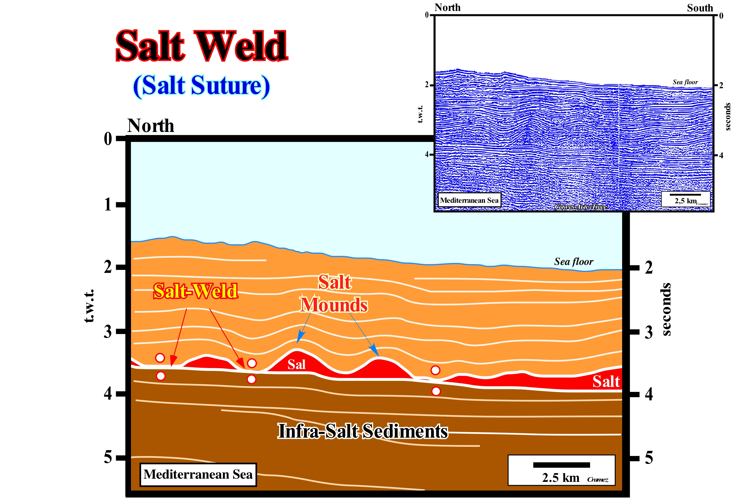
A salt-weld or salt-suture may consist of an insoluble brecciated residue composed of halite pseudomorphs or a thin salt interval (under seismic resolution) or a total absence of salt. A salt-suture is, but not always, marked by a tectonic disharmony (not to be confused with an unconformity, which implies a significant erosion). Another characteristic of the salt-sutures, as illustrated on this tentative geological interpretation of Mediterranean Sea seismic line, is the presence of a structural inversion in the postsalt sediments. This means that the salt mounds are not anticlines but rather antiforms. They correspond to lengthened structures created, in general, by a lateral flow of the evaporitic horizon. There are three types of salt welds: (i) Primary Welds; (ii) Secondary Welds and (iii) Tertiary Welds. Primary salt welds join strata, originally separated by autochthonous evaporites. These sutures are, usually, slightly tilted. They bring into contact, relatively, tilted infrasalt sediments with suprasalt sediments, which, locally, dip more sharply, which creates a tectonic disharmony. The dip is, locally, enhanced by the rotation of the sediment, by listric faults or compensatory subsidence. The secondary salt-welds join strata, originally. separated by diapiric structures (salt-walls, salt mounds, etc.). They are almost vertical. The tertiary salt-welds join sedimentary intervals, originally, separated by first order or higher order salt structures (overhangs, tongues, mantles, etc.). It is important to note that the internal configuration of the supra-salt intervals allows to determine if the lateral and vertical displacement of the evaporites is coeval of the sedimentation, slightly, later or very late. On this tentative of interpretation, the divergent configuration of the first post-salt interval suggests a precocious salt flowage.
Saltation............................................................................................................................................................................................................................................Saltation
Saltação / Saltación / Saltation / 突变 / Скачкообразное передвижение частиц / Saltation /
One of several ways sedimentary particles can be transported in a flow (flux). The sedimentary particles are, usually, transported by a combination of: (i) Rolling or sliding on the rocky substrate ; (ii) Salting (jumps in the flow to after falling and resting on the substrate) and (iii) Suspension in the flow.
See: « Transport (sediments) »
&
« Sediment »
&
« Base Flow »
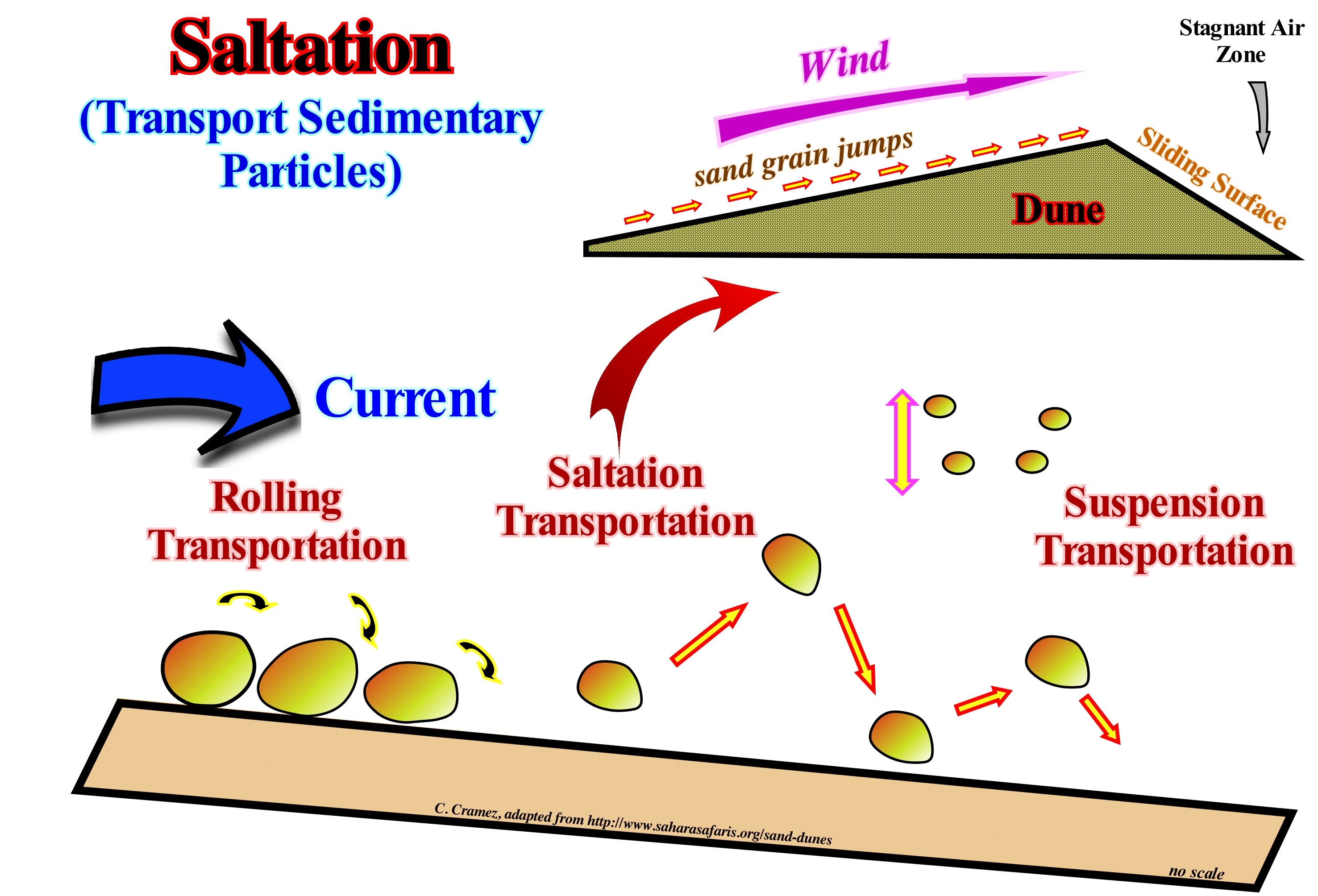
Saltation is a process of transporting the sedimentary particles by a fluid, either water or wind. Sedimentary particles the size of sand or gravel when carried by a fluid are, usually, displaced by jumps. In geology, it can be said saltation is a specific type of transport of sedimentary particles by fluids. Saltation occurs when the unconsolidated material, taken from the substrate or bed of a water-course, is carried by the fluid before it falls on the surface from which it was drawn. Examples of saltation include gravel transport by rivers, desert sand, soil over agricultural fields or even snow on the smooth surfaces of the Antarctic or Canadian prairies. Since a fluid flows at low speed, the unconsolidated sedimentary material rolls downstream, always being in contact with the surface of the substrate. It's what geoscientists call rolling, sliding, rebounding or tolling. In this case, the forces exerted by the fluid on the sedimentary particles are just sufficient to roll the particles around the point of contact with the surface. At great velocity, the uplift and the momentum exerted by the fluid on the particles are sufficient to transport them away from the surface in the flow. In the beginning, the sedimentary particles move, rapidly, in relation to the flow and, therefore, they rise and move upwards away from the surface. As the particles move towards a faster flow, the velocity difference between the particles and the flow decreases. When the weight of the particles is higher than the rising force, the particles fall back to the surface. During the fall, the particles retain, more or less, the speed they have acquired and return to the surface of the substrate at a velocity greater than that of the flow near the substrate. This creates a, more or less, parabolic particle path through the fluid, which is characteristic of a saltation transport.
Saltation (Transport)........................................................................................................................................................................Transport saltitant
Saltação / Transporte por saltación / Transport von Saltation / 由突变的运输 / Скачкообразное передвижение / Trasporto per saltation /
Transport by jumps of loose material, that is, material that is removed from a layer and transported by a fluid to return to the surface of the layer again. Examples of this type of transport are the transport of pebbles through a river, the sand on the surface of the deserts, the soil over the fields, as well as snow on flat surfaces such as in the Arctic or Canadian prairies.
See: « Charge (stream) »
&
« Flux (flow) »
&
« Traction (sediments) »
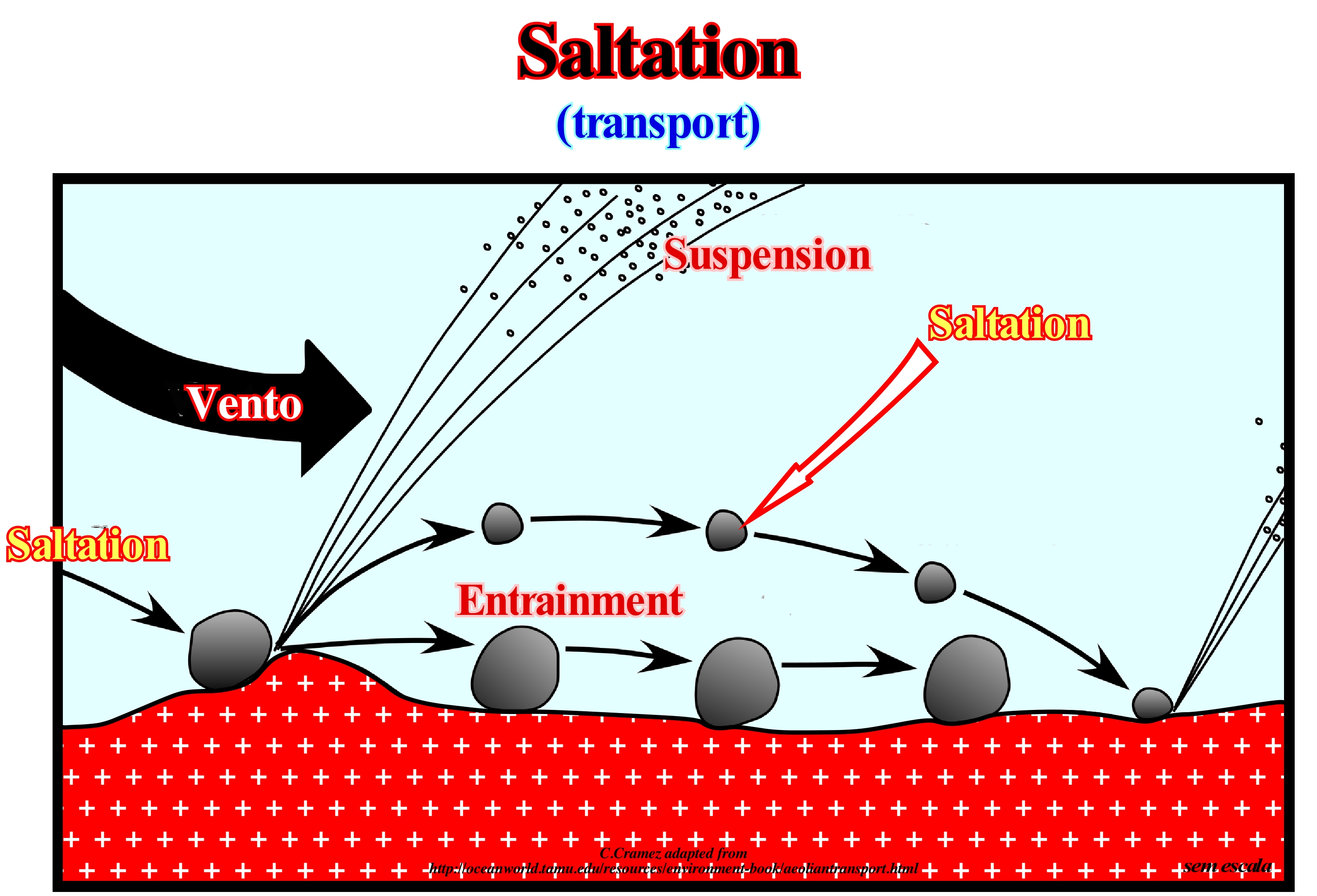
When a fluid flows at a small speed, the loose material it contains is displaced by rolling or dragging (entrainment) in the direction of the flow, i.e., the sedimentary particles are always in contact with the material-fluid interface. In this case, as illustrated in this sketch, the forces exerted by the fluid on the sedimentary particles are sufficient just to cause them to roll around the point of contact with the surface. When the velocity of the fluid (water or wind) is greater, the uplift and momentum exerted by the fluid on the particles is sufficient for some of them to move away from the fluid-material interface and into the flow. At first, they move faster than the flow and are therefore uplifted away from the interface. However, as the sedimentary particles move away from the material-fluid interface, they enter a faster flow and the velocity difference between the particles and the flow decreases, which makes the rising force smaller and smaller. When the weight of a particle is greater than the rising force, it falls back to the surface of the interface. As during the falling the particles retain some of the velocity in the faster flow zone, they return to the surface of the interface faster than the flow has at the interface. This forces the particles to make a parabolic trajectory through the fluid, which is one of the characteristics of the bouncing transport or saltation. When the particles reach the surface of the material-fluid interface, i.e. when they reach the ground, they can dislodge other particles, especially, the smaller ones. If the fluid velocity is too great, smaller particles can go into suspension, which is very common when the fluid is wind and, particularly, during dust storms. In the rivers this process is repeated continuously, which erodes the bed of the river and transports new upstream material.
Sand..........................................................................................................................................................................................................................................................................Sable
Areia / Arena / Sand / 沙 / Песок / Sabbia /
Sedimentary particle or clastic sediment, mobile sediment with a diameter ranging from 0.06 to 1 mm. Several granulometric patterns can be considered: (i) Very fine sand ; (ii) Fine Sand ; (iii) Medium Sand ; (iv) Coarse Sand and (v) Very Coarse Sand.
See: « Granulometry »
&
« Granule »
&
« Pebble »
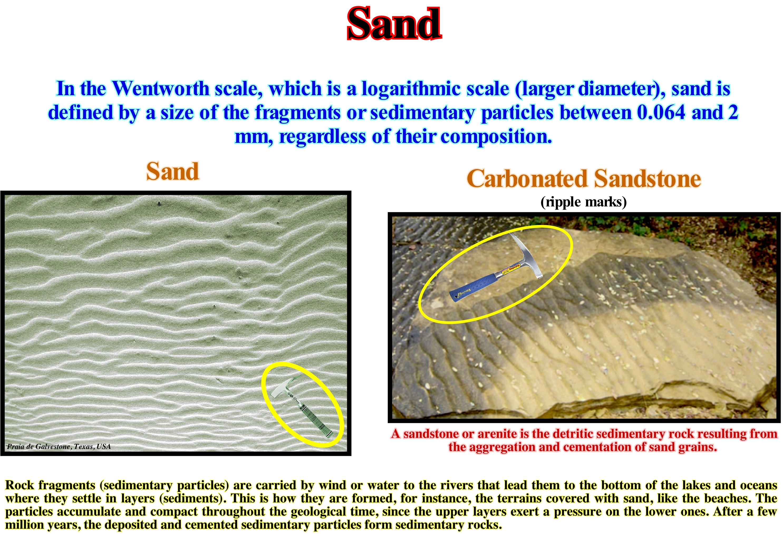
In the Atterberg granulometry scale, when the grain diameter varies between 0.02 and 0.25 mm, a sand is considered as Fine Sand. When the diameter varies between 0.25 and 2 mm, it is considered as Thick Sand. The grain size scale of Wentwork is a little more detailed, since more types of sand are considered: (i) Very Fine Sand, when the grain diameter varies between 0.06 and 0.12 mm, i.e., with values of φ between 4 and 3 (Krumbein scale, φ = - log2 [diameter in mm]) ; (ii) Fine Sand when the diameter varies between 0.12 and 0.25 mm or, with φ between 3 and 2 ; (iii) Medium Sand, when the diameter is between 0.25 and 0.50 mm or, with φ between 2 and 1 ; (iv) Coarse Sand, when the diameter varies between 0.50 and 1.0 mm or φ between 1 and 0 and (v) Very Coarse Sand, when the diameter between 1.0 and 2.0 mm or φ between 0 and -1. In the onshore (upstream of the shoreline) and in a nontropical geological context, silica (silicon dioxide, or SiO2) is the main constituent of the sands, particularly, in its quartz form due to its chemical inertia and its hardness, which makes it resistant to atmospheric changes. The composition of a sand varies greatly depending on the nature of the soil and the climate. In tropical and subtropical contexts, white sands are often the result of erosion of limestone rocks. They contain,often, coral fragments and shells as well as other limestone and organic fragments. Many sands contain magnetite*, chlorite, glauconite** and even gypsum. The sands rich in magnetite are, generally, black, while those rich in chlorite and glauconite are green. The sands derived from basalts contain a high olivine content. Sometimes the magnetite content of the sands is so important that they are used as iron ore. In the petroleum exploration, sands are excellent reservoir-rocks, particularly, those that are slightly cemented, since cementing retains sand when oil is produced, which it is not, often, the case when they are not cemented.
(*) Iron oxide: Fe3 O4 with 72% iron and high magnetism and density 5.5 to 6.5. It has a semi-metallic black glow.
(**) Green monoclinic mineral, phyllosilicate (from the group of mica) hydrated potassium and iron, authentically formed in the marine sediments deposited under a water depth between 50 and 300 meters. It has poor resistance to weathering (https://pt.wikipedia.org/wiki/ (lN).
Sand Island.........................................................................................................................................................................................................................Île de sable
Ilha de areia / Isla de arena / Sand Insel / 桑迪岛 / Искусственный остров / Isola di sabbia /
Land surface emanating from the waters of the sea or a lake, isolated from the continental area. An islet is a small island and an ait or eyot is a land surface smaller than an islet, particularly, in a river.
See: « Pinnacle, Stack »
&
« Rocky Islet »
&
« Shoreline »
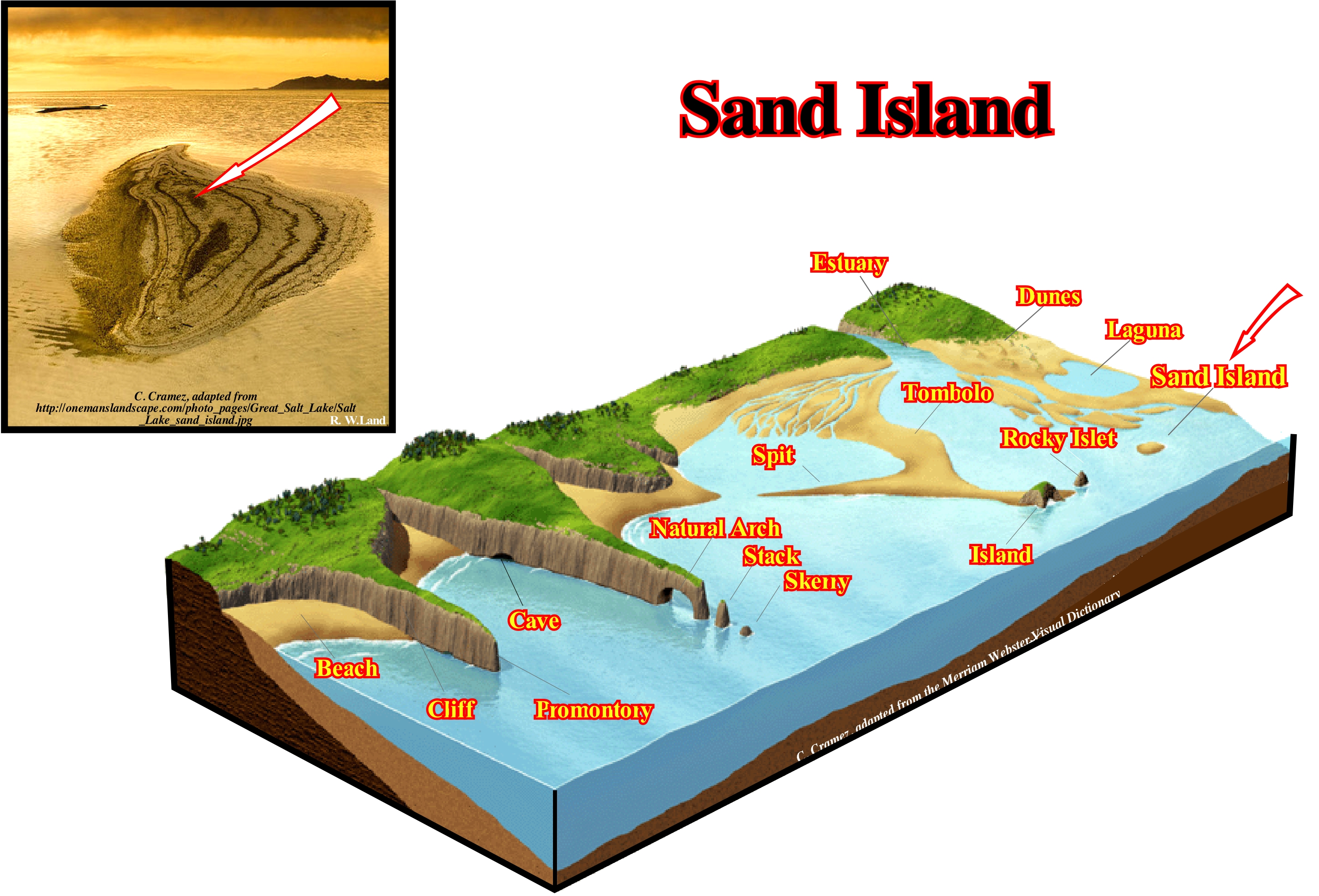
In this sketch are represented the main coastal morphological elements (landforms*). Thus, in addition to the sand island indicated by the arrow and which in this case represents the upper part of a sand deposit formed near the coastline, one can distinguish: (i) Beach ; (ii) Cliff ; (iii) Promontory ; (iv) Cave ; (v) Natural Arch ; (vi) Stack ; (vii) Skerry ; (viii) Spit ; (ix) Rocky Islet ; (x) Laguna ; (xi) Dunes ; (xii) Estuary , (xiii) Tombolo, etc. The Beach is a low coast type with a strand consisting of debris, terrigeneous, sandy-silty, and coarse (stones and blocks), in other words an accumulation of sand or pebble along the coastline. The Cliff is a rocky wall, very steep, that faces the sea. The Promontory is the cape or end of a cliff or rocky point (sharp protrusion of the coast line, advanced towards the sea). The Cave is a natural subterranean cavity created by a slow dissolution and erosion of the rocks by the sea. The Natural Arch is an arch pierced by the sea on a cliff near the promontory. The Stack is the rocky spur, high and narrow, that emerges from a platform of erosion and which is often the result of the collapse of a natural arch, which testifies to a retreat from the cliff. The Skerry, which is a rocky ledge that emerges or, which is almost discovered at low tide, and which, as a rule, is submerged during the prey; genetically, as illustrated in this scheme, a skerry testifies to the retreat of the abrasion platform and corresponds to the ultimate degradation of a natural arch and a stack. The Spit is a coastal barrier-bar, formed by the growth of the foreshorerunnels, with one free end, the tip of the spit, and the other resting on the coast. The Rocky Islet, which is a small island, i.e., a land surface emerging and isolated from the mainland. The Laguna is a shallow body of sea water, separated from the sea by a sandy coastal barrier-bar or by a barrier-island. The Dunes are accumulations of sand shaped by the wind. The Estuary is a mouth of a river influenced by the tides. The Tombolo, which is an extension of sand that joins the island to the shore, and which can be simple or compound (double or triple), depending on whether they are formed by one or more strand lines. The composite tombolos form, sometimes, between the lagoons barrier-bars (lido type coast).
(*) Typical landforms include hills, mountains, plateaus, canyons, shoreline features (bays, peninsulas, etc) as well as seas (including submerged features such as mid-ocean ridges, volcanoes, etc.). Landforms are categorized by characteristic physical attributes such as elevation, slope, orientation, stratification, rock exposure (outcroppings) and soil type. Gross physical features or landforms include intuitive elements such as berms, mounds, hills, cliffs, valleys, rivers, peninsulas, volcanoes and numerous other structural elements including various kinds of inland and oceanic water-bodies and subsurface features. (https://en.wikipedia.org /wiki/Landform)
Sand-Ripple...............................................................................................................................................................................................................Ride de sable
Ondulação de Areia / Ondulación de arena / Sandrippel / 沙垄 / Волнообразные наслоения песка / Ondulazione di sabbia, Increspature di sabbia /
One of the small parallel sinusoidal linear undulations in the model of wind-dry sandy surfaces (wind ripples, dissymmetric and transverse to the wind direction) or one of the wet sand surfaces (beach and shoreface) formed by the currents (beach currents, dissymmetric, symmetrical or slightly inclined towards the current).Synonym of Ripple-Marks.
See: « Wave »
&
« Swell »
&
« Trough and Bar »
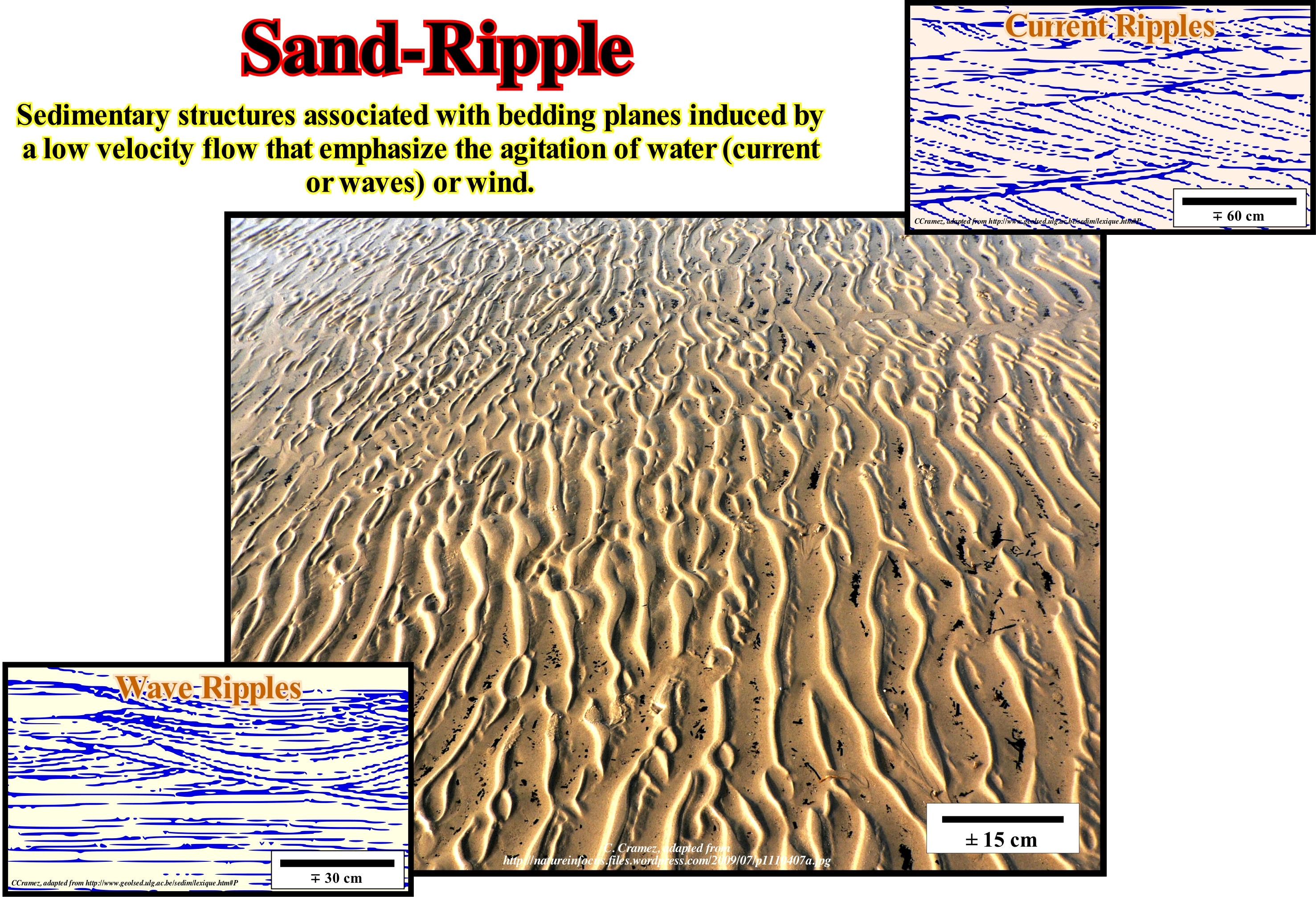
The sand-ripples and dunes are found in many deserts and beaches around the world. As wind, more or less, constant and blowing in a certain direction, these wind formations of sand are formed over long periods of time. The study of the formation and dynamics of the wind structures of sand gives the geoscientists experts in this field indications on how the dunes interact in different scenarios. Obviously, this helps protect desert cities, provides information about the environment of the past. To form the sand dunes and ripples, the sand particles are displaced by three processes: (i) Suspension ; (ii) Saltation and (iii) Rolling. The suspension comprises the very fine particles which float above the ground over great distances but which have little effect on the formation of structures. Saltation affects slightly larger particles that remain above ground for short distances. Larger particles do not spread in the air, they roll over the ground and are included in the rolling process. To simulate the formation of ripples and dunes, there are mathematical formulas that describe, perfectly, the saltation and surface flow processes, where the wind effect on the leeward side of the dunes is considered. The wavelength of the sand ripples is related to the distance travelled by saltation and the irregular shape of the surface is the result of the erosion and accumulation of sand particles in their movements. The irregular shape of the wind slope (windward) is, easier, to reach by leaching than the leeward side. The windward side is affected by the sand particles and forms a new impact zone, under the direction of the wind. The distance between the undulations is equal to the average length of the saltation. The sand-ripples form an alternating series of concave and convex sectors that follow the direction of the wind. The coarsest sediments. which can not be carried by jumping, accumulate at the top.
Sandstone.....................................................................................................................................................................................................................................................Grès
Arenito (grés) / Arena / Sandstein / 砂岩 / Песчаник / Arenaria (roccia) /
Clastic sedimentary rock composed of quartz grains, feldspar and fragments of other rocks, with a diameter ranging from 0.0625 to 2 mm and joined by cement of a quartz, carbonate and other mineral or by a matrix consisting mainly of clay minerals.
See: « Sand »
&
« Retrogradational Sandstone »
&
« Reservoir-Rock »
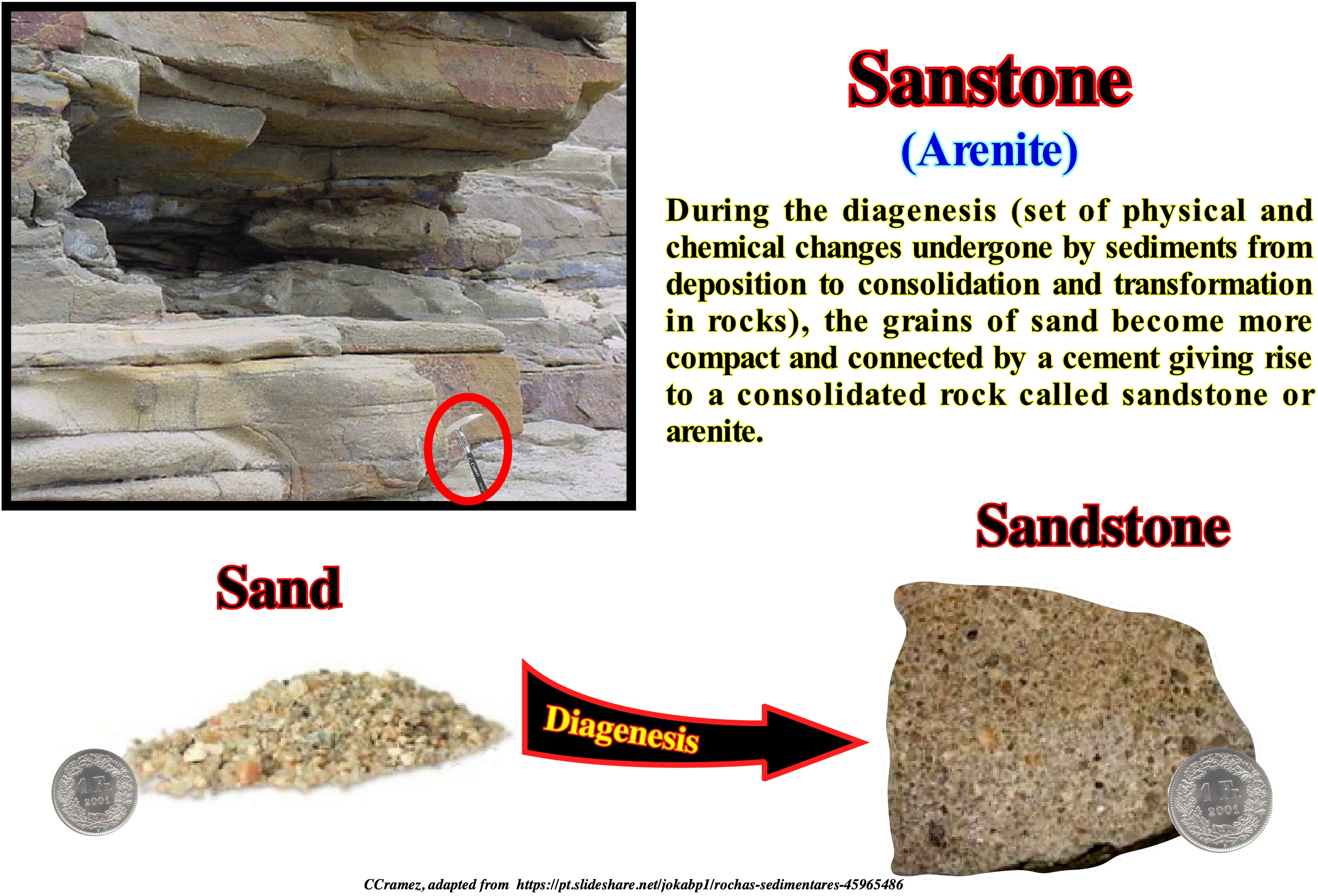
The sandstone is a category of rock made of sedimentary particles, i.e., a sedimentary rock. The sedimentary particles are clasts, or parts of minerals and fragments of rocks. As a sandstone is, mainly, composed of sand (medium grain particles). More precisely, the sand has a diameter ranging from 1/16 to 2 millimeters (thicker than the silt and thinner than the gravel). A sandstone may contain finer and thicker material than sand. However, if it has more than 30 % grains of gravel, pebbles, or pebbles, it is called a conglomerate (rounded clasts) or breccia (angular clasts) or simply rudite. In a sandstone, besides the sedimentary particles that compose it, there are two different types of material: (i) Matrix and (ii) Cement. The matrix is the finely granulated material (silt and clay), which was in the sediment along with the sand, while the cement is a mineral material, later introduced, which binds the sediments to form a rock. A high matrix sandstone is poorly calibrated or graded. If the matrix reaches more than 10 percent of the rock, the sandstone is called wacke. A well calibrated sandstone with little matrix and low cement is a clean sandstone (arenite). Although a sandstone is, formally, defined by particle size, detrital rocks consisting primarily of carbonate minerals are not referred to as sandstones. Carbonate rocks are known by the name of carbonates and are part of a separate classification, since a sandstone, basically, means a rock rich in silicates. A carbonate middle-sized rock or arenaceous limestone is, usually, called calcoarenite. Such a division makes sense because limestone is made or deposited in clean ocean water, while siliciclastic rocks are constructed from sediments resulting from the erosion of the continents. The sandstones are reservoir-rocks with good petrophysical characteristics (porosity and permeability).
Saprolite.......................................................................................................................................................................................................................................Saprolithe
Saprólite / Saprolito / Saprolith / 腐 / Сапролит / Saprolite /
Rock or autochthonous geological layer suprajacent to a deep soil resulting from the chemical alteration of a rock, sometimes of the original rock, due to the action of the climate, water or hydrothermal, without it being transported.
See: « Weathering »
&
« Erosion »
&
« Leaching »
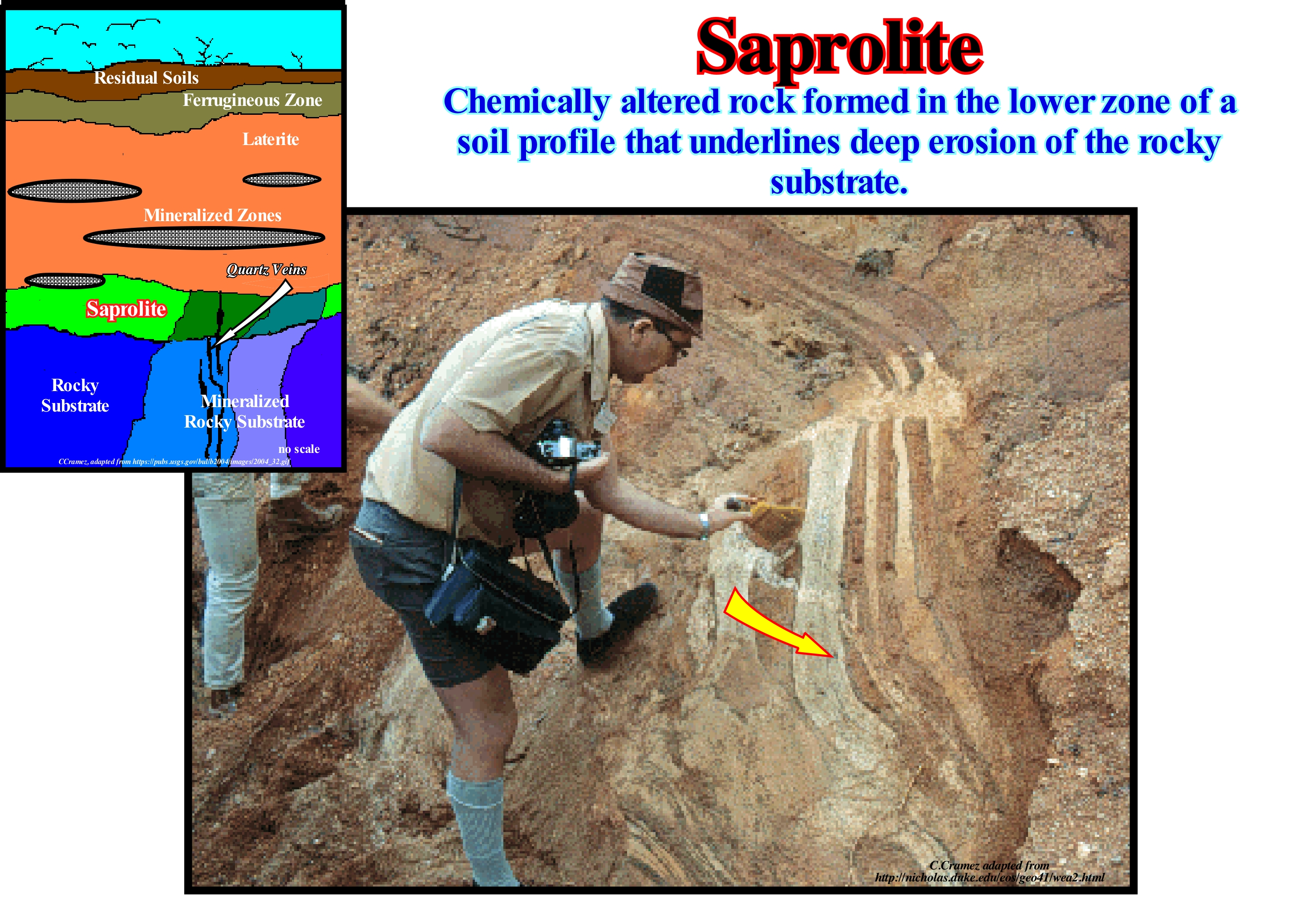
A saprolite is a rock, chemically, weathered. Saprolites form in the lower zones of the soil profiles and represent deep weathering of the surface of the rocky substratum. In most outcrops its colour is due to ferric compounds. The highly weathered profiles are scattered in all continental areas between latitudes 35° N and 35° S. The first condition for the formation of a heavily weathered regolith* is a moderately flat topography to prevent strong erosion and, above all, to facilitate the leaching of the products of chemical weathering (a set of processes and phenomena that lead to the disintegration of rocks). The second condition is a prolonged period of tectonic stability, since tectonic activity and climate change can cause erosion. The third condition is a humid tropical climate or a temperate climate. Thus, the thickness of a regolith can vary from a few meters to more than 150 meters, depending on the terrain, tectonic activity, climate, history of the climate and composition of the terrain. A deep weathering, which occurs often in cold climates, favours the formation of secondary and supergenic minerals** (minerals formed by reaction of preexisting minerals with surface fluids) such as bauxite, iron, gold, uranium and heavy minerals in residual deposits. In lateritic regoliths, the saprolite may underlie the upper horizons of residual laterite***. Most of the original profile is preserved by the residual soils or by a transported cover. The weathering formed fine kaolinite saprolites between 1,000 and 500 million years ago: thick kaolinite saprolites between 200/65 million years ago and saprolites, moderately thick and immature, about 5 million years ago. The general structure of kaolinite has Si2O5 silicate sheets bound by layers of aluminum hydroxide [Al2 (OH)4]. Iron compounds are mainly responsible for saprolyte staining.
(*) Layer of loose, heterogeneous superficial deposits covering solid rock including dust, soil, broken rock and other related materials. Earth's regolith includes the following subdivisions and components: (i) Soil or Pedolith; (ii) Alluvium and other transported cover, including that transported by aeolian, glacial, marine and gravity flow processes (iii) Saprolite, generally divided into the : a ) Upper saprolite : completely oxidised bedrock, b) Lower saprolite: chemically reduced partial weathered rocks, c) sapro-rock, i.e.,fractured bedrock with weathering restricted to fracture margins ; (iv) Volcanic ash and lavas : (v) Duricrust formed by cementation soils, saprolite and transported material by clays, silicates, iron oxides and oxyhydroxides, carbonates and sulfates, as well as less common agents, into indurated layers resistant to weathering and erosion ; (vi) Ground-water and water-deposited salts ; (vii) Biota and organic components derived from it. (https://en.wikipedia.org /wiki/Regolith)
(**) A supergene processes or enrichment are those that occur relatively near the surface as opposed to deep hypogene processes. Supergene processes include the predominance of meteoric water circulation with concomitant oxidation and chemical weathering (https://en.wikipedia.org/wiki/Supergene_(geology))
(***) Soil and rock type rich in iron and aluminium (rusty-red coloured) commonly considered to have formed in hot and wet tropical areas.
Saprotroph (Organism)..............................................................................................................................................Saprotrophique (Organisme)
Saprotrófago / Saprotrófico (organismo) / Saprobiont / 腐生营养 / Сапротроф / Saprotrofico (che mangia cose morte) /
An organism that obtains its energy from nonliving organic matter, whether it be pieces of plants or decomposing animals. Saprotrophic organisms are heterotrophic. Dead organic matter is decomposed and used by saprotrophic organisms, as bacteria and fungi.
See: « Heterotrophic »
&
« Bacteria »
&
« Theory of Evolution »

A saprotroph (saprophyte or saprobe) is a heterotrophic organism that obtains its nutrients from non-living organic matter, usually, dead and rotting plants or animal matter, absorbing the soluble organic compounds. As saprotroph organisms consume food from external sources instead of making their own food, they are considered a type of heterotrophs. Many species of fungi, bacteria and protozoa are saprotrophs. Necrophagous animals, such as beetles and vultures, are also, sometimes, regarded as saprotrophs, although they are, usually, called sapphagus (scavengers are those that feed on fresh corpses of other animals). In food chains, saprotrophs, generally, play the role of decomposers. As the saprotrophs are eaten by the consumers they, generally, play an important role in the recycling in the energetic flow of the ecosystems and biogeochemical cycles. The term saprotrophyte is an old term, which many geoscientists consider obsolete, since the suffix "phyte"comes from plant. There are no true saprotroph organisms that are embryophytes (they get their energy through photosynthesis), and fungi and bacteria are no longer placed in the plant kingdom. Plants that have been considered as saprotrophs, such as nonphotosynthetic and monotropic orchids (visited by a species of insect), are now considered to be known as parasites of other plants and are called mycoheterotrophs because it is a mycorrhizal* fungus (establishes a symbiotic association between a fungus and the root of a plant), which binds the parasite plant to its host. Indeed, as shown in this figure, most terrestrial fungi, some modified vascular plants, and gametophytes (plants that have sex cells, i.e. gametes which give rise to sporangia) of many pteridophytes (seedless plants) belong to the group of saprotrophs.
(*) Symbiotic association between a fungus and a plant. Mycorrhiza refers to the role of the fungus in the plant's rhizosphere, its root system. Mycorrhizae play important roles in plant butrition, sopil biology and soil chemistry. (https://en.wikipedia.org/wiki/Mycorrhiza)
Sawtooth Curve..................................................................................................................Curve du niveau de la mer (En dents de scie)
Curva do nível do mar (em dentes de serra) / Curva de nivel de mar (dientes de sierra) / Sägezahnkurve / 锯齿形曲线 / Пилообразная кривая / Curva a dente di sega /
Sea level change curve, published, originally, by P. Vail (1977), in which the changes are very asymmetric: the relative sea level rises are, relatively, slow and the relative sea level falls very fast. As shown in the figure below, the relative sea level falls are indicated by horizontal lines, which suggests that they are instantaneous.
See: « Global Cycle Chart »
&
« Relative Sea Level Change »
&
« Coastal Onlap Curve »
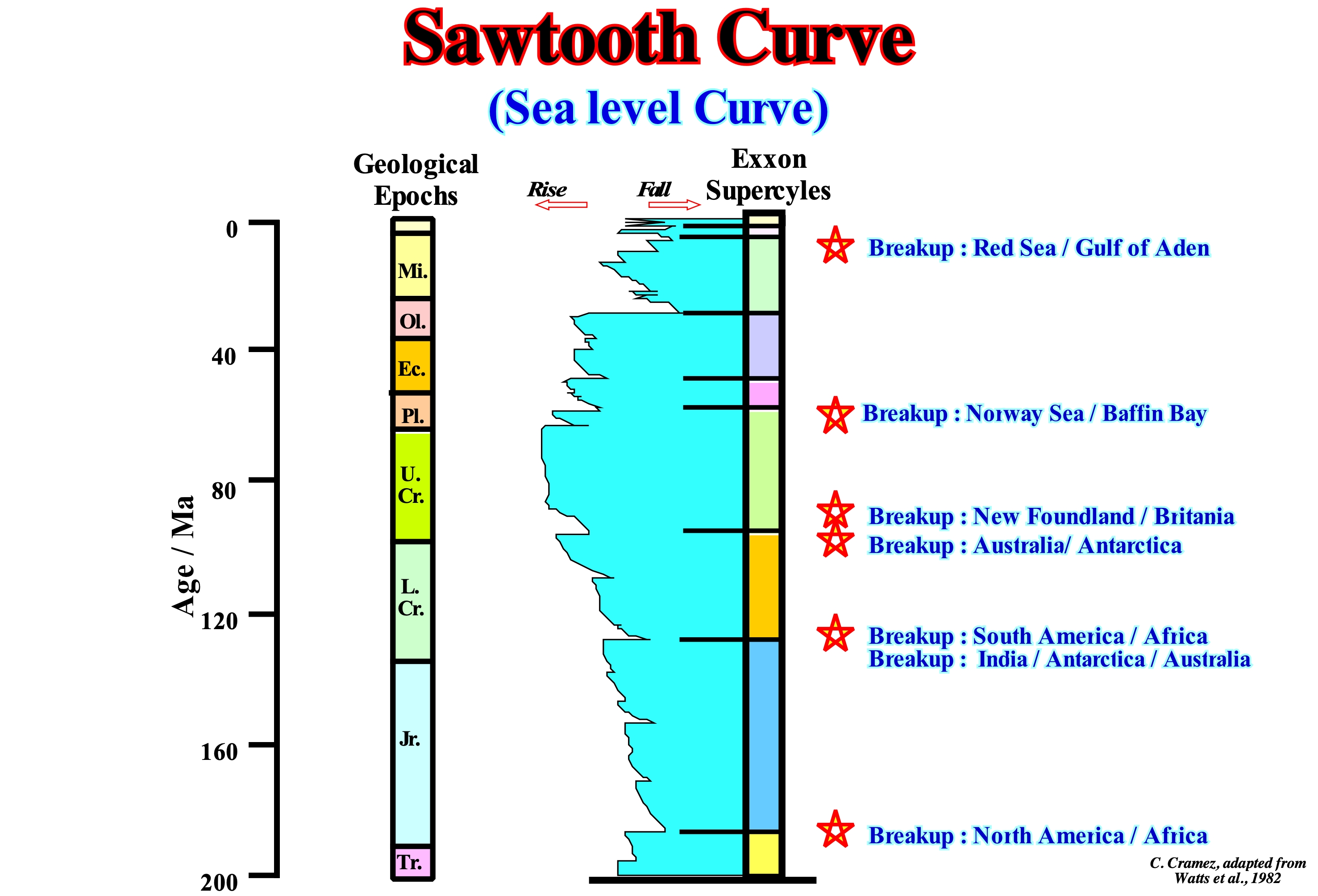
All the curves of sea level* change published at the beginning of Sequential Stratigraphy by the Exxon geoscientists, as well as, those constructed for the offshore of Labrador (Canada) in 1979, by the CFP's geoscientists (now Total SA) were asymmetric, i.e., in sawtooth teeth geometry. They were, heavily, criticized. Several geoscientists have advanced the hypothesis that sea level changes, particularly, sea level falls, even when eustasy is preponderant (absolute or eustatic sea level changes), were much slower than proposed. In a first phase, P. Vail insisted on the constant pattern observed in the seismic lines. Pitmann (1978) showed that the sea-level falls were so slow as the rises, and that a sea level fall should be recognized by a negative aggradation (coastal onlaps displaced seaward). P. Vail replied that on seismic lines almost no negative aggradation associated with relative sea level falls are observed. The vast majority of geoscientists think if the coastal onlaps associated with sea level falls are not observed on seismic lines, it is because they were eroded during the subaerial exposure involving a relative sea level fall. The sawtooth curve is now called coastal onlaps curve and no longer curve of the relative sea level changes. Coastal onlaps may not be, directly, associated with relative sea level changes, especially when they are in the alluvial and coastal plain. The upper limit of the onlaps that can be used to determine relative sea level changes is the upper limit of the coastal plain. A relative sea level fall displace seaward and downward (negative aggradation) the shoreline and so the coastal onlaps of the next stratigraphic cycle, in particular if the relative sea level falls puts the sea level lower than the basin edge (lowstand geological conditions).
(*) In sequential stratigraphy the sea level can be absolute (eustatic) or relative. The absolute sea level is supposed to be global and it is referenced to the Earth's centre. The relative sea level is a local sea level referenced at any point of the Earth's surface, which can be the base of the sediments (top of the continental crust) or the sea floor. The relative sea level is the result of the combined action of the absolute sea level and the tectonics (subsidence of the sea floor, when the predominant tectonic regimes is extensional (lengthening of the sediments) or uplift of the sea floor, when compressional tectonic regimes are predominant (shortening of the sediments). The absolute or eustatic sea level is the result of the combination of: (i) Tectono-Eustasy that is controlled by the volume variation of the ocean basins in association with oceanic expansion following the breakup of the supercontinents ; (ii) Glacio-Eustasy, which is controlled by the variation of water volume of the oceans as a function of the amount of ice (assuming that the amount of water in all its forms is constant since the formation of the Earth, around 4.5 Ga) ; (iii) Geoidal-Eustasy, which is controlled by the distribution of ocean water caused by variations in the Earth's gravity field (where gravity is stronger than normal, sea level is thrown to the centre of the Earth) and (iv) Steric sea level rise or thermal expansion of the oceans (if the temperature increases, the density of the water decreases, and for a constant mass, the volume increases).
Scale....................................................................................................................................................................................................................................................................Échelle
Escala / Escala / Skala / 规模 / Шкала, масштаб / Scala /
Relation between the two points distance on a map and the actual distance between these two points on the ground.
See: « Geological Time Scale »
&
« Geological Section »
&
« Longitudinal Seismic Line »
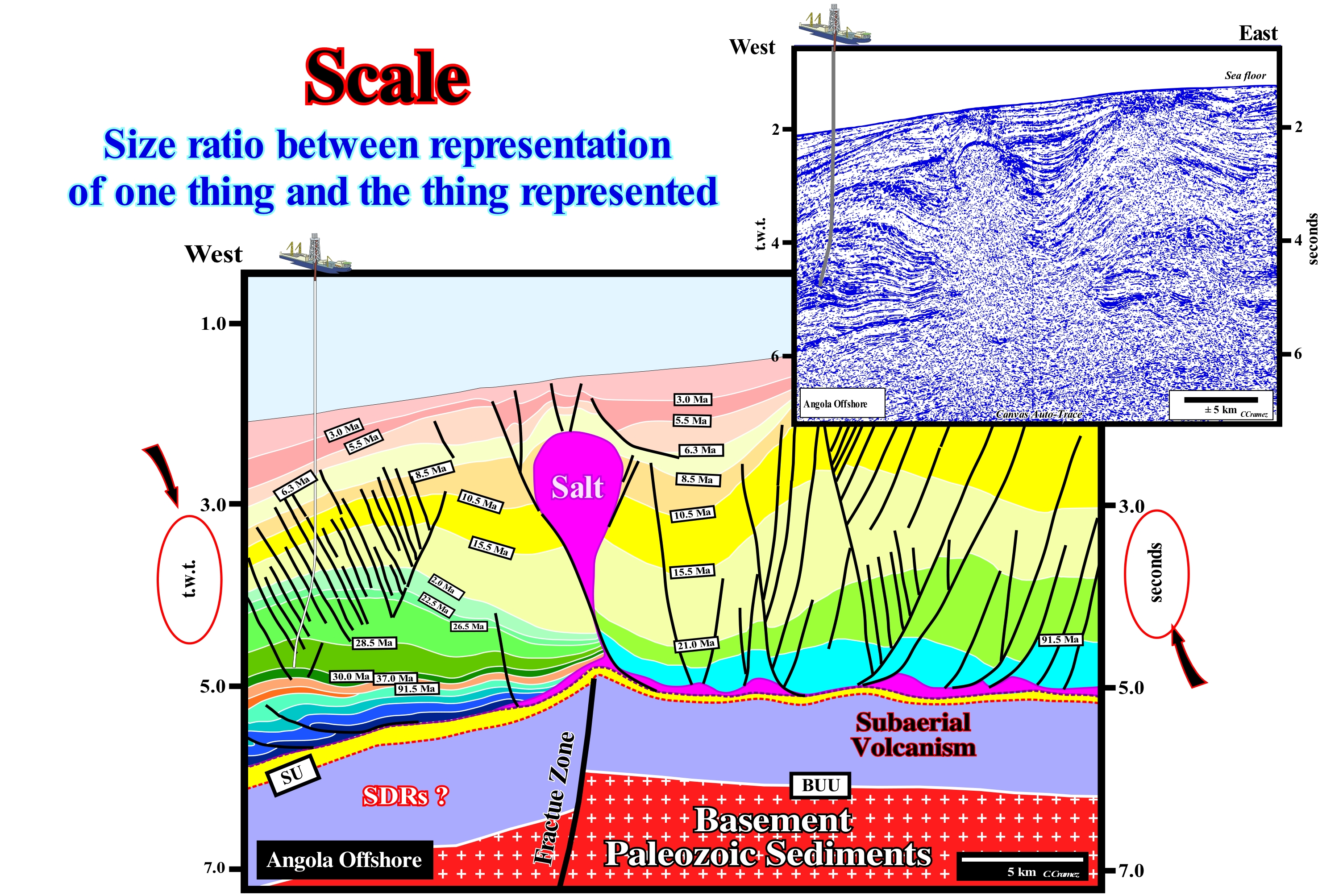
A scale can be expressed in three ways: (i) Numerically, as a ratio or a fraction, as, for example, 1: 100,000 or 1/100,000 ; (ii) Verbally, as "one centimetre for one kilometre" (never say "one centimetre equals one kilometre") and (iii) Graphically, marking the distances in a reference line. The latter method has the advantage that the scale remains true even if the map is enlarged or reduced, either manually or mechanically. The first method is, particularly, useful since any unit of measurement can be used. For example, if someone uses metric units, a scale of 1: 100,000 means that one centimetre on the map represents one kilometre of the Earth's surface (since 100,000 centimeters equals 1 km). The more the size of an object on a map approaches the actual size of the object on the Earth's surface, the larger the scale of the map. A large-scale map, generally, shows more detail than a small-scale map, but covers a smaller area than a small-scale map of the same size. In zoology and paleontology, the scale is, often, given by the size of any bone or scales on the skin of an animal. In fish, where the main component of the scales is bone, and they form directly on the skin membrane as the fish grows, the number of rows of scales, as well as the type, allows the identification of a species (the growth of the scales is marked by rings, which helps determine the age of the fish). On this tentative interpretation of a Canvas auto-trace of a detail of an Angola deep offshore seismic line, the horizontal scale is, graphically, expressed in the lower right corner where the (blank) sample line represents 5 km. The vertical scale of the seismic line of this auto-trace is in milliseconds and double time (round-trip time from seismic waves to a certain reflector). The total length of this seismic line can be represented, graphically, in an Angola offshore map. On seismic lines, the horizontal scale is, almost always, graphically represented, which allows the geoscientists to enlarge or reduce it. On tentative geological interpretations of seismic lines, the scale is fundamental. The geological interpretation is scale dependent. For instance, the geometry of a delta and a continental slope is, practically, the same. What sets them apart is the dimensions. A delta slope is, generally, at most about 60-100 meters thick, whereas a continental slope is, necessarily, more than 200 m thick and can reach several kilometers. In the same way, without a scale, a geoscientist, at the hierarchical level of the sequence-cycle, can never differentiate a retrogradation of the coastline, induced by a set of increasingly important marine ingressions and increasingly smaller sedimentary regressions, from the different abrupts and berms of a beach. Without scales (vertical and horizontal) a georadar line* looks like a conventional seismic line used in petroleum exploration. What differentiates them is the scale and, particularly, the vertical scale. Anyway, we must never forget that a geoscientist does not observe with the eyes but with the brain. The eyes serve just to receive the light waves coming from the observed object and transmit them to the brain, where they are stored, processed and correlated with previous observations. If a geoscientist does not know, a priori, what is the difference between a delta progradation and a continental slope he/she will never differentiate them on a seismic line, even if he/she spends days or weeks looking at the seismic line. As K. Popper said, a geoscientist to observe anything in the field or on a seismic line has to know what to observe, i.e., "Theory precedes Observation. What a geoscientist observes on a seismic line is a function of his knowledge and expectations (it is that is why the geographical and geological location of the seismic line is indispensable for the geoscientist to propose a coherent interpretation difficult to refute).
(*) Georadar is a non-destructive geophysical prospecting technique based on the analysis of propagation phenomena (refraction, reflection and diffraction) of high frequency (10 MHz to 2 GHz) electromagnetic waves in the subsoil. The georadar, initially, of an impulsive nature, is based on the excitation of the subsoil, from a transmission antenna, by a train of short pulses (1 to 50 ns) to detect, using a receiving antenna, the successive echoes associated to the permissiveness or conductivity contrasts found by the paleomagnetic waves during their propagation. These contrasts indicate the presence of buried objects or underground substrate. The use of frequency georadar is more recent due to the associated instrumental limitations, however, a great number of research works on this method are currently available.
Schorre (Tidal-flat, upper mud-flat)...........................................................................................................................................Schorre (Vasière dure)
Salgadiço (plataforma de preiamar) / Marjal de marea, Schorre / Schorre / 滩涂 / Шоры / Piatta marea, Schorre /
Part of the pelitic strand that is uncovered in neap (apogean) high-tides and covered during the spring high-tides and storms. The term platform is misused here. Synonym of High-Tide Platform.
See: « Beach »
&
« Intertidal Beach »
&
« Littoral »
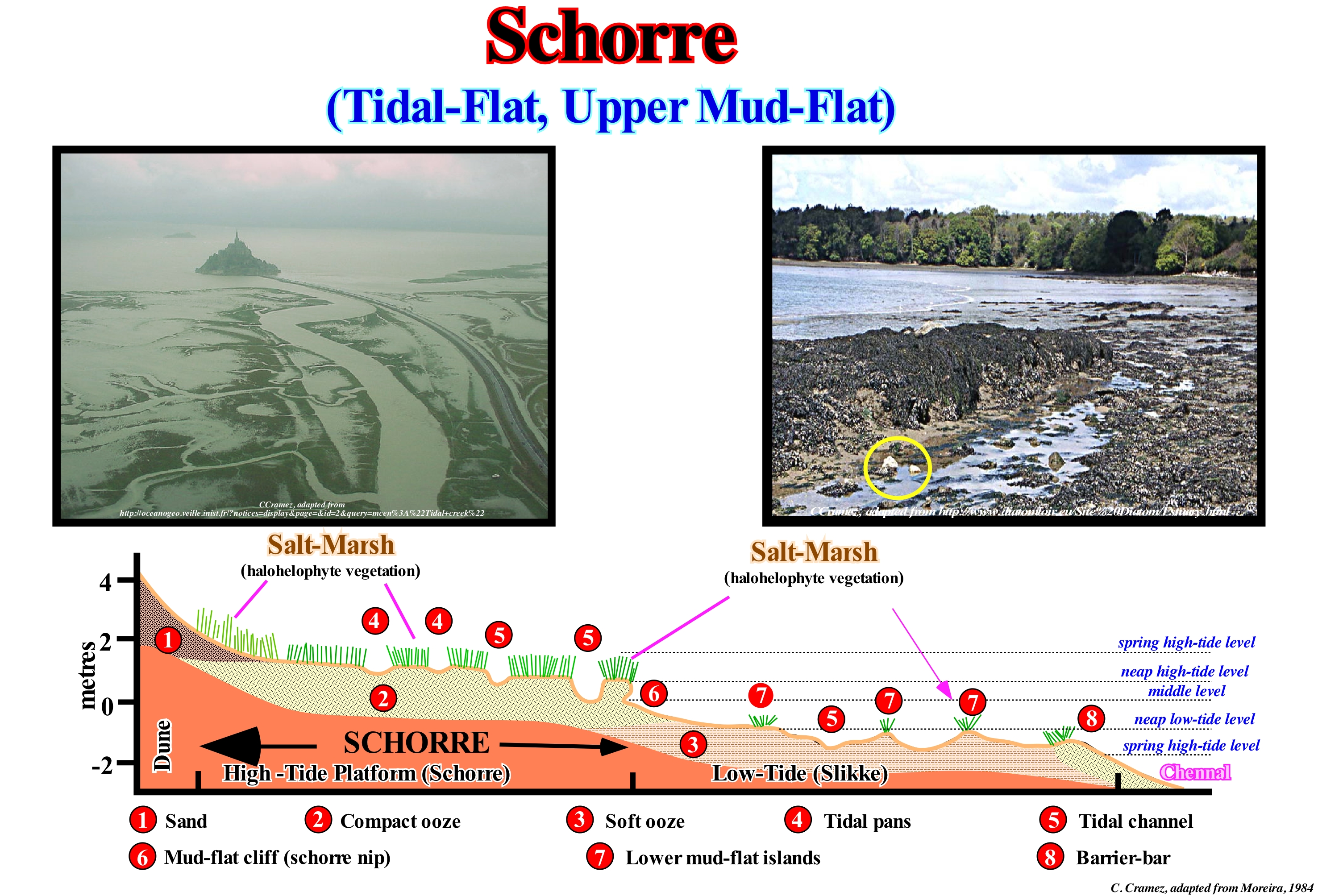
The schorre or tidal-flat is presented as a platform of consolidated ooze covered with soil halohydromorph (deposited in an engorged medium of salt water periodically or permanently), cut in convex islets by channels, with tidal-pans and, completely, channelled by halohelophyte vegetation (that lives in muds or salted oozes), herbaceous species in the extratropical ("sapal") and shrub and/or arboreal in the intertropical regions ("mangal"). The schorre is separated from the lower part of the strand (slikke or platform of low-tide) by a step that can reach a few meters, corresponding to the step of the high-tide, which is called schorre nip (Moreira, 1984). According to floristic differentiation and the slope of the schorre can be distinguished the high and low schorre. The schorre is submerged only during the spring high-tides and it develops at the expense of the slikke by a gradual increase of vegetation. According to the degree of submersion, the vegetation extends in three levels: (i) Low schorre ; (ii) Medium schorre and (iii) High schorre. The associated vegetation is suitable for intermittent immersion and a salty environment. The schorre contains varied vegetal communities, composed, mainly, of halophyte species, i.e., tolerant to salinity. Since always the schorre (platforms of high-tide) have always been used as pasture for sheep and cattle, but its transformation into farmland has been a common practice through the construction of dikes. These changes have produced important changes in the environment, with variations in salinity, sedimentation, access to water and, above all, biodiversity. The schorre or high-tide platforms are intertidal ecotones* (areas of environmental transition where different ecological communities come into contact), between terrestrial and marine ecosystems, which occupy a total area of less than 0.01% of the terrestrial globe.
(*) Combination of eco(logy) plus -tone, from the Greek tonos or tension –, i.e., a place where ecologies are in tension.
Schorre (High-tide platform).........................................................................................Plate-forma de haute-marée (Vasière dure)
Plataforma de preiamar (alta) / Plataforma de pleamar (alta), Saladar / Plattform hoch - Flut (Watt reicht) / 平台高-潮(泥滩持续)/ Болото, периодически заливаемое приливами / Piattaforma alta-marea (mudflat dura) /
Part of the pelitic strand that is uncovered in neap (apogean) high-tides and covered during the spring high-tides and storms. The term platform is misused here. Synonym of High-Tide Platform.
See: « Beach »
&
« Intertidal Beach »
&
« Littoral »
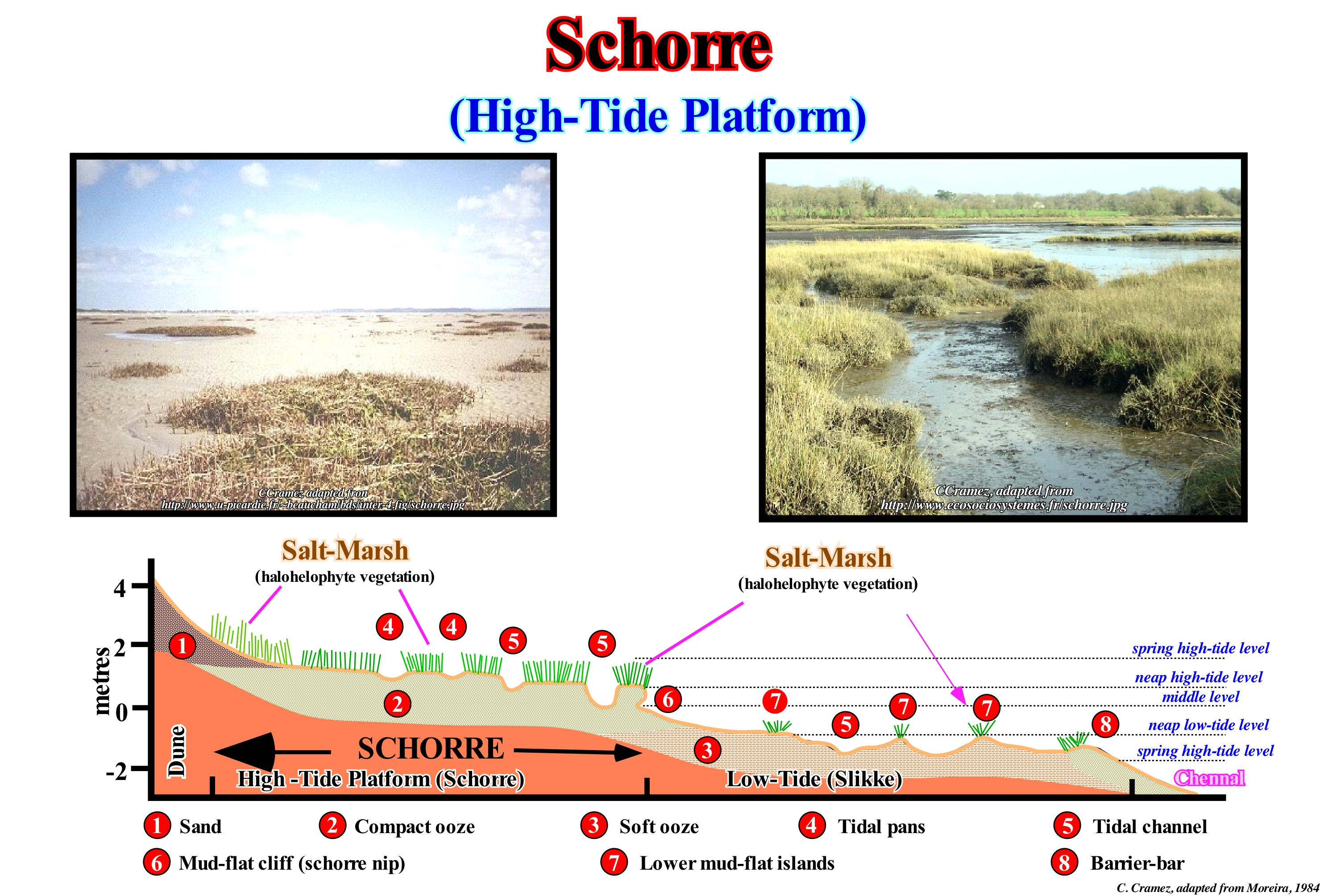
The high-tide platforms or schorre are natural environments with low vegetation located in the high edge of the coastal oozes. They correspond to a part of the strand that is uncovered that during the great tides and that extends from the upper part of the middle littoral floor to the lower part of the supralittoral floor. The high-tide platforms are formed upstream of the mudflat region, which is without vegetation in the temperate regions or that is occupied by mangroves in the tropical regions. The high-tide platform (schorre) is submerged only during equinoctial tides and forms at the expense of the low-tide platform (slikke) by a rise of muddy land and a gradual increase of vegetation. Function of the degree of flooding, the vegetation is distributed in three levels: (i) Low ; (ii) Middle and (iii) High. The vegetation is suitable for intermittent immersions and a salty environment. The high-tide platform contains a variety of plant communities, composed mainly of halophyte species, that is to say, tolerant to the salinity. The platforms of high-tide are found, most often, and, massively, in temperate regions. They generally cover areas protected from wind and wave force, at low altitude and with strong sedimentation, such as: estuaries, deltas, coasts protected by barriers or dunes or in the bays. This type of environment is found in the Camargue (France), Ebro delta (Spain), Mississippi, New Zealand, a large part of the east coast of the United States, etc. In tropical and subtropical regions, they are, usually, replaced by mangroves on a large part of the coastline, but high-tide platforms (schorre) are, often, present behind mangroves. These platforms are used as pastures. The transformation of these areas into farmland is common through the construction of dikes. These changes induce changes in the environment, with variations in salinity, sedimentation, access to water and, above all, biodiversity. The outstanding example is the Camargue (France), where the debate on the maintenance of the dikes is very intense.
Schorre (Salt marsh).........................................................................................................................................................................Vasière dure (Compacte)
Vasa compacta (preiamar) / Llanura fangosa dura / Salzwiese / 滩涂硬盘 / Илистое место (твердое) / Pianura fangosa dura /
Mud deposited on high-tide platform, in which certain spaces (polders*) are conquered by the man with the construction of dikes to prevent the schorre flooding by the tide.
See: « Slikke »
&
« Tide »
&
« Slikke (mud-flat) »
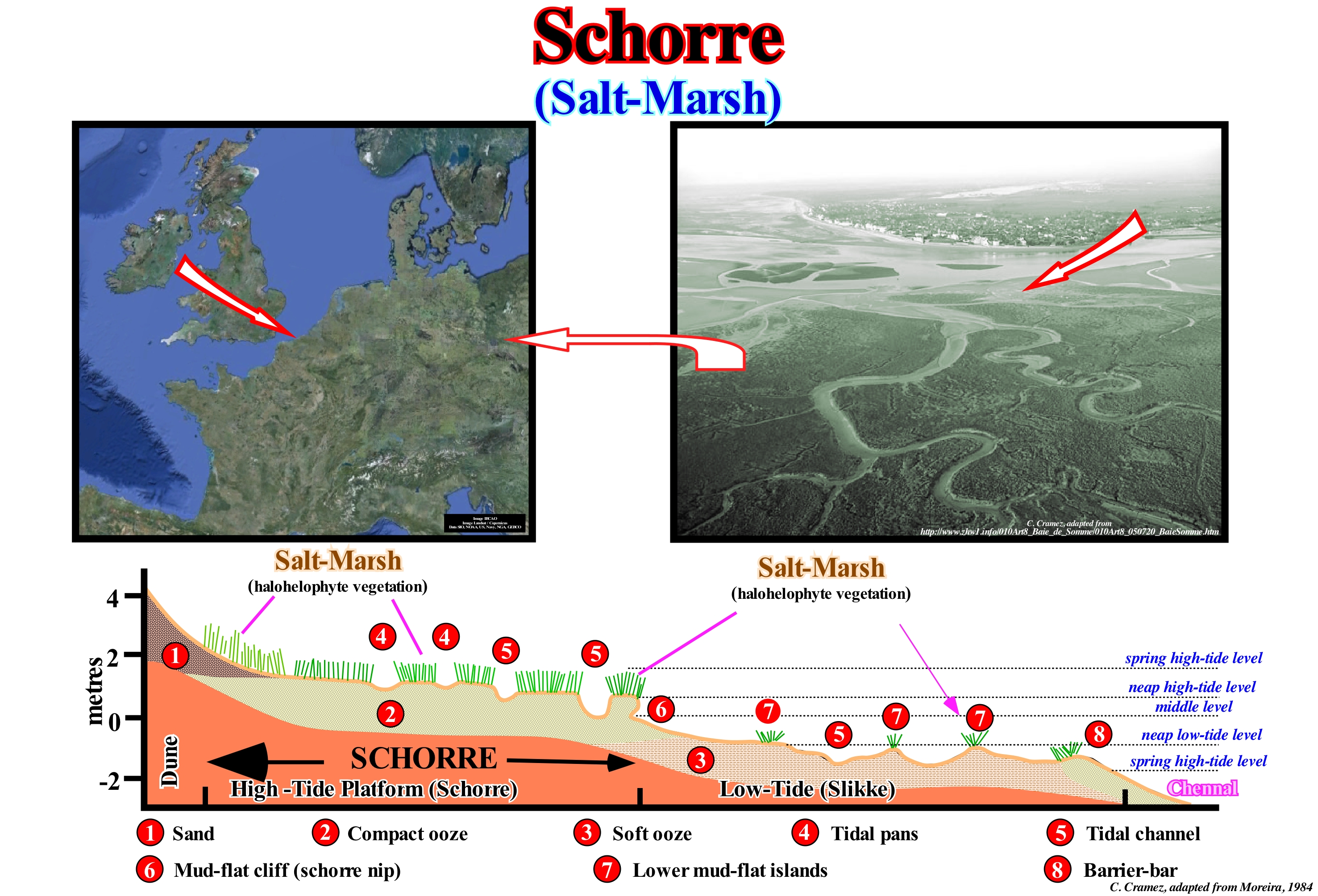
The compact and soft schorre oozes correspond to a stacking of fine marine and fluvial sediments, which are covered by the sea during high-tide. The vegetation develops little in this type of deposit, but the biological productivity is very important. The abundance of micro-organisms, crabs, earthworms and molluscs attracts many birds, among which the oyster-catcher**, which is accused of playing an active role in the exhaustion of resources. In the lower part of these oozes the presence of certain algae and "moliço"*** (a set of several vascular plants, among them the marine Zostera Marine, and the Zostera Molti , that grow submerged in salt water) promotes the accumulation of sediments. The upper part of the compact ooze of high-tide is colonized by halophytes, such as the Spartina and Salicornia that fix the ooze in its roots. The salt-marshes (alluvial formations, periodically flooded by salt water and occupied by halophyte vegetation or, in some cases, by salt mantles), which are formed by a rise of the soil level, due to successive accumulations of sediment, which are covered during high tide, are, generally, separated from the compact ooze by a micro-cliff (mud-flat cliff). Salt-marshes, which in tropical regions are known as mangroves, provide a quality pasture to sheep herds. In the photograph illustrated in this figure, the marshes are covered by numerous water planes that are used for hunting. If the silting of the bay illustrated above (Somme Bay, in France) has been a phenomenon known for many years, its intensity accelerates the extension of the marshes, which were little developed at the beginning of the XX century, but now occupy an important surface of the estuary and its progression does not stop increasing.
(*) Low-lying tract of land that forms an artificial hydrological entity, enclosed by embankments known as dikes The are three types of polder: (i) Land reclaimed from a body of water, such as a lake or the sea bed ; (ii) Flood plains separated from the sea or river by a dike and (iii)Marshes separated from the surrounding water by a dike and subsequently drained. (https://en.wikipedia.org/wiki/Polder)
(**) The name oyster-catcher was coined by Mark Catesby in 1731 as a common name for the North American species H. palliatus , described as eating oysters (https://en.wikipedia .org/wiki/Oystercatcher). It is, easily recognized by its black silhouette, which contrasts with the orange beak and whose characteristic acute call overlaps to the strong rumour of the surf of the waves in the rocks where he lives.
(***) "Moliço" is the Portuguese word for the submerged aquatic vegetation collected for use in agriculture.
Schuler's Pendulum..........................................................................................................................................................Pendule de Schuler
Pêndulo de Schuler / Péndulo de Schuler / Schuler Pendel / 舒勒摆 / Маятник Шулера / Pendolo di Schuler /
Any pendulum having a period equal to that of a hypothetical pendulum of a length equal to the radius of the Earth (84.4 minutes). Its arm remains, locally, vertical when the privot (fixed axis) is displaced, which makes it very useful in navigational instruments.
See: « Coriolis Effect »
&
« Earth »
&
« Geoid »
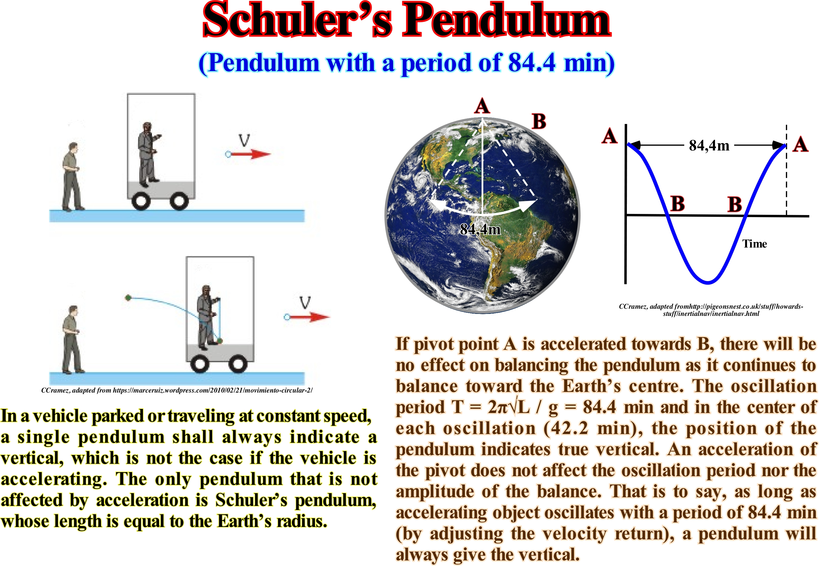
A pendulum is any body that oscillates hanging from a fixed horizontal axis that does not pass through its centre of gravity. When a pendulum is displaced from its equilibrium position, it is subjected to a restoring force of gravity which will accelerate it back to the equilibrium position. When released, the restoring force combined with the mass of the pendulum causes it to wobble around the equilibrium position, swinging back and forth. A very useful form of the pendulum is the Schuler's pendulum. Consider the problem of maintaining a horizontal platform in flight and suppose that you do not have GPS or celestial navigation to help you. How can you keep the floor of the platform horizontal? One way would be to control the local vertical. If hung a pendulum on the platform and started from a point, the pendulum tends to follow the vertical location. Of course, every time the platform is accelerated and hit a new speed or direction, the pendulum swings and we would have a vertical line that oscillates over the true vertical. The magnitude and frequency of oscillation vary with the length of the pendulum. The longer the pendulum, the smaller the amplitude and frequency of its oscillation. Is there any length of the pendulum that would give vertical without starting to oscillate? The answer is yes: it would be a pendulum of length equal to the distance to the centre of the Earth, this is a pendulum of Schuler, whose characteristic would be that of when accelerated forward, it would turn back, in reaction of such that the vertical would be always maintained. Obviously, you can not build a pendulum, the length of which is roughly the radius of the Earth, but we can build a computer-controlled emulation of such a pendulum. We can actually detect any acceleration of the ship, with accelerometers and sensitive gyroscopes, and immediately force the platform to rotate in the proper direction. Our platform will indeed be a Schuler pendulum and this technique has in fact been used for stable platforms in space vehicles.
Scarp (Cliff, scarpment).........................................................................................................................................................................Escarpement (Falaise)
Escarpa (falésia) / Escarpa / Bruchstufe /崖 / Крутой спуск (уступ) / Scarpata /
Particular form of coastal slope, abrupt or with a strong slope (15° to 90°) cut, usually, in coherent rocks by the action of marine agents (waves and currents) or by the joint action of marine and biological morphogenic agents.
See: « Cliff »
&
« Shoreface »
&
« Fair Weather Wave Base »
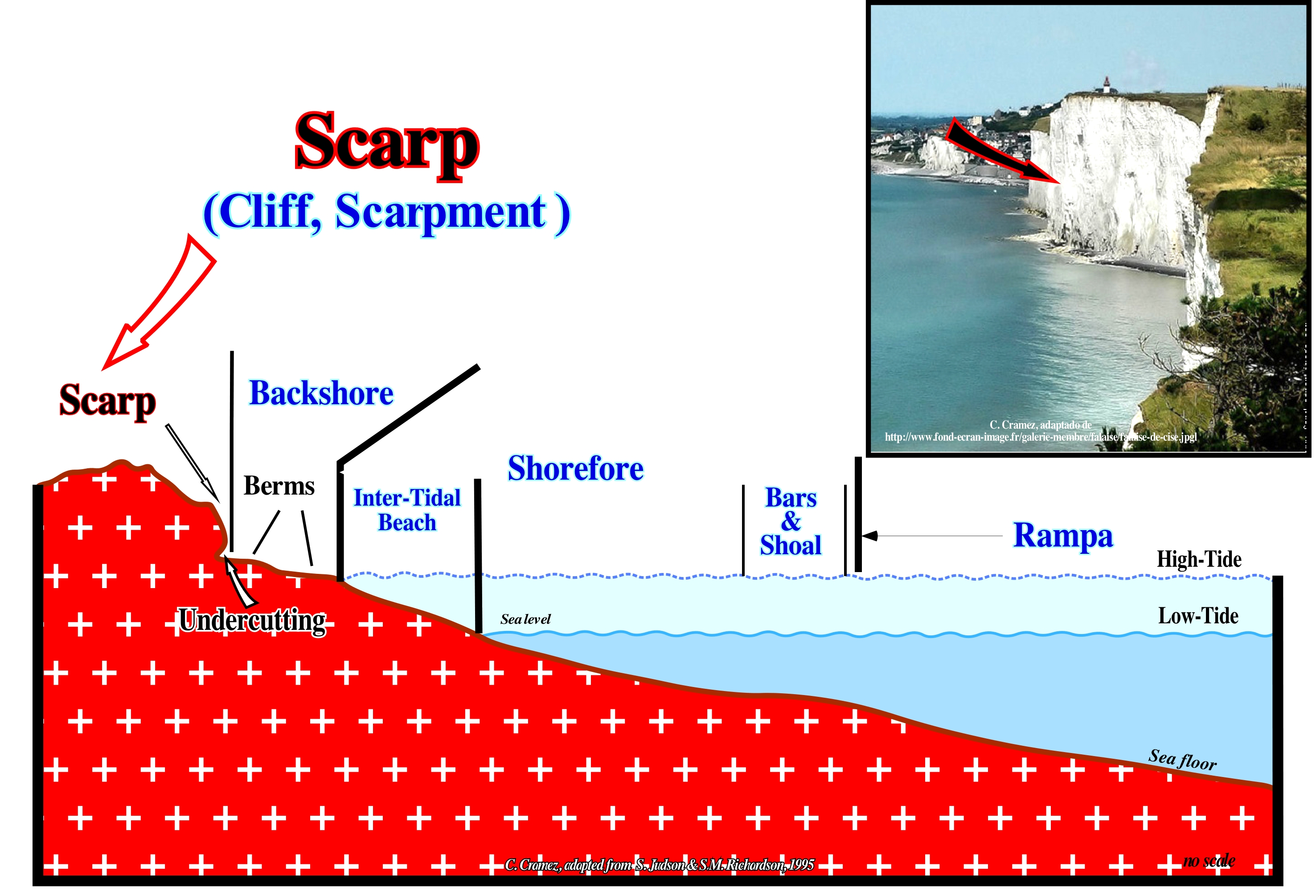
The cliffs (scarps, scarpments) are the most characteristic elements of the coastal zones. They form by the combined action of erosion and weathering. The weathering, preferably, acts on the top of the cliff and erosion wears out, above all, the base of the cliff (undercutting). The abrupt cliffs form when the rocks are harder. The height is, obviously, determined by the difference between the sea level and the ground level. Hard rocks erode and change, slowly, and the less fractured they are, the more they resist erosive agents. Eruptive rocks, such as granite and basalt form abrupt and rugged cliffs, as is the case on the coasts of the North Atlantic. The hard rocks, such as clayey rocks and sandstones erode more, easily, and form less inclined cliffs, although this is not a general rule. The importance and geometry of the cliffs in the sedimentary rocks depends on the inclination of the strata, i.e., if they incline towards the sea or towards the continent. In this sketch, the main morphological elements of a coastline are illustrated, where one can recognize: (i) Cliff or Scarp, which marks the coastal slope; (ii) Undercutting (groove or notch), formed by the erosive action of storm waves and located at the base of the cliff, upstream of the beach ; (iii) Backshore (inshore), which is the limited upstream zone by the cliff and, downstream, by the high tide level; (iv) Berms of the backshore, that is, the levels (the more or less horizontal parts) of the steps formed by the action of the waves ; (v) Foreshore, which corresponds to the sea floor zone bounded between the high tide level and the bars and shoals that delimit the ramp (upstream) ; (vi) Intertidal beach, which is the area most upstream of the low beach and which, as its name indicates, corresponds to the zone limited by high and low-tide levels ; (vii) Bars and shoals, which separate the lower beach from the ramp and (viii) Ramp, which is the bottom of the zone of the shorefore, downstream of the bars and shoals (riffles), and which is characterized by a substantial increase in slope of the sea floor.
Sclavia (Supercraton).............................................................................................................................................................................................................Sclavia (Supercraton)
Sclavia / Sclavia (super-cratón) / Sclavia (Super-Kraton) / Sclavia (超级克拉通)/ Склавия (суперкратон) / Sclavia (super-cratone) /
Continental land mass of Archean age, smaller than the speculative supercontinent Kenorland (Late Archean). From its breakup formed the Slave craton, located in the NW of Canada, near Yellowknife, that is the segment NW of the Canadian Shield that is part of the great craton of North America. The Sclavia is a simple fragment of the ancient continental crust, surrounded by divergent continental margins of Paleoproterozoic age.
See: « Craton »
SDR (Seaward dipping reflector).......................................................................................................................................SDR (réflecteur incliné vers la mer)
SDR (reflector inclinado para o mar) / SDR (reflector que inclina para el mar) / SDR (Reflektor zum Meer hin geneigt) / SDR(海倾反射层)/ Рефлектор с уклоном с сторону моря / SDR (riflettore inclinato verso il mare) /
Acronym for «Seaward Dipping Reflector», i.e., a reflector that dips seaward. These reflectors correspond, almost always, to subaerial lavas that thin down continentward and dip into the sea. In the past, these reflectors were, mistakenly, interpreted as interfaces of sedimentary intervals, rich in organic matter, of the rift-type basins. In other words, were interpreted as intervals with potential parent rocks.
See: « Darwin Seamount »
&
« Subaerial Lava »
&
« Sea Floor Spreading »
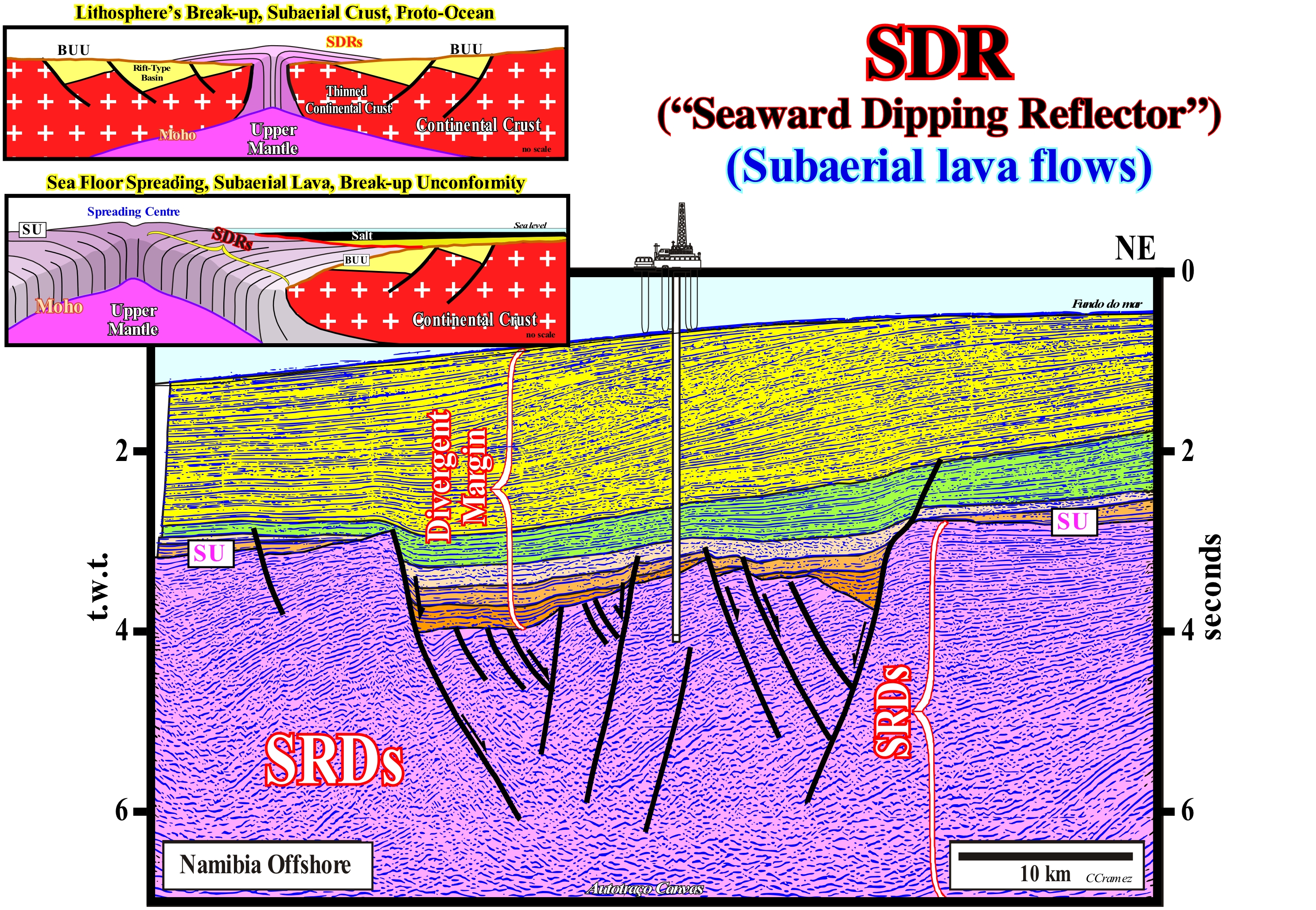
The great igneous provinces formed during magmatic pulsations. A magmatic plume, generally, raises the central zone of a supercontinent (zone of maximum extension of continental crust) creating rift-type basins, by differential subsidence and an important erosional surface that is fossilized, since the supercontinent breakup in several continents (breakup unconformity). The subaerial basaltic flows are later than the lithosphere's break-up. They are vomited by volcanoes and central fissures aligned parallel to the breaking line. These volcanic flows, which can reach more than 10 km in thickness, thin in continentward, forming what the geoscientists have called seaward dipping reflectors or SDRs, before that they realized their true volcanic lithology. On longitudinal seismic profiles (parallel to the breaking line), the SDRs are convex upward, with slopes and thicknesses increasing basinward, as illustrated on this tentative geologically interpretation of a Canvas auto-trace of a Namibia offshore regional seismic line. This tilting (dipping seaward) results from the overload of the most recent flows, which, progressively, move basinward. In cross-sectional profiles, SDRs are subhorizontal. Generally, the SDRs form a band with little accentuated magnetism, located upstream of the oldest magnetic anomaly of the oceanic crust. A magnetic anomaly is the difference between the actual value of the Earth's magnetic field strength, measured with a magnetometer, and the average value calculated theoretically. Magnetic anomalies can be positive when the magnitude of the magnetic field is higher than theoretically calculated, and negative when otherwise. The vast majority of geoscientists think that magnetic anomalies are induced by perturbations caused by magnetized rocks of the Earth's crust, which interfere with the magnetic field, moving it away from its value of the average value calculated for a given area. This magnetism, little accented, is the result of the superposition of the volcanic flows with different magnetic polarities and should not be confused with the magnetostratigraphic zone of tranquillity, i.e, with a zone that shows few or even no magnetic anomaly*. As the continental margins move away from the mantle plume , the successive volcanic flows cool and sink, putting under water the spreading centres, that is to say, a volcanic volcanoes and dikes. As the flow of volcanic material is impossible under the water, since it reaches the sea floor, it solidifies, quickly, forming the true oceanic crust (pillow lavas), characterized by obvious magnetic anomalies and, on the seismic lines, by chaotic reflectors. On this tentative interpretation, the SDRs are evident and, of course, they postdate the breakup of the lithosphere of the small supercontinent Gondwana. Their geometry, as well as that of the flexure graben (induced change by the dip change of the lava flows) would be difficult to explain without a volcanic spreading. However, many geoscientists interpreted, at least initially, this graben as a rift-type basin and SDRs as pre-Gondwana sedimentary deposits (Paleozoic or Karoo sediments). The exploration wells drilled in the area where the original seismic line was shot and even on this seismic line (Namibia offshore) were stopped after crossing more than 500 m of subaerial lavas. They indicate that the sediments of the pseudo rift-type basin are sediments of the transgressive phase of the post-Pangea continental encroachment cycle, induced by the second order Phanerozoic eustatic cycle, which is defined from the absolute or eustatic sea level changes (sea level supposed to be global and referenced to the Earth's centre) and not the relative sea level changes (resulting of the combined action of absolute sea level and tectonics).
(*) Magnetometers are devices used to measure the strength or direction of the magnetic signal of a sample. Some magnetometers are very simple, such as the Gouy balance or Evans balance, which measure the change in apparent weight produced in a sample when applying a magnetic field (by magnetic moment that induced), and more sophisticated, such as SQUID (Superconducting QUantum Interference Device), who are currently the most sensitive.
(**) Very frequent zones in oceanic areas where magnetic anomalies appear to be absent because the Earth's magnetic field did not change polarity during the formation of the new oceanic crust or because the original magnetization was destroyed or hidden by the sedimentary cover.
SDRs Unconformity (Lava flows).........................................................................................Discordance du top des SDRs
Discordância do topo dos SDRs / Discordancia del tope de los SDRs / Top-Mismatch von SDRs / 特别提款权的不匹配顶部 / Угловое несогласие СДР / Discordanza sottostante SDRs /
Discordance or nonconformity between the subaerial volcanic flows, postdating the lithosphere's breakup, and the clastic sediments of the overlying continental divergent margin.
See: " SDR (seaward dipping reflectors)"
Sea......................................................................................................................................................................................................................................................................................Mer
Mar / Mar / Meer / 海 / Море / Mare /
Extension of salt water with depth less than 200 meters (intra or pericontinental). Some geoscientists call "salt lakes" to the intracontinental seas, while others classify the seas in: (i) Intracontinental (inland) and (ii) Extracontinental or epicontinental, subdividing the latter in: a) Coastal or Pericontinental and b) Continental. Note that the ocean is the set of masses of salt water with depths exceeding 200 meters.
See : « Physiographic (province) »
&
« Relative Sea Level Change »
&
« Accommodation »
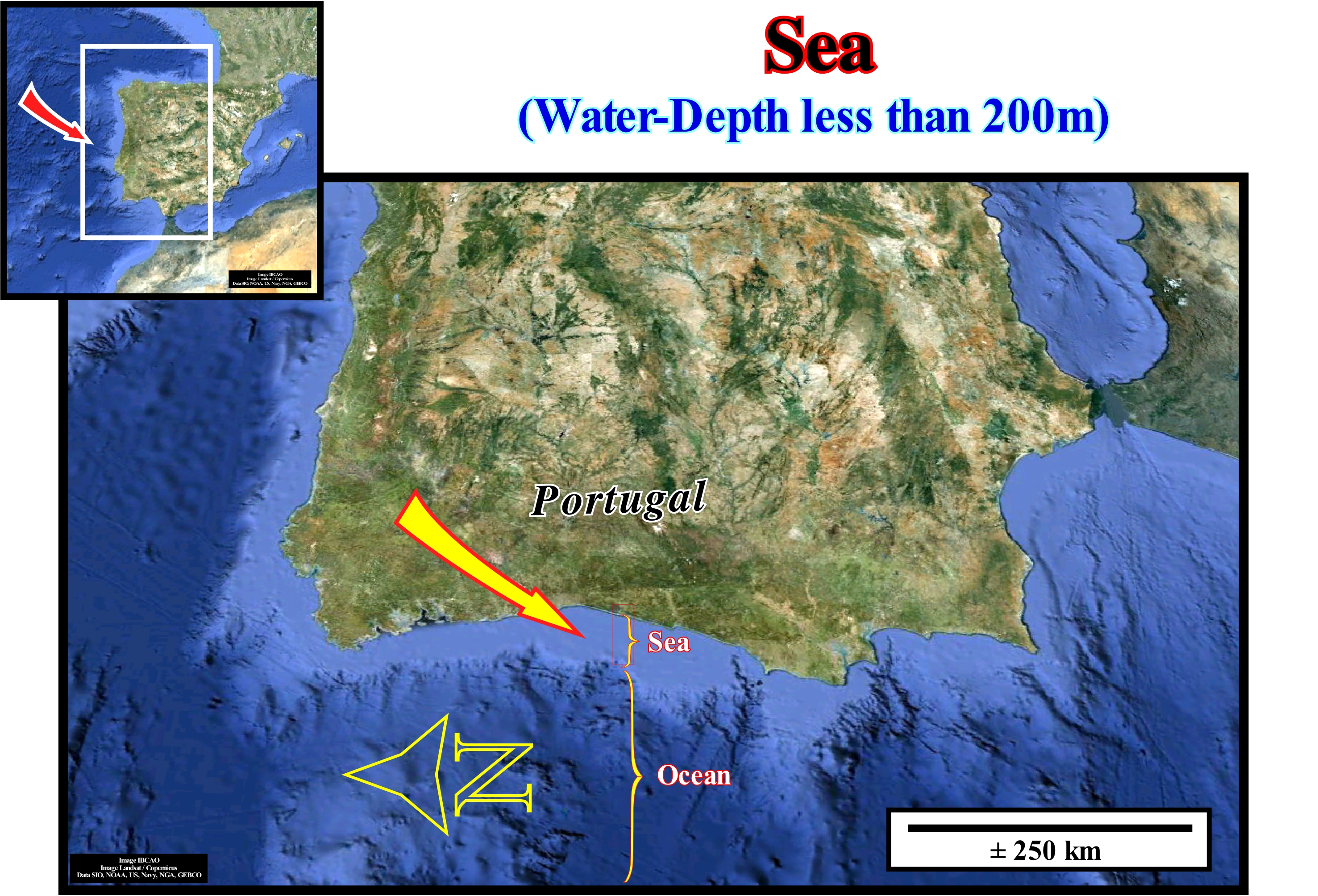
The sea or coastal sea is the part of the ocean near the mainland, generally with a depth less than 200 meters, which is influenced by human activity. The sea (coastal sea) corresponds, roughly, to the area between the outer edge of the continental shelf and the sea-influenced river area. Around the world there are about 14,250 x 1012 tonnes of water. The total ice on Earth corresponds to 16,700 109 tons of water. Every year, about 40 x 1015 litres of water (40x 109 tons) run from the land to the sea. The volume of water in the totality of the oceans, is superior to1370 106 km3. The volume of fresh water around the world is approximately 35 x 106 km3. If the matter constituting the Earth were evenly distributed in concentric layers and if the world were round and smooth like a billiard ball, ocean water would cover the entire surface of the earth and the global sea would be 3 km deep. When the sea is very agitated, it can affect the coast with a force equivalent to 30 tons per square meter. Sea and ocean water is composed of 3.5% of dissolved substances and 96.5% of pure water. Each litre of water contains about 35 grams of salt. In all the seas and ocean of the Earth there are about 50 x 1015 tons of salt (dissolved in the water and on the seabed). In every 19,000 litres of seawater, there is enough oxygen for 150 minutes to breathe. The mountain ridges scattered across the oceans of the world, measure more than 60,000 km. Of the volcanoes existing in these mountain ranges, fiery matter is continually emerging, producing annually about 17 km3 of new oceanic crust at the bottom of the seas. The amount of water, in all its forms, has been considered constant since the formation of the Earth. As the volume of the ocean basins increases or decreases (a function of the volume of the oceanic ridges, that is, of the ocean ridges), the mean sea level decreases or increases. The greater the volume of the oceanic ridges, the higher the sea level will be. The sea level is not smooth but wavy due to gravity anomalies.
Seafloor Spreading......................................................................................................................................................Expansion océanique
Expansão oceânica / Expansión oceánica / Ozeanbodenspreizung, Meeresgrund Verbreitung / 海底扩张 / Спрединг океанического дна / Espansione della crosta oceanica /
Process in which the ocean floor extends when two lithospheric plates move away from each other. As the lithosphereic plates move away from the mid-ocean dorsal (submerged mountain range) it develops as new mantle material reaches the surface (sea floor) along the oceanic rift*.
See: « B-Type Subduction (Benioff) »
&
« Paleomagnetic Stratigraphy »
&
« Magnetostratigraphy »
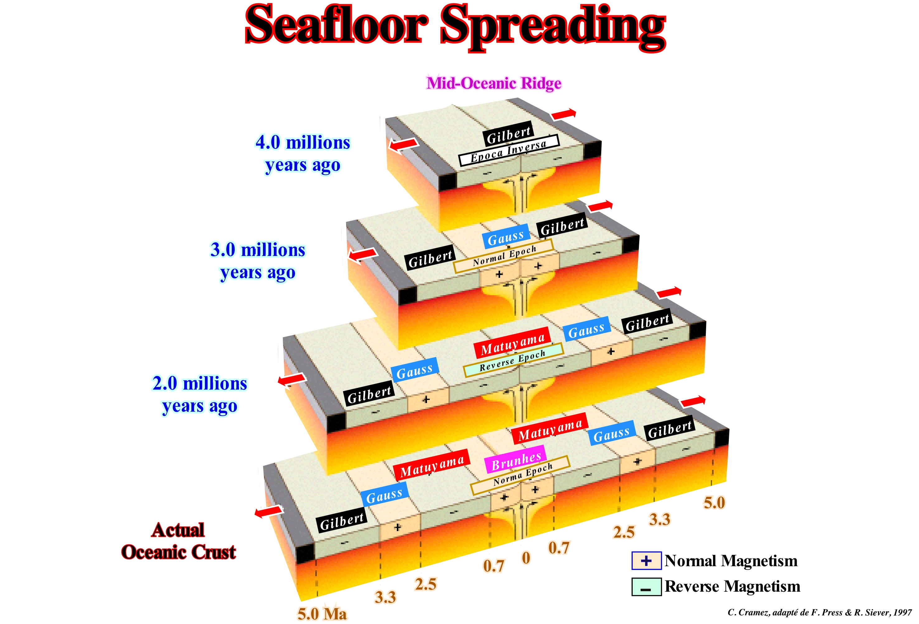
Most geoscientists think that the Earth's magnetic field is induced by the movement of liquid iron in the outer core as the Earth rotates. The magnetic field behaves as if a permanent magnet were attached near the Earth's centre, inclined about 11° to the axis of rotation of the Earth. The north magnetic field, measured with a compass, differs from the geographic north, which corresponds to the axis of rotation of the Earth. By placing a magnet under a sheet of paper in which iron filings are spread, a typical pattern is created by the magnetic field created by the magnet. With the Earth's magnetic field the same thing happens. The current orientation of the Earth's magnetic field characterizes a normal polarity. In the 1960s, geophysicists discovered that the magnetic field has periodically reversed, i.e., that the North Pole, throughout the geological history, has become South Pole and vice versa. As illustrated in this figure, the Earth had periods of inverse polarity that alternated with periods of normal polarity, which were, more or less, fossilized during seafloor spreading. It should be noted that the expansion or spreading of the ocean floor is a continuous movement, with velocity between 1 and 15 cm/year (**), which allows the formation of new oceanic crust at the level of the mid-oceanic ridge (injection of volcanic sheeted dykes) and which moves the continents with you (as a conveyor belt transports people or objects). Although the magnetic field has been inverted several times, Earth has continued to move without changing the direction of rotation (Earth rotates on itself, in the opposite direction the movement of the needles of a clock) and of translation (Earth realizes a movement of translation around the Sun, from West to East, describing an ellipse elongated at 365 days and six hours). Basaltic lavas containing iron-rich minerals such as magnetite act as compasses, that is to say, iron-rich minerals cooling below the Curie point (temperature at which certain materials undergo a complete change of their magnetic properties) and become magnetic in the direction of the Earth's magnetic field. The study of ancient magnetism recorded in rocks (paleomagnetism) allowed geoscientists to show, as illustrated above, that during the last 5 million years there were four reversals of magnetic polarity: (i) Brunhes, normal polarity, between now and 0.7 millions of years ago ; (ii) Matuyama, reverse polarity, between 0.7 and 2.5 million years ago ; (iii) Gauss, normal polarity, between 2.5 and 3.3 million years ago and (iv) Gilbert, reverse polarity, between 3.3 and 5.0 million years ago, which provides an excellent method of dating the rocks (paleomagnetic stratigraphy). To explain the magnetic inversions and the associated pattern, geoscientists have advanced the sea floor spreading theory. Indeed, the theory of plate tectonics, which is nothing other than a geometrization of the theory of sea floor spread, has almost completely concealed and eliminated Wegener's theory of drift from the continents***. On the other hand, almost fifty years after the recognition that the positive anomalies, that is, for which the measured magnetic field is superior to the current average magnetic field, and the negative ones draw a true zebra pattern (painting of black and white positive anomalies and negative) on both sides of the oceanic ridges, no satisfactory explanatory physical theory has yet been advanced to explain this geological phenomenon. Geoscientists speak of mantle convection, but are unable to properly associate the dissipation of energy, the source of which is the Earth's mantle, and the mechanics of the plates. As Claude Allègre ("l'Ecume de la Terre, Fayard, 1999) said," We know how, but we do not know why "
(*) The morphology of the oceanic rift corresponds well to that expressed in the original definition by J.W. Gregory (1984), who first used the term Rift-valley (Anglo-Saxon geoscientists) in geology to characterize the morphology of the African valleys Eastern: "linear valley with parallel and almost vertical sides distant between 30 and 100 km separated from the surrounding plateaus by large cliffs whose height can reach a few thousand meters and whose base probably fell along normal faults." The morphology of the sedimentary basins created during the lengthening of the supercontinents does not fit the morphology of a rift-valley. In most cases, there is no associated significant negative topographic anomaly (except when the elongation or extension rate is much greater than the fill rate), since as the available space for the sediments is created lithosphere of the supercontinent) it is immediately filled with sediments and, thus, the topography is always practically flat.
(**) The unit of velocities of the sea floor spreading is the centimetre per year. The variations are, more or less, from 1 to 20 centimeters/year. To appreciate the orders of magnitude: 1 centimetre (year is equivalent to 10 kilometers per million years or 1,000 kilometers per 100 million years. To open the Atlantic Ocean, at the ratio of 2 cm per year on each side of the mid-Atlantic ridge, it took about 150 million years.
(***) In 1929, A. Holmes, who worked on the role of radioactivity in temperature on the globe, discovered that the heat produced by radioactive decay must necessarily be evacuated. Seeking how this heat could be discharged, he proposed convection movements in the mantle. If there are convection currents in the mantle, then the convection currents may be the drift motor of the Wegener continents. Holmes relaunched the continental drift debate in 1930. Critics of continental drift, and especially Harold Jeffreys, show that the convective flow does not have the energy to divide a continent. In 1945, Holmes changed his hypothesis and suggested that oceanic ridges are the marks of the convective upward flow of the mantle. His hypothesis was rebutted because geologists have guaranteed that solid movements are impossible. The idea of convection of the mantle is marginal until 1960. In 1962, H. H. Hess resumed the theory of A. Holmes and corroborated it thanks to the findings on the composition of the ocean bottoms. The Hess theory was another bomb in the world of geology, since it relaunched the debate on continental drift. But an unexpected aid came from studies of geomagnetic studies (http://svt4vr.e-monsite.com/pages/premiere/la-tectonique-des-plaques/de-la-derive-des-continents-a-la-tectonique -des-plaques.html)
Sea Level Curve.................................................................................................................................................Courbe du niveau de la mer
Curva do nível do mar / Curva de nivel de mar / Meeresspiegel-Kurve / 海平面曲线 / Кривая уровеня моря / Curva delle livello della mare /
A curve representing sea level changes during the geological history (absolute or eustatic sea level) or during a certain geological time (relative sea level). The sea level curve, determined from seismic data, is referenced relatively to the current sea level position, which is relatively easy to determine on offshore seismic lines and slightly more difficult on terrestrial seismic lines, since a correlation is required. As sea level, in the seismic data is given by coastal onlaps, the depositional water-depth is considered as zero, which may, in some cases, not be true.
See: « Global Cycle Chart »
&
« Relative Sea Level Change »
&
« Aggradation »
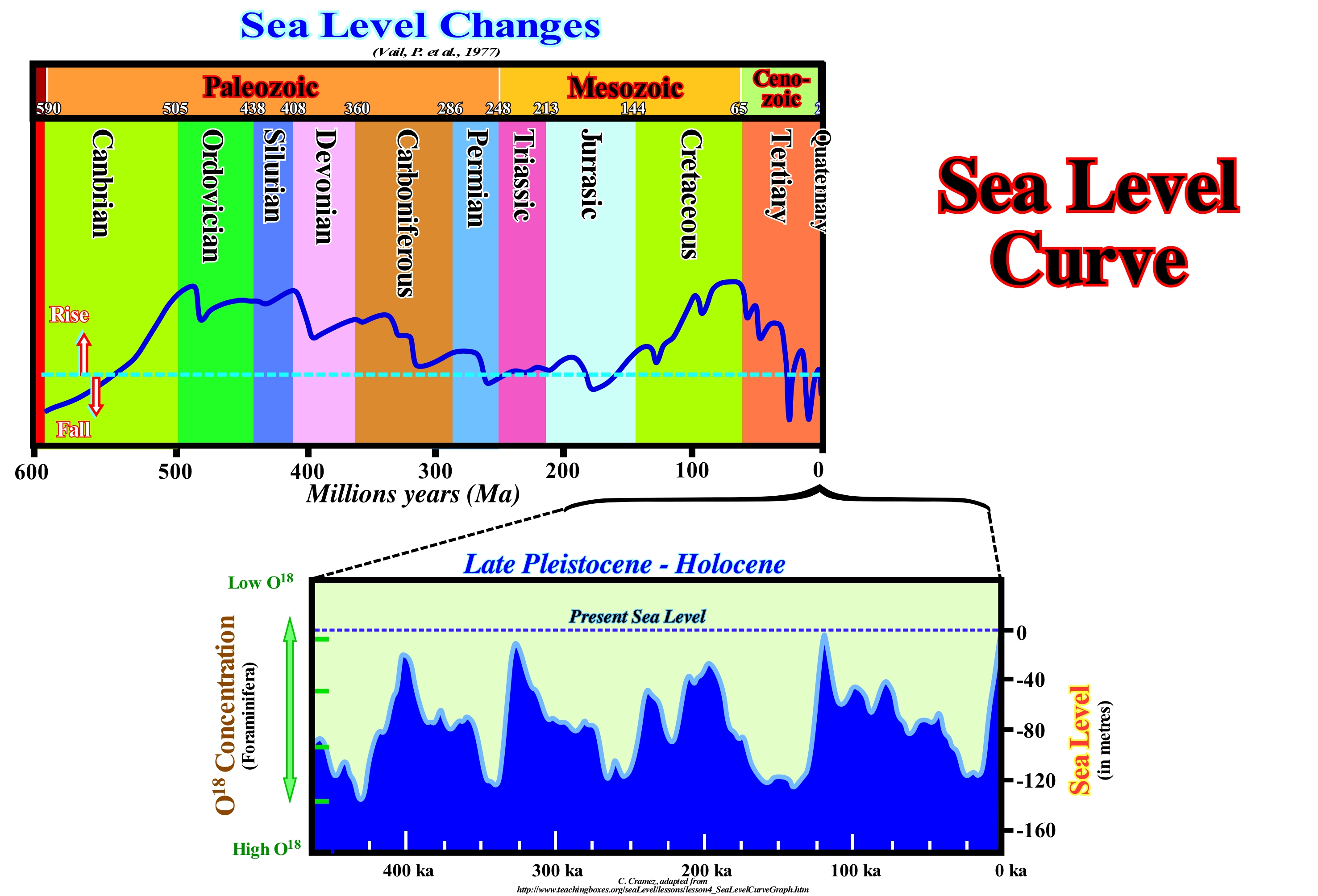
First of all it should not be forgotten that the sea level can be absolute (eustatic) and relative. The first is referenced to a global fixed point, such as the Earth's centre, while the second is referenced to any point on the Earth's surface which may be the top of the continental crust (base of the sediments) or the sea floor. The first curve of sea level changes (absolute or eustatic), proposed by P. Vail (1977), was constructed from information that Exxon oil company accumulated during dozens of years of petroleum exploration. It translates the result of the combination of absolute (eustatic) sea level changes and tectonics (subsidence or uplift of the sea floor) or, in other words, it emphasizes the main 2nd order eustatic cycles, whose time-duration varies from 3-5 My to 50 My. In fact, in the eustatic curve of the Phanerozoic proposed by the EPR (Exxon Exploration Production Research), five orders of eustatic cycles were considered. The time-duration of these cycles is: 1st order> 50 My ; 2nd order between 3-5 and 50 My ; 3rd order, between 0.5 and 3-5 My ; 4th order, between 0.5 and 0.08 My ; 5th order, between 0.08 and 0.03 My and 6th order, between 0.03 and 0.01 My. Each eustatic cycle induces a stratigraphic cycle. First-order eustatic cycles induce continental encroachment cycles. Eustatic cycles of the 2nd order induce continental encroachment sub-cycles. A third-order cycle induces a sequence-cycle, i.e., the building block of sequential stratigraphy. Eustatic cycles of 4th, 5th and 6th order induce high frequency stratigraphic cycles. In 1988, a revised eustatic curve for the Mesozoic/Cenozoic was published by the same authors (Haq's curve). Although a correlation is not a coincidence, geoscientists tend to correlate sea level variations, biotic crises, volcanism and climate with sequential stratigraphy. The paroxysm of volcanism during the Paleozoic coincides with the high eustatic Paleozoic, which reached its acme during the Cambrian-Ordovician. The paroxysm of volcanism during the Meso-Cenozoic has a correlation with the maximum sea level of the Cenomanian-Turonian. The glacial ice caps are larger during periods of lowstand (sea level lower than the basin edge), so biotic crises correlate sea level changes , but other correlations are also possible. In this figure, the sea level curve (absolute sea level) from the Late Pleistocene (± 500 ka) to today is also illustrated. It was constructed using the relationships between O18 and O16 oxygen isotopes found in wells cores in the ice caps and seas. In certain cases, such as in the ice of the polar seas, the ratio of oxygen isotopes (atoms having the same number of protons, but a number of different neutrons) is cyclic. The percentage of O18 to O16 varies in a more or less cyclic manner. This relationship seems to be linked to the temperature of the ancient oceans, which reflects to a certain extent the climate of the time, suggesting that the cyclicity of oxygen isotope relations probably reflects the cyclicity of climate change. In fact, as water H2O16 requires less energy to vaporize. The first water vapour to be formed during evaporation will be richer in H2O16 and the residual water will be enriched in H2O18. As the air moves from hot to cold, water vapour condenses and is removed by rainfall, which enriches H2O16with water vapour. Over time, this distillation causes precipitation, but the O18/O16 ratio is getting smaller as the temperature decreases. On this sea-level curve, assuming that the well cores were collected under normal conditions and that there is no contamination of the gaseous bubbles (there are many problems with regard to the age of the closure of the air bubbles and the meaning of what they contain), sea level rises and falls associated with glaciations and melting are evident. It is easy to see that, recently, sea level rose about 120 meters. The maximum extent of ice caps and ice seas (Northern and Southern hemispheres) during the last ice age are currently, relatively, well known. The maximum expansion of the ice was reached, approximately, at the same time, more or less, there are 19 ka. Then the ice began to melt, probably due to a global rise in sea level accompanied by changes in the circulation of deep waters in the Atlantic Ocean that transported warmer water to the continental margin of Antarctica. The retrogradation of the Antarctic ice cap, which is currently about 450 km (± 24 m / year), contributed, heavily, to the more or less 130 meters of postglaciation sea level rise. The contribution of the ice seas is null, since the water is denser than the ice. The graph of sea level changes during Late Pleistocene / Holocene suggests a cyclicity of about 100 ky which can be explained by the combined effects of eccentricity and precession.
Sea-Floor......................................................................................................................................................................................................................Fond de la mer
Fundo do mar / Relieve oceánico, Fondo de mar / Ozeanboden / 海床 / Дно моря / Fondali marini /
Ocean floor or ocean base. Function of water-depth, three major regions can be considered: (i) Neritic, sublittoral or attic; (ii) Bathyal and (iii) Abyssal. These regions correspond roughly to the three major deposition environments: (a) Continental shelf ; (b) Continental slope and (c) Abyssal Plain. At the base of the continental slope, mudslides and deposits of turbiditic sediments induce the continental rise formation.
See: «Continental Platform »
&
« Continental Slope »
&
« Abyssal Plain »
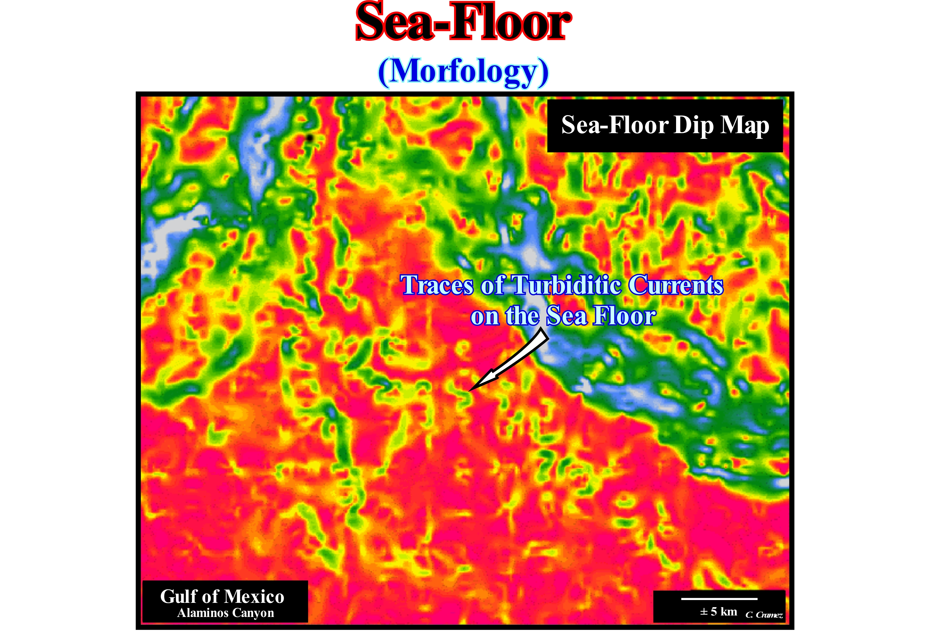
The ocean floor includes the various forms of relief existing in the land crust regions that are covered by the oceans: (i) Continental Platform (shelf),i.e., the bottom portion of the oceans that reaches, on average, 200 meters water-depth and one variable width and that is covered by sediments of continental origin brought by rivers, winds, waterfalls and glaciers, which implies the existence of great concentrations of mineral resources : (ii) Continental Slope, corresponding to the intermediate portion covered by sediments ; (iii) Abyssal Plain, which is the deeper and, more or less, flat region of the oceans ; (iv) Oceanic Trench, which is an abyssal depression created by the B or Benioff type subduction zones and (v) Mid-Oceanic Ridge, which corresponds to submarine mountain belt that extend through the ocean floor (https: //pt.wikipedia.org/wiki/Relief_ oceanic). The bottom of the sea was a place unknown until very recently. But it is in the deeper parts of the oceans that lithospheric plates are formed and destroyed and where exist the largest mountain belt of the world. It is important to know the oceanic relief to be able to understand the dynamics of the planet, i.e., the formation and destruction of lithospheric plates and the formation of islands. The oceanic relief is in constant transformation and movement. It is considered oceanic relief the part of the crust that is submerged by the oceans and is denominated of oceanic crust. This image depicts the seafloor of a sector of the Gulf of Mexico (USA) continental slope. Basically, it underlines the changes of the inclination of the seafloor, which gives important insights into the morphology of recent turbidity currents. In a more or less regular, but not periodic, turbidity currents flow along the continental slope and transport the sediments into the deeper parts, where they are deposited, within the sequence-cycles, lowstand systems tracts of the subgroups, i.e., submarine basin floor fans (SBFF) and submarine slope fans (SSF). The submarine slope fans (SSF) are, generally, formed by natural marginal dikes (overbank deposits with the "gull wing" structures of P. Vail) and the filling of the depressions between them or the filling of turbiditic channels (in this case of an evident erosion.) Submarine basin floor fans are, generally, formed by, more or less, important sandy lobes. A close observation of the patterns of the turbidity currents (zigzags indicated by the arrow), in this figure, clearly shows the downdip course of the currents along the continental slope is not rectilinear but meandriform. However, unlike what happens with the flow of a river, a turbidity current flows within a water-bods and not at the surface of it. Thus, a curvilinear flow geometry is explained in a very different way: (i) When the density of the turbidity current is much greater than the density of the water-body, in which it flows (which means that it carries a lot of sandy material), the trajectory is, practically, rectilinear ; (ii) When the density of the current turbidity is, more or less, equal to the density of the water-body (stream with little sandy material), the trajectory of the flow as a meandering geometry. It is therefore not very logical to interpret the fillings of turbidite meandriform patterns as potential reservoir-rocks on seismic data unless the filling is very late and in retrogradation (when the relative sea level, i.e., when measured to a the local reference point such as the sea floor, is already rising), as appears to be the case in certain Angola offshore oil fields. Theoretically, and according to the P. Vail turbidite systems model, this suggests that the submarine basin floor fans (SBFF) are induced by dense and, more or less, rectilinear turbidite currents (rich in sandy material), while the submarine slope fans (SSF) are associated with low density turbidite currents (rich in clayey material). If this is true, the model proposed by E. Mutti is more difficult to refute, since Type-I turbidites are induced by very dense, sand-rich turbidite currents, whereas Type-II turbidites are associated with smaller currents carrying almost exclusively shaly material.
Sea-Floor Morphology.........................................................................................................Morphologie du fond de la mer
Morfologia do fundo do mar / Morfologia del fondo del mar / Seafloor Morphologie / 海底形态 / Морфология морского дна / Morfologia del fondo marino /
The bathymetric chart, i.e., the depth map of the sea floor, which exhibits a very particular morphology that corroborates the plate tectonics theory.
See: « Eustasy »
&
« Accommodation »
&
« Abyssal »
Taking into account the vertical exaggeration of these two schemes, it is easy to conclude, at least at the level of the Tropic of Cancer, that the topography and bathymetry of the Earth's surface in no way falsify the tectonic theory of lithospheric plates. In reality: (i) Ocean Trenches underline well the B-type subduction zones (Benioff), where the oceanic crust dips under the continental crust ; (ii) The Andes correspond to the mountain chains and volcanic arcs induced by the B-type subduction zones ; (iii) The Oceanic Mountains, on each side of the mid-oceanic region, underline the oceanic accretion, that is, the formation of new oceanic crust, as sea floor spreading takes place, and (iv) Ocean floor between oceanic mountains and continents, that mark the old, cold and dense oceanic crust. All this means that bathymetry corroborates the structure and mechanism of lithospheric plate tectonics, i.e., the formation of new oceanic crust along the mid-oceanic ridges and the consumption of the old oceanic crust along the subduction zones. The extension along ocean ridges is compensated by the assimilation of oceanic crust in the subduction zones and the shortening of the sediments in the rising lithospheric plates along the subduction zones. As illustrated in the schemes of this figure, the major subdivisions of the Earth's surface are: (i) The Ocean basins, which cover about 60% of the Earth's total surface ; (ii) Continental platforms (up to 200 meters of water depth) ; (iii) The Ocean floor ; (iv) The oceanic mountains and (v) The continental slopes (including foothills) between the ocean floor and continental shelves. Water from ocean basins covers 71% of the Earth's surface. The total volume of the ocean basins varied throughout the geological history (one of the causes of eustasy). More than 65% of the emerging Earth is in the Northern Hemisphere. Oceanic mountains cover about 25% of the total Earth's surface and the mountainous system of the continents covers only about 12%. The volcanic arcs and associated trenches form about 1.2% of the total Earth's surface.
Sea-Spray (Salt-spray)...........................................................................................................................................................................................................Embrun
Salsugem / Rociado y salpicadura / Spritzwasser / 盐雾 / Брызги, водяная пыль / Nebbia salina /
A foam cloud formed by droplets of sea water and bubbles enclosing saline microcrystals resulting from the surfing foam that is projected against the shore and carried inward by the wind. The sea-spray is responsible for a characteristic corrosion modeling and the presence of certain biocenoses, that is, balanced associations of animals and plants in a same biotope (the physical environment where the living beings live in an ecosystem) and the formation of other (woody plants) (Moreira, 1984).
See: « Wave Action Level »
&
« Beach »
&
« Brakish-Water »
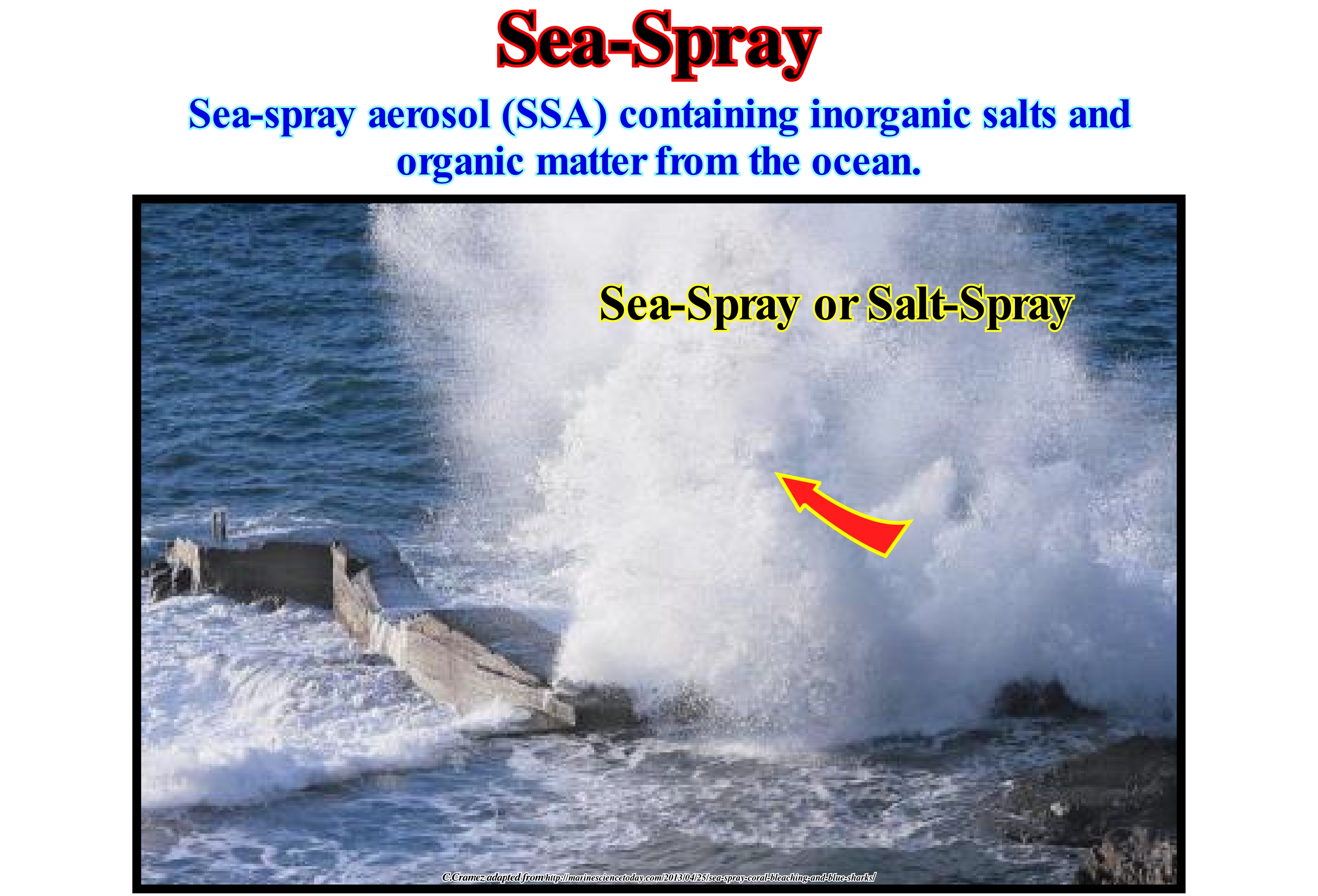
The salt-spray is a spray of sea water (small drops of sea water and air that carries them) that forms when sea waves break or strike against a natural or artificial rock wall. As the salt contains a high concentration of mineral salts (products formed by the neutralization reaction between acids and bases, and cation compounds, i.e., positive ions, and anions, i.e., negative ions), particularly chlorine anions, it is highly responsible for the corrosion of metallic objects near the coastline. Mineral salts greatly accelerate the corrosion process. It is enough to see the corrosion of the metal piers or the cement reinforcement of the piers to understand the corrosive role of the seal. It is well known that salt-spray contributes greatly to the karsification of limestone lines, i.e., to the morphogenic process affecting the shorelines constituted by carbonate rocks, which is characterized by the dissolution of calcium carbonate, which is carried under the form of bicarbonate of calcium. This process gives rise to a chaotic aspect surface topography and deep dissolution and runoff forms. The salt-spray is, partially, responsible for the formation of the corrosion alveoli (or bees' nests), which are the small rounded contour holes of depth between centimeters and 2-3 m, excavated in the coherent rocks of the supra-littoral zone that is reached by the salt-spray splashes. In the highest part of the spreading, the runoff from the bubbling drops and foam from the waves can form cutting lapiaz with corrosion ridges. Some geoscientists are even advancing that the sulfur, which releases bromine and chlorine, contributes to the destruction of the ozone layer.
Secchi's Disk..................................................................................................................................................................................................Disque de Secchi
Disco de Secchi / Disco de Secchi / Secchi - Scheibe / 透明度盘 / Диск Секки (белый диск) / Disco di Secchi /
Disc with two white and two black quadrants (opposites) used to measure the transparency of the water of oceans and lakes.
See: « Turbidite »
&
« Eutrophic (lake) »
&
« Blue Ocean »
The Secchi disk is mounted on a stick or a line and slowly lowered into the water. The depth at which the disk pattern, i.e., the black and white quadrants are no longer visible is taken as a measure of the transparency of the water. This measure is known as the Secchi depth and is related to water turbidity. The Secchi depth is reached when the reflectance (the flux of radiation incident on a surface and the flux being reflected) is equal to the intensity of backscattered light of the water. This depth, in meters, divided by 1.7 indicates the attenuation coefficient (also called extinction coefficient), for available light, calculated on the Secchi disk depth. Secchi disk readings do not give an accurate measure of transparency. There may be errors due to the sun's brightness in the water, and one person can see the disk at a depth, but another, with better vision, can see it at a greater depth. A Secchi disk is a cheap and simple method of measuring water transparency, but due to the potential for varying measurements, this method should be standardized as much as possible. Secchi disk readings should always be made out of a boat's shade or a season and made between nine o'clock in the morning and three o'clock in the afternoon. The best period is between 10 and 2 in the afternoon. The same observer should always take the measurements of depth in the same way. One of the ways to do a more rigorous measurement is to lower the disk beyond the point of disappearance of the black and white quadrants and then raise it and slowly lower it several times to better define the depth of Secchi. Another method is to record the depth at which the disk disappears, go down a few inches, and then record the depth at which the disc reappears when slowly raised. The Secchi depth will be the mean of the two values. Measurements made with the Secchi disk do not indicate how the attenuation changes with depth or with particular wavelengths of light.
Sechron.....................................................................................................................................................................................Durée d'un Cycle-Séquence
Duração de um ciclo sequência / Duración de un ciclo secuencia / Sechron, Zykluszeit Reihenfolge / 周期时间序列 / Продолжительность цикла-последовательности / Secrona /
Maximum time span occupied by a sequence-cycle that, generally, ranges from 0.5 My to 3-5 My. This interval is measured between the points where the unconformities, which limit the sequence-cycle, pass, laterally, to the paraconformities surfaces, i.e., in the areas with an insignificant hiatus (abyssal plain). Throughout an unconformity (erosional surface), the minimum hiatus, which dates from the relative sea level fall that caused it, is where it is fossilized by submarine basin floor fans of the overlying sequence-cycle.
See: « Continental Encroachment Cycle »
&
« Stratigraphic Cycle »
&
« Sequence Cycle »
On this tentative geological interpretation of a Canvas auto-trace of a detail of an United States onshore seismic line, it is easy to verify that it was made at the hierarchical level of the stratigraphic cycles called sequence-cycle, since the age difference between successive unconformities that limit the sequence-cycles is less than 3-5 My (million years) and greater than 0.5 My*. In sequential stratigraphy, each stratigraphic cycle is induced by an eustatic cycle, whose time-duration allows classification of the stratigraphic cycles in: (i) Continental Encroachment Cycles, when they are induced by 1st order eustatic cycles, that is, by eustatic cycles which have a time-duration of greater than 50 My ; (ii) Continental encroachment Subcycles, when they are induced by 2nd order eustatic cycles, which have a long time-duration ranging from 3-5 to 50 My ; (iii) Sequence-cycles, when they are induced by 3rd order eustatic cycles, whose time-duration varies between 0.5 and 3-5 Ma ; (iv) High Frequency Cycles, when they are induced by short duration eustatic cycles, usually between 0.5 My and 0.01 My**. The sequence-paracycles, which certain geoscientists erroneously call parasequence cycles, form the different systems tracts subgroups that make up a cycle-sequence, are induced by eustatic paracycles, which correspond to relative sea level rises (marine ingressions), whose duration may vary between 0.01 and 0.5 My, but without relative sea level fall between them. The relative sea level is a local sea level, referenced to any point on the Earth's surface, which may be the sea floor or the base of the sediments (top of the continental crust). It is the result of the combined action of absolute (eustatic) sea level, which is supposed to be global and referenced to the Earth's centre and tectonics (subsidence, when the predominant tectonic regime is in extensional or uplift, when the predominant tectonic regime is in compressional). The space available for the sediments (accommodation) that form the sequence-paracycles is created by successive marine ingressions without relative sea level between them. Sedimentation does not occur during marine ingressions, but during the stability period of relative sea level that occurs after each marine ingression. On conventional seismic lines, which have a seismic resolution of about 30-50 meters, a sequence-cycle interpretation is only possible if the area in which the seismic line was shot corresponds to a large depositional centre, that is, a area with a very high deposition rate, so that the sequence-cycles have a thickness higher than the seismic resolution, as is the case illustrated on this tentative interpretation. This is, particularly, important since only tentative interpretations at the hierarchical level of sequence-cycles, i.e., where sedimentary systems tracts groups and subgroups can be put in evidence, can be used to predict lithologies. In all other cases, when an interpreter prognoses lithologies, it is, certainly, a mistake of "jeunesse" as the French geoscientists say. On this tentative interpretation, an important tectonic disharmony was induced by the salt interval (coloured in red), whose flows (lateral and vertical) created a salt weld (emphasized by cycles above and below disharmony, which does not correspond, at least in the sequential stratigraphy, to what is called unconformity, i.e., to an erosional). In this area, all sequence-cycles are incomplete. The submarine basin floor fans (SBFF) and submarine slope fans (SSF) are always absent, at least on this seismic line. Some sequence-cycles are only represented by the highstand prograding wedge (HPW). The displacements of depositional coastal breaks of successive depositional surfaces (emphasized by the sedimentary interfaces responsible for the seismic reflectors) underlie relative sea level falls, as well as regressive (progradational) and transgressive (retrogradational) intervals.
(*) Ma means millions of years ago, that is, a geological age, while My means an interval of millions of years, which may have be Paleozoic or Cretaceous.
(**) Many geoscientists consider 4th order eustatic cycles, when the duration is between 0.5 My and 0.08 My, 5th order eustatic cycles, they have a duration between 0.08 M and 0.03 M, and eustatic cycles of 6th order, when they have a duration between 0.003 and 0.001 My.
Second Law of Thermodynamics.............................................Second loi de la thermodynamique
Segunda lei da Thermodinâmica/ Segunda ley de la termodinámica / Zweiten Hauptsatz der Thermodynamik / 热力学第二定律 / Второй закон термодинамики / Seconda Legge della Termodinamica /
The entropy* of an isolated system may just increase. As the entropy of a system is increasing, the possibility of the system performing useful work decreases. The Universe is an isolated system and, therefore, the possibility of sustaining life inevitably decreases with time (hundreds of millions or even tens of billions of years).
See « Early Universe »
&
« Life »
&
« Entropy »
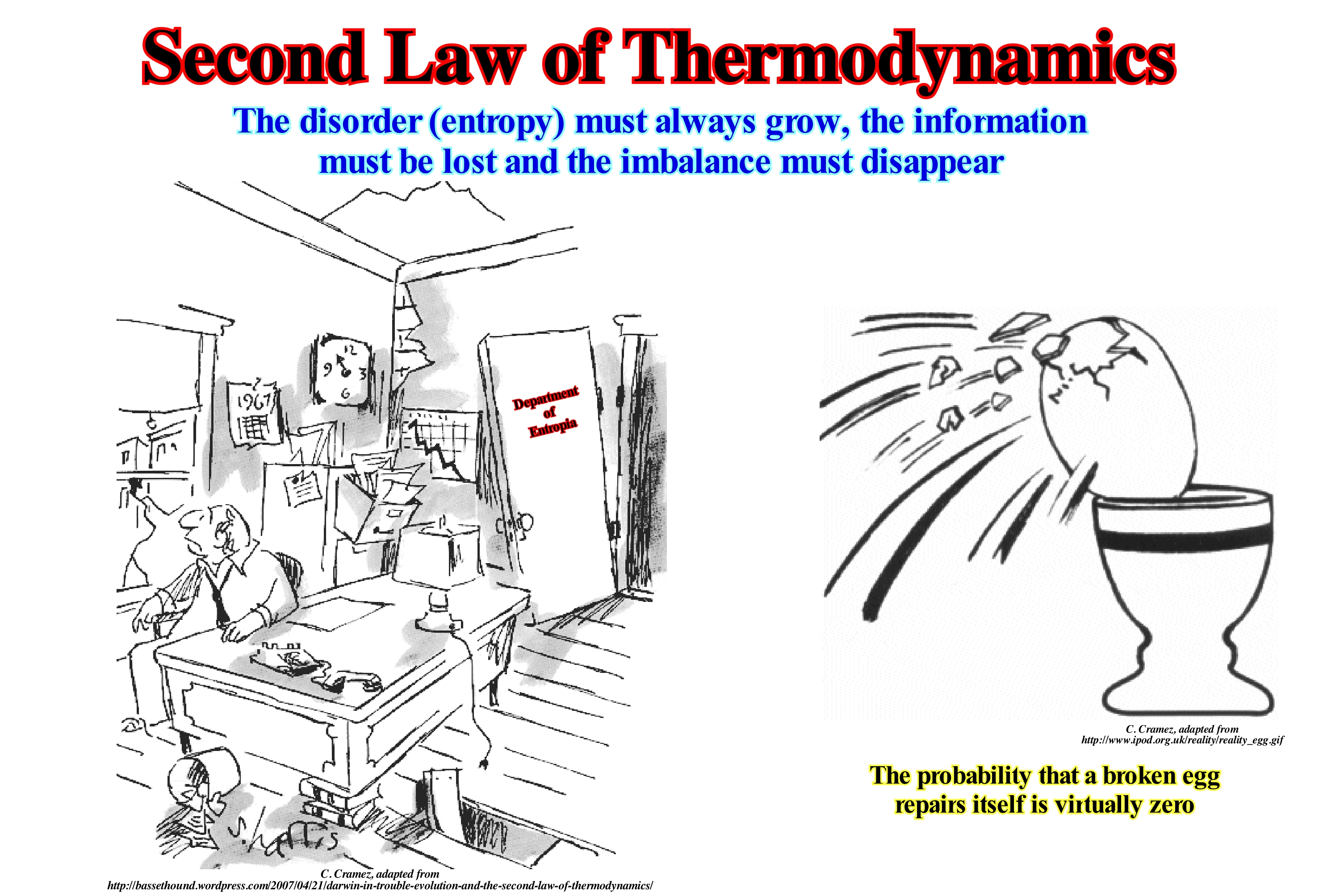
In classic physics, the Thermodynamics, i.e, how heat moves, is governed by three laws. The first law or law of energy conservation says that whatever happens, the energy of the Universe is constant (we can not create or destroy energy, but only change one form of energy in another). The second law says that entropy (the measure of the part of the energy that can not be exploited in any way) of an isolated system always increases. The third law says that when the temperature of a system reaches absolute zero (-273.15° C) all natural processes cease to occur and entropy reaches its minimum. The second law of thermodynamics or second principle of thermodynamics says the amount of entropy of any thermodynamically isolated system tends to increase with time until it reaches a maximum value. When one part of a closed system interacts with another part, the energy** tends to divide equally, until the system reaches a thermal equilibrium. While the first law of thermodynamics (conservation of energy establishes equivalence between work and heat: the total energy transferred to a system is equal to the variation of its internal energy) establishes the conservation of energy in any transformation, the second law establishes conditions for thermodynamic transformations to occur. Graphically, the second law of thermodynamics can be expressed by imagining a boiler of a steam boat, which could not produce work other than the steam it contains at a very high temperature and pressure compared to the surrounding environment. Another way to see this law is by observing its relevance. The first law is, in fact, a principle of energy accounting: the portions of energy must be summed, which is to say, that the first law of thermodynamics deals with the quantities of energy. The second law, by saying that kinetic energy (for example) can be, integrally, transformed into thermal energy (heat) but not the other way, indicates a quality for energy. For example, imagine that a car moves at 50 km/h and suddenly the driver brakes hard. All of its kinetic energy (car movement) is transformed into internal energy in brake discs and other sources of friction, such as tires, for example, that will warm up. Finally, a certain amount of heat will be transferred to the environment. If that amount of heat is given to the car (or the brakes), it will not leave the place.
(*) Term introduced in 1865 by Rudolf Clausius from a Greek word meaning "transformation", which characterizes the degree of disorganization, or unpredictability of the information content of a system.
(**) Energy is the ability to do a work. here are two types of energy, the kinetic energy, that is, the ability to do work through the movement and the potential energy, that is to say, the ability to do work through the position. Although we often meet terms such as electrical energy, chemical energy, nuclear energy such things do not really exist. They are only practical abbreviations for specific combinations of the kinetic energy and potential energy. Thus, the electrical energy is only the potential energy of negative charge electrons in the presence of positive charges. The exception to this universality of the kinetic energy and potential energy is the energy of electromagnetic radiation, such as the energy of light, such as the one transported from the Sun to Earth and which heats us or aliments photosynthesis. (P. Atkins, 2003-Galileo's finger- The ten Great Ideas of Science. Oxford Universioty Press).
Second Order Eustatic Cycle...................................................................................Cycle eustatique de 2ème ordre
Ciclo eustático de 2a ordem / Ciclo eustático de 2° orden / Zweite Ordnung eustatischen Zyklus / 二阶海平面周期 / Эвстатический цикл второго порядка / Ciclo eustatiche (2°ordine) /
Eustatic cycle with a time-duration between 3-5 and 50.0 My (millions of years).
See: « Eustatic Cycle »
&
« Supercontinent »
&
« Stratigraphic Cycle »
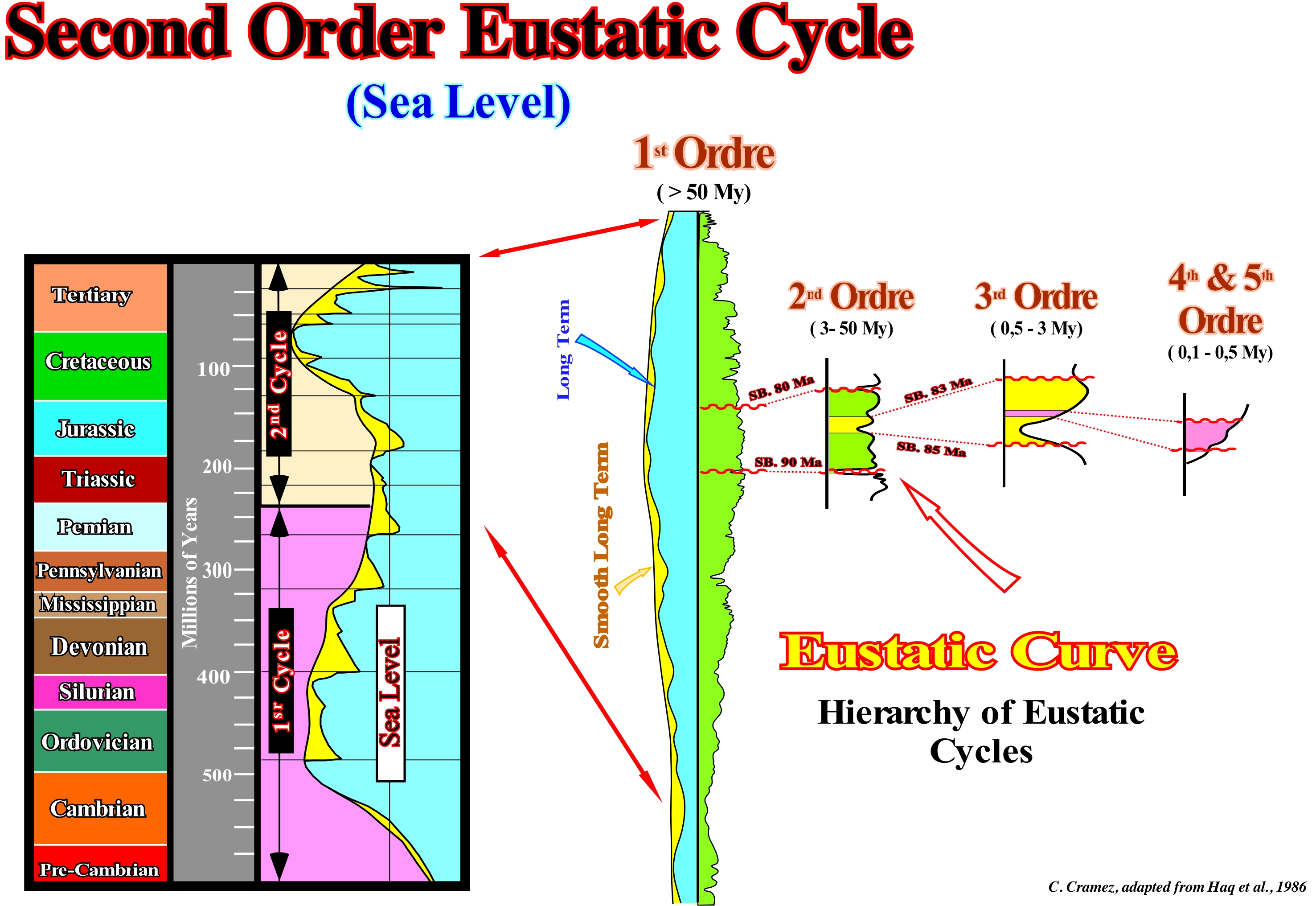
Within 1st order eustatic cycles, characterized by a time-duration of more than 50 My, second order eustatic cycles can be recognized, which have a much shorter time-duration which, according to Peter Vail, varies between 3 My and 50 My, but that can vary, according to other geoscientists between 5 My and 50 My*. Second order eustatic cycles are, probably, induced by changes in tectonic subsidence, which can easily be determined from sediment thickness plus water-depth but decreased from the effect of isostatic compensation due to increased and sedimentary and increased by the compaction effect. The origin of the tectonic subsidence may be due to: (i) Lengthening, when the lithosphere is lengthened by normal faults, as is the case during the formation of the rift-type basins, the crust lengthens reducing, at same time, its thickness, i.e., it subsides in relation to the thicker and undeformed crust ; (ii) Cooling, when the lithosphere is lengthened during the formation of rift-ype basins, the uplift of the upper surface of the lithosphere decreases while the lower limit rises, which forces the underlying asthenosphere to rise and replace the thinned mantle lithosphere ; after the lengthening phase, the surface of the asthenosphere cools and returns to the lithospheric mantle, however, as the lithosphere of the mantle is denser than the asthenospheric mantle, such cooling causes significant subsidence ; (iii) Charging, the sedimentation, the stacking of thrusts and the formation of folded mountains belts induce crustal depression and subsidence ; in the case of the sedimentary depocenters, these accompany the sinking of the underlying lithosphere, however, in the case of thrusting and mountain belts, the sinking occurs mainly in the lithospheric crust adjacent to the deposition. In association with the 1st eustatic cycles, created by the breakup and aggregation of supercontinents, the continental encroachment stratigraphic cycles are deposited, in which it is easy to recognize a transgressive sedimentary phase (dispersion of the continents) and a regressive sedimentary phase (agglutination of continents). During the transgressive phase, sediments are deposited under a water-depth, which, globally, is increasing (geometry, globally, retrogradational). On the contrary, during the regressive phase, the water-depth of deposition, progressively, decreases (geometry globally prgradational). In association with the second-order eustatic cycles, continental encroachment subcycles are deposited. Within each continental encroachment subcycle, geoscientists recognize transgressive and regressive phases or episodes (2nd order), which are separated by a downlap surface (secondary). The identification and hierarchy of the downlap surfaces, corresponding to the high eustatic levels, is very important, particularly, on the seismic lines, since they suggest the sedimentary intervals where the marine source-rocks of the hydrocarbons are most probable. Using this diagram, the most likely Paleozoic marine source-rocks are the rocks rich in organic matter, which deposited during the Ordovician and the Silurian when the eustatic level was high. Similarly, during the Mesozoic (second eustatic cycle of the Phanerozoic 1st order eustatic cycle), the most likely marine source-rocks are those deposited during the Cretaceous (Cenomanian / Turonian), since during this geological period the eustatic level was high. Secondary source-rocks, associated with the downlap surfaces of the 2nd order eustatic cycles, may develop, locally, and, sometimes, even regionally. In the North Sea, the most likely marine source-rocks are the organic matter-rich clay rocks of Kimmeridgian that are associated with a secondary eustatic peak of the Mesozoic-Cenozoic 1st order eustatic cycle. The formation of the marine source-rocks during the eustatic high is easily understood, since in the distal part of the continental shelves conditions of low sedimentation rate (starved areas) are developed that facilitate the formation and preservation of organic matter.
(*) Assuming that on the scale of the Phanerozoic, whose time-duration is, more or less, 600 My, an instantaneous geological event lasts about 1/100 of the total time (at least from the mathematical point of view), i.e., about 6 My, it can be said that a 3rd order eustatic cycle with a duration between 0.5 and 3-5 My, as certain geoscientists admit, continues to be considered with an instantaneous geological event, which is important, sequence are considered as the building blocks of sequential stratigraphy.
Sediment.........................................................................................................................................................................................................................................Sédiment
Sedimento / Sedimento / Sediment / 沉淀 / Осадок / Sedimento /
Material (sand, gravel, mud, etc.) carried by wind, water, ice, deposited by gravity or precipitated from a solution or a the settle of organic origin material.
See: « Sediment Influx »
&
« Rock Cycle »
&
« Erosion »
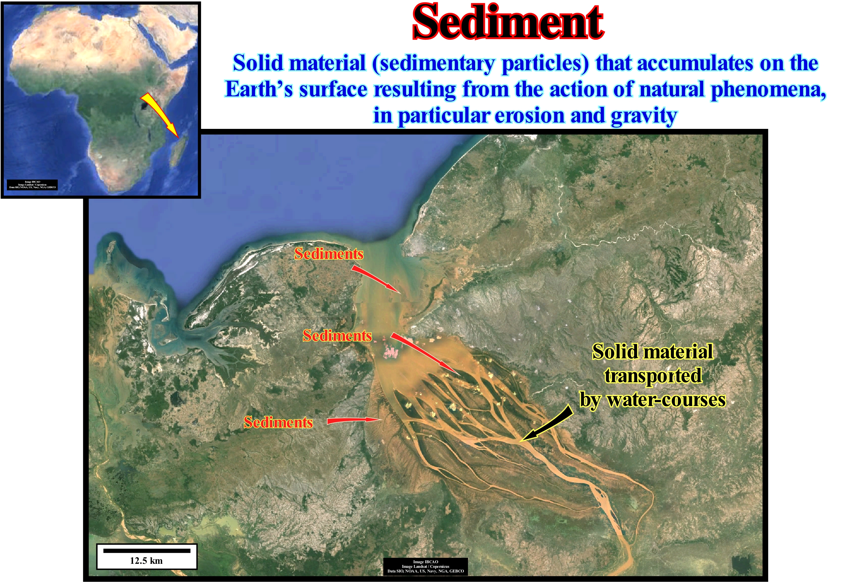
In this photograph, the sedimentary particles transported by the Betsiboka River (Madagascar) are responsible for the colour of the river water (well visible at the mouth), which contrasts with the colours of the sea. A sediment is any particle of matter (sedimentary particle), transported through a flowing stream (water, wind, ice) that was settle down, i.e., deposited. The size of a sediment is very variable (<1 μm in a mud and> 256 mm in a conglomerate). The transport of a sedimentary particle depends on the energy of the flow and its size, volume, density and strength. Energy flows lift and transport fine sedimentary particles, while larger and denser sedimentary particles fall to the bottom where they settle. This relationship is given by the Rouse number, R = ωs / κ u* (where ωs is the velocity of fall, κ is the Von Kármán constant and u* is the shear rate), i.e., the relationship between the falling velocity and the ascending velocity of a sedimentary particle. In the bed of a river, sediments (deposited sedimentary particles) can form SOC structures (Shelf Organized Critically), such as ripples, dunes and anti-dunes. The main environments of river deposition are: (i) Delta (between fluvial and marine environments) ; (ii) Point Bar ; (iii) Alluvial fan ; (iv) Braided River ; (v) Oxbow Lake or abandoned meanders lake ; (vi) Natural Marginal Dikes (levees) and (vii) Waterfalls. Sedimentary particles can also be transported by wind and deposited into dunes and loess (from the German Swiss "lösch**"). When transported by ice and, in particular, by glaciers, the sediments are deposited later in the form of moraines. Although, in general, a sedimentary particle consists of terrestrial material, i.e., that originated in the onshore, it can be transported to either terrestrial, lacustrine or marine sedimentary environments. Land material is provided by rivers or by the remobilization of marine sediments. In the oceans, far from the shoreline, organisms are primarily responsible for sedimentation, since when dead their shells or skeletons fall to the seabed (vertical sedimentation) and form important accumulations.
(**) Slightly compact, mobile, large pebble.
Sedimentary Basin.........................................................................................................................................................Bassin sédimentaire
Bacia sedimentar / Cuenca sedimentaria / Sedimentbecken / 沉积盆地 / Осадочный бассейн / Bacino sedimentario /
Low land area of the Earth's crust, of variable geometry, with a circular to linear form, usually of tectonic origin and in which sediments can be deposited, which always thicken to the deepest and central part, which is the most subsident . A sedimentary basin is a structure in extension, of sinform geometry (a syncline is a compressive structure), more or less circular, in which the layers dip and thicken, slightly, to the center. In Sequential Stratigraphy, the term basin refers, always, to the morphology of a stratigraphic cycle, whether it is a continental encroachment cycle or a sequence-cycle. At the hierarchical level of a sequence-cycle, geoscientists say that the basin does not have a continental shelf during the deposition of the group of lowstand systems tracts (basin floor fans, slope fans and lowstand prograding wedge) and during the deposition of the second stage of development of the highstand prograding wedge (HPW). On the contrary, the basin has a shelf during the deposition of the transgressive interval (TI) and the first stage of development of the higstand prograding wedge (LPW), which are subgroups of the highstand systems tracts group. The geographical names of the basins, such as Lusitanian Basin, Paris Basin, Neuquén Basin, etc., are to be avoided since they correspond to the temporal and spatial stacking of different types of sedimentary basins of the classification of Bally and Snelson (1980) that is followed in this glossary.
See: « Megasuture »
&
« A-Type Subduction (Ampferer) »
&
« B-Type Subduction(Benioff) »
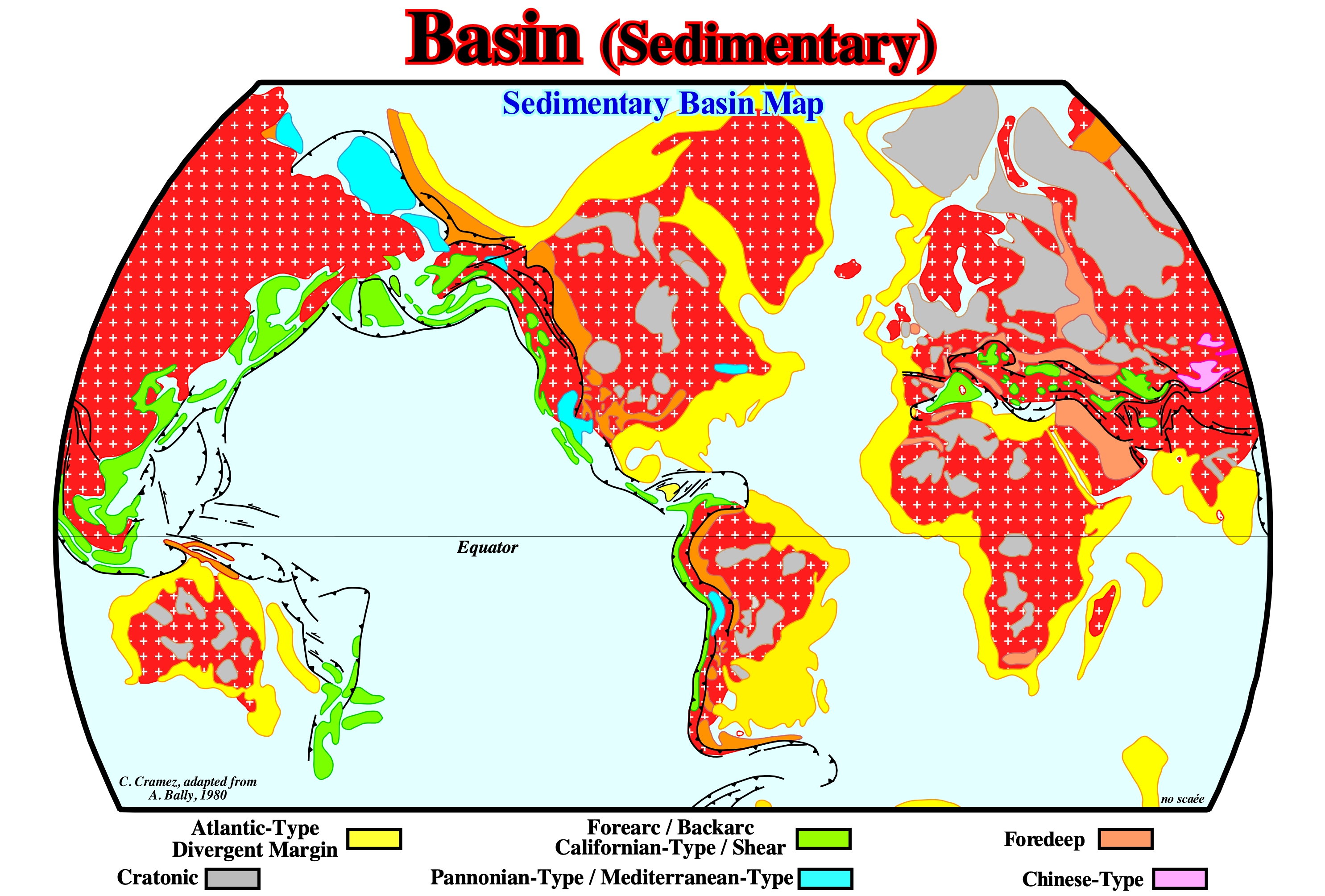
This map illustrates the distribution of the different types of Mesozoic/Cenozoic sedimentary basins recognized in the classification of Bally and Snelson* (1980), which is mainly based on subsidence. These geoscientists recognize two main types of sedimentary basins: (i) Basins not associated with the formation of the Mesozoic/Cenozoic megasuture** and (ii) Basins associated with the formation of Mesozoic/Cenozoic megasuture. In the former, there are three main classes: (a) Cratonic Basins, which developed in the Paleozoic continental crust and which were, generally, created by a regional thermal subsidence ; (b) Rift-type Basins, which were created in the Paleozoic continental crust by a differential subsidence, when the lithosphere was, locally, elongated and (c) Divergent Atlantic-type Margins that developed above the rift-type basins in association with a thermal subsidence, since the lithosphere of the supercontinent Pangea fractured. As rift-type basins are, usually, covered by either a cratonic basin or by a divergent margin, they are not visible in the map illustrated in this figure. In the sedimentary basins associated with the Mesozoic/Cenozoic megasuture formation, there are two large families: (1) Perisutural Basins, which developed at the periphery of the megasuture, in association with a type-B (Benioff) or type-A (Ampferer), such as the foredeep basin (foreland basins) or backarc basin ), and (2) Episutural Basins, which developed within the megasuture such as the backarc basins, the Mediterranean and the Pannonian basins. The extension behind the volcanic arc can be very important and create an oceanization, i.e., a breakup the lithosphere with formation of a marginal sea (formation of new oceanic crust), in which a divergent margin of non-Atlantic type develops. The fundamental difference between the Atlantic and non-Atlantic divergent margins is that the former develop in a tectonic, globally, compressive (sedimentary shortening) context, that is, they are located within the megasuture, while the latter they form in an extensive context (sedimentary lengthening), outside the megasuture. This classification can, of course, be used for the Paleozoic basins. Enough for this, to substitute the Pangea supercontinent by the Protopangeia (Rodhinia) supercontinent and the Mesozoic/Cenozoic megasuture by the Paleozoic megasuture. On the other hand, taking into account the geological time, a given area may correspond to an stacking of different sedimentary basins. Thus, for instance, the Angola offshore, from the bottom to top, it corresponds to the stacking of: (i) A Paleozoic fold belt, more or less, flattened or a Precambrian basement ; (ii) Late Jurassic / Early Cretaceous rift-type basins and (iii) A divergent Atlantic-type margin deposited from the Early Cretaceous until today, in which two tectonic-sedimentary phases can be recognized: a) A Regressive Phase with a well marked progradational geometry overlying a b) A Transgressive Phase with a retrogradational geometry. This classification, like all other classifications of the sedimentary basins, does not predict the volume of hydrocarbons generated and preserved in the different sedimentary basin families. However, it allows and, to a certain extent, it obliges the geoscientists in charge of the petroleum exploration to make geological observations based and controlled by the plate tectonics theory, which is the basis of all progress in geology and petroleum exploration. It allows, in particular, a better evaluation of the different petroleum parameters (1) Source-rock ; 2) Reservoir-rock ; 3) Trap ; (4) Migration and (5) Retention, that form the potential petroleum systems and quickly highlight the key parameters, which can "kill" from a petroleum standpoint a basin or a prospect.
(*) In this classification, only the sedimentary basins over 1,000 meters thick are taken into account. The abyssal plains of the oceans, certain marginal seas, volcanic plateaus, etc., are excluded.
(**) A megasuture is a mobile region of the Earth (folded and faulted mountain belts) that testifies to the complexity of the accretion and deformation phases undergone by the geological bodies in the regions where the compressive tectonic regimens are predominant. The term megasuture was first used by A. Bally (1975). Although the compressive tectonic regimes associated with the subduction zones are predominant in the formation of a megasuture, extensional regimes and the formation of sedimentary basins play, also, an important role.
Sedimentary Bypassing..........................................................................................................................................................Transposition
Transposição / Transposición (de los sedimentos) / Sediment-Umgehung /泥沙绕过 / Перестановка (отложений) / Trasposizione (sedimento) /
Transport of sedimentary particles through an area without depositing. The transposition explains the decrease in particle size as the distance to the sediment source increases. One of the most frequent cases of transposition occurs in the turbiditic currents, where the particles, of certain dimensions, surpass others that are transported simultaneously or that continue in movement while others are deposited. In some cases, sediment transposition may be reversed, i.e., when large sediments are transported further than the finer sediments.
Ver: « Sediment Supply »
&
« Lowstand Systems Tract »
&
« Turbidite »
Sedimentary bypassing is very frequent when sediments are transported under the influence of gravity and their movement displaces the interstitial fluid between them. Sedimentary particles are transported through a variety of mechanisms: (i) Suspension, when the grains are suspended on the sediment/fluid interface and occurs when three basic conditions are satisfied: 1) Existence of turbulence, 2) Low density and 3) Colloidal behaviour ; (ii) Saltation* ; (iii) Traction** ; (iv) Granular Upward Flow occurs when the flow is fluidized and the liquid rises through the grains ; (v) Grain Direct Interaction, in a granular, mass flow, in which the grains collide against each other ; (vi) Support of the Grains by a Cohesive Fluid, usually occurs in a mass flow of debris of gravity flow. There are four major types of gravity flow: A) Granular Flow, which occurs when sedimentary particles (detritus) are supported and displaced by direct interactions of grain to grain, as in the sand movements along the submarine cannons resulting in a calibration of the sand or pebbles deposited in the channels or depressions of the submarine fans ; B) Sedimentary Flow Fluid, which corresponds to the movement in which the sedimentary particles are supported by the induced vertical flow as the grains settle, such as the flows of the sand parcels moving along a slope like a traction mat ; C) Debris Flow, which corresponds to the offshore and onshore movement of the sedimentary particles (coarse and fine) and the water in which the larger grains are supported by the interstitial fluid and fine sediments sediment can be transported hundreds of kilometers and give rise to massive and poorly calibrated deposits) ; D) Turbidite Currents, which are dilute mixtures of sediments and water with a density greater than the water where they form and in which the sediments are supported by the vertical component induced by the turbulence of the water. As illustrated in this figure in a turbidite layer of a submarine basin floor fans, several intervals can be recognized (turbidite sequence of Bouma): a) Lower interval A, with graded stratification and a lower bound by erosion, which deposited in the proximal and upstream part of the stream, i.e., in the coarse deposition area ; b) Concordant interval B, with parallel laminae depositing beyond the lower interval, already in the area of fine deposition ; c) Interval C, with crossed and convoluted laminae, sometimes, reaching the beginning of the distal deposition ; d) Interval D, with parallel laminae that reaches the most distal part of the fine deposition zone;and e) Interval E, consisting of hemipelagic mud that , theoretically, it is not associated with the turbiditic current responsible for the gravitational deposit. On the other hand, the hemipelagic interval (E-interval) is deposited during the period of time that occurs between two consecutive turbidite layers, which may be hundreds, even thousands of years, while the time of deposition of the turbiditic layers is, geologically, considered as instantaneous (a few hours). It is the fauna and flora of the hemipelagic interval that allows to date the turbiditic fans, since all the fauna and flora that can be found inside the lobes is transported, and thus to date the relative sea level fall with which the systems of (model of deposition of P. Vail, which is not, necessarily, the case in the E. Mutti model).
(*) When the grains are temporarily suspended after the action of the stream, and return to the deposition surface causing a shock that produces rebounds, that is, the induced saltation that can through the impact between the particles cause other continuous movements (https://www.passeidireto.com/arquivo/ 1826551/ sedimentos-e-processos-sedimentares/2)
(**) When the transport of the grains is carried out by trawling (when transporting the grains is subparallel and close to the sediment/fluid interface and, as in saltation transport, the contact between the grains can cause new movements, such as the remobilization of the grains through the pushing and rolling (when the grains begin a process of rotation, some on the envelope).
Sedimentary Bypass Zone.............................................................................................Zone de transit sédimentaire
Zona de trânsito sedimentar / Zona de tránsito sedimentario / Sedimentary Zone verläuft / 沉积绕行区 / Зона осадочного транзита / Zona di passaggio sedimentario /
Area without deposit either on the coastal plain or on the upper continental slope or even in the deeper parts of a basin, generally, during the relative sea level fall or even during periods of lowstand. The bypassing zones allow the sediments to pass into the deeper or lateral deposition areas.
See: « Lowstand »
&
« Sediment Supply »
&
« Bypassing »
On this tentative geological interpretation of a Canvas auto-trace of a detail of a seismic line of the Gulf of Mexico, it can be recognized, at least two associated sedimentary transit zones emphasized by incised valleys by the erosion induced by two significant of the relative sea level* falls that destroyed the provisional equilibrium profiles of the water-courses and which put the sea level under the basin edge, i.e., they exhumed the platform and the upper part of the continental slope. The geometric relationships and, above all, the seismic surfaces, determined by the reflector terminations (lapouts), and defined by the onlaps, suggest the presence of three unconformities (erosional surfaces), which are underlined, in this tentative interpretation, by wavy lines of red. The lower unconformity was, partially, eroded by the intermediate unconformity, which is, easily, identified by the presence of an incised valley, such as the upper unconformity, which underlines a sedimentary transit zone. The geological history recorded on this tentative interpretation can be summarized as follows: (i) A relative sea level fall (combined action of eustasy, i.e., absolute sea level changes and tectonics ) has set the sea level lower than the basin edge (the basin no longer has a shelf) ; (ii) The continental platform or shelf (if the basin before the relative sea level fall had a platform) and the upper part of the continental slope (if the shoreline coincided, more or less, with the upper limit of the slope, the basin had no platform) were exhumed ; (iii) The river mouths were displaced several hundred or thousands of meters seaward ; (iv) The displacement of the river-mouths broke the (provisional) equilibrium profile of the water-courses, which were forced to dig their beds (formation incised valleys) to reestablish new provisional equilibrium profiles (when a water-course that has along its course, a slope just sufficient to evacuate the load and overcome the internal frictions, which means that the equilibrium profile is not definitive , the water-courser continues to deepen with erosion upstream, since materials are supplied to current) ; (v) Sedimentary particles (detritus) from the erosion are transported along the incised valleys toward the river-mouths where they will probably be deposited (becoming sediments) ; (vi) During the floods, however, the water-courses overflowed the incised valleys and deposited natural marginal dikes (fluvial levees) on either side of the stream bed, when the water-course geometry is, more or less, rectilinear and on the external bank, when the river is meandriform ; (vii) Since the relative sea level began to rise, submarine basin floor fans (SBFF) and submarine slope fans (SSF) were deposited in the deep part of the basin, which were covered and fossilized by the lowstand prograding wedge (LPW) ; (vii) During the deposition of the lowstand prograding wedge, before the marine ingressions flood the preexisting topography, the incised valleys are filled with sediments ; (viii) The incised valley fills fills were fossilized by the transgressive interval (TI), which later, following a further relative sea level fall, was almost completely eroded, which led the formation of a new incised valley. Note that the obvious presence of an stream bed, strongly, suggests that natural marginal dikes (levees) are fluvial and not associated with overbanking of a deep turbidite currents. The fluvial natural marginal dikes are, clearly, deposited above the river bed, while in most cases, at least the first natural turbiditic marginal dikes, are deposited at the level of the stream bed. In fact, a river, to flow, needs a bed, which is not the case of the turbidite currents. However, over time and with the continuation of deposition, the late turbidite currents can be channelled through the apparent depression (without incision) that forms between the first turbidite lateral lobes.
(*) In sequential stratigraphy the sea level can be absolute (eustatic) and relative. The absolute (eustatic) sea level is supposed to be the global sea level, referenced to the Earth's centre, while relative sea level is a local sea level, referenced to the base of the sediments (top of the continental crust) or to any other point on the Earth's surface, such as the seafloor. The relative sea level is the result of the combined action of the absolute (eustatic) sea level and tectonics. The absolute or eustatic sea level is dependent on: (i) Tectono-Eustasy that is controlled by the volume variation of the ocean basins ; (ii) Glacio-Eustasy, which is controlled by the variation of ocean water volume as a function of the amount of ice ; (iii) Geoidal-Eustasy, which is controlled by the distribution of ocean water caused by variations in the terrestrial gravity field, and (iv) Thermal expansion of the oceans or steric sea level rise (if the temperature of the oceans increases, the water density decreases and , for a constant mass, the volume increases).
Sedimentary Environment...........................................................................................................Milieu de fácies de dépôt
Ambient Sedimentar/ Ambiente de depositación / Ablagerungsraum / 沉积环境 / Условия осадконакопления / Ambiente deposizionale /
Area, geographically, more or less, circumscribed, in which the sediments are deposited and preserved. A sedimentary environment is characterized by: (i) Area morphology ; (ii) Climate ; (ii) Water flow energy ; (iv) Wind energy; (v) Biological activity and (vi) Relative abundance of the various chemical substances. Synonymous with Depositional Environment.
See: « Physiographic (province) »
&
« Deposition (carbonates) »
&
« Carbonate Sedimentation »
As illustrated in this scheme, sedimentary rocks can form in various sedimentary environments, which may be continental (nonmarine) or marine. Marine environments may be shallow (platform) or deep water (seaward of the continental rim, which may or may not coincide with the basin edge or the shoreline). Coastal or transitional sedimentary environments are, conventionally, considered nonmarine (paralic deposits). For Posamentier and Vail (1988), fluvial environments are located upstream of the bayline (first slope break of the depositional surface, starting from the mainland). They consider that the deltaic deposition occurs when a water-course enters a water-body, more or less, motionless and its velocity decreases instantly. The bayline concept was defined by the EPR (Exxon Exploration Production Research) geoscientists assuming that: (a) The coastal plain is formed by processes of sea floor progradation, rather than by exhumation ; (b) The sediments that accumulate on the coastal plain during the progradation of the shoreline are part of the coastal wedge (or coastal prism), which includes fluvial and shallow water deposits ; (c) The coastal prism is wedge-shaped and extends continentward by onlapping over the pre-existing topography ; (d) The updip boundary of the coastal wedge is the bayline, which can move upstream when the shoreline progradation is accompanied by aggradation(sigmoid progradations). Thus, the bayline is the boundary between the coastal plain and the alluvial plain. Upstream of the bayline, relative sea level changes have, practically, no influence on depositional systems. However, according to certain geoscientists, the encounter of a water-course with a water-body, almost, motionless controlling the provisional equilibrium profiler balance of the water-courses, occurs at the mouth of the river, that is, at the head of the delta and not on the bayline. Therefore, when discussing the provisional equilibrium profile of a water-course, it is important to specify whether the profile is in relation to the bayline (Vail's position) or to the shoreline (Miall's position). In all cases, three geological processes are always present in all sedimentary environments: (i) Transportation ; (ii) Deposition and (iii) Diagenesis (the set of chemical and physical changes undergone by sediments from deposition to consolidation and transformation into rocks). In the case of clastic sedimentary rocks, it can be said that: (A) Sedimentary particles are transported either by sliding along slopes (continental or deltaic) and mountain slopes, or by wind, or by river or sea currents, either by turbidity currents ; (B) The distance at which a sedimentary particle is transported and the energy of the transport agent, leave precious indications of the mode of transport in the deposits ; (C) The sedimentary particles are deposited when the energy of the transport agent is so weak that it can not continue to transport, which means that the sedimentary particles fall to the bottom and settle down (the sedimentary particles become sediments) ; (D) The final deposit reflects the energy of the transport agent ; (E) The first stage of diagenesis, which as said before, is the process that transforms the sediments into a rock, is the compaction, which occurs as the weight of the overlying sediments increases ; (F) Compaction forces the grains to tighten against each other, reducing the space between the pores, eliminating a significant amount of water ; (G) Water formation or interstitial water may contain minerals in solution, which later precipitate into the intergranular space as new minerals causing cementation as the grains are welded together ; (H) Subsidence (sinking or lowering of the bottom of a sedimentary basin) and the continuation of the depositional process increase burial, which intensifies compaction and recrystallization of other minerals that make the rock, increasingly, compact and harder. Each sedimentary rock compacts differently. The sandstones compact less than shales. The differences in compaction of the rocks, which form the faulted blocks, deform the geometry of the fault planes, which is used by geoscientists to make lithological predictions on tentative interpretation of the seismic lines (a normal fault plane after compaction, for example, is less inclined in juxtaposition to a more compactable rock of the lower faulted block, that is, the footwall).
(*) Water that occurs, naturally, within the pores of the rock. Water from fluids introduced into a formation through drilling or other interferences, such as mud and sea water, is not part of the formation water. Formation water or interstitial water, may not have been the water present when the rock was, originally, formed. Connate water is the water trapped in the pores of a rock during its formation, which is called fossil water.
Sedimentary Facies.........................................................................................................................................................Faciés sédimentaire
Fácies sedimentar/ Facies sedimentarias / Facies (Sediment) / 沉积相 / Осадочные фации / Facies sedimentarie /
Term used, mainly, by Anglo-Saxon geoscientists to designate an accumulation of deposits with specific characteristics that laterally change to other sedimentary accumulations formed at the same time but with different characteristics.
See: « Facies »
&
« Sedimentary Environment »
&
« Genetic Increment Strata »
They are the different lithologies with a typical fauna that the Swiss geoscientist Armanz Gressly called, in 1838, facies (sedimentary): (i) The lithological aspect of the stratigraphic unit, which is linked to a paleontological complex and (ii) The set of fossils that invariably excluded other facies. However, in 1898, J. Walther considered the law or the correlation of facies saying: "The various deposits of the same facies (" faciesbezirk ") as well as a set of rocks of different facies are spatially formed side by side, though in a cross-section are seen on top of each other". Haug (1907) standardized the meaning of facies as the sum of the lithological and paleontological characteristics of a particular deposit in a given place. Thus, it is more correct to say: a sandy facies associated with a fluvial environment, than a fluvial facies sand. Facies are merely descriptive and therefore, expressions such as fluvial facies or turbiditic facies are not relevant. when American geoscientists consider that a vertical sequence of facies (Walther's facies law) is the product of a series of depositional environments that (in situations where there is no interruption of sedimentation), they move away from the original definition of Armanz Gressly and J. Walther. The concept of facies tract's Walther's "faciesbezirk" of Walther, an idea taken, partially, from Gressly, was adopted by a whole rocky body, not just a vertical succession, by Busch (1971) and called "genetic increment of strata" (GIS). In 1977, Brown and Fischer used the same concept ("faciesbezik" by Walther) in the analysis of facies and renamed that of "systems tract." In general, as shown in this figure, sedimentary facies are distinguished from each other by the appearance of rocks or sediments. Sedimentary facies, when based on petrographic characteristics, such as grain size and mineralogy, are called lithofacies. When facies are based on fossils are called microfacies. These types of facies are usually subdivided. Thus, facies are often referred to as oolitic limestone facies, shaly facies or fine sand facies. The characteristics of a rock come mainly from the environment deposition and original composition. Sedimentary facies reflect the deposition environment and each facies underlines a distinct type of sediment from a certain area or environment. It can be said that a sedimentary facies underlines the physical, chemical and biological aspects of a sedimentary layer and the lateral changes within a set of layers of the same age. Sedimentary rocks are formed only where the sedimentary particles settle down for a relatively long time, which allows them to be compacted and cemented in, more or less, hard layers. Sedimentation usually occurs where sediments can be deposited for many years without being disturbed, that is, in sedimentary basins. Some sedimentary basins are, relatively, small, on the contrary, others may have very important dimensions, in the middle of which various types of deposition environments can be developed. Several physical, chemical and biological factors influence the deposition environments, which will determine the nature of the sediments that will accumulate there, when there is space available for the sediments i.e., accommodation. Different depositional environments can exist side by side, within the same sedimentary basin, provided that the conditions change laterally. Sedimentary rocks deposited in a basin are related to deposition environments (water-depth, sea-wave energy, etc.). Along a depositional surface, which in the seismic lines corresponds, roughly, to the chronostratigraphic reflectors, which are the great majority of the reflectors of a seismic line, three large sectors, characterized by more or less typical sedimentary environments and facies , can be seen: (i) Proximal subhorizontal sector, upstream of continental edge, which includes platform and coastal plain deposits ; (ii) The sector which is inclined seaward, which corresponds to the continental slope and includes slope deposits and (ii) The distal subhorizontal sector which corresponds to the abyssal plain and which includes, generally, turbidite deposits and pelagic clays.
(*) Busch, D. A. (1971) - Genetic units in delta prospecting. Am. Assoc. Pet. Geol. Bull. 55, 1137-1154.
(**) Brown, L. F., and Fischer, W. L. (1977) - Seismic-stratigraphy interpretation of depositional Systems: Examples from Brazilian rift and pull-apart basins. In “Seismic Stratigraphy Applications to Hydrocarbon Exploration” (C. E. Payton, ed.). Am. Assoc. Petrol. Geol. 26, 213-248.
Sedimentary Influx......................................................................................................................................................Apport sédimentaire
Acarreio terrígeno / Aporte sedimentario / Sedimentversorgung / 沉积物供给 / Осадочный нанос / Apporto solido /
One of the four factors controlling the geometry of stratigraphic cycles and, in particular, of sequence-cycles. The other three main factors are: (i) Tectonics ; (ii) Eustasy and (iii) Climate. The interaction between tectonics (subsidence or uplift of the sea floor) and eustasy (absolute or eustatic sea level changes) generates relative sea level changes, which control the available space for sediments (mainly shelfal accommodation). The terrigeneous influx determines how much of the available space is filled. Synonym with Sedimentary Influx, Sedimentary Supply and Terrigeneous Influx.
See: « Accommodation »
&
« Marine Regression »
&
« Transgression (marine ingression) »
When the relationship between the rate of creation of available space for sediments (accommodation) and the sedimentation rate is greater than 1 (> 1), the deposits have, globally, a progradational geometry and have a coarsening and thickening upward stratigraphic pattern. They form increasingly important sedimentary regressions. On the other hand, when the relationship between the rate of creation of available space (combined action of tectonics and eustasy, i.e., absolute sea level changes) and sedimentation rate is less than 1 (<1), deposited sediments, generally, have a retrogradational geometry. They form sedimentary transgressions, i.e., a set of increasingly important marine ingressions and increasingly smaller associated sedimentary regressions, with a finning and thinning upward sedimentary pattern. When within a sequence-cycle, the terrigeneous influx is constant, a series of relative sea-level rises* in acceleration (increasingly important marine ingressions, corresponding to the increasing and concave segments of the curve of the relative sea level changes) develops sedimentary transgressions. Overall, the shoreline moves continentward as the continental shelf increases**. On the contrary, for a relative sea level rise in deceleration (set of increasingly smaller ingressions), the shoreline moves seaward and the continental shelf extension increases progressively (segment of the curve of relative sea level changes crescent and convex). This is what geoscientists call a sedimentary regression. In other words: (i) When the terrigeneous influx is sufficient for the depositional coastal break of the depositional surface to move seaward, a sedimentary regression develops ; (ii) When the terrigeneous influx is not sufficient, increasingly smaller sedimentary regressions that collectively form sedimentary transgressions are produced. In both situations, a creation of available space for the sediments, induced by a relative sea level rise, is necessary. Within a sequence-cycle, in order to have deposition upstream of the basin edge, the relative sea level has to rise, that is, the space available for the sediments has to increase. However, during sedimentary transgressions, the relative sea level rises are in acceleration, while during sedimentary regressions relative sea level rises are in deceleration. At each relative sea level rise in acceleration, the shoreline moves continentward, which increases the spatial extent of the continental shelf. As the extent of the continental shelf increases, the available terrigeneous influx is not, usually, sufficient for a given sequence-paracycle to be greater than the preceding one. In the case of sedimentary regressions, the opposite is true. There is always more terrigeneous influx than is necessary to fill the available space, which forces the coastal deposits to prograde reducing the extension of the platform as the relative sea level rises in deceleration. Summarizing: (i) A set of retrogradational coarsening and thickening upward sequence-paracycles results from an increase in the rate of space creation available for each sequence-paracycle superior to constant terrigeneous influx ; (ii) A set of retrogradational sequence-paracycles, in which each paracycle has a constant thickness (marine ingressions more or less constant) results from a constant rate of increase in accommodation between the sequence-paracycles, but with a decrease in the rate of terrigeneous influx ; (iii) A set of aggradational sequence-paracycles (more or less constant position of the shoreline, stillstand conditions) results from a balance between the terrigeneous influx rate and the rate of accommodation increasing ; (iv) A set of progradational finning and thinning upward sequence-paracycles results from a rate of creation of available space for sediments between the sequence-paracycles smaller than the constant rate of terrigeneous influx (if the paracycles are coarsening upward the marine ingressions are increasingly important) ; (v) A set of progradational sequence-paracycles without aggradation results from a constant available space and a continuous terrigeneous influx ; (vi) A set of progradational paracycles-sequence with a negative aggradation of the shoreline (forced regression) results from an increasingly smaller rate of accommodation creation.
(*) Local sea level, referenced to any fixed point on the Earth's surface, which is the result of the combined action of absolute (eustatic) sea level, which is global referenced to the Earth's centre and tectonics (subsidence or uplift of the sea floor).
(**) The continental edge coincides with the shoreline during the second stage of development of the highstand prograding wedge (HPW), i.e., particularly true on the seismic lines. However, taking into account the seismic resolution, a basin without shelf, may, actually, have a continental shelf with a lower water-depth than the seismic resolution. The basin edge is the continental edge when the basin has a shelf.
Sedimentary Mound........................................................................................................................................Monticule sédimentaire
Montículo sedimentar/ Montículo sedimentario / Sedimentary Hügel / 沉积丘 / Осадочный холм / Monticello sedimentario /
Sedimentary structure with a geometry, more or less, wavy, usually, linked to sedimentary anomalies and that can be found in any systems tract. The internal configuration of these anomalies allows to classify them in different types, whose denominations vary according to the geoscientists: (i) Mound with aggradational structure ; (ii) Mound with complex structure ; (iii) Mound with shingled structure ; (iv) Mound with dipping structure; (v) Mound with a progradational structure ; (vi) Mound with chaotic structure ; (vii) Mound with disturbed structure ; (viii) Mound with truncated structure. Each of these types is often associated with typical geological bodies: (a) Submarine Basin Floor Fan (SBFF) or Slope Fan (SSF) ; (b) Turbidite fans on the base of the progradations, i.e, singhled turbidites ; (iii) Contourites ; (iv) Gliddings ; (v) Carbonated platform ; (vi) Reefs, etc.
See: « Sedimentary Structure »
&
« Stratal Pattern »
&
« Contourite »
On seismic lines, the term mound is a very general term, commonly, used to denote seismic reflector configurations, interpreted as strata, forming elevations or prominences that rise above the average level of the surrounding sedimentary deposits. Many of the mounds correspond to topographic anomalies resulting from classical sedimentary processes such as volcanism or organic constructions. They are, generally, relatively small and limited in length, but can be defined by a conventional seismic grid (3 km x 3 km). As illustrated in this figure, they are characterized by onlaps and downlaps of the overlying inner sediments. Due to the varied origins that mounds can have, they can display various external shapes and various internal configurations. Since the vast majority of subdivisions are descriptive (based on internal configuration and external geometry), they should always be considered as a preliminary step in a genetic interpretation. Within a sequence-cycle, submarine basin floor fans (SBFF) and submarine slope fans (SSF), as well as landslide structures, contourites, reef constructions, volcanic intrusions, etc., almost always have a mound geometry. . Contourites are deep-water deposits associated with submarine basin floor fans and genetically induced by contour currents created by the Coriolis force. Lithologically, the contourites are formed by thick packages of fine sand (without clay matrix), with a progradational geometry and an upward slope (climbing onlaps). Certains geoscientists as Bouma called contourites the deep-sea structures (channels filled by a lateral terrigeneous influx) found in the Swiss fliysch, which are characterized by a significant abundance of heavy minerals such as zircon, allanite, etc. This figure illustrates the most frequent types of seismic structures associated with sedimentary mounds: (i) Homogeneous with cover, often associated with reef constructions (without reflections) covered by pelagic clay; (ii) Monticular contourite, associated with erosion of submarine basin floor fans, by contour currents and an almost immediate redeposition not far from submarine fans ; (iii) Gliding mounds, associated with more or less chaotic internal slope deposits ; (iv) Volcanic mound, associated, often, with subaerial volcanic spreading in association with the breakup of the supercontinent lithosphere ; (v) Composite complex fans, associated with submarine slope cones and, in particular, with turbidite natural dike (levees) and marginal dike complexes (structures in seagull wings in flight from P. Vail) ; (vi) Wavy mounds, associated with continental slope deposits and turbidite deposits in, particularly, with submarine slope fans (SSF), but also visible in certain saltwater basins in association with halokinesis; (vii) Homogeneous mounds with diffractions, associated with reef constructions and volcanic intrusions, particularly on unmmigrated seismic lines ; (viii) Reef with uplift, associated with reef constructions without evident porosity (presence of pull-ups*) fossilized by transgressive or deep-water shales ; (ix) Depressed marginal bank, associated with reef constructions with potential porosity (presence of velocity depression effect) fossilized by deep clay; (x) Simple complex fans, associated with either submarine basin floor fans (SBFF) or slope fans (SSF) or volcanic cones.
(*) The terms velocity pull-up and velocity push-down refer to seismic data (double time). The basic idea is that, locally, there is an anomaly of seismic wave velocity affecting structures in time. If we imagine a flat interval in depth and above it the sea bed is also flat. The depth and time images will be the same, i.e., a structure is flat. Now, if we imagine that there is a large submarine cannon with a V-profile on the sea bed, the trajectories of the seismic rays from the surface to the flat event that do not cross the gorge will remain unchanged (the commute time is the same). However, the ray trajectories from the cannon surface will take longer to reach the flat event, because the length of the trajectories in water is longer and that in water the velocities of seismic waves are shorter than in sediments. Thus, in a double-time seismic line, the structure that is flat in depth will, in time, appear deformed downward, because the trajectory of the seismic rays passed through more water than sediment. The reverse effect (velocity uplift) occurs when locally there is a high speed anomaly such as halite or a carbonate reef. (http://forum. detectation.com/viewtopic. php? f = 28 & t = 3641).
Sedimentary Particle......................................................................................................................................Particule sédimentaire
Partícula sedimentar/ Partícula sedimentaria / Sedimentäre Partikel / 沉积物颗粒 / Осадочная частица / Particella sedimentaria /
Sedimentary particle, that certain geocientistats call sediment, is a material that is broken down by processes of weathering and erosion and subsequently transported by wind, water, or ice, and/or by gravity. Sedimetary particles range from the fine dust transported by high-altitude winds to gigantic erratic blocks moved by glaciers. Generally, the sedimentary particles are subdivided in three large categories: (i) Sand (2–0.063 mm) ; (ii) Silt (0.063–0.004 mm) and (iii) Clay (below 0.004 mm), which leads to a general classification of the deposited sedimentary particles (sediments). In other words, sedimentary particles reaching the sea bed or other depositionl surface are deposited by sedimentation forming sediments taht if buried, may eventually become a sedimentary rock (sandstone, siltsone, claystone, etc). We prefer use the term sediments for deposited sedimentary particles.
See: « Sediment »
Sedimentary Shortening............................................................................................................Raccourcissement sédimentaire
Encurtamento sedimentar/ Acortamiento sedimentario / Sedimentary Verkürzung / 沉积缩短 / Сокращение седиментации / Accorciamento sedimentario /
Adaptation of the sediments to the volume conditions imposed by the compressive tectonic regimes. The sediments are shortened (certain geoscientists say they are compressed), in only two ways: (i) Folding (cylindrical or conical folds) and (ii) Fracturing (reverse faults).
See: « Tectonics »
&
« Anticline »
&
« Antiform »
On this tentative geological interpretation of a Canvas auto-trace of a North Caucasus seismic line, the sedimentary shortening is evident, since this area corresponds to the collision of two lithospheric plates (closure of the Tethys Sea). The divergent continental margin of the north Tethys Sea is visible in the lower part of the interpretation, while the southern upper part corresponds to the foredeep basin. In this tentative interpretation, the blank traces underline the unconformities (significant relative sea level falls). In a foredeep basin (foreland) there are four main unconformities (A. Bally, 1980): (i) The Pre-Rifting Unconformity (a) ; (ii) The Breakup Unconformity (b) ; (iii) Basal Unconformity (c) ; (iv) Foredeep Unconformities. The prerifting inconformity marks the beginning of the lengthening of the lithosphere, which ends with the creation of a divergent margin. (ii) The breakup unconformity (b) underlines the breakup of the lithosphere, i.e., the end of the rifting phase and the beginning of the oceanic expansion (which begins with a subaerial expansion before finally becoming oceanic) and of marine transgression. This unconformity predates the creation of the foredeep basin. In the stratigraphic sections prior to the foredeep basin, most if not all unconformities are, mainly, induced by eustasy, or in other words, the eustatic component is predominant. Basal discordance (c), in the proximal area, close to the mountain belt, is characterized by the onlapping of deep-water sediments against the sediments of the divergent margin that were tilted towards the trench ; in the distal area, this unconformity is characterized by the toplaps of shallow water sediments. In the distal area, the progradation of the foredeep sediments, which fossilizes the erosional surface, is difficult to recognize, since the angle of the slope is very small. Foredeep unconformities are, generally, tectonically enhanced. It is these unconformities that, for some geoscientists, create an important problem in sequential stratigraphy, since the tectonic factor may in certain cases be predominant over the eustatic factor.
Sedimentary Structure...............................................................................................................................Structure Sédimentaire
Estrutura sedimentar / Estructura sedimentaria / Sedimentary Struktur / 沉积构造 / Осадочная структура / Struttura sedimentaria /
Organization of parts or elements forming a whole sedimentar. Any structure of a sedimentary rock or slight metamorphised that was formed at the moment of the deposition. Examples of sedimentary structures are, for example: (i) Cross-stratification; (ii) Oblique stratification ; (iii) Ripple-Marks, etc.
See: « Stratification (sediments) »
&
« Facies vs Environment »
&
« Genetic Stratigraphy »
The vast majority of sedimentary rocks are the result of weathering processes (the general process by which rocks are fractured at the Earth's surface, which can take on two aspects, a chemical and a physical), transport, deposition and diagenesis. The final texture (granulometry, shape, sorting, mineralogy, etc.) of the particles or sedimentary rock is dependent on the process that occurred during each sedimentation phase. The nature of the sedimentary charge determines the original form of the grains and the mineralogical composition of the original sediments. The force of wind or water currents, which carry and deposit the sedimentary particles, determine whether the grains are transported and deposited or not. The deposition processes also control the structures that can be preserved in the sediments and that give indications about the deposition environment, the transport distance or the time of the transport processes. The largest grains are those that in the transport process change shape on the basis of size and mineralogy. The distance and the transport time also control the transformations in more stable minerals. Biological activity prior to diagenesis is an important parameter. Animals that live buried in the soil can redistribute the sediments after they have been deposited, making certain information about the original deposition environment disappear. The chemical environment in which diagenesis occurs is equally important. During the diagenesis the grains are compacted, new minerals precipitate in the space between the grains, some continue to react to produce new minerals and others recrystallize. Furthermore, it can be said that much of what happens during sediment diagenesis depends on the composition of the fluids moving through the rock, the composition of the grains, and the pressure and temperature conditions. Among the different types of sedimentary structures, the laminae are the smallest, which can be identified with the naked eye. They are limited by nondepositional surfaces, which mark abrupt changes in deposition conditions, and erosive surfaces. In this figure there is illustrated an oolitic calcareous sand with cross-linked stratification. In this type of stratification, which suggests a high energy deposition environment, the blades are well visible. Cross-stratification is the most common type of stratification. It is characterized by layers with internal laminae inclined to the main plane of sedimentation. A cross stratification is tabular when the planes defining the layers (stratification planes) are parallel or almost parallel to each other. When the stratification planes are curved or grooved (with the geometry of a channel), certain geoscientists speak of corrugated cross stratification. Classical sediments exhibit a wide variety of sedimentary structures that help to determine certain factors, such as the deposition environment and can be used as a geopetal criterion (*). As illustrated in this figure: (i) A planar stratification has little diagnostic value, but the bioperforation or shape of the irregularities layers can give indications about the deposition environment and the original top of a stratum ; (ii) A cross stratification is, obviously, a geopetic criterion, since the strata are truncated by the influx of sediments of the overlying stratum, on the other hand, the orientation of the crossed stratification suggests the direction of the stream of water or the wind ; (iii) A ripple-marks stratification indicates the action of the waves and the apex of the ripples in the direction of the movement, also the action of the waves, generally, suggests shallow marine conditions, although there are undulations in freshwater sediments ; (iv) A stratification with imbricated shells is an overlap of fossil shells or flat pebbles that can be used as an indicator of current direction ; (v) A graded stratification in which each graduated unit may represent a depot or another cyclic deposit is usually coarsening upwards and is therefore a good geopetal criterion ; (vi) A cut-and-fill stratification, which is very frequent in river deposits, involves erosion of the strata by new currents followed by deposition and, therefore, a good geopetic criterion that also suggests the direction of the current.
(*) Criterion from which a geoscientist in the field can infer the original top of a stratum i.e., determine whether the layers are in the original deposition position or whether they were inverted by a compressional tectonic regime (characterized by an ellipsoid of the effective forces with the main axis, σ1, horizontal).
Sedimentary Supply....................................................................................................................................................Apport sédimentaire
Acarreio sedimentar / Aporte sedimentario / Sedimentversorgung / 沉积物供给 / Осадочный нанос / Apporto solido /
Amount of solid particles transported, in general, by a combination of the force of gravity and/or flow of a fluid, to the depositional environments. The sedimentary supply is one of the parameters that controls the depositional systems. The sedimentary particles when deposited form sediments. Synonym with Terrigenous Supply and Sedimentary Influx.
See: « Sedimentary Environment »
&
« Erosion »
&
« Granular Flow »
This figure illustrates, schematically, the influence of the sedimentary supply on a delta depositional system. Assuming that all other parameters controlling a deposition system, i.e., eustasy (absolute or eustatic sea level changes), tectonics, climate, etc., are constant, the influence of the sedimentary supply is recognized by the displacements of the shoreline or by the depositional coastal break of the depositional surface, which on the seismic lines can be taken as coincident. When the sedimentary supply is weak (upper sketch), as it is the case in the areas between the distributive channels or distributaries of a delta building, for a series of relative sea level rises (the marine ingressions always with the amplitude*), without relative sea level fall between them, i.e., for a series of increasingly important eustatic paracycles, the shoreline, in time, moves, globally, continentward. However, at the end of each marine ingression (increment of a composite marine ingression) there is a more or less long stability period of relative sea level during which there is deposition as the shoreline moves seaward. However, since the terrigeneous supply is weak, the shoreline progradation does not reach the position it had before the marine ingression. When the sedimentary supply is strong, as it is the case in front of the distributive channels, for the same series of relative sea level rises (without relative sea level falls between them), during the stability period of relative sea level, which occurs after each eustatic paracycle, the coastal aggradation (distance between the associated coastal onlaps) is the same as in the previous case. However, the shoreline moves seaward, that is, it progrades. In this case, sedimentary regressions are increasingly important, which, globally, creates a progradational geometry. In the third case (the sedimentary supply balances the relative sea level rise), which is infrequent, the sedimentary supply is such that for the same series of eustatic paracycles, i.e., for the same coastal aggradation, the shoreline remains, more or less, in the same position. In this case, there is neither retrogradation (increasingly smaller sedimentary regressions) nor progradation (increasingly important sedimentary regressions), but a stabilization of the position of the shoreline, as the sedimentary supply balances the relative sea level rise, which corresponds to the sum of the coastal aggradations of the sequence-paracycles (set of marine ingressions). When a geoscientist says that during a "transgression" the shoreline moves continentward, he is making a small error of language. The set of increasingly important marine ingressions (eustatic paracycles) and associated smaller sedimentary regressions (sequence-paracycles) were, collectively, called transgressions, rather than transgression, by Cesare Emiliani in 1992. A transgression is a gradual invasion of the sea on the lands that is, a marine ingression, which has nothing to do with the sediments. Coastal sediments are not deposited during relative sea level rises, but during stability periods of relative sea level between them. All coastal deposits prograde (seaward by definition). There are no sediments coming from the sea (except those transported by the coastal currents). As the relative sea level rises in acceleration (increasingly important marine ingressions), the spatial extent of the continental shelf increases as the shoreline moves to the continentward. Such a displacement, usually, decreases the sediment supply making it sometimes insufficient so that during deposition the shoreline may reach the position it had before the previous relative sea rise. Assuming that the sediment supply is constant, it can be said that: (i) When there is an increase in the rate of creation of available space for sediments (accommodation), that is, when marine ingressions are increasingly important, there is retrogradation and the sequence-paracycles (deposited during stability periods of relative sea level), are becoming thicker, i.e., coarsening upward ; (ii) When there is no change in the rate of creation of available space (accommodation), the position of the shoreline remains stable (more or less in the same place) and the thickness of the sequence-paracycles is more or less , constant ; (iii) When there is a decrease in the rate of creation of available space, there is progradation of the shoreline and the thickness of the sequence-paracycles decreases, which is to say that they are finning upward.
(*) When the marine ingressions have the same amplitude, the rate of relative sea level rises is constant (the eustatic paracycles have the same magnitude).
Sedimentary Supply(Parameter)..............................................................................................................................Apport terrigène
Aporte sedimentar (acarreio) / Aporte terrígeno, Aporte sedimentario / Sedimentversorgung / 沉积物供给 / Терригенный нанос / Apporto solido /
One of the four parameters that control the geometry of the stratigraphic cycles and, in particular, the geometry of the sequence-cycles. The other three parameters are: (i) Tectonics ; (ii) Eustasy and (iii) Climate. The interaction between tectonics (subsidence or uplift of the seafloor) and eustasy (absolute sea level changes) generates relative sea level changes, which, within a sequence-cycle, control the available space for sediments (accommodation). This is particularly true upstream of the continental edge, which may roughly coincide with the shoreline (lowstand systems tracts and 2nd phase of highstand prograding wedge). The terrigeneous supply (clastic) determines how much of the available space for the sediments is filled. In a deltaic system, for instance, the terrigeneous influx (local) determines whether the shoreline shifts seaward (progradation), continentward (retrogradation) or whether it remains in the same place (stability). For the same relative sea level rise (marine ingression), if the terrigeneous supply is weak, the shoreline may retrograde. If the terrigeneous supply is strong, it can prograde. When the terrestrial contribution compensates for relative sea level rise, the coast line does not move. It remains, more or less, stable. Synonym with Sedimentary Influx.
See: « Controlling Parameter »
Sedimentation................................................................................................................................................................................................Sédimentation
Sedimentação / Sedimentación / Sedimentation / 沉降 / Седиментация (образование осадочных пород) / Sedimentazione /
Deposition by the action of the gravity of the sedimentary particles.
See: « Sediment »
&
« Depositional System »
&
« Relative Sea Level Change »
A sedimentary particle is a particle of matter that can be carried by a fluid flow and which is, eventually, deposited in the base of a body of water or other fluid, becoming a sediments. Sedimentation is the deposition by gravity of a suspended material. Sedimentary particles are carried by wind, water and ice. Sand dunes in a desert and loess are examples of wind transport and deposition. The moraines and till are deposits resulting of the deposition of sedimentary particles transported by ice. Point bars and deltas are examples of deposits of sedimentary particles transported by water, as suggested in the scheme shown in this figure. Gravity collapses can create slope and slumping deposits, just as karst collapses create carbonate mounds. Each type of sedimentary particle has different depositional velocities depending on size, volume, density and shape. Over time, the sedimentary particles accumulate in the seas, oceans or lakes, which means that the sedimentary deposits can be terrestrial (deposited in onshore) or marine (deposited in offshore). All siliciclastic sedimentary particles are terrestrial (originating onshore), but can be deposited in terrestrial, marine or lake environments. The deposited sedimentary particles are the main source of the sedimentary rocks, which may contain fossils of the populations inhabiting the water-body, which, after death, fall into the sea bottom and are then covered by more recent sediments. Lake bottom sediments, which have not yet turned into solid rocks, by compaction and diagenesis, can be used to determine the climatic conditions at the time of deposition. For a fluid to begin to transport sedimentary particles, it is necessary that the energy of the flow is superior to energy absorbed by friction. The way sedimentary particles are transported depends on the particles and fluid characteristics. If a fluid, such as water, flows, it can carry suspended particles. The sedimentation velocity (ω) is the minimum velocity that a flow must have to transport and not to deposit the sediments, which is given by Stokes' law: ω =2(ρs-ρf)gr2/9μ, where ρ is the density, g acceleration, r is the radius of the particles, μ the dynamic viscosity of the fluid, s for particle and f for fluid.
Seep........................................................................................................................................................................................................................................................Exsudation
Exsudação / Exhudación / Exsudation / 渗出 / Экссудация (выпотевание) / Essudazione /
Emergence, generally, at the Earth' surface of water or other fluids such as oil or gas, usually, associated with faults or outcrops of reservoir-rocks.
See: « Asphalt »
&
« Petroleum »
&
« Gas »
This photograph illustrates the oil seeps of the Water Creek (Santa Cruz Mountains, USA), which degrade, severely, the water quality of groundwater in a natural way and endanger the lives of many wildlife. Seeps of oil are good indications of the presence of a petroleum system not far away. As the old French geoscientists used to say, they can be interpreted in two completely opposite ways: (i) The vanguard of a battalion hidden deep, or (ii) The rearguard of a battalion destroyed. The Lusitanian geographic basin in Portugal is, typically, an example of the first type. At least since the time when the French geologist P. Choffaz made the geological map of Portugal (around 1898), most hydrocarbon seeps were reported. However, to date, and despite the enormous financial effort expended on petroleum exploration in Portugal, the results are more than mediocre (no economically profitable accumulation has been found). Nevertheless, some optimistic geoscientists, continue to think that the Lusitanian geographic basin is not fully exploited, since all the wells have tested structural traps, which is a bad strategy of exploration when, like all we know, the sedimentary basin have been inverted and that the age of the tectonic inversion is postdate the age of hydrocarbon migration. Unlike the Lusitanian geographic basin, the Guarico geographic basin in Venezuela corresponds to the second case, the vast majority of the Venezuelan oil fields were discovered by drilling the oil seeps, i.e., the "menes" as the autochthones say. The majority of onshore oil fields in Venezuela have been discovered without seismic data just taking into account the oil seeps and field geological data. Moreover, it is now known that more than 80% of the world's recoverable reserves have been discovered without seismic data and that about 20% of the oil fields contain 80% of reserves, confirming that Pareto's law* in Earth' sciences.
(*) The Pareto principle (also known as the 80/20 rule) states that, for many events, about 80% of the effects come from 20% of causes. approximately 80% of the land in Italy, for instance, belonged to 20% of the population.
Seismic (3D)..........................................................................................................................................................................................................................Sismique 3D
Sísmica 3D / Sísmica 3D / 3D-Seismik / 三维地震 / 3D сейсмика (трёхмерная сейсморазведка) / Sismica 3D /
When the distance between the seismic lines (2D) is small (200/500 m) and the distance between the source and the geophones varies between 25 and 70 m, a large volume of data is obtained that can be combined in any direction to obtaining a seismic subsurface line or map ("time-slices"). At present, to control the injection fronts of water or other fluids in oil fields in production, two or more 3D surveys are carried out at different time intervals, which characterizes a so-called 4D seismic.
See: « Reflection Coefficient »
&
« Seismic Line »
&
« Reflection Seismic »
An area of a 3D campaign is divided into bins*, which are, usually 25 meters long by 25 meters wide. Seismic traces are assigned to specific compartments according to the midpoint between the source and the geophone, the reflection point or the conversion point. The compartments are, usually, determined according to the common midpoint, but more sophisticated seismic processing allows other types of bins. Traces inside a bin are added to create a meaningful trait. The quality of the data depends to a large extent on the number of strokes per bin. The resulting data series can be "cut" in any direction. The original seismic lines are called inlines. The seismic lines perpendicular to the lines are called crosslines. When the migration was, correctly, performed, in the 3D seismic lines, the events are placed in their true positions, either horizontally or vertically, which gives more correct subsurface maps than those constructed with 2D seismic lines, which being more require interpolation. As illustrated above, the 3D data provides detailed information on the geometry of faults and subsurface structures. The use of computers in interpretations and presentations allows a more critical analysis than those made in the 2D database. However, one must never forget that when increasing the quantity and quality of seismic data, the knowledge of the interpreters must also increase. A 3D seismic can solve a number of geological problems if the geoscientist in charge of interpretation knows, a priori, what he is looking for.
(*) The bin is a rectangular area used in processing and it brings the data to a rdctangular grid, defined by the bin centres. The size of the bin is dictated by the sampling theory which states that at least two samples per wavelength of the highes frequency need to be recorded. Normally theline spacing is taken as a dimension and the receiver point or common depth point is assigned as centre of the bin. Usually the data within the bin is simply projevcted to the linre centre. This approche introduces extra jitter in the stacked data. (Handbook of Geophysical Exploration, Seismic Exploration, Seismic Stratigraphy, Basin Analysis and Reservoir Characterisation, by P.C.H. Veeken, 2007)
Seismic Calibration......................................................................................................................................................Calibration sismique
Calibração sísmica / Calibración sísmica / Seismische Kalibrierung / 地震校准 / Сейсмическая калибровка / Calibrazione sismica /
Correlation between the geological events interpreted from the electrical records, namely SP (spontaneous potential), RG (gamma ray), resistivity, dipmeter, etc., and of cores (when available ) with the seismic surfaces (onlapping, downlapping and unconformity) recognized in the seismic data. The sequential interpretation of the electrical logs must be, interactively, correlated with the sequential interpretation of the seismic data. In the tentative interpretation of the seismic lines, as long as, the hierarchical level of the sequence-cycles is reached, calibrations with the well data and lithological predictions can be advanced for the different depositional systems that make up the different systems tracts.
See: « Acoustical Impedance »
&
« Sequential Stratigraphy »
&
« Seismic Line »
This figure illustrates the main geological events used by the CFP geoscientists (now Total SA) to calibrate the seismic lines around a Labrador (Canada) offshore well. The sequential interpretation of the seismic lines was calibrated (dating of the unconformity) by the sequential interpretation of the electric logs, drilling control and the micropaleontological analysis of the drilling debris. Unconformities (erosional surfaces) are the most difficult geological events to date. The micropaleontological study of the drilling debris is not enough. In fact, when a well crosses an unconformity, the micropaleontological study of the debris allows just to date the intervals immediately above and below the unconformities. Such a study does not allow to date the relative sea level fall responsible from the erosional surface, which underlines the unconformity, since the hiatus between the two intervals is, usually, very large. Only when the well crosses the minimum hiatus between two adjacent sequence-cycles does micropaleontology date the unconformity that separates them. This occurs in the deep parts of the basins where unconformity, recognized upstream (upper slope, platform or coastal plain), correlates with correlative paraconformity, which limits the sequence-cycles in the abyssal plain. The age of an unconformity is, more or less, given by the age of the submarine basin floor fans that were deposited during the relative sea level fall (result of the combination of absolute or eustatic sea level and tectonics) that created the erosional surface that marks the unconformity.
Seismic Facies Analysis.............................................................................................................Analyse des faciès sismiques
Análise de fácies sísmica / Análisis de facies sísmicas / Seismische Faziesanalyse / 地震相分析 / Сейсмофациальный анализ / Analisi di facies sismiche /
Description, quantification (when possible) and interpretation of the different seismic and seismostratigraphic parameters, such as the internal configuration, continuity, amplitude and frequency of the reflectors, as well as, the velocity of interval, dislocations, stratigraphic cycles, sedimentary environments, etc. The term facies is here applied in its most general possible meaning and not in the original meaning proposed by Gressly in 1838, i.e., of an associated lithology and fauna.
See: « Stratigraphic Cycle »
&
« Sequence-Cycle »
&
« Depositional Environment »
This figure shows an example of an analysis of seismic and stratigraphic parameters of a set of deep offshore seismic lines (water depth> 200 meters) of Angola (Atlantic Mesozoic-Cenozoic divergent margin overlying Late Jurassic/Early Cretaceous rift-type basins formed either by lengthening the substrate which may be a Precambrian basement or a Paleozoic flattened folded belt), in which three sequence-cycles with a given oil potential were recognized. A sequence-cycle is a stratigraphic cycle induced by a 3rd order eustatic cycle, which is characterized by having a time-duration between 0.5 and 3-5 My. The age difference between the unconformities (erosional surfaces induced by a significant relative sea level) limiting a sequence-cycle has to be less than 3-5 million years. If, perhaps, the age difference between the unc0nformities limiting a seismic interval is greater than 3-5 My and less than 50 My, the seismic interval has to be considered as a continental encroachment subcycle, which means that it has been induced for a 2nd order eustatic cycle (time-duration between 3-5 My and 50 My). In this analysis: (i) HC means hydrocarbons ; (ii) C, means concordant (geometry) ; (iii) O means onlap ; (iv) P means parallel (geometry) ; (v) D, i.e., downlap ; (vi) T, toplaps and (vii) O, that is, oblique (internal configuration). As can be seen, the amplitude, frequency and continuity of the seismic reflectors, as well as, the direct hydrocarbons indications (DHI) were taken into account. DHI are anomalous seismic attributes whose patterns can be explained by the presence of hydrocarbons in a reservoir-rock. They are, currently, widely used in petroleum exploration, since they reduce, if they resist aggressive refutation tests, substantially the risk of making dry wells. The main direct hydrocarbon indicators are: (1) Bright spots or spots, which are amplitudes, locally, of greater magnitude than normal amplitudes ; (2) Flat spots, which correspond to, more or less, horizontal reflectors that cross the chronostratigraphic lines and which often indicate the water/oil plane contact in a reservoir-rock ; (3) Dim spot, which underlines low amplitude reflectors, and (4) Polarity reversals, which occur when the sealing-rock has a seismic velocity, slightly lower than the reservoir-rock and the reflection have a reverse sign. The depositional environments, the lithologies (facies) of the different sedimentary packages and the petroleum potential were predicted using tentative geological interpretations of seismic lines in sequence-cycles (sequential analysis). This type of interpretation can never be considered definitive. A tentative interpretation, whether done in the original seismic lines or in auto-traces (manual or automatic) must always be tested (criticized) by new data. A geoscientist must always try to prove that his interpretation is wrong and not do the opposite. Verificationism (try hard to prove you're right) is not the method to take to make progress in geological and petroleum exploration. Since a tentative geological interpretation of a set of seismic lines is proposed, the geoscientist often has a tendency to look just for observation data that validates its interpretation, filtering or forgetting the data that refute it. There are no definitive or true interpretations. The best interpretation is probably the one that best withstands the refutation tests (K. Popper, 1934). In tentative interpretations and, general, in geology, Verification, Validation, and Confirmation are not synonyms. A geological hypothesis can never be verified. Truth does not exist in Science. Certain data may refute a conjecture and others may corroborate it, but never verified it. The concept of validation does not, directly, concern the evaluation of a conjecture in relation to the facts, but only to the study of its logical structure. A scientific hypothesis has all the logical form of a universal statement. In the strict sense, it is, logically, impossible to verify with certainty, but it is empirically falsifiable. The seismic analysis, illustrated in this figure, strongly suggests that the sequence-cycle that seems most interesting in the oil exploration point of view is, probably, the C sequence-cycle, although the rock-reservoir petroleum parameter is not excellent.
Seismic Line.........................................................................................................................................................................................................Ligne sismique
Linha sísmica / Línea sísmica / Seismischen Linie / 地震测线 / Сейсмическая линия / Linea sismica /
Profile of the sediments and, sometimes, of the basement obtained by the reflection of artificial seismic waves in the sedimentary interfaces.
See: « Migrated Seismic Line »
&
« Reflection Seismic »
&
« Unmigrated Seismic line »
As can be seen from this tentative geological interpretation of a Canvas auto-trace Thailand offshore seismic line, a seismic line is a time section, i.e., the vertical scale, unlike that of a geological section, is in time (double time, t.w.t.) and not in depth (meters). To know the depth of a given interface it is necessary to know the speed of the intervals crossed by the seismic waves and to make a depth-time conversion. On a seismic line, it is possible that a certain interval is isopach (constant thickness), but if there is a lateral variation of velocity, in depth, its thickness may be divergent. Similarly, on offshore seismic lines, the water-depth has to be taken into account, particularly, when it shows a sharp lateral change between, for instance, the platform and continental slope. The sediments beneath a large water-depth are slowed down (pulldown) compared to those under a smaller water-depth, since the velocity of the seismic waves in the water is smaller than in the sediments. The tentative interpretation of seismic lines, in geological terms, requires, a priori, a good knowledge of the global and regional geological setting of the regions where they were shot. In this tentative, for instance, the interpreter identified and respected the characteristics of the backarc basins, in which a sag phase (thermal subsidence) is deposited over a rifting phase (differential subsidence). On the other hand, because this type of basin is part of the basins connected to the formation of a megasuture, in this particular case of the Meso-Cenozoic megasuture, it lies within an area that, globally, is in compression (sedimentary shortening). Therefore, it is possible that some normal faults of the rifting phase have been reactivated in reverse faults with formation of tectonic inversions. Also, the interpreter knew, in advance, the stratigraphic signature of the area and dated the main geological events, before attempting to refute their ages from the well exploration results, that is to say, the method of interpretation is not at all the Aristotle's method: (i) Suppositio (hypothesis); (ii) Composite (demonstration); (iii) Resolutio (verification).
Seismic Parameter (Sequential stratigraphy)...........................Paramètre sismique (Stratigraphie séquentielle)
Paramêtro sísmico (estratigrafia sequêncial) / Parámetro sísmico (estratigrafía sequencial) / Seismische Parameter (Sequenzstratigraphie) / 地震参数(层序地层学) / Сейсмический параметр / Parametro Sismico (stratigrafia sequenziale) /
One of the parameters with significant geological meaning, which are used in sequential stratigraphy when it is made from seismic data: (i) Continuity, which reflects the continuity of stratification and deposition processes ; (ii) Amplitude, which marks the contrast of acoustic impedances, layer thickness and saturation ; (iii) Frequency, which translates layer thickness and saturation ; (iv) Configuration, which emphasizes stratification, as well as the processes of deposition, erosion, paleogeography, fluid contacts, etc. ; (v) Interval velocity, which translates to lithology, porosity, saturating fluids, etc.
See : « Reflection Seismic »
&
« Acoustical Impedance »
&
« Seismic Calibration »
The continuity of a seismic reflection is not an expression of the continuity of a geological unit. It is the expression of the continuity of two geological units, one immediately following the other and the contact between them is the interface where the reflection is produced. The continuity of a seismic horizon requires that both formations be continuous. If there is a change in the facies, it must be gradual and so that the contrast between them is maintained. Continuity results from the naked eye recognition of the forms and elements of successive traces, practically, at the same time, so that the eye recognizes them in alignment. The vertical resolution can be defined as the smallest vertical distance between two interfaces, necessary to give a reflection that can be observed on a seismic line (between 30-50 m as shown in this diagram). The vertical resolution depends on the wavelength and seismic signal. The lateral resolution is determined by the radius of the Fresnel zone, which depends on the wavelength of the seismic impulsion and depth of the reflector. When the seismic energy, which travels in waves across the Earth, comes into contact with a reflective surface in a certain area (such as the light of a pocket lamp reaches a wall), it is there that it is reflected in a constructive way. This area is the Fresnel zone. In a nonmigrated seismic line, lateral resolution depends on: (i) Seismic bandwidth* ; (ii) Interval velocity and (iii) Travel time to the reflector. In a migrated seismic line, the lateral resolution depends on: (a) Distance between the lines ; (b) Length of migration ; (c) Travel time to reflector and (d) Seismic bandwidth.
(*) In signal processing the bandwidth is the measure of the width of a range of frequencies, measured in hertz. It is the difference between the upper and lower frequencies in a continuous band of frequencies.
Seismic Ray..........................................................................................................................................................................................................Rayon sismique
Raio sísmico / Rayo sísmico / Seismische Strahl / 地震射线 / Сейсмический луч / Raggio sismico /
The trajectory by which a seismic wave travels. Seismic rays are perpendicular to the crests of the waves.
See: « Crest (wave) »
&
« Acoustical Impedance »
&
« Reflection Seismic »
As illustrated in this diagram, to create seismic rays in any model of the Earth, first of all, a seismic wave source must be placed at a certain site on the Earth's surface. The geographic coordinates of the seismic source must be perfectly determined. The seismic source (artificial) can be the detonation of buried explosive (ground source) or submerged (marine source) to few meters of depth or the shock of the fall of a body in free fall on ground, etc. The seismic source causes deformations in the rocks that propagate by elastic waves (seismic waves). In fact, the particles that constitute the rocks vibrate in four different directions, which means that the elastic energy of a seismic phenomenon radiates by four types of waves: (i) Love waves ; (ii) Rayleigh waves ; (iii) S (transverse) waves and (iv) P (longitudinal) waves. The Love and Rayleigh waves are surface waves. Just the S and P waves travel through geological bodies. The rays of these waves are the imaginary lines perpendicular to the direction of the waves, which is given by the direction of the crests or troughs. The waves emitted by the seismic source, which travel through the Earth (wave S and P). They curve as they cross media with different characteristics. From the source, not only do the seismic rays diverge, as the wave propagates, but their directions change as long as the characteristics of the medium, which the waves traverse, vary. The receivers, called geophones, are placed on the surface to detect the direction and amplitude of the waves as they reach the surface. Geophones are small, portable seismographs that measure and record the intensity, time, duration and amplitude of seismic phenomena. They transform the oscillations of the subsoil and soil into electric currents, which after being amplified and filtered are recorded on paper or on a photograph, forming what is called a seismogram. When the seismic source is placed in the sea, the receivers (hydrophones) are, usually, placed in buoys that are towed by a ship. Do not forget that the waves propagate through the geological bodies without moving them.
Seismic Reflection...................................................................................................................................................................Réflexion sismique
Reflexão sísmica / Reflexión sísmica / Reflexionsseismische / 地震反射 / Сейсмическое отражение / Riflessione sismica /
Time of travel that the seismic waves, produced by a seismic source (usually artificial), take to cross the space between a certain sedimentary interface (more or less continuous) and the geophones. If the wave propagation velocity in the upper interface range is known, the path time can be used to evaluate the depth of the interface.
See: « Reflection Coefficient »
&
« Acoustical Impedance »
&
« Reflection Seismic »
Most geoscientists, when interpreting a seismic line, sometimes refer to reflections, as for example: "This reflection, probably, corresponds to the maximum flooding surface of the Cretaceous transgression, that is, to downlap surface DS 91.5 Ma", but in reality they are not reflections. In general, they are referring to reflective events rather than reflections. A reflective event is marked by a series of reflections on different seismograms (traces recorded at a single shot point) that, apparently, can be correlated. A seismic line is an aggregation of numerous seismograms, which has a horizontal scale in meters and a vertical scale in time. The vertical scale "t.w.t." ("Two Way Time"), which is, usually, observed in the right part of the seismic lines, is, in a vertical path, the round trip time between the surface and the different sedimentary interfaces. Theoretically, the propagation equations of the seismic waves are, easily, solved and allow to predict the movement of a particle at any point if the movement of the particle at a point is known. However, this is only true if the longitudinal velocity of the seismic waves along the propagation medium is known. That is why geoscientists are always very interested in knowing the speed of seismic waves at different sedimentary intervals. If in the scheme illustrated in this figure, the velocity of the seismic waves, in the upper interval (between horizon 1 and the surface), laterally changes in a seismic line the reflective event, which underlies horizon 1 (interface between two sedimentary intervals), it is not horizontal. If the velocity of the waves is greater on the left, the reflective event will dips from left to right, since on the left the waves will spend less time than on the right to travel the same time.
Seismic Resolution............................................................................................................................................Résolution sismique
Resolução sísmica / Resolución sísmica / Auflösung seismische / 高分辨率地震 / Разрешающая способность сейсморазведки / Risoluzione sismica /
Ability to separate two seismic events that are very close or the minimum separation between two events before the identity of each is lost.
See: « Lateral Resolution (seismic) »
&
« Reflection Seismic »
&
« Fresnel's Zone »
The resolution concept of a conventional 2D seismic line is illustrated in this figure by the comparison between: (A) A seismic signal (30 Hz in a medium in which waves propagate at the rate of 1,800 m/s or 60 Hz when they travel at 3,600 m/s) ; (ii) Buildings with an average height of 100 meters ; (iii) An electrical diaphragm (resistivity) between 1,900 and 2,100 m from an oil field ; and (iv) The lithology of the interval equivalent to electrical logs (light grey highlights dark shales and grey shales). Obviously, sedimentary intervals with a thickness of less than 30-25 meters can not be individualized, seismically, which is the case, for a large part of the intervals with reservoir-rocks. The geoscientists in charge of the tentative interpretations of the seismic lines must be highly critical, i.e., they must always test and try to falsify (their interpretation), especially when they propose geometries of small geological bodies, such as, channel fillings, point bars, etc. All interpreters have to take into account not only the vertical resolution, but also the lateral (or horizontal) resolution. The vertical seismic resolution can be defined as the minimum vertical distance between two interfaces to obtain, on the seismic line, a single reflective event. The lateral seismic resolution is the minimum distance between two more or less vertical interfaces to obtain, in a line, two different and noncontinuous reflective events. The lateral seismic resolution is determined by the radius of the Fresnel zone, which depends on the wavelength of the acoustic pulse and the depth of the reflector. In the same way that light from a pocket lamp crosses the dark and illuminates a particular area (circle or ellipse), seismic energy travels across the ground in the form of wave fronts and reaches reflective interfaces over discrete areas (areas of Fresnel). The lateral resolution of a migrated seismic line is greater than that of a unmigrated, although in the migrated (2D) there is still the problem of orientation of the line in relation to the slope of the interface, which is not the case in 3D lines.
Seismic Stratigraphy (Seismostratigraphy)..............................................................................Stratigraphie sismique
Estratigrafia sísmica / Estratigrafía sísmica / Seismische Stratigraphie / 地震地层学 / Сейсмическая стратиграфия / Stratigrafia sismica /
A stratigraphic branch that studies the stratigraphic cycles deposited in association with the different eustatic cycles and that uses the systems tracts and set of systems tracts, defined from the seismic data, and calibrated by the electric log, field data and well's results as means of correlation. ISynonymous with Sequence Stratigraphy and, sometines, with Seismostratigraphy.
See: « Stratigraphy »
&
« Sequential Stratigraphy »
&
« Genetic Stratigraphy »

The seismic stratigraphy is, basically, a geological approach to the stratigraphic interpretation of the seismic lines, in which the reflections allow the direct application of the geological concepts based on the physical stratigraphy, since the great majority of the seismic reflections have a chronostratigraphic value. The seismic reflections are generated by sedimentary interfaces, with different acoustic impedances*. They are parallel to the stratal surfaces. It can be said a seismic line is a chronostratigraphic record of depositional and structural patterns and not a lithostratigraphic record. Since seismic reflections follow chronostratigraphic correlations, it is not only possible to interpret post-depositional deformations, but it is, also possible to make the various types of stratigraphic interpretation from the geometry of correlation patterns of seismic reflections: (i) Chronostratigraphic correlations ; (ii) Definition of the different depositional units ; (iii) Thickness and depositional environment of the different depositional units ; (iv) Paleobathymetry ; (V) Burial history ; (vi) Geometry of unconformities ; (vii) Paleogeography, etc. However, lithofacies and rock types can not be determined, directly, from the geometry of seismic reflection patterns. To accomplish such objectives a geoscientist needs to perform a sequence-cycle interpretation. The first step on tentative geological interpretations, in terms of sequential stratigraphy (seismostratigraphy) of a series of seismic lines is to subdivide the seismic data into intervals limited by unconformities, i.e., by erosional surfaces, which can be, more or less locally, tectonically enhanced (angular unconformities). These erosional surfaces, which are associated with significant falls of the relative sea level**, delimit all stratigraphic cycles (continental encroachment cycles, continental encroachments subcycles, sequence-cycle and high-frequency cycles), which are induced by eustatic cycles that may have different time-durations (order of magnitude). The unconformities may be characterized by onlapping and/or toplapping (or higher lapouts). The latter being either by truncation (significant erosion, that is, superior to the resolution of the seismic lines) or by no deposition (without erosion). Once the unconformities are identified they can be followed laterally along the seismic reflectors to the areas where they are cryptic, since the great majority of seismic reflectors are chronostratigraphic lines. When the unconformities are not tectonically enhanced, they are just evident near the basin edge (by the fills of the submarine canyons) and, in the coastal plain, where the rivers were forced to incised their beds to create a new provisional equilibrium profile, by filling of incised valleys. A significant fall of the relative sea level breaks the provisional balance profile of the rivers once the river-mouth is displaced seaward and downward from its original position. Within each interval bounded by unconformities and, particularly, within the sequence-cycles, the downlap surface separating the transgressive (retrogradation geometry) from the regressive episodes (prograding geometry), must be identified. If the age difference between two consecutive unconformities is less than 3/5 My and greater than 0.5 My, the interval limited by them is a sequence-cycle, within which all sedimentary systems tracts should be individualized if the sequence-cyle is complete. In this figure, a schematic model of an tentative geological interpretation of a set of seismic lines from the Mahakam (Indonesia) offshore was made by geoscientists, trained in sequential stratigraphy knowing, in advance the geological context of the region. Several relative sea level falls were recognized, as well as the highstand and lowstand periods. All parameters controlling sequential stratigraphy were taken into account. Although, in this particular case, the tectonic history of the area is not much needed, it is important not to forget that in most seismic interpretations, the tectonic history of the area is indispensable to make coherent tentative geological interpretation, that is to say, tentatives difficult to refute.
(*) The seismic impedance is the product of density by seismic velocity. It varies between different sedimentary intervals affecting the coefficient of reflection of the interface between them.
(**) Relative sea level is the result of the combined action of absolute (eustatic) sea level and tectonics (subsidence of the sea floor, when sediments are lengthened or uplift, when they area shortened, although in certain cases, when there is diapirism, the sediments can be elongated). It can be referenced to any point on the Earth's surface as the sea floor or the base of the sediments (top of the continental crust). The absolute (eustatic) sea level is supposed to be the global and referenced to the Earth's centre. It is dependent on the : (i) Tectono-Eustasy that is controlled by the volume variation of the ocean basins, in association with oceanic expansion following the breakup of the supercontinents ; (ii) Glacio-Eustasy, which is controlled by the ocean water volume variation due to the amount of ice ; (iii) Geoidal-Eustasy, which is controlled by the distribution of ocean water caused by variations in the terrestrial gravity field and (iv) Thermal expansion of the oceans or steric sea level rise.
Seismic Tomography..........................................................................................................................................Tomographie sismique
Tomografia sísmica / Tomografía sísmica / Seismische Tomographie / 地震层析成像 / Сейсмическая томография / Tomografia sismica /
Three-dimensional representation technique, by sections or profiles, from the Earth's interior using computers to compare the seismic records of a large number of stations. Seismic tomography, which is very similar to that of a scanner used in medicine, is generally used to estimate certain properties, such as the propagation velocity of compression waves (P waves) and shear (S waves).
See: « Reflection Coefficient »
&
« Reflection Seismic »
&
« 3D Seismic »
Theoretically, the results of the seismic tomography, shown in this figure, are dependent on several hypotheses, among which we can cite the following: (i) The cold material of the Earth's mantle is, generally, more rigid and less compressible than warmer material ; (ii) Seismic waves pass through the cold regions of the mantle more quickly ; (iii) The hot material, on the other hand, is less dense and therefore seismic waves pass through the warm regions of the mantle more slowly ; (iv) The hot material is associated with upwelling currents of the mantle ; (v) The colder and denser material is, preferably, in the downwelling currents. In this figure, the tomographic anomalies underlined by shades closest to yellow correspond to slower velocities (S waves); they suggest, generally, higher temperatures. In contrast, the anomalies underlined by shades closer to violet correspond to colder materials. At the top, representing a map made about 60 km depth, it is interesting to note a negative anomaly (cold material), oriented, more or less, north-south, located in the western part of the Pacific Ocean. This anomaly is, probably, associated with a type-B subduction zone, in which a colder descending oceanic lithospheric plate sinks beneath a warmer and less dense oceanic plate. In the eastern part of this map, the contrast between the oceanic crust and the continental crust underlines very well the type B subduction that characterizes almost the entire West Coast line of South America and North America. The A-A 'profile, more or less, at the Los Angeles latitude, illustrates, in the East sector, the transforming contact between North America's continental and oceanic crust and, in the West sector, the type-B subduction zone (with western vergence) that limits, at East, the Japanese islands, among others.
Seismic Wave (Tsunami).......................................................................................................................................Onde sismique, Tsunami
Ondea sísmica / Onda sísmica / Seismische Wellen / 地震波 / Сейсмическая волна / Onde sismiche /
Wave or vibration produced, naturally or artificially, within the Earth and that can be detected by seismographs. Seismic waves are produced, continuously, by waves of the sea and wind. In petroleum exploration, artificial seismic waves are used. Sometimes, synonymous with Tsunami.
See: « Love's Wave »
&
« Rayleigh's Wave »
&
« Reflection Seismic »
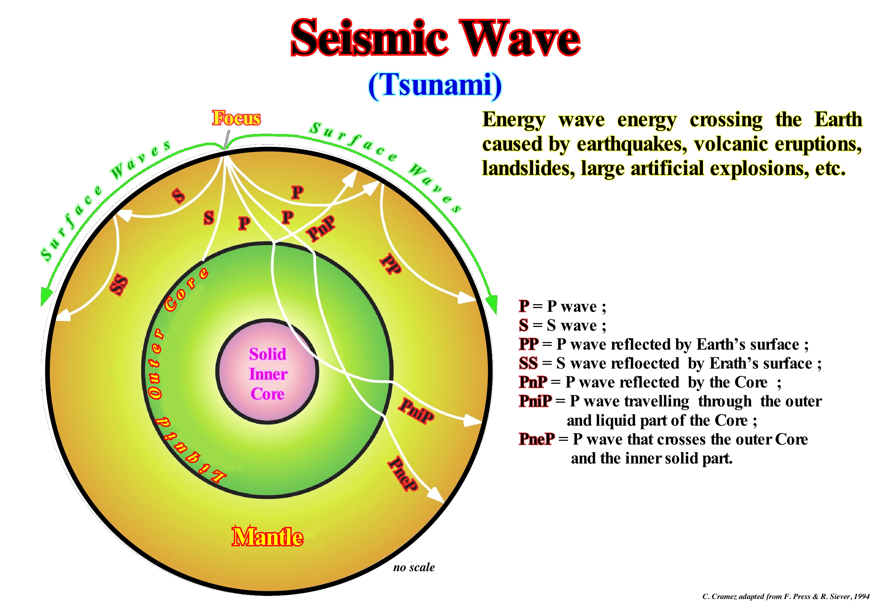
There are two types of seismic waves: (i) Surface waves and (ii) Body or Volume waves. In the surface waves there are the Love and Rayleigh waves. Love waves have just one horizontal component, while Rayleigh waves have a vertical and horizontal component. In body waves, there are: (a) Longitudinal waves, also called Compressional or P waves, which dilate and compress the particles of the bodies where they travel, along the direction of propagation and (b) Transverse waves, also called waves of Shear or S, that push the particles of the bodies, where they travel, perpendicularly, the direction of propagation. S waves travel at a velocity that is about half the velocity of the P waves. Unlike the P waves, the S waves do not propagate in either liquids or gases. If the Earth was made of a single material with constant surface properties till the Earth's centre, the P and S waves would travel in a straight line through the Earth's interior from the focus of a seismic shock to a seismograph. The waves do not travel in a straight line. This allowed geoscientists to infer that Earth is formed of a series of concentric layers composed of different materials along which the P and S waves travel at different speeds. The waves change direction as they pass from one layer to another, which means that the trajectories within the Earth are curved. In this scheme, it is easy to see that: (i) From the focus of an earthquake, the waves P and S radiate in many directions ; (ii) There are P and S waves, which are reflected by the surface of the Earth (PP and SS) ; (iii) There are P waves that are reflected by the core (PnP) ; (iv) Other P waves travel through the outer and liquid part of the core (PniP) ; (v) Other P waves cross not only the outer (liquid) core but also the solid inner part (PneP) and (vi) the S waves do not pass through the core since they do not travel through liquids.
Seismostratigraphy...........................................................................................................................................................Sismostratigraphie
Sismostratigrafia / Sismostratigrafía / Seismische Stratigraphie / 地震地层学 / Сейсмостратиграфия / Stratigrafia sismica /
Stratigraphy made from seismic data, i.e., the study of the succession of sedimentary deposits that are, generally deposited in strata or layers, by the analysis of the propagation of the seismic waves created by explosions, shocks or ultrasounds in the surface layers of the terrestrial crust (onshore or offshore). Taking into account the resolution of the seismic data (in general, reflection seismic), it is evident that a reflector corresponds to an interface between groups of beds and not to stratification planes, as is the case in conventional stratigraphy, in which the scale is 1: 1 (natural scale).
See: « Stratum »
Sequence-Cycle...................................................................................................................................................................................................................Cycle séquence
Ciclo sequência / Ciclo secuencia / Sequenz-Zyklus / 序列周期 / Последовательный цикл / Ciclo sequenza /
Succession of sedimentary layers (more or less conform and linked, genetically) that is induced by a 3rd order eustatic cycle whose duration is between 0.5 and 3 My (between 0.5 and 5 My, for certain geoscientists). A sequence-cycle is limited by two unconformities (erosional surfaces) and by their correlative paraconformities that are associated with them in deep water. When complete, a sequence-cycle is formed by two groups of systems tracts: (i) Lowstand System Tract Group (LSTG), in which three subgroups can be distinguished: a) Submarine Basin Floor Fan (SBFF) ; Submarine Slope Fan (SSF) and Lowstand Prograding Wedge (LPW) ; (ii) Highstand System Tract Group (HSTG) in which two subgroups can be distinguished: Transgressive Interval (TI) and (iii) Highstand Prograding Wedge (HPW). During small relative sea level falls a Bordering Prograding Wedge edge (BPW) can be deposited.
See: « Stratigraphic Cycle »
&
« Milankovitch's Cycle »
&
« Third Order Eustatic Cycle »
This tentative geological interpretation of a Canvas auto-trace of a detail of a Gulf of Mexico seismic line was made at the hierarchical level of the sequence-cycles, i.e., that each sedimentary package is defined by an unconformity and that the age difference between the upper and lower unconformities, limit each sedimentary interval, is always less than 3-5 million years. In the hierarchy of stratigraphic cycles, proposed by Duval et al. (1993), four main levels are considered: (i) Continental Encroachment Cycles ; (ii) Continental Encroachment Subcycles ; (iii) Sequence-Cycles and (iv) Sequence-Paracycles. Continental encroachment cycles are induced by 1st order eustatic cycles, whose time-duration is always greater than 50 My. These eustatic cycles are a consequence of the breakup of the supercontinents. Indeed, during the dispersal of the individualized continents, the volume of the oceanic ridges increases, which diminishes the volume of the ocean basins. Assuming that the amount of water, in all its forms, is constant since the Earth's formation, around 4.5 Ga, the absolute (eustatic) sea level (referenced to the Earth's centre) rises. On the contrary, during the aggregation of the continents, to form a new supercontinent, the volume of the oceanic ridges decreases, increasing the volume of the ocean basins, which causes the absolute (eustatic) sea level to fall. Continental encroachment subcycles are induced by 2nd order eustatic cycles, whose time-duration varies between 50 My and 5-3 My. These eustatic cycles are associated with the rate of tectonic subsidence (total subsidence decreased from the effect of isostatic compensation and increased by the effect of compaction), which varies with the velocity of oceanic expansion (sea floor spreading). The tectonic subsidence can be made by: A) Lengthening, as is the case during the formation of rift-ype basins (the lengthening of the lithosphere decreases its thickness, that is to say, it subsides in relation to the thicker and undeformed lithosphere) ; B) Cooling, during the lengthening of the lithosphere*, the upper surface sinks, while the lower limit rises, which forces the underlying asthenosphere to rise to replace the lithosphere of the thinned mantle (after the lengthening phase, the upper asthenosphere cools and returns, again to the lithospheric mantle; the lithosphere of the mantle is denser than the asthenospheric mantle ; such cooling causes significant subsidence) ; C) Charging, Sedimentation, Thrust Stacking and Folded Belt Formation induce crustal depression and subsidence (in the case of sedimentary depocenters, these follow the sinking of the underlying lithosphere, however, in the case of thrusting and folded belts, the sinking occurs, mainly, in the lithospheric crust adjacent to the deposition). Sequence-cycles are associated with 3rd order eustatic cycles, which are, basically, the result of the combination of absolute (eustatic) sea level and tectonic changers. The sequence-paracycles, that are induced by eustatic paracycles are, also, associated with glacio-eustasy, but, above all, with successive relative sea level rises without falls between them. On this tentative geological interpretation, the sequence-cycles, which have been deposited above the allochthonous salt interval (coloured in red), are not complete. There is always a group of systems tracts or a subgroup of the lowstand systems tracts, which has not been deposited (it is difficult to invoke erosion to explain such an absence). This is especially true for progradational sediments, in particular those deposited under highstand geological conditions (highstand prograding wedge, HPW). The lower subgroup of lowstand systems tracts group, i.e., the submarine basin floor fans (SBFF) are not present. It is likely that they have just been deposited downstream from the area where the seismic line was shot, which means that they are probably disconnected from the submarine slope fans (SSF). On the other hand, the other subgroups of the lowstand systems tracts group, that is, the submarine slope fans (SSF) and the lowstand prograding wedges (LPW), are always present and well developed, which means that during sedimentation the Lowstand geological conditions (sea level lower than the basin edge) were preponderant or, in other words, that for most of the time, the basin had no continental shelf. Within a sequence-cycle, the basin just has a platform during the transgressive interval (IT) and during the 1st phase of development highstand prograding wedge (HPW).
(*) Upper zone of the terrestrial mantle that is underneath the lithosphere, that is, under the 1,350° isotherm, limited, more or less, between 30-130 km and 670 km of depth and which is composed mainly of solid or partially molten ductile silicates.
Sequence-Cycle Boundary............................................................................................................Limite de cycle-séquence
Limite de ciclo sequência / Límite de ciclo secuencia / Sequence Begrenzung / 序边界 / Границы секвенций / Limite di sequenza /
Type I or II unconformity or correlative paraconformity in deep-water. Downlap surfaces are sequence boundaries of a sequence-cycle just in the distal part of the abyssal plain where the progradations of the group of highstand systems tract and, particularly, the highstand progradaing wedge (LPW) rest, directly, on the lower limit of the sequence-cycle.
See: « Stratigraphic Cycle »
&
« Sequence-Cycle »
&
« Unconformity »
In the mathematical model (Marco Polo software), illustrated in this figure, the following conjectures are assumed: (1) Eustasy (variations of absolute or eustatic sea level, i.e., of the supposed global sea level, referenced to the Earth's centre) is the main factor controlling the cyclicity of sedimentary deposits ; (2) The sedimentary intervals have a great completeness (relation between the really deposition-time and the total-time of the interval) ; (3) Eustasy, Subsidence (or uplift), Accommodation, Sedimentation and Climate are the main geological parameters that determine the strata configuration ; (4) Subsidence and sedimentary supply (mainly terrigeneous influx) are slower than eustatic variations ; (5) Terrigeneous influx is constant in time and space ; (6) Subsidence increases, linearly and progressively, towards the deep parts of the basin ; (7) The time-interval between each chronostratigraphic line is 100 k years, which means that at the geological scale, the depositional processes are instantaneous and catastrophic (for the Phanerozoic, for instance, which lasted for about 600 My, tall interval of time-duration lower than 6 My, that is 1/100 of 600 My, is considered instantaneous). In this model three stratigraphic cycles called sequence-cycles, induced by 3rd order eustatic cycles, i.e., eustatic cycles with a time-duration ranging between 0.5 and 3-5 My, are, easily, recognized by the unconformities that limit them (the coastal onlaps and the toplaps by erosion that characterize the unconformities are, easily, recognized). In contrast to the genetic stratigraphy, in which the boundaries between the different intervals are downlap surfaces that fossilize the diachronic surfaces of maximum marine ingressions, in the sequential stratigraphy, the limits between the stratigraphic cycles, whatever their hierarchy (continental encroachment cycles, continental encroachment sub-cycles, sequence cycles and sequence-paracycles), are the unconformities. An unconformity is an erosional surface created by a significant fall relative sea level (local sea level, referenced to any point on the Earth's surface, which is the result of the combined action tectonics and the absolute or eustatic sea level, which is supposed to be global and referred to the Earth's centre), which put the sea level lower than the basin edge or, in other words, which exhumed the rocks of the platform and upper continental slope. Stratigraphic cycles are associated with eustatic cycles limited by significant relative sea level falls. The hierarchy of a stratigraphic cycle is determined by the hierarchy of the eustatic cycle inducing them (function of the time-duration of the eustatic cycle). Geoscientists, working in petroleum exploration, use sequential stratigraphy more than genetic stratigraphy. All potential reservoir-rocks (shall or deep-water) terminate by onlaps against the unconformities, which, greatly, facilitates their identification. Genetic stratigraphy is used to determine the most probable position of marine source-rocks as they deposit, generally, in association with the top of the transgressive phase of continental encroachment cycles in the distal parts of the shelf. In the above-illustrated model, the oldest sequence-cycle (1) is incomplete. From bottom to top, recognize : (i) Lower Unconformity ; (ii) The lower subgroup of the highstand systems tracts group (HSTG), i.e., the Transgressive Interval (TI) ; (iii) The upper subgroup of the highstand systems tracts group (HSTG), i.e., the Highstand Prograding wedge (HPW) ; (iv) Bordering Prograding Wedge (BPW) and (v) Upper Unconformity bounding the sequence-cyle. The second sequence-cycle (2) is complete. Among the two unconformities, it is composed by the lowstand systems tracts group (LSTG), in which the three subgroups are recognized: (a) Basin Submarine Floor Fans (SBFF) ; (b) Submarine Slope Fans (SSF) and (c) Lowstand Prograding Wedge (LPW), which is fossilized by the Transgressive Interval (TI) and this one by the Highstand Prograding Wedge (HPW), which, seaward of the the continental edge are very condensed. The third sequence-cycle (3) is represented just by the lowstand systems tracts group (LSTG), where submarine basin floor fans (SBFF) with a sub-horizontal geometry are recognized, in aggradation, against a correlative deep-water paraconformity of the unconformity. The submarine slope fans (SSF) with their "gull wing" characteristic geometry are easily recognized as well as the the progradational geometry of the lowstand prograding wedge (LPW).
Sequential Stratigraphy.................................................................................................................Stratigraphie séquentielle
Estratigrafía sequencial / Estratigrafía secuencial / Sequenzstratigraphie / 连续的地层 / Последовательная стратиграфия / Stratigrafia sequenziale /
Stratigraphic analysis in sedimentary sets limited by unconformities and/or equivalent deep-water correlative paraconformities. Four main variables control these sets: (i) Subsidence ; (ii) Eustasy; (iii) Sedimentary Influx ; (iv) Climate. Sequential analysis can be done in the field, that is to say, at 1: 1 scale, in the electrical logs (also, more or less at natural scale), and on seismic lines (time sections). The former give precious details, while the latter allows a more regional view, though deformed by lateral variations of the interval velocity, since the vertical scale of the seismic lines is in time.
See: « Stratigraphy »
&
« Genetic Stratigraphy »
&
« Unconformities (stratigraphic cycles) »
First of all, let us remember that any sedimentary package limited, above and below, by a unconformity (type I) is, conventionally, a stratigraphic cycle induced by an eustatic cycle. Sedimentology and stratigraphy have, traditionally, considered geological formations as the fundamental units of record rocks and the interpretation of sedimentary environments as the main result of stratigraphic studies. Sequential stratigraphy considers stratigraphic cycles called -sequence-cycles, induced by 3rd order eustatic cycles, whose time-duration varies between 0.5 My and 3/5 My, as the fundamental unit of record rocks and depositional and non-depositional periods (associated with episodes of relative sea-level rise and fall *) as the essential information. Sequential stratigraphy developed from seismic stratigraphy, where the unconformities are recognized and followed relatively well. Although the prediction of lithology is more complicated. Sedimentary accumulation (as erosional surfaces that bound sequence-cycle) is controlled by changes in the baseline level at which sediments accumulate if the land surface is low, or are eroded if land surface, locally, is high. In other words, above the base level, erosion and transportation dominate, while below the base level, which seaward of the shoreline corresponds to sea level, the sediments accumulate and are preserved. In sedimentary basins connected to the oceans, the basal level is controlled by the combination of eustasy (absolute or eustatic sea level changes) and tectonics (subsidence or uplift of the sea floor), while in the endorheic basins, climate and tectonic control variations of the base level: (i) In periods of high base level, there is a lot of space to be filled by the sediments ; (ii) In periods of low base level, it is the opposite, there is little space and therefore the sedimentary particles fill, easily, all available space. In the first case (high baseline or rising), sediments do not spread throughout the basin. They are confined in continental environments (rivers, lakes) and near the coastline. If the baseline level continues to rise (increasing the available space for the sediments), the shoreline is, progressively, retrograded, recording transgressions (set of increasingly important marine ingressions and the associated increasingly smaller sedimentary regressions). In the second case (low or falling base level), the available space (accommodation) is, quickly, filled by the sediments and a continuous sedimentary supply produces a sedimentary regression. This tentative geological interpretation of Canvas auto-trace of an Indonesia offshore regional seismic line was made in stratigraphic cycles called sequence-cycles. The age difference between the successive unconformities (significant relative sea level falls) is greater which 0.5 My and less than 3-5 My. In this offshore, which corresponds to the stacking of two basins of the classification of the sedimentary basins of Bally and Snelson (1980), we can identify: (i) Above the Basement, an episutural back-arc basin, in which the lengthening or rifting phase can be distinguished at the base and the sag phase at the top and (ii) A non-Atlantic divergent margin associated with the break-up of the lithosphere and the subsequent sea floor spreading of the South China Sea. Due to the scales (horizontal and vertical), it is difficult to identify the sub-groups of sedimentary systems tracts that make up the sequence-cycles. Except for some downlap surfaces, like SBP. 5 Ma, SBP. 16 Ma and SBP 24.8 Ma, which emphasize the maximum of marine ingressions, within each cycle-sequence, and which underline the main transgressive events of the Neogene, juts the unconformities were drawn. Some of them were calibrated with the paleontological results of petroleum exploration wells drilled in this area, while the age of the others was, mainly, based on the stratigraphic signature of this offshore, which corresponds, roughly, to the one proposed by Vail and his students. Note that the age difference between two consecutive unconformities is always less than 3/5 My, i.e., the intervals bounded by them can be considered as sequence-cycles.
(*) Relative sea level is the result of the combined action of absolute ( eustatic) sea level and tectonics (subsidence of the sea floor when sediments are lengthened or uplift when they area shortened (in certain areas with diapirism, the sediments can be elongated). is referenced to any point on the Earth's surface, which can be, for instance, the sea floor or the base of the sediments (top of the continental crust). The absolute (eustatic) sea level is supposed to be the global and referenced to the Earth's centre, which is dependent on the : (i) Tectono-Eustasy which is controlled by the volume variation of the ocean basins in association with oceanic expansion following the break-up of the supercontinents ; (ii) Glacio-Eustasy, which is controlled by the ocean water volume variation, depending on the amount of ice (assuming that the amount of water in all its forms is constant since the formation of the Earth, around 4.5 Ga) ; (iii) Geoidal-Eustasy that controlled by the distribution of ocean water caused by variations in the Earth's gravity field (where gravity is stronger than normal, sea level is dropped to the centre of the Earth) and (iv) Thermal expansion of the oceans or steric increase of sea level (if the temperature of the oceans increases, the density of water decreases and, for a constant mass, the volume increases).
Serac........................................................................................................................................................................................................................................................................Sérac
Serac / Serac / Sérac (Gletschererscheinung) / 冰塔(冰)/ Серак / Seracco /
Block, or ice column, formed by the intersection of the crevasses of a glacier in association with: (i) Fusion ; (ii) Direct evaporation or sublimation and (iii) Erosion of the glacier by wind. The seracs that some geoscientists call penitents are formed, preferably, in areas where the flow of the glacier is faster or in front of a suspended glacier.
See: « Glacier »
&
« Calving »
&
« Moraine »
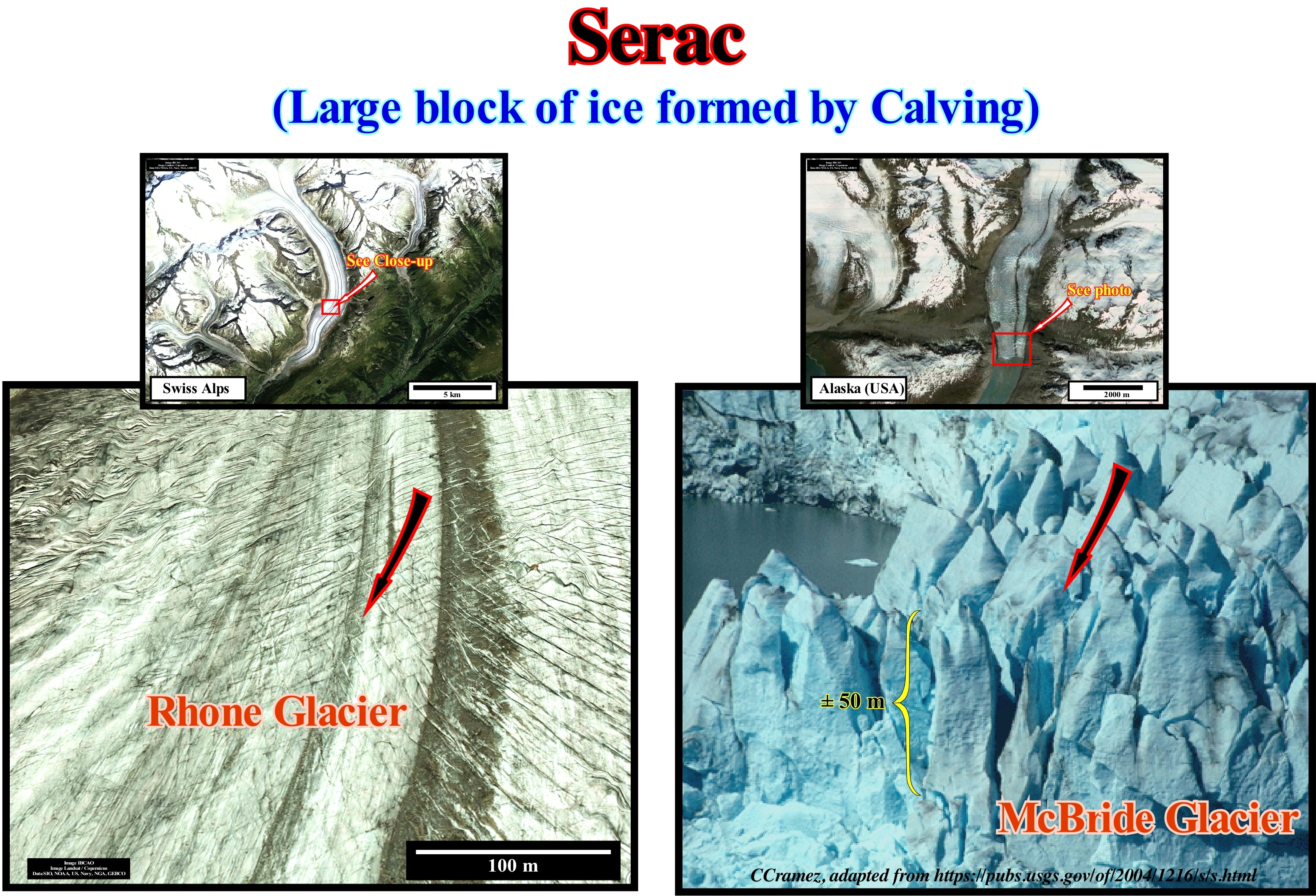
The "seracs" can reach large dimensions and even when small they are very dangerous for the mountaineers in that they collapse, easily, and without warning. It was the collapse of a large serac, which in August 2008 killed almost two dozen climbers in K2 (the second highest peak in the world, after Everest, 6,111 meters). The seracs, when stabilized for a very cold and persistent weather, oppose the flow of the glacier. The term serac was first used in 1787 by the Swiss scientist Horace Benedict de Saussure because of the similarity between the seracs and Schabziger cheese (curdled milk) which is, exclusively, made in the canton of Glarus, Switzerland. Swiss call it "sérac". The ice becomes brittle, either to the surface, to crack, or in its interior mass. The cracks, which do not exceed more than 50 meters, are formed mainly where the flow of the glacier accelerates. It is the intersection of these fissures that gives the appearance of curdled milk. The ice flow is subdivided into distinct movements independent of each other and separated by shear planes (clearly visible in this figure). These flow differences are summarized in the coexistence of a continuous flow and a movement of rigid blocks. In depth, the flow in rigid blocks is not marked by cracks. The more or less continuous areas that advance with different speeds are separated by thrust planes. These are probably the movements of the ice that produce the mixture of the materials transported and that probably bring to the surface the blocks torn from the glacier bed. Some geoscientists say that the movement of the ice takes place in a way still not well known. It is not known very well whether the ice reacts viscously (which does not retain its shape when the efforts that gave it disappear) or plastic (retains its shape when the efforts that deform it disappear).
Serie (Geological).............................................................................................................................................................................................................Série (Géologique)
Série (geológica) / Série (geológica) / Serie (geologische) / 系列(地质)/ Свита, толща (геологические) / Serie (geologici) /
Stratigraphic time unit composed of all rocks representing a geological epoch.
See: « Radiometric Dating »
&
« Geological Time Scale »
&
« Geological Time »
In this geological scale, the last column (Time%) represents the age, in percentage, of each of Period in relation to the total age of the Earth (100%). The 3.7% of the Cretaceous period means that the time elapsed between the beginning of the Cretaceous and today represents 3.7% of the total time of Earth's history since the beginning of the Archaeozoic or Precambrian (Planckian, Gamowian and Cryptozoic). The rocks that make up the Cretaceous, i.e., the Cretaceous system, are divided into three series: (i) Neocomian; (ii) Gallic and (iii) Senonian. These series (rocks) are associated with the three epochs (time) which are the Neocomian, Gallic and Senonian. The time-duration of the Neocomian period does not correspond in any way to the time of deposition of the rocks of the Neocomian series. The actual time of deposition of the Neocomian rocks is much less than the time of the Neocomian period. Periods of hiatus, that is, periods in which nothing happens, are, largely, superior to periods of deposition. The Neocomian series was introduced by J. Thurman (1835) when he studied the outcrops of the Neuchâtel (Neocomum) region in Switzerland. In the type region, the rocks were divided into two stages: (a) Valanginian, formed by the rocks that appear along the Seyon river gorge, near the village of Valangin and (b) Hauterivian, formed by the rocks that appear among the villages of St. Blaise and Hauterive. Later, Coquand (1876) considered yet another floor called Infravalanginian or Berrisian. It was during the Neocomian that the Pangea supercontinent lengthened with the formation of the rift-type basin and that it breakup in different continents that occupy a, completely, different position at present time. It was in the Neocomian that the first flowering plants appeared. During the Neocomian, the angiosperms were, probably, not very important. However, they began to form part of the flora and became dominant at the end of the Cretaceous. The development of the flowers, immediately, led to their coevolution with insects. Thus, geoscientists began to see specialized pollinators evolve from several clades (a group of organisms originating from a single common ancestor) of insects. The Neocomian was also the time when mammals evolved in placental and marsupial clades.
Sessile (Organism)...............................................................................................................................................................................................Sessile (Benthonique)
Séssil (bentónico) / Séssil (bentónicos) / Traubeneiche (benthische) / 柄(底栖) / Бесчерешковый (придонный) / Sessili (bentonici) /
Organism that is not able to move (zoology). In limnology, sessile refers to organisms anchored in the benthic environment, while in botany, the same term is used to denote plants in which flowers or leaves grow, directly, from the stem or from the stalk.
See: « Limnology »
&
« Benthos »
&
« Eutrophic (lake) »
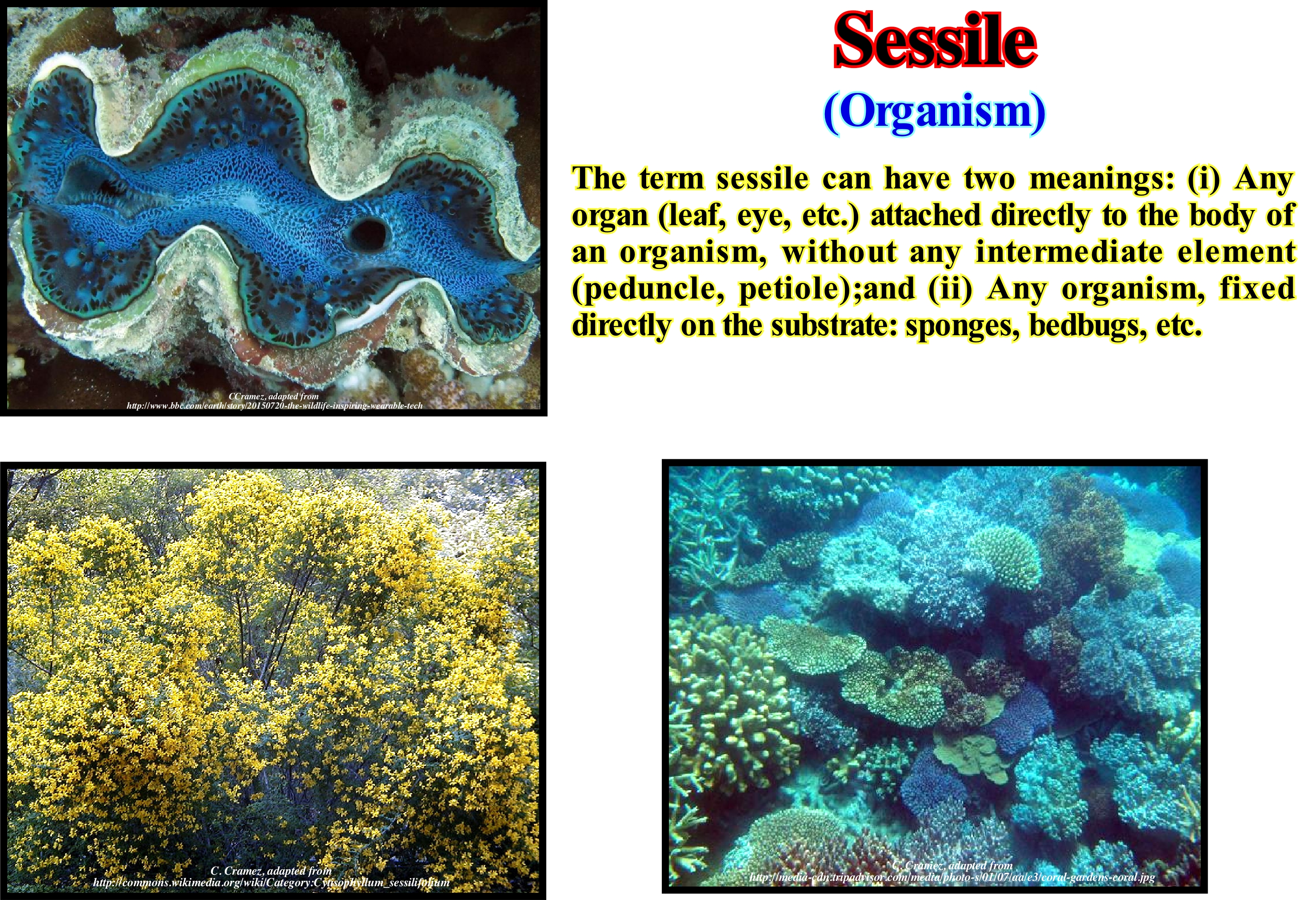
In zoology, sessility is a feature of animals that are not able to move. They are, usually, permanently attached to a solid substrate of any kind, whether it be a rock, the hull of a ship as is the case barnacles which also attach themselves to whales. Corals establish their own substrate. The sessile animals usually have a stage of their development in that they are mobile. The sponges are mobile during their larval phase, but become sessile when adult. Many jellyfish develop as sessile polyps early in their life cycle. Many sessile animals, such as sponges, corals and hydras, etc., are capable of asexual reproduction "in situ" by budding*. Groaning or gemiparity is a behaviour in an animal, usually, sessile, in which individuals from a particular group of species are close to each other for beneficial purposes, and can be seen on coral reefs. Gemulation is a process of asexual reproduction (type of reproduction that occurs without the intervention of gametes). The new beings are clones (set of individuals that gave origin to others by asexual reproduction) of the parent, in which the formation of a dilation called This process occurs in unicellular beings, such as bacteria and yeasts, and in multicellular beings such as the sponge, the sponge, the spider, and the spider. jelly, and hydra, and may also occur in higher plants, such as angiosperms (spermatophyte plants whose seeds are protected by a structure called a fruit).
(*) Type of reproduction where buds arise which grow attached to the initial organism and which may or may not various algae and plants, certain fungi and some invertebrate animals can reproduce by budding.
Settling.......................................................................................................................................................................................................................................Décantation
Decantação / Decantación / Dekantieren, Klärung, Läuterung / 解决 / Декантация (отмучивание) / Decantazione /
Deposition by gravity of sedimentary particles that are suspended in a water-body when this is not too agitated. The rate of settling of a particle, i.e., the rate at which a sedimentar particle is deposited depends on its : (i) Granulometry ; (ii) Shape ; (iii) Density and on the viscosity of the fluid.
See: « Sedimentation »
&
« Deposition (clastics) »
&
« Deposition (carbonates) »
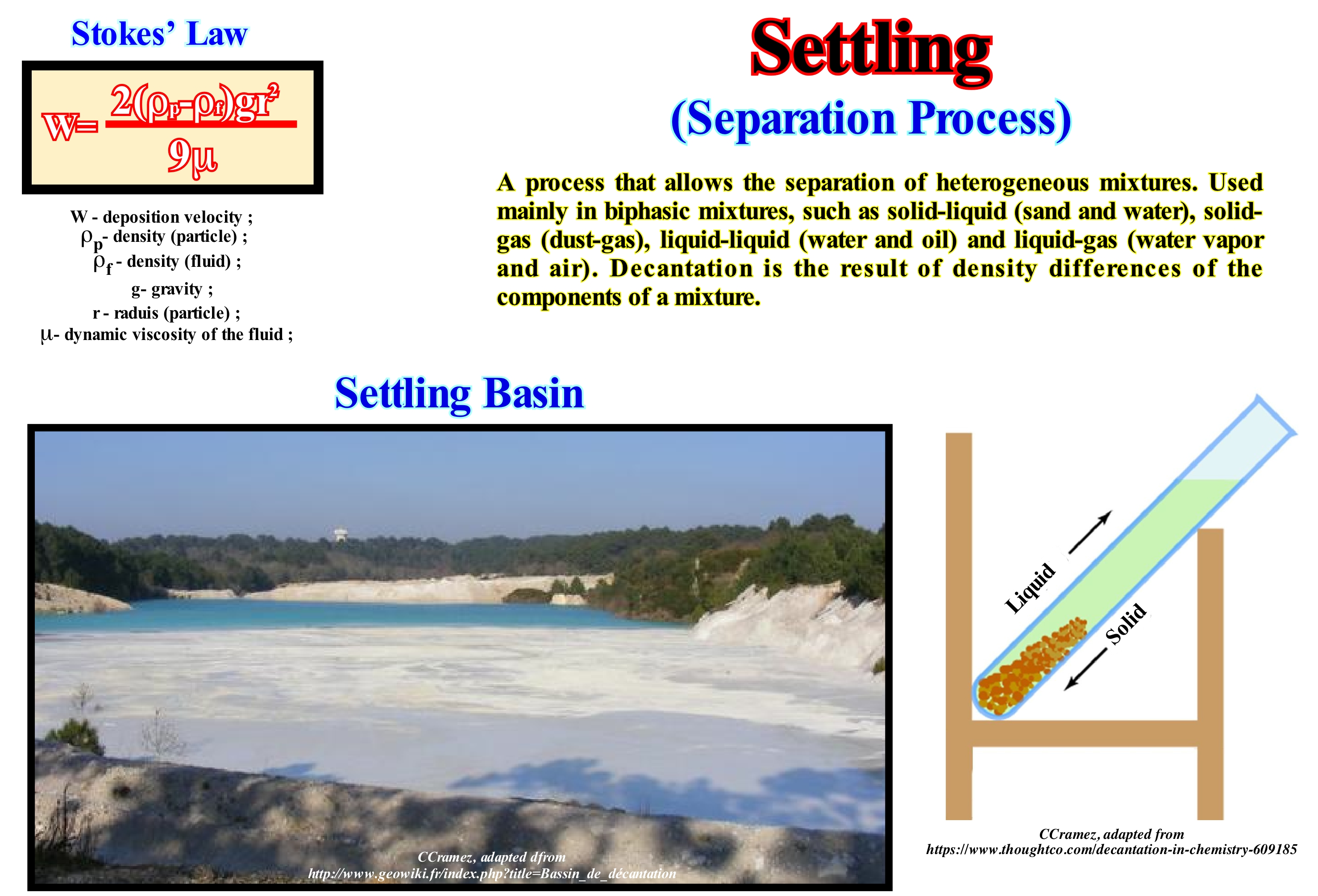
The term settling is used to designate the slow passage of a liquid from one container to another, in order to separate it from the precipitate. In geology, it is used to expressing the gravity deposition of a sedimentary particle which is suspended in a body of water. Sedimentation is nothing other than the deposition by decanting (settling) of the material transported in suspension (sediments) by a current. For the diluted suspensions, Stokes's law states that the rate of deposition of small spheres in a fluid (air or water) is given by the formula w = 2 (ρp-ρf) gr2 / 9μ, where "ρp" is the density of the particle , "ρf" the density of the fluid, "g" the acceleration of gravity, "r" the radius of the particle and "μ" the dynamic viscosity of the fluid. Terrigeneous sedimentary particles form on the continent but can be deposited on land (land deposits), at sea (marine deposits) or lakes (lake deposits) and by diagenesis * they become sedimentary rocks. A settling basin is a place (natural or artificial) where fine particles suspended in a liquid, usually water, are deposited by gravity. They are used to separate solids and/or petroleum from another liquid. When a turbid water stream passes through a settling basin, it becomes much clearer, because the vast majority of the particles it carried in suspension were deposited in the bottom of the basin. The stream of turbid water should remain in the settling basin the time it takes for the particles to settle down, since the thinner the particles in suspension the longer they spend to settle. The presence of a coagulant forces the finer particles to stick together, which significantly reduces the time required for settling. The Stokes formula can be used to calculate the dimensions of a settling basin needed to decant a certain particle size.
(*) Set of chemical, physical or biological changes that undergo the sediments after they have been deposited.
Shale.................................................................................................................................................................................................................................................Ardoise (Shale)
Shale (argilito físsil) / Esquisto (lutita) / Schiefer / 页岩 / Сланец (глинистый) / Shale /
Sedimentary rock composed of very fine grains (clay minerals and mud) with high fissility, i.e., it is debited in thin lamellas parallel to the planes of stratification that are difficult to recognize. Do not confuse shale, which is fissil, with lutite (same composition, but with grain size less than 1/16 mm) that is not fissile. Also, do not confuse shale with siltite, which has the same composition and similar grain size, but the clay content is much smaller.
See: « Distal Overbank Mudstone »
Shale (Slate).......................................................................................................................................................................................................................Ardoise, Shale
Ardósia / Esquisto (lutita) / Schiefer / 页岩 / Сланец (глинистый) / Shale /
Anchimetamorphic rock at the diagenesis boundary (sediment compaction and hardening) and metamorphism (recrystallization under the action of pressure and temperature). For certain geoscientists, a slate is a sedimentary rock, weakly metamorphised, of very fine grain, with a slightly satiny surface, black, blue/gray or purple, which is debited in thin lamella.
See: « Clay »
&
« Argillite »
&
« Granulometry »
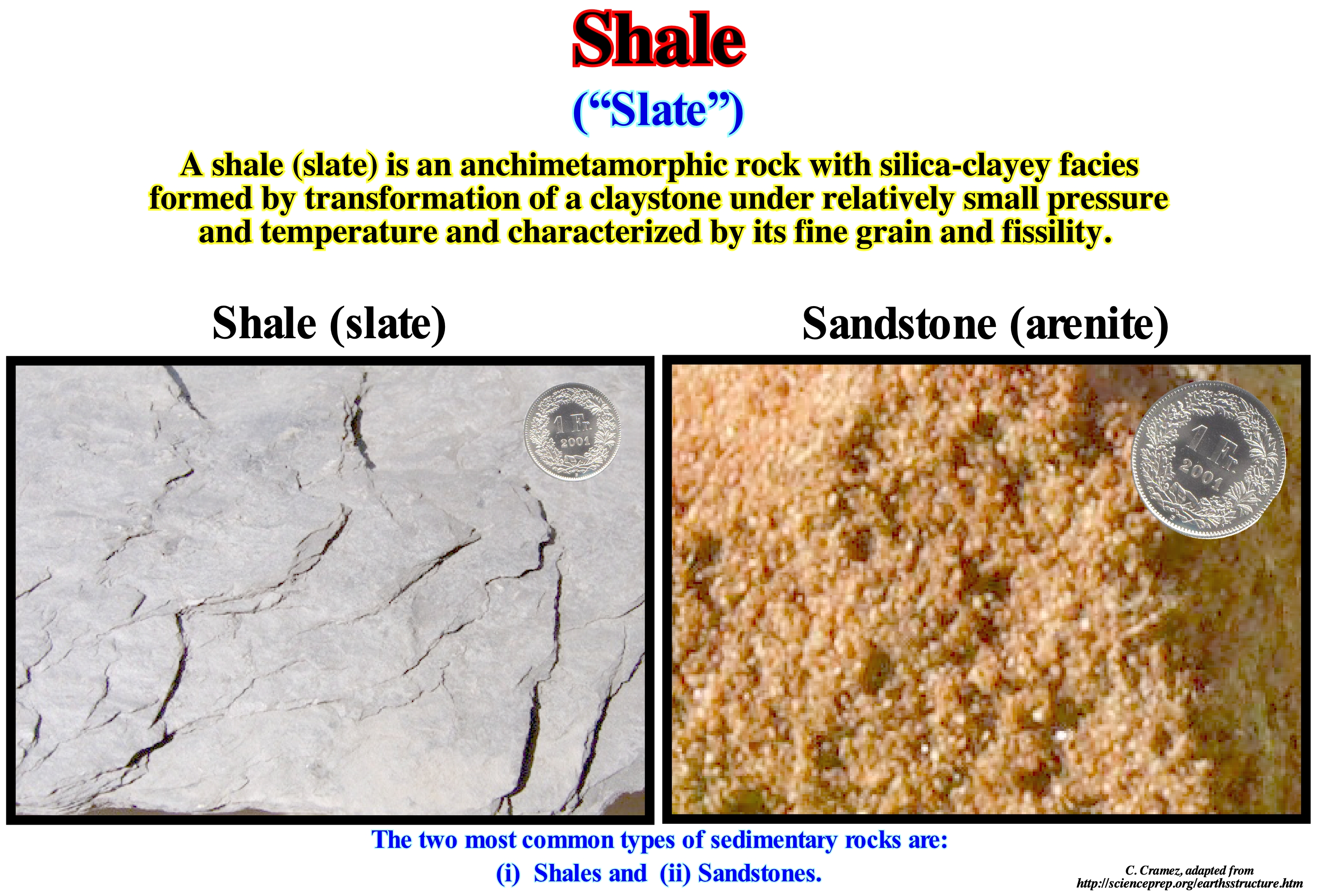
The shale (slate) is a sedimentary rock composed of very fine grains (mus and clay) that is, highly, fissile, i.e., it is foliated in laminae parallel to the bedding planes that are difficult to recognize. For many geoscientists a slate is fissile, while a shale, which has the same composition, but in which the grain size is less than 1/16 mm, is not fissile. Likewise, a shale should not be confused with a siltite, which has the same composition and grains of similar size, but which has a clay content is much smaller. The term argillite, which is, often, used by many geoscientists as synonymous of schist is confusing. However, certain geoscientists, perfectly, distinguish shale * and argillite **. Function of size, a sedimentary particle can be described as: (i) Gravel; (ii) Sand or (iii) Clay. Nonmetamorphic rocks from these sedimentary particles have a Latin root: (1) Rudite ; (2) Sandstone and (3) Lutite. The metamorphic rocks from the same sedimentary particles have a Greek root: (a) Psephite ; (b) Psammite and (c) Pelite. A lutite when compacted (by overload or tectonic stress) acquires a fissility and is, often, denominated a slate. In other words, a slate is a compressed shale, with significant fissility. The term pelite, which has a Greek root (Pelos = clay), should be used to describe, more or less, metamorphosed sediments, i.e., recrystallized due to changes in physical and chemical conditions (temperature, pressure, chemically active fluids, etc.). Shales are, probably, the most common sedimentary rocks. In a rock cycle, the process that forms a shale is compaction. The fine particles that make up the shale can reside in the water much longer than the larger, heavier particles. Shales are deposited in very calm waters and are, often, found in lacustrine, deltaic, floodplain deposits seaward of the beach sand and in the deep and calm parts of the ocean basins.
(*) A shale is a classical fine-grained sedimentary rock composed of mud that is, often, a mixture of clay mineral flakes and small fragments (silt-sized particles) of other minerals, especially quartz and calcite, characterized by their fissility ( foliation in thin laminae less than one centimetre thick).
(**) An argillite is, often, considered as a fine grain sedimentary rock composed, predominantly, of hardened clay particles that become a shale when it acquires a certain fissility.
Shale Oil.............................................................................................................................................................................................................Argile asphaltique
Argilito asfáltico (petrolífero) / Arcilla asfáltica / Argila Asphaltgestein / 油页岩 / Сланцевое масло / Scisto bituminoso /
Fine and fissile sedimentary rock containing significant amounts of kerogen (solid mixture of organic chemical compounds) from which liquid hydrocarbons can, eventually, be extracted. The term asphaltic or bituminous clay corresponds, sometimes, to a language error, since the rock from which the hydrocarbons are extracted is not always a clay, and the hydrocarbons are not necessarily petroleum. Extracted hydrocarbons require more substantial treatment than crude oil, which greatly affects the economic viability of such shale rocks.
See: « Asphalt »
&
« Light Oil (petroleum) »
&
« Clay »
Important deposits of asphaltic shale, which in reality often correspond to bituminous sands exist in the United States, Canada, Venezuela, Madagascar, etc. Some geoscientists suggest that these clay minerals have resources equivalent to 2.8-3.3 Tb (2.8 to 3.3 x 10¹² barrels of oil). Theoretically, an asphaltic or petroleum clay is a rock rich in organic matter, which belongs to the group of sapropelic fuels (from Greek "sapros + pelo", meaning "putrefaction + mud"). An asphaltic shale differs from a rock impregnated with bitumen (such as bituminous sand), a humic coal, and a carbonaceous slate. In an asphaltic shale, the kerogen was, naturally, converted into petroleum by increasing temperature and pressure. Asphaltic clay minerals vary greatly in mineralogy, chemical composition, geological age, type of kerogen, history of deposition and associated organisms. There are several attempts to classify these shales. One of them, perhaps the most used one, is based on the mineralogical composition of the rock: (i) Carbonate-rich petroleum clay ; (ii) Silica rich petroleum clay and (iii) Spore-rich petroleum clay (which certain geoscientists call the wrong way, in our opinion, sapropelic clay). Function of the sedimentary environment, where the original biomass was deposited, the petroleum clay may be: (a) Terrestrial; (b) Lacustrine and (c) Marine. Do not forget that there is no word in several countries to, adequate, translates the English term "shale". Some geoscientists even use the term shale and other argillite to designate such a rock and reserve the term clay for the sedimentary particle with a diameter of less than 0.1 mm and metargillite for the rock when it is anchimetamorphic* (slate).
(*) According to M. Winge (Geological Glossary, http://sigep.cprm.gov.br/glossario/index.html), anchimetamorphism is an extremely weak metamorphism with the frequent preservation of primary structures and textures and minor mineralogical modifications, linked to incipient dehydration reactions and recrystallizations.
Sheet Lobe Facies (Basin floor fan)...........................................................................................................Lobe (Cône sous-marin de bassin)
Lóbulo (cone submarino de bacia) / Lóbulo (conos submarinos de cuenca) / Lobe (U-Boot-Fans des Beckens) / 叶(盆地海底扇)/ Доля / Lobe (fan sottomarine del bacino ) /
Submarine fan deposited on the abyssal plain in association with a significant relative sea level fall, i.e., under lowstand geological conditions, or in association with a rupture of the basin edge or with the flood of a river, in highstand geological conditions.
See: « Submarine Basin Floor Fan »
&
« Contourite »
&
« Lowstand Systems Tract »
According certain geoscientists, the submarine fans can be deposit in different geological conditions. For P. Vail, within a sequence-cycle, the submarine fans (basin floor and slope fans) are deposited during lowstand geological conditions, i.e., when the sedimentary basin has no continental shelf, since the sea level is lower than the basin edge. This implies that the shoreline (roughly equivalent to the depositional coastal break of the depositional surface) is, practically, coincident with the continental edge, which marks the passage to the continental slope. This means that, for P. Vail, submarine fans are induced by a significant falls of the relative sea level (local sea level referenced to the base of the sediment or, even, to the sea floor, which is the result of combined absolute or eustatic sea level supposed to be global, referenced to the Earth's centre, and tectonics) that exhume the continental shelf (if the basin had one) and the upper part of the continental slope lifting, at the same time, relatively, the coastal plain, inducing an erosional surface, that characterizes the unconformities. For E. Mutti, as shown in this figure, at the level of a sequence-cycle, the submarine basin floor fans (SBFF) can also be deposited under highstand geological conditions, that is, with the sea level higher than the basin edge (when the basin has a continental shelf or when the basin edge coincides with the shoreline, i.e., during the 2nd stage of the development of the highstand prograding wedge), in association with turbidity currents, induced either by flooding of rivers or by instabilities of the continental edge and not in association with the formation of unconformities (significant relative sea level falls). When the amount of sedimentary particles transported by the turbidity currents is very large, the Mutti's Type I turbidites* (more or less equivalent of the submarine basin floor fans) are deposited. When the turbidity currents carry less sedimentary particles, the deposits are less lobular (more channelled) and less sandy (Type II and Type III turbidites of E. Mutti). They are more or less equivalent the P. Vail's submarine slope fans (SSF). As seaward of the continental edge (basin with or without shelf), there is any problem of space available for sediments (accommodation), it can be said that the only thing that is necessary to have deposition of submarine fans is the occurrence of turbidity currents, which can be formed in various ways, either in association with significant relative sea level falls (P. Vail model), or slope failures or the continental edge, or with river floods, as suggested by E. Mutti. As can be seen in the geological schemes illustrated in this figure, coarse residual deposits and erosional depression fillings may develop on the continental slope. Likewise, from the continental edge to the deep sea three zones can be individualized: (i) Feeding Zone (FZ) or zone of source, in the upper part of the continental slope ; (ii) Transfer Zone (TZ), generally, located in the middle (lower part of the continental slope) and (iii) Deposition Zone (DZ), usually, located at the beginning of the abyssal plain (when the turbidite lobes are disconnected of the base of the continental slope). The feeding or source zone corresponds to the initiation area of the turbidite currents and slope breaks. The transfer zone is the zone of the continental slope where the turbidite currents accelerate and where they can, locally, erode the sea floor and thus increase their load. The deposition zone is the area where the turbidite currents decelerate and lose the transport capacity which allows deposition of the sedimentary particles in coarsening upward sedimentary lobes, characterized by relatively thick sandy layers in the proximal part (towards the basal break of the continental slope) passing, laterally, downstream, to thinner layers of more clayey facies.
(*) Although turbidites had been considered as sedimentary deposits originated by submarine turbidite currents, above all, in the foredeep, i.e., in the sedimentary environment of the convergent margin, it is now known that they are found in all types of sedimentary basins in an association with significant relative sea level falls and that for most geoscientists, a turbidite is a layer with coarsening upward pattern deposited by turbidity current, which is, usually covered, by hemipelagic shales containing a set of deep-water fossils.
Sheet Lobe Mound..................................................................................................................................................................Lobe monticulaire
Lóbulo em Montículo / Lóbulo en montículo / Buckelschicht Lappen / 丘状叶 / Впадина на холме / Lobo in monticelli /
External three-dimensional shape of a sedimentary interval similar to a small mound or hill. Some external monticular forms and fillings can be subdivided into subtypes, function of the origin, internal configuration and external modification of the forms. The most common have a sheet, wedge or bench geometry. Their names depend on whether the sediments are proterogenes (primary origin formed directly from water) or deuterogenes (secondary or detrital origin) and varies with the authors.
See: « Mound Reflection Configuration »
&
« Stratal Patterns »
&
« Complex Mound »
The Venezuela offshore corresponds to the stacking of several basins of the classification of the sedimentary basins of Bally and Snelson (1980). Within the continental crust of the small supercontinent Gondwana, which functions as an infrastructure, by lengthening, rift-type basins were formed before the breakup of the lithosphere. Locally, these basins were filled with lacustrine sediments rich in organic matter that could be considered as potential source-rocks, if buried, sufficiently, so that their organic matter could reach the oil window. Since the breakup of the lithosphere, subaerial volcanic spills have been implemented at the base of the divergent margin, before the expansion centres became submarine (formation of oceanic crust) and the Atlantic-type divergent margin began to be deposited. On this tentative geological interpretation of a Canvas auto-trace of a detail of a regional seismic line of Venezuela offshore, is shown a sheet lobe mound composed by deuterogeneous sedimentary particles (derived from rocks by mechanical processes ; this term applies better to rocks than sedimentary particles). As it can be seen, in this area (Orinoco offshore), over the subaerial lavas (interval coloured in violet) deposited, immediately, after the breakup of the Pangea supercontinent, the continental encroachment cycle (post-Pangea) was deposited. In the Atlantic type divergent margin, two sedimentary phases can be identified: (i) Transgressive Phase, associated with the rise of the absolute (eustatic) sea level* (supposed global and referenced to the Earth's centre), induced by the drifting of the post-Pangea continents and characterized by a retrogradational parallel geometry (this geometry is a consequence of the set of increasingly important marine ingressions and increasingly smaller sedimentary regressions) and (ii) Regressive Phase, induced by eustatic (absolute) sea level fall, instigated by the diminution of the volume of the oceanic basins caused by the subduction of the crust along the subduction zones. It is characterized by a progradational geometry (this geometry is the result of the set of increasingly smaller marine ingressions and increasingly important sedimentary regressions). During these two tectono-sedimentary phases, there are several significant falls of the relative sea level (local, referenced to any point on the Earth's surface, which can be the sea floor or the base of the sediments ; it is the result of the combined action tectonics and absolute sea level), which set the sea level lower than the basin edge. These relative sea level falls created a series of erosional surfaces, i.e., a set of unconformities, of which, for various reasons, just one was mapped (emphasized by the blue wavy line). This unconformity located at the bottom of the regressive phase, shifted seaward (progradation) and downward (negative aggradation), the shoreline. This displacement exhumed the entire coastal plain and the upper part of the continental slope (the basin becomes with no shelf) breaking the provisional equilibrium profile of the water-courses, which were forced to incise their beds to reestablish new provisional equilibrium profiles. Such an excavation increased the terrigeneous influx and the load of the rivers, which discharged on the continental slope trigging turbidity currents **, that flowed to the abyssal plain, where the transported sedimentary particles were deposited in sediments forming submarine basin floor fans. However, as illustrated on this tentative, along the continental slope small sheet lobe mounds can be deposited, filling small depressions created by the erosive action of the turbidite currents.
(*) Obviously, at the level of the sequence-cycles, eustatic or absolute sea level changes will have a direct consequence on the variations of space available for sediments (accommodation) induced by relative sea level changes (referenced to base of the sediment or to the sea floor). Relative sea level is the result of the combined action of absolute (eustatic) sea level and tectonics (subsidence or uplift of the sea floor).
(**) High-density currents forming from submarine slides that occur at the mouths of large rivers, where a significant amount of sedimentary particles is deposited (sediments). Since, the equilibrium profile of the deposits becomes unstable, they, suddenly, moves into motion, putting in suspension a large amount of new sedimentary particles.
Shelfal Accommodation......................................................................................................Tranche d'eau de plate-forme
Lâmina de água de plataforma / Lámina de agua de plataforma / Shelfal住宿 / Водяной объем платформы / Lama di acqua de piattaforma /
Space available for sediment between bottom and sea level on a continental shelf. The available space is a function of eustasy (variations of absolute or eustatic sea level) and Tectonics (subsidence or uplift of the sea floor). Changes in available space are induced by relative sea level changes, which are the result of the combined action of absolute or eustatic sea level, which is the global sea level referenced to the Earth's center or to a satellite, and tectonics (subsidence or uplift). Synonymous with Available Space and Accommodation.
See: « Transgressive Interval »
&
« Relative Sea Level Rise »
&
« Shelf »
In this model, the combination of tectonics (subsidence of sea floor, in this case) and eustasy (changes in absolute or eustatic sea level, i.e., changes of the supposed global sea level referenced to a fixed point, which, generally, is the Earth's centre) creates relative sea level changes that determine the space available for the sediments (accommodation), in particular, continentward of the basin edge (may or may not coincide with the continental edge), which geoscientists call shelfal accommodation. When, at the level of a sequence-cycle, the basin has no platform (no shelf), the shoreline coincides, more or less, with the continental edge. When the basin has a platform, which happens, within a sequence-cycle, during the transgressive interval (TI) and during the initial part (1st stage) of the development of the highstand prograding wedge (HPW), the shoreline is located upstream of the basin edge that coincides with the continental edge. This is particularly true on seismic lines due to the resolution of seismic data. In this figure, since about 3 Ma, subsidence (continuous red line tilted rightward) has increased steadily until today. If there were no eustatic changes, subsidence (red line, descending sea floor), by itself, would increase in a more or less continuous way the water-depth and thus the space available for the sediments, from 3.0 Ma would always increase. The eustasy curve (blue line, which corresponds to variations of the absolute or eustatic sea level), which is a sinusoidal curve, shows two high points (2.8 Ma and 1.3 Ma) and two low points (2.1 Ma and 0.4 Ma), which means that the global sea level rose to about 2.8 Ma and then fell till 1.3 Ma, to rise again to about 1.4 Ma Ma, and again down to around 0.4 Ma, and then start again rise. When the absolute or eustatic sea level rises, the water-depth increases and this increase will join the water-depth created by subsidence. When the absolute or eustatic sea level falls, the water-depth decreases and it has to be subtracted from the increase of the water-depth created by subsidence. The relative sea level curve (green curve line) shows the variations of the water-depth determined by the combined action of the absolute (eustatic) sea level curve and tectonics (subsidence or uplift of the sea floor). This cyclic curve, also sinusoidal, represents the variations of the available space for the sediments continentward of the continental edge. As illustrated, the relative sea level may rise in acceleration (when the 1st and 2nd derivatives of the curve are positive) or in deceleration (when the 1stderivative of the curve is positive and the 2nd negative). Seaward from the continental edge, the bathymetry is very important and thus there is always space available for sediment, which is not always the case upstream. The cyclicity of the relative sea level curve is a function of the cyclicity of eustasy (subsidence increases continuously). The tectonic movements are also, more or less, cyclic, but the wavelength is much greater than that of the eustatic cycles, in particular of the 3rd order eustatic cycles, whose time-duration varies between 0.5 and 3-5 My. In the vast majority of cases, the cyclicity of sedimentary deposits is induced by eustasy and erosional surfaces (unconformities) are created by relative sea level falls that set the sea level lower than the basin edge. Within an eustatic cycle, four sectors are distinguished: (i) Deceleration Falling Sector - deposits of submarine basin floor fans (SBFF) and submarine slope fans (SSF) ; (ii) Acceleration Rising Sector - Lowstand prograding wedge (LPW) and transgressive interval (TI) ; (iii) Deceleration Rising Sector - in relation to which the highstand prograding wedge (HPW) is deposited and (iv) Early Falling Sector - during the deposition of the bordering prograding wedge (BBW). In mathematics terms it cab be said that a) In sector (i), the curve of relative sea level changes has the negative 1st derivative and the second derivative (concave decreasing geometry) ; b) In sector (ii), the 1st derivative is positive and the 2nd is positive (concave increasing geometry) ; c) In sector (iii), the derivative is positive and the negative second (convex growing geometry) and in sector (iv) the derivative is negative and the negative second (convex decreasing geometry). In a stratigraphic-cycle, to have sedimentation, the relative sea level must always rise to create. or increase. the space available for sediment (accommodation), except, of course, for the submarine fans (basin floor ans slope fans), since they lay under a large water-depth. The relative level of the sea does not rise or fall in continuity. In a relative sea level rise there are always stability periods, more or less, long, during which the sequence-paracycles are deposited.
Shelf Break..................................................................................................................................................................Rebord du bassin (cycle-séquence)
Rebordo da bacia ( de ume ciclo sequência) / Borde de la cuenca / Rand des Beckens / 陆架边缘 / Обрыв шельфа / Bordo del bacino /
At the level of a sequence-cycle, it corresponds, more or less, to the outer limit of the coastal plain. Its position depends on the geological conditions (highstand or lowstand). It is the downstream boundary of the continental shelf, if the basin has a shelf. In lowstand conditions, since the basin has no shelf, the basin edge is the last continental edge of the preceding sequence-cycle. In highstand geological conditions, if the basin has no shelf (2nd sphase of development of the highstand prograding wedge), the basin edge is the depositional coastal break of the highstand prograding wedge, which corresponds, here, to the continental edge.
See: « Continental Platform »
&
« Depositional Coastal Break »
&
« Continental Slope »
In the lowstand systems tracts of a sequence-cycle, in a ramp geological basin context, to speak of the continental edge does not make sense, since there is a gradual passage between the shoreline and the deep environments. On the contrary, in a growth faults geological basin context, the continental edge corresponds, more or less, to the position of the fault plane (intersection with the surface), whereas in an abrupt morphological geological basin context, such as during lowstand prograding wedge (LPW) or during the bordering prograding wedge (BPW), shown in this figure, the location of the continental edge is, relatively, easy. As can be seen in this sketch, during a sequence-cycle, the location of the basin edge is variable. The basin may or may not have a shelf (continental platform). When the basin has a shelf, the continental edge is the basin edge. When the basin does not have a shelf , the basin edge is the last continental edge of the preceding sequence-cycle. The continental edge is not the basin edge during the deposition of the lowstand systems tracts subgroups, i.e., during the deposit of the submarine basin floor fans (SBFF), submarine slope fans (SSF) and the lowstand prograding wedge (LPW). During the deposition of these sub-groups of sedimentary systems tracts, the basin edge is the last basin edge of the preceding sequence-cycle. However, during the 2nd stage of development of the highstand prograding wedge (HPW), when the basin ceases to have a shelf, as long as the progradations of the the highstand prograding wedge, completely, fossilize the platform and the shoreline became, practically, coincident with the new continental edge, which continues to be the basin edge. In the sketch illustrated in this figure, during the highstand prograding wedge (1, 2, 3, 4 and 5) of the lower sequence-cycle, the basin edge is marked by successive continental breaks, which coincide, roughly, with the shoreline, once the basin has no shelf (this scheme is exaggerated, vertically, about 20 times). Since the relative sea level fall, the shoreline moved seaward and downward, raising (relatively) the old coastal wedge (coastal prism) exhuming the upper part of the former continental slope, which created an unconformity (in red). The sea level was thus lower than the old basin edge (5), which continues to be the basin edge during the deposit of the lowstand systems tracts group (LSTG) of the new sequence-cycle: a) Submarine basin floor fans (SBFF), 6 and 7 ; Submarine slope fans (SSF), 8 and 9) and lowstand prograding wedge (LPW), 10 and 11. From the first flooding surface, the basin edge becomes the last continental edge of the lowstand prograding wedge (11), since the basin, due to flooding of the coastal plain of the lowstand prograding wedge, the basin get a shelf (continental platform). During the transgressive interval (TI), whose geometry is retrogradational, the basin edge continues to be (11), since the depositional coastal break rupture of the depositional surface (more or less the shoreline on seismic lines) moves continentward creating a shelf with increasing extent and water-depth (12, 13, 14 and 15). Since the relative sea level begins to rise, in deceleration, the highstand prograding wedge (HPW) begins to settle down, decreasing, progressively, the platform size (16, 17, 18 and 19), at the same time as the depositional coastal breaks of the depositional surface (shoreline) approaches the continental edge. As soon as the basin has no more platform (19), the old basin edge is fossilized by the slope deposits (2nd stage of development of the highstand prograding wedge). The shoreline is, more or less, coincident with the continental edge, that is to say, and the basin edge changes from (11) to (19). During the development of the highstand prograding wedge (HPW) and bordering prograding wedge (BPW), the basin edge passes, successively, from 20 to 27 until a relative fall creates a new erosional surface (unconformity),which is, later, fossilized by the deposition of transgressive interval (28, 29).
(*) Local sea level referenced to any fixed point on the Earth's surface, whether it is the base of the sediment (top of the continental crust) or the sea floor. It is the result of the combined action of the absolute (eustatic) sea level, supposed to be global referenced to the Earth's centre and tectonics (subsidence or uplift of the sea floor, for instance).
Shelf Downlap................................................................................................................Biseau de progradation de plate-forme
Bisel de progradação de plataforma / Bisel de progradación de plataforma / Shelf downlap, Bevel Platform Progradation, Progradierender Keil-Plattform / Progradational楔形平台, 货架downlap / Шельфовое подошвенное прилегание / Shelf downlap, Bisello piattaforma progradazionale /
Downlap on a shelf (water-depth less than 200 meters). This type of downlap, generally, underlines a delta slope (prodelta) located downstream of the depositional coastal break. Shelf downlaps are characteristic of the transgressive interval (TI) of a sequence-cycle, which is the subgroup (of the systems tracts) during which the relative sea level rises are accelerating (increasingly important marine ingressions) and they build, progressively, a continental shelf. It is during stability periods of relative sea level, which separate the eustatic paracycles, that the sediments are deposited by seaward progradations.
See: « Downlap Surface »
&
« Baseform »
&
« Accommodation »
This figure illustrates a Canvas auto-trace of a detail of a China offshore seismic line and a tentative geological interpretation of this auto-trace. The China offshore, located within the Mesozoic/Cenozoic megasuture, corresponds, in geological terms, mainly to the stacking of two types of basins of the classification of the sedimentary basins of Bally and Snelson (1980): (i) A Backarc Basin and (ii) A non-Atlantic Type Divergent Margin. Taking into account the vertical scale, it is evident the reflector segments of the basal interval of the divergent margin, more inclined seaward do not correspond to continental slopes. The time difference (double time) between the upper and lower terminations of these segments is, more or less, 100 ms (milliseconds). The seaward lapouts can be considered as shelf continental downlaps. Within the progradational interval (dark brown deltaic interval) of the divergent margin, lateral displacements of delta lobes induced by the pendulum effect (search of lateral free space for sedimentation) create, locally, small surfaces of negative aggradation that do not correspond to relative sea level falls and therefore should not be considered as unconformities. The pendulum effect is the lateral displacement of the delta depocenters. Since a delta lobe is deposited at the mouth of a water-course, the laws of nature controlling the Geology (Fermat-Maupertius law or minimum action principle, also known as Hamilton's principle, Snell's law or principle of minimum time and the Fibonacci law or minimum space), oblige the next lobe to be deposited to the side and not above the preceding lobe. In fact, since a delta lobe is deposited, in the absence of a relative sea level rise, in general, above it, there is no more space available for the sediments (accommodation). This is why the depositional centre moves sideways to where space is available ("cause debet praecedere effectum", i.e., there is no effect without cause). On this tentative interpretation, within the progradational interval, there are small aggradational intervals, seaward the base of the progradations, which can be interpreted as proximal turbidite deposits, induced by delta front failures, when the critical stability angle of delta slope is reached. As a delta progresses, the angle of the delta slope increases, progressively, towards the sea. Thus, at a certain point (function of the water-depth), the delta can not prograde further (the sediments can not be deposited on a inclined slope). Therefore, the delta front collapses creating small turbidity currents and landslides that lead the new sedimentary particles to be deposited at the base of the delta slope. Such deposition (aggradation) decreases the delta slope angle, which again allows the delta to prograde seaward. Certain geoscientists express this mechanism, in pseudo-latim, by "aggradate ut progrademus". However, this is simply a consequence of Walter's law (in continuity of deposition ➞ "abc" horizontally, ➞ "cba" vertically). Posamentier considered two types of sequence-paracycles (originally called parasequences): (i) Periodic and (ii) Episodic. The former are linked to the Milankovitch orbital cycles and are deposited, preferably, during the transgressive intervals (TI) of the sequence-cycles. The latter are, preferably, deposited on the highstand and lowstand prograding wedges and are, in most cases, associated with a delta depositional system. Episodic paracycles are caused by displacements of the delta lobes due to the pendulum effect (as stated above) and not due to relative sea level change*. These sequence-paracycles, bounded by coastal onlaps and shelfal downlaps are, readily, recognized in the deltaic interval of this tentative interpretation. At the beginning of sequential stratigraphy, some geoscientists called sub-sequences to episodic sequence-paracycles, reserving the term parasequence for the periodic sequence-paracycles.
(*) The relative sea level is a local sea level referenced to the top of the continental crust (base of the sediments) or to the sea floor. It is the result of the combined action of absolute sea level (referenced to the Earth's centre) and tectonics (subsidence or uplift of the sea floor).
Shelf Edge (Shelf break).....................................................................................................................................Rebord de la plaine côtière
Ruptura de planície costeira / Borde de la planicie costera / Rand der Küstenebene / 沿海平原的边缘 / Линия седиментационного перехода / Bordo della pianura costiera/
The outer limit of the coastal plain. It coincides, roughly, with the depositional coastal break. Within a sequence-cycle, it may coincide with the basin edge, when it has no shelf (when the progradtions of highstand prograding wedge fossilized the continental shelf of the transgressive interval) or is hundreds of kilometers continentward (during the transgressive interval).
See: « Coastal Plain »
&
« Offlap-Break »
&
« Depositional Coastal Break »
Some American geoscientists use the terms "shelf break", "shoreline break", "depositional shelf edge", "depositional coastal break" to express the same or different geological concepts. In the recent work of Vail, Wagonner and Posamentier, these terms were abandoned and replaced with an "offlap break", which is a very vague term expressing the depositional coastal break of the depositional surface upstream of the point where the base level of the sea is very close to the sea floor. The terms continental shelf and slope break are precise, which is not, necessarily, the case of "shelf", "edge" and "offlap". In this glossary we consider that: (i) The basin edge, which within a sequence-cycle, at certain times, may coincide with the continental edge (when the basin has a continental shelf), corresponds to the shelf break, but may also correspond to the depositional coastal break, when the basin has no platform (no shelf) ; (ii) The coastal plain edge or coastal break of the depositional surface corresponds to the shoreline break and the depositional coastal break, which may coincide with the continental edge when the basin has no platform (in general, it is noted that it marks the outer edge of the coastal wedge* or coastal prism) ; (iii) The slope break of the deposition surface of the platform corresponds to the depositional shelf edge and marks the position of the shoreline at the end of each sequence-paracycle (bed or succession of more or less conform beds, genetically, related bounded by two consecutive ravinment surfaces induced by a marine flooding (ingression). A sequence-paracycle is the stratigraphic unit deposited during an eustatic paracycle. Within a sequence-cycle, during the transgressive interval (TI), the shoreline is, globally, retrogradational. Its position at the end of each sequence-paracycle is, closer and closer, to the continent. In the sketches illustrated in this figure, which underline the evolution of a highstand prograding wedge (HPW) and a bordering prograding wedge (BPW) basin border prism (PPB), which is roughly the equivalent of a force regression (FR) and that certain geoscientists call descending systems tracts (DST), before an abrupt relative sea level fall** (which gave rise an unconformity), the coastal plain edge corresponds to the basin edge, which also corresponds, more or less, to the continental edge (the basin has no continental shelf). The relative sea level fall ends the sequence-cycle, which is incomplete. Just the highstand prograding wedge (HPW) and the obsolete bordering prograding wedge (BPW) were deposited. A new sequence-cycle begins with the deposit of the submarine basin floor fans (SBFF). During the lowstand systems tracts of this new sequence-cycle, the basin edge remains, roughly, the old edge of the coastal plain of the highstand prograding wedge (HPW) of the preceding sequence-cycle. Note that along the depositional surface, that is, along a chronostratigraphic line, there are several slope breaks, which from the continent seaward, during the deposition of the highstand prograding wedge (HPW) are: (i) Bayline ; (ii) Shoreline, that the 1st phase of development of the highstand prograding wedge is individualized from continental edge, but not in the 2nd phase ; (iii) Continental edge; (iv) Basal continental slope edge.
(*) The coastal wedge is the set of sediments that accumulate in the coastal plain during the progradation of the shoreline, which includes shallow fluvial and marine deposits. The coastal prism (Posamentier and Vail, 1988) has the wedge shape and extends to the continent by onlapping over the pre-existing topography. The upstream limit of the coastal wedge is the bayline.
(**) The relative sea level is a local sea level, referenced at any point on the Earth's surface, such as the sea floor or at the bottom of the sediments. It is the result of the combined action of absolute (eustatic) sea level and tectonic when the tectonic (subsidence of the sea floor when an extensional tectonic regime is predominant or uplift of the sea floor, when the tectonic regime is in compressional). The sea level can be absolute (eustatic) and relative. The absolute (eustatic) sea level is the global sea level, referenced to the Earth's centre. The absolute sea level is a function of: (i) Tectono-Eustasy ; (ii) Glacio-Eustasy ; (iii) Geoidal-Eustasy and (iv) Thermal expansion of the oceans or Steric sea level rise.
Shelf Edge or Shelf Break (Seqence-cycle)............................................................Rebord de la plaine côtière
Rebordo da planície costeira / Borde de la llanura costera / Rand der Küstenebene / 沿海平原边缘 / Внешний край континентального шельфа / Bordo della pianura costiera /
The outer limit of the coastal plain. It coincides, roughly, with the depositional coast break. Within a sequence-cycle, the edge of the coastal plain may coincide with the basin edge when it has no continental shelf: (i) During the deposition of the lowstand prograding wedge (LPW) or when the progradations of the highstand prograding wedge (HPW) fossilized the continental shelf created during the transgressive interval (TI), i.e., during the 2nd phase os developemet of highstand prograding wdge (HPW). On the contrary, during the transgressive interval (TI), the coastal plain edge is separated, sometimes, several hundred kilometers, upstream of the basin edge.
See: « Shoreline Break »
Shelf Lagoon Open Circulation........................................................................Lagon (plate-forme avec circulation ouverte)
Laguna de plataforma (com circulação aberta) / Laguna de plataforma con circulación abierta / Shelf Lagune offenen Kreislauf / 货架泻湖开放流通 / Лагуна (платформа с открытой циркуляцией) / Laguna di piattaforma (circolazione aperta) /
Lagoon that forms on a carbonated facies belt behind the deflation zone of the carbonated sands, but that is, sufficiently, connected with sea water to maintain a salinity and temperature similar to those of the adjacent sea.
See: « Deposition (carbonates) »
&
« Reef »
&
« Rimmed Carbonate Platform »
According to Schlager W. (1991), this type of carbonated sedimentary environment is characterized by: (i) A geological context ; (ii) A facies (lithology) and (iii) A fauna. The geological context is that of the top of a planar platform, situated in an euphotic zone, usually, located above the sea waves in calm sea conditions, and which has, more or less, the same salinity and temperature of the adjacent sea, which means that it is in direct connection with the sea. The sediments deposited in this environment are limestone muds or clay calcareous sand, depending on the sediment granulometry and the efficiency of the sorting (calibration or size selection) of sea waves and tidal currents. In association with mud or limestone sands are pieces of bioherms* and biostromes (limestone structures built by certain organisms, such as rudists, ostracods, which form one or more inter-stratified layers in a given carbonate sequence), as well as sand and muds, when the continent is not too far from the platform. The biota (total set of organisms in a geographic region or a period of time) consists mainly of benthos, such as lamelibranchs (aquatic animals, popularly called bivalves), gastropods (class of molluscs with a protected body shells), sponges (animals without symmetry or radiated symmetry, without digestive cavity), arthropods (invertebrate animals that have articulated and rigid body parts), foraminifera (unicellular organisms that are distinguished among protozoa because they have a network of filamentous pseudopodia and a carapace - test - of varying composition and complexity) and algae**. It is interesting to recall here the main problem related to the origin of the reefs***, i.e., the apparent contradiction between the impossibility of corals living below 25 meters in depth and the thickness of the reefs (fossils), which exceeds several hundred meters. Indeed, the theory of glacio-eustasy **** can not alone explain such a thickness, since the level of the sea during the Quaternary glaciations did not fall more than a hundred meters below the current level. That is to say, the corals, at least those of the Quaternary, could not have formed under a depth of 125 meters. The great depths to which the fossil reefs are, as their great thickness, can only be explained by a subsidence of the sea floor, which was compensated by the vertical growth of the reefs. In other words, only relative sea level rises, i.e. local sea level, referenced to the sediment base or to the seabed (a result of the combined absolute or eustatic sea level, referenced to the centre of the Earth or to a satellite and tectonics) may explain the enormous reefs found in the stratigraphic records.
(*) Thick lenticular limestones, without stratification, built by building organisms such as corals, coralline algae that remain in a position of life.
(**) Photosynthetic organisms, with no taxonomic value that houses a group of organisms that have chlorophyll a, with no stem differentiated in root, stem and leaves, have aquatic habits and are heterotrophic, autotrophic eukaryotes or mixotrophic, i.e., that is fed inorganic substances which transforms them into organic substances by photosynthesis - holophytic, and, directly, organic substances - saprophytic
(**) One of the explanations of the origin of atolls was proposed by Charles Darwin in 1830. According to Darwin's theory of subsidence, that does not explain all fringing and barrier reefs. the atoll has its origin when fringed reefs begin to grow along the coast of recent volcanic islands. Over time, these islands begin to suffer a heavy subsidence. If subsidence does not occur very quickly, the reefs can adapt, initially, forming a fringe reef, followed by the reef barrier, and finally an atoll, as the island disappears. due to the calm water conditions and high sedimentation this is not possible, which causes a pond to develop. By the 1950's, drilling was performed on the Marshall Islands (Eniwetok atoll), up to 1283 m deep, where volcanic rock was found, which corroborated Darwin's theory (Lad et al., 1953 in Nybakken, 1988).
(***) Eustatism, that is, variations of absolute (eustatic) sea level, which is the global sea level, referenced to the Earth's centre. The absolute (eustatic) sea level is dependent on: (i) Tectono-Eustasy that is controlled by the volume variation of the ocean basins ; (ii) Glacio-Eustasy, which is controlled by the variation of ocean water volume as a function of the amount of ice ; (iii) Geoidal-Eustasy, which is controlled by the distribution of ocean water caused by variations in the terrestrial gravity field, and (iv) Thermal expansion of the oceans or steric sea level rise (if the temperature of the oceans increases, the water density decreases and , for a constant mass, the volume increases). The relative sea level is the result of the combined action of the absolute (eustatic) sea level and tectonics.
Shelf Margin Wedge.........................................................................................................................................Prisme de bordure de bassin
Prisma de bordadura de bacia / Prisma de borde de cuenca / Prism Rand des Beckens / 楔形的大陆架边缘 / Клин краевой зоны бассейна / Prisma bordo del bacino /
Sedimentary prograding interval that fossilizes a Type II unconformity. It progrades on a continental shelf downstream of the old depositional coastal break. Synonym of Bordering Prograding Wedge (BPW).
See: « Sequence-Cycle »
&
« Systems Tract »
&
« Type II Unconformity »
The bordering prograding wedges (BPW) are associated with Type II unconformities. Initially, Exxon's Exploration Production Research (EPR) geoscientists consider two types of unconformities: (i) Type I and (ii) Type II. A Type I unconformity is induced by a significant fall of the relative sea level (local sea level, referenced to any fixed point on the Earth's surface, which may be the base of sediments or the sea floor and which is the result of combined action of the absolute (eustatic) sea level* and tectonic) that puts the sea level lower than the basin edge of the preceding sequence-cycle. The basin edge is, generally, the outer boundary of the coastal plain, since in most cases, during the 2nd stage of development of the highstand prograding wedge (preceding sequence-cycle), the basin has no platform (no shelf). Such a relative sea level fall, exhumed, completely, the continental platform, if it exists, or raises, further, the coastal plain in relation to the new sea level. It also exude the upper part of the continental slope. As shown in the upper diagram of this figure, such a fall implies: (a) A seaward and downward displacement of the shoreline and associated coastal deposits ; (b) The rupture of the provisional equilibrium profiles of the water-courses ; (c) The deposit of submarine fans ( basin floor fans, usually, initiate the deposit the new sequence-cycle) and (d) An erosional surface, which emphasizes soil and rock wear, usually, due to weathering, easily, recognized where there is development of incised valleys and submarine canyons. A Type II unconformity is induced by a relative small relative sea level fall. The relative sea level does not fall, sufficiently, to the highstand geological conditions change to lowstand. Coastal deposits are poorly displaced seaward and downward. The platform, if it exists, is not, totally, exhumed. In the case of the basin with no shelf, the coastal plain is not much raised relative to the new relative sea level. As the erosional surface is very limited, there is no deep turbidite deposition associated with type II unconformities. The deposition continues, practically, as during the highstand prograding wedge (HPW), since a rise or relative stabilization of the sea level occurs after the small fall. The depositional centre of this new sedimentary interval, i.e., the bordering prograding wedge (BPW) or shelf margin wedge is, slightly, displaced seaward of the highstand prograding wedge (HPW) to which it is aggregated. The deposition continues until a significant the relative sea level fall occurs, that is, until a Type I unconformity and that the deposition of a new sequence-cycle (stratigraphic cycle induced by a 3rd order eustatic cycle, i.e., an eustatic cycle lasting between 0.5 and 3/5 M). The great majority of geoscientists think that the differentiation between these two types of unconformities is not relevant. They speak, mainly, in forced regressions induced by the seaward displacement of the shoreline to following a small relative sea level fall. Catuneanu (2002) considers that it occurs during the phases of descent of the base level (surface to which the sediments are deposited or are eroded, controlled by erosion, deposition, tectonics, absolute sea level and related to the continental erosion), when the shoreline is forced to prograde due to a relative sea level fall, regardless of the sedimentary supply (terrigeneous influx), which triggers erosion, both in non-marine and shallow-water environments, which means that the river incision is accompanied by the development of coastal deposits. At the beginning of the sequential stratigraphy, a complete sequence-cycle was constituted from bottom to top by the following systems tracts subgroups: (i) Submarine basin floor fans (SBFF) ; (ii) Submarine slope fans (SSF) ; (iii) Lowstand prograding wedge (LPW) ; (iv) Transgressive interval (TI) ; (v) Highstand prograding Wedge (HPW) and (vi) Bordering prograding wedge(BPW) or Shelf margin wedge (SMW). At present, for many geoscientists the bordering prograding wedge (BPW) is replaced by a forced regression (FR).
(*) The absolute (eustatic) sea level is the global sea level, referenced to the Earth's centre, which is a function of: (i) Tectono-Eustasy that is controlled by the volume variation of the ocean basins in association with oceanic expansion following the break-up of the supercontinents ; (ii) Glacio-Eustasy, which is controlled by the variation of water volume of the oceans as a function of the amount of ice (assuming that the amount of water in all its forms is constant since the formation of the Earth, around 4.5 Ga) ; (iii) Geoidal-Eustasy, which is controlled by the distribution of ocean water caused by variations in the Earth's gravity field (where gravity is stronger than normal, sea level is thrown to the centre of the Earth) and (iv) Thermal ocean expansion or Steric rise of the sea level (if the temperature of the oceans increases, the density of the water decreases and, for a constant mass, the volume increases).
Shelf Wedge Systems Tract...........................................................................................................................Cortège de bordure
Cortejo de rebordo (da bacia) / Cortejo de borde (de plataforma) / Prozession Grenze / 大陆架楔状沉积体系 / Тракт системы шельфового выступа / Processione di bordo /
One of the systems tract forming the subgroup of systems tracts or set of systems tracts deposited when the relative sea level is near depositional coastal break, but downstream of the platform edge when they are very close or even coincident. The sediments deposit near the basin edge which retains its stability in the absence of marked erosion. Synonym with Bordering Prograding Wedge (BPW) systems tract or Descending Prograding Wedge (DPW) systems tract.
See: « Systems Tract »
Shifting (Chennal)..................................................................................................................................................................................Divagation (Cours d'eau)
Divagação (canal) / Divagación / Streifzug / 徘徊 (频道 ) / Блуждание (отклонение русла) / Divagazione (canale) /
Lateral displacement of a water-course, either by mechanism of formation of abandoned meanders or by more regional mechanisms that force currents to change watershed.
See: « River »
&
« Oxbow »
&
« Diffluence »
The Kosi River is a transboundary river flowing through Nepal and India. Some of its tributaries, such as the Arun River, Sol Kosi and Koshi Bhote, originate in China's Tibet Autonomous Region. As illustrated in this figure, the Kosi River is one of the largest tributaries of the Ganges River. Along with its tributaries, the Kosi River drains 29,400 km2 in China (mainly in the northern Upper Arun basin, on Mount Everest), 30,700 km2 in Nepal and about 9,200 km2 in India. The drainage basin is surrounded by the peaks separating it from the Yarlung Bonanza River, to the North, Gandhi to the West, Mahayana to the East, and the Ganges to the South. The river is fed by series of important tributaries in the Mahabharat Mountains, about 48 km north of the border between India and Nepal. Lower than the foot of the foothills (Siwaliks) the river has built a huge alluvial fan with more than 15,000 km2 of extension, and it branches in more than twelve, more or less, different channels that show important ramifications induced by the floods. Over the last 250 years, as illustrated in this figure, the Kosi River has changed its course about 120 kilometers from East to West. The unstable nature of this river is attributed to the heavy load of mud that it carries during the monsoon. The floods in India have extreme effects. The country is the second largest in the world after Bangladesh in flood-related deaths, accounting for one-fifth of flood deaths worldwide. The alluvial fan of the Koshi River is one of the largest in the world. It extends from Barāhkṣetra through the entire territory of Nepal, then to the north-east of Mithila Bihar and East of the Ganges. It is 180 km long and 150 km wide and shows shows an obvious lateral shifting of the bed that exceeds 120 km over the last 250 years, through at least twelve major channels. The river, which ran near Purnea in the 18th century, now flows west of Sahar (http://en.wikipedia. org/wiki/Koshi_River). The shiftings of the Yellow River designate the changes in the bed of the Yellow River (China) in its lower course since the establishment of the Chinese civilization several millennia ago. These modifications of the river route are associated with: (i) Regional topography ; (ii) Strong sedimentary supply (terrigeneous influx) of its waters that carry large amounts of clay (limo) and (iii) Construction of natural or anthropogenic marginal dikes. The peculiarity of these shiftings in the case of the Yellow River has to the fact that they can the mouth of several hundreds of kilometers along the coast to the point of making to pass of one part and another of the one in both sides of the Shandong Peninsula according to times. Around 1853-1855, an important shifting occurred due to a gigantic flood and lack of maintenance of the marginal dikes that passed the Yellow River on the other side of the Shandong Peninsula, adopting the current route. In 1938, the Yellow River flows back to the Blue River, but adopting a route more to the West and upstream of which it had in 1289 (when, the Yellow River changed completely and for the first time the course of its lower course). Finally, following a series of corrective works the Yellow River took its present bed in 1947 Since that time the shifting of the river are confined to its delta. (https://fr.wikipedia.org/wiki/Divagations_du_fleuve_Jaune).
Shingled Configuration...............................................................................Configuration de toiture en bardeaux
Configuração em telhado de ripas / Configuración en tejado de ripias / Geschuppt Konfiguration / 鹅卵石配置 / Схема плиточной структуры / Configurazione di scandole, Configurazione di tegole canadesi /
As the name implies, in this configuration the arrangement of the reflectors or associated strata is progradational. However, because the sedimentary unit is thin, the progradations are oblique and almost lying down, seeming to take turns one after the other.
See :« Stratal Patterns »
&
« Reflection Configuration »
&
« Turbidite »
On this tentative geological interpretation of a Canvas auto-trace of a detail of a West of Australia offshore seismic line, shingled internal configurations exist in two intervals, one of which, probably, corresponds to deep turbiditic deposits and the other to delta deposits. This offshore corresponds to the stacking of two types of basins of the classification of the sedimentary basins of Bally and Snelson (1980): (i) Rift-type basins (usually halfgrabens) developed during a rifting phase (sedimentary lengthening characterized by a differential subsidence) and (ii) An Atlantic-type divergent continental margin, associated with a thermal subsidence, and formed by a basal transgressive sedimentary phase, which is fossilized, that is, covered by a regressive sedimentary phase. The unconformity associated with the break-up of the lithosphere of the Gondwana small supercontinent (BUU) is the lower discordance (around 2.2 seconds t.w.t.). The upper unconformity is an internal unconformity with the regressive phase. It does not mark the boundary between the transgressive and regressive phase of the divergent continental margin. It corresponds, probably, to the top of the green coloured seismic interval, which, completely, fossilized the incised valley or submarine canyon, which underlines the unconformity. At the base of the transgressive phase, immediately, above the unconformity associated with the breakup of the Gondwana small supercontinent (lower unconformity), during lowstand geological conditions, an interval (LPW) was deposited with an internal configuration that can be considered as shingled (especially in the basal segments). This interval was crossed by an exploration well that corroborated the presence of turbidite reservoir-rocks in the basal segment of progradations of the lowstand prograding wedge (LPW). In the upper interval, close to the sea floor, the shingled internal configuration is more typical, not only because the interval is less thick, but also because the progradations are more oblique. The facies are sandy and correspond, probably, to the coastal barrier bars of a delta developed in association with the sea waves. It is possible that within the divergent margin, the upper unconformity limits two sequence-cycles. The lower sequence-cycle, limited by the unconformity of the lithosphere breakup and by the superior unconformity, is in this area of the basin, composed from bottom to top by: (i) Lowstand prograding wedge (LPW) ; (ii) Transgressive interval (TI) and (iii) Highstand prograding wedge (HPW). The internal configuration of the lowstand prograding wedge is progradational, shingled type, with nondeposition toplaps, and at the base with false downlaps, since many of the intervals between the chronostratigraphic lines continue seaward as more or less independent stratigraphic units. The main types of internal configurations found in seismic intervals are illustrated in this figure: (i) Parallel configuration, when the seismic reflectors are parallel to each other ; (ii) Sub-parallel configuration, when undulations of the reflectors are visible within a parallel internal configuration ; (iii) Tangent Oblique Configuration, when the reflectors have a decreasing slope to the base ; (iv) Parallel Wavy Configuration, when the seismic reflectors are corrugated, but parallel to each other ; (v) Divergent Configuration, when the reflectors thicken, laterally, basinward ; (vi) Parallel Oblique Configuration, when reflectors have a parallel/oblique pattern, that is, when they terminate downstream with a significant slope ; (vii) Convergent Configuration, when the reflectors taper, laterally, basinward ; (viii) Sigmoid Configuration, when the progradations have a geometry of a S upside down ; (ix) Sigmoid/Oblique Complex Configuration, which is a particular case of the sigmoid configuration, in which the inclination of the middle part of the progradations is very strong and the presence of toplaps by truncation is frequent ; (x) No Reflections Configuration, when there is no reflections ; (xi) Mounded Configuration, when the reflectors form topographic anomalies above the base level, as in organic and volcanic constructions ; (xii) Shingled Configuration, when the reflectors are oblique and almost lying on top of each other ; (xiii) Chaotic Configuration, when the reflectors are arranged in a disorderly manner; (xiv) Hummocky Configuration, when the reflector array has a mound shape and (xv) Filling Configuration, when the reflectors fill negative topographic anomalies of the underlying strata.
Shingled Mound.....................................................................................................................Monticule type toiture en bardeaux
Montículo em trlhado de ripas / Montículo en tejado “ Shingled ” / Geschuppt Hügel / 叠瓦状丘 / Холм типа «черепичная крыша» / Monticello scandole /
A mound-shaped sedinentary structure in a geological or seismic section in which the internal configuration of the bedding planes or associated reflectors has a progradational geometry similar to the geometry of a slat roof. This type of structures is characteristic of the turbidites deposited at the base of the progradations of the highstand or lowstand prograding wedges due to instabilities and ruptures of the continental edge.
See: « Sedimentary Mound »
&
« Reflection Configuration »
&
« Turbidite »
On this tentative geological interpretation of a Canvas auto-trace of a detail of a Labrador (Canada) offshore seismic line, where the depth water increases continentward (West), due to the erosion of the sea floor induced by the drag movement of the icebergs on the sea floor, the yellow coloured interval, within which one can see progradations, which overlap one another (a slight aggradation in relation to progradation), can be considered as a mounded sedimentary anomaly with an internal shingled configuration. This tentative interpretation, which is not done at the level of the sequence-cycles, i.e., in which the unconformities (erosional surfaces) that limit the sequence-cycles are not emphasized (only the different sedimentary packages were considered irrespective of their stratigraphic hierarchy). However, in terms of sequential stratigraphy, it can be said that the progradational interval, coloured in yellow) corresponds to turbidite depositional systems associated with the development of a lowstand prograding wedge (LPW) of a sequence-cycle and not to a submarine basin floor fan (SBFF). This hypothesis, admitted in the 1970s by some geoscientists of the company CFP (now Total S.A.), was corroborated by the results of an exploration well (well ≠ 1) and, particularly, by the drilling cores. In fact, the study of drilling cores, clearly, showed that the interval corresponded to a superposition of submarine lobes. At the level of the sequence cycles, regional seismic data strongly suggest that these submarine lobes were not associated to the lower lowstand systems tracts subgroup, i.e., to the submarine basin floor fans (SBFF), neither to the middle the subgroup (SSF), but to the upper subgroup, that is, to the lowstand prograding wedge (LPW). On the well oriented seismic lines (longitudinal in relation to terrigeneous influx), the lobes are located in the continuation of the downlaps of a lowstand prograding wedge. The electrical logs of this exploration well, corresponding to this sedimentary interval, exhibit a typical morphology of what is now called "shingled turbidites" (located at the base of the progradations of lowstand prograding wedge), that is, an overlap of sandbodies (sometimes with glauconite and coal fragments in the well cuttings debris) with very clear limits, which in the logs are translated by a geometry, more or less, cylindrical either of the the gamma ray (GR) or of the spontaneous potential (SP). This exploration well was drilled in 1976 and the first laboratory studies done on samples collected on the drilling core completely refuted the tentative interpretation proposed above. The laboratory report indicated that the coring had crossed several carbonate horizons. Such refutation disoriented the geoscientists in charge of the seismic interpretation, who did not quite rightly understand the presence of carbonate horizons on a turbidite mound. A reexamination of the drill core revealed an important error in sampling. In reality, in the company's laboratory, the geoscientist in charge of sampling, who had any idea what he should sample, since he did not know what a turbidite deposit was (geoscientist, naive inductivist*, apologist of "Tabula Rasa" in petroleum exploration), gave a very particular preference to the "dish structures" which very rich in limestone/siderite cement, misled the laboratory colleagues. Dish structures often found in sandy turbidic layers and other types of clastic deposits result from gravitational flows of subaqueous sediments are a type of sedimentary structures formed by liquefaction and fluidification of water loaded with soft sediments during or immediately after deposition.
(*) Geoscientists who prefer to have no idea what they are doing in order to not contaminate their observations with preconceived ideas, as they said. Unfortunately a geoscientist, only sees on a seismic line or in the field what he knows and what he expects to find ("Knowledge and Expectations" of Sir K. Popper).
Shingled Turbidites...............................................................................................................................................Turbidite en bardeaux
Turbiditos em telhado de ripas / Turbiditas en tejas / Geschuppt Turbidit / 叠瓦状浊流沉积 / Крытый турбидит / Torbiditici in tegole /
Progradational turbidite deposits with a very oblique geometry, which are deposited on the base of the progradations of the lowstand prograding wedge, due mainly to slips created by the instability of the coastal plain edge (more or less the coastline). These turbidite deposits may be connected or detached from the base of the lowstand prograding wedges (LPW).
See: « Submarine Basin Floor Fan »
&
« Submarine Slope Fan »
&
« Lowstand Systems Tract »
Turbidity deposits are induced by turbidity currents, which can be defined as sediment-laden currents, which move rapidly downward (continental slope, delta slope ) through water or other fluid. A turbidite current moves because it has a higher density than the fluid through which it flows. The driving force of a turbidity current derives from its sedimentary supply (terrigeneous influx), which makes the turbid water denser than the overlying water. Turbidity currents are an example of density or gravity currents, which include: (i) Ocean fronts (boundaries between distinct water-bodies with different temperatures, salinity or densities, moving in different directions) ; (ii) Avalanches or landslides (landslide caused by rock failures, where rocks one side of the failure plane passes through intact rocks and where the material collapses in mass and not in individual blocks) ; (iii) Lahars (mud flows or debris flows composed of a paste of pyroclastic material, rock debris and water) ; (iv) Pyroclastic flows (hot currents of hot gas and rock, collectively, known as tephra and (v) Lava flows (currents of molten rock that spill or flow from an eruption opening). In stratigraphic column of a given basin is divided into stratigraphic cycles, which are induced by eustatic cycles. In sequence stratigraphy, a stratigraphic column of a given basin is divided in stratigraphic cycles, which are induced by eustatic cycles. The stratigraphic cycles are limited by unconformities, which are erosional surfaces created by significant relative sea level fall (which put the sea level lower than basin edge). The basic stratigraphic unit of the sequential stratigraphy is the stratigraphic cycle called the sequence-cycle that is induced by a 3rd order eustatic cycle (time-duration between 0.5 and 3/5 M). When a sequence-cycle is complete, it is constituted by two groups of sedimentary systems tracts (lateral associations of depositional systems, that is, a lithology and associated fauna, synchronous and genetically linked between them). The lower group (LSTG) is formed by three subgroups of sedimentary systems tracts, that from bottom to top are: (a) Submarine Basin Floor Fans (SBFF) ; (b) Submarine Slope fans (SSF) and (c) Lowstand Prograding Wedge (LPW). The upper group of systems tracts (HSTG) is formed by two sub-groups : (d) Transgressive Interval (TI), which is fossilized by (e) Highstand Prograding Wedge (HPW). It is on the basis of the sigmoid progradations, characterized by having a significant aggradation* of the lowstand prograding wedge (LPW) of a sequence-cycle that shingled turbidites are settle down, every time the continental edge (the basin has no shelf), which may correspond to a delta front, lose cohesion and collapse down slopes, initiating (trigging) gravity currents to the base of the continental slope where the sediments settle since the currents decelerate. On this tentative of geological interpretation of a detail Canvas auto-trace of a NW Australia margin seismic line, an incomplete sequence-cycle can, easily, be individualized. The sequence-cycle is incomplete, not because the upper unconformity is not visible, but because of in the lowstand systems tracts group (LSTG), just the lowstand prograding wedge subgroup (LPW), in violet, has deposited and that is, perfectly, characterized by its progradational internal configuration. The submarine basin floor fans (SBFF) and submarine slope fans (SSF) have not been deposited. The progradational geometry of the lowstand prograding wedge (LPW) contrasts with the aggradational geometry of the transgressive interval (TI), in green, which is fossilized by another progradational interval which is the highstand prograding wedge (HPW). A downlap surface that separates the transgressive interval (TI) from the highstand prograding wedge (HPW), the submarine basin floor fans (SBFF) and slope fans (SSF) are, certainly, visible in the western continuation of this auto-trace of the original seismic line. Within the lowstand prograding wedge (LPW), shingle turbidites, in yellow, are easily recognized since they are associated with normal cylindrical faults of the upper part of the continental slope. The shingled turbidites in form morphological traps (in this case morphological by juxtaposition, taking into account the presence of faults) and as quite often they have a sandy facies, this type of turbidites are also excellent reservoir-rocks.
(*) When, on the seismic lines, the shoreline not only moves seaward (progradation, outbuilding), but also upwards (aggradation, upbuilding).
Shoal-Rimmed Plaftorm...................................................................................Plate-forme de sable (Carbonatée auréolée)
Plataforma de areia (carbonatada aureolada) / Plataforma de arena (bordeada de) / Shoal umrandeten Plattform / 浅滩环绕的台地 / Обрамленная отмелью платформа / Piattaforma di sabbia (carbonato di halo) /
Carbonated platform with the edge underlined by reefs or shallow sands. Basically, carbonate platforms have either the edge under a waterdepth of tens of meters or are fringed, which means that they have a more or less continuous barrier (reef, shallow reef or shallow carbonated sands) along of the edge.
See: « Rimmed Reef Platform »
&
« Drowned Shelf »
&
« Transgressive Interval »
A continental shelf is a physiographic province, which forms part of the morphological structure of the continental margin, which is the submarine extension of the continental block. A carbonate or carbonate platform is a sedimentary body that has a topographic relief and that is composed of calcareous deposits that have been formed "in situ", i.e., autochthonous calcareous deposits. A carbonated platform may coincide with a continental shelf but, in general, this does not seem to be the case. Most of the geoscientists consider five categories of carbonate platforms: (i) Rimmed Platforms ; ii) Carbonated Ramp Platforms ; (iii) Epeirial (or epíric) platforms and ; (iv) Isolated Platforms ; (v) Dead or drowned platforms. Rimmed platforms are characterized by the presence of reefs or calcareous sands of shallow (carbonated sandbank covered by shallow sea water) on the edge of the platform (as illustrated in this diagram and in the photograph) and clay sands in the lagoon or the open platform. This type of platform forms in calm waters and its extension varies between 10 and 100 km. Carbonated Ramp Platforms, in which the carbonated sands of the coastline pass at the base of the ramp to clay sands and deep water sludge. In this type of platform the reefs are rare and the width of the ramp can reach 100 km. Epeirial (or epíric) platforms are characterized by the presence of tidal surfaces and protected lagoons. The width of an epeiric platform can reach 10,000 km. In Isolated platforms the facies (lithologies) are very controlled by the orientation of the dominant winds. These platforms have reefs and sandy bodies, such as the rimmed platform, in the windward margin (facing the side where the wind blows), but in the leeward margin (in the direction where the wind blows), the sediments are more muddy ; an isolated platform can reach 100 km wide. Dead or drowned platforms are below the photic zone (where there is not enough light for photosynthesis, i.e., use of carbon dioxide, CO2 and water to obtain glucose through the energy of sunlight). At present, non-rimmed carbonated platforms, generally ,occur in the leeward banks of tropical banks and cold water environments. The most well known carbonate platform geometry is associated with tropical manufacturing processes, where carbonate platforms can be subdivided into three main sedimentary environments: A) Reef, which is the part of the carbonate platform created in situ by sessile organisms ; B) Inner Lagoon (part of the platform behind the reef, which is characterized by shallow and calm waters with sediments composed of fragments of reefs and hard parts of terrestrial organisms or sediments when the reef is epicontinental) and C) Slope which connects the reef to the basin and acts as a sink for the excess carbonate sediment, although most of the sediment produced in the lagoon and the reef is transported by various processes and accumulated on the slope, that is, on the slope). The platforms connected to the continent are divided into two large families: (1) Ramp Type and (2) Top-Flatened Type. In ramp type platforms two subtypes can be considered: (1.1) Monoclinal and (1.2) Distal Steepened. In top-flattened platforms there are also two subtypes: (2.1) Nonrimmed and (2.2) Rimmed. It is in the subtype (rimmed platform) that the designation of abrupt carbonated platform is more frequent. The absence of a barrier, such as that on the rimmed platform, is the result of a high energy that creates complex coastal lithologies with a high rate of sedimentary transport. Although barrier reefs are absent, reefs pinnacles and reef mounds can be found on unlaced platforms. Modern aureole platforms are found mainly on the tropical coast of the Arabian Gulf, Shark's Bay (Western Australia) and Yucatan (eastern part).
Shore-to-Slope Profile.....................................................................................................................................................Profil plage-talus
Perfil praia-talude / Perfil playa-talud / Strand-Hang Profil / 海滩-坡剖面 / Профиль пляж-откос / Profilo spiaggia-versante /
Profile of the depositional surface (chronostratigraphic line) between the coastline and the continental edge (the boundary between the platform, if any, and the top of the continental slope). Although, globally, the water-depth increases downstream, the geometry of this profile is very dependent on the nature of the deposited sediments (siliciclastic or carbonates).
See : « Shoreface »
&
« Continental Slope »
&
« Deposition (carbonates) »
The two geological schemes illustrated in this figure emphasize the bathymetry of the upper part of a sedimentary basin filled with siliciclastics (silicified fragments and associated grains) and carbonates. In the first case, the sediments are terrigeneous and transported from the continent by erosive and transport agents, while in the second the sedimentary particles are formed at the site. In the scheme of the clastics, it was assumed that the terrigeneous influx is abundant, that is, sufficient to fill the totality of the available space for the sediments (accommodation) created by rises of the relative sea level, that is, of local sea level, referenced to the base of the sediments (top of the continental crust) or to any other point on the Earth's surface, such as the sea floor. The geometry illustrated in this sketch is that of a transgressive episode (the deposit geometry is, globally, retrogradational), followed by a new relative sea level rise, induced, mainly, by a significant subsidence of the basin edge, which displaced the shoreline continentward placing the sediments already deposited under a depth-water that, progressively, increases seaward. This means that after the first marine ingression (relative sea level rise that characterizes an eustatic paracycle), which flooded the coastal plain of the lowstand prograding wedge (brown-coloured) and the substrate, displacing the shoreline continentward and increasing the space available for the sediments, a stability period of sea level occurred. It was during this stability period of relative sea level that the shoreline moved seaward as the sediments settled (light brown interval) until a relative sea level rise (new marine ingression) displaced, again, the shoreline to the position where it is currently. The old shoreline corresponds, now, to the continental edge, which means that the basin has a continental shelf, and that the continental edge has, also, become the basin edge, which used to be the last continental edge of the preceding sequence-cycle. The depth-water of the new continental shelf, progressively, decreases from the basin edge (continental edge) to the shoreline. In the case of carbonates, it was assumed that the water-depth is ideal for the production of carbonates and that the relative sea level rose, in acceleration (transgressive episode). The water-depth is, roughly, altered by the construction of reefs, which resist the waves and by rapid lithification of the carbonate sand banks , which are deposited, mainly, on the platform edge (which in this example corresponds to the basin edge) but also on other parts of the shelf ( lagoon patch reefs, not shown in this diagram). Basically, it can be said that in the case of siliciclastics, the continental shelf is, practically, flat and slightly inclined seaward, whereas in the case of carbonates, the platform (with its slope) has a convex upward geometry, which allows the formation of a protected lagoon. The carbonate ramps (slope) are constructed from loose carbonate sediments, without reef constructions or lithifications on the basin edge. The profile of the slope is similar to that of the siliciclasts, although there may be small rimmed constructions. All this explains why a carbonated slope is very difficult to recognize on the seismic lines than a deltaic slope and that is why, to illustrate deltaic progradations, many geoscientists use, often, examples of progradations associated with reef slopes. The carbonated platforms connected to the continent are divided into two large families: (1) Ramp Type and (2) Top-Flatened Type. In ramp type platforms two subtypes can be considered: (1.1) Monoclinal and (1.2) Distal Steepened. In top-flattened platforms there are also two subtypes: (2.1) Nonrimmed and (2.2) Rimmed. It is in the subtype (rimmed platform) that the designation of abrupt carbonated platform is more frequent.
Shoreface............................................................................................................................................................................................................................Bas de plage
Praia-baixa / Parte intermedia de la playa / Niederstrandstrand / 前滩 / Полоса осушки / Foreshore /
It corresponds to the lower part of the strand, comprising the space that extends between the limits reached by the spring and neap low-tides.
See: « Berm »
Shoreface (Low tide terrace)..........................................................................................................................................................................Bas de plage
Praia-baixa / Parte intermedia de la playa / Niederstrandstrand / 前滩 / Полоса осушки / Foreshore /
Type of coast with strand (scraped) formed by terrigenous detrital material, sandy, sandy-silty (pebbles and blocks) (Moreira, 1984).
See: « Beach »
&
« Littoral »
&
« Karst »
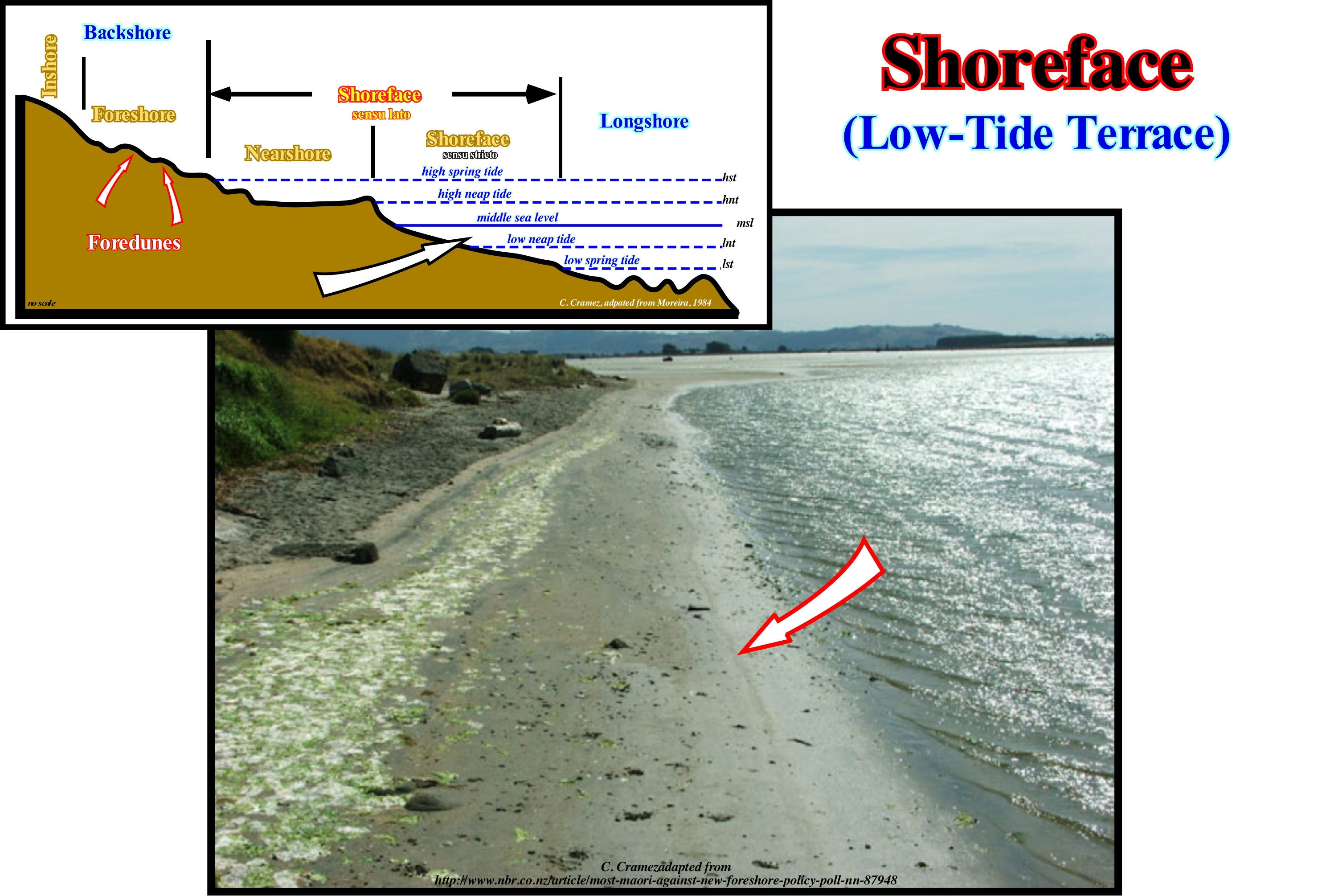
For many geoscientists, the shoreface corresponds to the lower part of the strand and comprises the space that extends between the limits reached by the spring low-tide and neap low-tide. The slope of the shoreface is very weak and the material deposited there is thin, but may contain coarse materials transported longitudinally. On the surface of the shoreface there are marks of bioturbation (marks of living beings, such as burrows and dejections of crabs, bird's feet, etc.) and low amplitude ripple-marks (between 3 and 15 cm). These ripples, called beach ripples, are, more or less, linear and parallel to each other and to the surfing line. They can be symmetrical or dissymmetrical. The beach ripples are created by the more or less turbulent flow of the swash currents, particularly the backwash current. At the outer limit of the shoreface may appear ripples of greater amplitude (up to 1 meter). These ripples form ridges and hollows that certain geoscientists call longshorerunnels. As can be seen in this scheme, the great majority of Anglo-Saxon geoscientists include in the shoreface what others call the middle beach (nearshore sensu stricto). For them, the shoreface corresponds to the beach area with concave geometry, defined between the high tide line and up to a depth of 5/20 meters. Seaward the shoreface, they consider the ramp (longshore), which slopes slightly towards the edge of the platform. At the base of the shoreface, bars and lows are formed due to the breaking of the waves. The intertidal beach, which lies between the high and low tide lines, corresponds roughly to the nearshore. The intertidal beach is situated between the high tide line and the beginning of the dunes. In the backshore there are one or several berms that look like small terraces with low slopes on the sea-side.
Shoreline Break.................................................................................................................................................................................Ruptura costeira
Ruptura (linha da costa) / Ruptura de pendiente costera / Kreuzbandriss (Küsten-Steigung) / 海岸线-断点 / Разрыв береговой линии / Rottura (versante costiero) /
Break in the slope of the sea floor very close to the base level (see wave action level). The term "coastal break" is, often, used by American geoscientists as synonymous with "Coastal Plain Edge" and "Depositional Coastal Break," or "Deposition Surface Slope Break."
See: « Basin Edge »
&
« Depositional Coastal Break »
&
« Depositional Surface »
In this geological model, P. Vail and his EPR colleagues (Exxon Exploration Production Research) assumed: (i) A given eustatic curve* (constructed from the absolute (eustatic) sea level, which is supposed to be the global sea level, referenced to the Earth's centre ; (ii) A seaward continental subsidence increasing, regularly, and in a linear manner, ; (iii) A constant sedimentary supply or terrigeneous influx (emphasized in the model by the area between two consecutive chronostratigraphic lines) ; (iv) A negligible erosion (not taken into account) and (v) A time difference between each chronostratigraphic line of 100 My or, in other words, each eustatic paracycle** has a time-duration of 100 My which is followed, after a stability period of relative sea level, by another rise without any relative sea level fall between them. Upstream of the depositional coastal break of the depositional surface, which corresponds, more or less, to the shoreline, the sediments fill up all the available space created for the sediments (accommodation): this means the depositional water-depth is, practically, zero. Downstream, and particularly on the continental shelf, just part of the available space, created by the relative sea level rise (marine ingression) is filled. This means that seaward of the depositional coastal break there is always a depositional water-depth. In this sketch, three sequence-cycles are represented, limited between two unconformities (erosional surfaces) and induced by three 3rd order eustatic cycles, whose time-duration varies between 0.5 My and 3/5 My. This implies that the age difference between the upper and lower unconformities, which bounded a sequence-cycle is, always, less than 3/5 My. Within the Phanerozoic, which last roughly 600 My, such a time interval (3/5 My) is considered to be instantaneous, since it is less than one hundredth (1/100) to total time. Of these three sequence-cycles only one sequence-cycle is complete. In a complete sequence-cycle there are two groups of sedimentary systems tracts (lateral associations of synchronous and genetically connected depositional systems). The lower systems tracts group (LSTG), during which the sea level is lower than the basin edge. During the upper group (HSTG) the sea level is higher than the basin edge (highstand geological conditions). In the lower systems tracts group (LSTG), three subgroups of systems tracts are distinguished: (i) Submarine Basin Floor Fans (SBFF) ; (ii) Submarine Slope Fans (SSF) and (iii) Lowstand Prograding wedge (LPW). In the highstand s¥stems tracts group (HSTG), two subgroups are distinguished: (iv) Transgressive Interval (TI) and (v) Highstand Prograding Wedge (HPW). In particular cases there may be another subgroup above the highstand prograding wedge, that certain geoscientists call Bordering Prograding Wedge (BPW) or Shelf Margin Systems Tracts (SMST) and other call it Forced Regression (FR). The first sequence-cycle is represented by the highstand prograding wedge (HPW), which is formed by the sequence-paracycles 1 to 5. The successive positions of the depositional coastal break of the depositional surface move seaward and correspond to the continental edge (which, here, mark the basin edge), since, at least during the final part of this subgroup of systems tracts, the basin has no platform. In the overlying sequence-cycle, which is separated from the preceding one by a significant the relative sea level fall, all the sedimentary systems tracts sub-groups are represented. During the deposit of the submarine basin floor fans (SBFF), submarine slope fans (SSF) and lowstand prograding wedge (LPW), the basin edge correspond to the last basin edge of the preceding sequence-cycle. Before the first transgressive surface, which marks the beginning of the transgressive interval (TI), the depositional coastal break of the deposition surface is individualized from the continental edge, which is not the basin edge. Since the first transgressive surface, the continental edge became the new basin edge, once the shoreline moved continentward, creating a continental shelf. However, as the continental platform develops, the depositional coastal break, globally, moves continentward, and the continental edge, which is the new basin edge, remained stationary until it is later fossilized by the progradtions of the highstand prograding wedge (HPW).
(*) Which can be considered at the level of 1st order eustatic cycles (time-duration greater than 50 My), 2nd order (time-duration between 50 and 3/5 My) and at the level of eustatic cycles of 3rd order (time-duration between 0.5 and 3/5 My), which means that the eustatic curve can be considered short-term (sequence-cycles), or long-term (subcycles of continental encroachment subcycles), or even flattened long term (continental encroachment cycles).
(**) An eustatic paracycle is a relative sea level rise, which is the local sea level, referenced to the base of the sediments or to the bottom sea. The relative sea level is the result of the combined action of absolute (eustatic) sea level, which is supposed to be global, referenced to the Earth's centre, and the tectonics (subsidence or uplift of the sea floor).
Shoreplatform (Wave-cut platform)...................................................................................................................Plate-forme littorale
Plataforma litoral / Plataforma litoral / Litoralplatte / 沿海台地 / Волноприбойная терраса / Piattaforma costiera /
Erosional surface sloping slightly seaward and extending between the base of the beach escarpment and the limit of shoreface (for certain geoscientists). The coastal platform corresponds, more or less, to the longshore plus the shoreface.
See: « Shelf »
&
« Isolated Platform »
&
« Schorre »
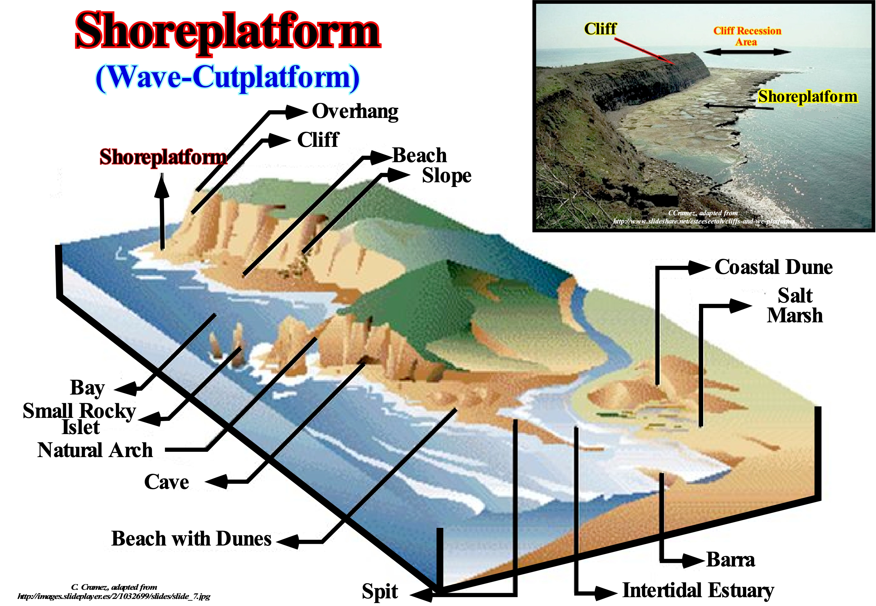
This photograph illustrates a shoreplatform, known also as coastal platform or wave-cut platform. The more or less flat and sloping surface that truncates the ground in the intertidal zone (between tides) is an old abrasion platform that has been, partially, eroded by the combined action of ice and sea-waves. On certain Canadian shores, finely, fractured shales (slate) is, easily, disintegrated by the cold weather conditions of this region, which prevail almost all year, resulting in a set of fine debris that are, easily, transported by the sea-waves and marine currents. The less fractured layers are slightly higher and thus less susceptible to the action of ice. Many of the modern shoreplatforms correspond to old abrasion platforms and are currently submerged or emerged due to relative sea level changes (relative sea level rise, in the first case, and falling in the second). In general, the shoreplatforms are old, slightly sloping, rocky surfaces extending from the bottom to the top between the highest and lowest tide levels (abrasion platforms). They are old abrasion surfaces carved by the action of the sea-waves and therefore tend to be more or less smooth or with weak undulations and some berms, which correspond to the level of the high tide or the level reached during the storms The roughness of an abrasion platform or a shoreline is, also, very dependent on the lithology of the rocks on which it was (or is) excavated and also on tectonics, that is to say, that the abrasion is not the same if the rocks are sub-horizontal or folded. It is natural to find sinuosities where the rocks are harder, whether on rocky banks, rocks (rocks on the surface of the water), stacks (high rocks and isolated on the coast) or faraglioni (small islands). When the lithology of the platform is carbonate, of course, it is, generally, modelled in potholes, pinnacles or alveoli or other karstic forms. Daveau (1977), describes the Portuguese shoreplatform as follows: (i) The Portuguese shoreline is surrounded in all its extension by a very regular platform, covered with marine deposits where water-courses, sometimes, carve true gorges ; (ii) Its altitude, which is, generally, between 100 and 200 meters, may fall to sea level or rise to around 400 meters ; (iii) The shoreline is, often, bounded inland by a steep ridge; (iv) It is an old top, contemporary of its modeling, or by a post fault cliff. The coastal platform in the Porto region, for example, corresponds to a set of stepped steps, which descend seaward from a line of marginal reliefs that correspond to the inner edge of the platform. In the geological scheme illustrated in this figure, in association with the shoreplatform, it is recognized. (i) A bay, which is a portion of the sea surrounded by land, that is, the opposite of a cap ; (ii) Two faraglioni, which are steep islets ; (iii) A natural arch, which is a geological formation formed by a rocky arch, naturally, excavated by erosion ; (iv) A cave, which is a natural rocky cavity with dimensions that allow access to humans ; (v) A beach with dunes, the geological formation composed of loose particles of minerals or rocks in the form of sand, gravel, pebbles, etc., along the margin of a body of water with sand mounds developed by wind ; (vi) An intra-tidal estuary, which is an estuary created by the action of the tides ; (vii) A bar, is a geological formation resulting from the accumulation of alluvial material, parallel or perpendicular to the shoreline ; (viii) A salt marsh, formed by standing and shallow waters, located on an impermeable mantle, with a dense vegetation and a soil with large amounts of decaying vegetation ; (ix) A coastal dune, which is a mound of sand developed by wind processes along the coastline; (x) A beach without dunes, which is a geological formation composed of loose particles of minerals or rocks in the form of sand, gravel, pebbles, etc. along the margin of a body of water ; (xi) Overhang, which are steep rocky cliffs, steep, surmounting a gentle slope or forming protrusions ; (xiii) Cliffs, which are coastal slopes, abrupt or with a steep slope; (xiv) A slope, which is an inclined terrain that limits a landfill and is intended to ensure the stability of the landfill.
Sial.....................................................................................................................................................................................................................................................................................Sial
Sial / Sial / Sial / SIAL (地球的层) / Сиаль (верхний слой земной коры) / Sial /
General term given to the rocks that form the continental masses, which are, basically, made up of silica and aluminum.
See: « Hot Spot »
&
« Sima »
&
« B-Type Subduction (Benioff) »
Sial or SiAl is the name given to the upper layer of the Earth's crust, which is also known as continental crust due to the significant absence of ocean basins. This name was taken from the first two letters of silica and aluminum. The sial is formed by rocks rich in minerals made from silica and aluminum. When the sial emerges, it is, basically, granitic, and that is why some geoscientists designate the sial as the granitic layer of the Earth's crust. The vast majority of geoscientists call the rocks that form the sial as felsic rocks. In the continental lithospheric plates, the base of the sial varies between 5 and 70 km of depth. The sial "floats" over the sima, the mountains extend downward (by density difference), like an iceberg in the sea, which explains the great in depth variation of the sial-sima limit (isostasy). In the same way, that for the sial, the sima name, which corresponds to the whole lower level of the Earth's crust and the mantle, was taken from the first two letters of silica and magnesium. The sima, sometimes, appears at the bottom of the ocean basins. The sial has a density between 2,700 and 2,800 kg /m3, which is less than the density of the sima. At the base of the sial, the rocks pass, progressively, to the basalts that form the sima. The line separating the sial from the sima is Conrad's discontinuity, which is, arbitrarily, set when the average density reaches 2,800 kg/m3. In the upper part, the average density of the gap varies between 2,800 and 3,300 kg/m3 and between 3,300 and 5,600 kg/m3 in the lower middle part. The sima extends up to 2,900 km deep to the upper limit of the Earth's core, which is called Nife, since nickel and iron are its main components. From the point of view of chemical composition, the Earth divides into three layers: (i) Sial, a thin, fragile, superficial layer, mainly composed of silica and aluminum ; (ii) Sima, intermediate layer, with a thickness of about 2,850 km, ductile, dense, composed mainly of silica and magnesium and (iii) Nife, lower layer and more or less equivalent to the Earth's core.
Siberia (Continent)..........................................................................................................................................................................................................................Sibérie
Siberia / Siberia / Sibirien / 西伯利亚 / Сибирь / Siberia /
One of the Cambrian continents resulted from the breakup of an ancient supercontinent called Protopangea (Rodhinia, for certain geoscientists). The largest of these continental masses was undoubtedly the small supercontinent Gondwana which, little by little, began to drift southward and fractured. The other continents such as Laurentia, Baltica and Siberia remained always independent.
See: «Protopangea»
Sidereal Period (Moon).......................................................................................................................................Période sidérale (De la Lune)
Período sideral/ Período sideral (de la Luna) / Sternzeit Zeitraum / 恒星周期 / Звёздный период (Луна) / Periodo siderale /
Time that the Moon spends to make a complete turn around the Earth in relation to fixed stars or, in other words, the time the Moon spends to make a complete orbit around Earth, i.e., the time it spends between two consecutive positions East of Earth. Synonym with Sideral Lunar Month.
See: « Orbit »
&
« Draconic Period (Moon) »
&
« Nodic Period (Moon) »

Theoretically during a month or sidereal period, the Moon moves from the position, for instance of a New Moon to the next position of New Moon. As can be seen in this diagram, this is not entirely true. To see where the approach is, just think that during that time, the Moon is orbiting the Earth, and that in turn, the Earth is also moving. This means that the Moon is not between the Earth and the Sun when the sidereal month is over and therefore not a true New Moon. Even though the sidereal month seems to be the simplest view of a month, astronomically there are other types of months that are more interesting from the terrestrial point of view. In addition to the sidereal month, there are other ways of considering how long it takes the Moon to complete an orbit: (i) Anomalistic month , (ii) Synodic month ; (iii) Draconic month ; (iv) Tropic month. The anomalistic month which is the time between two passes of the Moon by its perihelion (the point closest to the sun). The synodic month is the time the Moon spends between two phases (between two consecutive New Moons), which lasts about 29.5 days. The draconic month is the time that the Moon spends between two consecutive ascending nodes (point where the orbit of a satellite crosses the plane of the ecliptic and where the third coordinate of the satellite is increasing). The tropic month, which is the time between two consecutive phases of the Moon (same ecliptic longitude). The sidereal period or month differs from the anomalistic period or month because the larger diameter of the orbit, usually, advances slowly. The sidereal month, which after all is the time the Moon takes to make a complete return to Earth in relation to the fixed stars, lasts about 27.3 days. As a result of the slow precession of the Moon's orbit, the month or anomalistic, tropic, and draconic period are different from the sidereal month. Apart from Mercury and Venus, all planets in the solar system have natural moons. The Earth has only one, Mars two, a much larger number of moons revolve around the giant planets.
Sigmoid Configuration (Reflectors)............................................................................................Configuration sigmoïde
Configuração sigmóide / Configuración sigmóide / Sigmoid-Konfiguration / 乙状结肠配置 / Сигмообразная схема / Configurazione sigmoidale /
In this pattern, the progradations have a S-geometry upside down, which means that the slope in the upper and lower parts is relatively weak, while in the middle part it is much stronger. The same goes for the thickness. Between two consecutive reflectors, the thickness is maximum at the point of inflection of the progradation.
See: « Stratal Patterns »
&
« Reflection Configuration »
&
« Downlap Surface »
The Mozambique offshore corresponds to the stacking of three basins of the classification of the sedimentary basins of Bally and Snelson (1980), that from the bottom up are: (i) Basement or Paleozoic Folded Belts; (ii) Late Jurassic/Early Cretaceous-rift-type basins and (iii) From Early Cretaceous to Present an Atlantic-type Divergent Margin. Within the divergent margin, which corresponds to the continental encroachment cycle that was induced by the post-Pangea first order eustatic cycle, two stratigraphic phases can be recognized: At the base, the transgressive or aggradational phase, which, globally, has a retrogradational geometry, which is covered by a regressive phase characterized by a progradational geometry that is, easily, recognized on the seismic lines. On this tentative geological interpretation of a Canvas auto-trace of a regional seismic line of this offshore, the the post-Pangea transgressive phase of continental encroachment cycle, basically, exhibits an internal sigmoid configuration. The vast majority of chronostratigraphic lines (seismic reflections) have a sigmoid or a reverse S-shaped geometry. Each of these chronostratigraphic lines consists of three segments: (i) A subhorizontal upper segment, where the sediments deposit under a small water-depth (platform deposits) ; (iii) A deep subhorizontal segment, where the sediments are deposited under a greater water-depth than the continental slope. (ii) A segment dipping seaward, where continental slope sediments are predominant ; Often, between the upper horizontal segment and the seaward dipping segment, that is, near the continental edge (sometimes coincident with the basin edge), high-energy sediments such as organic constructions are deposited if the conditions allow it. Sometimes the basin has no continental shelf. Under such conditions, the basin edge almost corresponds to the continental edge and to the shoreline, which underlines the edge of the coastal plain. On this tentative interpretation, the progradational configurations are frequent, mainly, in the regressive phase of the continental encroachment cycle of the margin. The progradational geometry is very evident in the upper interval, since it is exaggerated by the seismic pitfall induced by the strong variation in water-depth, which causes excessive burial of the seismic reflectors where the water-depth is larger. Above the downlap surface (Mesozoic/Cenozoic maximum flooding, lower limit of the regressive phase of the post-Pangea continental encroachment cycle) the reflectors are sigmoid progradations. Note that the seismic pitfall induced by the abrupt change in water-depth manifests to the base of the seismic line. Thus, in geological terms, that is, in a depth version, the geometry of the downlap surface is, practically, subhorizontal or even inclined continentward, which changes, completely, the geometry of the margin. The main internal progradational configurations of the seismic intervals are schematised in the lower left corner of this figure: (i) Sigmoid configuration, the progrades have a geometry of a S upside down, which means that the slope in the upper and lower parts is relatively, small, while in the median it is much stronger ; (ii) Tangent Oblique Configuration, in this pattern, the seismic reflectors have a decreasing slope base-ward ; (iii) Parallel Oblique Configuration, set of seismic reflectors with a parallel /oblique pattern, in which the progradations terminate, downstream, with a relatively important dip ; (iv) Sigmoid/Oblique Configuration, which is a particular case of the sigmoid configuration, in which the inclination of the median parts of the progradations is very strong and the presence of toplaps by truncation is frequent ; (v) Shingled configuration, when the progradations are oblique and almost lying down, seeming to take turns one after the other, and (vi) Hummocky configuration, set of seismic reflectors with opposite inclinations, interpreted as strata associated with turbiditic deposits of slope (turbiditic natural marginal dikes or levees and the filling of the depressions between them or filling of channels, in case of evident erosion, where turbidite currents have travelled).
Sigmoidal Offlap (Progradation).........................................................................................................Progradation sigmoidale
Progradação sigmóide / Progradación sigmoidal / Sigmoidal Progradation / S形前积 / Сигмовидное несогласное регрессивное налегание / Progradazione sigmoidale /
When the successive displacements of the shoreline (roughly equivalent to the depositional coastal break) or the basin edge seaward are accompanied by a significant aggradation. Within a sequence-cycle, the shoreline and the basin edge coincide (more or less) when the basin has no shelf, i.e., during the lowstand prograding wedge (LPW) and during the second development phase of the highstand prograding wedge (HPW).
See: « Depositional Dip »
&
« Progradation »
&
« Depositional Coastal Break »
On this tentative geological interpretation of a Canvas auto-trace of a detail of a Black Sea seismic line there are several discordant sedimentary intervals (separated by unconformities probably induced by significant relative sea level falls, which were deposited during the regressive phase of the post-Pangea continental encroachment cycle, which deposited over the transgressive phase, whose geometry is slightly retrogradational (barely visible on this tentative interpretation) with a parallel internal configuration. The vast majority of regressive intervals, that is, globally progradational* , has an internal configuration marked by sigmoid progradations (sigmoidal offlap), and only the deep interval, which overlaps the yellow interval, seems to have an oblique progradational internal configuration, since the aggradation, if any, is very small. On the seismic lines, most geoscientists consider that the progradations of a progradational interval are sigmoid when there is a significant aggradation (upbuilding) upstream of the basin edges or continentward of the shorelines, which in this example are, practically, coincident with the continental edge, and that several chronostratigraphic lines (reflectors) can be put in evident. These conditions are, easily, recognized in the interval underlined by the first arrow with NE vergence (coloured interval in light brown between the green interval and the dark brown interval), in which the successive positions of the basin edge, which in this case coincide with the continental edge (the basin has a shelf). When no chronostratigraphic line is evident, upstream of the basin edges, without great error, it can be said the progradations are oblique and the basin edges coincide, roughly, with the successive shorelines (taking into account the seismic resolution). As a seismic line is a section in time and not a profile in depth, it may be said that in a sigmoid configuration, the depositional angle is relatively small (generally less than 1°). The lower segments of the chronostratigraphic lines approximate the deep-water correlative paraconformities of the unconformities with very small angles, and the associated reflector terminations (lapouts) are either true or apparent downlaps (when the deep sedimentary interval is below the seismic resolution). In a sedimentary interval constituted by sigmoid progradations the form of the sequence-paracycles is fusiform, which implies: (i) A relatively abundant sedimentary supply (terrigeneous influx) ; (ii) A significant and rapid rise in relative sea level, which shifts continentward the shoreline and increases, significantly, accommodation (space available for sediment) ; (iii) A sufficiently long, stability period of the relative sea level allowing the deposit and preservation of the upper segment of the progradations as the shoreline moves seaward and (iv) A low-energy sedimentary environment. In some cases, potential source-rocks, i.e., sediments rich in organic matter, are, sometimes, associated with the lower segments of these progradations where sedimentation is condensed. In addition to the sigmoid configuration, the seismic reflectors can be: 1) Convergent, when they thin, laterally, basinward ; 2) Divergent, when they thicken and diverge, laterally, basinward ; 3) Fill, when filling the negative topographic anomalies of the underlying strata ; 4) Hummocks or Wavy, when, more or less, discontinuous and with opposite inclination ; 5) Mounded, when they form topographic anomalies in the shape of a mound, above the base level ; 6) Parallel, like strata deposited in parallel beds ; 7) Progradational, when they have a prograding geometry ; 8) Oblique / Parallel, when they finish seaward with a relatively important dip ; 9) Oblique / Tangent, when they end with a descending slope to the base; 10) Shingled, when they have a progradational oblique geometry, almost lying on top of each other, like in a slatted roof.
(*) Globally, there may be clastic intervals with prograding geometry (regressive intervals) and clastic intervals with aggradational geometry (transgressive intervals). However, at small scale, i.e., at the scale of the sequence-paracycles, which constitute both clastic regressive and transgressive intervals, the internal geometry is always progradational. This means sequence-paracycles, which are the building blocks of the sequence-cycles, are sedimentary regressions. It can even be said that with the exception of the pelagic intervals deposited, mainly by decantation, all other clastic intervals are sedimentary regressions. It is only, collectively, that they can develop a retrogradational geometry, such as in the transgressive interval (IT) of a sequence-cycle, which is nothing more than a set of increasingly smaller regressions.
Signature in Stratigraphic Record.....................................................................Signature (Registre stratigraphique)
Assinatura no registo estratratigráfico / Firma estratigráfica / Unterschrift (stratigraphische Aufnahme) / 签名(地层记录) / Аномалия (в стратиграфической колонке) / Signature (record stratigrafico)
Response recorded in the sedimentary series of terrestrial and extraterrestrial events, such as: (i) Tectonics ; (ii) Eustatic ; (iii) Climatic ; (iv) Sedimentary influxes ; (v) Solar explosions ; (vi) Impacts, etc. Since record thickness is higher than seismic resolution, most of these events can be recognized in seismic lines, particularly in regional seismic lines.
See: « Neogene Stratigraphic Signature »
&
« Seismic Resolution »
&
« Sequential Stratigraphy »
This scheme, taken from P. Vail's course at Rice University (Texas, USA), shows: (i) The hierarchy of geological events ; (ii) The correlations (global, regional or local) between the different geological events and (iii) The main cause of the geological events. For example, considering the signature of the continental encroachment cycles induced by first-order eustatic cycles whose time-duration is greater than 50 My, it can be said that: (a) Their spatial distribution (correlation) is global ; (b) They are induced by first-order eustatic cycles (temporal distribution) and (c) They are most likely caused by volume changes in ocean basins induced by oceanic expansion (sea floor spreading). However, this latter conjecture is valid just if the quantity of water in all its forms (liquid, solid and gaseous) has been constant since the Earth's formation, around 4.5 Ga, that is, 4.5 billion* years ago. This conjecture, till today, has not yet been refuted. On the contrary, the great majority of geological observations corroborate it. Thus, when a supercontinent break-up, such as the Protopangea (Rodhinia) supercontinent or the Pangea supercontinent, the subsequent oceanic expansion produced important submarine mountains (ocean ridges), which, significantly, reduces the volume of the basins oceanic Under such conditions, if the amount of water is constant **, the absolute (eustatic) sea level, i.e., the sea level referenced to the Earth's centre, is obliged to to rise encroaching the continents. On the contrary, since the continental collisions associated with the Benioff (B-type) or Ampferer (A-type) subduction zones begin to be predominate, which happens, usually, in the final part or very advanced oceanic expansion, the volume of ocean basins decreases due to the subduction of the oceanic mountains, which forces the global (eustatic) sea level to fall by exhuming a large part of the continental crust. It's important not to forget that the relative sea level variations during the marine ingressions (absolute or relative sea level rises, which move the shoreline continentward) are slower (more or less 0.1 cm per 1,000 years) than during marine regressions (more or less, 2 cm/1,000 years). Peter Vail considers that the preponderant factor of stratigraphic signatures, i.e., sedimentary cyclicity, is the eustasy (absolute or eustatic sea level changes) rather than tectonics (subsidence or uplift of the sea floor), since eustatic changes are much faster than tectonic changes. In fact during the Mesozoic -Cenozoic, i.e., during the post-Pangea second continental encroachment cycle, which was induced by the second 1st order eustatic cycle of the Phanerozoic, whose time-duration was about 250 My there were four orogenies: (i) End of the Appalachian (± 260-250 Ma) ; (ii) Nevadan (± 180-135 Ma) ; (iii) Laramidia (± 65-60 Ma) and (iv) Alpine (± 25-13 Ma). However, during this time (± 250 My), eight large continental encroachment sub-cycles were deposited in association with eight large second-order eustatic cycles (time-duration between 3-5 My and 50 My), within which were individualized about 120 sequence-cycles, induced by 3rd order eustatic cycles, whose time-duration varies between 0.5 My and 3-5 My. On the other hand, tectonics (subsidence or uplift of the sea floor) alone does not produce erosional surfaces. These can only be formed if the sediments are exposed to erosive agents, which implies, necessarily, a falling of the relative sea level (the combination of absolute sea level and tectonics) exhuming the platform and the upper part of the continental slope. However, in certain types of sedimentary basins of the Bally and Snelson classification (1980), as in foredeep basins, for instance, tectonic variations may be, locally, preponderant. The tectonics, which is compressional (shortening) or extensional (lengthening) is responsible of folding, faulting, magmatism, diapirism, cycles, regressions, sedimentary supply, etc. It may have a regional or local distribution, while eustasy (a term used to denote the process that translates eustatic variations, i.e., global sea level variations) is considered to have a global distribution, which certain geoscientists doubt.
(*) In certain languages as in European Portuguese a Giga (1x10⁹) of the International System of Units is said thousand millions and not billions as the Brazilians say. In European Portuguese a billion is a million of millions or the unit followed by 12 zeros (1012) and not thousand millions (1x10⁹). Therefore, it is always better to follow the International System of Units.
(**) There are approximately 14,250 x 012 tonnes of water, of which 16,700 x 1109 are in the form of ice.
Silt ...............................................................................................................................................................................................................................................................Limon (Vase)
Limo (silte, vasa) / Limo / Schlamm / 淤泥 / Шлам, грязь / Limo /
Soil or rock formed from a granular material with a granulometry between sand and clay. Silt (ooze) can appear as a soil or as a sediment either suspended on the surface of a waterbody or deposited on the bottom.
See: « Deposition (clastics) »
&
« Beach Rock »
&
« Granulometry »
Silt (mud for certain geoscientists) is created by a variety of physical processes that can divide quartz crystals the size of sand from primary rocks from the disabilities of their structure. These processes involve the chemical alteration of rocks and regoliths, and a number of physical weathering processes such as ice-break and haloclasty. The main process is abrasion by transport (including gradual reduction by successive removal of small particles or by wear) fluvial, wind and glacier. It is in semi-arid environments that large amounts of silt are produced. In some countries, mud or mud is known as "rock meal" or "stone powder", especially when produced by the action of glaciers. From the mineralogical point of view, the silt is, mainly, formed of quartz and feldspar. Sedimentary rock composed mainly of silt is a siltite. In the Wentworth scale, the silt particles range from 1/256 to 1/16 mm. They are larger than clay. As with the naked eye, it is not possible to distinguish a slime from a clay, they can be separated, due to their plasticity, which is very low or non-existent in the slime. In fact, silt is chemically distinct from clay, and unlike clay, the silt grains are approximately the same size (in all dimensions). Clays are composed of flat, flat (blade-shaped) particles bonded together by a set of electrostatic forces that give it a lot of cohesion. Silt is, easily, transported by water or any other liquid and it is fine enough to be transported long distances by the wind in the form of dust. Very thick, silt deposits of wind are often called "loess" (in German) or "limon" (in French). Silt and clay contribute a lot to the turbidity of the water. Silt (silt for certain geoscientists) is carried by continental currents and also by ocean currents. When silt acts as a water pollutant (increased concentration and accumulation in the bottom of streams), this phenomenon is known as silting.
Silte............................................................................................................................................................................................................................................................Limon (Silte)
Limo, Silte / Limo / Schluff / 淤泥 / Ил, тина / Limo /
Granular material, derived from a soil or rock, having a particle size between that of a clay and a sand and which can occur either as a soil or as a sediment suspended on the surface of a waterbody.
See: « Compacted Clay »
&
« Clay »
&
« Limnology »
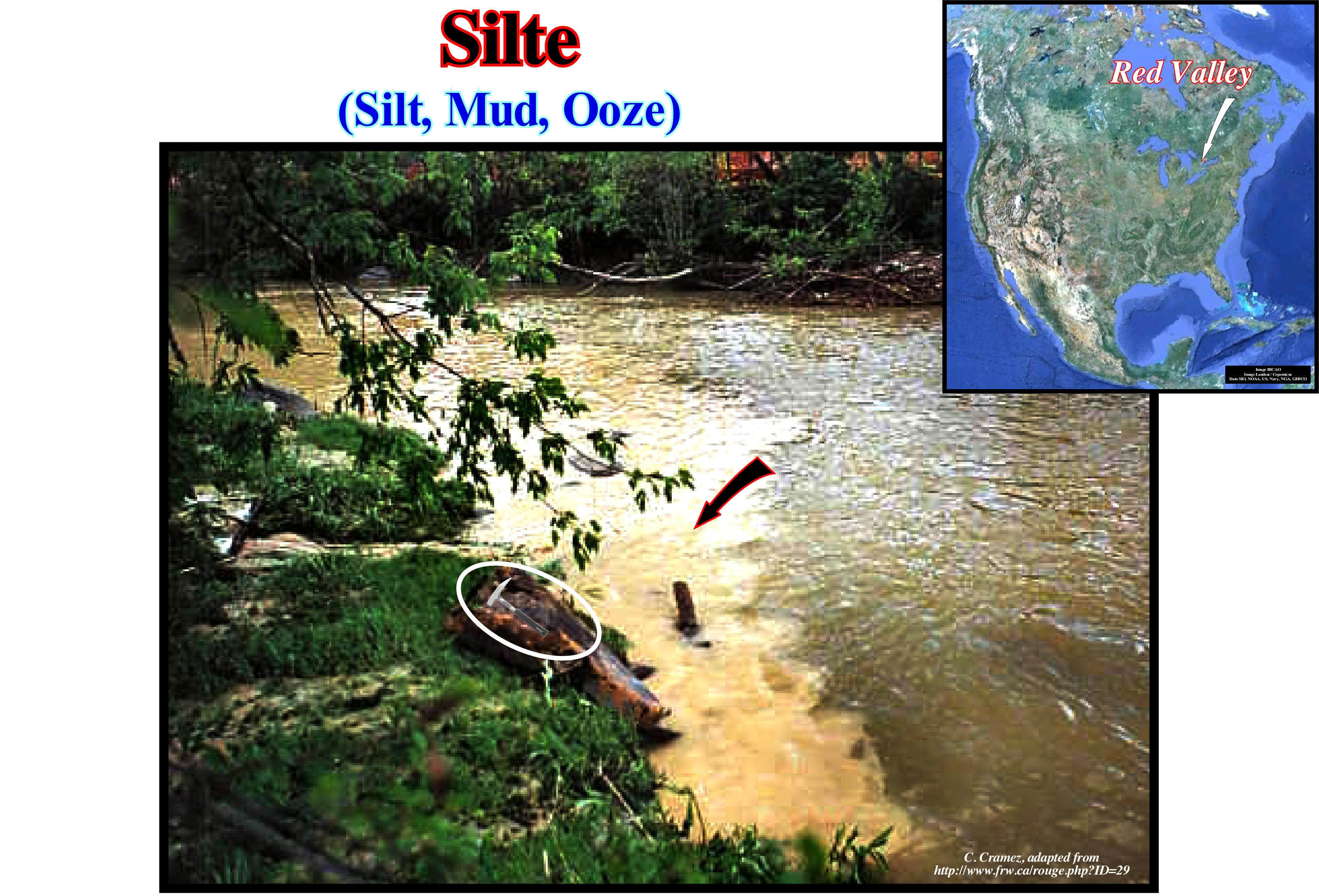
In this photograph, the yellowish spot seen on the left side, along the edge of the stream, is the water, laden with silt, of a stream that enters the river. Slime (or silt) may occur as: (i) A soil ; (ii) Sediment suspended in water ; (iii) Sediment carried by the wind ; (iv) Dust or (v) As a rock (siltite). The large aeolian deposits, which the German geoscientists called "loess" and the French geoscientists "limon" are siltstones. Mineralogically, the silt is mainly composed of quartz and feldspar. However, its main feature is the size of its grains, i.e., the diameter of the quartz and feldspar grains. On the Atterberg scale, the grain diameter of a silt ranges from 0.002 to 0.020 millimeters (although other geoscientists do vary from 0.002 to 0.062 millimeters). This corresponds in the Wentworth scale to a Φ between 8 and 5 (Φ = -log2 D / D0, where D is the particle diameter and D0 a reference diameter). In the Wentworth scale, the slime can be further subdivided into: (a) Very Fine Silt (Φ = 8); (b) Fine Silt (Φ = 7); (c) Medium Silt (Φ = 6) and (d) Coarse Silt (Φ = 5). The other particles are clay, smaller than silt, and sand and ballast of higher dimensions. In the Atterberg scale, the granulometric pattern is: (1) Clay ; (2) Silt ; (3) Fine sand ; (4) Thick Sand ; (5) Gravel ; (6) Pebble and (7) Block. Silt is produced by a wide variety of rock crystal separation processes. These include chemical weathering of rocks and regoliths, as well as physical weathering. In physical weathering, cryoclasty (migration of water along the non-ice areas of the pores of the rocks to accumulate in ice lentils) and haloclasty (weathering caused by the growth of salt crystals) are particularly distinguished. Slime may also form by abrasion during river, wind or glacial transport processes, but it is in semi-arid environments that a large part of the silt is produced.
Siltite......................................................................................................................................................................................................................................................................................Siltite
Siltito / Limolita / Schluffstein / 粉砂岩 / Алеврит / Siltite /
Sedimentary rock consolidated and constituted by silt, i.e., formed from detrital particles with dimensions between 3.9 and 62.5 microns.
See: « Granulometry »
&
« Arenite »
&
« Compaction »
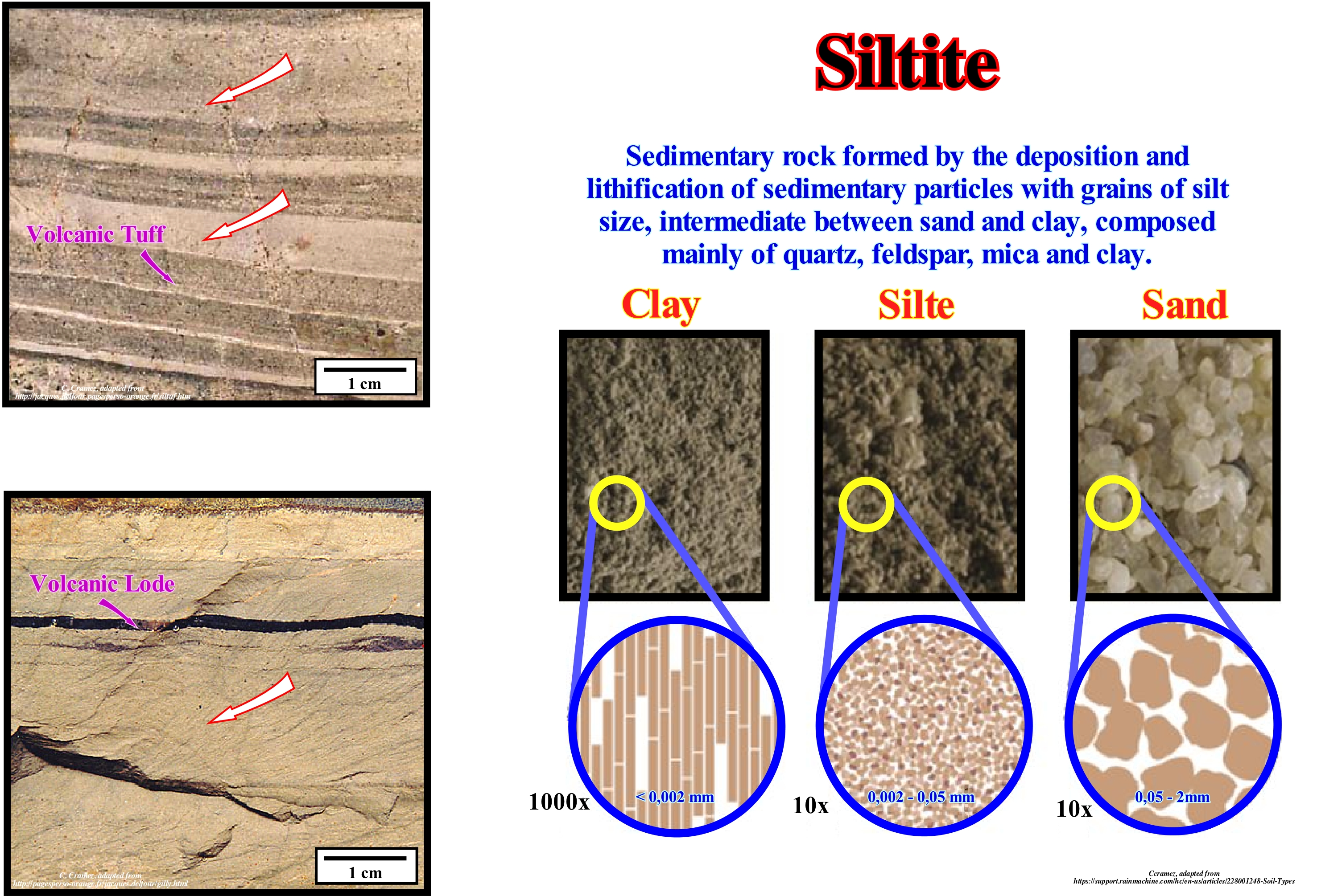
Before the construction of the Assouan hydroelectric dam on the Nile River, which was built in 1970, seven kilometers upstream from the city of Assouan in Upper Egypt and which is described as one of the largest dams in the world (capacity of 169 billion cubic meters of water), the silt deposited during the annual floods of the Nile river, created the rich (siltite) and fertile soil that sustained the ancient Egyptian civilization. After the construction of the dam, the floods ceased to exist and, subsequently, the siltites were deposited. Without this dam, every summer, the Nile flooded the fertile plains of the valley due to the influx of waters from East Africa. These floods brought nutrients and minerals (silts), which made the soil (siltstone) of the Nile valley very fertile and conducive to agriculture. However the population increase in the valley made it necessary to control the water to protect agricultural facilities and cotton farms. In the years of great floods many of the crops were destroyed, whereas in the years of weak floods, the population went hungry due to the drought. The objectives of the dam were to control flooding, generate electricity for the country and constitute a reservoir of water for agriculture. However, it seems that at least two things have not been taken into account: (i) The silting of the dam and (ii) The need for a massive use of chemical fertilizers to replace the fertile siltstones and muds deposited during floods. In the same way, the siltstones deposited by the Mississippi River during the twentieth century declined, significantly, due to a system of dams, built upstream, which led to the disappearance of wetlands and barrier islands in the delta surrounding New Orleans. This suggests once again that major disasters such as that associated with Hurricane Katrina in the New Orleans region, where the waters of Lake Pontchartrain flooded more than 80% of the city and about 200,000 houses were under water, in large part, induced by a lack of understanding of the geological problems by most of our political men.
Silurian.....................................................................................................................................................................................................................................................................Silurien
Silúrico / Silúrico / Silur / 志留纪 / Силурийский период / Siluriano /
Geological period between the Devonian and Ordovician. The Silurian lasted about 30 My between 438 and 408 Ma. As with almost all other geological periods, the rocks that characterize the beginning and end of the Silurian are well known, but their dates range from ± 5-10 Ma. The beginning of the Silurian corresponds to a great extinction in which about 60% of marine species disappeared.
See: « Paleozoic »
&
« Geological Time »
&
« Geological Time Scale »
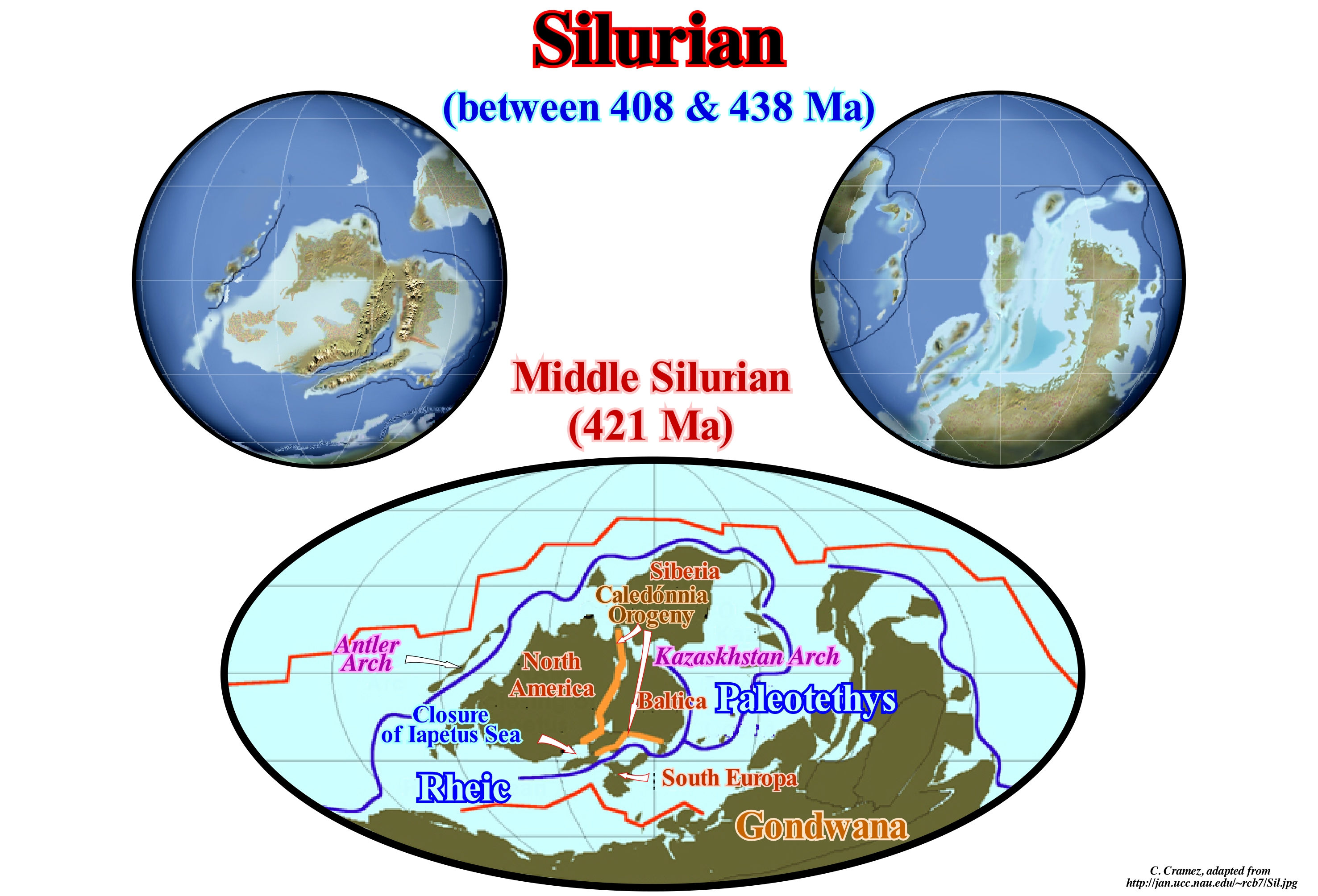
The limit between the Ordovician and Silurian corresponds to a great extinction. The complexity of this extinction suggests the occurrence of several catastrophic phases close to each other. About 100 marine families disappear, which corresponds, more or less, to 50% of the genera (between family and species). Brachiopods and bryozoans were exterminated, as were many of the families of trilobites, conodonts, and graptolites. The most probable explanation for this extinction was the beginning, in the Ashgilian (488/438 Ma), of a long glacial era, perhaps the most severe of the Phanerozoic. The climatic conditions favourable to the greenhouse effect, that prevailed during almost all Ordovician, have been replaced by glacial conditions. Such a change caused a significant drop in CO2 content in the atmosphere, which selectively affected shallow water marine organisms. On the other hand, as the supercontinent Gondwana drifted over the South Pole, it was covered by glacial caps. The alternation of glacial and interglacial periods produced repeated and important of sea level changes, which eliminated many of the ecological niches. During the Silurian, the climate was characterized by global warming and the return of moderate temperatures, which ended the Ordovician glacial period. As illustrated in this figure, North America remained near the equator, but began to join with the Baltica and Eastern Siberia. Gondwana continued to be the most important continent in the southern hemisphere, but there is no evidence of glaciation during the Silurian. The collision between the Baltica and North America created a mountain range (Caledonian orogeny), which, of course, brought about the closure of the Iapetus Sea (sea between North America and Baltic Sea). Between the Baltica and the Gondwana a new ocean began to form, which later gave rise to the Sea Tethys. In this scheme the location of the Rheic Sea between the south of North America and the Gondwana.

