
Radioactive Decay.............................................................................................................................................Décroissance radiocative
Décroissance radiocative / Decaimiento radioactivo / Radioaktivität / 放射性 / Спад радиоактивности / Radioattività, Decadimento radioattivo /
Process in which an unstable atomic nucleus, spontaneously, loses energy emitting particles and ionizing radiations. The loss of energy results in a nuclei, called a parent nuclide, (an atom species that exists for a measurable period of time, characterized by its atomic weight, atomic number, and energy state) that turns into an atom of another type called nuclide-child.
See: « Radiometric Dating »
&
« Geological Time »
&
« Relative Time »
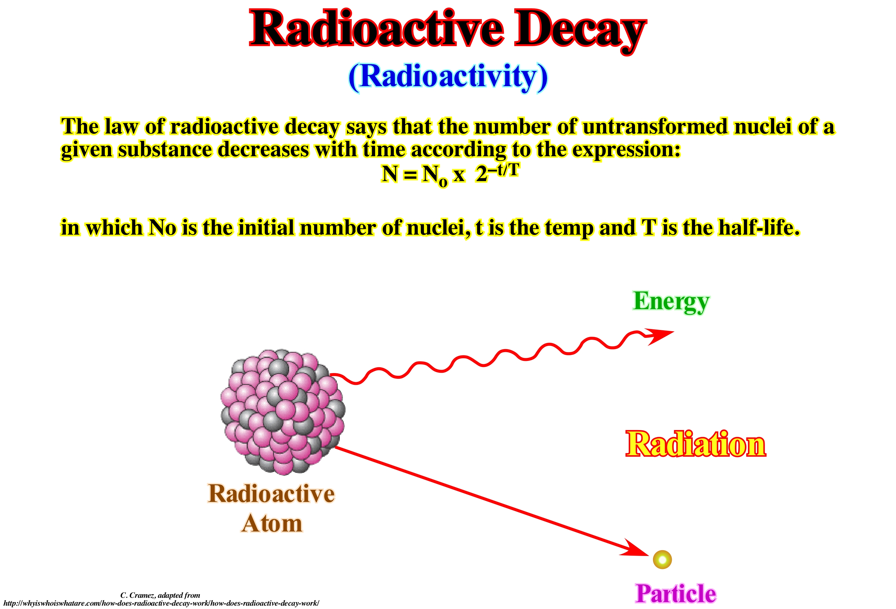
Protons and neutrons, as well as other particles near them, are governed by interactions. The strong nuclear force*, not observed on the familiar macroscopic scale, is the most powerful at subatomic distances. The electrostatic force is almost always important, and in the case of beta decay **, the weak nuclear force *** is also involved. The interaction of these forces produces a series of different phenomena in which energy is released by the new arrangement of the particles. Certain configurations of the particles in the nucleus, if they change even a little, can be reorganized into an arrangement of lower energy with a release of energy. Imagine a snow field. As long as the friction between the ice crystals supports the weight of the snow, the system is, naturally, unstable relative to a state of lower potential energy. A perturbation facilitates the change to a state of greater entropy, that is, the system will move to a state of lower energy (base state), producing heat (the total energy will be distributed by a greater number of quantum states). The result is an avalanche. In this process, the total energy does not change, but because of the law of entropy, avalanches are made toward the base state (lower energy), which is the state in the greatest number of ways by which the available energy can be distributed . Such a collapse (decay) requires a specific activation energy. In the event of a snow avalanche, this energy is usually an out-of-system disturbance, although such disturbances may be, arbitrarily, small. In the case of an excited atomic nucleus, the arbitrarily small perturbation comes from vacuum fluctuations or quantum void (space filled with particles and virtual antiparticles that appear in very short life and death cycles thanks to the turbid energy). A radioactive nucleus (or any excited system in quantum mechanics) is unstable, and can thus spontaneously stabilize in a system of less excitation. The resulting transformation changes the structure of the nucleus and the emission of a photon or any other high-speed particle (electron, alpha particle, etc.).
(*) Interaction between quarks and gluons (former nuclear force between protons and neutrons). It is one of the four fundamental forces of nature. She is the strongest. However, it has a very short radius of action (± 10-12 centimeters). The strong force does not come on either the photons or the electrons.
(**) Radioactive decay is the inverse of growth. Instead of a constant growth k we have a constant decay -d. If original number of atoms is «No», the number of atoms remaining after a certain time interval «t» will be given by the formula N = No e-dt. If a mineral contains a radioactive isotope (e.g. 238U), its age may be determined by measuring the N number of uranium atoms 238 present as well as the number of 206Pb atoms which is the isotope in which uranium 238 normally decays by successive alpha emissions and beta decays.
(***) The weak nuclear force, which is responsible for the radioactivity has an action of 10-14 centimeters. It transforms one into another. It is responsible for the disintegration of the proton free neutron after about 15 minutes.
Radioactivity Log.................................................................................................................................Diagraphie de la radioactivité
Diagrafia de radioactividade / Perfil de radioactividad / Radioaktivität-Protokoll / 放射性日志 / Диаграмма радиоактивного каротажа / Registro di radioattività /
Diagram that measures the natural radioactivity of the geological formations using a scintillation counter as the probe is withdrawn from the well. Also called gamma ray logs. The main radioactive element found in the rocks is potassium, which is very common in clayey rocks rich in illitie, but also, although lesser, in feldspar, mica and glauconite.
See: « Electric Log »
&
« Unconformity »
&
« Transgressive Interval »
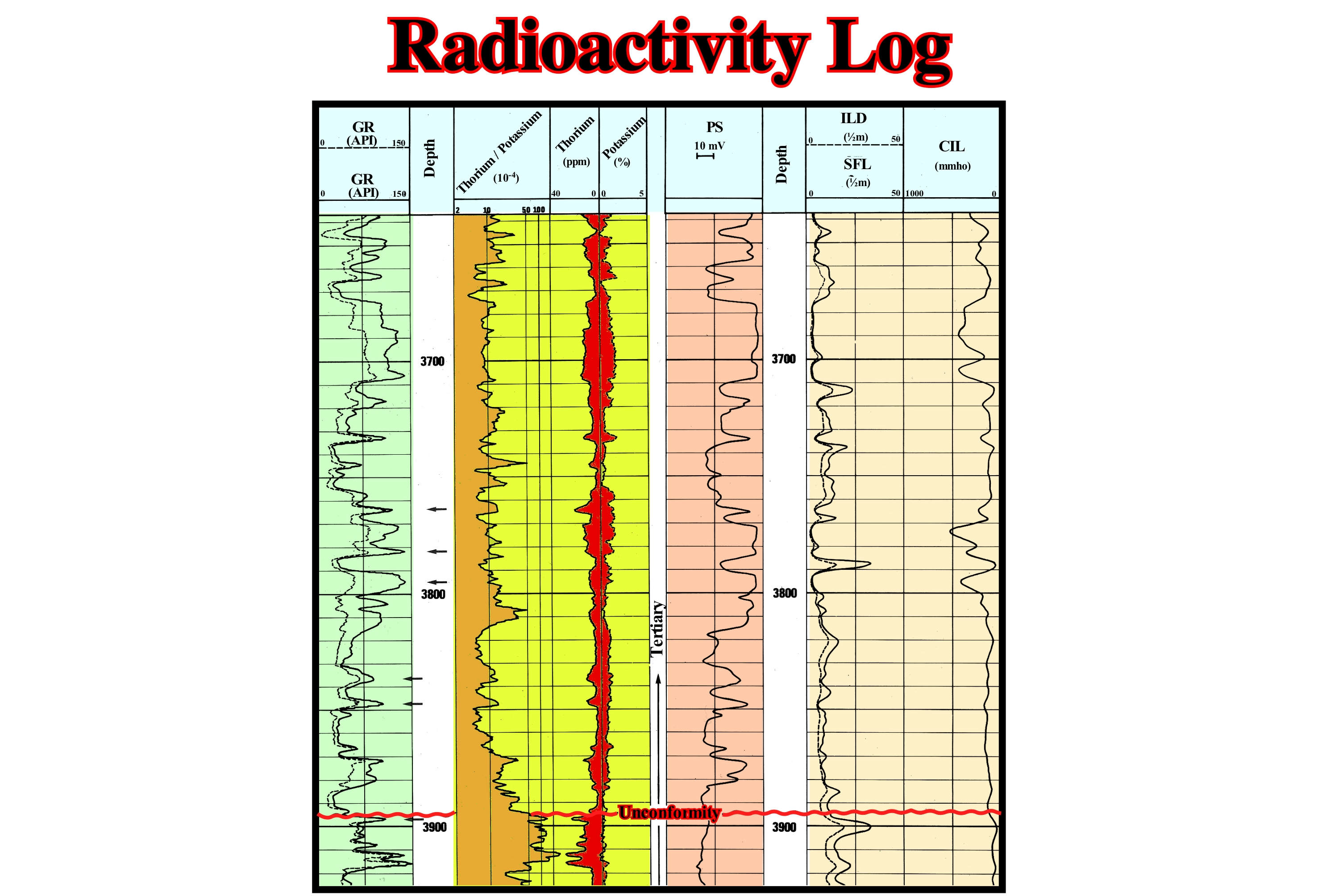
The radioactivity log is, usually, the gamma ray log, although two other diagrams can also measure radioactivity: (i) Neutron log and (ii) Density log. Radioactivity (or gamma ray) log uses a scintillation counter to measure the natural radioactivity of the geological formations as the probe is withdrawn from the well. The main radioactive element in rocks is potassium, which is very common in clay minerals. Radioactivity is measured in API units ("American Petroleum Institut") and is generally scaled to 0-100 or 0-150 API. Typically, readings of radioactivity are shown at the same time as spontaneous potential (SP) log. The gamma ray (GR) can be used, just like the spontaneous potential, with a baseline for the values given by the argillites. A deflection to the left of the baseline (smaller values) suggests a change in the facies (lithology), for example sandstone or limestone. As the gamma ray readings are affected by the diameter of the well, the diameter diagnosis (indicating the variations in well diameter) is almost always displayed next to the gamma ray. Diameter diagrams indicate variations in well diameter, but also the more permeable levels traversed by the well, since the drilling mud agglutinates in front of them forming the mud-cake* of the well. However, when the diameter variations of a well are very large and greatly affect the reading of the radioactivity, gamma ray diagrams can easily be made after the well has been coated by the steel columns protecting it. In sequential stratigraphy, radioactivity diagrams readily allow locating major disagreements, in particular, where the transgressive interval (TI) of the sequence-cycle rests directly on the lower discordance that limits the sequence-cycle, as appears to be the case illustrated in this figure.
(*) Residue deposited on a permeable medium when a slurry, such as a drilling fluid, is forced against the medium under a pressure. Filtrate is the liquid that passes through the medium, leaving the cake on the medium. Drilling muds are tested to determine filtration rate and filter-cake properties. Cake properties such as cake thickness, toughness, slickness and-permeability are important because the cake that forms on permeable zones in the wellbore can cause stuck pipe and other drilling problems.
Radiometric Dating (Radiochronology).....................................................................................Datation radiométrique
Datação radiométrica / Datación radiométrica / Radiometrische Datierung / 放射测年法 / Радиометрическое датирование / Datazione radiometrica /
Determining the age in years of a rock or mineral by measuring the proportions of a radioactive material and its disintegrating product.
See: « Geological Time »
&
« Relative Age »
&
« Chronostratigraphy »
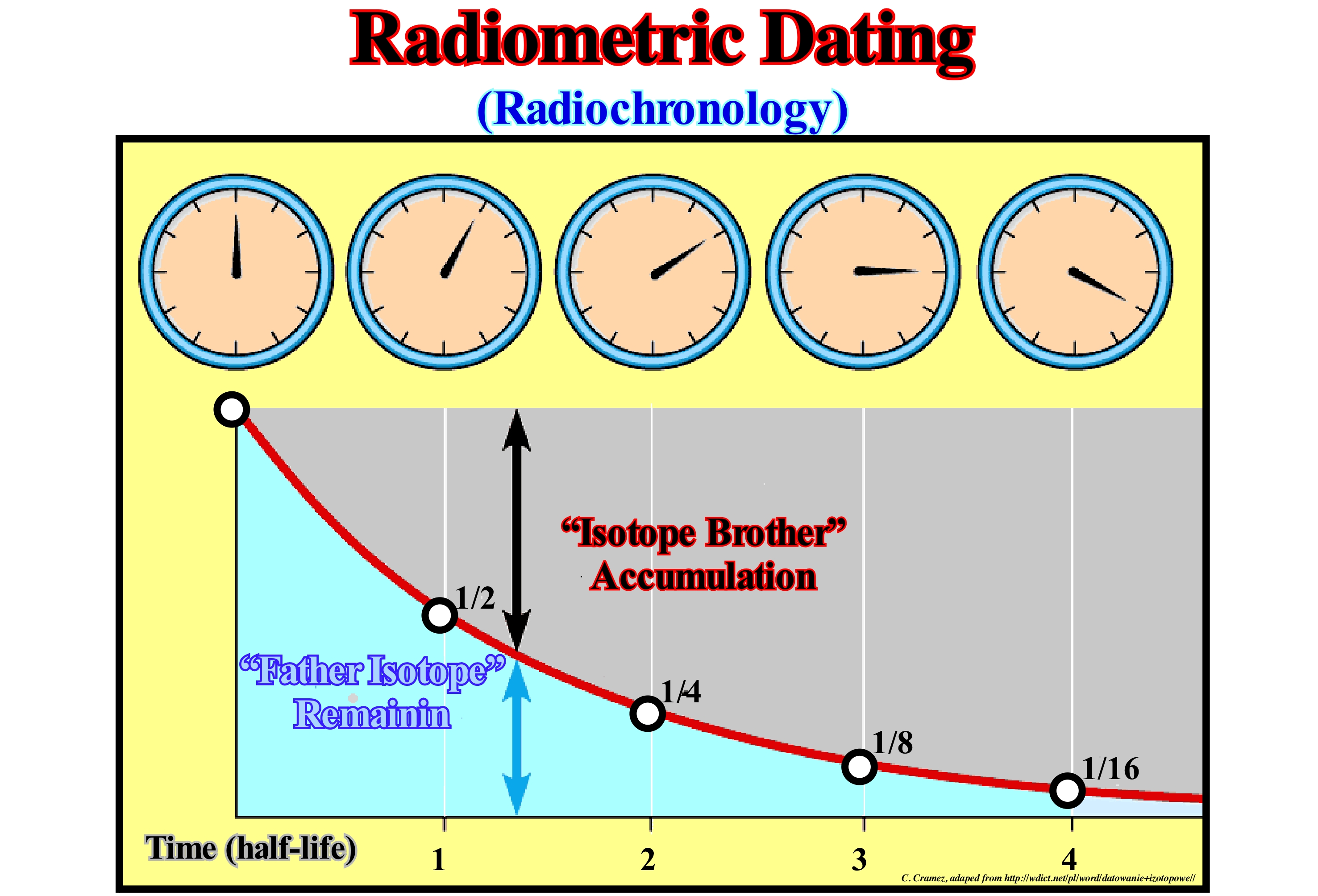
The standard model of particle physics relies on the existence of a small number of particles of matter without known internal structure and not separable: (i) Leptons and (ii) Quarks. Leptons are insensitive to the strong nuclear interaction responsible for the cohesion of atomic nuclei. There are six types of leptons. Three of null electric charge and very weak mass: are the Neutrinos. The others are massive and electrically charged: Electrons, Muons, and Tau, which have different life-durations. Quarks combine to form compound particles (Hybrons), sensitive to strong nuclear interaction (interaction between quarks and gluons, formerly considered as the nuclear force between the protons and neutrons considered before as indivisible), of which the most stable are the Protons and Neutrons (there are six types of quarks, known as flavours). A chemical element is composed of atoms with a number of protons (atomic number, Z) at its nucleus. It can have atomic weights (A) different function of the number of neutrons (N). Atoms of the same element with different atomic weights are called isotopes. In the case of the element O (O), all atoms have 8 protons (Z = 8) but may have 8, 9 or 10 neutrons (N = 8, N = 9 or N = 10, respectively). The isotope 16O has an atomic number (Z) of 8, a number of neutrons (N) equal to 8 and an atomic weight (A) of 16. Radioactive decay (decay) is the process by which an isotope (father isotope) loses particles from its nucleus to form an isotope of a new element (son isotope). The disintegration rate is expressed as "half-life", that is, the period of time necessary for half of the atoms present in a radioactive element to disintegrate. The "half-life" time is a characteristic of each radioactive isotope (it does not depend on the initial amount of the isotope nor on factors such as pressure and temperature). The number of moles of non-disintegrated atoms can be calculated by the following relation: n = n°/2x where: n = initial number of moles, n = final number of moles ex = number of half-life periods . The decay time (radioactive transmutation) can be calculated: t = x P. Most radioactive isotopes have very rapid disintegration rates (small "half-lives") and lose their radioactivity in a few days or years. Certain isotopes have a very slow decay. Some of them are used as geological clocks. The father isotopes and the corresponding son isotopes used to determine the age of the rocks are: (i) Uranium-238 (Lead-206) with 4.5 Gy half-life ; (ii) Uranium-235 (Lead-207) with 704 My half-life ; (iii) Thorium-232 (Lead-208) with 14 Gy of half-life ; (iv) Rubidium-87 (Strontium-87) with 48.8 Gy of half-life; (v) Potassium-40 (Argon-40) with 1.25 Gy half-life ; (vi) Samarium-147 (Neodymium-143) with 106 Gy of half-life. The O 14C degrades to N14 ; 238U in Pb206 ; K40 in Ca40 and then in Ar40, etc. There are three types of radioactivity (*): (i) Radioactivity α (alpha) ; (ii) β (beta) radioactivity and (iii) Radioactivity Ɣ (gamma). The first corresponds to the emission of a set of two protons and two neutrons, identified to a helium nucleus, such as: 238U92 → 234Th90 + 4He2 which is the first radioactive reaction of 238U, the natural isotope of uranium. The radioactivity β corresponds to the transformation of a radioactive element into another element with gain of a proton and loss of a neutron, which produces the emission and of a neutrino (the emission of the electron allows the conservation of the electric charge in the reaction), as in the reaction 234Th90 → 234Pa91 + e- +ve, in which Thorium 234 emits β to Protactinium Pa 234. The radioactivity Ɣ is, such as X-rays, an electromagnetic radiation, which does not correspond to a transmutation of elements such as α or β, but to the emission of high-energy photons by a chemical element that remains the same. This radiation usually occurs after α or β radiation. The U-series dating is the most reliable method to date the Quaternary (more or less, the last 2 million years), carbonate and clastic sediments and fossils. U-Pb dating of zircon in sediments is used to determine the origin of sediments. Strontium isotope stratigraphy using extremely precise measurements of Sr isotopes of marine fossils in conjunction with the known Sr isotope composition of seawater over time allows the dating of fossils. This technique can also be used to determine dolomitization. 14C allows to date material with organic carbon (limitation around 100 ka). 210Pb has a short half-life, and material date of the last 150 to 200 years.
(*) Moatti, A., 2006- Les indispensables mathématiques et physiques pour tous. Odile Jacob. Paris. ISBN: 2-7381-1722-8Moatti, A., 2006- Les indispensables mathématiques et physiques pour tous. Odile Jacob. Paris. ISBN: 2-7381-1722-8
Ramp (Longshore)................................................................................................................................................................................................Rampe (Avant-plage)
Rampa / Rampa (pre-playa) / Ramp (vorne-Strand) / 斜坡(前-沙滩) / Взброс (надвиг, платформа) / Rampa (front-spiaggia) /
Flat surface, which slopes seaward, from the downstream boundary of the shoreface. Sometimes considered as synonymous with Shoreface.
See: « Shoreline »
&
« Beach »
&
« Shoreface »
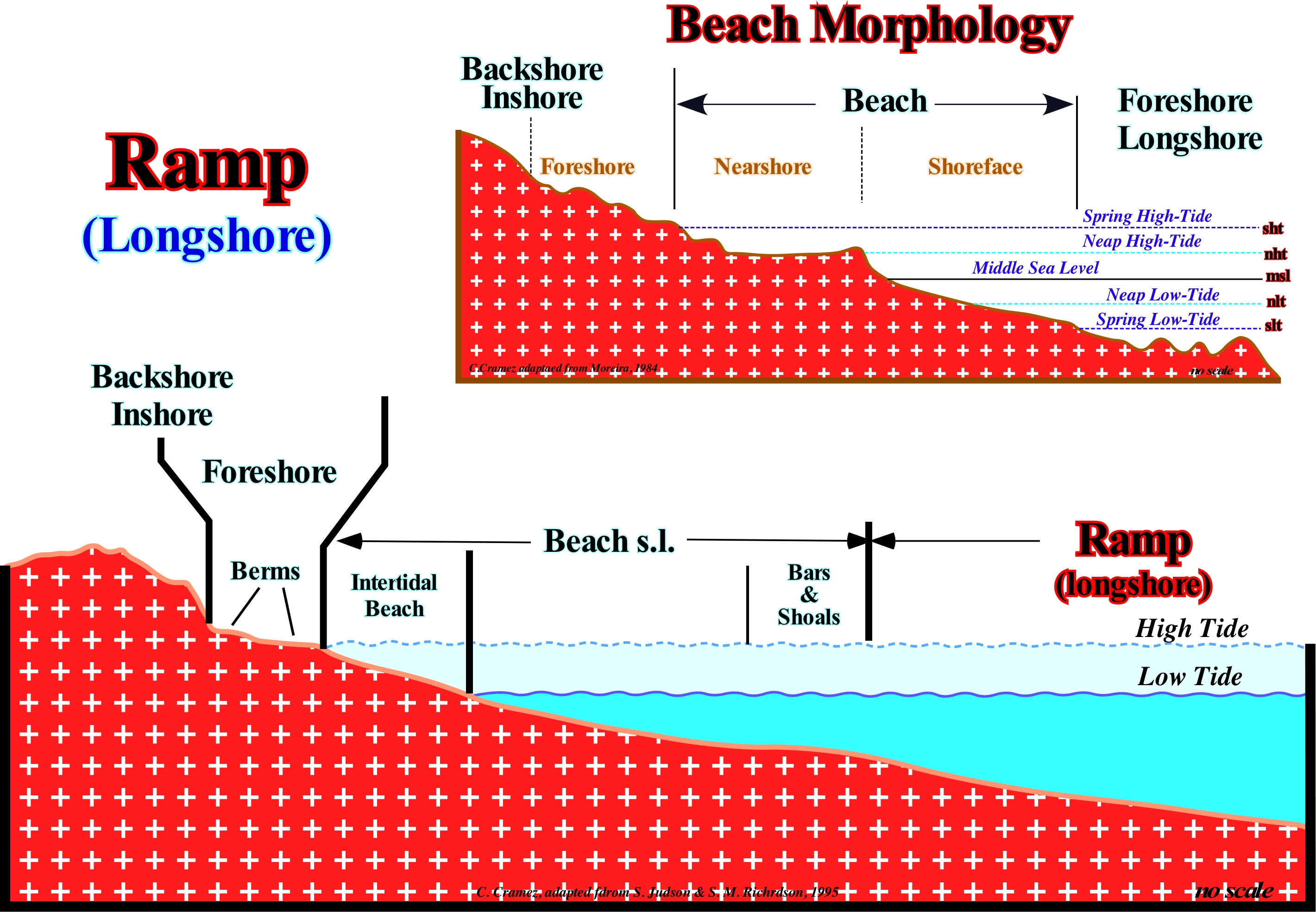
S. Judson and S. Richardson (1995) consider the ramp as the surface of the sea floor downstream of the distal boundary of the shoreface . For them, the shoreface encompasses the intratidal zone, which European geoscientists call the nearshore The majority of European geoscientists consider that, taking into account the tides and their effects, the morphology of a beach (sensu lato) can be divided into five bands: (i) Backshore/Inshore ; (ii) Foreshore ; (iii) Nearshore ; (iv) Shoreface and (v) Longshore. The backshore/inshore is the upstream region of the relief which marks the interior boundary of the beach, which may be a cliff or barrier bar and which may or may not insulate an interior lagoon. It is, generally, in the backshore that the houses are built. The foreshore corresponds to the upper part of the beach. It is only struck by the waves in spring high tides and in the storms. The foreshore can have dunes due to tufts of vegetation. The surface reached by the waves is modelled on steps, called beach steps, formed by a platform or berm of the beach and an abrupt. The nearshore is the area affected by the swash currents, between the levels of neap high and low tides. It is separated from the foreshore by the lower step of the beach and the shoreface by the inflection line. The inflection line between the berm beach and the abrupt of each step is the berm ridge. the highest ridge is the beach-ridge. All these forms are modified according to the situation of the tide and height of the waves. The shoreface corresponds to the bottom of the strand (space that extends between the limits reached by the neap and spring low-tides. The slope of the shoreface is very weak, although larger than that of the longshore ; the shoreface is made up, generally, of thin material, but sometimes may contain coarser material that is transported longitudinally. The longshore corresponds to the strip of beach that is always covered with water. It extends downstream from the level spring low-tide till external boundary that varies with the geoscientists. The longshore is considered by many geoscientists as equivalent to the surf zone, since the sea floor of the longshore is modelled by longshore ridges and longshorerunnels, whose amplitudes can exceed the meter high.
Ramp Setting..........................................................................................................................................................................................Contexte de bassin (Rampe)
Contexto de bacia (rampa) / Contexto de cuenca (rampa) / Ramp Kontext / 坡道的设置 / Внешнее окружение бассейна (платформа) / Contesto di bacino (rampa) /
As in the context of abrupt basin (deep sea) and growth fault, the said ramp basin context occurs during lowstand geological conditions, i.e., that the sea level is lower than the basin edge. When a significant relative sea level fall may occur, at the level of the lower unconformity of a sequence-cycle, the boundary between the coastal plain and continental slope is, practically, imperceptible, which means that the upper limit of the continental slope is difficult to locate.
See: « Basin (sedimentary) »
&
« Sequence-Cycle »
&
« Systems Trac t»
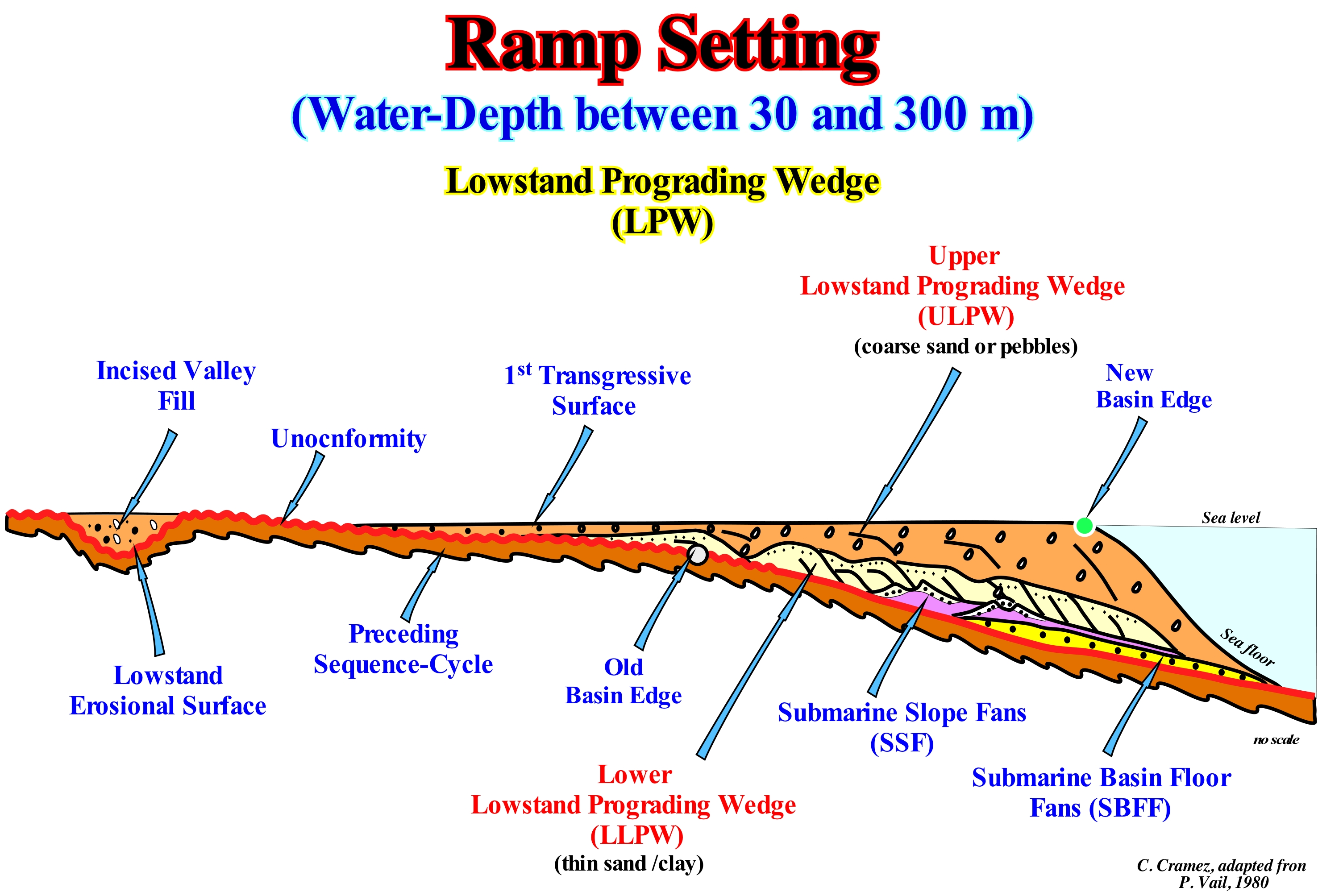
Within a sequence-cycle, that is, within a stratigraphic cycle, induced by a 3rd order eustatic cycle, whose time-duration varies between 0.5 and 3-5 My, when relative sea level is lower than the basin edge, i.e., in lowstand geological conditions, the shoreline, which is, roughly, equivalent to the depositional coastal break of the depositional surface, coincides, practically, with the colossal plain edge of the plain lowstand prograding wedge*. In these geological conditions, three basin settings can be distinguished: (i) Abrupt Basin Setting ; (ii) Growth-Fault Basin Setting and (iii) Ramp Basin Setting. In a ramp basin setting, by definition, the basin has no platform (no shelf) and, as illustrated in this sketch, the lower limit of the sequence-cycle, i.e., the lower unconformity has a morphology and seaward dip so little marked. Indeed, the limit between the coastal plain and the continental slope of the previous sequence-cycle (colored in dark brown) is very difficult to recognize. At the beginning of the new sequence-cycle (during the deposit of the submarine basin floor and slope fans), the shoreline, roughly, coincided as the last basin edge of the preceding sequence-cycle. However, since the lowstand prograding wedge (LPW) began to deposit, the shoreline began, progressively, to be located between the coastal plain and the upper slope of lowstand systems tracts subgroups. During the lowstand systems tracts group (LSTG) of a sequence-cycle, the basin edge is always the last basin edge of the preceding sequence-cycle. The new basin edge appears just at the end of then lowstand prograding wedge (LPW), when the first transgressive surface, which marks the beginning of the transgressive interval (TI) of the highstand systems tracts group group (HSTG)**. The first transgressive surface is induced by the first marine ingression (eustatic paracycle) in acceleration (marine ingression more important than the preceding one). Until the new basin edge is individuated, there is a gradual transition from the coastal plain and the deep sediments, which in this particular case is not a true abyssal sediments, via a very marked continental slope, as can be deduced from this figure (taking into account that the geological sketch, although without scale, is greatly exaggerated vertically). In fact, on the seismic lines, in such a basin setting, the different subgroups of lowstand systems tracts group are difficult to put into evidence. As in a ramp setting, the water-depth varies more or less between 30 and 300 meters, obviously the submarine basin floor fans (SBFF), the submarine slope fans (SSF), as well as the lowstand prograding wedge (LPW), which collectively form the lowstand systems tracts group (LSTG) are, poorly, developed and, most of the time, they are under seismic resolution (not visible in seismic lines). Just the upper part of the lowstand prograding wedge (LPW), which is composed of coarse sediments, is, often, recognized. During the lowstand prograding wedge, as the relative sea level*** rises, the shoreline (basin without platform) progrades seaward (lateral deposition implying outbuilding) and upward (vertical deposition or upbuilding). As the sedimentary particles settle-down, they fossilize, by downlapping the unconformity (lower limit of the sequence-cycle) and, gradually, the ramp disappear. Since the lowstand prograding wedge sediments are settle down, the ramp context, gradually, disappears and is, eventually, replaced by an abrupt basin setting since the first transgressive surface (beginning of the transgressive interval of the sequence-cycle), as the shoreline moves continentward, which automatically creates a continental shelf. The ramp setting is frequent in saliferous sedimentary basins with a significant halokinesis (evaporite movements, when σt = 0, due to the difference in density with other rocks whose density increases in depth, which is not the case with salt), particularly, when there are allochthone salt layers. A lateral outflow of salt produces a compensatory subsidence that sometimes induces ramp basin settings with relatively flat (low dipping) continental slopes in the prolongation of coastal plain.
(*) In this case we do not talk about the basin edge, which is the name that the geoscientists give to the continental edge when the basin has a continental shelf (during the transgressive interval and during the 1st phase of development of the highstand prograding wedge of a sequence-cycle ).
(**) Do not confuse the highstand systems tracts group, whose acronym is HSTG, with the highstand prograding wedge (HPW), which is the upper sub-group of the highstand systems tracts group (HSTG). The lower sub group is the transgressive interval (TI).
(***) Local sea level referenced to the seabed or to the base of the sediments (top of the continental crust), which is the result of the combination of absolute (eustatic) sea level, which is supposed to be global and referenced to the Earth's centre, and tectonics (subsidence or uplift of the sea floor).
Ramp Setting (example).........................................................................................................................................................Contexte de bassin (Rampe)
Contexto de bacia (rampa, exemplo) / Contexto de cuenca (rampa) / Ramp Kontext / 坡道的设置 / Внешнее окружение бассейна (платформа, пример) / Contesto di bacino (rampa) /
When the sedimentary basin morphology, induced by a significant relative sea level fall, i.e., at the level of the basal unconformity of a sequence-cycle, is relatively smooth and the boundary between the coastal plain (basin without shelf) is subtle and sometimes difficult to determine.
See: « Basin Setting »
&
« Sequence-Cycle »
&
« Systems Tract»
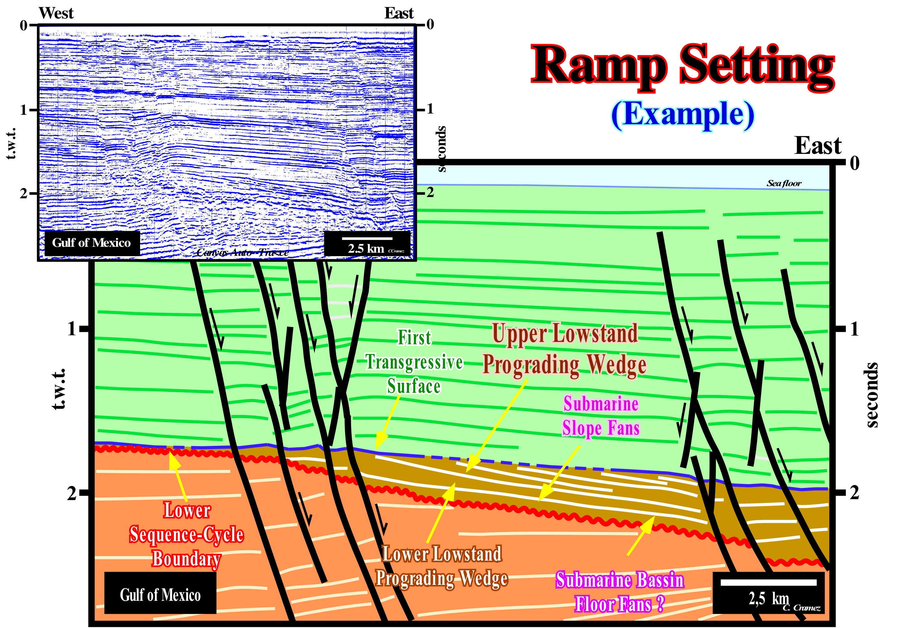
On this tentative geological interpretation of a Canvas auto-trace of Gulf of Mexico seismic line, a ramp setting is, easily, recognized at the level of the lower unconformity of a sequence-cycle, located at about two seconds depth (double time). At the level of unconformity (beginning of a new sequence-cycle, in lowstand geological conditions, i.e., sea level lower than the basin edge), the continental edge (located next to the more northerly normal faults) is little marked. It corresponds to the limit between the coastal plain and the continental slope, since at that time (lowstand geological conditions), the basin has no continental platform (no shelf). Under such conditions, the water column and the depositional water-depth of lowstand prograding wedge (LPW) deposited seaward of the initial basin edge (along the unconformity) are smaller than that of a lowstand prograding wedge deposited in a abrupt basin setting. In contrast, the continental encroachment (lateral component of the coastal onlaps) is much larger. The incised valley fills, deposited in the coastal plain, since the provisional equilibrium profile of the rivers was broken by the relative sea level fall, was made during the last phase of deposition of the lowstand prograding wedge (do not confuse incised valley, which is a negative topographic structure, with the filling of this structure, that is, its fossilization by deposition of sedimentary particles sediments). When the incised valley are are fully filled, immediately, before the first transgressive surface, a new basin edge is formed downstream, close to the depositional coasts break of the depositional surface of the lowstand prograding wedge. Ramp settings are very frequent in sedimentary basins with salt horizons such as in the Gulf of Mexico or Angola offshore. Often, this type of morphology is associated with lateral flows or vertical flows of salt horizons that, locally, induce a compensatory subsidence and lowstand geological conditions (sea level lower than the basin edge). Note that the same sedimentary environments can be found either at highstand or lowstand.
Rasa (Coastal rise)................................................................................................................................................................Banquette d'érosion, Rasa
Plataforma de erosão (rasa)/ Rasa / Rasa / 沿海崛起 / Прибрежная возвышенность / Piattaforma erosione /
Abrasion platform carved on a preexisting submarine platform, which genesis has been linked to marine agents and which is above current sea level and slopes, gently, inland, usually linked to a dead cliff.
See: « Platform »
Rate of Relative Sea Level Change..................................................................Taux de changement relatif
Taxa de mudança do nível do mar relativo / Tasa de cambio relativo (del nivel del mar) / Relative Geschwindigkeit der Änderung (NN) / 相对变化率(海平面)/ Коэффициент изменения относительного уровня моря / Tasso relativo di variazione (livello del mare) /
Velocity of the relative sea level change, which can be described by a curve. Such a curve reflects the temporal evolution of potential available space for sediments (accommodation). The relative sea-level change rate is the algebraic sum of the rates of change of subsidence or uplift of the sea floor and of the absolute or eustatic sea level (eustasy).
See: « Eustasy »
&
« Eustatism »
&
« Relative Sea Level Change »
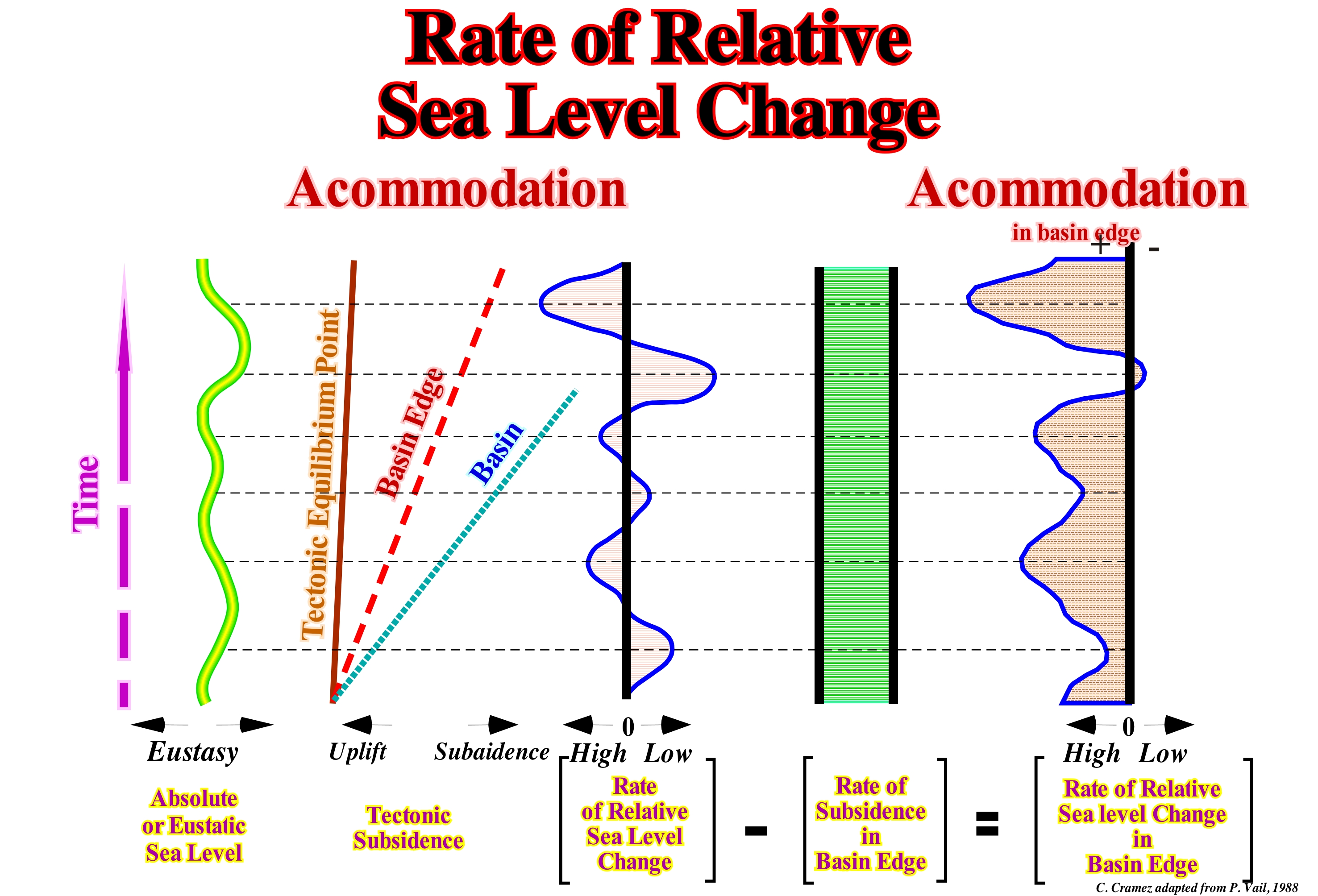
Firstly, it is necessary to specify that in the stratigraphy two levels of the sea have to be considered: (i) Relative Sea Level, which is the local sea level, referenced to any fixed point on the Earth's surface, as for instance the base of the sediments (top of the continental crust) or the sea floor and (ii) Absolute or Eustatic Sea Level, which is supposed to be the global and referenced to the Earth's centre. The relative sea level is the result of the combined action of absolute (eustatic) sea level and tectonics (subsidence or uplift of the sea floor). The absolute sea level is the result of the combination of: i) Tectono-Eustasy that is controlled by the volume variation of the ocean basins in association with oceanic expansion (sea floor spreading) following the break-up of the supercontinents ; (ii) Glacio-Eustasy, which is controlled by the variation of water volume of the oceans as a function of the amount of ice (assuming that the amount of water, in all its forms, is constant since the Earth's formation, about 4.5 Ga) ; (iii) Geoidal-Eustasy, which is controlled by the distribution of ocean water caused by variations in the Earth's gravity field (where gravity is stronger than normal, sea level is thrown to the Earth's centre and (iv) Steric Rise of Sea Level or thermal ocean expansion (if the temperature of the ocean increases, the density of the water decreases, and for a constant mass, the volume increases). During a given geological time, the combination of the eustatic curve (curve of the variations of the absolute sea level) and tectonic (subsidence, when the predominant tectonic regime is in extensional or uplift, when the predominant tectonic regime is compressional) gives the curve of the relative sea level change rate. As shown in this figure, eustatic variations (absolute sea level) are much faster than tectonic variations. This means that the cyclicity observed in sedimentary rocks is, probably, more dependent on eustasy than on tectonics. Although this conjecture seems to be true for the vast majority of sedimentary basins, in particular for Atlantic-type divergent continental margins, certain geoscientists think it can be refuted in tectonically active basins, for example in foreland basins. Assuming that the subsidence rate at the basin edge (which is the continental edge when the basin has a shelf) is constant, which means that subsidence increases linearly, the rate of change of absolute (eustatic) sea level minus the subsidence rate gives, the basin edge, the relative sea level change. Upstream of the basin edge, a relative sea level rise creates or increases the available space for sediments (accommodation), which favours deposition. On the contrary, a significant relative sea level fall can put the sea level lower than the basin edge, which strongly favours erosion, since there is exhumation of the continental platform and upper part of the continental slope. During 1st order eustatic cycles, relative sea level changes during marine transgressions (0.1 cm/1,000 years) are less rapid than during marine regressions (2 cm/1,000 years). This may be explained by the fact that the slow swelling of the mid-ocean ridges, induced by the Earth's internal heat, produces a fracture of the oceanic crust and a hydrothermal circulation up to about 5 km deep, which causes the heat and swelling of the dorsal to rapidly disappear, inducing a rapid marine regression (Geosoufflé Theory of C. Emiliani, 1992). The eustatic cycles controlled by glacio-eustasy, such as, probably, the 3rd order eustatic cycles (time-duration between 0.5 My and 3/5 My), which are responsible for the deposition of the sequence-cycles, seem to have an opposite dynamics, the marine ingressions inducing the deposition of transgressive intervals (TI) are accelerating, whereas they are in deceleration during the highstand prograding wedge (HPW). Attention to the term transgressive interval (IT), which in sequential stratigraphy, at the level of a sequence-cycle, refers above all to the set of increasingly important marine ingressions and increasingly smaller sedimentary regressions. In fact, an eustatic paracycle, i.e., a relative sea level rise, is accompanied by a continentward displacement of the shoreline, while a relative sea level fall displaces the shoreline seaward at the same time that a paracycle sequence, i.e., a sedimentary regression, is deposited. It is this set of increasingly important marine ingressions and increasingly smaller smaller sedimentary regressions that, collectively, form what are called transgressions.
Ravinment..........................................................................................................................................................................................................................Ravinement
Ravinamento / Ravinamiento / Gully Erosion (linear Schnitt) / 沟壑侵蚀(线性切口)/ Овражная эрозия (образование оврагов) / Canalone di erosione (incisione lineare) /
Local erosion, associated with a floodind surface, induced by relative sea level rise (marine ingression), such as during the transgressive interval (TI) of a sequence-cycle (SC).
See: « Transgressive Interval »
&
« Systems Tract »
&
« Ravinment Surface »
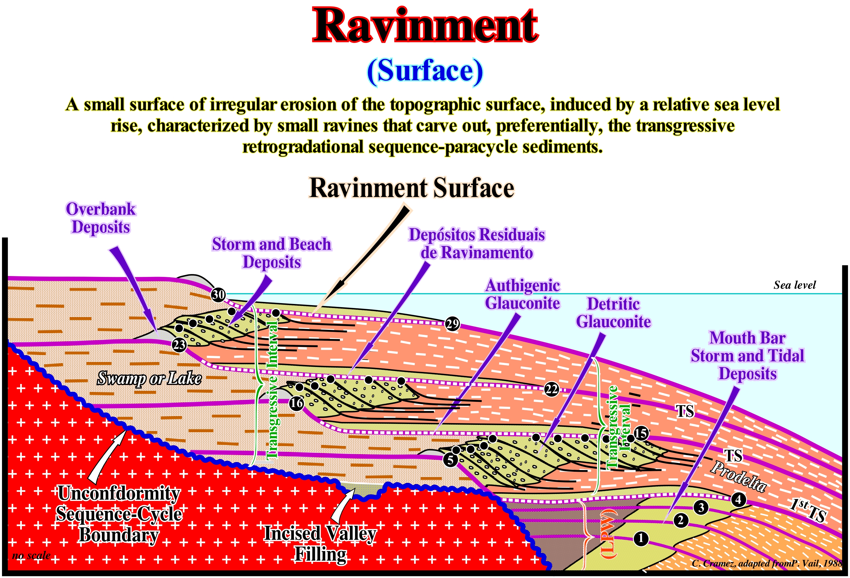
In this model of a transgressive interval (TI) of a sequence-cycle, created by a relative sea level rise*, in acceleration, the retrogradational geometry corresponds to the vertical staking of regressive episodes that, progressively, prograde seaward. At each increment of the relative sea level rise, i.e., at each simple marine ingression (each eustatic paracycle), there is a flooding that displaces continentward the depositional coastal break of the depositional surface (more or less, the shoreline), creating on the top of the sediments already deposited a ravinment surface. In this glossary, a simple marine ingression is an increment of a composite marine ingression. A relative sea level rise is not done in continuity, but in stages, for instance: (i) Relative sea level rise of 3 m (simple marine ingression) ; (ii) Relative sea-level stability period ; (iii) Relative sea level rise of 5 m (simple marine ingression) ; (iv) Relative sea level stability period ; (v) Relative sea level rise of 7 m (simple marine ingression) ; (vi) Relative sea-level stability period ; (vii) Relative sea level fall of 10 meters (marine regression). In this example, globally, the relative sea level has risen by 15 meters (composite marine ingression), in acceleration, since simple marine ingressions are increasing important. As shown in this geological sketch, within the lower subgroup of the highstand systems tracts group (HSTG) of a sequence-cycle, that is, within the transgressive interval (TI), the first ravinment surface corresponds to the first transgressive surface (1st TS), which underlines the boundary with the underlying lowstand prograding wedge (LPW). The shoreline, which during the lowstand prograding wedge (LPW) was located, successively, at points (1), (2), (3) and (4), following the marine ingression, goes, abruptly, retrograde to the point (5). Following the flooding, which produced a ravinment surface, in the preexisting topography, a stability period of relative sea level follows, during which the sedimentary particles become sediments, i.e., are deposited, displacing the shoreline seaward (sedimentary regression), before a new relative sea level rise occurs (a new marine ingression that is more important than the previous one). In other words, between the eustatic paracycles there is no relative sea level fall. The depositional coastal break of the depositional surface, which is, more or less, the shoreline (the error is minimal particularly on the seismic lines) is, progressively, displaced to the seaward until reaching the maximum of progradation (15), but without reaching the position that it had during the last phase of the lowstand prograding wedge (4). This means that a small continental platform (shelf) was formed for the first time, since, before, the basin had no platform (no shelf). At the beginning of the sequence-cycle (lowstand geological conditions). A new relative sea level rise, in acceleration (new simple marine ingression but more important, but more important than the previous one) displaced, again, the shoreline landward (16), creating a new ravinment surface, increasing the accommodation (available space for the sediments). A new stability period of relative sea level allows the deposition of a new sequence-paracycle (sediments deposited during the stability period of relative sea level , between two relative sea level rises without a falling between them). This implies a new displacement of the shoreline seaward (22), but without reach the last position it reached in the preceding sequence-paracycle. This story is repeated until the relative sea level begins to rise in deceleration, which allows the last coastline of the paracycle to exceed the position it reached in the preceding paracycle (it is the beginning of the highstand prograding wedge, LPW). Upstream of each sequence-paracycle, more or less, at the same time, swamp deposits are settle down. Obviously, the ravinment surfaces are more important when the marine ingressions are in acceleration, that is, more and more, important, as it is the case during the transgressive interval, than when they are in deceleration (becoming less important, as is the case case during the highstand prograding wedge (HPW) and lowstand prograding wedge (LPW).
(*) Sea level can be relative and absolute (eustatic). The relative sea level is the local sea level, referenced at any fixed point on the Earth's surface, which can be the base of the sediments (continental crust top) or the sea floor and which is the result of the combined action of the absolute sea level (supposed global and referenced to the Earth's centre) and tectonics (subsidence when extensional tectonic regimes are predominant or uplift, when compressional tectonic regimes are predominant).
Ravinment Lag Deposit........................................................................................................Dépôt résiduel de ravinement
Depósito residual de ravinamento / Depósito de ravinamento / Ravinement Lag Anzahlung / 冲刷滞后存款 / Осадочные отложения, образованные вымыванием / Deposito residue di ravinement /
Deposit associated with a ravinment surface.
See: « Ravinment Surface »
&
« Transgressive Interval »
&
« Erosion »
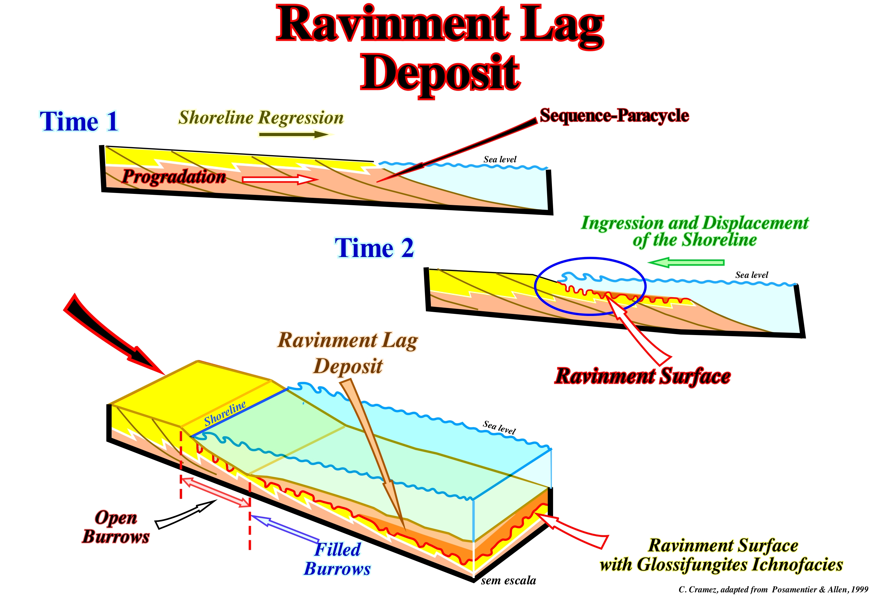
The ravinment surfaces and associated deposits are frequent in the transgressive intervals (TI) of the stratigraphic cycles called sequence-cycles, which are induced by 3rd order eustatic cycles, whose time-duration varies between 0.5 My and 3-5 My. These transgressive intervals are deposited in highstand geological conditions, ti.e., when the sea level is higher than the basin edge (not to be confused with the continental edge with which it can, under certain conditions, coincides more or less), which happens since a relative sea level rise (marine ingression) floods the coastal plain of the lowstand prograding wedge (where the continental edge is located). Within a sequence-cycle, provided that a sedimentary basin has a continental platform (shelf), at each rise in relative sea level(*) the coast line (more or less the depositional coastal break of the deposition surface) moves continentward. Such a landward displacement of the shoreline produces an erosion (albeit small) of the preexisting topography, which creates a ravinment surface. This surface is later fossilized by the sedimentary particles deposited during stability phase of the relative sea level, which occurs after each marine ingression and during which the sediments that form the sequence-paracycle associated with the relative sea level rise. During the deposition of the sequence-cycle, which as said before is deposited during the stability period of relative sea level the shoreline, progressively, moves seaward as the sedimentary particles settle down to form a sedimentary regression. It is, more or less, this that is illustrated in the sketches of this figure. In the upper sketch (Time 1), the progradational geometry of the depositional systems characterizes the sedimentary regression developed during the stability period of relative sea level, between two consecutive relative sea level rises between which there is any relative sea level fall (between two eustatic paracycles). During Time 1, the shoreline is upstream of the basin edge, since the basin has a no shelf. The intermediate sketch (Time 2) illustrates a marine ingression, that is, a relative sea level rise, which flooded part of the previously deposited sediments, i.e., during the previous sequence-cycle. During marine ingression, glossifungites** .These structures are fossilized by the progradations of the sediments deposited during the sea level stabilization phase that follows the marine ingress, i.e., during the sedimentary regression. The ravinment surfaces and the deposits that fossilize them, just occur in highstand geological conditions .However, there is a very important difference if the relative sea level rises in acceleration or in deceleration. If marine ingressions are increasingly important (transgressive interval, TI) or if they are getting smaller and smaller (highstand prograding wedge, HPW). During the 1st phase of development of a highstand prograding wedge, while the basin has a continental shelf, the formation of glossifungites and their fills is possible, but depends on the water column, although the proximal sector is often subaerial. During the 2nd stage of the development of the highstand prograding wedge, when the basin has no more platform (no shelf), the formation of ravinment surface is impossible. In other terms, it can be said that when there is aggradation and progradation (sigmoid progradations) the formation of ravinment surfaces is likely, which is not the case when the internal configuration of the highstand prograding wedge level is oblique (practically without aggradation).
(*) Local sea level, referenced at a particular point on the Earth's surface, which may be the bottom of the sea or the base of the sediments (top of the continental crust) the coast line (more or less the slope rupture of the deposition surface).
(**) Ichnofacies representing a set of vertical or U-shaped or slightly branched burrows occurring in compact but not lithiated muds and siltstones, or in carbonate muds and intertidal muds. The intertidal zone or region or is the name given to marine environments to the zone of the coastal substrate that is exposed to air only during low tide and submerged during the prelanding.
Ravinment Surface..................................................................................................................................................Surface de ravinement
Superfície de ravinamento / Superficie de ravinamiento / Ravinement Oberfläche / 冲刷面 / Поверхность размыва / Superficie di scoscendimento /
Area of minor submarine erosion linked to the action of waves and associated with marine ingressions, i.e., with relative sea level rises.
See: « Transgressive Interval »
&
« Wave Action Level »
&
« Sequence-Cycle »
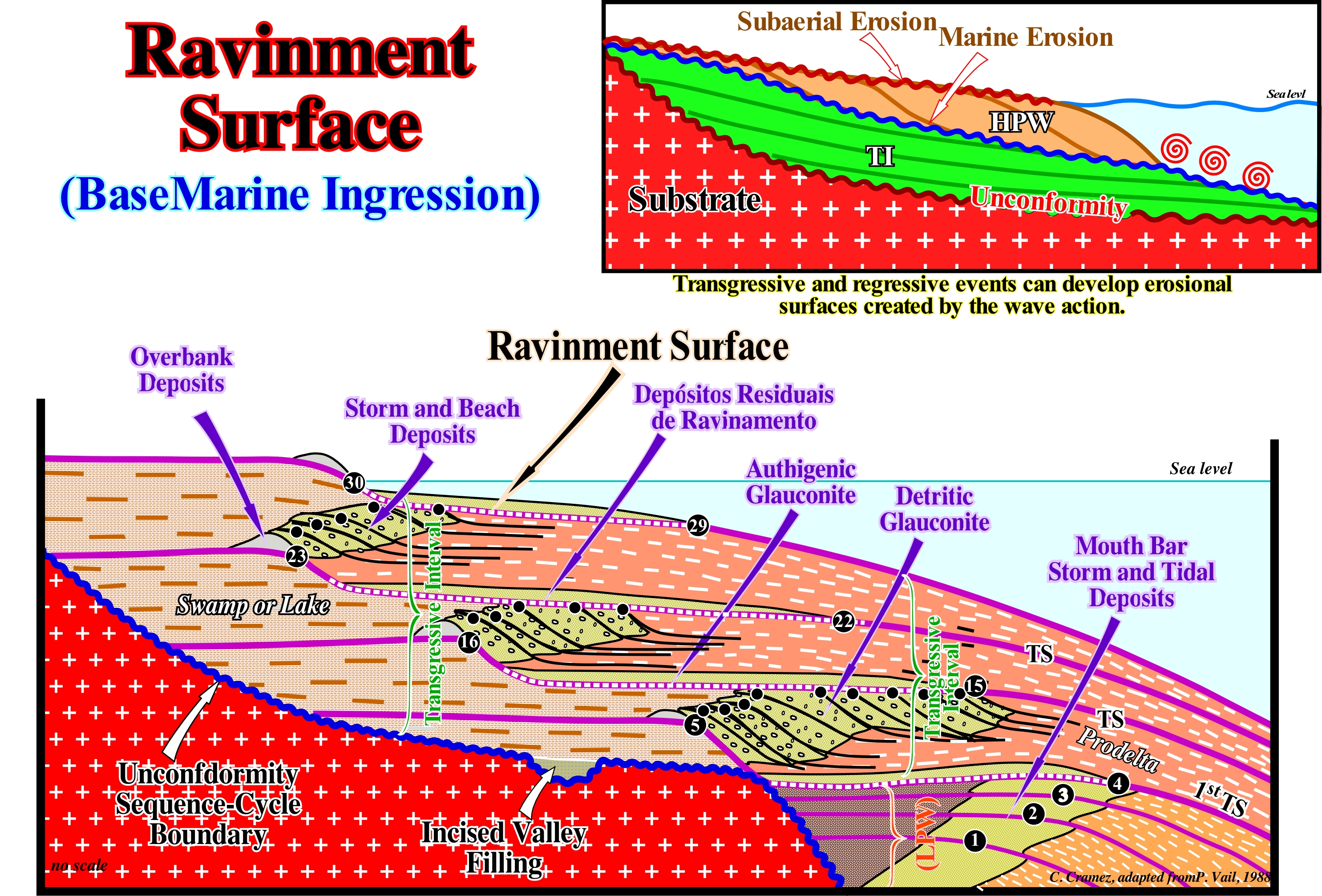
In this model of a transgressive interval (TI) of a sequence-cycle, it is important to note that the retrogradational geometry corresponds to the vertical stacking of increasingly smaller regressive episodes (sequence-paracycles), whose sedimentary systems tracts (lateral association of synchronous depositional systems and genetically linked, such as: delta plain silts - delta front sands - prodelta shales), progressively, prograde seaward. These sequence-paracycles are induced by increasingly important marine ingressions, which means that relative sea level rises in acceleration, as their increments are increasingly important. The absolute (eustatic) sea level is supposed the global and referenced to the Earth's centre, while the relative sea level is the local and referenced to any fixed point on the Earth's surface, which can be the base of sediments (top of the continental crust) or the sea floor and that is the result of the combined action of absolute sea level and tectonics (subsidence or uplift of the sea floor). The absolute sea level is the result of the combined action of: i) Tectono-Eustasy that is controlled by the volume variation of the ocean basins in association with oceanic expansion following the breakup of the supercontinents ; (ii) Glacio-Eustasy, which is controlled by the variation of water volume of the oceans as a function of the amount of ice (assuming that the amount of water in all its forms is constant since the Earth's formation about 4.5 Ga) ; (iii) Geoidal-Eustasy, which is controlled by the distribution of ocean water caused by variations in the Earth's gravity field (where gravity is stronger than normal, sea level is thrown to the Earth's centre) and (iv) Steric sea level rise or thermal expansion of the oceans (if the temperature increases, the density of the water decreases, and for a constant mass, the volume increases). The position of the shoreline, at the end of each sequence-paracycle, is, progressively, displaced landward, which, globally, creates a retrogradational geometry. Within a sequence-cycle (represented in this geological model just by the lowstand prograding wedge and the transgressive interval), which is induced by a 3rd order eustatic cycle (time-duration between 0.5 and 3/5 My), during the transgressive interval (IT), at each relative sea level rise in acceleration eustatic paracycle or marine ingression), the depositional coastal break of the depositional surface (more or less the shoreline) is displaced continentward. During this displacement, the wave action creates in the pre-existing topography a small surface of erosion, which is called ravinment surface. At the end of the relative sea level rise, a stability period of the relative sea level follows, during which the shoreline moves seaward, as the sedimentary systems tracts settle down as illustrated in this sketch. During this stability period, the depositional coastal break the depositional surface is, progressively, displaced to the seaward, but without reaching the position it had before the marine ingression. At each relative sea level rise, the platform extension increases, which means that if the terrigeneous influx remains constant, it becomes insufficient so that the depositional coastal break (more or less the shoreline line, particularly on the seismic lines, due to the vertical seismic resolution) reached its previous position. Between the old successive positions of the depositional coastal break, shaly sediments are deposited increasingly condensed, since the sedimentation rate decreases in a significant way (starved basin). A new relative sea level rise increases accommodation (available space for sediments) on the continental shelf, and the wave action creates a new ravinment surface over sediments deposited during the stability period of relative sea level. Then deposition occurs, again, as the depositional coastal break of the depositional surface is, progressively, displaced seaward and so on. During the transgressive interval, there is no relative in sea level fall between each increase in relative sea level (eustatic paracycle), i.e., there is no unconformity between the different sequence-paracycles, which is why they must be called sequence-paracycles and not parasequences. The ravinement surfaces are not just associated with the base of the sequence-paracycles of the transgressive interval (TI) and, eventually, with those of the lowstand prograding wedge (LPW). They also exist in the sequence-paracycles forming the highstand prograding wedge (PNA). However, as the marine ingressions are in acceleration during the deposition of the transgressive interval and the lowstand prograding wedge (PNB) and in deceleration during highstand prograding wedge (HPW), they are more developed and more evident when the action of the waves becomes increasingly important.
Rayleigh Wave.........................................................................................................................................................................................Onde de Rayleigh
Onda de Rayleigh / Onda de Rayleigh / Rayleigh-Welle / 场浪潮之前,迪瑞利 / Волна Рэлея / Onde di Rayleigh /
Surface seismic wave, in which the particles move along an elliptical orbit in a vertical plane. It does not travel within the Earth or any other geological body, as does the P (longitudinal or compression waves that compress and dilate the soil in the direction of propagation) and S (transverse waves, which move the ground perpendicularly to the direction of propagation). A Love wave, it has, just, an one horizontal component. A Rayleigh wave has two components, one horizontal and one vertical.
See: « Sesmic Wave »
&
« Love Wave »
&
« S Wave »
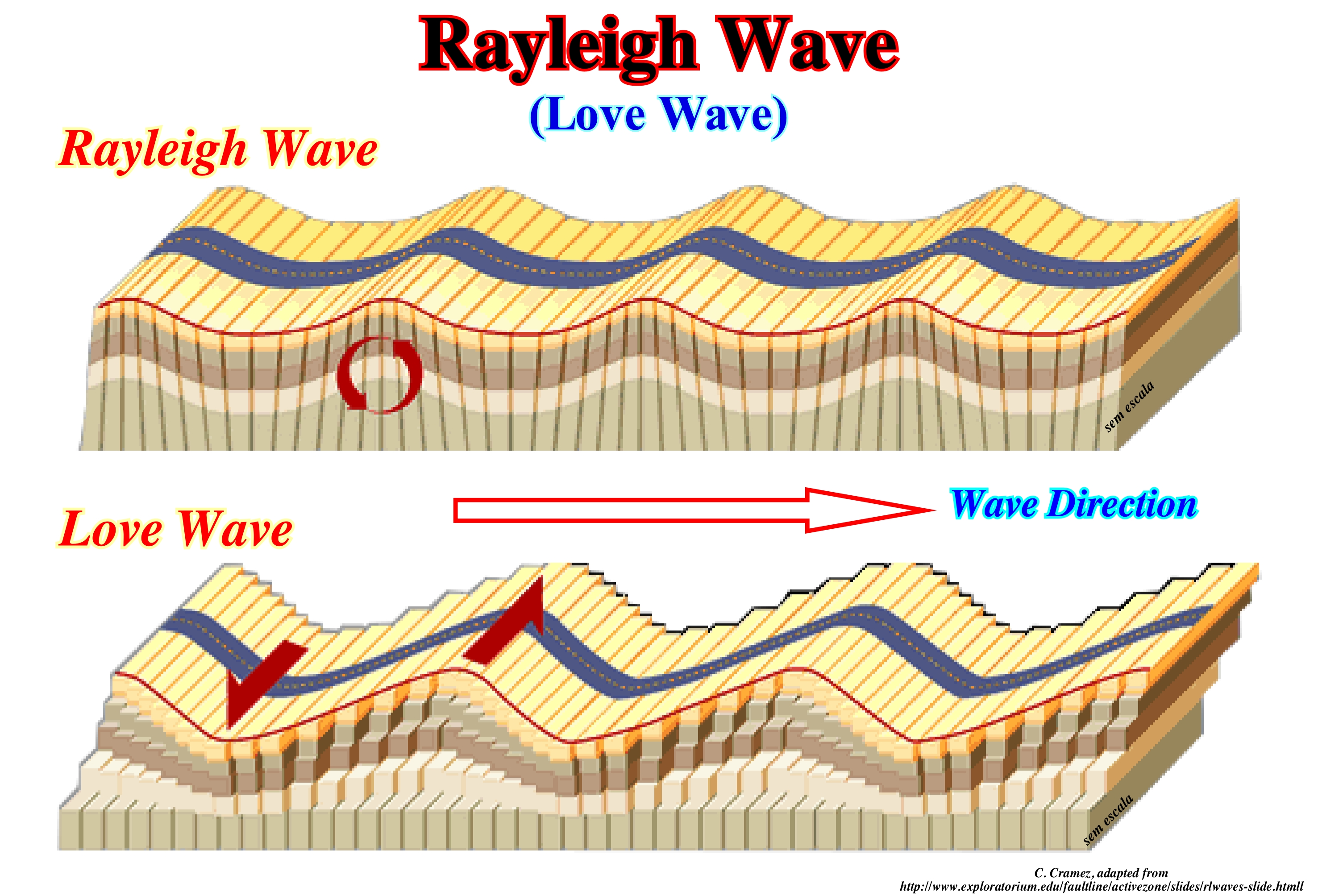
As illustrated, Rayleigh waves are easily differentiated from Love waves. Rayleigh waves have a vertical and horizontal component, which is not the case with the Love wave that has only one horizontal component. During earthquakes, there are waves that move, exclusively, to the Earth's surface from the epicentre (point to surface resulting from the intersection of the vertical line passing through the hypocenter or seismic focus, which is the point where the earthquake occurs in depth), and others that move through the interior of the Earth. The first are called surface waves and the second body waves or volume waves. Within the surface waves there are two types: (i) Love waves and (ii) Rayleigh waves. The Rayleigh waves move in a circle (orbital motion) forward and down and then back and up like the sea waves. The Love and Rayleigh waves are depreciated in depth. The amplitude decreases as a function of the distance (r) to the epicentre of the earthquake as 1/√ r, which means that surface waves slow down more slowly than body waves. In an ideal solid (homogeneous and horizontal), the Rayleigh waves do not suffer any dispersion. If the body has a density or velocity of the acoustic waves varies in depth, the waves become dispersive. Within the body or volume waves, there are those that compress and dilate the terrain in the direction of propagation (longitudinal or compression waves or P waves) and those that move the terrain, perpendicularly, to the propagation direction (transverse waves or S wave ). The low frequency Rayleigh waves generated during earthquakes are used in seismology to study the interior of the Earth.
Recessional Moraine.................................................................................................................................................................Moraine de recession
Moreia de recessão / Morena de recesión / Rezessionen Moräne / 退缩碛 / Конечная морёна отступающего ледника / Morena di recessione /
Moreia formed at the end of a glacier. It runs through the glacier valley and not along it. It forms when a thinning glacier remains stationary enough to produce a mound of material. The formation process is the same as for a terminal moraine, but it occurs when the retreat of the glacier is stopped.
See: « Moraine»
&
« Glacier »
&
« Ground Moraine »
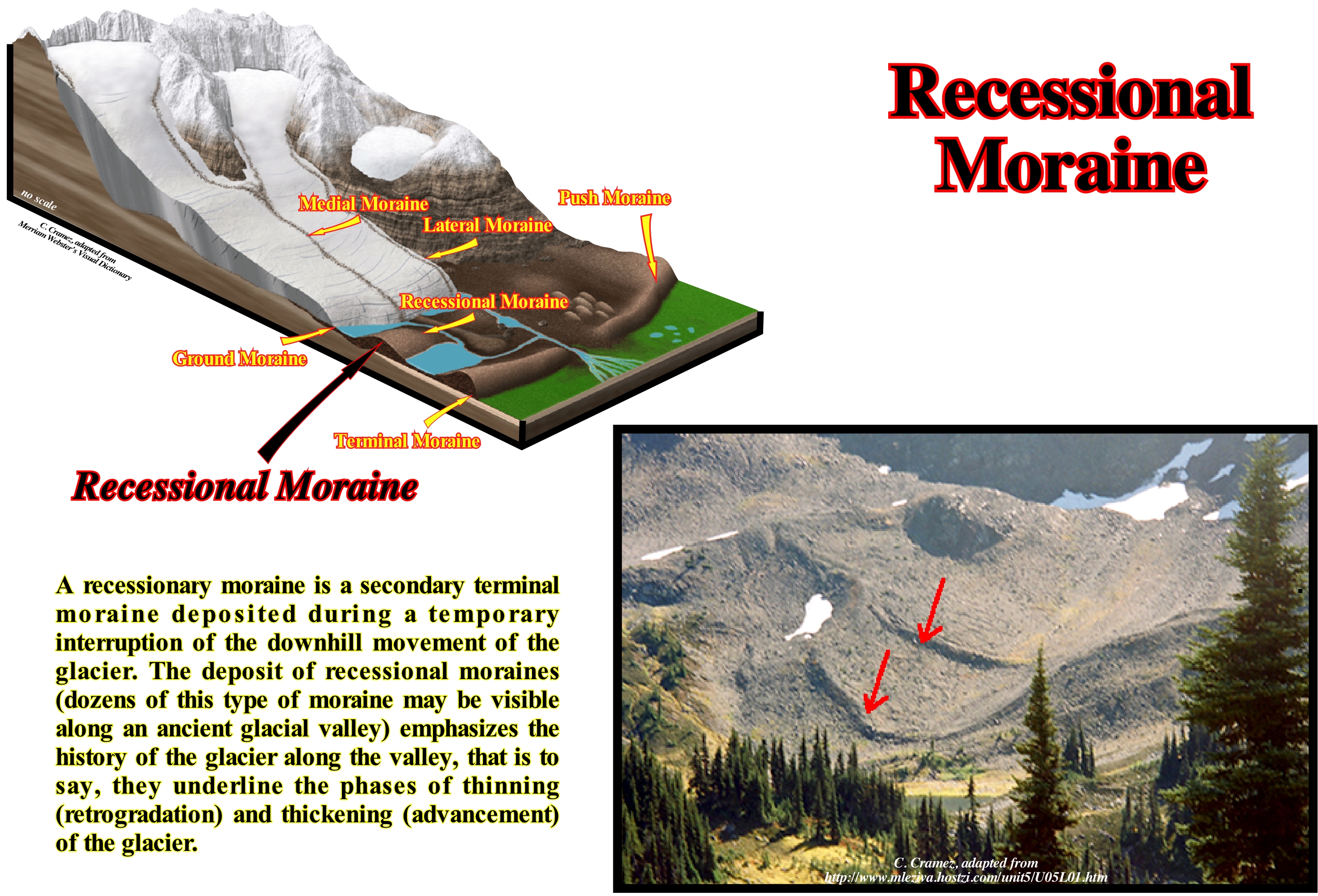
In this photograph (Baffin Island, Canada) several recessional moraines are visible at the mouth of a suspended glacier valley. A recessional moraine is in reality a secondary terminal moraine deposited during a period of glacial stability, i.e., deposited when the glacier does not thicken or thin. These moraines emphasize the history of thinning of the glaciers along the glacial valley, whether it is the main, secondary or suspended valley. In some cases, ten or more recessional moraines may be present in a given valley. In this example, at least three recessional moraines can be identified. The oldest ones were deposited in the main glacier valley, and the recent ones surpass just the border of the suspended glacier valley. The formation of recessional moraines is corroborated by the current observation of the movement of glaciers. In the glacial valleys of Canada, where the vast majority of glaciers, globally, are thinning, a new pulse moraine can be observed every winter when the glacier thickens. When a glacier advances, the sedimentary particles it carries (tills) and the fluvial sedimentary particles associated with it, advance until it stops, and then the next summer begin to thin. At the end of the glacial age, the ice of the glaciers began to melt and its extension began to decrease. However, the thinning was not done continuously. Several times the melting of the ice has ceased and the front of the glacier has held the same position for a period of time sufficient for the recessional moraines to settle. In certain glacial valleys one can observe several recessional moraines, behind, and parallel, the terminal moraine. Terminal and recessional moraines often obstruct the glacial valleys, which contributes to the formation of lakes. In addition to these moraines there are also: (i) Lateral moraines; (ii) Medial moraines ; (iii) Ground Moraines ; (iv) Frontal or terminal moraines.
Recurrent Interval...............................................................................................................................................Intervalle de récurrence
Intervalo de recorrência / Intervalo de recurrencia / Wiederholungsintervall / 重复间隔 / Интервал повторения / Intervallo di ricorrenza /
Average time interval between the occurrences of a certain geological event, such as a flood, regression, turbidity current, earthquake of a certain magnitude, etc. The number of times any geological event is observed in a given time interval is proportional to the frequency with which it occurs (number of times per unit time) and also proportional to the amplitude of the time interval during which it is observed.
See: « Event (geological) »
&
« Flooding-Forestepping »
&
« Stratigraphic Cycle »
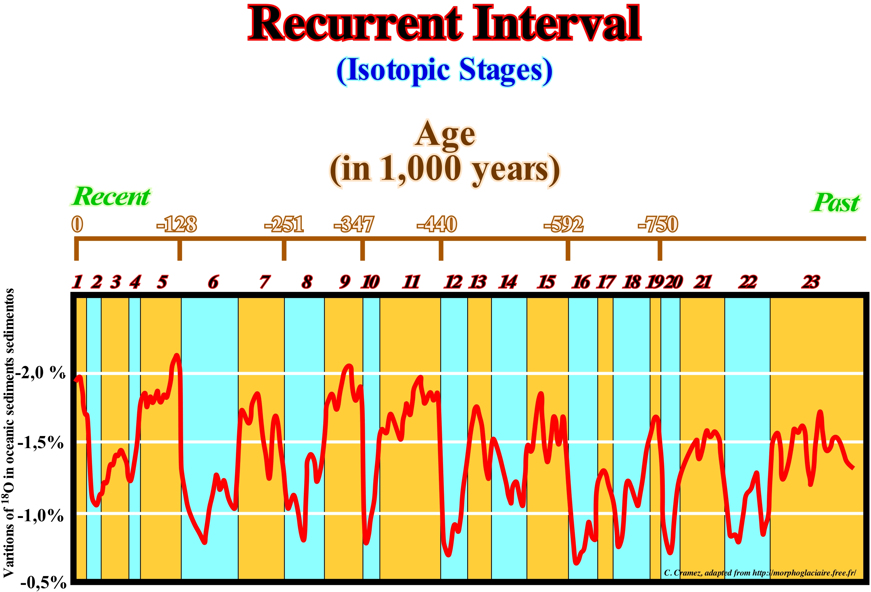
As illustrated in this figure, one of the best examples of geological recurrence is that of the recent glacial ages, whose temporal spacing is approximately 90,000 years. In this figure the isotope contents of oxygen 18 (stable natural isotope of oxygen, containing about 0.205%, and also one of the environmental isotopes*) determined from an ice-drilling test (about 16 m in length) drawn from a well drilled in the equatorial Pacific Ocean (about 1° N and 160° E). At the top of this diagram, the horizontal axis, between Recent (left) and Past (right) indicates the age of sediments counted from today on in thousands of years. The drilling core covers a period of about 900 thousand years. The "hot" periods, which are associated with the strong isotopic contents, are underlined by the orange columns. The "cold" periods, which are associated with the weak isotopic contents, are underlined by the blue columns. The numbers (from 1 to 23) mark the different isotopic stages. Even numbers indicate cold periods and the odd periods hot. Taking into account that such a calculation is, relatively, delicate, geologists, geochemists, paleontologists and sedimentologists, in general, have recorded 28 glacial epochs (or ages) for the time interval between 3.25 Ma and 650 ka. Therefore, it can be said that the interval of recurrence of the glacial epochs, i.e., their periodicity, is about 93 ky. However, it is important to note that a glacial age does not, necessarily, mean glaciation. It is also necessary to take into account the intensity of the cold and the amplitude of the precipitations. On the other hand, according to many geoscientists, there is a certain uncertainty (of the order of 1,000 years) between the difference in ice age and air bubbles (from where oxygen is sampled) (Caillon et al., 2003). In fact, we are, currently, in a glaciation that began several million years ago. About 20,000 years ago, the entire Earth north of a line passing through Seattle, New York, London, and Moscow was covered by a huge ice cap. However, given the glaciation patterns of the past few million years, the ice forms, sets in for a while and then disappears. This means that, periodically, the environment changes radically. As C. Emiliani said, the response of the biosphere is the fragmentation and dispersion of the population, genetic isolation and rapid speciation or in other words, a period of glaciation is a period of rapid evolution. From 2,500 years to this day, there existed six hot periods, corresponding roughly: (i) Pre-dynasty of Ancient Egypt ; (ii) Intermediate periods of Ancient Egypt ; (iii) Roman Empire ; (iv) Middle Ages ; (v) 19th and 20th centuries ; (vi) 21st Century. The periods with cold weather correspond, more or less, to: a) Period Nomadic ; b) Greek Empire ; c) Dark Ages ; d) Middle Ages ; e) Late Glacial Age and f) Late twentieth century (this small period of cold weather, during which the average temperature fell by about 1° C, was induced by the volcanic explosion of Pinatubo, an active stratovolcano located on Luzon Island, in the Philippines). All this calls into question and may even refute the conjecture of global warming, i.e., the anthropogenic increase in temperature since 1990. This means that natural climate changes, which have existed since Earth's formation (around 4.5 Ga), are more than evident. The theory of global warming, which must be tested by nonfraudulent scientific data that certain alarmists use in an attempt to prove their existence. As suggested by K. Popper (problem of demarcation), a theory is part of empirical science if it is contradictory to possible experiences, i.e., it has to be made fallible by means of experiments. If a geoscientist advances a hypothesis to try to explain certain observations, he must criticize its interpretation, that is, submit it to refutation tests and not try to verify it. Certain geoscientists tend to filter out all observation data that falsify their hypothesis and to consider just the data that support it. Such an approach, rarely, allows for scientific progress.
(*) Sub-set of isotopes, both stable and radioactive, which are the subject of isotopic geochemistry. Among the environmental isotopes, the most used are: deuterium, tritium, carbon 13, carbon 14, nitrogen 15, oxygen 18, silicon 29 and chlorine 36.
Redgiant (Star)...........................................................................................................................................................................................Géante rouge (Étoile)
Gigante vermelha / Gigante rojo (estrella) / Roter Riese (Stern) / 红巨星(明星) / Красный гигант (звезда) / Gigante rossa (stella) /
Star that spent all his hydrogen fuel and burns helium. The injection of energy due to the combustion of helium inflates the envelope of the star to a size that is tens of times larger than its original size, hence the name of giant. At the same time, the star cools at its surface giving it a reddish light.
See: « Star »
&
« Sun »
&
« Stellar Evolution »
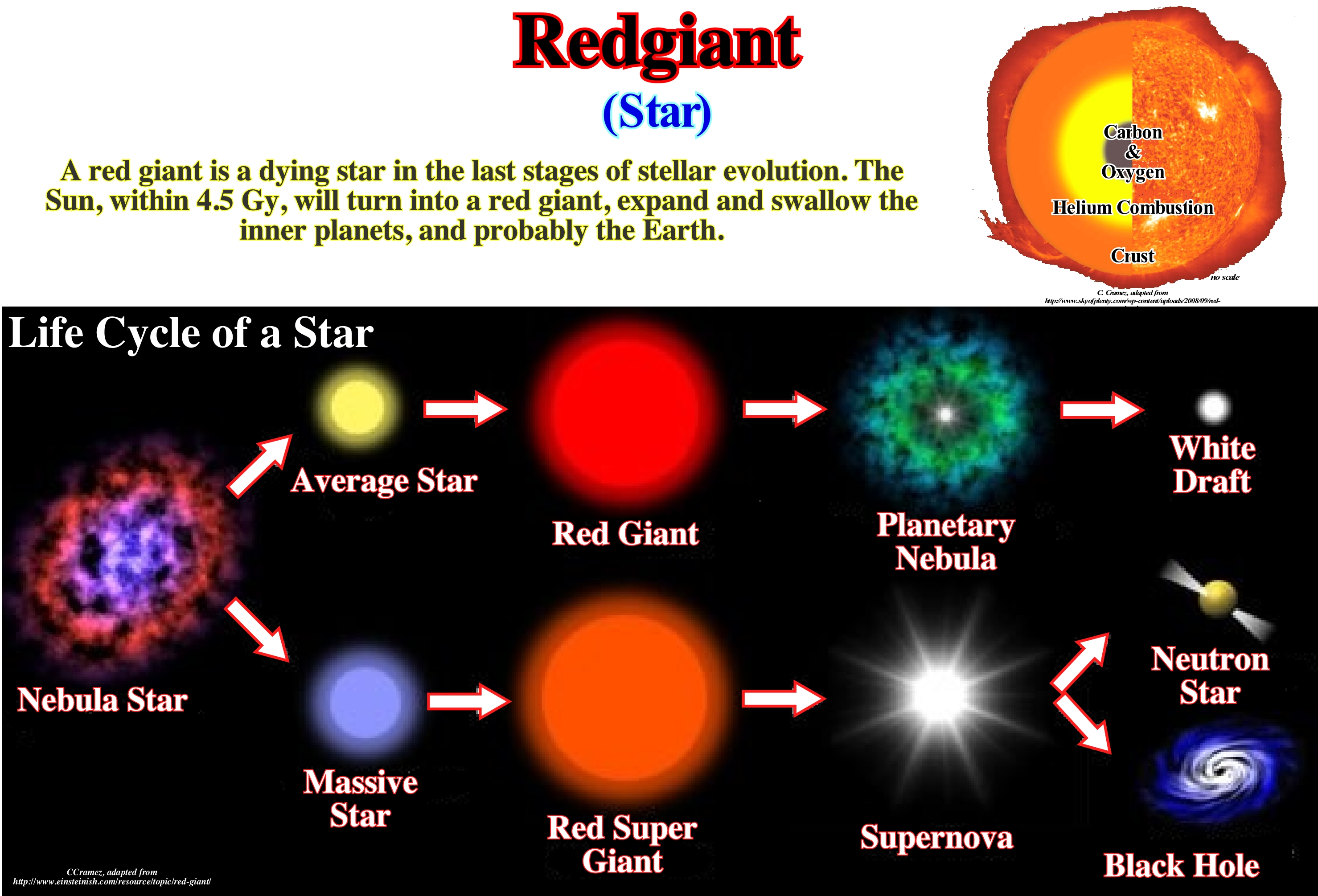
The red giants are stars that were previously equal in size to the sun (up to 8 times the solar mass), but have exhausted the hydrogen reserves of their nucleus. During the initial phase of life, the star burns the hydrogen of the nucleus, at a temperature of 2x10⁷ K*, turning it into helium. The helium produced in this first phase accumulates in the nucleus due to gravity. When the star depletes the entire hydrogen from the nucleus, the reactions in the centre of the star will decrease to finally end. The star goes into gravitational collapse. This means that the inner layers collapse more rapidly than the outer layers and, due to compression, the core temperature again again increases. This new temperature increase allows a new phase of hydrogen combustion in the "shell" around the core. This peeling combustion is a rapid process as the peel is collapsing and the temperature increasing. The brightness will increase, and in the HR diagram (Hertzsprung-Russell diagram, which illustrates the mathematical relationship between absolute magnitude, brightness, stellar classification and the surface temperature of the star), the star begins to move from the main sequence towards the top upper right. The outer layer of the star expands due to the new wave of energy coming from the interior. The star becomes a sub-giant and will later become a red giant (radius, more or less, 50 x 106 km). When a red giant's fuel is completely exhausted, it turns either into a neutron star and collapses into a black hole or into a small white dwarf (6,000 km radius, more or less Earth's radius), which that is to say, sooner or later, our Sun will become a white dwarf. In fact, our Sun will be a red giant within about 5 billion years. Its diameter will be about 400 times greater than today and its luminosity will increase about 10,000 times.
(*) The Celsius scale, though originally defined as the freezing point of water (and then the melting point of ice), is now officially a derived scale, defined in relation to the Kelvin temperature scale. On the Celsius scale, zero (0° C) is now defined as equal to 273.15 K, with a temperature difference of 1° C equivalent to a difference of 1 K, i.e. that the size of the unit on each scale it's the same. This means that 100° C, previously defined as the boiling point of water, is now defined as the equivalent of 373.15 K.
Red-shift..............................................................................................................................................................................................Décalage vers le rouge
Deslocamento ou desvio para o vermelho / Corrimiento al rojo / Rotverschiebung / 紅移 / Красное смещение / Spostamento verso il rosso /
Increasing the wavelength of light an object emits when moving away from an observer. When an object moves away from an observer or when an observer approaches an object, the wavelengths of light emitted by the object increase in the first case and decrease in the second. As the wavelengths of red light are larger than those of the other parts of the visual spectrum, when an object moves away from an observer there is a shift toward the red light.
See: « Inflationary Universe »
&
« Big Bang (theory) »
&
« Big Crunch (theory) »
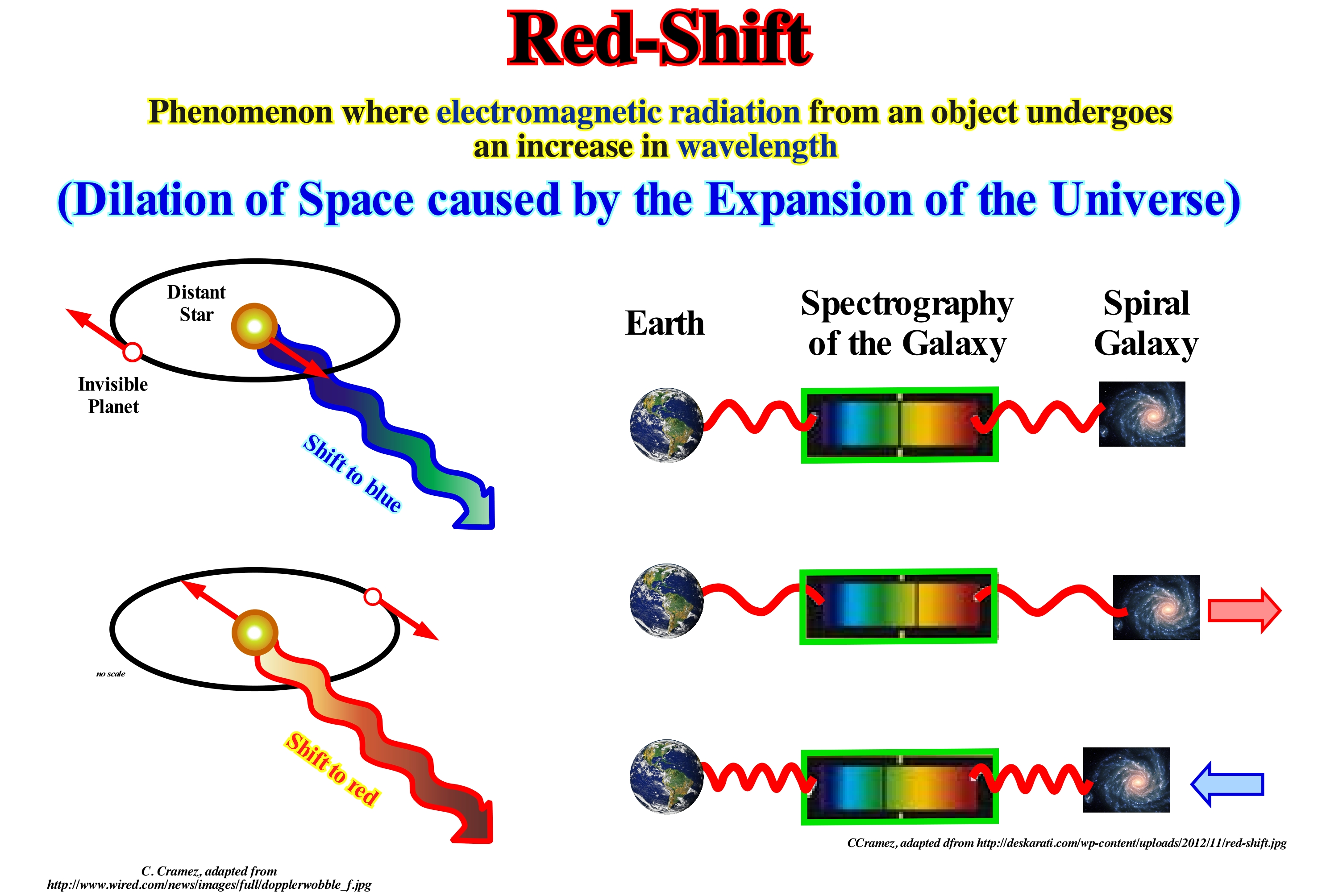
The red-shift is a very well documented phenomenon and considered as proof of the expansion of the Universe and the Big Bang cosmological model. This expression is also used for the more general notion of red or blue shift observed between astronomical objects when moving far or near an observer independently of the general expansion movement. In this sense, the red shift is, more or less, synonymous with the Doppler effect (changing the frequency of a wave to a moving observer in relation to the wave source). The law of Hubble** (galaxies move away from one another at a rate commensurate with their distance, that is, the further away a galaxy is from an observer, the more it seems to move away rapidly) as a relation between the distance and radial velocity of the observed objects. If this description is suitable for certain objects (neither too close nor too far away), it is not suitable for very distant objects. For these, the situation is more complicated, since the concept of distance in general relativity theory is not clear, and one must specify what distance it is (luminosity distance, angular distance, etc.). The shift to red is not due to a Doppler effect (it is a physical phenomenon observed in waves when emitted or reflected by an object that is in movement with respect to the observed). It is hardly interpreted in terms of speed. The general relativity*** allows to calculate the relation between the displacement (deviation) to red and a defined distance. This relation depends on the cosmological model considered. For a given model, there is a correlation between the deviation to red and the distance that is sometimes expressed in terms of distance-deviation (denoted by z).
(*) Variation of the energy of the light colour (or sound) due to the relative movement of the light source (or sound) relative to the observer. If the source goes away, the energy decreases and the light is shifted to red (the sound becomes more serious). If the light source approaches, the energy increases and the light is shifted to the blue (the sound becomes louder). The deviation of light is proportional to the speed of withdrawal or approach. The red-shift of a galaxy varies depending on the distance (Hubble's law).
(**) In 1929, Edwin Hubble advanced the conjecture that, in a general way, the galaxies are moving away from each other. What many consider as a consequence of a major explosion and that galaxies are flying through space. However, Einstein showed that, in reality, it is the space between galaxies that is expanding. This is because the Big Bang was not an explosion within space, but an explosion of space itself, which was concentrated at a tiny point and, as it exploded, gave rise to the universe. As in an explosion that trails for a billion years (1 x 10⁹), this space continues to expand - this explains why space is so dynamic. (http://revistagalileu.-globo.com/Valencia/optician/2015/11/5-conceitos-que-for-revolucionados-pela-teoria-geral-darelatividade.html)
(***) The theory of general relativity is a set of hypotheses that generalizes Newton's special relativity and law of universal gravitation and provides a unified description of gravity as a geometric property of space and time or space-time.
Reef (In a broad sense)...........................................................................................................................................................................................................................Récif
Recife / Arrecife / Riff / 礁 / Риф / Scogliera /
Organic-sedimentary building constructed by the interaction between organisms and the environment.
See: « Bioherm »
&
« Transgressive Interval »
&
« Deposition (carbonates) »
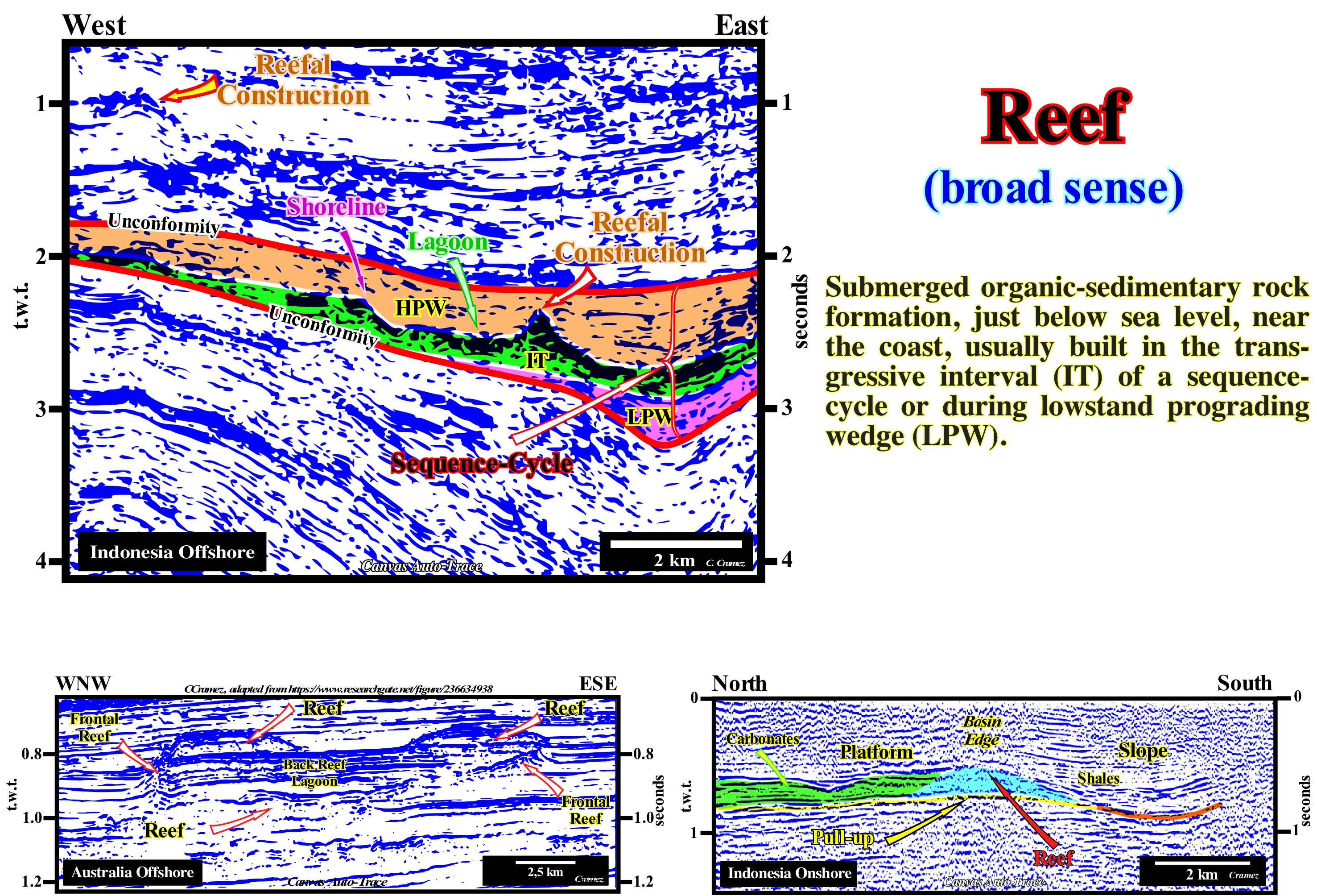
In geology, a reef and associated terms, such as bioherm, biostrome, carbonate mound, etc., are defined using three main parameters: (i) Depositional morphology ; (ii) Internal structure and (iii) Biotic composition. There is no consensus among the geoscientists of a universally definition of reef. Certain definitions distinguish reefs and reef mounds. Both are considered as varieties of organic sedimentary constructions, build-up by the interaction between the organisms and their environments, that have a synoptic relief, that is to say, that allows to corroborate a scientific conjecture, and whose biotic composition differs from the one found on and under the bottom of the sea. The reefs are supported by a macroscopic skeletal structure, the typical example of which are coral reefs. Calcareous corals and algae grow on top of one another and form a three-dimensional structure that is modified in various ways by other organisms and inorganic processes. In contrast, carbonate mounds, they are constructed by micro-organisms or organisms from which a skeletal structure does not grow. A microbial carbonate mound is constructed, exclusively, or mainly by cyanobacteria (prokaryotes capable of carrying out photosynthesis and which have existed for about 3.9 Ga). Excellent examples of biostromes formed by cyanobacteria, currently, occur on the Great Salt Lake in Utah (USA), Sharks Bay in Western Australia, etc. On the tentative geologically interpretation of a Canvas auto-trace of a detail of an Indonesia (SO Kalimantan, Borneo) offshore seismic line, it is easy to recognize the reefs. At least two carbonate sedimentary anomalies can be interpreted with reefs. One is about 1.0 second (t.w.t) deep in the left side of the auto-trace, and another, deeper, about 2.5 seconds, on the right side of the auto-trace. These reefs, probably, delineate aromatic carbonated platforms, that is to say, they grew as the relative sea level rose in acceleration, individualizing an open sea lagoon. In this auto-trace, within the sequence-cycle, bounded by the two underlined unconformities by the red line and corresponding to two significant falls of the relative sea level **, in association with the transgressive interval (TI), colored green, the shoreline, the lagoon and the reef construction are relatively well visible. They have been fossilized by the progradations emphasized by the sequence-paracycles, which form the different sedimentary systems tracts of the highstand prograding wedge (HPW), which have begun to deposit since the level of the relative sea began to rise in deceleration (increasingly smaller marine ingressions inducing increasingly important sedimentary regressions). In a sequence-cycle, highstand (HPW) and lowstand prograding (LPW) wedges are stacking of outbuilding systems tracts deposited in association with increasingly smaller marine ingressions and increasingly important sedimentary regressions (during periods of constant or crescent terrigeneous influx), while the transgressive interval (TI) is stacking of a prograding lateral deposited of sedimentary systems tracts in association with increasingly important marine ingressions and increasingly smaller sedimentary regressions (during a period of constant or decreasing terrigeneous influx). Therefore, the geometry of the low or highstand prograding wedges is always predominantly outbuilding (although the aggradation may be more or less important), whereas the geometry the transgressive interval (TI) is retrogradational. That is why at the hierarchical level of a sequence-cycle, what many geoscientists incorrectly call a "transgression" is, in reality, a vertical stacking of progressively smaller sedimentary regressions.
(*) Prokaryotes are cells without a defined cell nucleus, meaning that the genetic material is dispersed in the cytoplasm, assembled in an area called a nucleotide. The cells they have have a nucleus distinct from the cytoplasm are called eukaryotes, i.e., those cells whose DNA is inside a compartment separated from the rest of the cell.
(**) The relative sea level is the local sea level, referenced at any fixed point on the Earth's surface, which can be the base of the sediments (top of the continental crust) or the sea floor and which is the result of the combined action of the absolute sea level (supposed, global and referenced to the Earth's centre) and tectonics (subsidence when extensional regimes are predominant or uplift, when compressional tectonic regimes are predominant).
Reef (Faro, atollon)..............................................................................................................................................................................................................................................Recife
Faro (atollon) / Faro (recife) / Faro (Riff) / 法鲁(礁) / Небольшой атоллоподобный риф / Faro (scoglio)
Ring-shaped reefs within the lagoons.
See: « Bioherm »
&
« Transgressive Interval »
&
« Deposition (carbonates) »
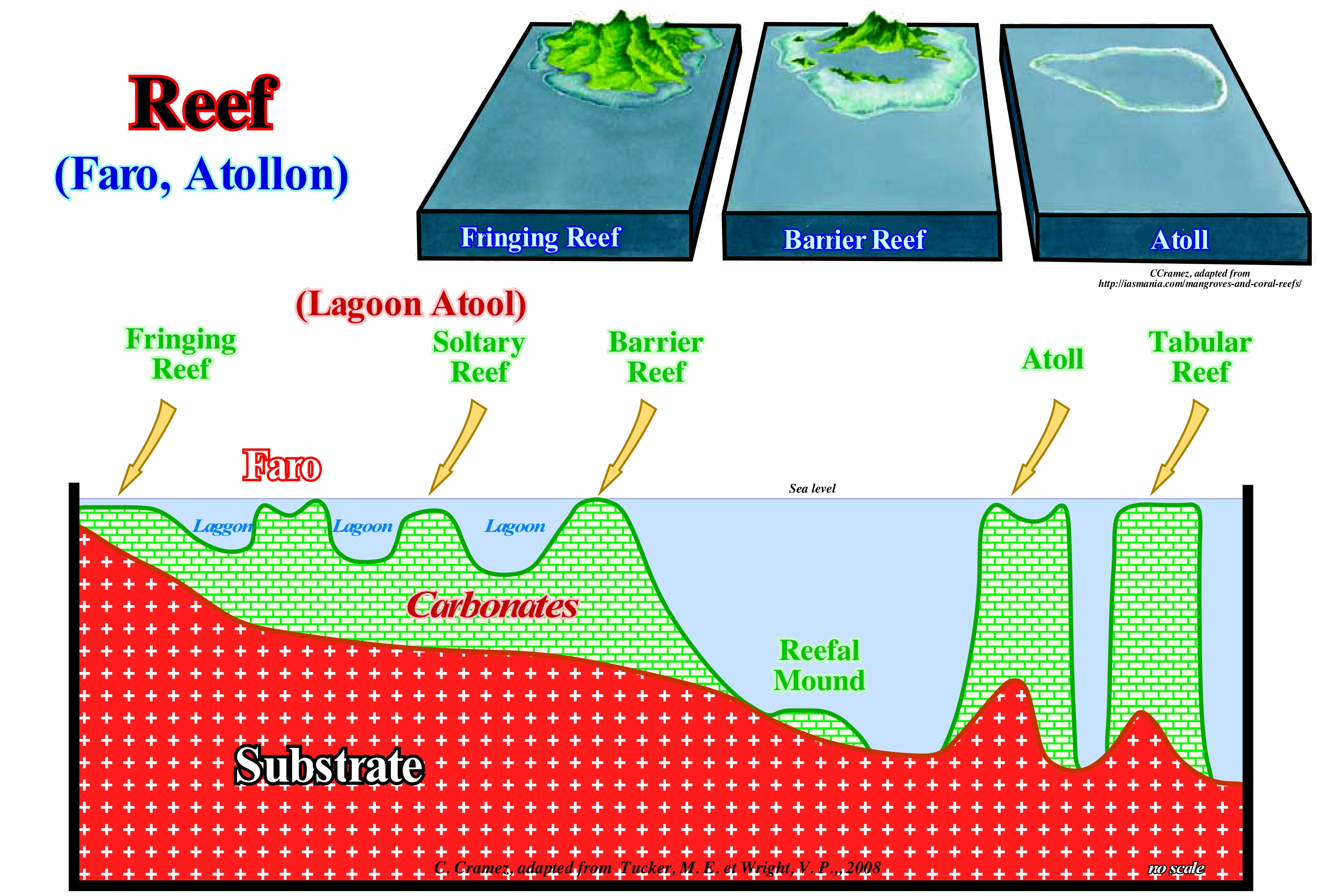
A reef can be: (i) A cliff or a set of cliffs at the edge of the water or (ii) A geological formation along the coast, formed of coral polyps. The term coral reef refers to a marine habitat that is among the most biodiverse environments on the planet (https://educacao.uol.com.br/disciplinas/biologia/recifes-de-corais-1-barreira-atol and-fringe-types-of-environment-marine.htm). The reef is formed by some species of coral (animals belonging to the group of cnidarians) able to secrete a limestone exoskeleton, along with limestone algae that produce fine slabs of calcium carbonate, which accumulate and cement the reef structure. The corals (tentacular coelenterates with tentacular formations and limestone skeleton that live in colonies) that form the reef live in symbiosis with small unicellular algae called zooxanthella that live inside their tissues. Corals receive large amounts of the organic matter produced by seaweed photosynthesis and depend on it to survive. The zooxanthella, in turn, receives nutrients from the excretion of corals and a safe habitat to settle. Although this relationship is also advantageous for seaweed, it can survive without coral. In general, there are three main types of reefs: (A) Bioclastics, that is, reefs constructed by the accumulation of organisms, especially metazoans (multicellular beings), which have a rigid carbonate shell ; (B) Biogenic, corresponding to biogenic carbonate constructions without accumulation of bioclasts and (C) Complexes, which correspond to reef constructions sufficiently large and resistant to the sea waves to be able to form significant reliefs and create a reef core with an internal margin and outer reef. All of these reefs are complex systems in which biological, physical and chemical factors interact. There are mainly four processes that operate in the formation of reefs: (i) Constructive processes, that is, biological processes, such as the growth of carbonate organisms ; (ii) Destructive processes, that is, all processes that may destroy or cause damage to reef growth, such as the action of sea waves, bioerosion (biological destruction), etc. ; (iii) Sedimentation, i.e., the accumulation of biogenic matter, created by the intense biological activity around the reef and the debris of the reef itself and (iv) Cementation, which has a great influence on the shape of the reef and which can be early and important, as is the case in many ancient and recent reefs. These four processes (constructive, destructive, sedimentation and cementation) determine a great variety of morphologies and internal structures that can be easily recognized in the reefs. In this figure is outlined a classification of the reefs taking into account their location and shape. In the direction of the sea one can find: (1) Reefs in Fringes, is the most common type of reef, are simple constructions and more or less, connected to the coastline (continents or islands), such as those found in the Caribbean and near Florida and the Bahamas ; (ii) Faros (atolls within the lagoon), which has a more or less ringed shape ; (iii) Solitary Reefs, which typically have a more or less important platform ; (iv) Barrier Reefs are linear or semicircular constructions separated from the mainland by channels; the typical example is Australia's Great Barrier Reef, the largest in the world, stretching for more than a thousand miles along the Australian coast ; (v) Reef mounds (term, rarely, used) that are reef insulated in deep-water, often, associated with landslides or instabilities of barrier reefs ; (vi) Atolls, which are ring-shaped structures with a central lagoon, which develops in relatively deep waters, generally on former submerged volcanoes and (vii) Tabular reefs which, like atolls, form in deep water , but which, unlike these, have no lagoons.
(*) The zooxanthellae are a type of unicellular algae that live in symbiosis with corals and some nudibranchs (marine gastropod molluscs that have unprotected gills, as their name suggests). The zooxanthellae live in the tissues of coral polyps. The zooxanthellae are responsible for the development of many corals in tropical waters that are poor in nutrients, develop by absorbing the carbon dioxide (CO2) released by corals and supplying various nutrients back. The amino acids produced by polyps stimulate the production of glycerol, which is directly related to coral breathing. Some species of nudibranchs, such as Spurilla neapolitana, also have zooxanthellae in their tissues, probably from anemones that kill and consume. (http://dictionnaire.sensagent.leparisien.fr/ Zooxantela / pt-pt /)
Reef-Flat..................................................................................................................................................................................................................................................Platier
Plataforma de recife / Plataforma del arrefice / Riff-Flach / 礁 / риф / Piattaforma Reef /
Platform dug by waves on the abrupt outer margin of a reef.
See: « Reef »
Reef Growth (Latitude)................................................................................................................................................Croissance des récifes (Latitude)
Crescimento de recife / Crecimiento de arrecife (latitud) / Riff Wachstum / 珊瑚礁的生长 / Рост рифов / Scogliera crescita (latitudine) /
The growth of a reef depends on the climatic conditions and the stability of the water-depth. The rate of relative sea level rise (subsidence + eustasy) mus be compensated for by the growth (aggradation) of the reef. In other words, in order that an ideal waterdepth (for the growth of a reef) remains, more or less, constant, the available space created by marine ingressions must be occupied by the vertical growth of the reef.
See: « Reef »
&
« Organic Production (carbonates) »
&
« Transgressive Interval »
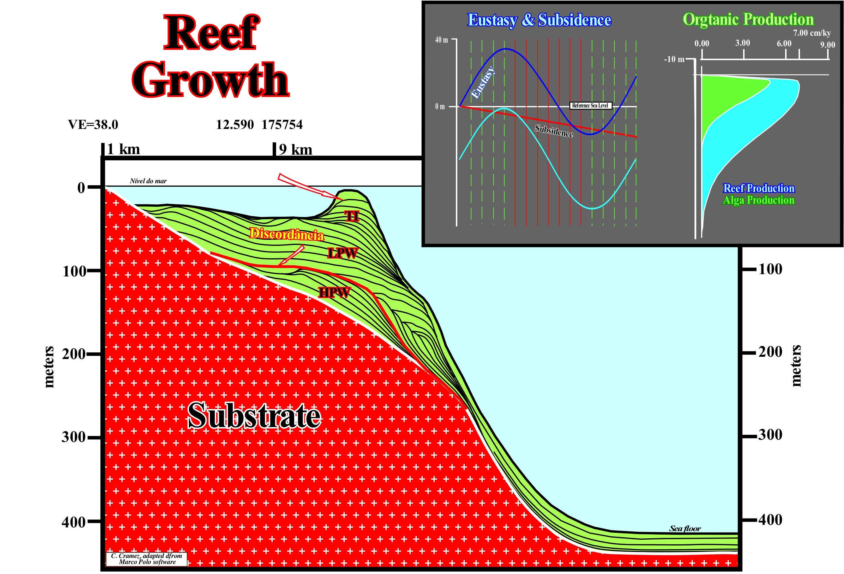
This geological model, constructed with an algae and reef production curve, which is illustrated in the upper right corner of this figure, is easily understand. Two stratigraphic cycles called sequence-cycles, which were induced by two 3rd order eustatic cycles (time-duration between 0.5 and 3-5 My) are illustrated. The lower sequence-cycle is incomplete. It is composed just by a highstand prograding wedge (HPW). The upper sequence-cycle, which is separated from the underlying cycle by an unconformity (erosional surface), which was created by a relative sea level fall, is also incomplete since the highstand prograding wedge has not been deposited. The submarine basin floor fans (SBFF) and submarine slope fans (SSF) are condensed. The lowstand prograding wedge (LPW), which is the upper systems tracts sub-group of the lowstand prograding wedge (LPW), is well developed, as is the transgressive interval (TI). In this systems tracts subgroup, as climatic conditions were favourable, from a certain point on, the available space, created by the relative sea level rise, near the basin edge was filled by the vertical aggradation of organic constructions. That is to say, that near the platform edge, the waterdepth was, more or less, constant, between 20 and 30 meters, which favoured the production of carbonated organic matter. Upstream of this area, the available space was not filled by organic constructions. The increasing of the water-depth created the space available for regressive sediments, which have, certainly, been deposited progressively, since the relative sea level rose in deceleration or starting even to fall.
Reef Knoll.............................................................................................................................................................................................................................Pinacle (Monticule récifal)
Pináculo (recife monticular) / Pináculo (montículo arrecifal) / Riff Knoll / 珊瑚礁小丘 / Рифовый холм / Poggio reef, Pinnacle (tumulo reef) /
Rock, in general, of limestone facies, with the morphology of a pinnacle, occurring both on the lagoon and on the carbonate platform, between the lagoon and the external slope of a reef building.
See: « Reef Mound »
&
« Reef »
&
« Transgressive Interval »
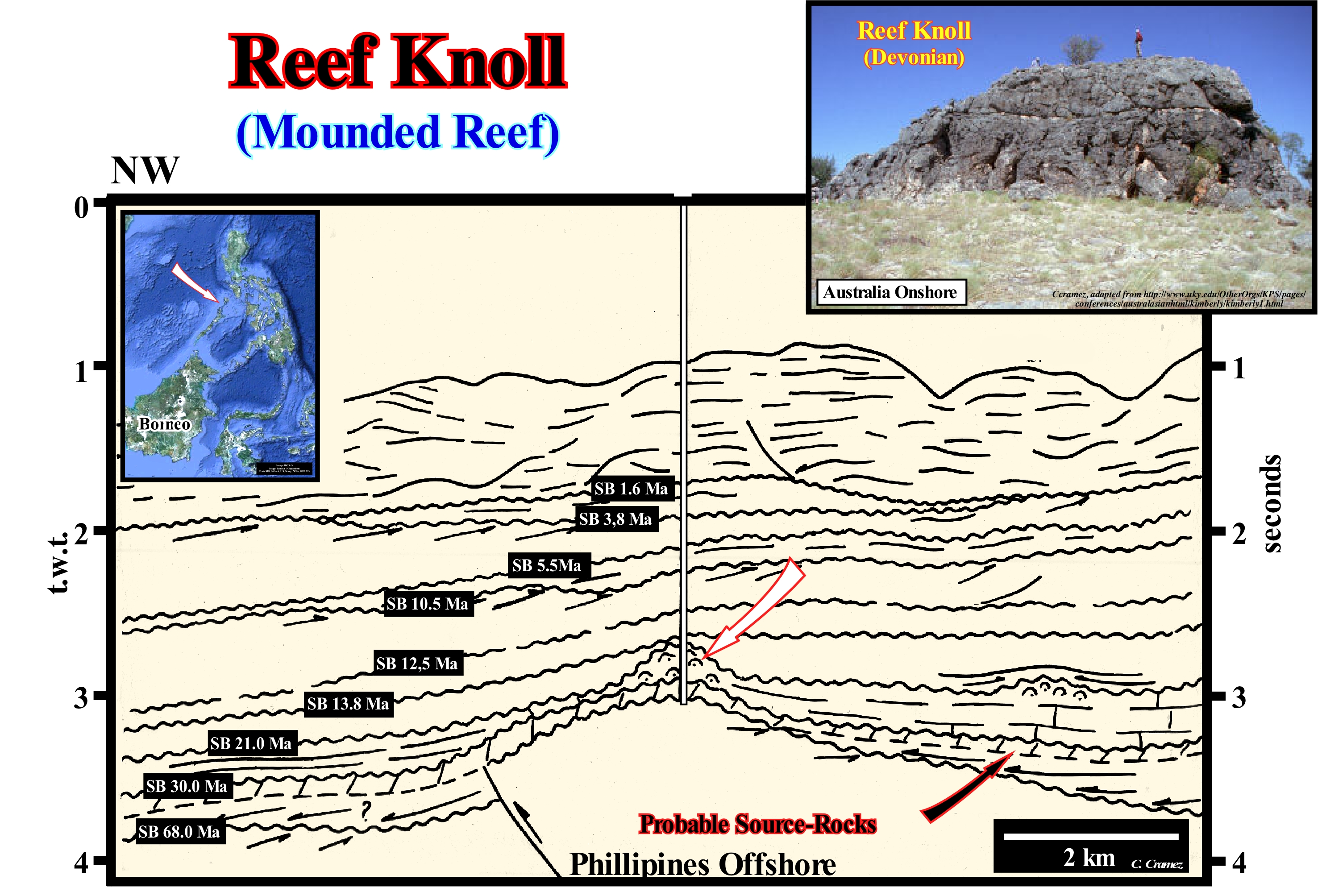
On this tentative geological interpretation in stratigraphic cycles of a Philippines offshore seismic line (north of Palawan Island), several reef constructions, probably, reef or mounded type pinnacles are visible. Within the lagoon, between the typical pinnacles (with the morphology of a pillar) and the mounded reefs there are all types of intermediate stages. On this tentative interpretation, within the continental encroachment subcycle, bounded by the unconformities SB. 30 and SB. 21.0 Ma, reef constructions may be thought of as pinnacles or mounded reefs, which certain geoscientists call reef pinnacles. These geoscientists use the term pinnacle when the morphology resembles that of a pillar and reef pinnacle when the morphology is mounded. These organic constructions are associated with the marine transgression induced by thermal subsidence, which accompanied the formation of the back-arc basin (cratonic or sag phase), which developed within the Meso/Cenozoic megasuture. This manual auto-trace illustrates a non Atlantic-type continental margin, that is to say, a continental margin formed in a tectonic, globally, compressive context. It corresponds to the oceanization of an ancient backarc basin. The lengthening, in the inner zone of the volcanic arc, was so great that it broke the lithosphere (individualizing two new lithospheric plates), allowing the opening of the China Sea (marginal sea) and the formation of new oceanic crust (diminution of the volume of oceanic basins) as well as the formation of a continental margin of the non Atlantic type. The rifting phase, during which subsidence was differential, is characterized by the formation of halfgrabens (rift-type basins). Some of these halfgrabens originated large lakes (when the lengthening rate is not compensated by the terrigeneous influx), in which lacustrine rocks, rich in organic matter, were deposited. They are the origin of the hydrocarbons discovered in this region. Since subsidence became thermal (cratonic or sag phase from the inner backarc basin), marine transgression and climatic conditions favoured reef constructions, particularly, within the lagoons, upstream of the outer reef slopes, where several types of pinnacles grew.
Reef Mound (Seismic line).........................................................................................................................................................Montícule récifale
Recife monticular / Montículo Recifal / Reef Hügel / 礁丘 / Риф курган / Monticello Reef /
Sedimentary anomaly with a mound shape constituted by limestone bioclastic and small levels of organic constructions. This reef mound refers primarily to biologically controlled autochthonous anomalies, which are, genetically, different from hydrodynamic anomalies (allochthonous accumulations of skeletal debris, such as crinoid or reef remains).
See: « Climbing Toplap Mound »
&
« Reflection Configuration »
&
« Reef »
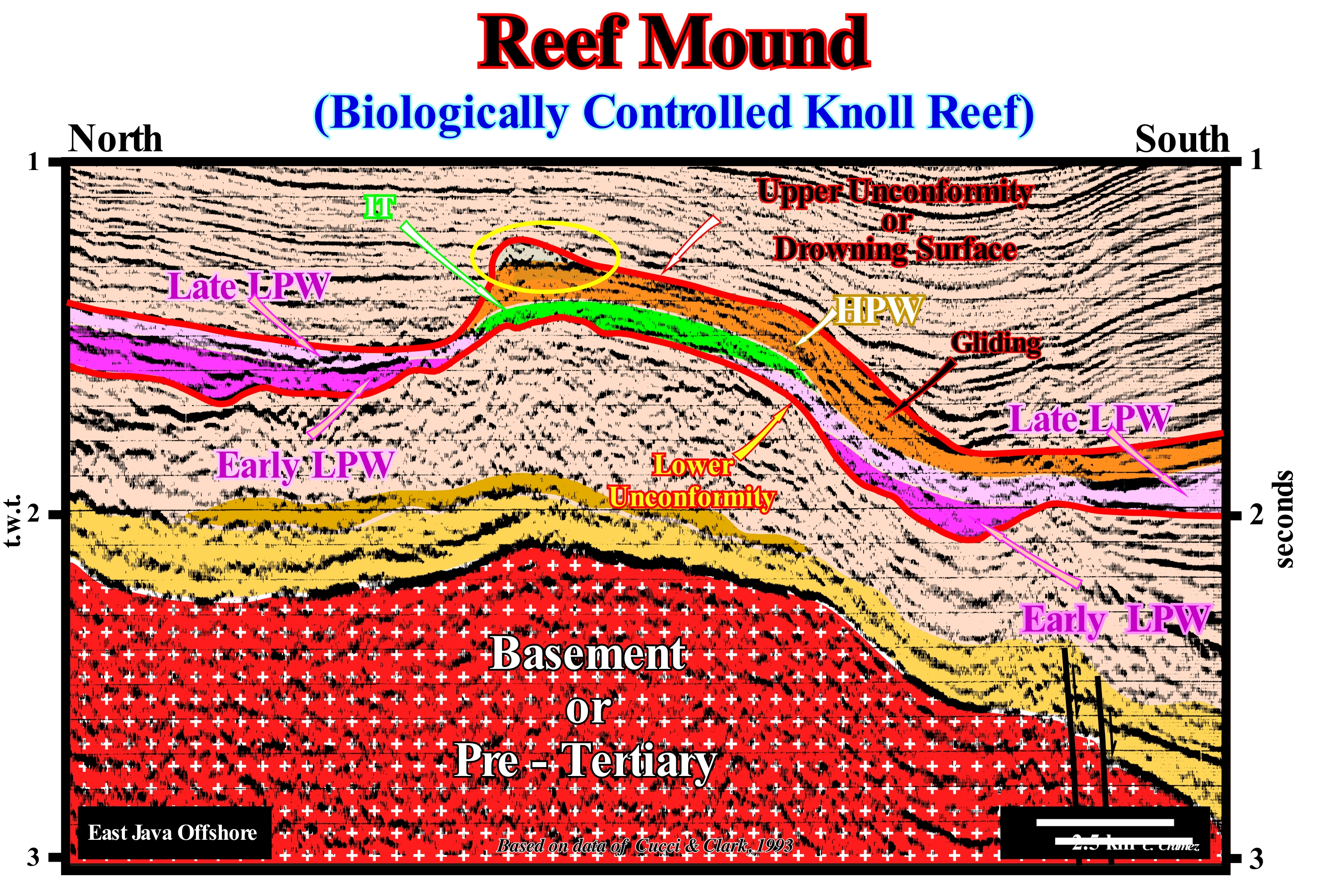
On this tentative geological interpretation of a detail of an offshore seismic line from Indonesia, a sedimentary anomaly is visible at the top of a stratigraphic cycle (sequence-cycle) individualized by two boundary unconformities (emphasized in red) : lower unconformity and upper unconformities or drowning surface. Concerning the lower boundary of this sequence-cycle, the vast majority of geoscientists consider that it corresponds to an unconformity, i.e., an erosional surface induced by a significant relative sea fall (local sea level, referenced to the base sediments or the sea floor, resulting of the joint action of absolute or eustatic sea level and tectonics), important enough to set the sea level lower than the basin edge. In contrast, the upper boundary can be interpreted in different ways according geoscientists are adherents of the Vail's School (sequential stratigraphy, as considered by most of Exxon's geoscientists) or the W. Schlager's school (carbonates). For the former it corresponds to an unconformity created by a significant relative sea level fall. For the latter, it corresponds to a flooding surface created by a significant relative sea level rise, which put the sediments below the photic zone. If the upper interval of the sequence-cycle is a carbonated platform, which is the case in this example, it extinguishes itself by drowning (important increase of the depositional water-depth), since under the photic zone there can be no formation of carbonates. In the interpretation proposed here, this limit is considered as an unconformity (significant relative sea level fall), since, laterally, submarine basin floor and slope fans were deposited not only of carbonate facies, but also of sandy facies. The large undulations of the reflectors underlying the considered sequence-cycle, which is formed, mainly, by carbonates, correspond to seismic pitfall induced, mainly, but not only, by changes of carbonate thickness (lateral velocity changes). Probably, the basement is also affected by such a pitfall. Within the seismic interval limited by the red colored unconformities, the two groups of sedimentary systems tracts, which form, normally, a sequence-cycle, can be recognized: (i) Highstand systems tracts group (HSTG) and (ii) Lowstand systems tracts group (LSTG). The highstand systems tract group is formed by two subgroups of sedimentary systems tracts: a) At the base, the sedimentary systems tracts forming the transgressive interval (TI), which is coloured green and (ii) At the top, the sedimentary systems tracts forming the highstand prograding wedge (HPW), which is coloured in orange ; (ii) Lowstand systems tracts group (LSTG), which is, here, represented only by the lowstand prograding wedge (LPW), in which an early phase (dark violet colour) and a late phase (light violet colour) can be recognized. In the upper part of the highstand prograding wedge, a reefal mound structure is easy to identify as well as the seismic reflection, probably, induced by the oil-water contact plane of a possible hydrocarbon accumulation. Do not forget that there are different types of carbonated platforms: (i) Rimmed Platforms, with reefs or shoal reefs in the edge of the platform ; (ii) Ramp-type Platforms, with carbonated sands near the shoreline and clay sands and deep-water mud at the base of the ramp (reefs are not important) ; (iii) Epeirial (or epiric) platforms, which are characterized by the presence of tidal surfaces and protected lagoons ; (iv) Isolated Platforms, in which the lithologies are controlled by the orientation of the winds (they have reefs and sandy bodies in the windward margin, but, in the leeward margin, the sediments are more muddy) ; (v) Dead or Drowned Platform, when the platform is placed under the photic zone (where sunlight penetrates, whose depth varies greatly depending on the turbidity of the water). On the other hand, the platforms connected to the continent are, often, subdivided into two large families: (A) Ramp Type and (B) Top-Flatened Type. In ramp type two subtypes can be considered: (A.1) Monoclinal and (A.2) Distal Steepened. In the Top-Flatened there are also two subtypes: (B.1) Non-rimmed Platforms and (B.2) Rimmed platforms.
Reef Mound (Seismic line & model).....................................................................Monticule récifal, Récif monticulaire
Recife monticular / Montículo arrecifal / Reef Hügel, Buckelschicht Riff / 礁丘 / Рифовый холм, Холмистый риф / Monticello scogliera, Scogliera a forma di tumulo /
Organic sedimentary construction without the typical characteristics of a reef, made from microorganisms and organisms without skeletal structure. A microbial mound reef is constructed, exclusively or mainly, by cyanobacteria. Synonym with Carbonated Mound.
See: « Reef »
&
« Transgressive Interval »
&
« Deposition (carbonates) »
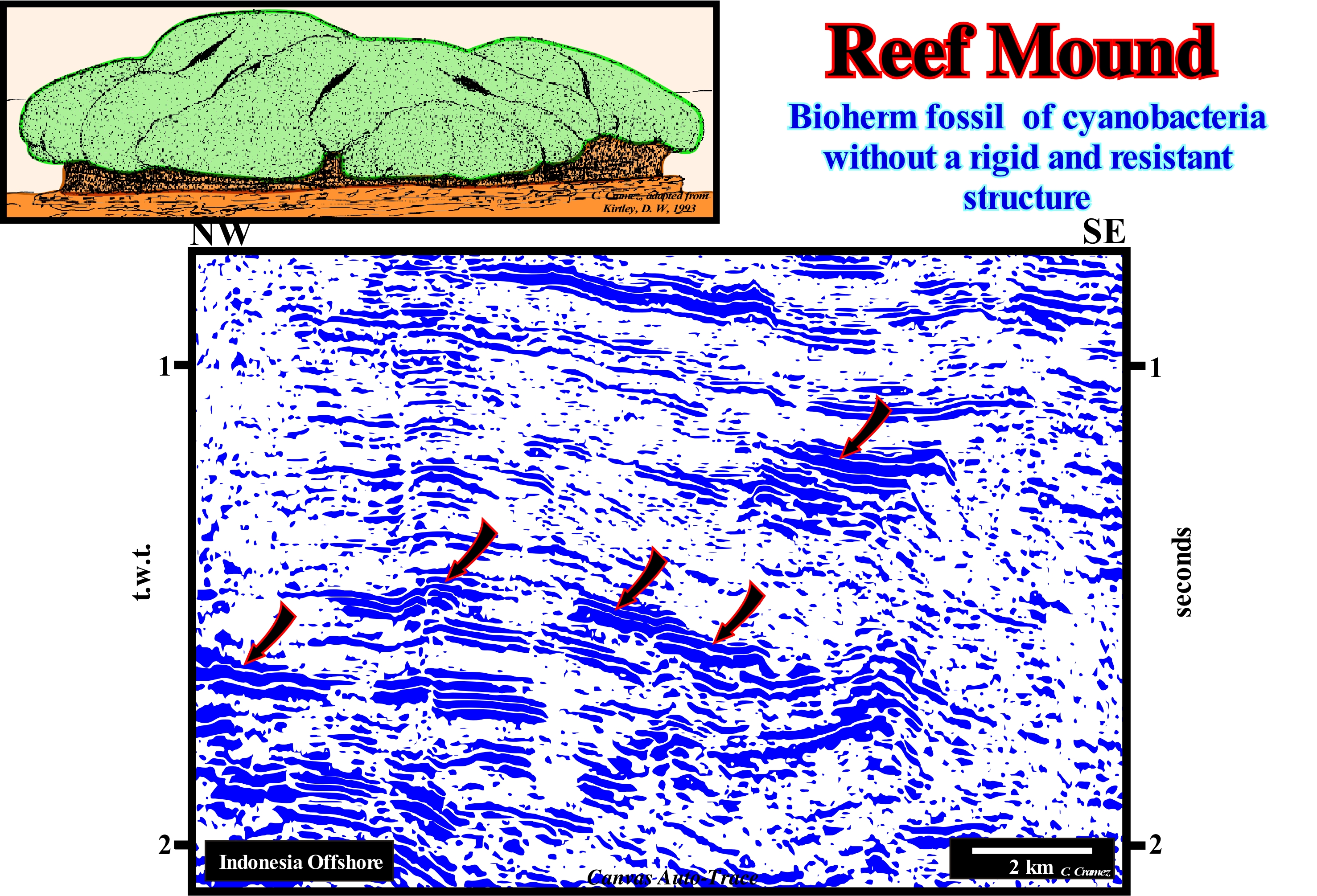
A reef (a term which can have two very different meanings: (i) A cliff or a cluster of rocks in the water near the coast or (ii) A carbonated geological formation and not a cliff. Thus a reef and the associated terms, such as bioherm, biostrome, carbonate mound, mounded reef, etc., are defined using, mainly, three parameters: (i) Deposition morphology ; (ii) Internal structure and (iii) Biotic composition. There is no consensus among the geoscientists of a definition, universally, applied. Certain geoscientists distinguish between reefs and reef mounds or carbonate mounds, although both are varieties of sedimentary organic constructions, constructed by the interaction between organisms and their environments, which has a synoptic relief and whose biotic composition differs from that found around it. Reefs are supported by a macroscopic skeletal structure, such as coral reefs, where corals and calcareous algae grow on top of each other, forming a three-dimensional structure that can be modified in various ways by other organisms and inorganic processes. Carbonated mounds, as illustrated in this figure, are constructed by microorganisms or organisms from which no skeletal structure is formed. A microbial carbonate mound is constructed, exclusively or mainly, by cyanobacteria (a group of bacteria that obtain energy by photosynthesis, which are also called blue algae or blue-green algae, although some geoscientists consider these names inadequate, since cyanobacteria are prokaryotic, i.e., unicellular organisms that do not have the genetic material delimited by a membrane, and the algae should be only eukaryotic (with individualized cell membrane). Low-relief mounded structures are found, for example, along the coast of Florida (USA). They are made up of numerous marine worms of the Sabellariidae family. Each earth worm sets on a stable surface and begins by building a protective tube out of the sand and around it. The earthworms of the Sabellariidae family attach to the neighbouring tubes forming large colonies that evolve into very massive mounded reefs of significant size, as illustrated in this tentative interpretation of a Canvas auto-trace of a detail of an offshore seismic line from Indonesia, as well as in the geological sketch of the upper left part of this figure. These mounds are sometimes exposed during the low-tide, creating small pools of water that are the habitat of numerous marine organisms. Over the last 10,000 years, relative sea level has risen and fall several times (three times the relative sea level was above current level). Carbonated buildings grew during relative sea level rises (some were drowned) but died and were eroded during relative sea level falls. The maximum development of carbonate buildings seems to have been around 5,000 years, when sea level was about 5 meters above the current level. However, since about 4,000 years, due to the sudden fall of absolute sea level, many reef structures have emerged and eroded, although some had grown laterally, forming, by coalescence, reef banks. Note that relative sea level is the local and referenced to any fixed point on the Earth's surface, which can be base of the sediments (top of the continental crust) or the sea floor. On the other hand, relative sea level is the result of the combined action of absolute (eustatic) sea level, which is supposed to be global and referenced to the Earth's centre, and tectonics (subsidence when extensional tectonic regimes are predominant or uplift of the sea floor, when compressional tectonic regimes are predominant).
Reef-Rimmed Platform..............................................................................................................Plate-forme récifal auréolée
Plataforma recifal aureolada / Plataforma de arrecifes aureolada / Reef-umrandeten Plattform / 边礁环绕的台地 / Обрамленная рифом платформа / Piattaforma scogliera aureolata /
Carbonated platform with the edge underlined by reefs. In general, carbonate platforms have an edge under a water-depth of several tens of meters and naturally do not have reefs, and are sometimes fringed, i.e., when they have a more or less continuous barrier formed by reefs that along the edge of the platform, under a small waterdepth, which may emerge during low tide.
See: « Rimmed Carbonate Platform »
&
« Reef »
&
« Drowned Carbonate Platform »
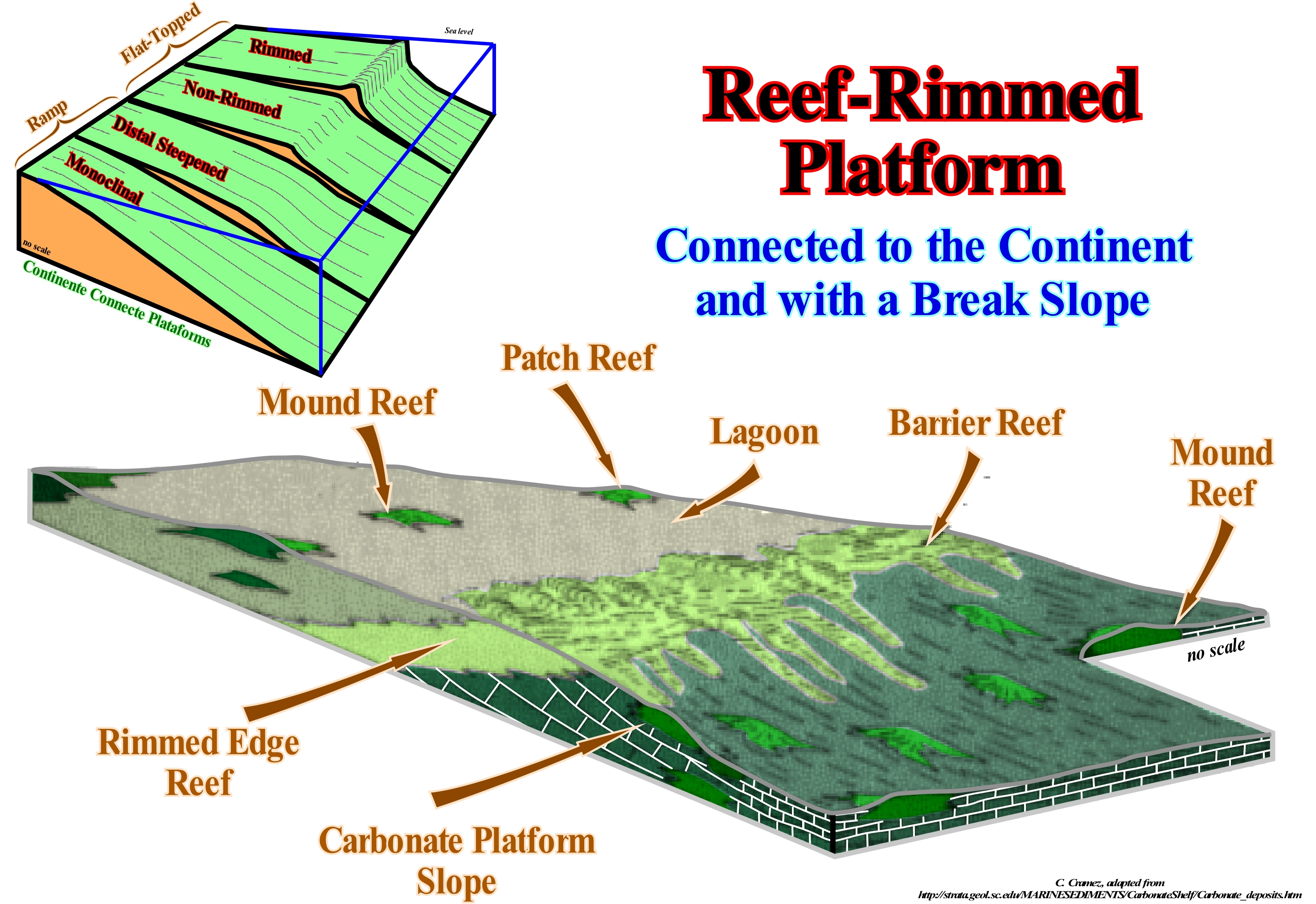
When a geoscientist talks about platform, in general, he/she is referring to the continental shelf, which is the slightly sloping surface of the sea floor, limited between a water slide from 0 to 200 m, which is not the case for a carbonate platform. Theoretically, under normal geological conditions, the depositional water-depth of a limestone platform can not exceed the depth of the photic zone, since without the energy of sunlight there can be no in situ formation of carbonate. Thus, to avoid misunderstandings, it is important to know if the term platform is being applied to a sedimentary context where clastics are predominant or to a carbonated context. Most of the geoscientists consider five main types of carbonate platforms: A) Rimmed Platforms ; B) Carbonate Ramp type Platforms ; C) Epeirial (or epíric) Platforms ; D) Isolated Platforms and E) Dead or Drowned Platforms. Rimmed platforms are characterized by the presence of reefs or calcareous sands of shallow (carbonated sandbank covered by shallow sea water) on the edge of the platform and clay sands in the lagoon or on the open platform. This type of platform forms in calm waters and its extension varies between 10 and 100 km. Ramp type platforms, in which the carbonated sands of the coastline pass, at the base of the ramp, to clay sands and deep-water muds. In this type of platform the reefs are rare and the width of the ramp can reach 100 km. The epeirial (or epíric) platforms are characterized by the presence of tidal surfaces and protected lagoons. The width of an epeiric platform can reach 10,000 km. The isolated platforms, the facies (lithologies) are very controlled by the orientation of the prevailing winds. These platforms have reefs and sandy bodies, such as the rimmed platform, in the windward margin (facing the side where the wind blows), but in the leeward margin (in the direction where the wind blows), the sediments are more muddy. An isolated platform can reach 100 km wide. The dead or drowned platforms are under the photic zone (where there is not sufficient light for photosynthesis, i.e., use of carbon dioxide, CO2, and water to obtain glucose through the energy of sunlight). An rimmed reef platform has characteristics of agitated sea, near the edge and of calm sea, in the lagoon. Where the energy is great, they form of reef, but not exclusively. Organic productivity is particularly important near rising sea currents. The lagoon is generally a low energy environment and its extent depends on how the reefs of the surround dissipate wave energy. If in the lagoon, the energy of the waves is insignificant, the environment is of poor circulation and formation of evaporites in saline can not be excluded. In this sketch, it is easy to verify that a sequence-paracycle of a rimmed reef platform is the lateral association of (1) Lagoon shales, (2) Shallow sands, (3) Barrier reefs and (4) carbonate, i.e., synchronous and genetically associated depositional systems. A vertical association of these sequences, of course, without relative sea level falls between them, forms a rimmed reef platform. The most well known carbonate platform geometry is associated with tropical manufacturing processes, where carbonate platforms can be subdivided into three main sedimentary environments: A) Reef, which is the part of the carbonate platform created in situ by sessile organisms ; B) Internal lagoon (part of the platform behind the reef, which is characterized by shallow and calm waters with sediments composed of fragments of reefs and hard parts of organisms or terrigeneous sediments when the reef is epicontinental) and C) Slope which connects the reef to the basin and acts as a sink for the excess carbonate sediment, although most of the sediment produced in the lagoon and the reef is transported by various processes and accumulated on the slope. The example shown here corresponds to an isolated platform. The platforms connected to the continent are, often, subdivided into two large families: (A) Ramp Type and (B) Top-Flatened Type. In ramp type two subtypes can be considered: (A.1) Monoclinal and (A.2) Distal Steepened. In the Top-Flatened there are also two subtypes: (B.1) Non-rimmed Platforms and (B.2) Rimmed platforms. It is in the subtype, platform with rupture rimmed that the designation of abrupt carbonated platform is more frequent.
Reef Wall..............................................................................................................................................................................................................................Mur de récif
Parede de recife / Pared de arrecife / Riffwand / 礁墙 / Рифовая стена / Muro di scogliera /
Abrupt wall or outer margin of a coral reef (bioconstructed reef, coral and algae, skeletal remains of dead coral and other organisms). The inner margin of a coral reef has a weak slope, which contrasts with the outer wall that sometimes has a platform dug by the waves (reef platform).
See: « Deposition (carbonates) »
&
« Rimmed Carbonate Platform »
&
« Reef »
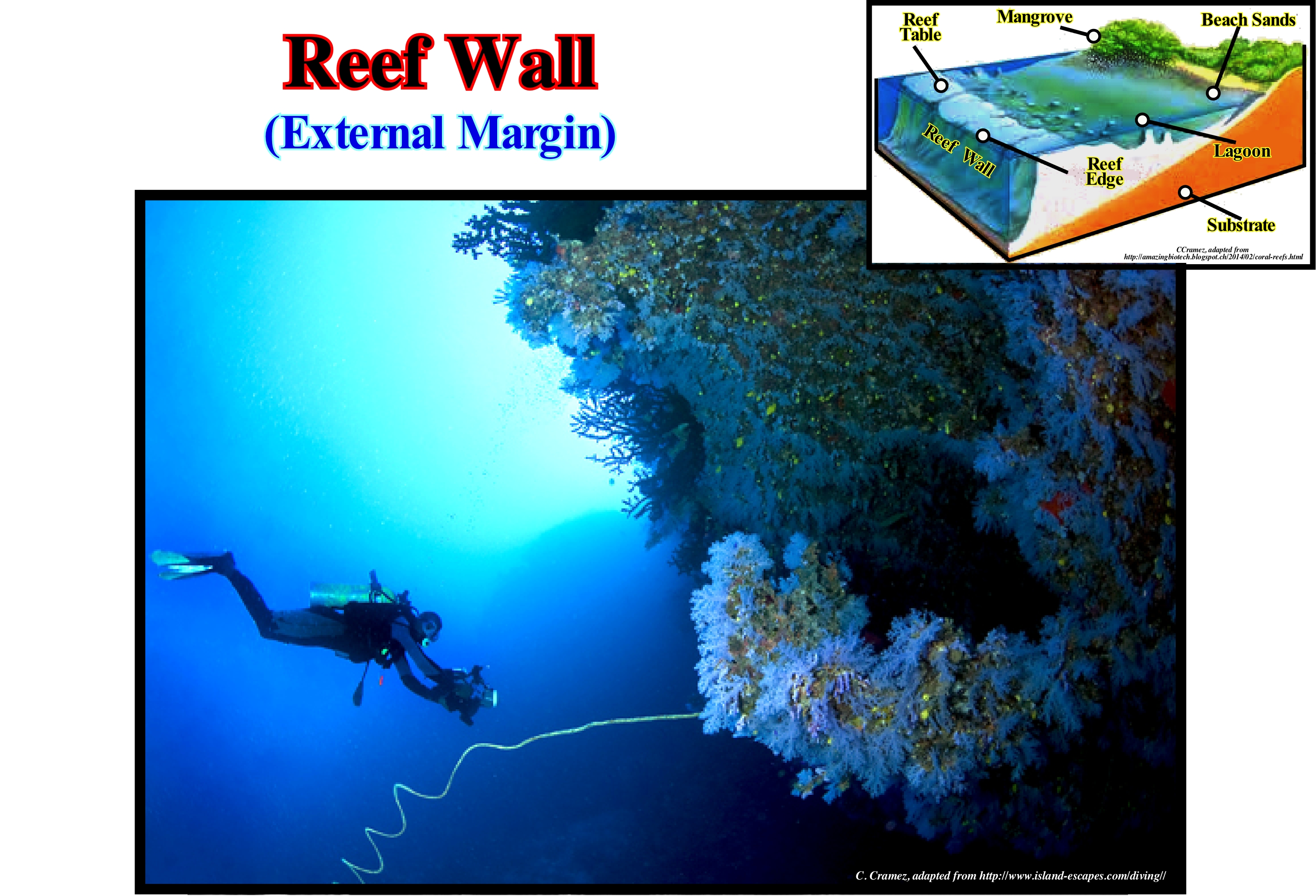
In this photograph, the morphology and dimensions (see scuba divers) of the wall (outer margin) of a coral reef are illustrated. A coral reef is a reefal biogenic limestone bank consisting of the outer skeletons of coral polyps colonies associated with encrusting, calcareous algae, in particular of the genus Lithothamnium and coral limestone debris that the waves accumulate in the reef, all cemented by precipitation calcite (Moreira, 1984). Depending on the shape of the reef and the position it occupies in relation to the substrate, a reef can be considered as: (i) Fringing or Coastal Reef; (ii) Barrier Reef ; (iii) Atoll ; (iv) Tabular Reef, etc. Geoscientists define reefs and associated terms (bioherm, biostrome, carbonate mound, etc.) using the depositional relief, internal structure and biotic composition. There is no consensus on a universally definition of reef. Some geoscientists distinguish reefs from carbonate mounds as follows: (a) Both are considered to be organic-sedimentary varieties of structures, which can be defined as structures constructed by the interaction of organisms and their environments, which have a synoptic emphasis (marked on the ocean charts) and whose biotic compositions differ from those found on or below the surrounding seabed ; (ii) Reefs are supported by a macroscopic skeletal structure (such as coral reefs) ; (iii) Coral and calcareous algae grow on top of both reefs and carbonate mounds and form three-dimensional structures that are modified in various ways by other inorganic organisms and processes ; (iv) Carbonate mounds do not have a macroscopic skeletal structure ; (v) Mounds are constructed by microorganisms and organisms with no skeletal structure ; (vi) Microbial mounds are constructed exclusively or almost by cyanobacteria.
Reflected Refraction.....................................................................................................................................................Réfraction réfléchie
Refracção reflectida / Refracción reflejada (sísmica) / Reflektierte Brechung (seismische) / 反映折射(地震) / Отраженно-преломлённая волна / Rifrazione riflessa (sismica) /
Rectilinear reflection induced by a refracted wave that is reflected along a refractor and back, directly, to the geophone.
See: « Reflection Coefficient »
&
« Acoustical Impedance »
&
« Reflection Seismic »
In certain basins, such as in the North Sea cratonic basin, to avoid mistakes in the interpretation of fault planes, it is of first importance to recognize and differentiate reflected refractions from the reflections associated with the fault planes. In most cases there are no seismic reflectors associated with the plans, except: (i) When they are injected by strong impedance rock materials such as salt, volcanic material, etc. ; (ii) When they put in juxtaposition geological formations with very different acoustic impedances. When there are reflections associated with the fault planes they always became horizontal in depth, i.e., the inclination of the reflections decreases in depth. The reflected refractions are rectilinear reflections (in time and depth). The slope of a reflected refraction is just dependent on the velocity of the seismic waves along the seismic refractor. Any anomaly along the refractor (such as the vertical displacement of an interface) can be a starting point for the return of the seismic waves to the geophone, that is, of a rectilinear reflection with no chronostratigraphic significance. In this auto-trace of a seismic line (detail of a regional line of the North Sea), a reflected refraction (rectilinear in depth), induced by the vertical displacement of the refractor (unconformity) caused by a normal fault is, easily, recognized. In the nonmigrated version of this seismic line, the reflected refraction is tangent to the diffraction hyperboles created by the fault. It can not exist in the back of the hyperboles, since on the front of the hyperboles, the refractor is not at the same depth. This explains why in this line, which is migrated, all other refractions reflected (not visible in this detail) always incline westward. If, at present, most geoscientists know that fault planes (normal or reverse) are horizontalized in depth, since the velocity of intervals increases in depth. In the 1980s and 1990s, it was common to see geoscientists in charge of geological interpreting of the seismic lines to use rolling rulers to delineate the fault planes. Do not forget, that, just, the fault planes of the strike slip faults are vertical.
Reflection Coefficient...................................................................................................................................Coefficiente de réflexion
Coeficiente de reflexão / Coeficiente de reflexión / Reflexionskoeffizient /反射系数 / Коэффициент отражения / Coefficiente di riflessione /
Rate between the amplitude of the reflected wave and the incident wave. The rate between the reflected energy and the incident energy is equal to the square of the reflection coefficient.
See: « Wave Range »
&
« Acoustical Impedance »
&
« Reflection Seismic »
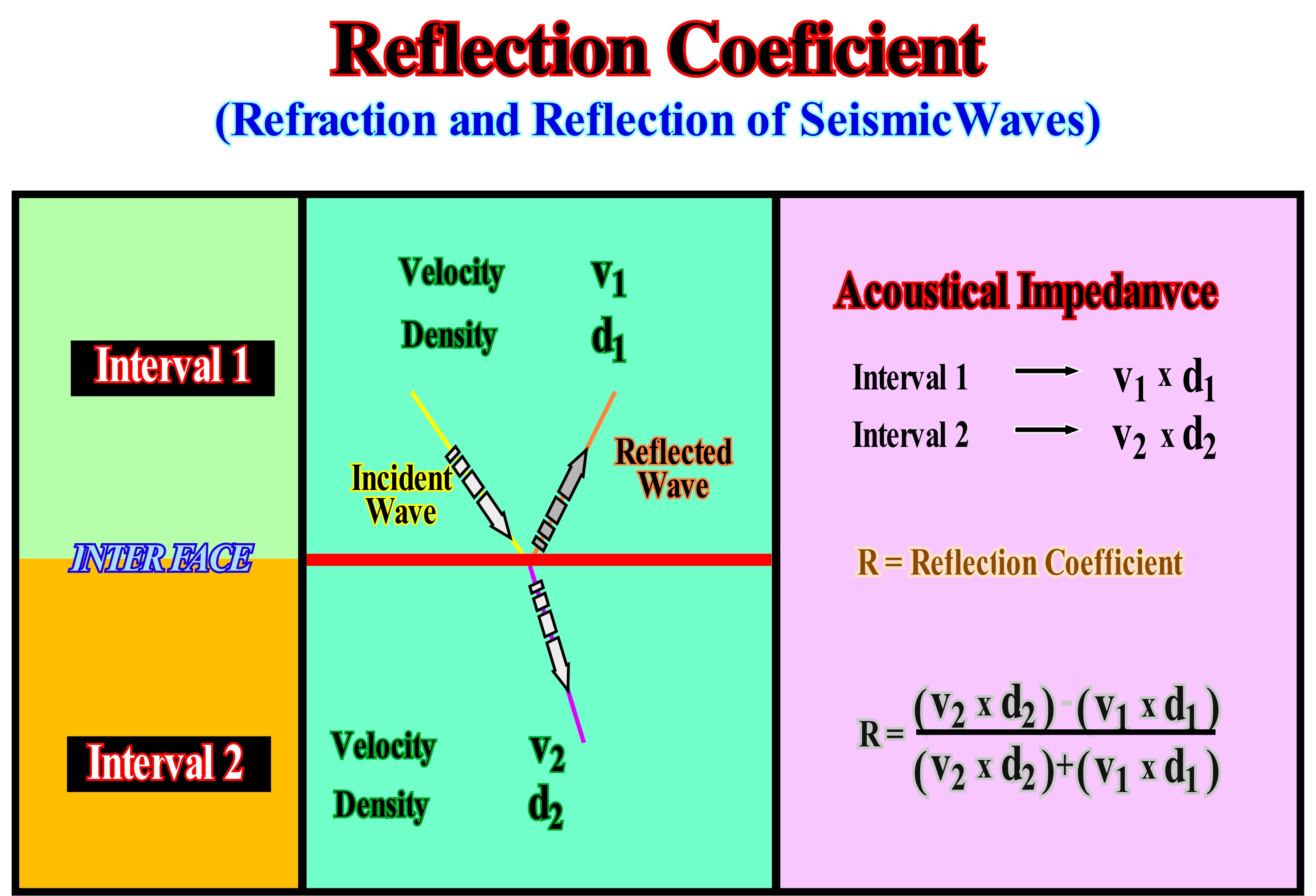
All oblique incident waves are broken in reflected and refracted waves. Assuming two sedimentary intervals with velocities (v1 and v2) and different densities (d1 e d2), i.e., with different acoustic impedances (vi x di), the reflection coefficient is given by the quotient between the difference and the sum of the impedances. On the seismic lines, a reflector translates the reflection coefficient of the sedimentary interfaces. The greater the contrast between the impedances of the two intervals that define the interface, the greater the reflection amplitude. If the upper interval has an impedance lower than that of the lower interval, the amplitude of the reflection is positive. Otherwise, it will be negative. It is rare for the reflection coefficient to remain, more or less, constant over long distances. The impedances of the sedimentary intervals change laterally. A lateral change of the facies (lithology), within a sedimentary interval, implies, necessarily, a lateral change of the acoustic impedance. The amplitude of the reflector associated with an unconformity and, particularly, an angular discordance (tectonically enhanced eustatic unconformity), varies, laterally, and may even change signal, i.e., it can be, in one place, positive and in another negative. In fact, the acoustic impedance profile changes, laterally, due to the sedimentary interfaces defined by the toplaps and onlaps characterizing the unconformity (erosional surface induced by a relative sea level fall). The coefficient of reflection of a sedimentary interface can also change, laterally, as a function of the saturating (oil, gas or water), which fills, completely or partially, the porosity of the sedimentary intervals define the interface. A very interesting example happens in the folded sedimentary intervals forming a trap for the hydrocarbons. If in an anticline trap, the reservoir rock is saturated with gas, the acoustic impedance is, locally, (where there is gas), smaller, which can change the signal of the interface amplitude (between rock-reservoir and sealing-rock) to create an amplitude anomaly.
Reflection Seismic..........................................................................................................................................................Sismique de réflexion
Sísmica de reflexão / Sísmica de reflexión / Reflexionsseismische / 地震反射 / Сейсморазведка методом отражённых волн / Sismica a riflessione /
A geophysical research method that uses the principles of seismology to evaluate the properties of the terrestrial subsurface from the reflected seismic waves. This method relies on the emission of artificial seismic waves on the Earth surface (ground or sea), generated by explosives, air cannons, falling weights or vibrators. Reflected (reflection seismic) and refracted (refraction seismic) waves at the interfaces of the Earth's crust layers return to the surface, where they are recorded.
See: « Reflection Coefficient »
&
« Seismic Line »
&
« Refraction Seismic »
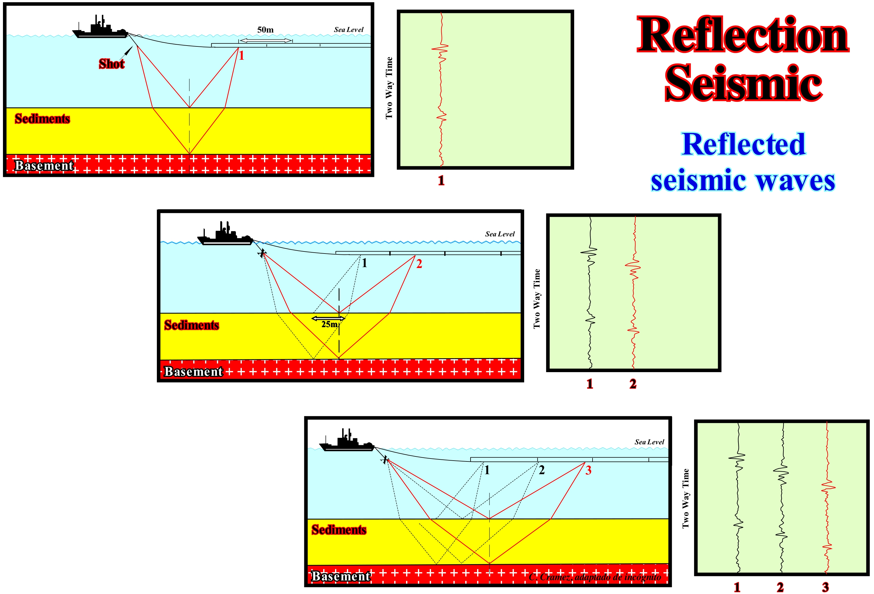
The reflection seismic method requires a source of energy, which can be dynamite / Tovex or vibrators (Vibroseis). The vibrators are large trucks that shake a cushion or vibration plate at a certain frequency. Noting the time, which spends a reflection until reaching a receiver, it is possible to estimate the depth of the interface that generated the reflection. In offshore, seismic acquisition, which is, more or less, the same as on land, is simpler, faster and cheaper. A seismic boat replaced the control and data logging truck. As illustrated in this schematic, the boat shifts the power source and a cable (or streamer) with hydrophones. The same boat can operate with multiple sources of energy, but experience shows that more shots are not necessarily better. The cable with hydrophones may be longer than 8 km, but rarely disturbs fishermen. Currently, seismic vessels operated with three power sources, the signals of which are received by hydrophones positioned on 8/12 cables of about 3 km in length and over a width of about 800 meters. In marine campaigns, dynamite is rarely used as an energy source. In high resolution studies, high frequency waves are used. In oil research under a major water-depth, air gun are often used as an energy source. In these cannons, an air bubble is compressed and discharged into the sea. The discharge emits sufficient energy to generate signals of more than 10 seconds depth (double time), which, depending on the speed with which the seismic waves travel within the different sedimentary intervals, can be equivalent to more than 5 km of depth.
Reflection Configuration...................................................................................................Configuration des réflecteurs
Configuração dos reflectores / Configuración de los reflectores / Reflections Konfiguration / 反思配置 / Рисунок на разрезах MOB / Configurazione di riflessioni /
Geometric relations between seismic reflectors, interpreted as strata responsible for reflections. The geometry of the seismic reflectors can be very varied. The most frequently encountered types in seismic lines are:
1) Convergent - set of seismic reflectors, interpreted as strata, that thin, laterally, basinward. This type of geometry can develop anywhere within a sequence-cycle. It should not be confused with onlappin along unconformities.
2) Divergent - set of seismic reflectors, interpreted as strata, which thicken laterally towards the basin. This variation in thickness is often accompanied by a fission of the reflectors, which should not be interpreted as an unconformity fossilized by onlaps.
3) Filling - set of seismic reflectors, interpreted as strata, that fill negative topographic anomalies of the underlying strata. The underlying reflectors may be truncated or concordant with the filling, which may be classified in relation to the underlying layers or relative to their own geometry.
4) Transparent - absence of seismic reflections, which suggests either homogeneous (non-acoustical impedance contrast) seismic intervals, either non-stratified or very deformed, or even very strong dipping intervals.
5) Wavy - more or less discontinuous set of seismic reflectors, often with opposite slope, interpreted as strata associated with turbiditic deposits, usually submarine slope fans (natural levees and fillings between them).
6) Mounded - set of seismic reflectors, interpreted as strata, that form topographic anomalies or sedimentary protuberances above the base level. This geometry is typical of organic (reef, etc.) and volcanic constructions. It may also be associated with turbidite systemy tracts.
7) Parallel - set of seismic reflectors interpreted as layers deposited in parallel.
8) Progradational - set of seismic reflectors interpreted as strata with a progradational geometry that is sometimes associated with regressive intervals.
9) Oblique-Parallel - set of seismic reflectors with a parallel / oblique pattern, that is to say, set in which the strata end up downstream with a relatively large dip.
10) Oblique-Tangent - in this pattern, the seismic reflectors or associated strata have a decreasing slope baseward.
11) Shingled - as the name suggests, in this configuration, the arrangement of the reflectors or associated strata, is progradational. However, because the sedimentary unit is thin, the progradations are oblique and almost lying down, seeming to take turns one after the other.
12) Sigmoid - In this arrangement, the progradations have a geometry of a S upside down (to the backhand), which means that the slope in the upper and lower parts is relatively small, while in the median it is much higher. The same goes for the thickness. The thickness between two reflectors is maximum at the point of inflection of the progradation.
See:« Stratal Patterns »
&
« Acoustical Impedance »
&
« Reflection Seismic »
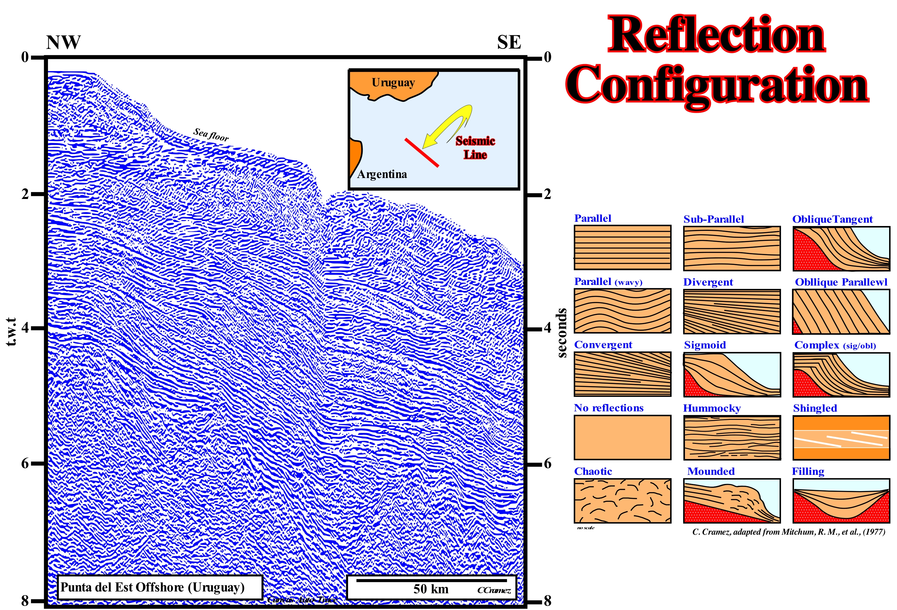
The great majority of the different types of internal configurations found in the seismic intervals can be observed in this Canvas auto-trace of a detail of an Uruguay offshore seismic line: (i) Parallel Configuration, when the seismic reflectors interpreted as strata groups are parallel ; (ii) Subparallel Configuration, when undulations of the reflectors are visible within a parallel internal configuration ; (iii) Tangent Oblique Configuration, when the reflectors have a decreasing dip to the base ; (iv) Parallel Wavy Configuration, when the seismic reflectors are corrugated, but parallel to each other ; (v) Divergent Configuration, when the seismic reflectors thicken, laterally, basinward ; (vi) Parallel Oblique Configuration, when seismic reflectors have a parallel/oblique pattern, that is to say, when they terminate downstream with a relatively important dip ; (vii) Convergent Configuration, when the seismic reflectors, interpreted as strata, thin, laterally, basinward ; (viii) Sigmoid Configuration, when the progrades have a geometry of an S in reverse, that is, when the inclination in the upper and lower parts is, relatively small, while, in the middle part, it is much stronger ; (ix) Sigmoid/Oblique Complex Configuration, which is a particular case of the sigmoid configuration, in which the dip of the middle part of the progradations is very strong and the presence of toplaps by truncation is frequent ; (x) No Reflection Configuration, when there is no reflections, which, generally, means that the seismic intervals are homogeneous (nonstratified), very deformed or dipping strongly ; (xi) Hummocky Configuration, when reflectors form topographical anomalies or sedimentary protuberances above the base level, as in organic and volcanic constructions ; (xii) Shingled Configuration, when the progradations are obliques and almost lying down that take turns one after the others ; (xiii) Chaotic Configuration, when the reflectors are arranged in a disorderly manner ; (xiv) Mounded Configuration, set of nipple-shaped progradations and (xv) Filling Configuration, set of seismic reflectors, interpreted as strata, that fill the negative topographic anomalies of the underlying strata. On the seismic lines, the types of internal configurations of the seismic intervals composed by chronostratigraphic reflectors (the only ones that can be interpreted as sedimentary interfaces) are very varied. Among the extreme cases, which are practically the so-called parallel and chaotic internal configurations, there are a whole series of intermediate configurations. Between a sigmoid (outbuilding with upbuilding) and oblique configuration (outbuilding without upbuilding), whether it is parallel or tangent, several intermediate configurations may exist. Likewise, in a complex configuration, often the sigmoid geometry is preponderant, but other times it is the oblique geometry that is preponderant. The meaning of the different configurations can be interpreted, whether in terms of aggradation (upbuilding) and progradation (outbuilding) or in terms of depositional energy or, even, in terms of sedimentary environment. Thus, for instance, in a sequence-cycle, a mounded or hummocky configuration is, often, associated with submarine slope fans, while a parallel configuration is very frequent either in continental shelves or in deep-water deposits, in particular in submarine basin floor fans. In the same way, it can be said that the progradational configurations, whether complex or sigmoid/oblique, characterize continental slope deposits, which function of the scale, can be interpreted as continental slopes or delta slopes (prodeltas). The height of a delta slope, rarely, exceeds 20-50 meters. A mounded configuration, located near the depositional coastal break (roughly the shoreline) of the deposition surface, coincides whether with continental edge (basin without continental platform or no shelf) or not (basin with a continental platform), corresponds, almost always, to a reef construction. A shingled configuration, when associated with a deep-water interval, may correspond to turbidite deposits on the base of a continental slope induced by turbidity currents, as well as, created by landslides and failures of the sediments composing the basin edge or by failures on the continental slope (lowstand or highstand prograding wedges). This same configuration when associated with platform deposits, corresponds, almost always, to proximal turbidites deposited in the base of the prodeltas, by turbidity currents promoted by delta front failures, when the angle of the delta slope reaches the critical angle. A hummocky configuration, with a gull-wings (in flight) geometry, that is to say, with downlaps in opposite directions, is, always, associated with submarine slope fans. The progradations, that is, the wings, correspond to the turbiditic natural marginal dykes levees), while the depressions between them correspond to the filling deposits that many geoscientists call turbiditic channels.
Reflection Termination..................................................................Terminaison et géométrie d'un réflecteur
Terminação e geometria de um reflector / Terminación y geometría de un reflector / Kündigung und Geometrie eines Reflektors / 反射的终止和几何 / Окончание и геометрия отражателя / Terminazione e la geometria di un riflettore /
As in a seismic line the vast majority of reflectors have a chronostratigraphic value, the termination and geometry of a reflector is practically the same as that of strata. Reflector terminations and geometries allow you to define unconformities and to predict t environments and depositional systems. There is a wide variety of reflector configurations or geometries. Some of them can be subdivided. Thus, for example, a filling configuration may be parallel, divergent, oblique, etc.
See: « Stratal Patterns »
&
« Geometrical Relationship (strata, reflectors) »
&
« Stratal Termination »
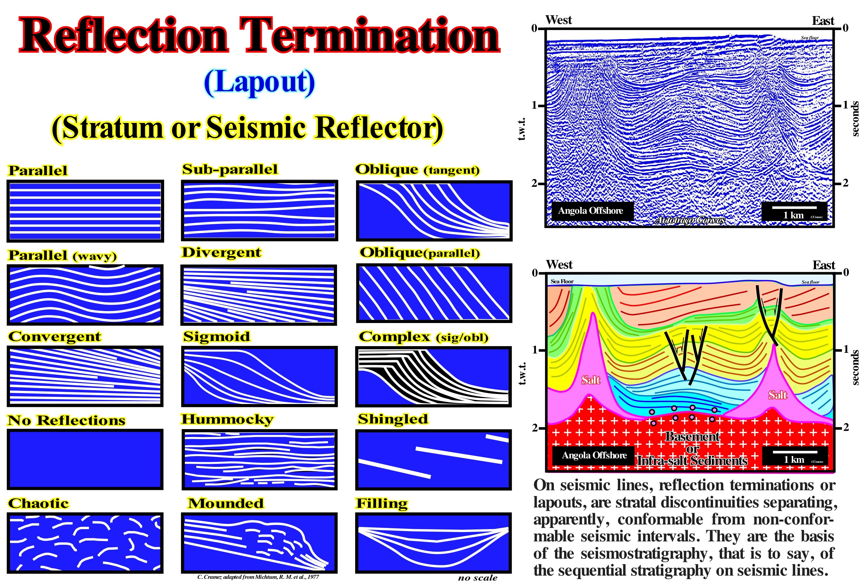
Assuming that in the seismic lines the chronostratigraphic reflectors can be interpreted as groups of strata with petrophysical characteristics and, above all, with similar acoustic impedance. Twelve types of terminations or lapouts can be considered: (1) Convergent, a set of seismic reflectors, interpreted as strata, that thin sideways basinward (can develop anywhere within a stratigraphic cycle, should not be confused with onlaps along unconformities) ; (2) Divergent, set of seismic reflectors, interpreted as strata, thickening, laterally, basinward (often accompanied by a fission of reflectors, which should not be interpreted as a fossilized discordance by onlapping) ; (3) Filling, set of seismic reflectors, interpreted as strata, which fill negative topographic anomalies of the underlying strata (the underlying reflectors may be truncated or concordant with the filling, which may be described in relation to the underlying strata or in relation to their own geometry) ; (4) Transparent or No Reflection cgaracterized by an, absence of seismic reflections, which underlie geological intervals, either very homogeneous (without acoustic impedance contrast), non stratified, very deformed or intervals with strong dip ; (5) Hummocky, more or less, discontinuous seismic reflectors, often with opposing slopes, interpreted as strata, associated with turbidite deposits, generally, with submarine slope fans ; (6) Mounded, when the seismic reflectors interpreted as strata, form topographic anomalies or sedimentary protuberances above the base level (it is the geometry typical of organic and volcanic constructions, but may be found in association with turbidite deposits) ; (7) Parallel, seismic reflectors, interpreted as strata, deposited in parallel ; (8) Progradational, seismic reflectors, interpreted as strata, with a progradational geometry, sometimes, associated with regressive intervals ; (9) Parallel/Oblique, seismic reflectors with a parallel/oblique pattern, in which the strata terminate downstream with a significant dip ; (10) Tangential/Oblique, in this pattern, the strata or associated seismic reflectors, show a decreasing dip to the base ; (11) Shingled, the arrangement of reflectors, or associated strata, is progradational (as the sedimentary unit is thin, the oblique progradations are almost lying down and seem to succeed each other) ; (12) Sigmoid in this pattern, the progradations have a S-geometry upside down (the slope in the upper and lower part is relatively weak, while in the middle it is stronger, the same is the thickness, i.e., the thickness between two successive reflectors is maximum between the inflection points of each reflector). A seismic interval, limited or not by two unconformities (erosional surfaces induced by a significant relative sea level fall) is, generally, composed of several chronostratigraphic reflectors whose geometry defines the internal configuration of the interval. Thus, as for the geometry of the reflectors, geoscientists speak of internal, parallel, sigmoid, oblique, configurations, etc. The interval between two consecutive seismic reflectors never corresponds to a clastic sedimentary bed, however thick it may be. Although in some cases it may correspond to an organic construction. In the same way, it can be said that an interval between two consecutive seismic reflectors, almost always comprises more than a sedimentary systems tracts, and that is why within a sequence-cycle geoscientists spoken of subgroups and groups of sedimentary systems tracts. Indeed, often, between two parallel seismic reflectors, there are small oblique or sigmoid progradations, which show that the interval between the parallel reflectors is a set of sedimentary systems tracts. This is, often, observed in the lower sub-group of highstand systems tracts group, that is, in the transgressive interval (TI), when between two marine ingressions one recognizes progradation within the sequence-paracycle, which underline the seaward displacement of the shoreline to the as the sedimentary particles settle down.
Reflector (Seismic).....................................................................................................................................................................................Réflecteur (Sismique)
Reflector / Reflector (sísmica) / Reflektor (seismische) / 反射镜(地震) / Отражатель (сейсмический) / Riflettore (sismica) /
Contrasting acoustical impedance* interface, according to Snell's law, which corresponds to the seismic energy or signal that returns from the interface. Subsurface profile, created by an acoustical impedance contrast between two sedimentary intervals.
See: « Acoustical Impedance »
&
« Parasite (reflection) »
&
« Reflection Seismic »
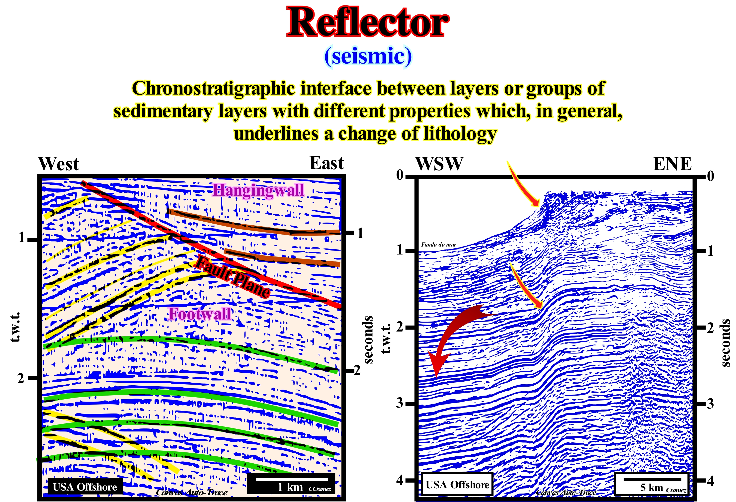
As illustrated on these Canvas auto-traces of USA offshore seismic lines, seismic reflectors may or may not have a chronostratigraphic value. In a well-processed and migrated seismic line, the vast majority of reflectors are chronostratigraphic and correspond to sedimentary interfaces limiting intervals with different acoustic impedances. Seismic reflectors with no chronostratigraphic value correspond to seismic pitfalls (diffraction, multiples, reflected refractions, etc.). These reflectors, when inclined, may correspond to failure planes and when horizontal planes may underlie contact surfaces between hydrocarbons and water (bright spots). Note that in the auto-trace of the right, the geometry of the reflector has no geological meaning. It is, strongly, deformed by the pitfall induced by the abrupt change of the bathymetry. A reflector can be positive or negative. In the first case, according to the convention of the European Society of Geophysicists (SEG), it underlines an interface between two sedimentary intervals, in which the interval with higher acoustic impedance is the lower one. In the second case, it is the upper interval that has the highest acoustic impedance. This means that in the first case, the reflection coefficient is positive and in the second negative. According to the same convention, the polarity of a reflector is positive when the amplitude is expressed by a deflection to the right of the baseline and negative when the deflection is to the left. A positive amplitude is coloured in black and a negative amplitude in white. For symmetrical seismic waves, the amplitude of a seismic reflector is half the orthogonal distance between the crests of the seismic trace. When a seismic wave reaches the Earth's surface, the amplitude of the seismic signal decreases rapidly with time. The range of amplitude variation is very large and, often, more than one million to one. Our eyes can enjoy only a range of width between 1 millimetre and 1 kilometre. However, in the normal seismic lines we can just distinguish amplitudes that vary from 10 to 1, that is, from 0.1 to 1 millimetre. Thus, the amplitudes must be limited within this range, either by automatic processes (dependent on the data) or by purely functional changes.
(*) T he acoustic impedance of a given sedimentary interval is, basically, given by the product of the velocity, at which the seismic waves travel in this interval, by the density of the sediments that compose it.
Refraction Seismic...................................................................................................................................................Sismique de Réfraction
Sísmica de refracção / Sísmica de refracción / Reflexionsseismik / 地震折射 / Сейсморазведка методом преломленных волн / Sismica a rifrazione /
Seismic method based on measurements of the seismic wave travel time, which move in parallel or almost at intervals with high speeds, so that they can be mapped. This type of seismic requires a particular geometrical arrangement of the device in order to favor the recording of the energy of such waves.
See: « Angle of Refraction »
&
« Reflected Refraction »
&
« Reflection Seismic »
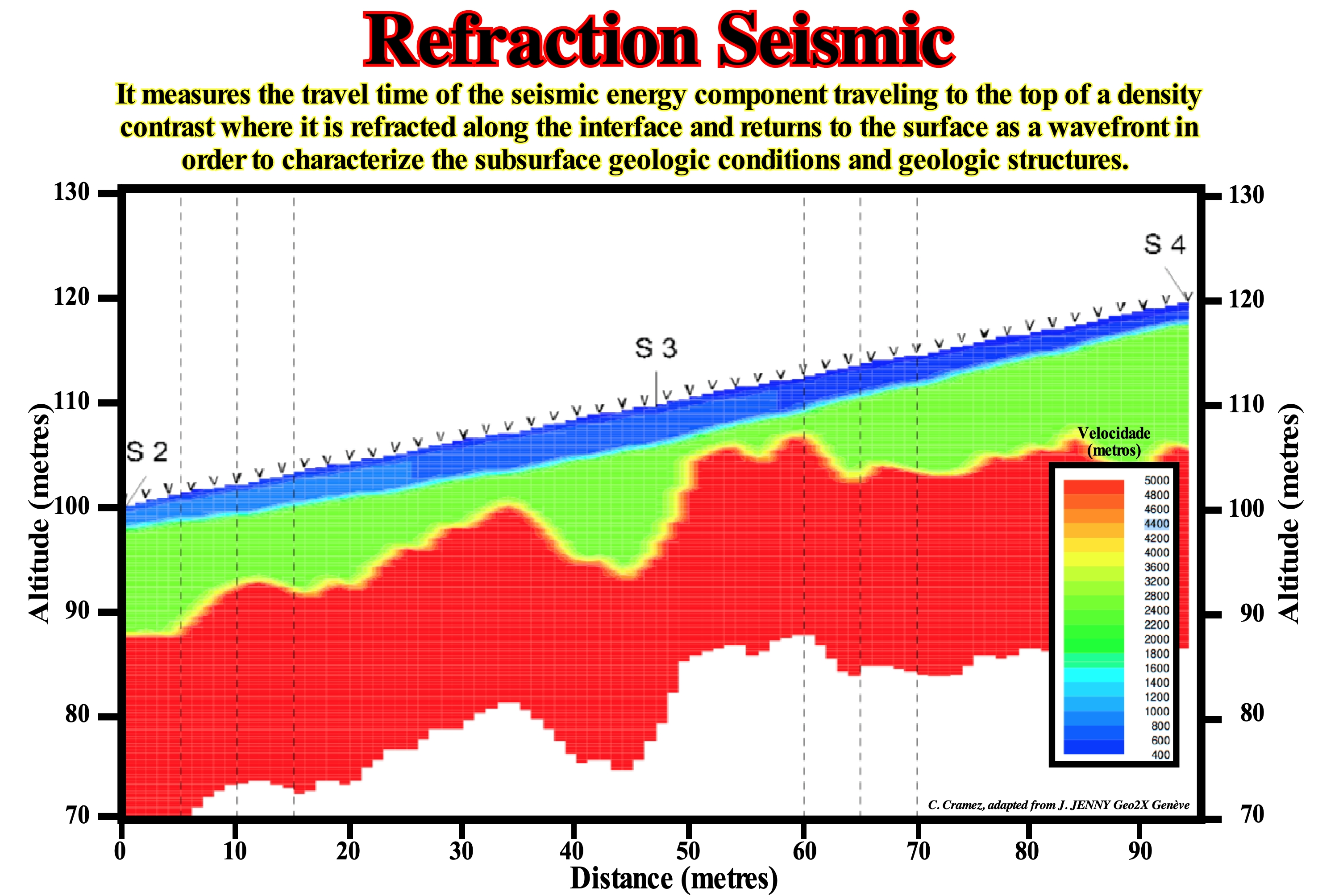
This method is based on the travel-time of refracted seismic waves at the interfaces between intervals. Seismic energy is provided by a surface energy source. In small depth applications, as shown in this figure, the power source may be a drop of a weight, a vibrator or a small explosive charge. Energy radiates from the source and travels travels either, directly, through the upper interval (direct arrival) or downwards and then travels, laterally, along an interface with high speed contrast (refracted arrival) before returning to the surface. When it reaches the surface it is detected in a line of geophones separated from each other by regular intervals. In addition to a certain distance from the shot point (source energy), called the crossover distance, the refracted signal is the first signal to arrive at the geophones (arrives before direct arrival). The travel times of the direct and refracted signals provide indications about the depth of the refractor. The first application of refraction seismic is the determination of the depth and geometry of the substrate. However, because of the seismic velocity dependence of the elasticity and density of the material through which the energy propagates, refraction seismic provides a means of determining the strengths of that material. This technique is, successfully, applied to determine the depth of buried quarry, public discharges and the thickness of the ground cover as well as the topography of groundwater. Refraction seismic is applied only where the seismic velocity of the intervals increases with depth. When a high speed range, such as a shaly interval, is above a lower speed range (such as a sandy interval), the results are, sometimes, incorrect. As said by Christian Hübschera and Karsten Gohlby (2014)*, in principle, seismic data acquisition requires an energy source, a receiver, and a recording system. The two most important seismic methods are reflection and refraction seismology. Reflection seismologists deal, mainly, with steep angle reflections, which means that the source to receiver distance is small compared to the target depth. This method utilizes the fact that a small part of the down-going energy is reflected on geological layer boundaries. The main fraction of the energy is transmitted and travels deeper where reflections occur at the next layer boundary and so on. This method results in a good vertical and horizontal structural resolution of the subsurface. Earth scientists benefit from the technical and methodical developments of the exploration industry which uses reflection seismology for the detection of oil and gas in depths of up to several kilometers below the seafloor. In refraction seismology, seismic waves are recorded that propagate along layer boundaries or as arcuate “diving waves” mainly subhorizontally. This method is either used in engineering geology for near-surface investigations or (the other extreme) to analyse deep crustal structures, the crust–mantle boundary and the upper mantle. Wide angle reflections recorded at large distances between source and receivers are part of this data analysis scheme. Geophysicists often use the abbreviation WARRP (wide-angle reflection/refraction profiling) for these techniques. The main advantage of WARRP is that the inversion procedure directly results in crustal depth sections; its major disadvantage is the relatively low structural resolution.
(*) Christian Hübschera and Karsten Gohlby, 2014- Reflection/refraction Seismology. Encyclopedia of Marine Geosciences. DOI 10.1007/978-94-007-6644-0_128-1# Springer Science+Business Media Dordrecht.
Regolith.............................................................................................................................................................................................................................................Régolithe
Rególito / Regolito / Régolite / 表岩屑 / Реголит / Régolite /
General term to denote all nonconsolidated interval formed of rock fragments.
See: « Erosion »
&
« Moon »
&
« Earth »
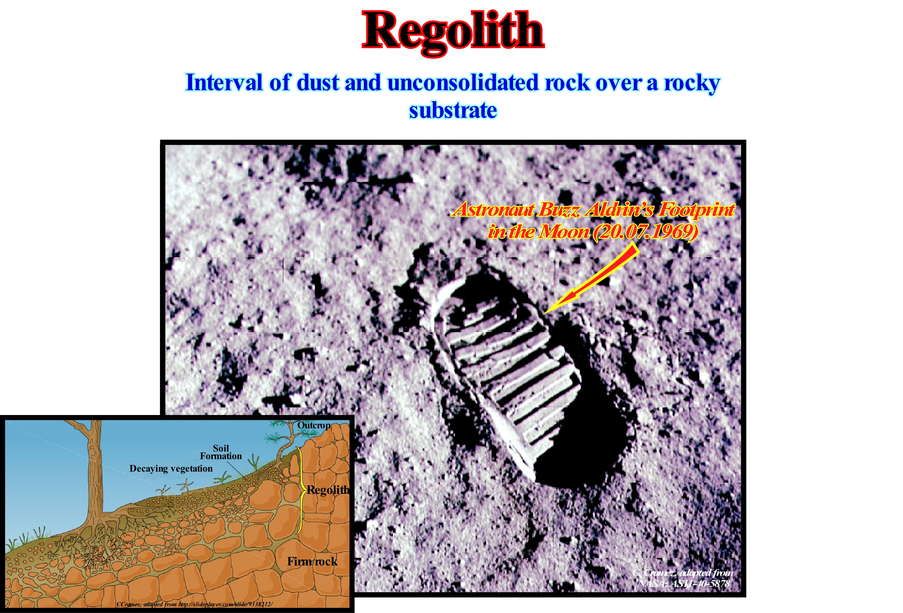
All sedimentary layer unconsolidated to the surface of a planet, that is to say, all the material that, sometimes, covers solid rock is a regolith. As on Earth, the soil is a regolith, the lunar regolith illustrated in this photograph, taken during the Apollo campaign, is, also, sometimes called soil. On this subject, certain geoscientists consider that on the Earth, the regolith, function of the cases, can have several components: (i) Soil or Pedolith ; (ii) Alluvium and Transported Covering, including those transported by wind, glacial, marine and gravitational processes ; (iii) Saprolite, which corresponds to chemically altered rock and which is not transported (the saprolite may be divided into: a) Upper Saprolite, which is, completely, oxidized, b) Lower Saprolite, which corresponds to the rock altered by chemical reduction and c) Fractured Saprolite, which corresponds to the rocky substrate altered just around the fractures) ; (iv) Ashes and Volcanic Lavas ; (v) Hardened Crust, which is formed by soil cementation, saprolite and transported material such as clays, silicates, oxides and oxyhydroxides of iron, carbonates, sulfates, and less common products, in horizons resistant to meteoric alteration and erosion ; (vi) Underground Water and Mineral Salts and finally ; (vii) Biota and Organic Derivatives. The thickness of the regolith varies from zero (when the regolith is absent) to hundreds of meters. Regolith formation may be almost instantaneous (in geological terms), such as the regolith produced by the deposition of volcanic ash during an eruption or may last hundreds of millions of years (Precambrian regoliths are known in various parts of Australia). The regolith is formed, mainly, by meteorological alteration or biological processes. Many mineral deposits are hosted in the regolith, such as mineral sands, uranium calcretes (pedogenic carbonate nodules), lateritic deposits, etc. When the regolith contains a significant percentage of biological components, it is, usually, called soil. On the terrestrial surface, the presence of regolith is one of the most important conditions for the development of life. Few plants can grow, directly, on or within the rocky substratum. Without regolith bioperforation is impossible, and thus many animals would die for lack of shelter to protect themselves from predators.
Regradation..................................................................................................................................................................................................................Régradation
Regradação / Regradación / Regradation / 再沉积 / Понижение поверхностисуши вследствие эрозии / Regradation /
Formation of a new provisional equilibrium profile of a stream, usually, a river, when the initial provisional profile, after gradation, was deformed by tectonic movements or by the climate. The gradation gives the stream bed a slope such that the water is only capable of carrying the material it contains.
See: « Transgressive Interval »
&
« Progradation »
&
« Retrogradation »
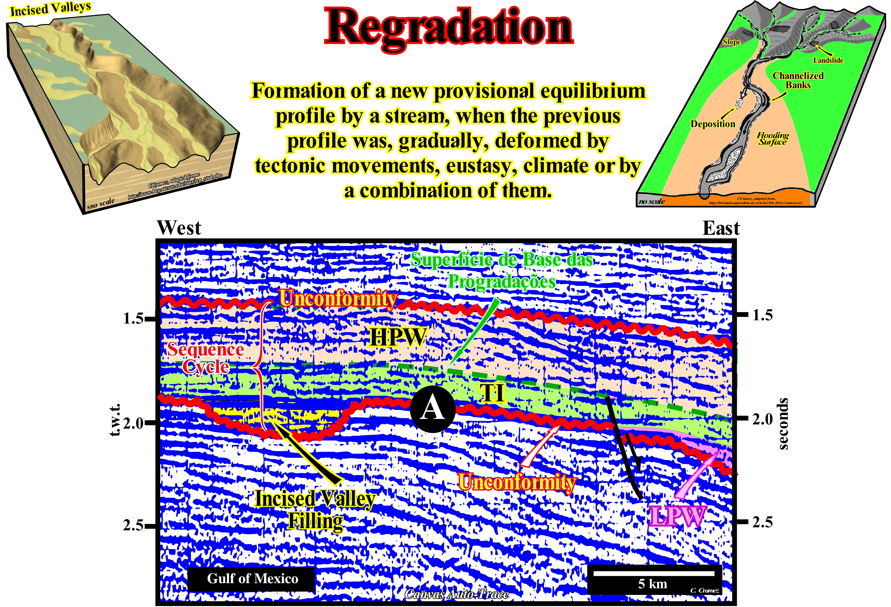
The rivers carry almost all the water that falls on the continents to the sea. They, generally, follow the line of greatest inclination, since their flows obey the law of gravity (any two particles of the Universe are attracted by a force that is, directly, proportional to the product of their mass and inversely proportional to the square of the distance that separates them). When at each point in the longitudinal river profile (a line joining the altitudes of its bed along its entire length from the source to the mouth), it has an equilibrium slope, that is, when the river neither deposit nor incised its bed, in a significant way, which is not the case in the sketch illustrated in this one, it is said that river reached its provisional equilibrium profile. Under these conditions, the slope of the river, throughout its course, allows it only to evacuate its load. Such a profile is not definitive. The river continues to transport sediments, which are eroded upstream. However, it can be imagined that from a certain moment, the inclination of the river is such that it only allows the water to flow and that all the sedimentary transport has disappeared. In this case, the river has reached what can be called its definitive or ideal equilibrium profile. When a significant fall of the relative sea level* occurs, the river mouths are shifted seaward, which breaks the provisional equilibrium profile of the rivers. They will be obliged to incised their beds (regradation) forming incised valleys until a new provisional equilibrium profile is reached. On this Canvas auto-trace of a detail of a Gulf of Mexico seismic line, the depression of unconformity A corresponds to an incised valley made by the river to establish a new provisional equilibrium profile, since it had been broken by the relative sea level fall responsible of the erosion surface that emphasizes unconformity (A). Later, when the sea level began to rise, above the submarine basin floor fans (SBFF), which were deposited during the relative the sea level fall, the submarine slope fans were deposited under lowstand geological conditions and the lowstand prograding wedge (LPW). Submarine slope fans and most part of the lowstand prograding wedge (LPW) are not visible on this auto-trace. They are, easily, recognized on the complete original seismic line. The filling of the incised valley was done during the terminal phase of the lowstand prograding wedge (LPW), which is just visible on this tentative interpretation (coloured interval in violet, at the eastern end of this autotrace, just above the unconformity A). Before the relative sea level flooded the coastal plain of the preceding sequence-cycle, the incised valley was already flooded. It is, topographically, lower than the last coastal plain of the previous sequence-cycle (when it is complete). The filling of the incised valley ends with the ravinment surface created by the 1st eustatic cycle of the transgressive interval (TI) of the sequence-cyle, which corresponds to a marine ingression in acceleration (more important than the preceding). This marine ingression, which shifted the shoreline to the mainland, slightly ravines the erosional surface responsible for the unconformity, which means that the lowstand prograding wedge (GNP) edge is located farther east than this area. On the other hand, it has begun the formation of a platform that will increase as the new marine ingression accelerates. After each marine ingression, there is a stability period of relative sea level during which the shoreline moves seaward, as the sedimentary particles settle down, creating a sedimentary regression that characterizes, what in sequential stratigraphy is called a sequence- paracycle, that it is bounded by a new flooding surface (new marine ingression more important than the previous one) and not by a relative sea level fall, i.e., by an unconformity. A marine ingression is rarely simple, i.e., just formed by a single sequence-paracycle. In general, they are composed, that is to say, induced by a succession of relative sea level rises, which may be in acceleration or deceleration.
(*) Sea level, local, referenced to any fixed point on the Earth's surface, which can be, for instance, the base of the sediments or the sea floor and which is the result of the combined action of the tectonics and the absolute or eustatic sea level, which is supposed to be global, and referenced to the Earth's centre.
Reinforced Unconformity (Enhanced, angular)........................................................Discordância reforçada
Discordância reforçada / Discordancia reforzada / Verbesserte Diskordanz / 不一致增强 / Увеличенное несогласие / Discordanza rinforzata /
Unconformity, locally, enhanced by tectonics. Outside of the region, tectonically active, an enhanced unconformity (angular unconformity) passes, laterally, to a paraconformity, which underlines the erosional surface (unconformity) induced by the combination of eustasy and tectonics (subsidence or uplift of sea floor) that limits a stratigraphic cycle in shallower parts of the basin (coastal plain, platform and upper continental slope). Evidence of the erosional surface is local and suggested by the filling of incised valleys and submarine canyons, as well as by the seaward and downward displacement of the coastal onlaps. Most geoscientists consider eustasy (absolute or eustatic sea level change) to be the main cause of unconformities, since eustatic changes have a high frequency and small amplitude, whereas tectonic changes have a small frequency and a strong amplitude.
See: « Unconformity »
&
« Angular Unconformity »
&
« Truncation »
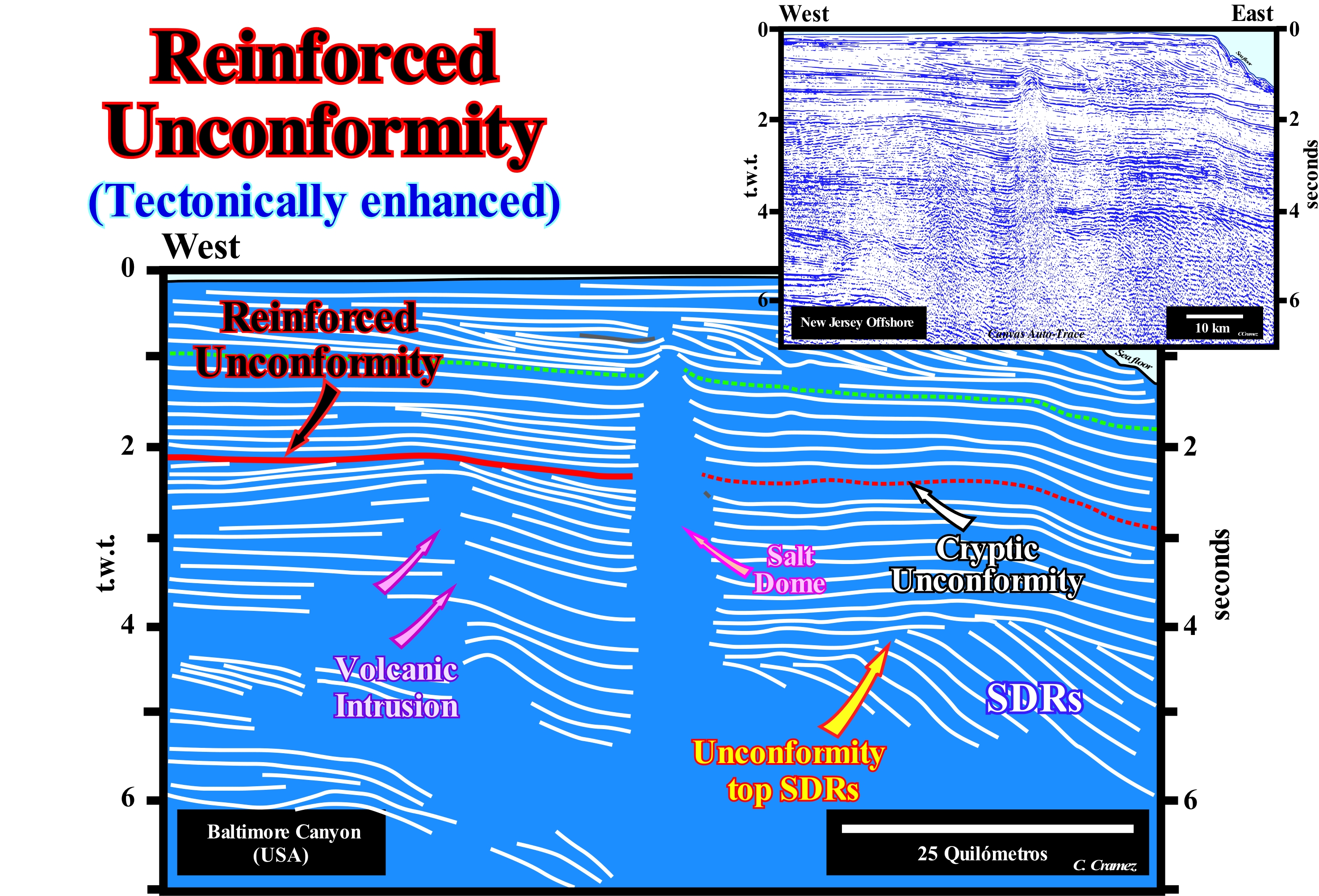
The East offshore of the United States and, particularly, the New Jersey offshore, which emphasizes the opening of the Atlantic Ocean, is constituted by the stacking of different basins from the classification of the sedimentary basins of Bally and Snelson (1980). In general, on the regional seismic lines, from the bottom to top, geoscientists recognize: (i) A Basement, that corresponds, most often, to a, more or less, flattened Paleozoic (Appalachian) mountain range, which emphasizes the Pangea supercontinent ; (ii) Triassic rift-type basins, which formed during the lengthening of the Pangea supercontinent, i.e., they predate the breakup of the lithosphere, which is here underlined by a series of thick lava flows* ; (iii) A Mesozoic/Cenozoic divergent Atlantic-type margin. On this tentative geological interpretation a Canvas auto-trace of a regional seismic line of the New Jersey offshore, it is easy to conjecture that an unconformity (in red), i.e., an erosional surface induced by a significant fall of the relative sea level (local sea level referenced to any point on the land surface, which may be the sea floor or the base of the sediments) resulting from the combined action of absolute (eustatic ) sea level and tectonic variations (subsidence or uplift of the sea floor), was, locally, tectonically enhanced by a volcanic intrusion. In the right part of this tentative interpretation, at about 2.2 seconds depth (double time), this angular unconformity is, easily, recognized by the reflector terminations (toplaps by truncation) of the underlying sediments. Later, this same tectonically enhanced unconformity (in this case by a local extensional tectonic regime created by the implementation of a volcanic intrusion) becomes a cryptic discordance, in which the erosional surface is not evident, especially eastward of the salt dome. The correlation between these two unconformities is corroborated by other seismic lines in the area that are not influenced by the volcanic intrusion and by the salt intrusion (salt dome**). We recall the presence of an important magnetic anomaly and the results of the petroleum exploration wells drilled, in this region, that corroborate the presence of volcanic intrusion, which deformed, i.e., lengthened the surrounding sediments, creating an angular unconformity (tectonically enhanced unconformity discordance). Excluding the folded belts and foreland basins, where compressional tectonic regimes may be predominant, unconformities (stratigraphic cycle boundaries) are considered in sequential stratigraphy as induced by significant relative sea level falls, in which eustasy (variations of the absolute or eustatic sea level, which is the global sea level referenced to the Earth's centre) plays the leading role. The eustasy *** is responsible for cyclicity of depositional systems, while the subsidence is, mainly, responsible for the amount of space available for sediment created by a relative sea level rise. The explanation, often, advanced by geoscientists is that the rate of eustatic variations is, generally, much faster than the rate of tectonic variations. Another tectonically enhanced unconformity is, easily, recognized in the eastern part of this tentative interpretation, around 4.0 seconds depth (t.w.t, i.e., double time). This unconformity, which corresponds to the top of the SDRs (Seaward Dipping Reflectors), that is, to the top of the subaerial lavas, whose implementation follows, immediately, the breakup of the lithosphere of the Pangea supercontinent. This unconformity underlines the passage from a subaerial to an oceanic crust, or in other words the passage subaerial lava flows to pillow-lavas and sheeted dykes. The tectonic reinforcement of the unconformity is caused by the seaward tilting sea of the volcanic flows, initially sub-horizontal and thinning continentward, due to the overloading of the more recent lava flows.
(*) This is a pleonasm, since a lava spill is necessarily subaerial: the volcanic material does not flow under water. However, it allows more emphasis to be given to the breakup of the supercontinent due to an excess of intrusive material in a relatively thin lithosphere, which ends up being torn individualizing two new lithosphere plates and allowing the implementation of the lava flow. The lateral accretion of the lithospheric plates produced by successive volcanic flows, progressively, submerges the expansion centres (volcanoes), inducing the formation of the oceanic crust in which the pillow lavas are predominant.
(**) Imprecise term for a domal upwelling comprising a salt core, which may or may not be diapiric (i.e. discordant), and an envelope of deformed overburden.
(***) The absolute or eustatic sea level is dependent on: (i) Tectono-Eustasy that is controlled by the volume variation of the ocean basins ; (ii) Glacio-Eustasy, which is controlled by the variation of ocean water volume as a function of the amount of ice ; (iii) Geoidal-Eustasy, which is controlled by the distribution of ocean water caused by variations in the terrestrial gravity field, and (iv) Thermal expansion of the oceans or steric sea level rise (if the temperature of the oceans increases, the water density decreases and , for a constant mass, the volume increases).
Relative Age.......................................................................................................................................................................................................................Âge relatif
Idade relativa / Edad relativa / Relative alter / 相对年龄 / относительный возраст / Età relativa /
Approximate age of rocks, fossils or minerals, determined by comparison, i.e., whether they are younger or older than the surrounding ones.
See: « Geological Time »
&
« Biostratigraphy »
&
« Geological Time Scale »
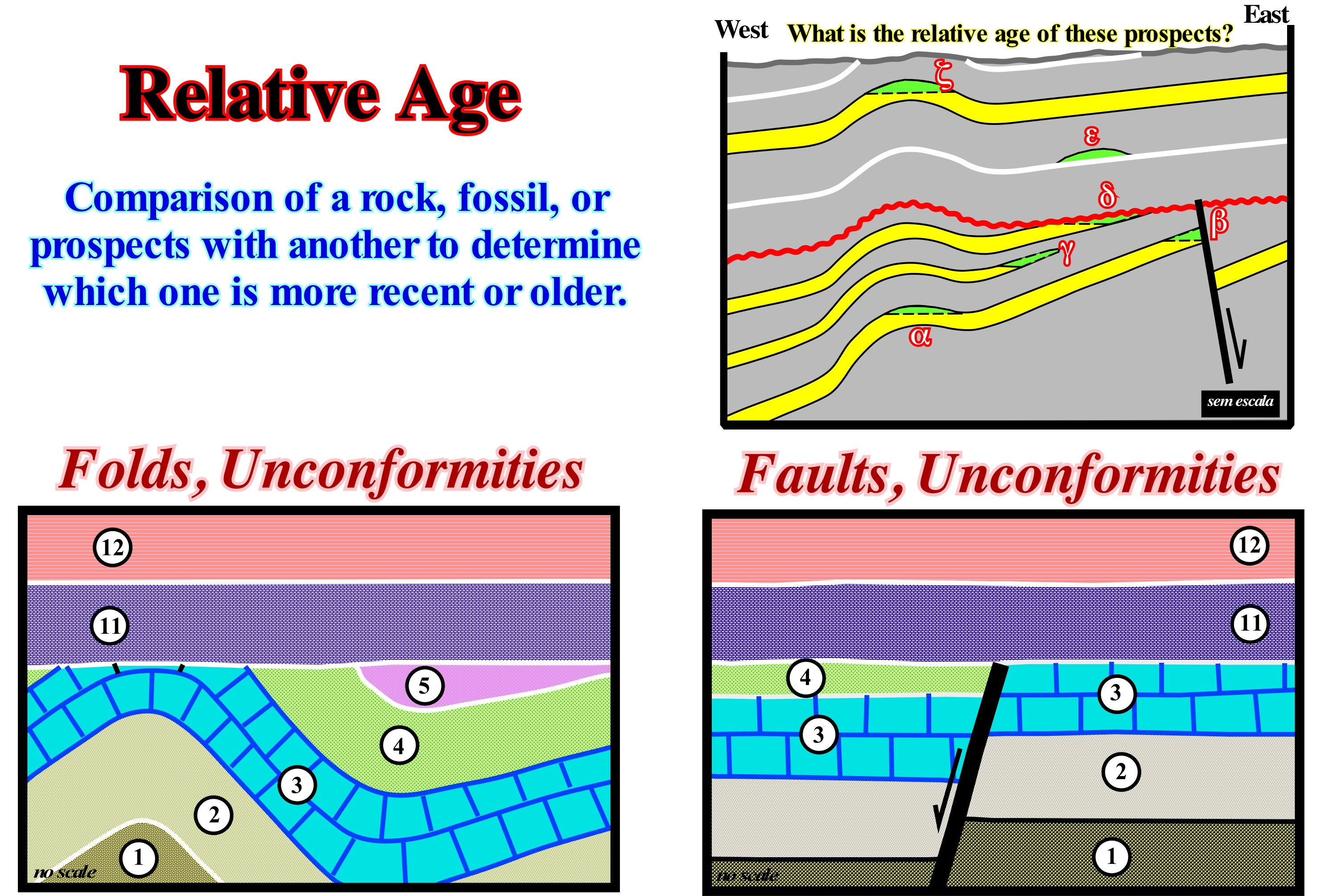
At present time, the relative age of rocks or fossils is for most geoscientists an evidence. Two hundred years ago, this concept was one of the great discoveries of Geology. The real geological time represented by a layer is unknown or a matter of opinion. Any depositional rate can be determined accurately. Relative age is estimated from stratigraphic and structural relationships, such as the overlap or type of fossils, since the relative ages and the fossils successions have long been determined by paleontologists. Measures of radioactive isotopes disintegration, such as uranium, rubidium, argon and carbon, which have enabled geoscientists to accurately determine the age, in years, of geological formations are known as absolute age determinations. Although these determinations are known as absolute, it must be remembered that they imply a potential error (method error) and therefore, they are not exact. On the contrary, certain, relatively, recent seasonal accumulations, such as varves*, can be counted and thus give the absolute age of accumulation. In this figure two examples, from the same basin, of determination of relative ages are illustrated. In the first one, there is a unconformity (erosional surface) induced by a significant relative sea level fall that was, locally, tectonically enhanced (angular unconformity, as certain geoscientists say). In the second, the erosional surface induced by the significant relative sea level fall, flattened a sedimentary interval that was deformed by an extensional tectonic regime that lengthened the sediments by normal faulting. Later, a relative sea level rise allowed the deposition of the sedimentary series (11 and 12) that fossilized the pre-unconformity intervals (1, 2, 3, 4, 5, etc.). In both examples, the interval 11 is older than the interval 12 and more recent than the interval 5, in the first example, and that the interval 4 in the second example. The relative age of the unconformity is between 5 and 11, for the first example and between 4 and 11 for the second. In fact, the relative age of unconformity may be 10 or 8. It all depends on the geoscientist knowledge of the region. In fact, when a geoscientist says that the age of an unconformity is 65 Ma, for instance, it is because he knows the age the submarine basin floor fans (SBFF) associated with this unconformity is 65 Ma, that is, the geological time of the minimum hiatus between the underlying and overlying sediments to the unconformity or to its correlative paraconformity in deep-water (the hiatus corresponds to the geological time of the strata that were removed rather than the time at which erosion occurred). Similarly, if a geoscientists says that in the sketches illustrated above the unconformity have an age 8, for instance, he is saying, that the age of the submarine basin floor fans associated with the fall of relative sea level**, that induced the responsible erosional surface of the unconformity 8. This age suggests, in relative way, that in the region concerned, the age of the minimum hiatus between the underlying sediments and overlying is 8. Within a sequence-cycle, the relative age of the submarine basin floor fans is given by the age of the pelagic shales that form within a turbidite lobe the layer E, in the Bouma's terminology. In fact, a turbiditic lobe consists of a sandy bed with a large lateral continuity, coarsening upwards, with ripple marks, base marks, turboglyphs and marks of objects and a pelagic shale layer (bed E of Bouma) , deposited as a single event, in which the energy variations of the gravitational flow give the layer typical features. The typical Bouma sequence of a turbidite lobe begins with: 1) Bed A, with an abrupt base and thickness of the order of the decimetres, of thick coarse to medium coarsening upwards sandstone ; 2) Bed B of sandstone with plane-parallel lamination ; 3) Bed C characterized by the presence of cross laminations of increasing dips upwards ; 4) Bed D formed by silts with parallel laminations associated with turbidite flow and 5) Bed E formed by pelagic shales.
(*) Each of the small-thickness sedimentary beds deposited seasonally at the bottom of the lakes, which have a typical lamellar structure with alternating sediments of sandy or light-coloured silts deposited in the summer, and dark silty sediments deposited in the winter. When the lake is of the glacial type, the varves are called glacial-lacustrine.
(**) Local sea level, referred to any point on the Earth's surface, which can be the sea floor or the base of the sediments and which is the result of the combined action of the tectonics and the absolute or eustatic sea level (supposed to be global and referenced to the Earth's centre).
Relative Sea Level...................................................................................................................................................Niveau de la mer relatif
Nível do mar relativo / Nivel relativo del mar / Relativer Meeresspiegel / 海平面 / Относительный уровень моря / Relativo livello del mare /
Sea level referenced to any point on the land surface whether it be the top of the continental crust (base of sediments) or the sea floor and which is the result of the combined action of the absolute or eustatic sea level (supposed global and referenced to the Earth's center) and tectonics (subsidence or uplift of the sea floor). Synonym with Absolute or Eustatic Sea Level.
See: « Major Storm Wave Base »
Relative Change of Sea Level................................................Changement du niveau de la mer relatif
Mudança do nível do mar relativo / Cambio relativo del nivel del mar / Relative Veränderung des Meeresspiegels / 相对海平面变化 / Относительное изменение уровня моря / Variazione relativa del livello del mare /
Change of sea level, local, referenced to the base of the sediments (top of the continental crust) or to the sea floor, which is the result of the joint action of absolute or eustatic sea level (supposed global and referenced to the Earth's center) and tectonics (uplift or subsidence of the sea floor).
See: « Eustasy »
&
« Subsidence »
&
« Space Available for Sediments (accommodation) »
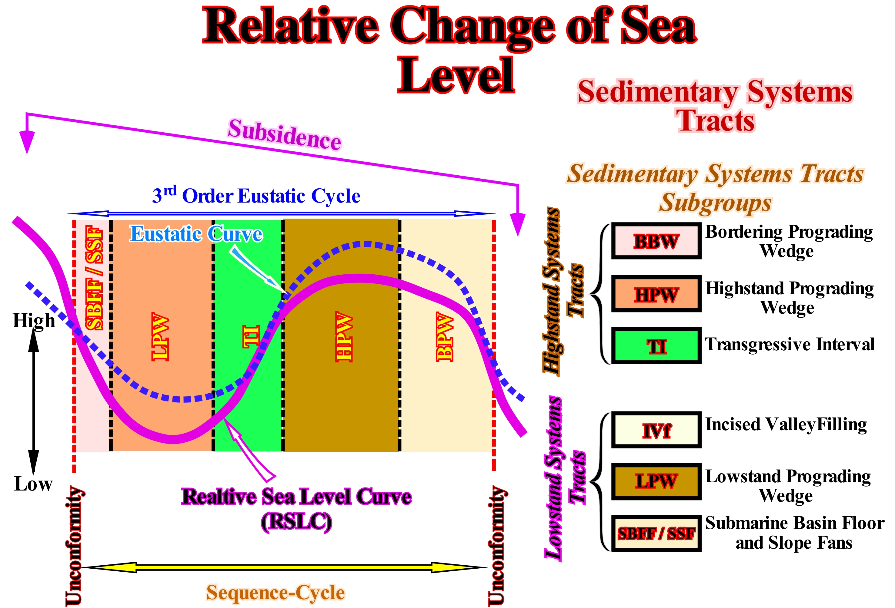
The curve variation of the relative sea level (local sea level, referenced to the baase of the sediments or to the sea floor) are the result of a combined action of the eustatic curve (absolute or eustatic sea level, which is supposerd to be global and referenced to the Earth's cemntre) and tectonics (subsidence of the sea floor, when the prevailing tectonic regime is extensional or uplift, when it is compressional). As shown in this figure, the relative sea level variations curve is a sinusoidal wave (wave sine or sine wave), in which each eustatic cycle is bounded between two consecutive downward inflection points. In mathematics, a sinusoidal curve represents, graphically, the sine function and also the function itself, that is, the relative sea level change. Thus, when the function is increasing and concave, at each point, the 1st derivative* and the 2nd derivative (derived from the derivative) are positive. When the function is increasing and convex the 1st derivative is positive, but the 2nd derivative is negative, that is to say, that since the function grows but less rapidly, the derivative of the derivative changes signal. When the function is decreasing and concave the derivative is negative, but the second is positive. Finally, when the function is decreasing and convex the 1st and 2nd derivatives are negative. The limits of the eustatic and stratigraphic cycles are limited by the points where the rate of relative sea level fall is maximum (points where the 1st derivative of the curve is maximum, i.e., where the slope of the function is maximum). As shown, within a stratigraphic cycle said sequence-cycle (stratigraphic cycle associated with a 3rd order eustatic cycle, which is characterized by a time-duration between 0.5 and 3-5 My) deposit two groups of sedimentary systems tracts (lateral association of contemporaneous and genetically linked depositional systems), each of which forms a stratigraphic paracycle or sequence-paracycle). From bottom to top, these groups of sedimentary systems tracts are: (i) Lowstand systems tracts group (LSTG) and (ii) Highstand systems tracts group level (LSTG). The lowstand systems tracts group (LSTG) is composed of three sub-groups which, from the bottom up, are: (a) Submarine basin floor fans (SBFF), characterized by a general planar geometry ; (b) Submarine slope fans (SSF), generally, characterized by a wavy geometry ("Gull Wings") ; (c) Lowstand prograding wedge (LPW), characterized by a progradational geometry. The highstand systems tracts group (LSTG) group is composed of two sub.groups: (a) Transgressive interval (TI), characterized by a global retrogradational geometry and (b) Highstand prograding wedge (HPW), characterized as the lowstand prograding wedge by a prograding geometry. In a curve of relative sea level change, the unconformities correspond to the points where the rate of the relative sea level fall is maximum. During the period of relative sea-level fall, submarine basin floor fans (SBFF) and submarine slope fans (SSF) are deposited. The first ones deposit when the rate relative sea level fall is the strongest, while the second are deposited when the rate relative sea level fall begins to slow down. The lowstand prograding wedge (LPW) deposits when the rate of relative sea level fall is in deceleration and even when it begins to rise. The transgressive interval (TI) of the highstand systems tracts group is deposited when the relative sea level rise is in acceleration, whereas the highstand prograding wedge (HPW) is deposited when the relative sea rise is in deceleration and, even, when it starts to falls. The bordering prograding wedge (BBW) is deposited during slow relative sea level falls, which did not put the sea level lower than the basin edge. At present, however, most geoscientists prefer to speak of forced regressions (seaward displacement of the shoreline within a sequence-cycle, when the relative sea level falls, and when the position of the upper limit of the sequence-cycle is difficult to locate). The bordering prograding wedge fell into disuse. Upstream of the continental edge, to have deposition the relative sea level has to rise, since the space available for the sediments (accommodation) must increase. Just the submarine fans (SBFF and SSF) and, particularly, teh submarine basin flloor fans (SBFF) are deposited during significant relative sea level falls, when the platform and the top of the continental slope are exhumed.
(*) The derivative is a the rate. So the speed of an automobile is the rate between the distance it has traveled and the time it took to travel that distance. The acceleration of an automobile is also a rate between the speed variation and the time of that variation, that is, a rate of a rate (second derivative).
Relative Sea Level Change...........................................................Changement du niveau de la mer relatif
Variação do nível do mar relativo / Variación relativa (del nivel del mar) / Relative Änderung (Meeresspiegel) / 相对变化(海平面)/ Относительное изменение (уровня моря) / Variazione absoluta (livello del mare)/
Variation of the relative sea level, which is the local sea level, referenced to any point on the Earth's surface, whether it is the base of the sediments (top of the continental crust) or the seabed and which is the result of the combined action of the absolute or eustatic sea level and the tectonics (subsidenceof uplift of the seafloor). The absolute ou eustatic sea level, is the global sea level, referenced to the Earth's center or to a satellite. The absolute sea level depends on: (i) Tectono-Eustasy ; (ii) Glacio-Eustasy ; (iii) Geoidal- Eustasy and (iv) Steric increase in sea level or thermal expansion of the oceans.
See: « Aggradation »
&
« Space Available for Sediments (accommodation) »
&
« Eustasy »
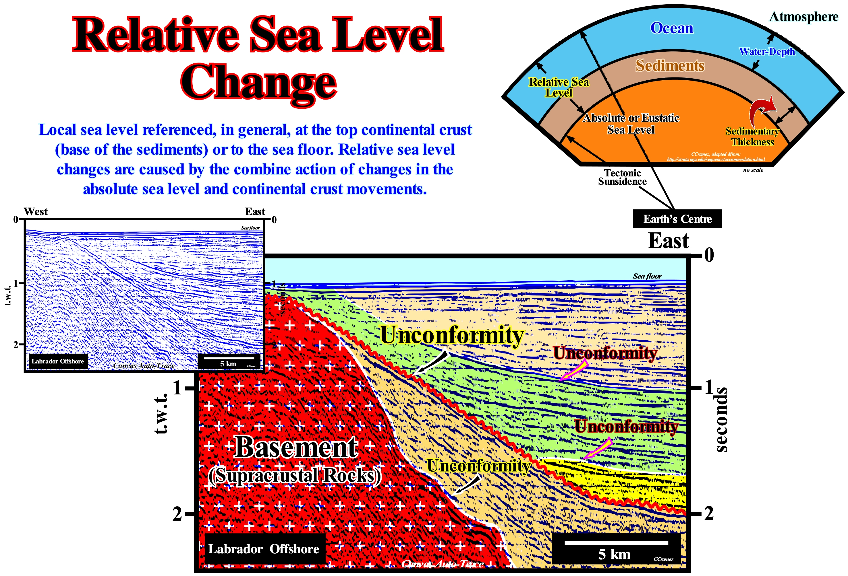
Although global sea level fluctuations result, largely, from the growth or melting (partial or total) of glaciers and ice caps*, as well as changes in the volume of ocean basins (configuration of the continental margins and ocean floor), there are also a series of regional geological processes that can change the positions of the relative sea level, which affect the position of the shoreline in a given area. These regional processes include: (i) Thermal expansion of ocean water (steric sea level rise) ; (ii) Variations in the melt water load ; (iii) Isostatic readjustment ; (iv) Uplift or subsidence of coastal areas induced by different tectonic and anthropogenic processes ; (v) Compensatory subsidence (i.e., lateral flow of mobile stratigraphic intervals) ; (vi) Sedimentary load ; (vii) Compaction, etc. Relative changes in sea level may also result from geodetic variations such as fluctuations in the Earth's angular velocity or polar traction (geological phenomenon caused by changes in the flow of the liquid part of the Earth's core which changes the magnetic field and thus the position of the North magnetic pole). It is interesting to note that tidal records suggest a global average rise in sea level over the last century. Although there is no compelling evidence on the rising values. Some alarmists, such as the US Environmental Agency, predict a global sea level rise of about 15 m (20 feet) by 2050 (± 3 mm per year) induced by anthropogenic global warming (if it exists). Global and relative sea level changes have, practically, existed since the Earth's formation. Without an increasing in shelfal accommodation (space available for sediments), sedimentation on Earth would be impossible. In sequential stratigraphy it is fundamental not to confuse the relative sea level with absolute or eustatic sea level. The relative sea level is local and referenced to any fixed point on the Earth's surface, which can be the base of the sediments (top of the continental crust) or the sea floor. The absolute (eustatic) sea level, which is supposed to be global and referenced to the Earth's centre. The relative sea level is the result of the combined action of absolute (eustatic) sea level and tectonics (subsidence or uplift of the sea floor). The absolute sea level is the result of the combined action of: i) Tectono-Eustasy that is controlled by the volume variation of the ocean basins in association with oceanic expansion following the breakup of the supercontinents ; (ii) Glacio-Eustasy, which is controlled by the variation of water volume of the oceans as a function of the amount of ice (assuming that the amount of water in all its forms is constant since the formation of the Earth, around 4.5 Ga) ; (iii) Geoidal-Eustasy, which is controlled by the distribution of ocean water caused by variations in the Earth's gravity field (where gravity is stronger than normal, sea level is thrown to the centre of the Earth) and (iv) Steric sea level rise or thermal expansion of the oceans (if the temperature increases, the density of the water decreases, and for a constant mass, the volume increases). During a given geological time, the combination of the eustatic curve (curve the absolute sea level changes) and tectonic (subsidence of the sea floor, when the predominant tectonic regime is in extensional or uplift, when the predominant tectonic regime is compressional) gives the curve of the rate relative sea level change. On this tentative geological interpretation of a Canvas auto trace of a Labrador offshore seismic line, the reflector terminations (lapouts) that define the seismic surfaces, such as the unconformities, allow the reconstitution of relative sea level variations that induced the deposition of the sedimentary column. The unconformity between the basement (supracrustal rocks) and the base of the sediments (divergent margin) was, tectonically, enhanced (angular unconformity). The same goes for the unconformity emphasized by the red wavy line, albeit differently. The relative sea level fall that induced then unconformity was later deformed by an isostatic differential uplift of the continent which created a significant the relative sea level fall that created the erosional surface, responsible, the underlined unconformity in red. The marine onlaps (especially the yellow range) and the upper coastal onlaps emphasize relative sea level rises (marine ingressions).
(*) The melting of the sea or ice shelves does not have a great influence on the glacio-eustasy variations or has a negative influence (sea level fall), since the ice is less dense than the water.
Relative Sea Level Fall ..................................................................................................Chute du niveau de la mer relatif
Descida do nível do mar relativo / Descenso relativo (nivel del mar) / Relativen Rückgang des Meeresspiegels / 海平面相对下降 / Относительное снижение (уровня моря) / Caduta relativa del livello del mare /
Apparent fall of the sea level relative to the underlying depositional surface. A relative sea level fall can be created when the absolute or eustatic sea level falls and the depositional surface rises, stillstand or falls slowly falls. Likewise, a relative sea level fall can be created when the sea level is stationary and the depositional surface rises, or when sea level rises and the depositional surface rises more rapidly. A relative sea level fall is recognized by the seaward and downward displecement of the coastal onlaps.
See: « Relative Sea Level Rise »
&
« Relative Sea Level Change »
&
« Aggradation »
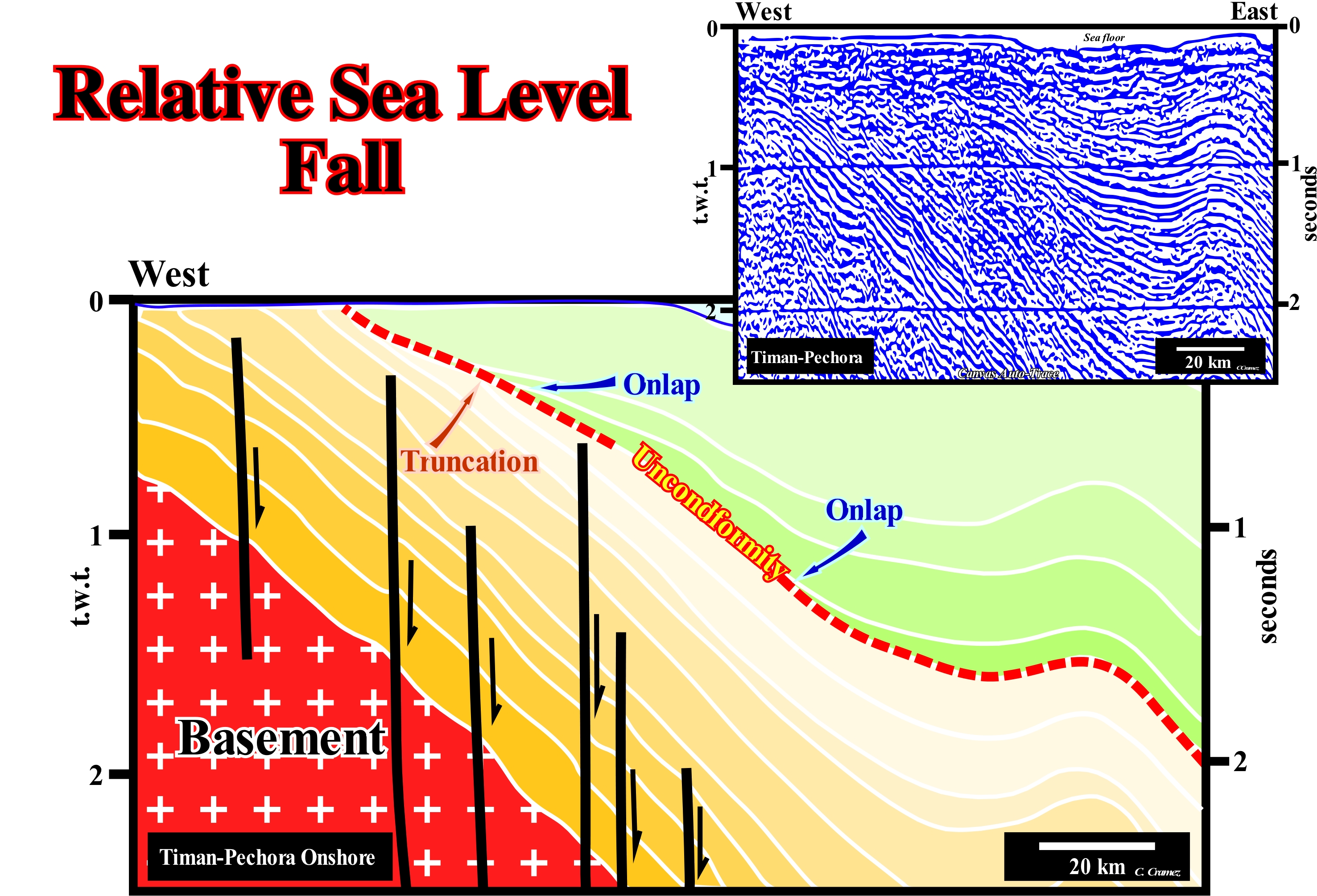
In sequential stratigraphy it is essential to differentiate: (i) The Relative Sea Level, which is, local, and referenced to any point on the Earth's surface that may be the base of sediments (top of the continental crust) or sea floor and (ii) The Absolute or Eustatic Sea Level *, which is, supposed to be global, and referenced to the Earth's centre, generally, via radar satellite measures**. Obviously, relative sea level results of the combined action of the absolute (eustatic) sea level and tectonics (subsidence of the sea floor, when the predominant tectonic regime is in extensional or uplift, when the tectonic regime is compressional). On this tentative geological interpretation of a Canvas auto-trace of a detail of an onshore seismic line from Timan-Pechora (Russia), the main unconformity (in red dash) is an erosional surface caused by a significant relative sea level fall, which put the sea level lower than the basin edge. It limits, at the top, sediments, which have been truncated (underlying sediments) and sediments, which lie against it (overlying sediments) by coastal onlaps. The sediments underlying the unconformity were, partially, eroded as suggested by the toplaps by truncation and also by the thickness variation of the sedimentary interval, immediately, below the unconformity. The overlying sediments, which fossilize the erosional surface (unconformity) by onlapping, in this case coastal onlaps, which are, particularly, well visible. This unconformity was later tectonically enhanced. The original geometry of the coastal onlaps was deformed, which is normal taking into account the geological history of this region: (i) Proterozoic basement (between 2.5 Ga and 542 Ma, which encompasses almost half the time of Earth's existence) ; (ii) Rift-type basins covered by a Cambrian/Silurian divergent margin of (Baikalian orogeny) ; (iii) Backarc basin during the Devonian period ; (iv) Divergent margin during the Carboniferous and Initial Permian with the formation of the Australian suture ; (v) Foreland basin during the Permian and Early Triassic with the formation of Australian orogeny and (vi) Cratonic basin till the Late Cretaceous with a low tectonic activity. All unconformities, even those, locally tectonically enhanced, are more or less highly visible erosional surfaces, induced by relative sea level falls, which set the sea level below the basin edge or coastal plain edge, when the basin has no shelf. When within a sequence-cycle, the sedimentary basin does not have platform (no shelf), practically, the basin edge coincides with the external limit of the coastal plain (continental edge), that is, with the depositional coastal break of the depositional surface, which corresponds, roughly, to the shoreline, particularly on the seismic lines, when the seismic resolution is taken into account. Even when subsidence is important, are the variations of absolute (eustatic) sea level rather than tectonics, which determine the cyclicity of relative sea level falls and thus the cyclicity of the sedimentary deposits. Absolute (eustatic) sea level changes are much faster and more frequent than tectonic changes. However, in some foreland basins, the influence of tectonics is likely to be more important than it is, for instance, in the evolution of a divergent margin. The age of a discordance is given by the associated relative sea level fall, which roughly corresponds to the age of the submarine basin floor fans of the overlying stratigraphic cycle, whose age can be given by the fossils of pelagic layer between the turbidite beds. In fact, between the underlying and overlying sediments of an unconformity, the hiatus is minimal when depositing the submarine basin floor fans of the overlying stratigraphic cycle.
(*) The absolute or eustatic sea level is dependent on: (i) Tectono-Eustasy that is controlled by the volume variation of the ocean basins ; (ii) Glacio-Eustasy, which is controlled by the variation of ocean water volume as a function of the amount of ice ; (iii) Geoidal-Eustasy which is controlled by the distribution of ocean water caused by variations in the terrestrial gravity field, and (iv) Thermal expansion of the oceans or steric sea level rise (if the temperature of the oceans increases, the water density decreases and , for a constant mass, the volume increases).
(**) To understand the difference between radar images and classical imagery just know that a radiation is reflected by all the obstacles whose dimensions are comparable to the wavelength of the radiation. The wavelength of visible light is slightly less than one micron (10–6 m = 0.000001 meter = 0.001 mm). That's why the clouds are opaque. The particles and the drops that exist in the clouds do not allow the light to cross them. The radars, in contrast, have lengths of about 5.6 centimeters for the Ers satellites. Nothing in the clouds can prevent the passage of this type of wavelength. Instead, it is reflected by soil irregularities such as pebbles, vegetation, etc. (Achache, L., 2004- Sentinelles da Terra, Hachette Littératures, Paris, ISBN: 2-01-2793207)
Relative Sea Level Paracycle.........................................................Paracycle du Niveau de la Mer Relatif
Paraciclo do nível do mar relativo / Paraciclo de NRM (nivel relativo del mar) / Paracycle die NRM (relative Meeresspiegel) /相对海平面(RSL)准周期(相对海平面) / Парацикл относительного уровня моря / Paraciclo il NRM /
Time interval occupied by a relative sea level rise (marine ingression). A sequence-paracycle of the relative sea level (eustatic paracycle or marine ingression) is separated from the following sequence-paracycle by a stability period of the relative sea level during which sediments settle (sedimentary regression). There is no relative sea level fall, i.e., there is no unconformity between two consecutive sequence-paracycles of the relative sea level (eustatic paracycles), but rather a flooding and ravinment surface.
See: « Eustasy »
&
« Eustatic Cycle »
&
« Stratigraphic Cycle »
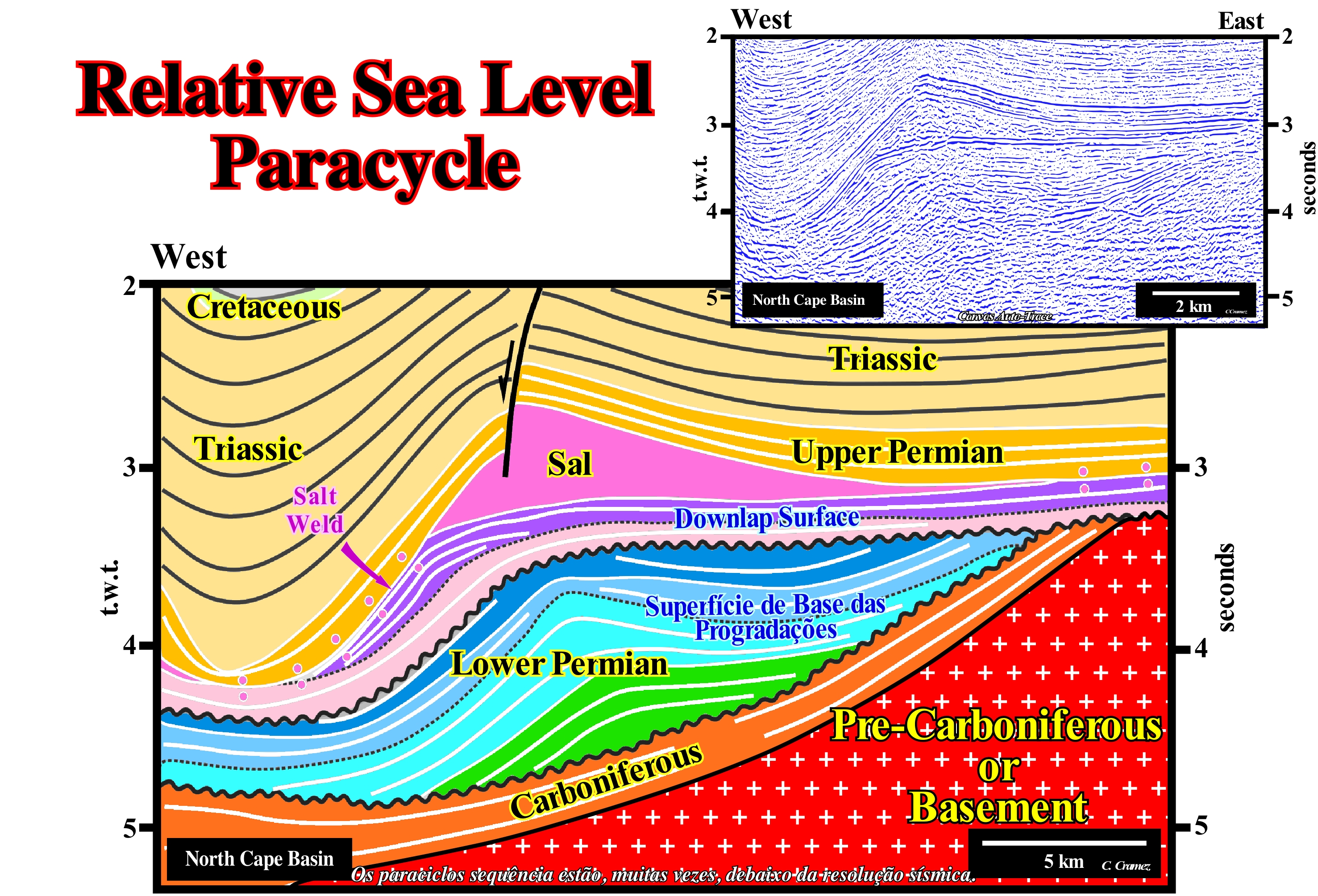
Function of the time interval between the two relative sea level falls (result of the combined action of absolute or eustatic sea level, which is referenced to the Earth's centre, and of tectonics) that delimit the eustatic cycles, different orders of magnitude can be considered. First order eustatic cycles have a time-duration greater than 50 My, which means that the time interval between the relative sea level falls considered is greater than 50 million years. The 2nd order eustatic cycles have a time-duration between 3-5 My and 50 My. The 3rd order eustatic cycles have a time-duration of 3-5 My and 0.5 My. The time-duration of the 4th and 5th order eustatic cycles (high frequency cycles) varies between 0.1 and 0.5 My. Initially, P. Vail considered that the 3rd order eustatic cycles had a time-duration between 0.5 and 3 My. However, many geoscientists have found that a large part of the stratigraphic cycles called sequence-cycles, induced by the 3rd order eustatic cycles, were, often, limited by unconformities whose ages differed, more or less, 5 My. Thus it is preferable to consider 3rd order eustatic cycles as limited between 0.5 and 3-5 My, which does not change much, but which from the theoretical point of view seems more correct. In fact, mathematically, a geological event is considered instantaneous when the time-change is 1/100 of the total time, since in a graph (natural scale, that is, 1:1) the time-change is, practically, zero (only on a large scale it is measurable). During the Phanerozoic, which lasted about 600 My, any geological event with a time-duration of less than 6 My can be considered as an instantaneous event or, in other words, any eustatic cycle with a time-duration of less than 6 My is an instantaneous event, at least in relation to the geological time of the Phanerozoic. An eustatic paracycle, corresponds to an increase of a relative sea level rise, i.e., to a marine ingression or to an increment of a composite marine ingression. In a set of eustatic paracycles, each paracycle is limited between two stability periods of relative sea level. It is during such stability periods of relative sea level that the sedimentary particles deposit (sediments) as the shoreline moves seaward forming a sequence-paracycle, which is nothing more than a sedimentary regression limited between two marine ingressions. A marine ingression (eustatic paracycle) just moves continentward the shoreline creating a ravinment surface by the wave action on the sea floor. The sequence-paracycle, induced by eustatic paracycles, form all subgroups of sedimentary systems tracts that can be recognized within a complete sequence cycle, which from the bottom to top are: (a) Submarine basin floor fans (SBFF) ; (b) Submarine slope fans (SSF) ; (c) Lowstand prograding wedge (LPW) ; (d) Transgressive interval (TI) ; (e) Highstand prograding wedge (HPW). Obviously, an eustatic paracycle is not a cycle. Between the relative sea level rises, which are emphasized by ravinment surfaces at the base and by flooding surfaces at top, there is a stability period of the relative sea level, during which the sedimentary particles are deposited, as the shoreline moves seaward, which form the sequence-paracycles and not by relative sea level falls. A set of eustatic paracycles limited by relative sea level falls form an eustatic cycle. Similarly, the sequence-paracycles induced by eustatic paracycles are not stratigraphic cycles. They are bounded by flooding surfaces rather than by unconformities. As illustrated on this tentative geological interpretation a Canvas auto-trace of a Norway offshore seismic line, the sequence-paracycles are, rarely, recognized in conventional seismic lines due to seismic resolution. They are just visible when a tentative interpretation at the hierarchical level of the sequence-cycles is possible, i.e., when the boundary flooding surfaces are well individualized and allow to recognize the groups and subgroups of sedimentary systems tracts that form a sequence-cycle, which is not the case on this interpretation, since it is made in seismic packets that correspond, probably, to continental encroachment subcycles induced by second order eustatic cycles.
Relative Sea Level Rise................................................................................................................Montée niveau de la mer relatif
Subida do nível do mar relativo / Subida relativa (del nivel del mar) / Relativen Anstieg (NN) / 减速上升(海平面) / Относительный подъём уровня моря / Crescita relativa (livello del mare) /
Apparent rise in sea level in relation to the underlying depositional surface. A relative sea level rise occurs when: (i) Sea level rises while the initial depositional surface sinks or remains stationary or rises more slowly ; (ii) The sea level is stationary and the initial depositional surface sinks and (iii) The sea level drops while the initial depositional surface sinks more rapidly. A relative sea level rise is recognized, in the field and on seismic lines, by onlaps, in particular, by coastal onlaps.
See: « Eustasy »
&
« Subsidence »
&
« Relative Sea Level Change »
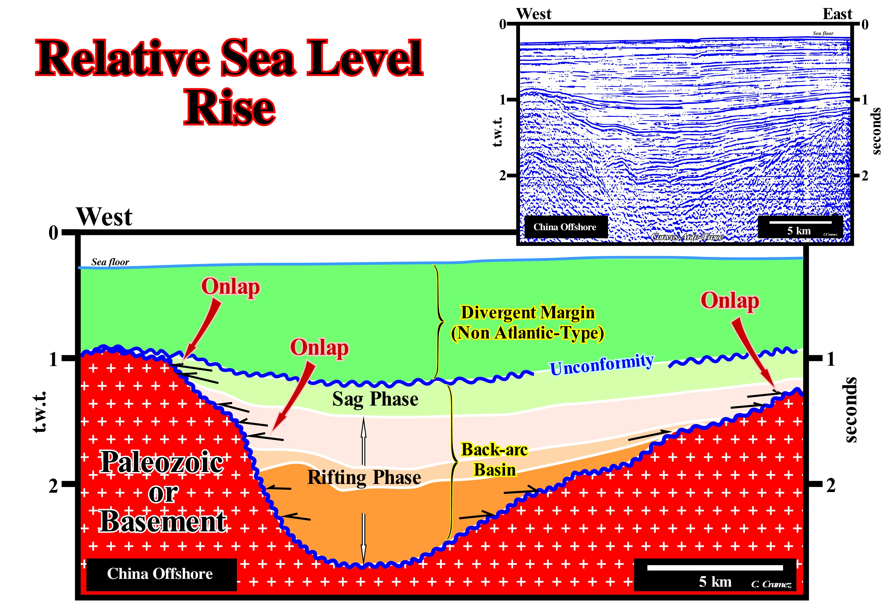
On this tentative geological interpretation a Canvas auto-trace of a China East offshore seismic line, reflector terminations (onlaps) suggest relative sea level rises. In sequential stratigraphy, sea level can be of two types: (i) Relative sea level, which is local and referenced at any fixed point on the Earth's surface, which can be the base of the sediments (top of the continental crust) or the sea floor and (ii) Absolute or eustatic sea level, which is supposed to be global and is referenced to the Earth's centre. The relative sea level is the result of the combined action of absolute (eustatic) sea level and tectonics (subsidence or uplift of the sea floor). The absolute sea level is the result of the combination of: i) Tectono-Eustasy that is controlled by the volume variation of the ocean basins in association with oceanic expansion following the breakup of the supercontinents ; (ii) Glacio-Eustasy, which is controlled by the variation of water volume of the oceans as a function of the amount of ice (assuming that the amount of water in all its forms is constant since the formation of the Earth, around 4.5 Ga) ; (iii) Geoidal-Eustasy, which is controlled by the distribution of ocean water caused by variations in the Earth's gravity field (where gravity is stronger than normal, sea level is thrown to the centre of the Earth) and (iv) Steric sea level rise or thermal expansion of the oceans (if the temperature increases, the density of the water decreases, and for a constant mass, the volume increases). At the level of a sequence-cycle, in order for the sedimentary particles settle down, there is a need to increase the available space for sediments (accommodation), in particular, a shelfal accommodation or upstream of the basin edge (when the basin has a platform) or upstream of the continental edge (when the basin has no shelf*). In other words, turbidite depositional systems, can be deposited during significant relative sea level falls, at or, immediately, after the formation of unconformities (erosional surfaces). On this tentative interpretation the unconformity between the Paleozoic substrate (probably a basement) of the Mesozoic/Cenozoic sediments of the rift-type basin and the non-Atlantic divergent margin (in the eastern part of the seismic line) is underlined by onlaps (geometric relation between strata or seismic reflectors, initially horizontal that terminate against a dipping surface). Within the rift-type basin, the onlaps are nonmarine onlaps, while the onlaps within the margin (above the younger unconformity that underlines the lithosphere's breakup) are marine onlaps. Many geoscientists think that the influence of relative sea level changes on the depositional systems of the rift-type basin is not very significant. In the divergent margin, within a sequence-cycle, upstream of the basin edge or the continental edge (when the basin does not have a shelf), the relative sea level always has to rise, both during transgressive episodes and during regressive episodes. The only difference is that during episodes, globally, transgressive, the relative sea level rises in acceleration (increasing important marine ingressions), while during the regressive episodes, it rises in deceleration (increasingly smaller marine ingressions). It is important not to forget that during a relative sea level rise there is no deposition. Just the shoreline moves continentward creating or increasing the available space for the sediments, i.e., the accommodation, at the same time that it produces a ravinment surface in the preexisting topography. Deposition occurs during the stability period of relative sea level, that occurs after each eustatic paracycle (increment of a relative sea level rise). During this stability period, the shoreline, gradually, moves seaward as the sedimentary systems tracts (lateral association of synchronous and genetically connected depositional systems) settle down, until a new relative sea level rise occurs. When eustatic paracycles are in acceleration, the progradation of the shoreline at the end of each paracycle sequence is increasingly smaller.
(*) During the deposition of the lowstand systems tracts group (LSTG) and during the 2nd stage of development of the highstand prograding wedge (HPW).
Subida do nível do mar relativo em aceleração / Crecida en aceleración, Subida relativa (del nivel del mar) en aceleración / Erhöhung der Beschleunigung (NN) / 加速上升(海平面)/ Ускоренный подъём уровня моря / Aumento in accelerazione (livello del mare) /
When the space available for sediments (combination of tectonics and eustasy) increases, more or less, regularly, such as 3, 5, 8, 10 meters, which means that marine ingressions are increasingly important. It is in association with relative sea level rises of this type that lowstand prograding wedge (LPW) and transgressive interval (TI) are deposited within a sequence-cycle.
See: « Third Order Eustatic Cycle »
Relative Sea Level Rise in Deceleration................................Montée en décélération (Niveau de la mer relatif)
Subida do nível do mar relativo em desaceleração / Crecida en desaceleración, Subida relativa (del nivel del mar) en desaceleración / Anstieg der Verzögerung (NN) / 减速上升(海平面)/ Замедленный подъём уровня моря / Aumento in decelerazione (livello del mare) /
When the space available for sediments, combination of tectonics (subsidence or uplift of the sea floor) and eustasy, decreases, more or less, as for instance, 15, 10, 8, 5, 0 meters. It is in association with relative sea level rises of this type that, within a sequence-cycle, the highstand prograding wedge (LPW) is deposited.
See: « Third Order Eustatic Cycle »
Relative Seal Level Stillstand......................................................................Stabilité relative (Niveau de la mer relatif)
Estabilidade do nível do mar relativoStabilité relative (du niveau de la mer) / Estabilidad relativa (del nivel de mar) / Relative Stabilität (NN) / 相对稳定(海平面) / Относительная стабильность уровня моря / Stabilità relativa (livello del mare) /
When the water column (water-depth) is constant. This occurs when the absolute (eustatic) sea level and the depositional surface are stationary, rise or fall with the same velocity. On seismic lines, a stabilty of relative sea level is recognized by the presence of toplaps and an, almost, absence of coastal onlaps i.e., an absence of aggradation (upbuilding).
See: « Relative Sea Level Change »
&
« Shoreline »
&
« No-Shelf (sedimentary basin) »
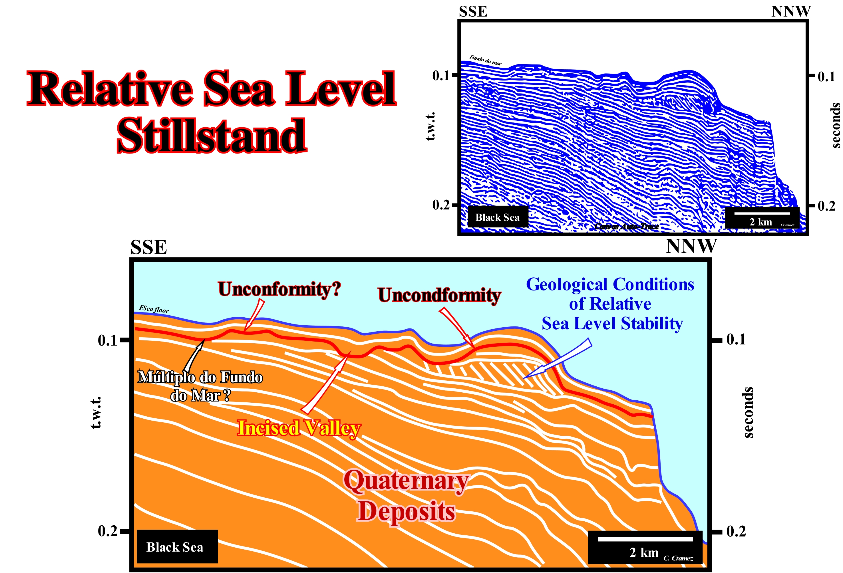
A seismic interval with an apparently oblique progradational internal configuration is, clearly, visible at the top of the geological interpretation of a Canvas auto-trace of a detail of a Black Sea seismic line. Such interval suggests that the deposition conditions were, at this site (space) and at that time, characterized by: (i) A relatively important terrigeneous influx ; (ii) A space available for sediment, i.e., a more or less. constant and, relatively, small accommodation throughout the deposit ; (iii) Relatively weak subsidence and (iv) Relatively sloping sea floor. Take into account the seismic pitfall, induced by the abrupt increasing of the water-depth. The distal reflectors are inclined due to the increase of the water-depth. All this means that during the deposition of this progradational interval the relative sea level*, probably, remained, more or less, constant during the deposition of all the sedimentary systems tracts (lateral association of depositional systems, i.e., lithologies and associated fauna, synchronous and genetically linked) that form this interval. Geological conditions of this type are frequent in energetic sedimentary regimes with a major transit or sedimentary transfer zone (bypass zone), which allows lateral accretion and a very fast filling of the basin without erosion or with a small erosion at the top of the depositional surface, which when lower than the seismic resolution is obviously not visible in the seismic lines. A more attentive examination of the upper part of this auto-trace suggests that the higher lapouts of the progradations, i.e., the toplaps may not be pure oblique progradations (without erosion of the upper part). The progradational interval, probably, deposited under lowstand geological conditions is, locally, covered by more or less horizontal horizons which, at the level of a sequence-cycle, may emphasize a transgressive interval (TI), before being upper bounded by an unconformity (erosional surface, in red, induced by a significant relative sea level fall, which put the sea level lower than the basin edge), which seems ** to be tectonically enhanced (angular discordance). This unconformity is very well recognized not only by toplaps by truncation of the underlying sediments, but also by the filling of a incised valley clearly visible in the central part of this tentative interpretation. It can not be ruled out these progradations were, initially, sigmoid (lateral and vertical accretions), but erosion, associated with the relative sea level fall responsible of the unconformity, has eroded the aggradational part of the progradations, which means, that the reflector terminations may correspond to toplaps by truncation. In this case, the picking of the unconformity has to be modified. The unconformity being responsible for the erosion of the upper part of the progradations has to be marked immediately above them and not as illustrated on this tentative interpretation. In such a hypothesis, it is difficult to consider the progradational interval as a interval deposited under lowstand geological conditions. An absolute sea level rise can be compensated by an uplift of the sea floor as the absolute sea level fall can be compensated by subsidence of the sea floor. In addition, it should not be forgotten the ratio between accommodation (A) and sedimentary charge (S), i.e., the stratigraphic base level (A/S) can be positive (A greater than 1), equal to 1 (A = S), equal to zero (A = 0) and negative (A less than 1).
(*) Sea level, local, referenced to the base of the sediments (top of the continental crust) or the bottom of sea, which is the result of the combined action of tectonics and the absolute (eustatic) sea level (supposed to be global and referenced to the Earth's centre).
(**) In this auto-trace it is very difficult to recognize the true morphology of the unconformity (red horizon), since the influence of the seismic pitfall induced by the lateral variation of the water-depth can be significant. Except for the filling of the incised valley, where the morphology of the sea floor is very different from the morphology of the valley, the red horizon, interpreted as an erosional surface (unconformity), largely mimics the sea floor.
Relative Time.......................................................................................................................................................................................................Temps relatif
Tempo relativo / Tiempo relativo / Relative Zeit / 相对时间 / Относительное время / Tempo relativo /
Temporal relationship determined by relative dates, placing the geological events chronologically without reference to their ages determined in absolute time.
See: « Geological Time Scale »
&
« Radiometric Dating »
&
« Relative Age »
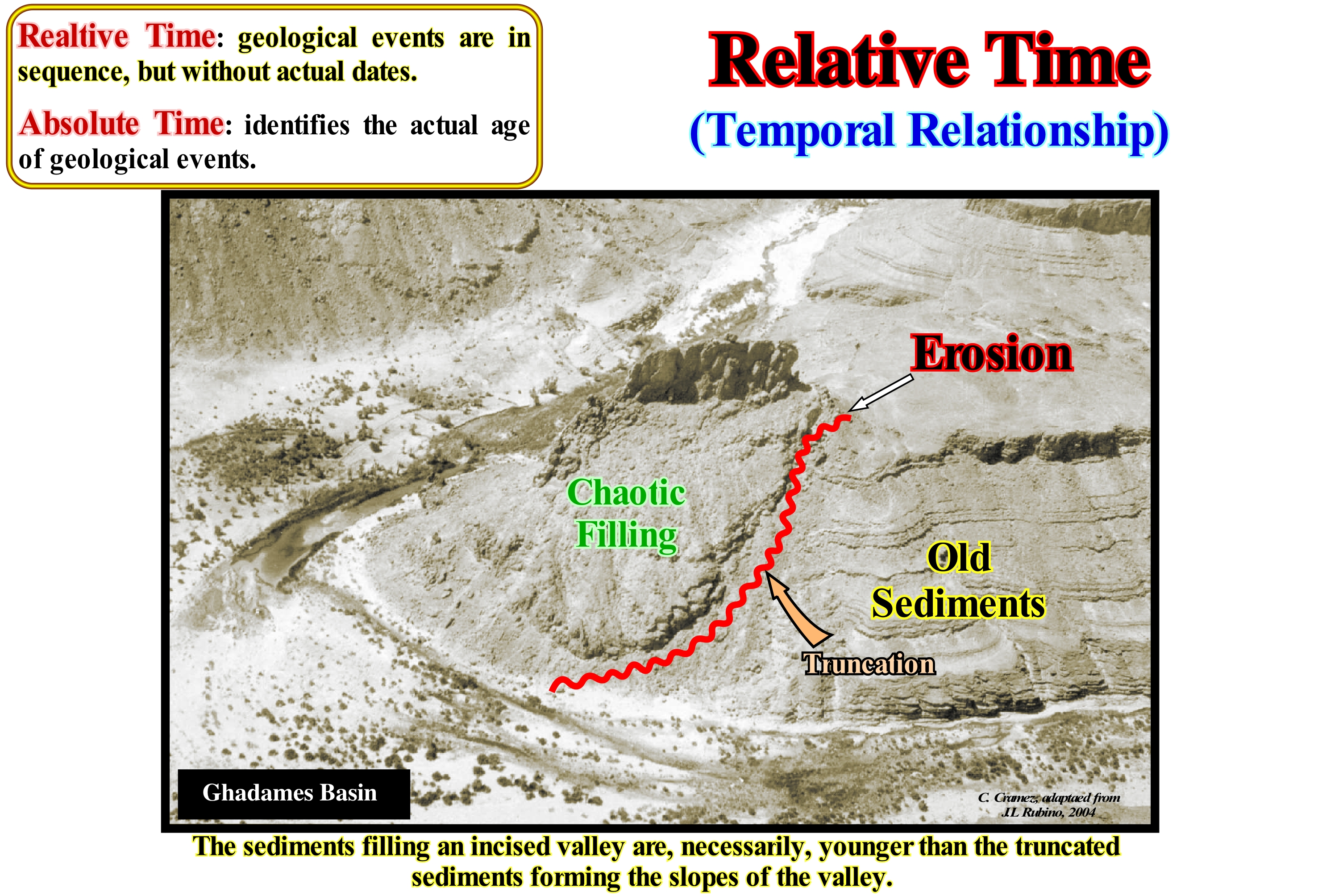
There are four major families of rock dating methods (https://moodle2.units.it/pluginfile.php/88407/mod_resource/content/1/ GQt%20D% 20Datazioni. pdf): (I) Radio-dating, methods based in the decay of some unstable chemical elements that are measured or that measure the decaying effect on the crystal structure (in both cases, the rate of decomposition is well known and may even be referred to as absolute dating) ; (II) Stratigraphic Analysis, it encompasses methods based on the accumulation of regular deposits of sediments or biological material at annual levels ; (iii) Relative Age, which can be by stratigraphic approach or by evaluation of the degree of change (chemical or biological indicators, hydration of obsidian, diagenesis of amino acids, etc.) ; (iv) Age Equivalence, which are based on the simultaneous presence of the same horizons in different and separate stratigraphic sequences, is more or less similar to the stratigraphic correlation through the fauna. This type of dating method to be useful should be calibrated with an independent method (tephrachronology, paleomagnetism, etc.). Few discussions in geology occur without a geoscientist referring to geological time. Geological time, however, is, often, referred in two ways: (i) Relative Time (chronostratigraphic), i.e., subdivisions of Earth's geology in a specific order, based on relative ages (vertical stratigraphic positions), which can be, globally, recognized, above all, on the basis of fossils and (ii) Absolute Time (chronometry), which is given in millions of years and is, generally, determined by radiometric dating methods. Radiometric dating can also be used to calibrate and test relative dating, which allows the establishment of an integrated or geochronological time scale. In this photograph, it is obvious that the chaotic fluvial filling, probably, of a glacial valley, is posterior to the formation of the valley. Do not confuse, as do many geoscientists in charge of tentative geological interpretation of seismic lines, a filling of incised valley with the valley itself. A valley is a geographic depression of variable size and geometry, depending on its origin, which is, generally, associated with an erosional surface** surrounded by higher areas, whereas a valley fill is a sedimentary interval, of variable facies, whose age postdate the valley's formation. For example, within a sequence-cycle, limited between two significant relative sea level falls, whose age difference does not exceed 3-5 My, an incised valley forms during the first relative sea level fall (lower unconformity) while the incised valley filling is done during the deposit of the upper part of the lowstand prograding wedge (LPW) of the post-discordance sequence-cycle having the unconformity as lower boundary. The geometric relations and stratal terminations are easy to interpret. They allow to delineate the eroded layers and thus the fluvial or glacial incision. However, this is not always the case, particularly when the topography is well marked. In a geological or seismic map of a more or less flat area, it is evident that the most recent faults cut the older fault planes traces, as well as, the more recent vein or lode (deposit of metalliferous ore that fills or is embedded in a fissure in a rock formation or a vein of ore that is deposited or embedded between layers of rock) cut and displace the older lodes. On the contrary, when topographic variations are important, in a geological map or in an isochrones map, it is the traces of the oldest faults or lodes that seem (due to the influence of topography) to displace the most recent ***. The influence of topography is, particularly, important in petroleum exploration, where the main phase of hydrocarbon migration often occurs between two extensional tectonic regimes, and the predominant traps are morphological by juxtaposition. If the geoscientist does not take into account the influence of topography on an isochronous structural map of the traps (top of reservoir rock), he may make a mistake in the relative dating of faults and propose an exploration well in a trap postdating the migration.
(*) Relative sea level is referenced to any of the terrestrial surface, while the absolute or eustatic sea level is referenced to the Earth's centre.
(**) Induced by a significant fall of the of relative sea level, which is the result of the combined action of the absolute (eustatic) sea level and of the tectonic, i.e., of the subsidence or uplift of the sea floor function of the predominant tectonic regime.
(***) Faults are mechanical lithologic discontinuities, as well as, the lodes and veins are intrusive lithologic discontinuities and the sequence boundaries are discordant discontinuities. (Https://estpal13.wordpress.com/2013/06/04/descontinuidades-sedimentares-e-estratigraficas/).
Remotion (Flow stripping, turbidites)........................................................................................................Rémotion (Courants turbiditiques)
Remoção / Remoción (corrientes turbidíticas) / Remotion (Trübeströme) / 流剥离(浊流) / Поток взвешенных наносов / Remotion (correnti di torbidità) /
Loss by overbanking of a part of the turbidytic current when it is very high in relation to the depth of the depression (or channel) along which it flows, and in particular when the depression is, more or less, sinuous.
See : « Sequence-Cycle »
&
« Submarine Slope Fan »
&
« Turbidity Current »
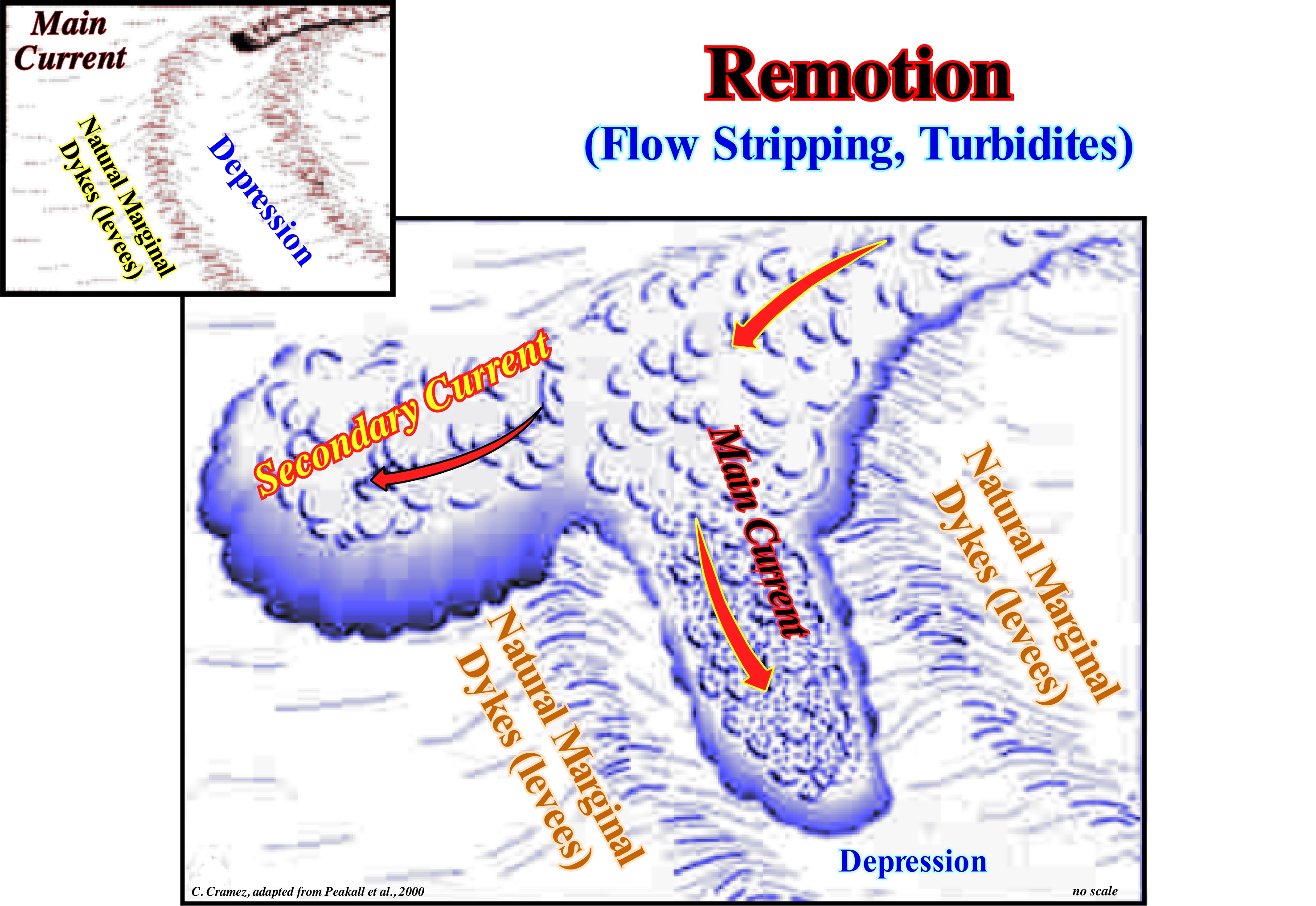
The remotion (or diverted flow) of a turbidytic current (density current due to a large amount of matter kept in suspension by turbulent phenomena, which makes the water very turbid) occurs when the height of the current is greater than the depth of the channel or of the depression (located between the natural marginal dikes) along which it flows. It is important feature to keep into account on turbidite currents when they are thicker than the channel or depression that confines them. In fact, as a turbiditic current deepens the channel or depression where it flows and approaches a curve, the lower part of the current, which has the thicker material, will continue along the axis, but in the upper part, usually, more muddy, the flow is higher than this confinement and overflows the channel. This is often the case when the geometry of the bed along which the flow is made is not straight. We use the term channel when the flow is made in a bed that has been eroded (incised) by the current itself and which is lower than the adjacent sea floor. However, in most cases there is no erosion. The currents flow along homogeneous slopes, but, progressively, due to the deposition of lateral lobes or natural marginal dikes (levees), they create a bed by lateral aggradation. In this case, the term relative depression or, simply, depression is preferable. At sites where a turbidity current rich in sandy material, is, partially, diverted by removal, turbidite lobes and secondary natural marginal dikes are formed as shown in the sketch of this figure. The main current, which flows in the original bed, can lose much of its energy and begin to deposit quickly. In high clay currents, the progressive overflow of muddy material causes less losses (material and energy) in the main current. The dimensions and sand/mud ratio of a turbidity current control, to a large extent, the morphology and extension of the submarine fans. In a depression with a large curvature, as illustrated in this figure, the flow divides into two parts because of the inability it has to cross the bed. In decelerating gravitational currents, overbanking or climbing can occur, which implies a deposition of the material transported, almost immediately, around the bed. In contrast, overflow can occur, once the flow becomes stable, which produces a dynamic gradient above and at the sides of the flow. This causes continuous transport of the sediments up and over the turbiditic natural marginal dikes, which greatly increases the aggradation rate (increase of land elevation, either onshore or offshore due to deposition of sediments). All of this applies to turbidic currents, regardless of the geological context of the basin. However, a turbidite current does not start without any exogenous mechanism (relative sea level fall, seismic shocks, landslides, river floods, etc.) that causes a large amount of sediment to be suspended, either the geological context, in which the turbidite currents are formed, is lowstand (relative sea level * lower than the basin edge, as suggested in the Vail model), or highstand (when sea level is higher that the basin edge) as suggested by E. Mutti. Within a sequence-cycle, the basin edge is the continental edge when the basin has a continental shelf, as well as, during the 2nd phase of development of the highstand prograding wedge (the shoreline is almost coincident with the continental edge). When the basin does not have a continental shelf, the basin edge is, in general, the last basin edge of the preceding sequence-cycle, if this is complete (except during the 2nd phase of development the highstand prograding wedge), The continental edge is the break of the sea floor that emphasizes the top of the continental slope. When the basin has no platform (no shelf) the continental edge corresponds to the outer limit of the coastal plain (more or less, the shoreline). When the basin is a platform, it corresponds to the outer limit of the continental shelf.
(*) Sea level, local, referenced at any fixed point on the Earth's surface, which can be the base of the sediments or the sea floor and which is the result of the combined action of absolute (eustatic) sea level, which is supposed to be global and referenced to the Earth' centre and tectonics (subsidence of the sea floor, when extensional tectonic regimes are predominant, or the uplift, when compressional tectonic regimes are predominant).
Repetitive Sedimentation..............................................................................................................Sédimentation répétitive
Sedimentação repetitiva / Sedimentación repetitiva / Repetitiven Sedimentation / 重复沉积 / Повторная седиментация / Sedimentazione ripetitivo /
When climate changes or relative sea level changes produce a vertical and cyclic accumulation of, more or less, typical sedimentary successions. These vertical sucessions may or may not be regularly recurrent (periodic).
see: « Terrigeneous Supply »
&
« Depositional Model (sand-shale) »
&
« Relative Sea Level Change »
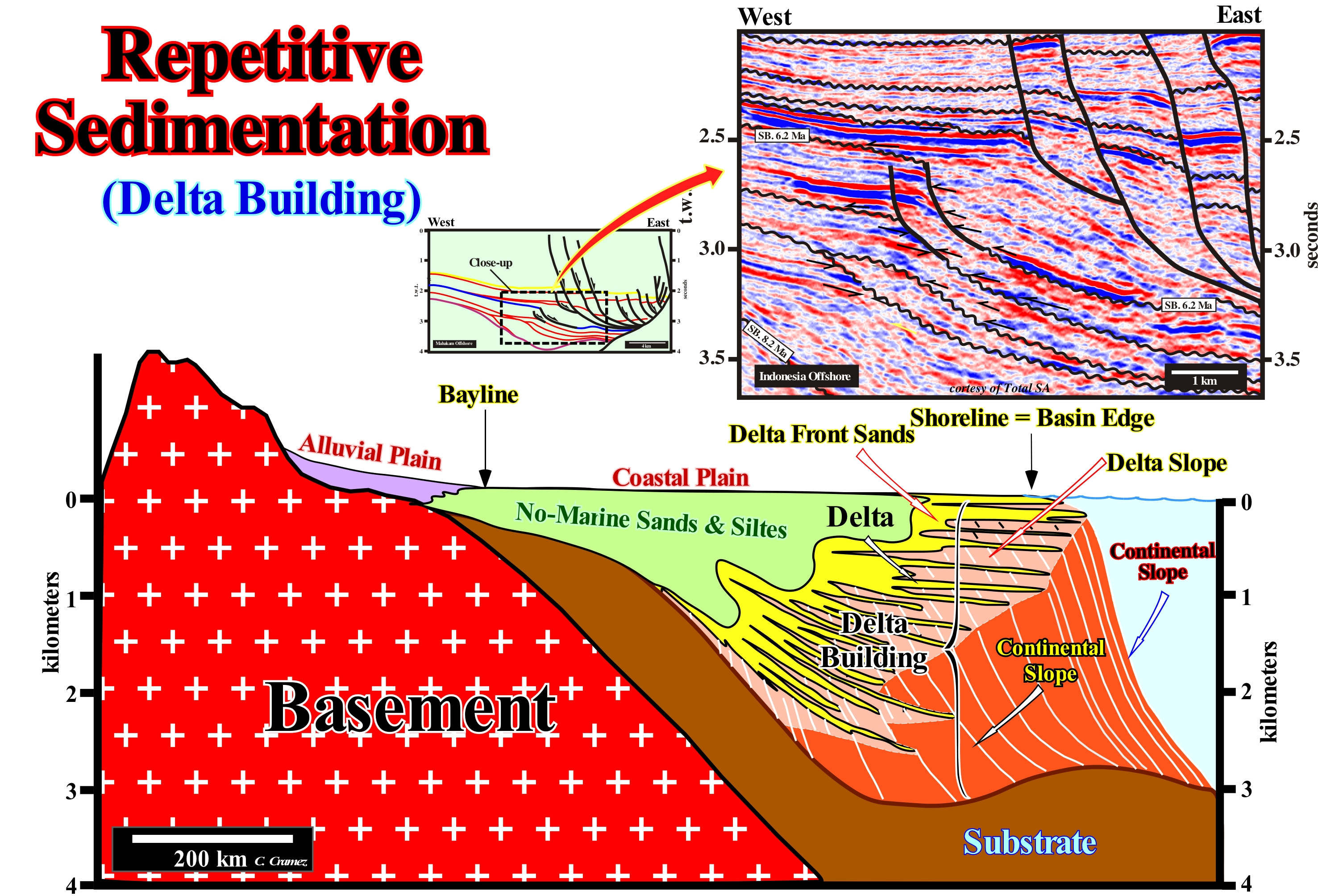
Assuming that a repetitive or cyclic sedimentation occurs when there is a repetition of a specific series of connected events affecting the environment, in which the sediments are deposited, two types of sedimentary cyclic successions can be considered, on the basis of the processes : (I) Self-Cyclical Successions and (ii) Allocyclic Successions. The first are cyclic sediments are created by processes that only occur within the basin to which the sediments are deposited. Tides and storms are examples of the types of processes that create auto-cyclical sequences, which have a limited stratigraphic continuity. Allocyclic successions, which can extend over large distances, are cycles of sediments caused by processes that also occur outside the basin where sediments settle, such as sea level variations, climate change, activity tectonics, etc. The typical example of repetitive sedimentation is a delta building, which should not be confused with a delta, as illustrated in this figure, since it is associated with a repetition of marine ingressions. The average thickness of a delta (height of the prodelta) is about 30-40 meters, while the thickness of a delta building, which is nothing other than the stacking of a number of deltas (repetitive sedimentation), can reach several kilometers, such as the Niger or Amazon delta buildings. In sequential stratigraphy, a delta, usually, corresponds to a sedimentary systems tracts, i.e., to a lateral association of depositional systems, characterized by lithology and associated fauna, synchronous and genetically connected, deposited during the stability period of relative sea level, occurring between two consecutive eustatic paracycles (marine ingressions or consecutive sea-level rises). Relative sea level is local and referenced at any fixed point on the Earth's surface, which can be the base of the sediments or the sea floor. Relative sea level is the result of the combination action of tectonics and absolute (eustatic) sea level (supposed global and referenced to the Earth's centre). On the other hand it can be said, a delta is constituted by three types of beds: (i) Upper Beds, which have a subhorizontal geometry ; (ii) Frontal Beds, which have dipping seaward geometry and (iii) Lower Beds, that when present, have a subhorizontal geometry. There are deltas made up only by dipping or frontal beds and deltas formed by the upper and the dipping beds. Overall, a delta has a progradational geometry. The sedimentation is repetitive and lateral. Within a sequence-cycle, a delta stacking is preferably performed during the lowstand prograding wedge (LPW) and the highstand prograding wedge (HPW), i.e, during which regressive episodes. If initially, the shoreline, which corresponds more or less to the boundary between the upper and the frontal beds of a delta, is located upstream of the basin edge (continental edge when the basin has a shelf), progressively, the prodelta or the lower beds, when they exist, fossilize the continental shelf. During this period (1st stage of the development of the highstand prograding wedge, HPW), the prodeltas are located upstream of the continental slope, which means that there is a small platform under a water-depth that is, usually, below the seismic resolution. If on a seismic line, the marine ingressions and the sedimentary regressions, induced by them, can not be made evident, the continental shelf is considered as nonexistent and the basin edge is the boundary between the upper and frontal beds of the delta, since the basin, seismically, has no shelf. The geological model illustrated in this figure, which is very exaggerated vertically, would give, probably, in a time seismic version, an image in which, at the hierarchical level of the sequence-cycles, the basins that do not have a continental shelf, that is, a seismic image in which deltaic progradations, i.e., sequence-paracycles, would be difficult to recognize. The successive continental edges would be considered coincident with the successive shorelines. It is important not to confuse the continental slope of a delta building, which can reach several kilometers in height, with the prodelta (slope of a delta), whose height, rarely, exceeds 50 meters.

