
Magnafacies.................................................................................................................................................................................................................Magnafaciès
Magnafácies / Magnafacies / Magnafacies / Magnafacies (齐在岩性和古生物但斜时) / Магнафация / Magnafacies /
Term used by certain American geoscientists to designate a continuous and homogeneous belt of sedimentary deposits, which is characterized by similar lithologic and paleontological elements, but which extends, obliquely, along the time lines or through several well-defined chronostratigraphic units. A magnafacies is a complete lithologic member or a perfect stratigraphic unit with the same facies, but formed at different times.
See: « Lithosome »
&
« Allostratigraphic Unit »
&
« Chronostratigraphy »
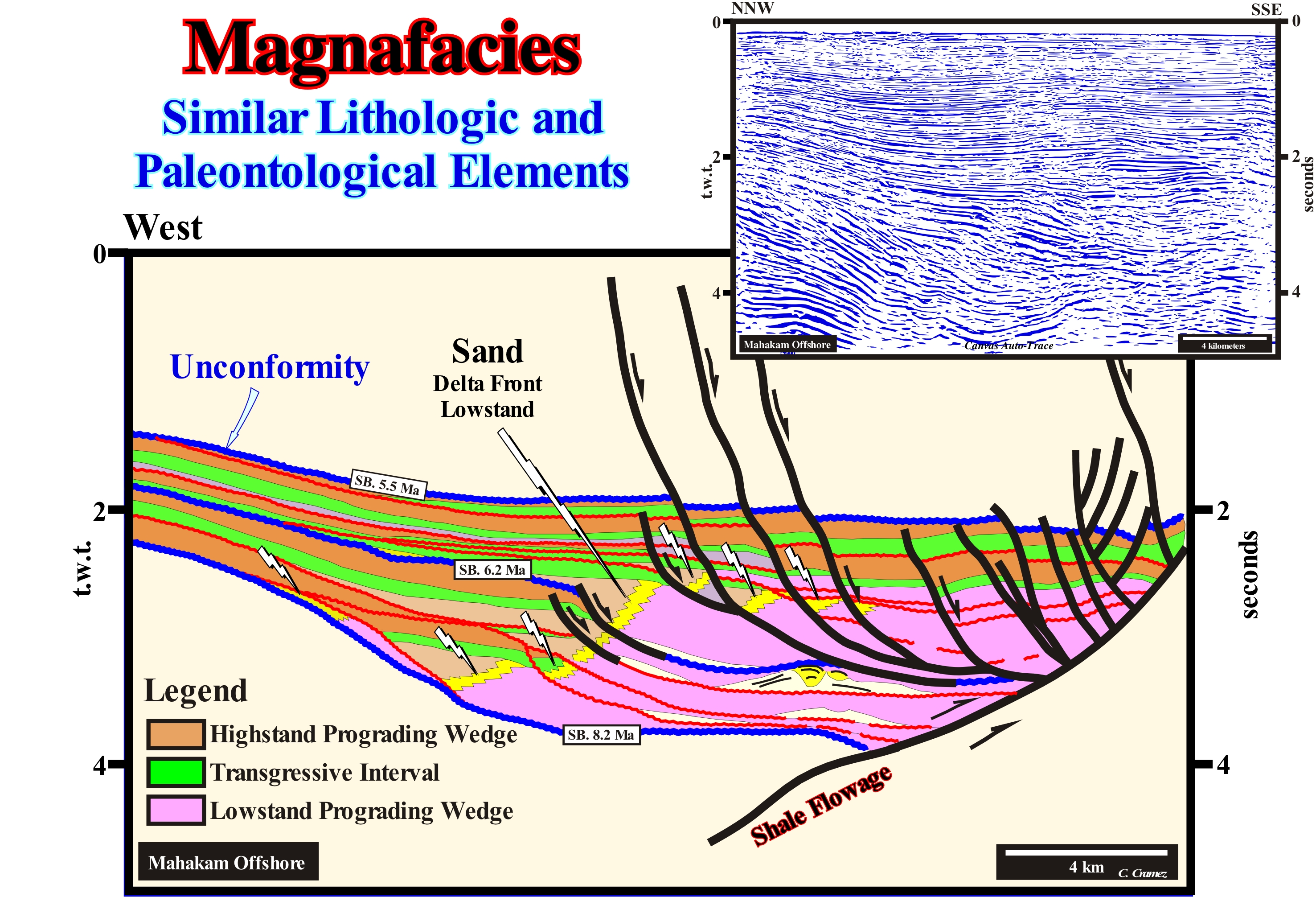
As illustrated on this tentative geological interpretation of a Canvas auto-trace of a detail of a Indonesia (Mahakam, West Borneo) regional offshore seismic line, the magnafacies, formed by the delta front sandstones (yellow colored interval) associated with the Mahakam River is, clearly, oblique to the sedimentary systems tracts sub-groups that form the different sequence-cycles bounded by SB. 5.5 and SB. 8,2 Ma unconformities. On this tentative interpretation, only two stratigraphic cycles were interpreted as sequence-cycles, which are associated with significant relative sea level falls. These relative sea level falls define two 3rd order eustatic cycles. They have a time-duration ranging between 0.5 and 3-5 My (SB 8.2 Ma/SB, 6.2 Ma ; SB. 6.2 Ma/SB, 5.5 Ma). These two eustatic cycles are typical of the Haq curve. However, in this area, as the sedimentation rate was very important, within each sequence-cycle, as can be seen, reflector terminations strongly suggest other significant relative sea level falls. These relative sea level falls (RSLF) put the sea level lower than the basin edge and define high frequency sequence-cycles. So, within the two conventional sequence-cycles defined by the SB 5.5 Ma, SB 6.2 Ma and SB 8.2 Ma unconformities, the relative sea level* was several times under the basin-edge and that the coastal deposits were displaced, several times, seaward (progradation) and downward (negative aggradation) and then to move again continentward (West). It is for this reason that during the periods of lowstand, the geometry of the magnafacies, defined by the progradation of the delta sandstones (marked with lightning arrows), have many ruptures although, globally, it is progradational. This magnafacies, which exist, also, in highstand systems tracts sub-groups have not been mapped (due to representation reasons), since the thickness of these sub-groups is relatively small. The obliquity of the magnafacies in relation to the chronostratigraphic lines is just noticeable when the systems tracts sub-groups are, sufficiently, thick. When a sequence-cycle is complete it is formed by two systems tracts groups: (i) The Lowstand Systems Tracts Group (LSTG) and (ii) The Highstand Systems Tract Group (HSTG). The lowstand systems tracts group (LSTG) is deposited when the sea level is lower than the basin edge. It is composed from bottom to top, by three sub-groups: a) Submarine basin floor fans (SBFF) ; b) Submarine slope fans (SSF) ; (c) Lowstand prograding wedge (LPW). The highstand systems Tract group (HSTG) is deposited when sea level is higher than the basin edge. It is formed by two sub-groups: a) Transgressive interval (TI) and b) The highstand prograding wedge (HPW), which fossilizes the transgressive interval. During the transgressive interval (TI), the basin has a shelf (continental platform), as well as during the 1st stage of development of the highstand prograding wedge, when the shoreline (depositional coastal break of depositional surface) is still individualized of the basin-edge. Since the basin-edge becomes, also, to be the continental-edge and is located near the shoreline (on the seismic lines we must take into account with the vertical seismic resolution), begins the 2nd stage of the evolution of the highstand prograding wedge, since the basin no longer has a shelf. The retrogradational geometry of the transgressive interval is the result of the set of increasingly important marine ingressions and increasingly smaller sedimentary regressions, while the progradational geometry of the highstand prograding wedge is the result of the joint action of marine ingressions increasingly smaller and sedimentary regressions increasingly important. All this means that at the sequence-cycles hierarchical level, in order to have deposition, the relative sea level must always rise. During the transgressive interval (TI), the relative sea level rises in acceleration (increasingly important marine ingressions), while during the highstand prograding wedge (HPW), the relative sea level rises in deceleration (increasingly smaller marine ingressions).
(*) The relative sea level is the local sea level, referenced at any point on the Earth's surface, whether it is the sea floor or the base of the sediment (top of the continental crust). It is the result of the combined action of tectonics (subsidence or uplift of the sea floor) and absolute (eustatic) sea level, which is supposed to be a global sea level referenced to the Earth's centre.
Magnesian Calcite ...........................................................................................................................................................Calcite magnésienne
Calcite rica em magnésio / Calcita rica en magnesio / Magnesischen Calcit / 镁方解石 / Магнезиальный кальцит / Calcite magnesiaca /
Variety of calcite, (Ca, Mg) CO3, in which magnesium, randomly, replaced calcium in a disordered calcite matrix. Also known as magnesian calcite.
See: « Calcite »
&
« Limestone »
&
« Stalagmite »
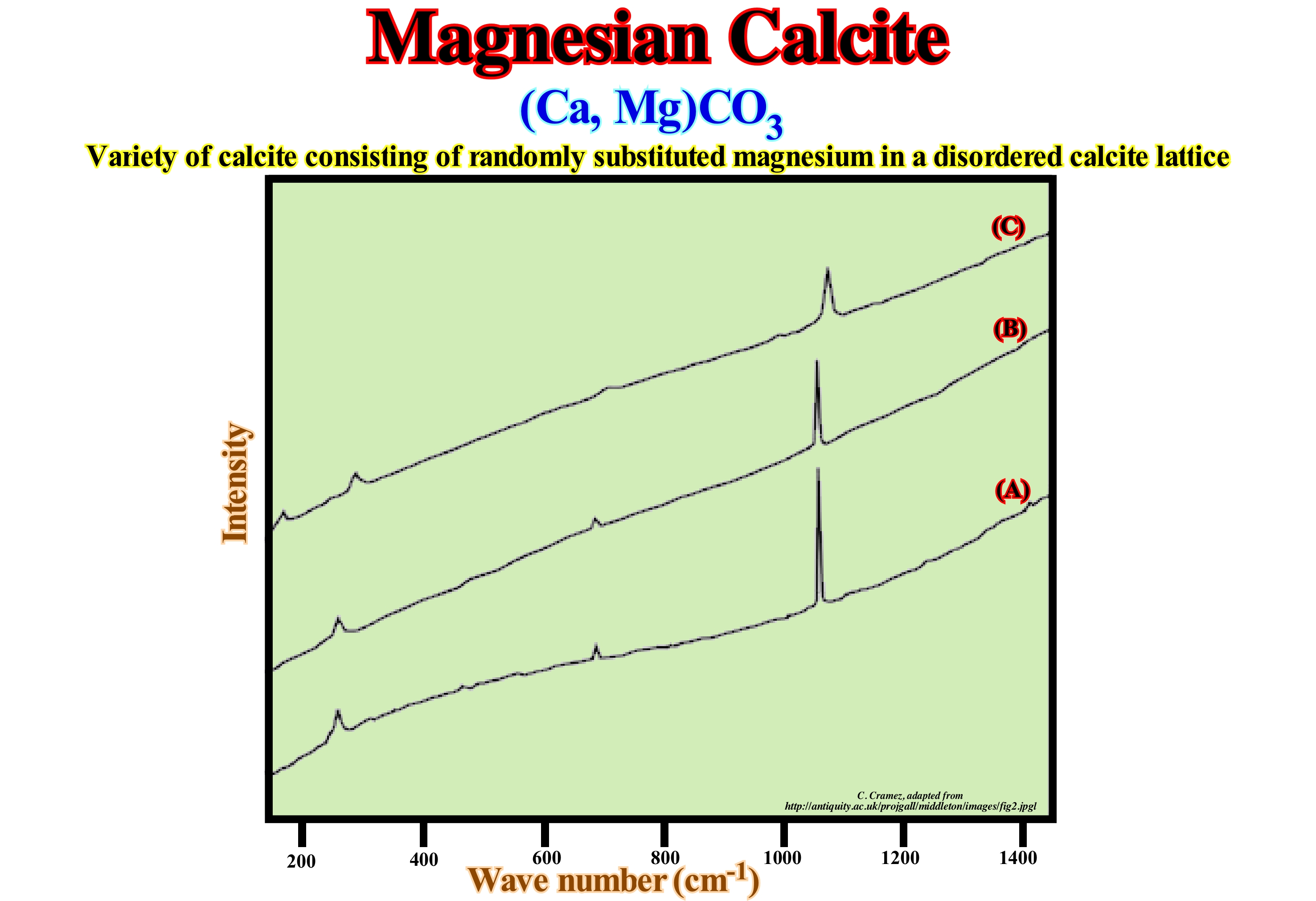
Calcite with little magnesium, i.e., less than 4% of CO3 Mg is the most common form of calcite. Calcite with more than 4 -19% of CO3Ca is metastable and, during the formation of limestones, it usually turns into calcite poor in magnesium or dolomite. In this figure, are illustrated Raman spectra (Dilor LabRam Infinity, equipped with an YAG laser of 532 nm) of: (i) A building material ; (ii) Calcite and (iii) A limestone rich in magnesium. Mineralogically, limestone rich in magnesium is, readily recognizable, because it is, typically, dolomitic, i.e., it contains dolomite which is a calcium carbonate rich in magnesium, whereas, for example, chalk, is composed of calcite (calcium carbonate). A simple mineralogical analysis enables one to determine whether a particular object is made of chalk or limestone rich in magnesium. A spectral analysis allows the possibility of distinguishing these two materials, practically, without destroying them (to make a Raman spectrum two or three small grains are enough). The spectra illustrated in this figure suggest the spectrum of the building material (A) has more affinity with the calcite spectrum (B) than with the magnesium rich limestone (C). The spectrum of the magnesium-rich limestone (C) is, relatively, similar to that of calcite (B), but, as can be seen, each peak is shifted towards the higher wavelengths (spatial frequency analogue, which is measured by the number of repeated propagation units of a wave or the number of times a wave has the same phase). On the other hand, they correlate, perfectly, with the dolomite spectra published in various scientific journals. When a shallow water limestone is transported to deep-water sedimentary environments, fractions of magnesium-rich calcite can convert to low-magnesium calcite. When this happens, oxygen isotope rates suggest the loss of magnesium occurs during the recrystallization of the carbonate from deep water (without changing the textures of the skeletal fragments).
Magnetic Polarity..............................................................................................................................................................Polarité magnétique
Polaridade magnética / Polaridad magnética / Magnetische Polarität / 磁极 / Магнитная полярность / Polarità magnetica /
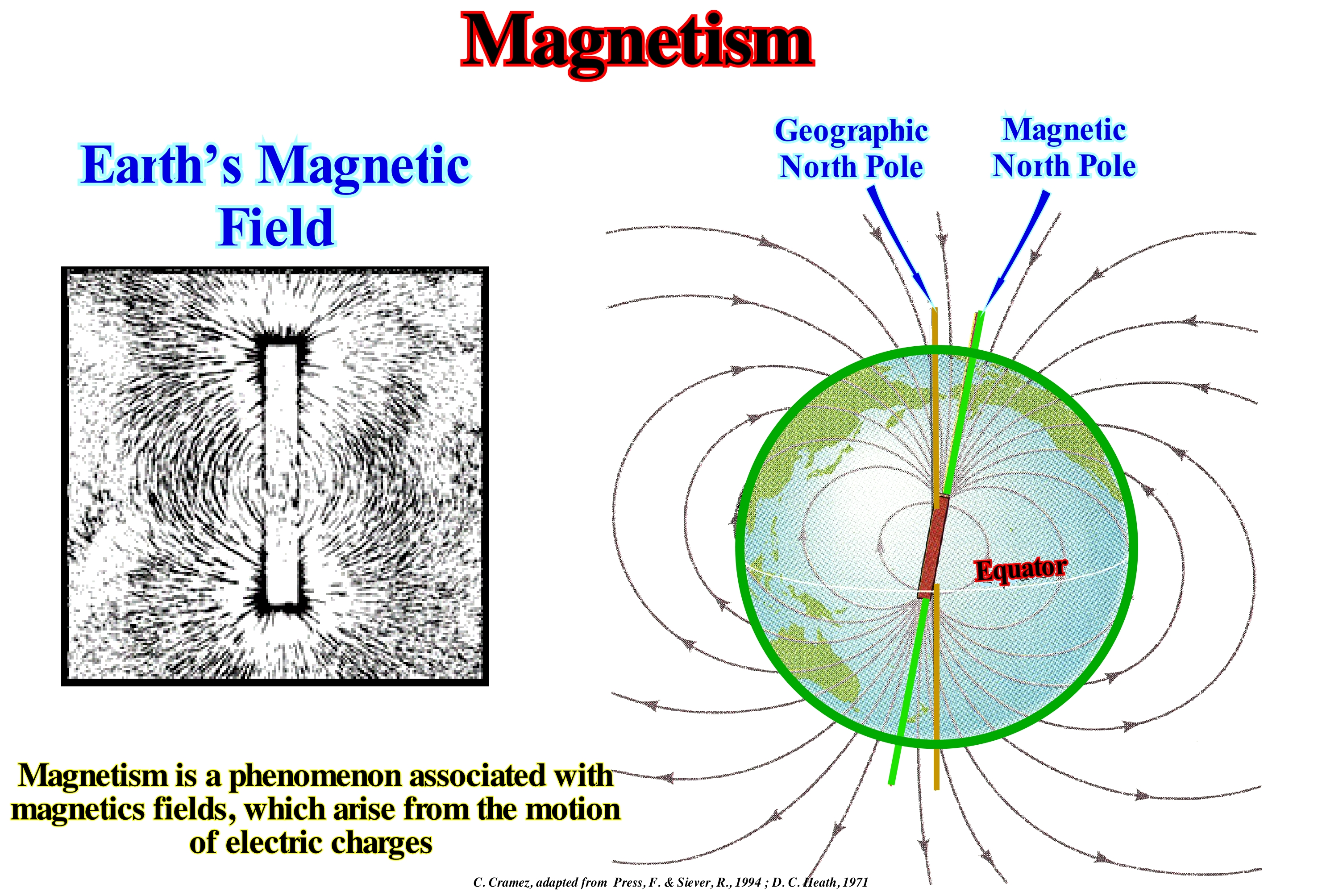
Orientation of the Earth's magnetic field. The polarity of a certain time is the period of time during which the Earth's magnetic field is oriented either in the normal direction (current direction of the earth's magnetic field) or in the reverse direction. The polarity of the terrestrial magnetic field of a certain time is contrary to the polarity of the previous epoch.
See: « Magnetics »
&
« Polar Wandering »
&
« Radiometric Dating »
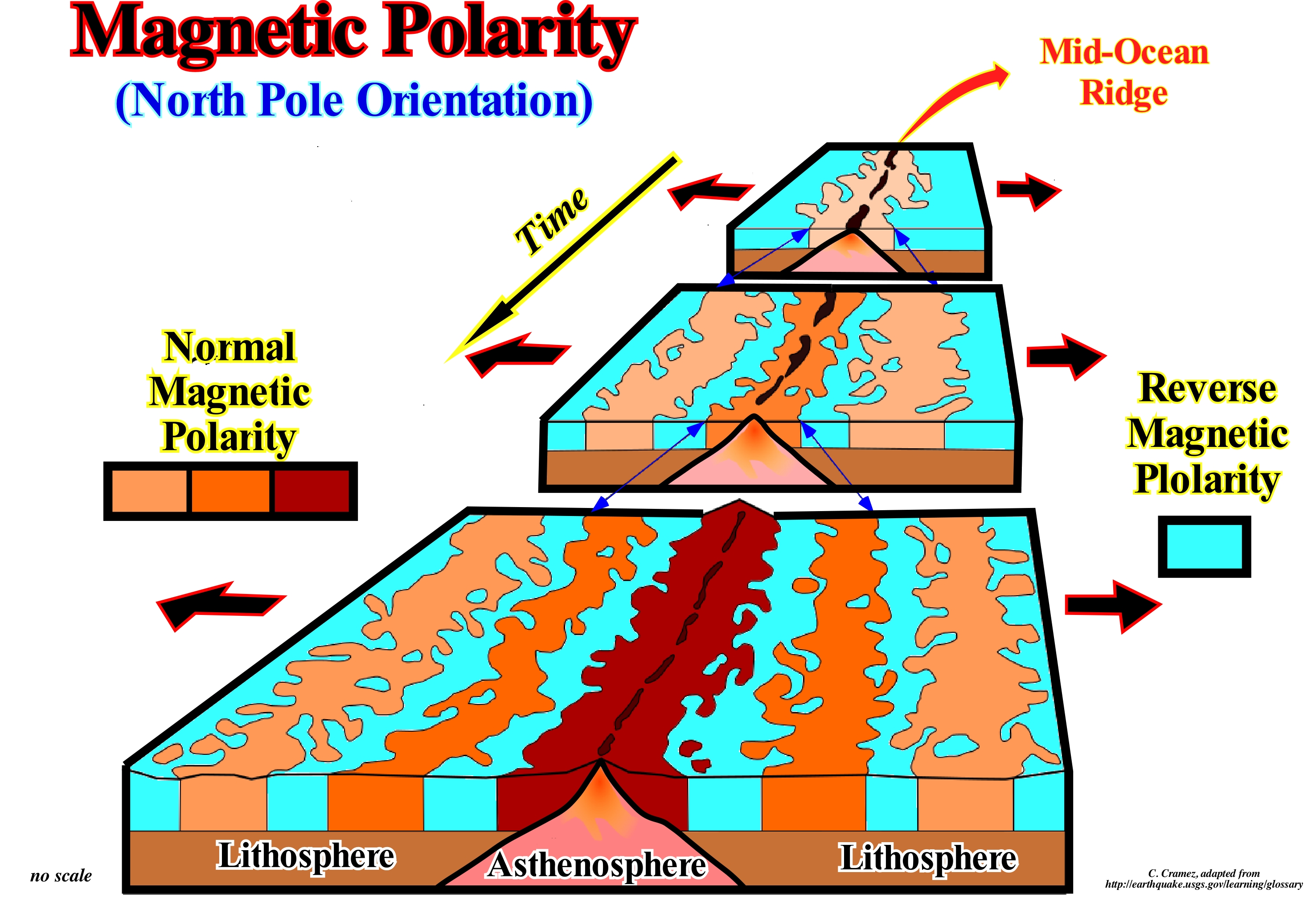
Magnetic polarity is a function of the position of the Earth's magnetic pole relative to the Earth's North Pole. When the North Pole of the Earth's magnetic field is close to the Earth's North Pole, as is the case today, magnetic polarity is said to be normal. Throughout geological history, this has not always been the case. Often, the South Pole of the Earth's magnetic field is near of Earth's North Pole. In this case, the magnetic polarity is said to be reverse. It can be said an reverse magnetic polarity is a change from the Earth's magnetic field to an opposite polarity. These changes occur throughout geological history in, more or less, irregular time periods. What is more interesting to geoscientists is that reverse magnetic polarities can be preserved in sequences of magnetized rocks and thus can be compared with scales of change of polarity patterns, which allows to determine the most probable geological ages of rocks. As illustrated in the sketch depicted above, the rocks formed in the mid-ocean ridges retain the polarity of the Earth's magnetic field from the moment they solidify. Some bands have a normal polarity and others reverse, which allows not only to determine the different ages of the ocean ridges, but also to determine the rate of ocean expansion. This is how geoscientists have found that the highest rate of ocean expansion occurs in the eastern Pacific Ocean (about 12 cm per year) and that in the Atlantic Ocean it is just 2 cm per year. The rate of expansion in the Atlantic is, more or less, the rate of growth of the nails of the hand. An ocean expansion of 2 cm per year implies that the rocks of the oceanic crust formed 1 million years ago are currently about 20 km on each side of the ridge where they formed.
Magnetic Reversal........................................................................................................................................................Inversion magnétique
Inversão magnética / Inversión magnética / Ummagnetisierung / 磁性逆转 / Перемагничивание (инверсия намагниченности) / Inversione magnetica /
Process by which the North Pole is transformed into a South Pole and the South Pole becomes a North Pole. The terrestrial magnetic field undergoes a simple excursion rather than an inversion, since it regenerates by itself with the same polarity.
See: « Magnetics »
&
« Magnetostratigraphy »
&
« Seafloor Spreading »
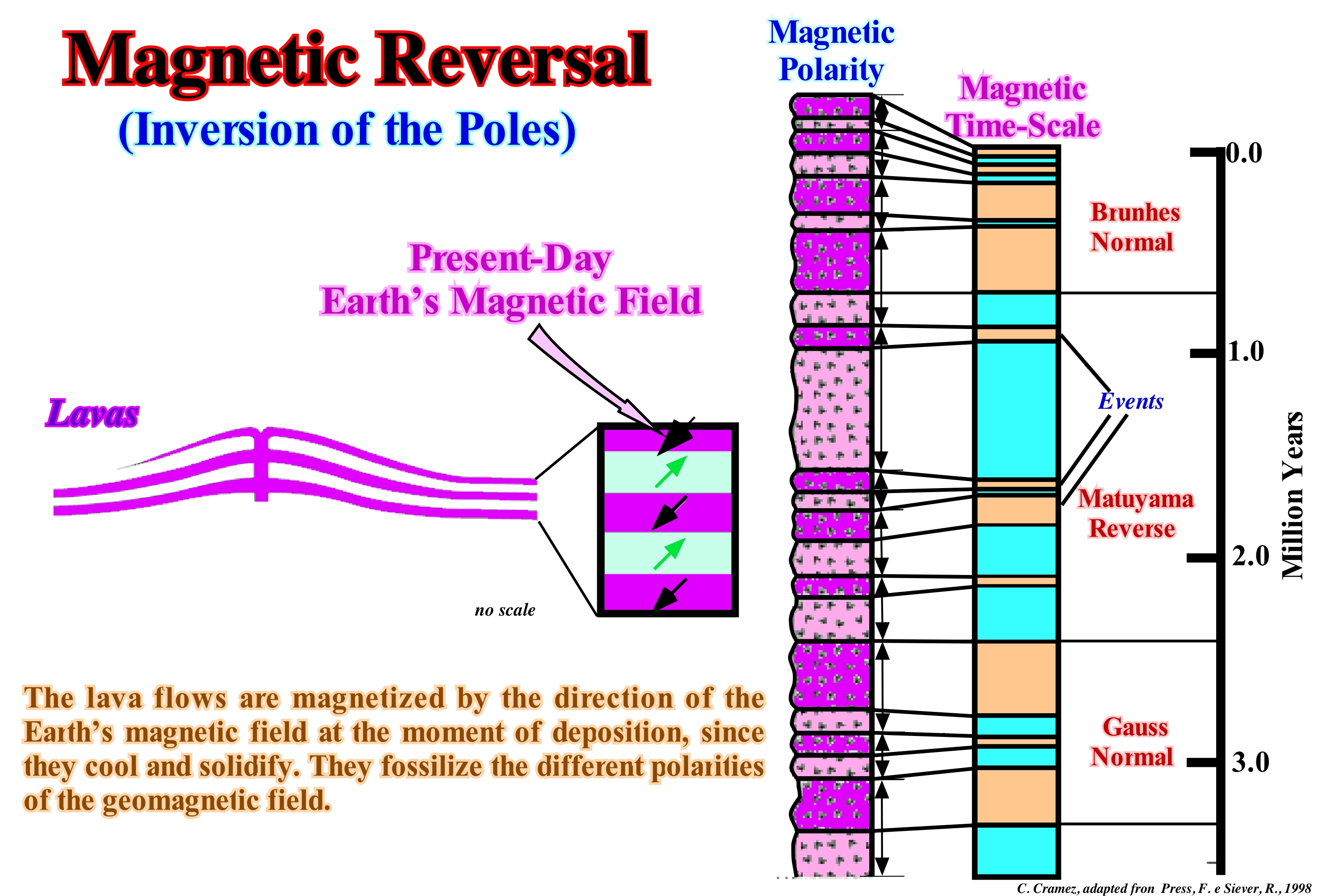
Earth behaves like a giant magnet. The innermost part of the Earth, known as core, is made up of very heavy minerals (iron and nickel) and is, largely, in the liquid state. It seems it is the movements of the liquid part, which generate the magnetic field, that has been inverted several times throughout the Earth's history, as certain rocks suggest. At the moment of deposition of certain rocks, the ferroginous minerals that they contain, are oriented according to the Earth's magnetic field of that moment. The magnetization of the rocks creates a fossil remaining magnetic field, which can be used as a fossil compass to determine the direction of the old magnetic field (paleomagnetism). To do this, simply measure the angle of the magnetic declination (D) and the inclination (I) in an oriented sample with a sensitive magnetometer. The latitude (L) is determined from the inclination by the equation: Tan L = 1/2 Tan I (tangent of the latitude is equal to half the tangent of the inclination). Measurements of the fossil magnetic field have shown that in the course of Earth's history, magnetic poles, for reasons not yet well known, have been inverted several times. The time interval between the magnetic inversions varies greatly. However, it may be said that during the Cenozoic the interval between each inversion is about 500 ky. The time intervals during which the polarity is the same that today are called normal or of normal polarity, otherwise they are called reverse or of reverse polarity. The Earth's magnetic field that is within the magnetosphere, created by the action of the solar wind, seems to show signs of diminishing intensity. At present-time, however, the magnetic intensity is, practically, the same as 50,000 years ago, although the last inversion has already occurred to about 800,000 years. Determinations made in old Roman jars from suggest that the magnetic intensity was twice that of today. It is very likely that in the near future (geological time) the magnetic polarity will change.
Magnetics............................................................................................................................................................................................................................Magnétisme
Magnetismo / Magnetismo / Magnetismus / 磁 / Магнетизм / Magnetismo /
Magnetic field produced by the movement of the liquid part of the Earth's core. The Earth behaves like a giant magnet, since the inner part, known as the nucleus, is made up of very heavy minerals (Fe and Ni) and is largely in the liquid state.
See : « Magnetostratigraphy »
&
« Earth »
&
« Chronostratigraphy »
In this figure (left), the magnetic field* of a magnet is underlined by the alignment of ferroginous debris on a sheet of paper placed on a magnet. The Earth's magnetic field, schematised on the right, can be compared to that of a large magnet placed in the Earth's centre and slightly inclined (11° Eastward), in which the compass needle is oriented according to the lines of the magnetic force produced by the magnet, as indicated in this diagram. Magnetism is much used by geoscientists to determine the composition, structure and depth of certain rocks. The method (magnetic analysis) is based on measurements of small variations of the Earth's magnetic field. In fact, since most of the sedimentary rocks are not magnetic, any variation in the composition of the rock of the basement or the relief of the basement (depth) causes variations of the Earth's magnetic field. These variations can be measured with magnetometers at the Earth's surface or by appropriate apparatus carried by aircraft or ships. The variations observed in the Earth's magnetic field are interpreted in terms of the most probable distribution of the magnetic material beneath the Earth's surface, which in turn is the basis for the hypothesis about the most probable geological conditions. In the northern hemisphere, negative magnetic anomalies occur to the north of the buried magnetic masses and to the south in the southern hemisphere. The maximum anomaly occurs at the poles and the minimum at the equator. The most frequent geological results that the geoscientists obtain from the magnetism are: (i) The depth of the rocks of the basement ; (ii) The thickness of the sedimentary column ; (iii) The location of the high points of the basement, etc. The interpretation of magnetic anomalies is similar to the interpretation of gravity anomalies, since both methods use natural potential fields based on the law of universal attraction. The term magnetism is derived from magnesia, i.e., the name of a region of Asia Minor, where magnetite (magnetic iron ore) was found for the first time.
(*) In physics, particularly in magnetism, the magnetic field is a vector field of solenoid (vector whose divergence is zero in a certain region, or whose flux is null through a closed surface of that region) created in space by motion of an electric charge or by a variable electric field over time. Along with the electric field is the electromagnetic field responsible for the electromagnetic interaction.
Magnetostratigraphy..........................................................................................................................................Magnétostratigraphie
Magnetostratigrafia / Magnetoestratigrafía / Magnetostratigraphie / Magnetostratigraphy (序列的反向极性和强度) / Магнитостратиграфия / Magnetostratigrafia /
Use of records of polarity changes of the magnetic field preserved in the sediments to establish correlations, such as between the exploration wells and dating the sediments. Individually, the time of the intervals with normal and inverse polarity (chronos) varies between 10 thousand and 10 million years.
See: « Paleomagnetic Stratigraphy »
&
« Geological Time Scale »
&
« Chronostratigraphy »
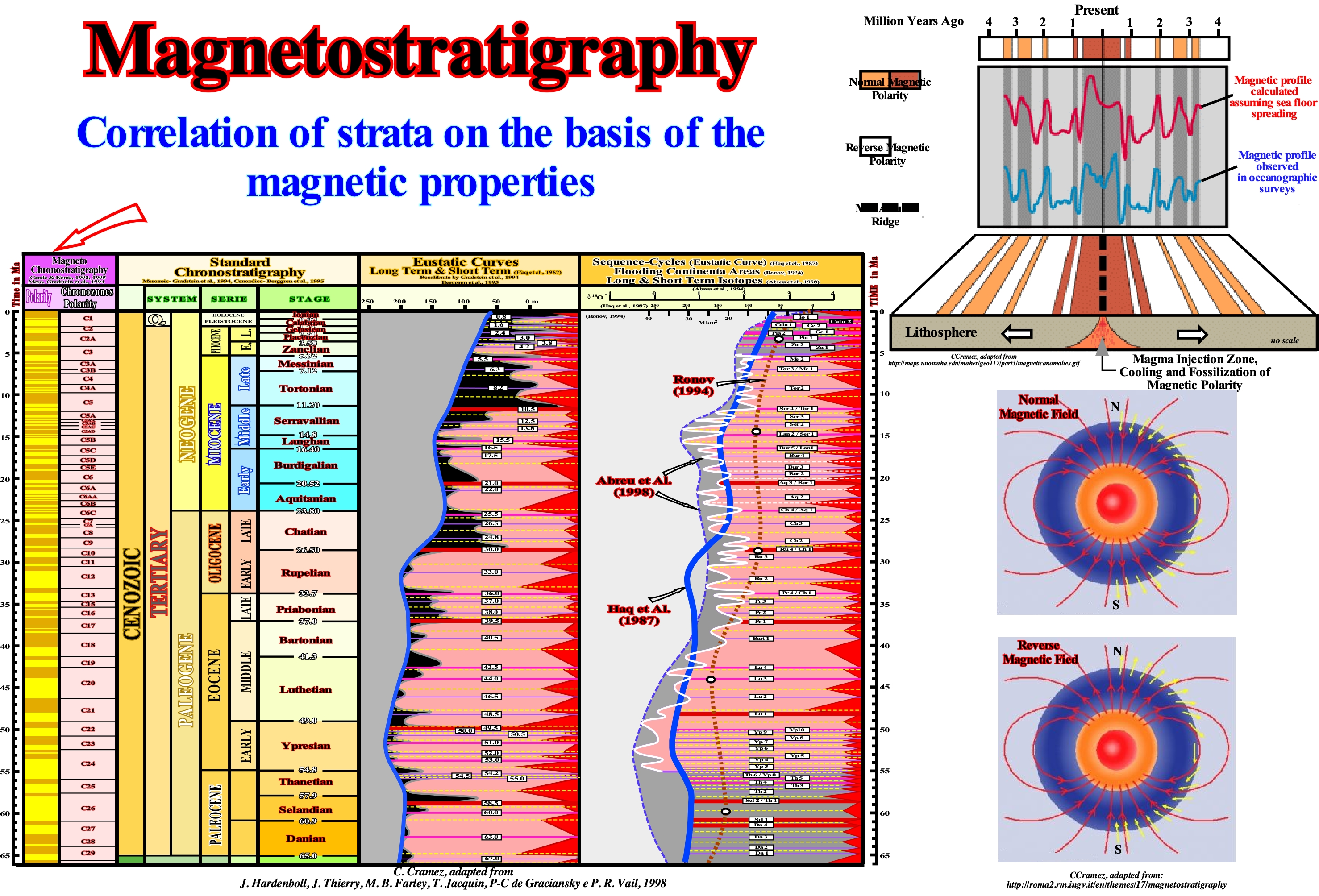
The magnetostratigraphy is a chronostratigraphic technique used to date the sedimentary and volcanic packages. In this figure, the scale shown is the scale of the Cenozoic magnetic polarity. At the moment of formation of the rocks, the ferroginous minerals are oriented according to the Earth's magnetic field of the time. The magnetization of the rocks creates a fossil remnant magnetism that can be used as a fossil compass to determine the direction of the old magnetic field (paleomagnetism). In this way, the geoscientists have verified that the measures of the fossil terrestrial magnetic field suggest that during the geological history, the magnetic poles, for reasons still not well known, have been inverted several times. The two points on the Earth's surface where its magnetic force lines meet, since the Earth acts like a huge magnet due to the existence of a mass of iron in its nucleus (electrical currents in the nucleus generate most of the magnetic field, although 10% is produced by currents of the ionosphere*). The magnetic poles change position slowly, but they remain about 1,600 km from the geographic poles that determine the axis of Earth's rotation. Unlike the geographic poles, the two magnetic poles are not exactly opposite. The imaginary line that connects them (magnetic axis), passes through the exact centre of the earth, but about 530 km from it (https://en.wikipedia.org/wiki /Polo_magnético). The time-interval between the magnetic inversions varies a lot. A mean of about 500 ky is, sometimes, advanced for each inversion of polarity. The time-intervals during which the magnetic polarity is the same today are now called normal and, conversely, reverse. Since the inversions of geomagnetic polarity are synchronous, the use of their registers represents an absolute clock to date the sedimentary intervals. This is, particularly, important for sedimentary intervals without fossils. The main difficulty of using magnetic registers in geological correlations is the identification, for a given region, of the global geological event that is represented by magnetic inversion. This problem is, partially, solved when the magnetic signature can become evident within a succession of inversions. If in the Eocene series, for instance, we recognize a succession of inversions in which a long normal period is interspersed between two long inverse intervals, the probable age is Middle Eocene. The use of magnetic stratigraphy in conjunction with other dating methods allowed geoscientists to date the sediments of the Cenozoic and the upper Mesozoic. The magnetization measurement process comprises 3 phases: (i) Demagnetization to remove the magnetizations subsequent to the original magnetization so that the minerals are only in the orientation of the original magnetic field** ; (ii) Measure of the Orientation is a phase measuring the orientation (striking) of the magnetic minerals ; (iii) Statistical Treatment, is the stage in which the obtained data, resulting from the samples of each locality are subjected to a statistical treatment, indispensable to make the results more reliable. Certainly, one of the most important applications of magnetostratigraphy is the determination of deposition rate. To do this, it is enough to trace the age of each magnetic inversion (millions of years ago) versus the stratigraphic level, in which the inversion was found (in meters), which gives the rate in meters per million years but expressed, usually, in millimeters per year, which is equivalent to a rate in km/My. The magnetostratigraphic data can also be used to model the subsidence rates of the sedimentary basins, since knowing the depth of a source-rock can calculate the age at which its organic matter reached the oil window and when the hydrocarbon migration has begun. On the other hand, since the age of a trap can be determined from magnetostratigraphic data, by comparing the ages of the trap and the migration of hydrocarbons geoscientists can calculate the likelihood of success of a prospect.
(*) Locates between 60 km and 1,000 km of altitude, composed of ions, plasma and that due to its composition, reflects radio waves until approximately 30 MHz.
(**) The rocks, usually, have a second magnetization, very more recent than the original remaining magnetization, which is imposed by the current magnetic field, which is, mainly, due to modifications during surface weathering of the rocks.
Mainland...............................................................................................................................................................................................................................Terre ferme
Em terra (terra firme) / En Tierra / Onshore, An Land / 陆上 / Материк (суша) / A terra /
Land limited continentward by the shoreline. The expression on land or onshore is opposed to that of offshore, i.e, the land covered by water seaward of the shoreline. Synonym of Coastal and Onshore.
See: « Shoreline »
&
« Onshore »
&
« Supercontinent »
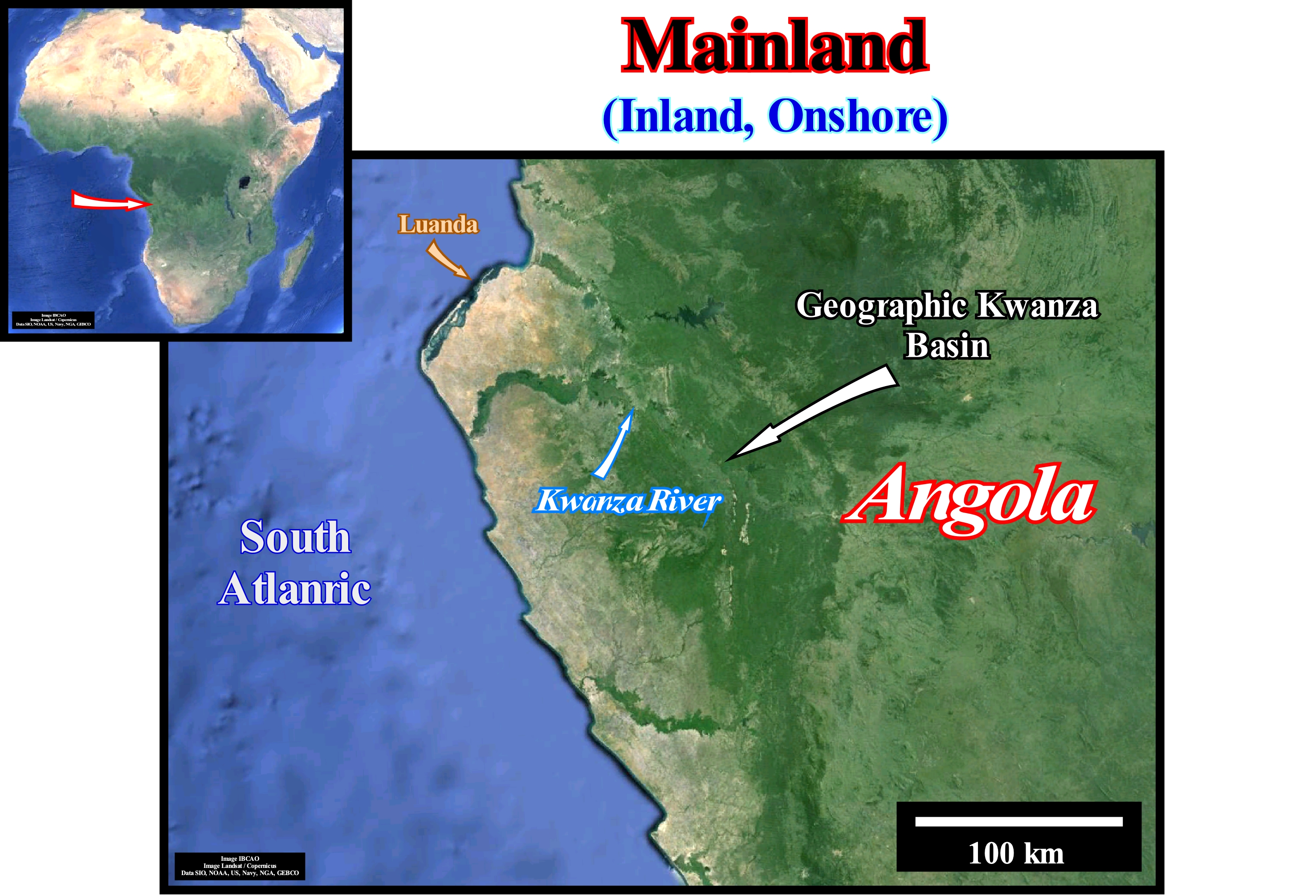
This figure shows a part of Angola onshore, i.e., a part of the land upstream of the shoreline, at the latitude of the Kwanza geographical basin, which is located south of the Congo River and crossed by the Kwanza River (south of Luanda, which is the Angola capital). This mainland, as distinguished from an island or peninsula, or onshore area is, at the geological point of view, composed of several basins of the classification of the sedimentary basins of Bally and Snelson: (i) A Precambrian basement; (ii) A Paleozoic folded belt ; (iii) Rift-type basins formed during the lengthening of the Gondwana small supercontinent (probably in association with a thermal anomaly) and (iv) A divergent Atlantic-type margin deposited over the rift-ype basins formed before the break-up of the lithosphere that individualized the African and the South American plates. The offshore, i.e., the land covered by sea-water (downstream of the shoreline), is formed by the central and distal part of the divergent margin (Atlantic-type) deposited over the oceanic crust and the sub-aerial crust implemented, immediately, after the break-up of the lithosphere, i.e., postdating the formation and filling of the rift-type basins. In geological terms, the distinction between onshore and offshore is important because, in general, they are formed by rocks deposited in different sedimentary basins. The offshore corresponds, mainly, to divergent Atlantic-type margins (developed in areas where the prevailing tectonic regimes are in extension and formed in association with the formation of new oceanic crust) or to divergent non-Atlantic margins. Non Atlantic-type margins develop in areas where the tectonic regimes in compression (shortening) are predominant, i.e., in association with the formation of megasutures* (Earth's moving regions). These regions, which correspond to folded and faulted mountain ranges, testify the complexity of the accretion and deformation phases undergone by the geological bodies in the regions where the compressive tectonic regimes are predominant. However, although the compressive tectonic regimes, associated with the subduction zones, are predominant in the formation of a megasuture, extensional tectonic regimes and the formation of sedimentary basins play, also, an important role. In the onshore, besides the Precambrian cratons, which form most of the onshores, the most common sedimentary basins are: (a) Rift-ype basins ; (b) Cratonic basins and (c) Those associated with the formation of convergent margins such as: Fore-Arc Basins, Foreland Basins and Folded Belts. In the offshore, the sedimentary basins are, often, associated with the formation of new oceanic crust. These associations, which induce different types of subsidence, are the basis of the classification of sedimentary basins proposed by Bally and Snelson (1980), in which the basins associated with the formation of megasutures can be: A) Perisutural Basins and B) Episutural Basins. The perisutural basins, which are located in the periphery of megasutures, are: a.1) Oceanic Trenches, created in association with Type-B subduction zone (Benioff) ; a.2)- Foreland or Foredeep Basins created in association with an A-type subduction zone (Ampferer) and a.3) Chinese-Type Basins, associated with felsic intrusions. The episutural basins, developed within the megasutures, are: b.1) Fore-arc Basins ; b.2) Back-arc basins ; b.3) Pannonian-type Basins ; d) Mediterranean-Type ; e) "Great Basin" Type basins ; f) Californian Type Basin. Note that Bally and Snelson sedimentary basin classification, as well as all other classifications, does not allow to predict the volume of hydrocarbons generated and preserved in the considered basins. However, it allows and, to a certain degree, it obliges geoscientists to make geological observations controlled by Plate Tectonics, which is the basis of any progress in petroleum exploration. This means that using of this classification in combination with a sequential stratigraphic interpretation of seismic lines, has immediate results in the evaluation of the remaining petroleum potential of geographic depocenters, particularly when structural exploration is mature or super-mature, as it is the case in many areas. Such a combination allows a better evaluation of different petroleum parameters and the recognition of the potential of non-structural traps, as well as, a quickly highlight of the killer petroleum parameter, that alone can, at the petroleum point of view, to kill a prospect or a basin.
(*) Earth's mobile region (folded and faulted mountain belt) that testify the complexity of the accretion and deformation phases undergone by the geological bodies in regions where the compressional (shortening) tectonic regimens are predominant. The term megasuture was first used by A. Bally (1975). Although the compressional tectonic regimes associated with the subduction zones are predominant in the formation of a megasuture. The extensional regimes and the formation of sedimentary basins play, also, an important role.
Major Downlap Surface................................................Surface de base des progradations principales
Superfície de base das progradações principais / Superficie de base de progradaciones principales / Basisfläche der wichtigsten progradations / 主要下超面 / Основная поверхность регрессивного налегания / Superficie di base di progradations principali /
Downlap surface associated with first order the eustatic cycles or, in terms of rocks, associated to the continental encroachment stratigraphic. The downlap surface known as DS. 91.5 Ma (Cenomanian / Turonian) is the major downlap surface of the post-Pangea continental encroachment cycle.
See: « Stratigraphic Cycle »
&
« Systems Tract »
&
« Flooding Surface »
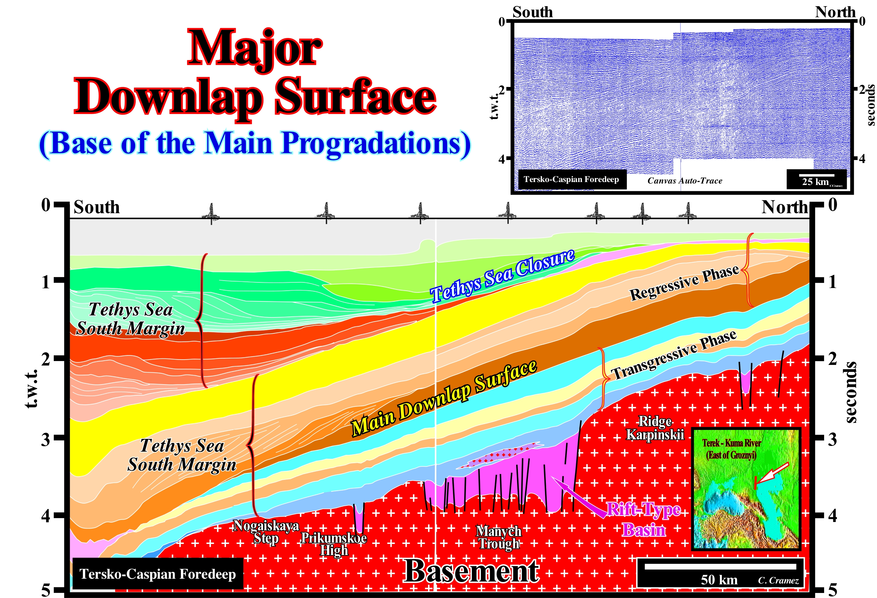
This tentative geological interpretation of a Canvas auto-trace of a seismic line, taken in a tectonically active area, illustrates the closure of the Tethys Sea*. The Tethys sea was located NE of the Gondwana small supercontinent and SE of the Laurasia small supercontinent . It replaced the Paleo-Tethys ocean, i.e, the ancient Paleozoic Ocean, between Gondwana, Central Europe, Iberia, China and Central Asia. At the bottom of this tentative interpretation, it is, easily, to recognize the southern margin of the Eurasia small supercontinent (north bank of the Tethys Sea) and, in the upper part, the north margin of the small supercontinent Gondwana. The major downlap surface, whose age is, more or less, Cenomanian / Turonian, marks the maximum flooding surface of the Cretaceous (MFS 91.5 Ma). It is, clearly, defined as the interface between a retrogradational geometry (chronostratigraphic lines, more or less, parallel, defining a sedimentary interval which, globally, slightly thickens continentward) and a progradational geometry (sigmoid chronostratigraphic lines, sometimes oblique, defining an interval that thickens seaward) with a south polarity. The southern polarity or vergence of this progradational interval indicates that the continental-edge of the different sequence-cycles composing it, moves, globally, southward, which suggests a continent located at North (small supercontinent Eurasia) and an ocean at South (Tethys Sea). Potential marine source-rocks, i.e., Cretaceous rocks rich in organic matter (mature or not) deposited in association with the maximum flooding surface (fossilized by the main downlap surface), whose age is Cenomanian-Turonian. The polarity of the progradations and the downlap surface of the northern margin of the Gondwana small supercontinent, overlying the divergent margin south of Eurasia, suggests a continent at the South (small supercontinent Gondwana) and ocean at North (Tethys Sea). Over time, as the small continents Eurasia and Gondwana approached one another, the Tethys Sea became smaller and smaller. Finally, the Tethys Sea closed, completely, when the two margins (north Gondwana and south Eurasia) collided, which is underscored by the downlap surface, which in this particular case corresponds to a major unconformity. Attention to the term collision, used here, since in the plate tectonics the kinetic energy** plays no important role, which is not the case in a collision between two cars that translates, above all, a change of kinetic energy in energy of deformation. Source-rocks, probably, lacustrine were deposited in the north margin of the Gondwana that today forms part of the Caucasus mountains. Before the Tethys Sea existed the Paleo-Tethys Ocean, within the great gulf of the supercontinent Pangea, where several micro-continents existed. About 300 million years ago, in the eastern part of this gulf, a thin arch was individualised in the interior of the southern arm of Pangea. Behind, i.e., between the Gondwana small supercontinent and this new micro-continent, which the geoscientists called Cimmeria (it included what is now Australia, Antarctica, part of the Indian continent and Africa-Arabia) began to form a new ocean, which was called Tethys Sea, but has nothing to do with the ancient Tethys Sea of the Austrian geoscientist Eduard Suess. The sea floor spreading associated with this new sea, forced the Cimmeria to move northward to Laurasia, closing, gradually, the Paleo-Tethys Ocean (former Tethys Sea of E. Suess). Some geoscientists consider secondary downlap surfaces when they are referred to continental encroachment sub-cycles, which are induced by 2nd order eustatic cycles, whose time-duration varies between 3/5 My and 50M. Similarly, at the level of the sequence-cycles, which are induced or deposited in association with 3rd order eustatic cycles (duration between 0.5 and 3/5 My), we can speak of tertiary downlap surfaces.
(*) The Tethys Sea began to form in the south of Paleo-Tethys, since the Cimmerian plate was individualized (Permian/Triassic). The expansion of the Tethys Sea forced the Cimmerian plate to collide with Laurasia, to finally the Sea Tethys completely replace the Paleo-Tethys. In Greek mythology, Tethys is the mother of Achilles and one of the daughters of Neree and Doris (sister of King of Scyros, Nicodemus).
(**) There are two types of energy, the kinetic energy, that is, the ability to do work through the movement and the potential energy, i.e., the ability to do work through the position. Although we often meet terms such as electrical energy, chemical energy, nuclear energy such things do not really exist. They are only practical abbreviations for specific combinations of the kinetic energy and potential energy. Thus, the electrical energy is only the potential energy of negative charge electrons in the presence of positive charges. The exception to this universality of the kynetic energy and potential energy is the energy of electromagnetic radiation, such as the energy of light, such as the one transported from the Sun to Earth and which heats us or aliments photosynthesis. (P. Atkins, 2003- Galileo's Finger, Oxford University Press)
Major Storm Wave Base..............................................Limite maximale d'action des vagues de tempête
Acção das vagas (mar agitado, limite máximo) / Límite máximo de acción de olas de tormenta / Aktion der Wellen (Seegang, Höchstgrenze) / 最大风浪行动 / Максимальное действие штормовых волн / Limite massimo di azione di onde di tempesta /
When the erosive action of the sea waves reaches about 50 m or more of waterdepth, which happens especially during strong storms.
See: « Average Storm Wave Base »
&
« Depositional Base Level »
&
« Turbidite »
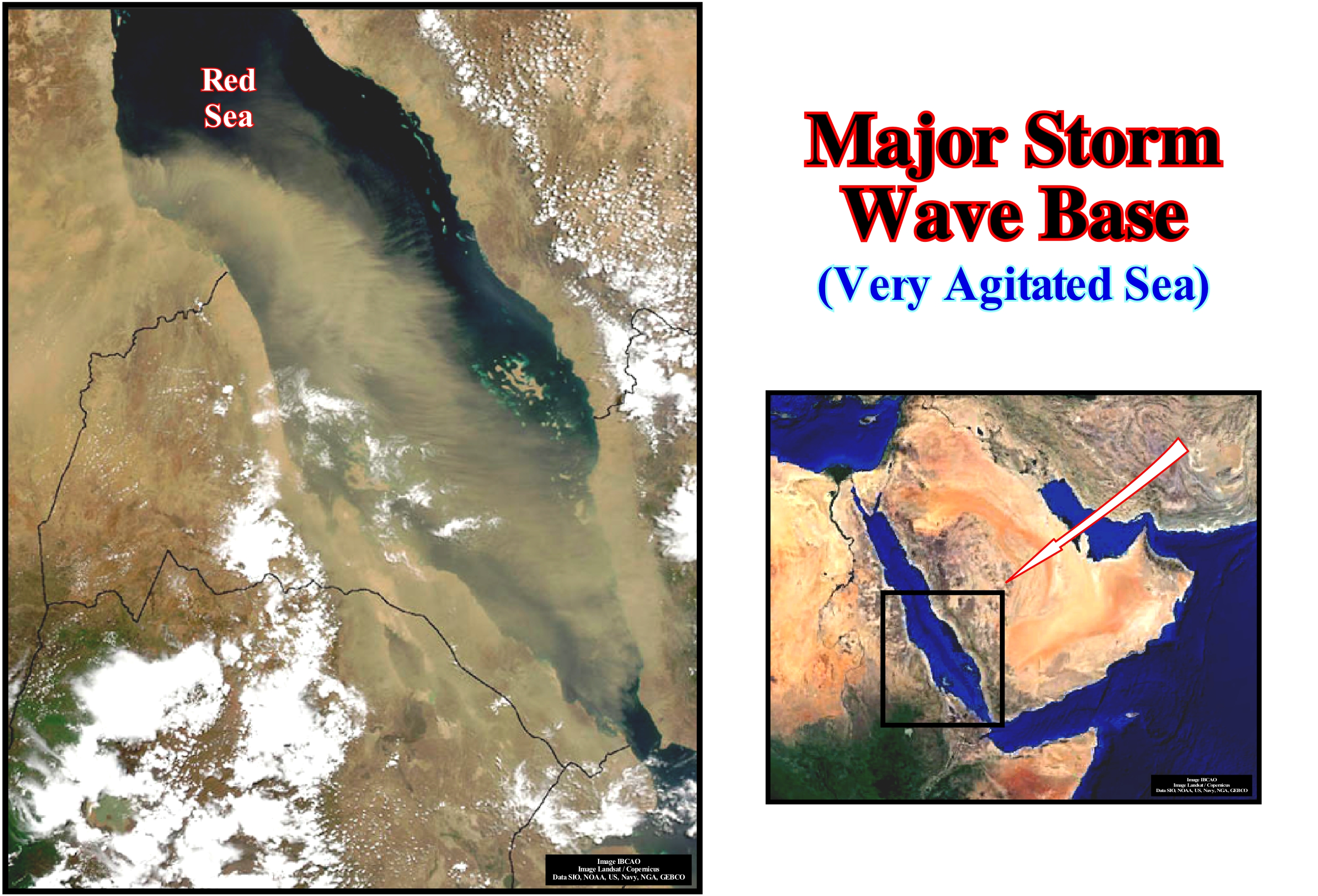
When the sea is very agitated, the depth of the erosive action of the waves is so great that the sediments of a vast area of the sea floor are put into suspension making it very muddy, as can be seen in this Red Sea aerial photograph. The brownish spot seen in the western part of the Red Sea should not be interpreted as clouds. The clouds correspond here to white spots. The brownish colours due to the strong sedimentary load that the sea had at the time the photograph was taken. The scale of the phenomenon illustrated here shows the impact of the erosive action of waves when the sea is very agitated (major storm wave base). This action may explain the formation of certain turbidite currents during highstand geological periods (when the relative sea level is above the basin-edge, which corresponds to the continental-edge, when the basin has a shelf ) and during the deposition of the 2nd stage of development of highstand prograding wedge (HPW). Within a sequence-cycle, induced by a 3rd order eustatic cycle, whose time-duration varies between 0.5 and 3-5 My (millions of years), during the deposition of the highstand prograding wedge (HPW), even if at the beginning the basin has a shelf (the basin-edge is the continental-edge or continental-border), from a given moment, the sedimentary basin has no more shelf, since the continental-edge coincides, more or less, with the shoreline (the depositional coastal break of the depositional surface and the continental-edge are, practically, coincident). In these conditions, when the sea is very agitated, the action of the waves erodes and remobilizes the coastal deposits, contributing to the formation of gravity currents (turbidity currents, which become, more or less, opaque due to suspended sedimentary particles), which transport the sediments to the abyssal plain via the continental slope. Depending on the amount of sediment carried by gravity currents, various types of turbidite systems can be deposited on the lower slope and on the abyssal plain. Emiliano Mutti (1995) considers three types of major turbidites: (i) Type 1 Turbidites ; (ii) Type 2 Turbidites and (iii) Type 3 Turbidites. The amount of sandy material carried by the streams decreases from Type 1 Turbidites to Type 3 Turbidites. Peter Vail (1988) considers only two types of deposits turbidites: (a) Submarine Slope Fans (SSF) and (b) Submarine Basin Floor Fans (SBFF). The great difference between the P. Vail and E. Mutti models is that Vail considers that within a sequence-cycle, turbidites settle down only during periods of lowstand (when the relative sea level is lower than the basin-edge), which is not the case E. Mutti's model. For P. Vail, turbidites are, always, associated with significant relative sea level falls, i.e., with erosion surfaces, considered to be unconformities (stratigraphic cycles boundaries). Mutti thinks, probably rightly, that turbidite deposits are not restricted to lowstand geological conditions. They can, also, be deposited during highstand periods, particularly, in association with strong storms, large floods of important rivers (rapid and marked rises in water level with overflow flooding) or in association with failures of the continental-edge (gravitational landslides) and upper continental slope. Turbidite deposits, whether associated with lowstand or highstand geological conditions, are the only depositional systems that do not require an increase in the available space for the sediments (accommodation), i.e., they do not require a relative sea level rise. When speaking of sea level, one must always determine whether it is absolute (eustatic) or relative*. The first is supposed to be global and referenced to Earth's centre. The second, i.e., the relative sea level is, local, and referenced either to the top of the continental crust (base of the sediments) or to the sea floor. The absolute sea level is the result of the combined action of: i) Tectono-Eustasy that is controlled by the volume variation of the ocean basins in association with oceanic expansion following the break-up of the supercontinents ; (ii) Glacio-Eustasy, which is controlled by the variation of water volume of the oceans as a function of the amount of ice (assuming that the amount of water in all its forms is constant since the Earth formation about 4.5 Ga) ; (iii) Geoidal-Eustasy which is controlled by the distribution of ocean water caused by variations in the terrestrial gravity field, and (iv) Steric rise in sea level or thermal expansion of the oceans, which is controlled by rising of ocean temperatures. The relative sea level is the result of the combined action of absolute (eustatic) sea level and tectonics (subsidence or uplift of the sea floor).
(*) When the media or a politician speaks of sea level rise without specifying whether it is the relative or absolute (eustatic) sea level, it is because he wants to pass on a false message or because he is, totally, ignorant. The "famous" sea level rise of the coastal regions of Al Gore, is a relative sea level rise and not an absolute (eustatic) sea level. It is induced by a lowering of the sea floor caused by the weight of the dwellings or by an excess deposit (in the case of the deltaic regions), which has nothing to do with a possible increase in the CO2 content or the temperature.
Map...................................................................................................................................................................................................................................................Mappe, Carte
Carta, Mapa / Mapa / Karte / 地图 / Карта / Mappa /
A diagram, drawing or other type of graphical representation, usually, in two dimensions, of certain physical characteristics (natural, artificial or both) of part or all of the Earth's surface, other planets, any other surface or an area of subsurface, by signs and symbols with indication of orientations, so that, the relative position and size of each characteristic on the map corresponds to its correct geographical position according to a predetermined projection and scale (Bates, RL & Jackson, JA, 1980).
See: « Contour Map »
&
« Mapability »
&
« Relative Sea level Change »
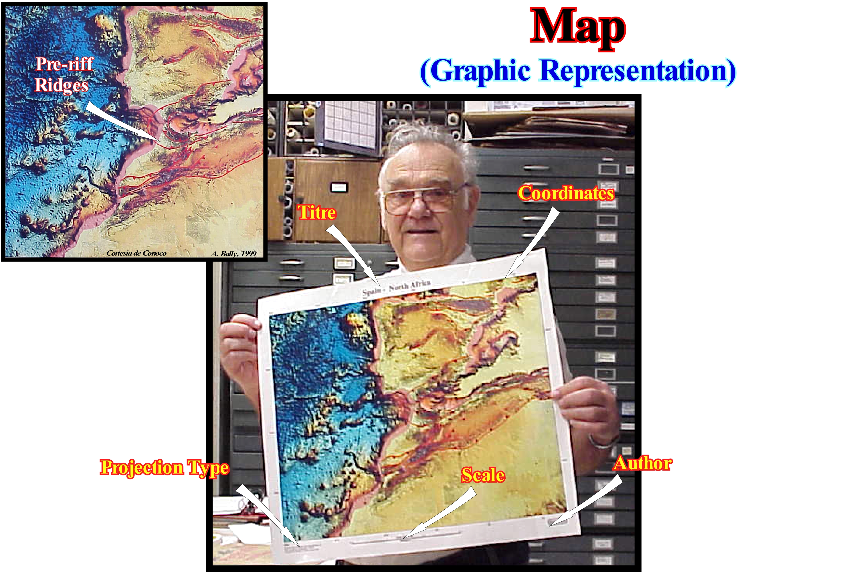
The maps that interest us here are, mainly, the maps used by geoscientists, such as topographic, bathymetric, geological, contour maps of seismic and geological horizons, etc. Often maps are called charts. A geological map shows geological information and especially information about what lies beneath the Earth's surface. It is possible to represent in a geological map: (i) The type, relative age and location of the different geological formations ; (ii) The type and location of the contact between the different types of lithology ; (iii) The type and location of surface deposits ; (iv) The strike and dip of stratified rocks ; (v) The type and location of aspects related to rock deformation ; (vi) The topographic base supporting the geological mapping, etc. Modern geological maps can, also, represent the stratigraphic column (vertical location of the lithological units in a particular area) relating the various units in chronological terms, highlighting the type of contact and the possible existence of unconformities between them and the interpretative profile defined according to directions that allow a better interpretation of the main geological structures existing in a certain region. Geological maps are useful for prospecting and exploration of energy resources, minerals, in particular hydrocarbons, but also for ground water exploration, as well as: (a) Selection and characterization of sites for the implantation of major engineering works ; (b) Studies on the characterization and preservation of the environment ; (c) Studies on the prediction and prevention of natural phenomena, such as seismic and volcanic activity and scientific studies.
Map Projection...............................................................................................................................................................................Projection (Carte, mappe)
Projecção (tipo de mapa ou de uma carta) / Proyección (tipo de mapa) / Kartenprojektion / 地图投影 / Картографическая проекция / Mappa proiezione /
Any method of representing a sphere or other geometric shape on a plane. Different projections are needed to create maps. All the projections distort, more or less, the surface that is wanted to represent. Function of map purpose, some distortions are acceptable and others are not. That is why there are different projections in order to preserve certain properties of the projected surface to the detriment of others.
See: « Geological Map »
&
« Mapability »
&
« Isochron »
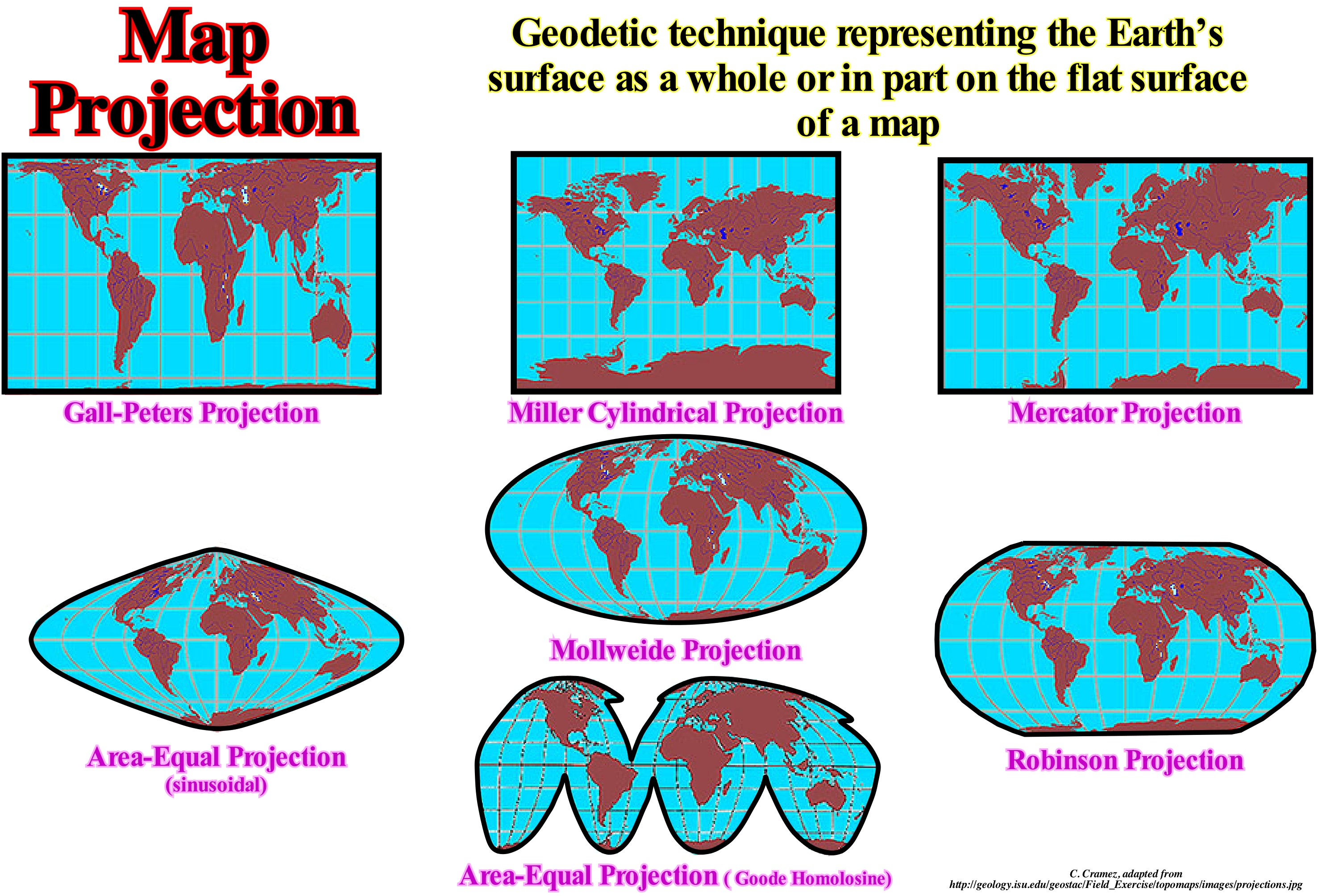
In this figure different types of projections are shown: (i) Gall-Peters projection ; (II) Mercator Projection ; (iii) Miller Cylindrical Projection ; (iv) Mollweide Projection ; (v) Equal Area Projection (sinusoidal) ; (vi) (vi) Equal Area Projection (Goode homolosine) and (vii) Robinson projection. In the Gall-Peters projection, called also equivalent cylindrical, the lines perpendicular to the parallel and the meridian lines have smaller intervals, which results in a faithful reproduction of the areas of the continents at the expense of a greater deformation of the same. The Mercator-projection is a representation of the spatial coordinates relative to the three dimensions of the terrestrial globe in a two-dimensional planisphere (even if markedly deformed such projection is an unfolding at the level of the terrestrial equator, of the longitude scales integrated into its latitudes). The Miller Cylindrical Projection is an alternative to Mercator projection, in order to reduce the large scale variation with latitude and to allow the poles to be represented. In the Mollweide projection, created to correct the various distortions of Mercator projection, the parallels are straight lines and meridians, curved lines (area is proportional to that of the terrestrial sphere having elliptical shape and flattening of the north and south poles). In the Projection of Equal Area (sinusoidal) the parallels are straight lines evenly spaced, and therefore the system is assimilated as a pseudo-cylindrical projection, although the meridians have a sinusoid shape (only the central meridian is straight ) and the surfaces are conserved and representation of the poles is less deformed than in a true cylindrical projection. The Projection of Equal Area (Goode homolosine), modification of Mollweide projection, of sinusoidal character, where several meridians are taken as the centre and separate projections are made. It is an equivalent projection (keeps the areas in proportion and gives a greater sense of the sphericity of the Earth's surface). The Robinson projection, nonconform and nonequivalent based on coordinates and not on a mathematical formulation (designed to minimize angular and area distortions).
Mapability.............................................................................................................................................................Capable d'être cartigraphiable
Mapeamento (possibilidade de) / Mapabilidad / Abbildbarkeit, Geeignet, um mappable / 能够被制图 / Способность быть отображаемыми на картах / Capace di essere mappabile /
Possibility of representation on a geological formation or stratigraphic event, either from field or seismic data. on a map. In the field, where the observation scale is 1: 1, practically, all stratigraphic events can be mapped, it is a simple matter of scale. However, this is not true in a seismic map, since seismic resolution has to be taken into account. Some geoscientists consider mapability as synonymous the seismic resolution.
See: « Geological Section »
&
« Seismic Resolution »
&
« Formation (geological) »
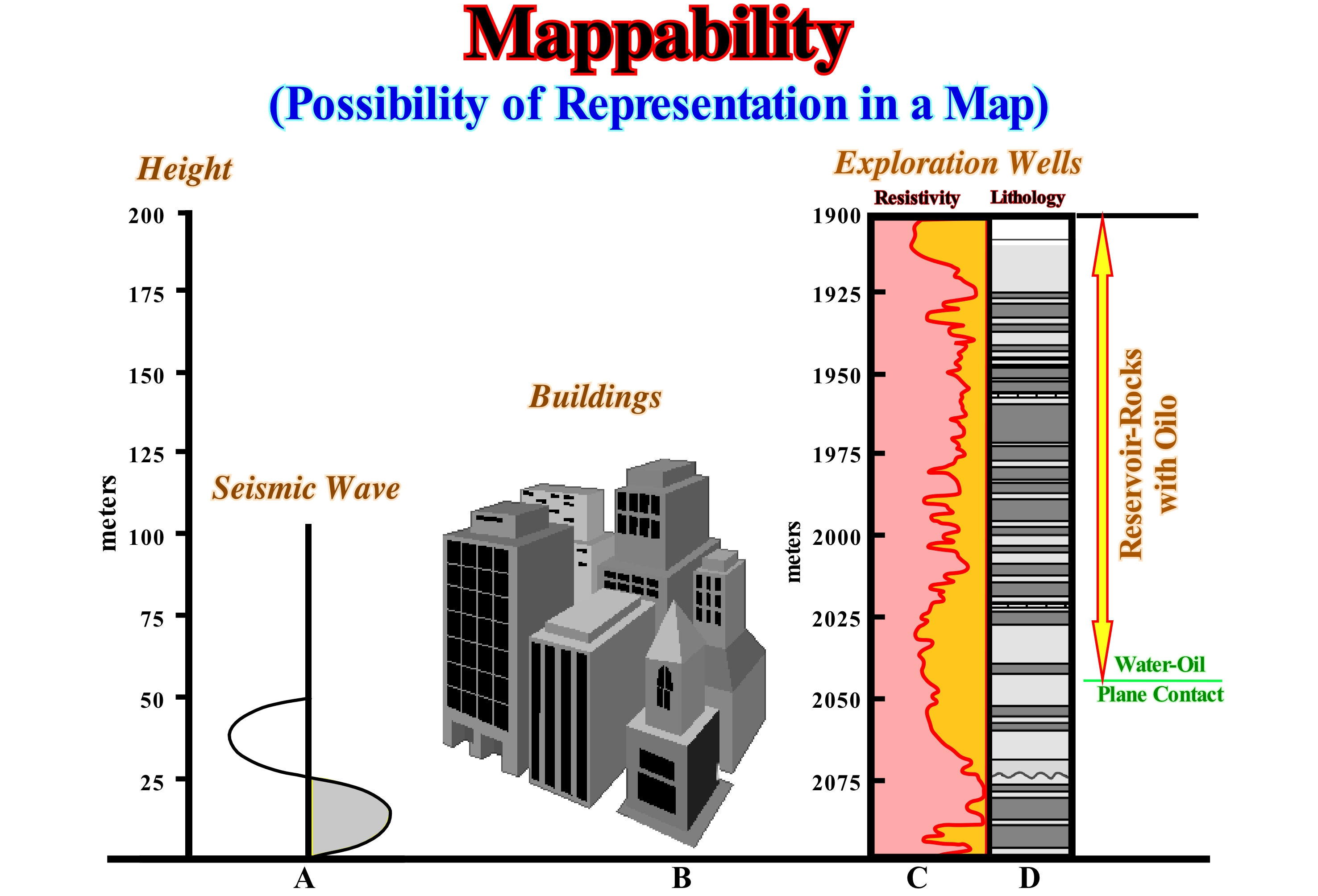
The mapability of the geological objects interpreted through the seismic data can be deduced from this figure, where the thickness of: (A) A 30 Hz* seismic wave in a velocity medium of 1,828 m/s (or 60 Hz with a velocity of 3657 m/s) ; (B) Buildings of a city y; (C) The resistivity diagrams of a research well (North Sea) and (D) The stratigraphic column crossed by the research well. The seismic resolution is rarely greater than 50/60 m, meaning that all stratigraphic intervals with a thickness of less than 50-60 meters can not be recognized in conventional seismic lines, and thus all representation (manoeuvrability) it's impossible. In the geological interpretation of the seismic lines, the geoscientists in charge of interpretation always have to take into account the seismic resolution, not only vertical, but also lateral. The first one can be defined as the smallest vertical distance between two interfaces, necessary for a simple seismic reflection to be observed. This distance is, of course, a function of the wave-length of the seismic energy. The lateral resolution is determined by the Fresnel zone, which, in turn, depends on the wavelength of the seismic pulsation and depth of the reflector. Seismic energy travels through the stratigraphic intervals and comes in contact with a reflection interface in the same way that light from a pocket lamp travels through the darkness and illuminates a certain area (usually a circle if the lamp light is perpendicular to the surface). Energy travels through wave fronts and the region in the reflector where the energy is reflected is called the Fresnel zone. In a non-migrated seismic line, the lateral resolution depends on the: (i) Seismic band ; (ii) Interval velocity and (iii) Travel time to the reflector.
(*) Hertz (Hz) is the unit of measurement derived from the International System for frequency, which expresses, in terms of cycles per second, the frequency of a periodic event, oscillations or rotations per second (s−1 or 1/s).
Marine Flooding Surface....................................................................................................Surface d'inondation marine
Superfície de inundação marinha / Superficie de inundación marina / Marine -Hochwasser Oberfläche / 海泛面 / Поверхность морского затопления / Superficie di inondazione marina /
Surface that separates sedimentary layers showing an increasing of depositional water-depth. An increase in water-depth may be accompanied by submarine erosion (ravinment surface) and a small hiatus induced by the action of the waves. A marine flooding surface limits sequence-paracycles, but not sequence-cycles
See: « Transgressive Interval »
&
« Hiatus »
&
« Relative Sea Level Rise »
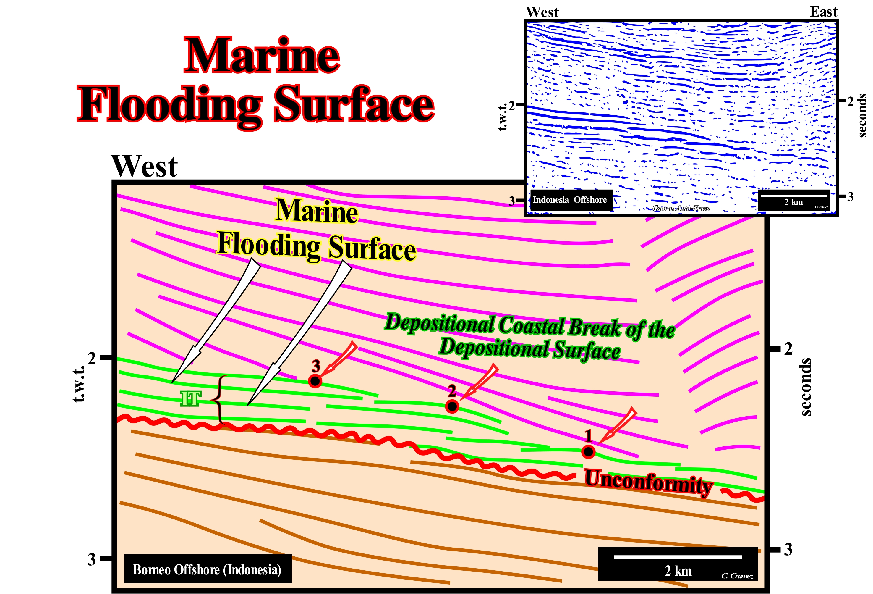
Sea level can be of two types: (i) Relative sea level and (ii) Absolute or eustatic sea level, The relative sea level is the local and referenced to any fixed point on the Earth's surface, which can be the base of the sediments (top of the continental crust) or the sea floor. The absolute (eustatic) sea level, which is supposed to be global, is referenced to the Earth's centre. Presently, NOAA, i.e., the National Oceanic and Atmospheric Administration, uses satellite altimetry. However all satellite measures must be always calibrated by corrected tide-gauge results, i.e., the subsiding and uplifting site areas (presently, NOAA, i.e., the National Oceanic and Atmospheric Administration, uses satellite altimetry that must be calibrated by corrected tide-gauge results, that is to say, the subsiding and uplifting site areas, must be imperatively taking into account, what seems not be always, often the case (Mörner, N. A., 2011). The relative sea level is the result of the combined action of absolute (eustatic) sea level and tectonics (subsidence or uplift of the sea floor). The absolute sea level is the result of the : i) Tectono-Eustasy that is controlled by the volume variation of the ocean basins in association with oceanic expansion following the break-up of the supercontinents ; (ii) Glacio-Eustasy, which is controlled by the variation of water volume of the oceans as a function of the amount of ice (assuming that the amount of water in all its forms is constant since the Earth's formation, around 4.5 Ga) ; (iii) Geoidal-Eustasy, that is controlled by the distribution of ocean water caused by variations in the Earth's gravity field (where gravity is stronger than normal, sea level is thrown to the Earth's centre) and (iv) Steric rise in sea level or thermal expansion of the oceans, which is controlled by rising ocean temperatures (if the temperature increases, the density of water decreases and, for a constant mass, the volume increases). The term marine flooding surface seems redundant, but in reality it is not, since there are flooding surfaces in fluvial environments, in particular, in association with overbank deposits. It can be said, for instance, that along a river valley, there is a non-marine flooding surface between each natural marginal dyke (levee). On this tentative geological interpretation of a Canvas auto-trace of a detail of an East Borneo offshore (Indonesia) seismic line, several marine flooding surfaces are recognized within the transgressive interval (TI) of a sequence-cycle, whose lower boundary is, in this particular case, underlined by a red colour. This transgressive interval (TI) is, in this tentative interpretation, underlined by chronostratigraphic lines coloured in green. It forms the lower systems tracts sub-group of the highstand systems tracts group (HSTG) of the considered sequence-cycle, whose upper boundary is, in this auto-trace difficult to recognize. The transgressive interval (TI), which here fossilises the lower unconformity of the sequence-cycle, is characterized by a, globally, retrogradational geometry. Its thickness increases continentward, then disappears, rapidly, by onlapping, to the west of this auto-trace. This retrogradational, global, geometry is the result of a succession of accelerating or increasingly important flooding or marine ingressions. The geological history of this transgressive interval may be explained as follows: (i) A relative sea level rise, i.e., an eustatic paracycle or a marine ingression, displaced the shoreline landward, as the water flooded the pre-existing topography, which corresponds, in this area of the basin, to the erosional surface that characterizes the upper unconformity of the underlying sequence-cycle ; (ii) During the marine ingression (growth of the eustatic paracycle), a ravinment surface* is formed on the preexisting topography ; (iii) The relative sea level rise created or increased the space available for sediment (shelfal accommodation) ; (iv) During the stability period of relative sea level, which occurs after each eustatic paracycle, the shoreline is displaced seaward as the sedimentary systems tracts, forming the sequence-paracycle, are deposited ; (v) However, the shoreline (position 1) does not reach the position it had before the eustatic paracycle ; (vi) A new marine ingression, but more important than the previous one, displaced, again, the shoreline continentward with the formation of a new ravinment surface and a new sequence-paracycle, which is less extensive than the previous one (position 2 of the shoreline which, overall, creates a retrogradational geometry). This history is repeated until a less important marine ingression occurs, which implies the associated sedimentary regression is more important than the preceding one and thus the shoreline line moves more seaward. That implies the beginning of the deposition of the overlying highstand prograding wedge (HPW), during which the marine ingressions are in deceleration.
(*) Surface of a submarine erosion linked to the action of waves and associated with sea flooding during a relative sea level rise.
Marine Gangway...........................................................................................................................................................................Passerelle marine
Passadiço Marinho / Pasarela marino / Marine-Gangway (Geologie) / 船用舷梯(地质) / Морской переходной мостик / Passerella Marine (Geologia) /
Passage between the two branches of a natural arch when the top of the arch collapsed.
See: « Natural Arch »
&
« Erosion »
&
« Pinnacle, Stack »
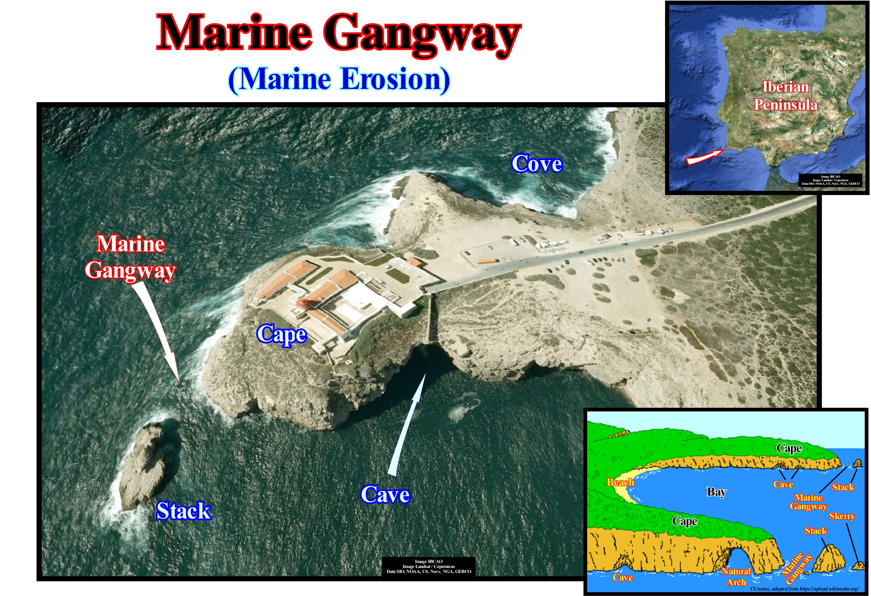
As illustrated in this figure, on the southern coast of Portugal it is easy to recognize marine gangways resulting from the collapse of a natural arch. The marine gangways illustrated here resulted, most likely from the collapse of a natural arches. A new natural arch is in formation, here in the marine cave phase. Within a few hundred years, probably the Fortress of Saint Vincent (visible in this figure) or will no longer exist or be separated from the continent. On this subject, it is important not to forget that the topography of the coastline, such as the interior, depends on the tectonic forces of uplift (shortening) or depression (lengthening) of the Earth's crust. The erosion tends to decrease the topography, while sedimentation tend to fill the depressions. The factors influencing the configuration of the shoreline are: (i) Uplift of the coastal region, which favours erosion ; (ii) Subsidence of the coastal region that induces deposition of coastal deposits ; (iii) Nature of the rocks or sediments that forming the coastline ; (iv) Relative sea level changes, which immerse or emerge the coastline ; (v) Storm importance and (vi) Tidal height, which affects erosion and sedimentation. The rate at which a cliff is eroded depends on the hardness of the rocks forming it and on the degree to which the cliff is exposed to erosive agents. The less resistant areas are the most eroded. If a fracture or fault exists on a promontory (cliff), the action of the waves will, easily, create an alcove, which will, gradually, turn into a cave. As a promontory is subjected to the erosive agents on both sides that define it, the marine caves with time become a natural arch. Later, eventually, the natural arch collapses, isolating from the stacks the front of the promontory. This was, certainly, what happened and what will happen at the tip of São Vicente illustrated in this photograph. In fact, the marine gangway here illustrated is defined to the west by a stack and westward by the slope of a natural arch in formation. In the erosion of shoreline, marine and terrestrial agents (underground sources, ice, wind, rivers, waves, etc.) operate together to produce erosion above sea level.
Marine Hiatus.......................................................................................................................................................................................................Hiatus marin
Hiato Marinho / Hiato marino / Marine-Hiatus / 海洋间断 / Морская расщелина / Iato marino /
Hiatus in a marine sedimentary environment. This type of hiatus is, almost always, by nondeposition, since submarine erosion is, generally, local, although it may be associated upstream with a regional erosional surface, i.e., with an unconformity.
See: « Hiatus »
&
« Unconformity »
&
« Downlap Surface »
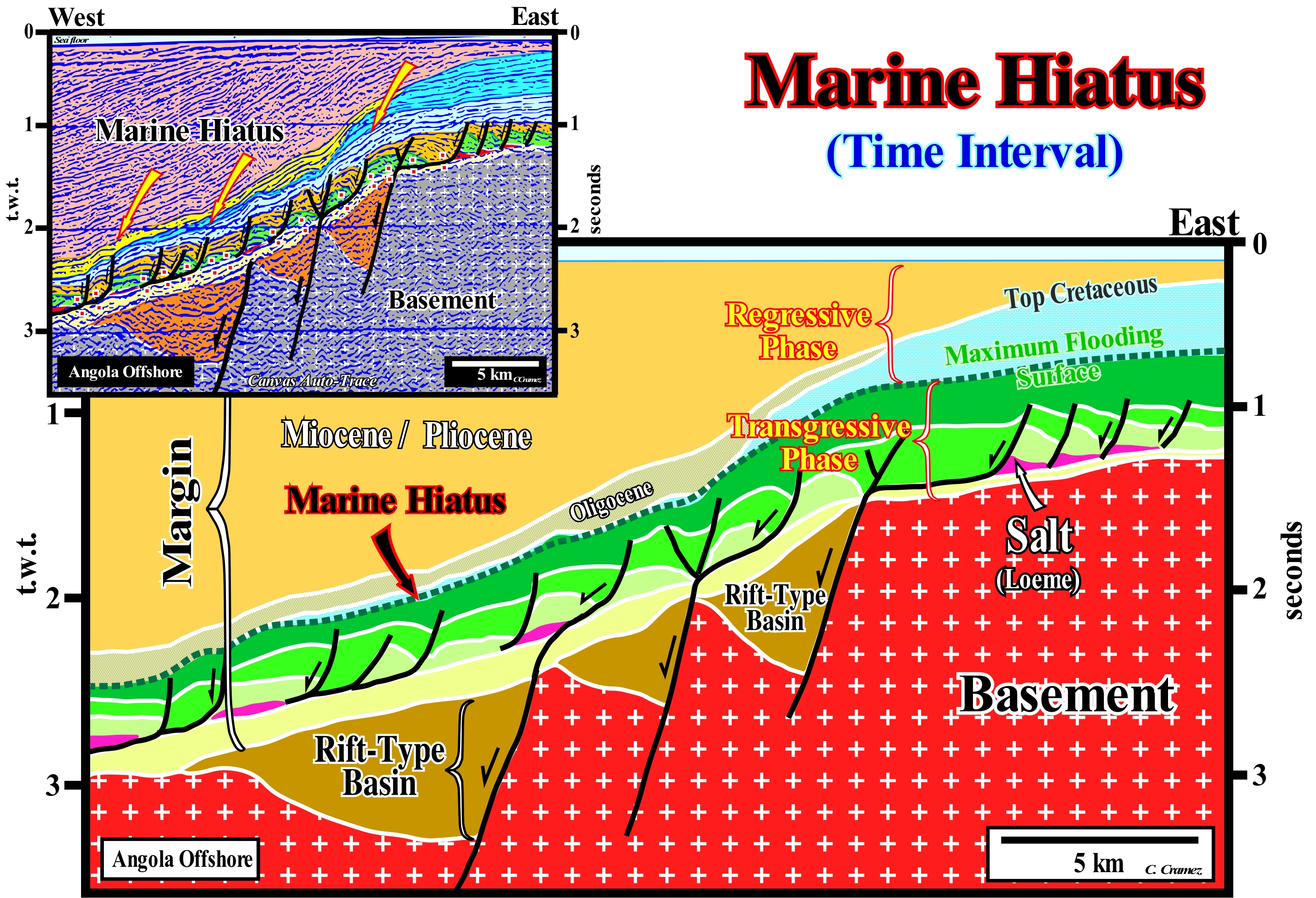
The Angola offshore corresponds to the stacking of several basins of the classification of the sedimentary basins of Bally and Snelson (1980). In most of the regional seismic lines, above a basement that corresponds, most often, to a set of Precambrian granite rocks or to a folded and flattened mountain belt, it is possible to recognize, the following basins: (i) Rift-type basins and (ii) An Atantic-type Divergent Margin. The rift-type basins, as their name suggests, are Late Jurassic/Late Cretaceous extensional structures (half-grabens) developed during the lengthening of the Gondwana small supercontinent, which are covered by a Mesozoic/Cenozoic Atantic-type divergent margin. The rift-type basins, which are filled by non-marine and, often, lacustrine sediments, predate the break-up of the lithosphere of the small supercontinent (Gondwana). The divergent margin begins with a sub-aerial volcanic accretion (lava flows incline and thicken seaward in direction of the spreading centres), before the spreading become oceanic with the formation of the oceanic crust (sheeted dykes and pillow lavas). In sequential stratigraphy, it corresponds to the post-Pangea continental encroachment cycle (induced by the second 1st order eustatic cycle of the Phanerozoic), within which two tectonic-sedimentary phases can be recognized: (a) Transgressive phase, retrogradational geometry, deposited during the absolute (eustatic) sea level rise (sea level supposed global and referenced to the Earth's centre) and (b) Regressive phase with progradational geometry and deposited during the absolute (eustatic) sea level fall. The geological interpretation of a Canvas auto-trace of a detail of an Angola offshore seismic line illustrates a huge marine hiatus between the transgressive and regressive phase of the post-Pangea continental encroachment cycle, which, by definition, increases basinward. The minimum hiatus along the downlap surface base surface marks the age of the Cretaceous marine ingression peak (91.5 Ma, Cenomanian/Turonian). The geological history suggested by this tentative interpretation is probably as follows: (i) The lithospheric crust of the supercontinent Pangea was elongated by an extensive tectonic regime due to normal faults that created rift-type basins (half-grabens, with opposite vergence, filled by non-marine sediments) ; (ii) From a given moment (when the thickness of the lithosphere, by thinning and injection of volcanic material reaches a thickness of about 10/15 kilometers), the lithosphere can no longer be stretched by normal faults and thus, it is broken by excess injections of the sub-litospheric mantle, individualizing two large lithospheric plates (Africa and South America) ; (iii) The break-up of the lithosphere of the supercontinent began a volcanic expansion (formation of subaerial crust ➡︎ new oceanic ➡︎ proto-South Atlantic ocean) ; (iv) On the margins of the new continents, a divergent continental margin was deposited, above the rift-type basins or above the basement of the small supercontinent Gondwana (southern part of the Pangea supercontinent), in association with a first-order eustatic cycle, which was responsible for the deposit of the post-Pangea continental encroachment cycle ; (v) This stratigraphic cycle is formed by two great tectono-stratigraphic phases: the transgressive phase and the regressive phase ; (vi) The lower transgressive phase, which was induced by an absolute (eustatic) sea level rise caused by oceanic expansion (tectono-eustasy) and, in particular, by the formation of oceanic ridges, which reduced the volume of ocean basins (the amount of water in all its forms is considered constant since the beginning of Earth's formation, around 4.5 Ga) ; (vii) During the absolute sea level rise, the shoreline, as well as the coastal depocenters, have, gradually, moved continentward ; (viii) Since the level of the eustatic sea level began to fall, the shoreline began to move seaward and downward, fossilizing, progressively, the Cretaceous maximum flooding surface, which underlines a huge marine hiatus by non-deposition. On this tentative interpretation it is important to recognize the tectonic disharmony induced by the salt horizon, near the base of the divergent margin. Above the tectonic disharmony, the sedimentary intervals were deformed (lengthened) by the halokinese (σt = 0, i.e., null tectonic vector) and by salt tectonics (σt < 0, i.e., when the tectonic vector is negative, traction), while that the intervals underlying the disharmony are not significantly deformed.
Marine Onlap.......................................................................................................................................................Biseau d'aggradation marin
Bisel de agradação marinho / Bisel de agradación marina / Marine-Onlap, Bevel Verlandung Marin / 海岸上超 / Морское подошвенное налегание / Marine onlap, Bisello d’aggradazione marina /
Onlap of marine strata or associated seismic reflectors. This type of onlap is preponderant in lowstand systems tracts (LST), i.e., in submarine basin floor fans (SBFF) and submarine slope fans (SSF), as well as, in lowstand prograding wedge (LPW) of a sequence-cycle.
See: « Onlap »
&
« Aggradation »
&
« Coastal Onlap »
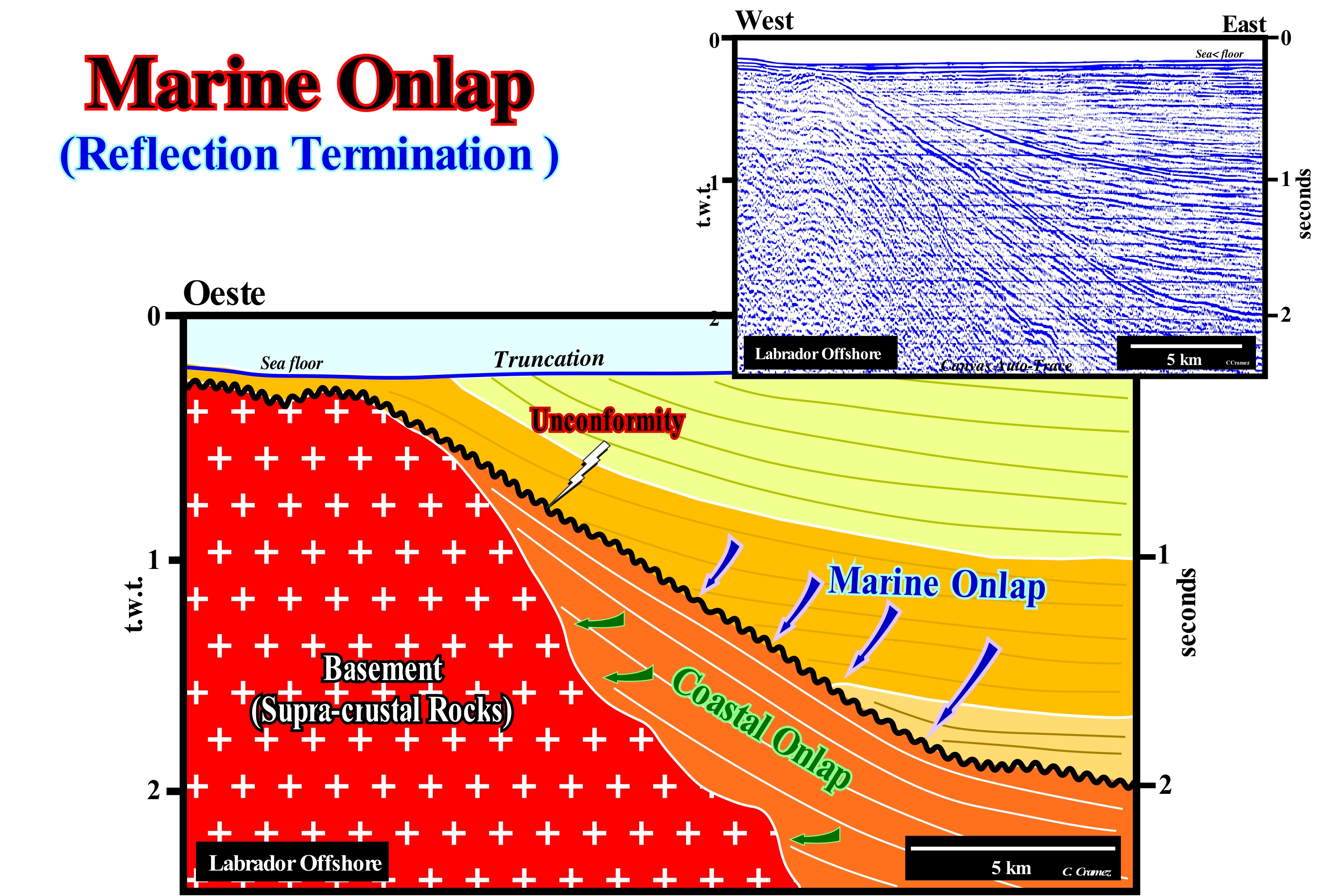
The Labrador offshore (Canada) corresponds to the stacking of three types of basins of the classification of the sedimentary basins of Bally and Snelson (1980), that from bottom to top are: (i) A Paleozoic folded and faulted mountain belt ; (ii) Late Jurassic/Early Cretaceous rift-type basins and (iii) Mesozoic/Cenozoic Atlantic-type divergent margin. The rift-type basins developed during the lengthening of the Laurasia* small supercontinent, which means that the rift-type basins predate the break-up of the lithosphere of the Pangea supercontinent, which caused an important subaerial volcanic flow before sea floor spreading. It is for this reason that many geoscientists do not encompass the rift-type basins in the post-Pangea continental encroachment cycle that forms the Mesozoic/Cenozoic divergent margins. On this tentative geological interpretation of a Canvas auto-trace of a detail of a seismic line of this offshore, whose orientation is, more or less, parallel to the direction of the terrigeneous influx (longitudinal line), the turbidite systems of the first seismic interval above the unconformity (in black) rests, against it, by marine onlaps. This unconformity underlines a significant relative sea level fall, induced by the combined action of tectonics (subsidence or uplift of the sea floor) and absolute (eustatic) sea level (supposed global and referenced to the Earth's centre), is characterized, mainly, by marine onlaps of the submarine basin floor fans slop fans, and, probably also of the submarine slope fans, that fossilize it. The reflections terminations underlying the unconformity, apparently, appear to be, more or less, in concordant with the unconformity. A marine onlap involves deep water deposition, while a coastal onlap characterizes a deposit made under a small water-depth (practically zero). As for the coastal deposits, it is also possible to speak of marine aggradation and encroachment, in particular, in the deep turbidite systems. However, most geoscientists keep the terms aggradation and encroachment to express the vertical and horizontal components of the coastal onlaps. It is important to note that on the seismic line (as, obviously on the auto-trace), there are reflectors near the seafloor that have no geological meaning (that is why they are not picked on this tentative interpretation). They correspond to a seismic pitfall induced by the sea floor and are, therefore, they are called sea floor multiples**. These multiples that hide evidence of the isostatic uplift that this area suffered after the ice melting during the Quaternary. The sediments and the basement were raised about 1,500-2,000 meters in association with the isostatic rebound. In the 1970s, such an uplift was proposed by B. Kubler (University of Neuchâtel), independently of the seismic evidence. Bernard Kubler showed the organic matter of the offshore potential source-rocks of this offshore was mature despite the shallow depth at which they are presently. The vitrinite reflectance from potential source-rocks suggested they had reached sufficient burial so that their organic matter could generate hydrocarbons before they were uplift to the current position, by isostasy, which occurred after the last glaciation. The B. Kubler's hypothesis was later corroborated by tentative geological interpretation of the seismic lines and not the opposite. Indeed, about 19,000 years ago, when the melting of the ice cap, which covered the northern part of the northern hemisphere, during the last glaciation, began to rise, not only the absolute (eustatic) sea level began to rise, but also initiated a major isostatic rebound of previously sunk areas. Note that for an ice thickness of 2,000 meters, similar to that existing today in Greenland, the ground sinks about 700 meters, since the ice density is, roughly, one-third the density of the Earth's mantle.
(*) The Laurentia and Baltica continents formed the small supercontinent Laurasia, which with the small supercontinent Gondwana formed the supercontinent Pangea.
(**) A multiple reflection is an arrival wave that has been reflected several times, usually, an odd number of times, during its underground trajectory. In offshore, as is the case in the Labrador offshore, the sea floor reflection appears several times with alternating signals and displaced each time of Δt (double time of the water trajectory) ; it is the reverberation or ringing that, sometimes, is obliterated by the mute of window trace. Seismic mute is the removal of the contribution of selected seismic traces in the stacking to minimize air waves, sea bed and other noise early arrivals. Low-frequency and long-offset can be removed by mute.
Marine Regression........................................................................................................................................................................Régression (Marine)
Regressão marinha / Regresión marina / Meerregrassion / 海洋回归/海退 / Морская регрессия / Regressione Marine /
Sea level fall (relative or absolute) and seaward displacement of the shoreline, but not of the coastal deposits. At the level of a sequence-cycle, the seaward displacement of the coastal deposits, which also implies the displacement of the shoreline, emphasizes a sedimentary regression, that occurs during the period of stability of the relative sea level after that the relative sea level rise created the available space for the sediments (accommodation) to settle.
See: « Highstand Systems Tract »
&
« Progradation »
&
« Transgression »
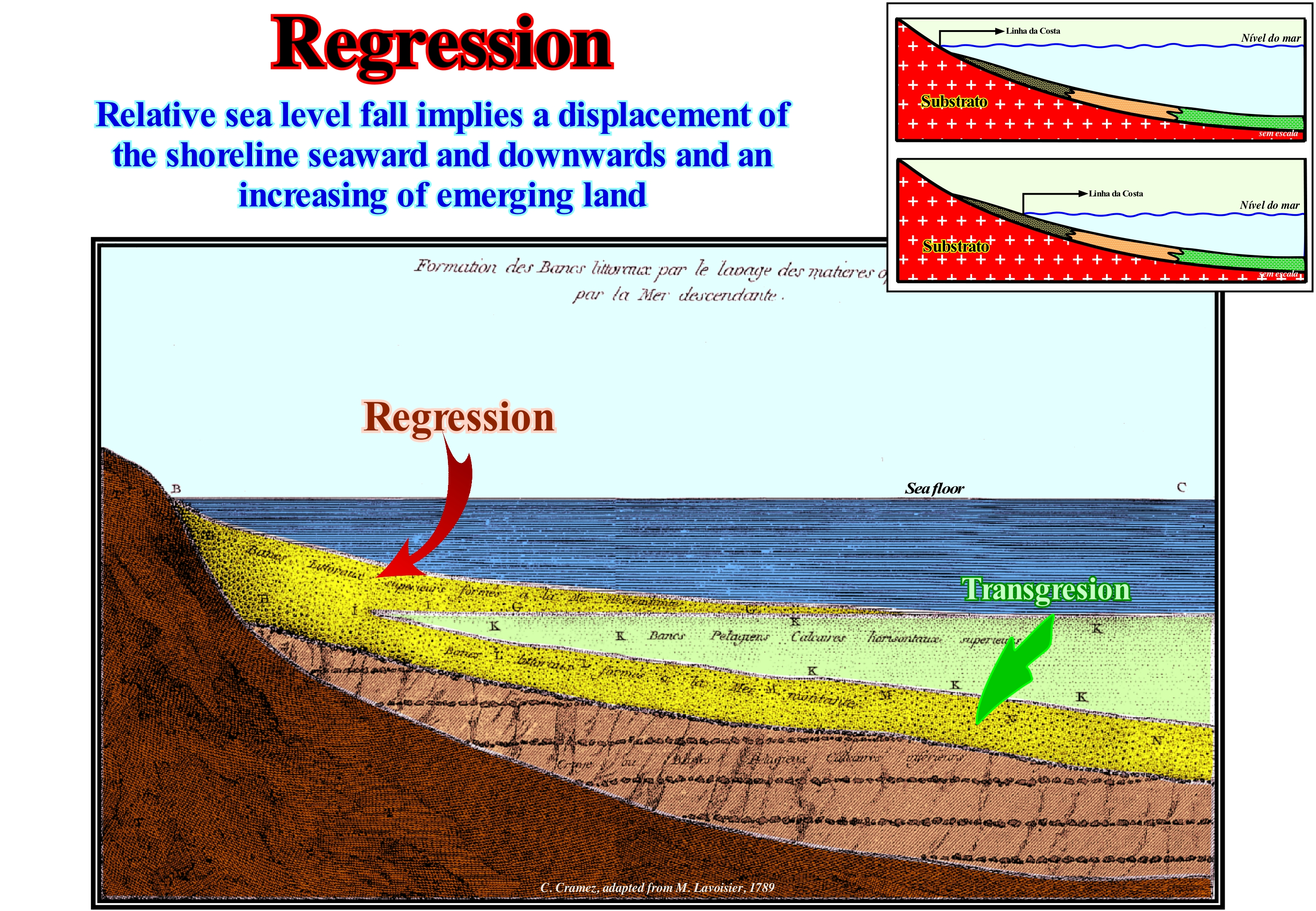
As can be seen in this figure, Antoine Laurent Lavoisier (1743/1794) was one of the first scientists to try to understand the mechanism of marine transgressions and regressions. In Paris geographic basin, which is not a sedimentary basin, but a deformed platform, Lavoisier associated the displacement of the shoreline and coastal deposits with sea level changes. He interpreted the seaward displacement of coastal deposits (sedimentary regression) as the consequence of a sea-level fall and continentward displacement (sedimentary transgression) as created by a sea level rise, which is, basically, wrong. At present, it is known that sea level can be absolute (eustatic) and relative. The absolute or eustatic sea level is supposed to be a global and referenced to the Earth's centre, while the relative sea level is local and referenced to any point on the Earth's surface, which can be the base of the sediments (top of the continental crust) or the sea floor. The relative sea level is the result of the combined action of absolute (eustatic) sea level and tectonics (subsidence or uplift of the sea floor depending if the predominant tectonic regimes are in extension or in compression). On the other hand, today all geoscientists know or should know the absolute (eustatic) sea level changes are induced by: (i) Tectono-Eustasy that is controlled by the volume variation of the ocean basins in association with oceanic expansion following the rupture of the supercontinents ; (ii) Glacio-Eustasy, which is controlled by ocean water volume variation depends on the amount of ice in the ice caps, seas or ice platforms and glaciers (assuming the amount of water in all its forms is constant since the Earth's formation, about 4.5 Ga) ; (iii) Geoidal-Eustasy, which is controlled by the distribution of ocean water caused by variations in the Earth's gravity field (where gravity is stronger than normal, sea level is thrown to the centre of the Earth) and (iv) Steric sea level rise or thermal expansion of the oceans (if the temperature increases, the density of the water decreases, and for a constant mass, the volume increases). Also, it is known, that at the sequence-cycle hierarchical level, highstand prograding wedge (HPW) is associated with a relative sea level rise, in deceleration, whereas the transgressive interval (IT) is associated with a relative sea level rise but in acceleration. In the first case, the marine ingressions are increasingly important and the sedimentary regressions, induced by them, are increasingly smaller. In the second case, marine ingressions are increasingly smaller and sedimentary regressions are increasingly important. Thus, it can be said in order to have deposition (excluding the submarine fans) there must always occur an increasing in the available space for the sediments and, within a sequence-cycle, a seaward displacement of the shoreline and associated coastal deposits does not imply a relative sea level fall. When a geoscientist speaks of "Cretaceous Regression", it is obvious that he is referring to an absolute (eustatic) sea level rise induced by the dispersion of the continents resulting from the break-up of the Pangea supercontinent. However, when it refers to the transgressive interval of a sequence-cycle, it is referring to a relative sea level rise. The curve of sea level changes can be considered for short and long duration, as well as smooth long duration. The first shows the relative sea level changes, while the others emphasize, above all, absolute sea level changes. At the level of the sequence-cycles (short-term eustatic curve), it is, also, necessary to take into account the terrigeneous influx. If the terrigeneous influx is small, the shoreline and associated coastal deposits move landward, regardless of the relative sea level rise (even when the relative sea level is stable). On the contrary, if the terrigeneous influx is important, the shoreline and coastal deposits move seaward regardless of the relative sea level changes (even during a rise). If the terrigeneous influx balances the relative sea level rise, the shoreline and associated coastal deposits neither prograde nor retrograde (apparent retreat to landward), they aggrades vertically (upbuilding) and the shoreline is stationary. In conclusion, forget the term marine regression, and use the expression sea-level fall ( absolute or relative) avoiding misunderstandings.
Marine Source-Rock.......................................................................................................................................................Roche-mère marine
Rocha-mãe marinha / Roca madre marina / Marine-Muttergestein / 海相烃源岩 / Морская материнская порода / Roccia fonte marina /
A marine rock rich in organic matter and buried, sufficiently, to its organic matter generate hydrocarbons in quantities, economically, profitable.
See: « Sealing-Rock »
&
« Source-Rock »
&
« Reservoir-Rock »
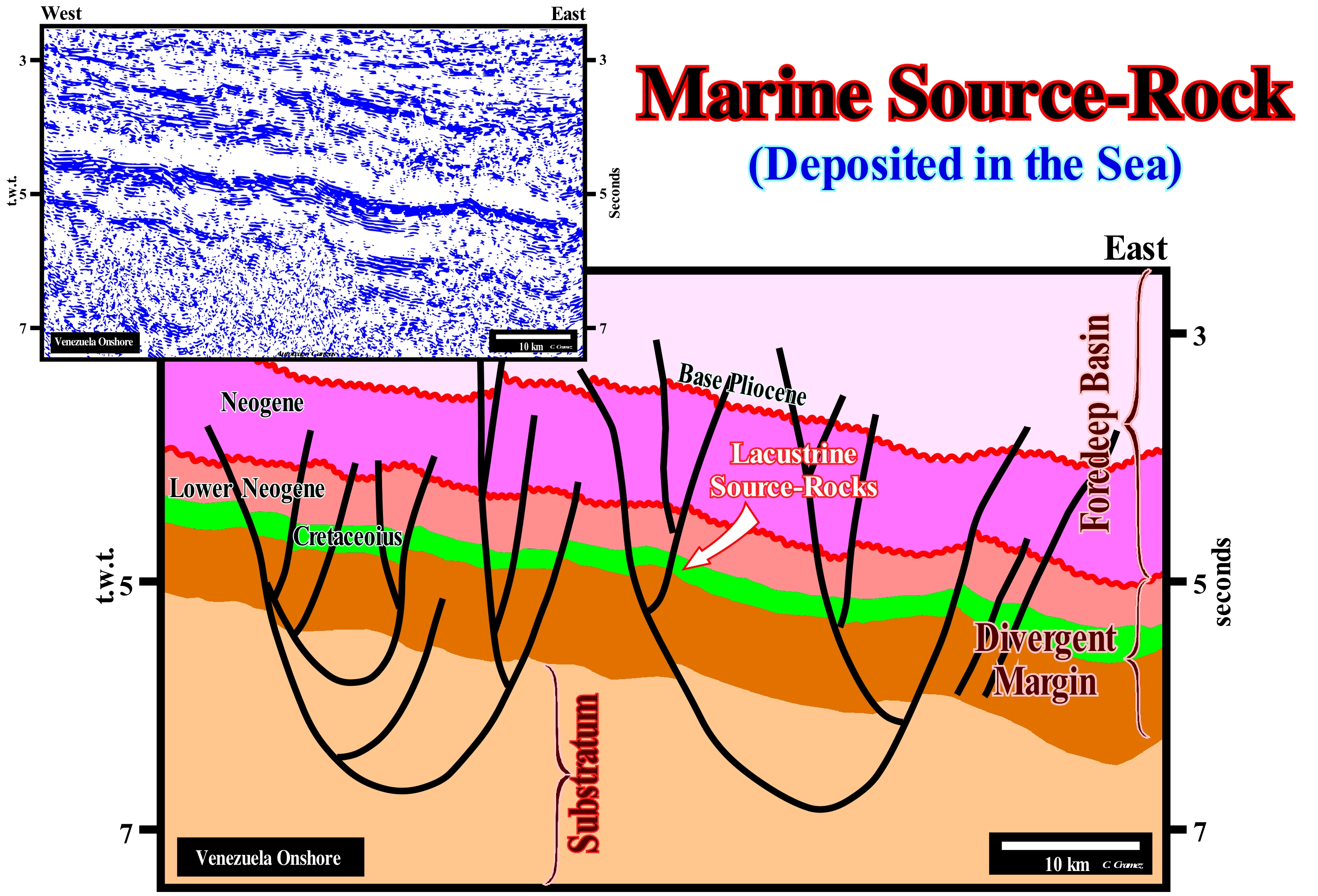
On this tentative geological interpretation of a Canvas auto-trace of a Venezuela offshore seismic line, whose direction is parallel to the strike of the reverse fault planes, underlies the seismic interval containing the marine source-rocks of the La Luna formation. This geological formation, which is, essentially, composed of, more or less, carbonated claystones is very rich in organic matter, was deposited during the peak of Cretaceous transgression (Cenomanian-Turonian), i.e., between 93.5 Ma and 89.0 Ma, probably, 91.5 Ma). After the rupture of the Pangea, as the continents moved away from each other, due to oceanic expansion (sea floor spreading), the volume of the ocean basins decreased as a function of the formation of the oceanic ridges. As the amount of water, in all its forms, is considered constant, since Earth's formation, around 4.5 Ga, the eustatic (absolute) sea level has risen. This absolute sea level rise was accompanied by a subsidence (non-continuous) of the continent margins, which, overall, created a relative sea level rise. At each increment of relative sea-level rise, the shoreline (depositional coastal break of the depositional surface, which in seismic terms is, more or less, coincident with the shoreline) and associated coastal deposits, moved landward. Such displacement created, in the distal parts of continental shelves, geological conditions with a very low sedimentation rate, which certain geoscientists call starved conditions. It is under these conditions, which are, sometimes, enhanced by the action of cold sea upwelling currents, that organic matter not only develops rapidly but is preserved as well, since it reaches the sea floor. Since the relative sea level begins to rise, globally, in deceleration (during the Early Neogene), a progradational interval is deposited, gradually, reducing the continental shelf by fossilizing and burying the condensed and rich of organic matter interval deposited during the transgression. If the burial is sufficient, potential marine source-rocks can become source-rocks if organic matter reaches the oil window.
Marine Toplap...............................................................................................................Biseau supérieur de progradtion marin
Bisel superior de progradação marinho/ Bisel superior de progradación marina / Bevel Marin-Superior Progradation, Bevel bis progradierender marine / 锥高达progradational海洋 / Морское кровельное прилегание / Bisello di progradazione marine /
Toplap in marine sedimentary environments. It is found in all sedimentary systems tracts of a sequence-cycle, except, probably, in the incised valleys (Iv), which are coevals of the upper sediments of the lowstand prograding wedge (LPW).
See: « Downlap »
&
« Continental Encroachment »
&
« Relative Sea Level Fall »
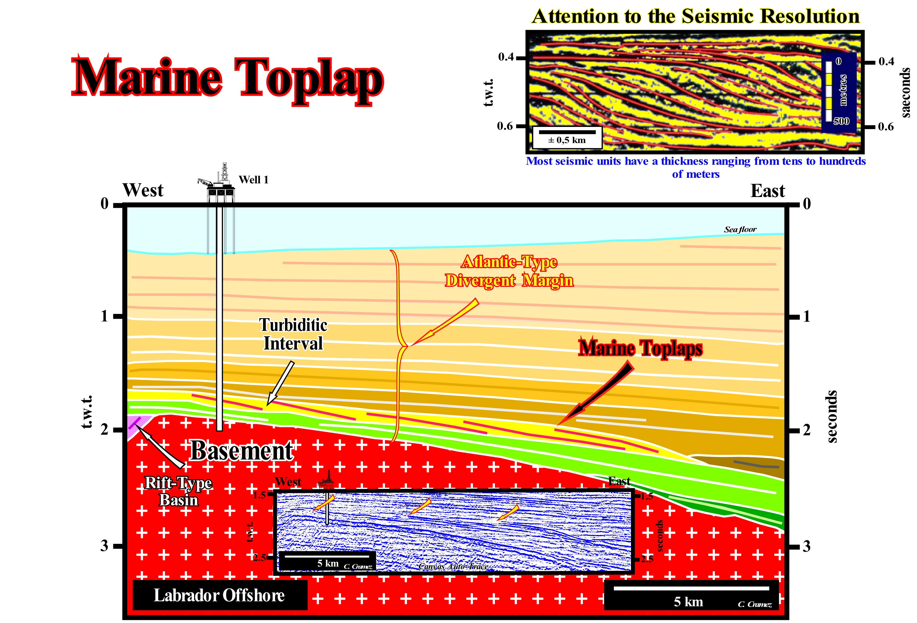
On this tentative geological interpretation of a Canvas auto-trace of a Labrador offshore (Canada) seismic line, the toplaps are marine. The Labrador offshore corresponds to the stacking of three types of basins of the classification of the sedimentary basins of Bally and Snelson (1980), which from the bottom to top are: (i) Basement or Paleozoic flattened mountain belt ; (ii) Late Jurassic/Early Cretaceous rift-type basins and (iii) Mesozoic/Cenozoic Atlantic-type Divergent Margin. The rift-type basins, which correspond to the filling of half-grabens formed during the lengthening of the Pangea supercontinent and, particularly, of the Laurasia small supercontinent, are separated from the divergent margin by the unconformity created by the break-up of the lithosphere. At the base of the Atlantic-type divergent margin, which corresponds to the 1st order post-Pangea continental encroachment stratigraphic cycle, a thick subaerial volcanic series was deposited, which emphasizes the beginning of the margin accretion. On this tentative geological interpretation, the marine toplaps are, here, associated with a deep-water turbidite interval. The turbiditic nature of this interval was corroborated by the results of an exploration well drilled in the 1970s. As shown, the internal geometry of the turbiditic interval (in yellow) is progradational. The toplap can be interpreted as the result of the lateral stacking of turbidite fans. These toplaps are, of course, considered marine toplaps by no deposition. This type of geometry characteristic of oblique progradation (without aggradation), which accommodate one another, such as tiles on a slatted roof, is often characteristic of the turbidite fans (shingled turbidites) deposited at the base of the lowstand prograding wedges (LPW), but can also be found in highstand prograding wedge (HPW). Likely, these turbidite deposits are not associated with significant relative sea level falls, which displace seaward and downward the coastal onlaps and put the sea level lower than the basin-edge*. They are not associated with unconformity. They appear to be associated with instability of the depositional coastal break of the depositional surface, when it coincides or is very close to the continental-edge, i.e., when the basin has no shelf. Under these conditions (basin without shelf), a small instability in depositional coastal break of the depositional surface can collapse the coastal deposits that slide, by turbidity currents, directly, along the continental slope. This can also occur under lowstand geological conditions during the deposition of the lowstand prograding wedge, since the outer edge of the coastal plain is almost coincident with the shoreline, which favours the formation of currents along the slope of the lowstand prograding wedge**, during river floods. Coastal sediments are transported to the deep parts of the continental slope where they settle down in the form of submarine fans, since the turbidic currents lose their ability to carry them. The facies (lithology plus associated fauna) of these turbiditic fans is dependent on the lithology of the coastal deposits. As in a basin without shelf, the coastal deposits are mostly deltaic in nature, these turbidite fans are potential reservoir-rocks that are, sometimes, very rich in sands from the delta front. For Emiliano Mutti, this type of turbidite deposits may also be induced by flooding of large rivers, whether in low or highstand geological conditions, which means that climate is an important parameter that must to be taken into account in the development of fluvio-hydraulic depositional systems.
(*) At a sequence-cycle hierarchical level, during the deposit of the highstand systems tracts group (HSTG), the basin-edge is the continental-edge, which individualizes, within the cycle-sequence, since a continental shelf is formed. During the deposition of the lowstand systems tracts group (LSTG), as it fossilizes the continental slope of the preceding sequence-cycle, the basin-edge is the last basin-edge of the preceding sequence-cycle.
(**) The expression continental slope has been, here, avoided, since within a sequence-cycle one can just speak of continental slope since there is formation of a shelf, that is to say, from the beginning of deposition of the transgressive interval (TI). Lowstand deposits, gradually, fossilize the continental slope of the preceding sequence-cycle, without forming a new continental-edge. In the same way, since the continental shelf can be fully fossilized during the deposition of the 2nd stage of development of the highstand prograding wedge, a new slope forms, once the shoreline becomes the basin-edge.
Marine Transgression (Gulf of Mexico)..........................................................................................Transgression marine
Ingressão Marinha / Transgresión marina / Marine Transgression (Golf von Mexiko) / 海侵(墨西哥湾)/ Морская трансгрессия (Мексиканский залив) / Transgressione Marine (Golfo del Messico) /
When during the recent sedimentation processes (from 5,000-7,000 years ago) in the Gulf of Mexico, the longshore of the barrier-bars advanced to the continent, displacing the shoreline downstream, between 30 and 80 km. Several times, more or less, every 1,000 years, the main stream of the Mississippi River changed bed creating different sets of delta lobes. The first ingression was made, practically, without ravinment, which is important in the following marine ingressions. Do not forget, the Mississippi Delta Building is characterized by: (i) Wave action so, poorly, that the amount of sand that is transported to the beach is much lower than the sand scattered offshore by storms ; (ii) A difference between low and high tide of about 30 cm, but which is sufficient to play an important role in sedimentation, since the gradient (slope) of the delta is very small ; (iii) Strong subsidence, induced by compaction of recent sediments (about 30 to 60 cm every 100 years).
See: « Finger Delta »
Marker Bed (Key bed).................................................................................................................................................................................Couche repère
Camada de referência / Estrato de referencia / Marker-Bett, Marker - Schicht / 关键的床 / Опорный горизонт / Strato guida /
Bed or a group of geological beds that can be traced over large distances on the ground, on electrical logs, and sometimes on seismic lines (when thickness is important and the seismic resolution good). A marker bed can have a significant chronostratigraphic value.
See: " Stratum "
&
" Correlation "
&
" Systems Tract ”
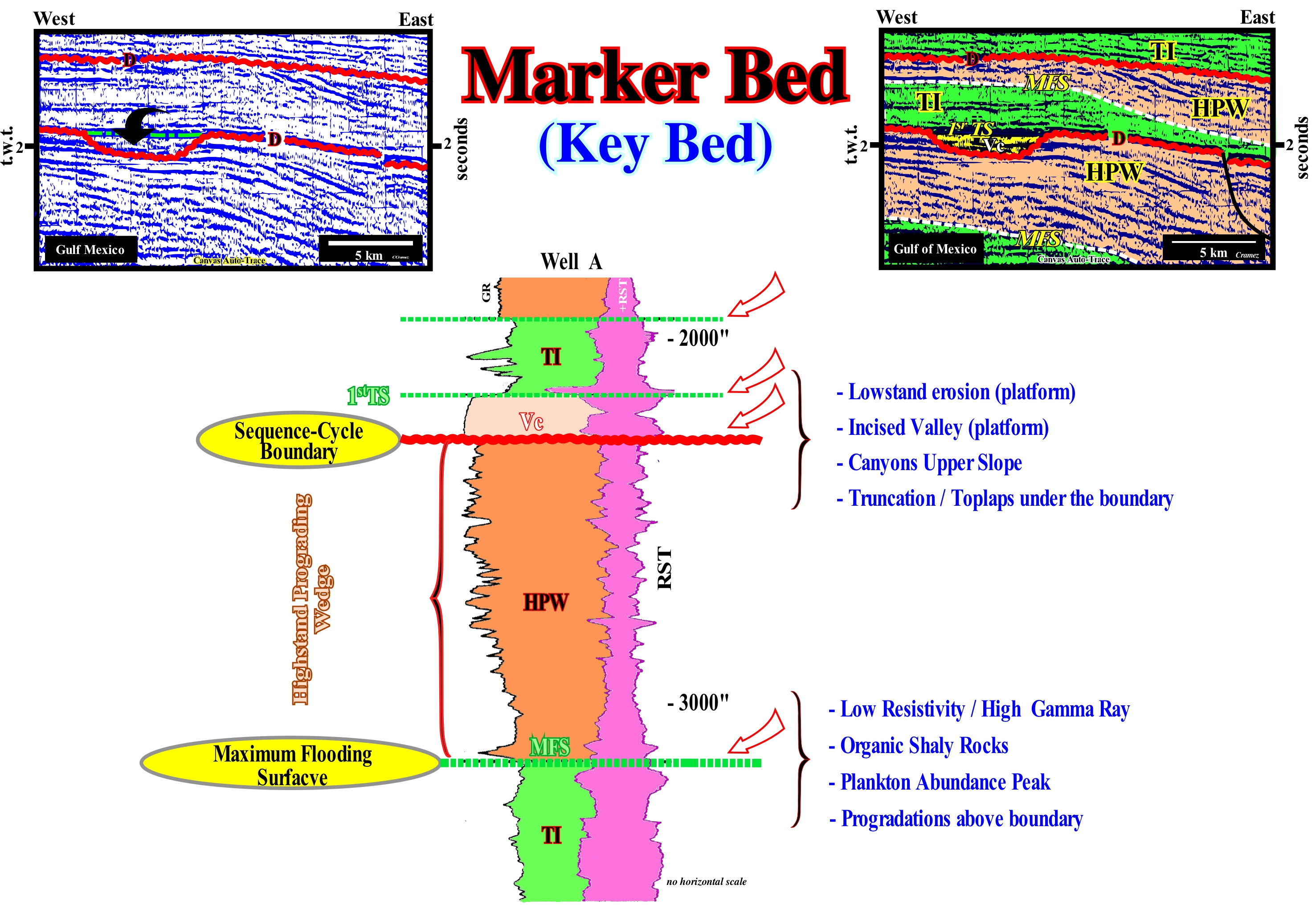
In the electrical logs of a North Sea (cratonic basin) oil exploration well, several levels (not layers, since the seismic resolution is about 20-30 meters) can, sometimes, be recognized. In this particular example, from top to bottom, one can identify: (i) A maximum flood surface (MFS) ; (ii) The first transgressive surface (1st TS) of a transgressive interval (TI) ; (iii) An erosional surface that emphasizes the unconformity that limits two stratigraphic cycles called sequence-cycles (stratigraphic cycles deposited during 3rd order eustatic cycles, whose time-duration varies between 0.5 and 3/5 My) ; (iv) Downlap surface of the highstand prograding wedge (HPW) of the lower sequence-cyle, which corresponds roughly to the maximum flooding surface of the transgressive interval of the same sequence-cycle. The last two horizons, i.e., the maximum flooding surface (MFS) separating the transgressive interval (TI) from the highstand prograding wedge (HPW) and the limit between the sequence-cycles (unconformity, which underlines a significant relative sea level fall, which has created the erosional surface), which, in this case, is characterized by the formation of an incised valley, are particularly interesting to establish correlations between different wells. The incised valley is, later, filled during the deposition of the upper part of the highstand prograding wedge (HPW). Between the maximum flooding surface (top of the transgressive interval of the lower sequence-cycle), which may also be a good key horizon, and the unconformity (erosional surface), which separates the two sequence-cycles, the morphology of the Gamma ray (RG) log suggest a coarsening and thickening upwards sedimentary interval, which corroborates the progradational geometry of the highstand prograding wedge (HPW) visible on the seismic lines of this area. The first flooding surface (base of the transgressive interval) may, in certain cases, be taken as a key marker. Within a sequence-cycle, in combination with the maximum flooding surface, which is a diachronic surface, is, often, deposited in the distal part of the shelf a condensed stratigraphic section, which is almost always capped with a hardened surface. This condensed section, which is fossilized by the downlap surface of the highstand prograding wedge, is very rich in organic matter and underlines an of abundance peak of fauna*. That means, that their fossils are used to date the geological events that occurred during the deposition of the sequence-cycle. However, as suggested by the electrical logs, in any case, the fauna associated with condensed stratigraphic section (top of the transgressive interval, colored green) allows to date the age of the unconformity, which in this case is stressed by filling the incised valley. The age of the unconformity, i.e., the age of the erosional surface or its correlative deep-water paraconformity, is the age of fall of relative sea level (locala and referenced to any point on the Earth's surface, which may be the sea floor or the base of the sediments, i.e., the top of the continental crust), which is given by the smallest hiatus between the sequence-cycles that it delimits. In seismic data, most of these horizons can be considered chronostratigraphic, although in reality in the field (1:1 natural scale) they are not. However, taking into account the seismic resolution and the vastness of geological time, the error is not, usually, very large and has no major consequences. The spontaneous potential (SP) log, which measures the potential difference between an electrode moving in a well and a fixed electrode on the surface, allows the identification of permeable intervals. The resistivity log (normal, lateral, lateralog) measure the resistivity of the sedimentary intervals, i.e., the resistance they oppose to the flow of electrons. When a sediment interval contains gas, oil and / or water mixed in the pores, the resistivity of that rock will increase considerably.
(*) This is, of course, used by amateur fossil hunters who empirically look for discontinuities between sloping clay sediments and subhorizontal underlying sediments, which in terms of sequential stratigraphy usually means at the level of a cycle-sequence, the interface defined between the highstand prograding wedge with the retrogradational maximum flooding surface.
(**) Practically, the relative age of n unconformity is given by the age of the pelagic clays that deposit between the turbiditic layers of the submarine basin floor fans (SBFF) overlying the unconformity.
Mass Extinction (Organisms).........................................................................................................Extinction en masse (Organismes)
Extinção em massa / Extinción en masa (organismos) / Massenaussterben / 生物集群 / Массовое вымирание / Estinzione di massa /
Disappearance of a part of the world's biota in association with various types of catastrophe. Theoretically, extinction is associated with a rapid event, during which a significant part of life on Earth is extinguished, and life forms, which have become extinct, belong to different phyla, live in different environments, and are scattered throughout the world.
See: « Fossil »
&
« Theory of Evolution »
&
« Paleogeography »
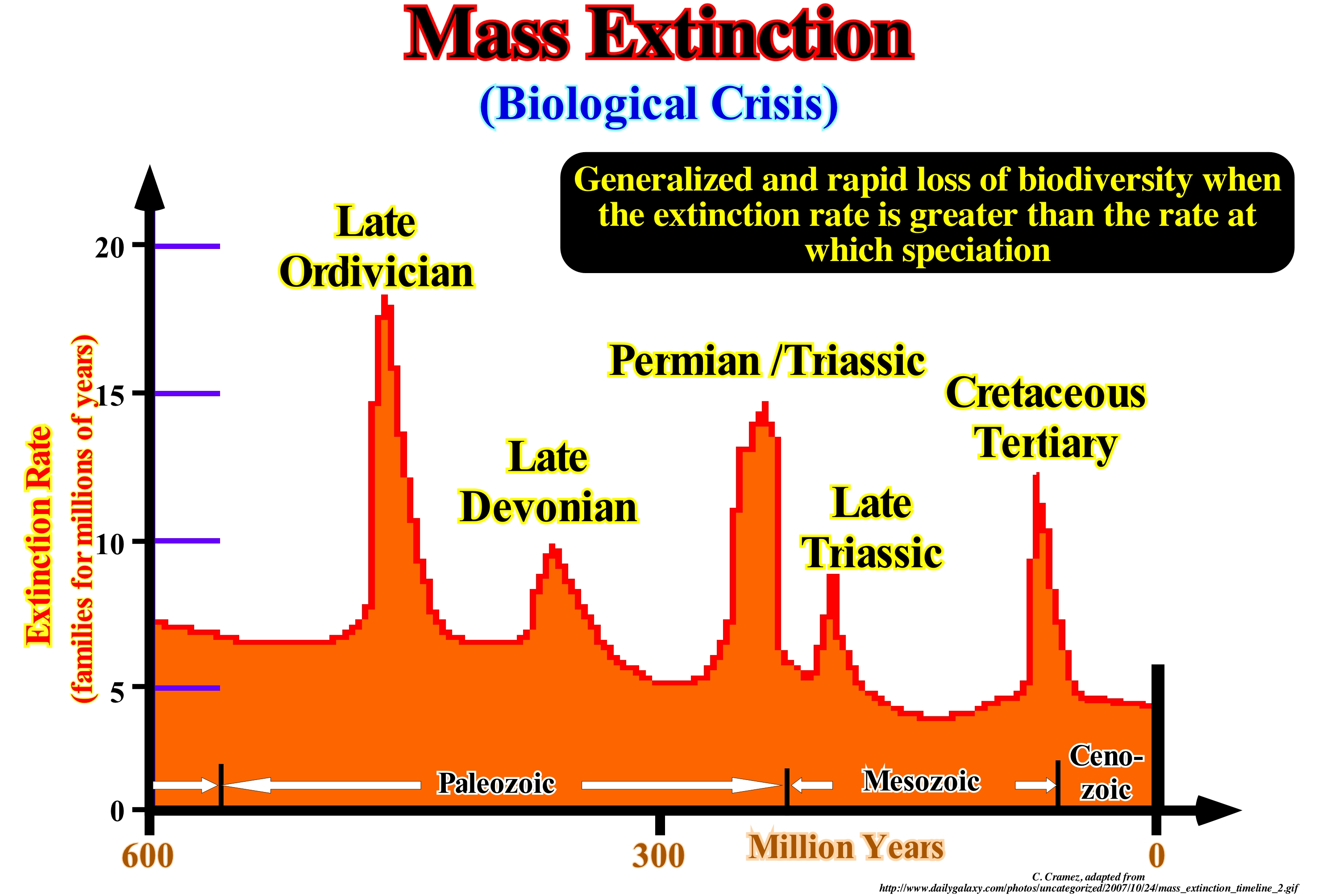
The definition of mass extinction is somewhat difficult, because the word "catastrophe" is almost always used in relation to human life or loss of property, whereas, until recently, mass extinctions were the events outside human experience and influence. The definition of "mass extinction" shall include: (I) A rapid event ; (ii) During which a significant part of all life on Earth has been extinguished and (iii) The extinct forms of life must have belonged to different phyla, lived in different environments and spread throughout the world. The last part of this definition, strongly, suggests the causes of mass extinction are, predominantly, external to the biota. Internal causes may include the evolution of a deadly germ, particularly, virulent, i.e., a virus or bacterium, but it is difficult to imagine that one of these germs can affect different phyla on land and sea. The five largest mass extinctions occurred in Earth's history: (i) End Ordovician period (about 438 Ma), where about 100 families died out and more than half of the brachiopods and bryozoans species died out ; (ii) End Devonian, around 360 Ma, in which about 30% of animal families have died out ; (iii) End Permian period, around 245 Ma, in which trilobites have been extinguished, as well as, about 50% of all animal families and 95% of all marine species and many trees die ; (iv) End Triassic, around 208 Ma, when 35% of all animal families die and most families of the first dinosaurs were extinct as were most synapsids* (except mammals) ; (v) End Cretaceous and beginning Tertiary (about 65 Ma), during which about half of all forms of life died. Probably there were mass extinctions before the Phanerozoic, but since there were no animals with hard parts of the body, the fossil record is insignificant.
(*) Or theropsids, that is to say, a group of animals that includes mammals and every animal more closely related to mammals than to other living amniotes, i.e., who have an amnion, or amniotic sac, protecting the embryo or foetus.
Matter and Antimatter..................................................................................................................................Matière et antimatière
Matéria e antimatéria / Materia y antimateria / Materie und Antimaterie / 物质和反物质 / Материя и антиматерия / Materia e antimateria /
The fact that antimatter is not observable creates a major problem. Antmatter raises the question why matter exists. During the early stages of the evolution of the Universe, matter and antimatter would have been formed from energy and they would have formed in equal quantities (a particle and antiparticle are always created together). So the question is why is it that all matter and antimatter did not annihilate it, leaving an Universe formed solely of energy?
See: « Big Bang (theory) »
&
« Inflationary Universe »
&
« Universe (age) »

Every fundamental particle has its antiparticle* with the same mass, but with the opposite charge. This idea is now also applied to atoms, i.e., to the anti-atoms that form the antimatter. In 1898, A. Schuster suggested the idea that an exotic type of matter can exist with properties that look (as a mirror) as those of ordinary matter. As she said "if there is a negative electricity, why not a negative gold, yellow like normal gold?". Indeed, in 1928, Dirac proposed the mathematical basis for Schuster's idea. Dirac conjectured that an electron, which has a negative charge, must have a positively charged counterpart, which must be a new particle, unknown in physics experiments, with the same mass and charge opposite that of the electron. Such a particle is called antielectron. The discovery of the antielectron, now known as positron (positively charged electron) in cosmic radiation was made in 1932 by Carl Anderson. Twenty-three years later scientists at the University of California (Berkeley) created an antiproton on a particle accelerator. When antimatter and ordinary matter meet, they annihilate each other and disappear in a violent explosion, in which the mass is converted into energy as suggested by the Einstein equation E=mc2. The energy released by a matter/antimatter annihilation is very large. In a collision of protons and antiprotons the energy released per particle is about 200 times the energy released by an H bomb. If matter and anti-matter annihilate each other, there is, probably, no antimatter on Earth or even in the solar system. Scientists speculate that antimatter exists in other parts of the Universe, but have yet to find any corroboration.
(*) An elementary particle that constitutes antimatter and has the same properties as that of matter. One of the main differences is the charge that has an opposite sign. The antiparticle of the electron is positron, and that of the proton is the anti-proton. When a particle comes into contact with its anti-particle, it annihilates itself to form light. We live in an Universe of matter. Anti-matter is, extremely, rare. It is just seen in cosmic rays or in the accelerators of high energy particles. (T. T. Thuan, 1988- La mélodie secrète, Fayard).
Maximum Faunal Abundance (Electrical logs)..................Pic d'abondance maximale de la faune
Ponto de abundância máxima de fauna / Pico de abundancia máxima de fauna (Logging) / Maximaler Spitzenstrom reiche Tierwelt (Logging) / 最大动物区系的丰度峰值(记录)/ Максимальный пик обилия диких животных / Picco di massima abbondanza di fauna selvatica (logging) /
In the electrical logs, the maximum abundance point of the fauna corresponds to the point, where resistivity log are lower and where the gamma ray is stronger. This point underlines, in general, downlap surface that fossilizes a transgressive interval of a sequence-cycle. As this point corresponds to the maximum abundance of the fauna, it is evident that the peak age of sedimentary transgressions (set of marine ingressions and smaller and smaller regressions) is easier to determine than the basal unconformity of a sequence-cycle (more or less the age of the associated submarine basin floor fans).
See: « Sequence-Cycle »
&
« Transgressive Interval »
&
« Maximum Floodind Surface »
These electrical logs (Gamma Ray and Resistivity) illustrate the base of a stratigraphic cycle called the sequence-cycle, induced by an eustatic cycle with a time-duration between 0.5 My and 3-5 My (3rd order eustatic cycle), which was crossed by an exploration well located slightly upstream of the basin-edge of the preceding sequence-cycle. That means, the exploration well recognized, in the considered sequence-cycle, just the highstand systems tracts sub-groups (transgressive interval and the highstand prograding wedge). The exploration well recognized in the sequence-cycle lower highstand systems tracts sub-group, i.e., the transgressive interval (TI), and upper sub-group, i.e., the highstand prograding wedge (HPW). The lower limit of the transgressive interval (TI) is a ravinment surface (1st transgressive surface), but under certain conditions, as in this particular case, the flooding surface may fossilize and thus to coincide with the lower unco9nformity of the sequence-cycle (when the sequence-cycle is incomplete and the lowstand systems tracts group has not deposited, or in a cross-section upstream of the basin-edge). The upper limit of the transgressive interval (TI) is the maximum flooding surface*, which is fossilized by the overlying highstand prograding wedge (HPW). It marks a depositional hiatus, almost nil upstream, at the beginning of the highstand prograding wedge, but that increases, considerably, seaward, that is, in the distal part of the continental shelf, where a condensed stratigraphic section. In electrical logs and, in particular, in gamma ray log, the upper limit of the transgressive interval corresponds to the more radioactive horizon. In fact, the interface between the transgressive interval (TI) and the highstand prograding wedge (HPW), characterized by a large hiatus by non-deposition, is, generally, quite rich in organic matter. It is with this type of interface that marine source-rocks are, often, associated. In the resistivity log, this horizon is underlined by a low resistivity, as illustrated in this figure. Taking into account the stratigraphic context, the important hiatus by no deposition and the amount of organic matter that exists between the transgressive interval and the highstand prograding wedge, it is evident that this limit corresponds to a fauna peak (maximum faunal abundance). This limit, between the transgressive episode (transgressive interval, TI) and the overlying regressive episode (highstand prograding edge, HPW) is, relatively, easy to date, which is not the case for unconformities (erosional surfaces) that bound the sequence-cycle. Before the advent of sequential stratigraphy, the vast majority of unconformities were roughly dated from the study of the fossils deposited along the downlap surface, that is, the age of the maximum surface of transgression. The age of an unconformity is given by the age of the submarine basin floor fans (SBFF) induced by the significant fall of the relative sea level** that caused the unconformity, which emphasizes the minimum hiatus between the two sequence-cycles, that the unconformity or its correlative deep-water paraconformity separates and not by the age of the surface of maximum marine ingress as it was, and is still, often, incorrectly determined. Geometrically, in gamma ray logs, the transgressive interval (TI), coloured in green (the colour of glauconite, which is very frequent in transgressive intervals) is emphasized by a fining and thinning upward morphology (negative sequence), while the highstand prograding wedge (HPW), coloured in orange, is characterized by a coarsening and thickening upward morphology (positive sequence).
(*) Limit between accelerating marine ingression, i.e., increasingly important marine ingressions, and marine ingression in deceleration, i.e., increasingly smaller or in other words, the limit between the retrogradational seismic interval (transgressive interval, TI) and the progradational interval (highstand prograding wedge, HPW).
(**) Local sea level and referenced to any point on the Earth's surface that can the base of the sediments, i.e., the top of the continental crust or the floor, and which is the result of the combined action of absolute or eustatic sea level, which is referenced to the Earth's centre and tectonics (subsidence or uplift of the sea floor).
Maximum Clay-Shale Point (Electrical logs)....................................Point de radioactivité maximale
Ponto de máxima radioactividade / Punto de máxima radioactividad / Punkt der maximalen Radioaktivität / 最高放射点 / Точка максимальной радиоактивности / Punto di radioattività massima /
In electrical logs, the point or zone of maximum radioactivity corresponds to the point where the resistivity log is, generall, lower and where the gamma ray is stronger. In a sequence-cycle, this point underlines the downlap surface that fossilizes the transgressive interval (TI). This point, which also marks an abundance of fauna, allows to make good correlations between the exploration wells and it, often, suggests the presence of rocks rich in organic matter, i.e., potential source-rocks.
See: « Sequence-Cycle »
&
« Transgressive Interval »
&
« Downlap Surface »
Although natural uranium is widespread in the Earth's crust at concentrations of 1 to 3 ppm, higher concentrations may be found in certain sedimentary rocks including within sediments rich in organic matter. Certain sedimentary rocks, such as black shales, breccias, argillites, limestones, phosphorites and sandstones, may contain an average of 4 ppm of uranium. Examples of higher elevated concentrations are the breccias of the Olympic Dam formation (Australia), in which uranium is present in a content of about 300 ppm. Low concentrations of uranium (2/4 ppm) are found in black shales, but much higher concentrations up to 700 ppm were recognized in deposits of phosphoric black shales. In addition to sedimentary rocks, U-uranium was found in sediments rich in organic matter, whether recent or old: peat, lignite, coal, oil and black shales. (http://www.sciencedirect.com/science/article/pii/S001282 521630099X). This figure shows several electrical logs of a typical Cabinda geographic basin (Congo Geographic Basin, Angola) petroleum exploration well, in which several points, or rather several zones of strong radioactivity, are recognized, easily, in the gamma ray. Two of these zones are visible beneath the salt interval (Loeme salt), within a rift-type basin (basin formed by lengthening of the Gondwana small supercontinent, before the breaking of lithosphere). The upper zone is located inside the Bucomazi formation and underlines an interval of source-rocks (lacustrine shales rich in organic matter). The second, less thick, radioactive zone is located within the Lucula formation, which consists, normally, of sands with good characteristics of reservoir-rock, but which are separated here by a lacustrine clay-rich interval of organic matter that is an alternative source-rock to the source-rocks of the Bucomazi formation. As these intervals have a strong resistivity and a slow sonic velocity (velocity log not shown in this figure), this means that the organic matter of these intervals reached the maturation zone (a lacustrine shale rich in organic matter, but immature has a low resistivity and a high sonic value). These radioactive intervals, rich in organic matter, were deposited in a lacustrine sedimentary environment. Another area of high radioactivity, not visible in this figure, is located above the salt interval, i.e., located in the divergent continental margin, which fossilized the rift-type basins. This zone corresponds to major downlap surface, which separates the transgressive phase of the post-Pangea continental encroachment cycle from the regressive phase of the same cycle. The rise of the absolute (eustatic) sea level (supposed global and referenced to the Earth's centre) during 1storder post-Pangea eustatic cycle (time-duration greater than 50 My) with which are associated the Atlantic-type divergent margins, created a transgressive phase that reached its maximum of marine ingression about 91.5 Ma during the Cenomanian/Turonian, that corresponds to this zone of maximum radioactivity in the electrical logs. It is with this zone of maximum radioactivity of the divergent margins, which corresponds to the main downlap surface of the post-Pangea continental encroachment cycle, that are associated the most likely marine source-rocks. This is particularly true for the Atlantic-type divergent margins, whether of the Angola, East United States or West Australia offshore. However, in certain particular, but not too rare, the radioactivity of a given stratigraphic interval may be associated with radioactive minerals, such as allanite (accessory mineral in many igneous or metamorphic rocks, which is slightly radioactive and usually associated with other minerals containing rare earth elements), glauconite, zircon (zirconium silicate of the chemical formula ZrSiO4 , whose crystalline structure has a natural coloration ranging from colourless to golden yellow, red, brown, blue or green ), etc and not to the presence of organic matter. How many times, in non-exhaustive tentative geological interpretation of the electric logs, a transgressive interval, with characteristics of reservoir-rock, was interpreted, at least initially, as an interval with characteristics of source-rock, due to the presence of radioactive minerals.
Maximum Flooding Surface...............................................................................Surface d'inondation maximale
Superfície de inundação máxima / Superficie de inundación máxima / Maximum-Hochwasser Oberfläche / 最大洪泛面 / Поверхность максимального затопления / Superficie di inondazione massima /
Surface that in a sequence-cycle separates the transgressive interval (TI) from the highstand prograding wedge (HPW) or the surface that, in a continental encroachment cycle, separates the transgressive phase from the regressive phase. A maximum flooding surface is, always, fossilized by a downlap surface. Marine source-rocks are always associated with maximum flooding surfaces.
See:« Transgressive Interval »
&
« Relative Sea Level Rise »
&
« Downlap Surface »
When talking about a maximum flooding surface, one has to specify what is the stratigraphic or eustatic cycle considered. By definition, within each eustatic cycle, whether it is 1st, 2nd, 3rd, 4th or 5th order, there is, always, a high of the sea level (absolute or relative). In a stratigraphic cycle there is always a maximum flooding surface. In a stratigraphic cycle called the sequence-cycle, which is induced by a 3rd order eustatic cycle (time-duration between 0.5 and 3/5 My), the maximum flooding surface corresponds to the limit between the transgressive interval (TI) and the highstand prograding wedge (HPW). The transgressive interval (TI) is characterized by an overall retrogradational geometry induced by increasingly important marine ingressions, caused successive relative sea level rises in acceleration, without falls between them. The highstand prograding wedge (HPW) is characterized by an overall progradational geometry induced by increasingly important marine ingressions created by successive relative sea level rises in deceleration, without falls between. On this subject, do not forget that in sequential stratigraphy, geoscientists consider two types of sea level function of the eustatic cycle considered: (i) Relative sea level, which is a local and referenced to any fixed point on the Earth's surface and (ii) Absolute or eustatic sea level*, which is supposed to be global and referenced to the Earth's centre. The relative sea level is the result of the combined action of absolute (eustatic) sea level and tectonics (subsidence or uplift of the sea floor). In a continental encroachment stratigraphic cycle, which is induced by a 1st order eustatic cycle (time-duration greater than 50 My), the maximum flooding surface corresponds to the interface between the transgressive phase, induced an absolute sea level rise and the regressive phase, induced by an absolute sea level fall. That is to say, in a cycle of continental encroachment cycle, the transgressive and regressive phases correspond, respectively, to a rise and fall of the absolute (eustatic) sea level. However, this is not the case within a sequence-cycle, since in order to have deposition, the available space for sediments (accommodation) must always to increase by a marine ingression created by relative sea level rises. When the marine ingressions area increasingly important (accelerating relative sea level rises) and the sedimentary regressions increasingly smaller increasingly smaller, the transgressive interval ("Transgressions") is deposited. When the marine ingressions are increasingly smaller (relative sea level rise in deceleration) and the sedimentary regressions increasingly important, the highstand prograding wedge (HPW) is deposited. On this tentative geological interpretation of a Black Sea seismic line, the contrast between the transgressive and regressive phase of the post-Pangea continental encroachment cycle is underlined by the aggradational geometry of the first and by progradational geometry of the second. The interface between these two phases is the maximum flooding surface of the continental encroachment cycle. Most of the progradations (chronostratigraphic lines) of the regressive phase are sigmoid, meaning that the aggradation (upbuilding) is significant, but always, largely, inferior to the progradation (outbuilding). The basal segments of this sigmoid progradations tend to disappear against the maximum flooding surface. The distal reflection terminations are either apparent or real downlaps (sometimes the space between two consecutive reflections is below the seismic resolution). These configurations imply a relatively weak terrigeneous influx or a rapid relative sea level rise, which allows the deposit and preservation of the upper segments. Within the continental encroachment cycles, the most likely potential marine source-rocks are associated with the maximum flooding surface, although, secondary source-rocks may occur in association with maximum flooding surfaces of the continental encroachment sub-cycles, as is the case, in the North Sea (Kimmeridgian source-rocks).
(*) The absolute sea level is the result of the combined action of: i) Tectono-Eustasy that is controlled by the volume variation of the ocean basins in association with oceanic expansion following the breakup of the supercontinents ; (ii) Glacio-Eustasy, which is controlled by the variation of water volume of the oceans as a function of the amount of ice (assuming that the amount of water in all its forms is constant since the Earth's formation, around 4.5 Ga) ; (iii) Geoidal-Eustasy which is controlled by the distribution of ocean water caused by variations in the Earth's gravity field (where gravity is stronger than normal, sea level is thrown to the centre of the Earth) and (iv) Steric sea level rise or thermal expansion of the ocean (if the temperature increases, the density of the water decreases, and for a constant mass, the volume increases).
Maximum Sustainable Yield.....................................................................Rendement soutenable maximum
Rendimento máximo sustentável / Rendimiento máximo sustentable / Höchstmögliche Dauerertrag / 最大可持续产量 / Максимально возможная производительность / Rendimento massimo sostenibile /
There is a maximum number of organisms that can be removed from a given population in a sustainable way. For instance, the amount of a particular type of fish that can be fished has to be controlled for the population to be sustained.
See : « Reserves »
&
« Resources »
&
« Eutrophisation »
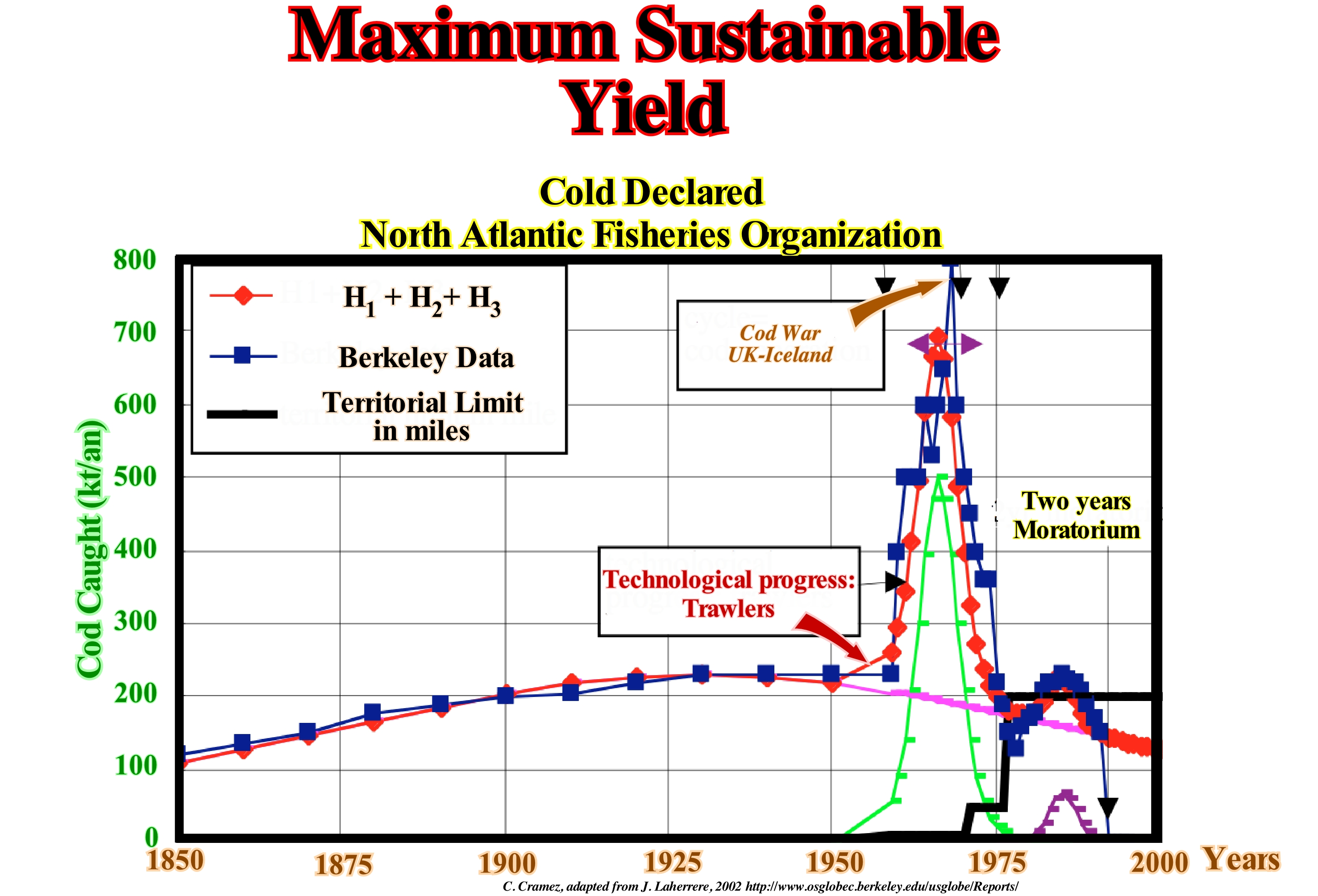
In population ecology and economics, MSY (Maximum Sustainable Yield), theoretically, corresponds to higher production or catch (for instance of a certain type of fish), expressed in number or mass, that can be extracted to a population, for an unlimited period, without exhausting the resource. The underlying principle that allows the continued operation of a species is the biomass gain, which exceeds the loss when the population is at a level below the carrying capacity (the maximum population size of an organism that a given environment can withstand). The dynamics of population of various species is such that a certain size of population, growth due to the birth and development of individuals exceeds the loss due to mortality. This phenomenon is expressed by the Verhulst model (logistic curve). Maximum sustainable yield is achieved when the exploitation rate is equivalent to the biomass surplus when the population size is at a level where growth is maximal. Traditionally, the calculation of the maximum sustainable yield is based on the analysis of the population of a single species. This method is in direct contradiction with the principle of natural ecosystems where all species are in constant interaction with each other. Generally, maximum sustainable yield can not be achieved for many species when they are exploited at the same time, as in the exploitation of fishery resources. In these cases, the most vulnerable species are over-exploited and others under-utilized. In addition, models for calculating maximum sustainable yield do not include the influence of other species present on the environment or the impact of population decline on ecosystem dynamics. Note in the diagram that the production curve for cod caught (in thousand tonnes per year) peaked in the 1970s, about 10/15 years after the use of trawlers. That's why cheap cod is gone.
Meander.............................................................................................................................................................................................................................................Méandre
Meandro / Meandro / Mäander / 曲流 / Меандр / Meandro /
Curve of the trajectory of a water-course (river, stream, brook, distributary, etc.) that when the current changes trajectory it forms an abandoned arm or channel.
See: « Neck (meander) »
&
« Point Bar (model) »
&
« Oxbow Lake »
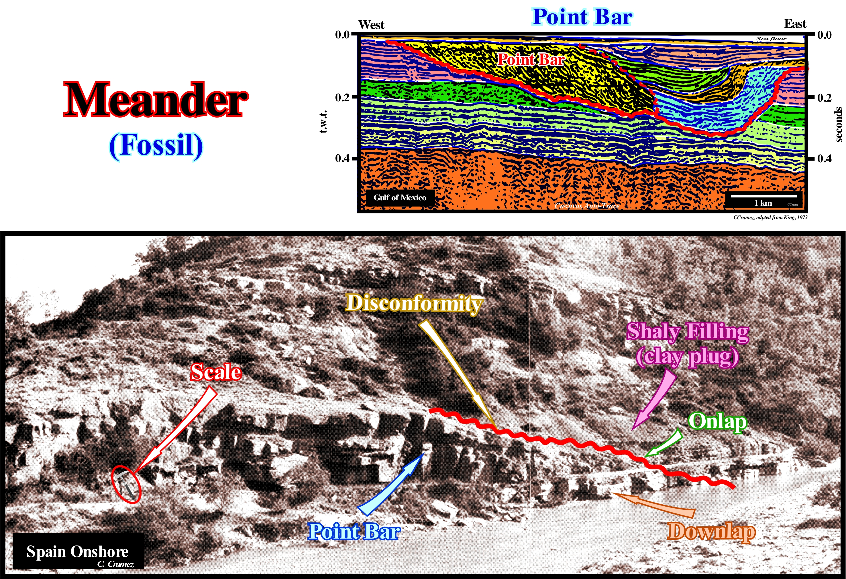
Not all the windings of a river are meanders. The term meander is reserved for a path that deviates, without apparent reasons, of the direction of flow to return back, after describing a curve, more or less marked at the same flow direction. Two main meander types can be distinguished: (i) Valley Meander or Incised Meanders, when the valley river meanders as the river, at the same scale and (ii) Alluvial Plain Meanders, which certain French authors call, erroneously, free or divagate meanders, when the sinuosities of the river are independent of the valley tracing and have very different scales, i.e., the river is much smaller than the valley. Valley meanders are as frequent as those of alluvial plain. Examples of the former are the meanders of the Colorado River, particularly, in the Grand Canyon (USA). The meanders of the Mississippi River are typical example of the alluvial plain meanders. This photograph illustrates a fossil meander in which it is easily distinguishable: (a) The point bar and (b) The clay plugs. The river incision (not to be confused with the current stream) does not appear in this place. In general, in a meander, the force of the stream erodes the external bank of the river allowing the point bar to progradate outward. The circular motion of the stream, which begins to erode the bank, then moves to the base of the channel, and then to the convex part of the canal, before returning to the surface of the river. This movement of water flow forces the sediments, from the erosion of the external bank, to deposit in the inner bank creating what is called a point bar. The material deposited on the point bar slopes, slightly, towards the eroded bank. This inclination is seen very well in this photograph (under the disconformity). The point bar ends by downlapping, which contrast with the onlapping of the sediments filling the clay plugs that fossilize the channel where the current flowed. The clay plug suggest that the meander was abandoned several times with formation of several oxbow-lakes.
Meander Belt.............................................................................................................................................................................Ceinture de méandres
Zona de meandros / Faja de meandros / Meander Gürtel / 曲流带 / Зона меандрирования / Cintura meandri /
Area of a flooding plain between the two lines tangent to the outer curvatures of the meanders. Area in which channel migration produces an accretion topography (point bars) and oxbow lakes. There are also valley meanders and not only meanders of alluvial plain.
See: « Point Bar »
&
« Clay Plug »
&
« Alluvial Plain »
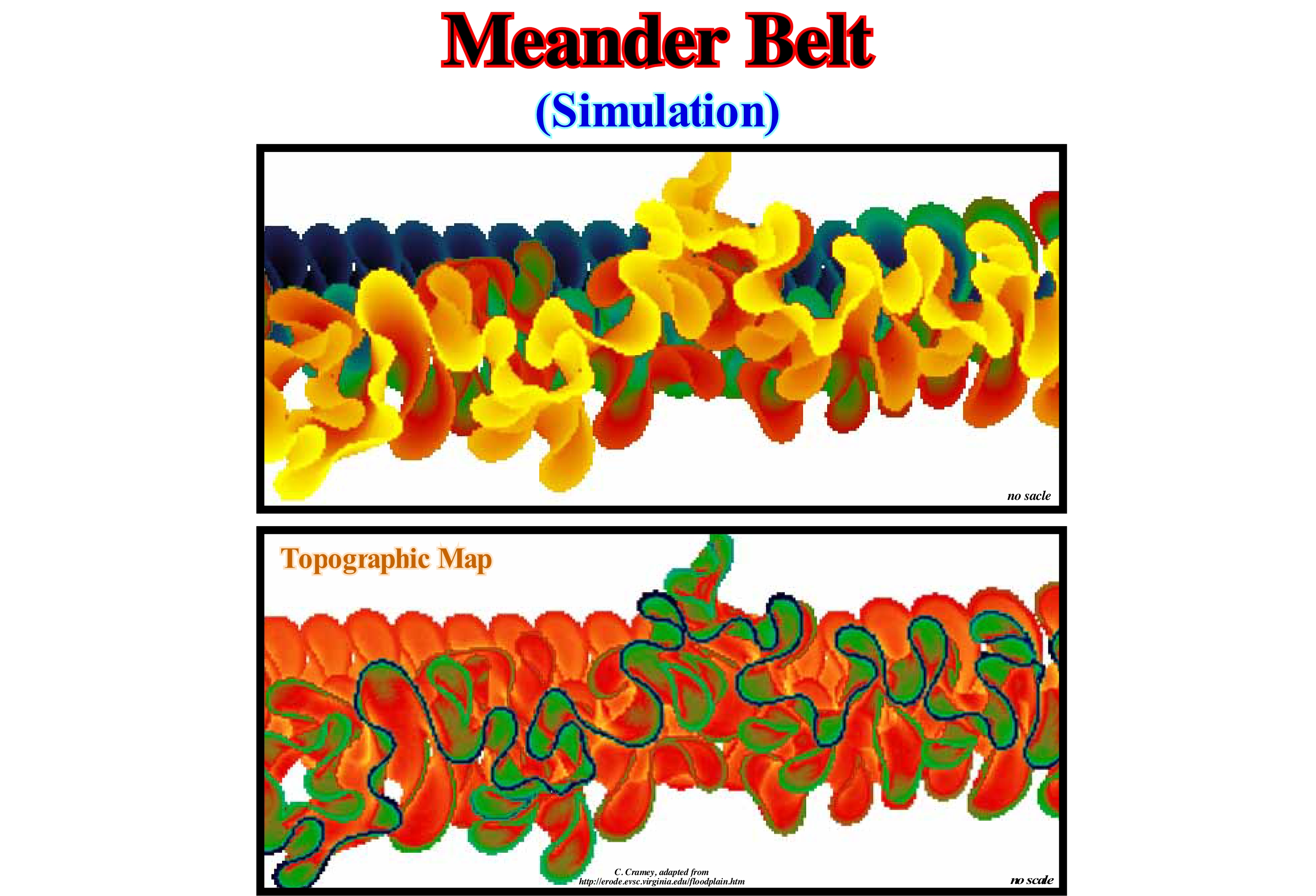
This figure shows the simulation of a meandering plain created by a meandriform current on an alluvial plain. The stream begins to flow through a rectilinear channel and then develop a meandriform configuration and eventually a complex pattern of active and abandoned meanders. The most recent areas occupied by the current are colored in yellow and the oldest in blue. The areas that were not occupied by the meandriform current during the simulation are yellow. This model also illustrates a sedimentation representation in the floodplain with a sedimentation rate that decreases exponentially with the distance to the active channel and the height of the floodplain. In the topographic map of the floodplain, the higher areas are yellowish and the lower (active channel) are bluish. Note the presence of meandering pond depressions in the abandoned meander arms. This model simulates only the meanders of the alluvial plain, also called, though without reason, free meanders or divagate meanders, which is the case, when the sinuosities marked by the river are independent of the valley and a smaller scale. The valley meanders or incised meanders, when the valley meanders like the river at the same scale, are as frequent as the meanders of the alluvial plain. In Portugal, Douro River meanders are, perhaps, the most typical incised embedded. The valley meanders like the river and at the same scale. The Tagus river meanders can be considered as alluvial plain meanders. The incised meanders can evolve in free meanders by calibration of the valley. The downstream migration of the meanders tends, over time, to calibrate the whole valley to the meanders' dimensions, transforming the valley meanders into alluvial plain meanders, which means that within a certain number of millions of Douro Valley will be quite different. By virtue of their accentuation, two neighbouring meanders can be cut in two different ways:: (i) By overbanking and (ii) By oscillation or contact. Overbanking occurs when during a flood, the entire floodplain is flooded and the stream takes a shorter rectilinear path instead of using the meander (impossible process in the incised or valley meanders). Oscillation occurs, when the exaggeration of the curvature makes the peduncle disappear, transformed the old meander into an abandoned channel, in which sometimes a lake forms. This last process brings into contact two points of the course of the river, which were previously at a certain distance and at different levels. Thus a cascade can be created which can be maintained for a certain time if the rock is hard. As the meanders become exaggerated, they migrate downstream, which, over time, can transform incised meanders into false alluvial plain meanders. A number of theories, not necessarily excluding, were advanced to explain the meander formation: (i) Stochastic Theory; (ii) Theory of Balance; (iii) Geomorphic Theory, etc. In the stochastic theory (which is subject to the laws of chance), the evolution of a meander seems to be the result of stochastic fluctuations in the direction of flow due to the presence of obstacles that change the direction of the current path. In the equilibrium theory, the formation of the meanders decreases the flow gradient (slope) of the stream until soil erosion and current carrying capacity are reached. In this theory, the descending water mass abandons potential energy (energy associated with the force of gravity), which is removed by the interaction of the flow with the bed material of the stream, since the velocity of the current is the same at the beginning and in the end of the course. In the geomorphic or morphotectonic theory, the tectonic structures of the terrain, especially the folds and faults, are the main responsible for the meanders formation, which, contrary to what is suggested by stochastic theory, can be predictable since they are associated with processes geological and geomorphological conditions. In a fluviodeltaic system (drainage basin, alluvial fan, braided-river, river with meanders, mouth of the river), the meandering zone is between the zone of braided rivers and the mouth of the river. In a fluvio-turbidite system, the meandering zone, which corresponds to the enrichment zone, is located between the alluvial fan and the zone of initiation of the gravitational currents.
Meander Bend................................................................................................................................................................................Courbe de méandre
Curva de meandro / Curva de meandro / Meander Kurve / 蜿蜒弯曲 / Изгиб меандра / Curva di meander /
Curve in the bed of a water-courser, usually, a river, which has a series of curves with opposite polarity and which may have been induced by a helical flow (movement of a corkscrew) of the stream.
See: « Meander »
&
« Point Bar »
&
« Alluvial Plain »
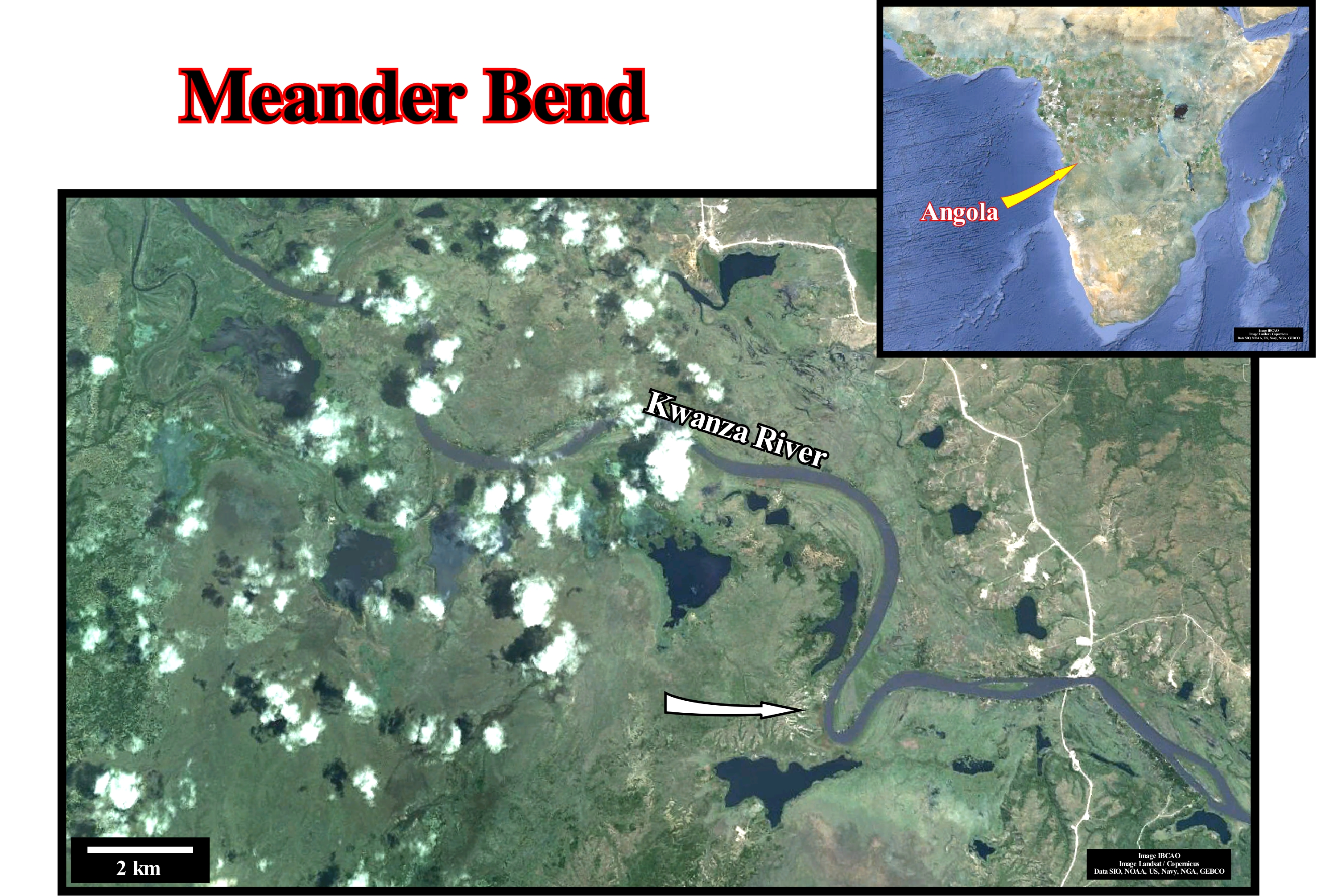
The shape of a water-course path changes constantly. Since the channel is sinusoidal, it is subject to the action of a process during which the amplitude and concavity of the curves increase greatly due to the helical flow of the water, which increases the erosion on the outside of the curve. The greater the curvature, the greater the erosion, which, in turn, increases the curvature, etc. Basically, three main theories were advanced to explain the fact that all water-courses were, more or less, sinuous at a certain time in their history: (i) Stochastic Theory ; (ii) Equilibrium Theory and (iii) Morphotectonic theory. The stochastic theory which assumes that the meanders are the result of stochastic fluctuations (related with chance and for which it is only possible to announce probabilities) of the flow direction due to the presence of obstacles in the stream bed. Even rectilinear channels have a sinuous thalwegs (the bottom line of the channel dividing it into two slopes) that may, eventually, create meander curves. The equilibrium theory, which suggests that the meanders decrease the current gradient until the equilibrium between erosion and current carrying capacity is reached, assuming (a) a constant velocity, (b) a mass of the descending water loses its energy potential by interacting with bed material, (c) a rectilinear channel has a high energy per unit length. The meander curve allows a current to adjust the length to an energy balance per length so that it carries all the sediments it produces. The morphotectonic theory, which takes into account the structure of the rocks where the current flows. The factors controlling this theory are not random, which means that the current path is controlled. Obstacles that deviate current can be predicted. A sandbar can deflect a current and cause or influence the formation of a meandriform pattern. The traces of fault planes are often invoked to explain the paths of many currents.
Meander Neck..................................................................................................................................................................................................................Pédoncule (Méandre)
Colo de meandro / Cuello de meandro / Meander Hals / 河曲颈部 / Шейка меандры / Collo di meandro /
Narrow isthmus of land separating two adjacent meanders.
See: « Meander »
&
« Point Bar (model) »
&
« Depositional Environment »
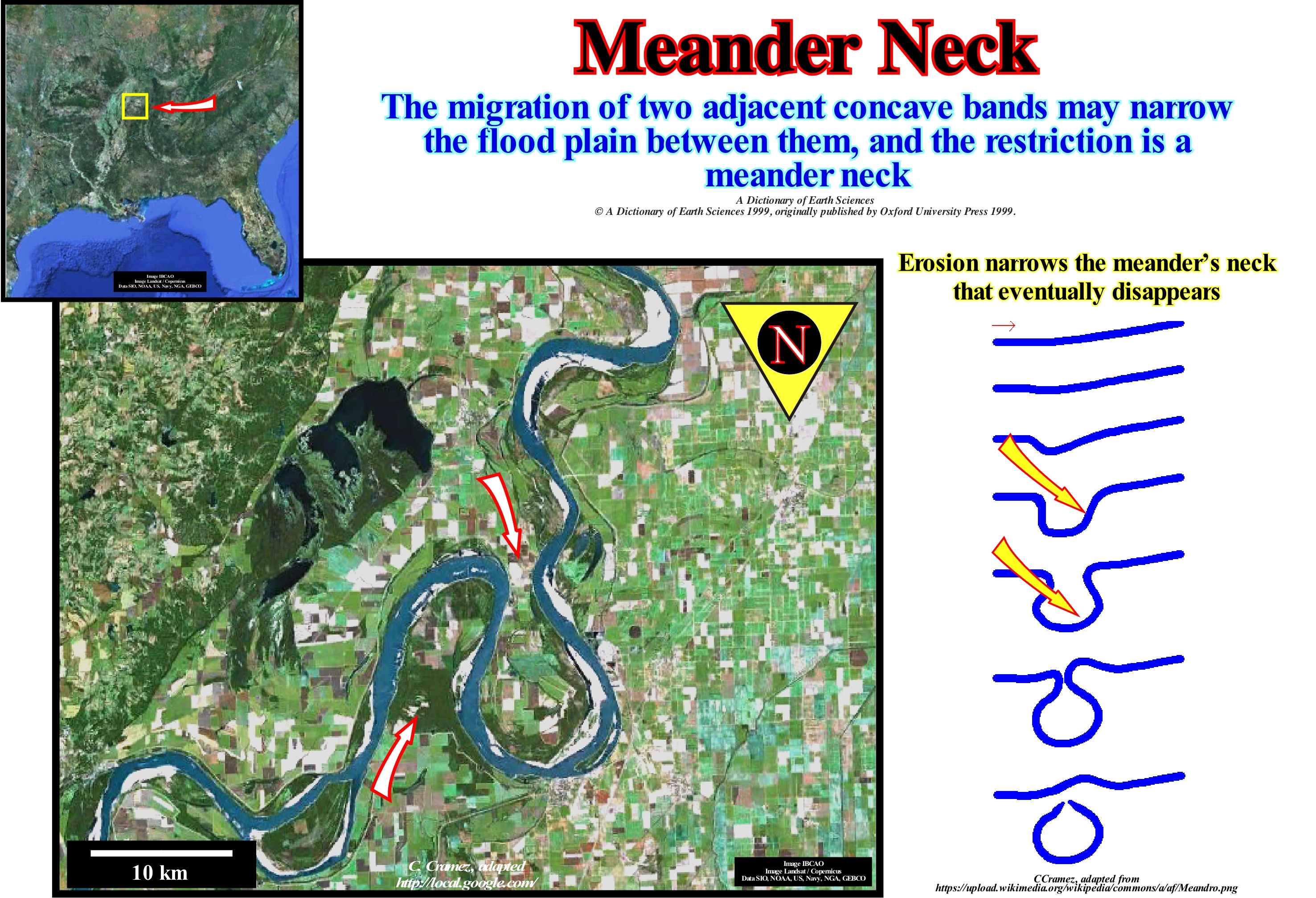
As illustrated in this figure, the meanders of the Mississippi River (near New Madrid, USA) become, progressively, so tight that sometimes a small isthmus forms between the beginning and the end of the meander. It is this isthmus that certain geoscientists call the neck of the meander, which is, often, used by the river, forming what is called a meander cut-off as seen in the upper part of the figure. With regard to the genesis of the meanders and especially to the genesis of meanders, there are a number of misconceptions in the geological literature that many geoscientists try to correct without great success. The base hypothesis, i.e, the conjecture that the sediments settle down where the velocity of the stream is smaller, that is, in the inner part of a meander, is refuted, easily. If this conjecture was true, the current velocity difference between the banks was sufficient to cause deposition on a bank. It would occur near the convex bank not because the current velocity is smaller, but because the swirling flow is smaller where the radius of curvature is greater. All the fluid, including the water of a stream, flows, only, around a whirlwind. In a stream where the water flows slowly, the current velocity difference next to the banks is not sufficient to explain that the deposition occurs on one bank more than the other. The base hypothesis (the deposition is done where the velocity of the current is smaller) does not explain why all the deposition is, practically, done in the inner bank of the meanders and not where the current flows in a straight line. The velocity of the water in a stream does not decrease when the stream enters a meander. In a meandriform stream, the water velocity is very small, as is the turbulence*, and therefore it is not able to hold in suspension the coarse sedimentary particles that make up the point bars. These sedimentary particles may not have been carried in suspension but, probably, by traction and saltation via secondary streams which exist at the base of each stream in the vicinity of the maximum curvature of the stream, which has nothing to do with the main stream.
(*) In the mechanics of fluids, turbulence, flow or turbulent flow, turbulent flow is the flow of a fluid in which the particles mix non-linearly, that is, in a chromatic way with swirls. In a turbulent flow, which opts for laminar flow, Poiseuille's law (Q=(PπR4) / (8lη), relates the flow rate Q of a cylindrical tube carrying a viscous liquid with radius R, length l, pressure P and coefficient of viscosity η) does not apply.
Medial Moraine.................................................................................................................................................................................Moraine médiane
Moreira média / Morena media / Mittelmoräne / 内侧碛 / Срединная морена / Morena mediale /
Moraine formed by two lateral moraines. When two glaciers join, the two lateral moraines will lie in the middle of the glacier and form a strand of sedimentary material on the surface of the new glacier.
See: « Moraine »
&
« Glacier »
&
« Recessional Moraine »
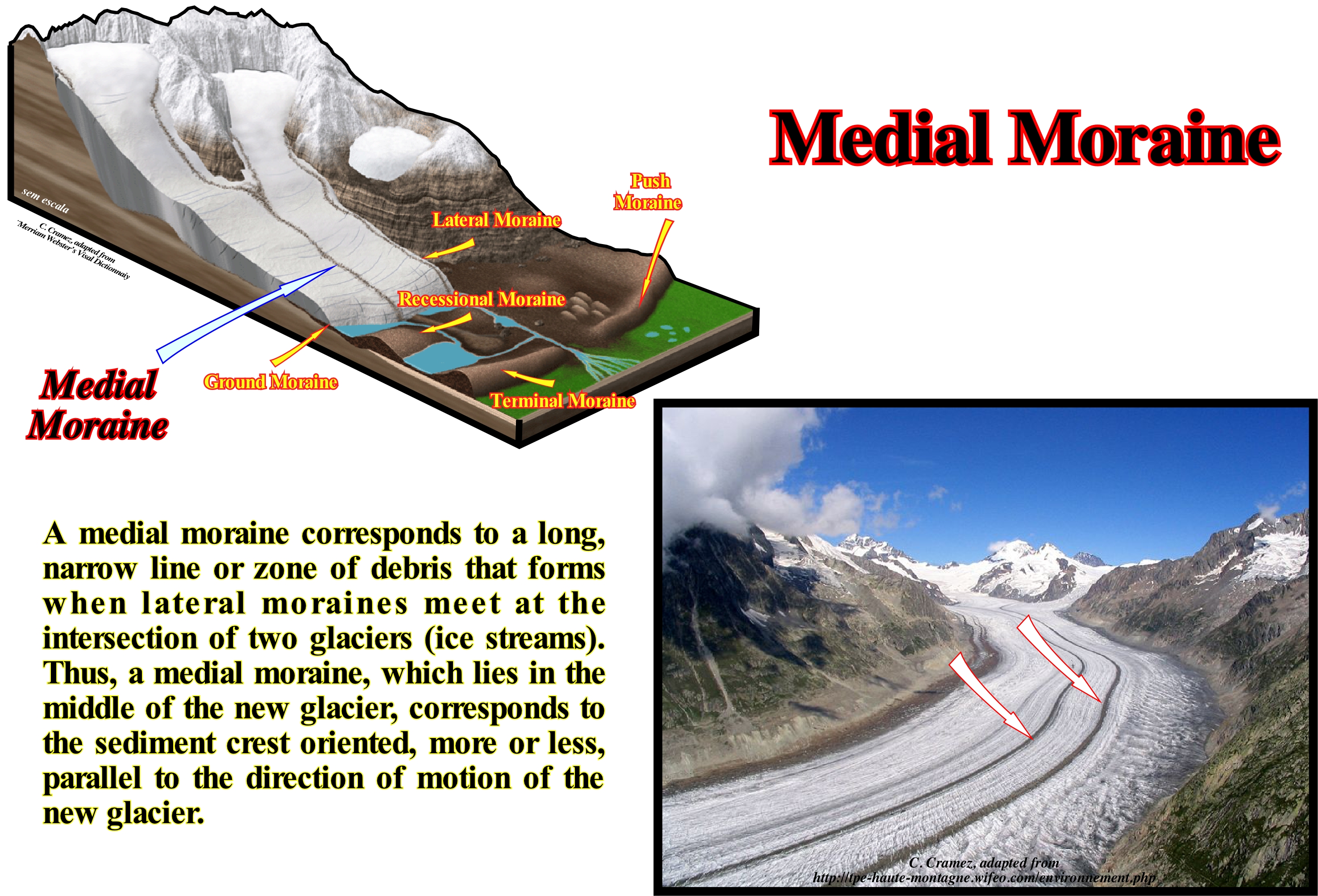
The existence of a medial moraine is the evidence that the glacier has more than one source, which means that a confluence between two glacial currents occurred and the adjacent lateral moraines have fused together to form the medial moraine of the new glacier. The lateral moraines of the new glacier include the material of the opposing lateral moraines of the two confluent glaciers. When the ice melts, the main glacier leaves a cord of sedimentary material in the middle of the valley. In this photograph, the medial moraine is recognized by the blackest colour in the St. Elisa Hills of Kluane National Park (Yukon Territory, Canada). As illustrated, this glacier contains several well-defined medial moraines. As stated above, as soon as two glaciers of the valley converge, the lateral moraines, i.e., the bands on each side of the glacier, merge in the middle to form the medial moraine. The moraines in this photograph indicate that this glacier is the result of the fusion of three glaciers. In this area, a large number of valley glaciers have several medial moraines resulting from the melting of multiple tributary glaciers. These confluences are rare in cirque glaciers, i.e., in the glaciers that accumulate in the highest parts of the Arctic or sub-Arctic mountains (above the line of the persistent snows), temperate and tropical mountains. In this type of glaciers, practically, they do not have lateral moraine. Unlike the glaciers of the valley, the cirque glaciers have small dimensions and are dominated by rocky walls almost vertical, from where the avalanches that feed them descend. All transition terms exist between cirque glaciers and plateau glaciers, which are glaciers deposited on more or less undulating plateaus between cirque glaciers and valley glaciers. The plateau glaciers are, sometimes, considered as replicas of small-scale inlandsis. Besides the medial moraines, there are: (i) lateral moraines; (ii) Ground moraines ; (iii) Frontal moraines ; (iv) Recessional moraines and (vi) Terminal moraines.
Megaparsec (Mpc)..............................................................................................................................................................................................Mégaparsec
Megaparsec / Megaparsec / Megaparsec (eine Millionen Parsec) / Megaparsec (一百万parsecs) / Мегапарсек / Megaparsec (uno milioni parsec) /
Unit of length (C) used in astronomy, equivalent to one million parsec (Mpc). A parsec is roughly equal to 31 trillion kilometers (1012 km) or about 3.26 light years. More strictly, a parsec equals 30.857 x 10¹⁶ meters, 1.9174 x 10¹³ miles or 3.26156 light-years.
See: « Inflationary Universe »
&
« Big Bang (theory) »
&
« Early Universe »
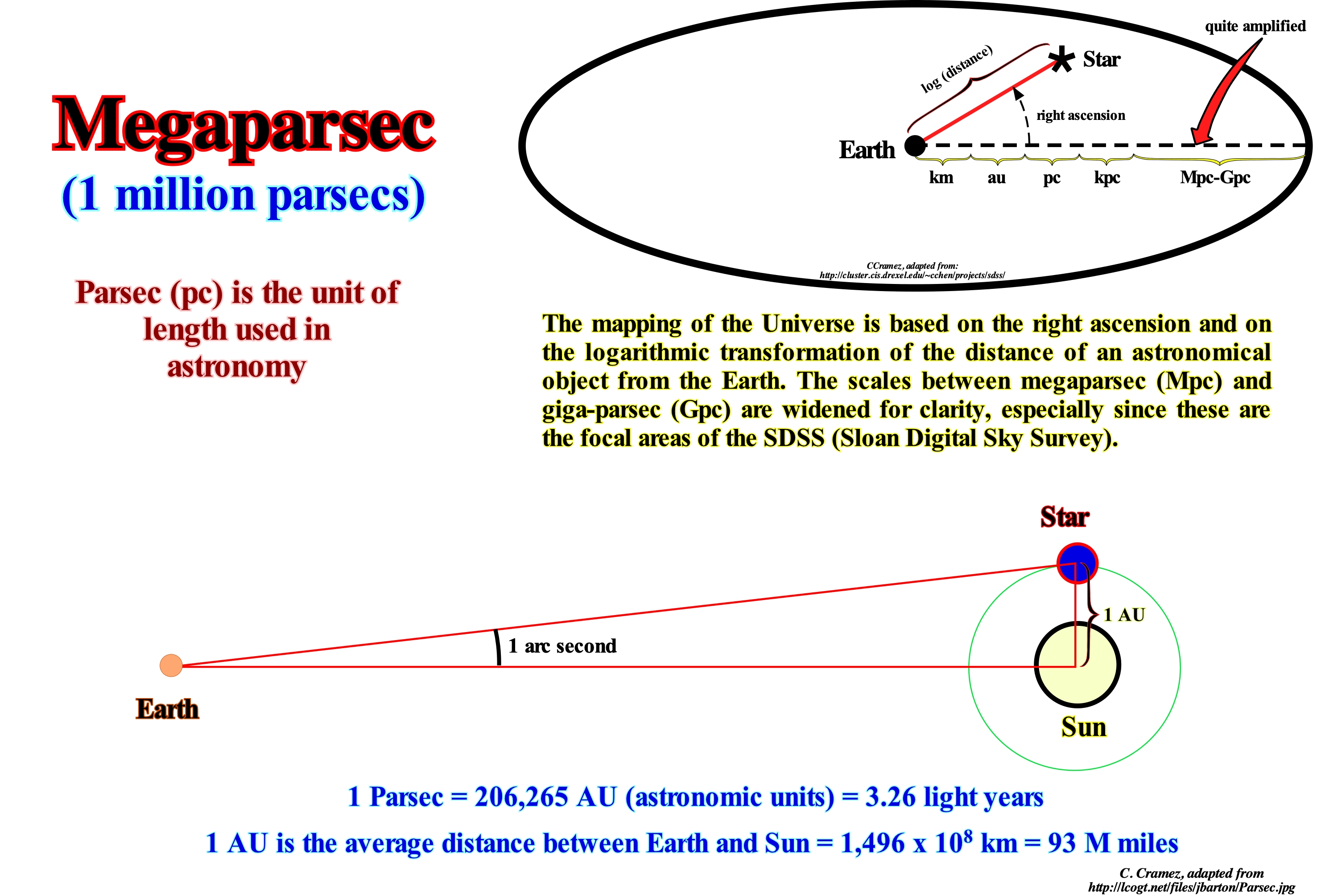
The Parsec (symbol: pc) is a unit of distance used in scientific works of astronomy to represent stellar distances. Equivalent to the distance of an object whose parallax (difference in the apparent position of an object seen by observers at different locations) is one-second of arc (1"). Because of the definition of annual parallax, parsec can also be understood as distance to which an observer should be placed to see an astronomical unit (AU) - equivalent to the distance from Earth to the Sun - under the angle of one second of arc. The annual parallax is defined as the difference in position of a star with a view of the Earth and the Sun. As we can not see the star from the Sun, the observation is made between two opposite points of the Earth's orbit and the result divided by 2. The parsec is the distance for which the annual parallax is one second of arc or arcseg. A parsec is equal to 3.26 light years. The word parsec came from the contraction of the words "parallax" and "second". Dyson (1913) suggested the name astron but said that Carl Charlier proposed the term syriometer and that Herbert Hall Turner suggested parsec, which became the name of the unit. Since the parallax method is the fundamental technique for calibrating astronomical distances, parsec is the most widely used distance unit in professional astronomical journals. The advantage of its use is that the distance (d) of a star, in parsecs, can be, directly, obtained from the parallax (π) by means of the formula: (d = 1 / π). Scientific articles and newspapers, however, prefer to use a more intuitive unit: the light year (unit of measurement used in astronomy and corresponds to the distance travelled by light in a year, in a vacuum). The light travels at a speed of approximately 300,000 km/s traveling 9.46 trillion (1012 km) per year among the stars. Thus, the distance from Alfa Centauro to us is equivalent to 4.2 light-years (40 trillion / 9.46).
Megaplankton...................................................................................................................................................................................................Mégaplancton
Megaplâncton / Megaplancton / Megaplankton / Megaplankton (大于或等于 2000 微米大小的浮游有机体) / Макропланктон / Megaplankton (organismi planctonici che sono maggiori o uguali a 2000 micrometri in termini di dimensioni) /
Set of planktonic organisms with dimensions equal to or greater than 2,000 micrometers*.
See: « Benthos »
&
« Pelagic (organism) »
&
« Meroplankton »
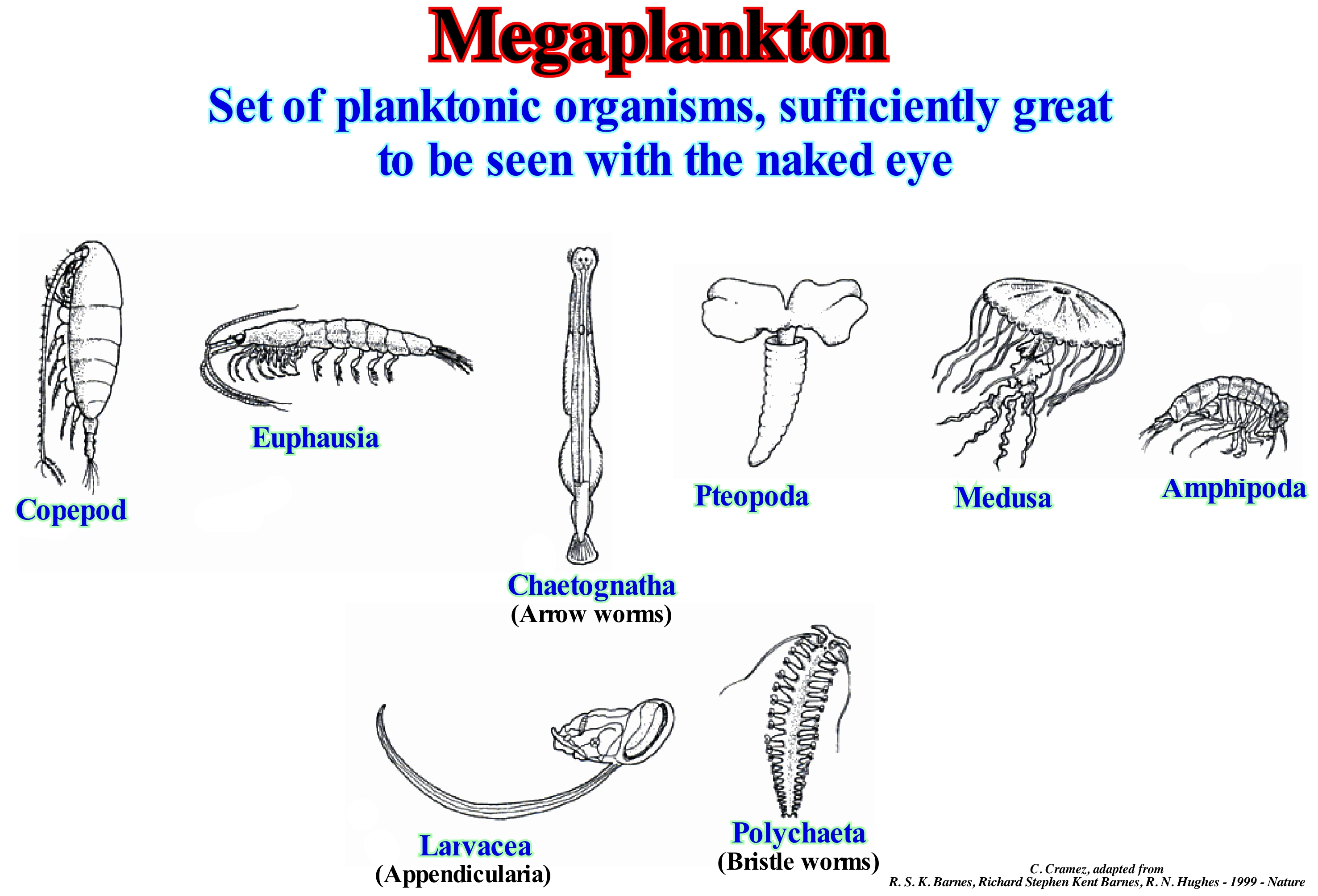
Plankton is often described in terms of size. Generally, the following divisions are used: (i) Megaplankton, with dimensions greater than 2 × 1 10-2 m; metazoans, such as jellyfish, ctenophores, salps and pyrosomes (Tunicata pelagic), Cephalopoda ; (ii) Macroplankton, with dimensions between 2 × 10⁻³ and 2 × 10⁻² m ; Metazoa, such as Pteropods, chaetognaths, euphausiacea, jellyfish; ctenophores; salps, doliolids and pyrosomes, cephalopods ; (iii) Meroplankton, with dimensions between 2 × 10⁻⁴ and 2 × 10⁻³ ; metazoans such as copepods, jellyfish, cladoceras, ostracods, chaetognaths, pteropods; Tunicata, heteropods, etc .; (iv) Microplankton, with dimensions between 2 x 10⁻⁵ and 2 × 10⁻⁴, as the major eukaryotic protists; much of phytoplankton, protozoa (foraminifera), ciliates, rotifers, juvenile metazoa (crustaceans), etc. ; (v) Nanoplankton*, with dimensions between 2 × 10⁻⁶ and 2 × 10⁻⁵ m, as small eukaryotic protists, small diatoms, small flagellates, pirrophites, chrysophytes, chlorophytes, xanthophites, etc .; (vi) Pico-plankton, with dimensions between 2 × 10⁻⁷ and 2 × 10⁻⁶ m, as small eukaryotic protists, bacteria, chrysophytes (golden algae), etc .; (vii) Femtoplankton, smaller than 2 × 10⁻⁷ m, such as those of marine viruses. Plankton is generally subdivided into: (a) Phyto-plankton, consisting mainly of microscopic algae ; (b) Ithiplankton, formed by larval or juvenile forms of the locust with little locomotivity ; (c) Zooplankton, made up of animals. The zooplankton can be divided into two main groups: (1) Holoplankton and (2) Meroplankton. The zooplankton is composed of those animals that spend all their life in the plankton. In marine plankton the main components of the holoplankton are the copepods (see shrimp-like figure) that can have the most varied feeding habits, from herbivores to carnivores or detritivorous. Chaetognathes are organisms, exclusively, planktonic. Meroplankton is plankton composed of animals that pass only one stage (usually the larval) of their life to the taste of the currents. Larvae may form part of the necton (in the case of fish larvae) or benthos (such as most mero-plankton larvae).
(*) A nanometer is a unit of spatial measurement that is 10-9 meter, or one billionth of a meter. A micrometer, also known as a micron, is an SI derived unit of length equal to 1 x 10⁻⁶ meter.
Megasequence .............................................................................................................................................................................................Mégaséquence
Megassequência / Megasecuencia / Megasequenz / Megasequence (地层) / Мегасеквенция / Megasequence (stratigrafia) /
The term megasequence is, in this glossary, replaced by the continental encroachment cycle, since it does not correspond in any way to a large or huge sequence-cycle as the prefix "mega" suggests. A megasequence or a continental encroachment cycle is a sedimentary interval deposited during 1st order eustatic cycle.
See: « Eustatic Cycle »
&
« Stratigraphic Cycle »
&
« Sequence-Cycle »
In sequential stratigraphy, each eustatic cycle (absolute sea level* or relative sea level change cycles) induces a stratigraphic cycle. There are, basically, three eustatic cycles: 1st order eustatic cycles ; 2nd order eustatic cycles and 3rd order eustatic cycles (the others are high frequency cycles). They are function of the time-duration. When the time-duration is greater than 50 My, the eustatic cycle is 1st order. When the time-duration is between 3-5 and 50 My, the eustatic cycle is of 2nd order: When the time-duration is between 0.5 and 3-5 My, the eustatic cycle is of 3rd order. The three associated stratigraphic cycles : (i) Continental Encroachment Cycles, induced by 1st order eustatic cycles ; (ii) Continental Encroachment Subbycles, induced by a 2nd order eustatic cycles and (iii) Sequence-cycles, induced by 3rd order eustatic cycles. The sedimentary intervals deposited during high frequency eustatic cycles are, of course, considered to be high frequency stratigraphic cycles. The old megasequence of P. Vail corresponds to the continental encroachment stratigraphic cycle. The total time of a stratigraphic cycle corresponds well to the time-duration of the equivalent eustatic cycle, but not to the depositional time. The total depositional time is much smaller than the total time of the eustatic cycle. Some geoscientists have even said the Geology's history resembles an Emmenthal Swiss cheese, which sometimes have more holes than cheese, which means that in Geology, periods of calm, where nothing happens, are much longer than the periods of activity, whether it is sedimentary or tectonic. This is why Sadler (1982) introduced the concept of "completeness" that emphasizes the ratio of real depositional time to total geological time between the boundary deposited intervals and showed the depositional time is inversely proportional to the sedimentation rate, i.e., the more the sedimentation rate is high, the shorter the depositional period. Comparing the 1st order eustatic cycles curve with the dispersal map of the Phanerozoic continents, it is easy to see the periods of absolute (eustatic) sea level rise (marine ingressions) seem to correlate with the dispersion of continents, which followed the break-up of the supercontinents. In the same way, the absolute (eustatic) sea level falls correlate with the periods of collision and agglutination of the continents that form the supercontinents. The absolute sea level 1st order falls correspond to the epochs of supercontinent formations: (i) Low absolute sea level between the Permian/Triassic, around 250 Ma ; (ii) Low absolute (eustatic) sea level in the Precambrian, there are about 590 Ma and (iii) Low absolute sea level in the Early Proterozoic, around 2.2 Ga, which is not illustrated in this figure. A continental encroachment cycle (the former megasequence of the EPR geoscientists, i.e. geoscientists of Exxon's "Exploration Production Research"), which is bounded between two unconformities associated with the formation of supercontinents, is formed by continental encroachment sub-cycles, which in turn are formed by sequence-cycles, which are the building blocks of sequential stratigraphy. The age difference between the unconformities bounding a sequence-cycle is, theoretically, less than 5 My, since it is induced by a 3rd order eustatic cycle. On the other hand, a sequence-cycle is formed by sequence-paracycles, which, as its name indicates, are induced by eustatic paracycles, i.e., by relative sea level rises (marine ingressions or increments of a composite marine ingression) without descending between them. Do not forget that to have deposition there must be an increase in the available space for the sediments (accommodation) upstream of the basin-edge (with the exception of submarine fans) and that deposition (at the level of a sequence-cycle) takes place during the stability periods of relative sea level that occurs between the relative sea level rises (eustatic paracycles or sea ingressions). As a rise in sea level, in general, is made by a succession of small increments, likewise, a marine ingression is, usually, made by a succession of small marine ingressions, without relative sea level falls between them.
(*) The absolute (eustatic) sea level is supposed to be global. It referenced to Earth's centre. It is controlled by glacio-eustasy, tectono-eustasy, geoidal-eustasy and the thermal expansion of the oceans or steric sea level rise. The relative sea level is the local and referenced to the any point of the Earth's surface that be the base of the sediments (top of the continental crust) or to the sea floor. It is the result of the combined action of absolute (eustatic) sea level and tectonics (subsidence or uplift of the sea floor).
Megasuture.....................................................................................................................................................................................................................Mégasuture
Megassutura / Megasutura / Megasuture (Tektonik) / Megasuture(构造) / Мегастык / Megasutura (Tettonica) /
Earth's mobile region (folded and faulted mountain ranges), which testifies to the complexity of the accretion and deformation phases undergone by geological bodies in regions where compressional tectonic regimes predominate. The term megasuture was first used in 1975 by A. Bally. Although the compressional tectonic regimes associated with the subduction zones are predominant in the formation of a megasuture, extensional regimes and the formation of sedimentary basins play, also, an important role.
See: « A-Type Subduction (Ampferer) »
&
« Supercontinent »
&
« Craton »
The Mesozoic/Mesozoic megasuture, illustrated in this figure, is, as A. Bally (1980) says, the integrated product of all subduction processes that are contemporaneous with the Mesozoic/Cenozoic sea floor spreading (ocean expansion). Mesozoic/Cenozoic megasuture encompasses the folded belts, as well as the sedimentary basins they piggy-back basin. Mesozoic/Cenozoic megasuture can be visualized as a float orogen or as deformed sediments and fragments of the Earth's crust that were, mechanically, separated from their roots. Three mega-sutures are usually considered: a) Pre-Cambrian Megasuture ; b) Paleozoic Megasuture and c) Mesozoic/Cenozoic Megasuture. The most important limits of a mega-suture are: (i) B type subduction zones (or Benioff), which coincide with the subduction of the oceanic lithosphere ; (ii) A type subduction zones (or Ampferer), which are outer boundaries of continents adjacent to folded belts, where a certain amount of continental lithosphere seems to disappear in depth by a mechanism similar to subduction ; (3) Limits dominated by slikke-slip tectonics (such as in Californian basins) ; (iv) Limits poorly defined by felsic intrusions* (as in China, Mongolia and Siberia). A megasuture can be considered as a suture formed by a Continent/Continent (between two continents) or Continent/Volcanic Arc (between a continent and a volcanic arc, created by a B-type subduction zone) with or less, of the metamorphic granite substrate. The Mesozoic/Cenozoic megasuture here illustrated, encompasses all the geological bodies associated with the subduction phenomena (A and B type) that have occurred since the Permian/Triassic until today. It represents the response to the oceanic expansion) sea floor spreading that accompanied the dispersion (cause or effect) of the continents formed by the break-up of the Pangea supercontinent. The Mesozoic/Cenozoic megasuture encompasses all products of orogenic and igneous activity following the break-up of the Pangea supercontinent and associated sedimentary basins, in particular the episutural basins and mountain ranges. As can be seen on the Mesozoic/Cenozoic megasuture map, illustrated in this figure, the Paleozoic megasuture now consists, exclusively, of continental crust and A type subduction zones (Ampferer). This absence of Paleozoic oceanic crust is explained by a very intense B type (Benioff) subduction mechanism that would have consumed almost all the oceanic crust of that age. Also, the orogenic zone that constitutes the mega-suture of the Precambrian does not also show evidence of Archaeozoic oceanic crust. Bally used the concept of mega-suture to classify the different domains of subsidence. Thus, it divided the sedimentary basins into two large groups: (i) Basins not associated with the mega-suture formation or Basins associated with the formation of a new oceanic crust (cratonic, rift-type, Atlantic and non-Atlantic type continental margins) and (ii) Basins associated with the mega-sutures formation, in which he considered two families: (a) Perisutural basins, i.e., formed in the periphery of the megasuture (forearc basins, foreland basins, etc.) and (b) Episutural Basins, i.e., basins formed within mega-suture (back-arc basins, Pannonian basins, Mediterranean basin, folded belts, etc.). The concept of megasuture is based on the basic principles of plate tectonics, which can be summarized as follows: 1) The outer and rigid layer of the Earth is a mosaic of tectonic plates that move relative to each other ; 2) The plates are born at the level of the mid-oceanic ridge and float on the asthenosphere ; 3) The plates move away without deforming ; 4) The new oceanic crust, continually, moves away from the axis of the mid-ocean ridges, and as it approaches the continents, it is destroyed along the B type subduction zones ; 5) The continents are, generally, considered as passive objects carried by the spread of the ocean floor ; 6) The continents or blocks of the continental crust can collide and create large continents ; 7) The boundaries of the plates are constituted by mid-ocean ridges, subduction zones and transforming faults ; 8) The internal energy of the globe dissipates in the limits of the plate ; 9) The relative movements of the plates are governed by the mathematical laws of kinematics on a sphere.
(*) It encompasses silicified minerals, magmas and rocks rich in light elements such as silicon, oxygen, potassium aluminum. The term felsic is a combination of the words feldspar and silica.
Meiofauna................................................................................................................................................................................................................................Méiofaune
Meiofauna / Meiofauna / Meiofauna / 小型动物 / Мейофауна / Meiofauna /
Small benthic invertebrates living in fresh or salt-water environments. The term meiofauna does not correspond to a defined taxonomic group, since it characterizes a group of organisms by the size, bigger than the one of the microfauna and smaller of the one of the macrofauna.
See: « Benthos »
&
« Pelagic (organism) »
&
« Meroplankton »

Fauna is the whole animal life of a particular region or time. The corresponding term for plants is flora. Zoologists and paleontologists use the term fauna to designate a typical collection of animals found at a particular time or place (e.g.: Burgess shale fauna or Sonoran Desert fauna). The fauna may be subdivided into: (i) Infauna, which includes aquatic animals living on the substrate of a body of water, especially on an unconsolidated seabed; (ii) Epifauna (or epibenthos), which encompasses aquatic animals that live on or in the bottom substrate, which means that the benthic fauna lives on the sedimentary surface of the sea floor ; (iii) Macrofauna encompasses those benthic organisms or organisms that live in the soil and are retained in a sieve with a mesh of 0.5 mm; in studies of the seabed the macrofauna is defined as the animals that are retained in a sieve of 0.3 millimeters mesh, which comes into account with the small size of many of the taxa; (iv) Megafauna, which encompasses large animals of a particular region or time, such as the Australian megafauna; (v) Meiofauna, which includes small benthic invertebrates living in marine and freshwater environments; the term meiofauna is very vague, since it defines a group of animals by their size, larger than the microfauna, but smaller than macrofauna, and not a taxonomic group; the ideal environment for meiofauna is between the grains of wet sand (Mystacocarida) ; in practice, they are metazoan animals that can pass unharmed by a mesh of 0.5-1 mm but are retained held by a mesh of 30 - 45 μm, but the exact dimensions vary with the authors (for an organism to pass by a 1 mm mesh depends, also, whether it is alive or dead) ; (vi) Mesofauna, which includes the macroscopic invertebrates of the soil, such as arthropods, earthworms, nematodes, etc. ; (vii) Microfauna, which includes microscopic or very small animals, such as protozoa and rotifers.
Merobenthos...........................................................................................................................................................................................................Mérobenthos
Merobentos / Merobentos / Merobenthos (am unteren Rand des Meeres) / Merobenthos(近海底)/ Меробентос / Merobenthos (vicino al fondo del mare) /
Seasonal benthic organisms, which are planktonic only at certain stages of their development (holobenthos when they spend their entire lives as planktonic). These planktonic organisms are included in the meroplankton. In the merobenthos are, also, included organisms that in unfavorable conditions of the year (winter, for example) settle in the seabottom.
See: « Benthos »
&
« Mesobenthos »
&
« Meiofauna »
In marine biology and limnology, benthos are organisms that live on the substrate, fixed or not, as opposed to pelagics, which live freely in the water column. Benthos or benthic organisms are those animals that live associated with the sediments, whether marine or inland waters, such as corals (colonies that grow in the seas and can form large reefs that have an ecosystem with a biodiversity and productivity). Benthos is subdivided into: (i) Phytobenthos, such as macroalgae, some microalgae and rooted aquatic plants, and (ii) Zoobenthos, such as animals and many benthic protists. Within the zoobenthos can be considered: (a) Macrofauna, which includes animals visible to the naked eye, such as most crabs, echinoderms, insect larvae, worms oligochaeta and some species of fish ; (b) Meiofauna, which encompasses animals permanently buried in the sediment, either free or within structures built by them, such as many molluscs, clams, and various types of worms; and (c) Microfauna, which encompasses animals microscopes that develop on the substrate, (mainly protists). The benthos can further be subdivided into: (1) Holobenthos, who live in the depths of the sea in all phases of the life cycle ; (2) Merobenthos, which are benthic during the adult phase, but planktonic during the larval phase ; (3) Epibenthos, that live on the surface of the sea or of a lake ; (4) Endobenthos, which live inside sediments that form the bottom of the sea or lakes (e.g., sandstones) ; (5) Mesobenthos that includes the marine organisms found in the bottom of the sea, between the sedimentary particles, specifically in the archibenthic area, between 200 and 1000 m of depth. Depending on their mobility, benthos may be subdivided into: (A) Sessile, which does not voluntarily move from its attachment site (buried in the substrate), such as macroalgae, oysters, sponges, etc. and (B) Vagile, who move by their own means.
Meroepipelagic (Organism)..........................................................................................................................................................Méroépipélagique (Organisme)
Meroepipelágico / Meroepipelágico/ Meroepipelagic (Teil ihres Lebens in der epipelagic Zone) / Meroepipelagic(在epipelagic带他们生活的一部分) / Мероэпипелагический (организм) / Meroepipelagic (parte della loro vita nella zona epipelagica) /
An organism that passes only part of its life in the epipelagic zone. Examples of this type of organism are fish that spend their adult life in the epipelagic zone, but which spawn in coastal waters (herring, whale shark, dolphin, etc.) or in fresh water, such as salmon.
See: « Pelagic (organism) »
&
« Meroplankton »
&
« Coastal Ocean »
In this figure, meroepipelagic fishes are shown, i.e., fish that pass only part of their life in the epipelagic zone. Oceanic nekton consists of a wide variety of bony fish, sharks, rays and, to a lesser extent, mammals and reptiles. The only invertebrates that can be considered as nekton are cephalopod molluscs. Fish that spend their entire life in the epipelagic zone are called holoepipelagic. Among them we can mention white tip sharks, yellow fin tuna, striped marlin, etc. Fish that spend only part of their lives in the epipelagic zone are called meroepipelagic. This group is more diversified and includes fish that spend their adult life in the epipelagic zone, but which spawn in the coastal waters (herring, whale shark, dolphin, etc.) or freshwater (salmon). Most fish have a gas filled bladder. On the other hand, as most fish can regulate the amount of gas in the bladder, they can control their buoyancy. The gas-filled cavities (lungs) help to float all nekton animals that breathe. Other means used by marine mammals to increase buoyancy are bone reduction and the presence of a layer of lipids (oils or fats). Large amounts of lipids also exist in nektonic fish that do not have swim bladders (sharks, mackerels, bonito, etc.). In addition to these static means of creating buoyancy, some nektonic animals have hydrodynamic mechanisms to produce buoyancy during movement, such as the fins either pectoral or caudal (heterocercal tail). Fish have two types of fins: (i) Pairs, which are the pectorals (with the base behind the gill apertures) and pelvic or ventral (located in front of the anus); and (ii) dorsal oddities (up to three, on the back), caudal (sometimes lobed, posterior extremity of the body) and anal (in the ventral region, behind the anus).
Meroplankton....................................................................................................................................................................................................Méroplancton
Meroplâncton / Meroplancton /Meroplankton (teilweise planktonischen) / Meroplankton (部分浮游) / Меропланктон / Meroplankton (parzialmente planctonicos) /
Organisms that are planonic only during a part of their life, mainly during the larval stage, like the larvae of hedgehogs, starfish, crustaceans, sea worms, some marine gastropods and many fish. After the planktonic period, meroplanktonic organisms evolve like neckon or adopt a benthonic (sometimes sessile) lifestyle on the seabed.
See: « Benthos »
&
« Nekton »
&
« Benthonic (organism) »
In marine biology, it is called meroplankton to the set of planktonic forms that can develop and become part of the nekton, as is the case of larvae and juveniles of fish or cephalopods, or benthos, which include the echinoderms, annelids and many crustaceans such as lobsters and crabs. The planktonic forms that spend their entire life cycle on plankton, such as copepods and other planktonic crustaceans, constitute the holoplankton. Plankton is the set of organisms that have little locomotion power and live freely in the water column (pelagic), being often dragged by the ocean currents. The holoplankton to the set of organisms that spend their entire life cycle in the water column, being part of the plankton. Not only are zooplankton animals such as copepods, which account for 70% of all zooplankton, and other crustaceans, some molluscs, such as pteropods, and even chordates, such as the Urochordata salpids and appendiculars, but also many protozoa. Among these are forms that are sometimes considered part of phytoplankton, such as dinoflagellates, but also foraminifera, whose shells form large deposits of limestone sediments on the ocean floor. Unlike meroplankton, the larval phases of these animals are also part of the holoplankton. Note that plankton is subdivided into: (i) Phytoplankton, consisting mainly of microscopic algae; (ii) Ithioplankton, formed by larval or young forms of the locust with little locomotion and (iii) Zooplankton, formed by animals. Examples of meroplanktonic organisms may include fish, molluscs, mussels, barnacles, shrimp and sponges. Some meroplankton larvae resemble adults, like certain fish, but others do not, such as goose barnacles.
Mesa............................................................................................................................................................................................................................................................................Mesa
Mesa / Mesa / Mesa (Geologie) / 梅萨(地质) / Плато, плоскогорье / Mesa (Geologia) /
Erosion residue, typical of stable platforms, associated with resistant geological formations and characterized by a, relatively, flat morphology at the top. A mesa is smaller than a plateau, but larger than a butte (*).
See : « Plateau »
&
« Peneplain »
&
« Erosion »

When a more or less horizontalized basement is covered by a shallow sea, a horizontal sedimentary series is deposited on top of it. This series which is, relatively, thin (2-3 km), when compared to the thickness of the basement, forms a stable platform. Under these conditions, a small uplift of the basement with little or no tilting can expose the sediment cover. Since this sedimentary cover, which is, usually, formed by an alternation of sandstones and shales induced by relative sea level changes, is exposed to the open air in a region of arid climate, erosive agents will create very erosive forms typical. As shaly horizons are, generally, poorly resilient, and sandstones, particularly carbonate sandstones (cemented by calcite) are harder and more resistant, erosion removes the least resistant intervals leaving a protective cover at the top, formed by an interval resistant, which forms a plateau, more or less, horizontal. As erosion progresses, it is quite possible that it individualises a, more or less, important portion of the plateau, i.e., a table, as suggested in the sketch illustrated in this figure (bottom right). It was, probably, in this way that the Gosseberry Table illustrated in the photograph (above left) was formed. As can be seen, the sediments of Moenkopi Formation in Utah (USA) are, more or less, horizontal, and the most resistant layers (function of grain size and amount of limestone present in the matrix) form small ridges . The top of the table is formed by the sediments of the Late Triassic formation, which are much more resistant than the sediments of the formation, which are better resistant to erosion agents and formed the top of the plateau. Erosion gradually receded the edge of the plateau creating a series of cliffs and escarpments until a part of the plateau was individualized by erosion (currents) to form the Table of Covered (as suggested in the sketch).
(*) Butte, (French: hillock or rising ground), flat-topped hill surrounded by a steep escarpment from the bottom of which a slope descends to the plain. Butte is sometimes used for an elevation higher than a hill but not high enough for a mountain, Buttes capped by horizontal platforms of hard rock are characteristic of the arid plateau region of the westernUnited States. (https://www.britannica.com/ science/butte-geology).


Send E-mails to carloscramez@gmail.com or to carlos.cramez@bluewin.ch with comments and suggestions to improve this glossary.
Copyright © 2009 CCramez, Switzerland
Last updated: August, 2019