
U-Shaped Valley.......................................................................................................................................................................................................Vallée en U
Vale em U / Valle en U / U - förmiges Tal / U形谷 / U-образная долина / Valle a forma di U /
Valley carved by glacial erosion, whose cross-section has abrupt sides and a nearly flat base, similar to the geometry of the capital letter U. Geographers to designate the shape of valleys make great use of the expressions "U-shaped" and "V-shaped". Most valleys belong to one of these two major types or to a mixture of them.
See : « Relative Sea Level Fall »
&
« Glaciation »
&
« Glacier »
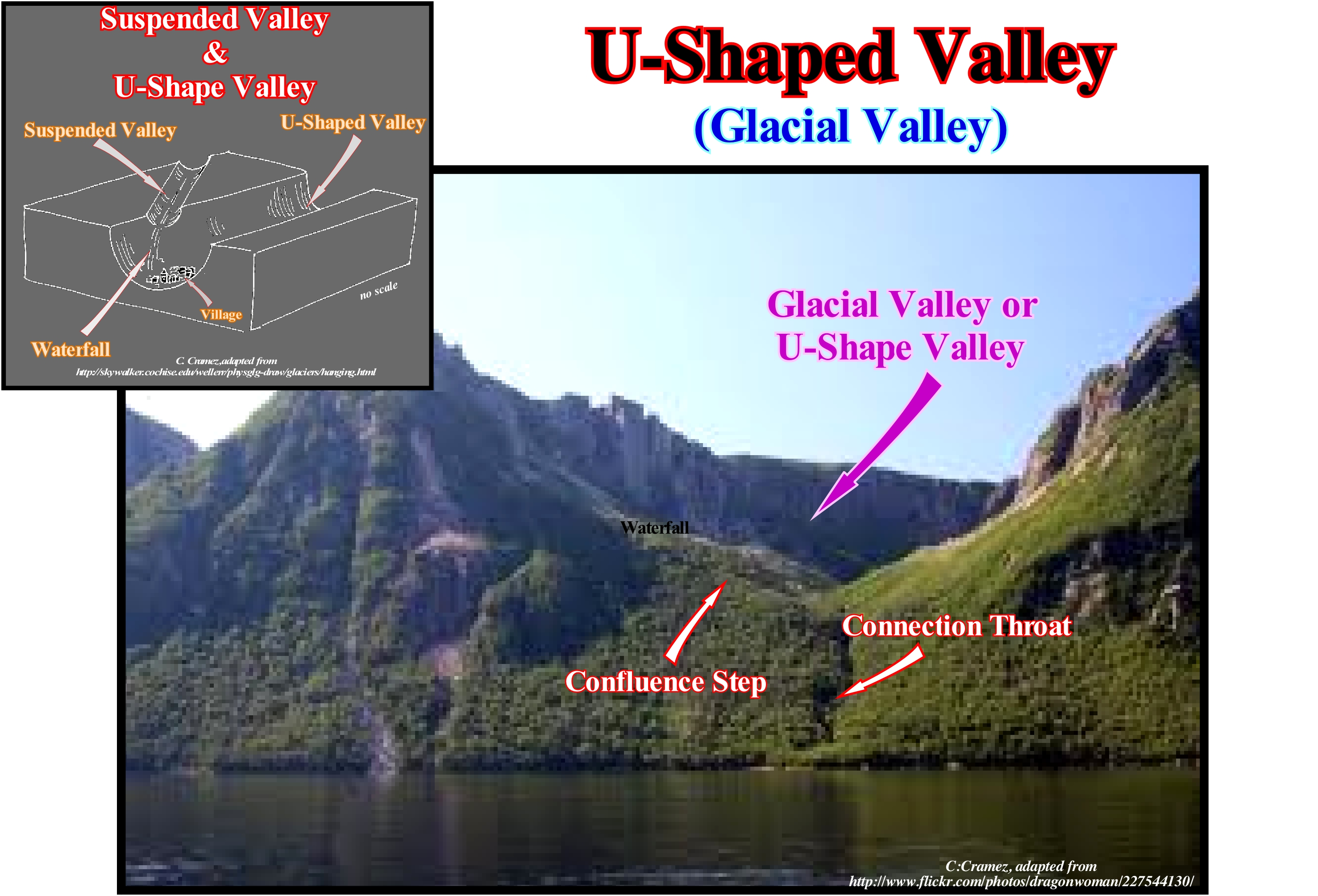
This photograph recognizes a suspended glacier valley, with its U-shape, a very small confluence step, in which the connecting throat is well marked. The terms glacial valley and U-shaped valley are, often, synonyms. The term trough ("gorge" in French) is, also, widely used. The great majority of the glacial valleys are shaped like a wooden gutter (where certain animals eat), with steep sides and a flat bottom, although the background morphology is, often, the consequence of filling an old lake with a water-course running along the valley. The U-shaped is created since a valley is deepened by a glacier. This means that the original V shape, which may have been made by a river, is enlarged and deepened after the ice has eroded the sides and bottom of the valley. The U-shaped valleys have a wide, flat floor, which may contain long, narrow lakes and streams (which are too small to make the valley). The sides of a U-shaped valleys or glacial valleys may have suspended valleys, as illustrated above. The suspended valleys are side valleys that were left high on the sides of the main valley, since this was deepened by the glaciation. The water-courses flowing from the suspended valleys can form important waterfalls when the water flows along the confluence steps. The lateral valleys may also have ridges truncated by the glaciers, which tend to flow more rectilinearly than a river. If all glacial valleys are not U-valleys, all U-valleys have a glacial origin (the resistance of the rocks must always be taken into account). When a river flows over a larger alluvial bed, it can form an alluvial gut of non-glacial origin.
Unamalgamated Turbidites................................................................................................Turbidite non-amalgamée
Turbiditos não-amalgamados / Turbidita no amalgamada / Unamalmagated Turbidit / 交合浊流沉积 / Разединённый турбидит / Torbiditici no amalmagato /
Distal facies of the submarine basin floor fans (SBFF) known as " laminate turbidite". The unamalgamated turbidites express a more or less regular alternation (1/2 m) of clay and sand levels. This facies corresponds to the type-2 of Emiliano Mutti, since they settle in the mouth of turbidite channels, in highstand geological conditions (sea level higher than the basin edge).
See: « Submarine Basin Floor Fan »
&
« Submarine Slope Fan »
&
« Lowstand Systems Tract »
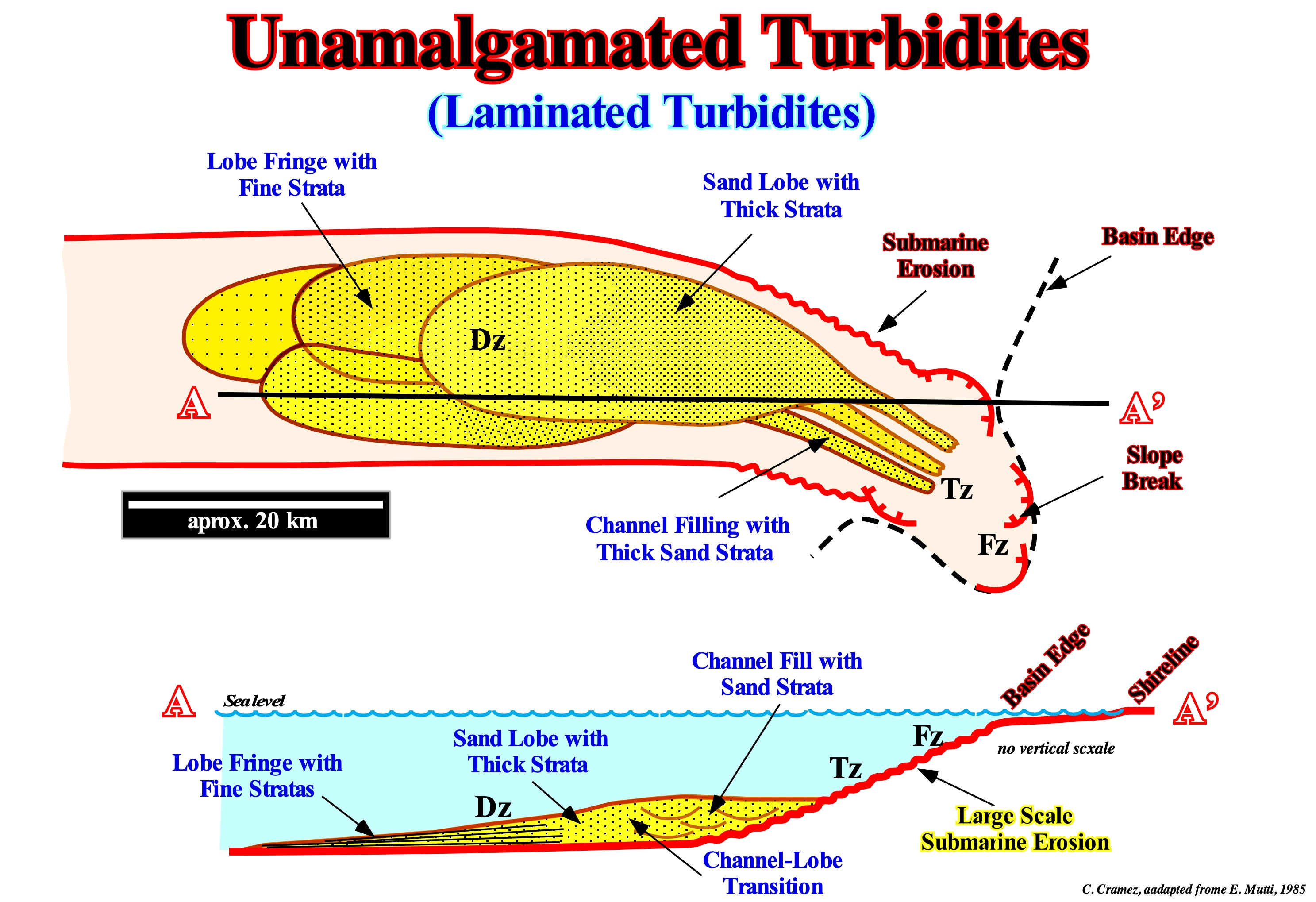
In turbidite depositional systems of E. Mutti, different geological factors control the geometry and distribution of the facies of a turbidite system, which can be grouped into two large families: (I) The continental shelf physiography, continental slope and abyssal plain ; (ii) The initial texture and lithologic composition of the turbidite current and its evolution. The first family (width and slope of the continental shelf, dip of the continental slope, presence of minibasins and/or submarine canyons in the continental slope, basin trench or flat abyssal plain) is related to the geodynamic and tectonic evolution of the sedimentary basin. The second one (rich in gravel, sand, mud and siliciclastic or carbonate) is related to the depositional systems developed from the continental shelf to the carbonate platform, reefs, muddy estuary, braided deltas with pendulum effect, alluvial cones, etc.). Theoretically, turbidite systems seem to correspond to large natural complex geological systems with many components that evolve to a critical state, away from equilibrium, where small disturbances can lead to catastrophic events. Turbidite systems, and particularly those of E. Mutti (developed under highstand geological conditions) can be taken as self-organized critical systems (SOC of P. Bak). In E. Mutti Type-2 turbidite systems, the geometry of the sandy turbidic layers suggests significant volume flows with little volume of sand loaded with mud. They correspond, more or less, to P. Vail's submarine basin floor fans (SBFF), but deposited at the base of the continental slope, i.e., they are, more or less, connected with the upstream turbidite channel fillings. They illustrate, perfectly, what certain geoscientists call unamalgamated turbidites. Unlike the lobes of the Type-1 turbidites, which overlap, vertically, to form homogeneous sand packets, the lobes of the Type-2 turbidites deposit, laterally, with respect to each other (such as the delta lobes under the pendulum effect). Unlike the amalgamated turbidites, they are, perfectly, connected to the turbidite channels (or depressions, without significant erosion, through which the turbidite currents pass, as shown in the diagram above.) In this scheme, where highstand geological conditions (sea level higher than the basin edge, which here corresponds to the continental slope since the basin has a very small shelf) are evident, it is suggested that the turbidity currents were induced by sediment collapses of the continental slope and basin edge. The lobes of the Type-1 turbidites are, completely, disconnected from the turbidite channel fills although there are residual deposits (bottom deposits), which is not the case for Type-2 turbidites. The lower sketch of this figure illustrates not only the lateral succession of the different zones: 1) Formation Zone (Fz), where turbidite currents start in association with failures in the continental slope and submarine erosion ; 2) Transfer Zone (Tz), which correspond to nondepositional zones and 3) Depositional Zone (Dz), where sediments are deposited since the current lose much of the transport capacity, but also different facies (lithology), i.e., (a) Turbiditic channel fillings (where there is evidence of erosion) or depressions between the lobes or between turbidite natural marginal dikes with thick strata of sand ; (b) Transition facies between the fills of the channels (or depressions) and the lobe ; (c) Lobe of sand with thick strata and (d) Lobe with thin strata. In the distal part of the turbidite lobes that many geoscientists recognize unamalgamated turbidites. In the Vail stratigraphic model, since submarine basin floor fans correspond, more or less, to Mutti Type-1 and Type-2 turbidites, it can be said unamalgamated turbidites are found in submarine basin floor fans (SBFF), in particular when these are connected to the basal break of the continental slope. The turbidite facies systems tracts of E. Mutti can only be reconstructed, significantly, within a context of predictive facies classification that relates facies and systems tracts, i.e., through a genetic level of facies analysis. This frame of reference, proposed by Mutti (1977, 1992), encompasses a very broad spectrum of facies from deposits of cohesive debris flow, with gravel clasts, pebbles, sands and even shales. Field evidence suggests that cohesive debris flow, hyper-concentrated flows and high-density turbidity currents of gravel produce types of facies which are clearly, genetically, interrelated, which can be subdivided into three main groups: A) very coarse granular facies ; B) Coarse granular facies and C) Fine grain facies.
Unconformities (Stratigraphic cycles)...................................................................................................................................Discordances
Discordâncias (ciclos estratigráficos) / Discordancias (ciclos estratigráficos) / Diskordanzen (stratigraphische Zyklen) / 不整合面(地层旋回) / Несогласие (стратиграфических циклов) / Discordanze (cicli stratigrafici) /
Type I and II unconformities, as well as, their correlative deep-water paraconformities, which are the limits of the stratigraphic-cycles. Type I unconformities are associated with significant relative sea level falls, which put the sea level lower than the basin edge. Type II unconformities are associated with small relative sea level falls, which, normally, do not exhume the shelf or just part of it. A Type I unconformity correlates, seaward, i.e., in the abyssal plain, with the base of the submarine basin floor fans (SBFF), which is not the case of type II unconformities. Downlap surfaces, which are not unconformities, may limit a stratigraphic cycle in the distal part of the abyssal plain when the progradations of the highstand prograding wedge (PNA) lie, directly, on sediments of an underlying stratigraphic cycle by downlaps.
See: « Unconformity »
&
« Stratigraphic Cycle »
&
« Systems Tract »
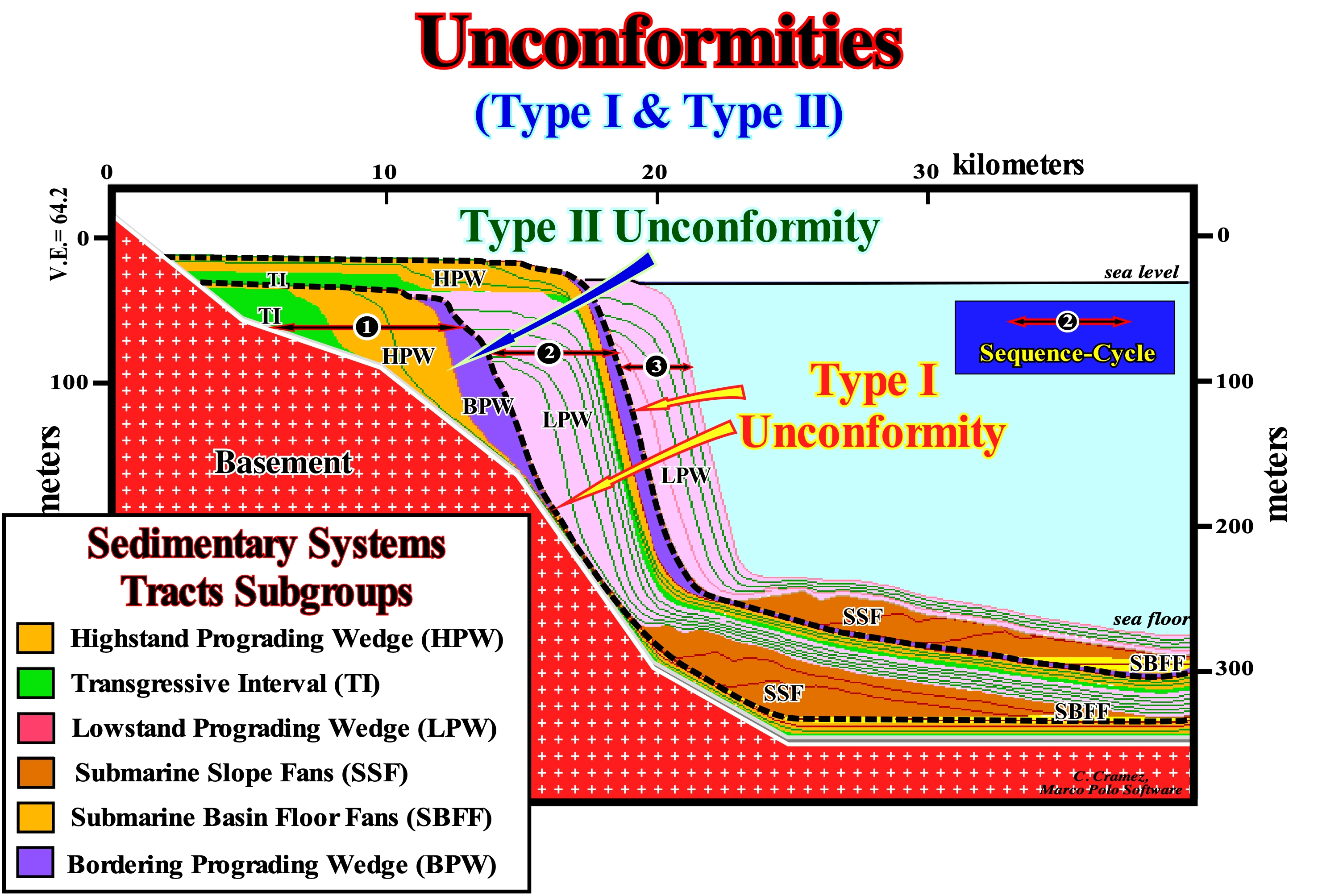
In this mathematical model (Marco Polo Software) are illustrated three stratigraphic cycles called sequence-cycles induced by 3rd order eustatic cycles, i.e., by eustatic cycles with a time-duration ranging between 0.5 and 3-5 My. All stratigraphic cycles are limited by unconformities. They underline, more or less, cryptic erosional surfaces created by relative sea level falls, which are the result of the combination of absolute (eustatic) sea level (supposed global and referenced to the Earth's centre) and tectonics (subsidence of the sea floor, when the predominant tectonic regime is extensional or uplift when it is compressional). However, locally, a, more or less, cryptic unconformity can be tectonically enhanced, creating what some geoscientists call an angular unconformity. Relative sea level fall (local sea level and referenced either to the sea floor or to the top of the continental crust, i.e., the base of the sediment) have to be, sufficiently, important to put the relative sea level to lower than the basin edge, which creates a Type I unconformity (erosional surface). Following a significant relative sea level fall, highstand geological conditions change to lowstand geological conditions. When the relative sea level is not lower than the basin edge, the associated unconformity is a Type II unconformity and it is not a stratigraphic cycle limit, since the deposited interval (bordering prograding wedge, BPW) is part integral of the sequence-cycle. In this scheme, only the intermediate sequence-cycle (sequence-cycle 2) is complete. From the base to the top, and above a Type I unconformity, the following systems tracts subgroups are identified: (i) Submarine basin floor fans (SBFF) ; (ii) Submarine slope fans (SSF), ; (iii) Lowstand prograding wedge (LPW) ; (iv) Transgressive interval (TI) *, (v) Highstand prograding wedge (HPW) and (vi) Bordering prograding wedge (BPW). The first three subgroups, i.e., the submarine basin floor fans (SBFF), submarine slope fans (SSF) and lowstand prograding wedge (LPW) form the lowstand systems tracts group (LSTG). The transgressive interval (TI), highstand prograding wedge (HPW) and bordering prograding wedge (BPW) form the highstand systems tracts group (HSTG). As it can be seen in this sketch, the submarine basin floor fans (SBFF) have a geometry, more or less, parallel and aggradational. The submarine slope fans (SSF) have a wavy geometry (gull-wings structures of P. Vail). The lowstand prograding wedge (LPW) has a progradational geometry. The transgressive interval (TI) has a retrogradational parallel geometry, whereas the highstand prograding wedge (HPW) and the bordering prograding wedge (BPW) have progradational geometries, but the aggradation is less marked in the highstand prograding wedge than in the bordering prograding wedge. Within a sequence-cycle, the highstand prograding wedge (HPW) is separated from the transgressive intervals (TI) by a downlap surface, which means that the boundary between these two subgroups of sedimentary systems tracts is diachronic. Sequence-cycle 1 is incomplete and formed just by highstand systems tracts group (HSTG), in which the transgressive interval (IT), the highstand prograding wedge (HPW) and the bordering prograding wedge (BPW), which is separated from the highstand prograding wedge by a Type II unconformity. The sequence-cycle 3 is, also, incomplete and composed just by the lowstand systems tracts group (LSTG), i.e., by the submarine basin floor fans (SBFF), submarine slope fans (SSF) and lowstand prograding wedge (LPW), whose progradations, generally, fossilize the submarine fans. Recalling that the absolute (eustatic) sea level is a function of: (i) Tectono-Eustasy, which is controlled by the volume variation of the ocean basins in association with oceanic expansion following the rupture of the supercontinents ; (ii) Glacio-Eustasy, which is controlled by the variation of water volume of the oceans as a function of the amount of ice (assuming that the amount of water in all its forms is constant since the formation of the Earth, around 4.5 Ga) ; (iii) Geoidal-Eustasy, which is controlled by the distribution of ocean water caused by variations in the Earth's gravity field (where gravity is stronger than normal, sea level is thrown to the centre of the Earth) and (iv) Steric sea level rise or thermal expansion of the oceans (if the temperature increases, the density of the water decreases, and for a constant mass, the volume increases).
(*) Some geoscientists call the transgressive interval, transgressive systems tract. As a systems tract is a lateral and synchronous association of depositional systems (association of a lithology with a typical fauna, deposited in a certain sedimentary environment i.e., a facies) a transgressive interval (TI) is necessarily formed by a set of retrogradational sedimentary systems tracts, the term transgressive systems tract is confusing not to say wrong.
Unconvencional Gas...................................................................................................................................................Gaz non-conventionnel
Gás não-convencional / Gas no-convencional / Unkonventionelle Gas / 非常规天然气 / Нетрадиционный газ / Gas non convenzionale /
Gas, currently little explored, but which in the near future may contribute (somewhat) to slowing down the energy crisis. The fundamental difference between an unconventional and conventional gas is more economical than geological. Examples of unconventional gases are, for example: (i) Marsh gas; (ii) Coal Gas ; (iii) Impermeable Sands Gas ; (iv) Gas from shale rocks* (fractured) ; (v) Clatrate Gas, etc.
See: « Methane »
&
« Biogenic Gas »
&
« Conventional Gas »
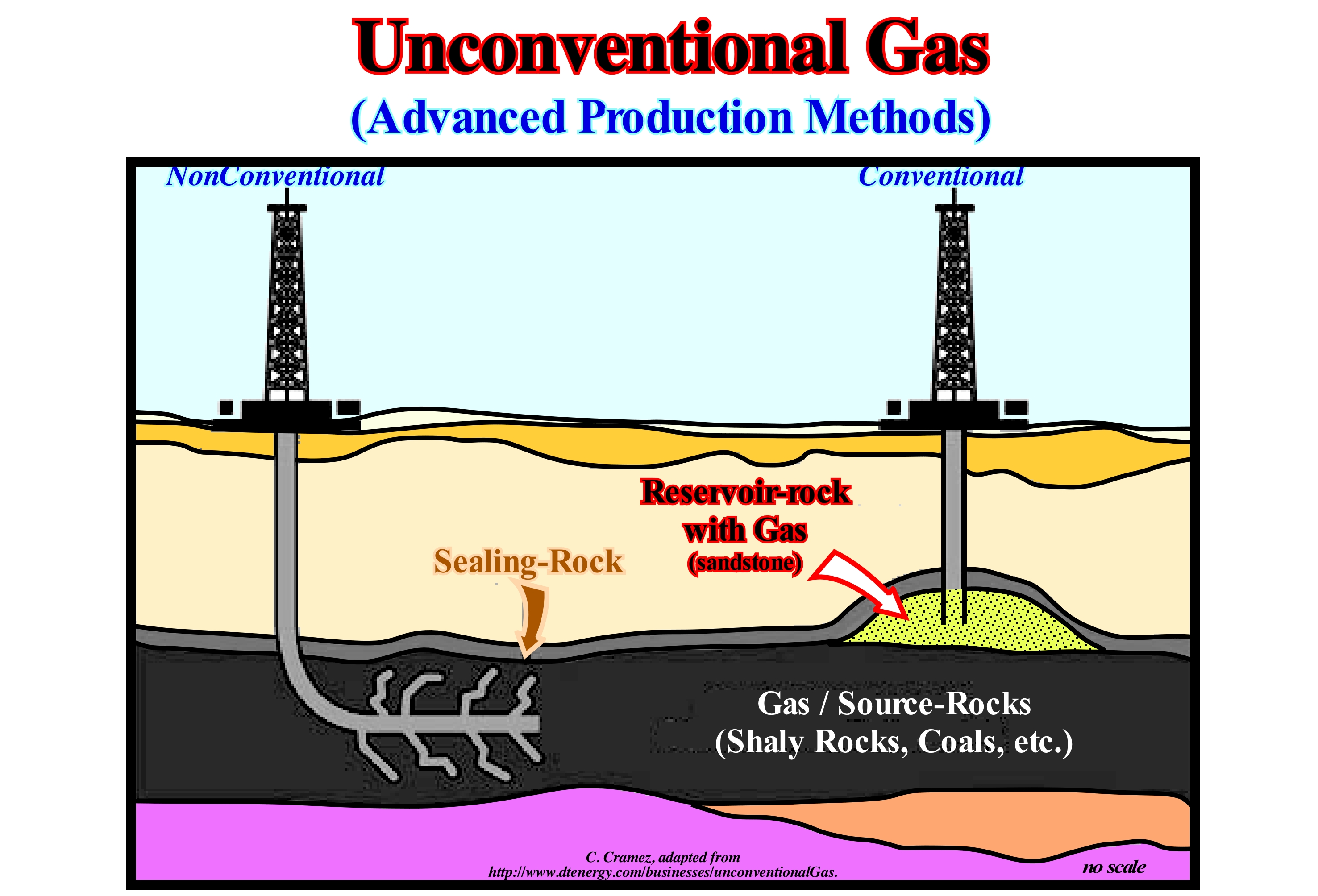
Conventional gas production was concentrated in sandy and carbonate geological formations with good petrophysical characteristics, i.e., with good porosity and, above all, a good permeability (Fermat-Maupertius law or minimum action principle**). The production of gas from a reservoir-rocks with low permeability (sands and impermeable shales) or from coal is increasingly important and will be very significant in the near future, since conventional gas reserves decline, fast, and unconventional gas resources are important. From the investment point of view, conventional gas exploration may even be more misguided than the unconventional one. Small reservoir-rocks not only trap little gas, but are, also, difficult to locate, especially, when there is no direct indication of the presence of hydrocarbons. On the contrary, certain unconventional gas reservoirs may extend over very large areas, which in some cases are penetrated by wells, which reduces the risk. New drilling techniques, such as the horizontal drilling (see figure) and new permeability enhancement techniques as hydraulic fracturing (technique used in tight geologic formations that involves horizontal directional drilling of wells, as well as, injection of water, sand and chemicals at high pressures to fracture rock and release hydrocarbons), acidizing, acid fracturing, thermal fracturing, high energy gas fracturing (HEGF) or explosive stimulation, etc., may contribute to the success of future unconventional gas production. The main sources of unconventional gas are: (i) Biogas ; (ii) Coal gas (or layered coal methane) ; (iii) Impermeable Sand Gas ; (iv) Low Permeability Shale Gas; (v) Clathrate Gas (or gaseous hydrates) ; (vi) Swamp Gas ; (vii) Gas from the Bottom of the Lakes ; (viii) Synthetic Natural Gas (GNS), etc.
(**) Shale gas refers to natural gas (primarily methane, CH4, with smaller quantities of other hydrocarbons) that is trapped underground in shale deposits, which have a lot of empty spaces to store natural (high porosity), but that are not well connected (bas permeability) which makes extracting the trapped gas difficult.
(*) This principle says that when a change occurs in nature, the amount of action, which is proportional to the product of mass by velocity and space, employed in such a change, is always the smallest possible.
Undertow...............................................................................................................................................................................................................Courant de fond
Corrente de retorno / Corriente de fondo / Unterström, Unterströmung / 暗流 / Глубинное течение / Corrente di fondo /
Current whose existence is much discussed. Theoretically, it is the current that moves along the sea floor, flowing seaward with the backwash current.
See: « Backwash Current »
&
« Surge Current »
&
« Uprush Current »
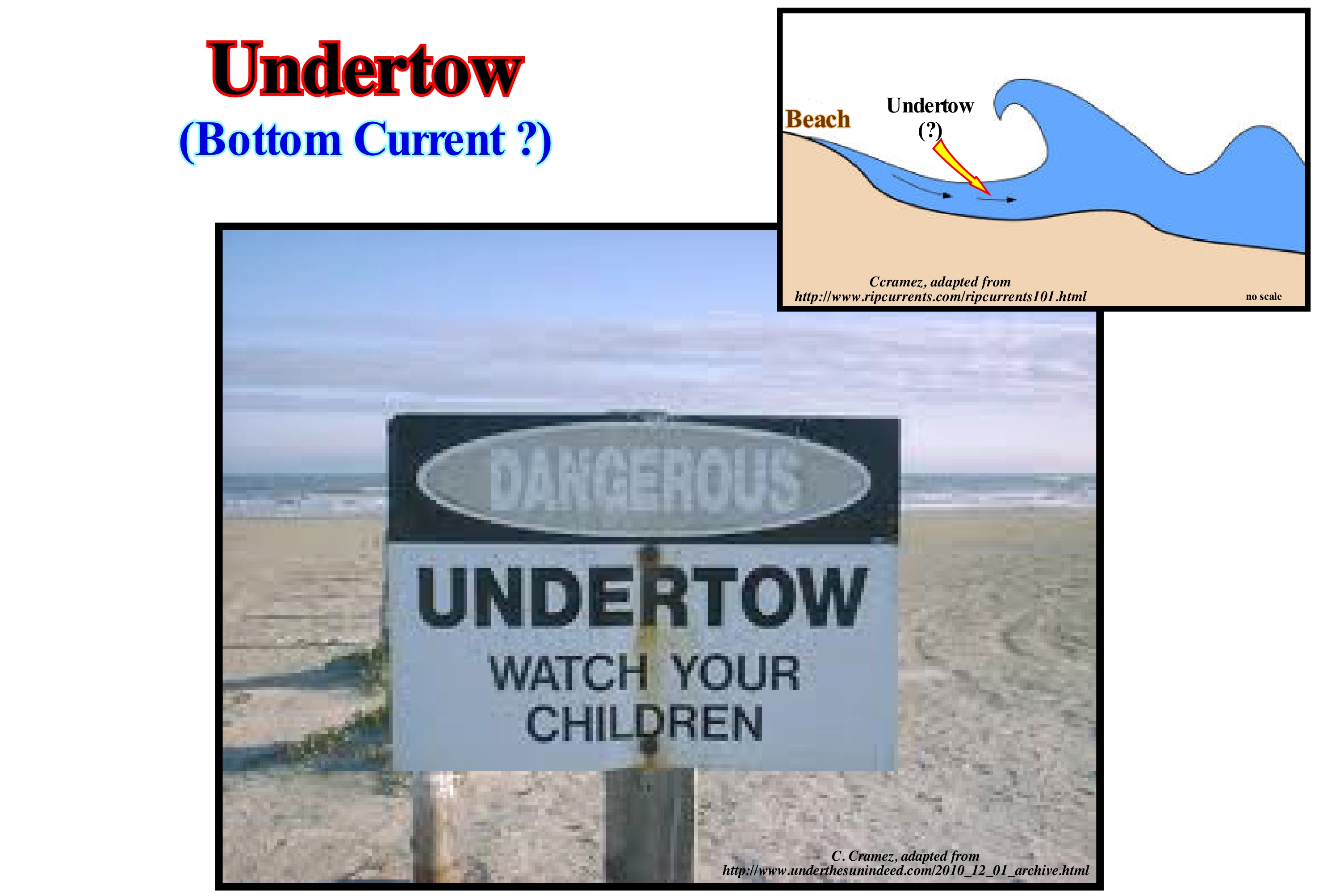
Certain geoscientists use this term as a synonym for backwash current which should be avoided, even if in ordinary language one often hears: "The swimmer was taken off by an undertow". The error comes from the term "undertow" that the inhabitants of the Gulf of Mexico use to incorrectly denominate the rip current or concentration current, as illustrated in this photograph. If undertow currents exist, which most geoscientists refute, they would move along the sea floor and, as such, they are or would be difficult to document. Anyway, one thing is certain, they have nothing to do with the rip current, which correspond to the drainage of the waters accumulated in the swash range and that channelled through the longshore ridges (large amplitude ripples formed at the outer limit of the shorefore induced by the turbulent flow of the swash currents), crossing the zone of the surf between the longshore ridge and hitting the coastal drifting (a mass of water that moves parallel to the shoreline, outside the surf zone, when it is oblique to the coast). In the area of shock (head of the concentration current), divergence is generated and the whirlwinds go back, again, to the coast. The presence of these currents is well recognized by the interruption of the crest line of the wave approaching the shoreline. These are the currents that drag the bathers off. So if one day it happens to you, stay calm, conserve your energy, do not try to fight against the current and use your knowledge in sedimentology, i.e.: (i) Try to swim parallel to the shoreline (rip currents, rarely, reach more than 10 m wide) ; (ii) When out of the current, swim in the direction of the shoreline. However, if you are not able to swim out of the current (which means that you are a bad swimmer and therefore should not swim in the sea), let yourself float or swim in the direction of the current until you get out of it (current is almost never more than 100 m long), and then swim in the direction of the shoreline.
Undiscovered Reserves (HC) ....................................................................................Réserves non-découvertes (HC)
Reservas não-descobertas / Reservas no-descubiertas (HC) / Reservierungen nicht-entdeckt (HC) / 保留不 - 发现(慧聪) / Неразведанные запасы (УВ) / Riserve non-scoperto (HC) /
Reserves not evidenced by exploration wells and estimated (with a certain level of confidence) on the base of geological or seismic maps of the potential reservoir-rocks, especially when the exploration wells, for several reasons, did not reach the main reservoir-rocks.
See: « Reserves »
&
« Discovered Reserves (HC) »
&
« Proven Reserves (HC) »
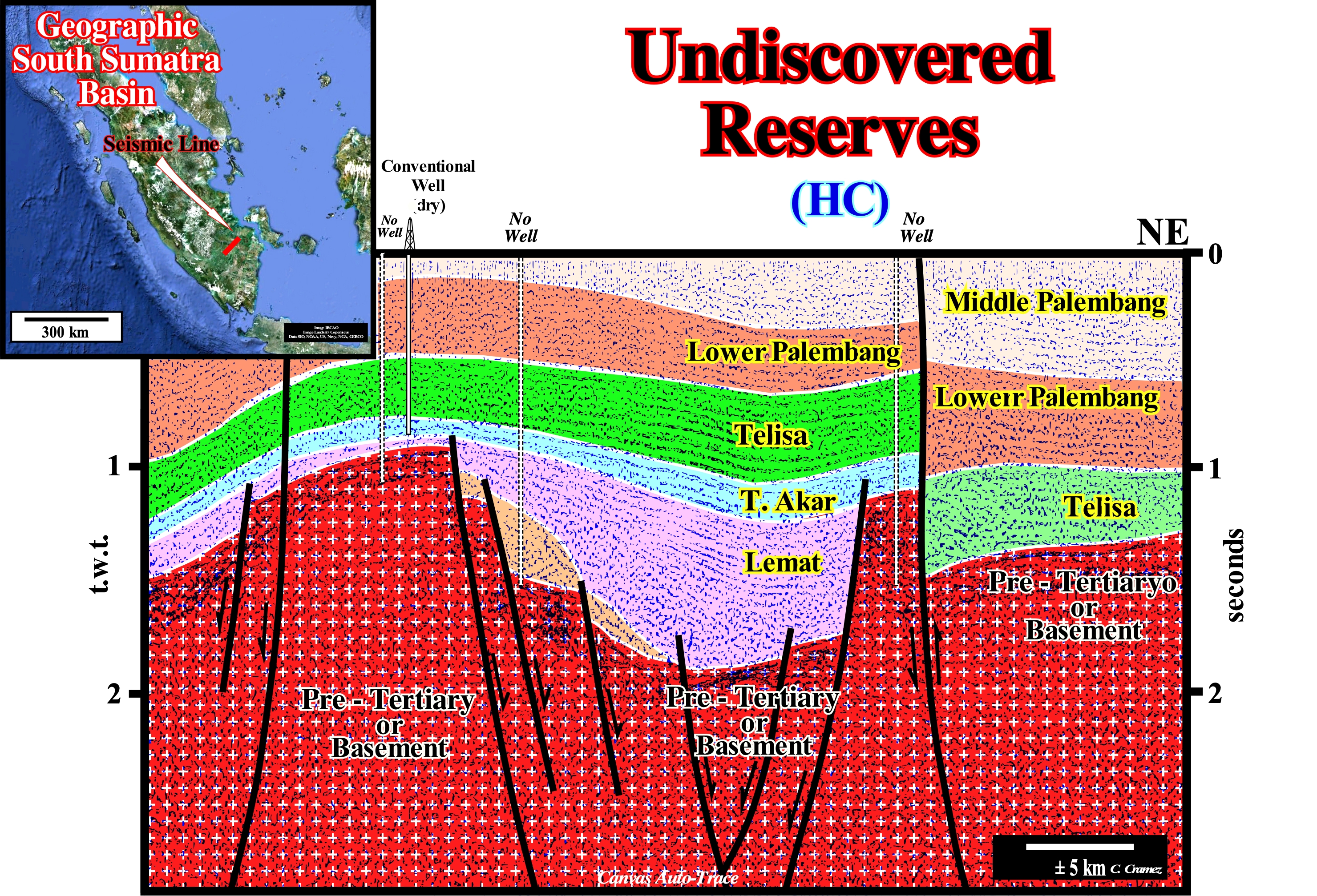
Undiscovered reserves and speculative reserves are not the same thing. Speculative reserves are estimated (with a certain degree and certainty, generally low) without the oil system being proved by an exploration well. On the contrary, undiscovered reserves are calculated in areas where the presence of a petroleum system and particularly the presence of a generating petroleum subsystem has already been proved by a well, but not the trap, which is supposed to contain such undiscovery reserves. The example illustrated above depict better what are undiscovered reserves. On this tentative geological interpretation of a Canvas auto-trace of a seismic line from the south Sumatra Island (Indonesia), several exploration wells corroborated the presence of a petroleum system. The generating petroleum subsystem (source-rock parameter) is composed by the organic rich lacustrine shales of the rift-type basins (Lemat formation). The main reservoir-rocks are the reefs of the Taleng Akar formation and the sandstones of the base of the rift-ype basins, as well as, under certain conditions, the basement (granite altered by weathering and leaching). In the region, which this seismic line represents, the only exploration well, located at the vertical of a basement buried hill, did not recognize all the potential reservoir-rocks, such as the potential reservoir-rocks of the Lemat formation (alluvial fans at the base of the rift-type basins), the sedimentary substrate or even the basement. Taking into account the presence of source-rocks (lacustrine rocks rich in organic matter), which reached the oil window and reservoir-rocks not tested by the exploration well, the geoscientists, with a certain level of confidence, advanced a certain amount of undiscovered reserves on the base of the seismic maps of the potential reservoir-rocks. As simple curiosity, three new explorations wells were suggested to test such reserves. Two of the drilled wells showed very significant gas reserves, either in the Lemat formation reservoirs or in the granitic basement.
Uniformitarianism (Principle)................................................................................................................Uniformitarisme (Principe)
Uniformitarismo (princípio) / Uniformitarismo (princípio) / Aktualismus (Geologie) / 均變論, 均变(原则) / Униформитарианизм / Uniformitarisme /
Earth was and is modeled by processes that are still active today, i.e., that the same laws and natural processes that currently operate in the Universe, have operated forever and everywhere.
See: « Geological Principle »
&
« Catastrophism (principle) »
&
« Theory of Evolution »
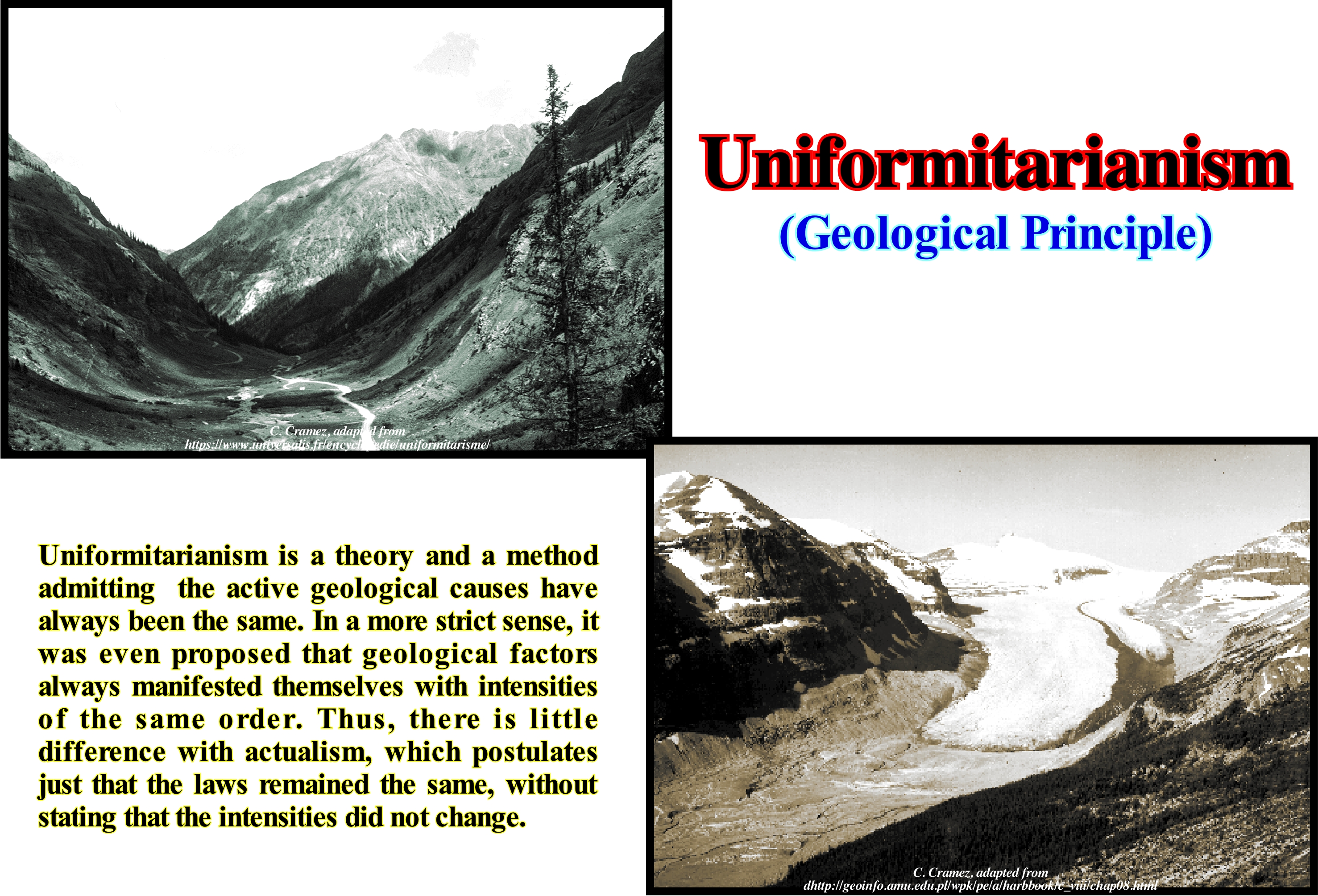
Uniformitarianism is a stream of geological thought formulated by James Hutton, the father of modern geology and later developed by Charles Lyell and which, according to certain geoscientists, was corroborated by Charles Darwin through the study of evolutionism. Uniformitarianism, basically, suggests: (i) The events of the past are the result of forces of nature identical to those observed today (geological actualism, which says that the morphological transformations of the Earth's crust, in the past, are due to phenomena analogous to those, currently, observed) ; (ii) Geological events are the result of slow and gradual processes of Nature (Gradualism, which says that evolution occurs through the accumulation of small modifications over several generations, which is in perfect opposition to the hypothesis of "Saltacionism or Punctuated Equilibrium*", which suggests a sudden change in a given organism from one generation to another). On Uniformitarianism, James Hutton concluded that "The Present is the key of the Past." In Uniformitarianism, the laws of nature are constant. The study of the current geological processes allows to interpret the geological evolution, placing the geological records printed on the rocks and their structures as in a puzzle. According to R. Hooykaas (1963), Lyell's Uniformitarianism is the set of four propositions, more or less, related to each other and not a single idea: (a) Law of Uniformity - the laws of nature are constant over time and space ; (b) Law of Methodology - the appropriate hypotheses to explain the geological past are analogous to those used to explain the present ; (c) Uniformity of Nature - past and present causes are all of the same type, have the same energy and produce the same effects ; (d) Uniform Intensity - geological circumstances have remained the same over time. However, none of these connotations requires another, and they are not all, equally, inferred by adherents of Uniformitarianism.
(*) The theory developed by S. J. Gould and N. Eldredge, tin which the evolution of species is a succession of long periods of stability interspersed with phases of rapid speciation in small populations subjected to reproductive isolation and undergoing large-scale genetic mutations.
Uniformity Law...............................................................................................................................................................................Loi de l'Uniformité
Lei da Uniformidade / Ley de Uniformidad / Uniformity Gesetz / 均匀定律 / Закон единообразия / Legge del’Uniformità /
Hypothesis that the same laws and natural processes that act in the Universe today, always operated in the Universe in the Past and apply throughout the Universe. This, which seems trivial, is very important because it reflects a concept that not only the geoscientists, but all human beings use every day and that is the hypothesis of universality: "What happens here also happens in other places".
See: « Uniformitarianism »
Universe (Age)....................................................................................................................................................................................................................Univers (Âge)
Universo (idade) / Universo (edad) / Universum (Alter) / 宇宙(年龄)/ Вселенная (возраст) / Universo (età) /
Assuming a probable value for the Hubble constant of 18 km/s to 1 My, the Universe's age is about 16.5 Ga. Of course, the decimal horn is illusory, since the error of the method of determination is much higher. It can be said the determination of the Earth's age by C. Patterson, in 1953, of about 4.6 Ga has not changed to this day. What changed was the Universe age, which consists, essentially, of matter (quarks and leptons), forces (force of gravity, weak force, electromagnetic force and strong force), space-time, and emptiness. Space-time and emptiness play an arena kind role, in the bull-headed sense, in which matter and forces evolve between them at the same time as space-time.
See: « Geological Time »
&
« Cosmologic Time »
&
« Impact »

According to the scientific model of the Universe*, known as the Big Bang, the Universe arose from a single point or singularity (what several authors nowadays contest, such as Étienne Klein in his book "Discours sur l'Origine de l'Univers, Flamarion, 2010) where all the matter and energy of the observable Universe was concentrated in a dense and extremely hot phase called Planck's Era. From the Planck Era, the Universe would have expanded to its present form, possibly, in a short period (less than 10-32 seconds) of cosmic inflation, i.e., that the size of the universe doubled a hundredfold in a fraction of a second, during which, for instance, a region about 1020 times smaller than a proton (= 0.84184 x 10⁻¹⁵ (phentometers) = ± 0.000000000000000800 meters) inflated into a sphere, about the size of a lemon. Several independent experimental evaluations support, theoretically, such an expansion and the Big Bang theory. Recent observations indicate this expansion has been accelerated by dark energy** and by the fact that most of the matter is in a form that can not be detected by existing instruments and therefore is not accounted for in the current models of the Universe. This matter is called dark matter. The imprecision of current observations has made it difficult to predict the fate of the Universe. The present interpretations of astronomical observations suggest that the age of the Universe is 13.73 (± 0.12) billion years, but it is all a function of the value of the Hubble constant, that is, of the constant of proportionality that exists today between distance and apparent recess velocity of galaxies in the observable Universe. In fact, this age was first calculated by measuring the distances and radial velocities of other galaxies, most of which are traveling away from ours at speeds proportional to their distances, and then using the current rate of expansion of the present Universe, to "rewind" the Universe to the point where everything was contained in a singularity, and to calculate how long it must have passed between that Big Bang and the present. For example, (https://www.forbes.com/sites/startswithabang/2016/04/29 / how-do-we-know-the-age-of-the-universe/# 22e9d49c6155) and if the Universe had the same properties as at present, but were made to 100% normal matter and without dark matter or dark energy, the age of the Universe would be only 10 billion years old (Hubble constant was 70 km/s /Mpc and 1 Megaparsec (Mpc) = 3.26 million light years). If the Universe had 5% of normal matter (no dark matter or dark energy) and the Hubble constant was 50 km/s/Mpc instead of 70 km/s/Mpc, our Universe would have been about 16 billion years old, but reversing (rewinding) until the Big Bang requires knowing the history of the rate of expansion, which can be determined by examining the density and composition of the Universe. The cosmologists studied observations of the cosmic microwave background, radiation of relics of the Big Bang time, to determine these parameters. Two spacecraft measured the cosmic microwave background throughout the sky (http://www.skyandtelescope. com/ astronomy-resources/age-of-the-universe/): the Wilkinson microwave anisotropy probe (WMAP) and Planck probe. The Planck probe improved the WMAP observations with greater sensitivity and resolution. From 2013, Planck's data set the universe's age at about 13.77 billion years (plus or minus 59 million years). The diameter of the Universe is 93 billion light-years or 8,80 ×1026 meters. According to the theory of general relativity, space can expand as rapidly as the speed of light***, although we can see only a small fraction of the Universe because of the limitation imposed by the speed of light. No one knows if the dimension of space is finite or infinite. Nowadays, it is still impossible to know whether the Universe will continue to expand infinitely, leading to the disintegration of all matter and its death, or whether eventually this expansion will slow down and begin a process of condensation. It is this last hypothesis, which supports the possibility of the occurrence of an inverse phenomenon to the Big Bang, which was called Big Crunch. The galaxies, on the scale of hundreds of millions of light-years, are arranged around huge empty bubbles (membranes), with an average diameter of 100 million light years. Universe seems to be structured as an Emmenthal cheese with holes (a Gruyère contrary to a widespread idea, has no holes). What we thought to be clusters of galaxies seems, actually, seems to be just the knots of these membranes that evoke a structure of contiguous soap bubbles. As in soap bubbles, it is the antagonism between two opposing forces (surface tension and pressure) that prevents the membranes from collapsing. So, there is, probably, something inside the "empty bubbles" (black matter or shadow matter).
(*) All the stars we see in the sky belong to a large system called the Galaxy. The galaxy consists of about 100 billion (1011) of stars and is shaped like a disk. This disk has a width of about 100,000 light years and about 1,000 light years thick in the centre. Galaxy is not the only system of its kind. There are about 100 billion (1011 other galaxies in the visible universe, some of which are smaller and some larger, but most of them are similar in size to our Galaxy.) Most of the distant galaxies we see are about 15 billion (15 x 109) light years away, which means that we see them as they were 15 x 109years ago and that we have the faintest idea where they are today or even if they exist. , the radius of the visible universe is given by the equation r = ct, where c is the velocity of light and the age of the universe. There are about 1011 stars in the Galaxy and about 1011 galaxies in the visible universe. visible universe and 1022 (C. Media, 1995).
(**) Form of hypothetical energy that would be distributed throughout the space and that tends to accelerate the expansion of the Universe. The main characteristic of dark energy is that it acts on a large scale as opposed to gravity, which is used by several modern theories that try to explain the observations that suggest that the Universe is in accelerated expansion.
(***) The speed of light is no longer held constant, but depends on the coordinate system when a gravitational field is present: all Gaussian coordinate systems (in a Euclidean coordinate system, the unit of distance does not vary with position, which is not the case in a Gaussian coordinate system since it corresponds to a coordinate system of arbitrary, non-juxtaposed curves on any surface) are equivalent for the formulation of the general laws of nature, so that the equations must not change form when they are arbitrary substitutions of the Gaussian variables.
Unloading...........................................................................................................................................................................Déchargement par érosion
Descarregamento por erosão / Descarga por erosión / Entladung / 卸载 / Разгрузка (опорожнение) / Scaricamento, Scarico da erosione /
Confined pressure decreasing produced by erosion of overlying rocks. This decrease results, often, in an expansion of the underlying rocks which is accompanied by the formation of relaxation fractures.
See: « Glacio-Eustasy »
&
« Erosion »
&
« Uplift (tectonic) »
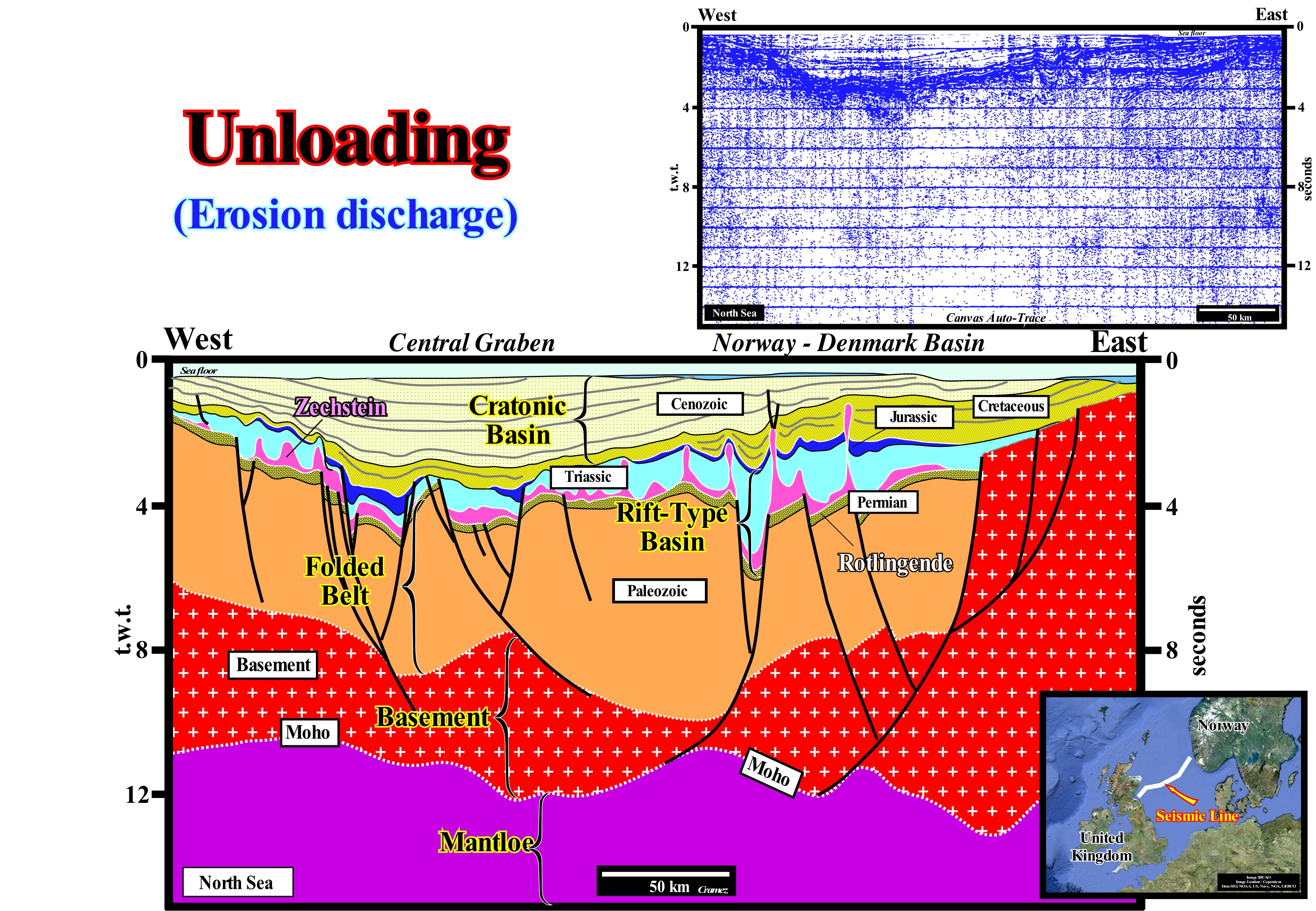
The North Sea corresponds to the stacking of four types of basins of the classification of the sedimentary basins of Bally and Snelson (1980). From bottom to top, it is easy to recognize: (i) A Proterozoic Folded Belt or Mountain Range ; (ii) A Paleozoic Folded Belt ; (ii) Permian/Jurassic rift-type basins, in which a thick salt interval was deposited and (iv) A Mesozoic/Cenozoic Cratonic Basin. On this tentative geological interpretation of a Canvas auto-trace of a regional seismic line of this offshore whose location, between the United Kingdom and Norway, is shown in the geographical map, it is, easily, to recognize an aborted divergent continental margin aborted and not an aborted rift-type basin, as certain geoscientists say*. From bottom to top it is, relatively, easy to identify: (i) The Mantle**, which is the underlying terrestrial layer beneath the crust, that extends from a depth of about 30 km (much less in ocean than continental areas) to 2,900 km ; (ii) The Moho or Mohorovičić Discontinuity, i.e., the discontinuity in P-wave velocity or primary waves, which have the highest speeds and propagate longitudinally (the first to be recorded by geophones), that marks the boundary between gabbro and peridotites rocks ; (iii) The Basement ; (iv) The Paleozoic Substrate ; (v) A Mesozoic Rift-Type Basin, associated to an extension of continental crust induced by an extensional tectonic regime (σ1 vertical) and (v) A Cenozoic Cratonic Basin. In this region, the extensive tectonic regime, probably, induced by a deep thermal anomaly, was not sufficient to break the continental crust (there is no evidence of oceanic spread), or else the thermal anomaly, laterally, moved to another region. In any case, there was no individualization of two lithospheric plates, and so instead of forming two divergent margins on either side of a recent oceanic crust and above the continental crust, only a cratonic basin formed above the continental crust. This region has never been subjected to compressive tectonic regimes and, thus, the deformations observed on this tentative interpretation are, mainly, in extension (the sediments were lengthening and not shortened). This seems true not only for the salt induced deformations (halokinese) but also for the isostatic uplift *** well observed in the ends of the part of this Canvas auto-trace. The antiform salt induced structures are in extension, they are not anticlines. The deformations associated with the isostatic uplift (which continues today), which results from the melting of the glacial cap that covered the northern part of Europe, are, like the deformations induced by the uplift created by the salt dome, are structures in lengthening. The erosion associated with the isostatic uplift, which is evident in the ends of this tentative interpretation, caused an important discharge of the pressures of the underlying sedimentary column. The toplaps by truncation on the sea floor are more than significant. The example of the isostatic adjustment uplift illustrated here (Scandinavia), which has occurred since the last deglaciation**** period, seems to be causing isostatic imbalance in other regions. Many geoscientists think that the sinking of the Netherlands is a consequence of the uplift of Scandinavia.
(*) An aborted divergent margin, i.e., a divergent margin that did not form, is the consequence of a significant displacement of the lithosphere breakup zone of the supercontinent. In the particular case of the North Sea, the breakup that was located, more or less, in the area of "Rockwall Trough" shifted to Iceland where the mid-Atlantic ridge is at present-time.
(**) The mantle differentiation began about 3,8 Ga, when the gravimetric segregation of the components of the Earth protoplanet produced current stratification, which differs, greatly, from the Earth crust by the chemical composition and its mechanical behaviour, which is translated by the existence of a clear and abrupt change in the physical properties of the materials (discontinuity), which became known as Mohorovičić (or simply Moho) discontinuity.
(***) Isostasy attempts to interpret the lithostatic offsets that occur deep in the mantle at the level of the Earth's crust. The principle of isostatic adjustment says that the lithosphere, which is dense and rigid, is floating over the asthenosphere, which is, considerably, more dense and plastic. When there is some alteration in the lithospheric relief, at the mantle level a compensation of lifting or sinking of the crust occurs, in order to compensate for the change. Processes such as erosion and melting originate negative isostatic anomalies, forcing the lithosphere to compensate for them by lifting. While processes such as sedimentation and glaciations, they originate positive isostatic anomalies, forcing the lithosphere to compensate them for sinking (http://geoexploradoras.blogspot.ch/ 2011/10 / adjustment-isostatico.html).
(****) Transition period from full glacial conditions, during ice ages, to warm interglacial conditions , characterized by global warming and absolute sea level rise.
Unmigrated Line (Seismic line)..........................................................................................................................Ligne non-migrée (Sismique)
Linha não-migrada / Línea no migrada (sísmica) / Nicht migrierte Linie (seismische) / 未迁移线(地震) / Неперенесенная сейсмическая линия / Linea senza migrazione (sismica) /
Seismic line in which some of the reflected energy is in the wrong position. During the initial calculation of the moveout it is assumed that the layers are, more or less, horizontal. If this is not the case, some of the reflected energy is incorrectly positioned. In the case of a small syncline, the reflections of the different points in the syncline are drawn, vertically, relative to the receiver. The syncline appears on the seismic line as a looped curve or even as a point. Migration is a process that corrects this effect and puts the energy where it should be.
See: « Seismic Line »
&
« Migrated Seismic Line »
&
« Reflection Seismic »
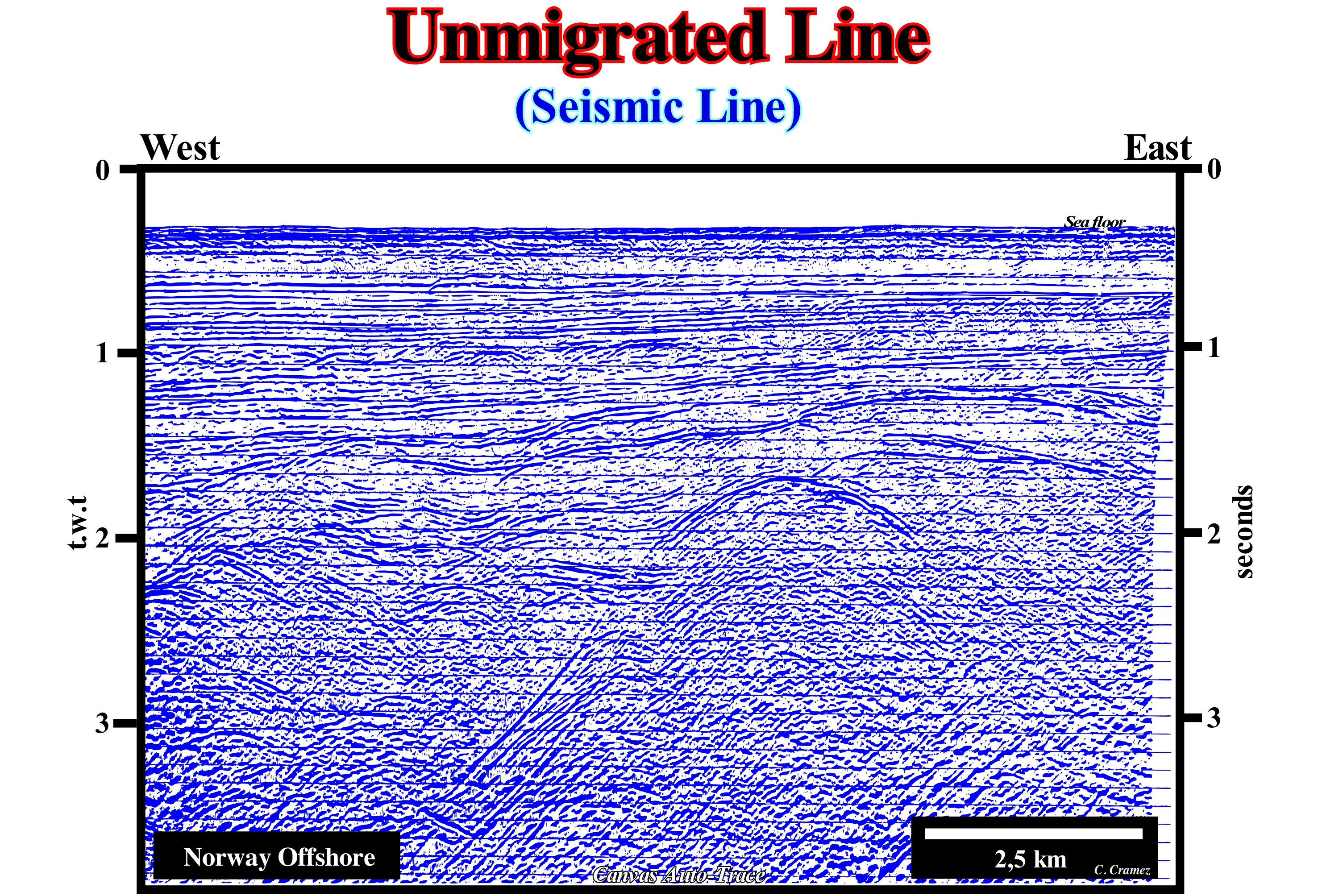
A geoscientist, who knows well the principles of reflection seismic and the difference between a migrated* and unmigrated seismic line, immediately, recognizes that the Canvas auto-trace illustrated above swas taken from an unmigrated line (note the amount of diffraction associated with the reflection points of the faulted-blocks) and that it represents an Atlantic-type divergent continental margin. The normal faults created during the lenghtening of the supercontinent, before de breakup of the lithosphere, developped rift-type basins (halfgrabens). The unconformity (erosional surface induced by a significante relative sea level fall, separating the rift-type basins from the overlying divergent margin is, easily, identified and mapped. Between a migrated and umigrated line the difference consists, basically, on the way the reflection points are plotted, since in reflection seismic, for a given time, each reflection point can be anywhere in the arc of circle centred in the source/detection position. In an umigrated line, as shown in this figure, the reflection points were plotted, vertically, from the source/detector, whereas in a migrated line, they are positioned under the corrected surface positions and in corrected vertical positions. Unlike a migrated section, which ressembles, closely, a geological section (the vertical and horizontal scales are metric, which is not the case on a seismic line, since the vertical scale is in time), an unmigrated line resembles, rarely, to geological section, particularly in high deformed areas, such as in a mountain range or in a salt basin. Only the migrated sections show the reflections in their true position. Such precaution is all the more necessary when the reflectors are steeper. Today, seismic migration migration is a central step in the seismic data processing flow. It represents the culmination of “standard” processing and it provides input for several relatively exotic nonstandard processes. Today, migration is a central step in the seismic data processing flow. It represents the culmination of “standard” processing, and it provides input for several relatively exotic nonstandard processes.
(*) Seismic migration is a wave-equation-based process that re-moves distortions from reflection records by moving events to their correct spatial locations and by collapsing energy from diffractions back to their scattering points. A migrated seismic line processed in such a way that the reflections are positioned correctly, i.e., in their true vertical position (in time).
Unnatural Greenhouse* Effect.......................................................................................Effet de serre non naturel
Efeito de estufa não-natural / Efecto invernadero no-natural / Nicht- natürliche Treibhauseffekt / 非天然的温室效应 / Искусственный парниковый эффект / Non naturale effetto serra /
Warming of the land surface produced by an excessive increase of the greenhouse gases, due, directly or indirectly, to the human activity. These gases such as: (i) Water vapour ; (ii) Nitrous oxide (hilarating gas N2O or diazotoxide) ; (iii) Carbon Dioxide; (iv) Methane and (v) Nitrogen, absorb the infrared radiation emitted by the Earth and radiate it into space and toward the Earth heating it. Over the past 50 years, production of carbon dioxide, nitrous oxide, methane has risen sharply, as has chlorofluorocarbons (CFCs), which have a powerful greenhouse effect, since a CFC molecule is 12,000 to 16,000 times more effective to absorb infrared radiation than a carbon dioxide (CO2) molecule.
See: « Natural Greenhouse Effect »
&
« Global Warming »
&
« Astronomic Theory of Paleoclimate »

The non-natural origin of greenhouse gases is, mainly, associated with an intense: (i) Agro-livestock (agrarian ecosystems are made up of biocenoses called agrocenoses) ; (ii) Agriculture and (ii) Use of fossil fuels. However, never forget that there are many geoscientists who do not believe in the greenhouse effect, which is, for them, is on a false analogy. It was the chemist Arrhenius, who based on an experience of the Swiss geologist De Saussure, advanced the hypothesis that CO2 of the atmosphere causes an increase of Earth's, like the glasses of a garden greenhouse. Obviously, most geoscientists did not believe in such an analogy. Several experiments, such as those made by R.W. Wood, refuted the hypotheses advanced by Arrhenius and Saussure and showed that the phenomenon that produces an increase of temperature in a greenhouse is the convection and not the opacity of the glasses to the infrared rays. Currently, probably, for propaganda reasons, certain geoscientists, journalists and politicians are allowed to blame humanity, which for them, is responsible for the global warming (not to be confused with climate change). They ignore (for incompetence rather than interest) that in geological history, climate change and solar cycles have existed for 4.5 Ga, i.e., since the Earth’s formation. Henrik Svensmark and his team (Danish National Space Centre) have sought to explain why the Earth cools and heats up. They do not believe that CO2 is, the primarily, responsible for the increase in global average temperature observed at the end of the last century (since 2000 the global temperature seems to be decreasing and not increasing). Their findings (published in October 2006 in the Proceedings of the Royal Society) can be summarized as follows: (i) Sun and stars could explain much, if not all, the warming of this century ; (ii) Changes in the magnetic field of the Sun, independently of the greenhouse gases, may be related to the recent increase in global temperatures ; (iii) The magnetic field of the Sun diverts some of the cosmic rays that penetrate Earth's atmosphere, and in doing so, it also limits the immense quantities of free ions and electrons produced by the cosmic rays. Svensmark and his colleagues came to their assumptions after examining data that showed a surprisingly strong correlation between cosmic rays (high-velocity atomic particles originating from exploded stars in the Milky Way) and low-lying clouds. The cloud coverage of Earth increases as the intensity of the cosmic rays grows and diminishes as the intensity decreases. Low altitude clouds are significant because they protect the Earth from the Sun to keep us at a pleasant temperature. Low cloud coverage can vary by 2% in five years, affecting the Earth's surface up to 1.2 Watts/m2 during that same period. Such an amount (1.2 Watts/m2) can be compared to the estimated 1.4 Watts/m2 estimated by the IPCC for the greenhouse effect of all CO2 increase in air since the Industrial Revolution. Thus, as in the twentieth century, the strength of the Sun's magnetic field has doubled, it is quite possible that the Earth will heat up because a large number of cosmic rays have been diverted, limiting the formation of clouds. Unfortunately, certain "Alarmists", in particular Dr. RK. Pachauri, ex-president of the IPCC (the leading agency investigating global warming), immediately criticized Svensmark, H., and his team treating them as naive and irresponsible scientists. Let's wait a few years and see who is naive and irresponsible. If Svensmark is correct, the average global temperature should decrease significantly in the coming years, since we are at the end of solar cycle 23 (hot cycle) or already in the initial solar cycle 24 (cold cycle), where solar activity should be lower. We wait and see.
(*) The term "greenhouse effect", although consecrated, is by no means correct. In an greenhouse, the thermal conduction of the walls and the confinement of the air increase the temperature, even when the glass is replaced by a material transparent to visible radiations and infrared radiation (as is the case of halite). The atmosphere has nothing to do with a greenhouse. The air is not confined and can cool gracefully to the phenomena of convection. However, the atmosphere produces radioactive heating since certain gases (water vapour, methane, CO2, etc.) that compose the atmosphere absorb the infrared radiation. This is why some geoscientists prefer to speak of a "radioactive greenhouse effect" in order to emphasize that only radioactive phenomena are taken into account (A. Foucault, 2016 Climatologie et Paléoclimatologie, Dunod, ISBN 978-2-10-75460 -1).
Unproven Reserves (HC).................................................................................................................Réserves non-prouvées (HC)
Reservas não-provadas / Reservas no-probadas (HC) / Reservierungen nicht - bewährte (HC) / 不保留-证明(慧聪) / Неподтверждённые запасы (УВ) / Riserve non-comprovate (HC) /
Estimated discovered reserves* with a certain level of confidence (probable or possible) based on geological or seismic maps of the reservoir-rock that an exploration well recognized as saturated with hydrocarbons in the closed area of the trap.
See: « Discovered Reserves (HC) »
&
« Possible Reserves (HC) »
&
« Proven Reserves (HC)»
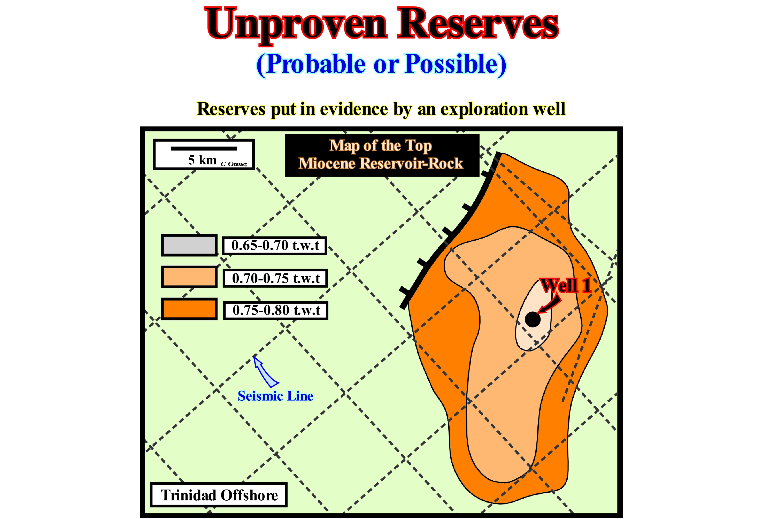
The probable reserves are the quantified estimates of hydrocarbons (crude oil, natural bitumen, natural gas, natural gas liquids) in addition to proven reserves, which from a certain date, the geological and engineering analysis of a certain data numbers suggested probability of existence and are, probably, not commercially recoverable under present economic or technological conditions (especially without development wells). The probability of recovering the estimated amount as probable and proven reserves varies between 40 and 60%. Possible reserves are similar estimates with a probability of existence smaller than probable reserves and that the probability of one day being, commercially, recovered under appropriate future economic and technological conditions is smaller than that of probable reserves. The probability of recovering the estimated amount of proved reserves most likely plus possible is less than 10%. In this isochronous seismic map (top of a Miocene reservoir-rock, in double time, i.e., t.w.t.), the exploration well n°1 showed the presence of hydrocarbons in the area (uncovered reserves). This positive result corroborated the hypothesis of the presence of advanced speculative reserves, previously, by the geoscientists and proved the presence of a certain amount of proved reserves (between 0.65 and 0.70 milliseconds). On the other hand, using the isochrone map of the rock-reservoir, the geoscientists estimated with a certain level of confidence, unproven reserves (probable and possible) between 0.70 and 0.80 milliseconds. Future evaluation wells will, eventually, increase proved reserves from unproven reserves (usually from probable reserves), i.e., that if the following wells are positive, a portion of the probable reserves will be considered as reserves proved. Do not forget that uncovered reserves can be: (a) Proved and (b) Unproven, which may be: (i) Probable and (ii) Possible.
(*) Reserves are evidenced from wells and estimated (with a certain level of confidence) on the basis of the reservoir-rock maps, usually, made from seismic data.
Uplift (Geological).......................................................................................................................................................................Soulèvement tectonique
Levantamento tectónico / Levantamiento tectónico / Tektonischer Hebung / 构造抬升 / Тектоническое поднятие / Sollevamento tettonico /
Elevation of a region of the lithosphere by structural forces, such as those associated with a rebalancing of isotherms, ascending convection currents, magma ascensions, diapirism (clayey rocks, evaporites) shortening of the crust (induced by a continental collision), etc.
See: « Erosion »
&
« A-Type Subduction (Ampferer) »
&
« Unconformity »
The onshore of Sumatra Island (Indonesia) corresponds to the stacking of several basins from the classification of the sedimentary basins of Bally and Snelson (1980) which from the bottom up are: (i) Basement or flattened Mountain Folded Belt and (ii) Backarc basin, within which two sedimentary tectonic phases can be evidenced: a) Lengthening or Rifting characterized by a differential subsidence that induced halfgrabens and b) A Sag phase characterized by a thermal subsidence. On this tentative of geological interpretation of a composite seismic line of the northern of the Sumatra Island (Indonesia), it is evident that the sediments of backarc basin were shortened by a compressional tectonic regime. Such a tectonic regime is characterized by an ellipsoid of the effective stresses (geostatic pressure σg + pore pressure σp + tectonic vector σt) with the main axis (σ1) horizontal and the smallest (σ3) vertical. The structures responsible for the shortening are cylindrical folds and reverse faults, which, for the most part, correspond to the reactivation of the old normal faults that lengthened the sediments during the rifting phase. As can be seen by the, more or less, constant thickness (without abrupt lateral variations) of the sediments of the sag phase (thermal subsidence that contrasts with the differential subsidence of the rifting phase), it can be said the sedimentary shortening is, practically, post-deposition. This means that the uplift associated the shortening had no influence on the creation of available space for the sediments for the already deposited sediments. Changes of the relative sea level (local sea level referenced to any point on the Earth's surface, which is the result of the combination of tectonics and absolute or eustatic sea level, which is supposed to be global and referenced to the Earth's centre) created the space available for sediments (accommodation), during the sag phase of the backarc basin, were induced, mainly, by relative sea level rises (marine ingressions). However, since the wavelength (cyclicity) of eustatic changes is much greater than that of tectonic changes, they have a predominant cause of the cyclicity of the deposits. Whenever the fall of the relative sea level is, sufficiently, to put it put lower than the basin edge, an erosional surface, i.e., an unconformity, was formed, marking the end of a stratigraphic cycle and the beginning of another. When the shortening is contemporaneous with sedimentation, the thickness of the sedimentary intervals decreases in the areas where there is a uplift, since the water-depth decreases, i.e., that locally, the space available for the sediments decreases relative to other areas. It is easy to see that the vast majority of hydrocarbon traps drilled in this region are structural traps* and correspond to tectonic inversions, i.e., the old, structural low points became high points following the recent compressional tectonic regime (the petroleum migration parameter and, particularly its age, is very important, since many traps may be post-migration). Thus, almost all rifting normal faults were reactivated as inverse faults with a displacement point, apparently, null in the fault plane. The position of the displacement point, apparently, null depends on the amplitude of the inversion, which is a function of the angle between the σ1 of the compressional regime and the fault plane, as well as the angle between the σ1 and the dip of the fault plane. Obviously, this type of trap requires the migration of the hydrocarbons is posterior to the tectonic inversion. It should not be forgotten that not all tectonic uplifts are induced by a shortening of the sediments (compressional tectonic regime). The uplifts associated with halokinesis and shalokinesis (extensional tectonic regime) correspond to antiforms, on the top of which, normal faults (contemporaneous of lengthening) are necessarily developed to elongate the sediments, which is not the case in anticline structures. In the same area, at the same time, the sediments can not be shortened and lengthened at the same time.
(*) A structural trap is characterized not only by the rock-reservoir interval having a four-way dip closure, but also the sealing-rock, which means that the reservoir-rock and the sealing-rock have the same geometry and are parallel to each other.
Upper Bathyal...................................................................................................................................................................................................Bathyal supérieur
Batial superior / Batial superior / Obere Bathyal / 上半深海 / Верхняя батиальная область / Superiore batiale /
Subenvironment bathyal, in which the water-depth varies between 200 and 500 meters.
See: « Bathyal »
&
« Abyssal »
&
« Lower Bathyal »
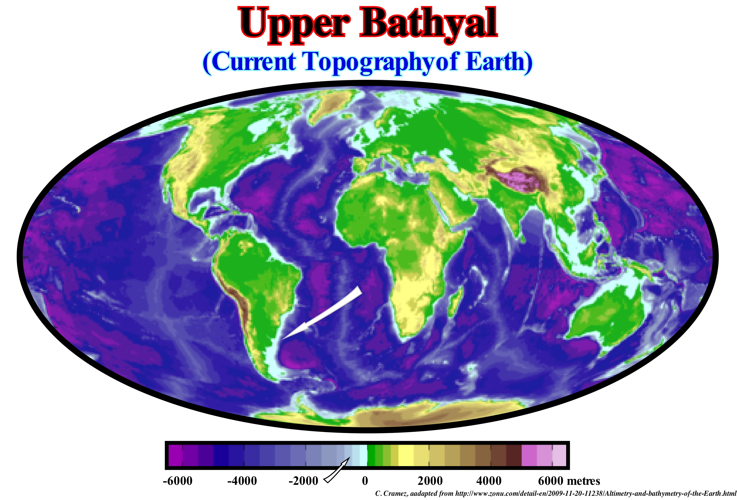
As can be seen from this map, the upper bathyal subenvironment is, relatively, narrow. It is the domain of the deep shaly rocks of the lowstand prograding wedge of a sequence-cycle, which rest on overbanking deposits (natural marginal dikes and depression fillings between overbanking deposits) of submarine slope fans. On electrical logs, the pattern of these rocks is, slightly, coarsening and thickening upward, which underlines, generally, a progradational geometry. This geometry is, perfectly, visible on the seismic lines. These shales fossilize, by downlaps, the submarine slope fans, which are deposited under a water-depth, typically, lower and middle bathyal. Progressively, the downlaps, gradually, fossilize the nondepositional hiatus associated with the top of the submarine slope fans (SSF). This fossilization creates a downlap surface rich in organic matter (peak in gamma ray log) and fossils. Above the lowstand prograding wedge (LPW) shales are deposited shallow-water sand or siltstones (neritic environment). It is important to note that in sequential stratigraphy, the location of the depositional coastal break coastal of the depositional surface is very important to understand the thickness of the deposited sediments and the depositional water-depth. A relative sea level rise of 5 meters, for example, moves upward and landward the depositional coastal break of the depositional surface, creating an accommodation of 5 m (available space for the sediments), between the new and old position of depositional break. Under normal conditions of sedimentation, this accommodation is, completely, filled, upstream of the old position of the depositional break, which is not the case seaward. Downstream, only part of the accommodation is filled, which increases the initial water-depth. During a regressive episode, when the depositional coastal break of the depositional surface coincides, more or less, with the continental edge, an increase in accommodation is, completely, filled upstream of the continental edge. However, this is not true during a transgressive episode (retrogradational geometry, induced by a succession increasingly smaller regression intervals), since the depositional coastal break is, always, upstream of the continental edge, once the basin, by definition, has a shelf.
Upper Delta Plain (Upper delta)...................................................................................................Plaine deltaïque supérieur
Alto do delta (planície deltaica superior) / Alto delta / Oberdelta / 上三角洲平原 / Верхняя дельтовая равнина / Delta pianura superiore /
Upper part of the delta plain located above the high tide line and extending from the apex of the delta to the zone of influence of the tides. The average slope of this zone is about 5°. The top of the delta is characterized by a predominance of forms induced by fluvial processes. It is, permanently, emerg*ed and subject to flooding. According to some geoscientists, the rising tide has just an ecological influence, in the distribution of the amphibian ecosystems in the margins of the channels and banks. Synonym with Upper Delta Plain.
See: « Delta »
&
« Coastal Plain »
&
« Prodelta »
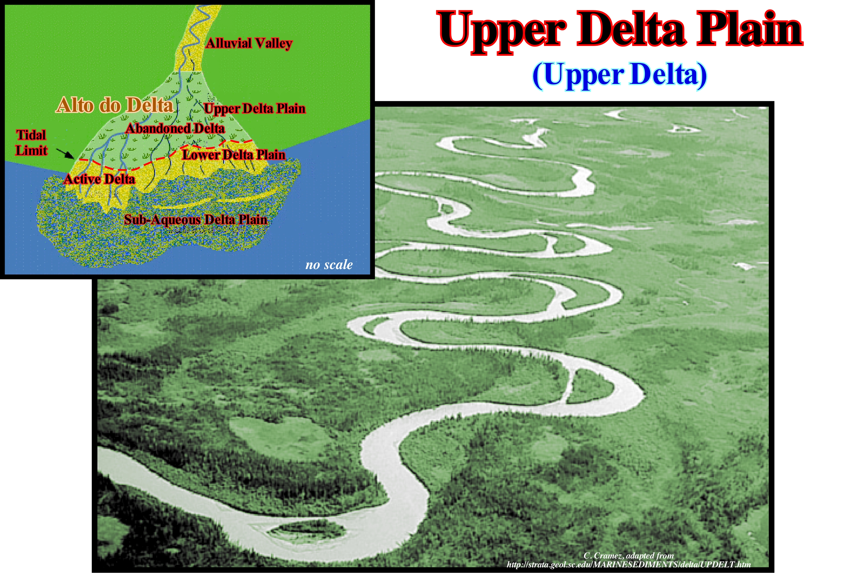
The top of the delta (upper delta plain) is located above the high tide limit, which means it does not suffer, practically, any marine action. Changes in relative sea level (local sea level, generally, referenced to the sea floor and resulting from the combination of absolute (eustatic) sea level* and tectonics, i.e., subsidence or uplift of the sea floor) have little influence. In this part of the delta plain, the most frequent depositional systems are: (i) Anastomosed Channels ; (ii) Braided Channels ; (iii) Abandoned Meanders ; (iv) Oxbow Lakes ; (v) Floodplain Deposits, etc. The development of these depositional systems is dependent on the discharge rate and the sediment loading capacity. The shape of the delta and thus the delta plain is determined by the amount of sedimentary particles carried by the associated current and the activity of the sea-waves and the tides. The free meandering channels, i.e., the meanders of the alluvial plain (not to be confused with the valley meanders), like those illustrated in this figure, are formed in the lower part of the upper delta plain. Generally, they have a less dipping gradient than the anastomosed channels. Theoretically, it is in the upper delta plain (upper delta) that the coarsest sediments are found, with heterometric grain levels (deposited during floods) and pelitic sediment spots decanted in the abandoned arms. In fact, as the topography is, more or less, flat, much material and coarse sedimentary particles are not transported downstream. The meandriform channels begin, generally, as anastomosed channels that are, usually, rectilinear from the sedimentary source to a certain distance, then to become sinuous and, eventually to become channels with meanders. The meandering channels have a natural tendency to exaggerate and migrate downstream, so that it is not abnormal that during floods, water overflows or finds a new flow path.
(*) The absolute (eustatic) sea level is the supposed to be global and referenced to the Earth's centre. It depends, basically, on Glacio-Eustasy, Tectono-Eustasy, Geoidal-Eustasy and on the Temperature of the water of the oceans (steric sea level rise).
Upper Lowstand Prograding Wedge.........................................Prisme de bas niveau supérieur
Prisma de nível baixo superior / Prisma de nivel bajo superior / Prisma Low-Level oberen / 低水位前积楔上部 / Верхний клин размывания низкого уровня моря / Prisma di basso livello superiore /
One of the three sedimentary assemblages that can be observed in the upper subgroup of the lowstand systems tracts group (LSTG), in a geological context of ramp: (i) Fillings of Incised valleys (Fiv) ; (ii) Lower Lowstand Prograding Wedge (LLPW) and (iii) Upper Lowstand Prograding Wedge (ULPW). The upper lowstand prograding wedge is deposited during a relative sea level rise in acceleration after the deposition of the lower lowstand prograding wedge. In relation to the relative sea level curve (available space curve) of a sequence-cycle, it can be said the upper lowstand prograding is associated with the middle part of the curve with the 1st and 2nd derivatives positives (the function ,i.e., the curve is increasing and concave, which means that the relative sea level rises in acceleration).
See :« Basin Setting »
&
« Lowstand Systems Tract »
&
« Systems Tract »
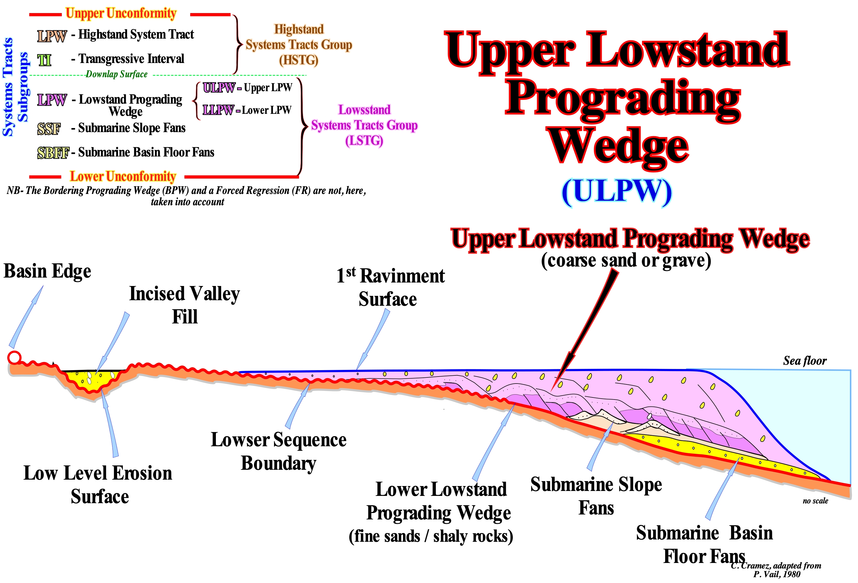
In lowstand geological conditions, which means that sea level (generally, relative sea level) is lower than the basin edge, which in these conditions is the last basin edge of the preceding sequence-cycle. The continental edge of the lowstand deposits and, in particular, the lowstand prograding wedge (LPW) can not be considered the basin edge, since the basin has no shelf. Thus, under lowstand geological conditions, in a ramp setting, the basin, by definition, has no shelf. On the other hand, as the basin edge is the last basin edge of the preceding sequence-cycle, it is, necessarily, poorly marked. As can be seen in the geological sketch illustrated in this figure, taking into account the geometry of the unconformity, which limits the lower sequence-cyle, it can be said that there was a, more or less, gradual transition between the coastal wedge or coastal prism*, the continental slope and the abyssal plain, before the relative sea level fall responsible of the unconformity. In other words, in a geological ramp setting it is very difficult to locate, exactly, the basin edge, in relation to which the subgroups of the lowstand systems tracts group (LSTG) will be deposited. In this context, since (i) Submarine Basin Floor Fans (SBFF), (ii) Submarine Slope Fans (SSF) and (iii) Lowstand Prograding Wedge (LPW), begin to be deposited as the aggradation is, relatively, small, the individualization of these subgroups is, relatively, difficult (without taking into account the seismic resolution that further aggravates the problem). On the other hand, it should not be forgotten that a sedimentary systems tract is a lateral association of synchronous and genetically linked depositional systems deposited during the stability period of relative sea level, which occurs after each relative sea level rise, i.e., after each eustatic paracycle or marine ingression. During this stability period of relative sea level, one or more sedimentary systems tracts may be deposited or taken into account. This is obvious, when the sequential interpretation is made using seismic data, since, in most cases, the thickness of a sedimentary systems tract (sedimentary regression induced by a single marine ingression**). During the relative sea level fall that induced the unconformity, in the lower parts of the basin, the submarine basin floor fans (SBFF) and slope fans (SSF) are deposited, as well as, the lower lowstand prograding wedge (LLPW). The thickness of these intervals is, relatively, small and, sometimes, below the seismic resolution. When they are visible on seismic lines, the geometry of the set of lowstand systems tracts is progradational as suggested in this sketch. Since the relative sea level fall stopped and begun to rise, in acceleration, the water-depth increases, significantly, and the shoreline moves continentward. During the stability period of relative sea level following the relative sea level rise (eustatic paracycle), as the terrigeneous influx is important (the old shelf has been exhumed), the shoreline will move, progressively, seaward, as the sediments are deposited along the lower lowstand prograding wedge (LLPW). Over time and with repeated alternation of increments of the relative sea level rise and stability, the fine bottom sediments of the lower low lowstand prograding wedge are fossilized by the coarsest sediments of the upper lowstand prograding wedge (ULPW), which is characterized by having, locally, an erosive base that can even erode the lowstand prograding wedge and form incised-valleys. When this happens, the incised-valleys are filled by very coarse sediments. To avoid confusion, during a relative sea level rise (eustatic paracycle), there is no deposition. The shoreline is displaced continentward increasing the available space for sediments. Deposition, i.e., the sequence-paracycle occurs during the stability period of relative sea level between two eustatic paracycles.
(*) A coastal wedge (or coastal prism) is the set of sediments that accumulate in the coastal plain during the progradation of the shoreline, which includes fluvial and shallow-water deposits. It has the wedge shape extending to the continent by onlapping over the preexisting topography. The upstream boundary of the coastal wedge is the bayline, which can move upstream when the progradation of the shoreline is accompanied by aggradation.
(**) A single marine ingression is an increment of a composite marine ingression, since a relative sea level rise is not done in continuity, but in stages,. For example: (i) Relative sea level rise of 3 m (single marine ingression) ; (ii) Stability period of the relative sea level ; (iii) Relative sea level rise of 5 m (single marine ingression ); (iv) Stability period of the relative sea level ; (v) Relative sea level rise of 7 m ; (vi) Stability period of the relative sea level ; (vii) Relative sea level fall of 10 meters (marine regression). In this case, overall, the relative sea level rose 15 meters (composite marine ingression), in acceleration, since the single marine ingressions are increasing important. The terms single and composite marine ingression should be used when clarification is required.
Upper Lowstand System..................................................................Système Supérieur de bas niveau (De la mer)
Sistema superior de nível baixo (do mar) / Sistema inferior de nivel bajo (del mar) / Superior-System Low Level (Sea) / 高级系统低电平(海)/ НУлучшенный уровень системы Low (море) / Sistema di basso livello superiore (mare) /
The upper part of the lowstand prograding wedge (LPW), in which incised valley fills (Ivf), submarine canyon fills (Scf) are founded. In the lower part shingled turbidites are, sometimes, associated.
See: « Lower Lowstand Prograding Wedge »
Upper Shoreface..........................................................................................................................................................Bas de plage (Plage moyenne)
Praia-médiaarte (praia propriamente dita, face da praia)/ Parte intermedia de la playa / Strand / 近岸 / Верхний береговой склон / Spiaggia, Spiaggia media /
Concave section of the beach seaward of the high tide limit to the middle of the longshore (ramp), between 5 and 20 m water-depth. It corresponds, more or less, to the intra-tidal beach.
See: « Shoreface »
&
« Littoral »
&
« Coastal Karst »
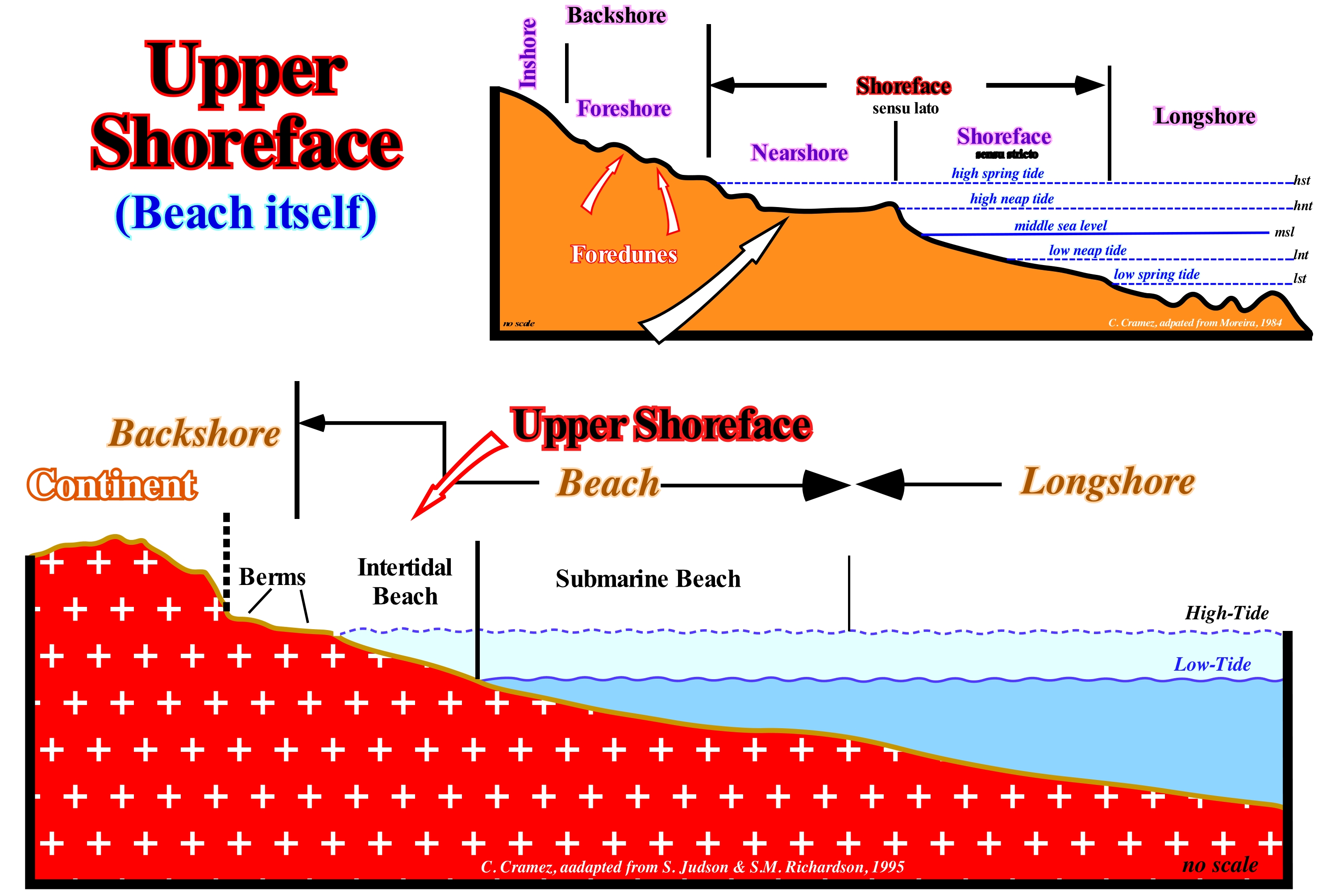
The shoreface ("bas de plage" of the French geoscientists) corresponds to the lower part of the strand and comprises the space between the limits of the low neap tide and high spring tide. The slope of the shoreface is very small and the material deposited is thin, but may contain the coarsest material transported longitudinally. At the base of the shoreface there are bioturbation marks (marks of living beings such as burrows, crab droppings, bird-foot molds, etc.) and low amplitude ripples (between 3 and 15 cm). These ripples, called beach ripples, are, more or less, linear and parallel to each other and to the surfing line of the sea-waves. They can be symmetrical or asymmetrical. Beach ripples are created by the, more or less, turbulent flow of swash currents (uprush and backwash currents), especially the backwash. At the extreme limit of the shoreface may appear ripples of greater amplitude (up to 1 meter). These ripples form crests and through that certain geoscientists call longshorerunnels. As can be seen in these sketches, the vast majority of Anglo-Saxon geoscientists encompass on the shoreface what they call submarine beach (part of the beach that extends into the space hit by the swash currents, between high and low tide levels in neap tides). For them, the "bottom of the beach" (nearshore and shoreface of many European geoscientists) corresponds to the beach area with a concave geometry, defined between the high tide line and up to a depth of 5/20 meters. Downstream from the shoreface, they consider the ramp (longshore) that descends, slightly, towards the edge of the platform (longshore of some European geoscientists). At the base of the shoreface, the surf of the waves forms crests and ridges (longshore ridge, of the French geoscientists). The intratidal beach, located between the high and low tide lines, corresponds approximately to the nearshore of certain geoscientists. The region between the high tide line and the beginning of the dunes for some geoscientists is the foreshore, where they often form one or several berms that look like small terraces with a small slope facing towards the sea.
Uprush Current..........................................................................................................................................................................................................Jet de rive
Corrent de afluxo / Corriente de avanço, Corriente ascendente / Auflaufen Ström / 助跑 / Восходящая струя / Corrente emergente (ondata) /
Sea-water current, which flowing to the coast after the breaking of waves (transformation of oscillation waves into translation waves).
See: « Stream »
&
« Breaking »
&
« Shoreface »
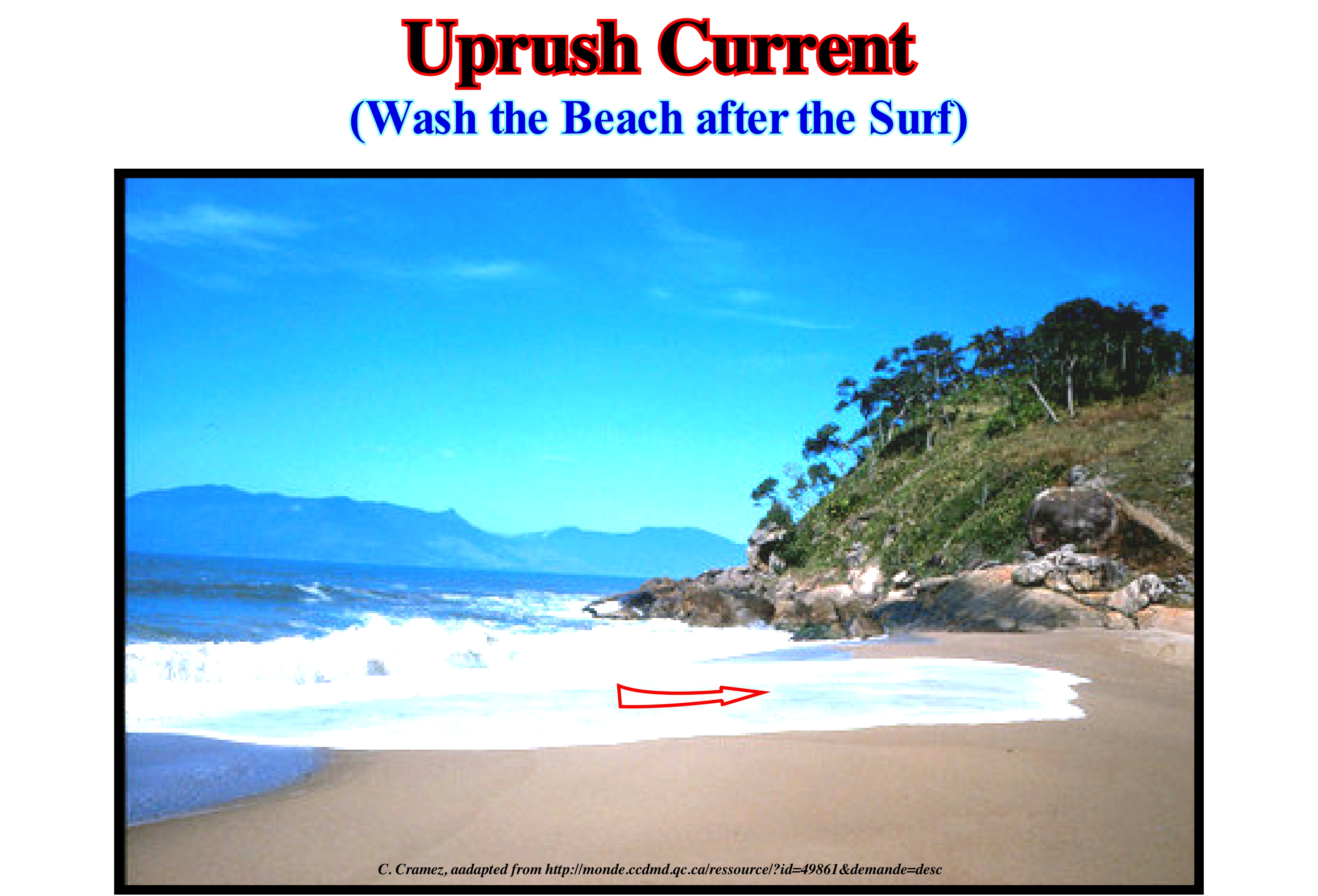
The currents of surf or swash currents are the currents that result from the transformation of the oscillation waves into translation waves . When the water-depth is about 1/3 the height of the waves, i.e., when the steepest parts of the waves incline 60° or more, the waves become unstable and the upper parts dive forward, which means, the waves break. Once the waves crash into turbulent foam masses, they continue toward the beach under the action of their own momentum. Finally, on the beach, the momentum of the waves transports them landward by a current that is called an uprush current. The waves wash and transport the sand and other finer sedimentary particles onto the beach. However, this uprush current, when losing energy, due to the friction of the sea floor and the slope, reverses direction, giving rise to another current, which is called the backwash current. This current is directed seaward and flows along the slope of the sea floor. This movement of the water searward is evident only on the surface, that is, it exists up to a depth of about 1 meter. In detail, when a wave breaks, the current moves along the sea towards the next crest. As the orbital motion of the oscillating waves produces the he back and forth movement of an object that floats in sea water. The same motion also causes the trough of the wave to move back and forth in direction of the next crest. The direction of the uprush current varies with the direction of the wind, while the direction of the backwash current is always perpendicular to the shoreline (depending on the slope of the sea floor). In this photograph, the area of "white water", where the waves finally release their energy and where sea-water contains many air bubbles that reduce their density, is a very dangerous area for swimming. Also, in the area of wave breaking, when the breaks approach, swimmers should dive at the base of the waves and go to the back of the waves, where swimming is much safer, since there are fewer currents.
Upward Deepening Cycle (Carbonates)...............................................Cycle bathycroissant ABC (Carbonates)
Ciclo baticrescente ABC / Ciclo baticreciente ABC (carbonatos) / Nach oben - Vertiefung Zyklus / 向上-深化循环 / Регрессивно-трансгрессивный цикл / Ciclo baticrescente ABC (carbonati) /
In Fischer's terminology (1964), an ABC cycle shows a crescent paleowater-depth, when A is associated with subaerial exposure, B with tidal deposits, and C with inframareal deposits. Currently, tidal plain carbonate cycles, formed by asymmetric units, are separated by discordant unconformities between supramareal deposits (shallow) of one cycle and subtidal (deeper) deposits of the next cycle. Such cycles (upward deepening) are actually stratigraphic paracycles (since there are no true relative sea level fall between them) and their successive repetitions produce a vertical pattern ABC, ABC-, ABC ..... which suggests a alternation of periods of progradation and submersion.
See: « Autocycle (carbonates) »
&
« Keep-up Carbonate »
&
« Deposition (carbonates) »
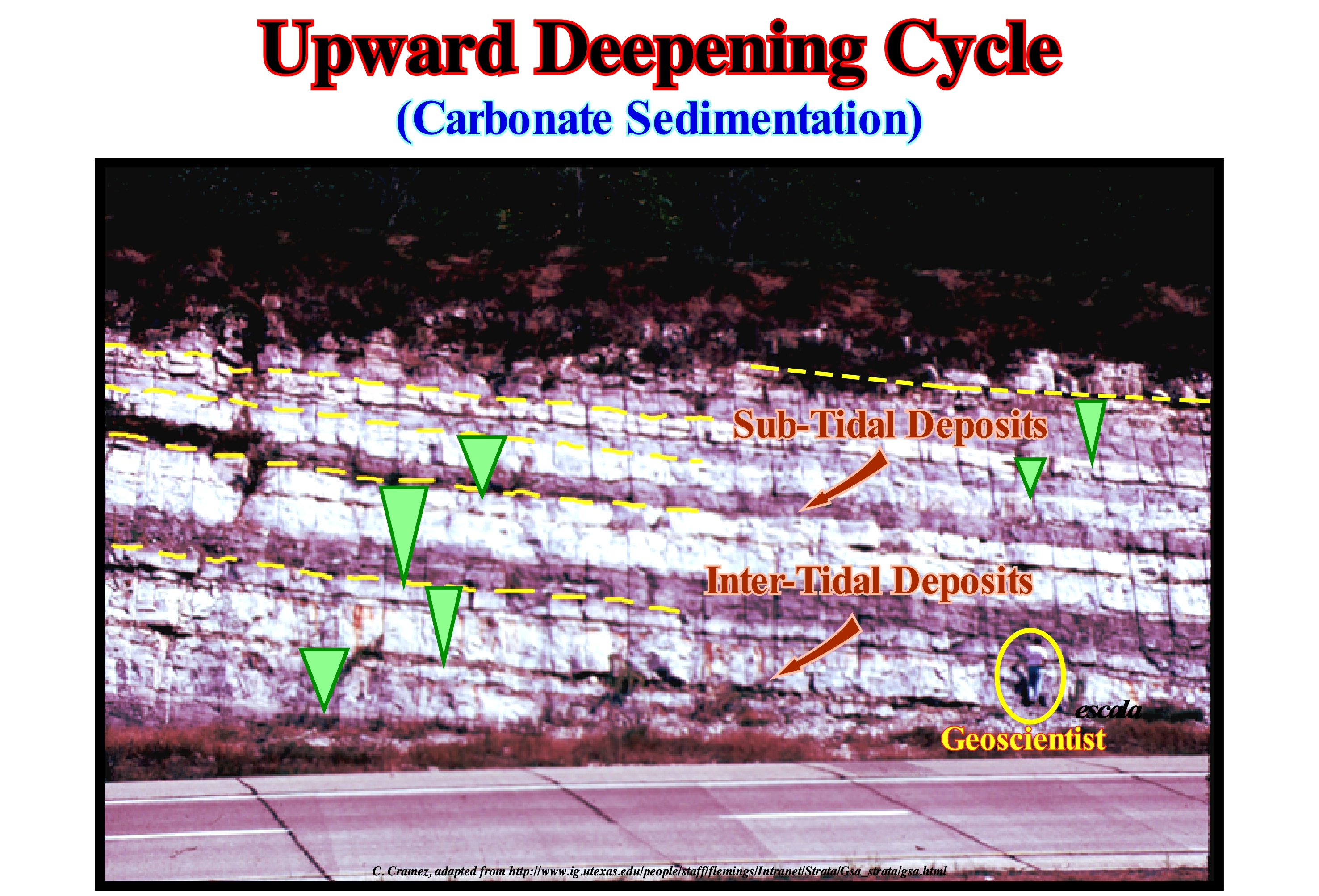
In this photograph (Ordovician sediments), the darker levels are subtidal deposits, while the lighter levels correspond to intertidal limestone deposits (submersion). If the boundary of the cycles is marked between the light and dark levels, the cycles are bathycrescent, i.e., that the water-depth during the deposition increases upward, as in the sedimentary transgressions (successive, increasingly important continentward displacements of the depositional coastal break of the depositional surface, i.e., a set of increasingly important marine ingressions and increasingly smaller sedimentary regressions without any relative sea level fall between them. If the boundary between the cycles is placed at the top of the intertidal (lighter interval) sediments, it is evident that the cycles will be bathydecrescent. The cyclicity in the carbonates is evident at the mesoscopic scale, i.e., the scale of the outcrops, but it is observed, also, in the deep-water carbonates. To mark the boundary between cycles, you need to know what determines the cyclicity. For most geoscientists, the main factors that determine the alternation between submersion and progradation are: (i) Terrigeneous influx ; (ii) Subsidence rate (lengthening) or uplift (shortening) ; (iii) Relative sea level change rate (*) and (iv) Time of each tidal flat cycle. In practice, it is almost impossible to determine, accurately, the deposition time of each cycle. However, an approximate estimate can be obtained by dividing the total age of the formation by the number of cycles (assuming that there is continuity of sedimentation, which, basically, seems to be wrong, in particular for detrital rocks). This method gives, generally, a time-duration for each cycle, which varies between tens and hundreds of thousands of years, suggesting that, probably, cycles are directly or indirectly associated with Milankovitch cycles (cycles of 19 , 23, 41 and 100 ky induced by insolation, which creates important changes in the cryosphere and, consequently, produces important eustatic changes). For the results to be acceptable or difficult to refute, at least, approximately, the completeness (or sedimentary integrality), i.e., the relationship between the actual deposition time and total geological time, must be known. If the time between two consecutive cycles is 10 ky and the actual depositional time is 5 ky, the completness is 0.5. The preservation of deposits must also be taken into account. In turbidite systems, for example, the completeness of the deposits is very small, but the preservation is great. The time of deposition of a deep turbiditic lobe (submarine basin floor fan) is, practically, instantaneous (in geological terms), while the time between two consecutive lobes, during which, practically, nothing happens (at the point of view of deposition), can be thousands of years or more. In carbonate depositional systems the transition zone from the transgressive to the regressive intervals is, invariably, preserved. Preservation depends on the ability of the depositional system to adapt to relative sea level fall changes, which is critical for the completeness of the succession. Stratigraphic completeness increases, drastically, as sediment production and accumulation rates increase in conjunction with high water temperatures and climatic aridity defined within a context of increasing eustatic amplitudes (increasingly important marine ingressions, i.e., absolute or eustatic sea level rises in acceleration). The result is a succession greenhouse style generated within an evolving cold environment. This underlines the principle that while a repetition of an older sequence is produced by eustatic forcing, the nature and completeness of the stratigraphic record of cold-water carbonates can vary, significantly, due to subtle changes in the nature of carbonate production, which are, in turn, determined by the temperature of the sea-water and by the food-related trophic resources related to the climate.
(*) The sea level can be absolute (eustatic) and relative. The first is supposed to be global and referenced to the Earth's centre, while the relative sea level is a local sea level referenced to any point on the Earth's surface which can be sea floor or top of the continental crust (base of the sediments) and is the result of the combined action of absolute sea level and tectonic (subsidence of the sea floor during tectonic regimens in extension and uplift during compressional tectonic regimens).
Upward Shift of Coastal Onlap...........................................................................Aggradation côtière négative
Agradação costeira positiva / Agradación costera negativa / Negative Küsten Verlandung / 负海岸沉积 / Прибрежные аккумулятивные отрицательные / Aggradazione costiera negativa /
When the depositional coastal break (roughly the shoreline) is displaced seaward and upward. When coastal aggradation is positive, the available space for sediments (on the shelf and coastal plain) increases and therefore it can be filled (partially or totally) by sediments. Except for turbiditic systems, to have deposition is necessary to have a positive coastal aggradation, i.e., creation or increasing of available space for the sediments. Within a sequence-cycle, the increasing in available space can be in acceleration (lowstand prograding wedge and transgressive interval) or in deceleration (highstand prograding wedge, HPW). During the development of an unconformity there is no deposition, except that of the turbiditic systems in the deep part of the basin. In the available space curve, during a cycle-sequence, the segments during which the lowstand prograding wedge and the transgressive interval are deposited have a 1st and 2nd derivatives positives (the function is increasing and has a geometry concave or, in other words, the rate of relative sea level rise is accelerating). The segment during which the highstand prograding wedge is deposited has a 1st derivative positive, but the 2nd derivative is negative (the function is increasing and has a convex geometry, which means that the rate of rise of the level of the sea is in deceleration). The sedimentary particles are deposited during the stability period of relative sea level occurring between each of the eustatic paracycle.
See: « Progradational Configuration » and « Potential Accommodation »
Upwelling Current..................................................................................................................................................................Courant de refoulement
Corrente ascendente / Corriente ascendente, Surgencia / Upwelling ström / 上升流 / Поток нагнетания / Corrente upwelling /
Climbing to surface of a deep-water current.
See: « Source-Rock »
&
« Coriolis Effect »
&
« Ekman's Movement »
Wind can create upward or downward currents. The downward currents are created by the action of Coriolis force (pseudo-force) on the water displaced by the wind. Function of the situations can distinguish three main types of upward currents: (i) Coastal ; (ii) Equatorial and (iii) Cyclonic Swirls. In the northern hemisphere, when the wind blows on the surface of the sea, the water does not move directly towards the wind, but 45° to the right (relative to the wind). This process is called the Eckman motion and is the result of the Coriolis effect. In the southern hemisphere, the water surface is shifted to the left relative to the wind direction. When the wind causes the surface water to move away from the coastline or it moves away from another water-body surface, deeper-water moves to the surface of the ocean, creating what is called a coastal upwelling current. This is, perfectly, visible in this photograph which shows that the greater part of the Canarian current recirculates southward to Cape Verde in association with an upwelling current. Instead, when the wind causes surface water to move to the coastline or it approaches another water mass, the surface water will try to move downward creating a downward current. Along the California coast, prevailing winds blow from north to south, which force the surface water to move westward away from the coastline. Coastal upwelling currents, coming from the deep parts of the ocean, bring to the surface cold water with a high concentration of nutrients. Surface waters are, normally, poor in nutrients such as phosphates and nitrates, which are key elements for plant growth. Thus, upwelling currents replenish the higher levels of the oceans with the food components required for biological productivity. All fishermen know the biological richness of areas where there are upwelling currents. In petroleum exploration, geoscientists always seek to locate the sedimentary basins and geological periods where upwelling currents predominate. They favour, albeit indirectly, the formation of marine rocks rich in organic matter that once buried ,sufficiently, they turn into oil source-rocks rocks. On the west coast of Africa (Angola and Congo offshores, for example), the Cretaceous marine source-rocks formed, probably, in association with upwelling currents. The equatorial upwelling currents are conditioned by the tension of the trade winds**, which form at the level of the equator a current directed towards the West that is deflected by the Coriolis force (Ekman's movement) to the high latitudes to the right in the Northern Hemisphere and to the left in the southern hemisphere. This induces in the equator a divergence of the waters that is compensated by a rise of the cold deep-waters. This type of upwelling current is frequent in the Pacific Ocean. The anticyclonic or cyclonic swirling currents form when Coriolis force acts on surface waters. They are affected by whirling movements induced by anticyclonic winds (turn clockwise direction in the Northern Hemisphere) and cyclonic (turn in the reverse direction of the pointers of a clock in the Northern Hemisphere). In the first case there is divergence with formation a upwelling current of the deep-waters (pumping). In the second, there is convergence with the formation of a downward current of oxygenated surface waters (ventilation).
(*) The Coriolis effect or deviation is the result of the linear velocity difference of the points of the terrestrial surface as a function of its latitude. On the equator, a point during 24 hours runs about 40,000 km. Its speed is ± 1,666 km/h). In the same period of time, a point one on the North or South poles does not cross anything. Its speed is zero. These speeds are communicated to moving objects that are preserved when they change their latitude. Any moving object, above the Earth's surface, is shifted to the right in the Northern Hemisphere and to the left in the Southern Hemisphere. Any water current that leaves the equator, where the velocity is maximum, for the high latitudes of the Northern Hemisphere, has an excess velocity in relation to its destiny and, therefore, it distorts itself to the East.
(**) Displacements of hot and humid masses moving concentrically towards the areas of lower atmospheric pressure of the equatorial zones of the terrestrial globe (zone of intertropical convergence).
Uralic Ocean (Ural Ocean)...................................................................................................................................................................Océan ouralien
Oceano Urálico / Océano urálico / Uralischen Ozean / 乌拉尔海洋/ уральская океана / Oceano di Ural /
Small ancient ocean situated between Siberia and Baltica, which formed in the Late Ordovician and closed in the Early Permian / Early Triassic.
See: « Truncation Toplap »
Uvala......................................................................................................................................................................................................................................................................Uvala
Uvala / Uvala / Uvala (Depressionen durch die Fusion von Dolinen gebildet) / Uvala (由落水洞合并形成抑郁症) / Карстовая долина / Uvala (depressione formata dalla fusione di doline) /
Large topographic depression closed, in any form and with rough bottom, usually, excavated by sinkholes.
See: « Karst »
&
« Sinkhole »
&
« Dissolution »
As shown in this figure, an uvala is an oval karst depression with sinuous contours, resulting, in most cases, from the resulting melting of several adjacent sinkholes. In the same way, the union of various uvala forms a "Polje". There are several mechanisms of formation of a sinkhole: (i) Gradual removal of the soluble parts of a rock (usually limestones) by infiltration of water ; (ii) Collapse of the roof of a cave ; (iii) Lowering of the water table (level at which water pressure equals atmospheric pressure), etc. Sometimes under the opening of a sinkhole you can find a cave and even rivers. The sinkholes are, often, associated with the karstic morphologies, subsequently the uvalas. In such regions, there may be hundreds or even thousands of sinkhole in relatively small areas such that the surface of the terrain is, totally, altered and no water-courses are possible on the surface since all water flows in depth. Over time, the caves in the limestones increase in volume, the ceilings collapse and form sinkholes, which, forming very rapidly, can have catastrophic consequences, destroying houses, cars and other properties. As shown above, the sinkholes associating with each other form uvalas of great dimensions, which in turn form a polje, which may remain dry, be crossed by a stream or be permanently or temporarily flooded. As the groundwater level rises, poljes can be fed by exsurgent or pornors (natural openings in karst areas that communicate with a network of galleries that can serve as sinks or exsurgents depending on the water table), which can function as sinks when the water table goes down gain. Sometimes they have "hums" which are a form of abrupt rocky relief, isolated and scattered inside the poljes. A hum can be defined as a residual limestone relief that rises on a surface of karstic corrosion, which may have varied shapes, generally pyramidal, with sharp or flat apex, solid or rounded shape.

