
Mesa Abyssal (Abyssal guyot, tablemound).................................................................................................Mesa abyssale, Guyot
Mesa abyssal / Mesa abisal / Guyot / 海底平頂山 / Подводная гора с плоской вершиной / Guyot (rilievo sottomarino di origine vulcanica) /
Volcan, seamount or submarine volcanic effusion, with a morphology, relatively, flat, rosing from the ocean floor.
See: « Mesa »
&
« Volcan »
&
« Abyssal Plain »
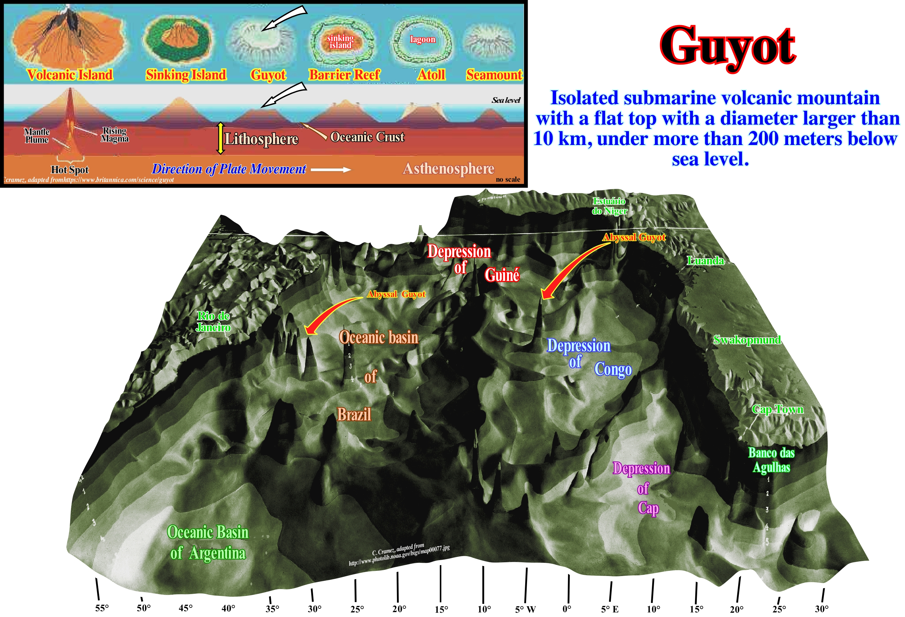
In contrast to a "mesa" that, in sedimentology, is a structure resulting from the differential erosion of a stable platform, where alternating resistant horizons and little resistance to erosive agents, an abyssal mesa (abyssal guyot or table-mound) is an intrusive volcanic structure whose top is, more or less, planar. In this model of the of the equatorial Atlantic Ocean sea floor made by the German Meteor expedition between 1925 and 1929, several abyssal mesas are proposed, in particular, between the Brazilian and Argentine abyssal basins. It is important to differentiate seamounts from abyssal mesas, sometimes, called submarine plateaus. An submarine hill is a mountain rising from the ocean floor but does not reach the surface of the sea, which means that an submarine hill never forms an island. Seamounts, typically, are extinct volcanoes that form very rapidly and rise, generally, from the ocean floor between 1,000 and 4,000 meters. The abyssal mesas are, in general, small volcanic provinces, i.e., small volcanic plateaus. The Kerguelen volcanic plateau, located in the Indian Ocean, can be considered as a large volcanic mesa. It is, approximately, 3,000 km from the Australian and is about three times the size of Japan. This mesa or small abyssal plateau extends for more than 2,200 km in the direction NO-SE, under a blade of very large water. Abyssal mesas correspond to hot spots (place on the surface of the Earth that has undergone active volcanism for a, relatively, long geological period). Thus Kerguelen's mesa, with the small abyssal mesas of the South Atlantic Ocean, are associated with the Gondwana break-up which occurred around 130 Ma. As lithospheric plates with their continents and oceanic floor, they pass over a hot spot, the associated volcanoes lay on the oceanic or continental crust a large amount of volcanic material forming either plateaus or abyssal mesas. The paradigm of plate tectonics is by far the best explanation of most abyssal mesas.
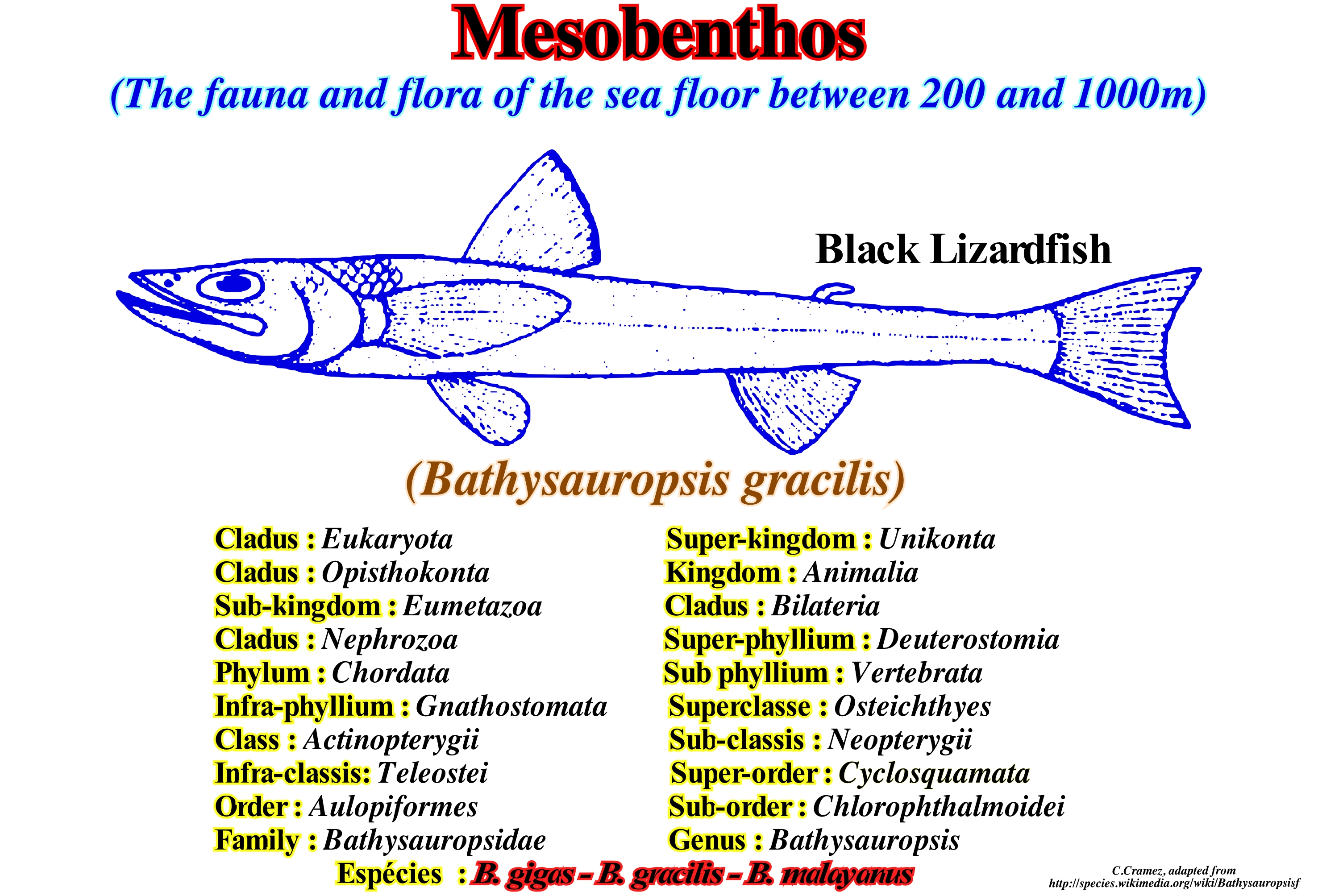
Mesobenthos...........................................................................................................................................................................................................Mésobenthos
Mesobentos / Mesobentos / Mesobenthos (Flora und Fauna leben am Boden der Tiefsee von 182 bis 914 m) / Mesobenthos(植物和动物生活在深海底部,从182到914中号) / Мезобентос / Mesobenthos (flora e fauna che vivono sul fondo del mare profondo tra 182-914 m) /
All animals and plants that live on the sea bed at depths between 200 and 1,000 meters. For some geoscientists, zoobenthos are classified according to the dimensions in: (i) Microbenthos; (ii) Meso or Meiobenthos and (iii) Macrobenthos, which makes the term mesobentho very confused.
See: « Benthos »
&
« Pelagic (organism) »
&
« Merobenthos»
The functioning of the marine environment is similar to that of any other ecosystem on the planet. There are producing organisms, which synthesize organic matter from the inorganic. This can be done by photosynthesis, which uses light as a source of energy, as with macro and microalgae, photosynthetic bacteria and higher marine plants, such as marine grasses in coastal regions. The other form is through chemosynthesis processes, where the energy source for synthesis of organic matter is obtained from some inorganic components. This type of production is the basis, for instance, of the food chain of the submarine thermal springs. At the next level are the consumer organisms, which feed on the biomass of the producers (herbivores) or other consumers (carnivores). Finally, there are decomposing organisms, which decompose the organic matter back into inorganic compounds, closing the cycle of materials. The decomposers are, fundamentally, constituted by the decomposing bacteria. In the marine ecosystem there are several communities, i.e., groups of organisms that occupy a certain habitat, and in each community there are organisms belonging to all trophic categories, that is, producers, consumers and decomposers. In the oceans, benthos, which form benthic communities, represent the organisms that are somehow associated with the substrate. Some are fixed (anemones), others buried (polychaetes), others vagiles (crabs and sole) that swim just near the bottom of the sea. The planktonic and nektonic communities circulate through the water. The distinction between plankton and nekton is made by their ability to beat or not the currents. Nekton organisms (fish and marine mammals, etc.) are able to swim against the current, while plankton organisms are carried by currents, although they have the ability to swim. Plankton organisms are usually microscopic or very small, such as phytoplankton microalgae. (http://www.comciencia.br/reportagens /litoral/lit02.html).
Mesopelagic (Organism).............................................................................................................................................Mésopélagique (organisme)
Mesopelágico / Mesopelágico (organismo) / Mesopelagic (Living in Tiefen zwischen etwa 180 bis 900 m) / Mesopelagic (生活在水深约180米至900米之间) / Мезопелагический (организм) / Mesopelagico /
Pelagic organism that lives between 200 and 1,000 meters of water, i.e., that lives between the epipelagic photic and the bathypelagic aphotic zone (where there is no light).
See: « Pelagic (organism) »
&
« Benthos »
&
« Physiographic (province) »
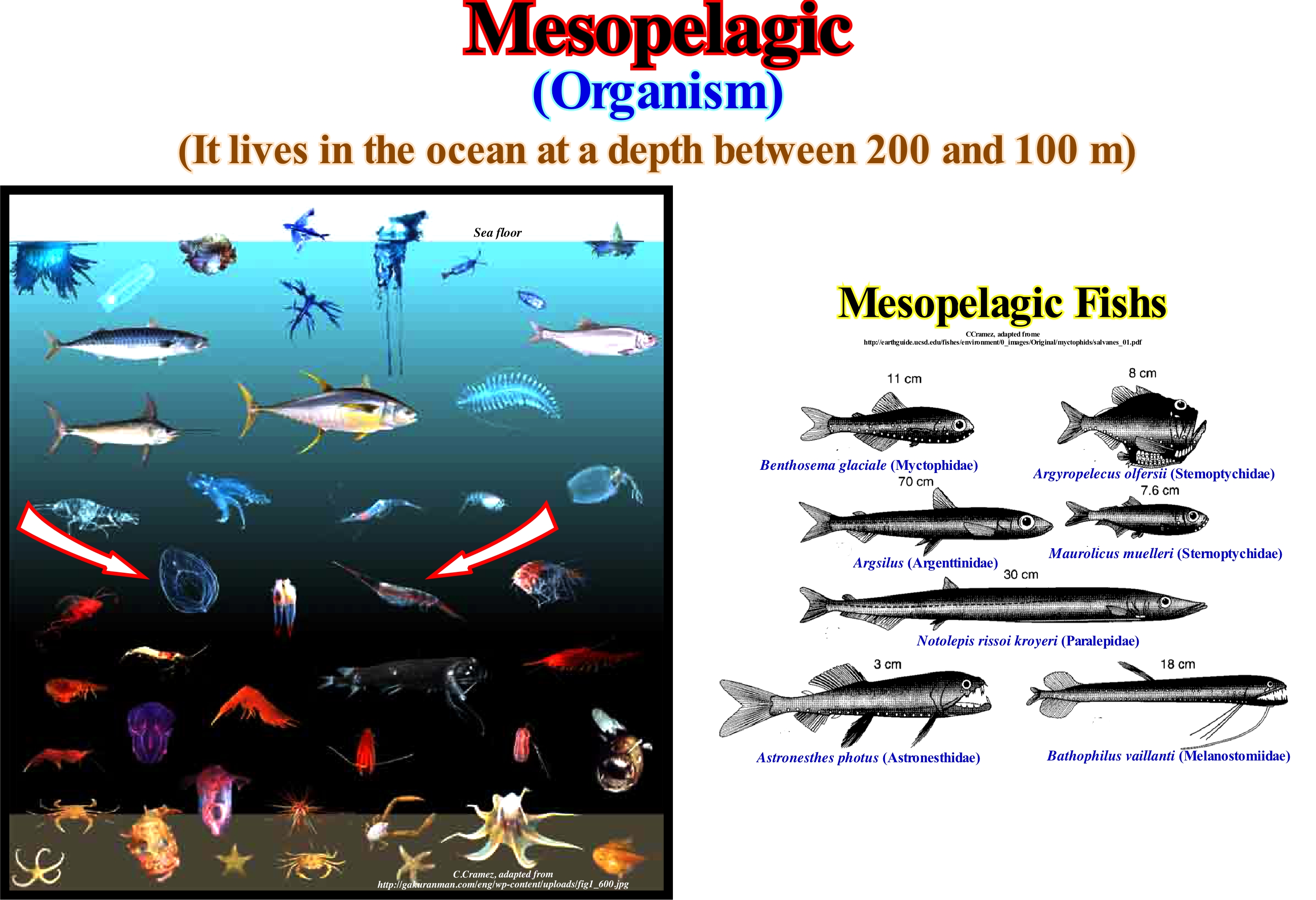
Mesopelagic organisms are organisms that live in the mesopelagic zone, which is the pelagic zone that extends from 200 m to about 1,000 m below sea level. The mesopelagic zone (the term *meso" comes from the Greek and means middle) is located between the photic epipelagic and the aphotic bathypelagic zone, where there is, practically, no light. The little light that surpasses the mesopelagic zone is insufficient for the photosynthesis (process by which the plants, autotrophic beings, produce their own food, and some other organisms transform luminous energy in chemical energy, transforming the carbon dioxide, water and minerals in organic compounds and oxygen). Although the temperature varies less than in the epipelagic zone, it is in the mesopelagic zone that the thermocline (abrupt temperature variation at a given depth of the sea) is located with temperatures ranging from about 20° C at the top to about 4° C at the bottom. Fish such as swordfish, squid, wolf, cuttlefish (sepia officinalis), and other medium-deep sea creatures live in this zone and are considered with mesopelagic organisms. When sonar began to be used during World War II, many operators detected the sea bed to a depth of 300-500 m during the day, but closer to the surface at night. Indeed, millions of organisms, including fish and zooplankton at dusk, move to the shallower parts to feed on microscopic plants where sunlight penetrates. On moonlit nights this deep layer remains, though the animals within it respond to the clouds that pass over the moon. Many species, including jellyfish, squid and crustaceans, are part of these vertical migrations, but they are, mainly, the fish that give rise to the echo that the sonar operators interpreted as the sea floor. This false bottom of the sea is known today as the deep layer of dispersion, which proves that it is difficult and even wrong to characterize organisms just in function of depth since they can migrate vertically hundreds of meters.
Mesothem..............................................................................................................................................................................................................................Mésothème
Mesotema / Mesotema / Mesothem (Stratigraphie) / Mesothem (地层) / Мезотема / Mesotema /
Stratigraphic unit, with a significant duration, corresponding to a depositional cycle. In the continental shelf, a mesothem is, usually, limited, at the top and bottom, by unconformities, but its limits are defined by typical points at the base of the chronozones of the sediments deposited in continuity in the basin. A mesothem is composed of several cyclothems. A set of mesothems forms a synthem. In sequential stratigraphy, a mesothem corresponds, more or less, to a stratigraphic cycle called the sequence-cycle.
Ver: « Cyclothem »
&
« Sequence-Cycle »
&
« Chronozone »
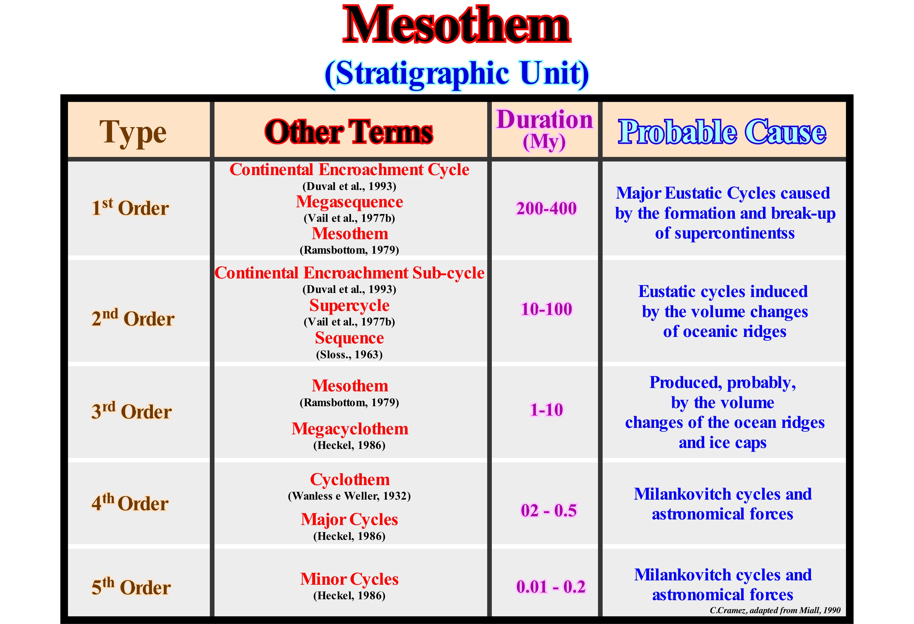
The term cyclothem was proposed by Weller (1958) to define a series of layers deposited during a sedimentary cycle of transgressions/regressions, i.e., sedimentary transgressions and sedimentary regressions. Sedimentary transgressions are a set of increasingly important marine ingressions, i.e., relative sea level rises in relative acceleration and increasingly smaller sedimentary regressions. Sedimentary regressions are a set of increasingly smaller marine ingressions, i.e., relative sea level rises in deceleration and increasingly important sedimentary regressions. The coal layers of Pennsylvania area associated with unstable platforms or cratonic basins, where sedimentary transgressions and sedimentary regressions alternated. The Pennsylvania Cyclothems were deposited due to an extremely flat topography of the cratonic basins, several times covered by the sea, which is why they were never covered by ice. Since the advent of sequential stratigraphy, the terms synthem, mesothem and cyclothem are little used. They are associated to the biostratigraphic method, that is, to a set of geological processes, that promotes and facilitates the multidisciplinary integration of paleontological, geological and geophysical data and that leads to a functional pattern of correlations. The basis of this biostratigraphic method is the recognition of a stratigraphic unit called "Biothem", which is nothing other than a sedimentary body : (i) Limited upstream, that is, near the coastline, by unconformities, which can be recognized by fossils (however an unconformity can only be dated in deep water where the hiatus is minimal) ; (ii) Conform with the overlying and underlying biothems at their maximum development, which ideally is on the platform; (iii) When applicable, conform or limited by areas of non-deposition and/or submarine erosion (downstream of the basin edge) or starved equivalent (deposited under conditions of poor sedimentation rate) and (iv) Characterized by a coherent succession of facies* deposits. Biothems are practical units with definitions and degrees of refinement, solely, dependent on the quality and availability of biostratigraphic controls. Ideally, each biothem, and in particular the mesothems and cyclothems, are interpreted as having been deposited in relation to and probably equivalent to a cycle of sedimentary transgressions/regressions. Biothems represent conceptual stratigraphic hierarchies. In a decreasing hierarchy, generally, three types of biothems are considered: (a) Synthems, i.e., a set of interactive and interdependent entities, real or abstract, that form a whole ; (b) Mesothems, that is, a stratigraphic unit with a significant time-duration, which corresponds to a deposition cycle** and (c) Cyclothems, that is, informal lithostratigraphic units equivalent to a geological formation. It can be said there are two concurrent hypotheses to explain the stratigraphic cycles induced by high frequency eustatic cycles (4th order or higher), which often form cyclothems, in which the deposition time of each rocky horizon rarely exceeds 1 My. The first hypothesis is based on glacio-eustasy: glaciers are capable of causing rapid changes in sea level that can be recognized in the rock record and certain geoscientists even think that many of the Carboniferous deposits of coal were induced by the thickening and thinning of the glaciers over a few million years. Other geoscientists have proposed the pendulum effect (lateral displacement of the delta lobes) using the modern deltas of the Mississippi Delta Building as an analogue: a stream of water carries the sedimentary particles into to the gulf and deposits a delta lobe that, locally, has reduced accommodation forcing the current to find another place to flow. Since the inflow of sand and silt is diverted from the lobe, a local marine ingression develops over the already deposited lobe, and any terrestrial plants present therein will be buried and may later be covered by another lobes turn into coal. The new channel of the current will transport the terrigeneous influx to form a new delta lobe, initiating a new displacement cycle (pendulum effect).
(*) Term used by Gressly in 1838 to express a lithology and associated fauna, which today has lost much of its original meaning, since certain geoscientists, particularly American geoscientists use it to express the shape, appearance and deposit conditions, that is, practically, as synonymous with the sedimentary environment)
(**) On the continental shelf, a mesothem is, usually, bounded below and above by unconformities, but their boundaries are defined by typical points on the basis of the chronozones of the sediments deposited in continuity in the basin.
Mesotrophic (Lake).........................................................................................................................................................................Mésotrophique (Lac)
Mesotrófico / Mesotrófico (lago) / Mesotrophen See / 营养型湖泊 / Мезотрофное озеро / Lago mesotrofico /
Intermediate lake between an oligotrophic and eutrophic lake. An oligotrophic lake contains little concentration of nutrients necessary for the growth of the plants and thus the productivity of the lake is small. An eutrophic lake, on the other hand, is very rich in nutrients and has a high productivity.
See: « Lake »
&
« Laguna »
&
« Organic Matter (types) »
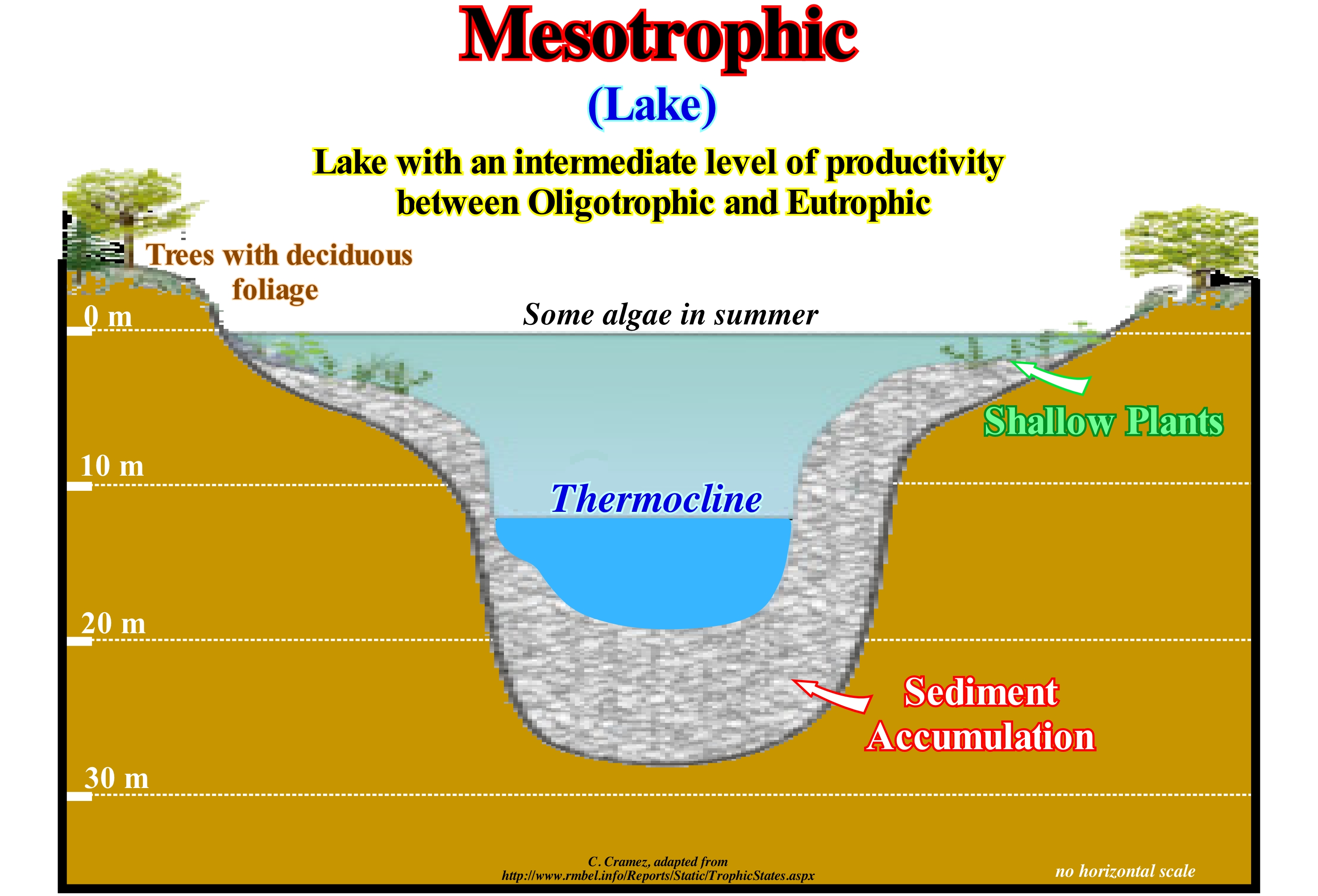
A mesotrophic lake contains an average amount of nutrients, mainly phosphorus and nitrogen, and thus, practically, it corresponds to an intermediate stage, between extreme situations of oligotrophic and eutrophic lakes. The productivity of a mesotrophic lake varies between 250 and 1,000 mg of carbon per square meter per day. Mesotrophic lakes, such as those located in the centre of the state of Minnesota have clear water with some algae in the summer. Mesotrophic lakes are excellent for sport fishing, since they inhabit a great variety of fish. All lakes undergo significant temperature changes, which makes their characteristics vary. When the temperature of the water increases, it becomes less dense. On the contrary, it is denser when the temperature decreases (the exception to this rule is when the water reaches its maximum density at approximately 4° C). As regards the temperature change of the water in depth within a lake (thermal stratification), the mesotrophic lakes have a very different behaviour from the oligotrophics, since, in the summer, they are laminated in several layers. The top layer becomes very hot and with many algae. Thus, a mesotrophic lake is enriched in oxygen resulting from photosynthesis. The lower layer of a mesotrophic lake remains cold and becomes anoxic (poor in oxygen). This happens due to the fact that the bodies, which die go to the bottom of the lake, where they decompose, which consumes a lot of oxygen. Since, in summer, water from the bottom of the mesotrophic lake does not mix with surface water, the bottom of the lake can not be replenished in oxygen. The implications of the lack of oxygen are that neither fish nor any other organism can live without oxygen, so in the middle of summer all fish move to the oxygen-rich upper layers, which naturally appeals to sports fishermen. The introduction of new animal or plant species can destroy the ecosystems of a mesotrophic lake.
Mesozoic..................................................................................................................................................................................................................................Mésozoïque
Mesozóico / Mesozoico / Mesozoikum / 中生代 / Мезозо́ / Mesozoico /
One of the Eras of the Phanerozoic Eon, which lasted from 245 Ma to 66.4 Ma.
See: « Geological Time »
&
« Geological Time Scale »
&
« Cretaceous »
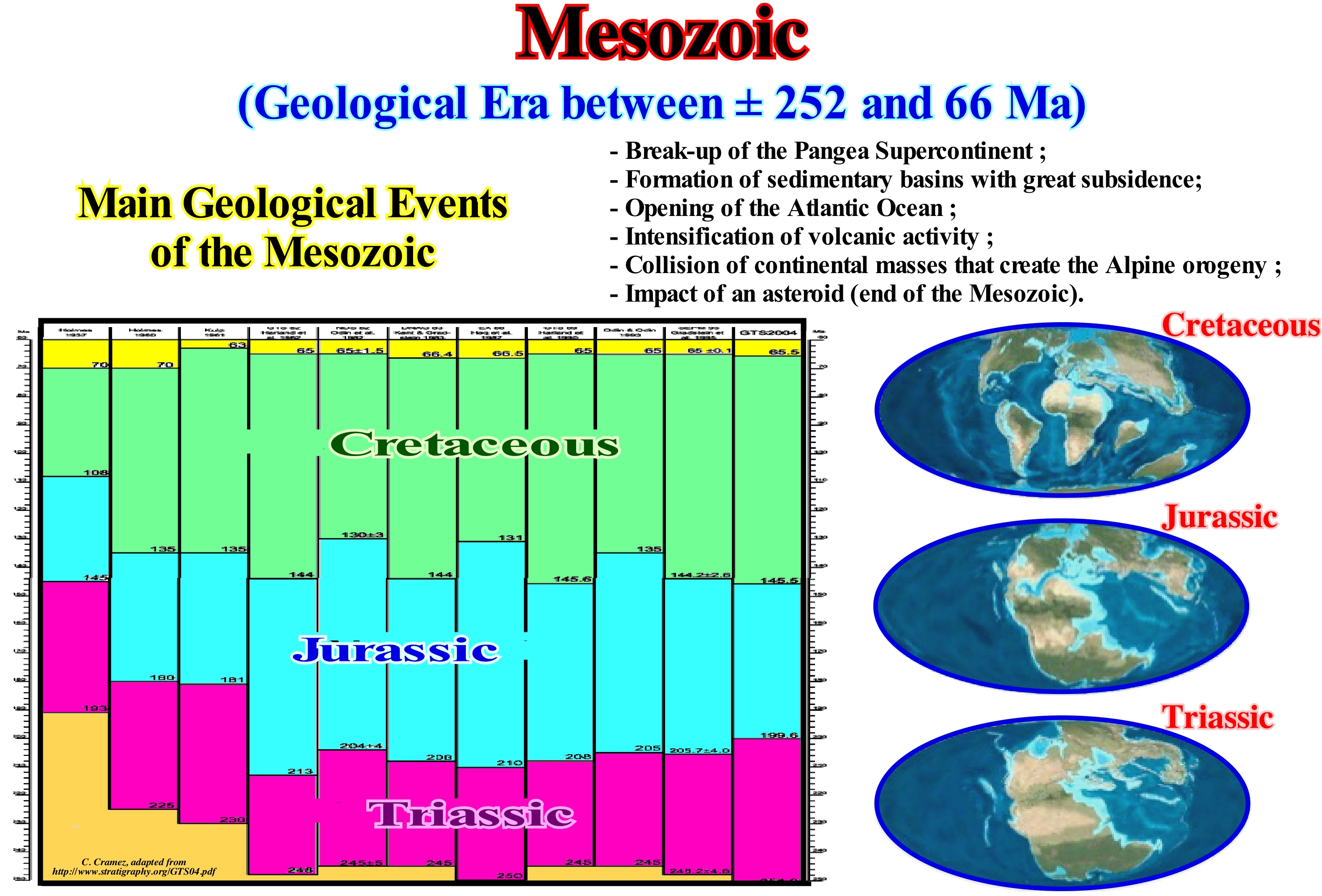
As illustrated in this figure, the Mesozoic is divided into three periods: (i) Triassic, which lasted more or less 35 My, between 245 and 208 Ma ; (ii) Jurassic, which lasted approximately 62 My, between 208 and 146 Ma and (iii) Cretaceous, which lasted about 81 My, between 146 and 65 Ma. The Mesozoic, which in etymological terms means average life (animals), is the time during which the terrestrial fauna changed, drastically, in relation to the Paleozoic fauna. Dinosaurs, which are perhaps the most popular organisms of the Mesozoic, developed in the Triassic, but until the Jurassic, were not very diversified. Except for birds, the dinosaurs died out at the end of the Cretaceous. The Mesozoic was, also, a time of great change of terrestrial vegetation. At the beginning of the Mesozoic, the foetuses, cicadas, ginkgophytes and other plants, that today are not very common, were predominant. Modern gymnosperms, such as conifers, appeared in their most recognizable form at the beginning of the Triassic. Around the middle of the Cretaceous, appeared the first angiosperms, which began to diversify, surpassed all other types of plants. In terms of sequential stratigraphy, it can be said that the Mesozoic corresponds, roughly, to the absolute (eustatic) sea level rise induced by the dispersion of the continents resulting from the break-up of the Pangea supercontinent, i.e., the rise of sea level of the first order eustatic, which began with the Pangea break-up. It was from the Cenomanian-Turonian that the eustatic sea level began to fall. The Mesozoic corresponds, roughly, to the transgressive phase of the continental encroachment stratigraphic cycle, which is characterized by sedimentary intervals with a retrogradational geometry, which explains the progressive increase of the depositional water-depth, as the extension of the continental shelves was growing. More rigorously, as said before for the rise of sea level, from the Cenomanian/Turonian, that is, from downlap surface 91.5 Ma, the geometry of the Mesozoic sedimentary intervals ceases to be retrogradational to become, predominantly, progradational, since, globally, the absolute sea level began to fall.
Messinian Salinity Crisis.....................................................................................................Crise de salinité messinienne
Crise Salina (Messiniano) / Crisis salina (Messiniano) / Messi Salinitätskrise / 墨西拿盐度危机 / Мессинский пик солёности / Crisi di salinità del Messiniano /
Geological event in which the Mediterranean Sea entered a partial cycle of dissection, completely, or almost during the last part of Messinian. The salt crisis ended with the Zanclian ingression (Zanclian flood of certain geoscientists), when the Atlantic Ocean returned to enter the basin of the Mediterranean ocean.
See: « Karst »
Metargillite......................................................................................................................................................................................................................Metargillite
Metargilito / Metarcillita / Meta-Argillit / 变粘土质的 / Мета-аргиллит / Metargillito /
Shale which has been, sufficiently, buried to reach the zone of anchimetamorphism, i.e., the first degree of metamorphism, which is, often, manifested by an illite recrystallization.
See: « Shale »
&
« Abyssal »
&
« Depositional Environment »
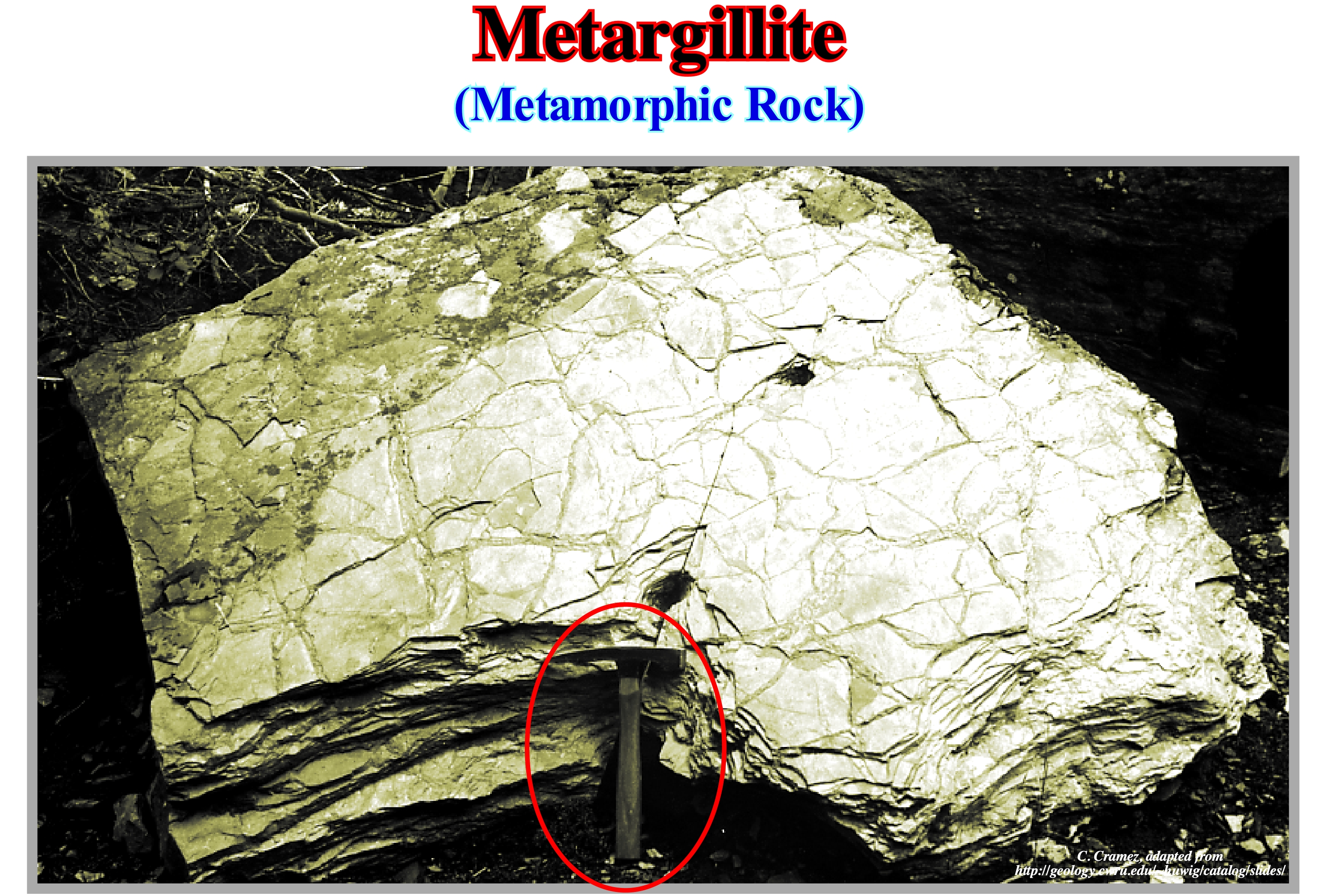
As a argillite (shale) is fossilized and buried by the overlying sedimentary deposits, the increase in pressure and temperature, gradually, begins to modify it until it becomes a metamorphic shale. Throughout such a burial, the argillite passes, successively through three zones well-known of the geoscientists: (i) Diagenesis, which encompasses all the physical, chemical and biological changes undergone by the sediments from the moment of deposition to their conversation on rocks solid and, subsequently, to the beginning of metamorphism ; (ii) Catagenesis, which is the process in which, with increasing pressure, the kerogen (the intermediate between organic material and fossil fuels) changes and most of the oil is formed ; (iii) Metagenesis, which represents the final stage of the evolution of a kerogen and which is the stage of dry gas formation (methane) by cracking the petroleum. The whole of the lower sector of the catagenesis zone and the upper part of the metagenesis zone forms the anchimetamorphic domain, that is, the domain in which the rocks are not yet truly metamorphic rocks, but the organic matter they had already been, completely, transformed, since the reflectance index of vitrinite* is greater than 1.2. The study of the vitrinite reflectance allows reconstituting the temperature history of the sedimentary basins. Initially used to diagnose the thermal maturity of coal layers, vitrinite reflectance is now widely used in oil exploration to determine the degree of maturation of organic matter in source-rocks (between 60°/120° C). Thus, in the phase of diagenesis, the vitrinite reflectance (% Ro) is less <0.6, which means that the organic matter is immature. In the catatagenesis phase, in which the organic matter is mature, three possibilities can be considered: (i) If % Ro varies between 0.60 / 1.00, the organic matter is in the oil window ; (ii) if % Ro varies between 1.00-1.35, the organic matter is in the regressive window ; (iii) If % Ro varies between 1.35-2.00, the organic matter is in the moist gas window. In the metagenesis phase, the organic matter is oversaturate, the % Ro is greater than 2, which means that the organic matter is in the window of the dry gas. Generally, the upper limit of oil generation is correlated with a vitrinite reflectance of 0.5-0.6% and the lower limit with a reflectance of 0.86-1.1%. The combination of illite crystallinity (clayey mineral resulting from orthoclase alteration) and reflectance of vitrinite (one of the major constituents of coals and many sedimentary kerogens) can be used as a geothermometer and, indirectly, as a means of determining maximum burial of a sedimentary interval. The following story shows how these geothermometers were and are useful in oil exploration. In the 1960s, the first major question of onshore oil exploration in the Kwanza geographical basin (Angola) was to know which were the true source-rock of oil discovered in the Quenguela Norte wells, as well as of the oil discovered in Cabinda onshore (Congo's geographic basin), since rocks rich in organic matter (potential source-rocks) are, currently, insufficiently buried. The first hypothesis was to admit that the substrate argillites (argillites of the Karoo formation) were the true source-rocks. However, the analyzed made by Bernard Kubler of the University of Neuchâtel (Switzerland) showed that the Karoo argillites were actually metargillites, and that the anchimetamorphism was prior to the deposition of the sediments of the Kwanza basin, which immediately excluded the hypothesis that oil was generated by such rocks. The same B. Kubler when analysing the organic rich rocks in the Kwanza and Cabinda basin found that the vitrinite reflectance index was superior to that of the current burial, which led him to advance the conjecture that the source-rocks had been uplift more than 1,000 meters, which later was corroborated by various methods. Such uplift is, perfectly, visible in modern regional seismic lines.
(*) The study of vitrinite reflectance (the ratio of the flux of electromagnetic radiation incident on a surface to the flux that is reflected is often reflected as a percentage) is a key method for obtaining the temperature history of the sedimentary basins. This method was first studied by coal explorers who attempted to diagnose the thermal maturity of the coal layers. More recently, its use as a tool for studying the transformation of kerogen into hydrocarbons is widely used. The main attraction of the method for this application is its sensitivity to temperature ranges corresponding to those of hydrocarbon generation (60° to 120° C). Thus, using an appropriate calibration, the vitrinite reflectance can be used as an indicator of maturity in hydrocarbon parent rocks. Generally, the beginning of oil generation is correlated with a reflectance of 0.5 to 0.6% and the end of the oil generation with a reflectance of 0.86 to 1.1%. (https://en.wikipedia.org /wiki/Vitrinita)
Metasoma (Mineral).................................................................................................................................................................................Métasome (Minéral)
Metassoma / Metasoma (mineral) / Metasome (Mineral) / Metasome(矿产) / Метасома / Metasome (minerale) /
Substitute mineral, which grows at the expense of another mineral (palasome).
See: « Palasome (mineral) »
&
« Diagenesis »
&
« Weathering »
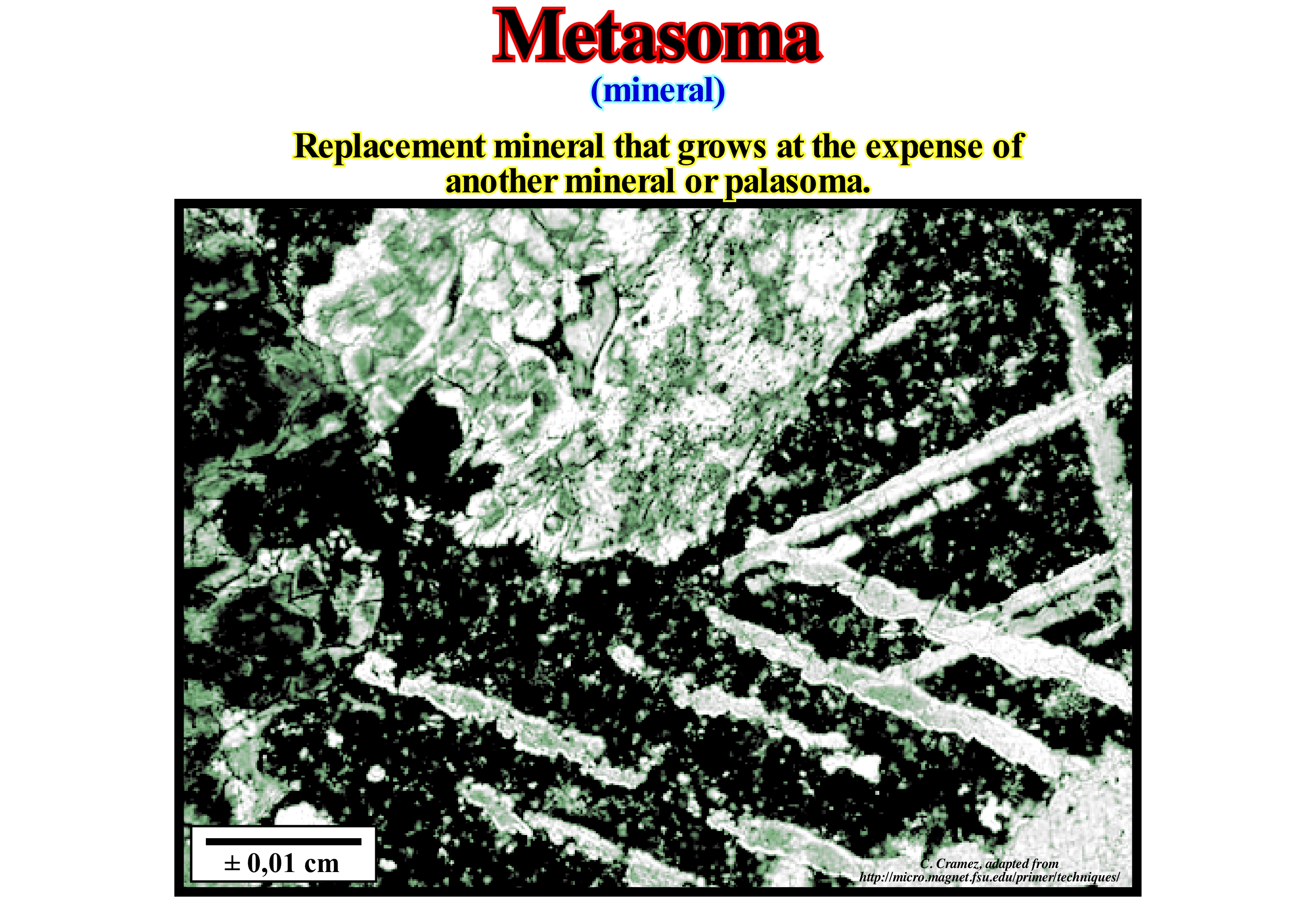
A tactite* (skarn) is a type of rock that has a complex mineral composition. It is, generally, considered as a type of "hornfels" ** (whetstones) and formed by contact metamorphism (which occurs around the igneous rocks) and metasomatism of carbonate rocks (chemical alteration of a rock by hydrothermalism and other fluids) and of another nature, with a important formation of metasomas (replacement minerals, which grow at the expense of original minerals called palasomas). The term "hornfels" (or skarn ) was used for the first time in Sweden to designate only the mineral deposits that formed next to the igneous intrusions. At present, the term hornfels is used more broadly and refers to all the rocks that form in the different zones of metamorphism that can be individualized around the intrusions. These areas are characterized by the introduction of large quantities of iron, silica, aluminum and magnesium, both in limestone and other sedimentary rocks. Hornfels are found all over the world and they are, particularly, abundant in the Mesozoic. The hornfels zone is, in general, relatively, irregular and function of the limits of the intrusive rock and the initial rock. It sometimes contains iron ores, copper, gold, wolfram, etc., albeit in small quantities. The most important features of hornfels can be summarized as follows: (i) They have no schistosity, i.e., that their mineral grains do not orient themselves parallel or subparallel to each other ; (ii) Some hornfels have a fine grain and dark colour ; (iii) They may be derived from shaly sedimentary rocks, in particular argillites, by contact metamorphism ; (iv) Hornfels derived from shaly rocks often contain aluminum silicates (andalusite, cordierite, etc.) ; (v) Certain hornfels have a variable granulometry and light colour as those derived from carbonated sedimentary rocks ; (vi) Hornfels derived from carbonate rocks in addition to calcite, have calcium and alumina-calcium silicates (calcium pyroxenes, calcium grenades, epidotes, wollastonite, etc.) ; (vii) Other types of hornfels may be evidenced by the nature of the original rock.
(*) Tactites or skarns or are hard, coarse-grained metamorphic rocks that form by a process called metasomatism (https://en.wikipedia.org/ wiki/Skarn). Tactites tend to be rich in calcium-magnesium-iron-manganese-aluminium silicate minerals, which are also referred to as calco-silicate minerals.
(**) Hornfels is the group designation for a series of contact metamorphic rocks that have been baked and indurated by the heat of intrusive igneous masses and have been rendered massive, hard, splintery, and in some cases exceedingly tough and durable.
Methane..............................................................................................................................................................................................................................................Méthane
Metano / Metano / Methan / 甲烷 / Метан / Metano /
It is the simplest hydrocarbon since it consists of one carbon and four hydrogens (CH4). Methane is the main component of natural gas.
Ver: « Gas »
&
« Biogenic Gas »
&
« Coal Bed Methane »
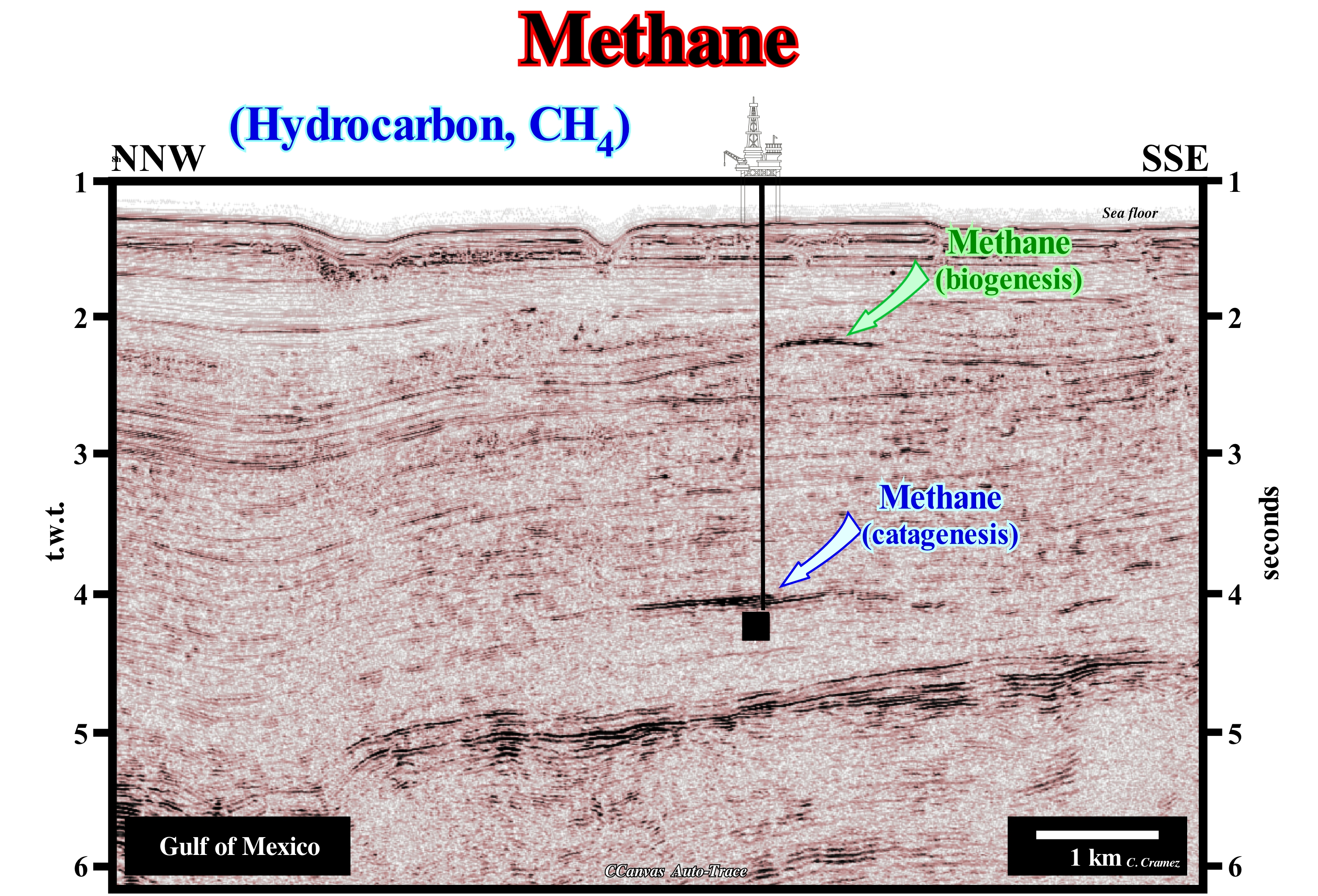
Methane exists in various forms and in diverse associations, both in the Earth's atmosphere and underground. At present, the concentration of methane in the atmosphere is much lower than it was at the beginning of geological history due, mainly, to the increase in oxygen content. It was about 1,745 ppb (part per billion, 109) in 1998, but this figure is an average once its concentration is much higher in the northern hemisphere than in the southern hemisphere. It is necessary to take into account the variation induced by the seasons (it is lower during the summer, due to the removal by its radical hydroxide). The discrepancy between concentrations to the north and south of the equator, which many ecological lobbies, systematically, neglect to get the farmers support, is due, obviously, to the production of methane by ruminants (cattle in particular), crops and man. This is, extremely, important, since methane in the atmosphere is a greenhouse gas (if greenhouse effect exists as, normally, defined), which has a potential for warming of 25 in 100 years, which means that methane emissions have an impact on the temperature that is 25 times greater than the impact of the same amount of carbon dioxide (CO2) over the same 100 year period (another thing ecologists forget). In the basement, methane exists, mainly, in two forms: (i) Crystalline solid, in the clathrates (hydrate gas) and (ii) Gaseous, in the marshes, coal or in the pores of the reservoir-rocks of the oil fields. Although some experts say that the amount of methane in clathrates may be 100 times greater than all conventional gas reserves, to date just insignificant amounts of gas have been produced from clathrates (productions that some geoscientists continue to deny). In any case, most of the gas reserves produced and to be produced, apart from biogenic gas, are associated with the oil fields and they result from the catagenesis of organic matter from the source-rocks. On this seismic line, one recognizes (by the amplitude anomalies of the reflectors), a deep horizon of gas of catagenesis and other, superficial, induced by biogenic gas.
Micrite...........................................................................................................................................................................................................................................................Micrite
Micrite / Micrita / Mikrit / 微晶 / Микрит / Micrite /
Sedimentary rock formed by mud or limestone of a rock. For many geoscientists, micrite is the equivalent of clay in clastic rocks. Originally, the micrite is deposited as microscopic needles of aragonite, but is then converted to calcite, which forms the cement of many rocks. As a rock, the micrite is dense, uniform, finely grained and conchoidal fracture.
See: « Calcite »
&
« Deposition (carbonates) »
&
« Limestone »
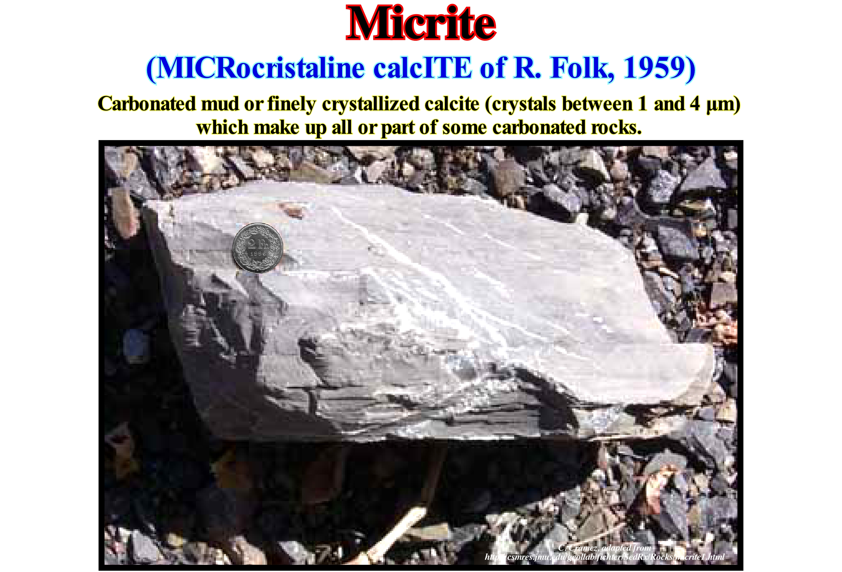
For most geoscientists, micrite is a sedimentary rock formed of calcareous particles having a diameter ranging from 0.06/2 mm and deposited, preferably, mechanically, although in some cases it may be deposited solutions. The carbonate particles that form the micrite are mainly: (i) Remains of fossils ; (ii) Small pebbles ; (iii) Carbonate granules and (iv) Oolithes (spherical nodules with a concentric structure), which are transported and calibrated by water currents. As illustrated, a micrite is a dense, uniform, finely grained rock that, often, has a conchoidal fracture. It is not uncommon for it to have light-coloured veins and, more or less, parallel ones. These laminations are, probably, algal laminations produced in the tidal plain by colonies of green and blue algae. The micrite is one of the most common carbonate rocks. Much of what the people, and not only, call limestone is, in most cases, micrite. As with clay (which forms the rock called claystone), the micrite, usually, deposits in calm waters and is found in sedimentary environments where these conditions exist. Although many geoscientists associate calm waters with deep waters, where the influence of waves and currents is, generally, null, when it comes to carbonate deposits such an association is not a good rule. Micrites and micrites, particularly, with algal laminations, as illustrated in this figure, are formed, mainly, in the upper tidal plains (upper intertidal and supratidal), where exposure to air is common. Carbonates, of whatever type, are, usually, associated with tectonically stable areas and tropical climates, i.e., with stable, shallow sedimentary environments associated with epicontinental platforms and seas.
Microbenthos.......................................................................................................................................................................................................Microbenthos
Microbentos / Microbentos / Microbenthos / Microbenthos (底栖动物) / Микробентос / Microbentos /
Benthonic organism (animal or plant) with dimensions less than 0.1 mm.
See: « Benthos »
&
« Pelagic (organism) »
&
« Meroplankton »

In marine biology and limnology, benthos are organisms that live on the substrate, fixed or not, in contrast to the pelagics, which live freely in the water column. Benthos or benthic organisms are those animals that live associated with sediment, both marine and inland, such as corals. Benthos are subdivided into: (i) Phytobenthos, as macroalgae, some microalgae and rooted aquatic plants and ii) Zoobenthos, i.e., animals and many benthic protists. The zoobenthos are often subdivided into: (a) Macrofauna, animals visible to the naked eye, such as most crabs, echinoderms, insect larvae, worms, oligochaetes and some species of fish ; (b) Meiofauna, animals that live, permanently, buried in the sediment either free or within structures built by them; many molluscs, such as clams, and various types of worms; and (c) Microfauna, microscopic animals that develop on the substrate, mainly protists. Taking into account the size of the benthos are usually subdivided into: (1) Macrobenthos ; (2) Meiobenthos and 3) Microbenthos. Macrobenthos are the largest benthos, with a size larger than 0.5 mm. Examples of macrobenthos include polychaete worms, bivalves, echinoderms, anemones, corals, sponges, ascidians, tubers and large larger crustaceans such as crabs, lobsters, etc. Meiobenthos, are benthos smaller than 0.5 mm but larger than 32 μm (examples may be nematodes, foraminifera, small crustaceans, such as copepods and ostracods). Microbenthos are microscopic benthos with dimensions smaller than 32 μm, such as bacteria, diatoms, ciliates, amoebas, flagellates, etc. In regard to the location of the benthos many geoscientists consider: (A) Epibenthos, that live on the surface of the sediments and (B) Hyperbenthos, that live, immediately, above the sediments. The notion of benthos is totally independent of the water-depth, which means that the benthic life exists at different depths to which the seabed can be found, that is to say that benthic organisms occur either in the (I) Littoral zone ; (II) Neritic zone ; (III) Abyssal zone or (IV) Hadal zone.
Microcontinent...........................................................................................................................................................................................Microcontinent
Microcontinente / Microcontinente / Mikrokontinent / 微大陆 / Микроконтинент / Microcontinente /
Fragment of the continental crust, isolated and smaller than a continent.
See: « Supercontinent »
&
« Gondwana »
&
« Pangea »
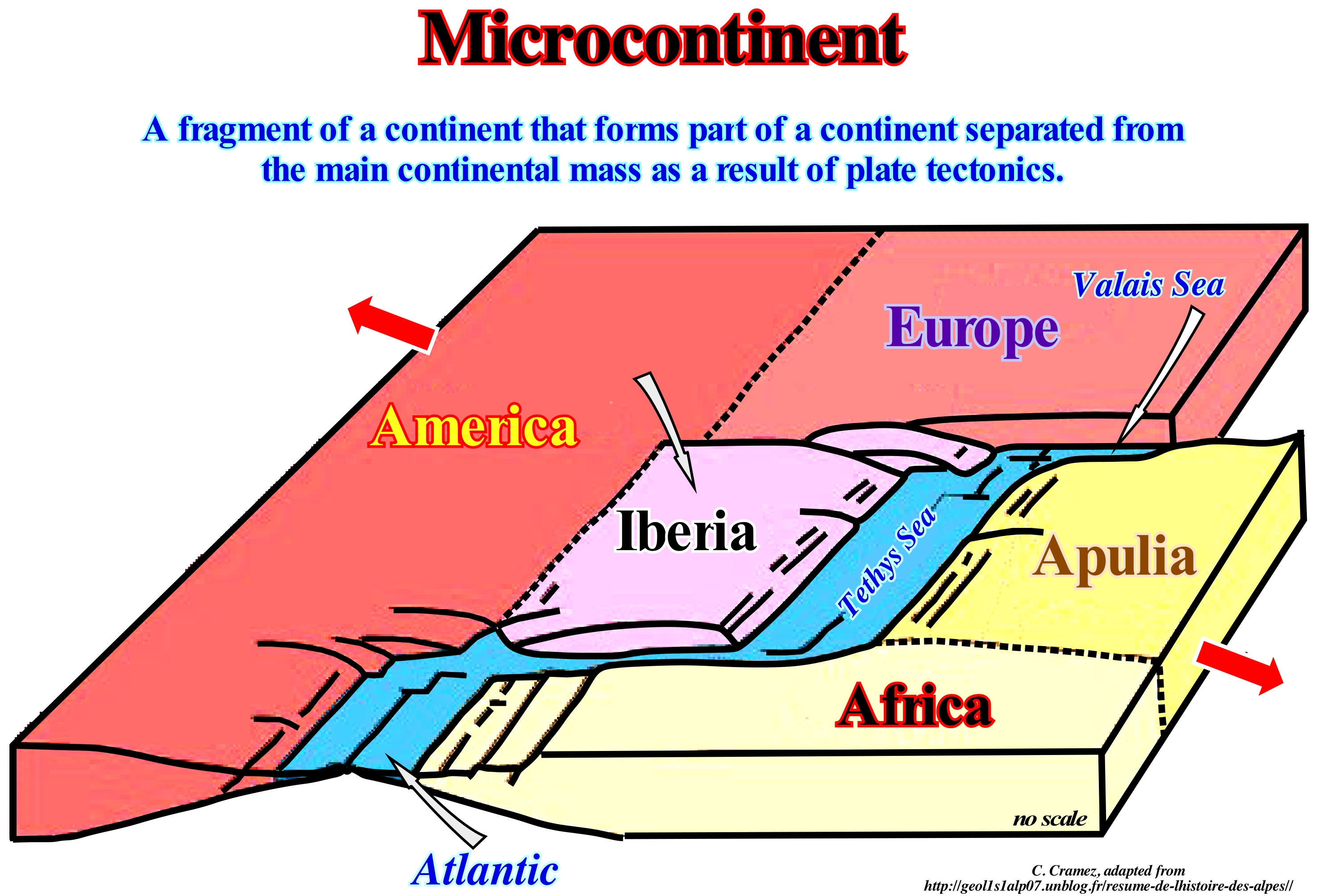
Often, in order to respect geological records in paleogeographic reconstitutions, geoscientists are obliged to consider microcontinents, i.e., portions of the continental crust that are larger than islands, but smaller than continents. The Briancon microcontinent (southern France), for example, is a continental crust of the Pennic mantles, which according to certain paleogeographic reconstructions, seems to be part of another microcontinent called Iberia, which included not only the Iberian Peninsula, but also Corsica, Sardinia and the Balearic Islands. A well-known microcontinent of the geoscientists is Apulia, which is illustrated in this block diagram, which is part of the enigma of the geological elements, formed the border between Europe, North America and Africa, around 150 Ma. The geology of the eastern Alps is complex, due to the existence of several oceanic and microcontinent domains (also called microplates), which have become individualized between Africa and Europe. This complexity is exaggerated by the relationships between the sedimentary shortening and lateral displacement movements, which hinder a coherent arrangement of the lithospheric plates of the region. It is for this reason that certain geoscientists have divided the Alpine orogeny into different tectonic units that mainly reflect the paleogeography of the Mesozoic and Paleocene. In its simplest form, as illustrated above, the tectonic plates (lithospheric) involved in this orogeny are: (i) The European plate (Europe) ; (ii) The oceanic plate associated with the Tethys Sea* ; (iii) The Apulia microcontinent and (iv) The Meliata Ocean (hypothetical ocean inferred from the presence of small tectonic slabs along the ALCAPA (eastern ALpes, western CArpathians and the PAnnonian zone of north-west of Hungary). In the first phase, the Pangea supercontinent fractured and induced the formation of the Tethys Sea and the central Atlantic Ocean, between Europe, still associated with America, and Africa. Later the Iberian microcontinent separated from Europe creating a narrow sea, called Valais Sea. Later, the microcontinent, which corresponds, presently, to Adriatic Sea and half of East Italy, was individualized from the African continent. The Black Sea, Caspian and Aral are considered as their crustal debris (although the Black Sea may actually be a remnant of the ancient Paleotethys Ocean) of the western part of the Tethys Ocean (also called Tethys Sea, the Western Ocean Tethys or even the Alpine Ocean Tethys). However, the Tethys Sea was not a really open sea. It covered small lithospheric plates, island arcs and microcontinents. Small oceanic basins, such as the Valais Sea, Piedmont/Liguria and Meliata, were separated from each other by continental lands of the Alboran, Iberian and Apulia plates. Another well-known microcontinent of geoscientists is Avalonia, which is a Paleozoic microcontinent that formed from a volcanic-arc on the northern shore of the small supercontinent Gondwana and which played a very important role in the evolution of the Rheic Sea and which today part of New England, Nova Scotia and Acadia. In fact, at the beginning of the Middle Ordovician, the rupture of the small supercontinent Gondwana forced the microcontinent Avalonia to compress in front of it the Iapetus Sea ** (sea that existed between 600 and 400 million years ago, between the Neoproterozoic and Paleozoic periods and which formed due to the separation of the Protolaurasia) opening behind the Rheic Sea. At the end of the Ordovician, when the Baltic continent and continent Laurentia collided, to form the Euroamerica (Laurasia) small supercontinent, the Rheic ocean had, already, increased, greatly, due to the oceanic expansion, replaced the Iapetus Sea, that at that time was not another thing that a simple narrow channel between the microcontinent Avalonia and the continent Laurentia.
(*) Sea, between the NE of the small supercontinent Gondwana and SE of the small supercontinent Laurasia, which replaced the Paleotethys ocean (formerly the Suess' Tethys Sea of, i.e., the Paleozoic Ocean, between Gondwana, Central Europe, Iberia, China and Central Asia). The Tethys Sea began to form in the south of Paleotethys since the Cimmerian plate was individualized (Permian /Triassic). The expansion of the Tethys Sea forced the Cimmerian plate to collide with the Laurasia, to finally the Tethys Sea completely replace the Paleotethys. In Greek mythology, Tethys is the mother of Achilles and one of the daughters of Neree and Doris (sister of King of Scyros, Nicomedes, i.e., uncle of the 19th Agiad Spartan king Pleistoanax, commanded the Spartan army at the Battle of Tanagra.
(**) The Iapetus sea encompasses the Tornquist Sea, located between the Avalonian microcontinent and the Baltica continent, whose remains today form a suture that extends through northern Europe (Tornquist Zone).
Mid-Oceanic Ridge......................................................................................................................................................Ride médio-océanique
Crista oceânica média / Dorsale centro-oceánica / Mittelozeanischer Rücken / 中 洋脊 / Срединно-океанический хребет / Dorsale oceanica /
Complex of submarine mountains adjacent to the median line of the ocean floor. The system of an oceanic ridge is essentially a segmented linear volcano. There are a large number of major oceanic ridges: (i) The Atlantic Ridge, which functions as the center of the Atlantic; (ii) The Eastern Pacific Ridge ; (iii) The Indian Ridge (southwest), etc. These ridges are centers of oceanization of the divergent margins, where the lithospheric plates move away from each other. The ocean ridges rise thousands of meters above the seafloor and can extend over 60,000 km.
See: « Crust »
&
« Subduction Zone »
&
« Sea Floor Spreading »
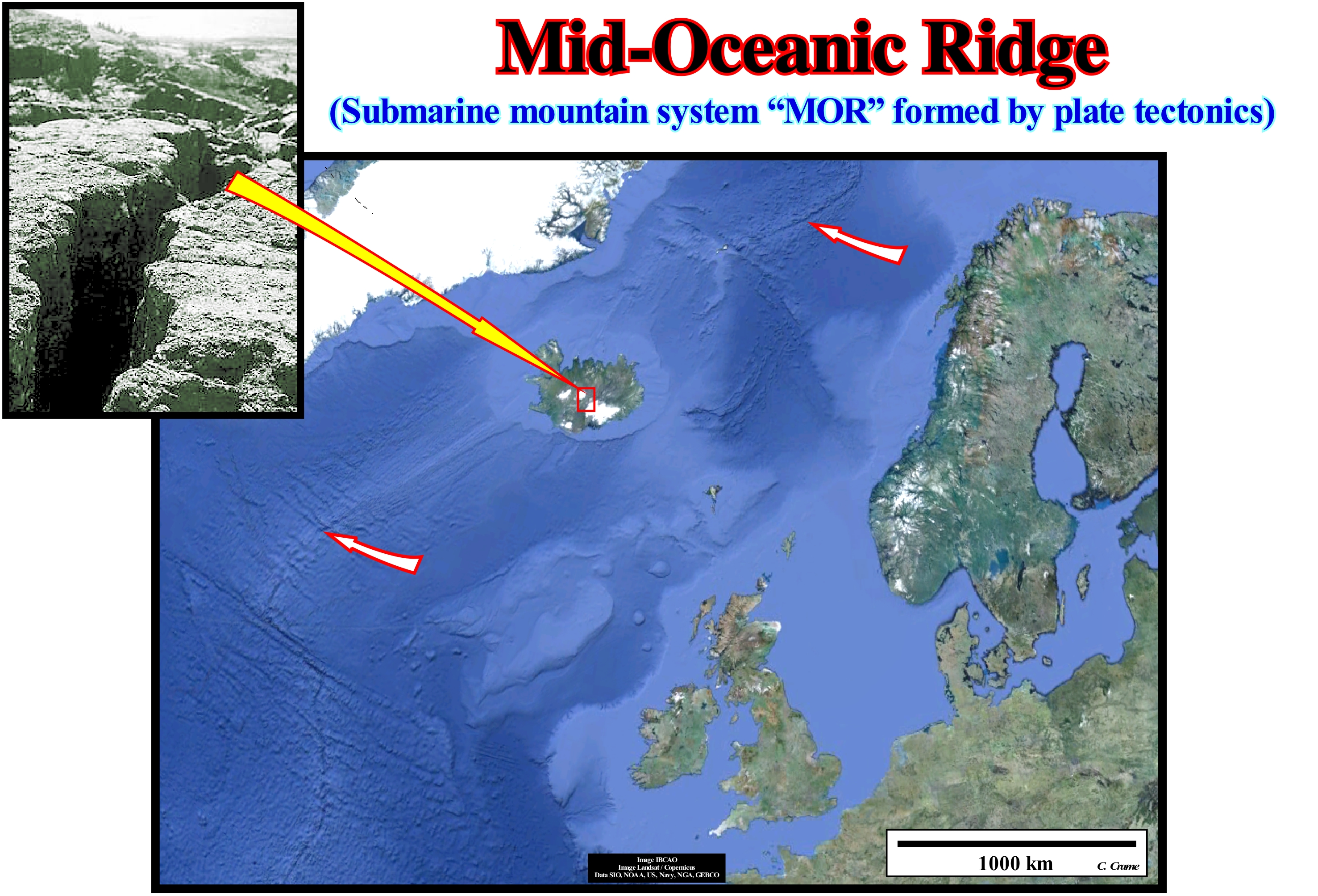
In Thingvellir, Iceland, the Atlantic mid-oceanic ridge is visible in outcropping as illustrated in this photograph. In this place, the lithospheric plate of North America and Europe move away, mutually, to allow the formation of new volcanic crust in the central valley (rift) that is the expansion centre (well visible in this figure). Before the break-up of the lithosphere, i.e., during the rifting phase, the continental crust is lengthened by normal faults forming rift-type basins, which are filled, mainly, by non-marine sediments. As these basins form, the continental crust thins and is injected by volcanic material. Over time and with the decrease in thickness of the continental crust, volcanic intrusions become preponderant and the lithosphere is broken creating two lithosphere plates separated by an expansion centre that is nothing more than a volcano, more or less, linear. From this moment on, all material of the asthenosphere reaching the surface (continental or subaerial environment) flows from each side of the expansion centre towards the continent. The thickness of the lavas decreases in the flow direction, which can reach several tens of kilometers. The stacking of the lavas produces an overload which, progressively, forces the subaerial expansion centres to immerse. From that moment (when the immersion is total) all the volcanic material arriving at the surface is under a significant water-depth and, therefore, it is obliged to consolidate quickly (formation of the ocean crust) since the volcanic material can not flow under water.
Mid-Oceanic Dorsal (Mid-oceanic ridge).........................................................................................Dorsale mid-océanique
Dorsal Média Oceânica / Dorsal medio-oceánica / Mid-ozeanischen Rücken / - 中洋脊 / Срединноокеанический хребет / Dorsale mid-oceanica /
Complex of submarine mountains adjacent to the median line of the ocean floor. The system of an oceanic ridge is, essentially, a segmented linear volcano. There are a large number of major oceanic ridges: (i) The Atlantic Ridge, which functions as the center of the Atlantic; (ii) The Eastern Pacific Ridge ; (iii) The Indian Ridge (southwest), etc. These ridges are centers of oceanization of the divergent margins, where the lithospheric plates move away from each other. The ocean ridges rise thousands of meters above the seafloor and can extend over 60,000 km.
See: « Sea floor »
&
« Sea Floor Spreading »
&
« Tephrachronology »
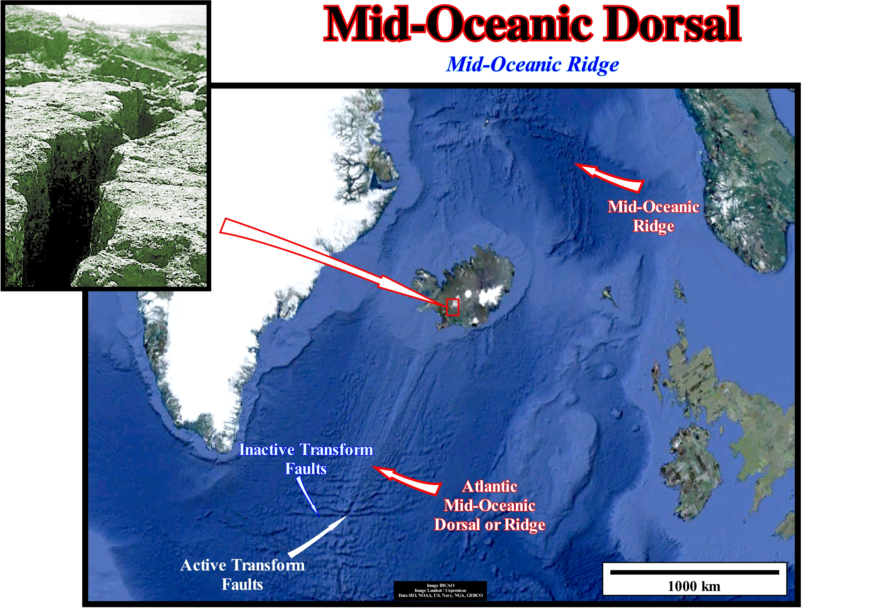
The mid-ocean ridges are the seamounts that are located in the middle of the Earth's oceans. They can reach an important height above the abyssal plain (more or less 2,000/3,000 meters). The mid-ocean ridges have a central fissure, called a rift, along which volcanic material, coming from the sublitospheric mantle, is emitted, more or less, continuously forming new volcanoes and portions of oceanic lithosphere. In this way the younger rocks are in the centre of the dorsal and near the rift. The age of the ocean floor increases as we move away from the oceanic rift. Over time (scale of millions of years), this oceanic spreading causes the ocean to become wider, so that the continents on both sides of the ocean move away from each other. The permanent renewal of the ocean floor by this continuous flow of magma makes the oceanic crust, generally, younger than the continental crust, at least in the nearer parts of the ridges. The central part of a mid-oceanic ridge (rift) can be seen, for example, in Iceland, as illustrated in the small photograph (above and to the left of this figure). Indeed, as the lithospheric plates (Europe and North America) move away, new oceanic crust is created in a slender (thin) lithosphere (rift) where sheeted dykes outcrop on the sea floor. In surface this region corresponds, more or less, to an elongated sink of sinking, formed by normal faults with opposite vergence. It can reach a few tens of kilometers wide and hundreds of kilometers long. The central depression, as stated above, is the rift of the mid-oceanic dorsal along which the new oceanic crust is injected. In this figure, it is interesting to note the displacement of the mid-oceanic dorsal by transform faults. These faults have nothing to do with shear faults (strike slip faults), as certain geoscientists thought, since they are only active between the segments of the mid-oceanic ridge. They individualize different lithospheric plates. The displacement, whether it is dexterous or sinister, is apparent. Contrary to another idea widely scattered among certain geoscientists, transform faults do not extend continentward. Are the continental fracture lines that condition the localization of the transform faults and not the opposite. This means that the sectors of the mid-oceanic dorsal, north and south of a transform fault may be totally independent of each other. It can not be said that initially there was a single dorsal that was split and displaced laterally by strike slip faults. Along the Atlantic margins, the strike of the recent transform faults correspond, exactly, to the strike of the fracture lines of the Pangea supercontinent, that is to say, of the supercontinent that formed at end of the Paleozoic. It was these fracture lines, which conditioned not only the location of the rift-type basins (sedimentary basins not to be confused with the rift of the mid-oceanic dorsal), formed during the lithosphere lengthening, but also the fracture areas of the lithosphere, directions of oceanic expansion and hot spots. As the central morphology of the mid-oceanic dorsal resembles the morphology of the Great Rift Valley, certain geoscientists have also given it the name rift, which creates misunderstandings. Indeed, what we call the rift-type basin has a similar morphology, but it corresponds to a stretching of the continental crust of a supercontinent followed by a sedimentary fill before the break-up of the lithosphere, that is, before the oceanization. The term Great Rift Valley* was given at the end of the 19th century by John Walter Gregory to the continuous geological trench, about 6,000 km long, extending from northern Syria to central Mozambique. The term vale rift continues to be used, but is considered, geologically, imprecise because it combines features that are now considered distinct.
(*) The Rift Valley is a complex of normal faults created about 35 Ma with the separation of the lithospheric plates African and Arabic. This structure extends in the North / South direction for about 5,000 km, from the north of Syria to the centre of Mozambique, with a width that varies between 30 and 100 km and, with a depth of a few hundred to thousands of meters.
Middle Bathyal..............................................................................................................................................................................................Bathyal moyen
Batial médio / Batial medio / Middle Bathyal / 中东深海 / Средняя батиальная область / Medio batiale /
Subenvironment batial, in which the water-depth varies between 500 and 1,000 meters.
See: « Bathyal »
&
« Abyssal »
&
« Lower Bathyal »
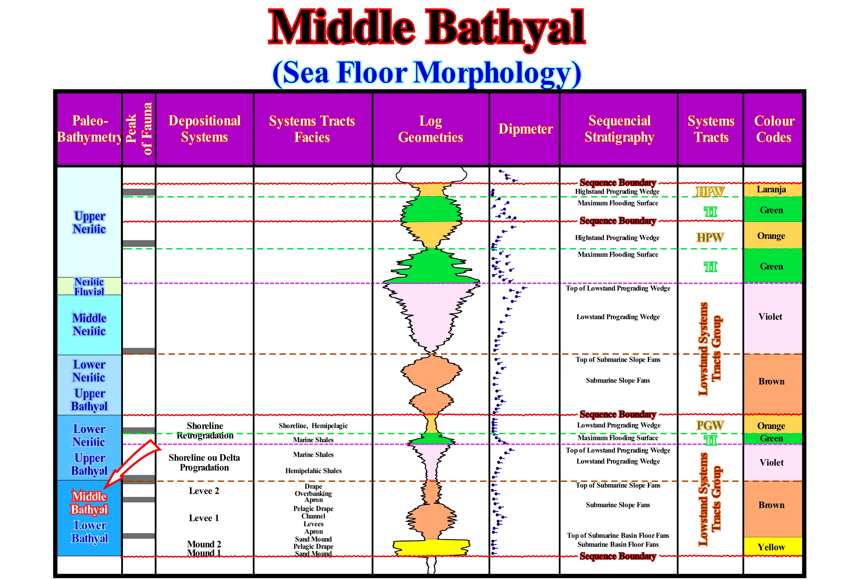
Unlike the sediments deposited in the lower bathyal sub-environment (apron domain and the natural marginal dykes or levees of the submarine slope fans), as can be seen from this sequential interpretation of an oil exploration well, sediments deposited in the middle bathyal sub-environment are, mainly, associated to "turbiditic channels" fills and pelagic envelopes. The "turbidytic channels" are, in most cases, the depressions (area without deposition) between the overbanking deposits, that is, the depressions where the turbidity currents pass. Later, these depressions are filled in retrogradation. The term "turbidite channel" or rather "turbidite channel fill" should just be used when there is erosion. The pattern in the electrical logs of sediments deposited in the middle bathyal sub-environment is very different from the pattern of sediments deposited in the lower bathyal. The pattern is thinning and fining upwards. In this example, in the middle bathyal sub-environment, there is a stacking of two submarine slope fans, separated by a pelagic interval relatively rich in fossils. The upper fan is poorer in sandy material. The boundary between the deposited sediments in the middle and upper sub-environment corresponds, in this particular case, to the limit between the submarine slope fan and the lowstand prograding wedge. This limit is marked by a hiatus by no deposition and underlined by a peak of fauna. The levels with better rock-reservoir characteristics and thicker ones are the fills of the "turbiditic channels" when the facies is sandy. The sandy levels of the natural marginal dikes (levees) are thin and limited in extent in order to accumulate significant amounts of hydrocarbons. In the Angola deep offshore most of the oil reserves are associated with the sands that fill the "turbiditic channels" of the submarine slope fans , which were deposited under a water-depth typically bathyal and probably middle bathyal. A relative sea level rise greatly affects the water-depth on the platform (coastal and neritic environment), but it has, practically, no influence on the water-depth of the continental slope (bathyal environment).
Middle Lowstand System........................................................................Système Moyen de bas niveau (De la mer)
Sistema médio de nível baixo (do mar) / Sistema médio de nivel bajo (del mar) / Durchschnittliche System-Low Level (Sea) / 均线系统低电平(海)/ Средняя система низкого уровня (море) / Sistema di medio basso livello (mare) /
Submarine slope fan (SSF). The group of lowstand systems tract (LST) is composed of three subgroups: (i) Upper, which consists of incised valleys (Ivf), submarine canyons fills (Scf) and lowstand prograding wdge (LPW ), with which are, sometimes, associated with slhingled turbidites ; (ii) Medium, which is composed by the submarine slope fans (SSF) and (iii) Lower, which is composed of the submarine cbasin floor fans (SBFF)) and contourites (when present).
See: « Lower Lowstand System »
Middle Neritic............................................................................................................................................................................................Néritique moyen
Nerítico médio / Nerítico medio / Middle neritischen / 内蒙古浅海 / Неритический (средне) / Neritico interno /
Marine environment characterized by a water-depth between 20 and 100 meters.
See: « Outer Neritic »
&
« Neritic »
&
« Shelfal Accommodtion »
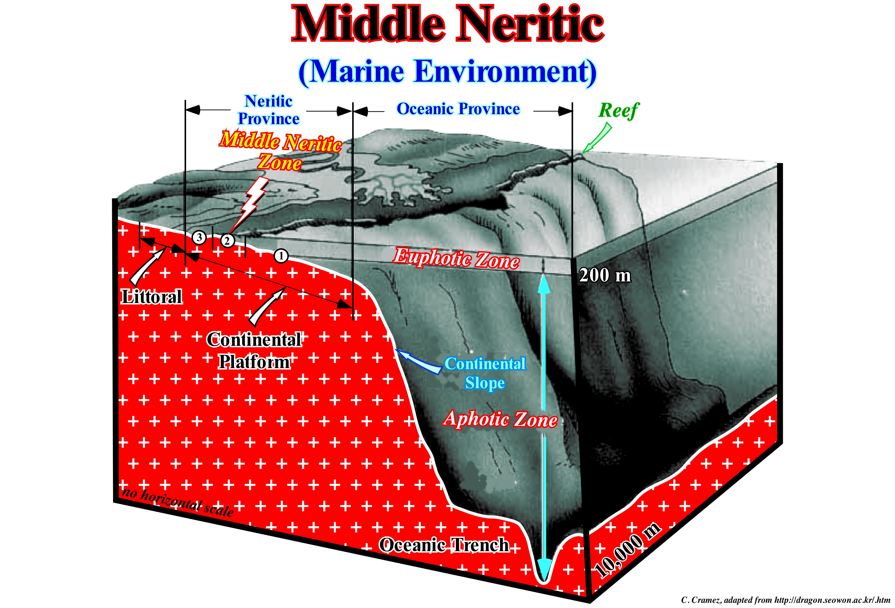
This diagram distinguishes the neritic province (water-depth between 0 and 200 m) and the oceanic province or blue sea. The first corresponds, more or less, to the continental shelf (between the shoreline and the basin edge, which may or may not coincide with the continental edge) and the blue sea surface area, i.e., up to 200 m deep. In certain geological conditions (lowstand geological conditions), when the basin does not have a continental shelf (shoreline coinciding, more or less, with the continental edge), the neritic zone corresponds just to the blue sea surface horizon. The neritic zone is, generally, divided into three sub-environments: (i) External Neritic Zone, characterized by a water-depths between 100 and 200 m ; (ii) Middle Neritic Zone, with a water-depth between 20 and 100 m and (iii) Internal Neritic Zone which is characterized by a water-depth between 0 and 30 meters. In the neritic zone, some geoscientists distinguish between a zone of transition between 0 and 5 m of depth, i.e., the brackish water domain (bays, lagoons, etc.) and the non-marine deposition zone. The outer neritic zone is, in general, a sector of low sedimentation rate. The upper part is part of the photic zone, but in the bottom part, the penetration of sunlight is insufficient for life to develop from photosynthesis (life that uses solar energy to convert carbon dioxide, CO2, in water and food). In general, it is in the middle neritic zone that the authigenic glauconite is formed, which geologists often use to differentiate a deep environment from a neritic environment using the so-called Selley criterion: (i) The presence in glauconite in the cuttings of a well suggests that these cuttings derive from a rock deposited in the middle-outer neritic zone, probably, in association with a transgressive interval (TI) of a sequence-cycle ; (ii) The presence in the cuttings of a well debris glauconite authigene and charcoal, strongly, suggests that they derive from a turbidite, i.e., from platform sediments transported and deposited rapidly in deep-water and (iii) the presence of remains of coal in the cuttings without authigenic glauconite suggests a non-marine environment.
Middle Sea Level (Mean sea level).........................................................................................................Niveau moyen de la mer
Nível médio das águas do mar / Nivel medio del mar / Meeresspigel, Seewaage / 平均海平面 / Средний уровень моря / Livello medio del mare /
Average height of the ocean surface (as the mid-point between mean high tide and mean low tide), used as standard in the terrain elevation calculation. Sea level varies greatly in time and space (distance). It is affected by tides, wind, atmospheric pressure, local gravity differences, temperature, salinity, subsidence, etc. To determine the mean sea level, the best thing to do is to choose a place and calculate the average level at that point and use it as a reference point. Generally, from hourly observations made over a relatively important period (± 30 years*), it can be calculated to be the mean for that measurement point. As a rise in sea level is perhaps the most familiar effect of climate change, and probably the one with the most consequences, it is important to always specify which sea level (eustatic, relative, medium, high-tide, etc.) and how it was calculated.
See: « Relative Sea Level Change »
&
« Eustasy »
&
« Highstand »
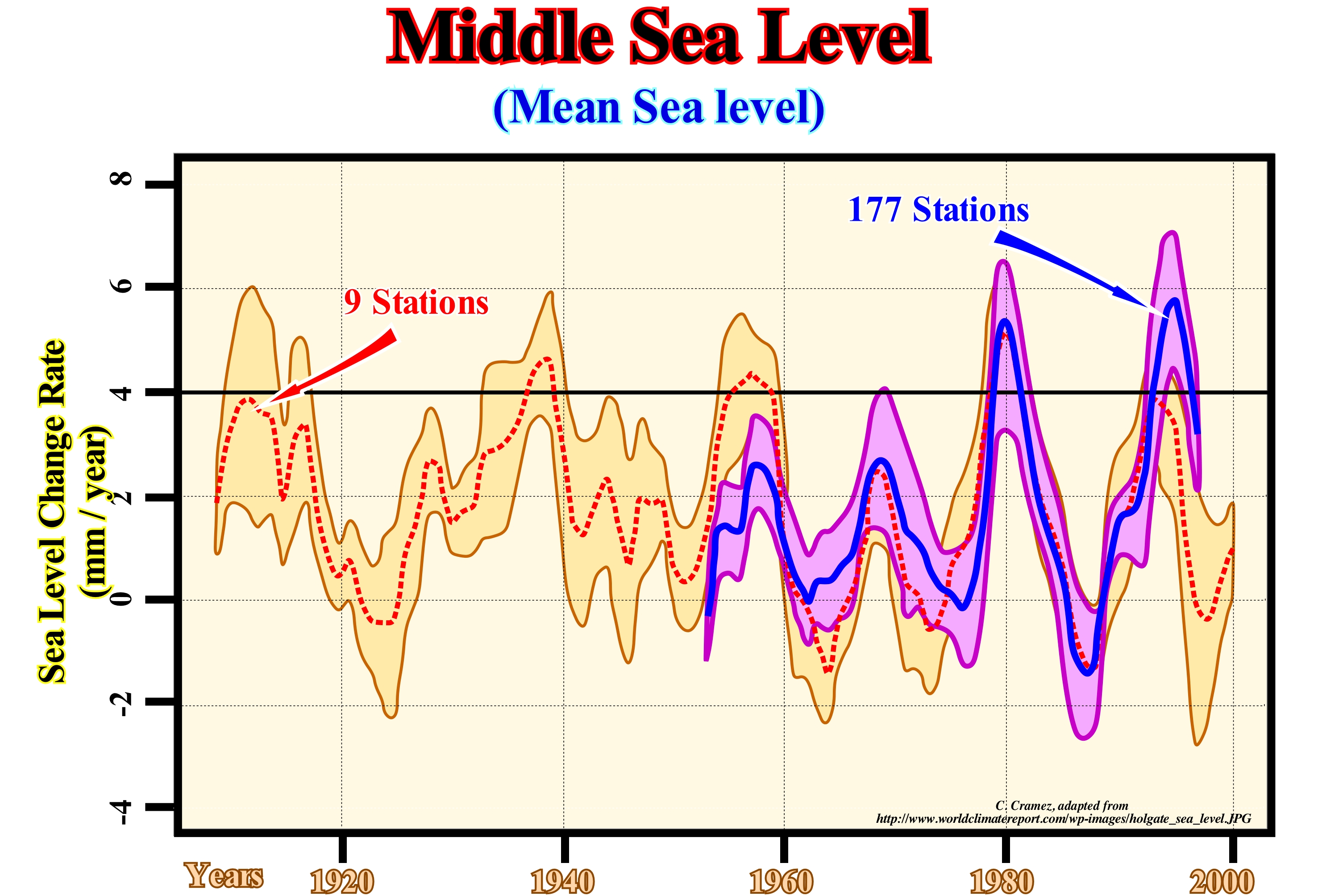
First of all when talking on sea level we need to specify what is the sea level considered. In fact, there are several sea levels. In sequential stratigraphy, the most commonly used sea levels are: (i) Absolute or eustatic sea level, which is supposed to be global and referenced to the Earth's centre and (ii) Relative sea level, which is local and referenced either at the base of the sediment (top of the continental crust), or to the sea floor at a given point, or any other point taken as a reference. The absolute (eustatic) sea level is a function of tectono-eustasy (controlled by the volume variation of the ocean basins), glacio-eustasy (controlled by the variation of volume of water of the oceans), geoidal-eustasy controlled by the distribution of the water of the oceans caused by the variations of the terrestrial gravity field) and thermal expansion of the oceans or steric sea level** increase (if the temperature of the oceans increases, the density of water decreases and, for a constant mass, the volume increases). The change in the amount of water in the ocean can be calculated from measurements of the ocean's mass , interpreted from data collected by satellites of Gravity Recovery and Climate Experiment program. With its two satellites that orbit Earth, precisely measuring anomalies in Earth's gravity field, GRACE is able to measure the changing mass of Earth' surface or interior (https://www.science.otg.au/curious/earth-environment/how-we-measure-global-sea-level-change-0). Satellite altimetry provides a total measurement of the sea-level rise, as the height of the ocean takes into account both thermal expansion and the addition of extra water from melting of glaciers and ice sheets. Comparing total altimetry data and GRACE mass data is another way to determine the steric contribution to total sea level rise. Relative sea level is, of course, the result of the combined action of absolute (eustatic) sea level and tectonics (uplift of the sea floor when the predominant tectonic regime are in compression or subsidence of the sea floor when the predominant tectonic regimes are in extension). Sea level varies, greatly, in time and space. It is affected by tides, wind, atmospheric pressure, local gravity differences, temperature, salinity, subsidence, etc. To determine the middle or mean sea level, the best thing to do is to determine a place and calculate the average level at that point and use it as a reference point. Generally, from hourly observations made over a, sufficiently, long period (30 years, for instance), the mean can be calculated for this measurement point. Thus, it can be said that the average sea level is the average sea surface elevation measured in relation to a reference land surface. The mean sea level is, in turn, used as a reference point from which the altitudes of topographic accidents are measured and the level curves and altitudes on the maps are marked. A concept related to the mean sea level is that of zero hydrographic (reference altitude from which the depths are measured). After checking the logs for several years (50 +/-), the smallest low-tide of this period is chosen, and even taking about 20/30 cm, there is, more or less, the hydrographic zero that, in general, is used in coastal hydrography and in the measurement of depths of ports and bars. In most cases, the hydrographic zero coincides with the mean sea level or has a simple and constant relationship with it. The determination of mean sea level has traditionally, been based on the readings of the tide gauges***, i.e., instruments that automatically record the tidal flux and reflux at a particular, point on the coast. The record produced, in the form of a graph, is called a maregram. By eliminating fluctuations due to waves, weather and tides and other astronomical factors from the collected data, a mean sea level reading is obtained for a given period by reference to the area used. The measures thus obtained incorporate the eustatic and isostatic effects and are, generally, chosen as a reference for stable geological environments, where isostatic and other variations that affect the altitude of the reference point are negligible, thus isolating only the eustatic effects. The geoid is considered, more or less, equal to the mean sea level. In the oceans they are roughly the same, but in the continental areas they may be very different. In Portugal the hydrographic zero is the lowest tide plane, in relation to which the probes and the isobathymetric lines of the charts are mentioned, as well as the tide height forecasts published in the Tide Tables of the Hydrographic Institute. This figure illustrates the calculation of mean sea level from 9 stations for a period of about 80 years (between 1908 and 2000) and 177 stations over a period of about 50 years. This means that the mean sea level change rate during a given period can not be expressed by a simple number, but by an accompanying number of variance (measure of the statistical dispersion indicating "how far" in 6-2 mm / year, which means that in certain places it was 6 mm/year, but in others, only 2 mm/year.
(*) An average whether it is sea level or temperature, to have meaning it must cover a rather long period. The World Meteorological Organization (WMO) recommends that it covers 30 years: from there one can speak of « normal ».
(**) The steric effect comes from the fact that every atom contained in a molecule occupies a certain space. If certain atoms are brought too close together, there is an energy expenditure associated with such an approximation. Indeed, a certain amount of energy is required to overlap the clouds of electronic orbital lobes (Pauli or Born repulsion). An expense or energy gain affects the normal form of the molecule and its properties. Roughly, an increase in temperature can be said to increase the size of the atoms.
(***) All sea level measurements taken from tidal gauges area recorded as "actual" and not adjusted for the effect of land sinking/rise. Measurements of the sea level height have been taken from satellite , such as Jason-2, since 1992. As this suggests. it is the height of the sea surface which is measured, by< calculating the distance between the ocean and the satellite. (httpa://notalotof peopleknowthat.files.wordpress.com/2014/10/th.jpg).
Migrated Line (Seismic)......................................................................................................................................................Ligne migrée (Sismique)
.Linha Migrada / Línea migrada (sísmica) / Migrierte Linie (seismische) / 迁移线(地震)/ Перенесенная сейсмическая линия / Linea migrati (sismica) /
Processed seismic line in such a way that the reflections are positioned, correctly, i.e., in their true vertical position (in time). In order to migrate a seismic line, accurately, it would be necessary to define, completely, the field velocity of the ground, i.e., to specify the velocity of the seismic waves at all points. In practice, to obtain a migration, an evaluation of the velocity field is made from the non-migrated version using all available data. Migration improves the resolution of seismic lines, since it focuses energy in a Fresnel zone* and destroys a large majority of the diffractions.
See: « Seismic Line »
&
« Unmigrated Seismic Line »
&
« Fresnel's Zone »
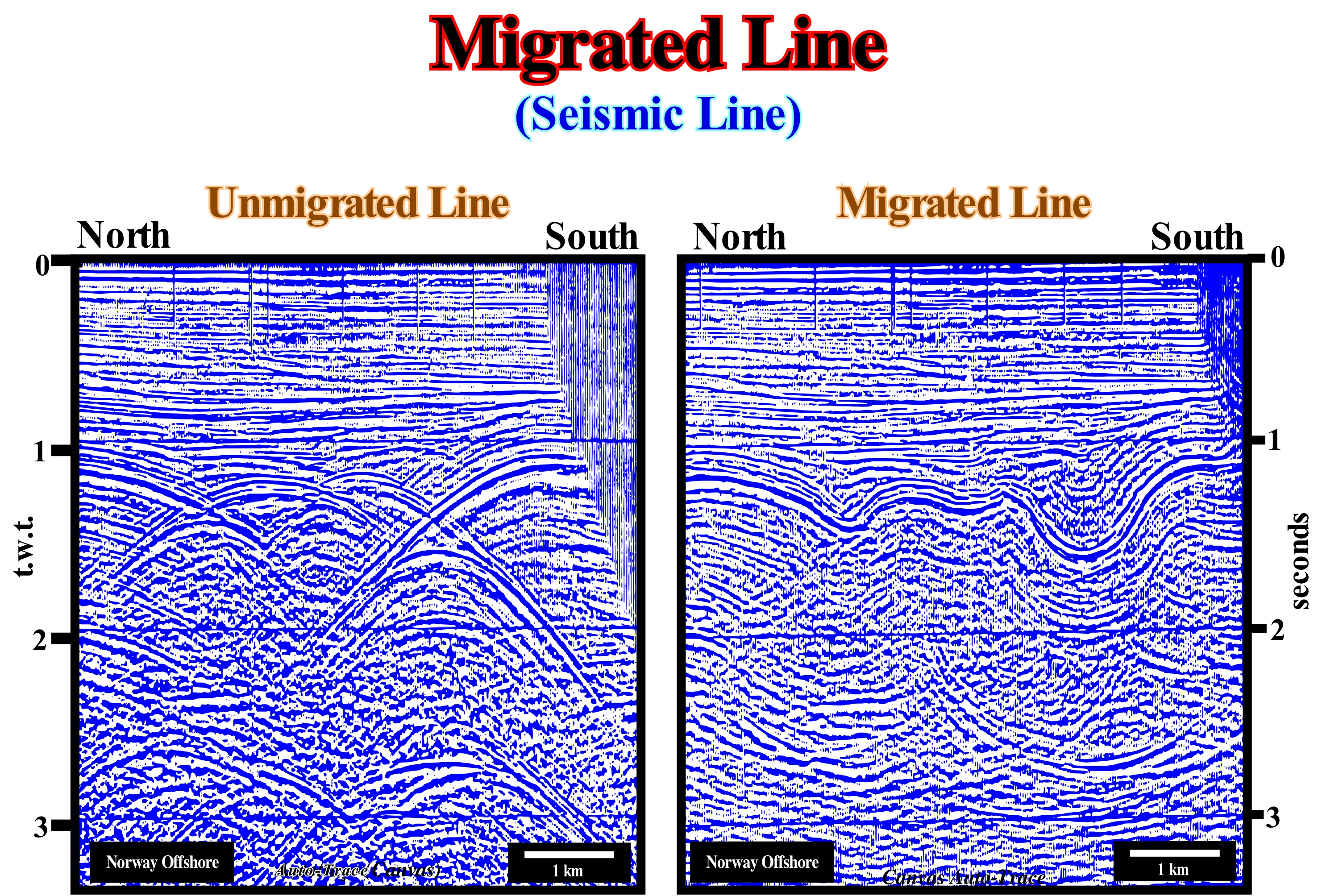
In this figure are illustrated two versions of the same detail of a regional seismic line of the offshore of Norway. The left line is non-migrated and the right line is migrated. A reflection point can be located in any part of the circle arc centred on the source-sensing position. In a unmigrated line, the reflection point is mapped so that its position is, immediately, underneath the source/detection. In a migrated line, the reflection point is positioned below its correct surface location and corrected vertical (time) reflection. A geoscientist with experience in stratigraphy and tectonics is able to propose a tentative geological interpretation, difficult to refute, of the migrated line (to the right), but not of the line not migrated. This is why, in the 1960s and 1970s, geological interpretation of unmigrated seismic lines was made just by geophysicists (more physical than naturalists) who knew the basic principles of seismic, but ignored, in most cases, those of geology. Thus tentative geological interpretations were made in a naive inductive manner, since the interpreters did not know what they had to observe. Even before the advent of migration, oil research officials realized that it was easier to explain to geologists the basic principles of seismic than to explain geology to physicists. From there, the interpretation teams became mixed and the geoscientists learned that: (i) The vertical scale is in time; (ii) Side velocity variations induce seismic pitfalls and (iii) Reflectors with geological significance are those that correspond to chronostratigraphic lines.
(*) Horizontal dimension of seismic resolution. Reflected seismic waves, constructively, interfere, where their trajectory differs from less than half a wave-length, and the reflecting surface portion surrounding such reflections is the first Fresnel zone.
Milankovitch's Curve.......................................................................................................................................Courbe de Milankovitch
Curva de Milankovitch / Curva de Milankovitch / Milankovitch Kurve / 米兰科维奇曲线 / Кривая Миланковича / Curva di Milankovitch /
A curve representing the amount of solar energy received by the Earth during a certain geological time and at a certain latitude (usually at 65° N).
See: « Milankovitch Cycle »
&
« Astronomic Theory of Paleoclimate »
&
« Climate »
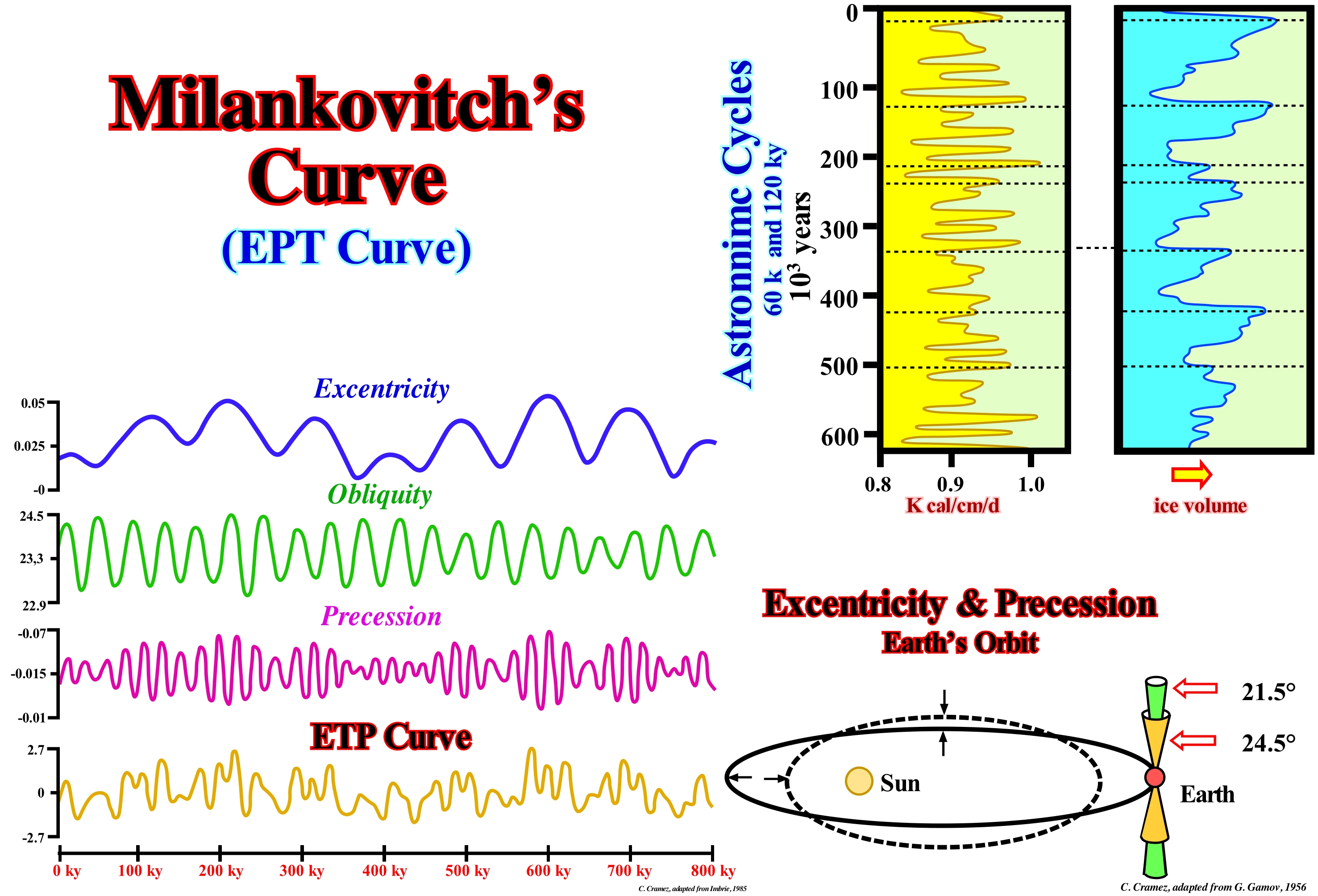
At any time or geological period, the Milankovitch curve is the curve representing the amount of solar energy received at latitude 65° N. It is, usually, constructed from the analysis of variations in the Earth's orbit. As illustrated in this figure, astronomical cycles have a very large influence on the solar energy received by the Earth. The correlation between the volume of ice and the heat energy* received from the Sun is excellent, as can be seen in the diagrams illustrated in the left part of the figure (do not forget that a good correlation does not necessarily mean causality). The main parameters that control this correlation are: (i) Precession, i.e., changes in the direction of the Earth's axis, which are cyclic and the cycle time is 22 ky ; (ii) Obliquity, since the Earth's axis is inclined and that the inclination varies between 21.5° and 24.5° with a period of about 41 ky and (iii) Eccentricity or Ellipticity, which measures the difference in form with respect to a circle, since the Earth's orbit is not a circle, but an ellipse, and that the eccentricity variations are cyclical of about 100 ky. When eccentricity and precession play in the same direction, the addition of its effects may be, particularly, important. During the Pleistocene, the main glaciations appeared every 100 ky, which, apparently, suggests a potential correlation with the eccentricity cycles of the Earth's orbit. The smaller glacial cycles seem to correlate, too, with the cycles of precession. Although the chronology of glaciations correlates, more or less, well with the Milankovitch curve, the amplitude does not seem to correlate very well. Astronomical cycles of 60 k and 120 k years appear to be corroborated by the curve of variations of ice volume, as illustrated (in particular in the northern hemisphere). Eccentricity variations show a strong cyclicity of about 400 ky. However, this cycle is much more evident in the climate records that precede the last few million years, which translate Earth's climate (hotter and colder periods, each lasting thousands of years). Either way, in this figure, the time scale is too small for them to be recognized. The Milankovitch curve and its theory on glaciations suggest that they occur when: (a) Summer begins in aphelion, that is, when the distance between the Earth and the Sun is greater ; (b) Eccentricity is maximal, that is, the distance between Earth and Sun in aphelion is the largest possible, which affects not only the relative intensity and duration of the seasons in the different hemispheres, but also the difference between sunshine maximum and minimum received during one year ; (c) Obliquity is low, which means that the difference between summer and winter is small and the latitudinal contrast is higher. Summarizing: A) According to the findings of M. Milankovitch (http://sigep.cprm.gov.br/glossario/textos/ Cicloestratigrafia_ e_Milankovith.pdf) the intensity of the effects of sunshine varies with latitude ; B) The influence of the inclination cycle of the Earth's axis of rotation, which lasts more or less 41 ky, is larger in the polar regions becoming weaker towards the equator ; C) The influence of the precession cycle, whose period is about 22 ky, caused by the variation of the distance from the Sun to Earth (the Earth's orbit is an ellipse) is smaller at the poles and larger at the equator ; D) The amount of solar radiation received at a given latitude is determined by the angle of inclination and the distance between the Earth and the Sun, which means that the radiation curve varies from the poles to the equator ; E) Hays et al. (1976), although corroborating the 41 ky and 22 ky periods, which represent, respectively, the obliquity and the precession, noticed that the dominant cycles in all the analyzed spectra varied between 94 Ky and 122 ky, which corresponds, more or less, to the period of eccentricity ; F) This cycle has a strong evidence in the stimulation of glaciations ; G) Its effects are caused by the variations that this cycle causes in the precession cycle ; H) The induction created by the precession implies a glacier thickening time greater than the thinning time ; I) The time of thickening (glaciations) is proportional to the cycle of 100 ky, with a rapid thinning of some thousands of years ; J) Glaciations occur when the summer begins in aphelion (when the distance between Earth and the Sun is maximum), when the eccentricity is maximum (affects not only the relative intensity and the duration of the seasons in the hemispheres, but also the difference between the maximum and minimum sunshine received during a year) and when the obliquity is low, which means that the difference between summer and winter or the latitudinal contrast is greater.
(*) There are two types of energy, the kinetic energy, that is, the ability to do work through the movement and the potential energy, i.e., the ability to do work through the position. Although we meet, often, terms such as electrical energy, heat energy, chemical energy, nuclear energy such things do not really exist. They are only practical abbreviations for specific combinations of the kinetic energy and potential energy. Thus, the electrical energy is only the potential energy of negative charge electrons in the presence of positive charges. The exception to this universality of the kynetic energy and potential energy is the energy of electromagnetic radiation, such as the energy of light, such as the one transported from the Sun to Earth and which heats us or aliments photosynthesis. (Peter Atkins. 2003- Le doigt de Galilée, Dunod, Parias 2004- ISBN 2 10 007338 9)
Milankovitch Cycle.......................................................................................................................................................Cycle de Milankovitch
Ciclo de Milankovitch / Ciclo de Milankovitch / Milankovitch Zyklus / 米兰科维奇周期 / Цикл Миланковича / Ciclo di Milankovitch /
One of the three climatic cycles induced by insolation*, which creates important changes in the cryosphere and, consequently, produces important eustatic changes. Several cycles of insolation (Milankovitch cycles) were recognized by Milankovitch with the periods of plus or minus 19, 23, 41 and 100 ky.
See: " Milankovitch's Curve"
&
" Milankovitch's Theory"
&
« Astronomic Theory of Paleoclimate »
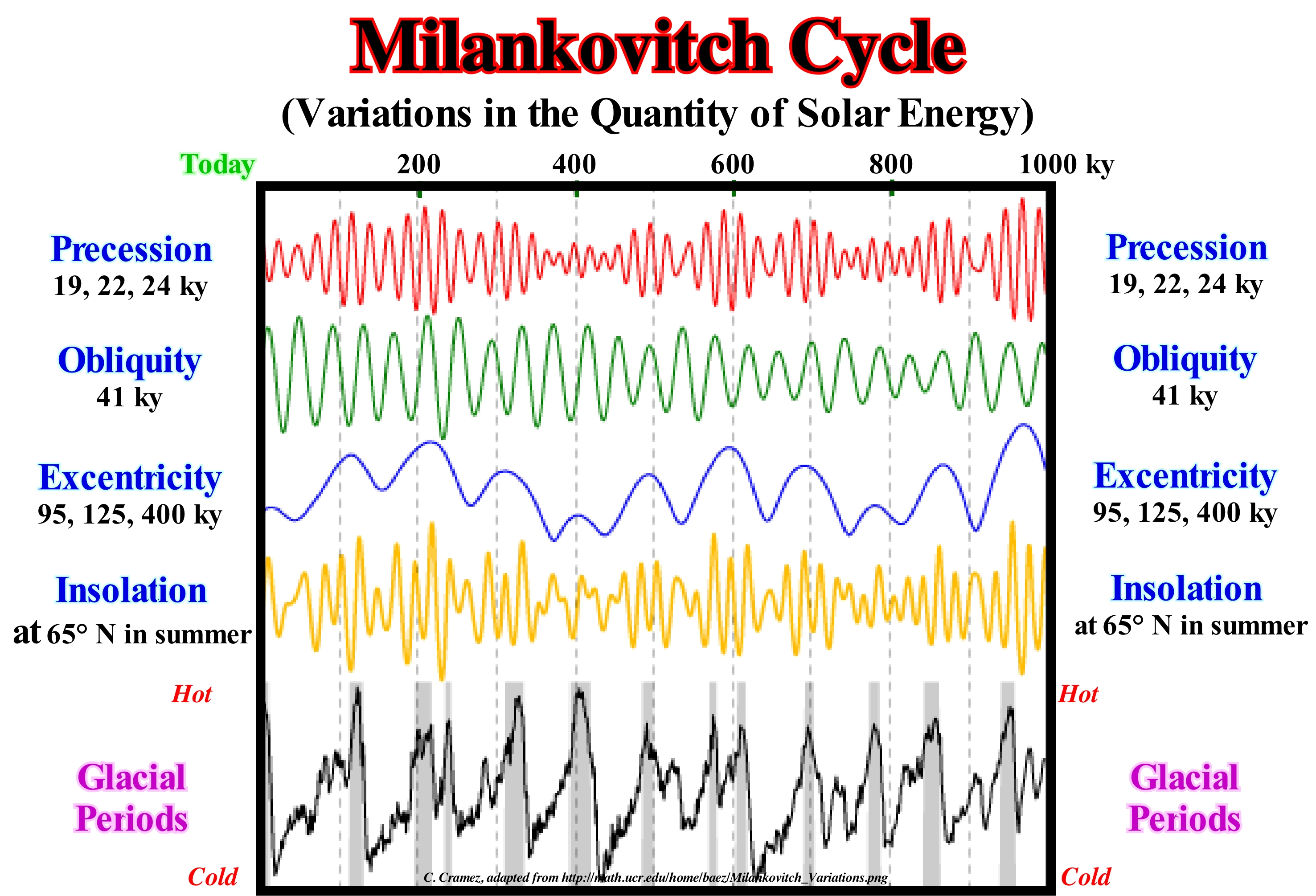
In recent millions of years, the glacial and interglacial episodes that the Earth has suffered appear to have been caused by cyclical variations in the Earth's motion around the Sun. Variations in the eccentricity of the Earth's orbit, the axial slope or obliquity, and precession of the axis of rotation of the Earth create three cycles, which together are known as Milankovitch cycles. The eccentricity** is away from a circular orbit, which is, usually, represented by values between 0 and 1, although values greater than 1 are observed in some comet orbits or certain space probes. The Earth's obliqueness is the angle between the axis of rotation and its orbital plane that remains confined between 21.8° and 24.4° and which is, currently, 23° 26' 14 ", but which recovers about 0.46" per year, i.e., 1 degree per 7,800 years. This small change from 21.8° to 24.4° is due to the presence of the Moon acting as a stabilizer on the Earth's equatorial protuberance. Typical variations in the obliquity have broad implications for the latitude of 65. Milankovitch, in 1920, calculated the effect of each of these cycles (eccentricity, obliquity, precession) on total summer sunshine at a latitude of 65 degrees N. He conjectured that at this latitude, small changes of sunshine could have a great effect since the decrease of the insolation in the summer would allow that the snow and the ice of the winter persisted during the months of summer and of the following winter. In this way, great layers of ice could develop and accelerate in a positive feedback by reinforcing the albedo in the northern latitudes. Precession is the movement that occurs when a moment is applied to a rotating body, in such a way that it tends to change the direction of its axis of rotation. The variations of these three cycles create great differences in solar radiation, which affects the Earth's surface, which influences the climate and, consequently, the thickening and thinning of the glaciers, which certain geoscientists call, advance and retreat des glaciers (a glacier is a current of ice, consequently, when it exists, it always advances). The first Milankovitch cycle, which is induced by the eccentricity (between 0 and 5% ellipticity) of the Earth's orbit, has a periodicity of 100 ky. The oscillations associated with eccentricity are crucial for the glaciations, since they reduce or increase the solar radiation received at the Earth's surface during the different seasons. The second cycle is induced by the inclination of the Earth's axis relative to the plane of the orbit around the Sun. This cycle produces oscillations of 41 k and for angles of inclination between 21.5° and 24.5°. Smaller is the inclination of the axis of rotation, more uniform is the distribution of solar radiation between winter and summer. The last Milankovitch cycle is induced by the precession of the axis of rotation, i.e., by the conical movement of the axis of rotation as the Earth rotates around it. In reality, as the Earth is spinning, the axis of the Earth does not align with the ecliptic axis (projection on the celestial sphere of the apparent trajectory of the Sun observed from the Earth) but precesses around it, in the same way as a spinning top rotates precesses around the vertical axis to the ground). The conical motion of the Earth's axis is made between the polar star and the Vega star. Sooner or later, the North will be given by the star Vega and no longer by the star. The periodicity of this conical movement or precession is 23 ky. When the Earth's axis is tilted to the Vega star, the positions in the northern hemisphere of the solstices (at which point the Sun, during its apparent motion on the celestial sphere, reaches the greatest declination in latitude, measured from the equator) winter and summer coincide, respectively, with aphelion and perihelion, which means that in the northern hemisphere winter is when the Earth is far from the Sun, which creates a great contrast between the seasons. At present, the Earth is in perihelion very close to the winter solstice. The sunshine curve combines information from the Milankovitch cycles and shows the amount of solar radiation at 65° north latitude. The lower curve of this figure shows the cyclicity of the glacial periods which more or less correlates with the insolation cyclicity.
(*) Quantity of solar energy received, but also can be synonymous with sunshine, i.e., the duration of exposure of a site to the Sun.
(**) In mathematics, eccentricity is a parameter associated with any conic, which measures its deviation from a circumference. The eccentricity of a circle is 0, whereas it is greater than 0 and less than 1 for an ellipse, 1 for a parabola, and 1 for hyperbola. The eccentricity of the Earth's orbit is 0.01671123, while the eccentricity of Mercury is 0.205630.
Milankovitch's Theory..............................................................................................................................Théorie de Milankovitch
Teoria de Milankovitch / Teoría de Milankovitch / Milankovitch Theorie / 米兰科维奇理论 / Теория Миланковича / Teoria di Milankovitch /
Astronomical theory of glaciations in which climate changes are the result of fluctuations in insolation, induced by variations in the Earth's orbit, eccentricity, rotation angle and perihelie's longitude. Most geoscientists admit climatic variations produce significant changes in the volume of ice on the continents, which produce absolute (eustatic) sea level changes. Milankovitch's orbital cycles have periods of 19, 23, 41 and 100 thousand years.
See: «Astronomic Cycle »
&
« Milankovitch Cycle »
&
« Equinoxial Precession »
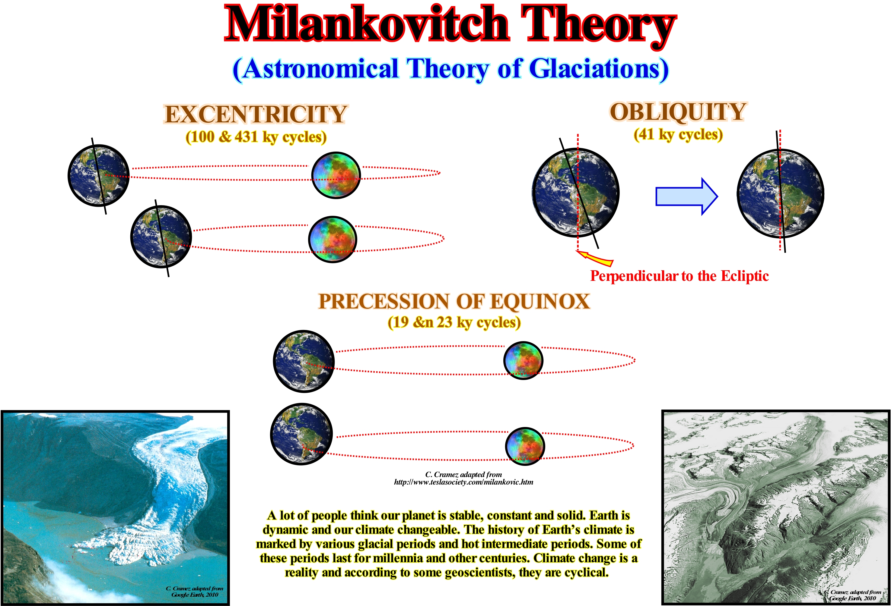
Milankovitch's theory or astronomical theory of climate changes* explains the changes of the seasons as the result of changes in the Earth's orbit around the Sun. The theory was named after the Serbian astronomer Milutin Milankovitch, who calculated the small changes in Earth's orbit to from meticulous measurements of the position of stars and mathematical equations using the gravitational pull of other planets and stars. He determined that the Earth swayed in the orbit just like a sniping top. Milankovitch also found it is the obliquity of the axis of rotation (above right in this figure) that causes the seasons and that any change of their position changes the intensity of the seasons. The variations in the obliquity of the axis of rotation of the Earth correspond to variations in the angle between the axis of rotation and the plane of the orbit, which remains confined between 21.8° and 24.4° (the axis of rotation oscillates around a cone with a complete cycle lasting 25,765 years). He also showed that the seasons can be, more or less, accentuated or modified by eccentricity (degree of roundness of the Earth's orbit around the Sun, top left), precession effect (retrograde movement of equinox points) and position of the solstices (time at which the Sun is at the furthest point from the equator of the Earth and seems to remain there for some days, 21 June and 21 December) in the annual orbit. Orbital changes occur in thousands of years and the climate system may thus take thousands of years to respond to orbital constraint. This theory suggests that the main cause of glacial epochs (the period of time during which the Earth was covered by thick layers of ice and snow) is the total amount of summer solar energy received in the northern latitudes where glacial ice caps formed in the past. Glacial epochs correlate with solar insolation at 65° N. The amount of solar energy that arrives per unit of time per unit area at a perpendicular to the sun's rays, at the average distance Earth/Sun, is called constant solar, and costs 1367 W/m2. However, due to the rotation of the Earth, the average energy incident at the top of the atmosphere per unit area and time is approximately 1/4 of the solar constant. In addition, the atmosphere reflects 39% of the radiation, so that only 61% is used to heat the Earth. The sunshine of a place is the amount of energy per unit area and time that arrives at that place, which varies according to place, time of day and the time of year. Astronomical calculations suggest that sunshine at 65° N should increase steadily over the next 25 ky and that no glacial epoch is likely in the next 50-100 ky (on this subject it is important not to confuse paleoclimatology with modern climatology). From the astronomical theories proposed to explain the origin of the glacial epochs, previous to the Milankovitch theory, the theory of the British scientist James Croll (1821-1890), that developed the first theory of the climatic changes based on the changes in the orbit of the Earth (https://it. wikipedia.org/wiki /Teoria_astronomica_delle_glaciazioni). According to Croll, the origin of secular climatic variations must be sought in secular variations in Earth's orbit, combined with the phenomenon of precession of the equinoxes and the displacement of perihelion, however, and to the difference of Milankovitch later, he did not ascribe to changes in elliptical inclination. (i) From the eccentricity of the orbit depends the different duration of the seasons of the year, whereas the precession depends on the position of the spring equinox, and therefore, the winter in a given hemisphere will happen to the earth in perihelion or aphelion ; (ii) Whatever the eccentricity and position of the equinox, the total amount of solar radiation received by one hemisphere is equal to the quantity received in the opposite hemisphere ; (iii) Intuitively, it is understood that if during a half revolution the Earth is closer to the Sun and the greater the intensity of the radiation received ; (iv) During the other half of a revolution, the intensity of the radiation is lower, but the duration of sunshine is longer ; (v) As the duration of the two winter is not the same, it will not be equal to the average daily intensity of the radiation received by the two hemispheres during the respective winter ; (vi) One hemisphere will have a long, cold winter, the other a short and relatively warm winter ; (vii) Precession, combined with the displacement of perihelion, changes paper in both hemispheres every 10,500 years approximately, and each hemisphere must therefore have a glaciation interspersed with interglacial periods, over a complete period of 21,000 years, and the (in this sense, the Croll theory does not differ much from that of Joseph Alphonse Adhémar (Paris, February 1797 - Paris, 1862).
(*) Taking into account both the duration and the magnitude of the climate changes, several geoscientists proposed the following hierarchy : (i) Pulsations, that last a few years or a few decades and which are, perfectly, reversible (e.g., series of years of raining or drought) ; (ii) Oscillations, that last from a few centuries to a few millennia, but are reversible (e.g., the Little Ice Age) ; (iii) The Fluctuations, that are spread out over tens, hundreds of thousands of years and have mark cyclic character (e.g., the evolution of the Quaternary) ; (iv) Mutations, that lasted millions, tens or hundreds of millions of years that have a irreversible character (e.g., irreversible upheavals of the Earth’s surface).
Minor Downlap Surface......................................Superfície de base das progradações secundárias
Surface de base des progradations secondaires / Superficie de base de progradaciones secundarias / Grundfläche von sekundären progradations / 小下超面 / Вторичная поверхность регрессивного налегания / Superficie di base di progradations secondarie /
Downlap surface associated with continental encroachment subcycles, sequence-cycles and sequence-paracycles. Potential secondary source-rocks are, sometimes, associated with the secondary (or smaller) downlap surfaces as, for instance, the Kimmeridgian clayey rocks in the North Sea rift-type basins.
See: « Stratigraphic Cycle »
&
« Systems Tract »
&
« Downlap Surface »
Theoretically, in the Phanerozoic there are two major downlap surfaces surfaces, once, that it has been deposited in association with two 1st order eustatic cycles (which has a time-duration greater than 50 My, usually between 250 and 350 My and that are induced by the break-up of supercontinents). The first is associated with the Paleozoic Eustatic Peak (more or less between the Cambrian and Silurian function of the geoscientists) and the second with the Mesozoic / Cenozoic eustatic peak (SBP 91.5 Ma). Secondary downlap surfaces are associated with 2nd order eustatic cycles, whose time-duration varies between 3-5 My and 50 My. Similarly, at the hierarchical level of the sequence-cycles, which are induced or deposited in association with 3rd order eustatic cycles (time-duration between 0.5 and 3/5 My), we can speak of 3rd order downlap surfaces. On this tentative geological interpretation of a Canvas auto-trace of a North Sea regional seismic line, the stratigraphic and paleontological results of oil exploration wells suggest that the most probable ages of the unconformities that define the different sedimentary packages are: SB. 21 Ma ; SB. 30 Ma ; SB. 36 Ma ; SB 39.5 Ma (?) ; SB. 49.5 Ma and SB 55 Ma. Theoretically, the age of an unconformity is the age of the erosional surface created by the relative sea level fall, which corresponds, more or less, to the minimum hiatus between the two sequence-cycles that the unconformity separates. The age of such a hiatus can be determined, roughly, by determining the most probable age of the submarine basin floor fans associated with the relative sea level fall. In practice such a determination can be made by dating the pelagic shales deposited between the submarine basin floor fans (layer E in the Bouma terminology of a turbidite layer). Erosional surfaces underlining these unconformities were induced by relative sea level falls that delimit 2nd order eustatic cycles (time-duration 3-5 to 50 My), and were, probably, induced by the combined action of the absolute (eustatic) seal level* changes and the velocity of tectonic subsidence changes (lengthening, cooling and tectonic loading). The intervals considered, on this tentative interpretation, do not correspond to sequence-cycles but, probably, to continental encroachment subcycles. Within these sedimentary packages, transgressive and regressive episodes are recognized. On the auto-trace illustrated in the left part of this figure just the most evident chronostratigraphic lines were drawn. On the right, is sketch a tentative interpretation made in continental encroachment sub-cycles, in which most of the reflector terminations (onlaps, downlaps and toplaps) that define the major seismic surfaces are mapped. The light violet coloured intervals represent the intervals deposited under lowstand geological conditions (sea level lower than basin edge). The green coloured intervals represent the transgressive intervals, formed by a, more or less, vertical succession of smaller and smaller sedimentary regressions, induced by increasingly important marine ingressions (in acceleration, which collectively have a retrogradational geometry). The regressive intervals, coloured in orange, which were deposited during highstand geological conditions, are constituted by a, more or less, vertical succession of increasingly important sedimentary regressions induced by increasingly smaller marine ingressions (in deceleration), which, collectively, creates a progradational geometry. The secondary downlap surfaces are, easily, recognized between the regressive and transgressive intervals Secondary potential source-rocks are, sometimes, associated with these downlap surfaces, which are induced by 2nd order eustatic cycles. By definition, the age difference between the two unconformities that limit a continental encroach sub-cycle varies between 3-5 My and 50 My, as well as, the age difference between upper and lower discordance, which limit a sequence-cycle can not be greater than 3/5 My.
(*) Absolute (eustatic) sea level is supposed to be global and referenced to the Earth's centre, while the relative sea level is the local and referenced to any fixed point on the Earth's surface, which is, often, the base of sediments (top of the continental crust) or the sea floor. The relative sea level is the result of the combined action of absolute (eustatic) sea level and tectonics (subsidence or uplift of the sea floor). The absolute sea level is the result of the combination of action of : i) Tectono-Eustasy ; (ii) Glacio-Eustasy ; (iii) Geoidal-Eustasy and (iv) Steric rise of sea level or thermal expansion of the oceans. In the upper 1,500 meters of the ocean, the steric contribution to sea level rise can be calculated from ocean temperature measurements recorded by the ARGO array - 3,890 free- drifting profiling floats (http:// www.argo.ucsd.edu/About_Argo.html) that measure temperature and salinity in the upper 2,000 m of the ocean.
Minor Unconformity (Interthem).............................................................................................................Discordance mineure
Discordância menor / Discordancia menor / Kleine-Diskordanz / 轻微差异 / Меньшее несогласие / Discordanza minore /
Unconformity limiting a stratigraphic unit with a thickness comparable to that of a geological formation or comparable to the time and thickness of a geological stage. Several smaller unonformities can, sometimes, be recognized within a synthem (discordant interval, i.e., limited sedimentary interval between two type I or type II unconformities). Synonym of Interthem.
See: " Interthem "
&
" Lithostratigraphy Unit "
&
" Synthem "
The Indonesia offshore and particularly the Kalimantan offshore (Borneo) corresponds to the stacking of three types of basins of the classification of the sedimentary basins of Bally and Snelson (1980) of different age, that from the bottom up are: (i) Precambrian Basement or Mesozoic Folded Belt ; (ii) Mesozoic / Cenozoic Backarc Basin, in which two tectonic stages can be recognized : a) The Rifting Phase, characterized by a differential subsidence and b) The Sag Phase, characterized by thermal subsidence and (iii) Recent Non-Atlantic Divergent Margin, which has formed since the break-up of the lithosphere occurred within the backarc basin, which created a marginal sea (South China Sea). On this tentative geological interpretation of a Canvas auto-trace of a detail of an Indonesia (East of the island of Borneo) offshore seismic line, three stratigraphic cycles called sequence-cycles (stratigraphic cycles induced by 3rd order eustatic cycles, i.e., eustatic cycles with a time-duration ranging from 0.5 to 3-5 My) can easily be highlighted. These stratigraphic cycles are limited by unconformities (SB 8.2 Ma, SB 6.2 Ma and SB 5.5 MS), which were created by significant falls of the relative sea level (local sea level, referenced to the sea floor or to the base of the sediments, that is to the top of the continental crust), which put the sea level lower than the basin-edge, since the coastal onlaps were, abruptly, displaced to the seaward and downward (progradation and negative aggradation). Each of these unconformities was dated using the paleontological studies of exploration wells and chronostratigraphic charts (Haq et al., 1986), since the wells in this region never reached the submarine basin floor fans associated with these unconformities, which allow them to date it, more or less, correctly. In fact, it is the age of the pelagic layer that is deposited between the submarine basin floor fans, which indirectly gives the correct age of unconformity, i.e., the age of relative sea level fall, since it underlines the minimum hiatus between the sediments underlying and overlying the unconformity. As the age difference between the unconformities SB. 8.2 Ma, SB. 6.2 Ma and SB. 5.5 Ma is always less than 3-5 My and greater than 0.5 My, the limited sedimentary intervals were conventionally induced by 3rd order eustatic cycles and thus can be considered as sequence-cycles. Within the sedimentary intervals that they define, that is, within these sequence-cycles, whose sedimentation rate is very high, there are unconformities, which certain geoscientists call minor unconformities*, which allow to consider stratigraphic cycles of lower hierarchy, which are, probably induced by 4th or 5th order eustatic cycles (time-duration between 0.01 My and 0.5 My). Some of these stratigraphic cycles, which many geoscientists call high-frequency or interthems, since the associated relative sea-level changes are very rapid, are complete. In this case, they are composed of all the systems tracts groups and subgroups that form a sequence-cycle, which from top to bottom are: (i) Highstand Systems Tracts Groups (HSTG), which is constituted by two subgroups : (a) High Prograding Wedge (HPW), whose progradational geometry is very well marked and contrasts as the subhorizontal geometry of the underlying systems tracts subgroup ; (b) Transgressive interval (IT), whose geometry is, globally, subhorizontal retrogradational and (B) Lowstand Systems Tracts Group (LSTG), which is, generally, formed from top to bottom by: (1) Lowstand Prograding Wedge (LPW), with a progradational geometry ; (2) Submarine Slope Fans (SSF), with the characteristic P. Vail's gull wings structures and (3) Submarine Basin Floor Fans (SBFF), with a parallel aggradational geometry, which may be disconnected from the lower break continental slope and directly overlain by the lowstand prograding wedge or even by the distal progradations of the highstand prograding wedge (HPW). When these high frequency cycles are incomplete are, usually, the highstand systems tracts sub-groups that are not deposited.
(*) This denomination is, certainly, due to the fact that these unconformities are not indicated in Exxon's Exploration Petroleum Research (EPR) chronostratigraphic charts.
Mississippian........................................................................................................................................................................................................Mississippien
Mississipiano / Mississipiano / Mississippium / 密西西比紀 / Миссисипский / Mississippiano /
Subdivision of the Carboniferous period which lasted from 359 Ma to 318 Ma. Like many of the other geological periods, the rocks deposited during this subperiod are easily identified, but their ages range from about 5-10 My. They are the rocks that appear along the valley of the Mississippi river that gave the name to this subperiod.
See: « Paleozoic »
&
« Geological Time »
&
« Geological Time Scale »
At the end of the nineteenth century, American geoscientists began to call the Mississippi to the lower carbonate interval of the Carboniferous, since it forms excellent outcrops in the Mississippi valley. In the same way, they called Pennsylvanian, the coal-rich upper interval, which outcrops quite often in Pennsylvania. Quickly, the Mississippian and Pennsylvanian were recognized as independent systems, and in 1953 the United States Geological Survey officially recognized them. Although the differentiation between the lower and upper part of the Carboniferous system is observed in almost every part of the world, the European geoscientists continued to admit a single system (Carboniferous). In the United States, the Mississippian consists mainly of limestone. In the state of Kansas, Mississippian rocks occur in almost all areas, except for the crests of uplift of the central part of the state (Cambridge arch), north and north-west of the Nemah anticline and other small regions where they were eroded by relative sea levels falls, which occurred in the Early and Late Mississippian, as well as in the Pennsylvanian. The relative sea level falls were, sufficiently, important to put the sea level below the basin edge, exhuming the continental shelves (where the basins had a platform). Such an exhumation exposed the Mississippian rocks to erosive agents, which were largely eroded. It was during this time that the most important phase of the orogeny, which formed the Appalachians, occurred. In the United States, the Mississippian is, often, divided into four stages: (a) Kinderhookian; (b) Osagean; (c) Merametian and (iv) Chesterian, while in Europe it is generally subdivided into three stages: (i) Tournasian, between 359 and 345 Ma (± 3.0 My) ; (ii) Visean, between 345 and 326 Ma (± 2.0 My) and (iii) Serpukhovian, between 326 and 318 Ma (± 2.0 My).
Mixed System (Deposition).................................................................................................................................................................Système mixte
Sistema Misto / Sistema mixto (depositación) / Gemischtes System / 混合系统 / Система смешанного типа / Sistema misto /
It forms when the basin has almost no continental shelf and therefore the bayline is very close to the shore line, which implies the formation of alluvial deltas (when the distal part of alluvial deltas or Gilbert delta reaches the basin edge ; gravitational landslides produce turbidity currents that deposit the sediments transported in submarine fans).
See: « Fluvial Deposition »
Moho (Mohorovičić discontinuity)..........................................................................................................................................................Moho (discontinuité)
Moho (discontinuidade) / Moho (discontinuidad) / Moho / 莫霍面 / Мохо (разрыв) / Moho (discontinuità) /
Abbreviation for Mohorovičić's discontinuity, i.e., the surface separating the Earth's crust from the underlying mantle.
See: « Crust »
&
« Asthenosphere »
&
« Sial »
Mohoroviĉiċ discontinuity (or Moho) limits the Earth's mantle crust. It lies more than 60 km underneath the mountain ranges and its thickness varies between 0.2 and 3 km. The Mohoroviĉiċ discontinuity is located about 5 km below the oceanic crust and between 30 and 50 km below the continental crust. Under the mountain ranges, where the continental crust is thicker, due to subduction zones of type A, the depth of Mohoroviĉiċ discontinuity reaches extreme depths, as, under the Qinghai plateau (Tibet), it is at a depth of about 75 km. This plateau is surrounded by important mountain ranges: Kunlun, to the north-west, separating it from the Tarim Basin and the Qilian Mountains that separate the Gobi desert plateau. This discontinuity: (i) Underlines an abrupt change in the velocity of seismic waves, as can be seen in the diagram to the left of this figure ; (ii) Corresponds to the horizon where the velocity of the waves P (the fastest waves, and consequently the first ones to arrive at a seismic station, and that move through the solid rocks and of the liquids) abruptly changes of 6.7 - 7.2 km /sec at the lower crust to 7.6 - 8.6 km/sec (mean 8.1 km/sec) at the top of the mantle and (iii) Represents a chemical change of basaltic or in simatic (rich in silicium and magnesium) at the top for a peridotitic or dunitic material at the base. A peridotite is a general term for a coarse granular rock composed mainly of olivine (iron and magnesium silicate having the formula SiO4 (Mg, Fe)2 with or without other mafic minerals such as pyroxenes, amphiboles or micas and which contains little or no feldspars (a dunite is a peridotite in which the mafic mineral is almost entirely olivine, with a little chromite which is practically always present). Some geoscientists think that Mohoroviĉiċ discontinuity underlines a change of basalt-eclogite phase (granular rock composed basically of garnet, almandin-pyrop, and pyroxene sodium, that is, omphacite).
Moho Discontinuity (Mohorovičić ).........................................................................................Discontinuité de Moho
Discontinuidade de Moho / Discontinuidad de Mohorovičić / Mohorovičić - Diskontinuität / 莫氏不連續面 / Граница Мохо / Discontinuità di Mohorovičić /č
Limit between crust and terrestrial mantle. The Moho's discontinuity, which lies, entirely, in the lithosphere, separates the continental and oceanic crust from the underlying mantle. Among the mid-oceanic ridges, the Moho's discontinuity marks the boundary between the lithosphere and the asthenosphere. Synonym with Mohorovičić's Discontinuity.
See: « Lithosphere »
&
« Crust »
&
« Mohorovičić's Discontinuity »
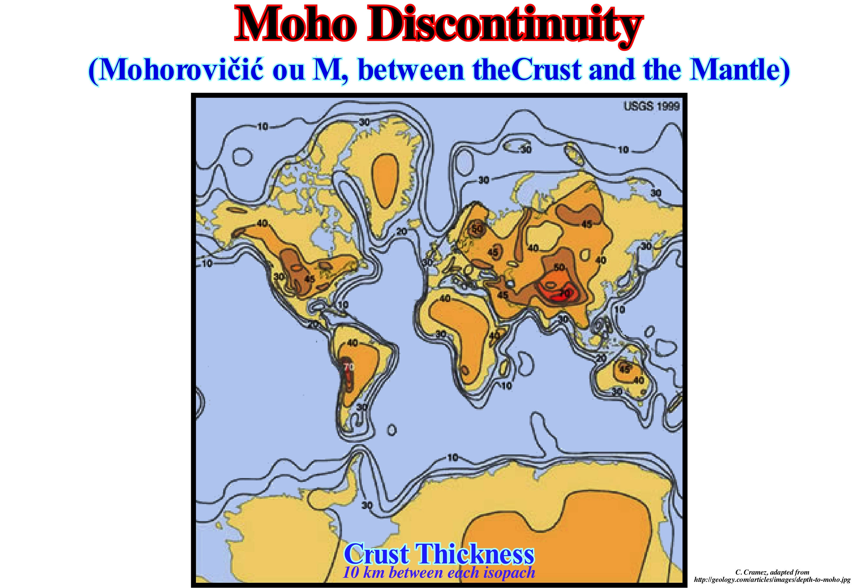
Mohorovičić's discontinuity was first identified in 1909 by Andrija Mohorovičić when he observed that in the seismograms of surface-focused earthquakes there are two sets of P and S waves, one following a path near the Earth's surface and another that was refracted by a high speed medium. The Moho or Mohorovičić discontinuity is about 5-10 km below the ocean floor and about 20-90 km below the continents (an average of 35 km). The map shown in this figure shows the thickness of the Earth's crust. The highest values (dark colours) are under the great mountains such as: Andes (west of South America), Rocky Mountains (west of North America), Himalayas (north of India in South Central Asia) and Urals ( North-South alignment between Europe and Asia). Immediately above this discontinuity, the velocities of the primary seismic waves (P waves) are those of basalt (6.7-7.2 km/s), and below (7.6 - 8.6 km/s) those of peridotites or dunites (ultramafic peridotite consisting mainly of olivine with pyroxene, plagioclase or chromite as accessory minerals). This suggests that it marks a change in composition. To this day, no one has been able to test Mohorovičić's discontinuity. The deepest well that has been drilled to date has been located on the Kola peninsula (Zapoliarny well, from the name of the nearest Russian town, which began on May 24, 1970 and ended in 1989, was aimed at drilling the as deep as possible, about 15,000 meters in order to cross the earth crust to better understand its composition and the internal mechanisms of the Earth and eventually recognize the discontinuity of Conrad or Mohorovičić). This well reached a depth of about 12 km. This drilling to reach Moho discontinuity was a failure. The Russian geoscientists found no transition up to 12 kilometers deep (more or less the total depth of the well). However, there are outcrops of mantle material that were brought to the surface by tectonic deformations. Note that in geology, the term discontinuity* is not always used to designate a surface that marks a velocity change of the seismic waves, as in the case of Mohorovičić's discontinuity (sometimes referred to as "Moho").
(*) In geology, there are several types of discontinuities: 1- Stratigraphic ; 2- Sedimentary ; 3-Lithologic ; 4 - Tectonics, etc. Within the lithologic discontinuities, which are the most important in sequential stratigraphy, we can recognize: (i) Concordant discontinuities, when there is continuity between successive intervals ; (ii) Paraconform Discontinuities or Paraconformities, when there is no difference in attitude between overlapping intervals, but there is a hiatus due to the absence of significant deposition between them ; (iii) Non-Conform Discontinuities or Non-Conformities (which certain geoscientists call Heterolithic Unconformities), when there is a contact between a sedimentary interval and an older igneous body ; (iv) Discontinuous Discontinuities or Disconformities, when the layers of the intervals are parallel on one side and the other side of the contact surface which does not conform to the regional bedding ; (v) Discordant Discontinuities or Unconformities when the two ranges are separated by an erosion surface induced by a relative sea level fall ; (vi) Enhanced Discontinuities or Tectonic Enhanced Unconformities when the sediments of the interval underlying an unconformity were deformed by tectonics (shortened or lengthening ); (vii) Intrusive Discontinuities, when an igneous body traverses a sedimentary series ; (viii) Mechanical Discontinuities, when they are induced by failures, etc. (https://estpal13.wordpress.com/ 2013/06/04 / discontinuities-sedimentary-and-stratigraphic /).
Mohorovičić Discontinuity (Moho).....................................................Discontinuité de Mohorovicic (Moho)
Discontinuidade de Mohorovicic (Moho) / Discontinuidad de Mohorovicic (Moho) / Mohorovičić-Diskontinuität / 莫氏不連續面 / Поверхность Мохоровичича / Discontinuità di Mohorovičić /
Mohorovičić's discontinuity, which lies entirely in the lithosphere, separates the continental and oceanic crust from the underlying mantle. Among the mid-oceanic ridges, the Mohorovičić's discontinuity marks the boundary between the lithosphere and the asthenosphere. Synonym with Moho's Discontinuity.
see : « Crust »
&
« Conrad's Discontinuity »
&
« Gutenberg's Discontinuity »
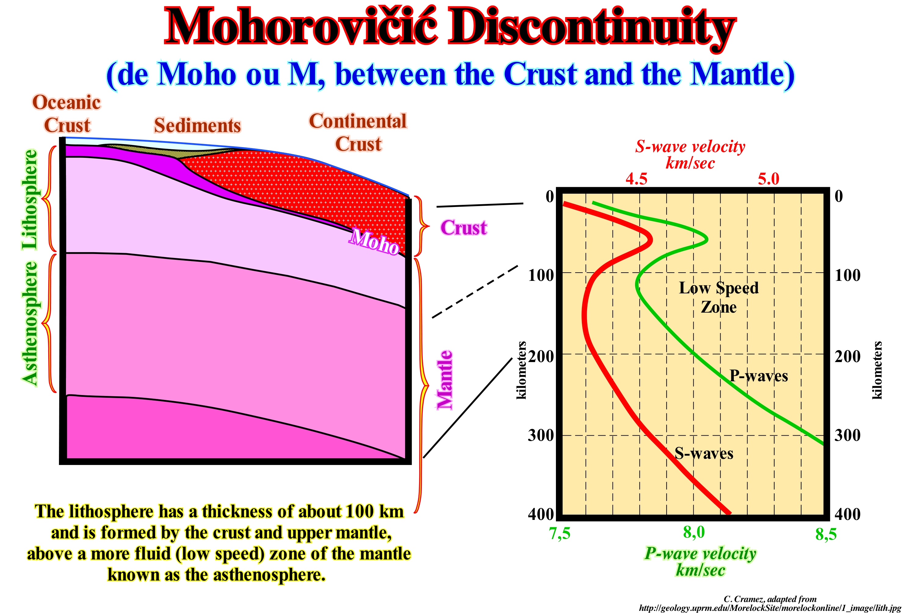
On October 8, 1909, a strong earthquake struck the Kupa River valley, with the epicentre near Pokupsko (40 km southeast of Zagreb). The buildings in brick and stone were badly damaged, but there was no damage in the houses built in wood. The earthquake was recorded at seismic stations in many European countries. Mohorovičić to study the earthquake in more detail, asked his European colleagues to send him copies of the seismograms or readings of the arrival time of the waves. The arrival phase of the main pulse and replicas, as well as a large majority of the earthquakes that occurred between 1904-1905, allowed Mohorovičić to understand how earthquake waves propagate through the Earth's interior, which is illustrated in diagram from the right of this figure. Mohorovičić discovered the existence of a discontinuity surface, called Mohorovičić discontinuity today, and hypothesized that there should be reflections associated with seismic waves. Mohorovičić also calculated a table of theoretical travel times for seven fundamental reflections that correlated well with the observed data from, at that time, unidentified phases. The discovery of this discontinuity within the Earth has become a solution to one of the first problems of inversion in geophysics, that is to say, that on the basis of the data observed at the Earth's surface, the properties of the terrestrial layers can be determined the seismic waves propagate. In this way, certain seismic methods have been and are still used to determine the properties of the Earth's interior, inaccessible to direct measurements. Mohorovičić discontinuity, as illustrated above on the left, is the greatest natural event on our planet as it exists in all parts of the Earth. On average it lies at a depth of 33 km (under the oceans it is shallow between 5 and 10 km, but under the mountains can reach 70 km). The greatest depths are found under the great mountains such as: Andes (west of South America), Rocky Mountains (west of North America), Himalayas (northern India in South Central Asia) and Urals (north-south alignment between Europe and Asia).
Momentum (Linear, impulse)........................................................................................................................................................................................Moment (Linéaire)
Momento / Momentum (lineal) / Schwung, Momentum /动量(线性)/ Импульс (линейный) / Momentum (lineare) /
Vector that has a magnitude and a direction. The moment quantity is equal to the mass of the moving object multiplied by the velocity. The direction of the moment is the same as the direction of the object's velocity.
See: « Orbit »
&
« Kynetic Theory »
&
« Transportation (sediments) »

Linear momentum is a physical quantity given by the product of mass by the velocity of a body. Linear momentum is a vector quantity, with direction and direction, whose modulus is the product of mass by the velocity module, and whose direction is same as velocity. The total amount of movement of a set of objects remains unchanged, unless an external force is exerted on the system. This property was perceived by Newton, who defined and demonstrated the amount of movement and its conservation. In physics it is said a system is mechanically isolated when the sum of the external forces is zero. The amount of movement is the only quantity that is conserved after an inelastic collision if the system is, mechanically, isolated. The unit of linear momentum in the International System is the kilogram meter per second (kg.m/s). If we consider a couple skating on an ice rink and despise the effects of air and the frictional forces between the track and the skates they are wearing, by the time they are together, they act with the same magnitude, but in opposite direction. In the vertical, the force weight is balanced with the normal one, that is to say P = N, in the man as in the woman. Horizontally, at the moment of the push, both the man and the woman push each other, since they act in forces of action and reaction, FHM = - FMH, hence FHM + FMH = 0, since forces in all the directions cancel out, which ensures the conservation of linear momentum. The conservation of linear momentum allows us to calculate the ratio between the speed of man and the speed of the woman after the push, known its masses and initial velocities. Since the total momentum is to be conserved, the variation of the velocity of man is VH = - MM / MHVM, where MV is the variation of the speed of the woman. The variation of the momentum is often called impulse (physical magnitude that measures the change in the amount of movement of an object): I = ΔP = Pf - Po I, whose unit used is N.s (Newton x second).
Monadnock.......................................................................................................................................................................................................................Monadnock
Monadnock / Monadnock / Inselberg / 莫纳德诺克 / Остаточный холм / Monadnock /
Erosional residue on a peneplain. A prominent steep hill formed by hard and consistent rocks, rising abruptly from a low relief plain "(Whittow, 1984). Also called "inselberg", although this is characteristic of tropical landscapes, particularly savannah areas (in the hyperarid desert of Namibia there are granite inselbergues hundreds of meters high). Synonym with Inselberg.
See: « Erosion »
&
« Inselberg »
&
« Relative Sea Level Fall »
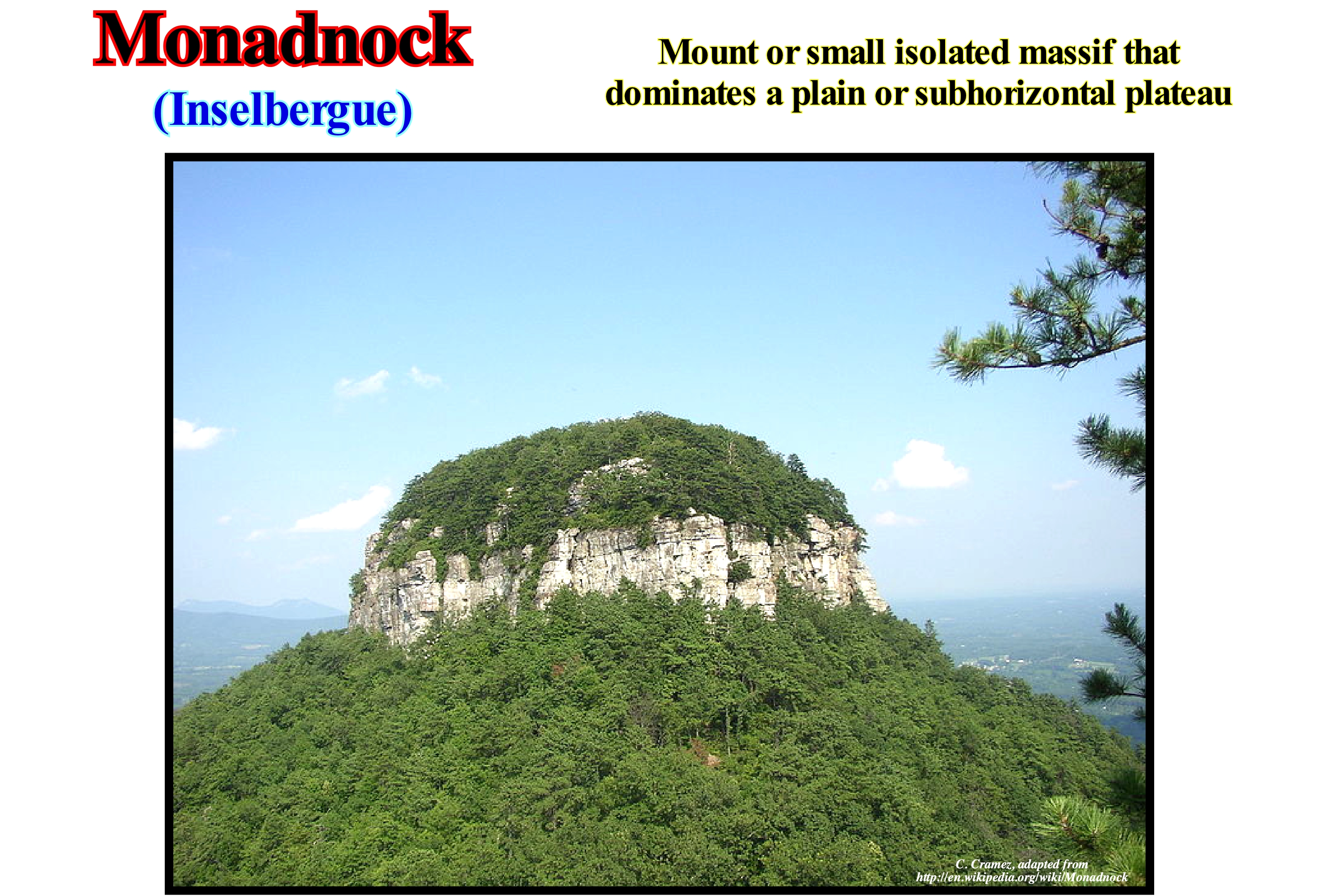
"Monadnock" is the term that North American tribes used to designate an isolated hill, or less, important that resisted erosion. American geoscientists have taken this term from Monadnock Mountain in south-western New Hampshire (it is thought that this term is derived from the Abenaki language, from the term "menonadnocke" meaning rounded mountain or "menadena" meaning isolated mountain). This photograph illustrates the monadnock of "Big Pinnacle" of Pilot Mountain, North Carolina (USA). As can be seen, it can be said that a "monadnock" or "inselberg" (a German term for a mountain island used by eighteenth-century explorers) is a mountain, more or less, isolated, a ridge or a small mountain, rises abruptly from a plain (which may be slightly inclined) and on the flanks of which there may be a, more or less, developed pediment (erosional surface that forms the base of a mountain or retrogradtional escarpment). In the central and southern part of the African continent there are many granite monadnock that the natives call "kopje". The presence of a "monadnock" or "inselberg" typically suggests the existence, not far from either a plateau or its remains. This is especially evident in the case of sedimentary inselbergues, which, in general, exhibit the same stratigraphic units as the surrounding plateaus. There are also "monadnocks" created by volcanic intrusions, in that they are almost always harder and more resistant than the rocks they invade. Erosion wears away the less resistant rocks to form a plain, while the hardest, that is, the volcanic intrusions, resistant longer and form an isolated mountain, which in time (geological) will disappear as well.
Monsoon............................................................................................................................................................................................................................................Mousson
Monção / Monzón / Monsun / 季风 / Муссóн / Monsone /
Inversion of the seasonal wind accompanied by changes in precipitation. Monsoon is, currently, used to describe the seasonal changes in atmospheric circulation and precipitation. The most important monsoon systems occur in West Africa and Asia-Australia.
See: « Global Change »
&
« Climate »
&
« Relative Sea Level Change »
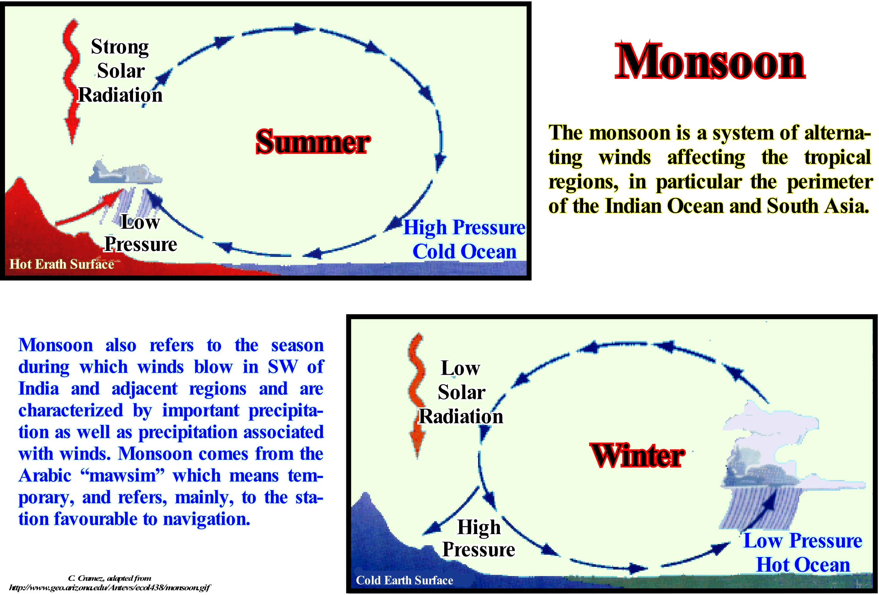
The monsoon effect is caused by the seasonal appearance of large thermal differences between the seas and adjacent continental regions in the areas near the outer edges of the Hadley cell*. The difference in temperature is generated due to a much lower thermal capacity of emerging surfaces in relation to the maritime regions. The rocks that constitute the soils have a, relatively ,low thermal capacity when compared to that of the water, in addition to the fact that the temperature variation in general does not propagate in each season of the year beyond 1 to 1,5 m below the surface. This reality contrasts with the sea surface, where the much greater thermal capacity of the water adds to the existence of convection and vorticity induced by the winds and rains that lead to the appearance of a layer of mixture, of temperature, relatively homogeneous, that in general around 50 m thick. The amount of heat in each hot season is absorbed and accumulated in sea water and is, incomparably, greater than that accumulated on land. As a consequence, land areas heat up much more rapidly during the hot season, but also cool even more rapidly during the cold season. As a result of these different dynamics, during summer, the earth is warmer than sea water, so that the warm air on the continent tends to rise, creating an area of low atmospheric pressure on the region, which contrasts with the air cooler situated on the sea where an anticyclonic region forms. In turn, this difference in atmospheric pressure creates a constant wind in the direction of the sea to continent, carrying to the continent maritime air rich in humidity. This air, when elevated by the convective effect, particularly when the zone of intertropical convergence or the presence of mountains is present on the region, cools, causing condensation and rainfall. Between the latitudes of 30° N and 30° S, the atmosphere is characterized by low temperature amplitudes, which characterizes a region with predominant weak winds.
(*) Closed circulation model of the terrestrial atmosphere predominant in equatorial and tropical latitudes. This circulation is, closely, related to trade winds, humid tropical zones, sub-tropical deserts and jet streams. There are three primary circulation cells, known as the Hadley cell, Ferrel cell and Polar cell. (https://en.wikipedia.org /wiki/Hadley_Cell)
Moon.........................................................................................................................................................................................................................................................................Lune
Luna / Luna / Mond / 月 / Луна / Luna /
Earth's natural satellite and the fifth largest natural satellite in the solar system. A satellite is a natural object (man is for nothing in his creation) in orbit around a planet, such as the Earth around the Sun.
See : « Earth »
&
« Apside »
&
« Aphelion »

The average distance from Moon to Earth is about 384,400 km. The diameter of the Moon is 3,476 km, that is 27.3% of the Earth's diameter. The surface of the Moon is 0.074 times that of Earth. The volume of the Moon is 0.20 times that of Earth. The mass of the Moon is 0.1123 times that of Earth and the force of gravity at its equator is 16.54% of the Earth's gravity at its own equator. The Moon revolves around the Earth in 27.3 days. The moon also turns on itself in 27.3 days. Because of this equality between rotation and revolution, the Moon always presents the same face to the Earth. It lies in the same position in the sky all 29.5 days. There is no atmosphere on the Moon. Even during the day, the sky on the Moon is always black. There are also no earthquakes or volcanic eruptions, at least since life appeared on the Earth's surface. In this way, viewed from the Earth, the Moon with its spots, mountains and craters is exactly the same since the first living organisms appeared on the Earth's surface. From Earth, we always observe the same face of the Moon (the first photos of the face hidden from Earth were made by a probe in 1959). The most flagrant effect of Earth's gravity on Earth is manifested by the tides. The seas of our planet when they are facing the Moon are strongly thrown by it, by reason of their proximity, which causes a rise of the level of the seas of that side. In the same way, the seas, which are on the opposite side of the Moon, are less thrown by it, since they are further away which creates a falling from sea level. Although the force of gravity of the Sun is stronger than that of the Moon, its effect on the tides is about 2/3, because of the great distance that separates the Sun from the Earth. When the Moon is, more or less, aligned with the Earth and the Sun, the tides brought about by the Moon and the Sun are added, which produces much more important tides (spring tides, which naturally occur twice a month). In the same way, when the Moon is in the fourth or last quarter (quadratures), the tides have a minimum amplitudes (neap tides). Because of the tides, the Moon influences the race of time on Earth. The energy dissipated by the tides slows down the Earth's rotation. The length of the day lengthens little by little. From six o'clock in the beginning, it has grown to 24 hours today and in a few billion years it will be worth fifty today. The moon ensures the maintenance of the axis of rotation of the Earth, whose angle with the vertical remains stuck between 21 and 243 degrees. Without the moon to act on the bulge of the equator, the axial stability would disappear and, in which millions of years, the axis of the Earth would oscillate in a chaotic way at angles ranging from 0° to 85°, destroying all climatic stability. Note that the Moon is formed by a crusty anorthosite, mantle and nucleus, whose outer part is liquid (assuming that 10% crystallized).
Moraine.................................................................................................................................................................................................................................................Moraine
Moreia / Morena (o morrena) / Moräne / 冰碛 / Морена / Morena /
Accumulation of pebbles and coarse sand, not stratified, with mound or crest shape, deposited by the direct action of a glacier, that rests on a great variety of topographic forms. There are several types of moraines, some that form landscapes, easily recognized, and others that exist only when the glacier is still present. The moraines associated with the presence of a glacier are: (i) Supraglacial moraines and (ii) Englacial moraines (moraines on the glacier).
See: « Sedimentary Environment »
&
« Glacio-Eustasy »
&
« Fluvial Deposition »
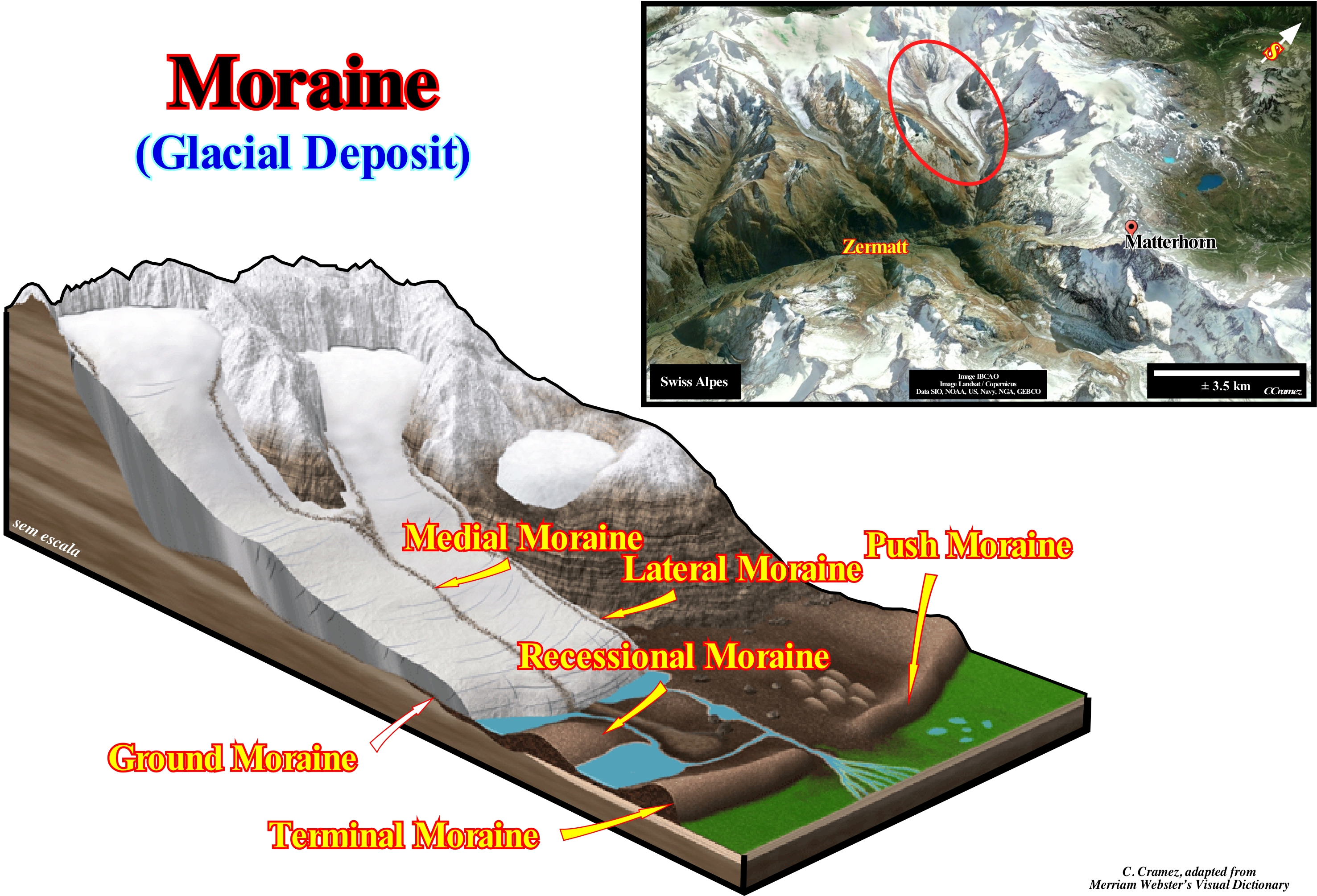
Valley glaciers, as illustrated in this figure, form a dendritic network. The feeding area comprises several paths coming from the upper cirques. These paths unite in confluences and, in the downstream area, just the resulting path descends the transverse convex topography, since the ablation is more important in the borders. The surface of a glacier is, more or less, covered by glacial deposits (moraines). The types of morays that create topographic forms are: (i) Lateral moraines, that form on the sides of the glacier, in the vicinity of the slopes, by incorporation of the material that has been eroded or fragmented by the ice-melting cycles, which is, easily, identified by its dark colour ; (ii) Medial Moraines , which form when the lateral moraines of two glaciers merge, to be located in the centre of the glacier ; (iii) Ground moraines, that are formed by the deposition of material under the ice of the glacier in contact with the substratum ; (iv) Frontal or Push Moraines formed by the material transported in front of the glacier that is pushed downstream, forming a prominent deposit ; (v) Recessional Moraines, that form perpendicular to lateral moraines, as a series of transverse ridges crossing a valley behind a terminal moraine during temporary stops of a thinning glacier and which are composed of debris, not consolidated, deposited by the glacier and (vi) Terminal Moraines, when the glacier thins leaving a moraine that marks the most distal position of the glacier. The lateral moraines are formed by the materials that fell on the glacier or that were torn by him to the walls of the valley. When two ice streams converge, as shown in this figure, a medial moraine is formed by juxtaposition of two lateral moraines. The glacier can carry rocks inside the ice mass. They constitute the inner moraine (not represented in this scheme), but it seems that this internal charge is not significant. On the contrary, the ground moraine, constituted by blocks and crushed material at the base of the glacier, represent an appreciable volume. The glacier deposits in front of it the transported materials. They constitute the terminal or frontal moraine, which certain specialists call "moraine valley". Terminal moraines are deposited just if the front of the glaciers is stationary for a certain time in the same place, or if the glacier pushes them forward during a glacier progression (push moraine). When the glaciers thin the frontal moraine is abandoned and another type of frontal moraine is deposited (recessional moraine) if the fronts of the glaciers stops. All these forms of accumulation are not particular to valley glaciers, but it is in them that the different types are easy to recognize. By definition a glacier corresponds to a mass of more or less important of ice formed by compaction of layers of snow, which, due to their own weight, expel the air they contain, transforming it into a compact mass of ice that flows, slowly, downdip under the effect of gravity. The ice behaves like a brittle solid until its thickness reaches about 50 meters. Once this limit is exceeded, the ice behaves like a plastic material and begins to flow. The ice from a glacier is a set of layers of molecules packaged together, but since the bonds between the layers are weaker than those within a layer, when the stresses exceed the forces of the bonds holding the layers joined, these move one on top of the other, which means that the ice flows. As stated by Cesare Emiliani (1992), a glacier being an ice current can only advance downhill, it can never retreat (a glacier is not like an automobile that has a reverse). However, when ablation is superior to accumulation, a glacier becomes thinner which, overall, can develop a retrogradational geometry. The same goes for the coastal deposits, since they are always progradational, that is to say, they always move seaward. However, when induced by marine ingressions increasingly important the associated sedimentary regressions become progressively smaller, what, globally, creates a retrogradational geometry, which makes many geoscientists to say that the coastal deposits move continentward, which, of course, is not true.
Morphotectonic Theory (Meanders).............................................................................Théorie morphotectonique
Teoria Morfotectónica / Teoría morfotectónica (meandros) / Morphotektonische Theorie (Mäander) / 构造地貌学(曲流河)/ Морфотектоническая теория (меандры) / Teoria morfotettonica (meandri) /
Are the obstacles that induce meandering. Contrary to what stochastic theory suggests, in morphotectonic theory obstacles can be predictable, since they are associated with known geological and geomorphological processes.
See: « Oxbow (channel) »
&
« Point Bar »
&
« Stochastic Theory (meandres) »
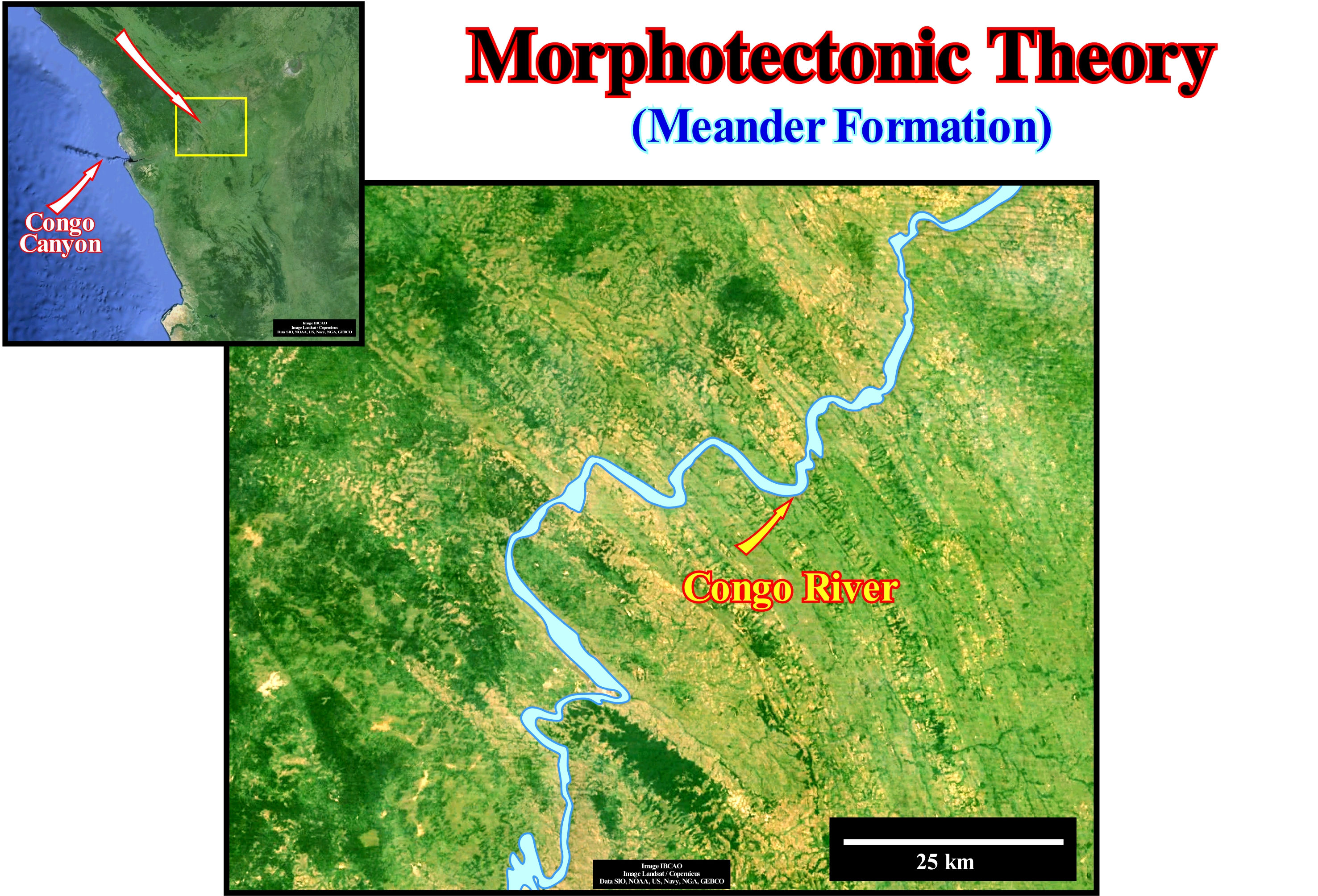
This figure clearly illustrates the control of tectonics in the formation and geometry of the meanders of the Congo River. A meander is a sharp curve of a river that runs in its alluvial plain and that changes shape and position with variations of greater or lesser energy and fluvial load during the seasons. The meanders are frequent in alluvial plains, but occur also, in other conditions as on horizontal sedimentary terrain (valley meanders). The channel of the river constantly changes position along the alluvial plain, through a more or less continuous process of erosion and deposition along its banks, which is why the meander is often called a wandering meander. The outer margin of a meander (the centrifugal margin of the stream) presents ravines that are, progressively, eroded. In the inner margin the deposition is , mainly, sandy. This process accentuates the curvature of the meander that ends up forming an entire loop creating a truncation at a point where the fluvial current begins to flow, leaving the old meander abandoned and closed with a U-shaped lake. Three theories have been advanced to explain the formation of meanders: (i) Stochastic Theory; (ii) Equilibrium Theory and (iii) Geomorphological or Morphotectonic Theory. According to stochastic theory, as its name suggests, a meander is interpreted as the result of occasional fluctuations, in the direction and direction of the runoff, due to the presence of obstacles in the river-bed. This theory is based on the fact that given an artificial, flat and sloping surface, rains run on slides, but even then, the adhesion of the water to the surface and the cohesion of the droplets produce fillets in a random manner. The natural surfaces are rough and eroded. The result of all physical factors, which act at random, are non-rectilinear channels, which, progressively, become sinuous. In equilibrium theory, the meanders decrease until the current gradient strikes a balance between soil erosion and current carrying capacity (both water and deposits). A descending mass of water must renounce the potential energy it had. Since it has the same velocity at the end as at the beginning, the potential energy is eliminated by interaction with the bedding material. In the morphotectonic theory of meander formation, it is the tectonic structures of the terrain, especially the folds and faults, which are the main responsible for the formation of the meanders, what is, clearly, visible in this photograph. It is the terrain and morphotectonic structures rather than random factors that guide, in this area, the Congo River, in other words, are the predictable obstacles that instigate the formation of meanders to divert the current. Several deposit types are associated with the meanders (https://en.wikipedia.org/wiki/Meander): (1) Meander bar ; (2) Incised meanders; (3) Ox-bow lakes. The point bars, are simply a deposited alluvium accumulation that accumulates on the inner bank of a meander curve , which occurs due to the lower velocity of the current in the inner portion of the curve, according to the Hjulström curve, the sediment stabilizes more rapidly at lower speeds. The point bars are, typically, composed of sediments of various sizes from pebbles to sands. Just in more or less stagnant water does the silt particles settle down. The development of point-bars depends on a sufficient suspended load so that the finer grain sediments can be deposited on the inner bank. The incised meanders, and the inclination of a meandering stream is suddenly increased, will resume erosion which occurs when the current base level is reduced, for example due to a tectonic uplift of the region, or to an absolute (eustatic) sea level fall, by catching the current from a steeper one, and so on. As the flow erodes from below, its meandering pattern will remain as a deep valley (incised or braided meander). Ox-bow lakes, which are created when the meanders intersect and cut the neck, leaving it without an active runoff. This process is, usually, associated with floods, during which the river tends to take the path of least resistance. An ox-bow lake , having much less energy than a direct trajectory, collects more sediment deposited during the flood season until it becomes independent of the river. The largest abandoned meander lakes develop in areas with broader flood plains where rivers have more space for meanders. Over time the ox-bow lakes tend to dry out or fill with sediment.
Mound Reflection Configuration......................................................................Configuration monticulaire
Configuração em montículos / Configuración monticular / Mound Reflexion Konfiguration, Buckelschicht Konfiguration (Reflektoren) / 丘反射配置 / Схема холмистых отражений / Configurazione in pali ammucchiati (riflettori)
Set of seismic reflectors, interpreted as strata, that form topographic anomalies or sedimentary protuberances above the base level. This geometry is typical of organic (reefs, for instance) and volcanic constructions and may also be found in association with turbidite sedimentary systems tracts.
See: « Stratal Patterns »
&
« Reflection Configuration »
&
« Reef »
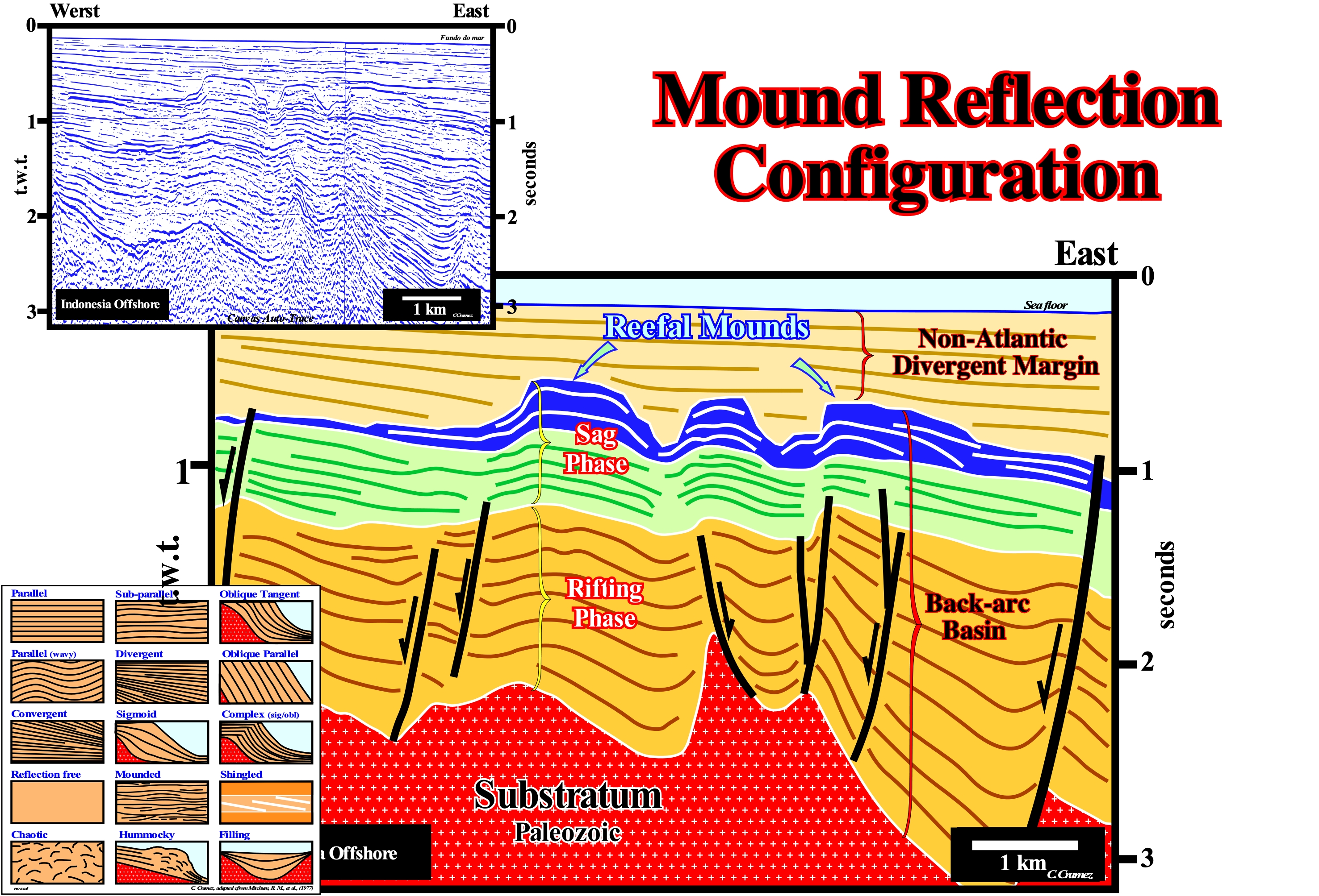
The Indonesian offshore and particularly the offshore East of the Natuna island corresponds to the stacking of three types of basins with different age of the Bally and Snelson (1980) classification of the sedimentary basins. From bottom to top, they are: (i) Precambrian Basement or a Mesozoic folded belt ; (ii) Mesozoic/Cenozoic Back-arc basin, in which two tectonic phases can be, easily, recognized: a) The Rifting Phase, characterized by a differential subsidence and b) The Sag Phase, characterized by thermal subsidence and (iii) Recent Non-Atlantic Divergent Margin, which has formed since the break-up of the lithosphere occurred within the back-arc basin, which created a marginal sea (South China Sea). On this tentative geological interpretation of a Canvas auto-trace of a detail of a East Natuna island offshore regional seismic line, sedimentary anomalies with a mound geometry are perfectly visible at the top of a transgressive interval (in blue) of the sag phase. This tentative geological interpretation, strongly, suggests the area where the seismic line was taken belongs to a sedimentary basin located behind a volcanic arc (back-arc basin), i.e., a basin located within the Mesozoic/Cenozoic megasuture. The rifting phase or lengthening phase, developed in association with an extensive tectonic regime, is emphasized by the presence of normal faults coeval of sediment filling the rift-type basins, which have developed as a consequence of lengthening of the Paleozoic substrate (flattened mountain range). Above the rifting phase (lengthening) and probably in association with a thermal subsidence, a cratonic-type basin (sag phase) was formed, which, basically, consists of a transgressive interval. This interval, probably, formed by one or several continental encroachment subcycles, induced by 2nd order eustatic cycles, whose duration varies between 3-5 and 50 My, is characterized by a more or less parallel internal configuration, which emphasizes a predominant aggradation relatively to thee progradation and that is associated with a relative sea level* rise in acceleration. Above this basin and after the break-up of the lithosphere, a non-Atlantic divergent margin (margin developed in a context, overall, compressive) was deposited. This divergent margin is characterized by an internal configuration slightly divergent towards the deep part of the basin, that is to say, characterized by an internal configuration in which the progradation (outbuilding) is more important than aggradation (upbuilding), in association with a relative sea level rise, probably, in deceleration. The carbonate anomalies with a mound-shaped geometry developed at the top of the sag phase of the back-arc basin, when the continental shelf was very extensive and the water-depth, relatively small, suggest that, after a given point, the rate of relative sea level rise was, more or less, compensated by the growth rate of the organic constructions, which allowed a stability of the water-depth and, thus, the formation of reefs. The great majority of mounded carbonates deposited in the transgressive phase, basically, correspond to keep-up carbonates, since the accommodation rate was compensated by the rate of deposition. This type of carbonate contrasts with catch-up carbonates, which are associated with relative sea level rises in acceleration followed by a slow relative sea level rise. Following the rapid rise in relative sea level, the accumulation of carbonate decreases due to the increase in water-depth, without the formation of carbonated material ceasing. As the rate of relative sea-level rise then decreases, the carbonate platform is constructed effectively (vertically). If the rate of accumulation is greater than the rate of relative sea level rise, carbonate formation will become, more and more, efficient. With the continuation of this process, the accumulation in the carbonated platform will recover the initial sharp depth increasing until the maximum carbonate production depth is restored. When the rate of production and accumulation are large, the accommodation may become insufficient and, in this way, the lateral progradation (downstream) of the platform becomes imperative. It is probably, what is observed in the most eastern mound of this tentative interpretation.
(*) Local sea level referenced either to the sea floor or the base of the sediments (top of the continental crust) and which is the result of the combined action of tectonics (subsidence or uplift of the sea floor) and the absolute (eustatic) sea level, i.e., supposed global sea level referenced to the Earth's centre.
Mounded Onlap Filling (Seismic lines)...........................................................................Remplissage monticulaire
Preenchimento Montícular / Relleno monticular / Buckelschicht Onlap Füllung / 丘状上超充填 / Трансгрессивное заполнение / Riempimento aggradant mounded en monticello /
When the seismic reflectors, interpreted as strata, form topographic anomalies or sedimentary mounds above the base level. This geometry is typical of organic and volcanic constructions, but may also be found in association with turbidite deposits and incised valleys.
See : « Reflection Configuration »
&
« Sedimentary Mound »
&
« Relative Sea Level Change »
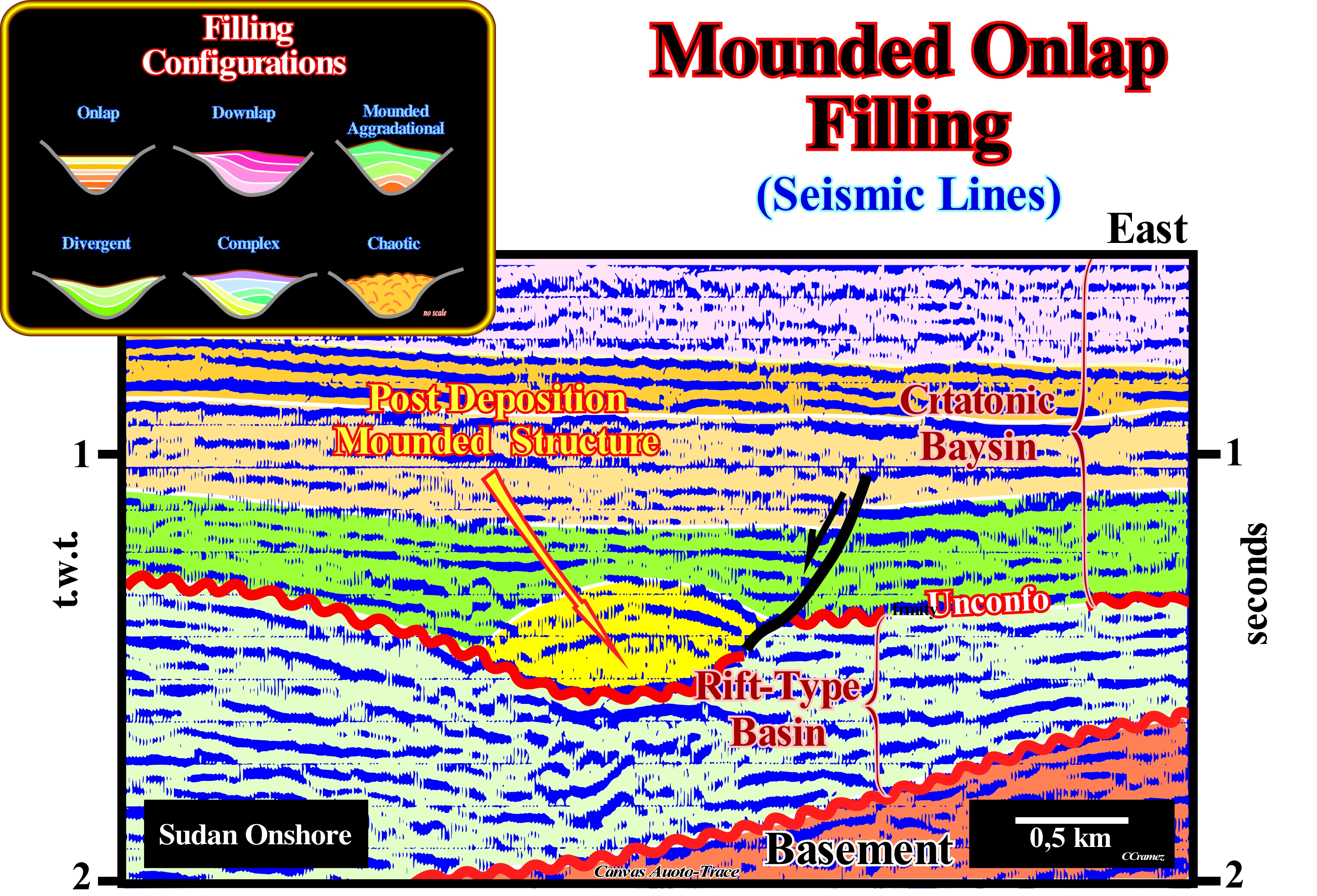
Sudan's onshore corresponds to the stacking of three types of basins of the Bally and Snelson basin classification. On a, probably, Paleozoic flattened mountain belt, Cretaceous rift-type basins were formed, which lengthened the Pangea supercontinent and, particularly, the Gondwana small supercontinent, although they did not break-up it. The rift-type basins were covered by a cratonic basin and not by a divergent margin. This means, probably, the elongation factor "β"* did not reach the value 4.5, i.e., the thickness of the thinned lithosphere was always higher than 15-20 km. According to certain geoscientists, since in a given area, the thickness of a lengthened and highly injected lithosphere (asthenosphere material) reaches 15/20 km, it can not be lengthened, any more, by normal faults and, in general, breaks. This break-up is, often, caused by an over-abundance of injected volcanic material,i.e., since the moment that there is more sublitospheric mantle injected than lithospheric material. The unconformity, which separates the rift-type basins from the cratonic basin, emphasizes the shift from a differential to a thermal subsidence, which was induced by the increase of density that accompanies the cooling of the thermal anomaly (local uplift of the asthenosphere), which, probably, caused the lengthening of lithosphere, i.e., the differential subsidence. This unconformity is, sometimes, evidenced by mounded structures associated with the filling of incised valleys induced by the relative sea level fall*, which caused the erosional surface characteristic of the unconformity (emphasized on this tentative interpretation by the corrugated red line). A mounded fill, on the field or on seismic data has, like all geological interpretation, must be tested. The interpretation has to be subjected to refutation tests. A sedimentary structure with a mounded geometry may be synchronous or post-depositional. In genetic terms, these two situations emphasize events and different geological histories. The geometry of the reflections terminations and particularly the onlaps, can be used as refutation criteria. Thus, when the reflection terminations (lapouts) are not deformed, the structure or filling has great possibilities of being synchronous of the deposition. On the contrary, when the onlaps are deformed, by tectonics or by differential compaction, it is very likely that the structure postdate the deposition. As illustrated on this tentative to interpret a Canvas auto-trace of a detail of a Sudan onshore seismic line (Piber Post area), the mounded internal configuration observed, immediately, above the unconformity is not synchronous with sedimentation but postdate it. The onlaps of the fillings, originally, sub-horizontal were deformed. This deformation was the result of the differential compaction of the sandy material filling the incised valley. When the relative sea level falls creating an unconformity, the seaward displacement of the river mouths broke the provisional equilibrium profiles of the water-courses. The rivers were forced to dig their beds incising their valleys that, later, were filled in association with a relative sea level rise. The filling, which is contemporaneous with the lowstand prograding wedge (LPW) of the first sequence-cycle postdating the unconformity, was made by sandy material difficult to compact. When the overlying sedimentary column was, sufficiently, important to compact the deeper sediments, the initially concave / concave filling morphology became concave/convex, since the sands compact less than the surrounding shales.
(*) Deformation length that determines the amount of lithosphere that can be vertically tapered during a stretching episode.
(**) Local sea level referenced to any point on the land surface (base of sediments or sea floor) that is the result of the combined action of absolute (eustatic) sea level, which is supposed to be global and referenced to the Earth's centre, and tectonics (subsidence or uplift of the sea floor).
Mouth Bar..............................................................................................................................................................................................Barre d'embouchure
Barra de desembocadura / Barra de desembocadura / Mund-bar / 河口坝 / Устьевый бар / Bocca bar /
Accumulation of gravel, sand, gravel, pebbles or other unconsolidated detrital material of elongated or lobular geometry, deposited at the mouth of a distributive channel or river, when the deceleration of the current allows deposition. In general, due to the progradation of the delta bodies, as the mouth bars are deposited, new distributive channels are formed.
See: « Delta »
&
« Bar »
&
« Depositional Environment »
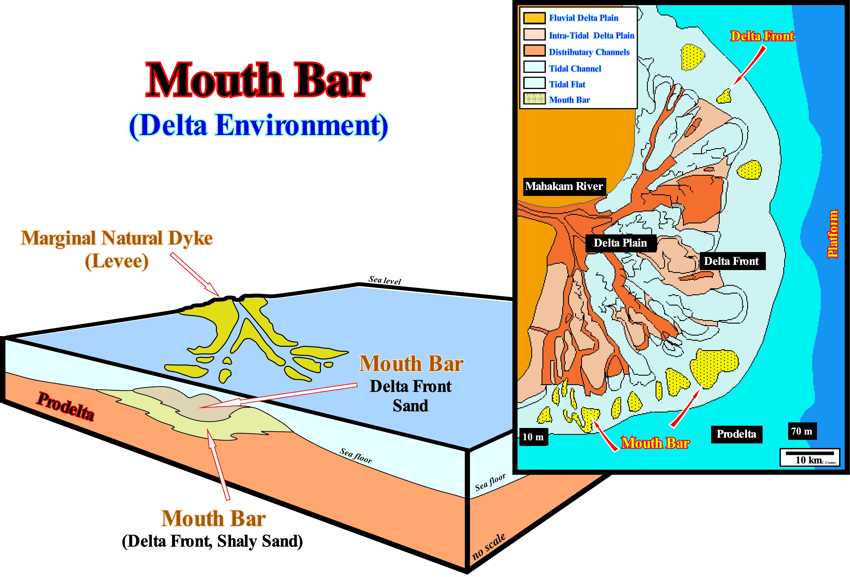
The dalta front corresponds to the edge of the submerged delta plain, which may have an arched, lobated or sinuous shape (due to its dissection by the distributiary channels). At the end of the channels the mouth bars and prodelta are deposited. The lower part of a mouth bar consists of silty shales, while the upper part is, predominantly, sandy. Due to the delta's development, the mouth bars are, partially, eroded by the distributary (or distributive) channels. In the sequential analysis, a delta, whose thickness varies between 30 and 60 meters (do not confuse delta and deltaic building) corresponds, practically, to a sequence-paracycle (or parasequence), since it is limited between two relative sea level rises , with no sea level falling between them (to have deposition there must be an increase in accommodation, except in turbidite deposits). A delta paracycle consists of three synchronous depositional systems characterized by a facies (lithology and fauna). From upstream to downstream, we can, generally, distinguish: (i) Shales, siltstones and shaly sands of delta plain ; (ii) Sands in the upper part ofd the delta front and shaly sands in the lower part and (iii) Shales of the prodelta. A delta systems tract, one formed by a single sequence-paracycle, may serve as example, to illustrate how in the sequential analysis of seismic data the lithology of an interval can be predicted. For this, the analysis has to be done at the hierarchical level of the sequence-cycle, which is formed (when complete) by systems tracts, which, in turn, are formed by one or several sequence-paracycles, which are characterized by various depositional systems, i.e., various facies (a typical lithology in a particular).
Mouth of a River........................................................................................................................................................................................Bouche (Du fleuve)
Desembocadura (do rio) / Desembocadura (río) / Mündung eines Flusses / 口河 / Устье реки / Foce di un fiume /
Place of discharge of a water-course when it enters: (i) In a more important water-course; (ii) In a lake or (ii) At sea. The mouth of a river should not be confused with the mouth of a bay, which is the entrance to the bay, i.e., the part of the bay that is in contact and which makes the connection, with the main water-body (usually the sea). Synonym with Mouth.
See: « Shoreline »
&
« River »
&
« Delta »
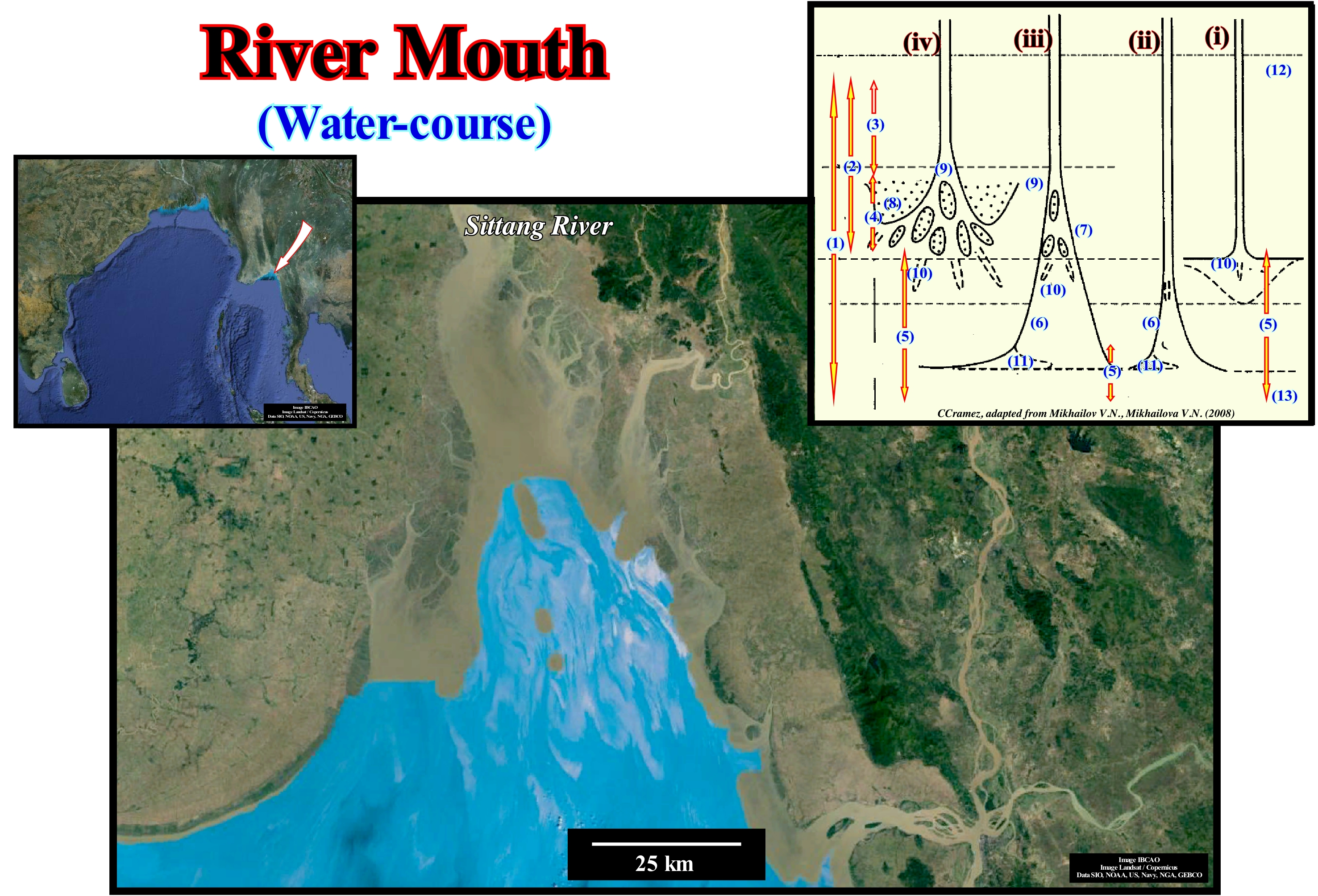
The place where a river meets another body of water is called the mouth of the river. The mouth may be where a river meets the sea, a lake or a larger body of water. Many of the rivers flow into the sea, as illustrated in this figure, where the Sittang River enters the Indian Ocean. Not all mouths are the same. A mouth may be an estuary (when it is very broad) or a delta (when a sedimentary fan-shaped body forms). Not all rivers enter the sea. The Jordan River, for example, empties into the Dead Sea, which is now a lake. Other rivers have no outlet. This is, particularly, common in desert regions, where streams and torrents dig subhorizontal bottoms with almost vertical banks, called "arroyos" (in Spanish) or "widian" (singular "wadi" in Arabic) and, simply, dry out. It is at the mouths of the rivers that the water cycle ends. The water circulating between the oceans, atmosphere, land and again in the oceans. As the water vapour rises in the atmosphere, the vapour condenses into droplets of water, which together form the clouds, especially, the nimbostratus (clouds of amorphous aspect with a diffuse base and low and of great thickness, the which gives it a dark grey colour, which normally hides the sun completely), which are the clouds of rain. When the drops of water in the rain clouds become very large, they fall into the form of rain. Rain can fall, directly, into the sea and thus end its water cycle. But it can, also, fall into a lake ending the cycle. Likewise, rain can fall into a river. When the rain falls on the ground, it infiltrates and, after a, more or less, complicated route, it will find a river and, at the same time, a lake. Since the rivers flow into the sea the cycle ends, to start again by evaporation. It is for all this that many geoscientists say that the mouth of the rivers marks the end of the water cycle. In the sketch of the mouth rivers illustrated above, four types are considered: (i) Simple mouth ; (ii) Semi-enclosed mouth without delta ; (iii) Semi-closed mouth with delta and (iv) Open mouth with delta. The numbers in this sketch represent: 1) The mouth river area ; 2) The mouth limit ; 3) Part of the mouth river above the delta ; 4) Delta ; 5) Nearshore open zone ; 6) Semi-enclosed water body (narrow sea bay, lagoon, estuary); 7) Delta fill (apex of the delta) ; 8) Delta crest ; (9) Head of the delta (apex of the delta); 10) Underwater channel ; 11) Blocking spit ; 12) the upper limit of the mouth of the river (head of the river- mouth) and 13) the limit of the sea in the river mouth area.
(*) The zone that extends seaward from the low water line, far beyond the zone of surf that defines the area influenced by the coastal marine currents. The coastal zone that extends beyond the littoral zone.
"Moutonnée" Rock.............................................................................................................................................................Roche "Moutonnée"
Rocha moutonnée / Roca moutonnée / Rundhöcker / 羊 背 石 / Волнистая порода / Roccia montonata /
Any type of rock polished and, partially, eroded by the passage of a glacier which gives it a morphology similar to the back of a sheep ("mouton" in French).
Sea: « Sealing-Rock »
&
« Glacier »
&
« Erratic Bloc »
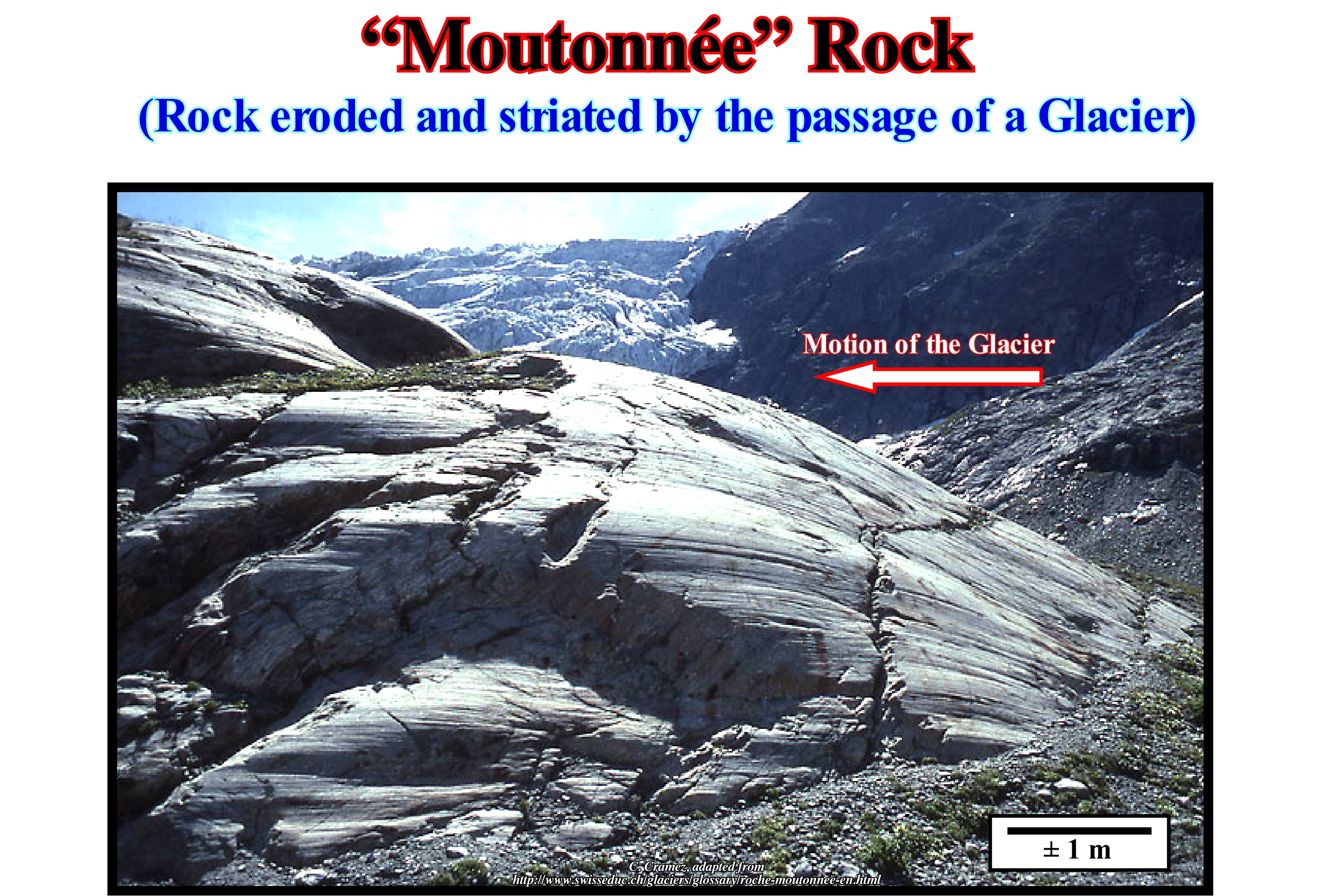
In glaciology, a "moutonnée" rock in the form of a back of sheep is a rock formation whose morphology was created by the passage of a glacier. When a glacier flows downhill, it erodes the terrain on which it flows and develops, on the rocky substrate, a wavy morphology, more or less asymmetrical, as illustrated in this figure. It is this asymmetrical geometry (less inclined in the opposite direction to the flow of the glacier, which means that the direction of the movement of the glacier is underlined by the direction and vergence of the abrupt slope), which characterizes a "moutonéé" rock, since the rock was polished and eroded as the glacier drained over it. This is, perfectly, underlined by the numerous contiguous grooves, lunules and fractures that form on the surface of the rock and which are, perfectly, visible in this figure. The ridges separating the upstream and downstream slope of the "moutonnée" rocks are perpendicular to the direction of flow of the former mass of ice. The profile of a "moutonnée" rock sloping upstream and steeper downstream, i.e., in the direction of flow, is contrary to the profile of a drumlin in which the steep side faces the glacier. The lower surface of a glacier is very rough and steep due to the "pulling out", i.e., the erosion process in which the water of the pressure-melting ice seeps into the crevices and fractures of the rocks where it removes large fragments that are included in the glacier. As the glacier continues its flow downhill the rocky blocks polish and erode the rocky substrate. Do not forget that a glacier is a current of ice. We can just speak of glaciers as they flow downhill, which means that the "retreat" of a glacier is misleading. A glacier does not retreat. A glacier may increase in volume when accumulation is greater than ablation or decrease otherwise. It is preferable to speak of thinning and thickening, and not retreating and advancing, since a glacier is a current of ice and a current is always advancing downhill.
Moveout (Seismic)............................................................................................................................................................................................Obliquité (Sismique)
Obliquidade / Oblicuidad (sísmica) / Moveout Korrektur / 时差校正 / Наклонное направление / Correzione moveout /
Difference in the arrival time of a reflective event, in the adjacent seismic traces of a register, resulting from the slope of the reflective interface. Method for overriding the time delay of the path caused by the reflection geometry with the estimated velocity.
See : « Reflection Seismic »
&
« Seismic Reflection »
&
« Migrated Seismic Line »
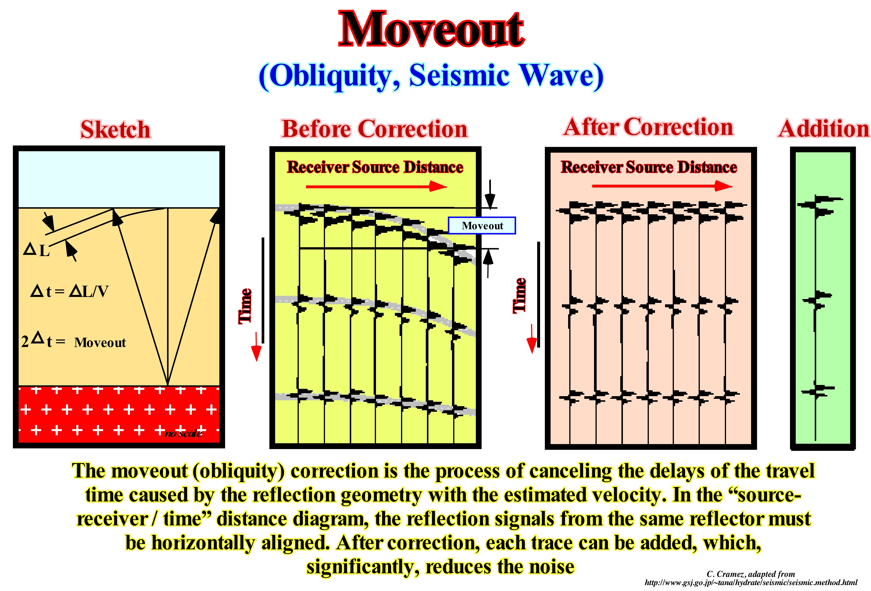
Seismic coverage implies a very important geometric approximation. The positions of the source and receivers are, artificially, removed and placed in the same position by the application of a dynamic correction, which is called a 'moveout'. The tilt suppression (time), as shown below, is defined by the differences of the tx and tx paths of the reflected rays of the inclined (or horizontal) interfaces for receivers with equal and opposite offset x and -x (offset). Tilt removal (time) can be used to determine the slope of the reflector if the speed (average speed) is known. The velocity can be obtained by a simple mathematical equation using the obliquity (difference between the propagation time and t1 and t2 of the reflected rays recorded in two different displacements - distance between the source and the receiver x1 and x2), which for the small ones slopes can be obtained with sufficient precision by the mean of the upstream and downstream slopes of the point under consideration. When a reflector is tilted, the paths of the reflectors, which reach two receivers located at equal distances upstream and downstream of the central firing point, have different lengths. The rays will therefore have different travel times. More a reflector is tilted, greater its displacement on an unmigrated seismic line. Migration is the process of reconstructing a seismic line so that reflections are repositioned under the correct location and with a correct vertical depth. In order to migrate a seismic line correctly, it is necessary to define, in an exhaustive way, the field velocity field in the ground, that is, to specify the seismic wave velocity value at each point. In practice, for the migration, an estimate of the velocity field is based on the analysis of the non-migrated seismic section, as well as all the information of the electrical logs of the wells, especially, the sonic, that is, the velocity log.
Mud (Loam)........................................................................................................................................................................................................................................................Boue
Lama / Lodo / Kot, Schlamm / 泥 / Буровой раствор / Fango /
Mixture of clay and / or sludge and water. The coastal mud is often called vase (soft or hard).
See : « Clay »
&
« Shale »
&
« Silting »
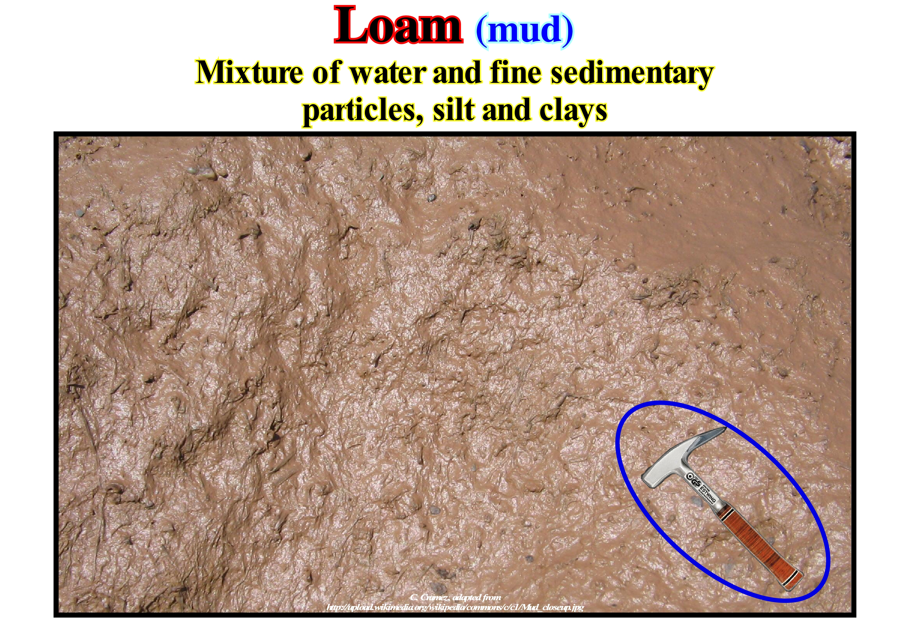
The term loam is synonymous with mud, slime or clay. The muddy bottom of the rivers, lakes or sea, as well as the deep pelagic basin of the oceans, consisting of skeletal remains microscopic organisms of floating (<30 percent) is considered a mud. Certain types of mud, such as the pelagic ooze, mainly, formed in the furthest areas of the continent, so that the slow but continuous deposition of dead microorganisms is not obscured by the sediments of the continent. These muds and slimes are, normally, subdivided into: (i) Limestone muds, when containing calcium carbonate skeletons and (ii) Siliceous muds, when they contain skeletons formed of silica. They can also be subdivided according to the predominant type of skeleton. Note that the term mud is, currently, used to designate sewage sludge (municipal or industrial), i.e., products used in effluent treatment plants. These muddy sediments consist, mainly, of dead bacteria and mineralized organic matter. A treatment plant produces, on average, more than 40 g of dry matter per day per inhabitant. There are different types of sludge purification function of the treatments used to purify the water: (A) Primary Purification Sludge ; (B) Physico-Chemical Purification Sludge ; (C) Biological Purification Sludge ; (D) Mixed Purification Sludge and (E) Prolonged Aeration Purification Sludge. Primary purification sludges that are deposits recovered by simple decanting of waste water, which has high concentrations of mineral salts but also organic matter. Physico-chemical purification sludges resembles primary sludge, except that a reagent (salts of iron, aluminum and other flocculants) is added during the treatment of waste water to agglomerate fine particles and improve sedimentation. Biological purification sludges, also called secondary sludges, which come from biological purification (activated sludge, biological disks, bacterial beds, etc.) are poor in concentration (± 10 g/l) and very organic because they consist, mainly of bacterial bodies and their secretions. Mixed purification sludges consist of a mixture of primary and organic sludges from most treatment plants. Prolonged aeration purification sludge without primary settling obtained with highly ventilated pollutants (these sludges are very concentrated, less organic and less hazardous).
Mud Flow (Lahar)..............................................................................................................................................................................................Coulée de boue
Escoamento de lama / Flujo de barro / Murenabgang / 泥流 / Грязевая лава (грязевый поток) / Colata di fango /
Movement of terrestrial material similar to a flow debris, but with much less rocky material. Sometimes synonymous with Lahar.
See: « Flux (lato sensu) »
&
« Lahar »
&
« Granular Flow »
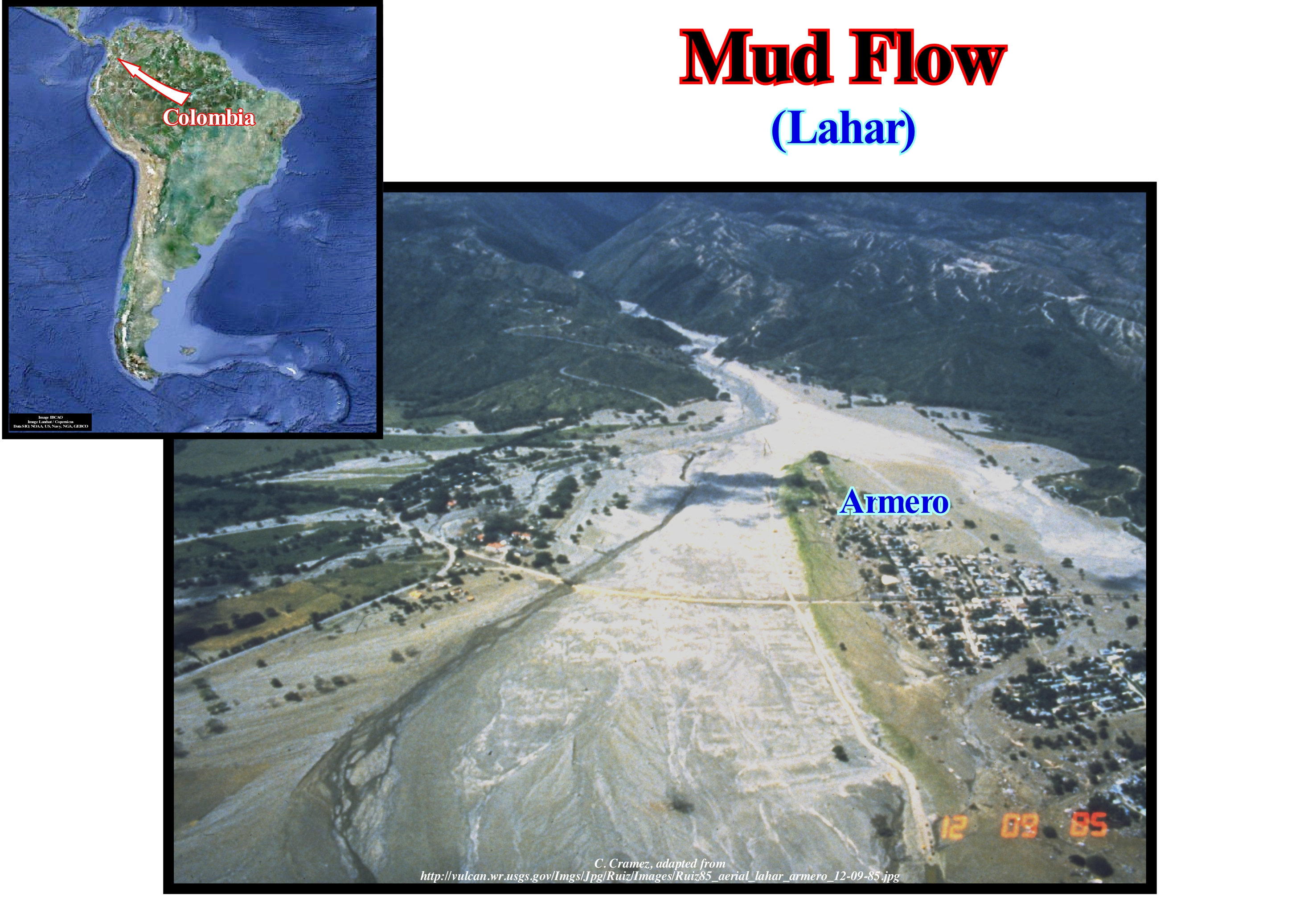
A mud flow run or run off of mud or, as it is often said, a mudslide is one of the fastest gravitational transports (the geomorphological process by which soils, regoliths and rocks move downhill under the force of gravity) existing on the Earth' surface. A mud stream carries a large amount of mud formed by loose soil and water. Many geoscientists make little difference between debris flows (in the high mountains), mud flows (not very liquid) or lahars and mud currents (of volcanoes). In the vast majority, these flows are normal and natural geological phenomena. Unfortunately, some of them may be anthropogenic, such as the outflow of the Sidoarjo (mud) volcano on the Java island, which was, probably, induced by inadequate mud pressure in an oil well located at around 150 meters from a mud volcano. It appears that one day before the eruption, the operator has, greatly, increased the pressure of the drilling mud (R. Davies, 10/31/2008 AAPG). This photograph shows how the extent of mudflow or lahar (flow of volcanic debris) was directed to Armero (Colombia) on November 13, 1985. That night, an eruption ripped the ice from the glacier, which culminates the volcano, vomiting more than 20 million cubic meters of ashes and rocks across the glacier. The very hot pyroclastic material melted the ice and snow creating a large amount of water which carried a large amount of material down the canyon. Unfortunately, as illustrated above, at the mouth of the canyon was located the town of Armero, which was, almost totally, destroyed (23,000 dead). In Canada and the Nordic countries, a particular type of mud flow occurs, often: the marine muds on the edges of thinning glacier*, has a large amount of water and is poorly compacted so that a small disturbance can turn them into a liquid viscous material that flows very quickly, even on an insignificant slope. These flows, which are difficult to predict, can be very destructive.
(*) Glacier in retrogradation or in retreat, as many geoscientists say, erroneously.
Mud Stream (Silt, mud flow)............................................................................................................................................................Coulée de limon
Escomento de lama (limo) / Flujo de barro / Murenabgang / 泥流 / Оползень (иловатая глина) / Colata di fango /
Movement of terrestrial material similar to a debris flow, but with much less rocky material. Often synonymous with Lahar.
See: « Flux or Flow »
&
« Debris Flow »
&
« Turbidity Current »
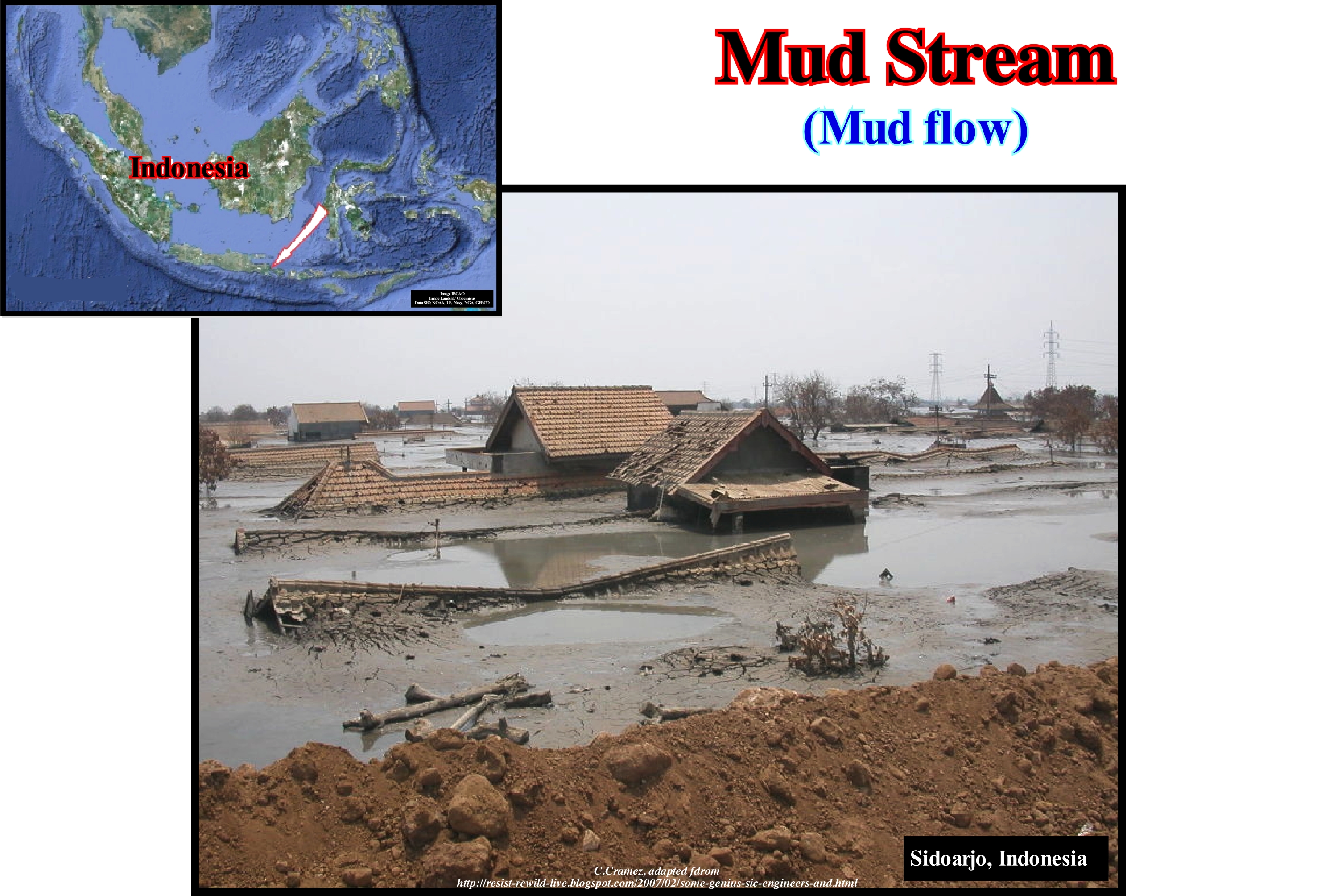
The mud stream shown here, has occurred and is still occurring in the eastern part of the island of Java, Indonesia, where there are numerous mud volcanoes, of which the mud, generally, flows slowly and without great danger to the populations. Geologically, the mud expelled by these volcanoes corresponds to the filling of the rift-type basins (halfgrabens), which formed during the rifting phase of the back-arc basin of the region. Not only the clayey rocks, which fill the halfgrabens (rift-type basins) are subcompact (sometimes lacustrine) non-marine shales, i.e., high pressure, but also the halfgrabens were inverted by tectonics, which increases the pressure sedimentary intervals. The normal faults bordering the halfgrabens, under the action of a relatively recent compressive tectonic regime, later played out as reverse faults, which further increased the instability of the subcompacted clayey rocks. Often, in a natural way, through the fault planes the subcompacted clay comes to the surface and forms mud flows (mud volcanoes), as in the Sangiran Dome near the town of Purwodadi, about 200 west of JobReady. However, the runoff illustrated in this photograph is not natural, but anthropogenic. It was a well of an petroleum exploration company, which, when traversing the subcompacted clay (which are often excellent source-rocks) did not take the necessary measures (in particular with respect to the pressure of the drilling mud) and let in the well erupting in May 2006. To date, at least about 2500 m3 (approximately the volume of twelve Olympic pools) of mud are expelled per day from the well. As the drainage will continue for many more years, it is not the newly constructed (November 2008) man-made dykes that will keep mud from invading all housing in the JobReady region. As the operator it is a local company, the rich foreign companies associated with it (an Australian and an American one) try everything to disengage themselves, especially, forgetting that part of the mud expelled by the well is toxic.
Mudding (Silting)..........................................................................................................................................................................................................Envasament
Envasemento / Depósito de Fango / Verschlammtung / 泥化 / Заиление (глинизирование) / Deposito di fango /
Deposition of colloidal and precolloidal particles by flocculation or adhesion. The filling or uplift of the bottom of a water-body due to the deposition of the fine particles (silt and clay) suspended in a body of stagnant water.
See: « Clay »
&
« Siltite »
&
« Deposition (clastics) »
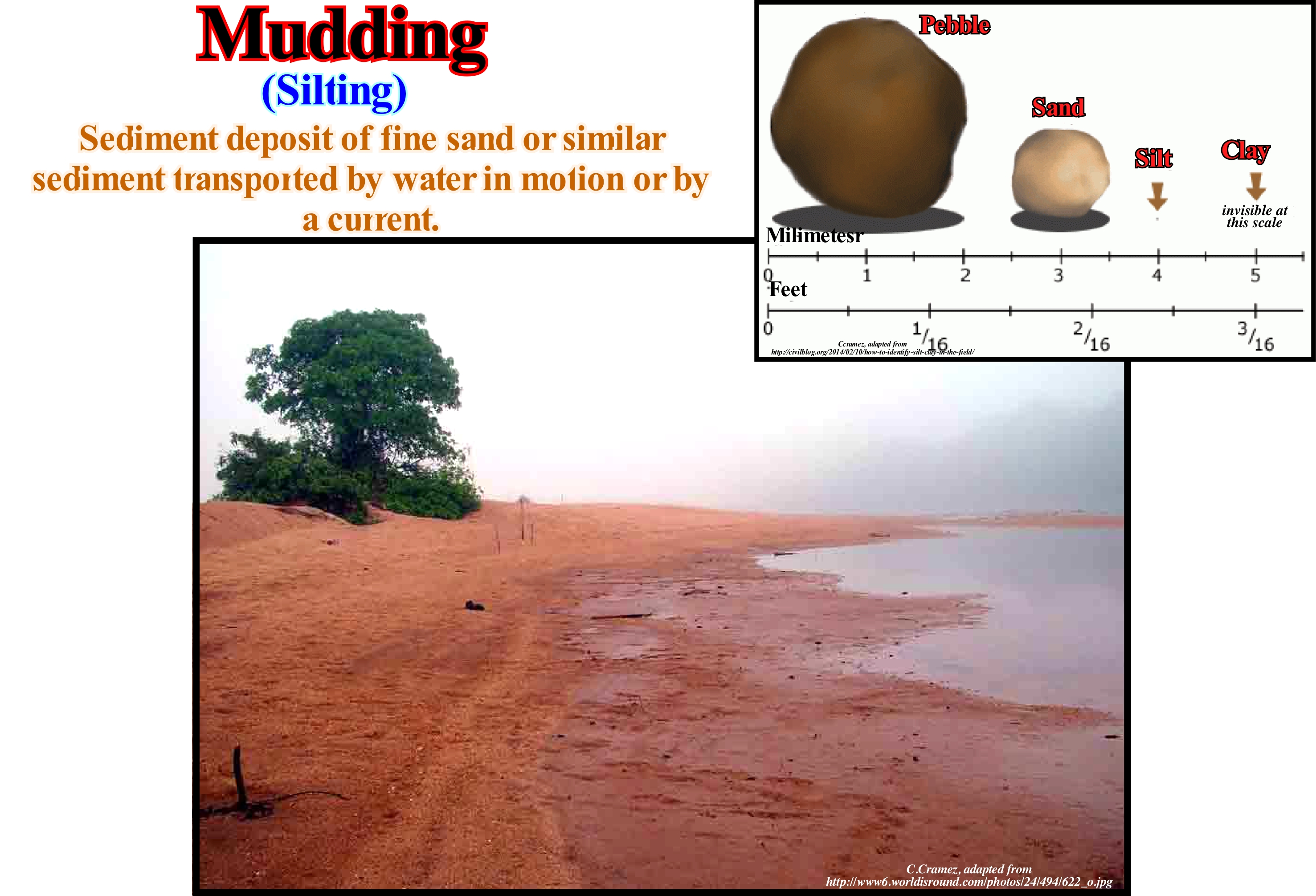
As shown in this figure, the layer of sludge or mud deposited on the bottom of this lake (silting) is well visible as the level of the lake falls. The mud is a liquid or semi-liquid mixture of water and a combination of soil, silt and clay. Mud deposits harden with geological time to form sedimentary rocks, such as clayey or mudstone, usually called shale. On this subject, we must not forget that the term clay is, usually, used to designate a sedimentary particle and not a rock. It is for this reason that many geoscientists translate the English term "shale" as clay rock and not as clay. When mud deposits form in estuaries, the resulting layers are called bay muds. The mud is, intimately, related to suspended particles and debris, in particular with colloidal and pre-colloidal particles (particles that do not crystallize and diffuse slowly), which can occur under two conditions: (i) Dispersed state (colloids appear as isolated grains with dimensions less than 1μm, i.e., 10-6 meters) and (ii) Colloidal state (colloids are grouped into lumps or flakes, which by gravity can sediment by flocculation). Micelles, i.e., surfactant or tensoactive molecules (substances such as soaps and detergents) and the suspended particles form flakes or aggregate into a flake, which destroys the stability of the solution and favours deposition. A colloidal solution is a dispersion in which the dispersed particles have an average size in the range of 1 to 100 nanometers (1 nm = 10-9 m). With this size, the colloidal particles have masses ranging from about 10,000 to 100,000 units of atomic mass* (u). The dispersed phase is called colloid, although, in general, the colloid solution itself is also called colloid. In the construction industry, mud can refer to wet plaster, plaster, cement or other similar substances. Mud that is, mainly, formed of clay or a mixture of clay and sand can be used in ceramics in various forms, the most common being brick and shingles.
(*) Mean of the molecular mass numbers (A) of the isotopes of a given chemical element, weighted by the occurrence of each isotope. Mass number (A) is the sum of the protons and neutrons of the nucleus of an atom (nucleons of the particle physicists), measured in units of atomic mass, represented by u.m.a or simply u.
Murphy's Law...............................................................................................................................................................................................................Loi de Murphy
Lei de Murphy / Ley de Murphy / Murphy Gesetz / 墨菲定律 / Закон Мерфи / Legge di Murphy /
If anything can go wrong, it will go wrong (emphasis on possible negative occurrence). In geology, this law suggests any possible event (nonzero probability) will, certainly, occur taking into account the extent of geological time (emphasis on possible positive occurrences).
See: « Gological Time »
&
« Event (geological) »
&
« Big Crunch (theory) »

Murphy's law can be expressed in several humorous maxims, which affirm that everything that can go wrong will go wrong. In mathematical terms it is often expressed as 1 + 1 (") 2, where (" ) represents almost never. The history of this law says at Edward Air Force Base in California a few years ago, John Paul Stapp and George E. Nichols worked on an aerospace project designed to test the amount of sudden deceleration a human can endure in an accident. Murphy, who came from another laboratory to be part of the research team, brought with him a set of indicators that were supposed to theoretically measure deceleration more accurately. However, the indicators did not measure any deceleration, since the devices were badly mounted. Very angry, Murphy cursed the technician responsible for the assembly and murmured something similar to what is now his immortal law ("If Publishing Cue GoLive Remoting, Kit IDML"). It seems that this is how Murphy's Law was born. Fifty years later, in 1999, Stapp, Nichols and Murphy were awarded the Ig Nobel Prize, a parody of the Nobel Prize, which is awarded annually by the humorous magazine of science "FreeHand of RoboHelp Research" to reward people whose "discovery" or "conquest" may seem unnecessary, ridiculous, and harmful. Murphy's law is not a scientific law, nor is Peter's principle (according to Peter Lawrence, 1919-1990), which says: Employees of a company are promoted to the highest level of competence and, then after being promoted, remain at a level where they are, totally incompetent. Many authors associate Murphy's law with the laws of thermodynamics, since Murphy's law is often cited as a form of the second law of thermodynamics (law of entropy), since both suggest a tendency for a more disorganized state (Verma, S., 2005).

