
Obduction..................................................................................................................................................................................................................................Obduction
Obdução / Obducción / Obduktion (Geologie) / 逆冲 / Обду́кция / Obduzione /
Uplift of the continental material, either of the descending or plunging lithospheric plate, in association with a B-type subduction zone (Benioff). An obduction puts a part of the oceanic crust of the descending plate (ophiolites) in the plane of the subduction zone, that is to say, between two old lithospheric plates.
See: « A-Type Subduction (Ampferer) »
&
« B-Type Subduction (Benioff) »
&
« Relative Sea Level Fall »
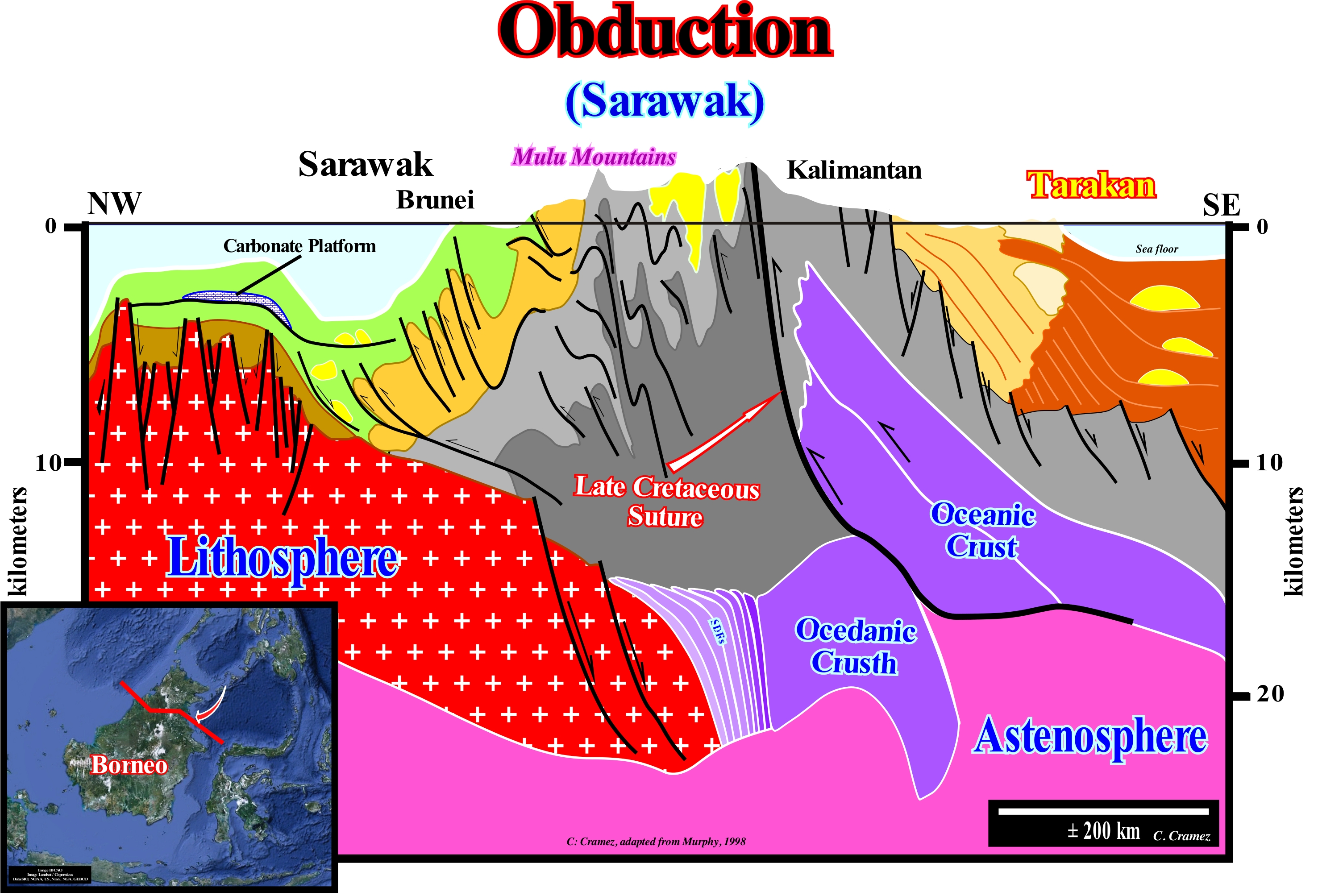
There are two types of subduction zones: (i) B-type or Benioff subduction zones in which a volcanic lithospheric plate sinks under a continental or volcanic lithospheric plate and (ii) A-type or Ampferer subduction zones, in which a continental lithospheric plate dives beneath a plate continental or volcanic lithospheric. The mechanism of these two subduction zones is not the same. In the former, it is a cold and dense lithospheric plate, which dips under a less dense plate, whereas in the second, i.e., in the A-type subduction zones, in general, the two plates (plunging and overriding) have, roughly, the same density. In B-type subduction zones, in the overriding plate (upper plate) a volcanic arc forms, whose distance, measured from the oceanic trench, is function, mainly, of the subduction angle. The greater the subduction angle, the closer the volcanic arc, on the overriding or ascending plate, will be from the oceanic trench. Often, as illustrated in this geological section through the north of the island of Borneo (Indonesia), due to the total subduction of the oceanic crust under the continental crust, the upper plate can enter into obduction, i.e., it can strongly ride the descending plate. In this example, the old continental lithospheric plate of Kalimantan and Tarakan (a non-Atlantic divergent margin, that is, developed in a, globally, compressional geological context within the Meso-Cenozoic megasuture) rode the old Brunei plate, which corresponds, also, to an old non-Atlantic divergent margin, that uplifted strongly. It may be said that an obduction occurs when a fragment of the continental crust is stopped and raised as a result of the thrusting of the mafic and ultramafic mantle material over the continental crust. Often, an obduction occurs where a small lithospheric plate is compressed between two larger plates. In this way, island and oceanic arches can be attached as new terrain to an adjacent continent.
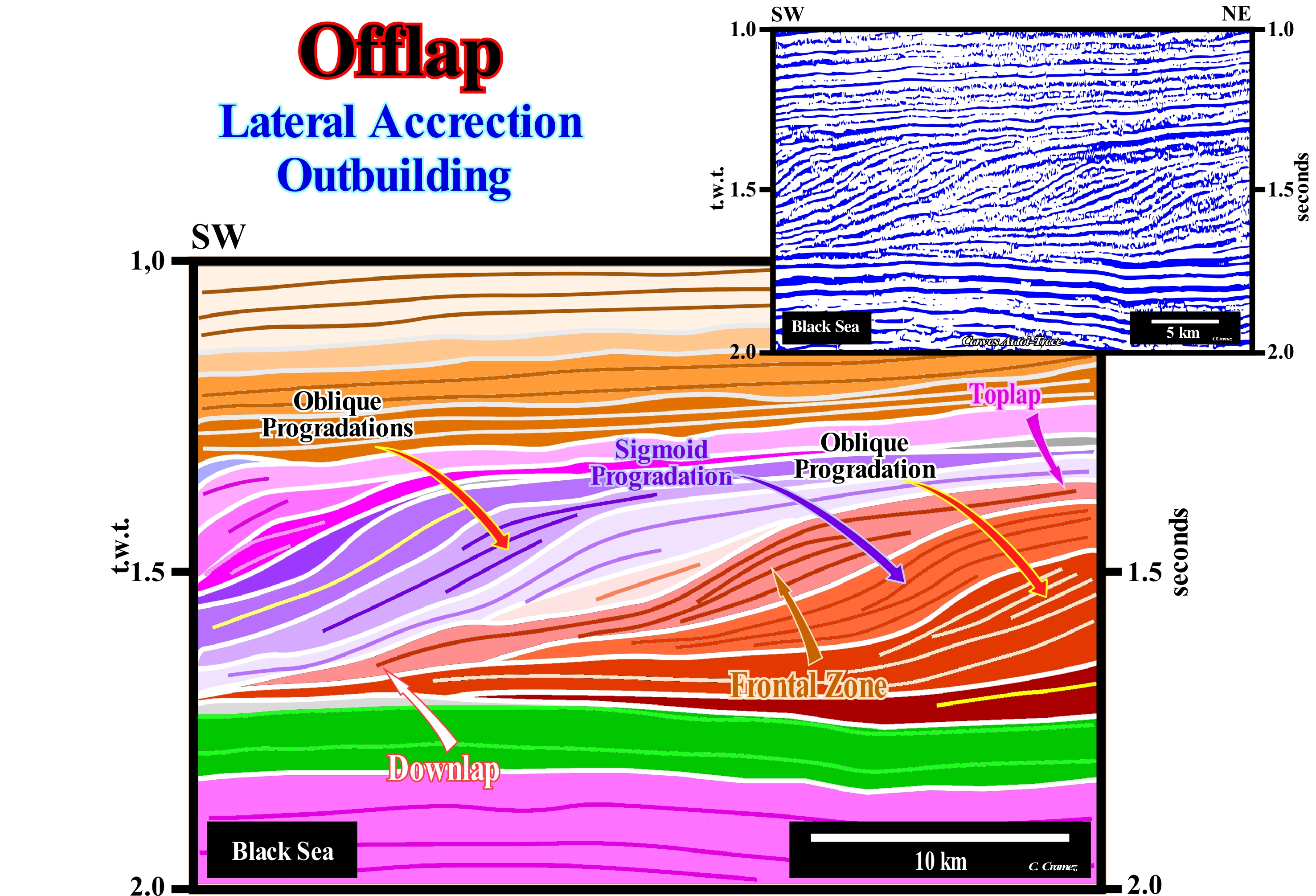
Oblique Offlap.........................................................................................................................................................................Progradation oblique
Progradação oblíqua / Progradación oblícua / Oblique Progradation / 斜前积 / Наклонное несогласное регрессивное налегание / Progradazione oblique /
When aggradation is zero or below seismic resolution, that means that the seaward displacement of the shoreline (depositional coastal break of the depositional surface) or the basin edge (which may coincide) is, practically horizontal.
See: « Depositional Dip »
&
« Progradation »
&
« Depositional Coastal Break »
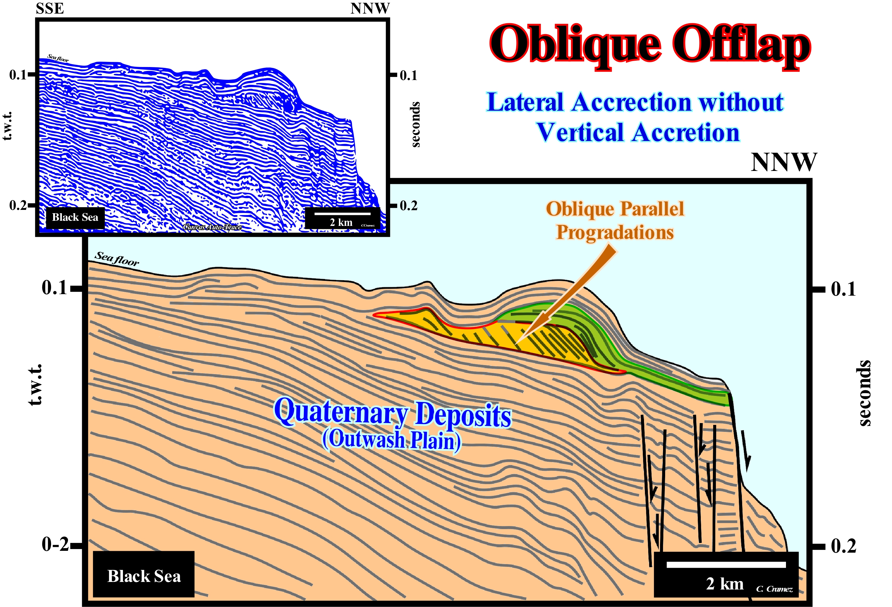
In a pattern of oblique parallel progradations, as illustrated in this sketch of a tentative geological interpretation of a Canvas auto-trace of a detail of a Black Sea seismic line, the chronostratigraphic lines, which separate the sedimentary intervals, whether they are sequence-paracycle, sequence-cyles or continental encroachment sub-cycles (rarely) have an dipping and rectilinear geometry. The upper terminations of the chronostratigraphic lines, which mark either the successive positions of the shoreline or the successive basin edges (if the basin has a no shelf), are abrupt and are all along the same plane. Probably, this means that during deposition the relative sea level was stable (neither rising nor falling) and that the depositional coastal break of the depositional surface just moved seaward without any aggradation (an aggradation implies a relative to the level* rise, at the level of sequence-cycles, or of the absolute (eustatic) sea level, at the level of the continental encroachment cycles. Thus, it can be said an oblique progradational configuration, at the level of a sequence-cycle, involves the following depositional conditions: (i) An important terrigeneous influx ; (ii) A small or null subsidence ; (iii) A relative sea level, more or less, constant ; (iv) A sedimentary transit zone or erosional zone in the upper part (upstream) of the depositional surface and (v) A high energy sedimentary environment. On a seismic line, before considering whether a progradational interval has an oblique or aggradational configuration, the geoscientist in charge o the interpretation has to decide whether the toplaps (upper reflector terminations or stratification planes) are toplaps by nondeposition or by erosion which, geologically, means two things, totally different. In the first case, the internal configuration is truly oblique progradational, since upstream and above the reflection termination there is a sedimentary transit zone and that all the deposition is done by lateral seaward deposition without aggradation. The same final geometry can be obtained from the deposition of a progradational interval constituted by aggradational progradations (sigmoid progradations), which is then, partially, eroded due to a significant relative sea level fall that put the sea level lower than the basin edge, thus creating an erosional surface, i.e., a unconformity. In this sketch of tentative interpretation, in which an interval exhibits an internal parallel oblique configuration, several things have to be taken into account: (a) The original seismic line is in time (double, t.w.t.) ; (b) The vertical scale is in tenths of a second, which means that the seismic line is, probably, an high-resolution seismic record (boomer sound sources), greatly exaggerated vertically ; (c) The lateral variations of the water-depth, particularly at the east end of the auto-trace, which modify, considerably, the reflector dips of the intervals overlying the sedimentary anomaly (emphasized by parallel oblique by non-deposition), which probably are subhorizontal in a depth version of the original seismic line. The seismic reflectors can be: 1) Convergent, when they thin, laterally, basinward ; 2) Divergent, when they thicken and diverge, laterally, basinward ; 3) Filling, when they fill negative topographic anomalies of the underlying strata ; 4) Wavy, when they are, more or less, discontinuous and with opposite dip ; 5) Mounded, when they form topographic anomalies in the shape of a mound, above the base level ; 6) Parallel, like strata deposited in parallel ; 7) Progradational, when they have a progradational (outbuilding and upbuilding) geometry ; 8) Oblique/Parallel, when they terminate downstream with a relatively important dip ; 9) Oblique/Tangent, when they end downdip with a progressive decreasing descending dip ; 10) Singled, when they have a progradational oblique geometry, almost lying on top of each other, as in a slatted roof ; 11) Sigmoid, when the have S backwards shape, i.e., the dip in the upper and lower parts is relatively small whereas in the middle part it is much higher dip.
(*) The relative sea level is the local and referenced at any fixed point on the Earth's surface, whether it is the base of the sediments (top of the continental crust) or the sea floor. It is the result of the combined action of absolute (eustatic) sea level, which is supposed to be global and referenced to the Earth's centre, and tectonics (subsidence of the sea floor, when extensional regimes are predominant or uplift, when compressive tectonic regimes are predominant).
Oblique Parallel Configuration (Reflectors)..............................Configuration oblique-parallèle
Configuração oblíqua-paralela / Configuración oblícua-paralela / Oblique parallelen Konfiguration / 斜平行配置 / Схема наклонно-параллельных отражений / Configurazione obliquo-parallelo (riflettori) /
Set of seismic reflectors with an oblique parallel pattern. A pattern in which reflectors or strata, more or less, parallel end up, seaward, with a, relatively, high slope.
See: « Stratal Pattern »
&
« Reflection Configuration »
&
« Clay Plug »
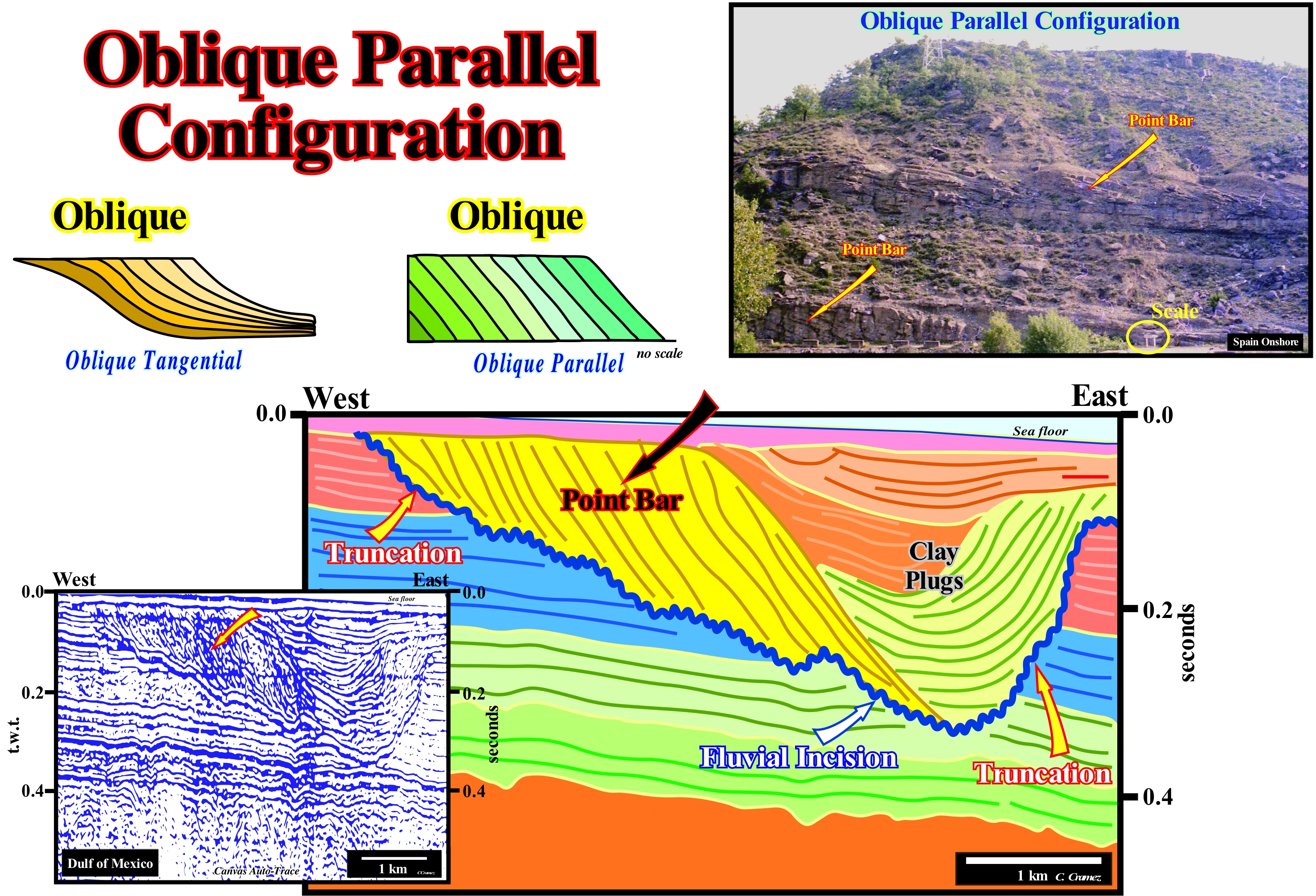
On this tentative geological interpretation of an Canvas auto-trace of a detail of a Gulf of Mexico seismic line, the interval interpreted as a point bar (arched sedimentary deposit, usually formed of sand, located along the inner convex edges of the meanders of a flowing water and prograding to the stream bed as it migrates) has a parallel oblique internal configuration. The top terminations of the reflectors are toplaps (nondeposition) and the bottom terminations are downlaps. In addition, the reflectors are parallel to each other and no significant aggradation is visible (all deposition is made, laterally, towards the concave bank of the meander). The internal configuration of the point bar contrasts with the geometry of the different clay plugs, which correspond to the successive fills of the river channel during abandonment periods. In this particular case, the presence of three clay plugs suggests that the current abandoned its channel intermittently, at least three, before abandoning it definitively. When the stream abandons its main bed, an meander lake (oxbow lake) is formed, at the bottom of which deposits, mainly by decantation, clay sedimentary particles that are, sometimes, rich in organic matter. The period of abandonment may be, more or less, long, before the current resumes its original trajectory. Obviously, the meander illustrated on this tentative interpretation is a free or wandering meander that has its origin in the dynamics of the water-course itself. When the meanders are independent of the valley path (depression of the ground surface, elongated, relatively narrow and dipping where the river flows) several sectors can be distinguished: (a) Headland ; (b) Flanks or slopes ; (c) Thalweg (variable line lying in the middle of the deepest junction of a valley or river, which, of course, varies with time) and (d) Mouth. The affected banks or flanks are, continually, shifted towards the course of the river and the meander arches expand. This type of meander contrasts with the incised meander, in which the river curves coincide with the topographic tracing, as it is the case of the Douro River, particularly in the Port wine area. The geological history inferred from this tentative interpretation may be summarized as follows: (i) A significant fall relative sea level (local sea level referenced to the seafloor or the base of the sediments and resulting of the combined action of the tectonics and the absolute or eustatic sea level, i.e., of the supposed global sea level referenced to the Earth's centre), shifted seaward and downward the depositional coastal onlaps exhuming the old shelf (if it existed) and uplifting (relatively to sea level) the coastal plain ; (ii) The provisional equilibrium profile of the rivers was broken, which forced them to incise further their beds to establish a new provisional equilibrium profile ; (iii) The exhumed ground, under the action of erosion agents, was, partially, eroded to create an unconformity, which was later was fossilized when the relative sea level rose ; (iv) Continentward of the depositional coastal break of the depositional surface, which corresponds, approximately, to the shoreine, i.e., in the coastal wedge or coastal prism ** (set of wedge shaped sediments extending continentward by onlapping on the pre-existing topography that accumulates on the coastal plain during the progradation of the shoreline), the rivers, which have lost much competence and transport capacity, flow towards the coastline in a more or less tight meanders ; (v) The erosional surface of the meandering base may, but not always, correspond, indirectly, to the unconformity created by the relative sea level fall ; (vi) In the convex part of the meander, where the velocity is smaller, secondary flows transport the sediments by traction and saltation, depositing them forming a point bar, which is mainly constituted by parallel oblique progradations. Note that the vertical scale of this auto-trace is not in seconds, but in tenths of a second.
(*) In geomorphology two types of meanders are considered: (i) Free or wandering meanders that snaking in a plain made of more or less moving materials and (ii) Valley meanders that follow, more or less, the geometry of the valley, that is to say, that the valley itself snacks following the water-course geometry.
(**) The upstream limit of the coastal wedge or coastal prism is the bayline.
Oblique Reflection Configuration (Reflectors)...................................................Configuration oblique
Configuração oblíqua / Configuración oblícua / Oblique Reflexion Konfiguration / 斜反射结构 / Схема наклонных отражений / Configurazione obliquo (riflessioni) /
In this pattern, the seismic reflectors or associated strata have a downstream slope which is often decreasing to the base (oblique tangent configuration).
See: « Stratal Pattern »
&
« Reflection Configuration »
&
« Marine Regression »
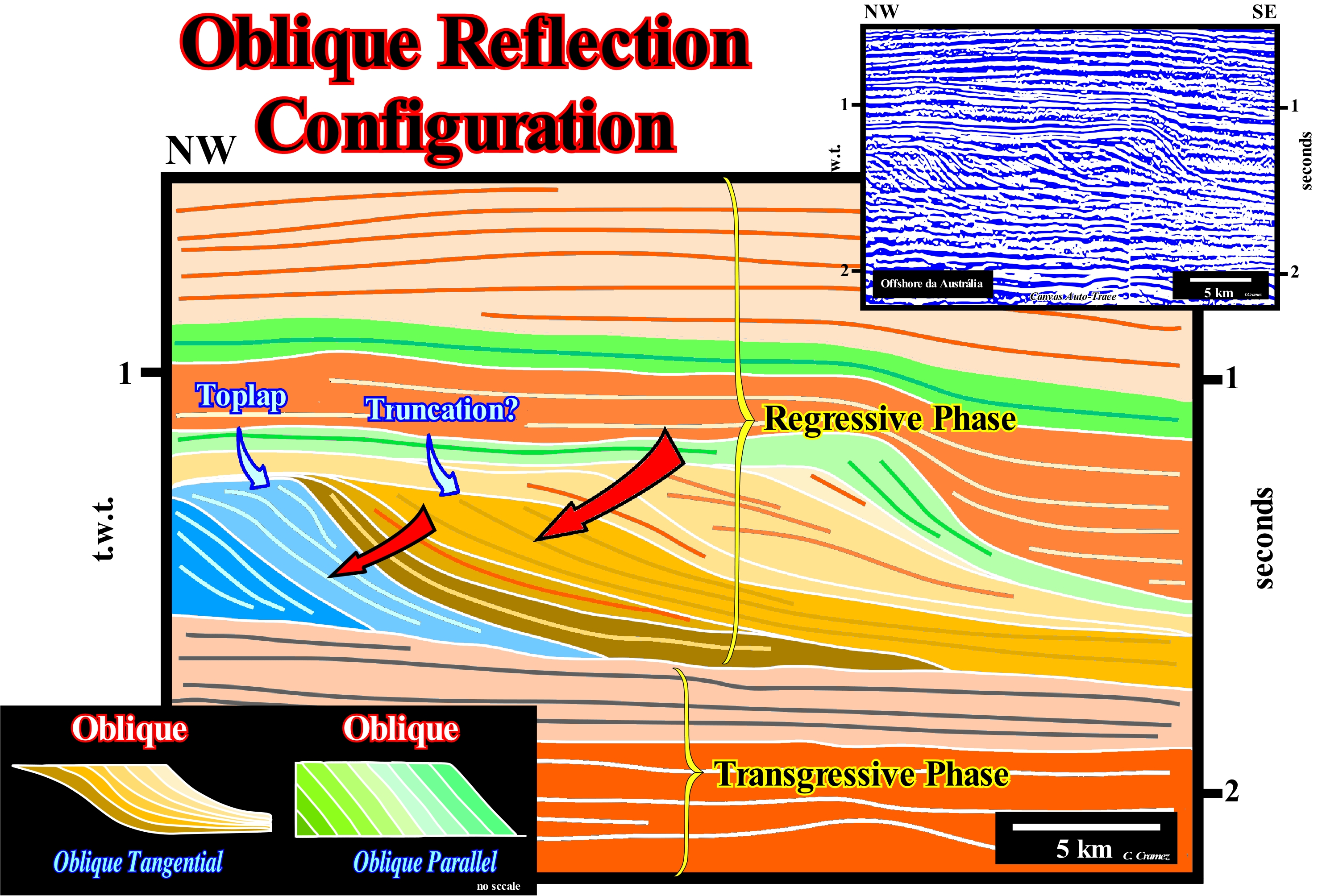
As suggested on this tentative geologically interpretation of a Canvas auto-trace of a detail of West of Australiaa offshore regional seismic line, the sedimentary intervals with an oblique internal configuration correspond to the continental slope progradations of the transgressive phase of the Atlantic-type margin divergent (post-Pangea continental encroachment cycle, induced by the second Phanerozoic 1st order eustatic cycle) covering the rift-type basins (not visible on this auto-étrace). Function of the scale, the slopes may be continental, as in this case, or deltaic when the height of the progradations does not exceed 50-60 m. Do not confuse a delta and delta building. A delta corresponds to a sedimentary systems tract, induced by eustatic paracycle, deposited during the stability period of relative sea level that occurs after marine ingression. A deltaic building is an progradation stacking of deltas, generally, from the same subgroup of sedimentary systems tracts, that may be associated with different sequence-cycles. There are false internal oblique configurations. If the upper part of a interval with an internal sigmoid configuration, i.e., with aggradation (vertical deposition or upbuilding) and progradation (lateral deposition or outbuilding) is eroded (more or less at the time of deposition), the upper reflection terminations are no longer toplaps (by non-deposition) and become toplaps by erosion, and the internal configuration becomes, apparently, oblique. When interpreting, in geological terms, an internal configuration, it has to be original (configuration at the deposition time) and not resulting from tectonics or erosion. In this tentative interpretation, if the progradational interval indicated by the large red arrow is interpreted as having an original oblique configuration (interpretation A) or a sigmoid configuration (interpretation B) in which the toplaps by non-deposition were eroded, these two interpretations imply different geological histories. In the first case, the interval was deposited during a period stabilization of the relative sea level (local sea level referenced to the base of the sediments or to the sea floor) and the terrigeneous influx was forced to deposit on the continental slope before, that in the following of another relative sea level rise, a new sequence-cycle (stratigraphic cycle induced by a 3rd order eustatic cycle, whose time-duration varies between 0.5 and 3-5 My), would be deposited on top of it. In the second case, the geological history can be summarized as follows: (i) In association with several marine ingressions (eustatic paracycles), during the period of stability of relative sea level, that occurs after each marine ingressions, sequence-paracycles with an internal sigmoid configuration (upbuilding and outbuilding) ; (ii) Subsequently, a significant relative sea level fall shifted seaward and downward the shoreline and coastal onlaps exhuming the platform (if any) and the coastal plain, which were, partially, eroded creating an erosional surface, that is to say, an unconformity ; (iii) Finally, a new marine ingression (significant relative sea level rise) flooded the coastal plain, which allowed the deposit of a new stratigraphic cycle, probably a sequence-cycle (note that the lower subgroups of the lowstand systems tracts group, i.e., the submarine basin floor fans (SBFF) and submarine slope fans (SSF), are deposited during relative sea level falls). The sketches (bottom left, of this figure) suggest that an oblique configuration (without significant aggradatio0n), can be: A) Tangential, when the downlaps are false (they become horizont and continue into the deep part of the basin as stratigraphic units that are, often, so thin that they are not visible on the seismic lines) and B) Parallel, when the downlaps are well marked and not thinned against the lower boundary. These two types of oblique configurations suggest that sandy facies are the base of the interval when they are tangential and at the top when the progradations are parallel oblique . This is particularly true at the delta slope scale (usually less than 60 meters in height) and it may be said that the proximal turbidites are associated with tangential oblique progradations, while the coastal strand lines are associated with parallel oblique progradtaions (e.g., Woodbine delta, East Texas Oil Field).
Obliquity of the Earth's Ecliptic (Earth).......................................Obliquité de l'ecliptique (de la Terre)
Obliquidade da eclíptica / Obliquidad eclíptica (de la Tierra) / Obliquity der Ekliptik / 黄道的倾角 / Наклон эклиптики Земли / Obliquità dell'eclittica /
Inclination of the rotation axis of the Earth relative to the plane in which Earth rotates around the Sun. Obliquity cycles vary between 21.5° and 24.5° before returning again to 21.5°, which happens every 41,000 years (Milankovitch's cycle).
See: « Equinoxial Precession »
&
« Milankovitch's Curve »
&
« Global Warming »
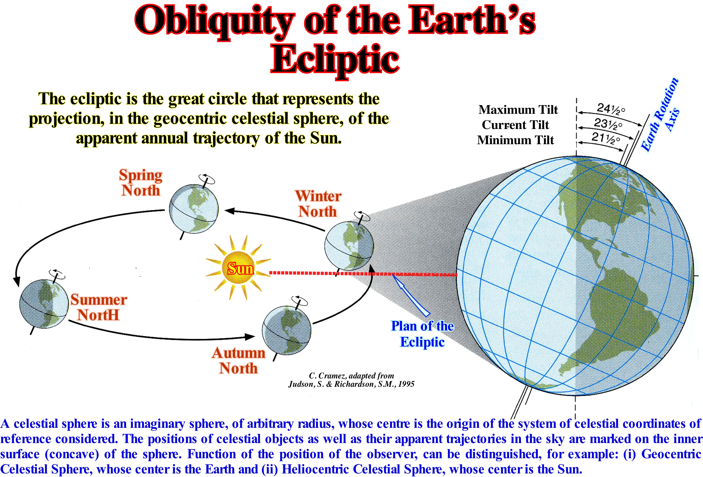
Probably, following a collision between Earth and an asteroid, the Earth rotation axis is not perpendicular to the plane of its orbit. The Earth equatorial plane is not parallel to the equatorial plane of its orbit around the Sun (ecliptic). The Earth equatorial plane makes an angle about 23° 26' with the plane of the ecliptic, which determines the obliquity of the ecliptic. The intersections of the Earth equatorial plane and the plane of the ecliptic with the celestial dome are the celestial and ecliptic equators. The line of interception of the two planes defines two points of intersection, diametrically opposite, which are the equinoxes. The obliquity of the ecliptic is the angle between the Earth rotation axis and the plane of the ecliptic, in which the Earth rotates around the Sun. The obliquity refers to the fact that the angle is oblique,i.e., it is not a right angle or multiple of it. At present time the obliquity is about 23.5° if the angle is measured between the Earth rotation axis and the perpendicular to the plane of the ecliptic. This inclination of the Earth rotation axis, with respect to the plane of the orbit varies with time, due to the gravitational influence of the Sun, Moon and other planets. The obliquity of the ecliptic, for a given year, can be, simply, calculated from the following formula: 23° 27' 8,26" - 0,4684 (t-1900) seconds, where "t" is the year for which the obliquity is desired. The obliquity varies from a maximum of 24.5° to a minimum of 21.5 °, all 41,000 years. The Earth rotations axis moves in a similar way as the axis of a whipping-top. The axis moves towards different points of the firmament during a cycle of 26,000 years. This cycle is reduced by a small oscillation of the plane of the Earth's orbit in the opposite direction. These movements together produce a lag or precession of the spring and autumn equinoxes in every 23,000 years. The hemisphere that is currently tilted towards the Sun receives, each day, more solar energy and sunlight, which reach the Earth's surface closer and more vertically, that is, the Earth receives more energy per surface unit.
Ocean Current...................................................................................................................................................................................Courant océanique
Corrente oceânica / Corriente oceánica / Ozeanströmungen / 目前海洋 / Океанское течение / Corrente oceanica, Corrente di impulso/
Continuous movement of the ocean caused by forces acting, directly, on water, such as wind, Coriolis force, temperature differences, salinity and tidal differences caused by the gravitational attraction of the Sun and the Moon.
See: « Coriolis Effect »
&
« Contour Current »
&
« Gulf Stream »
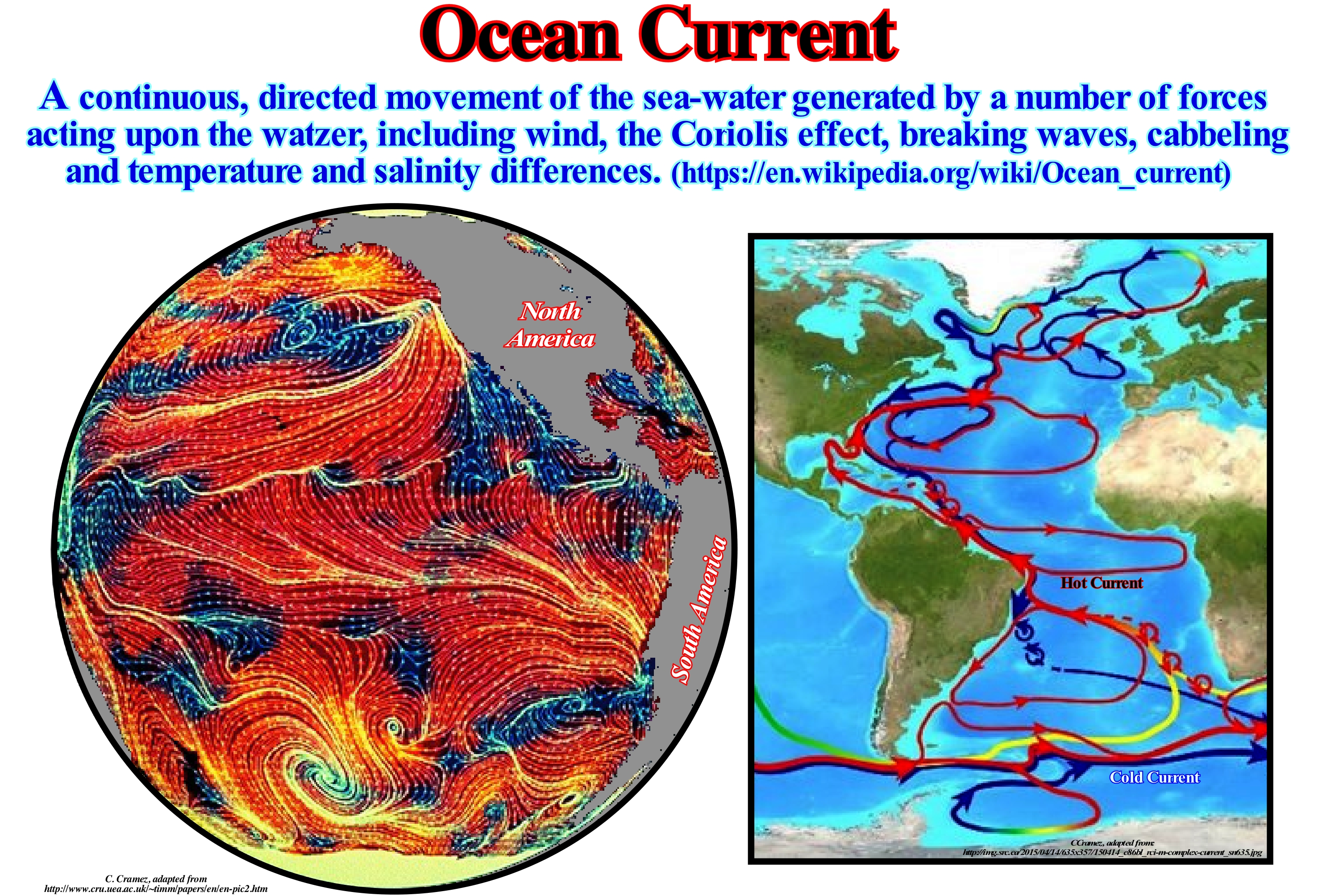
There are two types of ocean currents: (i) Surface Currents, whose waters make up about 10% of all ocean water and correspond to the first 400 meters of the ocean and (ii) Deep Currents (thermohaline circulation), whose waters make up about 90% of the oceans and move in the ocean basins by the action of gravity and forces induced by the density differences. Due to the different temperatures and salinity, the deep-waters sink in the oceanic basins, at high latitudes, where the temperatures are cold enough to increase the density. Ocean currents are influenced by two types of forces: (a) Primary Forces, which initiate water movement and (b) Secondary Forces, which influence where currents flow. Among the primary forces can be mentioned: (1) Solar Heating ; (2) Wind Force ; (3) Gravity Force and (4) Coriolis Force. Solar heating causes the expansion of water (near the equator, the water level is about 8 centimeters higher than in the middle latitudes, which causes a slight slope and a slight flow of water). Wind force pushes the water when the wind blows on the surface of the ocean (the friction makes the connection between the wind and the surface of the water). A wind blowing for 10 hours through the ocean will cause a runoff of surface water at a rate of about 2% of the wind speed (water accumulates in the direction the wind blows). Gravity force, tends to pull the water down or stacks it against the pressure gradient. Coriolis force causes water to move rightward (in the Northern Hemisphere) around water-heaps, which are created by the inward displacement of the water due to Eckman's transport*. These rotating water-heaps are called oceanic gyres, i.e., great system of rotating marine currents, in particular those that are related to the great movements of the wind. As the Coriolis effect is stronger near the poles, the water flows eastward at high latitudes by diverting earlier, which decreases the size of the gyre. At the equator the Coriolis effect is nonexistent and the water flows west until it finds a blocking continent. The western boundary of the currents is faster and deeper than the east boundary, and the water-heap is shifted westward. The North Atlantic gyre is divided into four distinct currents: (A) Equatorial North Current ; (B) The Gulf Stream ; (C) North Atlantic Current and (D) The Canarian Current. The equatorial north current is an important current of the Pacific Ocean and Atlantic Ocean flowing from East to West, between about 10° North and 20° North. It corresponds to the south sector of the subtropical gyre that flows in the clockwise direction. Despite its name, this current is not connected, in both oceans. to the equator. It is separated from the equatorial circulation by the Equatorial Counter-Current, which flows eastward. The westward the surface runoff at the equator in both oceans is part of the South Equatorial Current. The Gulf stream is a fast and warm ocean current from the Atlantic Ocean that originates in the Gulf of Mexico, passes through the Florida Straits and follows the East Coast of the United States continuing to Europe. The North Atlantic Current, which is a warm-water ocean current, is a continuation of the north-eastern part of the Gulf Stream, which at west of Ireland it divides into two branches. One flows southward (Canarian current) and another that continues northward along the north-west coast of Europe; directed by the global thermohaline circulation (GTC). The North Atlantic Current is, often, considered an extension of the Gulf Stream. The Canarian Current, is a sea current from the North-East Atlantic (southern branch of the Gulf Stream) flowing southwest along the north-west coast of Africa to the region of Senegal, where it flows westward, moving away from coast to become the Northern Equatorial Current, which crosses the Atlantic from East to West (its temperature, which is higher than the surrounding waters, results from the incorporation of colder, nutrient-rich waters raised from the deeper layers of the ocean by the upwelling phenomenon. As illustrated in the map on the right, ocean currents are divided into (1) Hot Currents (in red on the map), which form in the intertropical zone, near the equator, flow towards the polar zones with a sinistral movement, in the southern hemisphere, and dextral movement in the Northern Hemisphere and (2) Cold Currents (blue on the map), which form in the polar zones and move towards the equatorial region.
(*) Amount of water transported by a marine current function of depth, since it decreases in depth due to the effect of Coriolis. The variation of the velocity vector of a marine current in depth, as a function of the Coriolis effect, is the Eckman spiral.
Oceanic Basin..........................................................................................................................................................................................Bassin océanique
Bacia oceânica / Cuenca oceánica / Ozeanbecken / 大洋盆地 / Глубоководный бассейн / Bacino oceanico /
Large depressed area of the ocean floor, between 4,000 and 6,000m deep, elongated or rounded, with or without isolated reliefs and bounded by abyssal or oceanic ridges.
See: « Seafloor »
&
« Abyssal Hill »
&
« Abyssal »
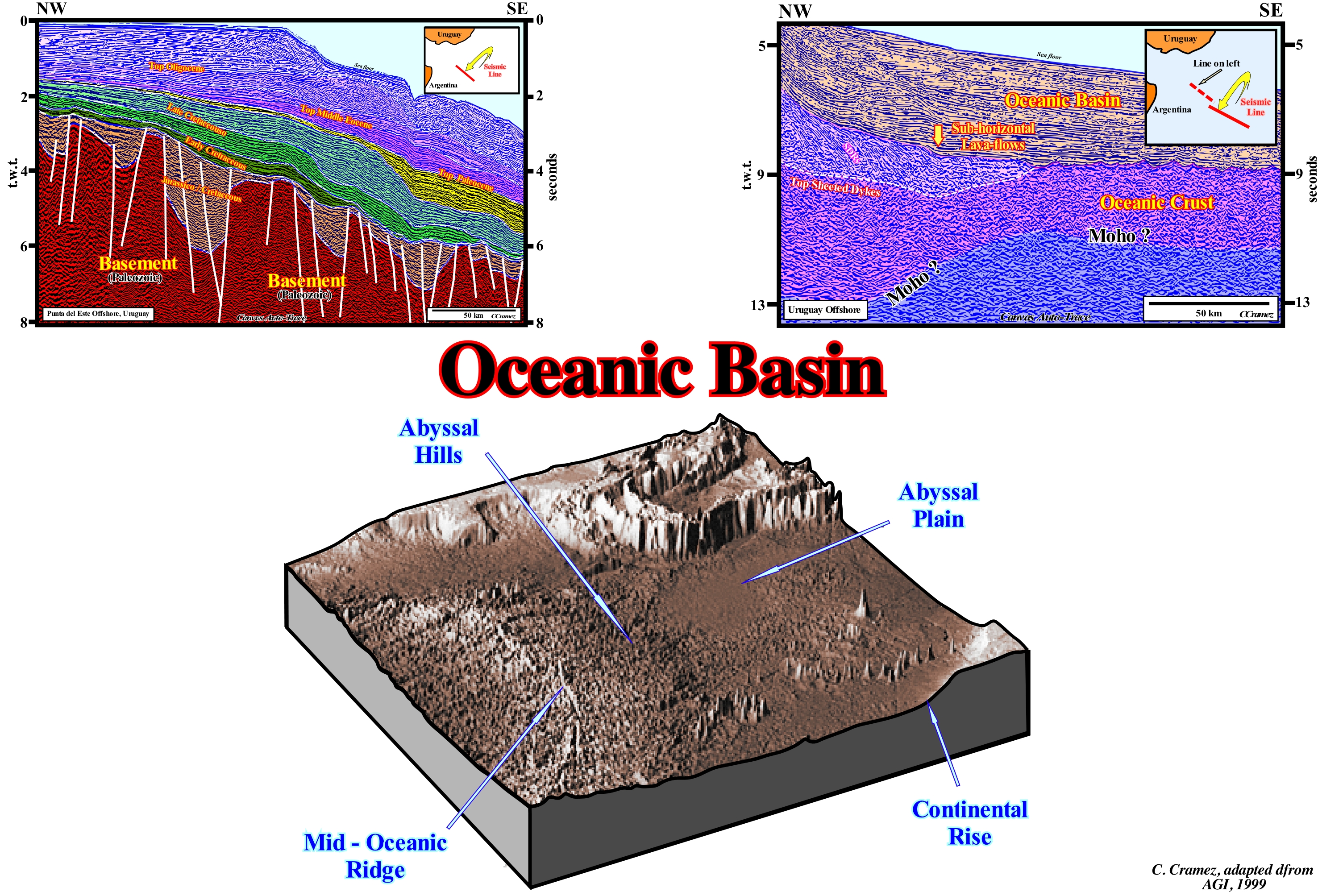
An ocean basin corresponds, more or less, to what certain oceanographers call the abyssal plain, which is located downstream of the continental slope foothills or more simply, downstream from the continental rise. Its substrate is, basically, formed by volcanic rocks deposited under a significant water-depth, although in some cases it may, also, be constituted by subaerial volcanic rocks. In fact, particularly, in the Atlantic-type divergent margins (as illustrated in this figure by tentative interpretation of Canvas auto-traces of the Uruguay offshore seismic lines), which today are considered by most geoscientists as volcanic margins, the. substrate is volcanic. It is formed by SDRs (Seaward-Dipping Reflectors) deposited, immediately, after the break-up of the Gondwana lithosphere, as well as expansion centres (sea floor spreading centres), the volcanoes and volcanic dykes not yet covered by water. Under these conditions volcanic material, when it reached the surface, by sheeted dykes* (each injection of a dyke, which intrudes on the older dykes, represents an increase of sea floor spreading), flows continentward (on each side of the expansion centre) in the form of lavas, which thin as they move away from expansion centres. The sedimentary interval that is deposited in the oceanic basins is, generally, not very thick, reason why the oceanic basins are not considered in the classification of the sedimentary basins of Bally and Snelson (1980). It consists,, basically of pelagic sediments (depositional water-depth more than 1000 m), deposited by decantation (slow sedimentary particles fall to the sea floor, which may take several decades). The morphology of (i) Abyssal Hills (a set of small, topographically well-defined oceanic elevations with a height of up to 1,000 m in height, with extensions between 100 and 100 km, occurring either in the middle of the abyssal plains, or along the continental ramps) ; (ii) Mid-oceanic ridge and (iii) Oceanic ridges associated with the former mid-oceanic ridges, which depends, basically, on the degree of maturation and the speed of oceanic spreading, is very important in sequential stratigraphy. It controls, particularly, the absolute (eustatic) sea level changes, i.e., it controls the eustatism or eustasy**. When the oceanic expansion is rapid, the morphology of the ocean floor is quite accentuated. The oceanic mountains are high, which diminishes the volume of the ocean basins. As the amount of water, in all its forms, is supposed to be constant, since the beginning of the Earth's formation (around 4.5 Ga), the absolute sea level rises. When ocean basin volume increases, due to the activity of the subduction zones, particularly, along the B-type subduction zones (crust zone, associated with negative gravity anomalies, where the convective currents of the Earth's mantle push lithosphere downward), or because the oceanic expansion velocity is slow (allowing cooling and increasing density of the newly formed oceanic crust, which causes a partial collapse of the ridges), the absolute sea level falls. First order (time-duration higher than 50 My) and 2nd order eustatic cycles (time-duration between 3-5 and 5 My), associated with these types of sea level changes, are responsible for the deposition of continental encroachment stratigraphic cycles and continental encroachment subcycles, which form all the divergent continental margins.
(*) The expression sheeted dykes is used to denote dykes covered by pillow lavas, whose formation can be summarized as follows: (i) During the stretching of the lithosphere of a supercontinent, in the thinnest part of the continental crust, magma is injected into the fractures that developed above the magma chamber ; (ii) The magma then cools and solidifies forming dikes between the magma chamber and the surface ; (iii) Continued stretching of the continental crust facilitates the injection of new dikes (cause or effect) among the oldest forming a volcanic sequence that from a given moment becomes predominant - it is the break-up of the supercontinent and the individualization of two new lithospheric plates ; (iv) If the breakup occurs in a continental or subaerial environment, when the magmatic material reaches the surface, it flows into the continent forming the so-called Seaward-Dipping Reflectors (SDRs) ; (v) As soon as the expansion centres are submerged, due to the weight of the successive volcanic flows, the dikes reach the sea floor and the volcanic material solidifies forming lavas with a more or less round shape that the geoscientists called pillow-lavas ; (vi) It is this association of dykes, more or less, vertical covered by pillow-lavas that geoscientists call sheeted dykes.
(**) Eustatism or Eustasy corresponds to the changes of absolute sea level (supposed global and referenced to the Earth's centre). Four major types of eustasy can be considered: (a) Glacio-Eustasy (ice volume) ; (b) Geoidal-Eustasy (variations on the Earth gravity field) ; (c) Tectono-Eustasy (volume of the oceanic ridges) and (d) Steric-Eustasy or thermal ocean expansion (if the temperature of the oceans increases, the density of water decreases and, for a constant mass, the volume increases).
Oceanic Basin Floor....................................................................................................................................Fond du bassin océanique
Fundo da bacia oceânica / Fundo de la cuenca oceánica / Grund des Ozeans Becken / 洋盆的底部 / Дно океанического бассейна / Fondo del bacino oceanico /
Deep ocean floor induced by the tectonics of lithospheric plates. All ocean basins are formed of volcanic rocks that have come to the surface (continent or sea floor) from the expansion centers located along the mid-ocean ridges. The oldest rocks that make up the ocean floor are about 200 million years old, meaning they are much younger than the continental crust, which in some places is more than 4,000 million years old.
See: « Abyssal Plain »
&
« Bathyal »
&
« Seafloor »
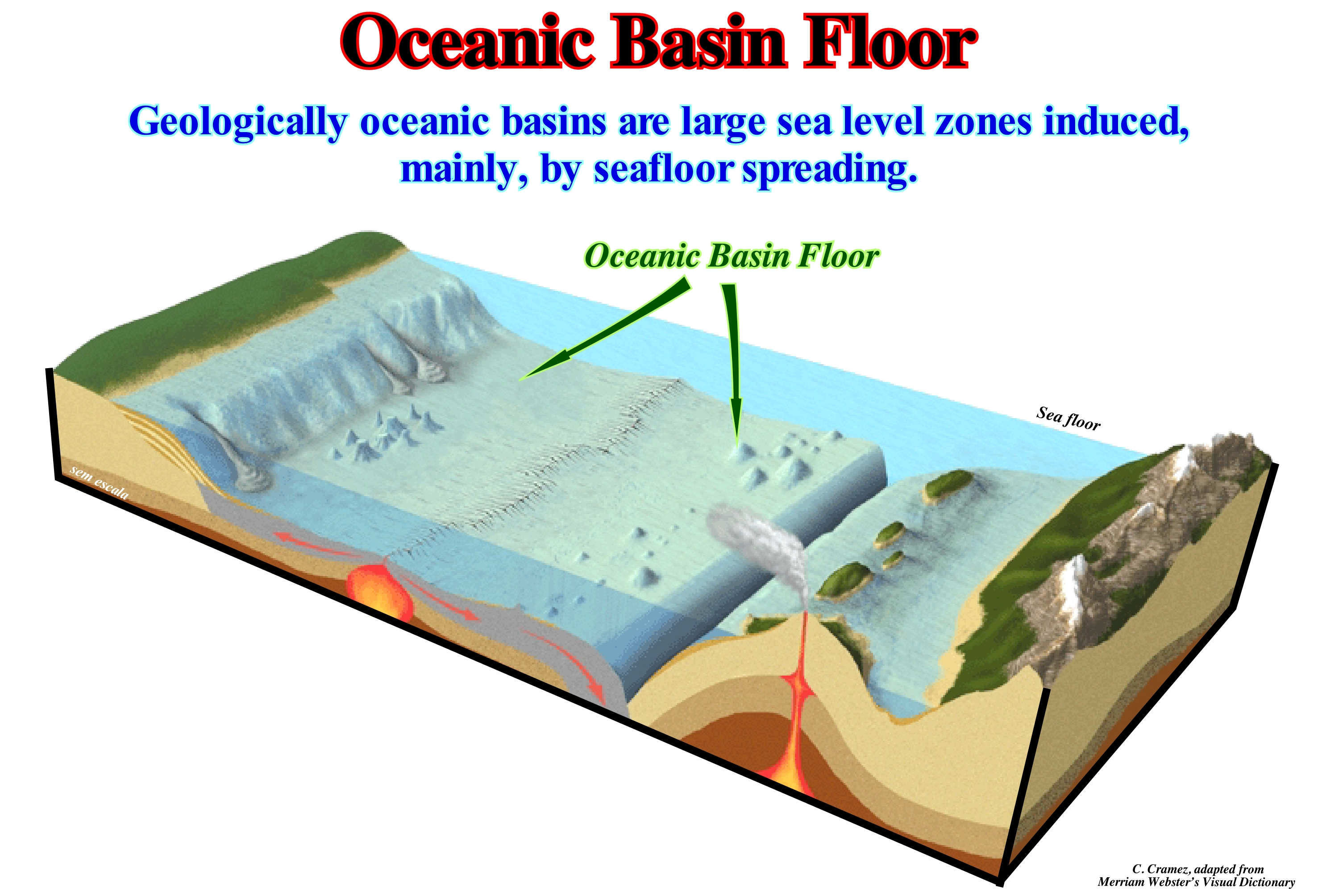
This block diagram explains, perfectly, the discrepancy between the age of the oldest rocks that constitute the ocean floor (± 200 million years) and the age of the continental crust, which, in certain areas, reaches more than 4.0 Ga (thousand millions years). The reason for this difference is very simple. In subduction zones, particularly, in Benioff or B-type zones (when a lithospheric plate of oceanic composition plunges under a continental plate), the old oceanic rocks are destroyed, i.e., the oceanic material returns to the mantle as suggested in this scheme. In contrast, along the mid-ocean ridges, the ascending material of the asthenosphere is extruded creating a new oceanic crust that contributes to the expansion of the oceans and forces the continents to move away from each other. As ocean expansion (sea floor spreading) progresses, not only the surface of the ocean floor increases but also the density of the oceanic crust, since, the temperature of the oceanic crust decreases. Over time, the material that forms the ocean floor farthest from the mid-oceanic ridge from which it emerged becomes so dense that it plunges (goes into subduction) under the adjacent material thereby initiating a B-type subduction zone. The creation and subduction of oceanic material characterizes two types of continental margins. The former is associated with divergent continental margins, while the latter characterizes convergent margins. Certain convergent continental margins are associated with the Ampferer or A-type subduction zones (when two continental lithospheric plates collide, i.e., one under the other). The convergent margins can be considered as the beginning of the formation of a supercontinent.
Ocean Geoid (Geodetic sea level).........................................................................................................................................Géoïde océanique
Géoide oceânico / Geóide oceánico / Geodätische Meeresspiegel / 大地海平 / Средний уровень моря / Geodetic livello del mare /
The sea level of the geoid, also, called the geodesic sea level, corresponds to a set of digital values of the highest geoid points in relation to a reference ellipsoid. The geoid is defined as the equipotential surface of the Earth's gravity field that best represents the average global sea level. The sea level is wavy and mimics, more or less, the topography of the sea floor, however these undulations are very small and can just be measured by altimetric radars from satellites.
See: « Geodesic Sea Level »
&
« Eustasy »
&
« Geoidal-Eustasy »
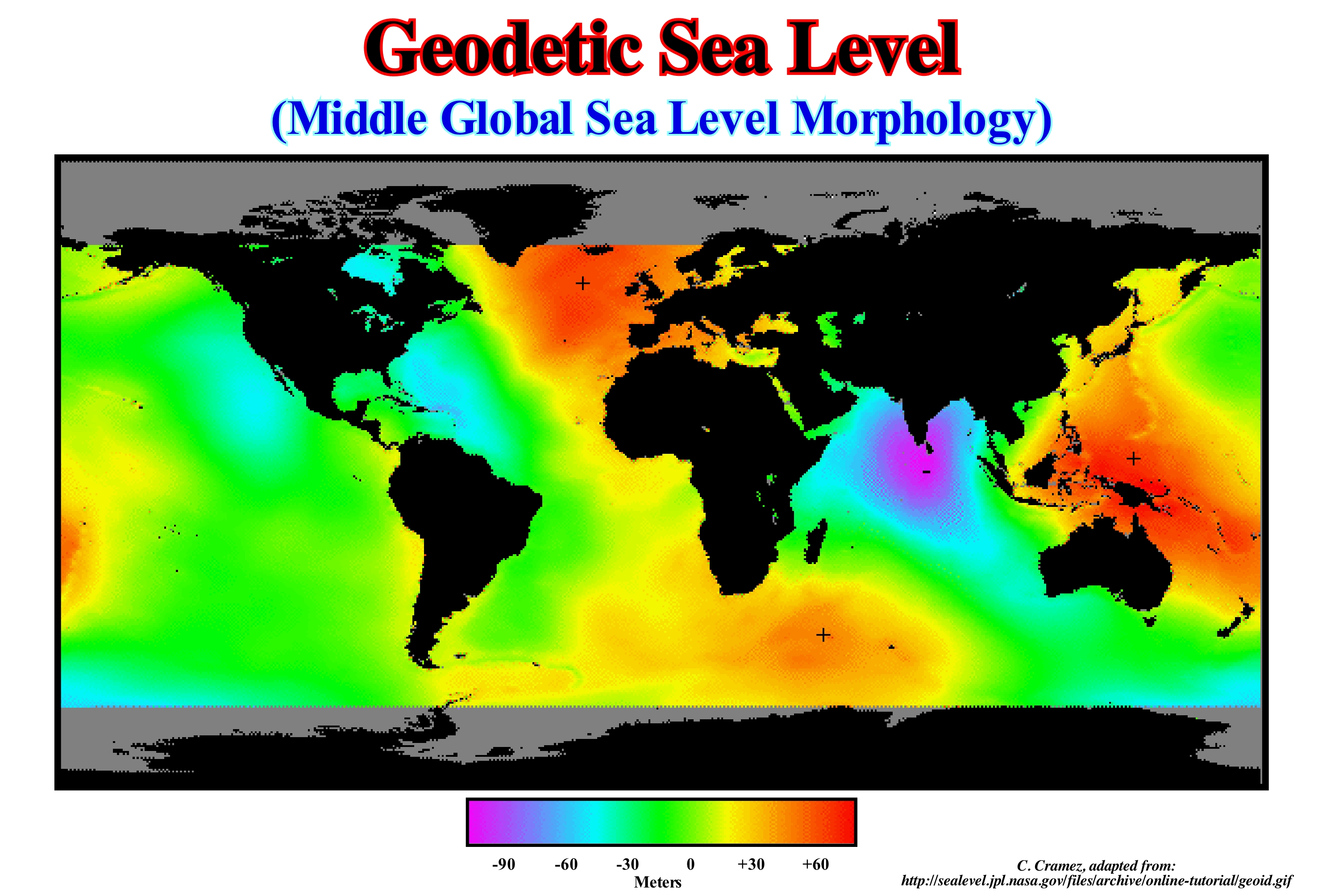
In this oceanic geoid it is easy to distinguish the undulations of the average global sea level. These must, necessarily, be taken into account in sequential stratigraphy, especially in order to determine the validity of certain geological events considered as global. The GOCE (Gravity field and steady-state Ocean Circulation Explorer) mission, accurately, measured the gradients* on gravity and proposed a global model of the Earth's gravity field and the geoid, which serves as a reference for all topographical elements. Everything depends on the knowledge of the field of terrestrial gravity, which defines the horizontal. It is a function of several factors. The presence of mountain ranges and oceanic trenches, which make the surface of the Earth very uneven. The materials that form the Earth have different densities and are not, evenl,y distributed. For all these reasons, the force of gravity varies from one place to the other at the Earth's surface. The accuracy of gravitational force values is fundamental not only for geodesy, but also to better understand the geological processes that occur within the Earth: a) The circulation of the oceans ; b), The movement of the glacial caps and c) The absolute (eustatic) sea level changes (measured with reference to a fixed point, which may be the Earth' centre), which is, particularly, relevant to sequential stratigraphy. Considering the oceanic geoid, an absolute (eustatic) sea level rise observed at a certain point on the Earth's surface, probably, does not have the same sedimentological consequences on all parts of the Earth's surface. Suess (1888) thought that shoreline shifts were caused by variations in sea level. He used Eustasy to name those variations that he considered global. Such a concept of eustasy was falsified when the geoscientists showed that the cycles of sediment transgressions/regressions do not correlate globally and that they are, mainly, induced by local uplift and subsidence of the sea floor. Eustasy or Eustatism is, often, defined as "simultaneous and global sea level changes", i.e., variations in absolute (eustatic) sea level, in order to differentiate them from relative and local sea level changes. Many of the unconformities induced by significant relative sea level falls (measures in reference to any point on the Earth's surface which is, usually, the seafloor or the base of the sediments), probably, do not have a global value, as is often thought. In some places, tectonics (subsidence of the sea floor, when the predominant tectonic regime is in extension or uplift, when it is in compression) may be more important than eustasy. A significant relative sea level rise can occur due to: (i) An anthropogenic subsidence of the sea floor, as is the case for many coasts with large agglomerations, as Jakarta city harbour, Indonesia and (ii) A natural subsidence (sediment weight) as is the case in the Ganges delta and particularly in Bangladesh. Do not forget that Earth is wider around the equator than between the North Pole and South Pole. It is similar to an ellipsoid or spheroid. The terrestrial ellipsoid is a rough mathematical figure of Earth's shape, used as a frame of reference for geodesic, astronomical, and geoscience computations. The geoid is a surface that is complex to describe mathematically but can be easily identified by measuring gravity. In fact, if all points of the Earth that have the same gravity are united and this gravity is the one that has the sea surface, a geometric figure is formed, but it is not regular and perfect, but with deformations that rise and fall depending on the composition and density of the ground mass below each point. It can be said the ellipsoid is a mathematical figure while the geoid is a physical figure. The geoid is roughly equal to the sea level, but in the oceans the geoid and the mean sea level are, roughly, the same, but in continental areas they may be very different. The "mean sea level" can be determined in a certain place and used as reference point. Generally, it is determined from hourly observations, made over a period of about 30 years**, the average can be calculated for that measurement point. In this oceanic geoid it is easy to distinguish the undulations of the average global sea level. These must necessarily be taken into account in sequential stratigraphy, especially in order to determine the validity of certain geological events considered as global.
(*) Rate of change of a quantity in the variation range of another quantity on which the former depends. In mathematics, the gradient is a multi-variable generalization of the derivative. While a derivative can be defined on functions of a single variable, for functions of several variables, the gradient takes its place. Like the derivative, the gradient represents the slope of the tangent of the graph of the function.
(**) An average whether it is sea level or temperature, to have meaning must cover a rather long period. The World Meteorological Organization (WMO) recommends that it covers 30 years. From there one can speak of « normal »
Oceanic Depression.................................................................................................................................................Dépression océanique
Depressão oceânica / Depresión oceánica / Seebecken / 洋盆 / Океаническая впадина / Bacino oceanico /
Large depressed area of the ocean floor, between 4,000 and 6,000 meters deep, elongated or rounded, with or without isolated reliefs and bounded by abyssal or oceanic ridges.
See: « Sea floor »
&
" Ocean Basin "
&
« Abyssal »
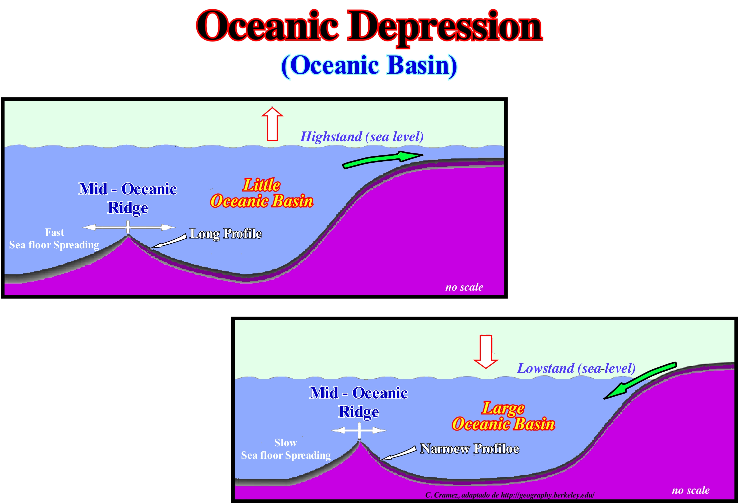
In sequential stratigraphy, the concept of oceanic depression is, extremely, important, since the evolution of oceanic basins, which are nothing else, than all oceanic depressions, play a major role in absolute (eustatic) sea level changes, which control, to a large extent, the available space for the sediments (accommodation). The importance of the evolution of the ocean basins is conditioned by the non refutation (at least until today) of a basic conjecture, which says the amount of water, in all its forms (liquid, solid and gaseous), is constant since the Earth's formation (about 4.5 G or 4.5 billion years ago). As illustrated in these sketches, the dimensions of an ocean basin are, largely, conditioned by the velocity of oceanic expansion (sea floor spreading), i.e., by the rate of formation of new oceanic crust. When the oceanic expansion rate is large, the morphology (height and lateral extension) of the oceanic mountains is very important. They do not have enough time to cool and shrink, so that, the volume of the ocean basin becomes smaller, since part of the volume that was, initially, occupied by water is occupied by the mountains, which forms the new oceanic crust. In this case, assuming that the amount of water (in all its forms) is constant, the water level of the oceans rises and encroaches the continents. When the rate of oceanization (sea floor spreading) is slow, it is the opposite. The new oceanic crust has sufficient time to cool, that implies an increase in density and a decrease in volume, creating larger oceanic basins. In this case, absolute sea level* falls as the volume of the ocean basins is larger for the same amount of water. The sea level fall can create lowstand geological conditions, which imply the exhumation of the continental shelf and uppermost part of continental slope. It can be said that the volume variation of the ocean basins has direct implications in eustasy: (i) When the rate of oceanization is strong, sea level is generally high (highstand conditions) and (ii) when it is weak, sea level is lower than the basin edge (lowstand conditions).
(*) The sea level can be (a) Absolute or Eustatic and (b) Relative. The absolute sea level is supposed to be global and referenced to the Earth's centre. The relative sea level is local and referenced to any point on the Earth's surface, which may be the sea floor or the base of the sediments (top of the continental crust). The absolute sea level depends on the Glacio-Eustasy (variations of the volume of water in the global ocean), Tectono-Eustasy (variations of the global volume of the ocean basins), Geoidal-Eustasy (distribution of ocean water caused by the variations of the terrestrial gravity field and Steric-Eustasy or thermal ocean expansion. Relative sea level is the result of the combination of absolute sea level and tectonic (uplift or subsidence of the sea floor).
Oceanic Front..............................................................................................................................................................................................Front océanique
Frente Oceânica / Frente oceánica / ozeanisch Front / 海洋前 / Океанический фронт / Fronte oceanica /
Contact zone between a mass of oceanic air, generally, cold with a continental mass of air, which is, generally, warmer.
See: « Climate »
&
« Climatology (modern) »
&
« Cloud »
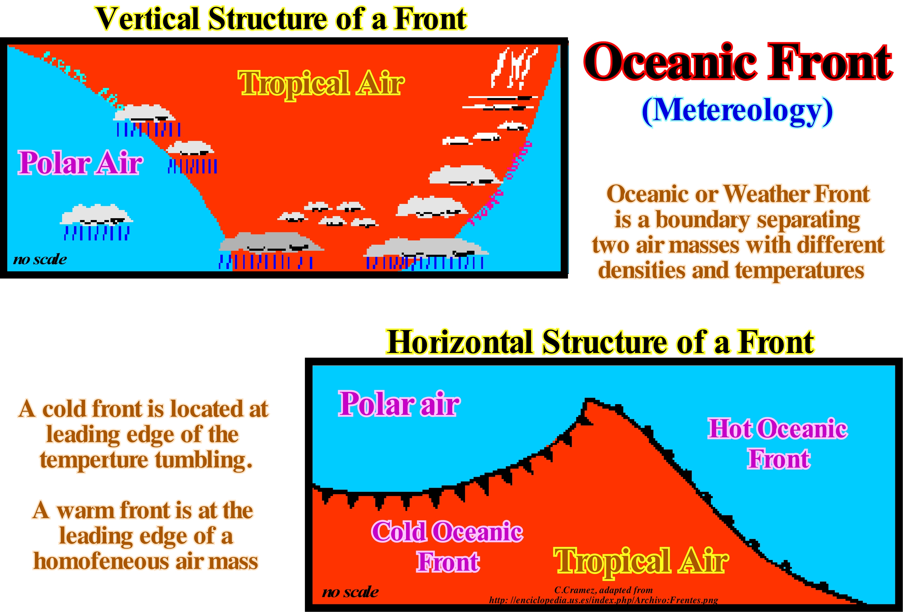
Air masses move from regions where atmospheric pressure is greatest to regions where pressure is lower. Air masses can travel due to differences in temperature (which also cause pressure differences) and also by the dominant atmospheric circulation in the region. A mass of air can be considered as a portion of the atmosphere that travels over the Earth's surface by carrying part of the characteristics of the region where it formed, such as temperature and humidity. As long as the air remains stationary for a long time on certain land surfaces, such as the polar, desert regions, or the hot or cold sea expanses, the mass of air is influenced by the characteristics of those surfaces as it is in contact. The masses of oceanic air are humid and the continental ones are, generally, dry since the differences in the incidence of the solar rays on the Earth's surface are responsible for the formation of air masses. Air movements (air masses and winds) result from the uneven distribution of solar energy in low, medium and high latitude areas. The difference in temperature of the atmospheric air plays a very important role in the formation of areas of low and high atmospheric pressure and, consequently, in the movement of air masses and winds, since the air displacements are made of an area of high pressure to a low pressure. The heated air in the low latitude zones near the equator expands, becomes light and rises, creating a low pressure or cyclonic area. The colder, denser air in the mid- and high-latitude areas descends, giving rise to a high-pressure area. Since the masses show a certain tendency to equalize these pressures, an atmospheric dynamic is established, that is, a general circulation of hot air between the tropics and the poles, passing through mid-latitude zones. Cold or high pressure areas, such as polar, and subtropical or mid-latitude areas, disperse air masses and winds, and (anticyclonic areas), while hot or low-pressure (low latitude) areas such as the equatorial ones, capture the masses of air and winds; they are called cyclonic areas.
Oceanic Trench.......................................................................................................................................................................................Fosse océanique
Fossa oceânica / Fosa oceánica / ozeanischen Graben / 海沟 / Океаническая впадина / Fossa abissale /
Depression of the ocean floor, in general, arched, narrow and much deeper than the adjacent ocean. The ocean trenches are induced and associated to B-type subduction zones. Synonym with Abyssal Trench.
See: « B-Type Subduction (Benioff) »
&
« Abyssal »
&
« Source-Rock »
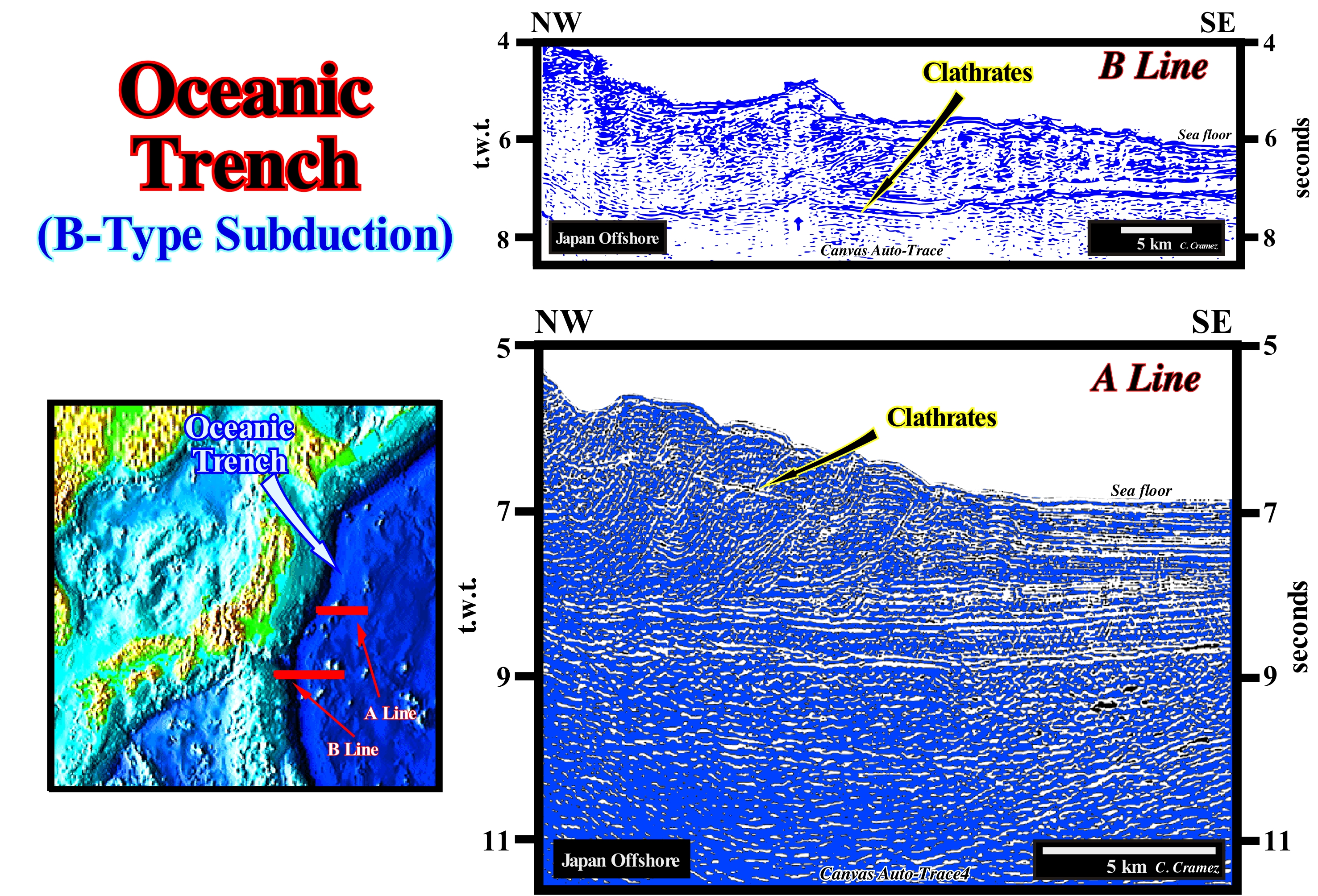
This oceanic or abyssal trench is, of course, associated with a B-type or Benioff subduction zone, in which the descending or plunging lithospheric plate is oceanic and the ascending or overriding plate is continental. It marks the beginning of the subduction zone that characterizes the East Japan offshore. In these details of Canvas auto-traces of two regional seismic lines that cross this region, one can see: (i) The great amplitude of the water-depth, which is between 5 and 7 second (double time, t.w.t.), that is more or less, 4-5 kilometers ; (ii) The probable absence of sediments rich in organic matter (absence of source-rocks) and (iii) The low sedimentary thickness. These elements are, largely, sufficient to consider this area, as indeed most of the oceanic trenches, with very weak oil potential. In such a geological context, the petroleum parameters: (a) Trap and (b) Rock-reservoir may be excellent, but they are simple geological curiosities, since the main parameters, i.e., the source-rocks and maturation parameters are always absent. In the oceanic trenches there may be good turbidite reservoir-rocks and magnificent structural traps, particularly, in the accretionary prism created by the compressive tectonic regime induced by the B-type subduction. It may be said that oceanic trenches have no oil potential. They have a total absence of source-rocks, that is to say, that even when sediments rich in organic matter are present, the organic matter remains immature, since it has not been buried sufficiently. The water-depth is, by definition quite important, often exceeding 5 seconds (double time). This point of view is not followed by a small number of geoscientists who think that certain oceanic trenches have significant potential in methane clathrate or gas hydrate* (mineral association between hydrocarbons and water). This conjecture is based on the presence of seismic reflectors of strong amplitude that mimic the sea floor. These reflectors interpreted in association with hydrates are visible on these seismic lines at about 6-8 seconds (t.w.t.) from the sea floor.
(*) Methane clathrate (CH45.75H2O) or (4CH423H2O), also called methane hydrate, hydro-methane, methane ice, fire ice, natural gas hydrate, or gas hydrate, is a solid clathrate compound, i.e., a chemical substance consisting of a lattice that traps or contains molecules in which a large amount of methane is trapped within a crystal structure of water, forming a solid similar to ice. (https://en.wikipedia.org/wiki/Methane_clathrate).
Ockham's Principle............................................................................................................................................................Principe d'Ockham
Princípio de Ockham / Principio de Ockham / Prinzip von Ockham / 奥卡姆原理 / Бритва Оккама (методологический принцип) / Principio di Ockham /
The plurality should not be invoked without necessity "Pluritas non est ponenda sine necessita".
See : « Eustasy »
&
« Sequential Stratigraphy »
&
« Geological Principle »
The Ochkam's principle is the principle that when several possible explanations exist for a phenomenon is the simplest explanation that is most likely to be closer to the truth. Several scientists and philosophers do not agree with this principle. Chatton (1290-1343), contemporary of Ochkam, argued that "if three beings are not sufficient to verify an affirmation about something, then a fourth must be added, and so on." Leibniz (1646-1716) said "the variety of beings can not be diminished." Menger (1902-1985) argued that "entities can not be reduced to the point of inadequacy," and that "it is useless to do little of what requires the most." Obviously, none of these statements, actually, contradict the meaning of the Ochkam's Razor, but rather serve as a warning against excessive zeal in applying this principle. We should eliminate the superfluous, but that alone. This principle, which says plurality should not be invoked without necessity ("Pluritas non est ponenda sine necessita") is the predecessor of the so-called KISS Principle ("Keep It Stupidly Simple") advocated by I. Kant (1724-1804) in the Critique of Pure Reason (1781/1787, pp. 538-9), in which not only did he accept the maxim "rudiments or principles should not be multiplied unnecessarily," but says that this is a regulatory idea of the pure reason which underlies the theorizing of scientists about nature. At present, this principle is applied in all sciences. Certain geoscientists, especially, today with the anthropogenic global warming, tend to forget it. Scientific truth does not exist. Any hypothesis or conjecture can never be verified. It can just be corroborated or validated. The scientific approach is falsification and not verificationism**. Besides this principle, in Geology, there are many other principles or hypotheses (*), among which we can mention: (i) Composition Principle, a rock represented by fragments in another rock is older than the rock that contains them ; (ii) Carbonated Bucket Principle, the architecture of the growth of a rimmed carbonate platform resembles the geometry of a bucket or inverted cone trunk ; (iii) Original Horizontality Principle, the sedimentary layers deposit horizontally (not totally true) ; (iv) Intersection Principle, the most recent dyke*** move the oldest dykes ; (v) Intrusion Principle, an igneous intrusive rock is younger than the rock it penetrates ; (vi) Superposition Principle, in a slightly deformed sedimentary series, the oldest beds are at the base and the most recent beds above ; (vii) Goguel's Principle, during the deformation, the volume of the sediment remains more or less constant ; (viii) Original Lateral Continuity Principle, the sedimentary layers settle in lateral continuity ; (ix) Walther's Principle, in conforming strata, vertically succeeding facies occur laterally in adjacent environments ; (x) Dextrological Principle, if a reference system rotates clockwise the deflection (Coriolis effect) is to the left of the object, in the direction of motion ; (xi) Uniformity Principle, geological changes are due, mainly, to the same ongoing processes and changes that are currently observed ; (xii) Fossil Succession Principle, the distribution of fossils in rocks is not unpredictable, it follows a definite vertical sequence ; (xiii) Catastrophism Principle, changes that occurred on Earth were due to the occurrence of major natural disasters ; (xiv) Continental Drifting Principle, the continental masses have a small density and, for that reason, they floated on the dense masses of the ocean, moving and changing the surface of the planet ; (xv) Neocatastrophism Principle, which admits Uniformitarianism as the main guide, but does not exclude that occasional catastrophic phenomena have contributed to any changes in the earth's surface (Neocatastrophism associates catastrophic ideas with Uniformitarianism to explain certain phenomena such as the extinction of dinosaurs), etc.
(*) In all the principles or geological hypotheses advanced by geoscientists there is a certain contribution of the cognoscente (i.e. the geoscientist) to the known (geological data). Such a contribution occurs, mainly, at level of observation (ground or seismic data). It comes from the geoscientist to his scientific knowledge, when the geoscientist expresses his knowledge by means of theories and description of observations through the scientific language. In describing what he sees in an outcrop, for instance, the geoscientist uses the language of things that endure in the time, i.e., the language of the causes. He describes the action of things and substances acting on one another. (see: Harré Ron, 1984,- The Philosophies of Science, Chapters I-VI, Oxford University Press, 1972, Chapter VII, Rom Harré, 1984)
(**) Philosophical methodology applied to the natural sciences, which uses the principle of verifiability of a hypothesis, by means of the empirical method, as a way of knowing if the hypothesis is true or not.
(***) A dike or dyke is a sheet of rock that is formed in a fracture in a pre-existing rocky material.
Offlap.............................................................................................................................................................................................Superposition progradante
Sobreposição progradante / Superposición progradante / Überlagerung progradierenden / 前超 / Регрессивное залегание / Sovrapposizione progradante /
Expression used by certain geoscientists to express the geometry of a sedimentary interval that progrades to the basin. This expression characterizes a downstream expansion (seaward) of the areas of nondeposition and erosion. Three families of progradational configuration can be considered: (i) Sigmoid ; (ii) Oblique and (iii) Aggradational.
See: « Highstand Systems Tract »
&
« Marine Regression »
&
« Progradation »
On this tentative geological interpretation of a Canvas auto-trace of a Black Sea seismic line, a regressive interval during which the coastal deposits are displaced seaward, it is, easily, recognized over an aggradational interval, probably, associated with a transgressive episode (displacement of the coastal deposits continentward). On the other hand, it is not difficult to verify that, in certain cases, the seaward displacement of the coastal deposits is made with a significant aggradation (upbuilding) and that in others, the aggradation, if it exists, is below the resolution of the seismic lines (more or less 30/50 m). In the former, the chronostratigraphic lines correspond to sigmoid progradations, whereas in the second cases, i.e., when the aggradation is null, they correspond to oblique progradations. The limited sedimentary intervals between two consecutive chronostratigraphic lines (the great majority of seismic reflectors), which correspond, probably, to sequence-paracycles (deposited during stability periods of relative sea level * occurring after a relative sea level rise, i.e., after a marine ingression) have, in the first case, a fusiform geometry and in the second a prismatic geometry. Within a sequence-cycle (stratigraphic cycle induced by a 3rd order eustatic cycle, which has a time-duration between 0.5 and 3/5 My), in the lowstand systems tracts group (LSTG), the coastal plain edge of the lowstand prograding wedge (LPW), which corresponds to the continental edge (upper limit of the continental slope) is, always, located downstream of the basin edge, which is the last basin edge of the preceding sequence-cycle. During highstand systems tracts group (HSTG), when sea level is higher than the basin edge, i.e., during deposition of the highstand systems tracts sub-groups (transgressive interval, TI, and highstand prograding wedge, HPW, of sequence-cycle), the shallow water deposits are deposited, by definition, upstream of the basin edge, which in these conditions coincides with the continental edge (here almost always the boundary between the platform and the continental slope). From the 1st transgressive surface, and during the deposition of the entire transgressive interval (IT), the basin edge is the border of the underlying lowstand prograding wedge . During the 1st phase of development of the highstand prograding wedge (LPW), i.e., when the basin still has a shelf, obviously, the basin edge remains the border of the lowstand prograding wedge (LPW). However, in the 2nd phase of the highstand prograding wedge (HPW), the basin no longer has a shelf, since the platform is, totally, fossilized by the progradtions of the highstand prograding wedge. Thus, the basin edge becomes the new continental edge. From a lithological point of view (facies), in a stratigraphic series composed of sands and shales, the sandy horizons are predominant in the upper sub-horizontal sectors of the sigmoid progradations, whereas in the oblique progradations, they, preferentially, deposit in the upper part of the front zone dipping basinward. The term aggradational progradation is, often, used for a progradational interval, in which aggradation is significant, but, of course, without equating the seaward displacement of the coastal deposits. It is not too much to say that a progradational interval is associated with a shoreline and associated coastal deposits seaward displacement. In a clastic stratigraphic series and, especially, at the scale of a sequence-cycle, all the sequence-paracycles have a progradational geometry, since during the marine ingression, which creates the space available for the sediments, the shoreline is displaced continentward. It is during the stability period of relative sea level, which follows the marine ingression, that the shoreline moves again seaward as sediments settle down along the depositional surface in a, more or less, progradational relay geometry.
(*) The sea level can be absolute (eustatic) and relative. The absolute (eustatic) sea level is supposed to be global sea and referenced to the Earth's centre. The relative sea level is the local sea level, referenced to any fixed point on the Earth's surface, that can be the base of the sediments (top of the continental crust) or the sea floor. The relative sea level is the result of the combined action of absolute sea level and tectonic (subsidence of the sea floor, when the predominant tectonic regime is in extension, i.e., when the sediments are lengthened or uplift, when the prevailing tectonic regime is compressive, i.e., when the sediments are shortened)
Offlap Break (Depositional surface)................................................................................................................Rupture (Surface de déposition)
Ruptura (superfície de deposição) / Ruptura (superficie de deposición) / Kreuzbandriss (Oberfläche Deposition) / 前积断点 / Перелом, разрыв (поверхность накопления) / Rottura (deposizione superficiale) /
Sudden change in slope of the depositional surface which expresses, naturally, a change in the water-depth deposition. It translates the level of erosion of the waves when the sea is calm, which corresponds, more or less, to 10 m of water-depth (varying between 8 and 20 m). Most geoscientists consider the depositional coastal break of the depositional surface corresponds, roughly, to the shoreline Particularly on seismic lines).
See: « Basin Edge »
&
« Depositional Coastal Break »
&
« Depositional Surface »
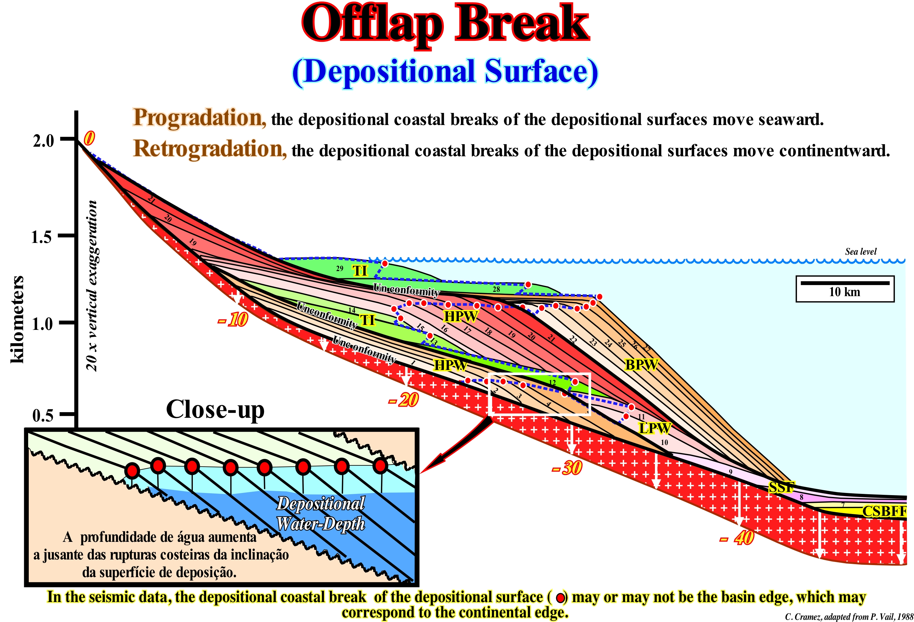
When one speaks of break of the depositional surface, one speaks. usually, of the coastal dip-break of the depositional surface, which marks the erosional level of the waves, when the sea is calm (more or less, 10 m depth) that, at least in seismic lines, is impossible to differentiate from the shoreline. The depositional coastal break may coincide with the basin edge. Such a coincidence (at least on seismic data) is just possible during the 2nd phase of development the highstand prograding wedge (HPW) of a sequence-cycle, i.e., when the relative sea level is, more or less, at the level of the continental edge that, in this case, works,also, as the basin edge, since the basin no longer has a shelf. During the lowstand prograding wedge (LPW) of a sequence-cycle, as the sea level is lower than the basin edge (which in this case is the last basin edge of the preceding sequence-cycle), the depositional coastal break of the depositional surface (more or less the shoreline) coincides with the continental edge, since the basin edge is, in this particular case, the last basin edge of the highstand prograding wedge preceding sequence-cycle, when this cycle is complete. Within a stratigraphic cycle said sequence-cycle (induced by a 3rd order eustatic cycle, whose time-duration ranges between 0.5 and 3/5 My), from the first transgressive surface (limit between low and highstand geological conditions), the relative sea level is higher than the continental edge of the lowstand prograding wedge (LPW), which becomes the new basin edge. In the transgressive interval (TI), which is the lower subgroup of the highstand systems tracts group (HSTG), whose overall geometry is retrogradational. For each eustatic paracycle (marine ingression), the depositional coastal break of the depositional surface is displaced landward, moving away from the new basin edge (continental edge), which creates a shelf (continental platform). During the stability period of relative sea level following an eustatic paracycle, the depositional coastal break of the deposition surface, gradually, moves seaward as the sediments settle-down by progradtions. However, as the terrigeneous influx is insufficient due to the shelf formation, the depositional coastal break does not reach the position it had previously, before a new eustatic paracycle occurs moving it continentward, so that a new eustatic paracycle forms inducing the deposition of a new sequence-paracycle, etc., etc. This is visible on the geological sketch illustrated in this figure, between the sequence-paracycles 12/14 and 27/29, in which the depositional coastal break of the depositional surface corresponds, more or less, to the shoreline (particularly on the seismic lines), is located landward of the basin edge (basin with a shelf). In the first stage of development of the highstand prograding wedge (HPW), the depositional coastal break of the depositional surface does not coincide with the basin edge. However, as it progresses seaward, the continental shelf decreases in size and since it disappears (beginning of the 2nd phase of development of the highstand prograding wedge) a new basin edge coincides with the shoreline, once the sea level is, roughly, at the level of the continental edge, which in this case is, also, the basin edge. In this geological model, P. Vail and his EPR colleagues (Exxon Exploration Production Research) assumed: (i) A particular eustatic curve, which can be considered at the level of 1st order eustatic cycles (time-duration greater than 50 My ), of 2nd order (time-duration between 50 and 3/5 My) and at the level of 3rd order eustatic cycles (time-duration between 0,5 and 3/5 My) and constructed from the combined action of tectonic (subsidence or uplift of the sea floor) and the absolute (eustatic) sea level, which is supposed to be global and referenced to the Earth's centre ; (ii) The subsidence of the continental edge increases seaward, regularly, and in a linear manner ; (iii) A constant terrigeneous influx (emphasized by the area between two consecutive chronostratigraphic lines) ; (iv) A negligible erosion and (v) A time difference between each chronostratigraphic line of 100 My, or in other words, each eustatic paracycle* has a duration of 100 My.
(*) An eustatic paracycle corresponds to a relative sea level rise, i.e.,a rise of the sea level referenced to the base of the sediments or to the sea floor. It results from the combined action of absolute (eustatic) sea level and tectonics and it is followed, after a stability period of relative sea level, by another relative sea level rise without any relative sea level fall between them.
Offshore (In the sea)..............................................................................................................................................................................................................Offshore
Offshore / Offshore (en el mar), Costa afuera / Offshore / 离岸 / Акватория / Offshore /
It can have different meanings depending on the field in which it is used, such as coast off or on the sea.
See: « Onshore »
Offshore Drift (Longshore drift current).....................................................................................Courant de dérive littorale
Corrente de deriva longitudinal (litoral) / Corriente de deriva del largo / Litoralströmung / 沿岸漂, 陆上漂移 / Дрейфовое продольное течение / Deriva littorale, Corrente longitudinale /
Accumulation of sand or gravel forming on the backshore (landform that constitutes the inner limit of the beach, which can be a cliff or an insulated barrier-bar or an internal lagoon), due to the concentration of sediments by the waves and wind.
See: « Beach Drifting »
&
« Shoreline »
&
« Swash Currents »
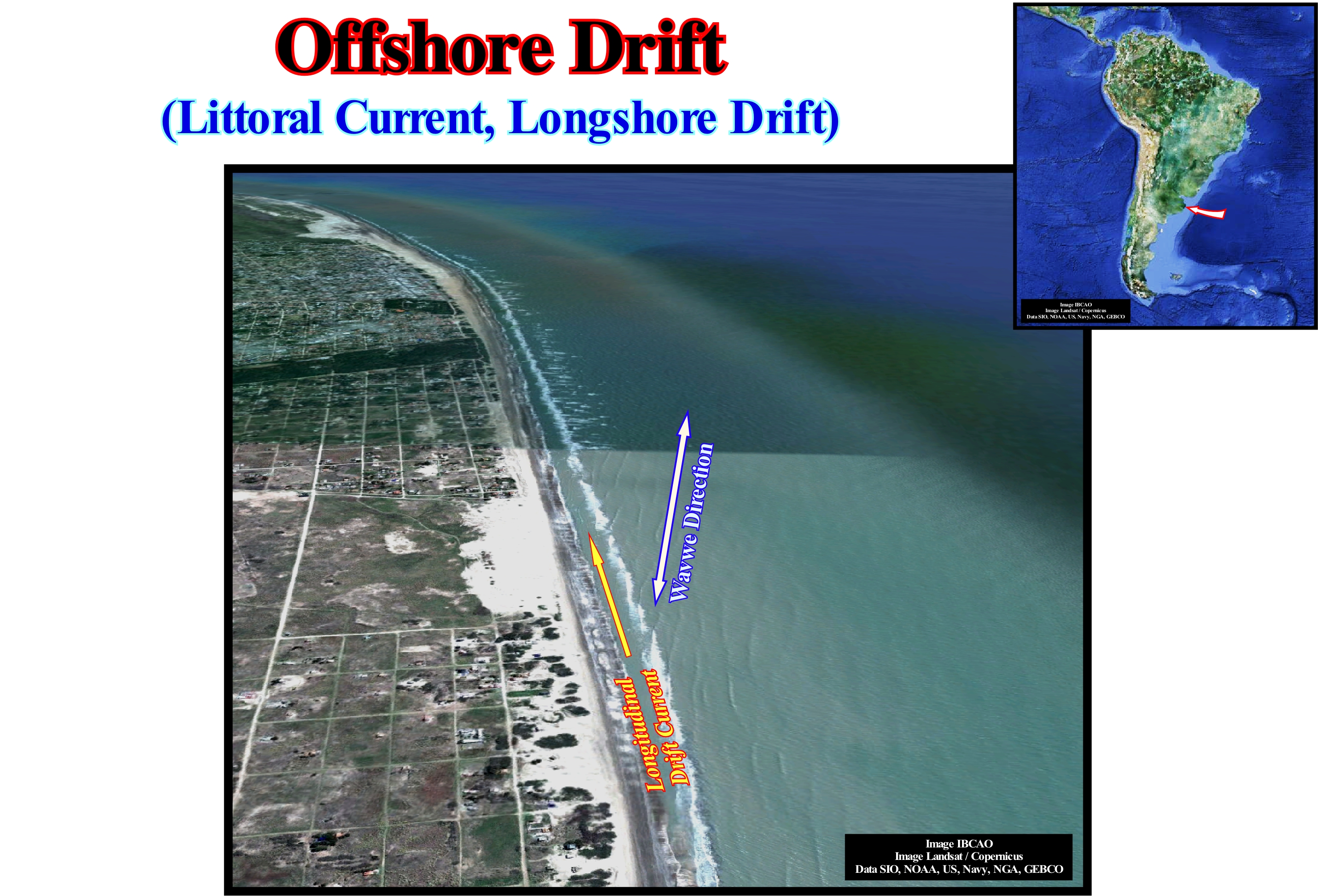
On this photograph of the east coast of Argentina, the dominant direction of the waves is, clearly, visible (perpendicular to the blue arrow). The aggregation of the coastal strand lines (barrier bars) that form the successive shorelines can be explained as the result of the offshore drift current (longitudinal drift current). In fact, as soon as the waves break in the surf zone, a current flows towards the beach perpendicularly to the direction of the wave crest (perpendicularly to the blue arrow drawn in the photograph). Such a current is, often, called uprush current (one of the two swash currents). Gradually, this landward current loses energy and, eventually, reverses itself, i.e., it starts to lean seaward, following the slope of the sea floor. This new current, called backwash current, is the second swash current. The uprush and backwash currents have different directions. Not only the magnitude is different, but the tail (the first point of the current) and the head (final point of the current) as well. The interaction of these currents forms what some call geoscientists, a zigzag current, whose final result is the formation of a current, more or less, parallel to the shoreline, called offshore drift current (littoral current or longshore drift), which, in certain places, is responsible not only for the erosion of the beach, but the sand deposit in other places, as well. In this example, the beaches are eroded in the south, along the agglomeration of San Clemente del Tuyu. The sand is transported and deposited in the north, in the form of barrier bars. Often, to protect the beaches from the offshore drift current, populations build piers (platforms built out from the shore into the water and supported by piles) perpendicular to the coastline. Once these protective structures are built, the width of the beach varies, greatly, on each side of the piers. The wider beach is the side of the pier which offers a resistance to the offshore drift current, which losing transport competence deposits the carried sedimentary particles sediments. When the wave direction is NW-SE, as in this example, and the coastline strikes NNW-SSE, if a pier is constructed perpendicular to the coastline, the broadest beach will be located southward of the pier.
Oil.....................................................................................................................................................................................................................................................................................Huile
Óleo / Petróleo / Öl / 油 / Нефть / Olio /
Greasy substance, liquid at ambient temperature, flammable, which may be of animal or vegetable origin and which is insoluble in water. When the oil is of mineral origin, and natural, it is preferable to call it petroleum.
Ser: « Petroleum »
&
« Hydrocarbon »
&
« Source-Rock »
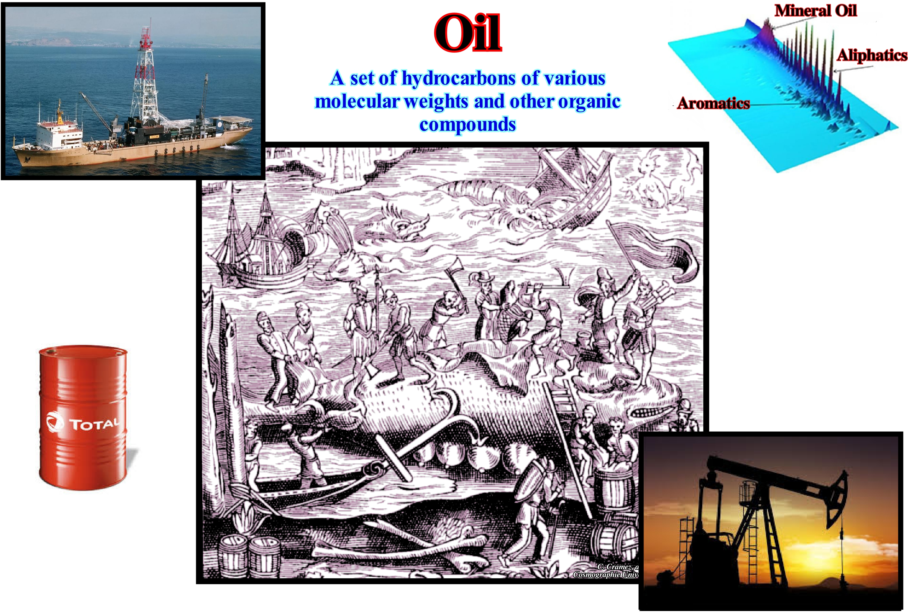
To avoid confusion, in this glossary the term oil is, mainly, used for a greasy and inflammable substance, liquid at normal temperature, soluble in a similar solvent but insoluble in water, and extracted from certain plants or seeds (coconut, corn, palm, almond, castor, olive, etc.) and of animals (cod liver, etc.). The term petroleum is used, preferentially, for oils of mineral origin. One of the best known oils is whale oil. The first reference to whaling to produce oil, for lighting, was made in 1059 by the inhabitants of Bayonne (France). Whale oil for illumination cost about USA $ 2,000 (in 2005 USA $), while the price of a barrel of petroleum cost about $ 90 a barrel. Thus, in order to prevent gross errors, it is preferable to determine the prices of fuels, and in particular of petroleum, by the number of working hours required to buy a barrel. To date, the most expensive price of a barrel of petroleum was in 1982 (about 10 hours of work for a European worker). At present (2007), the price of one barrel of oil is about 5 hours of work (price of working time in Europe), which means, and contrary to what many people think, the petroleum price is not yet too expensive*. Oils are produced by plants, animals and other organisms by organic processes (processes in which most chemical components contain carbon). They have a great diversity. That is why, the term oil is very vague and practically never used in scientific studies. The scientific term for oils, fats, waxes, cholesterol and other oily substances found in living things and their secretions, is lipid. Lipids, ranging from waxes to steroids, are difficult to characterize. They are bound in a group just because they repel or do not dissolve in water but are miscible in other lipid liquids, which are high in carbon and hydrogen and are poor in oxygen compared to other organic components.
(*) Oil (primary energy) is a very concentrated, stable energy (not very explosive) and easy to use. Do not forget there is as much energy in a liter of gasoline (10 kWh or 10,000 Wh) (as in 250 kg of lead battery or 100 kg of lithium-ion battery. Even if more powerful batteries such as lithium batteries exist, an electric vehicle using batteries can hardly compete with the autonomy of a petroleum vehicle. In other words, oil (primary energy) is a very concentrated, stable energy (not very explosive) and easy to use. The energy of 1kWh corresponds to: (i) 1/10 liter of essence; (ii) 3 m2 of photovoltaic panels for an average day ; (iii) 0.05 mg of uranium; (iv) 25 kg of lead acid batteries; ; (V) 100 h of lamp LED (10 W); (V) 12 hours of TV (123 cm, 85 W); (vi) 5 min shower, etc.
Oil Field (Petroleum)....................................................................................................................................................................................Champ pétrolier
Campo petrolífero / Campo petrolífero / Ölfeld / 油田 / Нефтяное месторождение / Campo petrolifero /
One or more hydrocarbon pool (oil or gas) located in a single trap or in traps not too far apart. Oil fields cover less than 0.1% of continents and continental shelves (Deffreyes, K., S., 2006).
See: « Trap (oil or gas) »
&
« Petroleum »
&
« Reserves »
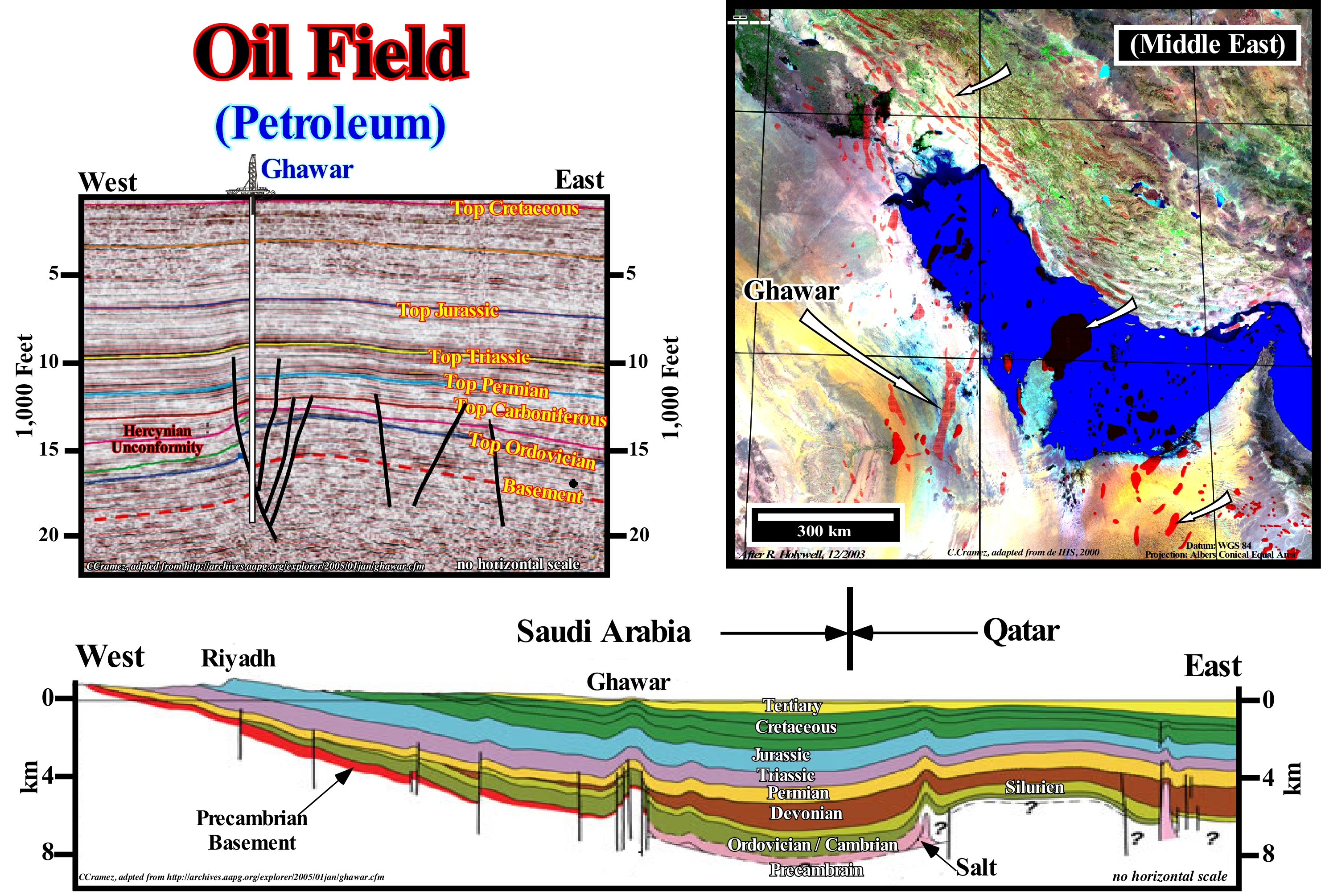
On this figure, the main oil fields (petroleum) of the Middle East are marked (by red spots). As an example, note the location of the world's largest oil field - Ghawar, which is located in Saudi Arabia foreland basin (foredeep). Geologically, some places are, extremely, rich in hydrocarbons, while others (the vast majority) are very poor or have no hydrocarbons. Such a distribution seems unfair. It is the result of an important law of nature, i.e., the inequality law. In the case of petroleum accumulations, this law is the result of the formation of natural systems (petroleum's systems). The probability of formation of an oilfield* depends on the existence of several geological parameters: (i) Source-rocks or generator petroleum subsystem ; (ii) Rock-reservoir (petroleum reservoir/trap subsystem) ; (iii) Trap (petroleum reservoir sub-system) ; (iv) Migration (time of formation of the generator petroleum subsystem) and (v) Retention (petroleum reservoir trap subsystem). If one of these parameters does not exist (zero value), the probability of occurrence of hydrocarbons, economically profitable, is zero. It can be said the probability of existence of an oilfield is the probability of the existence of the least favourable petroleum parameter. In mathematical terms, the probability of formation of an oilfield is the product of the probabilities of occurrence of the different parameters. Subsequently, since the vast majority of the oil fields have been found (more than 95% of the reserves have already been discovered and all the oil basins known today were already in the 1950s), it can be said the probability of finding a oil field, drilling, randomly, a sedimentary basin with petroleum exudations is 4 to 5%. This shows the modern and expensive technology, currently, used, i.e., seismic (2 and 3D) just contributes to increase the likelihood of discovery from 5 to 10-15%.
(*) A petroleum accumulation in the American sense of "oil pool" corresponds to the oil accumulated in a distinct treservoir-rock within a large simple or compound trap. Which means that an oil field, in general, is made up of several petroleum accumulation.
Oil Peak (Hubbert's law, Hubbert's peak)....................................................................................................................................Loi de Hubbert
Lei de Hubbert / Ley de Hubbert / Hubbert-Gesetz / 哈伯特的法律 / Закон Хабберта (пик нефтедобычи) / Legge di Hubbert /
Annual oil production rate depends, linearly, on the total oil fraction that has not yet been produced. The total amount of oil produced follows a logistic curve. The rate of production, at a certain point, is given by the rate of change of the logistic curve, that is to say, by the derivative at that point in the curve, which is called the Hubbert curve. Under normal conditions, when the oil production curve reaches its maximum, about half of the reserves have already been produced.
See: « Hubbert's Curve »
&
« Oil Field »
&
« Hubbert's Peak »
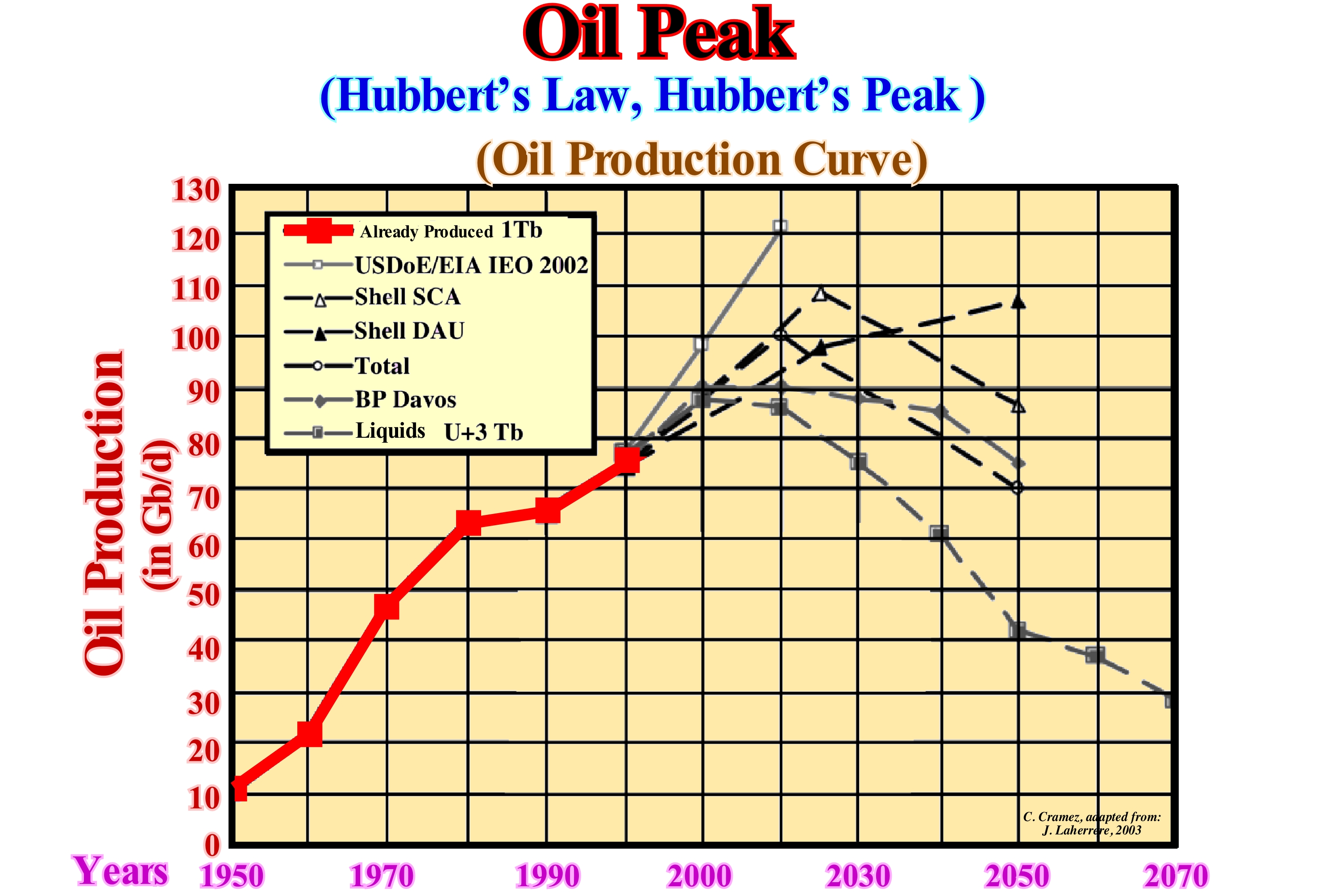
in this diagram proposed by J. Laherrere in 2003, it is easy to see the difference between the political estimates (oil companies and international organizations) and the estimates made from the technical data (Petroconsultants and IHS). For Laherrere (2003), as well as for most of the geoscientists who have the technical data, peak oil production was already reached in 2010 (regardless of the decrease in production induced by recent economic crisis). However, for some oil companies such as BP, peak oil production will only be reached by 2020, while others (Shell DAU) do not peak before 2050, let alone USDOE / EIA, which continue to see oil production increase (lack of knowledge of the laws of nature, such as the law of Finitude). The area under the curves, i.e., the integral of the curves is equivalent to the accumulated oil production. Due to symmetry (another law of nature), in relation to time, the peak oil production occurs when the area under the curve has reached half of the accumulated production. It is, relatively, easy to calculate the amount of oil from an oil field before starting production. Do not forget that only about 1/4 of the total oil (petroleum) is recovered during the primary recovery. Later, during a secondary recovery, about half of the oil is still in the reservoir. Likewise, since the water enters the rock-reservoir, the oil droplets are, practically, isolated and most of the oil is not recoverable. Consequently, the production price of the remaining half of the reserves will not be the same. Cheap oil is gone.
Oil Pool..............................................................................................................................................................................................................Gisement (hydrocarbures)
Jaszigo (hidrocarbonetos) / Yacimiento (de hidrocarburos) / Öl-Schwimmbad / 油池 / Месторождение (залежь) / Accumulazione di olio /
Underground accumulation of hydrocarbons in a particular reservoir-rock. An oil field may contain one or several oil pools in distinct rock-reservoirs within the same trap whether structural or non-structural.
See: « Seismostratigraphy »
&
« System »
&
« Reserves »
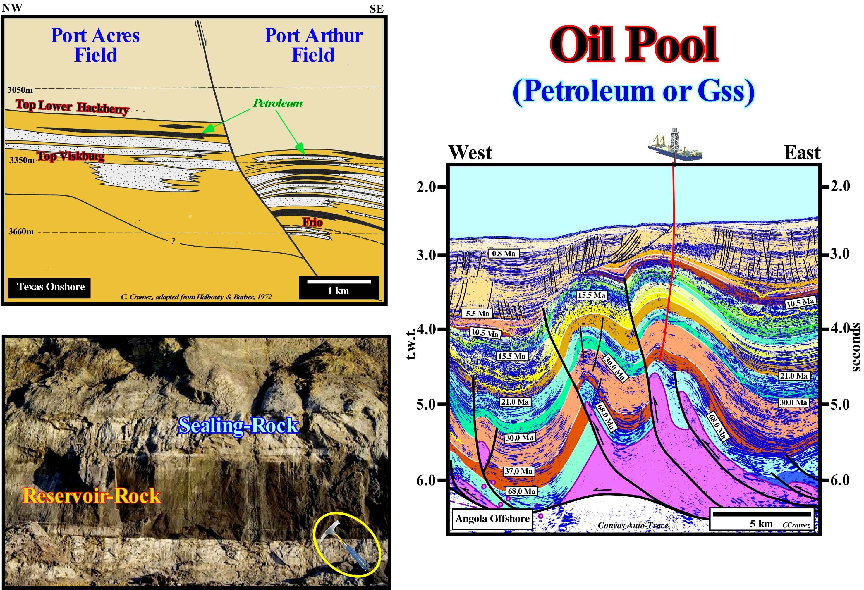
It is important not to confuse an oil field, which may be oil, gas, condensate or a mixture between them, with an oil pool. An oil field can be formed by a single oil pool, but in general it is made up of several oil pools, especially, when the oil field is important. An oil pool is defined by a particular rock-reservoir*, whether it be a sandstone or limestone and a trap (a geological device in which hydrocarbons may be detained), whether it be structural, morphological (by juxtaposition or not) or stratigraphic. If there are different traps in an oil field, what is very often, necessarily, there are different oil pools. In this figure, among others, two oil fields on the Texas onshore are, easily, recognized: (i) Port Acres field and (ii) Port Arthur field. The first is made up of two oil pools in which oil is trapped in stratigraphic traps. The extent of reservoir-rocks (sand horizons) is limited, since they end by lapout not only landward but also seaward (although the reservoir-rock of the lower reservoir disappears down-dip against a normal fault). In Port Arthur field, which, conventionally, is considered, by many geoscientists, as a structural field, it is constituted by eight oil pools. All reservoir-rocks are of the same type (slightly consolidated sandstones). In this field there are, basically, three types of traps. The highest deposit, structurally, is associated with a stratigraphic trap by pinchout, at least, updip the reservoir-rock lapout. The five underlying oil pools are associated with a structural trap created by an antiform (not to confuse antiform with anticline which is a shortening structure, whereas an antiform is a lengthening structure) formed in the upper faulted block (hangingwall) in order to respect the volume of sediments (Goguel's law**). The geoscientists who proposed the geological section through these oilfields, which is, certainly, based on tentative geological interpretation of seismic lines, interpreted it as a shortening structure (anticline), since they did not see normal faults at the top of the structure. However, as in many other cases in the Gulf of Mexico, these "structural" traps are, in fact, traps by juxtaposition created on top of the antiform formed in association with an extensional tectonic regime (vertical σ1, i.e., the main axis of the ellipsoid of the effective stresses that are : a) geostatic pressure, σg ; b) hydrostatic pressure, σp and c) tectonic vector, σt. All the tectonic regimes with σ1 vertical (σ2 ≠ σ3 or σ2 = σ3) lengthened the sediments, which implies the existence, at the apex of the antiforms, of small normal faults. Sediments can only be lengthened by normal faults, which were not drawn, since in the seismic lines they are below the seismic resolution (the fault displacement, i.e., the vertical distance between the surfaces of the two fault blocks). The lower trap is a morphological trap by juxtaposing. The lateral closure is made by the shales of the upper faulted block (a fault never traps hydrocarbons). The trap of the Angola offshore oil field illustrated in the tentative interpretation of a Canvas auto-trace of a detail of a seismic line seems to be, basically, a structural trap, since the salt horizon (colored in violet) was shortened by a tectonic regime compressive (σ1 horizontal). However, if a late diapiric movement of the salt horizon occurred, the salt cover will be, locally, lengthened. Such an elongation implies the formation of normal faults at the top of the structures (not visible on this tentative interpretation since the fault displacement is under the seismic resolution), which can have important negative consequences. The initial structural trap can be transform in a set of small morphological traps by juxtaposition.
(*) Any type of rock with petrophysical characteristics of porosity and permeability conducive to the accumulation and production of oil and/or gas, since hydrocarbons generally occur in the pores or fractures of reservoir rocks.
(**) Goguel's law says that during deformation, the volume of sediment must remain, more or less, constant. Although this law is approximate (taking into account compaction and dissolution) it, often, prevents geoscientists from proposing inconsistent (easily refuted) geological interpretations.
Oil Production Acme (Hubbert's peak, Hubbert's law)..............................................................................Pic du pétrole
Pico do petróleo / Pico de petróleo / Peak Oil / 石油峰值 / Пик нефтедобычи / Picco di olio /
Point, or year, where the maximum of the overall oil production rate is reached. After this point, or year, progressively, the production rate decreases. The rate of oil production follows a bell-shaped curve (antiform). Synonym with Hubbert's Peak and Hubbert's Law
See: « Hubbert's Peak »
&
« Logistic Curve »
&
« Reserves »
On this figure, the diagram on the right illustrates US oil production and Hubbert's predictions, considering as final reserves 150 Gb and 200 Gb reserves. As highlighted by J. Laherrere (2005), the predictions formulated by Hubbert correlate much better with a value of 230 Gb for the final reserves. Like the oil production, the evolution of the AAPG (American Association of Petroleum Geologists) members can be modelled according to Hubbert's law (J. Laherrere, 2005), since it is a function of oil activity. This evolution is illustrated in the diagram on the left. Oil research follows, more or less, but not exactly, the drilling activity. Both follow the investment of the oil companies, which depends on the yield of oil and especially its price. It can be said since 1910, the evolution of the AAPG members can be modelled in four cycles: (i) The first cycle reached its maximum in 1939 and then, the number of members decreased with depression, since the consumption of oil prices declined and companies did not need geoscientists to research and produce them (fewer geoscientists, fewer members) ; (ii) The second cycle peaked in 1960, when oil research declined (as before, the number of discoveries was so important, oil companies were, mainly, interested in selling off the oil more than finding new reserves) ; (iii) The third cycle peaked in 1986, when oil activity peaked, during which many geoscientists called the crazy years, since the price was so high that the whole prospect, even mediocre, was accepted by management of companies' exploration ; (iv) The last cycle, and perhaps the main cycle, reached its peak in the early years of the new millennium (as for oil production), and it seems that no new cycle is evident.
Oil Recovery..........................................................................................................................................................................................Récupération (Pétrole)
Recuperação (petróleo) / Recuperación (de petróleo) / Recovery (Öl) / 采油 / Извлечение нефти / Recupero (olio) /
Amount of oil produced by a field. The amount of oil in a field before starting production is easy to calculate. During primary production (when production is done by natural mechanisms) only about 1/4 of the total oil is recovered. At the end of the secondary production (when the oil pressure is increased artificially) there are still about 50% of oil remaining in the reservoir. Since water enters a reservoir, the oil droplets are more or less isolated, making it unrecoverable. Practically, half of the underground oil will never be recoverable even with a price of the barrel very high.
See: « Oil Pool »
&
« Petroleum »
&
« Reserves »
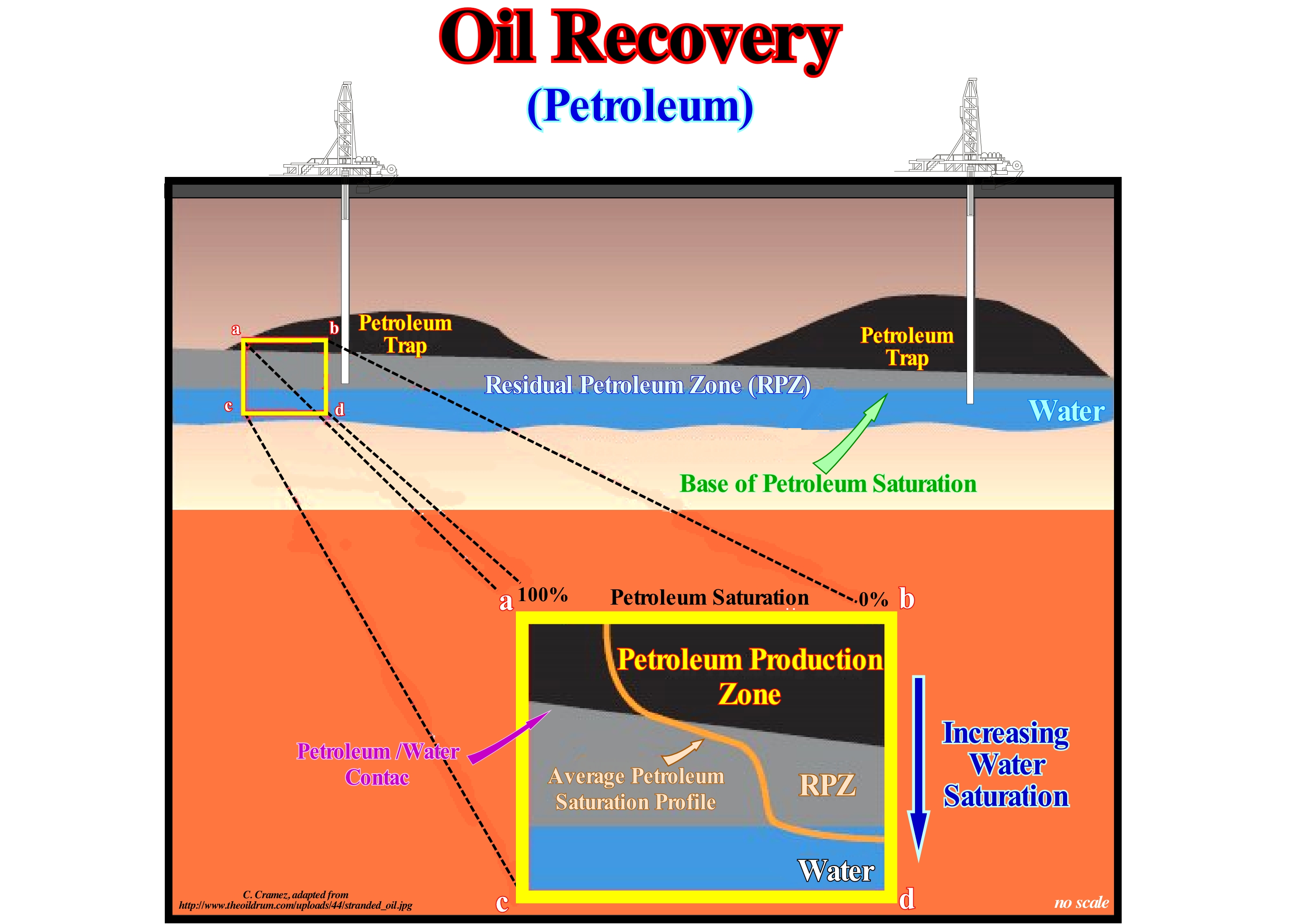
The presence of a transition zone under the plane of contact between petroleum and water from a reservoir-rock is now accepted by most geoscientists working in oil companies. What certain geoscientists advance is that under certain geological and hydrodynamic conditions a zone of residual petroleum (ZPR) may exist under the transition zone. The extent and thickness of this zone (ZPR) may be significant and filled with residual oil, which may possibly be recovered using carbon dioxide (CO2) as the basis of an assisted petroleum recovery (APR) operation. These areas of significant residual oil, from which oil can be recovered, exist where water naturally entered the bottom of the reservoir-rock. Traditionally, the areas of residual oil were not taken into account for two main reasons: (i) They would add very little oil during the first and second stages of production and (ii) To avoid or reduce the water production that these areas contains. Evidently, a CO2injection recovery is costly, but it can be largely economical close to large urban centres, particularly in countries that will oblige industries to pay for excess CO2 production*, and private individuals who use the car as a means of transport, as is the case in the USA, France, Portugal, etc. The difference is that in France and Portugal, there is practically no oilfields to reactivate, which is not the case. case of the USA.
(*) Certain countries have earned billions of dollars by selling "CO2 credits" to other countries as part of the absurd world market for this gas set up by the United Nations under the name Clean Development Mechanism (CDM), defined in Article 12 of the Kyoto Protocol (Annex B Party), which allows a country with an emission-reduction or emission-limitation commitment to implement an emission-reduction project in developing countries.
Oil Sand (Tar sand)........................................................................................................................................................................................Sable petrolifère
Areia petrolífera / Arena asfáltica / Ölsand / 油砂 / Нефтенасыщенный песок / Sabbia Petrolifera /
A sandy deposit, badly consolidated, containing organic matter impregnated with bituminous material consisting mainly of hydrocarbons, from which the oil can be extracted. Sands containing asphalt, or bitumen, from which hydrocarbons may be potentially extracted by distillation. Often considered as synonymous of Asphaltic Sand or Bituminous Sand.
See: « Betuminous Sand »
&
« Bitumen »
&
« Asphalt »
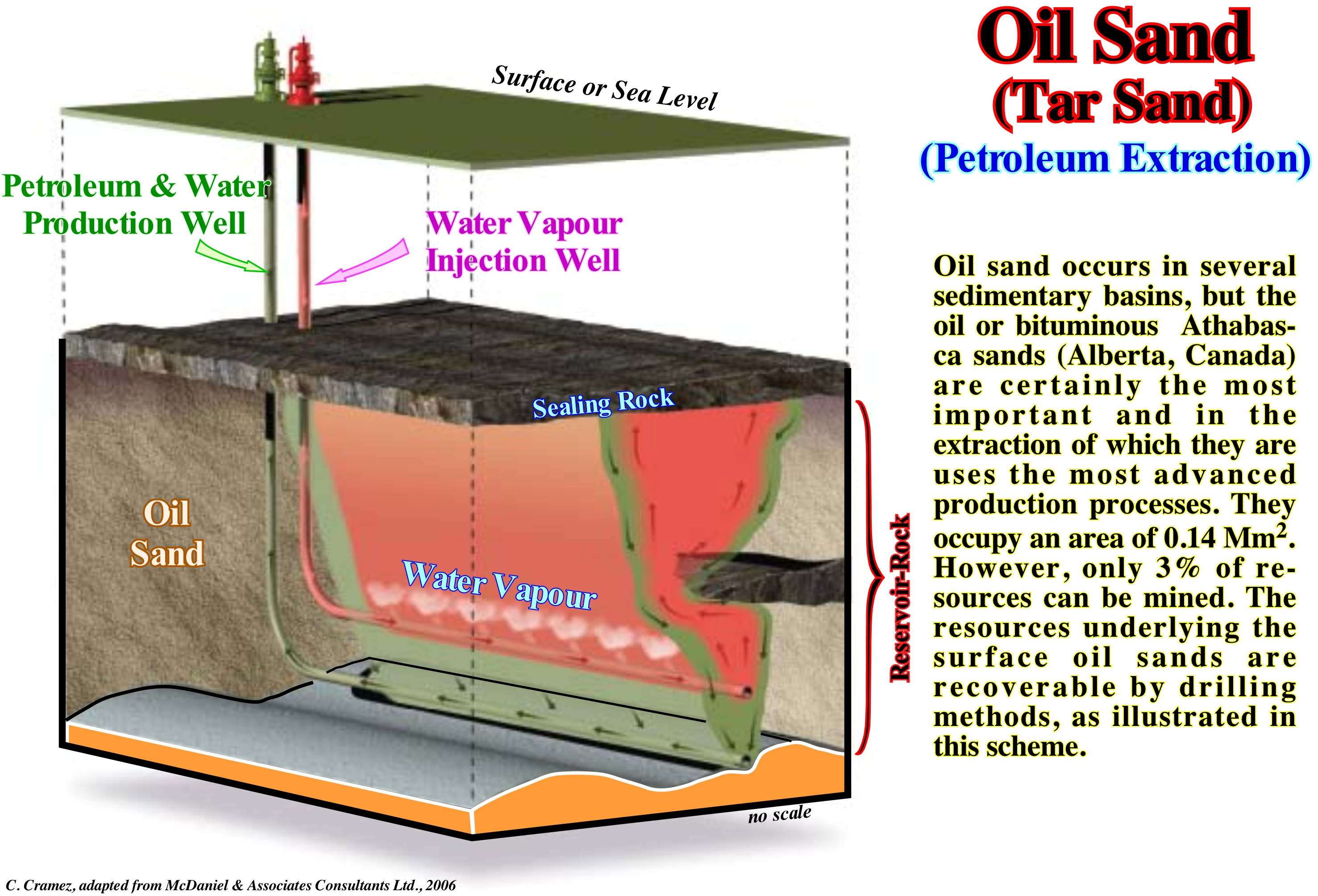
The vast majority of oil or petroleum sands (as certain geoscientists call them) is not suitable for surface mining and must be extracted through in situ recovery. The most productive "in situ" method is Vapour Gravity Drainage (acronym VGD). Fire-flooding and electrovolatization are alternative in situ recovery methods, but are not as widely used as vapour gravity drainage (VGD). As shown in this figure, in this method, high pressure water vapour is injected into the oil sands through vertical wells, which at the level of the sands are deflected parallel to their dip. Heat and water vapour force the bitumen, which is, often, heavy oil, to flow to the production wells from which it is pumped to the surface to be treated. One of the regions where several companies are using, more or less, this method is the Orinoco Belt in Venezuela, where oil sands (heavy oil, more or less of 8-10° API density) occur between 300 and about of 1,000 meters of depth. One of the major problems of this method is that, in most cases, the water vapour path is difficult to determine, which of course makes it difficult to locate the production wells, even when they are horizontal, which is the most frequent. To remedy this problem, certain geoscientists such as Manik Talwani have proposed the use of micro-gravimetry* 4D, i.e., using several microgravimetric campaigns, before and after the injection of water vapour, which, theoretically, by comparison of results, allows geoscientists to locate the areas where the water vapour has concentrated and thus better locate the production wells. This microgravimetric 4D method was, successfully, used in certain oil fields of the Marathon Oil Company.
(*) Gravimetry is based on the measurement of Earth's gravitational field changes caused by materials of different densities. Typical targets of this high resolution microgravimetry technique include (i) Low density targets, such as location of caves and fault zones, mining or assisted oil production works, etc., and (ii) High density targets, such as the location of dikes, surface rocks, buried-hills, etc. The presence of a body of abnormally high (or low) density in the subsurface causes a localized high (or low) anomaly in the measured gravitational field. The effects of gravity described may be extremely small, however, modern instrumentation and extensive data processing techniques allow the detection of geological and artificial structures or voids (https://www.terradat.co.uk/ survey-methods/ microgravity /).
Oil Shale............................................................................................................................................................................................................Schiste bitumineux
Xisto betuminoso / Esquisto bituminoso / Ölschiefer / 油页岩 / Битуминозный сланец / Scisto bituminoso /
Expression to avoid. In the vast majority of cases, it corresponds to an erroneous translation of "oil shale", which does not convey the true geological meaning. An "oil shale" is a clayey petroleum rock (nonmetamorphic fissile clay), that is, a sedimentary (rather than metamorphic, as a slate) rock, of a more or less clayey, fine grain containing a large amount of kerogen (not bitumen) and which gives liquid or gaseous hydrocarbons by distillation.
See: « Shale »
&
« Abandonment Shale »
&
« Reserves »
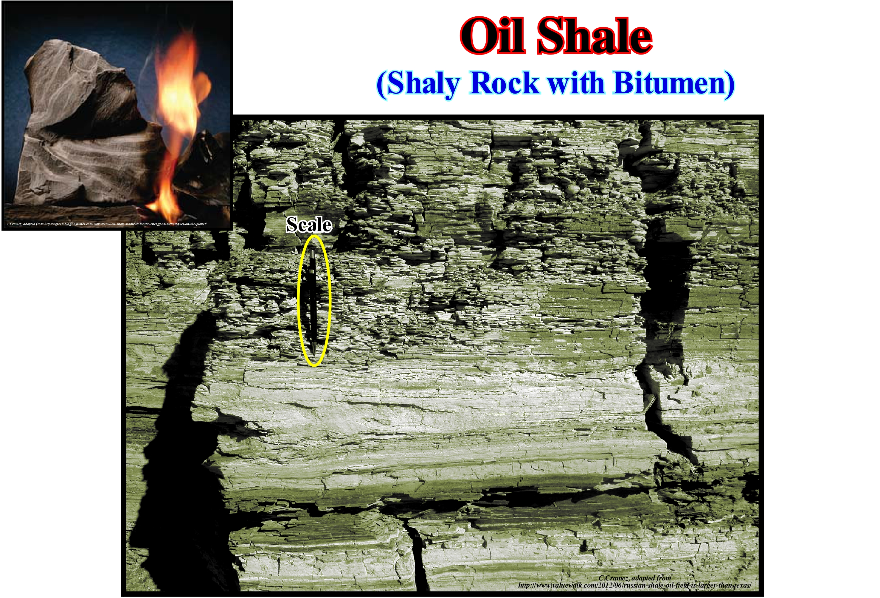
An oil or bituminous shale is a sedimentary rock rich in organic matter, which belongs to the group of sapropel fuels (rich in organic matter with a concentration of organic carbon that, generally, exceeds 2% by weight). A bituminous shale contains a large amount of kerogen and not bitumen (mineral pitch or tar which is a liquid mixture of high viscosity, dark colour and is highly flammable hydrocarbons formed and which can occur both in nature and to be obtained artificially). Kerogen is the fossil organic matter, insoluble in common organic solvents, dispersed within some sedimentary rocks. Kerogen, which chemically closely resembles sapropel, is a mixture of large complex hydrocarbon molecules, such as waxes and resins, whose colours range from yellow, orange, red, and brownish. The increase in temperature inside the Earth's crust and time transform organic matter into this type of Kerogen-bitumen. Kerogen reserves are estimated at about 1016 t, most of which are associated with pellets deposited on the continental margins. An oil shale (bituminous shale) differs from bitumen impregnated rocks, humic coals* and carbonaceous shales, since its kerogen has not yet been transformed into petroleum by increasing temperature and pressure. An oil shale does not have a definitive geological definition or a specific chemical formula. The oil shales vary, considerably, in mineral content, chemical composition, age, type of kerogen and depositional history. They derive from different organisms. Some geoscientists classify them according to the petrographic composition and consider, normally, three main categories: (i) Carbonate-Rich Petroleum Shales ; (ii) Silica-Rich Petroleum Shales and (iii) Spore and Coal Rich Petroleum shales. Other geoscientists classify the oil shales according to the type of kerogen they contain, based on the hydrogen, carbon and oxygen content of the original organic matter. Often, oil shales are classified as terrestrial, lacustrine or marine, depending on the environment where the initial biomass was deposited. Oil shales can be mined and processed to extract petroleum like oil. However, the extraction of oil from oil shales is much more complex than conventional recovery and much more expensive and sometimes unprofitable (without taking into account ecological problems). However, considering the continuous reduction of oil reserves combined with an increasing consumption of its derivatives, the bituminous shale rocks can quickly become a very important reserve of energy and raw materials. According to wikipedia (https://en.wikipedia.org/wiki/Oil_shale) from 2008, the industry used bituminous shales in Brazil, China, Estonia and, to a certain extent, Germany and Russia. A number of other countries have begun to assess their resources in oil shales or have built experimental production facilities, while others, gradually, phase out their oil shale industry. Estonia, Brazil and China use bituminous shales for oil production, whereas they are used as a basis for electricity production in Estonia, China and Germany and for cement production in Estonia, Germany. China, Estonia and Russia use them in the chemical industries. As of 2009, 80% of the oil shale used, globally, is used in Estonia, mainly in power plants. Power plants using petroleum shales in Estonia, which has an installed capacity of 2967 megawatts (MW), in China of 12 MW and Germany 9.9 MW. Israel, Romania and Russia also used them in power plants but shut them down or switched to other fuel sources, such as natural gas.
(*) The term humic refers to materials constituted by carbonaceous products, of variable colour, according to the quality of the plants that gave rise to them. Humic coals are the result of accumulations of in-carbonized plants that in their formation have undergone an initial humic phase. They are divided into cutin coals, in which the plant material consists of leftover leaves, spores and pollen, and lignocellulosic coals formed by woody tissues and cellulose. This type of coal can be subdivided into peat, lignite, coal and anthracite. (http://knoow.net/ciencterravida/biologia/carvao/)
Oil Window (Maturation zone).......................................................................................................Fenêtre de maturation à huile
Janela de maturação / Ventana de maduración / Reifung-Fenster / 成熟的窗口 / Зона преобразованности нефтей / Finestra di maturazione /
Depth at which the processes of transformation of kerogen into oil, i.e., more or less, between 1.6-2.1 and 4.0-4.5 km. At these depths the source-rock generate oil, while at higher depths it generates gas. Depth is not the only factor for the evolution of the kerogen into hydrocarbons. Geological time must have taken into account. The maturation of the organic matter of the potential source-rocks depends on two T: (i) Temperature, i.e., the amplitude of the burial and (ii) Time, since the longer is the heating time the less heat energy is required for organic matter generate hydrocarbons.
See: « Organic Matter »
&
« Gas Window »
&
« Kerogen »
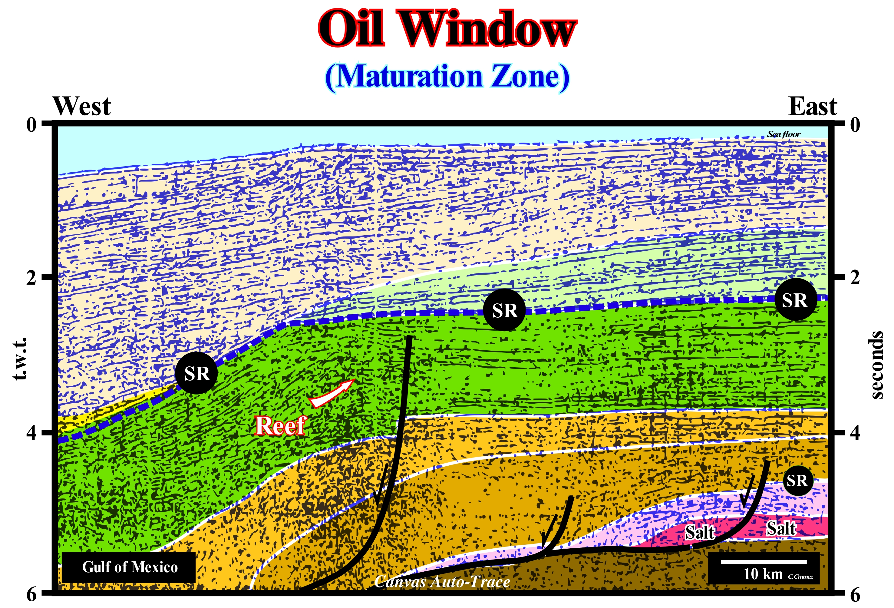
In the sedimentary basins in extension, which are characterized by a lengthening of the sediments by normal faulting, all the deposited intervals are, more or less, preserved. On the contrary, in compressional basins, characterized by shortening and lifting of sediments by folding (anticlines and synclines) and reverse faults, many deposited intervals are eroded by erosion agents (water, wind, ice, etc.). In the extensional basins, as shown on this Canvas auto-trace of seismic line, the absence of an important uplift (there is no isostatic readjustment) allows a prediction of the maturation window of the organic matter of the potential source-rocks (provided that the interpreter is able to locate the more likely source-rocks on seismic lines, which is not very difficult). In recent Atlantic-type divergent margins, which correspond to the post-Pangea continental encroachment stratigraphic cycle, the most likely marine source-rocks are associated with the interface between the transgressive phase (characterized by a, more or less, parallel reflector configuration, but retrogradational) and the overlapping regressive phase (characterized by a progradational reflector configuration either by sigmoid or oblique progradations). In this example, the downlap surface of the regressive phase (progradational geometry) corresponds to the (upper) SR horizon, over which, probably, the potential marine source-rocks were deposited. Since they are, more or less, localized, it is easy to predict that the organic matter of these potential source-rocks reached the maturation zone in the western part of the seismic line where they were buried sufficiently, but not in the eastern sector.
Oil Window (Example)...............................................................................................................................................................................Fenêtre à huile
Janela do petróleo / Ventana de petróleo / Öl-Fenster / 油窗 / Главная зона нефтеобразования / Finestra delle olio /
Oil formation zone. This zone is located at a depth where the temperature ranges from 50° to 120-150° C and, above all, from a hundred degrees, where the transformations of the kerogen into hydrocarbons and, particularcular, where the C15-C40 fractions are the most important. This formation zone and the conservation of liquid hydrocarbons is characterized by organic evidence and dependent on the time and nature of the kerogen.
See: « Source-Rock »
&
« Gas Window »
&
« Kerogen »
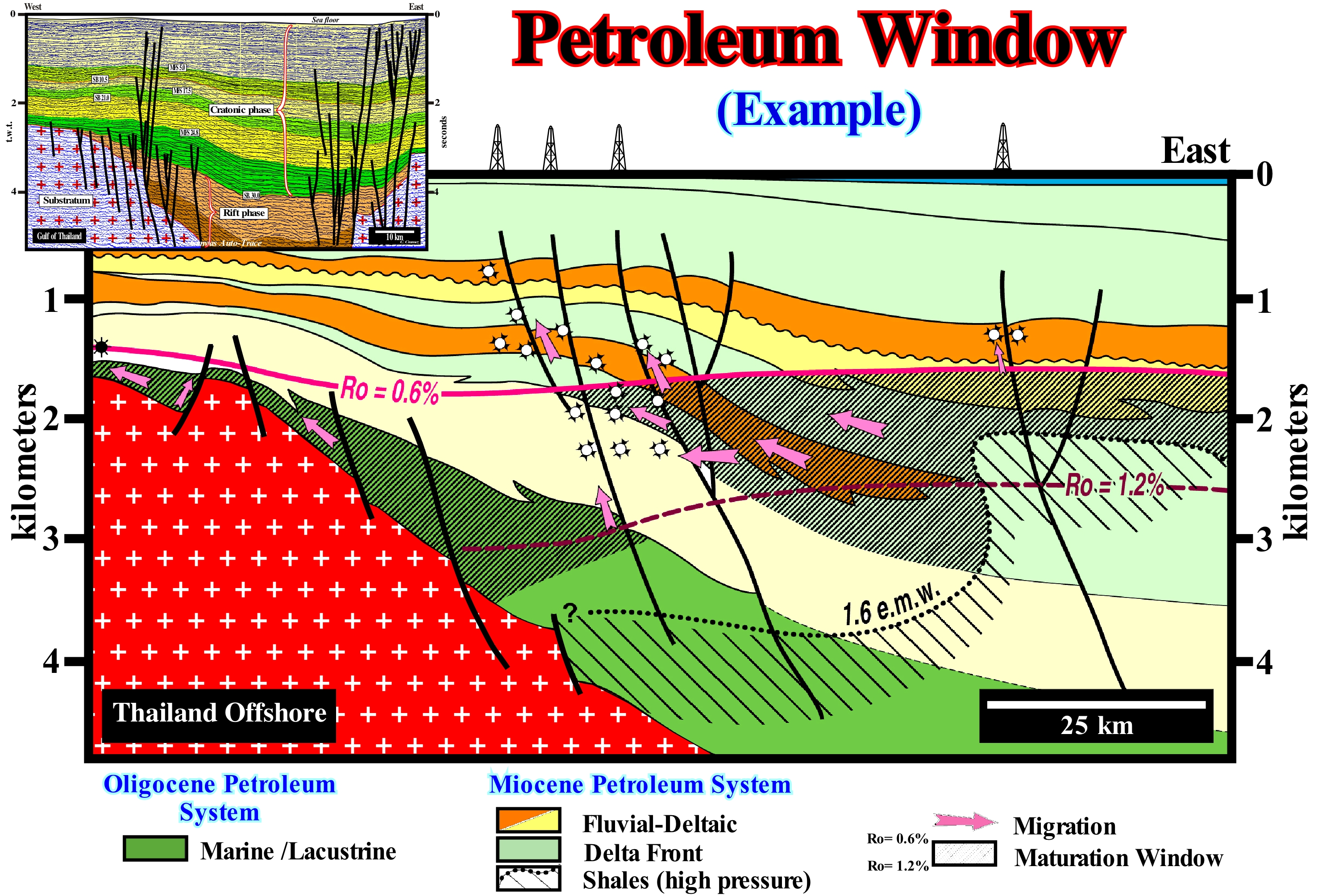
Before all take note that the tentative geological interpretation of a Canvas auto-trace (upper left corner) and the depth cross-section, which was based in the interpretation of parallel seismic line and on the well's results, were not, , obviously, done by the same geoscientist. The normal faults proposed on the depth converted profile are not steep enough, which is not the case on the tentative geological interpretation. In fact, if such a profile is drawn at the natural geological scale 1:1, the dip of the faults planes becomes to low, which is in contradiction with the faulting Anderson and Coulomb laws*. On the tentative geological interpretation of a Canvas auto-trace of Thailand offshore seismic line, which corresponds to a back-arc basin, the most probable oil window of organic matter can be predicted. As illustrated in depth cross-section of a parallel seismic line, the oil window, using the results of the exploration wells, is limited between the values 0,6 and 1,2 of vitrinite reflectance. The sediments rich in organic matter were buried to such a depth that organic matter was, probably, transformed into oil. As shown in the figure, the hydrocarbons produced in the two oil fields, traversed by the seismic lines , are a mixture of petroleum and condensate. In this way, it is probable that the organic matter of the potential source-rocks is type III, i.e., humic and with a kerogen characterized by an H:C ratio less than 0.84, produced from the lignin of plants which grow on dry land. In this type of sedimentary basin (back-arc basin), the conventional source-rocks are lacustrine shales that have been deposited in the rift-type basin (initial phase or rifting phase) that, of course, are much more buried than the shales of the cratonic phase. In other words, it can not be ruled out that a part of the oil produced in these fields was generated in the deep rift-type (halfgrabens) basins and that it migrated vertically along the normal faults to the reservoir-rocks of the morphological traps by juxtaposition. The normal faults of the rifting phase were slightly reactivated into reverse faults by a relatively recent compressional tectonic regime and that the vast majority of the oil pool traps (do not confuse the oil pool with oil field) are morphological by juxtaposition and not structural traps. They do not have their own close (four way dips), which, at least the lateral seal, is made by the juxtaposition of impermeable rocks to the reservoir-rocks.
(*) The Earth surface is not confined and is not acted, essentially, on by shear stresses. Lithospheric plates move, generally, parallel to the Earth's surface, which requires two of the three main effective stresses must (σ1, σ2 ,σ3) be parallel with the Earth's surface. Consequently, there are three possible combinations: A) Reverse faults, σ1 horizontal and σ3 vertical ; B) Normal faults, σ1 vertical, σ1 horizontal ; C) Strike-Slip Faults, σ1 horizontal, σ3 horizontal. In addition, according to Coulomb's Law, fractures develop at θ (dip)≈ 30° in most rocks because most rocks have φ (fracture angle) ≈ 30°. Therefore: (I) Reverse faults should dip at ≈ 30 ° ; (ii) Normal faults should dip at ≈ 60 ° and (iii) Strike-slip faults should dip at ≈ 90 ° .There are very few exceptions to Anderson’s law.
Olber's Paradox..................................................................................................................................................................................Paradoxe d'Olber
Paradoxo de Olber / Paradoja de Olber / Olberssches Paradoxon / 奧伯斯佯谬 / Фотометри́ческий парадо́кс / Paradosso di Olbers /
Apparent contradiction between the fact that the sky is dark at night and the hypothesis that the Universe is static and infinite or why the sky is black at night if there is an infinity of Stars. in fact, Why the simple question: Why is the sky dark at night? intrigued astronomers for centuries. And the answer is not because at night the sun is on the other side of the Earth, as explained below.
See : « Big Bang (theory) »
&
« Atmosphere »
&
« Early Universe »

First of all let's remember that a paradox is a proposition that seems absurd or self-contradictory, but it is or may be true. Historically, the first scientists who wondered why the sky is dark at night seems to have been E. Halley (16th-18th centuries). Twenty two years later, the Swiss astronomer P. de Cheseau (eighteenth century) asked himself the same question. In 1823, Heinrich Olbers did the same thing. Olbers' argument was very simple: if the Universe is infinite and does not change (which was obvious to the astronomers of the eighteenth-nineteenth century), then no matter the direction in which we look, our line of sight must always find a star, which means that for any point, in which we look, in the sky we must find a star, so the whole sky should be as bright as the light of day. Olbers attempted to solve this paradox by arguing that the light from distant stars was absorbed by matter as by clouds of dust. When the first law of thermodynamics was discovered, however, this explanation was refuted. On the other hand, if a cloud of dust absorbs some energy from the starlight, it warms up. In time, it would come luminous radiating its own light. The paradox was solved in the twentieth century when astronomers discovered that the Universe exists just from a certain moment, i.e., that it is not infinite. The Universe began with the Big Bang about 15 billion years ago. The number of stars in the sky, although very large, is not infinite, which means that there is no star anywhere in the sky. In the same way, today, geoscientists know that a star does not always shine. It ends up shining when it burns all its nuclear fuel. Even if there is a star in a certain direction, it does not mean that we should see its light. It may have stopped shining many millions of years ago. Although Olbers' paradox does indeed prove that if the distribution of stars in the sky were regular in an infinite Universe, the amount of stellar energy that would reach the Earth would be infinite, does not create obstacles for an infinite static universe with an infinite number of stars distributed irregularly. The presumption that an infinite Universe has, necessarily, an infinite number of stars can not be proved either. One can imagine an infinite Universe with the set of finite matter, but divided in infinite different bodies.
Oligotrophic (Lake).......................................................................................................................................................................Oligotrophique (Lac)
Oligotrófico / Oligotrófico (lago) / Oligotrophe (See) / 贫营养 / Олиготрофный / Oligotrofe /
Lake that offers little possibility for a sustainable life. Contrariwise to an eutrophic lake, an oligotrophic has a small amount of nutrients.
See: « Eutrophism »
&
« Nutrient Trap »
&
« Organic Matter (types) »
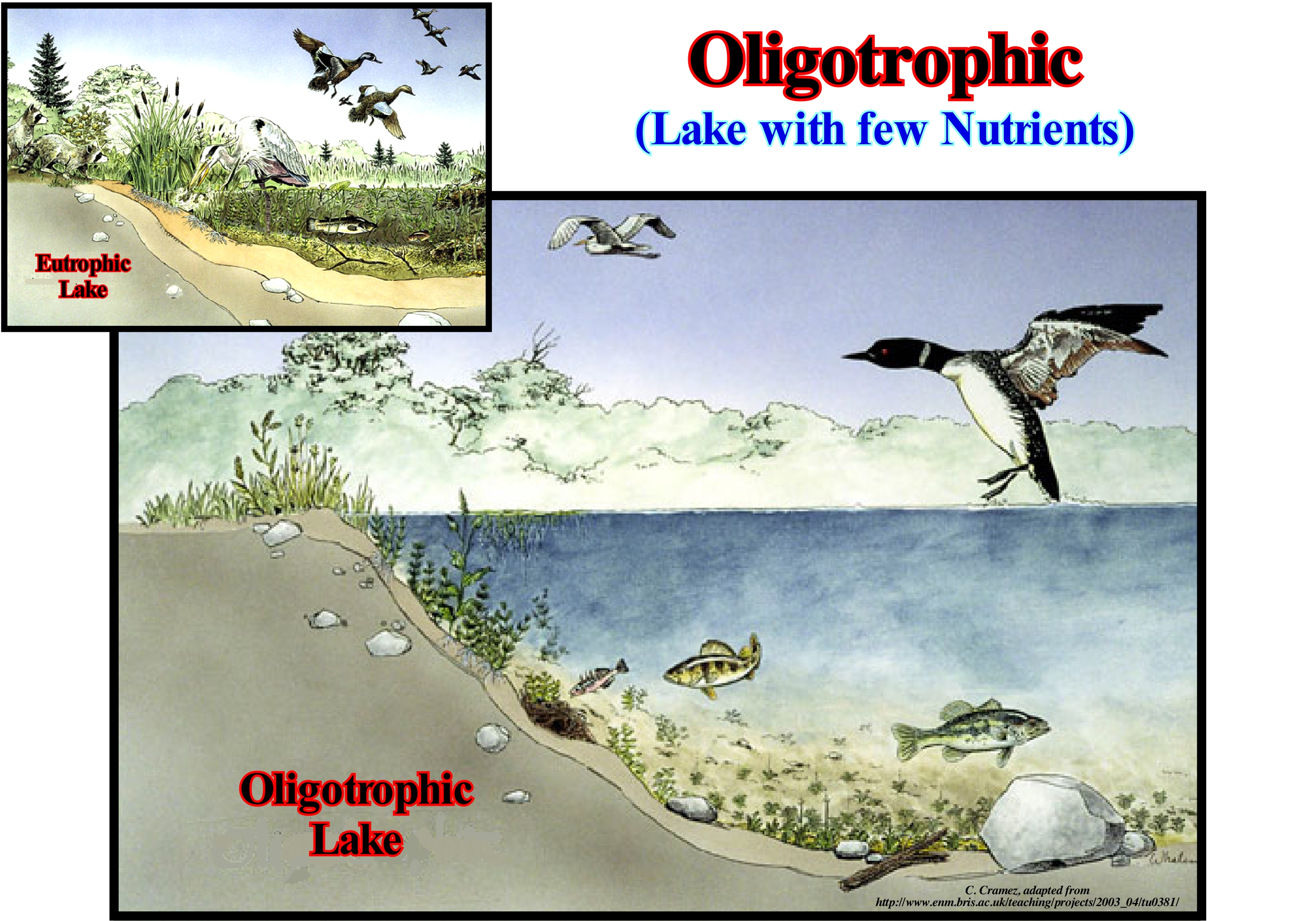
From the ecological point of view, the term oligotrophic distinguishes the poorly productive lakes (characterized by a nutrient deficiency) from the very productive lakes, called eutrophic, which have an excess of nutrients. The production of organic components from atmospheric or aquatic carbon dioxide (CO2), either by photosynthesis or chemosynthesis (from bacteria) is very poor in oligotrophic lakes and therefore the nutrient content is very low. These lakes have a very small seaweed production. The water is clear and good to drink. Phytoplankton, zooplankton, algae, seaweeds, bacteria and fish are all present in small populations. The bottom of these lakes has a lot of oxygen, and so, as illustrated in this figure, certain species of fish, but not many, can live there, such as lake trout, which require not only cold but rich waters in oxygen. Theoretically, the oxygen content is higher in deep lakes, which have a large water volume underneath the thermocline. At present they are uncommon in regions with a large population, since the presence of many people and the use they make of them, gradually, transform them into eutrophic lakes. Thus, oligotrophic lakes exist, rarely, in agricultural regions. The rich or enriched soils, necessary for agriculture, do not allow the presence of drainage waters poor in nutrients, which characterize an oligotrophic lake. Oligotrophic lakes are common in the granitic shields of cold climate regions. In North America, most of the oligotrophic lakes are located north of Michigan Lake, which can be considered as an oligotrophic lake. In any case, over time (several thousand years), an oligotrophic lake, gradually, accumulates nutrients and sediments and becomes a eutrophic lake. This process of natural eutrophication contrasts with cultural eutrophication that may occur in one or two human generations. When a lake is in the transition phase between oligotrophic and eutrophic conditions, some authors say the lake is mesotrophic.
Omission Surface......................................................................................................................................................................Surface d'omission
Superfície de Omissão / Superficie de omisión / Oberfläche des Weglassens / 遗漏表面 / Поверхность бездействия / Superficie di omissione /
Surface of no deposit or with a very small deposit rate. This type of surface is, usually, developed between the different sedimentary systems tracts of a sequence-cycle. In a sequence-cycle, the most common omission surface is that associated with the downlap surface that separates the transgressive interval (TI) from the highstand prograding wedge (HPW).
See: « Highstand Systems Tract »
&
« Transgressive Interval »
&
« Hiatus »
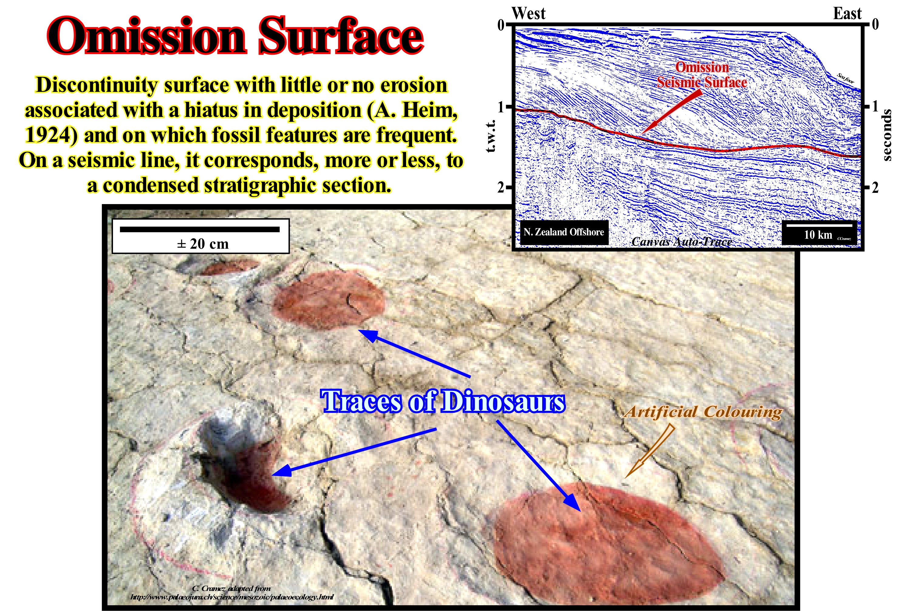
The term "omission surface" was used for the first time by Swiss geoscientists Albert Heim to designate discontinuity surfaces, which underline a temporary stopping of the deposition without any or very little erosion occurring. In a broader sense, any discontinuity surface, such as hardened surfaces or bedding planes with dinosaur traces (as shown in this figure) or with dissecting slits, are omission surfaces. For many geoscientists a discontinuity denotes a transition or contact between intervals at different densities, such as Mohorovičić discontinuity, with different sedimentary facies (lithologies) or between intervals separated by a hiatus (absence of significant deposition). In geology, several types of discontinuities can be considered: 1- Stratigraphic ; 2- Sedimentary ; 3-Lithological ; 4 - Tectonic, etc. Within the lithological discontinuities (3), which are probably the most important in sequential stratigraphy, we can recognize: (i) Concordant Discontinuities, when there is continuity between successive intervals ; (ii) Paraconform Discontinuities or Paraconformities, when there is no difference in attitude between overlapping intervals, but there is an hiatus due to the absence of significant deposition between them ; (iii) Nonconform Discontinuities or Nonconformities (which certain authors call Heterolithic Unconformities), when there is a contact between a sedimentary interval and an older igneous body ; (iv) Discontinuous Discontinuities or Disconformities, when the layers of the intervals are parallel on one side and the other side of the contact surface which does not conform to the regional bedding ; (v) Discordant Discontinuities or Unconformities when the two intervals are separated by an erosional surface induced by a relative sea level fall ; (vi) Enhanced Discordant Discontinuities or Tectonically Enhanced Unconformities when the sediments of the interval underlying an unconformity were deformed by tectonics (shortened or extended) ; (vii) Intrusive Discontinuities, when an igneous body traverses a sedimentary series ; (viii) Mechanical Discontinuities, when they are induced by faults, etc. (https://estpal13. wordpress.com/2013/ 06/04/descontinuidades-sedimentares-e-estratigraficas/). In carbonated platforms, the omission surfaces mark the transition between lithologies with very different depositional water-depths. On a large scale, and particularly on seismic lines, the omission surfaces correspond, almost always, to downlap surfaces, along which the sedimentary intervals are condensed and, often, rich in organic matter (potential source-rocks). These surfaces are formed between sediments with retrogradational (transgressive episodes) and progradational (regressive episodes) geometries. These sedimentary episodes may be associated with continental encroachment cycles, continental encroachment subcycles and sequence-cycles. In the first two, the regressive and transgressive phases are associated with variations of the absolute or eustatic sea level (referenced to the Earth's centre). Thus, it can be said during the regressive phase the absolute (eustatic) sea level felt. However, within a sequence-cycle it can not be said that during the highstand prograding wedge (HPW) the sea level has fallen, but rather that the relative sea level (combined action of absolute sea level and tectonics) has rose, in deceleration. Within a sequence-cycle, except for submarine fans, to have deposition, the relative sea level must always rise to create or increase the available space for the sediments (shelfal accommodation). When it rises in acceleration the transgressive interval (TI) is deposited. When it rises, in deceleration, the highstand prograding wedge (HPW) or the lowstand prograding wedge (LPW) are deposited. During the deposition of retrogradational sediments, the successive rises of relative sea level (without relative sea level falls between them), i.e., eustatic paracycles move continentward the shoreline and the coastal deposits. This landward displacement of the depositional coastal break of the depositional surface, increases the extension of the shelf, decreases the terrigeneous influx, and creates starved geological conditions (very low deposition rate) in the distal parts of the shelf. Since the relative sea level begins to rise, in deceleration (such as 15 m, 10 m, 7 m, 5 m, 2 m, 0 m) and until it begins to rapidly fall (formation of an erosional surface), the sediments progradate seaward, progressively, decreasing the extension of the shelf and fossilizing, gradually, the omission surface of the top of the condensed section deposited during the transgressive episode of the sequence-cycle.
On Land (OnOnshore)............................................................................................................................................................................................................................Onshore
Costa adentro / Onshore (costa adentro) / An Land / 陆上 / Наземный / A terra
Area upstream of low-tide. Area located on or near the coast. Even defined as the upstream area of low-tide, the on land varies in the short term with the position of the low-tide line. Certain geoscientists define on land in relation to the coastline, which is an even more imprecise definition than the previous one, since the coastline is not fixed. Synonymous with Onshore.
See: « Onshore »
&
« Shoreline »
&
« Inflexion Line (berm)»
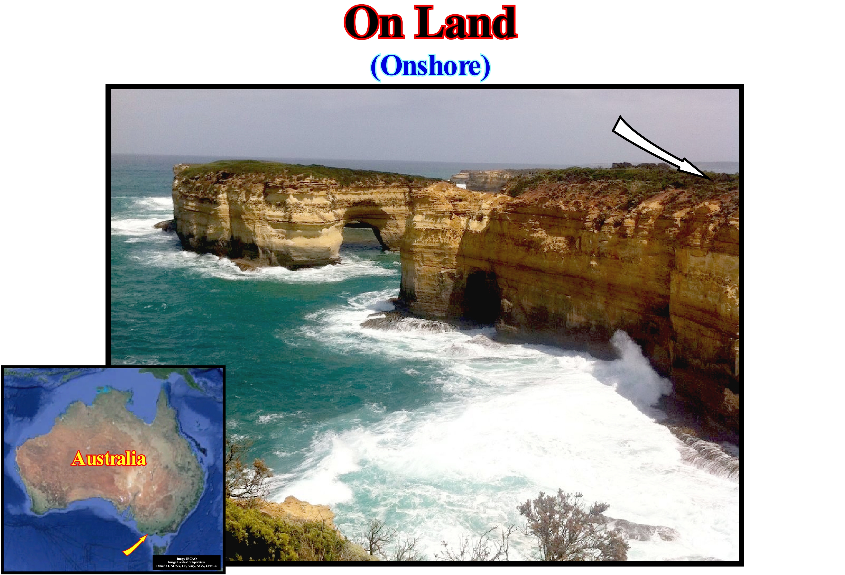
Except for steep shorelines (cliff-like), such as the one illustrated in this figure (the area of the Twelve Apostles in South Australia), where the boundary between land and sea is very stable and well marked, the onland (onshore) even defined as the region upstream of the low-tide level, varies in the short term with the position of the tide line. Certain geoscientists define the on land (onshore) in relation to the shoreline. However, this definition is even more imprecise than the previous one, since the shoreline is not fixed. With the tides, it varies, relatively, little, but every day. This problem is further complicated when there are islands near the coast. Some countries, at least from an administrative point of view, include all islands on the offshore. Others just encompass in the onshore the largest islands and those furthest from the coast. Others consider the islands to be part of the onshore. During sedimentary regressions (seaward displacement of coastal onlaps) and sedimentary transgressions (set of increasingly important marine ingressions and increasingly smaller sedimentary regressions, which, globally displace continentward the coast onlaps), the position of the shoreline varies and thus, also, the boundaries of the on land. The displacements of coastal onlaps are dependent on relative sea level changes and continent morphology. If the continent has a low, or rather flat, topography, a small relative sea level rise (combined of the absolute or eustatic sea level and tectonics, i.e., uplift or subsidence of the sea floor) can produce a marine ingression or a continentward displacement of the shoreline of several hundred kilometers. On the contrary, when the topography of the continent is sharp and the beach slope quite strong, the same relative sea level rise produces a marine ingression of just a few tens of meters. When within a sequence-cycle (induced by a 3rd order eustatic cycle whose time-duration varies between 0.5 My and 3 to 5 My), a geoscientist speaks of the transgressive interval (TI), it is referring to a seismic interval with a vertical aggradation (vertical distance, even in milliseconds, between two consecutive coastal onlaps) and a continental encroachment (horizontal distance, in meters, between two consecutive coastal onlaps). These two values allow us to determine, easily, at least locally, the topography of the unconformities (limits of the sequence-cycles). However, for this, it is necessary the geoscientist has regional seismic lines, since in most cases, the continental encroachment may be greater than the length of conventional seismic lines. On land, the seismic lines, rarely, reach 20 km. On the contrary, offshore, for obvious reasons, even the conventional seismic lines shot by oil companies can reach more than 100-200 km. With regard to shoreline displacements (ingressions and regressions of the sea) it is necessary to always take into account the tectonic factor in order to avoid gross errors, much used by alarmist social communication, since in scientific practice, there is always the risk that a geoscientist will take his desires or his fears for scientific realities. We all hear, regularly, on television or on the radio, but also in most newspapers, phrases such as this: "It is scientifically proven * that a near future, due to the greenhouse effect, induced by the increase of CO2 in the atmosphere, the coastal cities will be flooded due to an eminent rise of the sea (sic) ". Indeed, in certain areas of the land surface, and particularly in the coastal areas, the rate of tectonic changes (shortening or lengthening) may be higher than the rate of relative sea level changes (local sea level referenced to the sea floor or to the base of the sediments), which means that a relative sea level rise may just occur due to: (i) An anthropogenic sinking of the sea floor, as is the case for many coasts alongside large agglomerations (the Jakarta harbour in Indonesia, for example, sinks on average about 2 meters a year, simply because of the weight of buildings and groundwater production) ; (ii) A natural subsidence of the seabed due to the weight of sediments which continuously increase due to the terrigeneous influx, as it is the case in the Ganges delta and particularly in Bangladesh. All this means the vast majority of coastal floodings is induced by an anthropogenic or natural subsidence of the sea floor, which, probably, has nothing to do with the so-called greenhouse effect, whose existence was refuted by a whole series of observations (see F. Meynard, 2011, ISBN: 978-2-8289-1158-4).
(*) The beginning of the phrase is already fallacious, since in Science nothing can be proven. The scientific procedure is of the type "modus tollens" (process that denies in denying or denying the consequent). A theory or hypothesis can never be proven or verified, it can just be refuted or corroborated.
Onlap................................................................................................................................................................................................................Biseau d'aggradation
Bisel de agradação / Bisel de agradación / Onlap, Bevel Verlandung / 上超 / Подошвенное налегание / Onlap, Bisello d’aggradazione /
Geometric relationship between initially horizontal strata (or seismic reflectors) ending against a sloping surface. Geometric relationship between initially inclined strata that terminate against an initially more inclined surface. Different types of onlap can be considered: (i) Coastal onlap, that is to say, the onlap of a coastal deposit ; (ii) Distal Onlap, which is the onlap in the opposite direction to the terrigenous influx ; (iii) Proximal onlap, which is the onlap in the direction of the sedimentary influx provenance and (iv) Marine onlap, that is to say, the onlap of a marine layer.
See: « Downlap »
&
« Geometrical Relationship (reflector, stratum) »
&
« Aggradation»
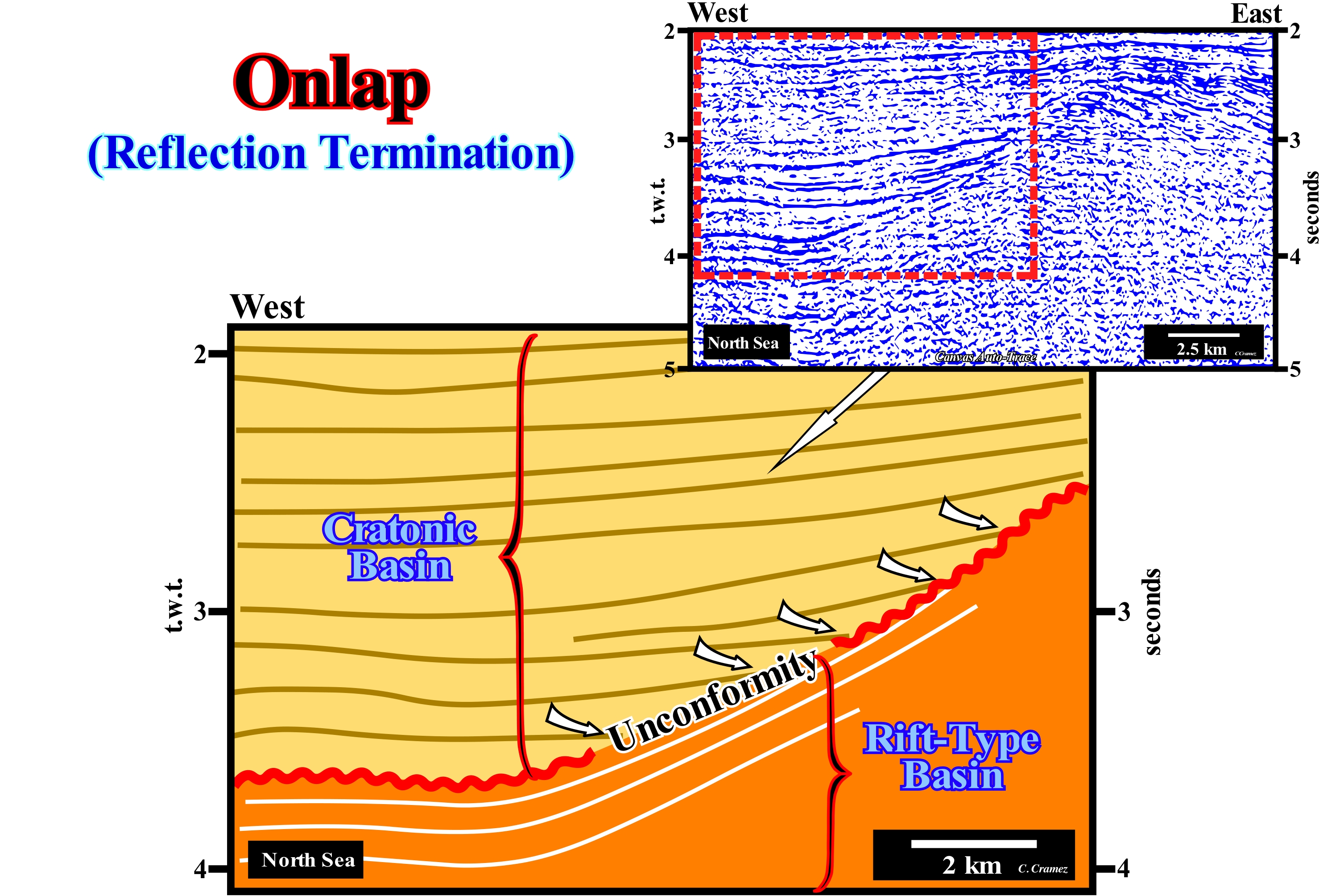
On this tentative geological interpretation of a Canvas auto-trace of a detail of a North Sea seismic line, it is easy to see that the sediments of the cratonic basin (also known, in this particular case, as the geographic North Sea basin) rest on the sediments of a rift-type basin by onlapping (marine onlaps). From the geological point of view, the infrastructure of the North Sea is constituted by the stacking of three basins of the classification of the sedimentary basins of Bally and Snelson (1980). From bottom to top, geoscientists recognize: (i) A Paleozoic Folded Belt (not visible on the seismic line of this tentative interpretation), which can be considered as a petroleum basement (absence of source-rocks and significant reservoir-rocks) ; (ii) Several Mesozoic Rift-Type Basins and (iii) A Cenozoic Cratonic Basin. The basal sediments of the rift-type basins are nonmarine, but the upper sediments suggest marine ingressions (or a lacustrine sedimentation), meaning that they were, probably, deposited during stability periods of relative sea level, which occur after each relative sea level rise in acceleration (eustatic paracycle). These eustatic paracycles form a set of sequence-paracycles (sedimentary regressions). On this tentative interpretation, the unconformity (erosional surface underlined by the red wavy line) between the sediments of the rift-type basins and the cratonic sediments is very noticeable due to the marine onlaps of the sediments of the cratonic basin. This unconformity was, locally, tectonically enhanced (uplifted probably induced by a sedimentary shortening). Locally and especially at the top of the buried-hill of sediments of the rift-ype basin, it can be considered as an angular unconformity. However, even when tectonically enhanced, the erosional surface is, mainly, induced by eustasy (changes in absolute or eustatic sea level, which is the global sea level referred to the Earth's centre) and not by tectonics. To have erosion (degradation produced on the terrestrial surface by destructive agents or erosive agents such as rivers, torrents, seas, winds, glaciers, etc.), the sediments must be exposed to these agents. For this, a significant fall of the relative sea level (combined action of absolute sea level and tectonics) is indispensable. The simple uplift of the rocks, either by a compressive tectonic regime (shortening of sediments as in an anticline structure), or by an extensive tectonic regime (lengthening of the sediments, such as that created in the postsalt sediments by a salt-dome or a turtle back structure *) is not enough. Sediments must be exposed in surface or at bottom sea to be eroded. On this tentative interpretation the continental encroachment and aggradation** of the intervals overlapping the unconformity that can be, easily, calculated in time and depth (if the velocity with which the seismic waves pass through the cratonic sediments is known) underline the morphology of the unconformity which, as stated above, was locally tectonically enhanced (probably following an arrangement of lithospheric plates). In fact, as shown on the auto-trace, the sediments underlying the unconformity (rift-type sediments) are, clearly, truncated under the top of the paleohigh, while at the west end of the auto-trace they are perfectly concordant with the overlying sediments. The interface between the cratonic sediments and the sediments of the rift-ype basin at the top of the paleohigh corresponds to a tectonically enhanced unconformity (angular unconformity of certain geoscientists), while at the west end of the auto-trace, it corresponds to a paraconformity, since there is no difference of attitude between the overlying and underlying strata, but just an hiatus by non-deposition between them.
(*) A sedimentary antiform between two salt diapirs, with a more or less flat base, which may or may not have a core formed by a salt cushion. Such a structure is formed by structural inversion of the salt cover as the salt flows, laterally and vertically, to form the salt diapirs that surround it. The salt flow, by compensatory subsidence, creates around the salt domes a more or less circular sinform that many geoscientists wrongly call the marginal syncline, since the overlying sediments are lengthened rather than shortened. During the formation of a turtle back structure, the originally tectonically high points become low points and the originally tectonically ow points are the high points.
(**) Horizontal and vertical distances between consecutive onlaps.
Onlap Infill...............................................................................................................................................................................Remplissage aggradant
Preenchimento agradante / Relleno agradante / Füllen aggradant / 上超填充 / Наносное заполнение / Riempimento aggradante /
Sedimentary fill made mainly by onlapping, after a relative sea level rise in acceleration. When the filling is done by progradations, it is, generally, not regarded as aggaradtional because the relative sea level rise is in deceleration.
See: « Aggradation»
&
« Onlap »
&
« Relative Sea Level Change »
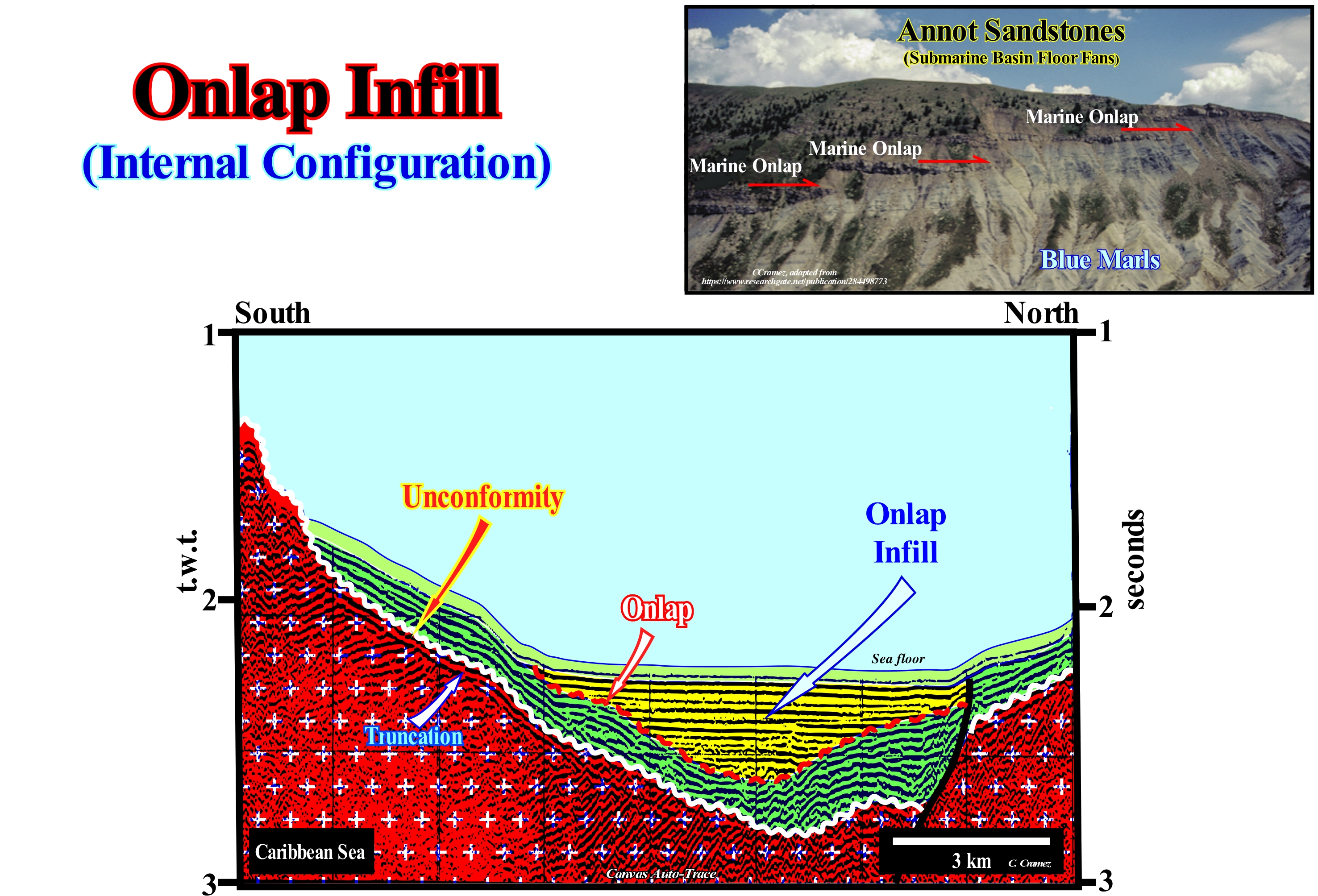
On this tentative geological interpret a Canvas auto-trace of a Caribbean Sea seismic line, two unconformities, i.e., two erosional surfaces induced by two significant falls of the relative sea level (local and referenced to the base of the sediments or any other point on the Earth's surface, such as the seafloor, which is the result of the combined action of the absolute or eustatic sea level and tectonics), which have set the sea level lower than the basin edge of the previous stratigraphic cycle. These two unconformities were tectonically enhanced into angular unconformities, since the reflection terminations underlying the unconformity are toplaps by truncation (erosion). The sedimentary interval, probably, a deep water interval, which is limited between the upper unconformity and the sea floor, colored in yellow in this tentative interpretation, has a parallel internal configuration. This means that it is characterized by parallel reflectors which rest on the unconformity (lower boundary of the stratigraphic cycle) by marine onlaps, since on the perpendicular seismic lines, the geometric relations and terminations of the reflectors are the same (take into account the pitfall introduced by the lateral change in the water depth). It can be said the depositional water depth decreased as sediments, certainly, pelagic deposited. As you have, probably, seen, the underlying sedimentary interval, colored in green, and bounded between the two unconformities (colored in white and red), can, eventually, be subdivided into two stratigraphic cycles. Indeed, in the northern part of the auto-trace, in the footwall of the normal fault, which seems contemporaneous with the sedimentation, at least two onlaps allow to bring into evidence another erosional surface, i.e., another unconformity. For the sake of simplicity, it was not drawn. In any case, the internal configuration of this interval is, more or less, parallel and the reflectors fossilize the unconformity limiting the stratigraphic cycle (probably a sequence-cycle) by onlaps, which underline a coastal aggradation rather than a marine aggradation, which implies a significant the relative sea level fall between the substratum (probably the old mountain range), before this sedimentary interval became deposited. When a geoscientist speaks of a stratigraphic cycle, whether it is a continental encroachment cycle, a continental encroachment subcycle or a sequence-cycle, he is referring to the sedimentary filling that occurred, respectively, during a first-order eustatic cycle (time-duration more than 50 My), 2nd order (time-duration between 3-5 My and 50 My) or 3rd order (duration between 0.5 My and 3-5 My). Similarly, when he recognizes a submarine canyon or a incised valley on a seismic line, it is, generally, referred to the filling a submarine canyon or an incised valley rather than to the cannon or incised valley themselves, induced by the relative sea level fall, which shifted the shoreline seaward (progradation) and downward (negative aggradation). An submarine canyon or submarine gorge, for instance, is a cliff-like valley (cut to the bottom), located on the continental slope formed, generally, in association with a relative sea level fall, which may or may not be later, partially or totally, filled by sediments. This means the formation age and the filling age are quite different. The same happens with the formation age and the filling age of an incised valley. The first corresponds to the age of the erosional surface, which created the unconformity, i.e., the age of relative sea level fall, while the age of filling an incised valley ** is, in general, the age of the terminal part of the lowstand prograding wedge (LPW) of the sequence-cycle limited, at the bottom, by the unconformity.
(*) Absolute or eustatic sea level, which is supposed to be the global and referenced to the Earth's centre. It is dependent on: (i) Tectono-Eustasy, which is controlled by the volume variation of the ocean basins ; (ii) Glacio-Eustasy, which is controlled by the variation of ocean water volume as a function of the amount of ice ; (iii) Geoidal-Eustasy, which is controlled by the distribution of ocean water caused by variations in the terrestrial gravity field, and (iv) Thermal expansion of the oceans or steric sea level rise (if the temperature of the oceans increases, the water density decreases and, for a constant mass, the volume increases).
(**) Valley formed by fluvial systems that extend their channels basinward and erode the underlying strata in response to a relative sea level fall, responsible for the lower sequence-cycle boundary. An incised valley can be several hundred meters deep and a width ranging from tens to thousands of meters.
Onshore.........................................................................................................................................................................................Onshore (Exploration area or block)
Onshore (em terra, área ou bloco de pesquiza) / Onshore (costa adentro), Onshore (en tierra) / An Land / 陆上 / Наземный / A terra /
Area upstream of low-tide. Area located on or near the coast. In the oil industry, unlike offshore, the term onshore refers either to: (i) An oil field, natural gas or condensate that is located on the mainland ; (ii) The reserves in such a field ; (iii) Operations carried out in that field ; (iv) The production block of thiat field ; (v) Any exploration block located on land, etc. Sometimes synonymous with the Inland and On land.
See: « On Land »
&
« Relative Sea Level Change »
&
« Shoreline »
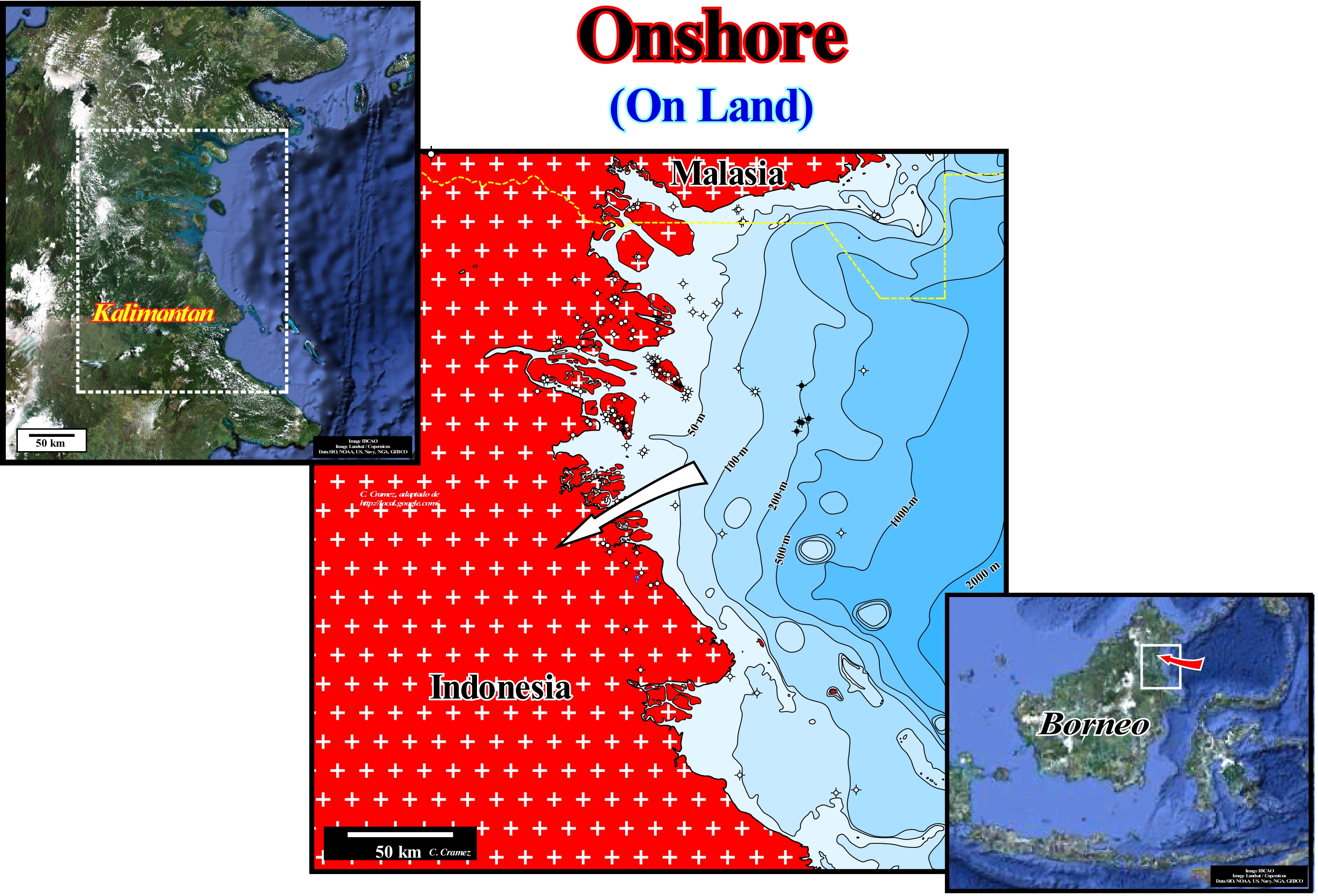
On the map illustrated in this figure, offshore and onshore petroleum exploration operations are located, since there are offshore and onshore drilling and development wells. The shoreline (intersection of mean sea level, with land) is difficult to define. It varies with the tides, which means that the boundary between onshore and offshore is variable. On the other hand, as in this particular case, there are a lot of islands, of all sizes, the problem of the differentiation between offshore and onshore is, even, more complicated. Some countries include all islands in the offshore, others just encompass the largest and most remote of the shoreline and others consider the islands as part of the onshore. Which means that each country has its own legislation for the oil industry. In this example (the west coast of Borneo, north of the Mahakam Delta), the only two oilfields found in this area are located on two islands: (i) Tarakan oilfield and (ii) Bunu oilfield. The Indonesian authorities consider that these fields are in onshore located, although the initial exploration blocks have been mixed blocks, i.e., with an onshore (island) and offshore (sea) parts. Some countries consider that an onshore block is a block where all the exploration is done on land (seismic lines and conventional drilling operations) and that an offshore block is a block where the seismic lines are made in the open sea and the drilling rigs are located on in the sea or in ships. However, this definition has exceptions. In the case of a delta region, particularly when deltas develop under the influence of waves, the exploration block is sometimes considered as an onshore block, but the seismic and drilling campaigns are not entirely done on land. On the contrary, in an offshore block, it is common for part of the exploration wells to be located onshore and that from a certain depth they are deviated to the offshore, just because the price of an onshore well is much cheaper than at an offshore well. All this means that in the oil industry, the border between onshore and offshore varies by country. Geologically, the onshore/offshore boundary may correspond to the continental edge when the basin has no shelf, which means that the shoreline coincides or is very close to the continental edge. In highstand geological conditions (sea level higher than the basin edge), when the basin has a shelf it is obvious that the onshore offshore limit does not correspond to the continental edge (upper limit of the continental slope). Do not forget that within a sequence-cycle, the basin does not have a shelf during the lowstand systems tracts group (LSTG): Submarine basin floor fans (SBFF), Submarine slope fans (SSF) and Lowstand prograding wedges (LPW) . On the contrary, during the deposition of the highstand systems tracts group (HSTG), the basin has a shelf (continental platform) during the transgressive interval (TI) and during the 1st phase of development of the highstand prograding wedge (HPW). In this particular case, an important difference is made by the oil companies between conventional offshore and deep offshore. The conventional offshore is limited to the continental shelf (water depth less than 200 meters), while in the deep offshore the water-depth, theoretically, exceeds 200 meters. With regard to the boundary between onshore and offshore that, in principle, separates land from the sea, let us recall, the paradox of the shoreline evidenced by Lewis Fry Richardson and later by Benoit Mandelbrot. This paradox corresponds to the counter-intuitive observation that the shoreline of any land mass (island or continent) does not have a well-defined length. This is a consequence of the fractal properties of the shoreline, whose geometry is invariant by scale change. The length of the shoreline depends on the method used for its measurement. Since a land mass has details at all scales, hundreds of miles to tenths of millimeters, there is no obvious size from which all details can be measured. There is not a single well-defined perimeter for the boundary between land and sea. Several approaches exist when specific assumptions about the minimum size of shoreline details are made.
(*) During the 2nd phase of development of the highstand prograding wedge (HPW), the shoreline coincides, roughly, with the continental edge and, therefore, on seismic lines (taking into account the seismic resolution), the basin has no shelf (continental platform).
Onshore Reef (Fringing reef).............................................................................................................................Récif frangeant (Récif côtier)
Recife costeiro / Arrecife en franja, costero / Franzenriff, Küstenriff / 边礁 / Окаймляющий или береговой риф / Fringing scogliera, Frange reef (barriera corallina) /
Reef that develops supported to the rocks of the shelf, in bands, more or less, parallel to the shoreline. Between a coastal reef and the shoreline there is a narrow, shallow channel that certain geoscientists call a boat channel. Synonym wit Rimmed Reef.
See: « Reef »
Ooze (Biogenic mud)......................................................................................................................................................................................................................Biovase
Biovasa, Vasa biogénica / Biovasa / Sickern, Ooze / 渗 / зоогенный ил / Stillare, Ooze /
Pelagic sediment containing at least 30% of skeletal remains of microorganisms.
See: « Pelagic (deposit) »
&
« Pelagic Sediment »
&
« Calcite »
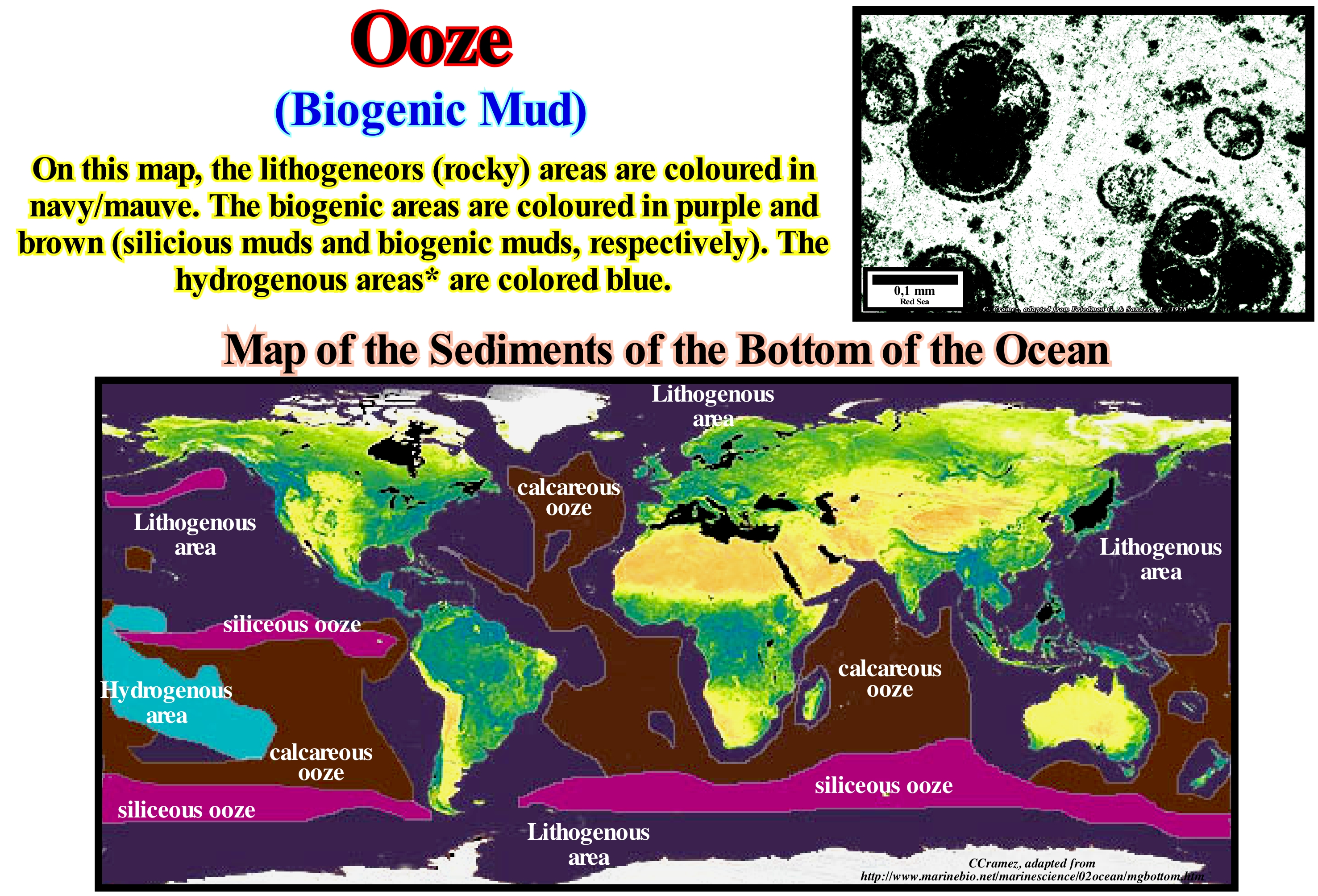
The micro-photography of a thin section, in polarized light, from a Pleistocene calcareous ooze (biogenic mud) suggests that the mud is, essentially, formed by Globigerinas** cemented by micritic calcite. This ooze was collected, approximately, ninety six (96) meters below sea level (DSDP, site 229). Calcareous oozes encompass globigerinas biogenic muds, which contain shells of planktonic foraminifera and biota with pteropods, which are composed, mainly, of pelagic shells. Siliceous oozes encompass biogenic muds with radiolaria *** which contain, essentially, brown clays with more than 30% skeletons of freshwater protozoa and diatomaceous muds containing frustules (thin shells) of diatoms. The skeletal remains of the radiolaria, which settle down on the sea floor, form radiolaria oozes. When the sea floor is raised, due to a significant relative sea level fall (continental collision, for example), and transformed into a continent, oozes become sedimentary rocks. Siliciclasts sedimentary rocks, such as flint, chert and diatom, come from radiolaria oozes. Pelagic calcareous oozes are, probably, the modern analogues of the ancient Calcilutites biogenic muds of the ancient abyssal plains. They are composed, mainly, of plankton, which secretes aragonite and floats near the surface. Biogenic muds are pelagic sediments, which have more than 30% of skeletal material. They can be carbonated or siliceous. The skeletal material of the carbonated oozes is calcium carbonate, usually, in the form of calcite, but sometimes also in the form of aragonite. The main sources of skeletal remains are the foraminifera, coccoliths (microscopic carbonate plates), which cover certain species of seaweed and protozoa. The siliceous oozes are composed of opal, which forms the skeleton of several micro-organisms, such as diatoms, radiolaria, sponges and silicic-flagellates. The distribution of biogenic muds depends, mainly, on the contribution of skeletons, their dissolution and dilution by other sediments such as turbidite clays.
(*) The hydrogenous areas originate from chemical reactions with water that occur in the existing sediment. Hydrogenated sediments are, often, found in the form of nodules with manganese and iron oxides.
(**) A genus of planktonic foraminifera inhabiting the oceans since the Middle Jurassic, which has a globular, spiral-wound test composed of spherical to oval chambers but not radially elongate, which increase rapidly when added, though, usually, they have only three to five.
(***) Amoeboid protozoa, exclusively, marine organisms, which has a spherical shape, with an inner and an outer part. The inner region has many nuclei and is bounded by a central membranous capsule. There is an extravasation of the internal cytoplasm through perforations of the capsular membrane, which allows a continuity of the external and internal cytoplasm. The extra capsular cytoplasm forms the "calime" which is a cortex with vacuoles circling the central capsule.
Open Sea Shelf (Carbonate facies belt).....................................................................................Plate-forme de mer ouverte
Plataforma de mar aberto / Plataforma de mar abierto (cinzura carbonatada) / Platform offenen Meeres (Carbonat Gürtel) / 开放大陆架(碳酸盐岩带)/ Шельф открытого моря / Piattaforma marine aperta (cintura di carbonato) /
Distal sedimentary environment of a rimmed carbonated platform between the deep basin and the edge of the deep platform, which is located downstream of the external slope.
See: « Shelf »
&
« Carbonate Facies Belt »
&
« Epeiric Platform (epiric) »
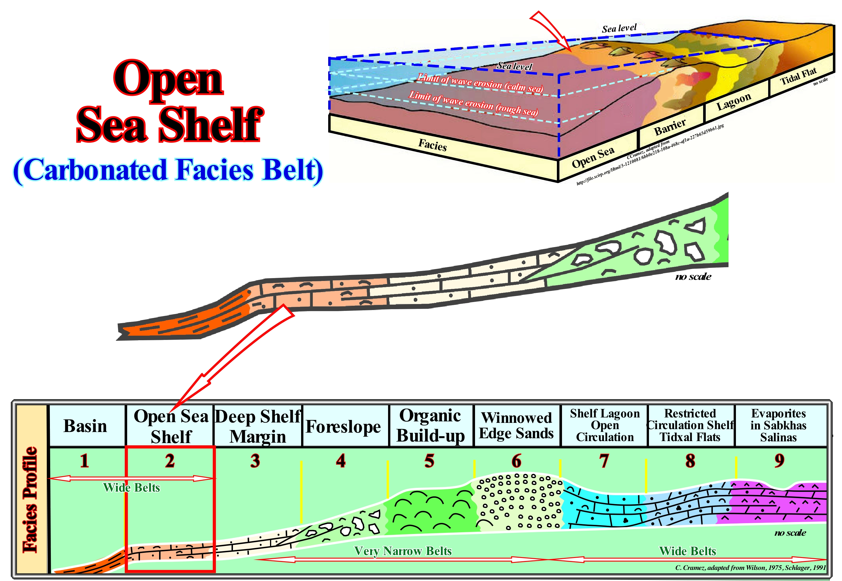
Several geoscientists have observed carbonate platforms and particularly in the rimmed or fringed carbonate platforms (characterized by the more or less continuous presence of reefs or calcareous shoal sands along the edge of the platform), the occurrence of a typical succession of a more or less constant sedimentary environments between the basin and the mainland (when the platform is connected to the continent). This succession of carbonate sedimentary environments is illustrated in this figure and can be considered as a platform model, although it does not say anything about the differentiation often found between the leeward and the windward (platform not connected to the continent), i.e., about the asymmetry of the platform. In this model, nine sedimentary environments are distinguished: (i) Basin ; (ii) Open Sea Shelf ; (iii) Deep Shelf Margin ; (iv) Foreslope ; (v) Organic Build-up ; (vi) Winnowed Edge Sands ; (vii) Shelf Lagoon Open Circulation ; (viii) Restricted Circulation Shelf & Tidal Flats ; (ix) Evaporites in Sabkhas Salinas. The Basin (i) is very deep for the production and deposition of carbonates, depending on the influx of fine clay sediments and siliceous material. The Open Sea Platform has a depth between tens and hundreds meters. It is, usually, oxygenated and with a normal marine salinity, in which the currents have a good circulation and, deep enough, not to have suffered the effect of the swell. The bottom sediments are just affected during intermittent storms. The Deep Shelf Margin is located at or near the carbonate platform and composed of conchoidal material derived from the shelf, with swell conditions and the oxygen level are very similar to basin (i). The Foreslope is located above the lower limit of hydrogenated water, above the swell level. The carbonate debris deposits with a dip around 30° with landslides, mounds, wedge-shaped fronts and large blocks. The development of organic build-up platform Reefs depends on water energy, slope ramp, organic productivity, amount of built structures, connections, obstacles and frequency of subaerial exposures and cementation. The winnowed edge sands are characterized by banks, beaches, open sea fan tidal bars, belts or dune islands and a depth-water deposition between 5 and 10 m. An oxygenated environment not suitable for marine life due to a constant substrate change. The Shelf Lagoon with Open Circulation is characterized by narrow, open lagoons and bays behind the outer platform edge. The water-depth is small, sometimes just a few meters, with normal salinity and moderate circulation. The Restricted Circulation Shelf and Tide Flats include most of the fine sediments in surface lagoons and coarse sediments in tidal channels and local beaches. The whole complex corresponds to the tidal plain environment. It may have fresh, saline and hypersaline waters, with frequent aerial exposures, abundant marine and marsh vegetation. Terrigeneous components of wind origin may have important proportions. The evaporites in Sabkhas Salinas is a supratidal environment with lakes in the marine shelf. The climate is arid with intense heat with sporadic marine ingressions. Gypsum and anhydrite are very common. As illustrated, the open sea shelf is located below the action of the waves, in calm sea, but it is hit by the action of the waves during the storms. It is inside or slightly below the photic zone. It corresponds, normally, to the more or less horizontal surfaces between the active platform and the deep part of the basin. This environment is, often, found in association with drowned platforms created when a relative sea level rise*. The most frequent sediments of this environment are carbonates, mainly, bioclastic wackestones (carbonate rock containing more than 10% allochemicals in a carbonaceous clay matrix), grains, marls and some silica, which are, usually, well stratified and a lot of bioturbation. The biota is, mainly, represented by a conchoidal fauna, which indicates normal marine conditions and plankton (a set of microscopic plants and animals that live suspended in water and which are the basis of many food chains).
(*) Local sea level referenced to any point on the land surface that is the sea floor or base of the sediments (top of the continental crust), which is the result of the combined action of absolute (eustatic) sea level, which is supposed to be global and referenced to the Earth's centre and tectonics (subsidence of the sea floor when the predominant tectonic regime is extensional or uplift of the sea floor, when the predominant tectonic regime is in compression).
Ophiolite...........................................................................................................................................................................................................................................Ophiolite
Ofiolito / Ofiolito / Ophiolith / 蛇绿岩 / Офиолит / Ofioliti /
Portion of the oceanic crust, mainly coming from the overriding lithospheric plate of a B-type subduction (Benioff), which has been transported upwards, i.e., uplifted (obduction) and incorporated into the subduction plane and which may, possibly, remain above the continental crust, even before the two continental masses collide.
See: « A-Type Subduction (Ampferer) »
&
« B-Type Subduction (Benioff) »
&
« Obduction »
When the sea, between two divergent continental margins, begins to close, because a zone of subduction was formed between them and a part of the oceanic crust of a lithospheric plates is consumed underneath the other, as illustrated in this sketch, the formation of ophiolites is possible even before the two continental masses collide. Attention to the term collision, since in plate tectonics, kinetic energy plays no role. This means that the effect of constraint does not exist in nature. The term collision, which in current language translates the transformation of kinetic energy into deformation energy, as, when a car crashes into a wall, it is, poorly, used in tectonics, and particularly in plate tectonics. Ophiolites, which appear along the suture lines of the continents, are characterized by a succession of various types of rocks. In the Samail ophiolites (Oman Mountains), the base of the succession is composed of the sedimentary rocks of the Arabian Shield, on which the oceanic plate was pushed. From the base to the top of the ophiolites are recognized: (i) Peridotites ; (ii) Stratified gabbros (igneous intrusive rock formed mainly by plagioclase and clinopyroxene) ; (iii) Massive gabbros, (iv) Dikes and (vi) Volcanic rocks. This succession, in Samail, has a thickness of about 15 km. The basal peridotites are formed by harzburgites (rocks consisting mainly of olivine and enstatite). Within the peridotite, which is deformed, there are many dykes of gabbro and dunite. Peridotites are superimposed by dunites (intrusive igneous rocks composed mainly of olivine), which pass, gradually, into gabbros. This succession is covered by dikes and volcanic rocks (pillow basalts formed along the ocean ridges). Do not forget that the volcanic material can not flow under water, i.e., there are no submarine lava flows.
Opposite Downlaps.......................................................................................Biseaux de progradation (En directions opposées)
Biséis de progradação opostos / Biseles de progradación (en direcciones opuestas) / Gegenüber downlaps, Bezels Progradation (in entgegengesetzte Richtungen), Progradierender Keile (gegenläifig) / 相反downlaps, Progradational 楔子(方向相反) / Подошвенные прилегания (в противоположных направлениях) / Cunei progradanti (direzioni opposte) /
One of the synchronous downlaps in opposite directions. This type of downlap is characteristic of overbank deposits, in particular of the levees, whether associated with fluvial or turbidite deposits (deep water or not). Opposite downlaps suggests a local divergent sedimentary influx.
See : « Downlap »
&
« Toplap »
&
« Geometrical Relationship (reflector, stratum) »
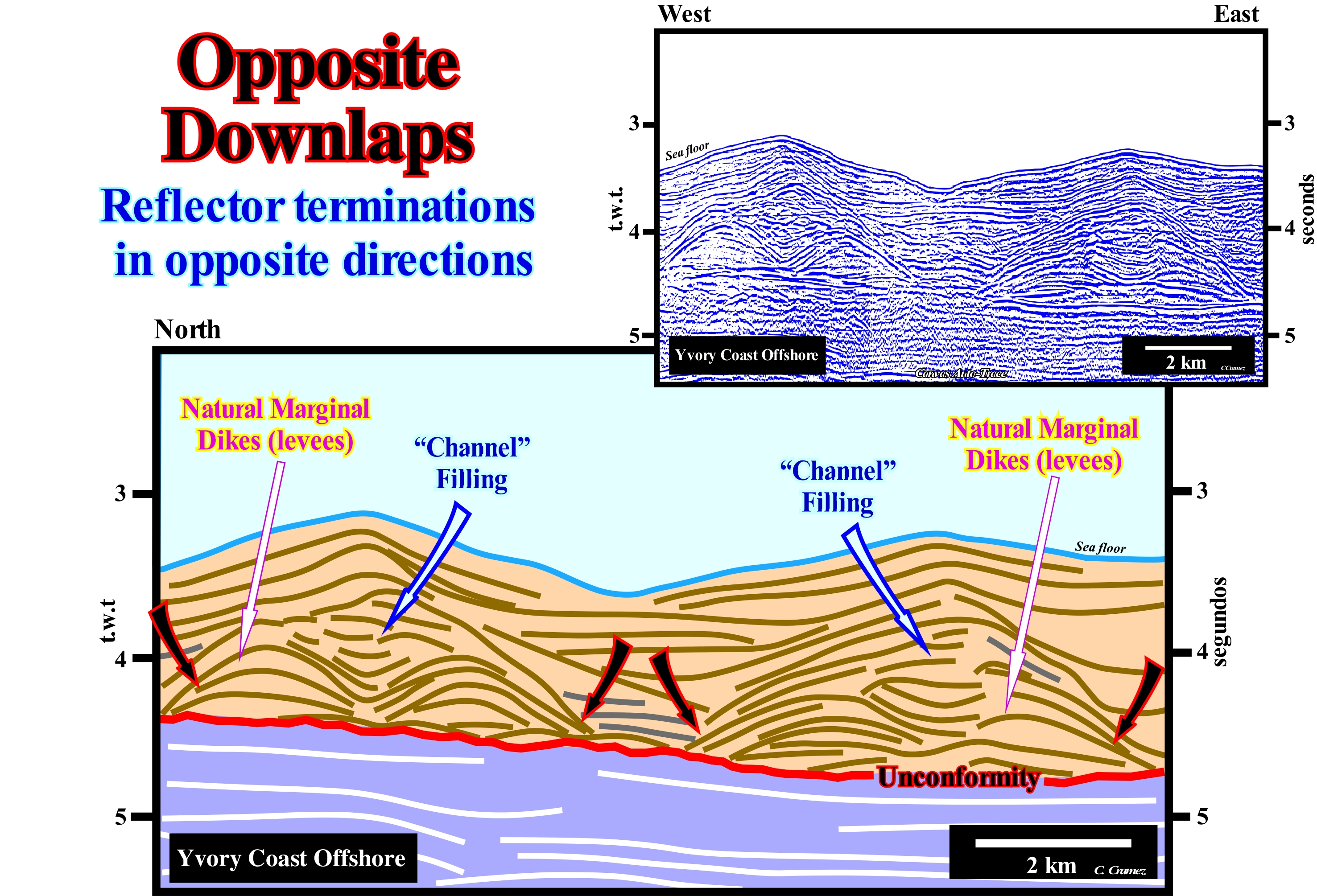
This figure illustrates a tentative geological interpretation of a Canvas auto-trace of a detail of an Ivory Coast offshore seismic line. This offshore corresponds to the stacking of several basins of the classification of the sedimentary basins of Bally and Snelson (1980), which from the bottom up are: (i) Precambrian Basement or a Paleozoic folded and flattened mountain belt ; (ii) Late Jurassic-Early Cretaceous rift-type basins and (ii) An Atlantic-type divergent margin developed from the Early Cretaceous until today. The rift-type basins, which developed during the lengthening of the Gondwana small supercontinent, are separated from the sediments of the post-Pangea continental encroachment stratigraphic cycle, i.e., separated from the sediments of the divergent margin by the break-up of the lithosphere of the Pangea supercontinent. On this tentative interpretation, the complex associations of channel filling and natural marginal dikes (P. Vail's turbiditic levees in the form of the "gull wings") are predominant and characteristic of the submarine slope fans (SSF). Within a sequence-cycle, this subgroup of sedimentary systems tracts is deposited, generally, on the submarine basin floor fans (SBFF) and, laterally, against the lower boundary (unconformity) of the cycle-sequence, by marine onlaps. However, in certain cases, when the submarine basin floor fans (SBFF) are disconnected from the base of the continental slope, the submarine slope fans (SSF) may rest, directly, on the lower unconformity of the sequence-cycle. This is what seems to be the case on this tentative interpretation, in which the unconformity, coloured in red, corresponds to the lower boundary of the sequence-cycle, which in this area is just represented by the middle subgroup of the systems tracts, i.e., by the submarine slope fans (SSF). The downlaps in opposite directions, which characterize overbank deposits, are, easily ,recognized on this tentative. Obviously, these downlap do not indicate the direction of the regional terrigeneous influx (corresponding, more or less, to the direction of the turbiditic currents), but to the direction of the overbanking currents, which are, generally, more or less perpendicular to the direction of depression between the turbiditic natural marginal dikes (levees). This depression between the natural marginal dikes, which corresponds, normally, to an area without deposition (transport zone), may in certain cases correspond to a turbiditic channel, i.e., a negative bathymetric anomaly resulting from the incision (erosion) of the turbidite stream, which is, relatively, rare. What in this tentative interpretation is called "channel", corresponds to the filling of the depression between the turbiditic natural marginal dikes (zone of passage of the turbiditic currents), which form, progressively, as the dikes on each side of the depression are deposited. As natural turbiditic marginal dikes (levees) settle down, the depression between them channels the next turbidite currents. Since the height of the turbiditic currents is greater than the height of the depression, the current overflows and deposits the sediments that it transports forming more marginal natural dikes and, sometimes, crevasse-splay fans. As a turbidite current, unlike a river, does not require a bed to flow, the turbidite natural marginal dikes have a different geometry from that of fluvial natural marginal dikes, since they are implemented differently, particularly, the older marginal dikes. As illustrated on this tentative interpretation, in a turbidite depositional system, natural marginal dikes (levees) are deposited, more or less, at the level of the base of the turbidite stream, whereas in a river depositional system the marginal dikes are deposited, sharply, above from the bottom of the current bed. As the relative sea level begins to rise (in acceleration) and the intensity of the turbidite currents decreases (overbanking and avulsion of the turbiditic currents become rare events), the depression between natural dikes begins to be filling in retrogradation (phase of retreat). When the fill facies are sandy, the morphology of the filling is, more or less, fusiform (due to differential compaction), as on this tentative interpretation. On the contrary, when the facies is shaly, the morphology of the filling is lenticular with a concave upper surface and a convex lower surface, since the shaly sediments, rich in water, compact much more than the sandy sediments.
Opposition (Astronomy)...........................................................................................................................................................Opposition (Astronomie)
Oposição / Oposición (astronomía) / Opposition (Astronomie) / 衝 (天體位置) / Противостояние планеты / Opposizione (astronomia) /
When a celestial body is on the opposite side of the sky when viewed from a particular place (usually, from Earth), which means that two planets are in opposition to each other when the longitudes of their ecliptics differ from 180°.
See: « Earth »
&
« Moon »
&
« Ecliptic »
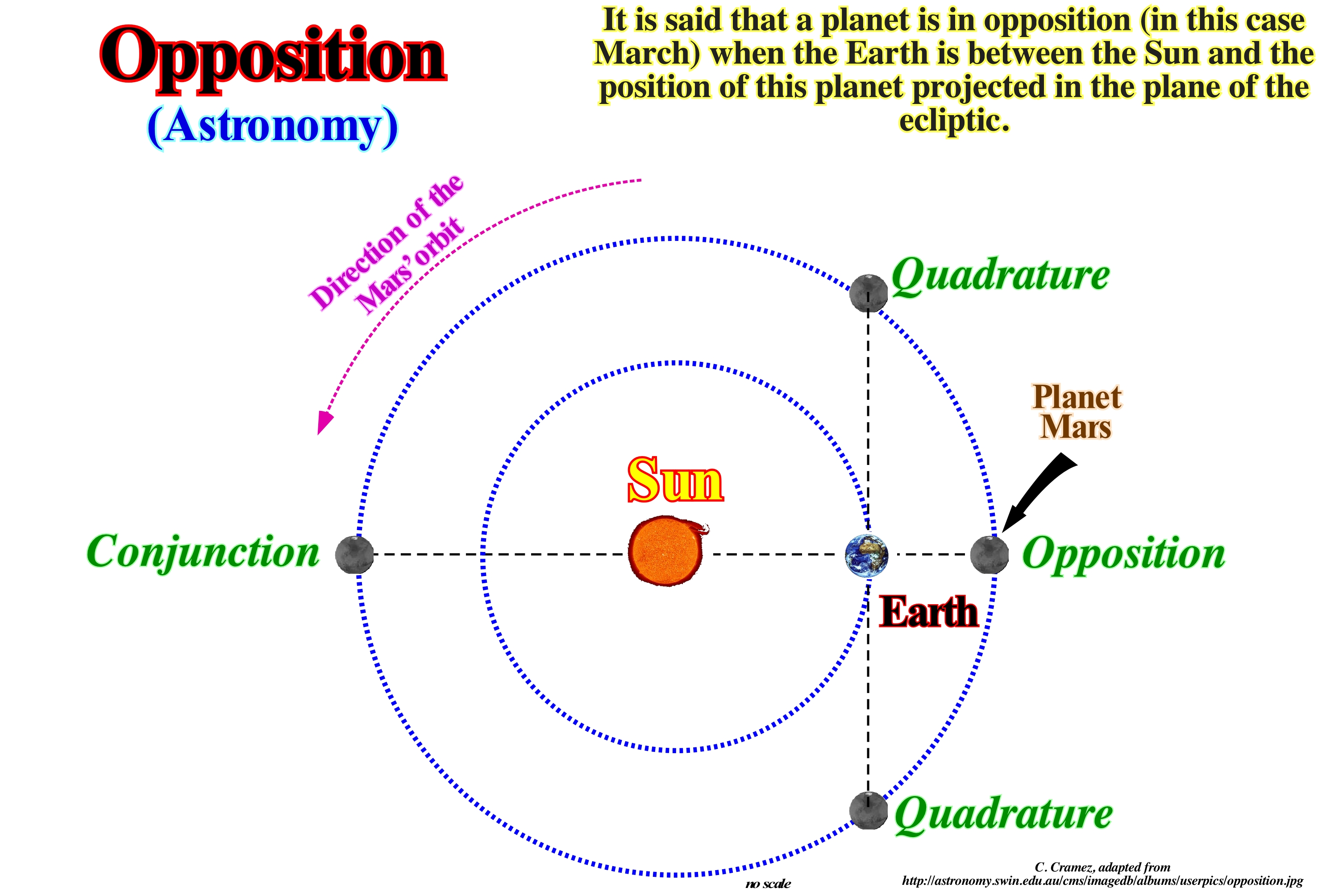
Opposition is a term used in astronomy to indicate when a celestial body is on the opposite side of the sky when viewed from a particular place (usually Earth). Two planets are in opposition to each other when their ecliptic longitude differ by 180°. A planet (or asteroid or comet) is in opposition, when viewed from Earth it is in opposition to the Sun. When a planet is in opposition: (i) It is visible almost all night, rising, more or less, at sunset of the Sun, culminating around midnight and disappearing at sunrise ; (ii) It is at this point in its orbit that it is closest to Earth, which makes it appear larger and brighter ; (iii) Half of the planet, visible from the Earth, is illuminated,completely, ("full planet") ; (iv) The effect of the opposition increases the light reflected by bodies with dark rough surfaces. In our Solar System, astronomers often divide the planets into two groups — inner planets and outer planets. The inner planets are closer to the Sun and are smaller and rockier. The outer planets are further away, larger and made up mostly of gas. Classification in inner planets, i.e., planets that are closer to the Sun than Earth, such as Mercury and Venus and outer planets such as Mars, Jupiter, Saturn, Uranus, Neptune as well as smaller and dwarf planets, including Ceres and Pluto, which are farther from the Sun than the Earth, should not be confused with the terms inner and outer planets designating the planets within the asteroid belt and those outside it. Similarly, inner planet should not be interpreted as small planet or dwarf planets. Opposition occurs only on outer planets. The Moon, which orbits the Earth, not the Sun, is in opposition to the Sun in full Moon. When the Moon is, exactly in opposition, a lunar eclipse occurs. When viewed from a outer planet, if an inner planet is on the opposite side of the Sun, it is in superior conjunction with the Sun. A lower conjunction occurs when the two planets meet on a line on the same side of the Sun. In a lower conjunction, the outer planet is in opposition to the Sun, seen from the lower planet. To understand the mechanism of an orbit of one object about another of larger dimensions, do not forget that: (i) It falls towards the centre of the main object ; (ii) It moves so rapidly, that the main object bends beneath it ; (iii) He tries to move in a straight line, but the force of gravity forces him to take a curved trajectory ; (iv) If its tangential velocity is sufficient (velocity of escape), it falls, indefinitely, that is, that it never collides with the main object and enters orbit ; (v) The shape of the orbit is an ellipse with the centre of mass of the main object in one of the foci. An object to escape to the Earth's gravitational field must have a kinetic energy higher than its potential gravitational energy. At the Earth surface, the escape velocity is about 11,100 m/s. The solar system, illustrated in this figure, represents the cosmic family of the Sun. It comprises all objects moored by their gravity: (a) Planets; (b) Dwarf Planets; (c) Moons; (d) Comets; (e) Asteroids and (f) Other small objects not yet discovered. The closest planet to the Sun is Mercury (± 57.9 Mkm). The outermost planet is Neptune (± 4.5 Gkm). Since 2006, the International Astronomical Union no longer considers Pluto as a planet, but as a dwarf planet. Currently, the number of planets in the solar system is eight (8): Mercury, Venus, Earth, March, Jupiter, Saturn, Uranus and Neptune. The number of dwarf planets is three (3) : Ceres, Pluto and Eris (from the nearest to the farthest). The number of known planetary moons is one hundred sixty five (165): Mercury 0, Venus 0, Earth 1, March 2, Jupiter 63, Saturn 59, Uranus 27 and Neptune 13. The number of known comets is 1,000 (estimated real number 1000 T). A moon is a natural satellite of a planet. A satellite is an object that orbits around a planet, such as the Earth around the Sun. There is talk of a natural satellite when man did not intervene in its creation. The Earth has one planet, the Moon, which orbits around the Earth in 27.3 days. The Moon is in the same position in the sky all 29.5 days. The average distance from Earth to the Sun is 149.6 km.
Orbit......................................................................................................................................................................................................................................................................Orbite
Órbita / Órbita / Orbit / 轨道 / Орбита / Orbita /
Path that an object, like Earth, makes around another object, like the Sun, when it is under the influence of a source of a centrifugal force, like gravity.
See: « Aphelion »
&
« Milankovitch's Cycle »
&
« Glaciation »
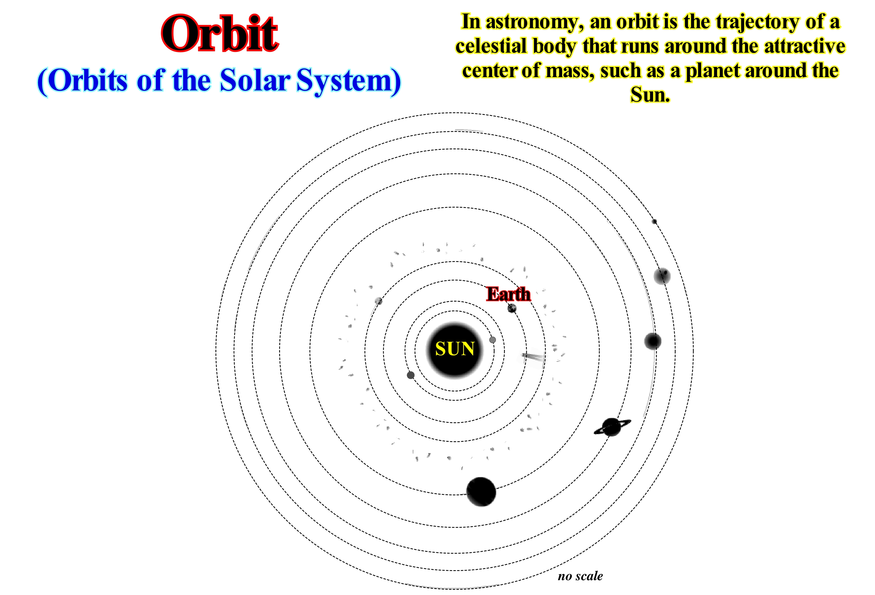
To understand the mechanism of an orbit of one object about another of larger dimensions, do not forget that: (i) It falls towards the centre of the main object ; (ii) It moves so rapidly, that the main object bends beneath it ; (iii) He tries to move in a straight line, but the force of gravity forces him to take a curved trajectory ; (iv) If its tangential velocity (velocity measured at any point tangent to the orbit) is sufficient (escape velocity*), it falls, indefinitely, that is, that it never collides with the main object and enters orbit ; (v) The shape of the orbit is an ellipse with the centre of mass of the main object in one of the foci. An object to escape to the Earth's gravitational field must have a kinetic energy** higher than its potential gravitational energy. At the Earth surface , the escape velocity is about 11,100 m/s. The solar system, illustrated in this figure, represents the cosmic family of the Sun. It comprises all objects moored by their gravity: (a) Planets; (b) Dwarf Planets; (c) Moons; (d) Comets; (e) Asteroids and (f) Other small objects not yet discovered. The closest planet to the Sun is Mercury (± 57.9 Mkm). The outermost planet is Neptune (± 4.5 Gkm). Since 2006, the International Astronomical Union no longer considers Pluto as a planet, but as a dwarf planet. Currently, the number of planets in the solar system is eight (8): Mercury, Venus, Earth, March, Jupiter, Saturn, Uranus and Neptune. The number of dwarf planets is three (3) : Ceres, Pluto and Eris (from the nearest to the farthest). The number of known planetary moons is one hundred sixty five (165): Mercury 0, Venus 0, Earth 1, March 2, Jupiter 63, Saturn 59, Uranus 27 and Neptune 13. The number of known comets is 1,000 (estimated real number 1000 T). A moon is a natural satellite of a planet. A satellite is an object that orbits around a planet, such as the Earth around the Sun. There is talk of a natural satellite when man did not intervene in its creation. The Earth has one planet, the Moon, which orbits around the Earth in 27.3 days. The Moon is in the same position in the sky all 29.5 days. The average distance from Earth to the Sun is 149.6 km.
(*) On the surface of the Earth, the escape velocity is about 11.2 km/s.
(**) Energy is the ability to do work. There are two types of energy, the kinetic energy, that is, the ability to do work through the movement (half of the product of the mas by the square of the velocity, i.e., E= 1/2 m x V 2) and the potential energy, that is to say, the ability to do work through the position. Although we often meet terms such as electrical energy, chemical energy, nuclear energy such things do not really exist. They are only practical abbreviations for specific combinations of the kinetic energy and potential energy. Thus, the electrical energy is only the potential energy of negative charge electrons in the presence of positive charges. The exception to this universality of the kynetic energy and potential energy is the energy of electromagnetic radiation, such as the energy of light, such as the one transported from the Sun to Earth and which heats us or aliments photosynthesis. (P. Atkins, 2003- Galileo's Finger- The Ten Great Ideas of Science. Oxford University Press).
Ordovician.............................................................................................................................................................................................................................Ordovicien
Ordovícico / Ordovícico / Ordovizium / 奥陶纪 / Ордови́кский период / Ordoviciano /
The second period of the Paleozoic Era between, approximately 490 and 440 million years ago. The Ordovician comes after the Cambrian period and before the Silurian.
See : « Palezoic »
&
« Geological Time »
&
« Eon »
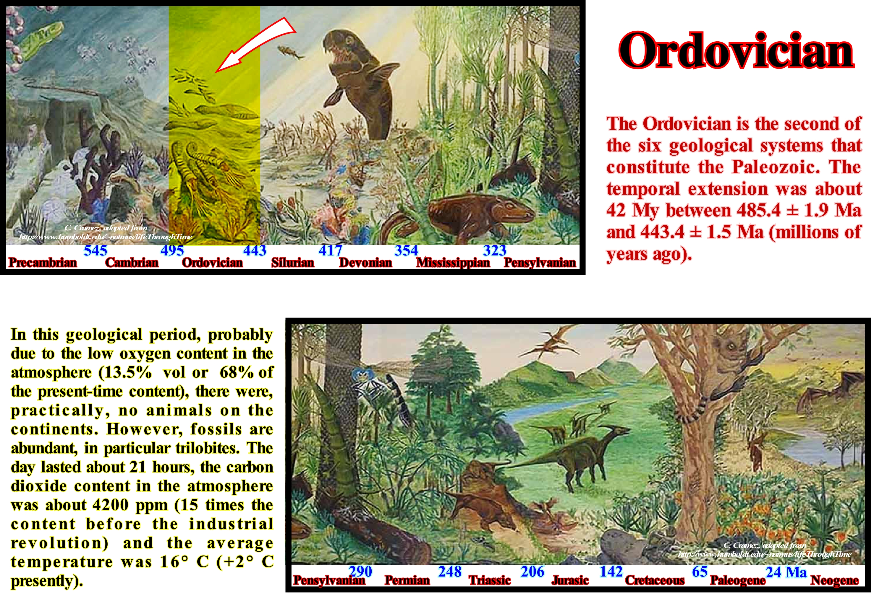
In the Ordovician, the area north of the tropics was, practically, the whole ocean. Most of the continents, resulting from the fracture of Protopangeia (Rodhinia), were located in the southern hemisphere. Laurentia (North America) and Baltica (NW of Europe) were the largest of the continents located west of Gondwana. At the beginning of the Ordovician and even the Middle Ordovician, Earth had a, relatively, soft climate. The weather was warm and the atmosphere humid. Graptolites, trilobites, brachiopods, and conodonts (primitive vertebrates) are the most common Ordovician fossils. Within the marine fossils are red and green algae, primitive fish, cephalopods, corals, crinoids and gastropods. During the Late Ordovician, the Gondwana moved to the south pole. Thus, a great glaciation occurred in the region that today corresponds, more or less, to the Sahara desert. This glaciation produced an eustatic (absolute) sea level fall, since a great amount of water got stuck in the glaciers and ice caps (assuming the amount of water, in all their forms, has remained constant since the Earth's formation). The combination absolute (eustatic) sea-level fall, which reduced the continental shelf ecosystems, with the cold that caused the glaciation, were, probably, responsible for the extinction that occurred at the end of the Ordovician, in which 60% of the marine invertebrate genera and 25% of all families disappeared. This mass extinction, considered by many geoscientists to be the second most important mass extinction of the marine communities of the geological history, has caused the disappearance of a third of all brachiopod and bryozoan families, as well as, numerous groups of conodonts, trilobites, graptolites and much of the fauna reef builder. It can be said that in total more than a hundred families of marine invertebrates disappeared in this mass extinction. During Ordovician, the average CO2 content was 4,200 ppm, that is, 15 times the actual content, and the amount of O2 was 70% of what it is today. At the beginning of the Ordovician, the sea level was ±220 meters higher than today, but fell to about ±140 m during the glaciation.
Organic Matter (Types)..........................................................................................................................................................Matière organique (Types)
Matéria orgânica / Materia orgánica (tipos) / Organisches Material (Typen) / 有机质 (类型 ) / Органическое вещество / Materia organica (tipi) /
The organic matter (kerogen) that is disseminated in the sediments and is soluble in the normal petroleum solvents, such as carbon disulfide. Function of the chemical composition and its nature, organic matter can be presented under three types. These three types of kerogens (I, II and III) generate different hydrocarbons, their identification and distinction is very important in petroleum geology.
See: « Source-Rock »
&
« Kerogen »
&
« Oil Window »
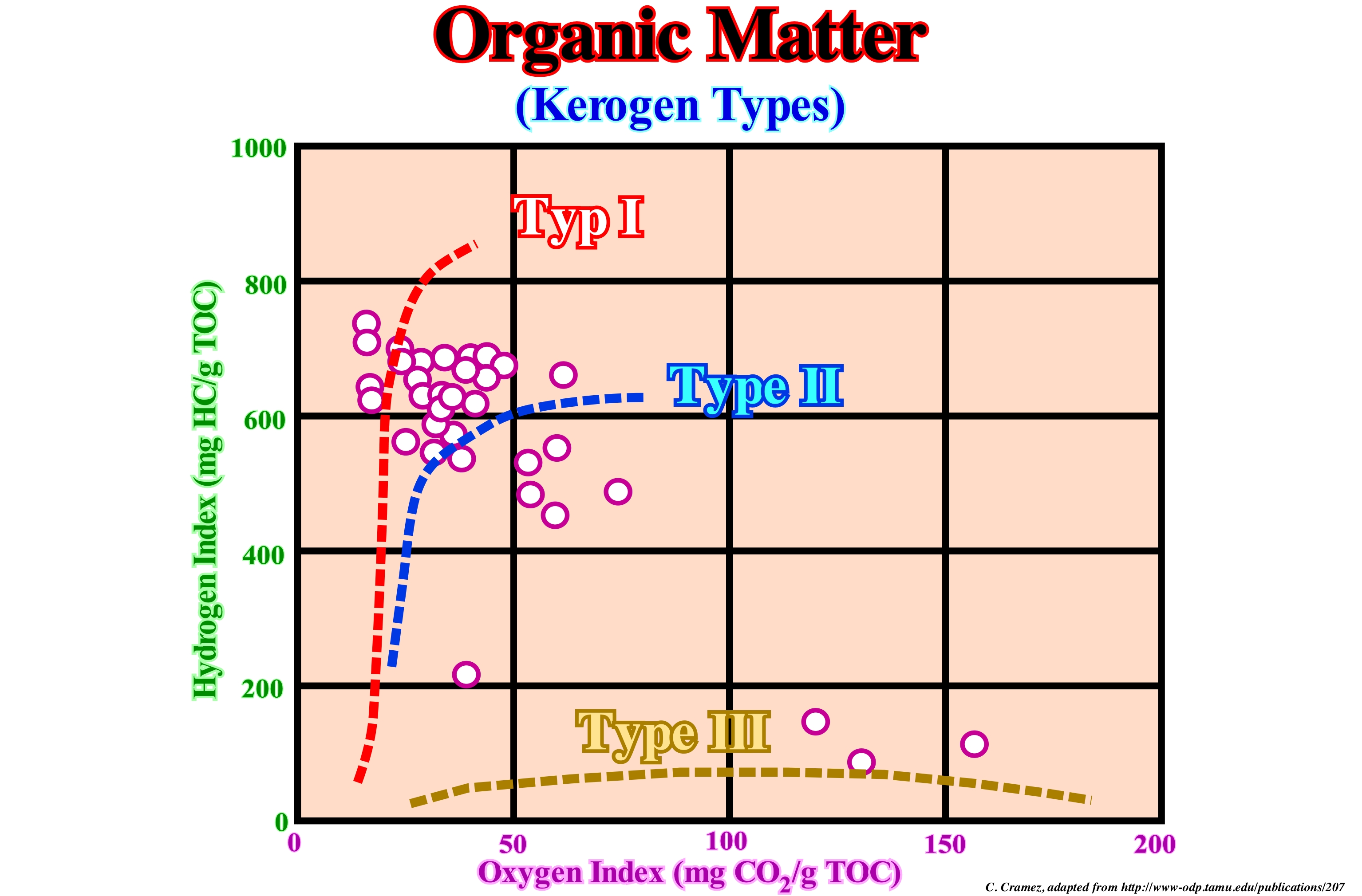
Type I kerogen* is, mainly, of algae origin. It has a higher proportion of hydrogen, relatively, to oxygen (H: O ± 1.2/1.7) than the other kerogen types. The H: C ratio is about 1.65. Lipids (a group of substances that integrate fats, steroids and phospho-lipids and have in common their insolubility in water) are its main components, which are particularly abundant in the Botryococcus algae, occurring in the present day "coorongite" (peat coal) and in the old bituminous shales. Type II kerogen has an intermediate composition. Like algae kerogen, type II kerogen is rich in aliphatic components and the H:C ratio is greater than 1. The original organic matter of this kerogen type consists of algae debris and material derived from zooplankton and phytoplankton. Type III kerogen or humic kerogen has an H:C ratio of less than 1. It is produced by the lignite of plants growing on the continent. This type of kerogen tends to produce large amounts of gas and, practically, little or no petroleum. Initially, non-marine basins were thought to produce, mainly, gas because of the strong predominance of humic kerogen. The marine basin were supposed to produce, mainly, petroleum because the strong predominance of algae kerogen. However, this type of generalization has been, largely, refuted by the results of petroleum exploration, since many rift-type basins (usually halfgrabens), resulting from the lengthening of the continental crust preceding the break-up of the lithosphere, are extremely rich in algar kerogen and in petroleum, such as the rift-type basins of the northern offshore of Angola (Cabinda). In a first approximation, it can be said type I kerogen is source-rocks and type II, in the marine source-rocks and type-III in continental source-rocks.
(*) Kerogen is solid, insoluble organic matter in sedimentary rocks. Consisting of an estimated 1016 tons of carbon, it is the most abundant source of organic compounds on earth, exceeding the total organic content of living matter by 10,000 fold. It is insoluble in normal organic solvents and it does not have a specific chemical formula. (https://en.wikipedia.org/wiki/Kerogen)
Organic Production (Carbonate function)...............................................................................................Carbonate function
Produção orgânica (carbonatos) / Production organique / Producción orgánica (carbonatos) / Ökologische Produktion (Carbonate) / 有机生产(碳酸盐岩)/ Органическое производство (карбонаты) / Produzione organica (carbonati) /
Production of carbonate material as a function of water-depth. Synonym of Carbonate Production Curve.
See: « Depositional Model (carbonates) »
&
« Reef »
&
« Relative Sea Level Change »
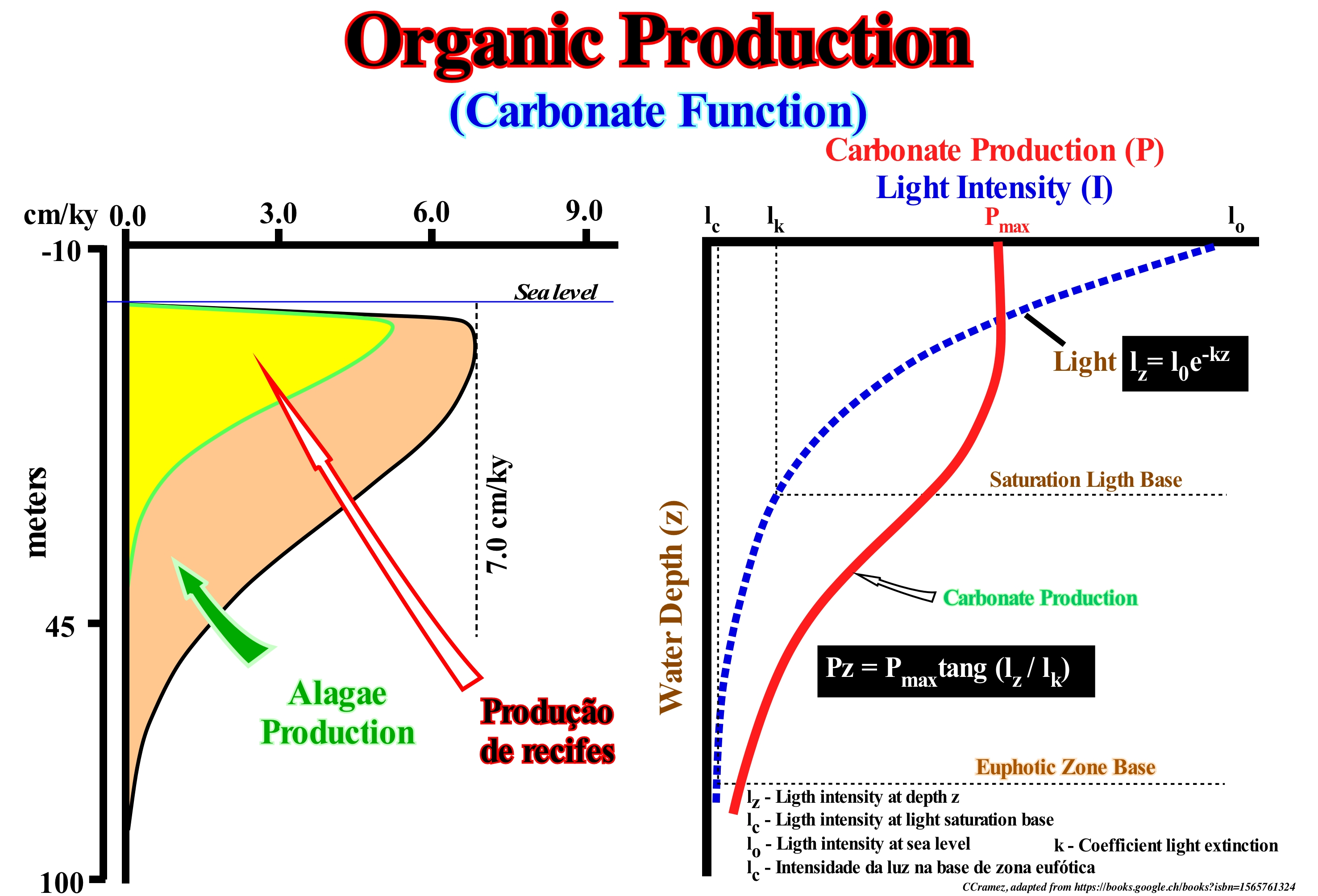
According to W. Schlager*, light is, arguably, the most important factor in the carbonate precipitation of skeletons due to the predominance of photoautotrophic organisms in the production of carbonate, at least in the Cenozoic. Photosynthesis is a complex and just, partially, understood process. The basic reaction can be simplified as CO2 + H2O + solar energy ---- HCHO + O2, where HCHO represents a simple summary formula of organic matter. This reaction, clearly, illustrates the link between photosynthesis and carbonate chemistry. Photosynthesis extracts CO from sea-water, thus increasing its saturation in carbonate which facilitates the precipitation of mineral carbonate. For the organisms themselves, CO3Ca precipitation has the additional advantage that potentially deleterious (deleterious to health) Ca2+ ions can be removed from the system and a protective backbone can be constructed. The relationship between carbonate fixation in skeletons, photosynthesis and light explains the increase in the production of skeletal carbonate with tropical environments of water-depth. Above sea level, carbonate production, rapidly, falls to zero in supratidal zones and becomes negative in most terrestrial environments as the carbonate material dissolves in rainwater and acid soils. In this example, the carbonate production curve suggests maximum production under 3-10 meters of water-depth. The production of algae ends about 35/40 meters and production is practically zero, below 60/70 meters. This production curve takes into account the intensity of sunlight penetrating the water and its shape depends mainly on the depth of the photic zone and the saturation zone of light. The penetration of the light follows a simple exponential decrease with the water-depth. The organic production curve is a hyperbolic function dependent on the intensity of light. Organic production is, relatively, important under a thin layer of water, i.e., in the area of light saturation, where light is not a growth factor, but production is, rapidly, decreasing. with the water-depth. It is the organic production curve that creates the great difference between the continental siliciclastic platforms and the carbonated platforms. In a siliciclastic continental shelf, the terrigeneous influx is, usually, abundant and largely dependent on the equilibrium position (the point on the margin at which the space available for sediments induced by tectonics and eustasy (variations in absolute or eustatic sea level, which is supposed to be the global and referenced to the Earth’s centre) are compensated, which means that there is no change in relative sea level at the point of equilibrium. As the relative sea level rises or falls, the equilibrium point moves respectively continentward or seaward. Upstream of the equilibrium point, the available space for the sediments decreases and there is erosion, whereas downstream the available space increases and, therefore, there is deposition. In a carbonated platform and in particular in rimmed platforms, in which the sedimentary terrigeneous is, practically, absent. The deposits of moderate to high energy settle down near the shoreline (function of the width and depth of the lagoon). The high-energy carbonated sands and reefs are formed by organic construction and synchronous sedimentation lithification, away from the shoreline (outer and abrupt shore of the lagoon). In a siliciclastic platform the water-depth increases, more or less, regularly until the slope break that marks the beginning of the continental slope, while in a rimmed carbonated platform, due to the organic production curve, the water-depth between the shoreline and the slope break (which may be coincident with the basin edge) is, more or less, constant and depends on the depth of the lagoon. The profile of the siliciclastic platforms is in equilibrium with the depth wave action, which is not the case in the rimmed platforms, since the organic constructions resist to the wave actions. On the other hand, a carbonated platform, rarely, corresponds to a continental shelf.
(*) Wolfgang Schlager, 2007- Carbonate Sedimentology and Sequence Stratigraphy, SEPM Concepts in Sedimentology and Paleontology ≠8
Orogenesis (Orogeny)....................................................................................................................................................................................................Orogénie
Orogenia / Orogénia / Gebirgsbildung / 造山運動 / Горообразование (орогенез) / Orogenesi /
Geological process of building mountains. After the advent of plate tectonics theory, the preponderant processes are associated with the subduction zones, either B-type (Benioff) as the Andes or, especially, A-type subduction zones (Ampferer) like the Alps and Himalayas.
See: « Continental Collision »
&
« Supercontinent »
&
« A-Type Subduction (Ampferer) »
The main orogenies are associated with the A-type subduction zones (Ampferer), in which the plunging lithospheric plate is continental in nature. Most of the time, the overriding lithospheric plate also has a continental nature. Most orogenies correspond to the closing of a sea or an ocean, located between two divergent continental margins. Over time, the oceanic crust formed in the early oceanization stages becomes, progressively, colder and more dense. From a given moment, the density contrast between the old oceanic crust and the adjacent continent (or even with recent oceanic crust) may be large enough for the ancient oceanic crust begin to plunge, either, directly, under continental crust or under a portion of oceanic crust adjacent to the mainland. From that moment on, the oceanic crust begins to be consumed along the subduction zone, which implies, progressively, a decrease in the volume of the ocean basin between the two continents and, thus, the progressive closure of the sea or ocean between them. Since the continents collide* (continental crust against continental crustal), the sea disappears and the sediments are shortened and uplifted into a mountain range, as illustrated in this tentative interpretation of a Canvas auto-trace of a German onshore seismic line. Indeed, on this seismic line, as in the diagram block, it is easy to see that the northern margin of the Tethys Sea went into subduction under the southern margin causing a significant shortening of the sediments that is represented here by the Alps mountains, where the thrust faults and the tectonic nappes are predominant. On the contrary, on the north margin, here represented by the Jura mountains, not only is the basement involved in the deformation, but the thrusts are, practically, absent.
(*) The term collide is, here, abusive, since in Plate Tectonics, the kynetic energy (the ability to do work through the movement) does not plays any role.
Orogenic Movement..........................................................................................................................................................Mouvement orogénique
Movimento orogénico / Movimiento orogénico / Orogenic Bewegung / 造山运动 / Орогенические (горообразующие) движения / Movimento orogenico /
Predominantly horizontal translational movement of the Earth crust that shortens sediments. This movement is, generally, associated with the formation of the mountain belts induced by the movement of the lithosphere plates. After the advent of plate tectonics theory, the deformation of the crust in extension (epyrogenic movements, igneous or volcanic intrusions) is no longer considered by many geoscientists as an orogeny.
See : « A-Type Subduction (Ampferer) »
&
« Fault »
&
« Orogenesis »
For many geoscientists, an orogenic movement is induced only by one or several compressive tectonic regimes (ellipsoid of the effective stresses with the main axis, σ1, horizontal). This implies just a shortening of the sediments, but this is not suggested by the geological section illustrated above. This definition is somewhat extreme for two reasons. The first one is that before shortening the sediments it is necessary to deposit them and the deposition always implies an extensional regime (main axis of the ellipsoid of the effective stresses, σ1, vertical). The second is what deform the sediments is not the tectonic vector*, but the combination of geostatic pressure (sediment weight), hydrostatic pressure (weight of the water column contained in the pores of an open system) and tectonic vector (movement of lithospheric plates). The geostatic pressure corresponds to a biaxial ellipsoid with a vertical major axis. The pore pressure corresponds to a uniaxial ellipsoid (a sphere). The tectonic stress corresponds to a more or less horizontal vector. Thus, the sum of the three (effective ellipsoid forces) corresponds to a triaxial ellipsoid, which means that when the geostatic pressure is too large and the tectonic vector small (but positive), the result is an oblong ellipsoid of the effective forces , that is, with σ1 vertical, which implies a lengthening and not a shortening of the sediments. Thus, it can be said (in a pedagogical way) that in all mountain belts, as we move away from the compression centre (shortening), the tectonic vector decreases and, from a certain distance, the tectonic regime becomes extensional, with normal faults forming and grabens oriented perpendicularly to the front of mountains. In fact, it is not the tectonic vector that varies but the resistance of the sediments to the deformation, but the final result is the same.
(*) A vector is a mathematical object that has both a length (or magnitude) and a direction in space. A movement is the simplest example of a vector quantity.
Ortometric Heigh......................................................................................................................................................Hauteur orthométrique
Altitude Ortométrica / Altura ortométrica / Orthometrische Höhe / 正交高度 / Ортометрическая высота / Altezza ortometrica /
Vertical distance of an Earth's surface point relative to a reference geoid.
See: « Geodetic Sea Level »
Oscillation-Ripple Mark.............................................................................................................................................Ride d'oscillation
Marca de Oscilação / Marca de ondulación (de oscilación) / Oszillierende Wellen / 振动涟漪 / Осцилляторная рябь / Increspature di fondo simmetriche, Increspature oscillatorio /
Symmetrical ripple mark, with a quasi-sigmoid profile, strongly suggesting a marine environment with few currents where the movement of water is dominated by oscillating waves (orbital motion of water).
See : « High-Tide »
&
« Intertidal Beach »
&
« Shoreface »

As its name implies, the oscillation ripple marks are formed by a movement of the water caused by oscillation waves on a sandy substrate under a water depth lower the wave action limit. The oscillating waves are composed of particles of water, each of which oscillates around a point, with little, if any, permanent change of position. The water particles have an orbital motion. In general, these marks are symmetrical, with the crests, relatively, rectilinear between wide and rounded troughs. An oscillatory flow associated with the sea waves produces ripple marks with laminae tilted in the opposite direction (from the crest). To understand how the marks form by oscillation remember the movement of an object that floats in the sea waves . As the wave (energy) advances, the object is uplift to the wave crest and then back to the trough (the waveform advances, but the water particles move in orbit, returning to their original position). As a wave approaches the shoreline, it becomes asymmetrical and breaks (the water stops moving in orbit to flow toward the beach). As the sea waves have varying degrees of asymmetry, in shallow water, they can give asymmetric marks as the ripple marks induced by a current with a single direction. Their crests are less rectilinear, less sharp and less tall. Likewise, the flow of air over the sand produces marks which, superficially, are like water-induced marks, but have a lower relation between the height and the wavelength. The block illustrated in this figure comes from the Moenkopi formation (Arizona), which has Triassic age. The ripple marks are symmetrical and simply indicate that they were created by a current (in this particular case, an oscillatory current back and forth, i.e. from the top of the block to the base). Symmetrical ripple marks indicate one of two possible current directions and are associated with a larger water depth and quieter water.
Osculation (Meander).........................................................................................................................................................................Osculation (Méandre)
Osculação / Osculación (meandro) / Schmiegung (Mäander) / 接吻(河曲)/ Соприкосновение (меандр) / Osculazione (meandro) /
One of the two processes of formation of an abandoned meander. A cut between two meanders by osculation (contact of two curves) is made by simple exaggeration of the curve of the meander, which, little by little, makes the neck nonexistent. This favours the flow of the stream, directly, to the next meander abandoning the meander without peduncle in which a lake can be formed. A cut by overbanking is made during a flood period, when the entire floodplain is flooded, since, as long as the water height begins to decrease, the stream preferably takes the rectilinear path more than the path long and curved meander.
See: « Point Bar »
&
« Meander Belt »
&
« Fluvial Deposition »
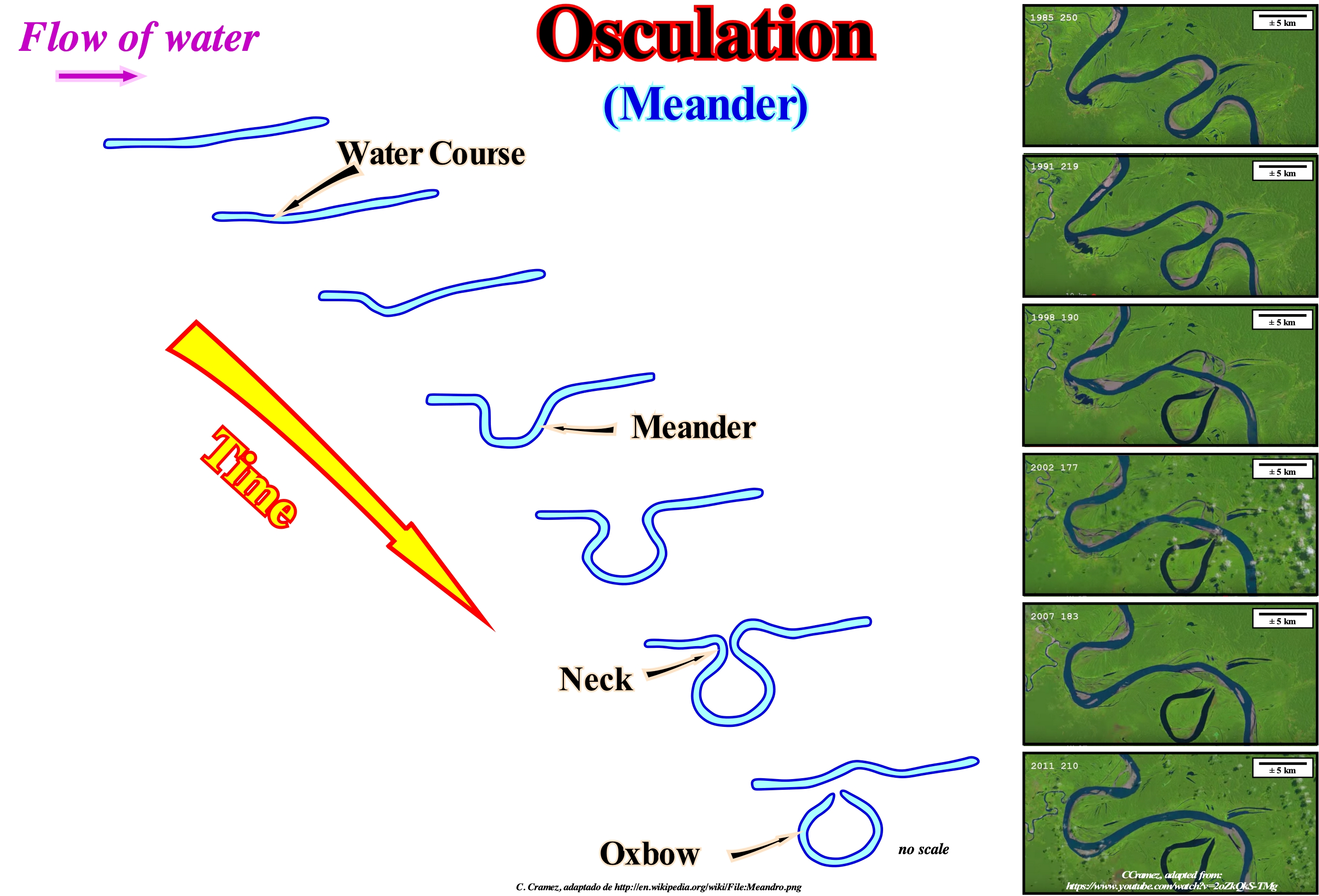
The term meander comes from the name of a Turkish river that was deified due to the regularity of its shape. In Greek mythology, meander (Greek Μαίανδρος / Maiandros) is a river god connected to the river Meander (present Büyük Menderes). The meanders have a characteristic shape that is independent of climatic factors and therefore can be found in all Earth regions. The meanders may also form in ocean currents, as is the case with the Gulf Stream. The general shape of a meander is, also, independent of the size of the water-course. There are meanders in small streams as in a large river. The formation of a meander is the result of natural factors and processes. The wavy configuration of a flow changes constantly. Since the bed of a water-course begins to follow a sinusoid trajectory, the amplitude and concavity of the curves increase, drastically, due to the effect of the helical flow which shifts the dense eroded material to the inside of the curve, leaving the outer part of the unprotected curve and thus vulnerable to accelerated erosion associated with a positive retroactive cycle. In a meander, the greater the curvature, the greater the erosion of the external bank which, in turn, increases the curvature. The flow of a fluid around a curve is swirling (in circular motions). To preserve angular momentum* (quantity that remains constant, under certain conditions, over time as the system evolves, which led to a conservation law known as the law of conservation of angular momentum). The velocity of the flow on the side curve is faster and slower on the inner side. On the other hand, the surface of the water is raised to the outside of the curve and, therefore, the water pressure in the bed of the stream is greater on the outside than on the inside of the meander. This pressure gradient causes a counter-current to the interior of the curve. The greater the curvature of the meander and the faster the flow, the stronger the counter-current and the stronger the action of the dense eroded material along the bottom of the channel towards the inner bank. The particular and relatively invariant form of the meanders always intrigued the geoscientists. A mathematical expression of the curve of a meander was proposed by Langbein and Leopold (1966). They noticed that a boat moving at a constant speed along the centre of a meander, the angle formed between the direction of the boat (tangent to the trajectory) and North (or any other fixed direction) varies sinusoidal with the distance along the bed of the current. The curve of the meander is not sinusoidal, but generated by a sinusoidal function. The curve is controlled by two main parameters: (i) The maximum angle between the tangent to the curve and the horizontal and (ii) The length of the curve for a complete oscillation. For curves of equal lengths, it is seen that the more the maximum angle between the tangent to the curve and the horizontal increases, the more the amplitude increases and the wavelength decreases. The study of the maximum tangential angle shows that for a maximum angle of 120° the meander is near the short circuit. In fact, the meander closes to an angle of minus or minus 120.9 degrees and this angle also corresponds to the maximum amplitude that the meander can have. Thus, the relation between the amplitude and the wavelength of a meander has a theoretical limit is, more or less, 2.3 (http://www.zones-alluviales.ch/ Documentation/RapportMeandres.pdf). However, the main question of the formation of the meanders is to know why the flows become sinuous. A number of not necessarily excluding theories have been advanced: (i) Stochastic; (ii) Equilibrium ; (iii) Geomorphic, etc. In the stochastic theory (which is subject to the laws of chance), the evolution of a meander seems to be the result of stochastic fluctuations in the direction of flow due to the presence of obstacles that change the direction of the current trajectory path. In the equilibrium theory, the formation of the meanders decreases the flow gradient (slope) of the stream until soil erosion and current carrying capacity are reached. In this theory, the descending water mass abandons potential energy (energy associated with the force of gravity), which is removed by the interaction of the flow with the bed material of the stream, since the velocity of the current is the same at the beginning and in the end of the course. In the geomorphic or morphotectonic theory, the tectonic structures of the ground, especially, folds and faults, are the main responsible for the formation of the meanders, which, contrary to what is suggested by stochastic theory, can be predictable since they are associated with processes geological and geomorphological conditions.
(*) A vector quantity describing an object in circular motion. Its magnitude is equal to the momentum of the particle (product of the mass and velocity, possessing a magnitude and a direction in three-dimensional space), and the direction is perpendicular to the plane of its circular motion.
Outcrop..................................................................................................................................................................................................................................Affleurement
Afloramento / Afloramiento / Aufschluss, Aufschluß / 露出 / Обнажение (породы) / Affioramento
Portion of the rocky substrate (firm rock) exposed to the open air with relatively small dimensions. For some geoscientists, a typical outcrop corresponds to the observer's field of vision which is Wegmann's mesoscopic geological scale (1935), i.e., the scale of continuity of observation. In addition to the mesoscopic scale, Wegmann considers the microscopic and macroscopic scales. The macroscopic scale is the discontinuity scale, which is characteristic of geological maps and most geological sections. The scale of the seismic lines, whether they are regional or not, and whether they are in time or in depth, is always mesoscopic, since most of the reflectors correspond to chronostratigraphic lines that can be followed in continuity. Theoretically, it is easier to make tentative geological interpretations on seismic lines than to make geological cross-section on field observations or geological maps. It was probably for this reason that the sequential stratigraphy was born on tentative geological interpretations of the seismic lines and not on field geology.
See: « Aggradation »
&
« Scale »
&
« Geological Principle »
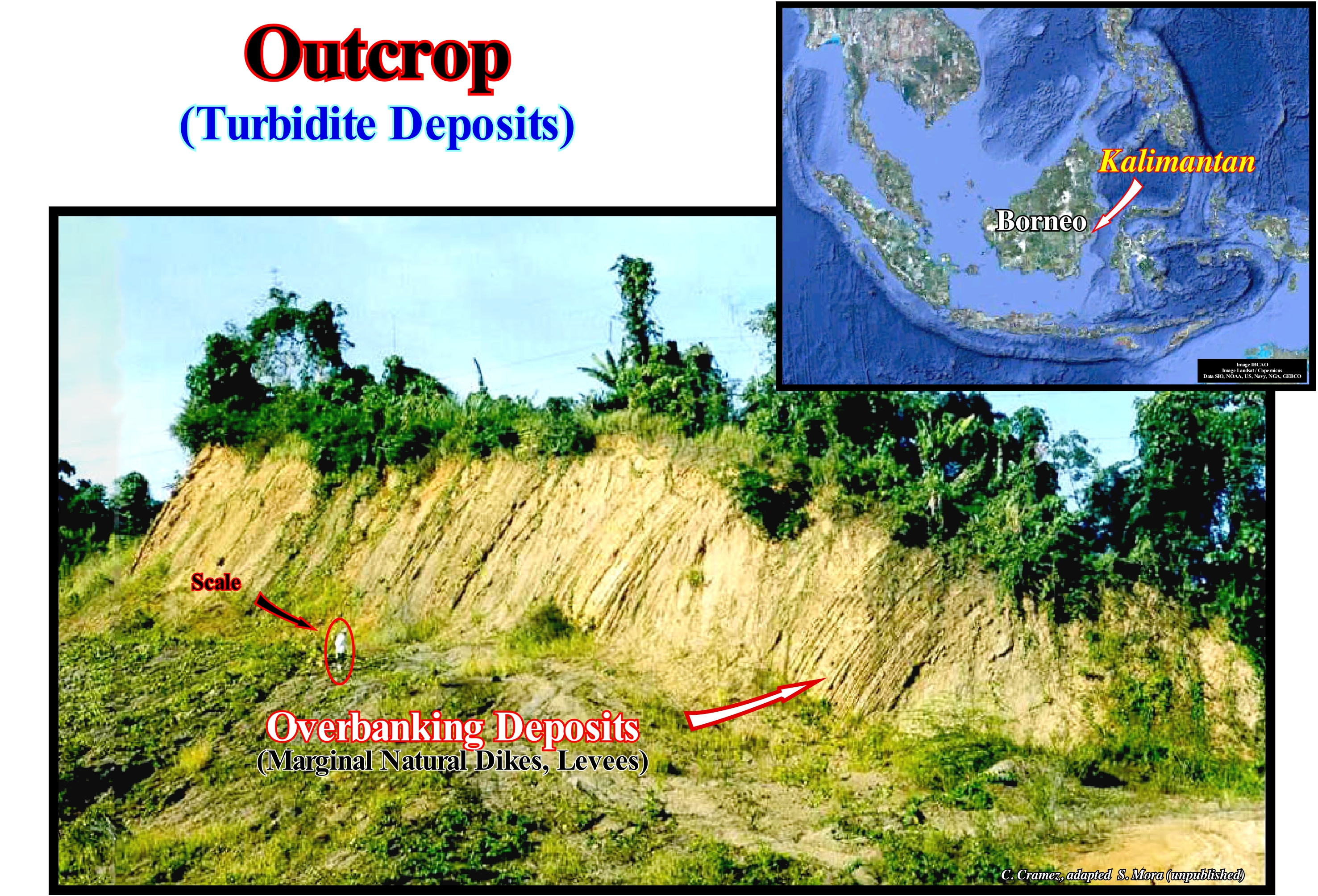
This outcrop, located in Samarinda area (Borneo Island, Indonesia), is formed by Lower Miocene turbidite deposits. It characterizes what E.C. Wegmann called the mesoscopic scale or observation continuity scale, which contrasts not only with the macroscopic scale, which is the scale of the discontinuity, observed mainly in the geological maps, but also with the microscopic scale. The succession of turbidite deposits observed in this outcrop is made up of immature facies (lithology and fauna), with deposits associated with low density flows. Facies and micropaleontological studies suggest that these turbidite deposits were deposited at the top of the continental slope and that they are rich in redeposited organic matter. In these deep sediments, which were shortened and uplifted by a compressional tectonic regime (σ1 horizontal), different types of clasts* are identified : (i) Large Coal Clasts in the cohesive deposits of debris flows ; (ii) Angular Coal Clasts** dispersed in the central part of the deposits of hyper-concentrated flows ; (iii) Rounded Coal Clasts floating in the upper part of the deposits of the high density flows ; (iv) Plant debris (coated particles) dispersed in massive deposits of high-density flows and (v) Resin-Coated Particles concentrated in low-density flow deposits. A large amount of coal clasts suggests that these turbidite deposits, under favourable geological conditions, can function as potential source-rocks, mainly of gas and condensate (type III dispersive source- rocks). In terms of sequential stratigraphy, th P. Vail's hypothesis, which assumes that these deposits were settle during lowstand geological conditions (sea level lower than the basin edge), these turbidites belong to the middle subgroup of lowstand systems tracts group (LSTG), i.e., submarine slope fans (SSF), in which different depositional systems can, normally, be observed: (a) Apron ; (b) Turbidite natural marginal dykes ; (iii) Drape shales, etc. The lower subgroup of the lowstand systems tracts group (LSTG) consists of submarine basin floor fans (SBFF) and the upper subgroup corresponds to the lowstand prograding wedge (LPW). The submarine fans (basin and slope fans) deposit during a significant relative sea level fall, which induced the lower unconformity bounding the sequence-cycle, whereas the lowstand prograding wedge (LPW) begins to settle when the relative sea begins to rise. Obviously, the 1:1 scale of the outcrops (and also that of the electrical diagrams) allows a much more detailed sequential stratigraphy that the seismic data. The vertical and horizontal seismic resolution must be taken into account. Vertical seismic resolution is, roughly, the size that an object has to have to be seen on a seismic line. Stratigraphic intervals with a thickness equal to 1/4 of the wavelength (d = V/F, where V is the velocity and F the frequency of the seismic waves) can be recognized. The horizontal seismic resolution is derived from the Fresnel zone (part of a reflector covered by the seismic signal at a certain depth), since the seismic waves move in three dimensions and propagate over an increasing area as they move away from the source. In a, more or less, deep horizon, all objects with a lateral extension high than the Fresnel zone will be visible (the migration of the seismic data focuses on the propagation of energy in the Fresnel zone, reorganizes the displaced reflections due to the inclination, and removes the reflections associated with the edges). Since the vertical scale of a seismic line is, usually, in time (double time or round trip time), in depth, the signal frequency decreases, while the speed and the wavelength increase. This means that the higher the depth, the poorer the seismic resolution (the high frequencies are reflected in the shallow reflectors, while the lower frequencies reach deeper interfaces). On the other hand, as deep sediments become more compact, it can be said seismic wave velocity increases with depth.
(*) A term that comes from the Greek klastós, which means "broken or fragmented" and which in geology refers to fragments of minerals or of rocks that may later constitute the sediments of the detrital rocks.
(**) Presence of coal clasts and authigenic glauconite in the field or in drilling debris is typical of deep turbidite depositional systems. Indeed, coal debris suggests a rapid deposition, otherwise they would be oxidized, and the glauconite debris a provenance from platform deposits.
Outer Bend Splay Sand (Turbidites)......................................................................Sable de débordement (Turbidites)
Areia de transbordo / Arena de desborde (turbiditas) / Overflow Sand (Turbiditen) / 溢出砂(浊流) / Приносимый приливом песок / Sabbia di troppopieno (torbiditi) /
Sand associated with turbidite levees of submarine slope fans (SSF). These overbank sands (sand and mud) are deposited when a turbidic current overflows the depression along which it flows towards the deep parts of the basin (abyssal plain). A turbidite current overflows when its height exceeds the transport capacity along the depression, which corresponds, sometimes, to a channel (when there is erosion). The sandy horizons associated with this type of deposit are, relatively, thin. In general, they do not exceed 1-2 m thick. Locally, under certain conditions, overbank sand horizons can be considered as accessory or supplementary reservoir-rocks.
See: « Turbidite »
&
« Submarine Slope Fan »
&
« Systems Tract »
This photograph illustrates a detail of an Eocene turbidite depositional system in eastern Turkey. These deposits are part of the middle subgroup of the lowstand systems tracts group (LSTG). The lower subgroups corresponds to the submarine fans (SBFF and SSF), while the lowstand prograding wedge (LPW) forms the upper subgroup. The lowstand systems tracts group (LSTG) with the highstand systems tracts group (HSTG) form a complete sequence-cycle that was deposited during a 3rd order eustatic cycle, characterized by its time-duration between 0.5 M and 3-5 My. Within the eustatic cycle, the subgroup of the submarine slope fans (SSF) deposits when the relative sea level fall in deceleration (relative sea level curve changes decreasing with concave geometry) and, probably also, in the beginning of the rise in acceleration (bottom sector of the crescent curve). From the geometric relations of the terminations of the bedding planes, it is easily to recognize on this photograph: (i) The depressions fillings between turbidite natural marginal dikes, which sometimes, but not in this case, correspond to turbiditic channel fillings (when there is erosion) ; (ii) Turbidite natural marginal dikes and (iii) Other overbanking deposits. In the field, the spatial relationships between the different sedimentary bodies, which constitute the submarine slope fans (SSF) are easier to determine than on the seismic lines, due to the seismic resolution. However, even in the field (natural scale or scale 1:1), the differentiation between natural marginal dikes and other overbank deposits is, sometimes, subtle, since it is poorly defined and based, in most cases, just on the sand content. Of all overbank deposits, turbidite natural marginal dikes are those with higher sand content, which, however, is, often, lower than the sand content of filling depressions between the marginal dykes or turbiditic channels (although, in certain cases, they may be entirely filled with shaly sediments). In North Angola's deep offshore, most Tertiary reservoir-rocks in the oil fields correspond to the filling of depressions between turbidite natural marginal dikes. The turbidite channels of certain geoscientists, which most, often, correspond to the filling of the depressions created by the absence of deposition, between the turbiditic natural marginal dikes and not to the filling of channels produced by the erosive action of the turbidite currents, are always posterior to the overbank deposits. The vast majority of these fills are made in retrogradational (thickening continentward) when the relative sea level begins to rise. As illustrated on this tentative interpretation of Canvas auto-trace of a detail of an Ivory Coast offshore seismic line, the morphology of gull-wings structures and the formation of the natural marginal dikes of turbidite systems is very different from of the river's natural marginal dikes. A river stream, unlike a turbidite current (flow of a mixture of water and sediments that moves due to gravity, without significant influence of the medium in which it flows), needs a bed (i.e., it needs a depression on the ground in which it flows toward the coast, while a turbiditic current does not. The basal surface of natural fluvial marginal dikes is underlined by downlaps on either side of the bed which have an opposite vergence, It is always higher than the bed of the water-course. The turbidite natural marginal dikes, and in particular the first ones to be deposited, are at the same level of flow. As turbidite natural dykes settle down, as there is no deposition between them, the later turbidite currents are. generally, more or less channelled and will overflow if their height is greater than the height of the depression where they flow.
(*) Vertical seismic resolution is, roughly, the size an object has to have to be seen on a seismic line. Stratigraphic intervals with a thickness equal to 1/4 of the wavelength of the seismic waves can be recognized. The horizontal seismic resolution is derived from the Fresnel zone, since the waves move in three dimensions and propagate over an increasing area as they move away from the source. Objects with a lateral extension greater than the Fresnel zone will be visible.
Outer Neritic..............................................................................................................................................................................................Néritique externe
Nerítico Externo / Nerítico externo / Outer neritischen / 外浅海 / Неритический (внешне) / Neritico esterno /
A marine subenvironment characterized by a water-depth between 100 and 200 meters, i.e., between the middle shelf and the continental edge (which may or may not match the basin edge).
See: « Bathyal »
&
« Neritic »
&
« Shelfal Accommodation »
On this block diagram are distinguished the neritic province (water-depth between 0 and 200 meters) and the oceanic province or blue sea. The first corresponds, more or less, to the continental shelf (between the shoreline and the basin edge, which may or may not coincide with the continental edge) and the surface zone of the blue sea, i.e., until 200 meters deep. In certain geological conditions (lowstand conditions), when the basin does not have a shelf (shoreline coinciding, practically, with the continental edge), the neritic zone corresponds just to the surface horizon of the blue sea. The neritic zone is, generally, divided into three subenvironments: (i) Outer Neritic Zone, characterized by a water-depth between 100 and 200 meters ; (ii) Middle Neritic Zone, with a water-depth between 20 and 100 meters and (iii) Inner Neritic Zone which is characterized by a water-depth between 0 and 30 meters. In the neritic zone, some geoscientists distinguish a transitional zone between 0 and 5 meters depth, which corresponds to the brackish-water domain (bays, lagoons, etc.) and the zone of nonmarine deposition (continental, fluvial, etc). The outer neritic zone is, in general, a sector of low sedimentation rate. The upper part belongs to the photic zone, but in the lower part, the penetration of sunlight is insufficient for life to develop from photosynthesis (life that uses solar energy to convert carbon dioxide, CO2 and water into food). The outer neritic zone, where sandstones alternate with shales, is an environment that is very conducive to the development of nonstructural traps for hydrocarbons, especially, in the transgressive interval (retrogradational geometry) o a sequence-cycle. The petrophysical characteristics (porosity and permeability) of clastic reservoir-rocks formed there are, generally, good. The relatively large thickness of the shaly horizons alternating with the reservoir-rocks increases the likelihood of vertical and lateral seal in the morphological traps and, above all, in the morphological traps by juxtaposition.
Outline of breakers........................................................................................................................Limite externe de déferlement
Limite externo de rebentação / Límite externo de rompimiento de ola / Äußere Grenze der Brandung / 冲浪的外部界限 / Внешняя граница прибоя / Limite esterno del surf /
The boundary separating the rippling zone ( open sea) from the area where the sea-waves break. The outer boundary of the surf, in general, corresponds to the backshore,i.e., the zone between the beach drifting current and the longshore ridges.
See : « Beach »
&
« Surf Zone »
&
« Onshore (on land) »
As suggested in this sketch, since the depth of the sea is less than the wavelength* of the oscillation waves, these become translation waves (when the waves have broken, the water, previously, in the crest flows through the front face and continues to cross the surf zone). A wave travels, but the water is not going anywhere. The circular motion of the water, when the wave passes, is orbital circular, goes forward and upwards when a crest passes, and down and back in the passage of the trough. Do not forget that are not the water particles that move, but the trough and crests induced by the trace of the orbits described by the water particles (the trough follow the base of the orbits while the crests follow the tops). Put another way, in an oceanic swell, it is not the water that moves, but the surface phase of water. It's all happening like the "colas" made by spectators of a soccer match, who in a collective and synchronized movement stand in lines, stand in rows, raise their arms and sit down again, giving the visual impression of a great wave running through the field benches. Obviously, the spectators do not move. What moves are the crests and troughs that they create by an orbital movement to get up and down. In broken waves (after the breaking) the water, actually, shifts. Indeed, in the translation waves the sea water is transported to the beach, whereas in the oscillating waves, there is no transport of the water from one side to the other of the wave. The demarcation line between the oscillation waves and the swell of high sea (characterized by a period of 30-300 seconds, several hundred meters long, a few meters in height and a speed of several hundred kilometers per hour) is, for certain geoscientists, the external boundary of the surf zone, i.e., where the sea waves break. The waves break when they reach a depth, measured from the stillstand sea, equal to 1/3 of their height (vertical distance between the top of a wave and the bottom of the trough of the adjacent wave). In deep water, the waves break when the ratio between their height and their length (horizontal distance between a point of a wave and its corresponding point in the next wave) exceeds 1/7. After a wave breaks, the water moves to the front of the beach forming the uprush current. The breaking of a wave consists of a wave curvature increasing, which implies an imbalance and collapse of the crest. The way a wave breaks depends on the relationship between the height and length of the wave, as well as the slope and roughness of the sea floor. Moreira (1984) distinguishes three types of reaching: (i) Plunging breaker ; (ii) Spilling breaker and (iii) Rolling breaker. The breaker is plunging , when the crest of the wave rises, rounded, and wraps itself in a volute, falling against its base, which happens when the substratum is tilted and regular and the relationship between wave height and wavelength is weak. The breaker is spilling, when the crest of the wave becomes angular and breaks in the upper part, next to the apex, with formation of foam balls, that slide in front of the wave, which happens when the substrate is little inclined and whenever the ratio between the height and the length of the wave is large (consequence of strong winds). The breaker is rolling, when the crest of the wave, rounded, increases the radius of curvature until it breaks in the upper or middle, with formation of rolls of foam, which happens when the substrate is very dip and the waves are very high (storm waves, which burst, parallel to the coast line to a great extent). Within the breaking zone, the swash zone can be differentiated, which is characterized by a turbulent layer of water that washes the beach after a wave has broken, and the line that marks the limit of the uprush current (on the beach, the moment** of the waves transports them continentward by a uprush current). The waves wash and transport the sand and other finer particles to the beach. However, the uprush current losing energy due to friction along the sea floor sea and to the slope, reverses direction, giving rise to another current, which is called the backwash current.
(*) In physics, the wavelength (represented by the Greek letter lambda, λ, is the distance between successive repeated values in a wave pattern.) In a sinusoidal wave or sine wave is a waveform whose graph is identical to the generalized sinus function: y = A sin (kc - ω t - φ) + D, where: A is the amplitude, k is the wave number, ω is the angular frequency, φ is the phase change, D is the vertical displacement or slip "Offset" is used to indicate the difference from a reference value.) The wavelength is the distance (parallel to the direction of wave propagation) between waveform repeats. "It can then be represented by the distance between crests (maxima), troughs (minimums), or twice the distance between nodes.
(**) Momentum is the product of mass and velocity of an object, It is usually defined with respect to a fixed reference point. It deals with physical quantities as measured at some distance from that reference point. In principle, any physical quantity can be multiplied by distance to produce a moment, commonly used quantities include forces, masses, and electric charge distributions. Impulse is the change in momentum of an object, often, as a result of collision where the impact time is very small. An example is a racket hitting a tennis ball.
Outwash .....................................................................................................................................................................................................Cône fluvio-glaciaire
Cone fluvioglaciário / Cono fluvio-glaciar / Cone glaziofluviale / 锥冰水 / Флювиогляциальный конус выноса / Cono fluvioglaciali, Dilavamento glaciale /
Sedimentary fan, formed by layers of sand, gravel and gravel, deposited by the melting water of a glacier. The terms fluvial and fluvioglacial are, often, interchangeable. During the Quaternary glaciations, when the sea level was about a hundred meters lower than at present, there was much water retained in the glaciers. When the thaw began, currents were created that carried sediments previously retained, in the glaciers. These sediments are later deposited, in the form of fluvioglaciary fans.
See: « Glacio-Eustasy »
&
« Fluvial Deposition »
&
« Moraine »

The outwash fans are the largest glacial deposits. They provide the largest amount of material to be carried by the wind. An outwash fan is characterized by: (i) Sediments deposited by the melting water of a glacier ; (ii) More or less, stratified beds of sand, gravel and finer particles, such as silt and clay ; (iii) Proglacial and glacial sedimentation (in contact with ice); (iv) Outwash plains ; (v) Eskers, i.e., long and narrow crest of sand and gravel, more or less, stratified, formed in tunnels under the glaciers (when in a retrogradational glacier, the materials it carries deposit in the tunnels at the base of the glacier where subglacier rivers flow) ; (vi) Kames, i.e., irregular low hills, isolated or not, formed of stratified sand or gravel, that are formed by sediments mobilized by braided rivers, that can be present in the surface of the glacier, and that deposit, in a depression on the surface of a glacier in the phase of retrogradation and lie on the ground after the complete melting of the glacier ; (vii) Drumlins, which are either small medial moraines deposited during a short period of glacial stagnation, during the retrogradational phase or the filling of a longitudinal incision of the glacier formed by a stream of water flowing to the surface of the glacier ; (viii) Deltas, etc. Adjacent to the glacier, the thickness of an outwash fan may be greater than 100 meters, while its length may reach more than 1,000 kilometers. A glacier is a stream of ice that flows downhill causing erosion and glacial sedimentation. When a glacier thickens, the front of the glacier progrades downhill. When a glacier thins the glacier front retrogrades. It is incorrect to say that a glacier retreats. A glacier does not have a reverse-gear like an automobile. It can only advance downhill by the gravity action, but it can, obviously, thin when ablation is higher than accumulation. Outwash fans induced by the melting of the Würm glaciation (between 1.6 Ma and 10,000 Ma) extend over 1,100 km. In the mountainous regions the outwash fans are elongated and the deposits are, more or less, planar, which many geoscientists call valley systems tracts. On the contrary, in the slightly rugged regions, outwash fans form wide plains, called outwash plains. The outwash fans can be excavated by erosional kettles or dissected by defrost currents. In outwash plains, where braided (or anastomosed) streams predominate, deposits with cross-bedding sedimentation and different grain-size (granulometry) are very common. In general, a more or less smooth slope allows the coarser material to deposit near the glacier and the finer material to be transported further downstream. Striated pebbles are relatively rare. The striae (slickensides) are worn during transport. On this picture, the outwash fan was deeply excavated by a consequent stream (a small stream of water, not permanent, which follows the ground slope, in this case, of the outwash fan) induced by the fusion of the small glacier visible slope above the outwash fans. The erosion induced by this small, nonpermanent water stream is, typically, fluvial. It is quite important when the dip of the current is high. It is largest in the upper part of the outwash fan. In the lower part, accumulation and sedimentation of the materials ripped and transported prevail. However, as this stream is a tributary of the Rhone River *, most of the accumulations associated with it were, largely, eroded by the main river. These nonpermanent small streams are very common on the Rhone banks. Its beds sometimes have important slopes, which in the period of snow melting, i.e., when the flow of the current is significant, give rise to the rapids and waterfalls that the local populations use for the electricity production.
(*)The Rhone River starts at an altitude of 2,209 meters on the Rhone glacier, in the Swiss Alps, at the eastern end of the Valais canton. Its upper course runs through a glacial valley between the Bernese Alps, to the north, and the Valais Alps to the south to flow into Geneva Lake. Across the lake, the Rhone River enters in France, beginning its mid-course, running west along the western foothills of the Alps to Lyon, which is the largest city along its course. It then runs south, between the Alps and the Central Massif. Near the Arles, the Rhone divides into two main branches: (i) The Great Rhone to the East and (ii) The Small Rhone to the West, between them the vast Camargue delta is formed, before flowing into the Mediterranean Sea, in the Gulf Lyon.
Outwash Plain........................................................................................................................................................................Plaine fluvio-glaciaire
Planície fluvioglaciária / Planicie fluvio-glaciar, Sandur / Sander / 冰水沉积平原 / Флювиогляциальная равнина / Pianura fiume-glaciale /
Plain, slightly inclined, formed of debris, mainly fine and coarse sand, carried by a stream of water resulting from the partial melting of a glacier. In general, outwash plains result from the coalescence of several sedimentary fans.
See: " Glacio-Eustasy "
&
« Bayline »
&
" Moraine "
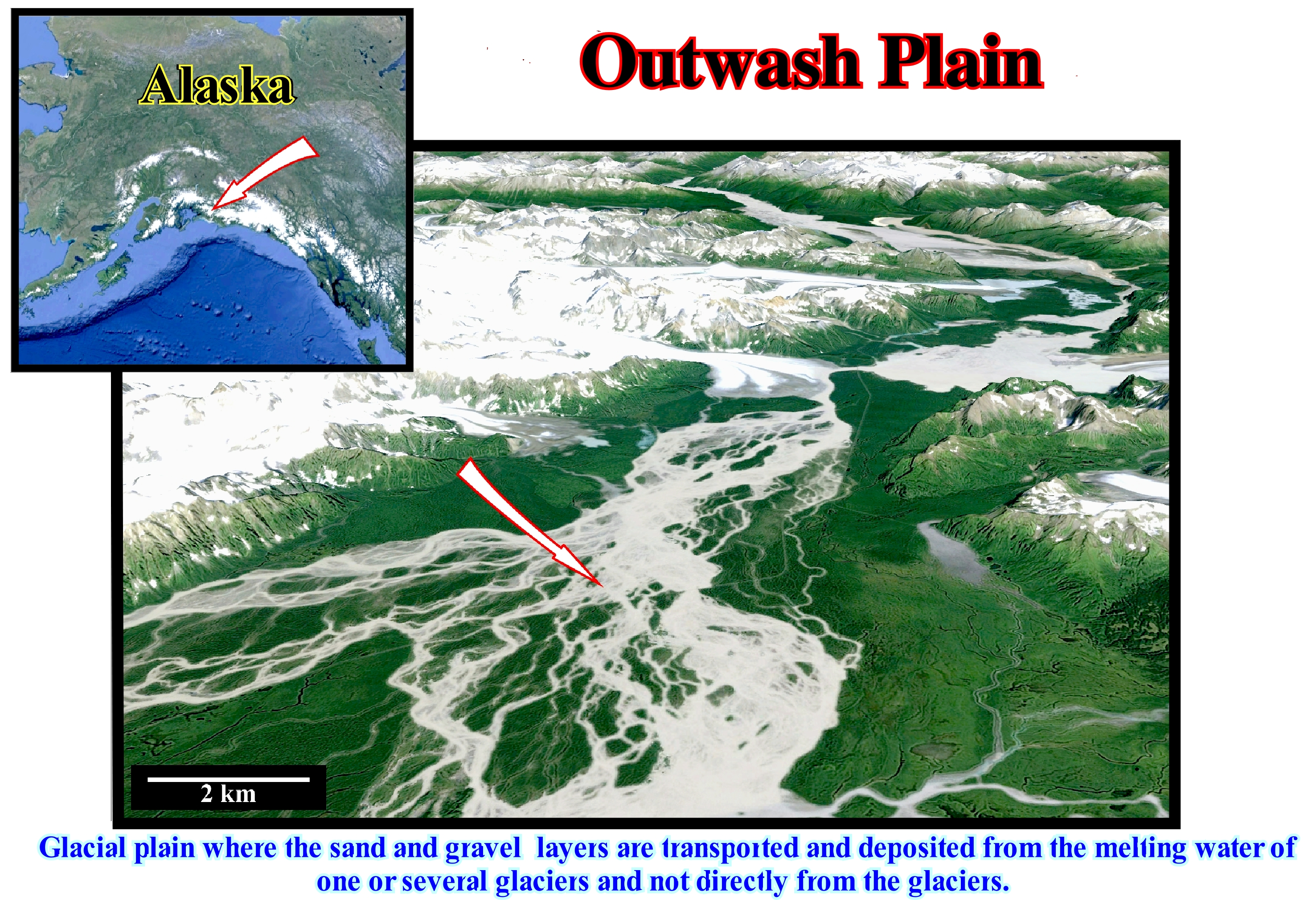
A glacier is a mass of ice flowing downhill that forms when more snow and ice falls than the one that melts and evaporates from previous years. We can say like a river, a glacier always advances downhill. Therefore, it is not very correct to say a glacier retreats. A glacier, like a river, can not drain uphill. Thus, it seems to be more correct to say a glacier is thinned or retrogradates (as the shoreline during the deposition of the transgressive interval of a sequence-cycle), when ablation (loss of snow or ice from a glacier, either by melting, evaporation, erosion, etc.) is greater than accumulation. A glacier carries a large amount and variety of rock material, either on the surface, at the base, or at the front, or at the sides or even inside. When the glacier melts, it releases a large volume of water that disperses, in front of the terminal moraine and which carries a large amount of rocky debris and other materials. The area, in general, a plain where these debris is deposited is the outwash plain, as shown in this figure (outwash plain in Southern Alaska). Ice and glacier rocks act as erosive agents as the glacier moves along the valley. The valley walls are polished and its width is increased, which gives it a characteristic U-shaped geometry that contrasts with the V-shape geometry of the river valleys. When two glaciers dig valleys close together among them a topography crest that the French authors call "arêt", that has been translated as spine glacier. When several glacial valleys begin near the top of a mountain, a sharp peak or "horn", such as the Matterhorn (Cervin, in French), which made famous the village of Zermatt, located in the highest part of the Valais canton, in Switzerland. The outwash plains are the areas where the glacial sediments are deposited by the currents that form downstream of the glacier. The outwash plains are formed by gravel, sand, silt, and clay. Generally, they are developed, relatively, far from the glacier, where the finer and lighter sedimentary particles transported by the glacier are deposited. The material deposited by the old water currents or by the activity of the ice can be later remobilized and reworked by more recent currents. The thickness of the outwash plain, which can exceed 50 meters, allows a gross prognosis of the maximum extent of the glacier. As shown on this figure, the outwash plain is the domain of anastomosed or braided rivers (a bed formed by a network of small, temporary channels separated by small islands, often called braided benches or deposition bars). Recall that a water-course can be classified according to its planar geometry (http://www.aquafluxus. com.br/os-rios-e-configuracoes/): (i) Rectilinear ; (ii) Anastomosed ; (iii) Meandriform and (iv) Braided. These river channel patterns, which can be found in different rivers, along the same river or even at different periods in the same section of a river. A rectilinear river is a river with low sinuosity, running, generally, in areas with marked slope, along which the water flows with great speed. It has a great erosive capacity and small deviations. An anastomosed river is a river with multiple channels. The streams divide and intertwine, forming a river without a main channel, with a great capacity of transport and sedimentation. They adapts to the relief modifying its trajectory since they find an obstacle. A meandriform river is a sinuous river, with a low flow velocity, that cross flat and low slope areas, whose suspension and bottom loads are more or less equivalent. It has a continuous and regular flow, usually in a single channel, and which develops a more or less characteristic pattern. An intertwined river, which is characterized by a predominance of bottom loading. It flows between islands and bars formed by silting the material transported in suspension by its own waters, is often found in desert and glacial environments.
Overbank Deposit......................................................................................................................................................Dépôt de débordement
Depósito de transbordo / Depósito de desbordamiento (canal) / Ablagerung Überlauf (Kanal) / 存款溢出(频道) / Пойменное отложение / Deposito di alluvionamenti (canale) /
Deposit formed by sediments, usually, fine, transported by suspension from an excessive current that can not be contained, entirely, in the channel or in the depression (between the levees of a turbiditic system), where it flows downhill. This type of deposit can be found in fluvial and turbidite environments.
See: « Flood-Plain Deposit »
&
« Slope Deposit »
&
« Submarine Slope Fan »
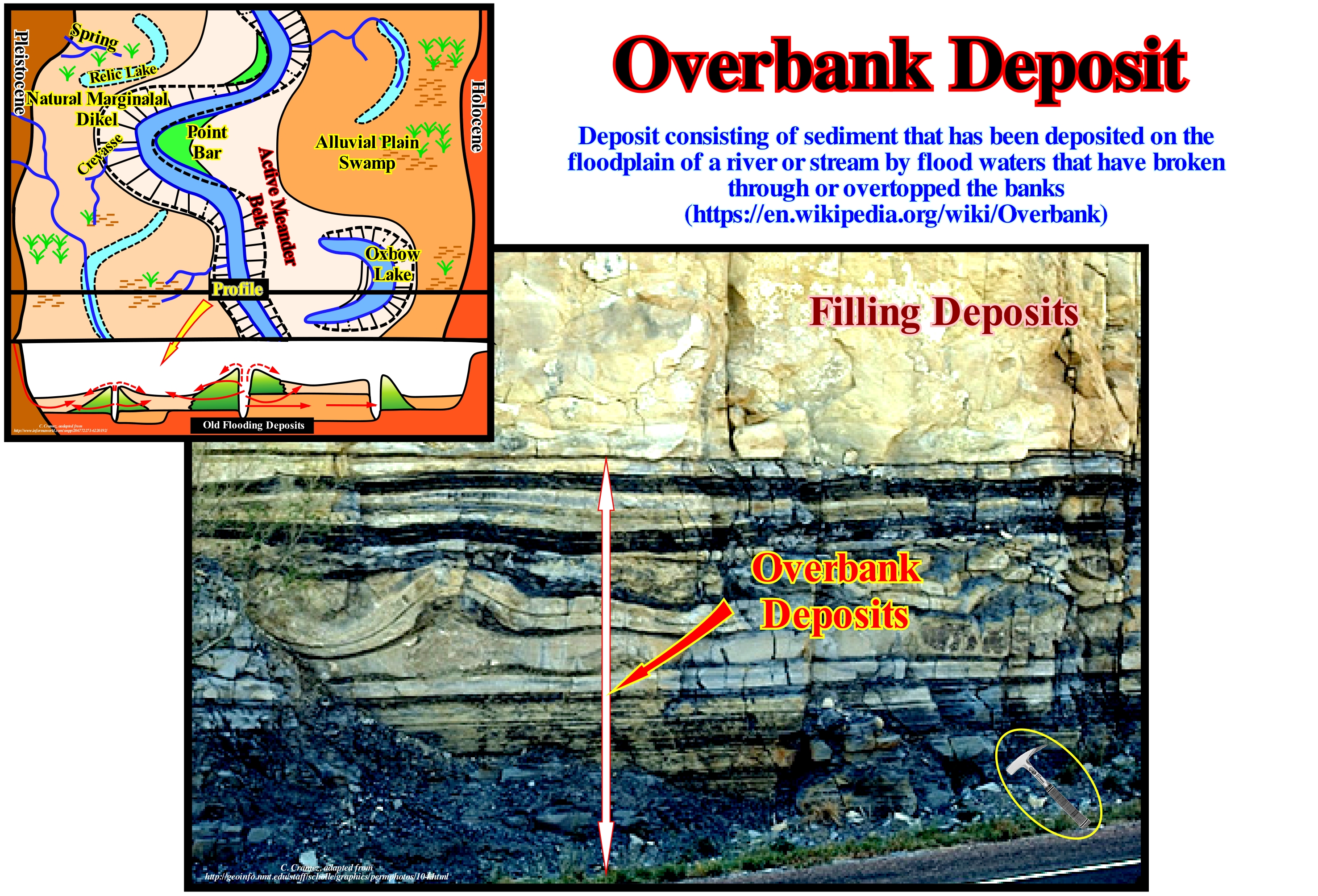
Overbanking deposits may occur either in turbidite depositional or in the coastal plain systems, in particular, in association with a meander belts. The turbiditic overbanking deposits and the filling of the depressions, through which turbidite currents have passed, are always associated with the submarine slope fans (SSF). Since a turbidite current encounters a major slope break in its path to the abyssal plain, it slows down, loses competence and begins by depositing two more or less parallel elongated lobes separated by an area in which nothing has been deposited. The area without deposition corresponds to the zone where the turbidite current passed with more speed and carried the other sediments further. Later, if a new turbidite current passes in the same place, it will probably be channelled through the area of nondeposition (lower energy law). If the current is sufficiently (thick) in relation to the depression between the deposited lobes, new overbank deposits are deposited on each side over existing ones, which exaggerates the relative negative morphology of the passage area. The greater the depression (if there is erosion it is minimal) between the overbanking deposits plus the future currents will be channelled. If for any reason the turbidity currents take another path, the depressions between the overbanking deposits will later be filled (in retrogradation), usually, by sandy sediments. On this photograph taken by Peter A. Scholle (1999), overbanking deposits visible in the lower part contrast with the filling of sand of a channelling depression. There is no obvious erosion between them. In overbanking deposits associated with a meandering belts the deposition mechanism is slightly the same. As illustrated in the geological sketch of this figure, precipitation water is concentrated in the riverbeds of the drainage basin after a surface and underground runoff. As the flow velocity of a stream depends on the slope of its bed the greater the slope, the greater the flow velocity. An important difference with turbiditic overbanking deposits is the presence of a bed where the fluvial stream flows. Here, fluvial overbanking deposits correspond to alluvial deposits formed by the sediments deposited in the floodplain of a river by the flood-waters that have passed through or passed over the natural marginal fluvial dikes (levees). As sediments, which are, largely, transported in suspension, have been displaced out of the main channel, away from the faster flow, they are, usually, fine-grained. The most frequently encountered facies in this environment are fine sand, silt and clay. The detailed sedimentological and lithological study of three subenvironments of overflow in the meandering valley valley of the Mississippi River* led to the following conclusions: 1) Marsh deposits, natural marginal dikes and rupture fans can be subdivided into units in association with development waist of meanders ; (2) The cycles of avulsion, the development of marginal dikes, the development and abandonment of rupture fans and flood blades are preserved in flood basin deposits ; 3) Flood basin facies progradate basinward as the natural levees accumulate, vertically, along the meandering belts. The development of a meandering belt is divided into four phases: A) Pre-avulsion phase ; B) Avulsion phase; C) Early meander belts and D) Late meander belt. In the studied area, the flood-basin sequence associated with avulsion and meandering belt development (30 meters) has a maximum thickness of about 10 m. The avulsion is, probably, recorded in the sedimentary sequence by a lithological change of blue clay, with organic debris deposited in stationary waters, to floods and sands associated with the development of dykes and ruptures during the incipient formation of the meandering belts. Surface dykes (silt sand) exhibit a coarsening upward stratification (2.5 m) reflecting the migration of the meander curve from the sampling site during the late stage of the meandering belt development. The surface deposits of the crevasse splay (silty sand), initially, coarsening upward, during the progradational phase are then thinning upwards when the crevasse splay fan is abandoned (3 m).
(*) K. M. Farrell, 1987- Sedimentology and facies architecture of overbank deposits of the Mississippi River, False River Region, Louisiana,The Society of Economic Paleontologists and Mineralogists (SEPM), Recent Developments in Fluvial Sedimentology (SP39), 1987.
Overbank (Meander)...........................................................................................................................................................................................Débordement
Transbordo / Transbordamiento (meandro) / Überlauf (Mäander) / 溢出(曲流河) / Переполнение (меандр) / Overbank di meandro /
Alluvial deposit or sediment that is deposited in the floodplain of a river. An overbank deposit occurring outside the flow bed, away from the zone of maximum flow, is composed, usually, of grains of small particle size.
See: « Point Bar »
&
« Overbank Deposit »
&
« Turbidite »
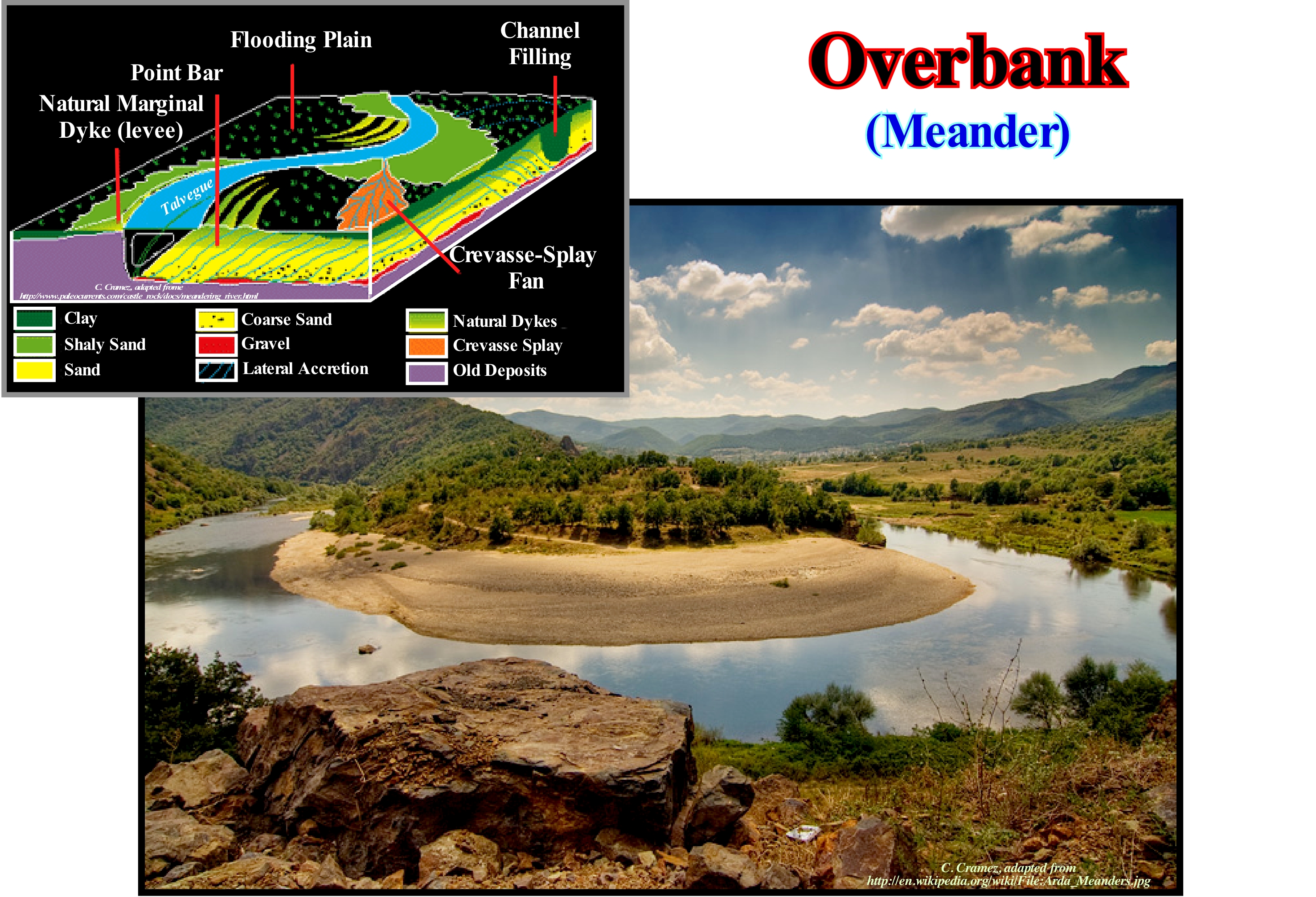
As illustrated in this figure, the term overbanking describes a type of alluvial deposit of the floodplain of a river. It occurs outside the main channel, away from the faster flow of the stream, reason why it has a fine granulometry. This type of overbanking deposition can occur either in non-marine environments, as it is the case here, but also in coastal and deep-water environments. In coastal environments and, particularly, in association with coastal barrier bars and bars, natural marginal dykes, designated by certain geoscientists as a overbanking, often produces deltas of relatively small dimensions in the inner part of the opening of the lagoons, bars or barriers, due to the accumulation of material transported by storm waves that surpass the already deposited sedimentary bodies. In deep-water environments, overbanking is very frequent in turbidite systems and, in particular, in submarine slope fans (SSF) of a sequence-cycle. In contrast to overbanking occurring in nonmarine environments and, particularly, in fluvial environments, where the stream needs a bed or channel to flow and to overflow, in the deep-water environments (turbidites), the current does not require, at least at the beginning of the process, a bed or canal for overflow. When the first turbidite stream begins to decelerate, on the flat and subhorizontal surface of the abyssal plain, it deposits two lateral lobes separated by a nondeposition zone through which the fastest current, loaded with coarser sedimentary material, further downstream, in the form of a distal turbiditic lobe (submarine basin floor fans). If the next turbidite stream transits along the nondeposition zone, a part of the stream will overflow the previously deposited side lobes, depositing two more lateral lobes at the same time as it channels (exaggerates) the nondeposition zone, sometimes called, in a wrong way, turbidite channel. In a nonmarine environment, in the case of violent or very prolonged rains, the increased flow of a river may be such that it can overflow its side banks and flood the generally low-lying and low-sloping areas of the floodplain. The damage can be very large and, above all, there is a risk of drowning at the time of the arrival of the flood wave. A torrential flood is formed by the flow of a stream enriched in solid materials that dramatically increase its erosive power. Material enrichment may come from the margins, due to abnormal water flow (concave portion of a meander, for example) or a significant surface runoff in the drainage basin which increases, significantly, the current load. In the geological model shown in the top right part of this figure, a whole series of geological phenomena that occur in association with the development and evolution of a river in a meandering plain are summarized: (i) Marginal natural dykes (levees), resulting from the deposit of entrained material by the river on the outer margin thereof during floods, which will, progressively, cause the margin to rise ; (ii) Floodplain, which is the whole region alongside a water-course that is inundated during floods ; (iii) Point Bar, an arched deposit of sediments usually consisting of sand, located along the inner convex edges of the river meanders and deposited outwardly as the river channel migrates ; (iv) Channel Filling, which corresponds to an old river-bed that was abandoned and filled by sediments; (v) Crevasse-Splay Deposits,generally, sedimentary body of lobular geometry deposited in the floodplain of a river from the water that escaped the main stream through a crevasse ; (vi) Thalweg, which is the variable line over time that lies in the middle of the deepest junction of a valley or river, etc.
(*) It may well be asked why it is the geoscientists build models or even why it is that old or even wrong models should be presented and discussed when it is well known that they are not correct. Perhaps it would be better not to try to find the true reality whatever we observe or whatever the reality, and perhaps there is nothing underlying existence. But there is, however, a very practical reason for making models. They are convenient and make it possible to summarize in relatively few coherent words an intricate collection of physical and geological phenomena. A model is definitely not a real thing. It is just a representation of the real thing, and all geoscientists must keep this in mind as they advance, examine, or study a model.
Overbanking...........................................................................................................................................................................................................Débordement
Galgamento / Desbordamiento / Überlauf / 溢出 / Разлив (перелив) / Traboccamento /
When a water-course, such as a river or a turbidite current, discharges a portion of the water above the banks that flank the bed of a river or stream, forming, in general, levees but not only.
See: «Avulsion»
Overbanking (Turbidites).......................................................................................................................................................................Débordement
Sobrederrame / Desbordamiento / Überlauf / 溢出 / Разлив (перелив) / Traboccamento /
Overbanking occurring along depression with a great curvature, when the flow of a turbidític current is divided in two parts due to the inability it has to cross the bed. In decelerating gravitational streams, a buildup can occur with deposition, almost immediately, around the bed of the material transported. In contrast, overflow may occur, once the flow becomes stable producing a dynamic gradient above and at the sides of the flow. This causes a continuous (or periodic discontinuous) transport of the sediments up and over the natural leves which greatly increases the rate of aggradation.
See: «Avulsion»
Overlapping (Imbrication, shingling).................................................................................................................................................Imbrication
Imbricação / Imbricación / Schuppenlagerung / 重叠 / Взаимное чешуйчатое наложение (пород) / Sovrapposizione /
Primary deposition of clasts with a preferential orientation such as tiles on a slatted roof or as a series of overturned dominoes.
See: « Sediment »
&
« Transportation (sediments) »
&
" Deposition (clastics) »
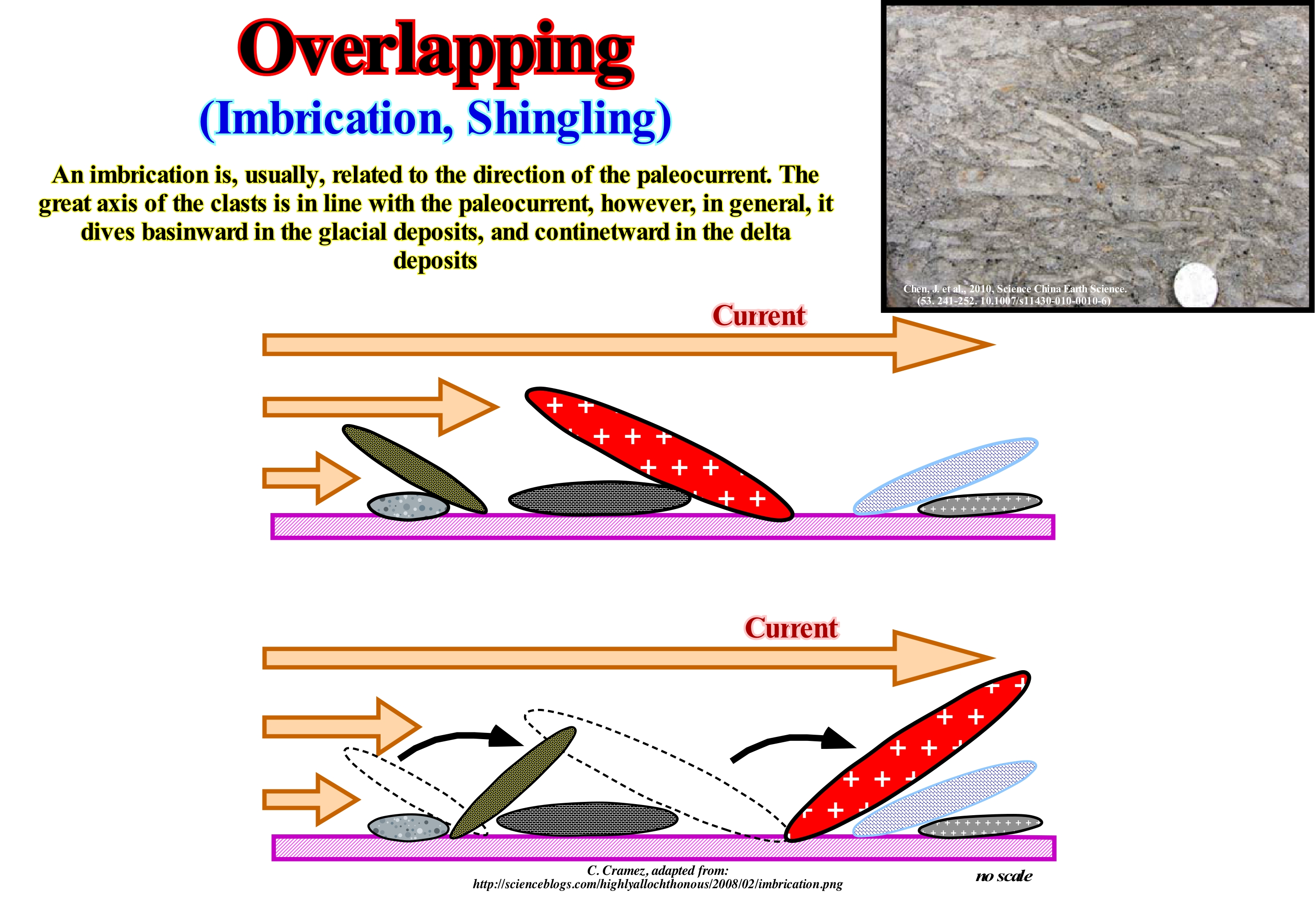
In sedimentology, as suggested in this figure, imbrication refers to a primary deposition pattern constituted by a preferential orientation of the clasts so that they overlap one another in a manner, more or less, consistently, somewhat like a series of overturned dominoes. This type of clast orientation allows geoscientists to determine the direction of the original chains. The imbrication of clasts is mainly observed in conglomerates and, in certain cases, vulcano-clastic deposits. It can also be observed in certain aeolian deposits. As in conglomerates the shape of many clasts is, approximately, that of an ellipsoid. Three main axes can be seen: (i) The main axis, also called the major axis or A axis ; (ii) Intermediate axis or B axis and (iii) Small axis or C axis. Many geoscientists consider two main types of imbrication: (A) Imbrication along A axis, in which the main (longer) axes of the clasts are oriented parallel to the direction of current flow ; (B) Imbrication according to the plane AB, in which the major axes of the clasts are oriented perpendicular to the direction of flow and (C) Imbrication supported in plane AB, with the intermediate axes of the clasts in the direction of flow of the current. The imbrication along A axis is characteristic of clasts transported in suspension and, therefore, it is just preserved in the case of a fast flow in which the clasts are deposited without any significant bearing. This pattern is typical of conglomerates of the basin floor fan (layer A), but is also, occasionally, observed in alluvial fan reworked by floods. The imbrication according to the AB plane is characteristic of entrainment clasts. This imbrication is formed, for example, when the clasts roll at the base of a channel. As shown in the diagram below, the flattened clasts roll over the downstream clasts and deposit against them with their downstream end resting against the lower clasp, which may be used to diagnose the original flow directions.
Oxbow (Abandonned channel)....................................................................................................................................................Chenal abandonné
Canal Abandonado / Canal abandonado / Oxbow, Verlassene Kanal / 故道, 废弃河道 / Высохшая река / Oxbow, Canale abbandonato /
Meander of a U-shaped watercourse, which has been abandoned and where a small lake is, usually, formed, which is later filled either by clay plugs, more or less coeval of the meander, or later, by sediments of flood plain or transgressive sediments. Synonym with Abandoned Meander .
See: « Fluvial Deposition »
&
« Clay Plug »
&
« Bayline »
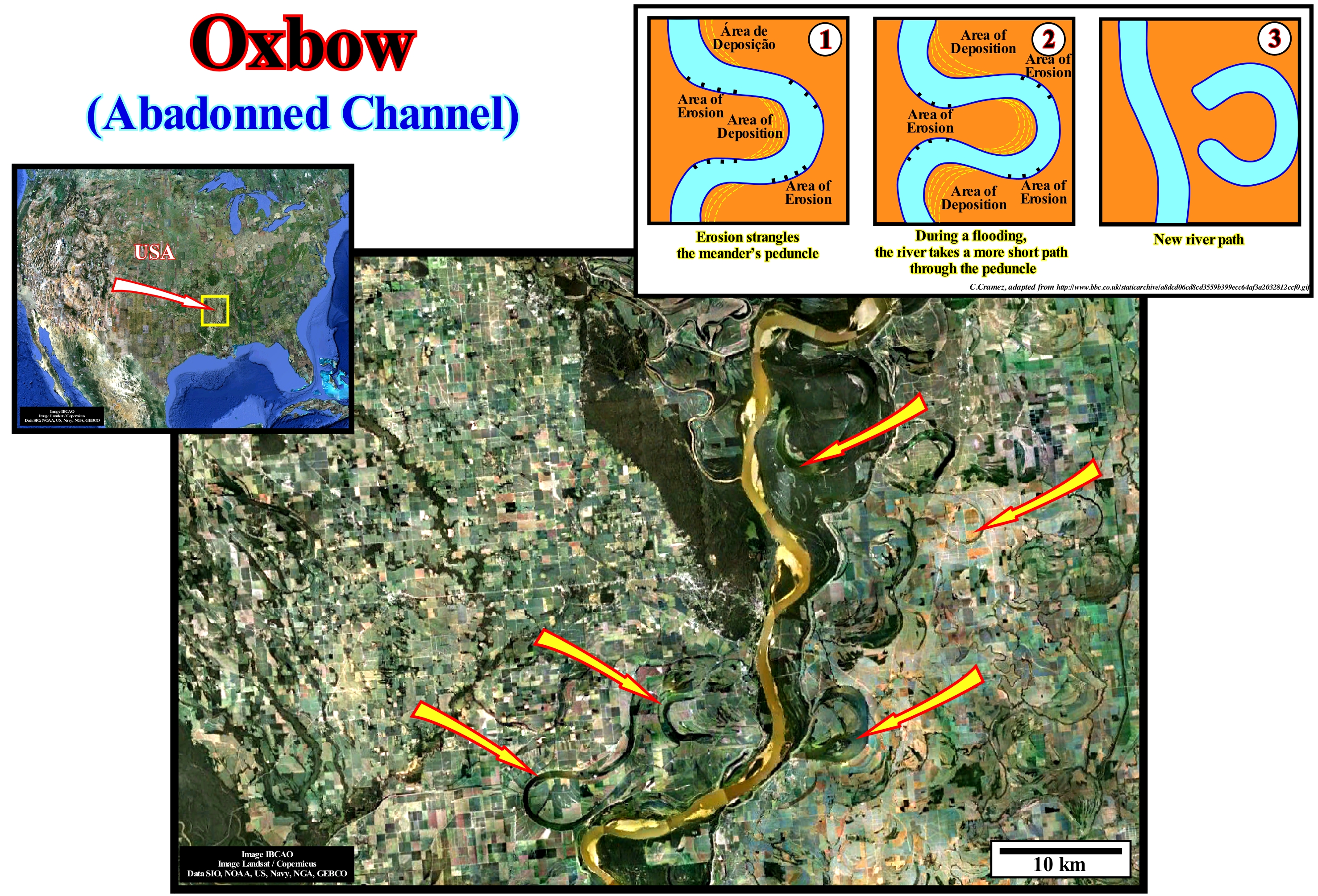
The genesis of oxbow or meander abandoned channels is, more or less, well known. In a meander, the river flows more slowly in the inner part, which allows the deposit of the finer sediments that it transports in the convex margin (point bar). On the contrary, on the outside of the meander, the river flows with greater speed causing erosion on the outer bank. Over time, the bow of the meander widens, continuously, until the throat or neck of the meander disappears completely. Eventually, the arch of the meander is isolated from the river route creating an abandoned canal, which when with water forms a very typical lake, shaped like a horseshoe (oxbow lake). Once the water no longer flows into the old river bed, a lake forms, where fine and organic sediments settle down by decantation. If the abandoned meander lake is, sufficiently, large and deep, an ecosystem can be formed, which, later, favours the local formation of local potential source-rocks*. The meanders and oxbow lakes can become a marshy area, which often evolves in a meadow where trees are easily rooted. This process, by which what was once a meandriform river one day becomes forest is sometimes called ecological succession. It was, probably, this succession of geological events (evident in this photograph) that originated, in the United States of North America, most of the onshore of Louisiana and the Mississippi. The abandonment of a meander's arm is, rarely, abrupt. In general, a river returns to its former bed at the end of a year or two, and then leaves again at the end of another two three years. This alternation of currents paths in the meandering plain to the definitive abandonment of a meander arm (oxbow) is corroborated on seismic lines (particularly in high resolution seismic lines) when they cut a meander bar. Point bars (sedimentary interval, more or less, coarse which is deposited in the inner part of the meander with an internal progradational oblique configuration) are, rarely, fossilized (laterally) by a single clayey plug. The presence of five or six clay plugs is not exceptional. Each clay plug corresponds to the fill during a period of abandonment of the arm of the meander, i.e., when the current had a different trajectory. We recall that there are two types of meandering: (i) Free Meanders or Wandering Meanders and (ii) Incised Meanders or Valley Meanders. In the first type, the meanders are independent of the tracing of the valley. In the second, i.e., in incised meanders, the curves of the river coincide with the geometry of the valley. The Mississippi River (USA) meanders are typical free meanders that gradually move the river bank in the direction of the river course and meander arches are amplified, while Douro River (Portugal) meanders are, typically, incised meanders or valley meanders. Three theories explain the formation of most of the meanders: (A) Stochastic or Chance ; (B) Equilibrium (C) Geomorphic and Morphotectonic. In stochastic theory, the meanders are explained as the result of stochastic variations in the direction of flow because of the random presence of obstacles that change the direction of the current path. The terrestrial surface is not only irregular, but is formed by rocks with different resistance to erosive agents, which means that as the result of the physical factors, which act at random, the river-beds become, progressively, sinuous (even when a current seems straight, the thalweg may be sinuous, which in time may create sinuous meanders). The equilibrium theory conjectures that the meanders decrease the flow gradient until a balance is reached between the erosion of the terrain and the carrying capacity of the stream. The amount of descending water abandons the potential energy, which, when the water velocity is constant, is lost by the interaction with the bed material of the stream. A rectilinear flow (more short distance from the flow), which has the highest energy per unit length, breaks more the banks, creating more sediment and the bed is more silted. The presence of meanders allows the flow to adjust the length to an equilibrium energy per unit length, so that the flow carries all the sediment it produces. Geomorphic and morphotectonic theory considers that many meanders follow the superficial (geomorphic) or deep (morphotectonic) structures of the ground, whose elements (boundaries between geological formations, faults, synclines, etc.) are not random and guide flows.
(*) This seems to be the case in some meander belts, for instance in the Neuquéngeographic basin (onshore Argentina), where the petroleum found and exploited in certain meander bars is, probably, generated by the clay-rich sediments rich in organic matter, which fill the clay plugs.
Oxbow (Meander-lake)...............................................................................................................................................Lac de chenal abandonné
Lac de chenal abandonné / Lago de canal abandonado / Altwasser (Fluss) / 河迹湖 / Пойменное озеро / Lanca /
Lake in a meander or abandoned canal formed by overbanking of the water during a flood or by oscillation (exaggeration of the curvature of the meander). Synonym with Meander Lake and Abandoned Meander Lake.
See: « Fluvial Deposition »
&
« Point Bar (fossil) »
&
« Clay Plug »
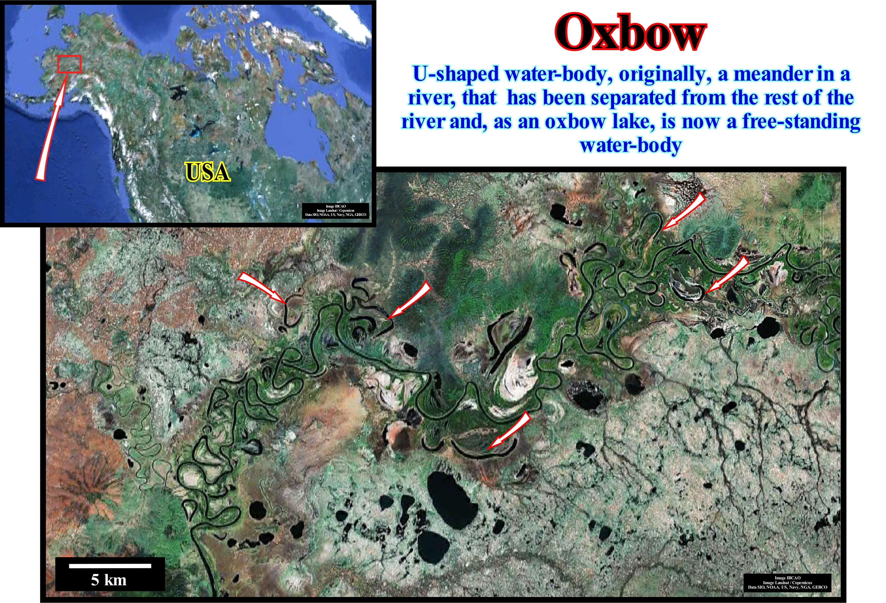
An abandoned meandering lake (oxbow lake) forms when a river creates a meander due to erosion of the banks, a function of hydraulic action and the relationship between abrasion and corrosion. Over time the meander curves more and more and eventually it may happen that the meander neck will finally put in contact both sides isolating the meander forming a meander lake. Indeed, when a river reaches a plain, often on its final course toward the sea or to a lake, it describes numerous meanders. In the vicinity of a curve of the river, the sediments are deposited on the convex margin. On the contrary, in the concave margin there is lateral and basal erosion. Continuous deposition at the convex margin and erosion at the concave margin exaggerate the curvature, and the two concave edges approach. Over time, the strip of land between the two neighbouring concave edges is isolated either by the lateral erosion of either the concave banks or the strong currents of a flood. When this happens, the river takes a new, more rectilinear path, which deepens to transport the lower water more quickly, a sector of the meander is abandoned. When the deposition finally fills the short-cut of the river channel, a meandering lake forms. This process can last from several years to several decades. In this photograph the lakes of the deserted canal, meander lakes or horseshoe lakes associated with the Yukon River (runs in North America, British Columbia, Yukon Territory and Alaskan state, and empties into the sea of Bering from the Pacific Ocean) are perfectly visible, and probably most of them have been produced by oscillation, that is, by exaggeration of the curvature of a meander, which makes the peduncle disappear (base of the meander) and creates a path of the river much shorter, than by overbanking. Along a river, not all the sinuosities are exaggerated, since there are sections without meanders. For a meander to form, there must be a state of equilibrium between the inclination, the flow, the load and the resistance of the margins. When it comes to a meandering alluvial plain (wandering meander), as is the case of the example illustrated in this figure, the banks are embedded in alluviums. On the contrary, when it is a meander valley (incised meander when the water-course accompanies the sinuousness of the valley), the concave parts of the margin, during the evolution of the meander, are carved into the rock and, in this case, is the resistance which is taken into account. As most rocks are stronger than alluviums, the meander valleys have relatively stronger slopes. For a long time geoscientists thought that the meanders formed when the inclination was very weak, that is, when the current was almost at the end of its evolution and was unable to excavate. Therefore, it began to deposit the sediments and, little by little, the bed of the river filled up. However, and in the first place, at the end of evolution, a river does not necessarily have to be filled. Secondly, a meander can not be considered as the result of the impotence of a river, since it is a form of excavation or equilibrium. A heavily laden river does not form meanders, but it forks or divides into several channels. Finally, it can be said that a meander is the result of a state of equilibrium between the strength of the river and the resistance of the nesting rock. If the banks are not very resilient, the evolution of the meander will cause a great amount of material to fall into the river, which paralyzes the river along the banks, and the stream will return to the apparent bed. If the margins are low resistance, the river will not be able to dig significantly. Artificial meander lakes can form when a river channel is artificially straightened to improve navigation or to reduce the risk of flooding. This occurred mainly on the upper Rhine River in Germany in the 19th century. A well-known example of an entirely artificial, navigable waterway with meander lakes is the Oxford Channel in England, which when originally built had a very winding course, following the contours of the ground, but the northern part of the canal was straightened between 1829 and 1834, reducing its length but creating a number of sections with isolated meander lakes from the new course. Three theories were invoked to explain the formation of the meanders. (i) Stochastic ; (ii) Equilibrium and (iii) Morphotectonic. In the stochastic theory, the evolution of a meander seems to be the result of stochastic fluctuations in the direction of flow due to the presence of obstacles that change the direction of the current path. In the equilibrium theory, meander formation decreases the current flow gradient until equilibrium between soil erosion and current carrying capacity is reached. In the morphotectonic are natural the obstacles that induce the formation of meanders.
Oxbow Lake........................................................................................................................................................................................Méandre abandonné
Meandro Abandonado / Meandro abandonado, Galacho / Altwasser (Fluss) / 故道 / Высохшая река / Meandro abbandonato, Oxbow /
Water-body with an U-geometry formed when a meander of a river is cut off (abandoned) from the main stram forming a lake. Synonymous of Abandoned Channel.
See: « Neck, Chute Cutoff (evolution) »
&
« Point Bar (seismic) »
&
« Meander Belt »
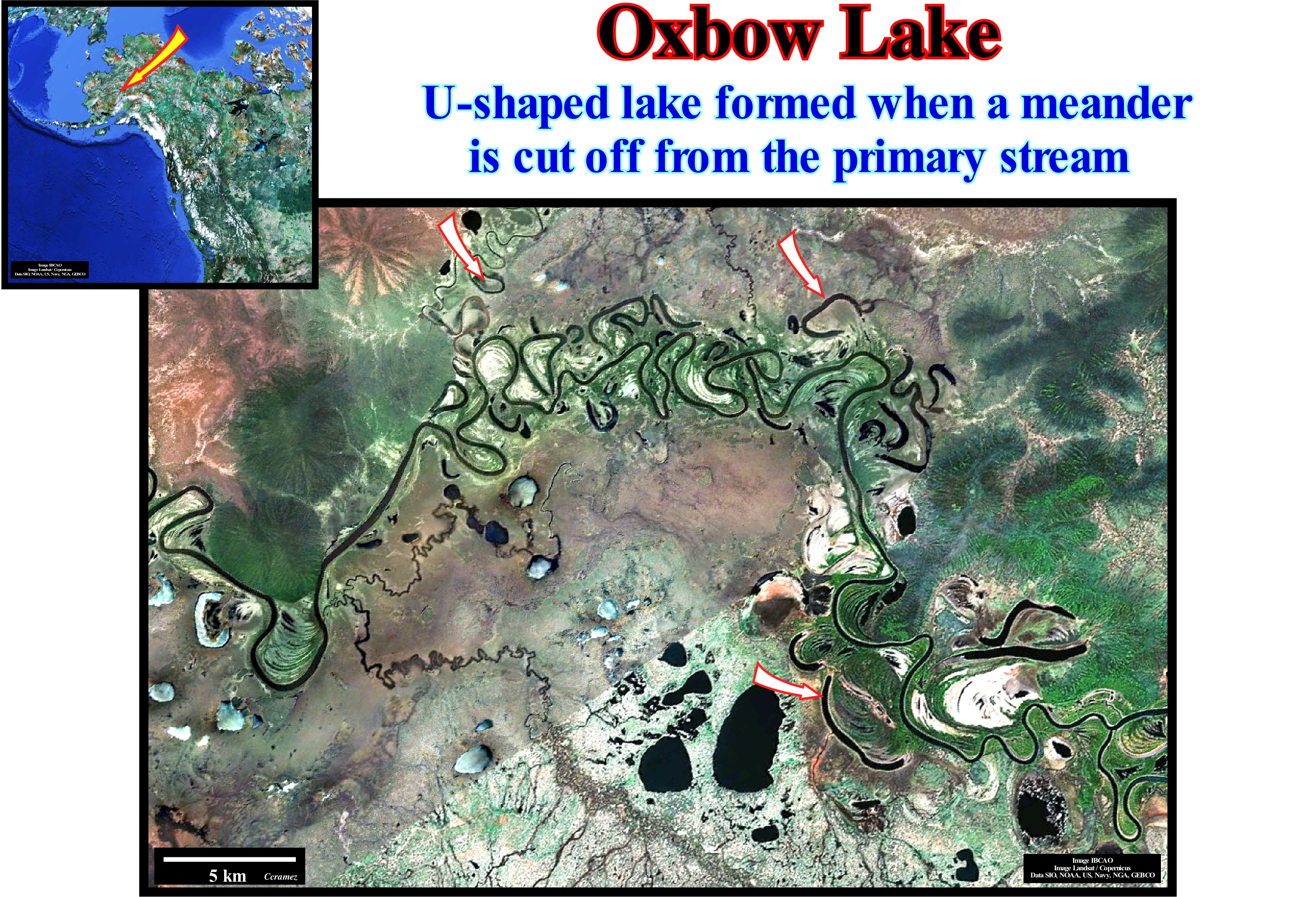
This figure visualizes series of oxbow lakes along the alluvial plain of Kneai River (one of the most popular river for sport fishing in Alaska). During the melting ice period, many of the channels become, again, active. This is perhaps the most likely reason to explain the absence of water-bodies or oxbow lakes in some of them. When an abandoned channel or oxbow becomes active, what happens, more or less periodically, part of the channel is filled with sediment which, progressively, leaves less room for water once it is abandoned. The meanders of the alluvial plain (do not forget that there are also valley meanders*) by the force of being accentuated, can be cut out from the main current creating abandoned channels. A cut between two meanders can be done in two ways: (i) Overbanking and (ii) Tangency or Osculation. In the first case, the cut between two meanders is realized during a flood period, when the entire floodplain is flooded. in fact, since, as soon as the water height begins to decrease, the stream, preferably, takes the more rectilinear path than the long and curved path of the meander. The meander is abandoned and may form a meander lake (oxbow lake). This mechanism is impossible in valley meanders (in which the sinuosities of the river coincide with the sinuosities of the valley). A cut by tangency or osculation (contact of two curves) is made by simple exaggeration of the curve of the meander. Progressively, the neck of the meander becomes nonexistent, favouring the flow of the stream, directly, to the next meander leaving the an abandoned meander in which a lake can form. As a meandering cut brings two points of the stream in contact, which were initially at a certain distance with different altitudes, the occurrence of a waterfall is possible. The existence period of the waterfall is, more or less, large and function of the hardness of the incised rocks. All meanders migrate downstream, which allows the capture of small streams through the meander and the transformation, over time, of meanders of valley in meanders of alluvial plain.
(*) There are two types of meanders: (i) Meanders of alluvial plain, when the river meanders, independently, of the course of the valley, i.e., when the meandering stream does not follow the course of the valley in which it flows, as in Mississippi river, in USA ; (ii) Incised or valley meanders, when the valley meanders like the river, at the same scale ,i.e., the valley follows perfectly the meandering watercourse (e.g., Douro river, in Portugal).
Oxbow Lake (U-shaped lake).........................................................................................................................................................Lac de méandre
Lago de meandro / Lago de meandro / Altwasser (Fluss) / 河迹湖 / Меандровое озеро / Lanca (lago) /
Lake formed in an abandoned meander whether this is from the alluvial plain or from a meander valley (incised meander). Synonymous with Lake Abandoned Channel.
See: « Meander »
&
« Point Bar (model) »
&
« Clay Plug »
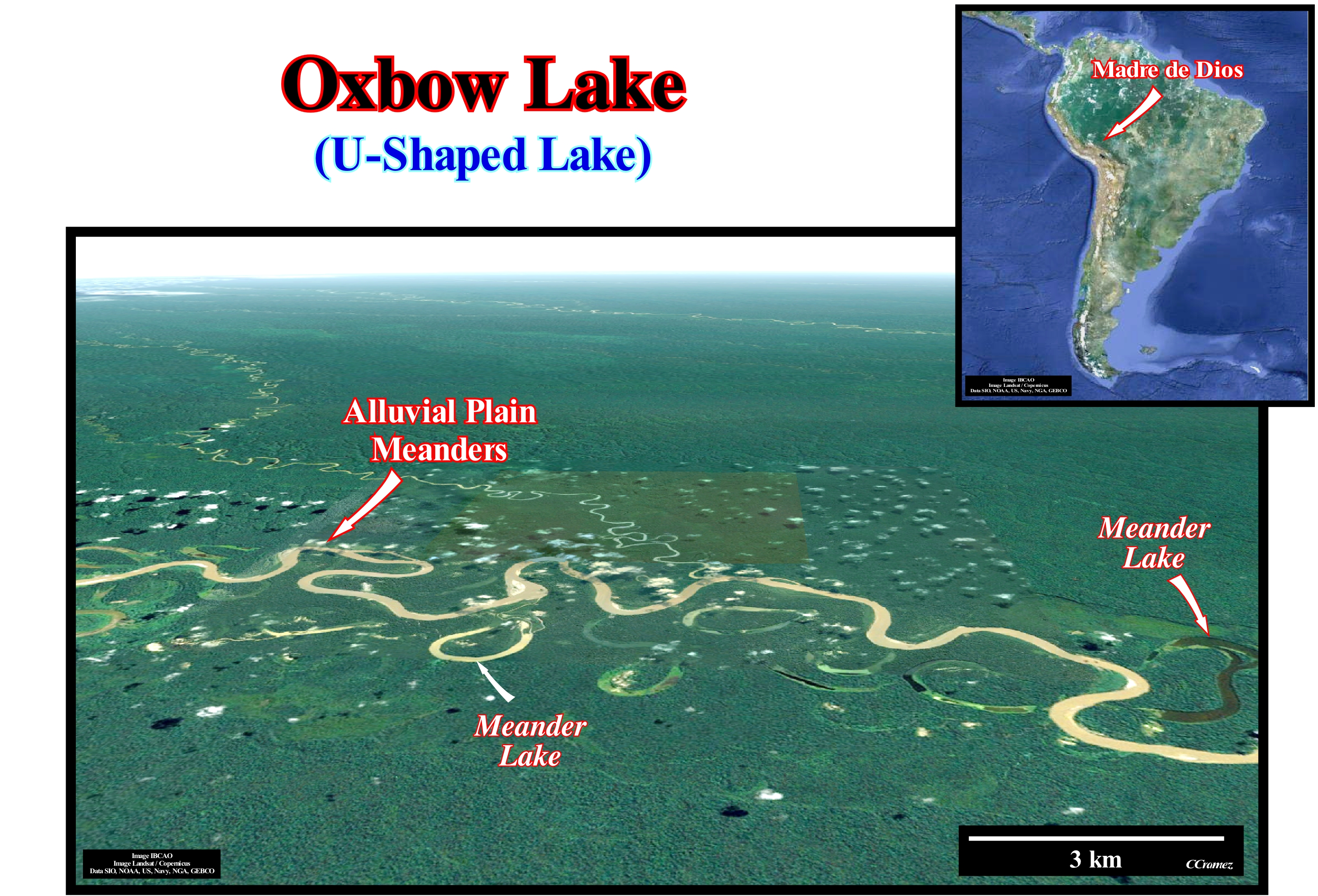
A meander, whether it is incised (or valley meander, that is, when the river and valley zigzag at the same time) or alluvial plain meander, is always inclined to accentuate. The main stream is diverted to the outer side of the meander, i.e., it approaches the concave edge (when viewed from the flow channel). In a series of meanders, the current approaches the right and left margin, describing curves larger than the axis of the apparent river bed and tends to exaggerate the curves, since where the speed is maximum where the erosion is stronger. The concave margin is more eroded than the convex margin, in which the current is much slower and thus leaves its load beginning to build a point bar, which accentuates the curvature. In one meander, there is erosion and deposition at the same time. Therefore, in terms of sequential stratigraphy one can not speak of unconformity (relative sea level fall). By this process the concave margin becomes abrupt, while in the convex margin, which is lower, the sediments deposit. By virtue of their accentuation, two neighbouring meanders can be cut out in two different ways: (i) Overbanking, that is, when during a flood the whole plain is flooded and the stream takes a shorter rectilinear path instead of (ii) Oscillation or contact, when the exaggeration of the curvature removes the peduncle (base of the meander), the old meander is transformed into a channel abandoned, in which sometimes a lake is formed like those illustrated in this photograph (Rio Madre de Dios, SE of Peru). This last process brings into contact two points of the course of the river, which were previously at a certain distance and at different levels. This can create a water fall that can be maintained for a certain time if the rock is relatively hard. At the same time as the meanders are exaggerated, they migrate downstream, which, over time, can transform incised meanders into false alluvial plain meanders.
Oxygen Isotropic Stratigraphy....................................................................Stratigraphie isotopique (Oxygène)
Estratigrafia isotópica (oxigénio) / Estratigrafia isotópica (oxígeno) / Sauerstoffisotopie Stratigraphie / 氧同位素地层学 / Изотопная стратиграфия / Isotope stratigrafia (ossigeno) /
Stratigraphy based on the ratio of the oxygen isotopes (18O / 16O) present in sea water as a function of time. Geoscientists associate lower levels of heavy oxygen (18O) compared to a standard with fresh-water, which on a global scale indicates warmer temperatures and melting, and on a local scale indicate heavier rains. Do not forget that: (i) The ratio (relative amount) of these two types of oxygen in the water varies with the climate ; (ii) The proportion of heavy (18O) and light (16O) oxygen in marine sediments, ice cores, or fossils is different from the accepted, universally, standard, which may indicate the climate changes that occurred in the past ; (iii) The scientific standard used for comparison is based on the proportion of oxygen isotopes in sea-water at a depth of 200/500 meters ; (iv) Evaporation and condensation are the two processes that most influence the ratio of oxygen isotopes in the oceans ; (v) Water molecules containing light oxygen evaporate a little faster than water molecules containing a heavy oxygen atom ; (vi) Water vapour molecules containing the heavy oxygen range condense more easily.
See: "Stratigraphy »
&
« Sequential Stratigraphy »
&
« Biostratigraphy »
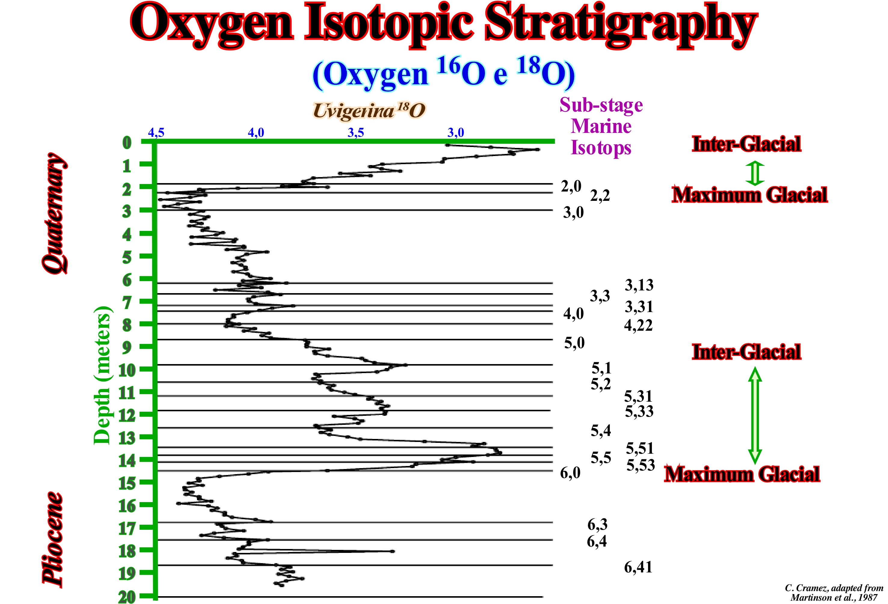
As shown in this figure, besides the sequential and genetic stratigraphy as well as sedimentary transgressions/regressions (T/R stratigraphy), we can also consider isotopic stratigraphy, which allows to determine the relative ages of sediments based on the relative proportions of the isotopes of an element particular. The basic principle is that the proportions of some isotopes embedded in biogenic minerals such as calcite, aragonite, phosphate and others change with time in response to paleoenvironmental and geological changes. However, the relative proportions of the isotopes are, often, masked by the diagenetic alteration of sediments. Differentiation between primary and secondary isotopic proportions is a difficult and very controversial subject. Although the isotopes of many elements have been studied, isotopes of oxygen, strontium and carbon, are the most, commonly, used. The isotopic oxygen stratigraphy is, of course, based on the oxygen isotope curve in which the relative proportions of the 18O and 16O isotopes are projected. Remember that an isotope is one of two or more varieties of a chemical element whose atoms have the same number of protons and electrons (even atomic number), but which have a different number of neutrons in the nucleus (different atomic weight). Oxygen may exist in various forms, but only 16O and 18O are important in the analysis of the oxygen isotopes. Oxygen-16 or 16O is a stable isotope of oxygen, which has 8 neutrons and 8 protons at its core. It is the most abundant isotope of oxygen (99% of the natural abundance of oxygen), since it is not only the main product of stellar evolution but also a primordial isotope, since it was made by nucleosynthesis in stars that were originally made exclusively of hydrogen. The rate of abundance of these two isotopes gives various types of information about geological past, such as the origin of water and the most probable temperature of the oceans. As at present the average rate of 18O over 16O is, more or less, 1 to 500, all measures are taken against this value which is taken as a reference. The vast majority of geoscientists consider that the rate between 18O and 16O varied in the oceans, cyclically, as a function of the alternation of the glacial and interglacial periods. The rate between 18O and 16O depends on the water temperature. The 18O isotope increases as the temperature decreases. The oxygen incorporated in the calcium carbonate of the shells of marine organisms reflects the rate between 18O and 16O. As the acidification of the fossil shells releases oxygen, it allows determining the temperature of the oceans in which the fossilized animals have now lived. During the peak of the last glaciation, the deep-water was enriched by 18O from about 1.6 parts per thousand (1.6 ppm), which is equivalent to an absolute (eustatic) sea level fall of about 165 m in relation to the current sea level. Thus, it can be said oxygen isotopes can emphasize changes in ocean temperature and ice volume. The oxygen isotopic stratigraphy made in the Cenozoic sediment and, particularly the Quaternary sediment samples, using microfossils, suggested changes in ocean temperatures and ice caps thickness, which allowed the recognition of isotopic stages of oxygen. The separate effects of these parameters (temperature and ice volume) are distinguished by comparing the isotope ratios in planktonic and benthic microfossils, mainly foraminifera. On the other hand, as they were induced by the Milankovitch cycles, it is possible to identify and correlate the isotope stages of oxygen globally. Curves 18O provide a time scale (20 ka resolution) from the Quaternary to the Neogene. In pre-Cenozoic sediments, the use of oxygen isotopes is more limited because much of the carbonate is recrystallized and rarely reflects changes in isotopic proportions of oxygen. In this figure, the isotopic oxygen (18O/16O) stratigraphy in depth (composite metric depth), determined from the shells of the benthic foraminifera Uvigerina to the site 1014, is illustrated. The oxygen isotope data (horizontal lines) are numbered at (sub-stages of the marine isotopes) and correlated with the reference section (depth) of deep sea oxygen isotopes. The maximum glaciers are well marked and underline the cyclicity of the variations of the absolute sea level.
Ozone Hole............................................................................................................................................................................Trou de la couche d'ozone
Buraco de Ozono / Agujero de ozono / Ozonloch / 臭氧层空洞 / Озоновая дыра / Buco nell'ozono /
Region of the stratosphere (over Antarctica) where the ozone layer is very impoverished. Such a conditions sems to occursevery year in the early spring of the Southern Hemisphere (August/October), as suggested by the satellites that provide us with daily images of the ozone hole over the Antarctic. In technical terms the ozone hole is not a hole where ozone is not present, but rather a region.
See: « Atmosphere »
&
« Cloud »
&
« Stratosphere »
Ozone (O3) is a molecule made up of three oxygen atoms. Which is a kind of anomaly, since the usual oxygen molecule is made up of two oxygen atoms (O2). It can be said ozone is a type of oxygenated oxygen. Until the 1980s, with the exception of experts, no one or almost anyone was interested in ozone. However, since the 1980s, ozone has become a concern for mankind, albeit with much confusion. In fact, many people are, often, confused by the destruction of the famous Antarctic ozone layer, which is about 40 km high and warns of ozone during periods of heat, which in turn translate into an excess of ozone. In the atmosphere, at the ground, that is, in the air we breathe the ozone is toxic. Living matter is oxidized, which means that it is destroyed. That is why there are ozone alerts during the summer, since ozone is formed by photochemical reactions from automobile gas and fertilizers*. The ozone layer in the Antarctic is an area where the ozone concentration is 8 parts per million (in the lower atmosphere it is less than one part per million). The ozone layer plays a very important role for the terrestrial balances, since it absorbs the ultraviolet rays of the Sun, which has a double consequence. It heats the zone between 35 and 40 km of altitude, which is a barrier between the air of the troposphere and the stratified air of the stratosphere. Without the ozone layer this division would not exist and the atmosphere would certainly be mixed. On the other hand, the ozone layer protects living beings from ultraviolet rays that can produce mutations and cancers of the skin. In the 1980s scientists found that the ozone layer was thinning and that chlorine compounds called CFCs or freons (chlorofluorinated hydrocarbons) destroyed the ozone in the laboratory. After many years of discussions, the manufacture of CFCs, used in refrigerators and sprayers, has been banned, and it appears that the ozone layer does not thin.
(*) By definition, photochemical pollution needs sunlight. In the presence of the volatile organic compounds (VOCs) emitted by the vehicles, the oxides of nitrogen (NOx), coming from the same sources, are split by ultraviolet radiation with the formation of ozone (secondary pollutant very aggressive to the respiratory tract) which is, particularly, abundant when the anticyclonic situations, forming the pseudo-fog said photo-oxidant that characterizes the great cities, but not only.

