
Platform Reef............................................................................................................................................................................................................................Platier
Recife Plataforma / Plataforma del arrefice / Riff-Flach / 礁 / риф / Piattaforma Reef /
Platform dug by waves on the abrupt outer margin of a reef.
See: « Reef »
Playa.........................................................................................................................................................................................................................................................................Playa
Playa / Playa / Playa / 普拉亚 / Плайя (небольшой песчаный участок суши в устье реки или вдоль берега залива) / Playa /
Subhorizontal desert basin, which may contain ephemeral lakes with closed drainage basins (endorheic lakes). The beaches are formed by fine sediments mixed with alkaline salts. They are also known as alkaline plains, mud plains, salt flats, sabkhas and even dry lakes. When the surface is salty, it is known by the name of salar as, it is the case of most beaches of South America and, in particular, of the Andes.
See : « Desert »
&
« Laguna »
&
« Alluvial »
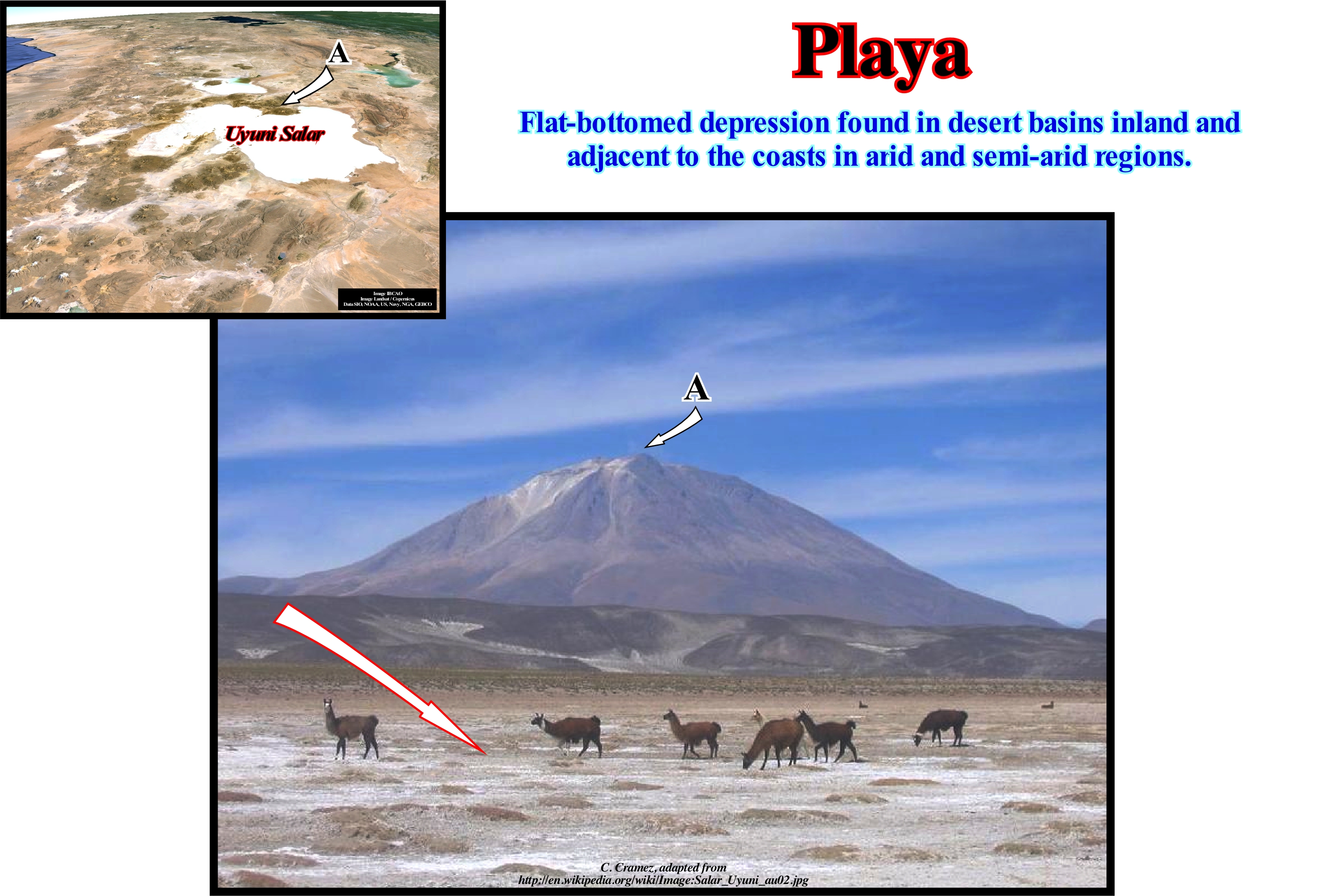
During the summer, the surface of a playa is, usually, dry, hard and smooth. During the winter months it is moist, sometimes, flooded and soft. The playa correspond to depressions of the surface of the land. A playa-lake forms when rainwater fills the depression. A playa-lake can form when the water plane intersects the surface and the water runs into the depression. In general, the playas are formed in the semiarid and arid regions. The largest concentration of playa-lakes in the world (more or less, 22,000) is in the high plains of southern Texas and in eastern New Mexico. While most playa-lakes are, relatively, small, others have important dimensions such as Lake Alablab in Suguta (Kenya) and Wild Horse Lake in Oklahoma (USA). The Uyuni salar or play, illustrated in this photograph, which is located near the town of Potosí in Bolivia, is the largest salt playa-lake in the world. It has a surface about 10,582 km2, that is roughly 25 times, for instance, the surface of Bonneville (Northwest Utah, USA) salty playa-lake. Many playas have shallow lakes during the winter, in particular during the years of high humidity. When the water-depth of the ponds is small, water can move within the playa under the action of the wind and create a smooth and flat surface throughout. A thicker water-depth, generally, creates a surface with mud cracks and dissecting structure with the geometry similar to that of the Indian tent. While the playas are, generally, devoid of vegetation, they are almost always surrounded by small salt-tolerant shrub lands that provide the necessary fodder for livestock and other herbivores, especially during the winter.
Plenilune...............................................................................................................................................................................................................................Plenilunium
Plenilúnio / Plenilúnio / Plenilune / 满月 / Полнолуние / Plenilunio /
One of the phases of the Moon, when its totality is reflected in the Earth or full Moon. When two full moons occur in one month, the event is known as the Blue Moon. Synonym with Full Moon.
See: « Moon »
&
« Quadrature (stars) »
&
« Conjunction (astronomy) »
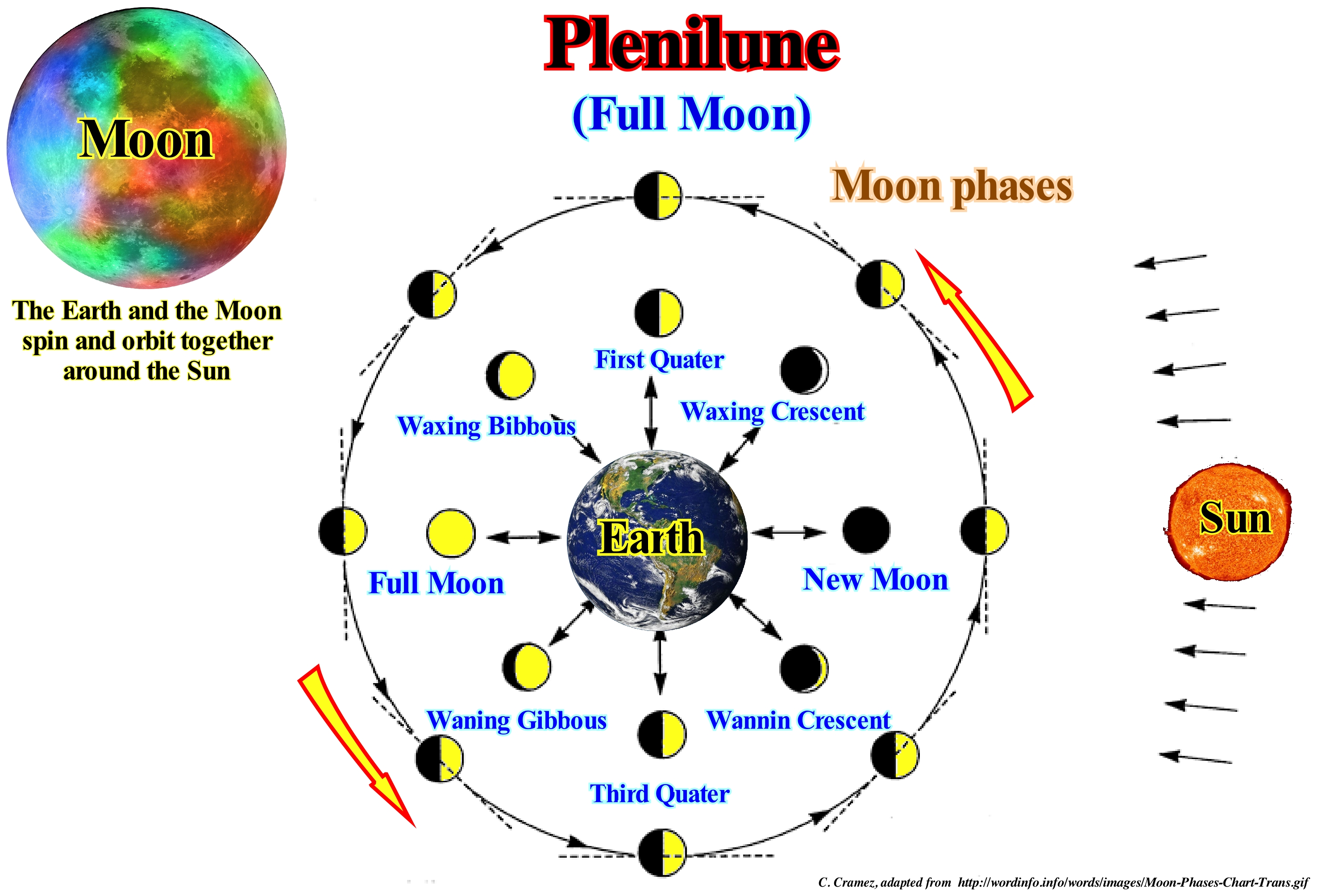
Take note that the Moon is tidal locking*, i.e., its object’s orbital period matches its rotational period. The moon takes 28 days to go around the Earth and 28 days to rotate once around it’s axis. This results in the same face of the Moon always facing the Earth. The phases of the moon are called the four basic aspects that the Earth's natural satellite, the Moon, presents according to the angle by which the face is illuminated by the Sun. When the Moon is in conjunction with the Sun, the visible face is totally in the dark and the hidden face is illuminated. It is the new Moon, since at this stage the Moon is born and sets with the Sun, it is only visible when a solar eclipse occurs. The new moon in its original sense marks the beginning of the month in lunar calendars, such as the Muslim calendar, and in luni-solar calendars, such as the Jewish calendar, the Hindu calendar and the Buddhist calendar. About 7.5 days later, the Moon lies at a 90° angle to the Sun. At this stage the illuminated portion is half the visible face, so a quarter of the lunar surface is the fourth crescent. At this stage, the moon rises at about noon and sets at midnight (in the northern hemisphere, the right half of the disk is illuminated, while in the southern hemisphere the left half of the disk is illuminated during this phase). When the Moon is in opposition to the Sun, about 15 days after the new Moon, its visible face is, totally, illuminated, it is the full moon or full moon. At this stage the moon is born when the sun goes down and its sunset occurs at sunrise. This is also where the lunar eclipses happen. Another week until a 270° angle is formed and the Moon will be in the fourth quarter. At this stage the Moon is born at midnight and it is set at noon (in the northern hemisphere, the left half of the disc is illuminated, while in the southern hemisphere the right half of the disc illuminates during this phase). The lunar cycle* if it completes in a little over 29.5 days and is therefore almost two days longer than the translation. This occurs as a function of the Earth's translation motion.
(*) The same side always faces us. The another side always faces away. When Earth views a darkened new moon, the far side is lit. When there's a full moon in our sky, the far side is dark.
(**) Complete lunar cycle, which corresponds to the time space between two consecutive new moons; the time interval between two consecutive new moons is on average of 29 days, 12 h, 44 m and 2,9 s but this time interval is not constant, varying between 29 days and 4 h and 29 days and 22 h approximately.
Plume (Mantle).........................................................................................................................................................................................................Panache (Manteau)
Panache (manteau) / Pluma del manto / Mantel-Plume / 地幔熱柱 / Плюмаж / Mantle plume /
Abnormal rise of hot rocky material within the Earth's mantle that can reach the upper levels of the lithosphere. As the top of the mantle plumes* can be partially melted, many geoscientists think they are one of the causes of hot spots (volcanic centers), which can form large provinces of basalt.
See: « Hot Spot »
&
« Sima »
&
« Plate Tectonics Theory »
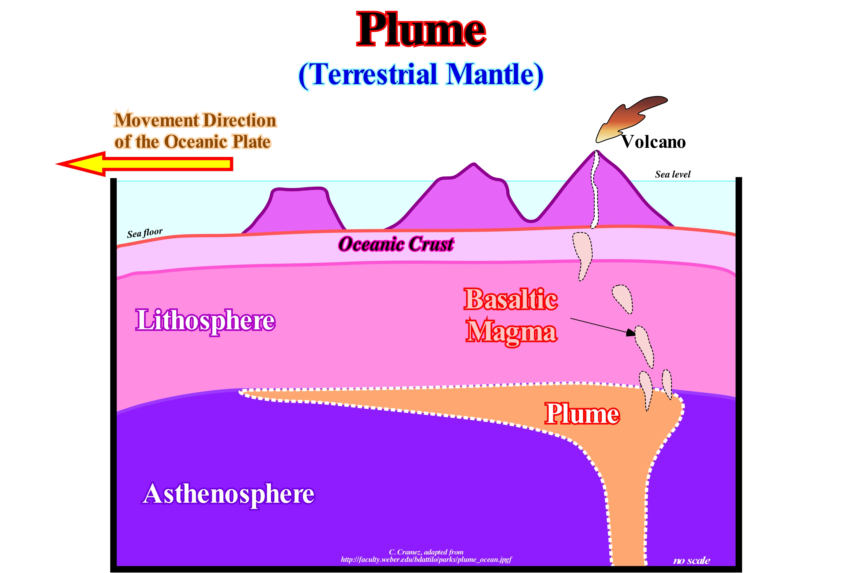
As illustrated in this figure, a mantle plume is a geological phenomenon consisting of the ascending of a large volume of magma from the deep mantle regions to the Earth's offshore regions. This phenomenon is explained by certain geoscientists as the influence of temperature on the density of magma. The interior of the Earth is very hot due to the constant radioactive decay of the minerals there. The geothermal gradient, therefore, points in the direction of increasing temperature as we walk into the depths of the globe. Mathematically, the density of a body is represented by a relation between its mass and the volume occupied: d = m/v, (where d is density, m mass and v volume). This explains the tendency of a body to sink or to float relative to a medium of constant density. The temperature dilating the bodies increases the volume, which implies a decrease of the density, forcing it to float. The opposite is also valid. As the mantle plume approaches the shallower land regions, the temperature decreases and the density of the magma increases, since for the same amount of material, the mass is always the same. The magma descends again into the depths of the planet. It is this phenomenon that creates magma convection cells in the mantle, which is used to explain the relative movement of lithospheric plates (plate tectonics). According to the plate tectonics theory, the hypothesis of a decrease in the movement of lithospheric plates, which may be associated with the formation of a supercontinent, assumes that without convex cells in the asthenosphere, the upper mantle may locally, overheat. These areas of overheating of the mantle, near the mantle-core boundary, begin to ascend, relatively, to the neighboring regions thus beginning a sort of diapirism that later creates mantle plumes.
(*) A mantle plume is an upwelling of abnormally hot rock within the Earth's mantle. As the heads of mantle plumes can partly melt when they reach shallow depths, they are often invoked as the cause of volcanic hot spots and large igneous provinces.
POGO.............................................................................................................................................................................Biseau d' aggradation maximum
Bisel de agradação máximo / Bisel de agradación máximo / POGO, Onlap maximale, Maximale Fase Verlandung / 上超最大 / Наибольшее подошвенное налегание / Onlap massima, Bisello d’aggradazione massima /
Onlap that marks, within a stratigraphic cycle (in general, in a continental encroachment cycle or subcycle), the maximum encroachment and aggradation. POGO is the acronym for "Point Of Greatest Onlap".
See: « Onlap »
&
« Aggradation »
&
« Relative Sea Level Rise »
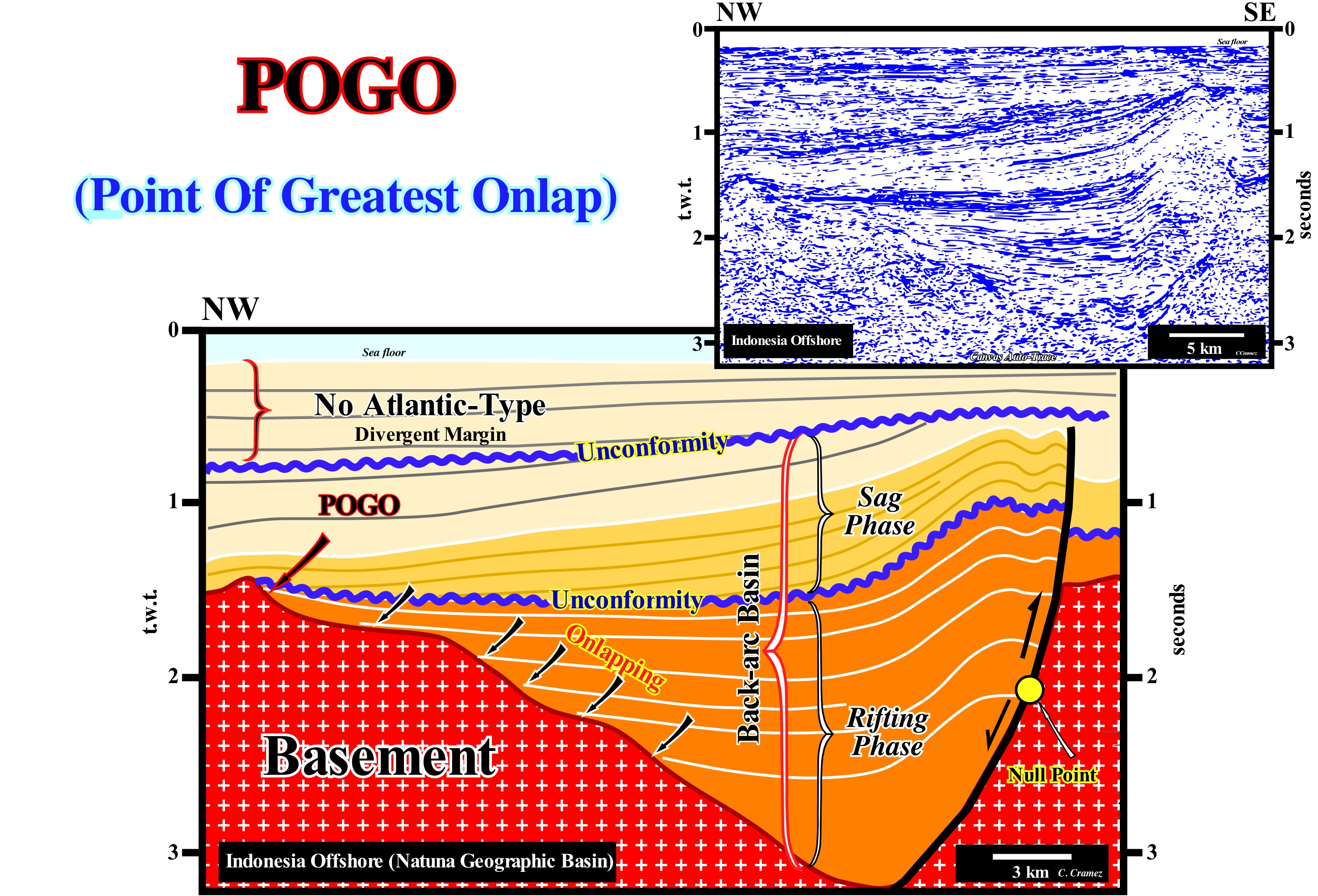
The Indonesian offshore and in particular the neighbouring area of the Natuna Island (southwest of Borneo), where the seismic line of the Canvas auto-trace shown in this figure was taken, at present time corresponds to a staking of different basins from the classification of Bally sedimentary basins and Snelson (1980). On the tentative geological interpretation of this auto-trace, over the basement, which locally may correspond to a pre-Tertiary flattened folded mountain belt, from the bottom to top, the following basins were considered: (i) A Backarc basin formed by a rifting phase (halfgraben geometry) and a sag phase and (ii) A non-Atlantic type divergent margin. During the rifting phase of the backarc basin, subsidence was differential, while during the sag phase, the subsidence was thermal. This offshore developed within the Mesozoic/Cenozoic megasuture, that is to say, it is formed in a geological context in which compressional tectonic regimes were and still are predominant. On the tentative geological interpretation, it is not difficult to verify that the sediments that filled the halfgraben of the rifting phase and the sediments of the sag phase were shortened by a compressional tectonic regime characterized by an ellipsoid of the effective stresses with σ1 horizontal* and σ3 vertical and therefore have been uplift (horizontal σ1 → compression or sedimentary shortening → rising → relative sea level fall → erosion → discordance). A part of the sediments that fill the rift-type basin, illustrated in this interpretation, which initially had an internal configuration, more or less, parallel and subhorizontal, were mainly deformed near the fault bordering the hemigraben of the rifting phase. This deformation was, mainly, induced by a compressional tectonic regime (σ1 horizontal), which, locally, seems to have been enhanced by a sedimentary lengthening induced by the upward movement of shaly domes. Likewise, the bordering fault of the halfgraben that was normal during the rifting phase was later reactivated in reverse failure. The point of maximum aggradation (POGO) of the sediments deposited during the rifting phase is, easily, recognized at the top of the SE slope of the buried hill of the basement (located, slightly below the lower unconformity, which separates the rifting phase from the sag phase). In this backarc basin, as in all backarc basins basins, sooner or later, a compressional tectonic regime reactivates the old normal faults, developed during the rifting phase (formation of the rift-type basins) replay them as reverse faults. Such reactivation creates important tectonic inversions. When the reactivation of an old normal fault is not total, there is always a point, in the fault plane, that the geoscientists call a null point, since at its level, apparently, the faulted blocks appear not to have been displaced one in relation to other. As a consequence of the shortening reactivation, above the null point, the geometry of the reflector terminations of the faulted blocks, which characterize the mechanical discontinuity (failure plane), is that of an inverse fault. On the contrary, below the null point, the geometry of the reflector terminations of faulted blocks is that of a normal failure. This means that under the null point, the reverse displacement (most recent movement) was not sufficient to compensate for the initial normal fault displacement, whereas above the null point, the reverse fault motion is greater than the displacement during the formation of normal failure. In this type of rift-type basins (rifting phase of a backarc basin), a "rationalist" geoscientist is not afraid to correlate (to joint) the faults with apparently different geometries and displacements, whereas a "naive" geoscientist (inductivist) never correlate them. In fact, it can be said to a rationalist geoscientist "Theory precedes Observation" (K. Popper, 1934), while for an inductivist, it is the "Observation that precedes the Theory" .
(*) σ1 is the major axis of the effective stress ellipsoid (σ1, σ2, σ3), which is the result of the combination of geostatic pressure (σg), hydrostatic pressure or pore pressure (σp) and tectonic vector (σt). They are effective stresses that deform sediments. When σ1 is horizontal the sediments are shortened, in contrast, when σ1 is vertical the sediments are enlarged.
Point Bar (Fossil)......................................................................................................................................................................................Barre de méandre
Barra de meandro / Barra de meandro / Point-bar / 点吧 / Прирусловый бар (ископаемые) / Meandro bar /
Accumulation of silt, sand or gravel deposited in loose water (little energetic and without transport competence), either in a swirling river or in the convex part of a meander and later fossilized, laterally, by clay plugs and, vertically, by transgressive marine sediments. The development of meander bars is not directly conditioned by relative sea level changes. The nonconformities* that separate the clay plugs, deposited during the meander abandonment periods (meander lakes) do not correspond to unconformities (erosional surfaces), since in the evolution of a meander there is both erosion and deposition.
See: « Clay Plug »
&
« Fluvial Deposition »
&
« Downlap »
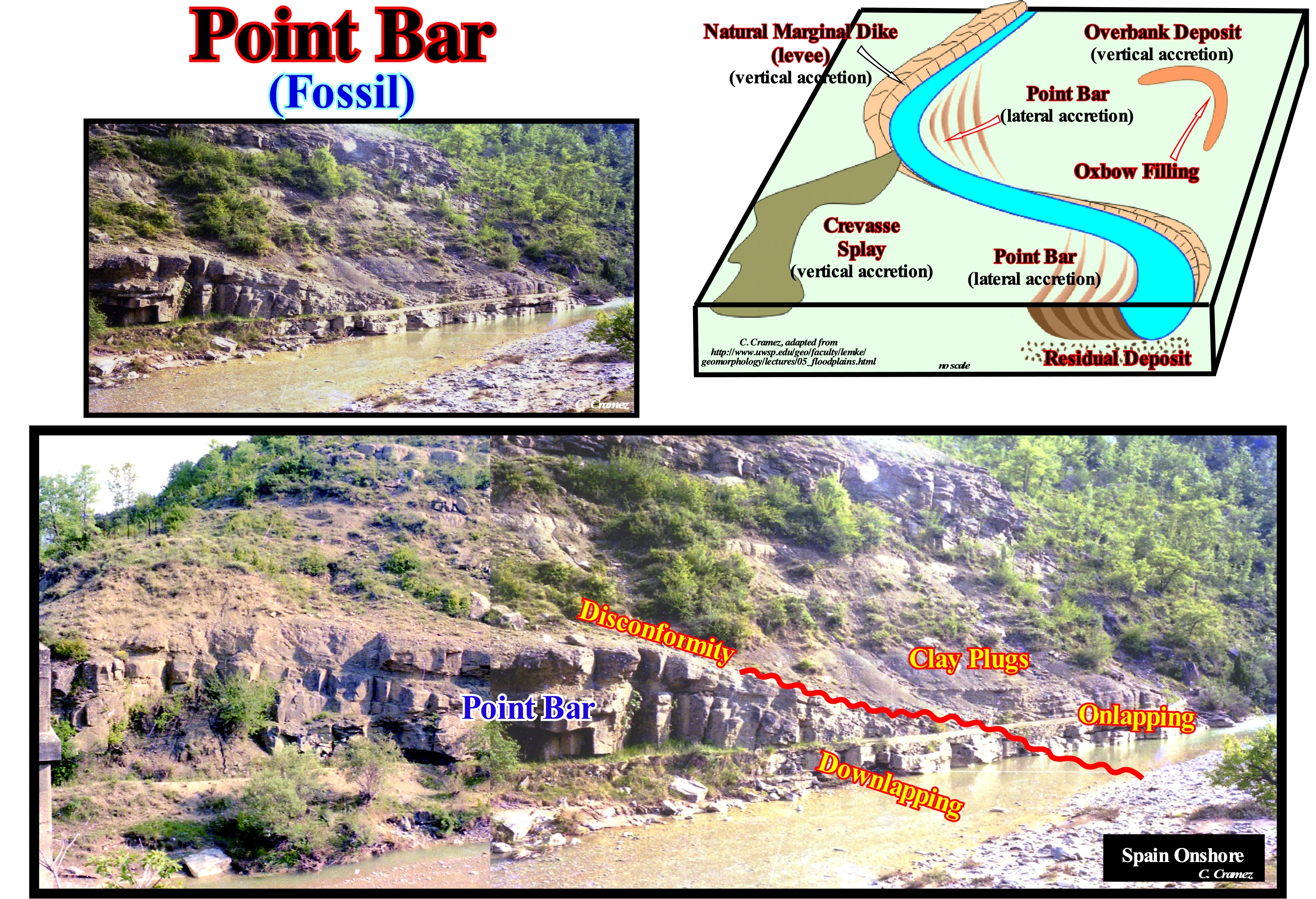
In nonmarine deposits and, particularly, in fluvial environments, as illustrated in this fossil point bar, the downlaps are very characteristic. The inclined strata of the point bar terminate, at the base, i.e., against the fluvial incision surface (not visible in the photograph of this figure) by downlaps. The discontinuity*, underlined by the undulating red line, is not an inconformity in terms of sequential analysis, meaning that it was, probably, not induced by a significant fall of the relative sea level (result of the combined action of the tectonics and the absolute or eustatic sea level, which is supposed to be global and referenced to the Earth's centre) that produced a regional erosional surface. Most likely, this discontinuity was created by a meander cut-off, which individualized an oxbow lake, which was later fossilized by clay plugs. The basal shaly sediments, which fill the old oxbow lake and form the first clay plug, rest by onlapping against the discontinuity that limits the outside of the point bar. As in this type of sedimentary environment, where erosion and deposition are, almost always, synchronous, the term unconformity can not be used as it is, usually, in sequential analysis. In sequential stratigraphy, an unconformity corresponds to an erosional surface induced by a fall of the relative sea level (local sea level referenced to a local point, which may be the top of the continental crust or the sea floor), which moves seaward the coastal onlaps exhumed, wholly or partially, the continental platform (if it exists, since within a sequence-cycle, the basin may not have continental shelf). The erosional surface, which characterizes an unconformity, is later fossilized by the marine and coastal onlaps of the overlying sediments. However, on the seismic lines, these reflection terminations are just evident in submarine canyon fills, near the basin edge and in incised valley fills (non-marine onlaps are, rarely, visible on the seismic data). The sedimentary environment where the point bars are deposited is located upstream of the coastal onlaps, which means that the incision surface of the river, whether original or reactivated (rupture of the provisional equilibrium profile) can, eventually, correlate laterally with an erosional surface (unconformity). But in geology, as in all sciences, a correlation may not be a cause-and-effect relationship. The sediments that fill the fluvial incision, where several discontinuities are always visible, are associated more with the lateral variations of the flow velocity of the river than with relative sea level changes. The point bars are found in the two main types of meander: (i) Free or wandering meanders, which originate from the dynamics of the water-courses themselves, when the windings are independent of the valley and (ii) Incised meanders or of valley meanders, which have their curves coincident with the topographic trace of the valleys. The term valley corresponds here to the depression of the terrestrial, elongated, relatively narrow and dipping surface, which may or may not be occupied by a water course along which one can differentiate: a) The headwater (upper path); b) The mouth (lower path) ; c) The flanks or slopes (the sides) and d) The thalweg, which corresponds, practically, to the deepest part of the stream bed.
(*) In geology, for many geoscientists a discontinuity designates a transition or contact between intervals (a) of different densities, such as Mohorovičić discontinuity, (b) with different sedimentary facies, or (c) between intervals separated by a hiatus ( absence of important deposition). There are several types of discontinuities: 1- Stratigraphic ; 2- Sedimentary ; 3-Lithologic ; 4 - Tectonics, etc. Within the lithological discontinuities, which are the most important in sequential stratigraphy, we can recognize: (i) Concordant Discontinuities, when there is continuity between successive intervals ; (ii) Paraconform Discontinuities or Paraconformities, when there is no difference in attitude between overlapping intervals, but there is a gap due to the absence of significant deposition between them ; (iii) Non-conform Discontinuities or Non-Conformities (which certain authors call Heterolithic Unconformity), when there is a contact between a sedimentary interval and an older igneous body ; (iv) Disconform Discontinuities or Disconformities, when the layers of the intervals are parallel on one side and the other side of the contact surface which does not conform to the regional stratification ; (v) Discordant Discontinuities or Unconformities when the two intervals are separated by an erosion surface induced by a relative sea level fall ; (vi) Tectonically Enhanced Unconformities when the sediments of the interval underlying an unconformity were deformed by tectonics (shortened or extended) ; (vii) Intrusive Discontinuities, when an igneous body traverses a sedimentary series ; (viii) Mechanical Discontinuities, when they are induced by faults, etc. (https://estpal13.wordpress.com/2013/06/04/ discontinuities-sedimentary-and-stratigraphic /)
Point Bar (Model)....................................................................................................................................................................................Barre de méandre
Barra de meandro / Barra de meandro / Point-bar / 点吧 / Прирусловый бар (модель) / Meandro bar /
Accumulation of silt, sand or gravel deposited in loose, almost stagnant water (little energy and no transport competence), either within a stream that swirls or in the convex part of a meander and which was later fossilized by overlying sediments.
See: « Point Bar (fossil) »
&
« Point Bar (seismic) »
&
« Neck, Chute Cutoff »
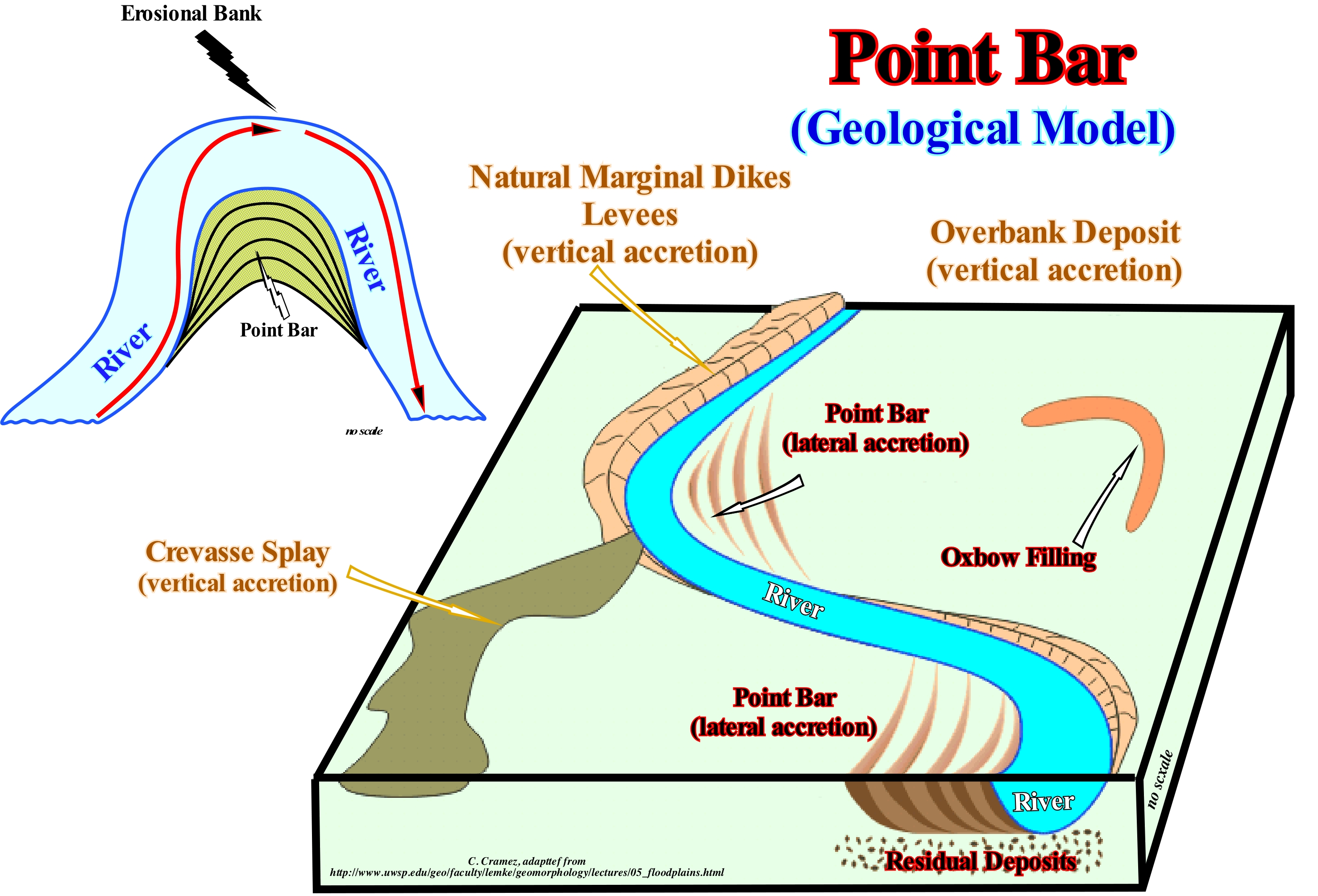
The most likely model for forming a point bar is summarized in these sketches. The basic conjecture is that a stream or a meandriform river represents a balance between: (i) The effects of friction and the inertia of the water runoff and (ii) The natural tendency for water to follow the shortest path and greater slope. In regions that are not rich in sediments, rivers tend to form semicircular channels in which the fastest flow is located in the central part as if the channel were rectilinear. When the channel is curved, as it happens most of the time, the inertia pushes the flow zone faster against the concave bank, which is eroded to create an erosional bank. In contrast, along the convex meander bank, as the water runoff is weak (loose water), a part of the transported sedimentary particles deposited forming a point bar. Erosion on the concave bank and deposition on the convex bank forces the river bed (channel) to migrate towards the concave bank until a meander cut-off is formed, i.e., a direct passage of the current. between two consecutive concave banks and forms an oxbow lake in the part of the abandoned canal. Generally, a meander cut-off occurs during a river flood period, during which the main flow is diverted to the depressive zone between the point bars, since the water has the natural tendency to follow the shortest path and higher dip (law of Fermat-Maupertius or principle of minimum action and law of Snell or principle of minimum time). Over time, a point bar is fossilized, laterally, by the clay sediments deposited in the oxbow lake, when the channel is, finally, abandoned (definitive cut-off) or by an alternation of clay and sand, when the canal is abandoned intermittently (intermittent cut-off). This mechanism is valid not only for meander of the alluvial plain meander, but also for valley meanders.
Point Bar (Seismic)................................................................................................................................................................................Barre de méandre
Barra de meandro / Barra de meandro / Point-bar / 点吧 / Прирусловый бар (сейсмика) / Meandro bar /
A set of seismic reflectors that underline an accumulation of silt, sand, gravel or gravel which has, probably, been deposited in loose water (low energy and without transport competence) either inside a swirling river or in the convex part of a meander and which was fossilized by overlying sediments.
See: « Point Bar (model) »
&
« Point Bar (fossil) »
&
« Clay Plug »
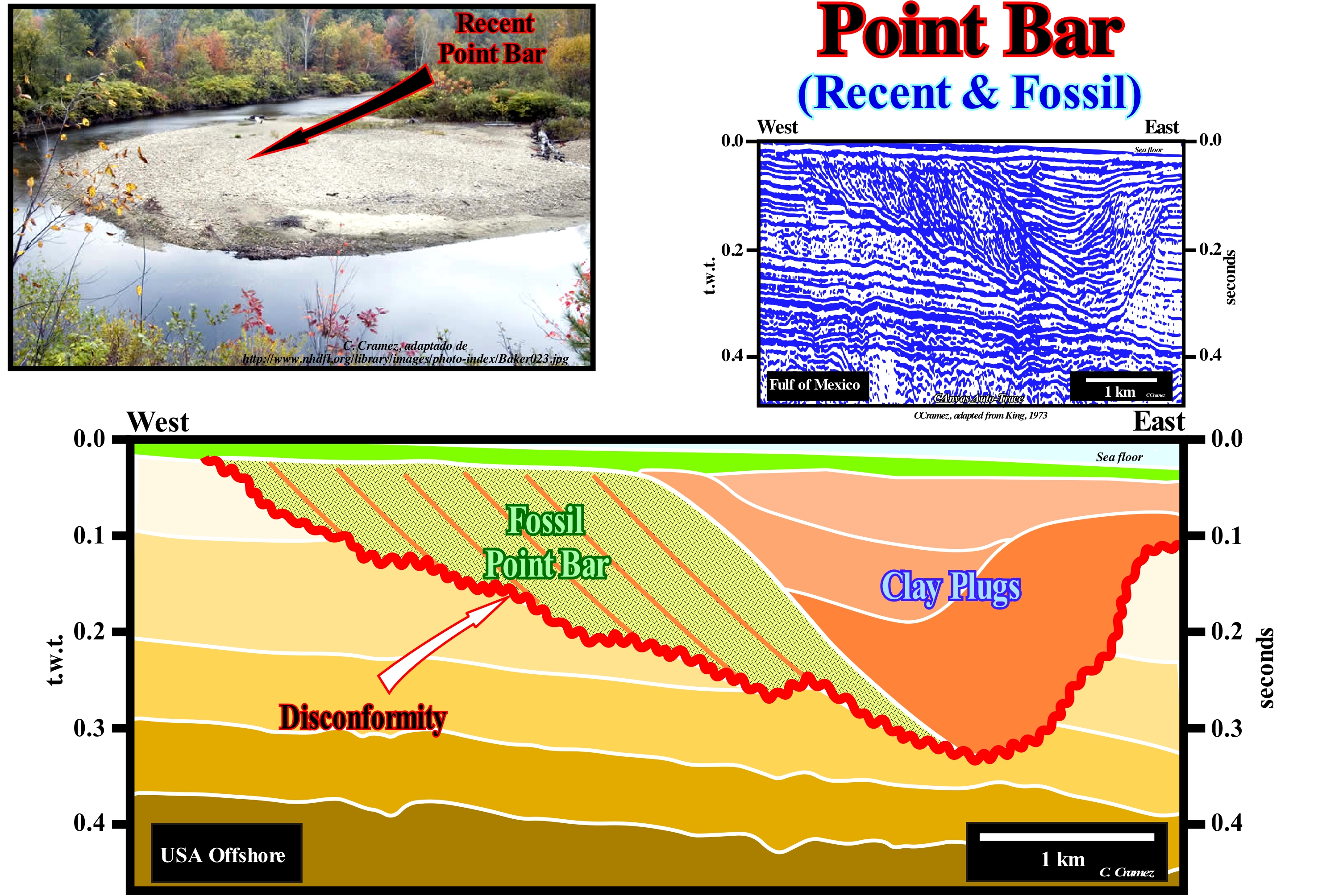
On this tentative geological interpretation of a Canvas auto-trace of a conventional offshore (less than 200 m of water) seismic line*, a point bar is recognized by the progradational geometry towards the concave bank of the meander and by successive clay plugs. The toplaps and downlaps of the point bar, as well as the onlaps of the clay plugs, are easy to recognize. The downlaps of point bar and the onlaps of lower clay plug fossilize the fluvial incision created, probably, by a relative sea level fall (a combination of absolute or eustatic sea level, which is referenced to the Earth's centre, and tectonics) that displaced downward the coastal onlaps forcing the currents to incise new beds to restore new provisional equilibrium profiles. Thus, if this conjecture is not falsified, it may be said that the fluvial incision (disconformity on this tentative interpretation) correlates with a (regional, at least) unconformity created by a relative sea level fall. The different clay plugs, created by intermittent abandonment of the main channel of the current, are separated by disconformities characterized by onlaps, which can not be considered as unconformities in the sense of sequential analysis. The deposit of the point bar and clay plugs is not associated with any relative sea level rise (marine ingression). The migration of the point bar towards the concave bank is a function of the different flow rates of a curved stream. The clay plugs correspond to the decantation deposits of the oxbow lakes. As several clay plugs can be evidenced by the geometrical relationships between the reflectors, the most likely one is that the abandonment of the meander channel was done in several steps or, in other words, that the meander cut-off left several times to be active and, that the course of the current has taken up several times the old bed, which, later, was definitively abandoned.
(*) The vertical scale of this Canvas auto-trace strongly suggests that this seismic line is a high-resolution line, probably, shot with an acoustic source of the Sparker type (consisting of several electrodes between which an electric discharge occurs which heats and vaporizes the water, shock wave that propagates through the aquatic environment and that continues to propagate in the marine subsoil).
Point of Overbanking.......................................................................................................................................................Point de déviation
Ponto de desvio / Punto de desvío / Ablenkpunkt / 偏转点 / Точка отклонения / Punto di deflessione /
Point where the most dilute part of a turbidite current escapes over a topographic confinement to deposit a part of the clayey material which it carried in the lower areas between overbank deposits (between the "gull wings") of the submarine slope fan. The more flow stripping form, the more the main current becomes rich in sand and the more sandy are the terminal lobes.
See: « Flow-Stripping »
Polar Motion.........................................................................................................................................................................................Mouvement polaire
Movimento polar / Movimiento polar / Polbewegung / 極運動 / Полярные движение / Polodia /
Movement of the Earth's axis of rotation through the Earth' surface.
See : « Precession »
Polar Traction (Drift).......................................................................................................................................................................Traction polaire
Tracção polar (deriva polar) / Tracción polar / Polar Traktion / 极地牵引 / Полярное растяжение / Trazione Polar /
Geological phenomenon caused by the variations of magma flow in the outer core of the Earth, which causes changes in the orientation of the Earth's magnetic field and the position of the Magnetic North Pole. The Magnetic North Pole is approximately 965 km from the geographic North Pole. Each day, the pole drifts significantly, and moves about 10 to 40 km per year, as a result of polar traction.
See : « Earth »
&
« Milankovitch's Cycle »
&
« Magnetics »
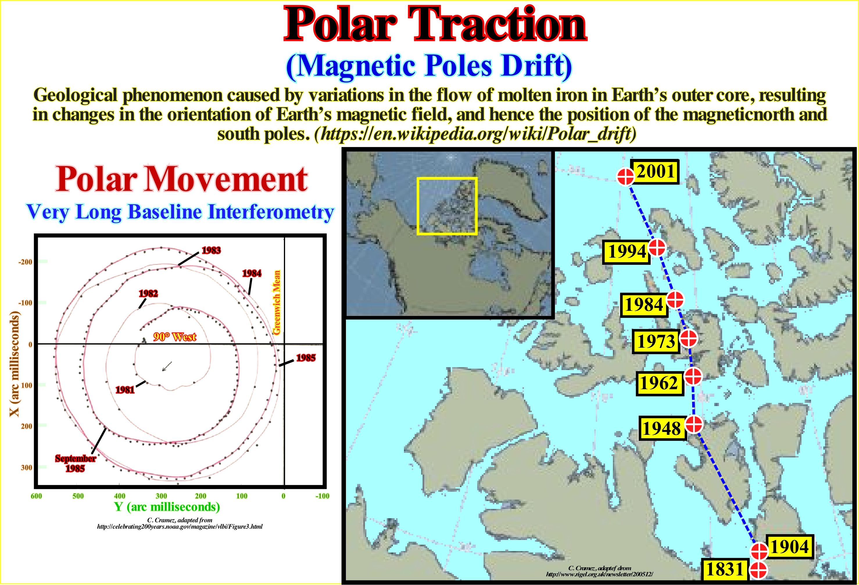
The Earth's magnetic north pole is moving away from North America towards Siberia at such a speed that Alaska can lose its spectacular aurora borealis in the near future. Despite the accelerated movement over the last century, the possibility that the Earth's magnetic field collapses is remote, but such a shift may mean that auroras borealis become more visible in southern Siberia and Europe. The magnetic poles mark the axis of the magnetic field generated by the liquid iron of the Earth's core and are far from coinciding with the geographic poles. Scientists have known for a long time that magnetic poles migrate, and can be seen when they move, although we do not know why. Certain studies have shown that field strength has decreased by 10% over the past 150 years. During the same period, the magnetic north pole deviated about 685 miles into the Arctic. The rate of movement increased in the last century, compared with the relatively stable movement of the previous four centuries. The figure on the left illustrates the projection of the polar motion determined from the VLBI (Very Long Baseline Inferferometry) observations. The small points are the positions of the geographical pole determined by VLBI in relation to the adopted international origin and based on the location of the geographical pole around 1900. The displacement of the centre of the VLBI runway to international origin represents the long-term drift of pole. The red line is the path made by the pole determined by the "Bureau International de l'Heure" using all available observations collected by various techniques. At present it can be said that since 1900, to the polar movement (here of the North Pole), this is the slow displacement of the poles was about 20 meters and that it was mainly caused by the movements in the Earth's core and the mantle, and partly because of the redistribution of the body of water, such as the ice of part of the Greenland ice cap and the isostatic recovery (isostatic rebound), that is to say, the slow rise of the land which was formerly overloaded with ice sheets and glaciers. The displacement seems to have been made along the meridian 80° West. This kind of displacement, which has nothing to do with polar traction, should not be confused with the polar drift induced by the rotation of the Earth which certain geoscientists call the true polar deviation. The true polar deviation observed in all rotating celestial bodies corresponds to the rotation of a planet or a moon in relation to its axis of rotation, which causes a change in the geographical location of the North and South (geographic) Poles. On the other hand, polar traction is not to be confused with precession or nutation, which is where the axis of rotation shifts (when the North Pole points to a different star), which are caused by the gravitational attraction of the Moon and the Sun and occur all the time and at a much faster rate than polar drift. In the same way polar traction has to be differentiated from continental drift, which is when the different parts of the Earth crust move in different directions, probably, due to the convective currents of the mantle material. Likewise, it should not be confused with the geomagnetic inversion that describes the proven repeated inversion of Earth's magnetic field. Do not forget that the Earth is not a real sphere. It has three orthogonal axes of inertia. The axis around which the moment of inertia is greatest is, practically, aligned with the axis of rotation (the axis passing the North and South Poles). The other two axes are near the equator.
(*) Solar winds that reach the atmosphere in a zone around the Magnetic North Pole, forming arcs, waves, and clusters of light moving through the sky, with sudden rays of light drawn down.
Polar Wandering (Poles migration)................................................................................................Migration polaire (Errance polaire)
Migração polar / Migración de los polos / Polar Wandern / 极地游荡 / Движение полюсов / Vagando polar /
Displacement of the poles of the Earth invoked to explain the glaciations of the Appachian orogeny (North America, South Africa, Australia and India). Several geoscientists have admitted that when these regions were agglutinated (Gondwana little supercontinent), the South Pole was located in the Pacific Ocean, not far from the Hawaiian Islands. Kreichgauer (1950), to explain the great ice cover between North America and Northern Europe, admitted that at the beginning of the Cenozoic, the North Pole moved to Alaska and then to South Greenland and that the Quaternary is due to the displacement of the North Pole from South Greenland to its present position. Note that except for the small period movements, are the continents and not the poles that move.
See: « Supercontinent »
&
« Gondwana »
&
« Baltica »
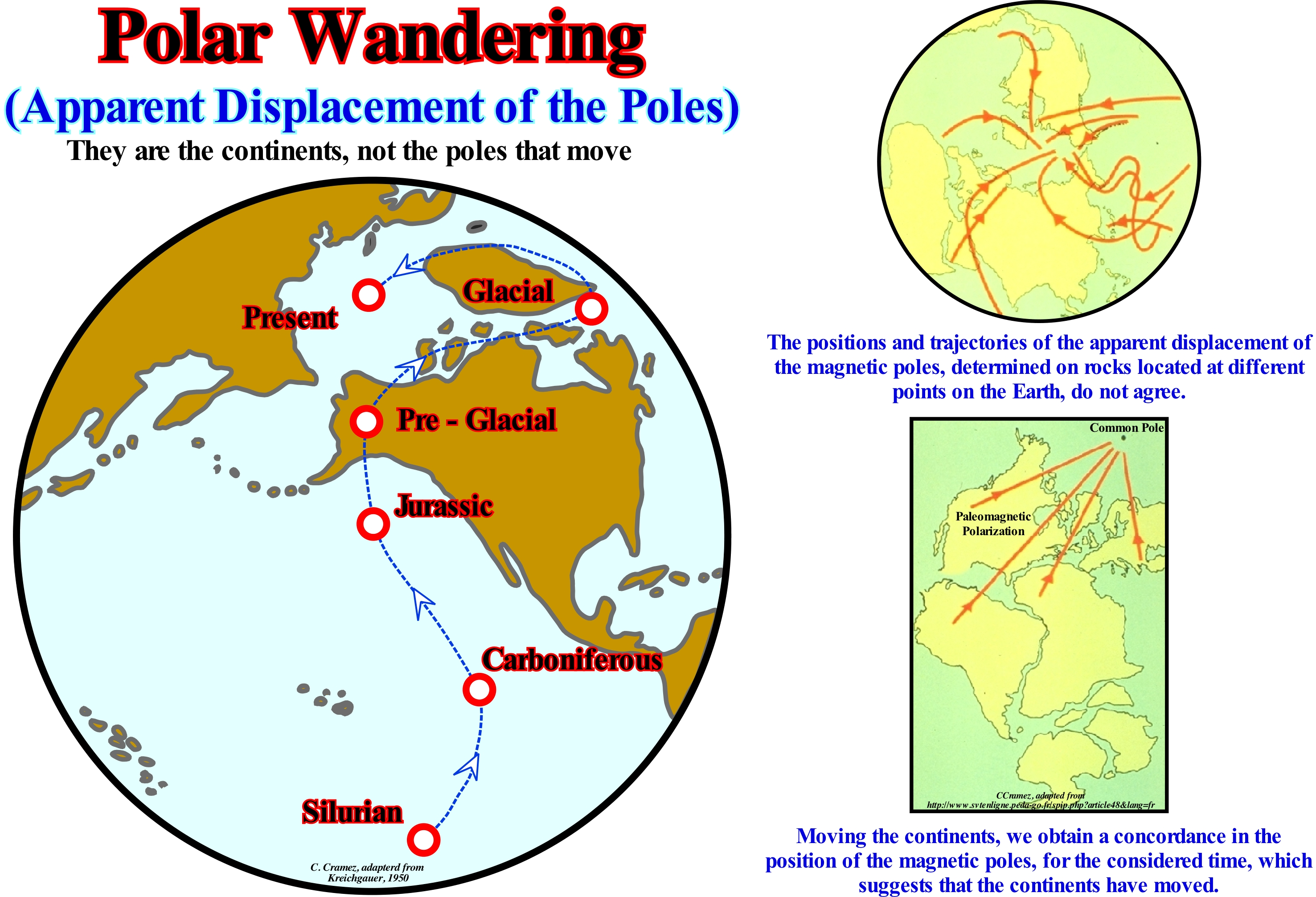
First of all, we must not forget that there are two polar migrations or drifts: (i) True Polar Migration and (ii) Apparent Polar Wander (APW). True polar migration is the movement of the Earth relative to its rotation axis in order to re-align the major axis of the moment of inertia with the axis of rotation. In a stable situation, the largest axis of the moment of inertia* is aligned with the axis of rotation, with the two small axes in the plane of the equator. In a non-stable situation there is true polar drift. The apparent polar deviation is the movement of the Earth's paleomagnetic poles (which are not fixed) in relation to a continent, considering the continent with a fixed position. The apparent polar migration is often presented in current latitude/longitude maps, such as the trajectory of the different geomagnetic pole locations determined at different times using paleomagnetic techniques. The Earth's magnetic field can be represented by a centred dipole whose axis is inclined more or less 11,7° in relation to the axis of rotation of the Earth. The dipole axes intercept the Earth's surface at the following antipodes coordinates: 79.3° N; 288.6° E and 79.3° S; 108.6° E. These poles are called geomagnetic poles (points of intersection of the line passing through the Earth' centre, along the dipole axis). Since the magnetic poles (points on the Earth's surface where the magnetic field is vertical) are relatively stationary over time, geoscientists often use magnetic minerals to find the continent's latitude toward magnetic poles of the time. As the continents have moved in relation to the magnetic poles, one can imagine that the continents were always fixed and that were the magnetic poles that moved. With sufficient data, it is possible to reconstruct the movement of the continents relative to the magnetic poles. The apparent polar deviation is nothing more than the trajectory that the magnetic pole would have made in relation to the continents. In fact, geoscientists have long found that the directions of magnetization of many rocks did not correspond to the present direction of the Earth's magnetic field. This figure shows the different positions of the North Pole from the Early Paleozoic to the present (apparent polar migration). During the Early Paleozoic, it was located in the Pacific Ocean. In the Carboniferous, it was located near the equator, whereas during the Jurassic, it was, more or less, to the latitude of Vancouver (Canada). In the pre-glacial age, the North Pole was located in Alaska. However, during the glacial ages it was situated between Greenland and Baffin Island (Canada). If the continents had fixed positions, it could be assumed that the magnetic pole paths on the Earth's surface were a global phenomenon, independent of the location of the observer. However, since the poles of migration of the poles to the different continents do not agree with each other, this has become one of the first evidences of the dispersion and displacement of the continents. As the migration curves of the poles converge to the present location, it is possible to determine the relative movement of the different continental blocks during the different intervals of geological time. It may be said that the relative movement of the poles may be due to the true or derivative polar migration of the continents (or a combination of two). Data from all over the world is needed to isolate or distinguish between these two possibilities. However, on Earth, as magnetic poles seldom depart from geographic poles, the concept of apparent polar motion is very useful in plate tectonics, since it may retrace the relative movement of the continents, as well as formation and break-up of the supercontinents. Do not forget that the vast majority of geoscientists instead represent the position of the continents over time using the paleomagnetic poles for paleogeographic reconstructions, use the apparent polar drift curves, which can be determined more easily. In conclusion: it is not the poles that move, but the continents.
(*) The inertia's moment or moment of inertia of mass expresses the degree of difficulty in changing the state of motion of a rotating body (https:// pt.wikipedia.org/wiki/Momento_de_inércia). Unlike the inertial mass, the moment of inertia or inertia tensor also depends on the distribution of mass around an arbitrarily chosen axis of rotation. The greater the moment of inertia of a body, the harder it will be to make it rotate or change its rotation.
Polarity (Sensu lato)........................................................................................................................................................................................Polarité (Lato sensu)
Polaridade (lato sensu) / Polaridad (sensu lato) / Polarität / 极性 / Полярность / Polarità /
Quality of what has opposite senses, such as faults, progradations, etc. Synonym with Vergence.
See: « Vergence »
&
« Fault »
&
« Progradation »
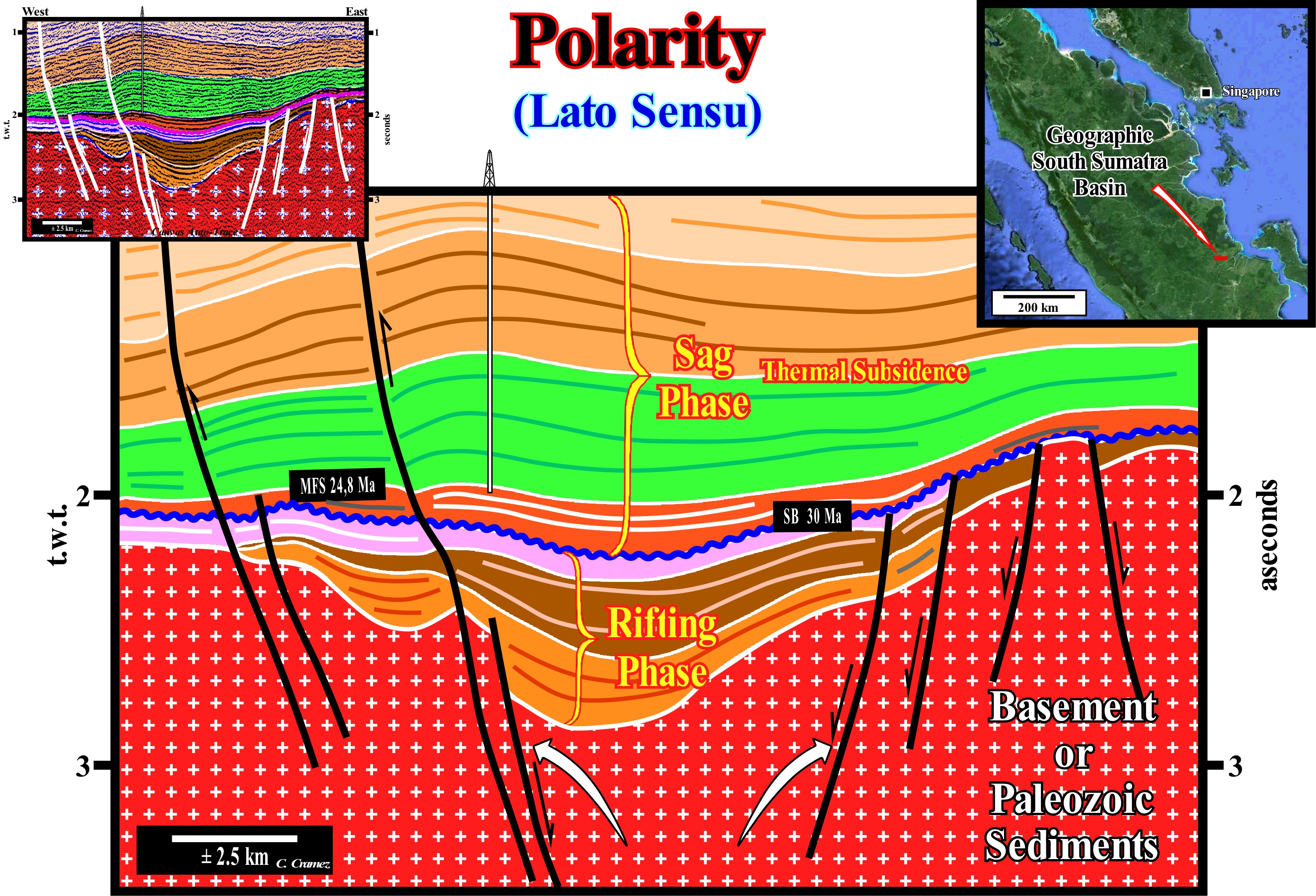
On this tentative geological interpretation of a Canvas auto-trace of onshore seismic line of the Sumatra Island (Indonesia), the faults have an opposite polarity, that is to say, they dip in opposite directions. Originally, these faults were normal and developed during the rifting phase (lengthening of the sediments) of the back-arc basin southern Sumatra Island. Later, during the sag phase (thermal subsidence phase), some of them were reactivated as reverse faults, which created very marked tectonic inversions on this line. This tentative interpretation suggests the following geological history: (i) In association with the B-type subduction zone, located westward of Sumatra Island, the continental crust of the gentle lithospheric plate was elongated by normal faults with opposite polarity or vergence ; (ii) Normal faults have created rift-type basins, that is to say, half-grabens, which were, largely, filled by lacustrine rocks rich in organic matter (potential source-rocks) ; (iii) Differential subsidence, which is the origin of the formation of the rift-ype basins, produced (cause or effect) a rise in the isotherms (thermal anomaly) ; (iv) Later, the isotherm deepened and re-established a thermal equilibrium, which means that the differential subsidence of the rifting phase was replaced by a thermal subsidence ; (v) Thermal subsidence in association with eustasy (absolute or eustatic sea level changes) creates a cratonic basin (sag phase of the back-arc basin) above the continental crust and the rift-type basins ; (vi) The cratonic basin is filled by marine sediments, during the basal transgressive basal episode, and by sediments, mainly, non-marine, during the upper regressive episode ; (vii) Sedimentary intervals with petrophysical characteristics of reservoir-rocks (reefs and sandstones) and sealing-rocks (shales) were, mainly, deposited during the thermal subsidence phase ; (viii) As this basin is located within the Meso-Cenozoic megasuture (compressional global tectonic context), from a certain moment, the sediments were shortened with the old normal faults playing as inverse faults, which produced magnificent tectonic inversions, in which the low structural points become high points and the highs point become low points, as illustrated above.
Polarity (Seismic)..................................................................................................................................................................................................Polarité (Sismique)
Polaridade (sismica) / Polaridad (sísmica) / Polarität (seismische) / 极性(地震) / Полярность (сейсмическая) / Polarità (sismica) /
Graphical representation of the amplitude, leftward or rightward, relative to the axis of the trace of a seismic reflection. In the representation of the seismic data, the choice of the parameters that control the reproduction of the interpolation trace is critical for the final aspect of the lines and their interpretation. The simplest method is to illustrate the data in an undulating trace, where the distance from the trace axis represents the amplitude of the reflection. The polarity is given by the sense of the amplitude representation in relation to the axis (vertical) axis of the trace, rightward or leftward.
See: « Seismic Reflection »
&
« Impedance (acoustical) »
&
« Amplitude (seismic reflection) »
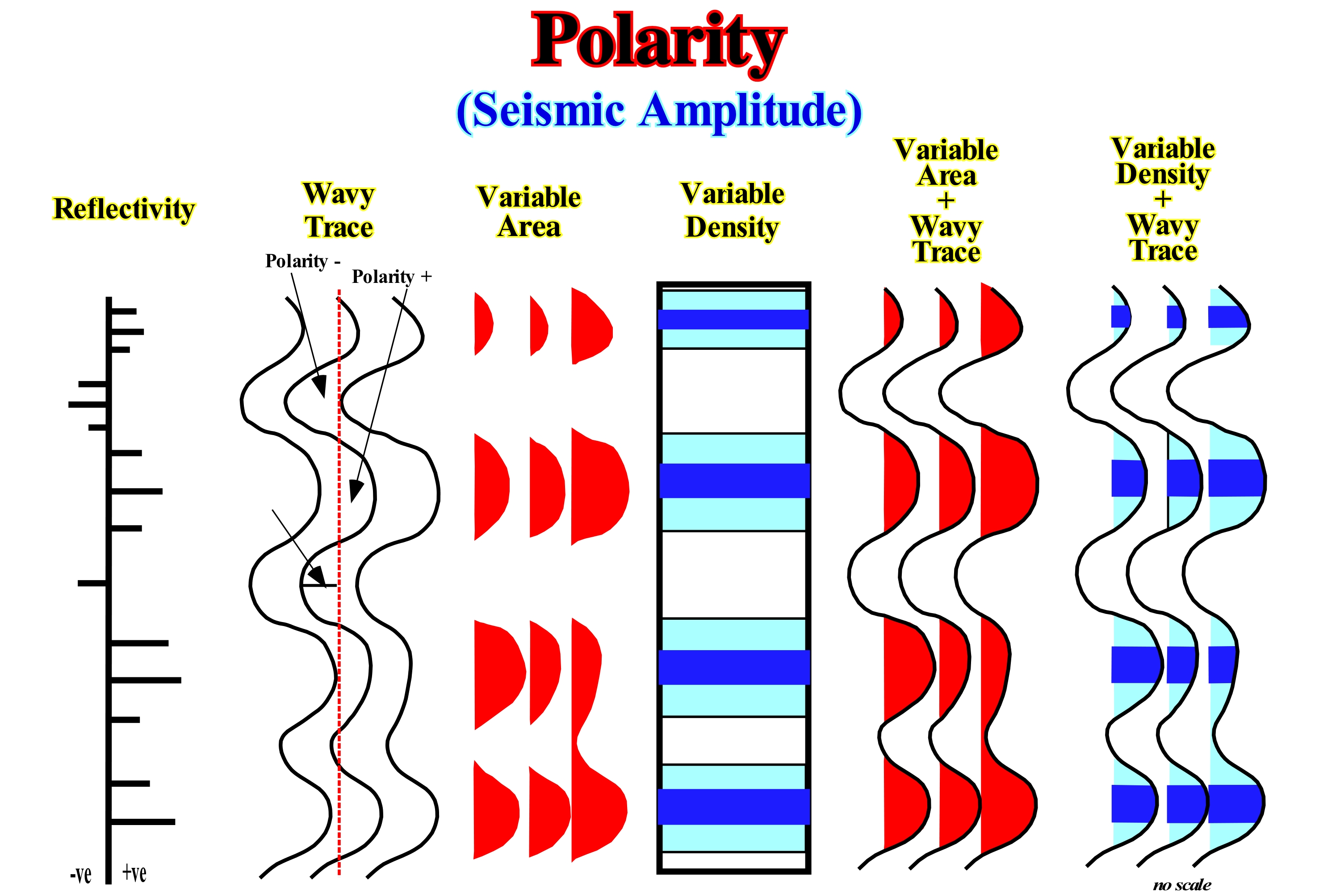
The simplest way to represent the seismic data on a profile is to illustrate them by undulating or wavy traces to the right or left of a baseline. Each trace represents the amplitude of reflection, which, of course, varies in depth. Displacements of the amplitude to the right or left from the baseline represent the polarity. According to the European Society of Geophysics (SEG) convention, a reflection with a positive polarity (poor acoustic impedance above a strong impedance) is represented by a deflection to the right of the baseline, which is colored black. A reflection with a negative polarity (strong acoustic impedance above a weak impedance) is represented by a deflection to the left and colored in white. There are several alternatives to the representation of the wavy trace, but they are little used, although some have certain advantages. In a variable area representation, there is no continuity in the traces, but the amplitude of the values is shown and is, generally, colored in black (SEG convection). In a representation with variable density, variations in the amplitude of the reflections are underlined by different shades or colourings. The variable area can be combined with the wavy trace. Also the variable density can be combined with the wavy trace. Each representation has its advantages and disadvantages. A combination of the different representations is sometimes used in detailed studies and, especially, when the interpreter is interested in the attributes of the reflections, which can give indications on the petrophysical characteristics of the reservoir-rocks, that is to say, on the porosity, permeability, but also on the extent and presence of hydrocarbons.
Polarity Magnetic..............................................................................................................................................................Polarité magnétique
Polaridade magnética / Polaridad magnética / Magnetische Polarität / 磁极 / Магнитная полярность / Polarità magnetica/
Orientation of the Earth's magnetic field. The polarity of a certain time is the period of time during which the Earth's magnetic field is oriented either in the normal direction (current direction of the Earth's magnetic field) or in the reverse direction. The polarity of the terrestrial magnetic field of a certain time is contrary to the polarity of the previous epoch.
See: « Magnetics »
&
« Polar Drift »
&
« Radiometric Dating »
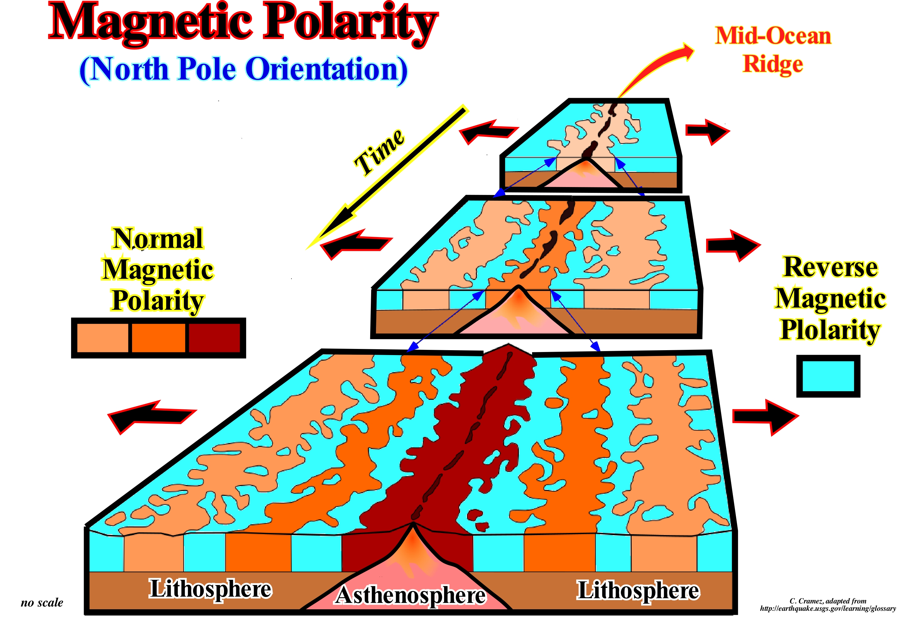
Magnetic polarity is a function of the position of the Earth's magnetic pole relatively to the Earth's North Pole. When the North Pole of the Earth's magnetic field is close to the Earth's North Pole, as is the case today, magnetic polarity is said to be normal. Throughout geological history, this has not always been the case. It is often the South Pole of the Earth's magnetic field near the Earth's North Pole. In this case, the magnetic polarity is said to be inverse. It can be said that an inverse magnetic polarity is a change from the earth's magnetic field to an opposite polarity. These changes occur throughout geological history in, more or less, irregular periods of time. What is more interesting to geoscientists is that inverse magnetic polarities can be preserved in sequences of magnetized rocks and thus can be compared with scales of change of polarity patterns, which allows to determine the most probable geological ages of rocks . As illustrated in the sketch depicted above, the rocks formed in the mid-ocean ridges retain the polarity of the Earth's magnetic field from the moment they solidify. Some bands have a normal polarity and others reverse, which allows not only to determine the different ages of the oceanic ridges, but also to determine the rate of oceanic expansion (sea floor spreading). This is how geoscientists have found that the highest rate of oceanic expansion occurs in the eastern Pacific Ocean (about 12 cm per year) and that in the Atlantic Ocean it is only 2 cm per year. One can say the rate of expansion in the Atlantic is, more or less, the rate of growth of the nails of the hand. An oceanic expansion of 2 cm per year implies that the rocks of the oceanic crust that formed 1 million years ago are currently about 20 km on each side of the ridge where they formed.
Polimorphic Delta (Complex shaped delta)..........................................................................................................Delta complexe
Delta complexo / Delta complejo / verwickelt Delta / 复杂形三角洲 / Дельта со сложным строением / Delta complesso /
Delta characterized by a large extension of the deltaic plain, in which the dynamic irregularities produce a great variety of morphologies. In this type of delta can be developed, locally, sectors in which the delta is lobated, rounded, atrophied, cruspate, etc.
See: « Delta »
&
« Delta Plain »
&
« Foreset Bed (of a delta) »
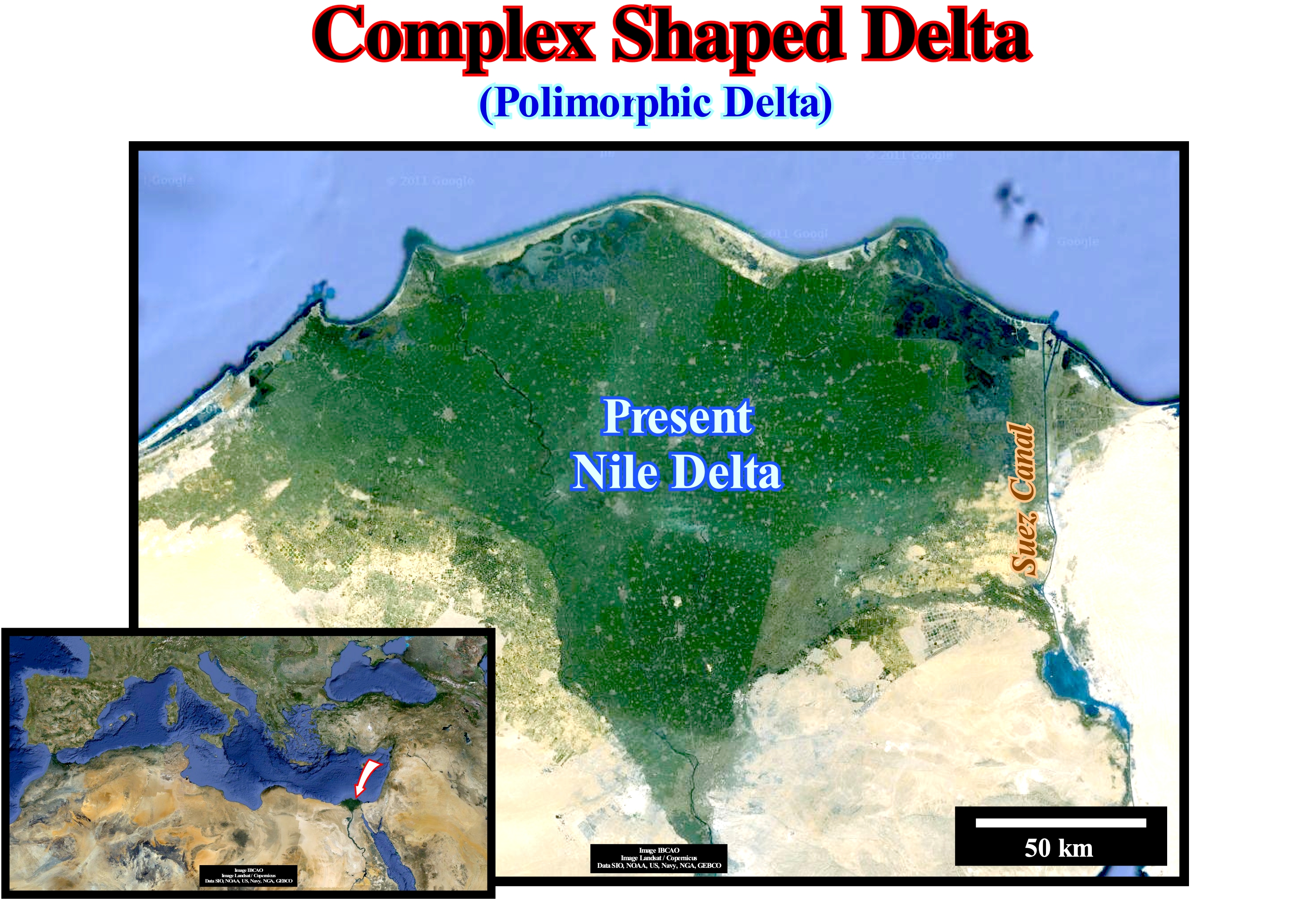
The Nile delta is located in the north of Egypt, where the Nile River deposited a huge delta building, as its mouth advanced seaward. This delta building is one of the largest in the world. It begins a little south of the city of Cairo, where the delta apex (the point of defluence of the river channel, which is more upstream and which marks the upper limit of the delta) is located, and extends until to the Mediterranean Sea over a distance of about 160 km and with a thickness of several kilometers. The delta shoreline is about 240 km, between the cities of Alexandria to the west, and Port Said to the east. The delta building is, basically, complex, since locally, in association with the different distributaries (streams flowing out of the main channel of the river) that make it up, several morphologies can be observed, as the suggests the geometry of the shoreline. The fluctuations of the river always exerted a strong influence on the development and morphology of the delta building and, subsequently, on the location of the settlements and plantations. In the time of Herodotus (between 484 and 420 BCE), the Nile delta had five branches, which from West to East are: (i) Canopic from Canopo city name (near Abukir city) ; (ii) Saitic from the name of the fifth Sais or Sa el-Hagar ; (iii) Sebenitic, named after the 12th name of Sebenites ; (iv) Mendesian, named after the gulf of Djedet (now Tell El-Ruba) and (v) Pelusiac Branch, named after the city of Pelusy. At present, there are just two branches, which are known as the Roseta branches (about 65 km east of Alexandria) and Damietta. For thousands of years, settlements in Lower Egypt protected themselves from the floods and variations of the Nile's flow, settling on the mounds of sand (Egyptian turtle backs *), which are geological remnants that the pre-Nile formed about 15,000 years ago. Unfortunately, since the Aswan dam was built in upper Egypt, which aimed to regulate floods, irrigate millions of square kilometers of desert and obtain cheap energy for the country's industrialization, the delta no longer receives any nutrient and sediment input from the streams upstream of the dam, which has disastrous consequences for the environment: (i) The floodplain soils have become almost barren, requiring populations to use huge quantities of fertilizers with all the consequences that this entails ; (ii) The arable layer of the soil, which before the dam could reach a thickness of about 2 meters, is now much smaller, which inevitably has produced a rise and contamination of the water table ; (iii) The erosion of the delta has increased in a frightening way (several tens of km2 per year), which leads some geoscientists to believe that the Nile delta will probably not survive this millennium. To make matters worse, Ethiopia plans to build a dam (Renaissance) to store water, produce energy and irrigate its plantations. Until very recently, according to the agreements signed with Sudan and Ethiopia, Egypt receives about 55 million cubic meters of water from the Nile. However, times have changed, populations have grown and the energy needs of the region as well. The war for water is intensifying and should worsen even more in the future. As most geoscientists say, mankind can live without oil, but without water is another story. Other types of delta may be considered as a function of the dynamics of the delta and the shape of the emergent plain: (i) Abandoned Delta or sub-delta ; (ii) Alluvial delta ; (iii) Arctic Delta; (iv) Lobated Delta ; (v) Atrophied Delta; (vi) Cuspate Delta; (vii) Finger Delta; (viii) Flood delta ; (ix) Closed Delta; (x) Gilbert-type Delta; (xi) Lava Delta ; (xii) Delta lobed; (xiii) Tidal delta ; (xiv) Submarine Delta; (xv) Storm Delta ; (xvi) Wave Delta ; (xvii) Ebb Delta, etc.
(*) These topographic anomalies called turtle back have nothing to do with the tectonic inversion structures induced by the lateral and vertical movement of the salt interval, such as those found in the geographic Kwanza Basin (Angola), that the geoscientists of Petrangol (a subsidiary of the former company petroleum company PetroFina) called "Turtle Backs".
Polje ..........................................................................................................................................................................................................................................................................Polje
Polje / Polje / Polje / 科索沃波列(喀斯特) / Полье / Polje (Carso) /
Great closed karst depression, characterized by having a flat bottom, joining angularly with the slopes, which are generally abrupt. Its drainage is underground. It can remain dry, be crossed by a watercourse, or be permanently or temporarily flooded (Fink, 1973).
See: « Karst »
&
« Kartsification »
&
« Sinkhole »
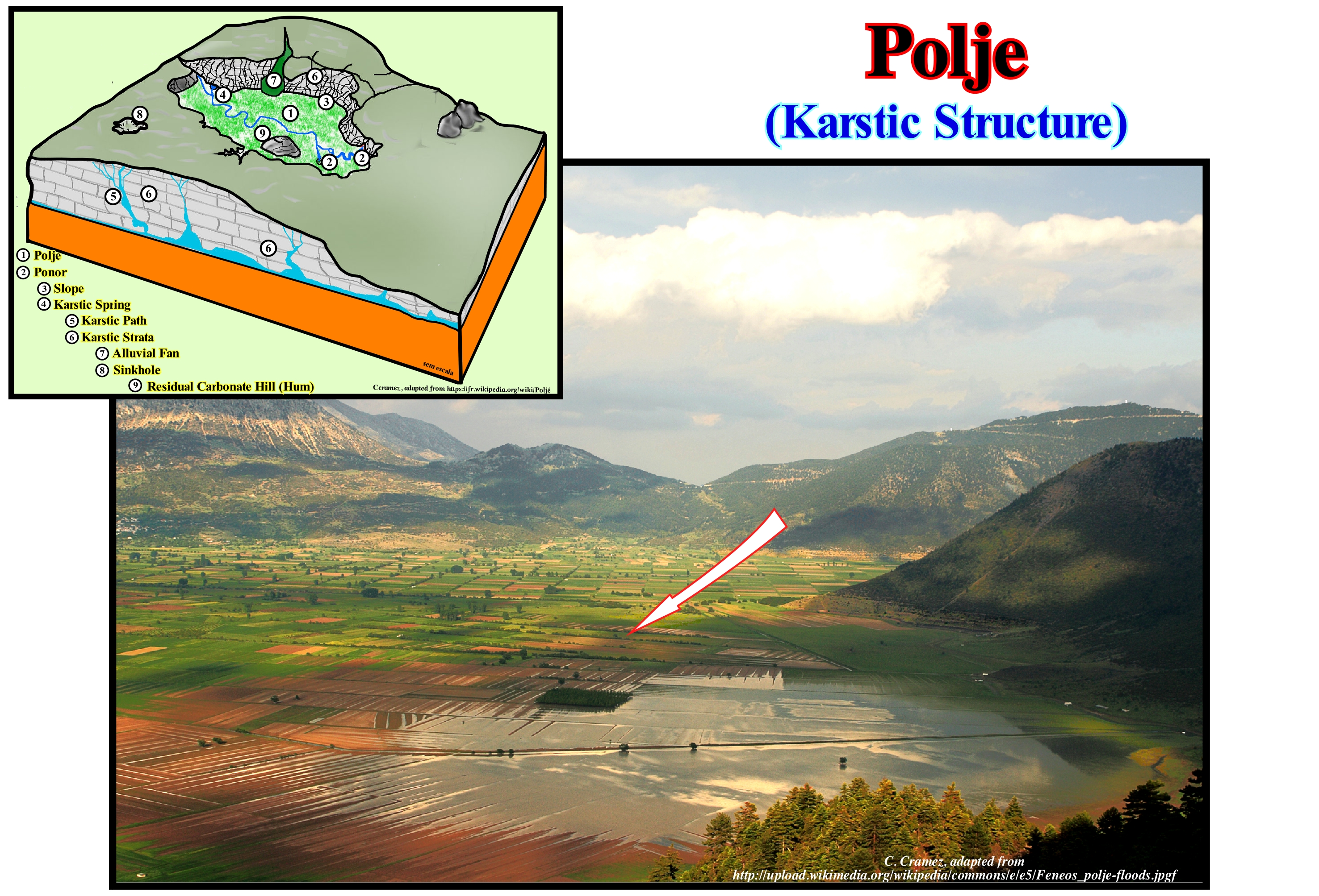
As shown in this figure, a polje is a closed or open depression in the karst, with considerable dimensions and slopes with a steep and steep slope, with the background, generally, flat and covered with "terra-rossa"* and alluviums. The basin of reception has an endorheic and centripetal drainage. The polja (plural de polje) can remain dry, be crossed by a water-course or be, permanently or temporarily, flooded. With the rise of the water table, they can be fed by exsurgents or pornors (natural openings in karst areas that communicate with a network of galleries that can serve as a sink or exsurgency depending on the water table), which can function as sinks when it comes back down. Sometimes they have hums (residual relief of limestone that rises on a surface of karst corrosion, which may have varied forms, usually pyramidal, with sharp or flat ridges, massive or rounded forms), which are a form of abrupt, isolated rocky relief and dispersed within the poles. A polje, in general, is a closed depression, being about 3 km wide and 10 km long. These are limestone plains, which began to deteriorate in the Tertiary when the climate was hot and humid and there was plenty of water with abundant vegetation and a large amount of CO2 due to decomposition. Thus, there was certainly a carbonation, since the water was acidified by CO2 from the atmosphere. These conditions, which gave more or less important activity to the region of the globe, produced a total dissolution of the limestone by combining the carbon of the water and the calcium of the rocks, forming a solution of the water charged with calcium and carbon dioxide. Polja are connected to aquifers by natural conduits. These resurgences (places where groundwater currents reappear on the surface of the ground after disappearing upstream of the water table) cause water courses or floods of associated depressions.
(*) Terra rossa (Italian for "red soil") is a well-drained, reddish, clayey to silt clayey soil with neutral pH conditions and is typical of the Mediterranean region (https://en.wikipedia.org/wiki/Terra_rossa_(soil) )
Polymer.................................................................................................................................................................................................................................................Polymère
Polímero / Polímero / Polymer / 聚合物 / Полимер / Polimero /
Macromolecule composed of a repetition of structural units, usually connected by covalent chemical bonds.
See: « Organic Matter (types) »
&
« Atom »
&
« Viruses »

A polymer is a large molecule, i.e., a macromolecule, composed of a repetition of structural units. These subunits are. usually. bound by covalent chemical bonds. Although the term polymer sometimes is used to designate plastics, it covers, actually, a broad class of natural and synthetic materials with a wide variety of properties. Natural polymeric polymers such as shellac, amber and natural rubber have been used for centuries. A variety of other existing natural polymers, such as cellulose, which is the main constituent of wood and paper. The list of synthetic polymers includes synthetic rubber, bakelite, neoprene, nylon, polystyrene, polyethylene, polypropylene, silicone etc. The properties of the polymers are, roughly, divided into several categories based on the scale at which the property is defined as well as on its physical basis. The most basic property of a polymer is the identity of its constituent monomers (a small molecule that can bind to other monomers forming larger molecules called polymers; examples of monomers are hydrocarbons, petroleum derivatives, alkanes and alkenes). A second set of properties, known as micro-structure, essentially, describes the arrangement of these monomers within the polymer on a single chain scale. These basic structural properties play an important role in determining the set of physical properties of the polymer, which describes how the polymer behaves as a continuous macroscopic material. Chemical properties, at the nanometre scale, describe how the chains interact through various physical forces. At the macro-scale, these properties describe how the polymer interacts with other chemicals and solvents. There are three main classes of biopolymers: (i) Polysaccharides; (ii) Polypeptides and (iii) Polynucleotides. In living cells, they can be synthesized by enzyme-mediated processes, such as the formation of DNA catalysed by the polymerized DNA.
Polyp.............................................................................................................................................................................................................................................................Polypier
Polipeiro/ Polipero / Polypen / 息肉 / Колония полипов / Polipo /
Biogenic construction made by coalescence of the outer skeletons of corals living in colonies. Animal or animal colony formed by the collection of polyps.
See: « Benthos »
&
« Animalia »
&
« Coral »
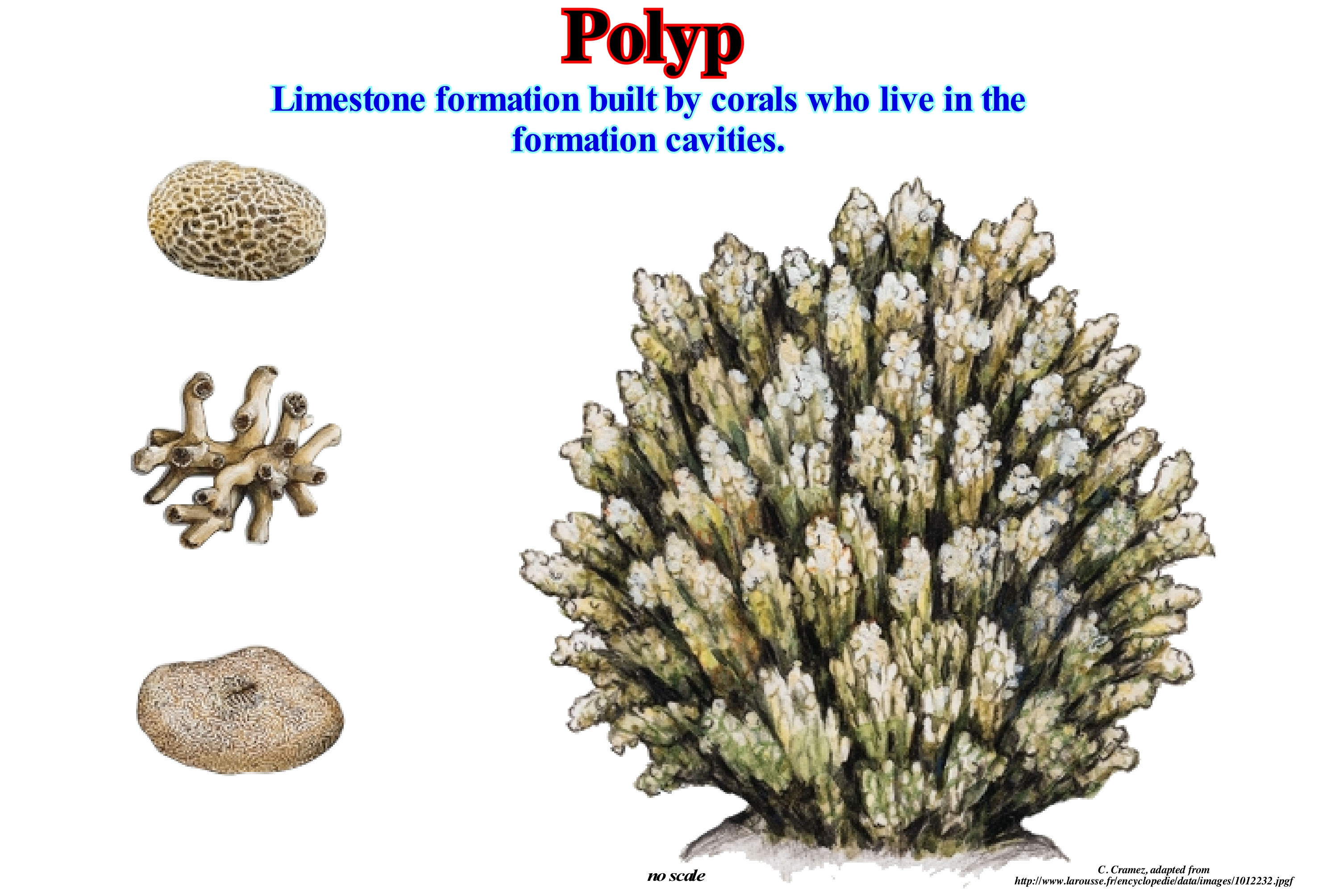
A polyp is one of two forms found on the cnidarian phylum, the other is the jellyfish. The polyps are, practically, cylindrical, elongated along the body. In the isolated polyps, the lower end is attached to the substrate, whereas in the colonies, it is attached to other polyps either directly or indirectly. The upper end containing the mouth is about tentacles. Polyps are colonial corals, and most of them are extremely sturdy, making them ideal candidates for the novice aquarist. All polyps contain symbiotic algae and require moderate to strong illumination. Some polyps, such as the button polyps, also benefit from foods such as salt-water or plankton shrimp. Most corals consist of many small polyps that live together in a large group or colony. A simple polyp has a tube-shaped body with a mouth surrounded by tentacles. Hard coral polyps produce a rocky skeleton of calcium carbonate underneath and around its base. Often the skeleton forms a cup-like structure in which the polyp lives. When fed, especially, at night, the polyps extend their tentacles to collect food. During the day, or when they feel threatened, the polyps shrink the tentacles in the protective tubes. The tentacles have tiny stinging cells called nematodes, which can fire venom spears at small animals adrift. These animals (zooplankton, i.e., small animals, or larvae of larger animals, which derive in the sea) are used as food and are introduced into the mouth by the tentacles. Only corals such as fire corals (in fact hydroids, i.e., cnidarians belonging to the subclasses Anthoathecata and Leptothecata, two of the eight subclasses of the Hydrozoa class), have stinging cells that are sufficiently powerful to affect man. In addition to capturing food adrift in streams, the polyps get food from the cells of small plants (called zooxanthellae) that live inside their tissues. Plant cells use sunlight and nutrients from seawater to produce food, which is shared with coral.
Pond (pool)....................................................................................................................................................................................................................................................Étang
Charco (poça, lagoa) / Estanque, Lago estancado / Teich / 池塘 / Пруд / Stagno /
A small water-body, shallow, surrounded by land on all sides and occupying, permanently, a natural depression of the terrain. Waterbody stagnant, shallow, of relatively small area (up to several tens of hectares), resulting from the soil impermeability.
See: « Lake »
&
« Laguna »
&
« Proglacial Lake »
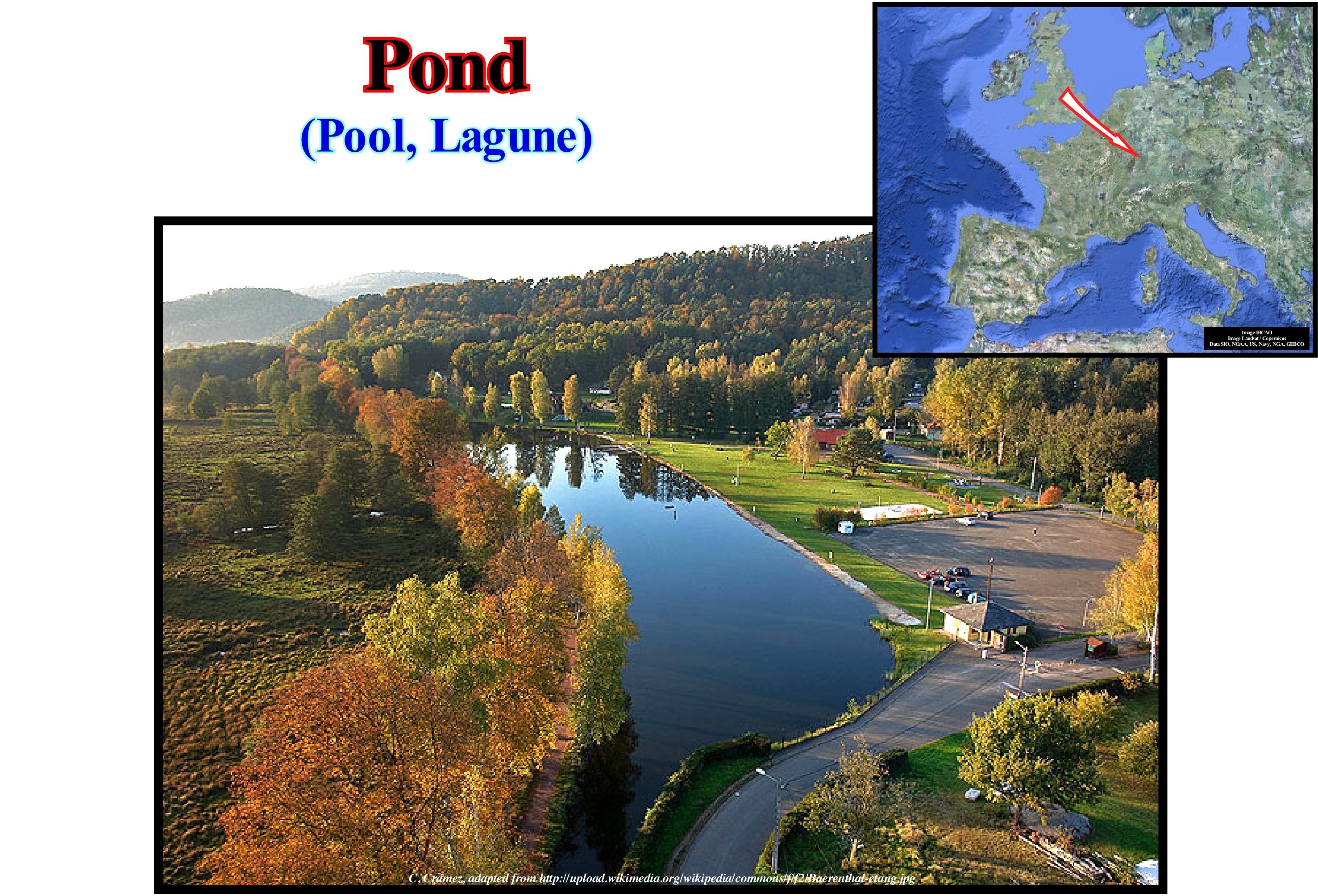
When a lake is, relatively, small or when a pool (puddle) is, relatively. large, the difference between the lake and pond (pool) is very difficult, if not impossible. Some geoscientists consider a pond (sometimes called laguna) as a small lake, but there is no international agreement, even national, that establishes the border between them. The values between 2 and 8 hectares or 20,000 to 80,000 km2 were proposed as possible boundaries between a lake and a puddle. In general, a pond has no outlet and is often fed from underground sources (in the aquifer between the surface of the land). As a pond corresponds to a course of lentic water (water does not flow, it is more or less stationary), which contains, generally, several ecosystems (communities of organisms composed of producers, composers and decomposers, functionally linked to one another and to the environment , and treated as a single entity). In heavily vegetated areas, the decomposing remains of plants that inhabit ponds or lagunas may rise to the surface and form a more or less dark colour layer, constituting the so-called grey scum ponds. One of the main contributors to pond foam is the presence of algae, which multiply rapidly, especially in eutrophic lakes (with more nutrients than they normally should) and well exposed to sunlight. Four different micro-habitats exist in a pond: (i) "Surf", that is, the surface film rich in decomposing plant remains ; (ii) Water-depth or layer ; (iii) Base and (iv) Margin. Foam is a habitat for animals that need air to breathe. The water-layer or layer is habitat for large swimming animals, as well as plants and animals that form the microscopic plankton. The lower part, especially when it is composed of sand, is home to sponges, snails, earthworms, etc. The margin (land) is a habitat that can be divided into three domains: (a) Field of emergent plants ; (b) Area with leaves and (c) Floating area of submerged plants.
Porosity................................................................................................................................................................................................................................................Porosité
Porosidade / Porosidad / Porosität / 多孔性 / Пористость / Porosità /
Percentage of the total volume of a rock, or soil, which is occupied by interstices, either isolated or connected with each other.
See: « Reservoir-Rock »
&
« Permeability »
&
« Oil Pool »
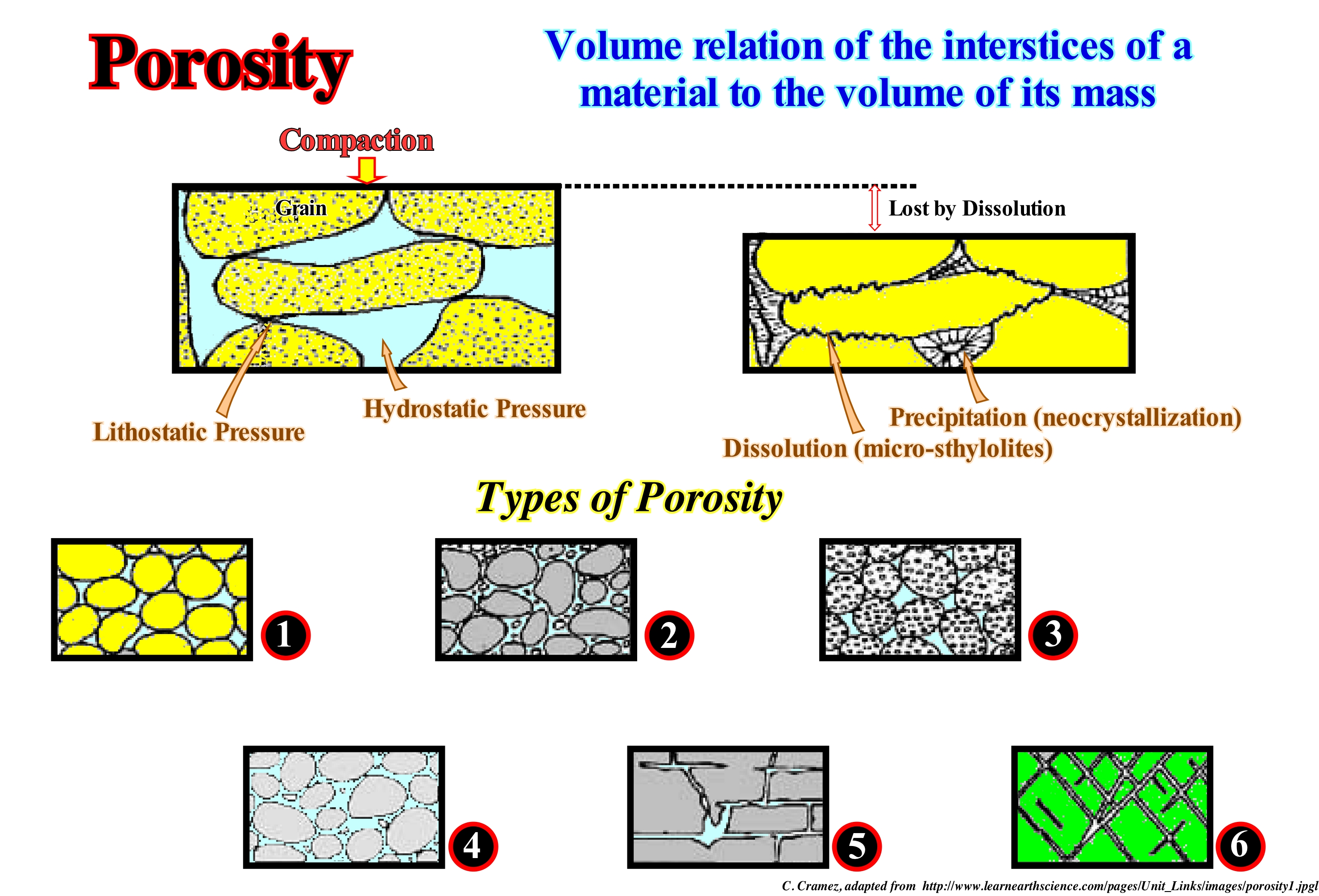
As shown in this figure, the porosity of a rock can be defined either as the volume of the pores (space between the grains) or as the volume of a rock that contains fluids (water, oil or gas). Porosity may be the result of deposition (primary porosity), which is the space between grains that have not been fully compacted or it may develop by grain alteration (secondary porosity), such as when grains of feldspar or fossils are partially or totally dissolved. It is important to differentiate the effective porosity from total porosity. The effective porosity is determined by the pores that are interconnected and that allows the flow of fluids in a rock-reservoir. The total porosity is given by the total pore volume of a rock, regardless of whether or not they are interconnected. The total porosity can be determined by the electrical diagrams of density, neutron porosity and nuclear magnetic resonance. The effective porosity is always much smaller than the total porosity. This scheme illustrates the compaction of a rock and thus the loss of porosity by dissolution and precipitation (neocrystallization), as the rock is buried under more recent rocks, that is to say, as the lithostatic pressure (weight of sedimentary column) and hydrostatic (water column weight) increase. Several types of porosity are illustrated in this figure: (1) Strong Primary Porosity, which is induced by the good calibration of the grains, which form the rock ; (2) Poor Primary Porosity, which is induced by a poor calibration of the grains forming the rock ; (3) Very Strong Primary Porosity, which is induced by a good calibration of the grains, but also by the porous character of the grains (porosity within the grains) ; (4) Very Poor Primary Porosity of a rock with well-calibrated grains, due to partial cementation, i.e., partial filling of the pores by a cement ; (5) Secondary Porosity by Dissolution and (6) Secondary Porosity by Fracture induced by the formation of a fracture system in association with a compressional tectonic regime, during which the rocks are shortened and uplifted.
Positive Encroachment................................................................................................Empiétement continental positif
Invasão continental positiva / Invasión continental positiva / Übergriff, Continental positiv /正水侵 / Положительное континентальное затопление / Invasione continentale positiva /
When the coastal onlap move upward and towards the continent increasing the available space for the sediments (accommodation).
See: « Costal Onlap Curve »
Positive Reflection........................................................................................................................................................................................Réflexion positive
Reflexão positiva / Reflexión positiva (sísmica) / Positive Reflexion (seismische) / 积极反映(地) / Положительныое отражение / Riflessione positiva (sismica) /
When the acoustical impedance of the upper interval of the sedimentary interface, which defines a reflection, is smaller than that of the lower interval (example: shale/limestone, or sand/shale).
See: « Reflection Coefficient »
&
« Acoustical Impedance »
&
« Negative Reflection »
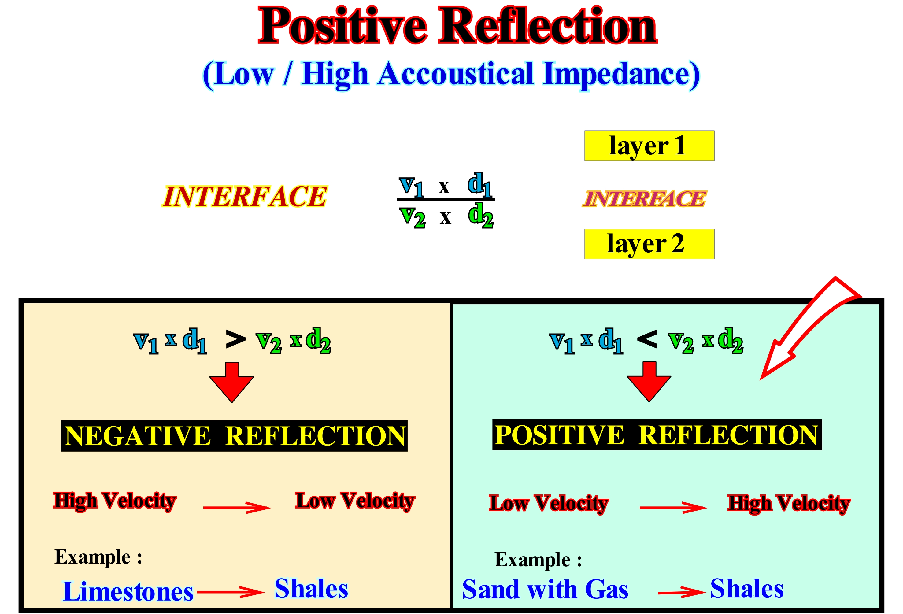
A seismic reflection is induced by an acoustic impedance contrast. The acoustic impedance of a given interval is the product of the velocity of the seismic waves, through the interval, by the density of the interval. A positive reflection occurs when the acoustic impedance of the upper interval is greater than that of the lower interval. An interface between a shaly interval and a limestone interval or between a sandy interval and a limestone creates a negative reflection. In the case of a shale-sandstone interface, the reflection can be positive or negative. Everything depends on depth. In the upper part of a sedimentary basin, where the shaly sediments have not yet been sufficiently compacted, the acoustic impedance of the shaly interval is smaller than that of the sandy interval and the associated seismic reflection is positive. However, in the deep parts of the basin, the shaly sediments are much more compacted than the sands, since they lose all their original porosity. Thus, under a certain depth, which certain authors call point or depth of inversion, which varies from basin to basin, a shale-sandstone interface creates a negative reflection. In the SEC convention, i.e., in the European Geophysical Society convention, on a seismic line, a positive reflection is represented by a deflection to the right of the baseline of the seismic trace. It is coloured black (positive polarity). In contrast, when the acoustic impedance of the lower interval is greater than that of the upper interval, the associated seismic reflection is negative (example: limestone/shale). A negative reflection materializes by a deflection of the seismic trace to the left and the space between the trace and the baseline is colored to white. Along a chronostratigraphic line, in particular when it has been deformed (as for example in an anticline), a positive reflection can become a negative reflection or vice versa. Imagine at the shallow apex of an anticline a interval of sand with gas between two shale intervals. The negative reflection induced by the shale-sandstone interface changes to positive in the area where the sand is saturated with gas (the presence of gas in a sandy range significantly decreases the acoustic impedance of the interval).
Possible Reserves..........................................................................................................................................................Réserves possibles (HC)
Reservas possíveis (HC) / Reservas posibles (HC) / Mögliche Reserven (HC) / 可能储量(慧聪) / Возможные запасы (УВ) / Riserve possibili (HC) /
Part of the unproven reserves (P3), whose analysis of geological data and engineering suggests that they will no longer be commercially produced under future economic conditions or technological developments, than probable reserves. Possible reserves are less certain than probable reserves. In this context, the designation of possible implies that the confidence level (probability) of production of the most likely most probable proved reserves (P1+P2+P3) is at least 10%.
See: « Discovered Reserves (HC) »
&
« Reserves »
&
« Probable Reserves (HC) »
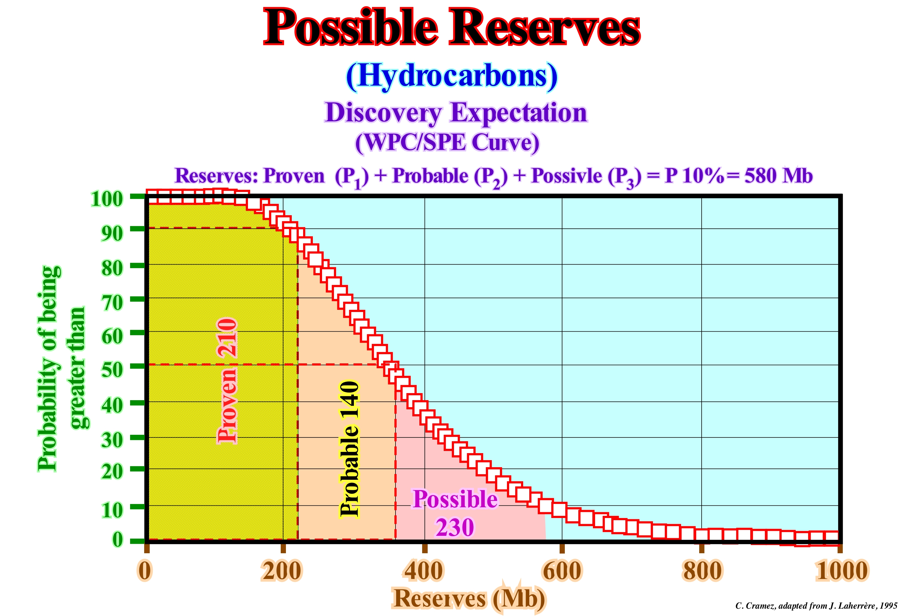
Possible reserves are quantified estimates of hydrocarbons (crude oil, natural bitumen, natural gas, natural gas liquids), in addition to proven and probable reserves, that, from a given date, geological and engineering analysis, a certain number suggests a probability of existence, with a certain degree of certainty, and which may, eventually, be commercially recovered under appropriate future economic and technological conditions (the likelihood that these reserves will be produced economically is smaller than those of the reserves probable). Possible reserves are less certain than proved or probable reserves. In this context, it is reasonable to expect that the probability of recovery of the estimated amount of proved reserves most likely to be more probable is less than 10%. In this graph, the possible reserves (the second family of unproven reserves) corresponding to a confidence level of 10% are 230 million barrels, that is to say, all proven reserves (P1) plus probable reserves (P2) plus possible reserves (P3) is, in this particular example, 510 million barrels (510 Mb). Do not forget that the publication of reserves is a political act and dependent on the image that the oil companies want to give. Also, never forget that within the same oil company there are internal reserves, which vary, substantially if they are determined by geologists, geophysicists, engineers, economists, etc., and the external reserves, which are those that the company announces and which vary according to the image that the company wants to give (the announced reserves for taxes are never the same as those announced to the bankers, for example).
Potential Accommodation...................................................................................................Accommodation potentielle
Acomodação Potential / Acomodación potencial / Mögliche Akkommodation / 潜在可用空间 / Потенциальное размещение / Accomodamento potenziale /
Potentially available space for sediments created by relative sea level changes (local sea level referenced to any point on the land surface, whether the seabed or the sediment base). The relative sea level is the result of the combined action of absolute or eustatic sea level, which is global and referenced to the center of the Earth or to a satellite, and the tectonics.
See: « Relative Sea Level Change »
&
« Shelfal Accommodation »
&
« Stratigraphic Cycle »
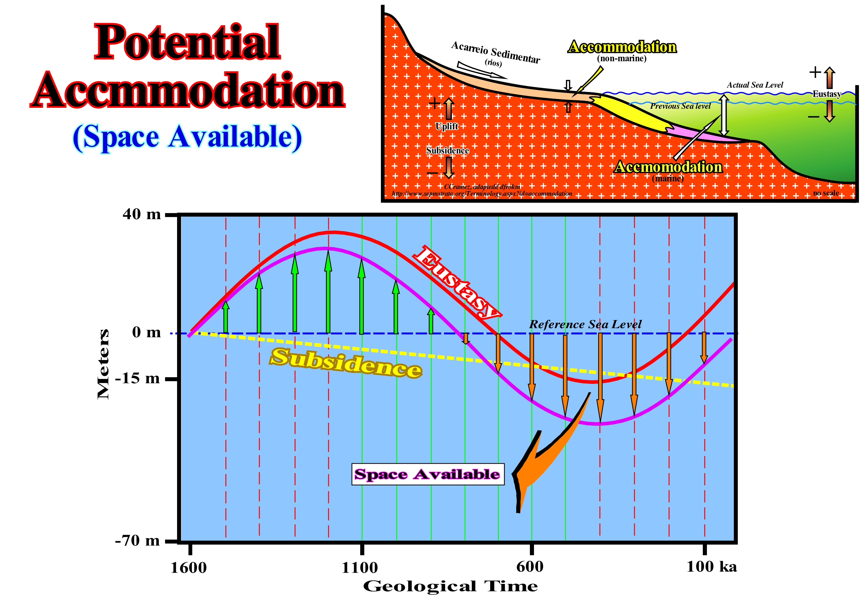
The space available for sediment or accommodation, particularly upstream of the continental edge, is the result of the combination of the eustatic curve (curve of absolute or eustatic sea level changes, as shown in red in this figure) and subsidence (in yellow on the diagram). On this example, the absolute (eustatic) sea level has risen by about 30 meters, between 16 Ma and 1.2 Ma (millions of years ago), and then falls, about 60 meters at 400 ka years ago). At first, it accelerated down at 800 ka and then decelerated at 400 ka, then rose (about 30 meters), accelerating to today (0 ka). When the geometry of the sea level change curve, whether relative or absolute, is increasing (1st positive derivative) and concave (positive 2nd derivative), the sea level rises in acceleration (marine ingressions are increasingly important). When the geometry is increasing and convex, the sea level rises in deceleration (1st derivative * positive and 2nd derivative negative). When the geometry of the curve is decreasing and convex (1st derivative negative and 2nd derivative negative), the sea level falls in acceleration. When the geometry of the sea level changes curve is decreasing and concave (1st negative derivative and 2nd positive derivative), the sea level decreases in deceleration. Subsidence of the continental edge increases over time to the sea, more or less, linearly (as in the EPR deposition model, i.e., Exxon's Exploration Production Research model). The reference sea level (in dashed blue) is horizontal. When the eustatic level (absolute sea level) rises (positive accommodation), the space created on the shelf by eustasy is increased by the space created by subsidence. When the eustatic level falls (negative accommodation), the available space for sediments created by subsidence (positive accommodation) is diminished from the negative value of accommodation induced by eustatic fall. A decrease in the available space for the sediments induces erosion. However, it is important to consider whether the sedimentary basin (sequence-cycle considered) has a continental shelf or not. In the case of a basin with a shelf (when the depositional coastal break of the deposition surface roughly, the shoreline is upstream of the continental edge, which in this case coincides with the basin edge), a relative sea level rise creates or increases the available space for sediments (shelfal accommodation). In this case, there will be sediment deposition function during the stability period of relative sea level that occurring after a marine ingression (eustatic paracycle). If the sediment is sufficient, all the available space created will be filled and the depositional water-depth deposited will remain, more or less, constant. If the terrigeneous influx is not sufficient, to fill all the available space for the sediments created by relative sea level rise, there will be deposition, but the depositional water-depth will increase. When the basin does not have a continental platform (shelf), the shoreline (more or less the depositional coastal break of the depositional surface, especially, on the seismic lines) coincides, roughly, with the upper limit of the continental slope, which marks the continental edge. In this case, several hypotheses are possible: (a) If the available space, created by the relative sea level rise is, completely, filled, the depositional water-depth is zero ; (b) If available space is not, completely, filled, a depositional water-depth forms or it increases ; (c) If the available space is insufficient, part of the terrigeneous influx shall be deposited, directly, in the upper sector of the continental slope. Subaerial accommodation (see the upper diagram of this figure) is, for many geoscientists, the space available for fluvial sediments when the bayline (upstream limit of Posamentier and Vail coastal prograding wedge, which includes fluvial and shallow water deposits) migrates seaward. It is defined by the space between the old and the new provisional equilibrium profiles of river. Do not forget that geoscientists, generally, consider two levels of the sea: (i) Absolute or eustatic sea level is, supposed to be global and referenced to the Earth's centre and (ii) Relative sea level, i.e., the local sea level referenced to a point on the Earth's surface which is, generally, the top of the continental crust (base of the sediments) or the sea floor. When the sea level is local and referenced to a point on the seabed, once there is a lateral variation of the depositional water-depth, such as that induced by a reef construction or a delta lobe, certain geoscientists speak in local relative sea level fall.
(*) We recall that in mathematical terms that when a straight line dips to the right, it is said to have a negative slope and that when it dips to the left it has a positive slope. The derivative of a point (a) of a curve f (x) is given by the tangent to that point (a). The derivative of a point (a) of this curve is positive if the tangent dips leftward and in this case the curve is increasing. Instead, the derivative of point (a) is negative if the tangent at that point (a) dips rightward. In this case the curve is decreasing. To sum up: (i) if f '(a)> 0 (first derivative at point a is positive), then the curve f (x) is increasing at x = a; (ii) if f '(a) <0, then the curve f (x) is decreasing at x = a; (a) <0, then f (x) is convex at x = a and if f "(a) <0, then f (x) x) is concave at x = a.
Potential Source-Rock..................................................................................................................................Roche-mère potentielle
Rocha-mãe potencial / Roca madre potencial / Potenzielle Muttergestein / 潜在的烃源岩 / Возможная материнская порода / Potenziale roccia fonte /
Rock rich in organic matter, but not buried, sufficiently, to its organic matter reached maturation, i.e., organic rich rock that did not generate hydrocarbons.
See: « Sealing-Rock »
&
« Source-Rock »
&
« Reservoir-Rock »
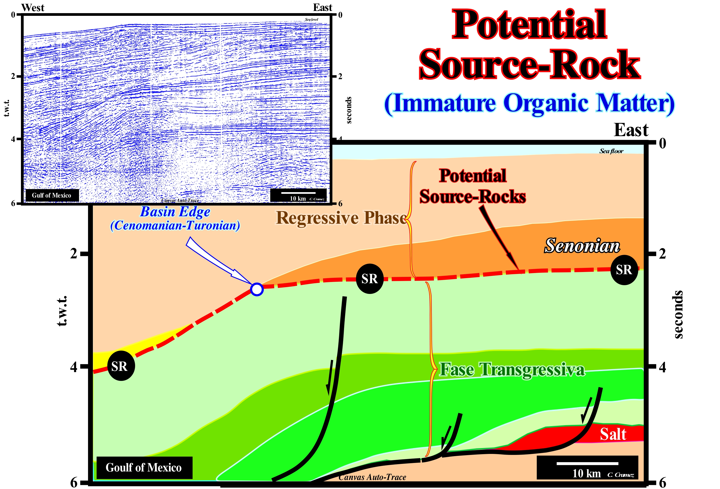
On this tentative geologically interpretation of a Canvas auto-trace of a Gulf of Mexico seismic line, it is easy to recognize potential marine source-rocks whose organic matter has matured. The first are the Cenomanian-Turonian (Cretaceous transgression) shales rich in organic matter, which have not been sufficiently buried so that their organic matter has reached the oil window. The latter are the same shales, but have been buried sufficiently, and thus organic matter has not reached maturation. On this tentative geological interpretation, the first step was to locate the transgressive shales and, secondly, was to determine the maximum burial, since they might have been deformed and uplifted by tectonics. Theoretically, their identification is very easy, especially if the seismic line is sufficiently long. Considering that the Gulf of Mexico is associated with the break-up of the Pangea, the things are very simplified, once, the continental encroachment cycle, induced by the first order post-Pangea eustatic cycle consists of two sedimentary phases : (i) Transgressive Phase and (ii) Regressive Phase. The first, which is the oldest, is associated with an eustatic (absolute) sea level rise, and the second, with an eustatic fall. The first one underlines the Cretaceous transgression, which, gradually, displaced the shoreline and coastal deposits continentward, creating in the distal parts of the continental shelf starves conditions, which are favourable to the deposition of sediments rich in organic matter. This means that sediments rich in organic matter are, preferably, located between the retrogradational (aggradation) geometry of the transgressive sediments and the progradational geometry of the sediments deposited during sedimentary regression. This interface, which marks the most probable location of the marine source-rocks is obvious on this tentative interpretation (red dotted, SR). However, upstream of the basin edge (during the Cretaceous), the depth of this interface is about 2s (double time), which is insufficient, in absence of a tectonic uplift. for the organic matter of the potential source- rocks to reach the oil window.
Pothole................................................................................................................................................................................................................................................Marmite (Nid de poule)
Marmita (ninho de galinha) / Marmita / Schlagloch / 壶洞 / Выбоина / Buca, Marmitte (buca) /
Hole of a rock formed by the whirlwinds of a grain of sand, or pebble, induced either by the flow of a stream or by the wind.
See: « Erosion »
&
« Kettle »
&
« Pebble »
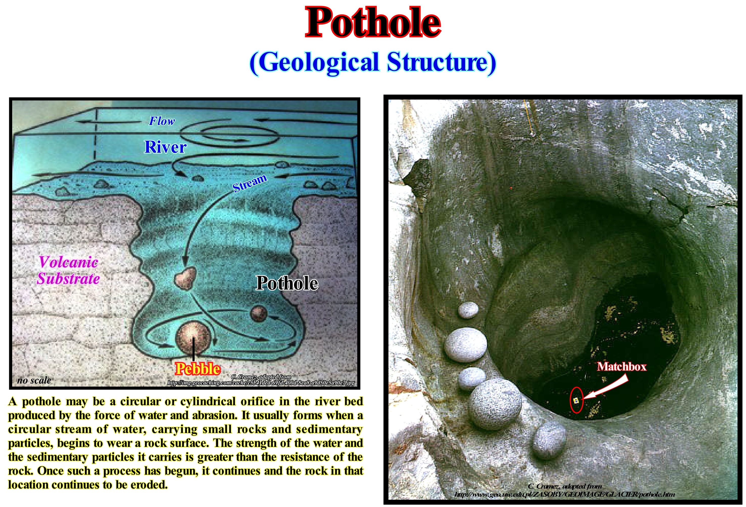
In this photograph, the matchbox (arrow), on the surface of the water that partially fills the pothole gives the scale. The pebbles that are in the upper part of the pothole (when its diameter was larger) are probably similar to those responsible for the abrasion that originated it. The term pothole is often used to describe the holes made in the bed and banks of a river by the erosive action of the whirling movements of the stream, which can be, locally, enhanced by the presence of pebbles. This type of structure illustrates well the fantastic power of currents that are able to cut, almost vertically, the calcareous walls of the beds of certain rivers. In fact, in general, the basal load of sand and gravel of a river is most of the time stationary. However, during periods of rain and floods, it moves with the flow of water. The displacement of this material is a very efficient abrasion process, which rapidly erodes the bed and walls of the channel so that the current reaches a provisional equilibrium profile. The abrasion responsible for the formation of the potholes is simply a particular case of this type of abrasion, in which the piercing of the river bed is made by the circular movement imposed by the current, the pebbles and circumscribed pebbles in a depression. Since pebbles and pebbles are worn away and disappear, others take their place and continue to pierce the riverbed since the current forces them to rotate in a circular motion. As river erosion is not only effected by the action of the current with its charge, that is to say by gravity, but also by the play of whirling currents which form at the level of the accidents of the provisional equilibrium profile, and water falls, giant kettles can be formed without being drilled, since whirling currents produce alveolar erosion of the stream bed. These giant kettles sometimes join together forming channels, caves and cornices, such as those found along the valley of the river Doubs, in particular between Villers-le-Lac and Morteaux in eastern France (border with Switzerland). Thus, this type of pots as illustrated can reach several meters in diameter and more than 5 m deep. Potholes are frequently encountered during mining operations in the Bushveld Igneous Complex in South Africa. Two ore-bodies, the Upper Group 2 (UG2) and the Merensky Reef, host about 70% of the world's platinum group metals (PGM), and pose major extraction problems for the mining industry in their faults, dykes, joints, domes, iron-rich ultramafic pegmatoids, rolls and dunite pipes. The greatest mining problems, though, are presented by potholes. (https://en. wikipedia.org/wiki/ Pothole_(geology)

