

Landward-Dipping Fault
Synonym of Counter-Regional fault. However, it must be said that all faults belonging to a counter-regional system are landward-dipping faults, but not all landward-dipping faults belong a counter regional system. See: Counter Regional System.
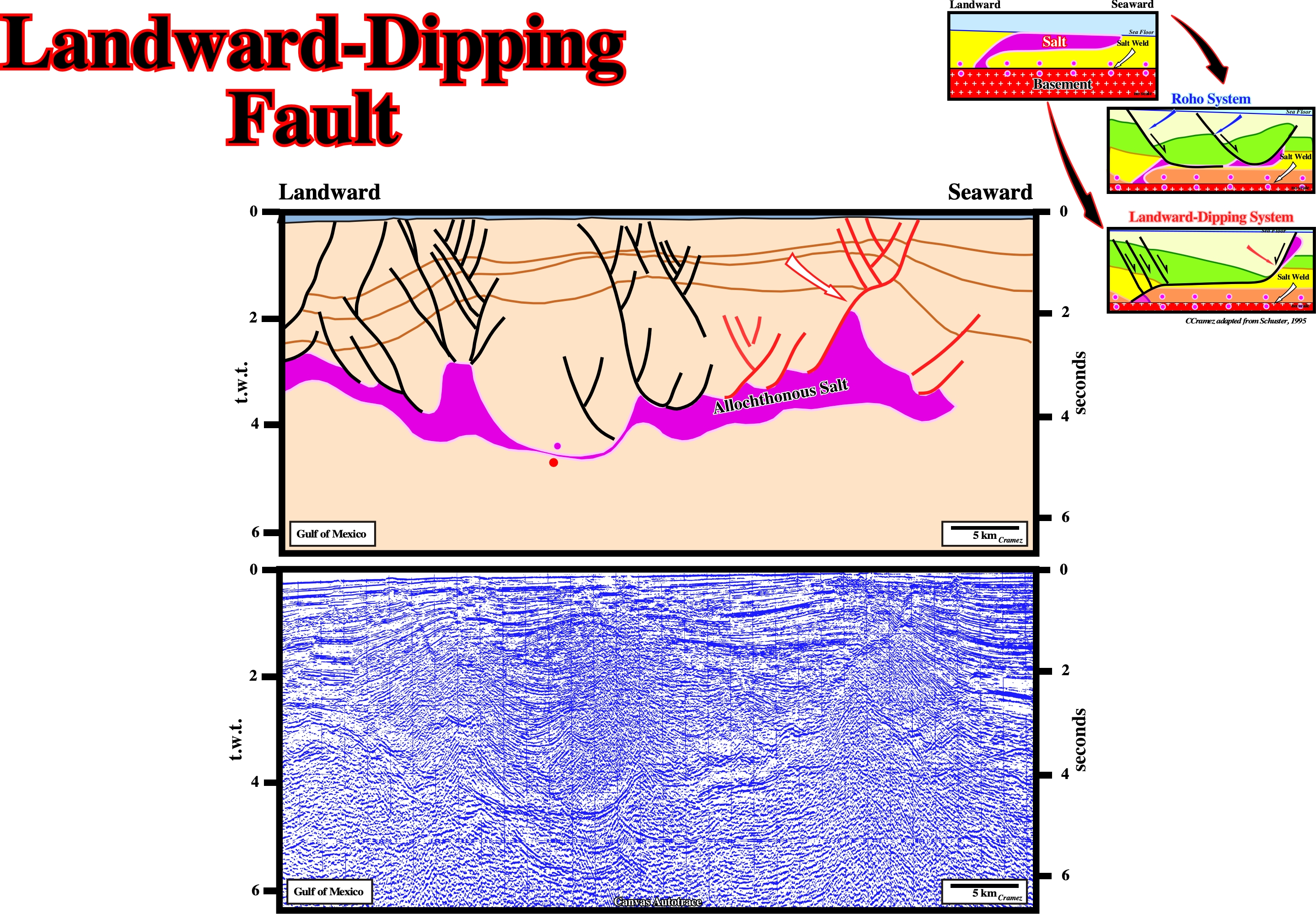
On this tentative geological interpretation of a Canvas autotrace of a Gulf of Mexico seismic line the presence of landward-dipping fault, i.e., a counter regional fault system associated with the outward movement of an allochthonous salt is quite evident. The antithetic accommodation normal faults associated with major landward-dipping faults belong, obviously, to the counter regional fault systems. The local occurrence of a salt weld individualizes, in this area, two allochthonous salt layers.
Lateral Confining Pressure
Pressure induced laterally by a tectonic stress (σt). Indeed, when a tectonic stress (σt) is added in one direction it produces, by reaction, a lateral confining pressure (σh). The amount of lateral confining pressure is function of rocks' rheology and ranges from 5/10 to 10/10 of the tectonic stress. On the vertical, towards the free surface, the tectonic stress (σt) is released by uplift or subsidence.
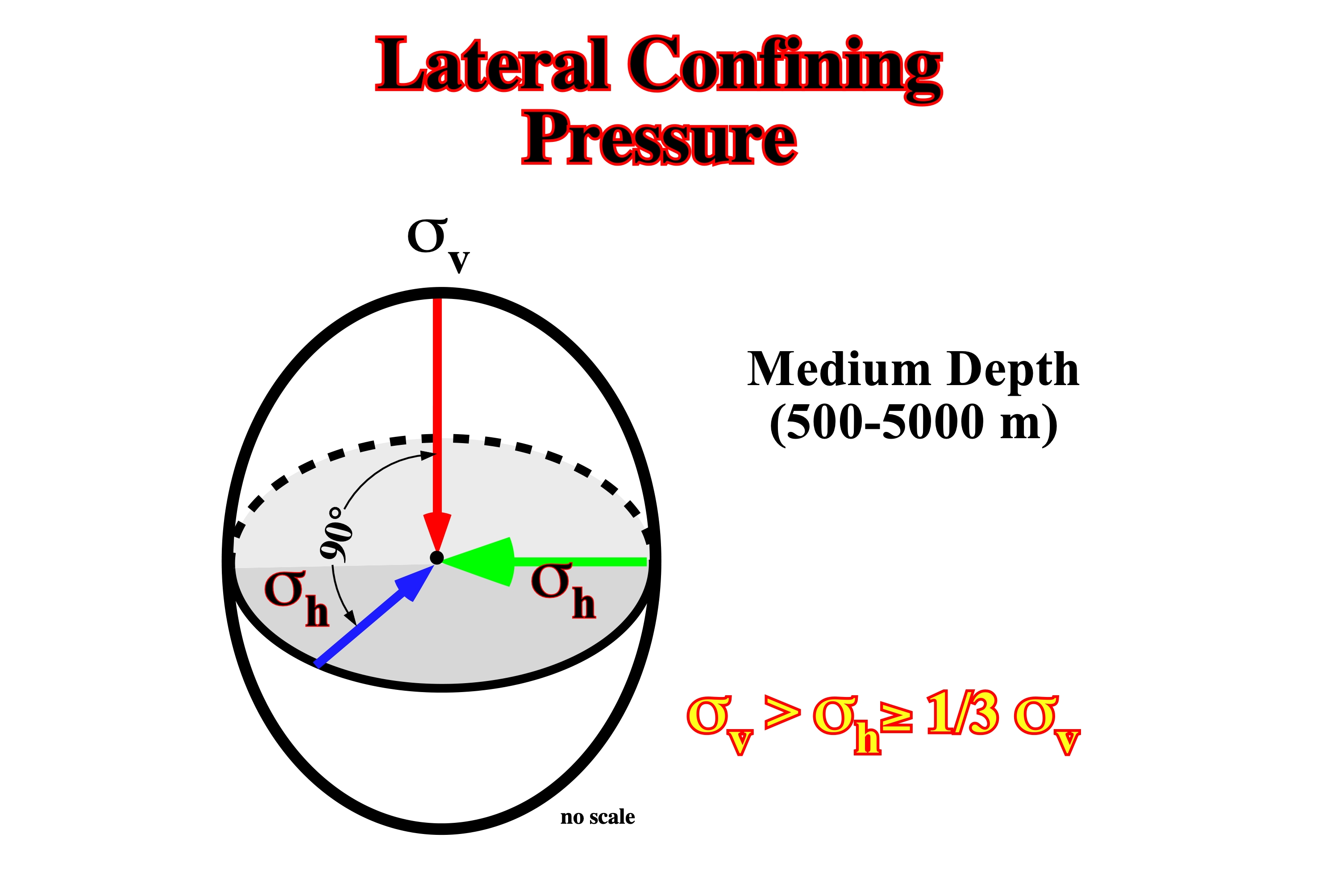
At a given depth point, the weight of the sediments (σv) creates a lateral pressure (σh). At normal depths, the lateral pressure ranges between 5/10 and 8/10 of the vertical pressure. However, at greater depths, as the biaxial ellipsoid becomes uniaxial, the values of the lateral pressure becomes equal to the vertical pressure.
Leading Edge
The foremost edge of a spreading salt body, in surface or under water, i.e., the forward part of the moving salt.
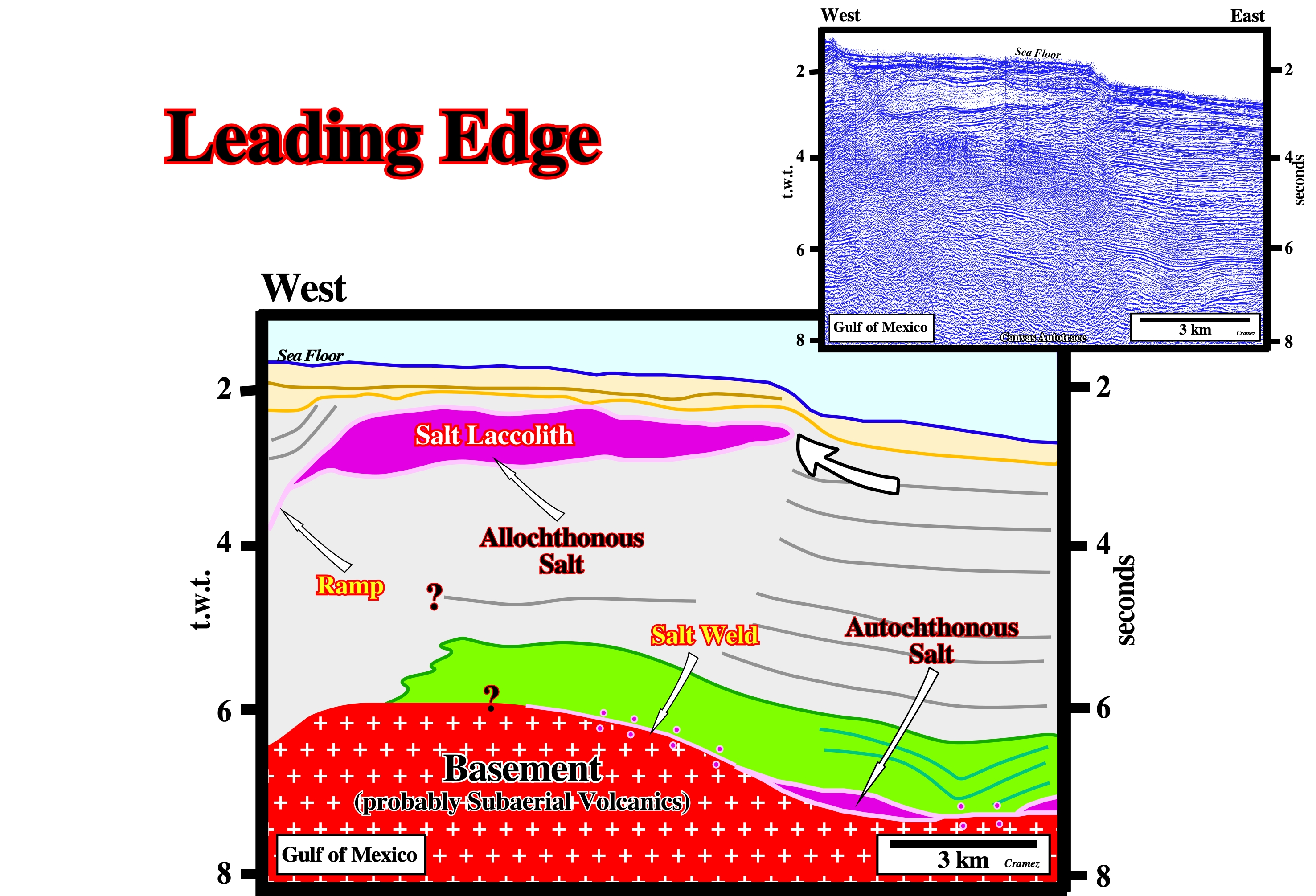
On this tentative interpretation of a Canvas autotrace of a GOM seismic line, the leading edge of the allochthonous salt nappe is, easily, recognized by the associated bathymetric anomaly. The autochthonous salt layer is underlined by the tectonic disharmony recognized at around 7 seconds.
Lessening Tectonic Regime
Extensional tectonic regime developed when the tectonic stress (σt) is not big enough to balance the geostatic pressure in the effective stresses ellipsoid. This tectonic regime, characterized by a σ1 vertical and σ2 and σ3 horizontal, occurs in association with folded-belts and foredeep basins.
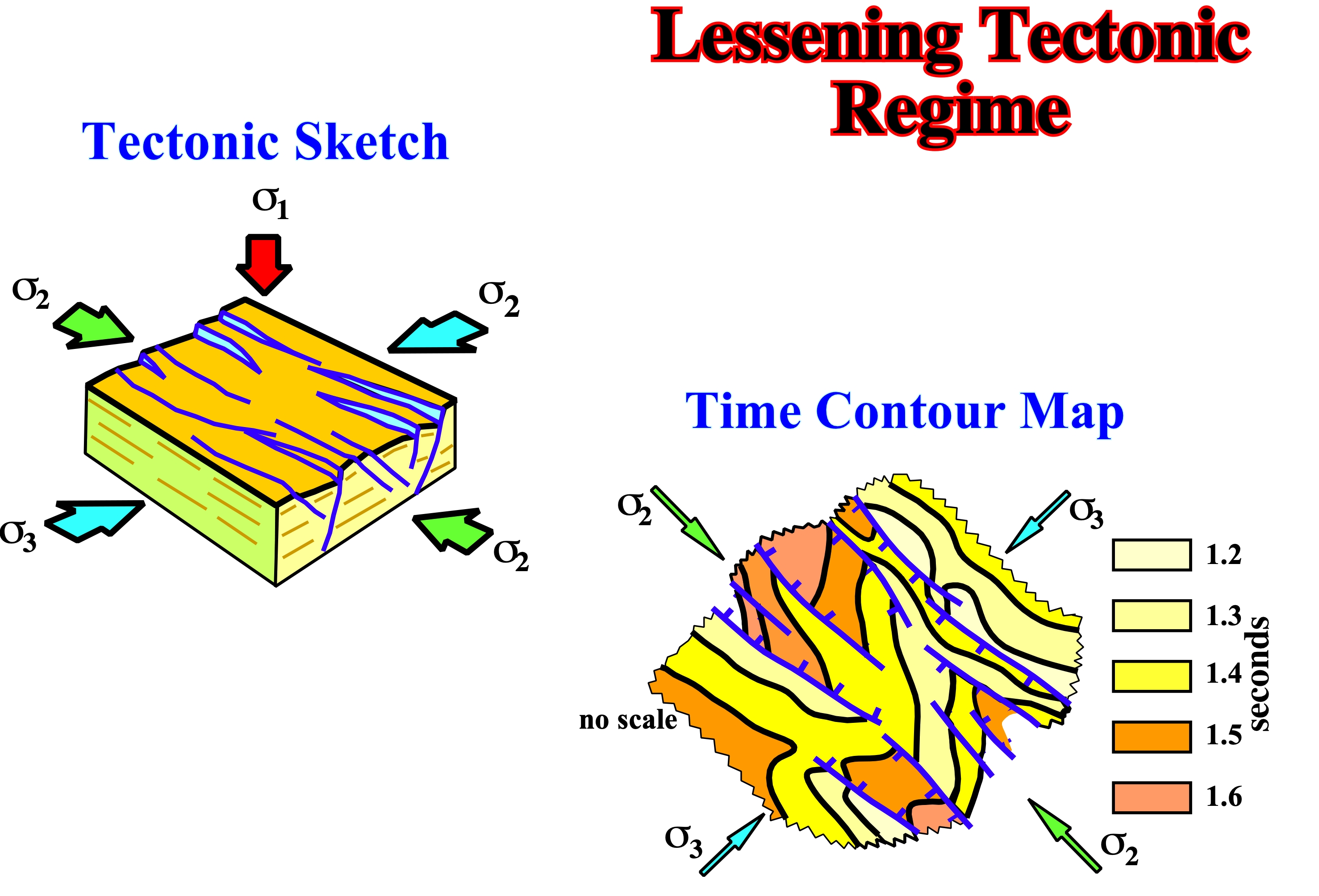
This tectonic regime is often recognized in the distal part of foredeep basins. Inn this areas, extensional structures, generally, halfgrabens and grabens strike perpendicular to the compressional structures of the fold-belts, i.e., cylindrical-folds and thrusts.
Level of Neutral Buoyancy
Depth at which the bulk density of the overburden is equal to that of salt (about 2,200 kg/m3). This is the level at which a diapir spreads most rapidly if surrounded a yielding, fluid overburden (including air or water). Terrigeneous clastics must be buried before they compact, dehydrate, or cement to reach the density of the salt. This burial depth varies from basin to basin but is approximately 450 to 900m under normal compaction gradients (hydrostatic pore pressure) and around 500m where shales are under-compacted (pore pressure elevated between hydrostatic and lithostatic pressure gradients).
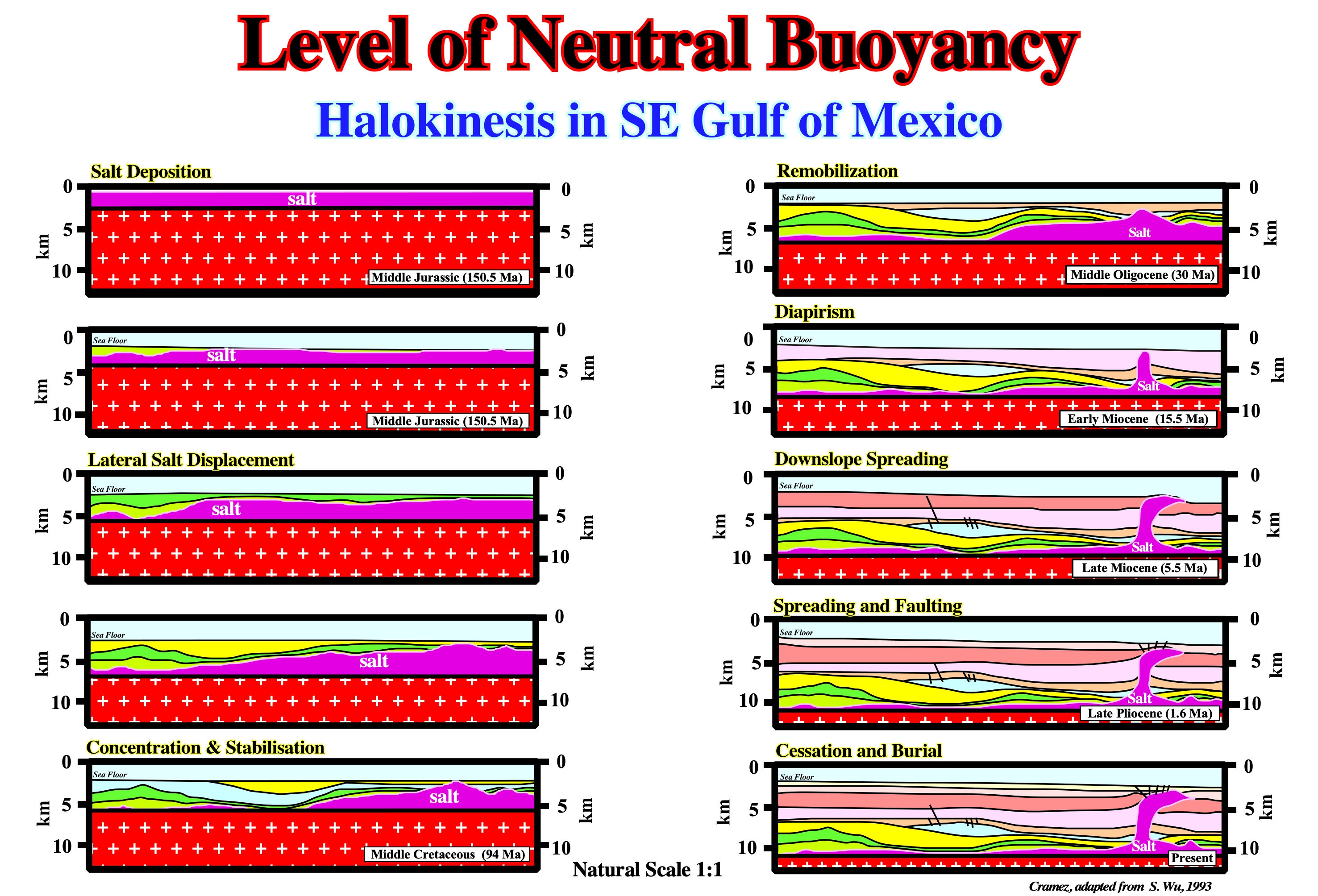
On this halokinesis model, proposed by Shengyu Wu for SE Gulf of Mexico, it can be said that the bulk density of the overburden was, roughly, equal to the salt density when downslope spreading, that is at, more or less, 5.5 Ma (Late Miocene).
Listric Fault
A particular curvilinear faults having a normal fault geometry up-dip and a reverse fault geometry down-dip, as in a slumping fault. In spite of the fact that listric comes from "listron", in Greek, means "spoon", presently, listric fault is used to express all kinds of fault having a curvilinear geometry.
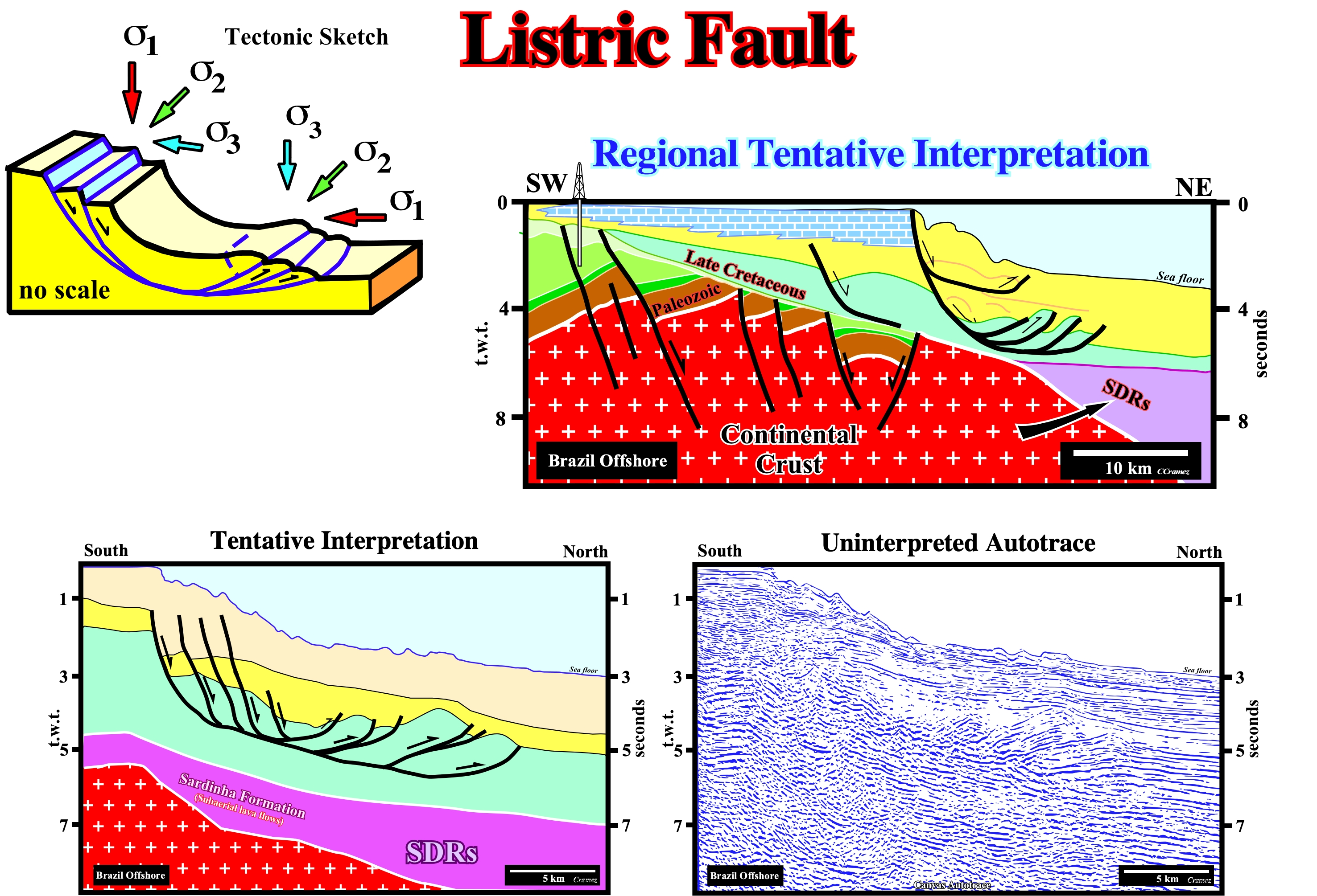
Listric faults as the one illustrated on this seismic line develop mainly in slope environments. Due to the seaward increasing of the water depth, slope failures take place up-dip. The up-dip extension is balanced by a sedimentary shortening created by local compressional tectonic regime developed near the toe of the slope. The tentative geological interpretations illustrated above come from Canvas autotraces of the Barreirinhas geographic basin, located in NE Brazil onshore and offshore.
Lithostatic Pressure
See: Geostatic Pressure
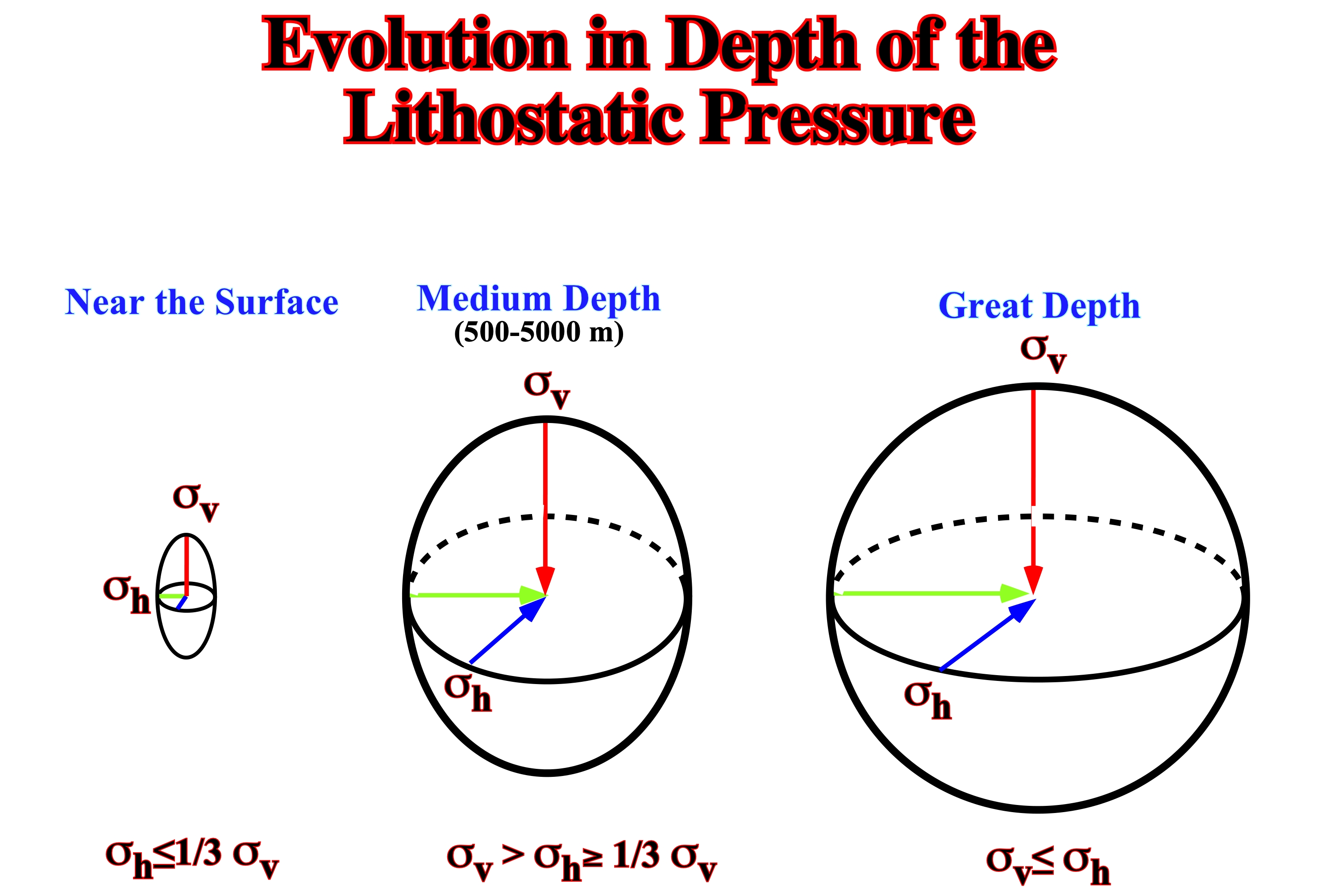
At a given depth, the lithostatic pressure or geostatic stress (σg) is the stress caused by the weight of a column of the overlying beds. It can be depicted by a biaxial ellipsoid, in which the σv is the weight of the sedimentary column (d.h.g) and the σh , the confined pressure, is 6-8/10 of σv. The average density of the sedimentary column is d , h is the height of the column and g the gravitational force. Assuming a sedimentary basin with undeformed homogeneous and continuous rocks, the stress field is characterized by a biaxial ellipsoid. However, the geostatic stress ellipsoid varies with depth. The state of stress tends to become hydrostatic at great depth, as illustrated above: (i) Near the surface, rocks of a elastic behavior, therefore: σh< 1/3 σv ; (ii) At medium depth, rocks of a viscous-elastic behavior: 1/3 σv< σh and (iii) At great depth, rocks of a viscous behavior, therefore: σh = σv.